
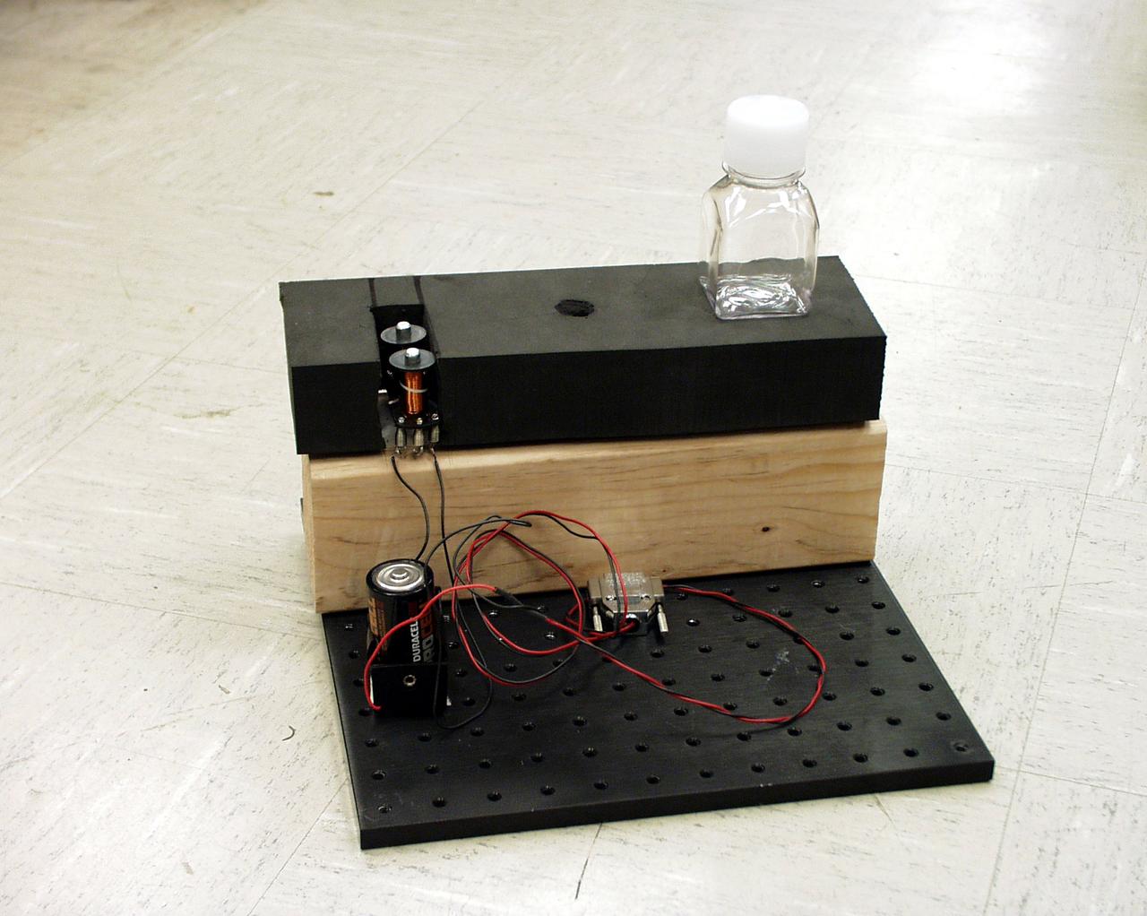
National Aeronautics and Space Administration (NASA) Lewis Research Center. NASA signed an agreement with the Papago tribe in May 1978 to provide the village with solar-generated electricity within the year. The project was funded by the Department of Energy and managed by NASA Lewis. Lewis provided all of the equipment and technical assistance while the tribe’s construction team built the arrays and support equipment, seen here. The 3.5-kilowatt system was modest in scope, but resulted in the first solar electric village. The system provided power to operate a refrigerator, freezer, washing machine, and water pump for the village and lights in each of the 16 homes. The system was activated on December 16, 1978. During the next year officials from around the world travelled to Schuchuli to ascertain if the system was applicable to their areas. The major television networks and over 100 publications covered the story. Less than one percent of the cells failed during the first year of operation.
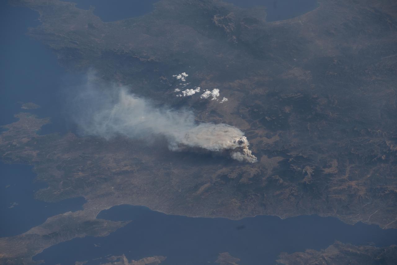
iss073e0421317 (July 22, 2025) --- Wildfires breakout near the Greek village of Feneos south of the Gulf of Corinth in this photograph from the International Space Station as it orbited 261 miles above Southern Europe.
iss074e0043972 (Jan. 3, 2026) --- Villages light up the coastline in this nighttime image of Lake Sevan, one of the largest freshwater high-altitude lakes in the world, sitting at 1,900 meters above sea level in Armenia. Lake Sevan is protected as Sevan National Park for its ecological importance and for providing landlocked Armenia with most of its fish. The International Space Station was orbiting 262 miles above Earth at 11:13 p.m. local time when this photograph was taken. Credit: JAXA/Kimiya Yui

iss074e0043930 (Jan. 3, 2026) --- The amber high-pressure sodium lights of Erciş, Türkiye (top), along with its suburbs and villages, dot the landscape surrounding Lake Van in the nation’s Eastern Anatolia Region. The International Space Station was orbiting 262 miles above Earth at approximately 10:12 p.m. local time when this photograph was taken. Credit: JAXA/Kimiya Yui
Okata is a small village of about 3,000 residents in northwest Japan. It is known internationally for its Solar-car rally. The village consists entirely of land reclaimed from the former Lake Hachirogata, and is mostly below sea level (Wikipedia). The image was acquired August 28, 2012, covers an area of 17.5 by 22.8 km, and is located at 40 degrees north, 139.9 degrees east. https://photojournal.jpl.nasa.gov/catalog/PIA23531
This image from NASA Terra spacecraft shows a cluster of villages known as Mawsynram in India, which is the current world record holder for the wettest place on earth.
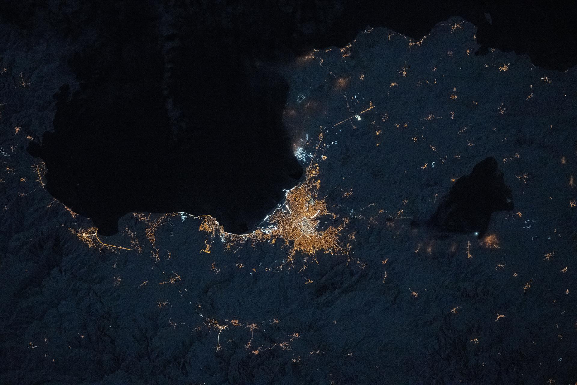
iss074e0043921 (Jan. 3, 2026) --- The amber high-pressure sodium lights of Van, Türkiye (center), along with its suburbs and villages, dot the southeast coast of Lake Van in the nation’s Eastern Anatolia Region. The International Space Station was orbiting 262 miles above Earth at approximately 10:12 p.m. local time when this photograph was taken. Credit: JAXA/Kimiya Yui
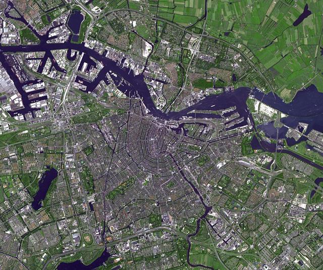
Amsterdam is the largest city and the capital of the Netherlands. Its name derives from a dam in the river Amstel. Founded in the 12th century as a fishing village, Amsterdam was one of the most important ports in the world in the 17th century.

LAnse aux Meadows is a site on the northernmost tip of the island of Newfoundland, located in the Province of Newfoundland and Labrador, Canada, where the remains of a Viking village were discovered in 1960. This image is from NASA Terra satellite.
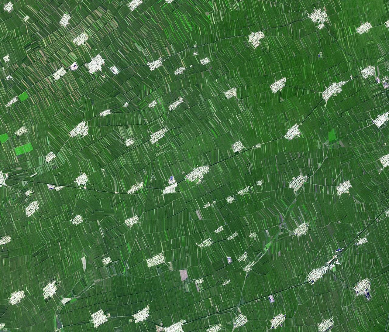
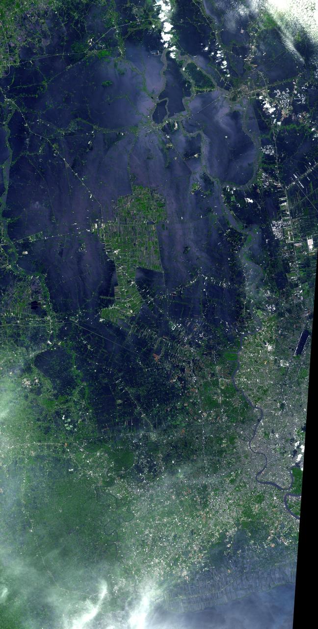
Acquired by NASA Terra spacecraft, this image shows Heilongjiang, a province of China located in the northeastern part of the country. Farms are small and long skinny rectangles in shape, surrounding regularly spaced villages.
Located 600 km south of Algiers, Algeria in the heart of the Sahara Desert, the five ksour fortified villages of the MZab Valley form an extraordinarily homogenous ensemble in this image captured by NASA Terra spacecraft.

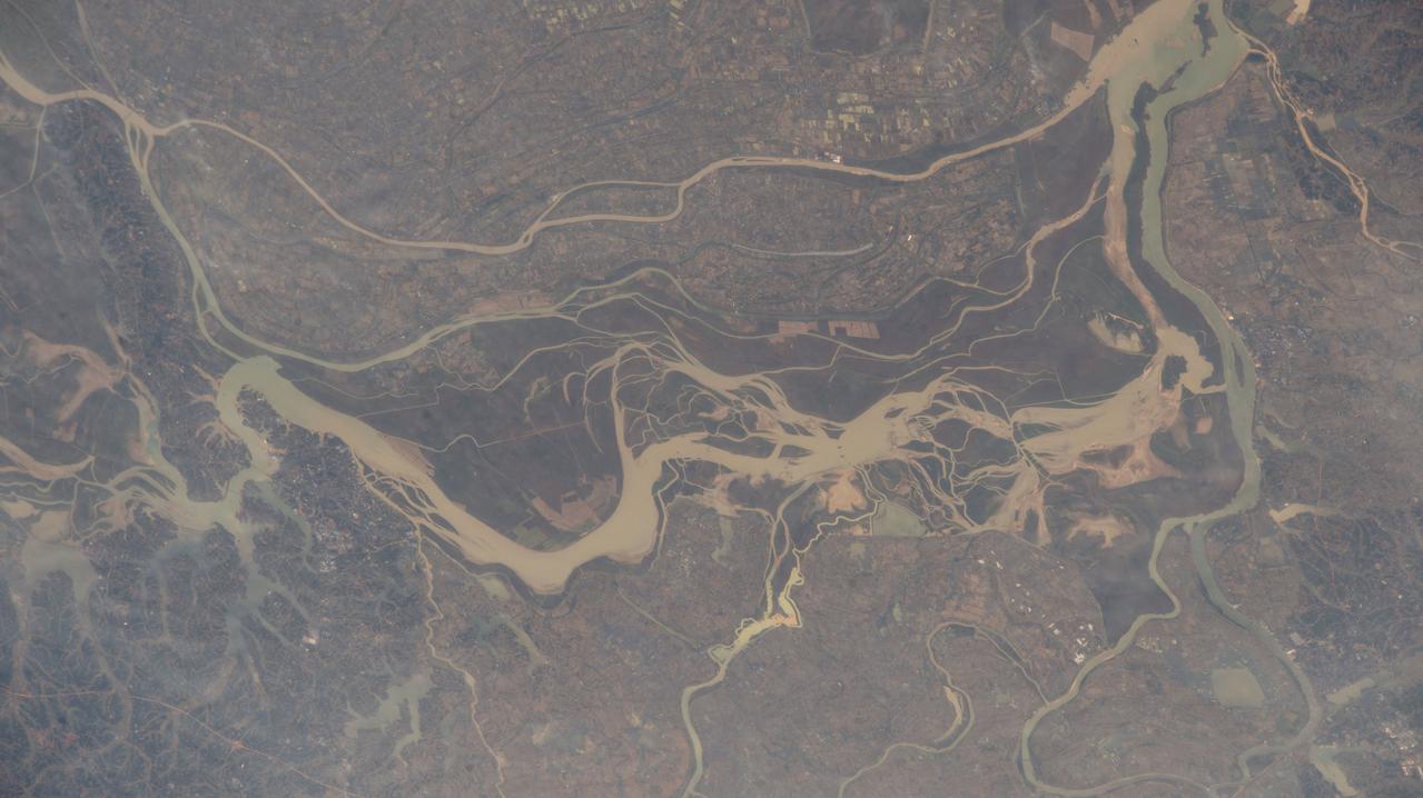
On Oct. 25, 2011, the Chao Phraya River was in flood stage as NASA Terra spacecraft imaged flooded agricultural fields and villages depicted here in dark blue, and the sediment-laden water in shades of tan.
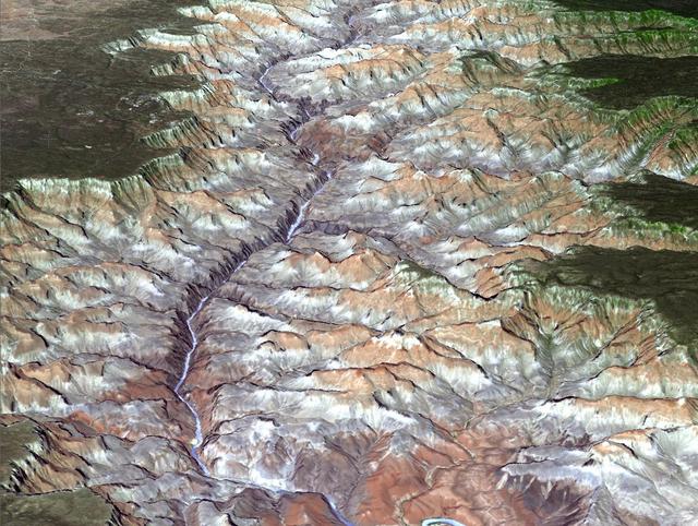
NASA Terra spacecraft provided this view of the eastern part of Grand Canyon National Park in northern Arizona in this image on July 14, 2011. This view looks to the west, with tourist facilities of Grand Canyon Village visible in the upper left.
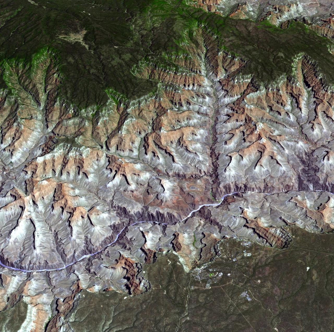
Arguably one of America most magnificent national parks is the Grand Canyon in northern Arizona. NASA Terra spacecraft captured this image looking to the northeast, the buildings and roads in the center foreground are Grand Canyon Village.
iss069e090319 (Sept. 19, 2023) --- Moroccan towns and villages are pictured on the African nation's Atlantic coast as the International Space Station orbited 258 miles above.
Flooding from the Chao Phraya River, Thailand, had begun to ebb in this image acquired by NASA Terra spacecraft on Nov. 1, 2011. Here, in blue-gray is the muddy water that had overflowed the banks of the river, flooding agricultural fields and villages.
NASA Terra spacecraft acquired this image of flooding from the Chao Phraya River, Thailand on Nov. 8, 2011. The muddy water that had overflowed the banks of the river, flooding agricultural fields and villages, is seen in dark blue and blue-gray.

The Mar. 11, 2011, Tohoku, Japan earthquake and tsunami devastated a large extent of the northeastern Japan coast, and virtually erased many villages and cities from the map. NASA Terra spacecraft acquired this image of Sendai on Mar. 14, 2011.
iss070e031373 (Nov. 28, 2023) --- Rivers and lakes are surrounded by villages in the south-central portion of China in this photograph from the International Space Station as it orbited 260 miles above the Asian nation
iss063e074053 (Aufg. 13, 2020) --- The Portuguese village of Comporta (lower center), pictured from the International Space Station, is on the other side of the Península de Troia from the Sado Estuary Natural Reserve.
This simulated true color perspective view over the Grand Canyon was created from Advanced Spaceborne Thermal Emission and Reflection Radiometer (ASTER) data acquired on May 12, 2000. The Grand Canyon Village is in the lower foreground; the Bright Angel Trail crosses the Tonto Platform, before dropping down to the Colorado Village and then to the Phantom Ranch (green area across the river). Bright Angel Canyon and the North Rim dominate the view. At the top center of the image the dark blue area with light blue haze is an active forest fire. http://photojournal.jpl.nasa.gov/catalog/PIA01908
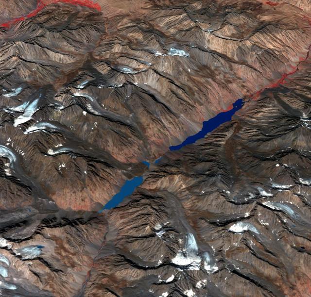
In the Hindu Kush Mtns. in northern Pakistan, landslides from the steep, glaciated terrain are common. When the landslides block rivers, they form temporary lakes or cause small lakes to grow larger. If the landslide dams fail catastrophically, an instantaneous flood surges down the narrow valley, endangering downstream villages. A good example is Lake Shuwarang Chhat, that is upstream of villages of Barsat, Tery, Bahach, and Hundarap. The perspective view data were acquired September23, 2019, and are located at 36 degrees north, 72.6 degrees east. https://photojournal.jpl.nasa.gov/catalog/PIA25355
The fishing and tourist village of Nazare, Portugal was practically unknown, until 2000, when surfers first braved its monstrous winter waves. Since then, world records for surviving surfing the 30m+ high waves have fallen, and movies have been made, celebrating the brave (crazy?) surfers willing to risk their lives to challenge the world's tallest waves. Sediment highlights off-shore current patterns in the image. The image was acquired November 24, 2009, covers an area of 18 by 25.7 km, and is located at 39.6 degrees north, 9.1 degrees west. https://photojournal.jpl.nasa.gov/catalog/PIA25121

KENNEDY SPACE CENTER, FLA. -- Family members of the STS-107 astronauts and other dignitaries gather for the dedication ceremony of the Columbia Village at the Florida Institute of Technology in Melbourne, Fla. Each of the seven new residence halls in the complex is named for one of the STS-107 astronauts who perished during the Columbia accident -- Rick Husband, Willie McCool, Laurel Clark, Michael Anderson, David Brown, Kalpana Chawla, and Ilan Ramon.

KENNEDY SPACE CENTER, FLA. - Family members of the STS-107 astronauts, other dignitaries, members of the university community and the public gather for the dedication ceremony of the Columbia Village at the Florida Institute of Technology in Melbourne, Fla. Each of the seven new residence halls in the complex is named for one of the STS-107 astronauts who perished during the Columbia accident -- Rick Husband, Willie McCool, Laurel Clark, Michael Anderson, David Brown, Kalpana Chawla, and Ilan Ramon.

KENNEDY SPACE CENTER, FLA. -- NASA Associate Administrator for Space Flight William F. Readdy addresses the family members of the STS-107 astronauts, other dignitaries, members of the university community and the public gathered for the dedication ceremony of the Columbia Village at the Florida Institute of Technology in Melbourne, Fla. Each of the seven new residence halls in the complex is named for one of the STS-107 astronauts who perished during the Columbia accident -- Rick Husband, Willie McCool, Laurel Clark, Michael Anderson, David Brown, Kalpana Chawla, and Ilan Ramon.

KENNEDY SPACE CENTER, FLA. -- Family members of the STS-107 astronauts and other dignitaries gather for the dedication ceremony of the Columbia Village at the Florida Institute of Technology in Melbourne, Fla. Each of the seven new residence halls in the complex is named for one of the STS-107 astronauts who perished during the Columbia accident -- Rick Husband, Willie McCool, Laurel Clark, Michael Anderson, David Brown, Kalpana Chawla, and Ilan Ramon.

KENNEDY SPACE CENTER, FLA. - Family members of the STS-107 astronauts and other dignitaries attending the Columbia Village dedication ceremony at the Florida Institute of Technology in Melbourne, Fla., stand for the posting of the colors by members of the university's ROTC. Each of the seven new residence halls in the complex is named for one of the STS-107 astronauts who perished during the Columbia accident -- Rick Husband, Willie McCool, Laurel Clark, Michael Anderson, David Brown, Kalpana Chawla, and Ilan Ramon.

KENNEDY SPACE CENTER, FLA. - Family members of the STS-107 astronauts and other dignitaries attending the Columbia Village dedication ceremony at the Florida Institute of Technology in Melbourne, Fla., enjoy a rendition of "God Bless America" by the university's Players in Harmony. Each of the seven new residence halls in the complex is named for one of the STS-107 astronauts who perished during the Columbia accident -- Rick Husband, Willie McCool, Laurel Clark, Michael Anderson, David Brown, Kalpana Chawla, and Ilan Ramon.
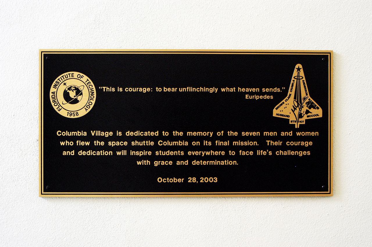
KENNEDY SPACE CENTER, FLA. - A plaque dedicating the Columbia Village at the Florida Institute of Technology in Melbourne, Fla., is unveiled at a ceremony attended by family members of the STS-107 astronauts and other dignitaries. Each of the seven new residence halls in the complex is named for one of the STS-107 astronauts who perished during the Columbia accident -- Rick Husband, Willie McCool, Laurel Clark, Michael Anderson, David Brown, Kalpana Chawla, and Ilan Ramon.
iss073e1198938 (Nov. 28, 2025) --- A yellow-red airglow blankets Earth's horizon as village lights dot the Saharan landscape of Algeria in this photograph taken at approximately 8:50 p.m. local time from the International Space Station as it orbited 261 miles above north Africa.
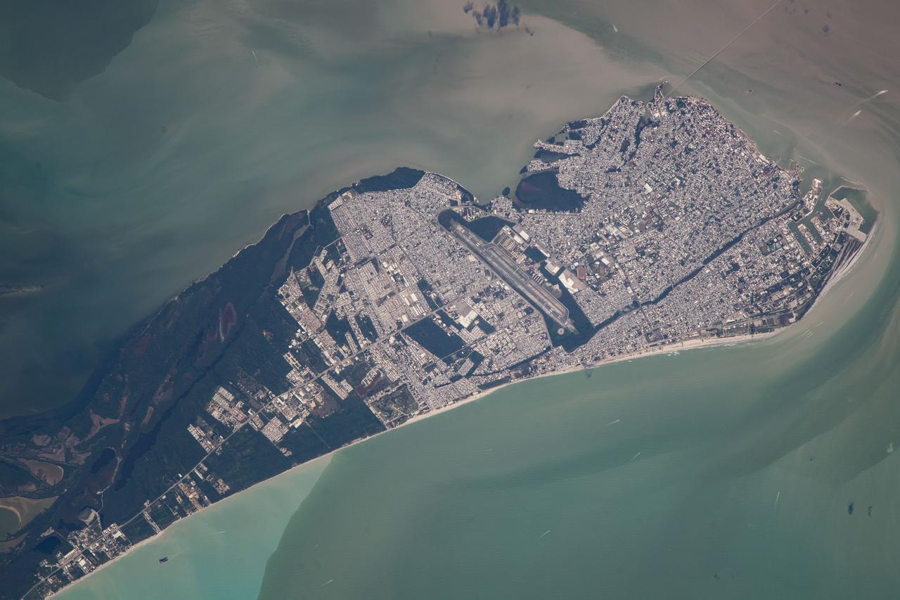
iss070e080020 (Jan. 23, 2024) --- Ciudad del Carmen, a city in the Mexican state of Campeche on the coast of the Gulf of Mexico that has grown from a fishing village to a petroleum and tourism-based economy, is pictured from the International Space Station as it orbited 260 miles above.
Mt. Etna, Italy erupted Tuesday, February 16, 2021, sending rivers of lava down the southeast flank of the volcano, and spewing ashes and volcanic stones over nearby villages. Sicily's Catania Airport was temporarily closed due to an ash plume that rose to 3700 m altitude. The ASTER nighttime thermal infrared data shows the extent of the active lava flows, draped over an older Google Earth image. The image was acquired February 17, 2021, covers an area of 38 by 39 km, and is located at 37.8 degrees north, 15 degrees east. https://photojournal.jpl.nasa.gov/catalog/PIA24417
On Nov. 5, 2015, a dam at an iron-ore mine in southeastern Brazil burst, sending a wall of water, clay-red mud and debris downstream, overwhelming several villages in the path as seen by NASA Terra spacecraft. The Germano mine is near the town of Mariana in Minas Gerais state. The region is seen in this image from the Advanced Spaceborne Thermal Emission and Reflection Radiometer (ASTER) instrument aboard NASA's Terra spacecraft was acquired Nov. 12, 2015, covers an area of 6.8 by 14.3 miles (11 by 23 kilometers), and is located at 20.2 degrees south, 43.5 degrees west. http://photojournal.jpl.nasa.gov/catalog/PIA20156
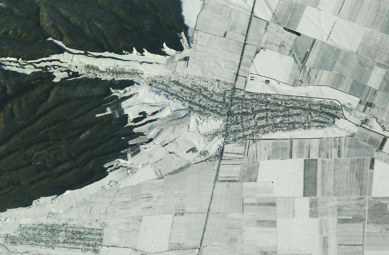
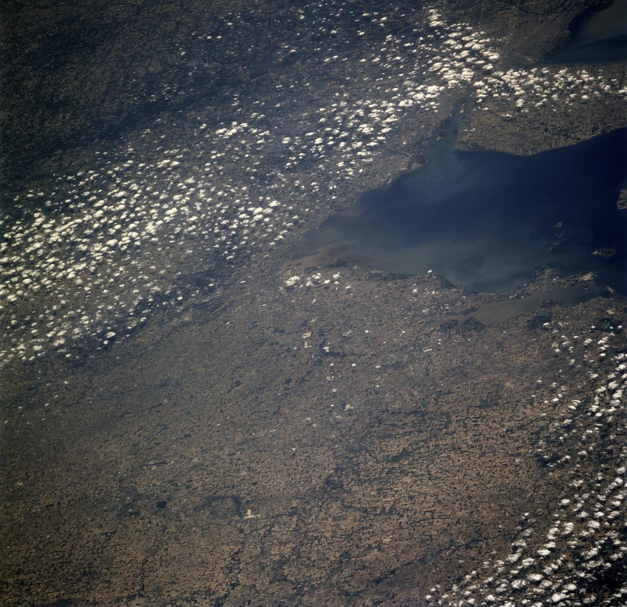
ISS008-E-09603 (20 December 2003) --- The village of Argudan near the north slopes of the Greater Caucasus Mountains in Russia is featured in this photo taken by an Expedition 8 crewmember onboard the International Space Station (ISS). The striking land use pattern, seen through a high magnification lens and highlighted by winter snow and low sun angles, produces this unique view. This rural, agricultural community sits astride the main highway about 15 kilometers east-southeast of the city of Nalchik. Shadows from a line of trees planted as a windbreak near the highway give the road a ragged appearance. A small stream flowing northeastward exits heavily forested foothills through the village and fields of intensely cultivated croplands on the plains. Snow falls through the vegetation, making the woodlands appear extremely dark compared to the snow-covered fields.

KENNEDY SPACE CENTER, FLA. -- Evelyn Husband, wife of STS-107 Commander Rick Husband, visits a new residence hall at the Florida Institute of Technology (FIT) in Melbourne, Fla., named for her late husband. Family members of the STS-107 astronauts, other dignitaries, members of the university community and the public gathered for a dedication ceremony for the Columbia Village at FIT. Each of the seven new residence halls in the complex is named for one of the STS-107 astronauts who perished during the Columbia accident -- Rick Husband, Willie McCool, Laurel Clark, Michael Anderson, David Brown, Kalpana Chawla, and Ilan Ramon.

KENNEDY SPACE CENTER, FLA. -- Dr. Jonathan Clark, husband of STS-107 astronaut Laurel Clark, addresses the family members of the STS-107 astronauts, other dignitaries, members of the university community and the public gathered for the dedication ceremony of the Columbia Village at the Florida Institute of Technology in Melbourne, Fla. Each of the seven new residence halls in the complex is named for one of the STS-107 astronauts who perished during the Columbia accident -- Rick Husband, Willie McCool, Laurel Clark, Michael Anderson, David Brown, Kalpana Chawla, and Ilan Ramon.

KENNEDY SPACE CENTER, FLA. - Dr. Anthony J. Catanese, president of the Florida Institute of Technology in Melbourne, Fla., delivers the opening remarks at the university's Columbia Village dedication ceremony. The event is attended by family members of the STS-107 astronauts, other dignitaries, members of the university community and the public. Each of the seven new residence halls in the complex is named for one of the STS-107 astronauts who perished during the Columbia accident -- Rick Husband, Willie McCool, Laurel Clark, Michael Anderson, David Brown, Kalpana Chawla, and Ilan Ramon.

KENNEDY SPACE CENTER, FLA. -- Sandra Anderson, wife of STS-107 Payload Commander Michael Anderson, visits a new residence hall at the Florida Institute of Technology (FIT) in Melbourne, Fla., named for her late husband. Family members of the STS-107 astronauts, other dignitaries, members of the university community and the public gathered for a dedication ceremony for the Columbia Village at FIT. Each of the seven new residence halls in the complex is named for one of the STS-107 astronauts who perished during the Columbia accident -- Rick Husband, Willie McCool, Laurel Clark, Michael Anderson, David Brown, Kalpana Chawla, and Ilan Ramon.

KENNEDY SPACE CENTER, FLA. -- Lani McCool (back row, left), wife of STS-107 Pilot Willie McCool, accompanied by their children and other family members, visits a new residence hall at the Florida Institute of Technology (FIT) in Melbourne, Fla., named for her late husband. Family members of the STS-107 astronauts, other dignitaries, members of the university community and the public gathered for a dedication ceremony for the Columbia Village at FIT. Each of the seven new residence halls in the complex is named for one of the STS-107 astronauts who perished during the Columbia accident -- Rick Husband, Willie McCool, Laurel Clark, Michael Anderson, David Brown, Kalpana Chawla, and Ilan Ramon.

KENNEDY SPACE CENTER, FLA. -- Dr. Jonathan Clark (right), husband of STS-107 Mission Specialist Laurel Clark, and their son (left) visit a new residence hall at the Florida Institute of Technology (FIT) in Melbourne, Fla., named for his late wife. Family members of the STS-107 astronauts, other dignitaries, members of the university community and the public gathered for a dedication ceremony for the Columbia Village at FIT. Each of the seven new residence halls in the complex is named for one of the STS-107 astronauts who perished during the Columbia accident -- Rick Husband, Willie McCool, Laurel Clark, Michael Anderson, David Brown, Kalpana Chawla, and Ilan Ramon.

KENNEDY SPACE CENTER, FLA. -- Rona Ramon, wife of STS-107 Payload Specialist Ilan Ramon, visits a new residence hall at the Florida Institute of Technology (FIT) in Melbourne, Fla., named for her late husband. Family members of the STS-107 astronauts, other dignitaries, members of the university community and the public gathered for a dedication ceremony for the Columbia Village at FIT. Each of the seven new residence halls in the complex is named for one of the STS-107 astronauts who perished during the Columbia accident -- Rick Husband, Willie McCool, Laurel Clark, Michael Anderson, David Brown, Kalpana Chawla, and Ilan Ramon.
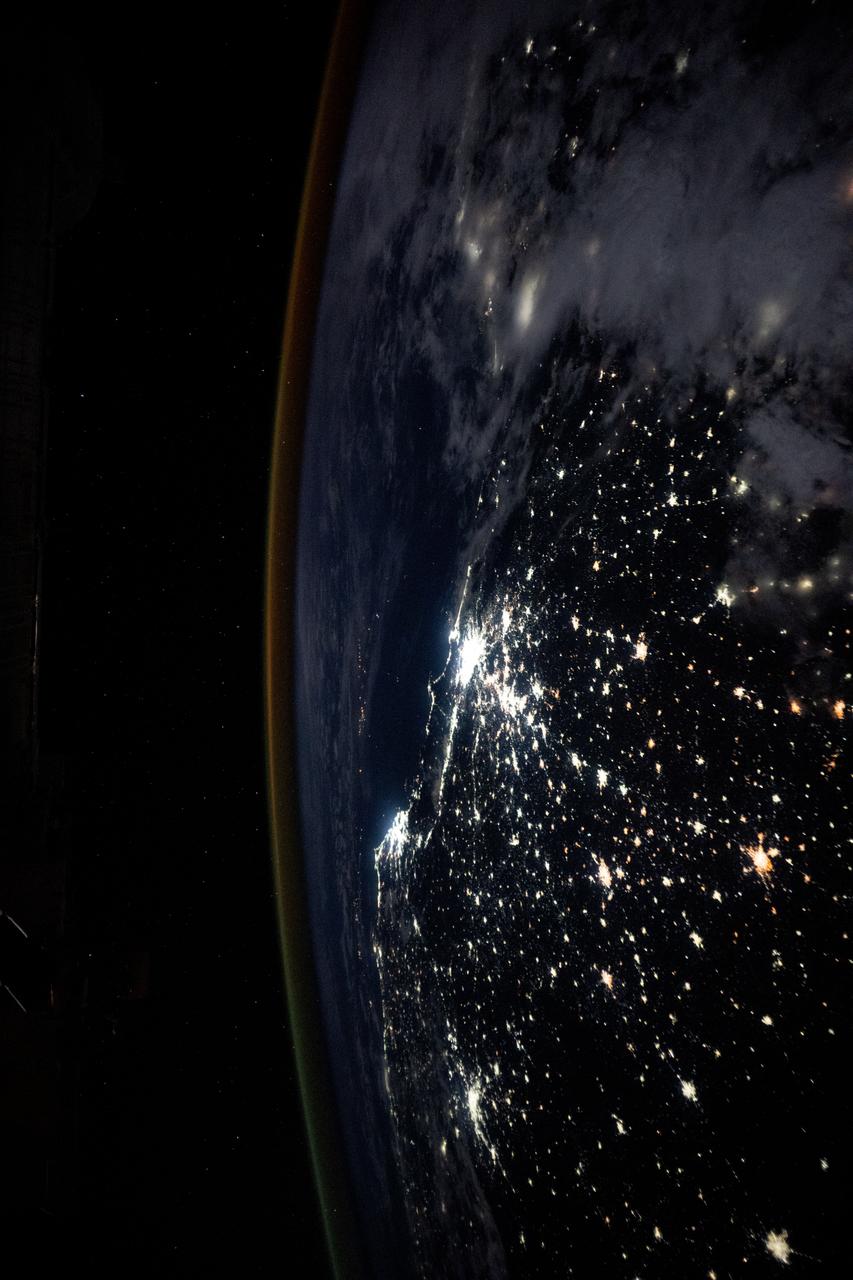
iss073e0124971 (May 19, 2025) --- The Brazilian coast on the Atlantic Ocean is lit by the nation's two largest cities of Rio de Janiero and São Paulo surrounded by its suburbs and numerous inland towns and villages. The International Space Station was orbiting 263 miles above Brazil at approximately 3:52 a.m. local time when this photograph was taken.
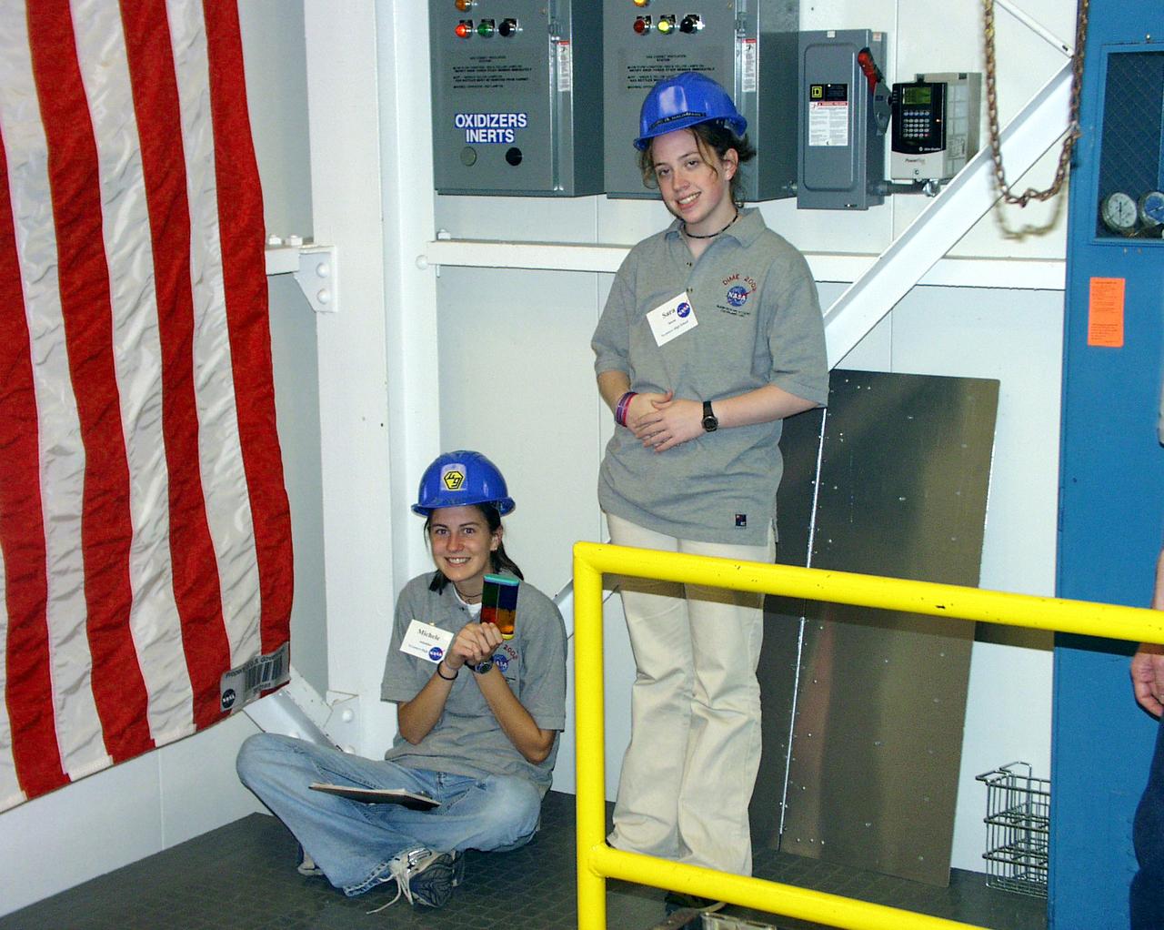
Students pause while waiting their turn at the 2.2-second Drop Tower during the second Dropping in a Microgravity Environment (DIME) competition held April 23-25, 2002, at NASA's Glenn Research Center. Competitors included two teams from Sycamore High School, Cincinnati, OH, and one each from Bay High School, Bay Village, OH, and COSI Academy, Columbus, OH. DIME is part of NASA's education and outreach activities. Details are on line at http://microgravity.grc.nasa.gov/DIME_2002.html.

Students prepare their experiment apparatus for free-fall during the second Dropping in a Microgravity Environment (DIME) competition held April 23-25, 2002, at NASA's Glenn Research Center. Competitors included two teams from Sycamore High School, Cincinnati, OH, and one each from Bay High School, Bay Village, OH, and COSI Academy, Columbus, OH. DIME is part of NASA's education and outreach activities. Details are on line at http://microgravity.grc.nasa.gov/DIME_2002.html.

Students prepare to load fluids in their experiment apparatus during the Dropping In a Microgravity Environment (DIME) competition held April 23-25, 2002, at NASA's Glenn Research Center. Competitors included two teams from Sycamore High School, Cincinnati, OH, and one each from Bay High School, Bay Village, OH, and COSI Academy, Columbus, OH. DIME is part of NASA's education and outreach activities. Details are on line at http://microgravity.grc.nasa.gov/DIME_2002.html.
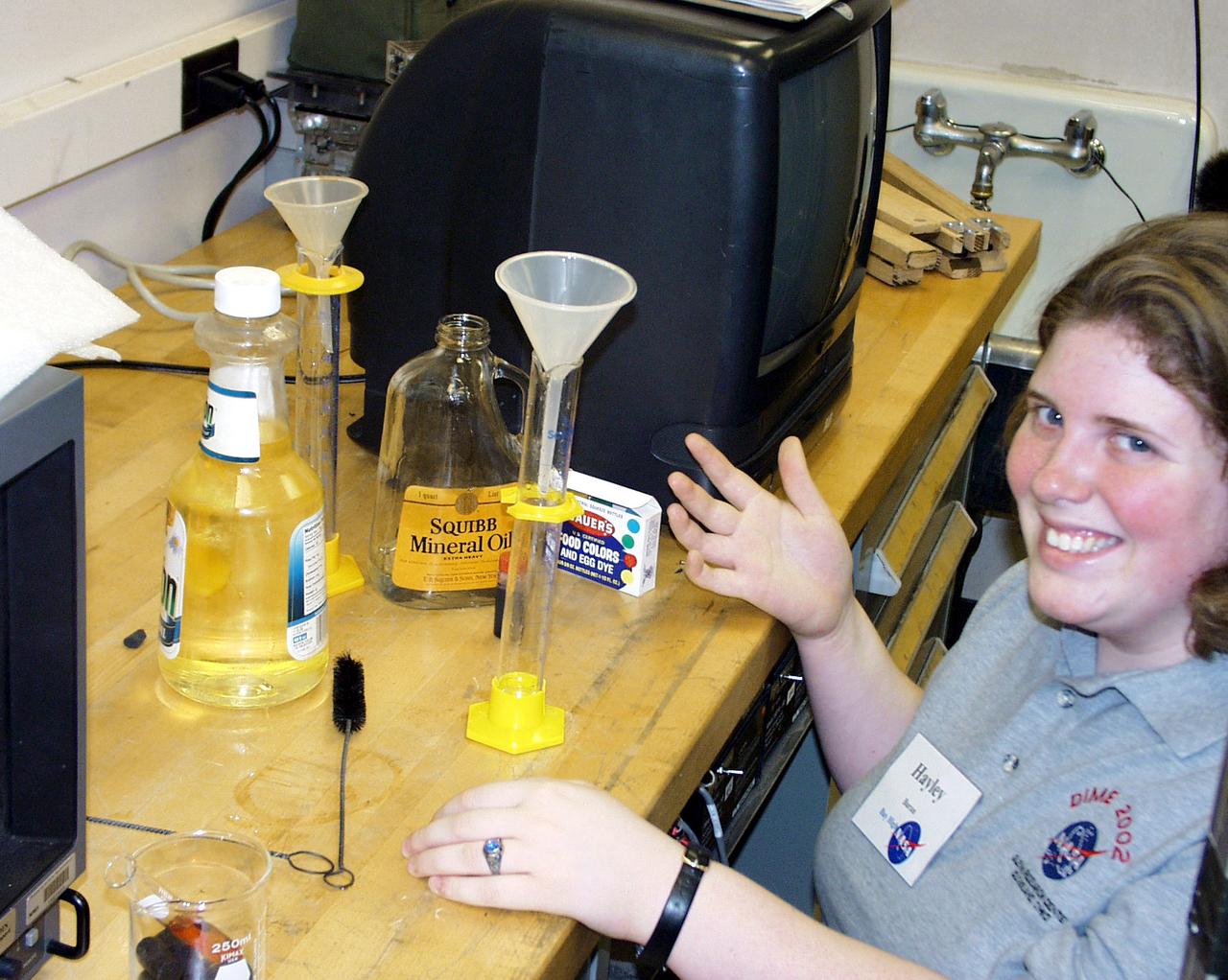
A Bay High School team member prepares the oil and water samples for their next drop operation as part of the second Dropping in a Microgravity Environment (DIME) competition held April 23-25, 2002, at NASA's Glenn Research Center. Competitors included two teams from Sycamore High School, Cincinnati, OH, and one each from Bay High School, Bay Village, OH, and COSI Academy, Columbus, OH. DIME is part of NASA's education and outreach activities. Details are on line at http://microgravity.grc.nasa.gov/DIME_2002.html.

A NASA test conductor at the top of the 2.2-second Drop Tower monitors a student lecture at a lower level. This was part of the Microgravity Environment (DIME) competition held April 23-25, 2002, at NASA's Glenn Research Center. Competitors included two teams from Sycamore High School, Cincinnati, OH, and one each from Bay High School, Bay Village, OH, and COSI Academy, Columbus, OH. DIME is part of NASA's education and outreach activities. Details are on line at http://microgravity.grc.nasa.gov/DIME_2002.html.

Students discuss fine points of their final design for the Drop Tower experiment during the second Dropping in a Microgravity Environment (DIME) competition held April 23-25, 2002, at NASA's Glenn Research Center. Competitors included two teams from Sycamore High School, Cincinnati, OH, and one each from Bay High School, Bay Village, OH, and COSI Academy, Columbus, OH. DIME is part of NASA's education and outreach activities. Details are on line at http://microgravity.grc.nasa.gov/DIME_2002.html.

A student assembles a Lego (TM) Challenge device designed to operate in the portable drop tower demonstrator as part of the second Dropping in a Microgravity Environment (DIME) competition held April 23-25, 2002, at NASA's Glenn Research Center. Competitors included two teams from Sycamore High School, Cincinnati, OH, and one each from Bay High School, Bay Village, OH, and COSI Academy, Columbus, OH. DIME is part of NASA's education and outreach activities. Details are on line at http://microgravity.grc.nasa.gov/DIME_2002.html.
The northwest-southeast trending, snow-covered, linear mountain range is the King Ata Tag Mountain, located in extreme western most China. Highest peaks are just over 20,100 feet above sea level. The town or village of Muji is located in the largest river valley that is south of this range of mountains. This area includes part of the country of Tajikistan. The center point of the photo is approximately 39.30 degrees north and 74.30 degrees easth.

Students discuss fine points of their final design for the drop tower experiment during the second Dropping in a Microgravity Environment (DIME) competition held April 23-25, 2002, at NASA's Glenn Research Center. Competitors included two teams from Sycamore High School, Cincinnati, OH, and one each from Bay High School, Bay Village, OH, and COSI Academy, Columbus, OH. DIME is part of NASA's education and outreach activities. Details are on line at http://microgravity.grc.nasa.gov/DIME_2002.html.
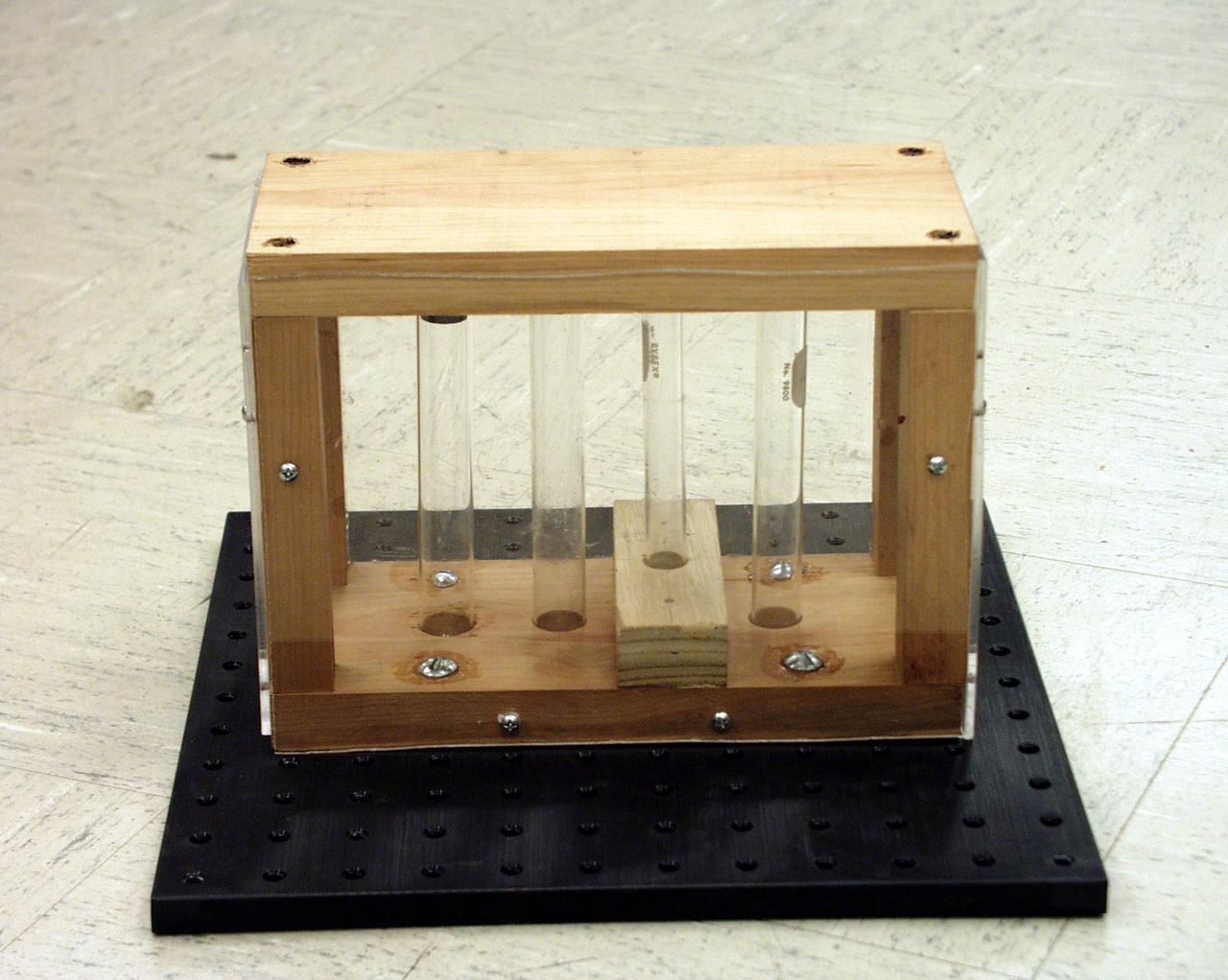
Test tubes to hold different types of fluids while in free-fall were among the student-designed items for the second Dropping in a Microgravity Environment (DIME) competition held April 23-25, 2002, at NASA's Glenn Research Center. Competitors included two teams from Sycamore High School, Cincinnati, OH, and one each from Bay High School, Bay Village, OH, and COSI Academy, Columbus, OH. DIME is part of NASA's education and outreach activities. Details are on line at http://microgravity.grc.nasa.gov/DIME_2002.html.
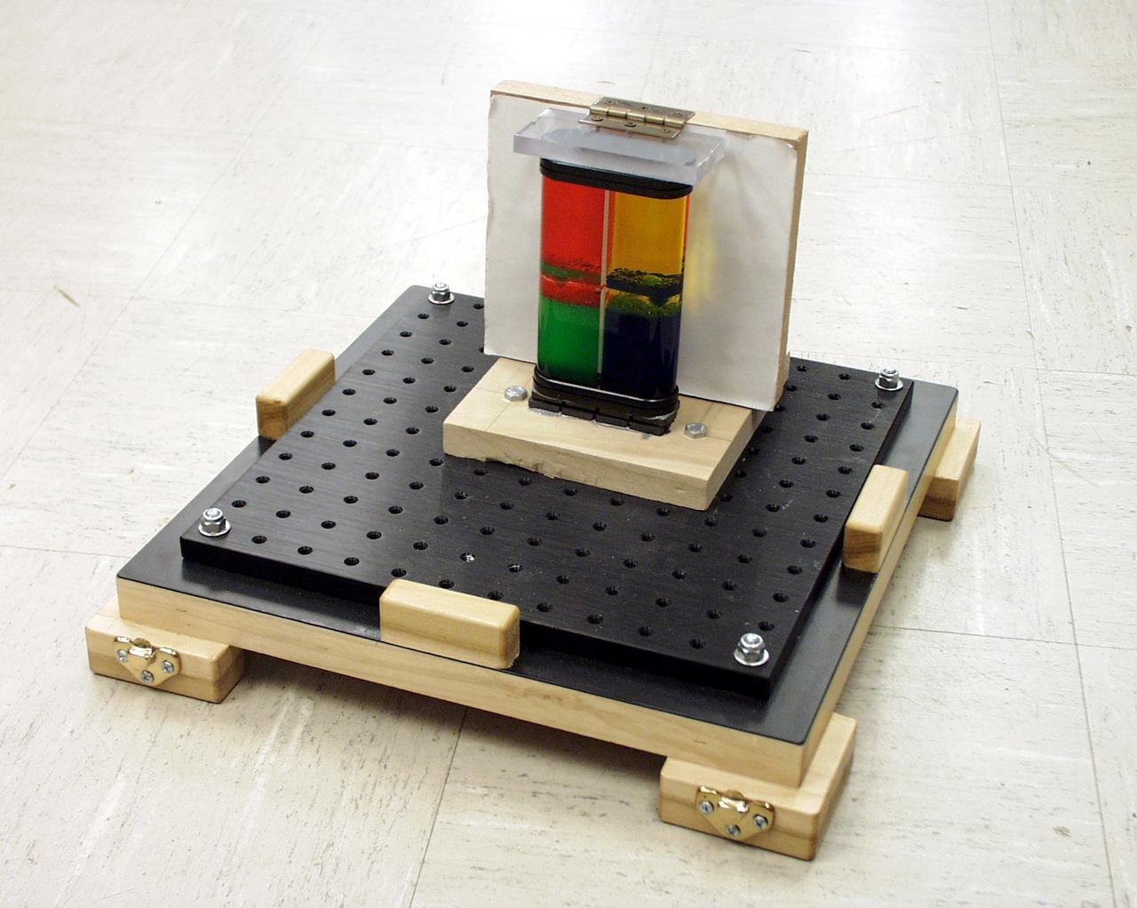
Colored oil flow toy was part of a student-designed apparatus used in the second Dropping in a Microgravity Environment (DIME) competition held April 23-25, 2002, at NASA's Glenn Research Center. Competitors included two teams from Sycamore High School, Cincinnati, OH, and one each from Bay High School, Bay Village, OH, and COSI Academy, Columbus, OH. DIME is part of NASA's education and outreach activities. Details are on line at http://microgravity.grc.nasa.gov/DIME_2002.html.
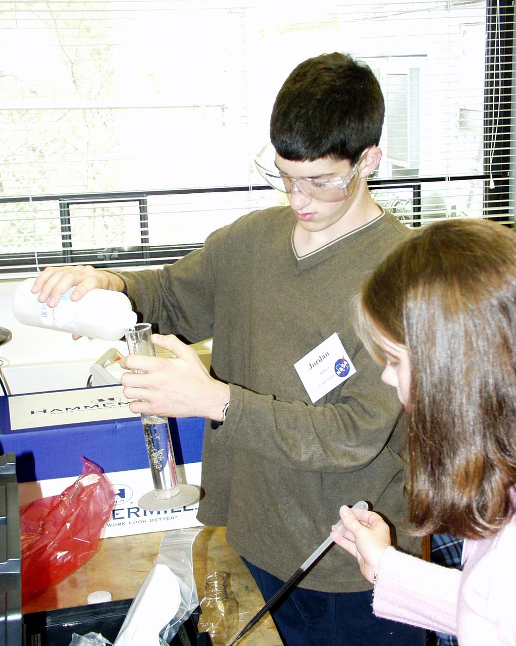
Students prepare to load fluids in their experiment apparatus during the Microgravity Environment (DIME) competition held April 23-25, 2002, at NASA's Glenn Research Center. Competitors included two teams from Sycamore High School, Cincinnati, OH, and one each from Bay High School, Bay Village, OH, and COSI Academy, Columbus, OH. DIME is part of NASA's education and outreach activities. Details are on line at http://microgravity.grc.nasa.gov/DIME_2002.html.
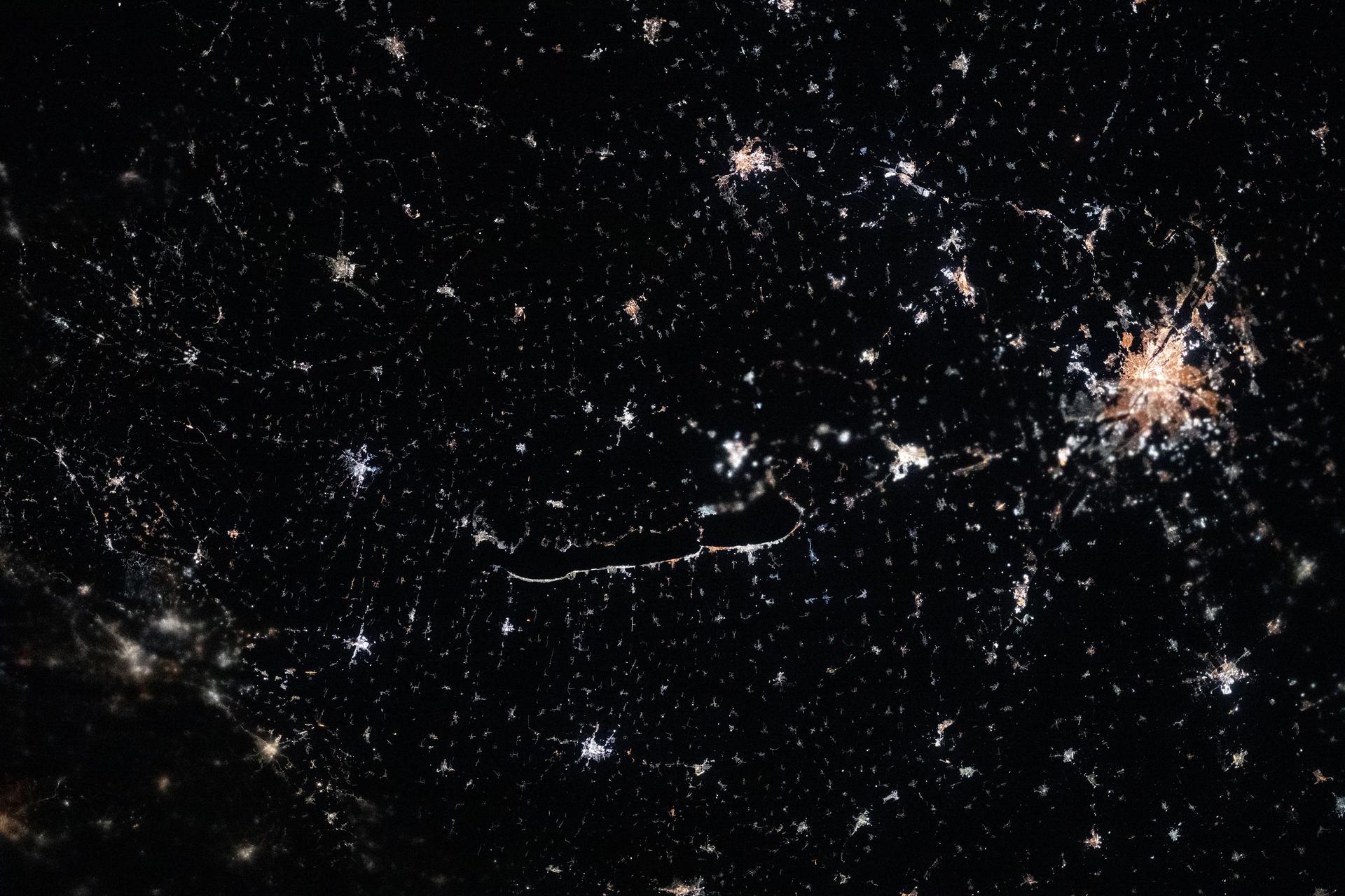
iss074e0149554 (Jan. 18, 2026) --- The city lights of Budapest (right) dominate the nightscape of Hungary, which is dotted with small, picturesque villages. At the center of the frame, lies Lake Balaton—Central Europe’s largest lake—surrounded by volcanic hills, vineyards, historic churches, and traditional settlements. The International Space Station was orbiting 262 miles above the region at approximately 9:10 p.m. local time when this photograph was taken. Credit: NASA/Chris Williams

iss074e0149548 (Jan. 18, 2026) --- Vienna, Austria, and Bratislava, Slovakia, light up the Central European nightscape, each divided by the Danube River. Surrounding the two capital cities are wine‑country towns and historic market villages that dot the landscape. The International Space Station was orbiting 262 miles above Earth at approximately 9:09 p.m. local time when this photograph was taken. Credit: NASA/Chris Williams
Student-designed and -built apparatus for the second Dropping in a Microgravity Environment (DIME) competition held April 23-25, 2002, at NASA's Glenn Research Center. Competitors included two teams from Sycamore High School, Cincinnati, OH, and one each from Bay High School, Bay Village, OH, and COSI Academy, Columbus, OH. DIME is part of NASA's education and outreach activities. Details are on line at http://microgravity.grc.nasa.gov/DIME_2002.html.
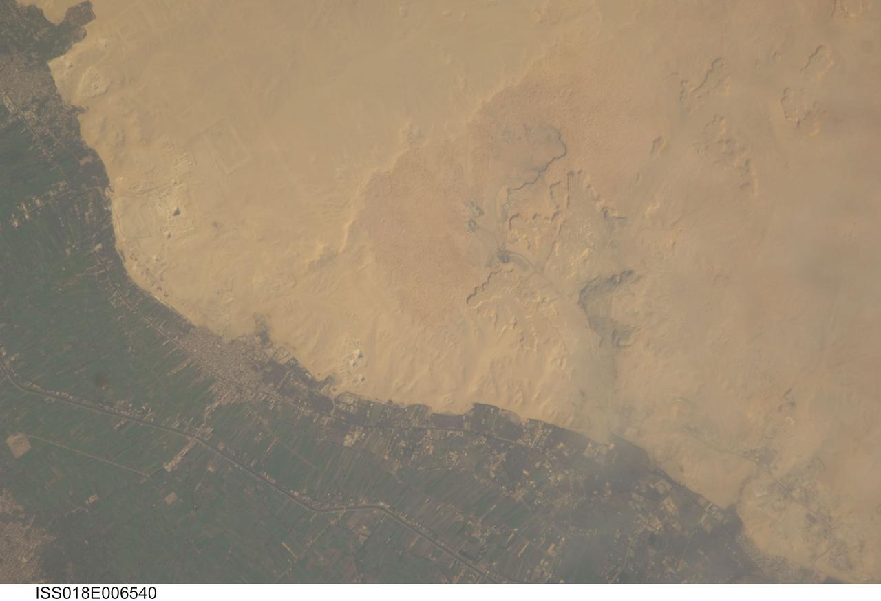
ISS018-E-006540 (31 Oct. 2008) --- Cities of the Dead and the Nile River Delta in Egypt are featured in this image photographed by an Expedition 18 crewmember on the International Space Station. The ancient pharaohs (kings) and queens of Egypt established several royal cemeteries, or necropoli (cities of the dead) along the Nile River valley. On the western bank, these cities of the dead were built on a gravelly desert plateau formed of limestone and clay overlooking the river -- several scarps are visible at upper right. The most widely recognized features of royal Egyptian necropoli are pyramids, which frequently served as both tombs and monuments for their occupants. This detailed photograph illustrates a portion of the Nile Delta that includes two royal cemetery complexes, Abusir and Saqqara-North. The present day village of Abusir is clearly visible as a grey-white irregular patch of urban materials that contrasts with adjacent green agricultural fields of the Delta and tan desert sands and gravels to the west. The historical necropolis of Abusir is located to the northwest of the village at bottom center. Three pyramids are readily visible in the image, all built by kings of the 5th Dynasty (2465--2323 BC): Sahure, Niuserre and Neferirkare. The site of Abusir was likely chosen due to the existence of a lake -- now dry -- that facilitated transport of building materials for the pyramids and other structures. The northern portion of the large necropolis of Saqqara is also visible to the south-southwest of the village of Abusir. The largest pyramid in this complex is that of Djoser, a king of the 3rd Dynasty (2650--2575 BC). Other readily visible pyramids include that of Userkaf (5th Dynasty) and Teti (6th Dynasty: 2323--2150 BC), attesting to the long history of use of the Saqqara necropolis.
ISS033-E-022759 (18 Nov. 2012) --- Agricultural fields under snow in easternmost China are featured in this image photographed by an Expedition 33 crew member on the International Space Station. This photograph highlights many hundreds of rectangular fields on either side of a 36-kilometer stretch of the braided Songhua River (right). Some fields are easier to see than others due to the winter snow cover. The Songhua joins with the Amur R. about 40 kilometers downstream, at the border with Russia?s Far East. Numerous villages also appear as small gray polygons. Broad floodplains can be recognized on both sides of the river, occupied by fewer fields by almost no villages. The town of Suibing stands out as a larger gray patch on the banks of the river. A significant 300-meter-high hill south of the river throws midmorning shadows (left). The region is one of the most heavily cultivated in northeastern China with corn, soybeans, and sorghum being major crops. The areas of varying whiteness of the snow cover may correlate with zones of different crops and forest cover (for example, on the hill in the center part of the image). The degree to which fallow fields are cleared of vegetation may also affect the apparent snow brightness.
Two of Guatemala's active volcanoes, Fuego (upper left) and Pacaya (lower right) were erupting when the ASTER nighttime thermal infrared image was acquired on March 5, 2021. Pacaya's most recent eruption began Wednesday, with several lava flows and ash eruptions; surrounding villages were ordered evacuated. Since mid-February, Fuego continued to produce sporadic emissions of ash from its active central crater. In the ASTER image, the hottest areas are white, and coldest are black. The image covers an area of 29.8 by 40.3 km, and is centered at 14.4 degrees north, 90.8 degrees west. https://photojournal.jpl.nasa.gov/catalog/PIA24419

Students from the four teams pose in front of he NASA Glenn Administration Building alongside the NASA Glenn Time Capsule. The students participated in the second Dropping in a Microgravity Environment (DIME) competition held April 23-25, 2002, at NASA's Glenn Research Center. Competitors included two teams from Sycamore High School, Cincinnati, OH, and one each from Bay High School, Bay Village, OH, and COSI Academy, Columbus, OH. DIME is part of NASA's education and outreach activities. Details are on line at http://microgravity.grc.nasa.gov/DIME_2002.html.
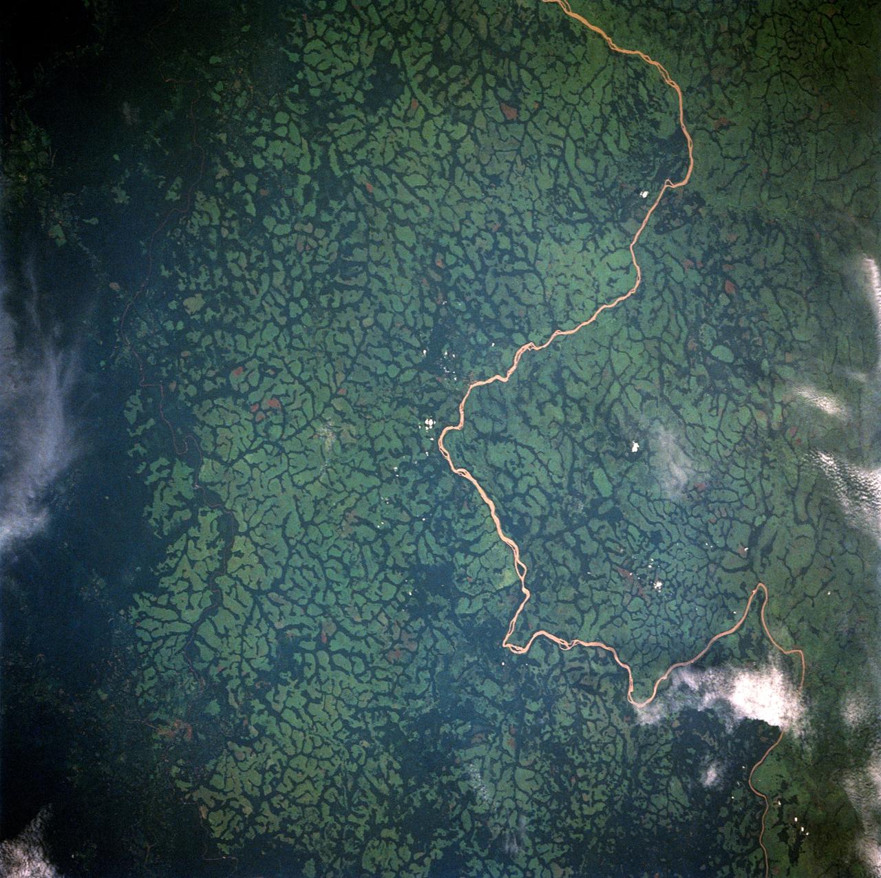
STS049-91-079 (7 - 16 May 1992) --- This 70mm frame, photographed from the Earth-orbiting Space Shuttle Endeavour, features a dendritic drainage pattern in Zaire. Cleared pasture land shows light green in this color photograph, in contrast to the dark, closed-canopy forest of Zaire. Remnant woodland along minor streams indicates the intricate drainage network of this hilly region. Scattered vegetation-free spots show the deep red, tropical soil of the region. The sediment-laden stream is the Vele River just west of the village of Niangara. A crew member used a 70mm handheld Hasselblad camera with a 250mm lens to record the image.

Administrator Bill Nelson and GRC Center director Jimmy walk through NASA village. NASA Glenn Research Center and the Great Lakes Science Center hosted a three-day celestial celebration in downtown Cleveland, OH. This free, outdoor, family-friendly science and arts festival will feature free concerts, performances, speakers, and hands-on science activities with community partners. A total solar eclipse swept across a narrow portion of the North American continent from Mexico’s Pacific coast to the Atlantic coast of Newfoundland, Canada. A partial solar eclipse was visible across the entire North American continent along with parts of Central America and Europe.

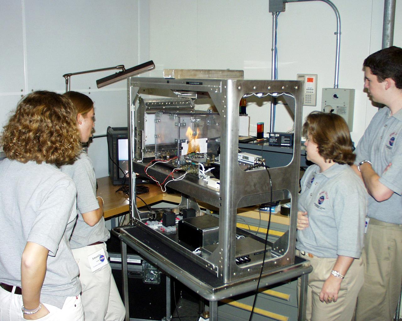
Interior of a combustion experiment apparatus used in the 2.2-second drop tower at NASA's Glenn Research Center. This was shown to students participating in the second Dropping in a Microgravity Environment (DIME) competition held April 23-25, 2002, at NASA's Glenn Research Center. Competitors included two teams from Sycamore High School, Cincinnati, OH, and one each from Bay High School, Bay Village, OH, and COSI Academy, Columbus, OH. DIME is part of NASA's education and outreach activities. Details are on line at http://microgravity.grc.nasa.gov/DIME_2002.html.
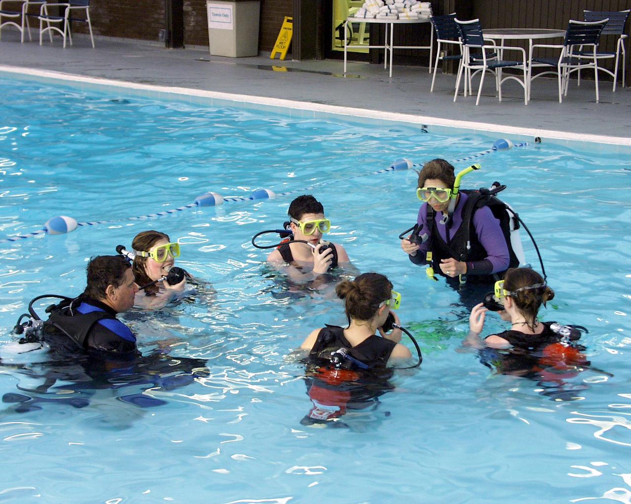
In addition to drop tower activities, students assembled a plastic pipe structure underwater in a SCUBA exercise similar to training astronauts receive at NASA Johnson Space Center. This was part of the second Dropping in a Microgravity Environment (DIME) competition held April 23-25, 2002, at NASA's Glenn Research Center. Competitors included two teams from Sycamore High School, Cincinnati, OH, and one each from Bay High School, Bay Village, OH, and COSI Academy, Columbus, OH. DIME is part of NASA's education and outreach activities. Details are on line at http://microgravity.grc.nasa.gov/DIME_2002.html.
Mt. Etna, Italy erupted February 17, 2021, sending rivers of lave down the southeast flank of the volcano, and spewing ashes and volcanic stones over nearby villages. Sicily's Catania Airport was temporarily closed due to an ash plume that rose to 3700 m altitude. By the following week, the eruption had waned. The ASTER visible image shows the extent of the active lava flows (derived from the thermal infrared data). The image was acquired February 26, 2021, covers an area of 25.5 by 27.0 km, and is located at 37.8 degrees north, 15 degrees east. https://photojournal.jpl.nasa.gov/catalog/PIA24418
STS054-152-189 (13-19 Jan. 1993) --- This near-vertical color photograph shows the very diverse landscape that is part of the great Sahara Desert of north Africa. Specifically, the vast expanse of sand dunes, located in the extreme southwestern corner of Libya, is known as the Murzuk Sand Sea. Close inspection of this photograph shows the agricultural village of Murzuk as evidenced by the numerous center pivot irrigation patterns at the edge of the Murzuk Sand Sea. The very rugged, dissected terrain to the west of this sand sea is the eastern tip of the Tassili N'ajjer Mountains and the Tadrart Plateau that are in neighboring Algeria. Several smaller areas of sand dunes are interspersed between the major areas of rock outcrops. The photograph was taken with a Linhof camera.
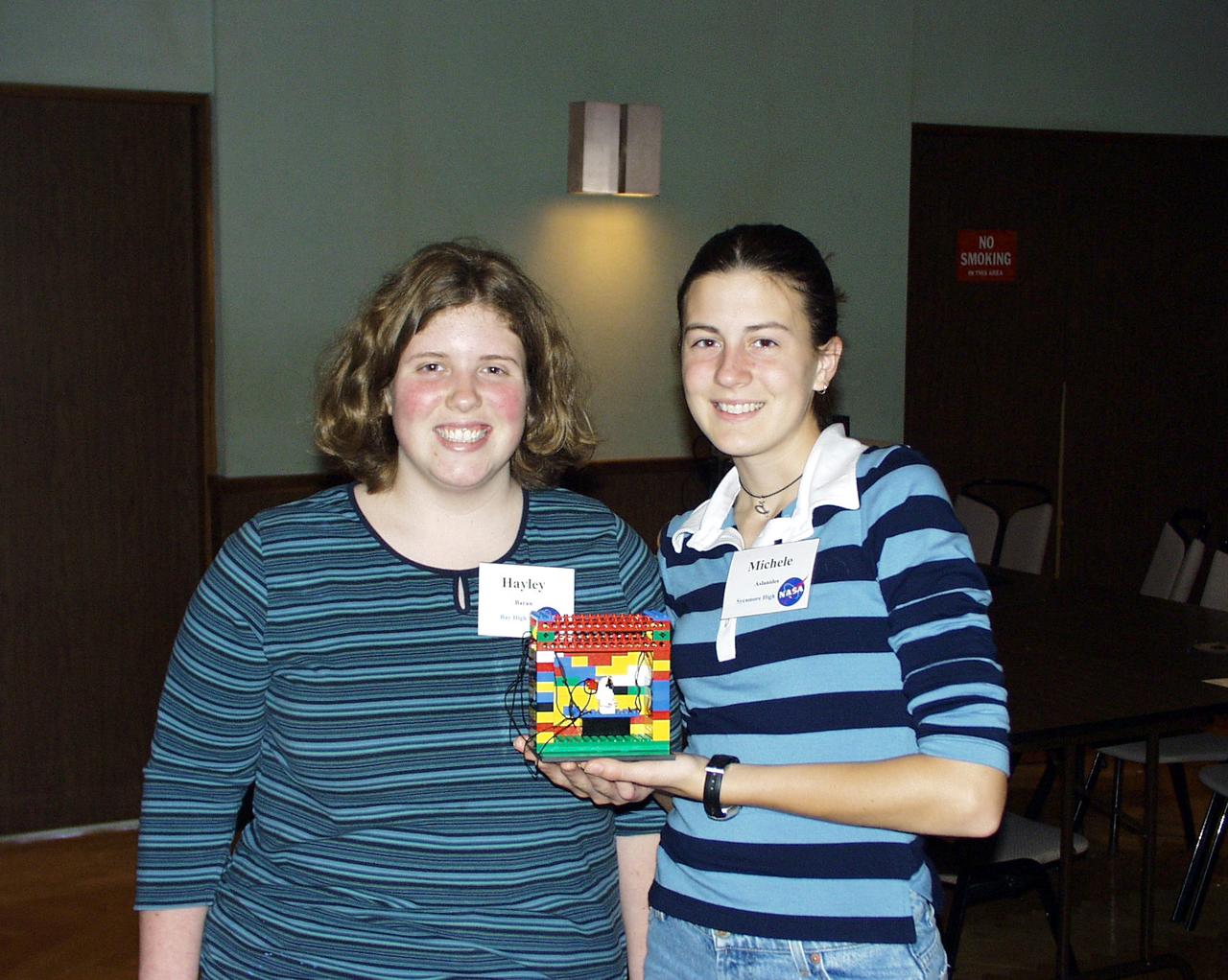
Two students show the Lego (TM) Challenge device they designed and built to operate in the portable drop tower demonstrator as part of the second Dropping in a Microgravity Environment (DIME) competition held April 23-25, 2002, at NASA's Glenn Research Center. Competitors included two teams from Sycamore High School, Cincinnati, OH, and one each from Bay High School, Bay Village, OH, and COSI Academy, Columbus, OH. DIME is part of NASA's education and outreach activities. Details are on line at http://microgravity.grc.nasa.gov/DIME_2002.html.
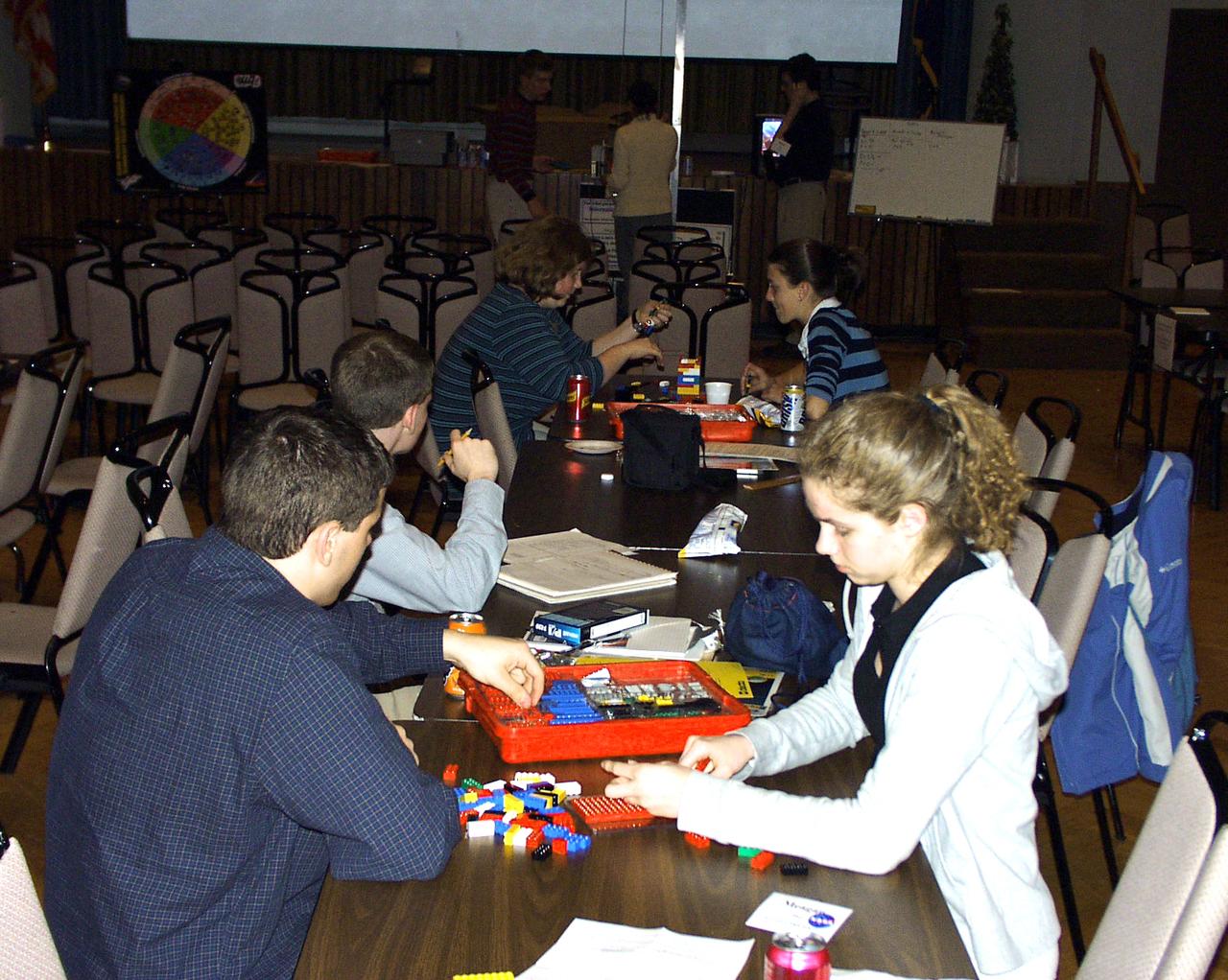
Members from all four teams were mixed into pairs to work on a Lego (TM) Challenge device to operate in the portable drop tower demonstrator (background). These two team members are about to try out their LEGO (TM) creation. This was part of the second Dropping in a Microgravity Environment (DIME) competition held April 23-25, 2002, at NASA's Glenn Research Center. Competitors included two teams from Sycamore High School, Cincinnati, OH, and one each from Bay High School, Bay Village, OH, and COSI Academy, Columbus, OH. DIME is part of NASA's education and outreach activities. Details are on line at http://microgravity.grc.nasa.gov/DIME_2002.html.
Students watch a test run on their experiment before the actual drop. They designed and built their apparatus to fit within a NASA-provided drop structure. This was part of the second Dropping in a Microgravity Environment (DIME) competition held April 23-25, 2002, at NASA's Glenn Research Center. Competitors included two teams from Sycamore High School, Cincinnati, OH, and one each from Bay High School, Bay Village, OH, and COSI Academy, Columbus, OH. DIME is part of NASA's education and outreach activities. Details are on line at http://microgravity.grc.nasa.gov/DIME_2002.html.
STS068-220-033 (30 September-11 October 1994) --- Photographed through the Space Shuttle Endeavour's flight deck windows, this 70mm frame shows a small section of China's Yellow River (Huang Ho) highlighted by sunglint reflection off the surface of the water. The river flows northeastward toward the village of Tung-lin-tzu. The low dissected mountains that cover more than half of this scene rise some 2,000 feet (on the average) above the valley floor. A major east-west transportation corridor (both railway and automobile) is observed traversing the landscape north of the river. This entire region is considered to be part of the Ordos Desert, actually part of the greater Gobi located just north of this area. Approximate center coordinates of this scene are 37.5 degrees north latitude and 105.0 degrees east longitude.
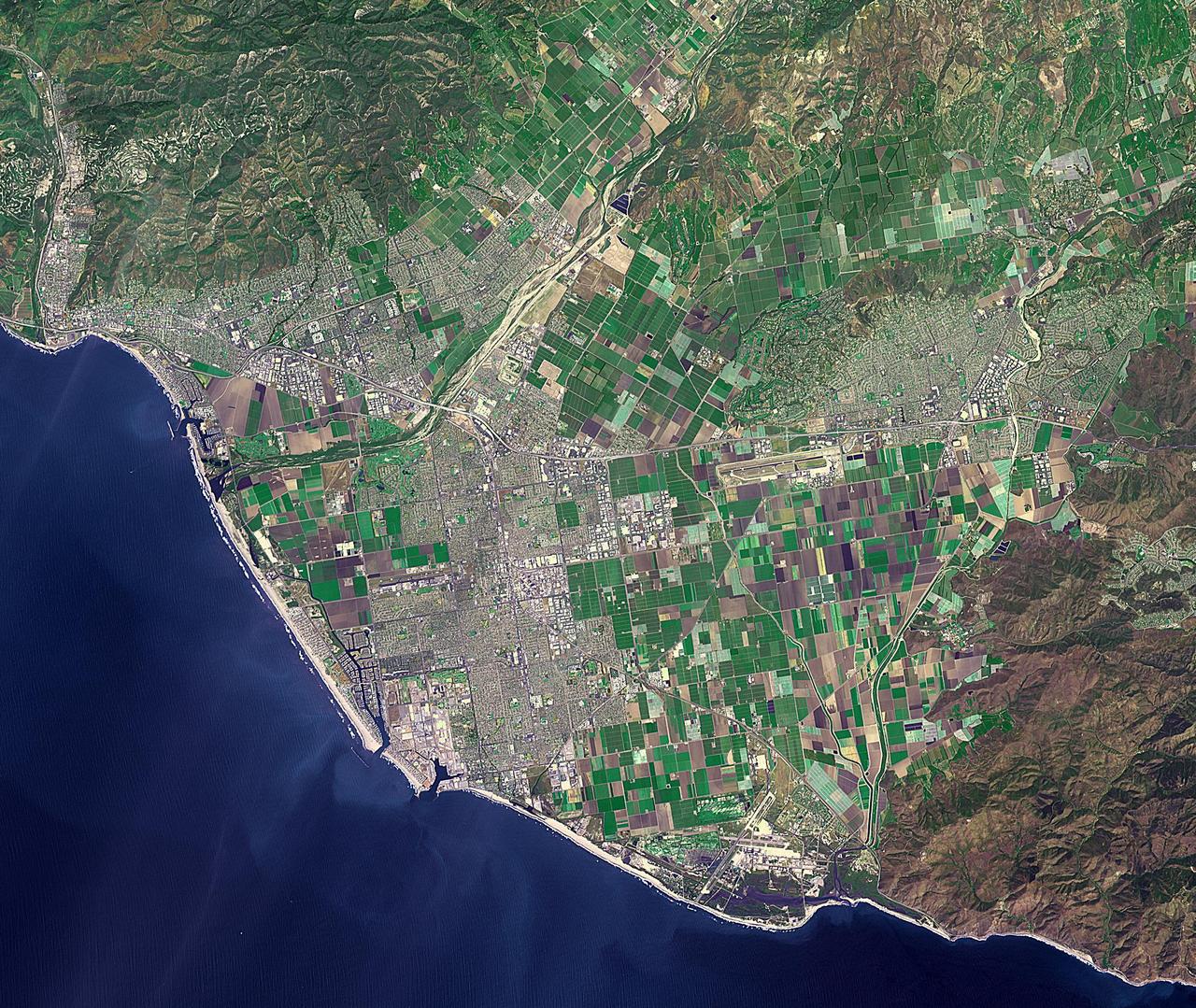
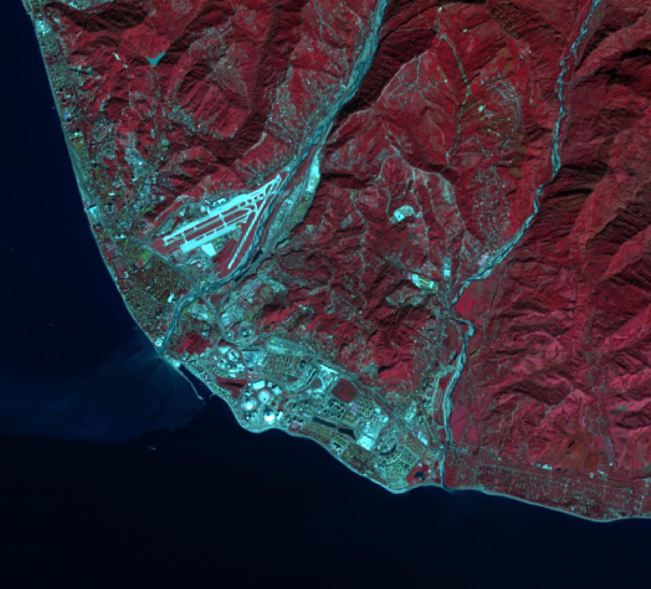
Ventura, California has a coastal site, set against hills and flanked by two rivers. Archaeologists have found remnants of human settlements dating back 10,000 years. When the Spaniards arrived at the end of the 18th century, they found the Chumash people and the Shisholop Village (Wikipedia). In 1782 Junipero Serra founded Mission San Buenaventura. Rich agricultural lands and the more recent discovery of oil led to economic growth. In late 2017, the Thomas Fire spread through the downtown and nearby communities, eventually burning over 270,000 acres. The image was acquired April 27, 2016, covers an area of 28.8 by 34.1 kilometers, and is located at 34.2 degrees north, 119.1 degrees west. https://photojournal.jpl.nasa.gov/catalog/PIA22841
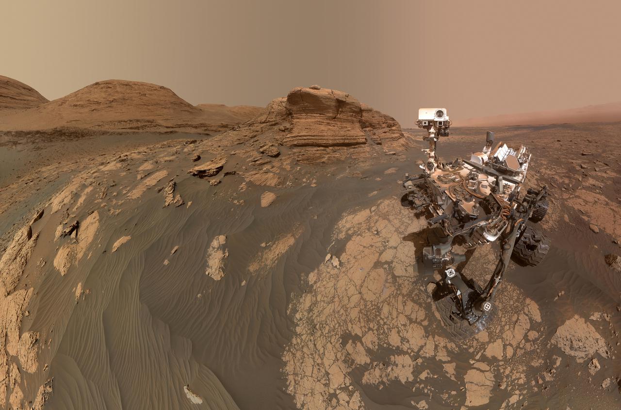
NASA's Curiosity Mars rover used two different cameras to create this selfie in front of Mont Mercou, a rock outcrop that stands 20 feet (6 meters) tall. The panorama is made up of 60 images taken by the Mars Hand Lens Imager (MAHLI) on the rover's robotic arm on March 26, 2021, the 3070th Martian day, or sol, of the mission. These were combined with 11 images taken by the Mastcam on the mast, or "head," of the rover on March 16, 2021, the 3,060th Martian day of the mission. The hole visible to the left of the rover is where its robotic drill sampled a rock nicknamed "Nontron." The Curiosity team is nicknaming features in this part of Mars using names from the region around the village of Nontron in southwestern France. https://photojournal.jpl.nasa.gov/catalog/PIA24543
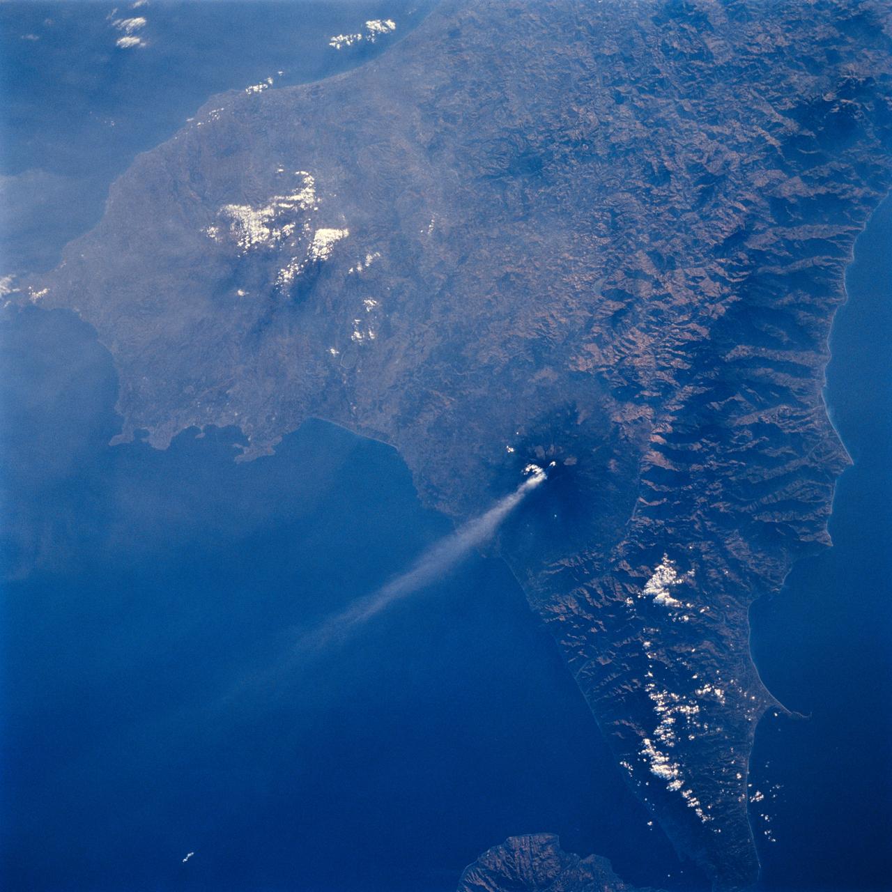
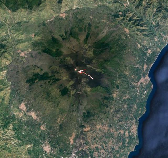
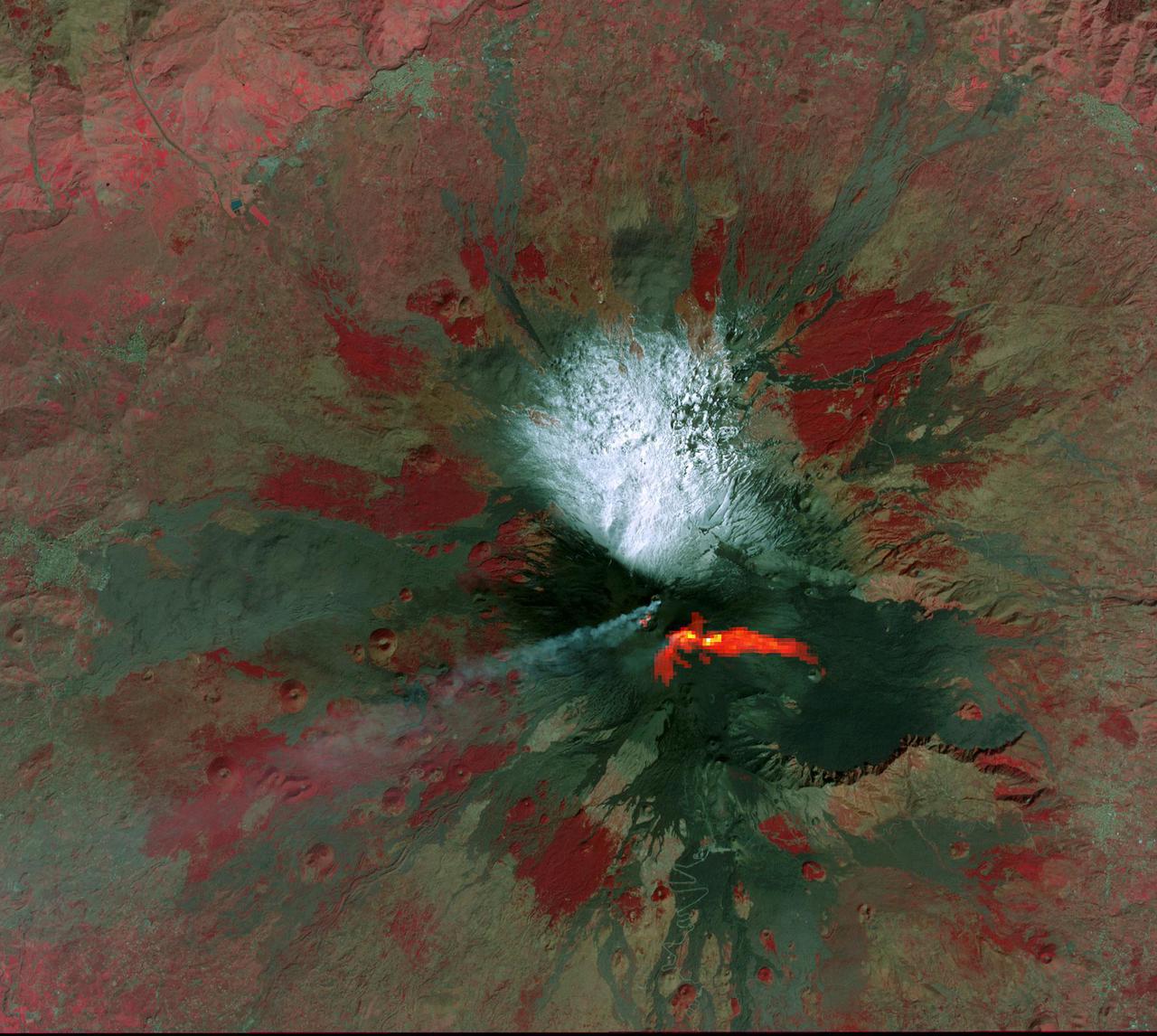
STS064-71-037 (9-20 Sept. 1994) --- Mt. Etna on Sicily displays a steam plume from its summit. Geologists attribute the volcano's existence to the collision of tectonic plates. Unlike the sudden, explosive eruption at Rabaul, Mt. Etna's activity is ongoing and is generally not explosive - Etna's slopes have been settled with villages and cultivated land for centuries. Other Mediterranean volcanoes (like Santorini) have experienced large catastrophic eruptions. Etna recently finished a two-year eruption (ending in 1993), marked by relatively gentle lava flows down the eastern flank. It has been continually degassing since then, according to the geologists, producing an omnipresent steam plume, as seen here. The 1993 flow is difficult to identify in this image because it lies within shadows on the eastern flank, but small cinder cones on the western flank mark earlier episodes of volcanic activity. Photo credit: NASA or National Aeronautics and Space Administration

ISS026-E-029958 (26 Feb. 2011) --- This partial view of the starboard wing of the space shuttle Discovery was provided by an Expedition 26 crew member during a survey of the approaching STS-133 vehicle prior to docking with the International Space Station. As part of the survey and part of every mission's activities, Discovery performed a back-flip for the rendezvous pitch maneuver (RPM). The image was photographed with a digital still camera, using a 400mm lens at a distance of about 600 feet (180 meters). Although at first glance, it appears there is some sort of wire or cord hanging from the shuttle, the curly object is actually 220 miles below and appears to be a portion of the Alto Purus River in southeastern Peru near the village of San Pedro in Ucayali province.
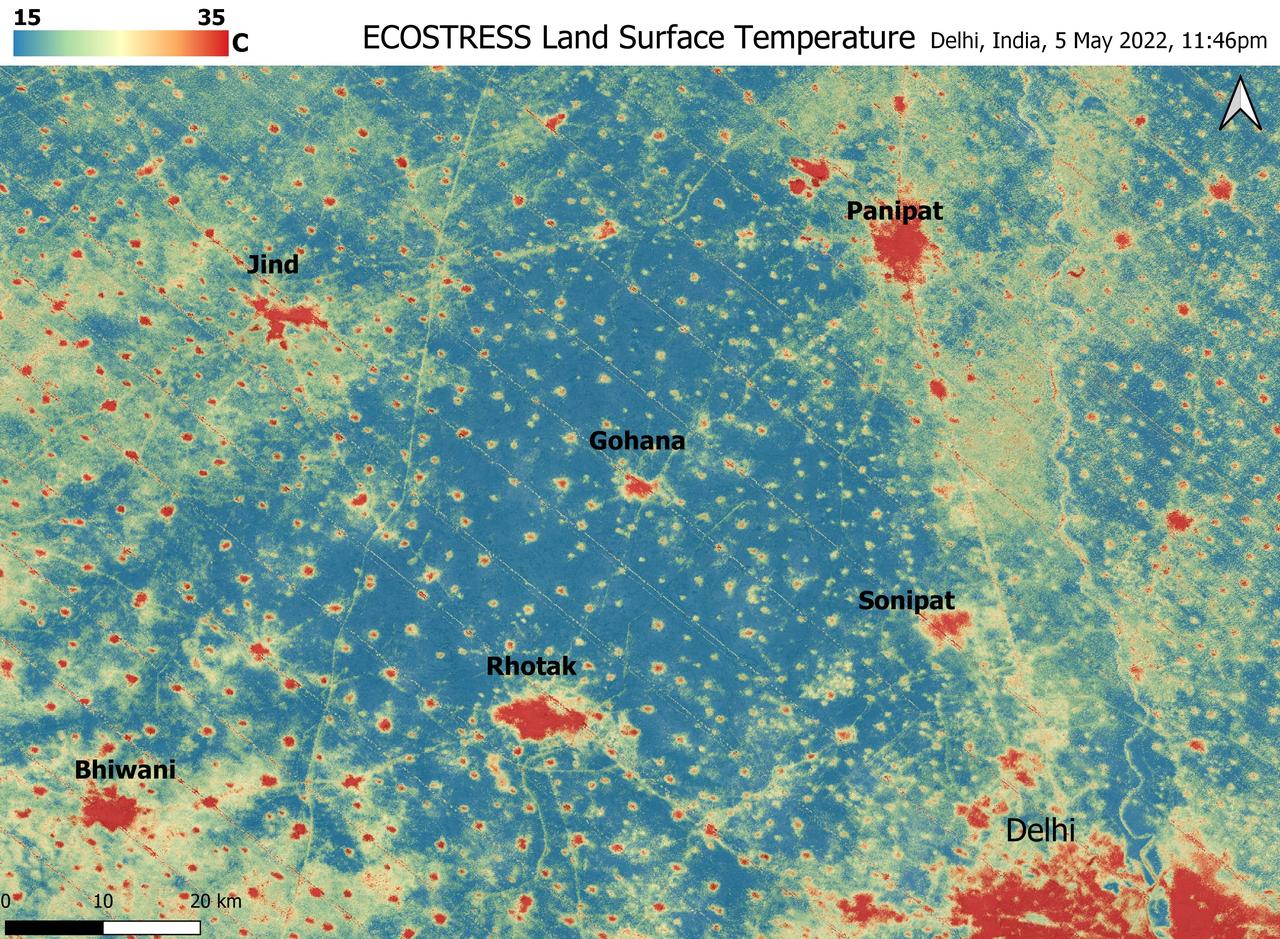
A relentless heat wave has blanketed India and Pakistan since mid-March 2022, causing dozens of deaths, fires, increased air pollution, and reduced crop yields. NASA's Ecosystem Spaceborne Thermal Radiometer Experiment on Space Station instrument (ECOSTRESS) has been measuring these temperatures from space, at the highest spatial resolution of any satellite instrument. This image, taken shortly before local midnight on May 5, shows urban areas and agricultural lands northwest of Delhi that are home to about 28 million people. The image covers about 4,800 square miles (12,350 square kilometers). Cities are usually markedly warmer than the surrounding countryside due to human activities and the materials used in the built environment. The image clearly delineates these urban "heat islands." Nighttime temperatures in Delhi and several smaller villages were above 95 degrees Fahrenheit (35 degrees Celsius), peaking at about 102 degrees F (39 degrees C), while the rural fields nearby had cooled to around 60 degrees F (15 degrees C). This data suggests that city dwellers are experiencing considerably higher temperatures than the average temperatures reported for their regions. ECOSTRESS measures the temperature of the ground itself, which is very similar to air temperature at night (though the ground may be warmer than the air in daylight hours). The instrument launched to the space station in 2018. Its primary mission is to identify plants' thresholds for water use and water stress, giving insight into their ability to adapt to a warming climate. However, ECOSTRESS also records other heat-related phenomena like this heat wave. Its high-resolution images, with a pixel size of about 225 feet (70 meters) by 125 feet (38 meters), are a powerful tool for understanding aspects of the weather event that might be overlooked by traditional observation networks. https://photojournal.jpl.nasa.gov/catalog/PIA24987
This is a radar image of the Rabaul volcano on the island of New Britain, Papua, New Guinea taken almost a month after its September 19, 1994, eruption that killed five people and covered the town of Rabaul and nearby villages with up to 75 centimeters (30 inches) of ash. More than 53,000 people have been displaced by the eruption. The image was acquired by the Spaceborne Imaging Radar-C/X-band Synthetic Aperture Radar (SIR-C/X-SAR) aboard the space shuttle Endeavour on its 173rd orbit on October 11, 1994. This image is centered at 4.2 degrees south latitude and 152.2 degrees east longitude in the southwest Pacific Ocean. The area shown is approximately 21 kilometers by 25 kilometers (13 miles by 15.5 miles). North is toward the upper right. The colors in this image were obtained using the following radar channels: red represents the L-band (horizontally transmitted and received); green represents the L-band (horizontally transmitted and vertically received); blue represents the C-band (horizontally transmitted and vertically received). Most of the Rabaul volcano is underwater and the caldera (crater) creates Blanche Bay, the semi-circular body of water that occupies most of the center of the image. Volcanic vents within the caldera are visible in the image and include Vulcan, on a peninsula on the west side of the bay, and Rabalanakaia and Tavurvur (the circular purple feature near the mouth of the bay) on the east side. Both Vulcan and Tavurvur were active during the 1994 eruption. Ash deposits appear red-orange on the image, and are most prominent on the south flanks of Vulcan and north and northwest of Tavurvur. A faint blue patch in the water in the center of the image is a large raft of floating pumice fragments that were ejected from Vulcan during the eruption and clog the inner bay. Visible on the east side of the bay are the grid-like patterns of the streets of Rabaul and an airstrip, which appears as a dark northwest-trending band at the right-center of the image. Ashfall and subsequent rains caused the collapse of most buildings in the town of Rabaul. Mudflows and flooding continue to pose serious threats to the town and surrounding villages. Volcanologists and local authorities expect to use data such as this radar image to assist them in identifying the mechanisms of the eruption and future hazardous conditions that may be associated with the vigorously active volcano. http://photojournal.jpl.nasa.gov/catalog/PIA01767
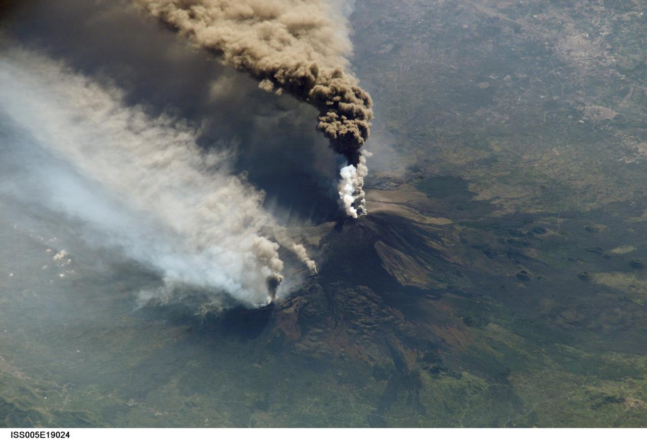
ISS005-E-19024 (30 October 2002) --- The three-member crew of the Expedition Five mission onboard the International Space Station was able to observe Mt. Etna’s spectacular eruption, and photograph the details of the eruption plume and smoke from fires triggered by the lava as it flowed down the 11,000 ft mountain. This image and a second image (ISS005-E-19016) are looking obliquely to the southeast over the island of Sicily. The wider view (ISS005-E-19024) shows the ash plume curving out toward the horizon, caught first by low-level winds blowing to the southeast, and to the south toward Africa at higher altitudes. Ashfall was reported in Libya, more than 350 miles away. The lighter-colored plumes downslope and north of the summit seen in this frame are produced by forest fires set by lava flowing into the pine forests on the slope of the mountain. This image provides a more three-dimensional profile of the eruption plume. This eruption was one of Etna’s most vigorous in years, volcanologists reported this week. The eruption was triggered by a series of earthquakes on October 27, 2002, they said. These images were taken on October 30. Although schools were closed and air traffic was diverted because of the ash, no towns or villages were reported to have been threatened by the lava flow.
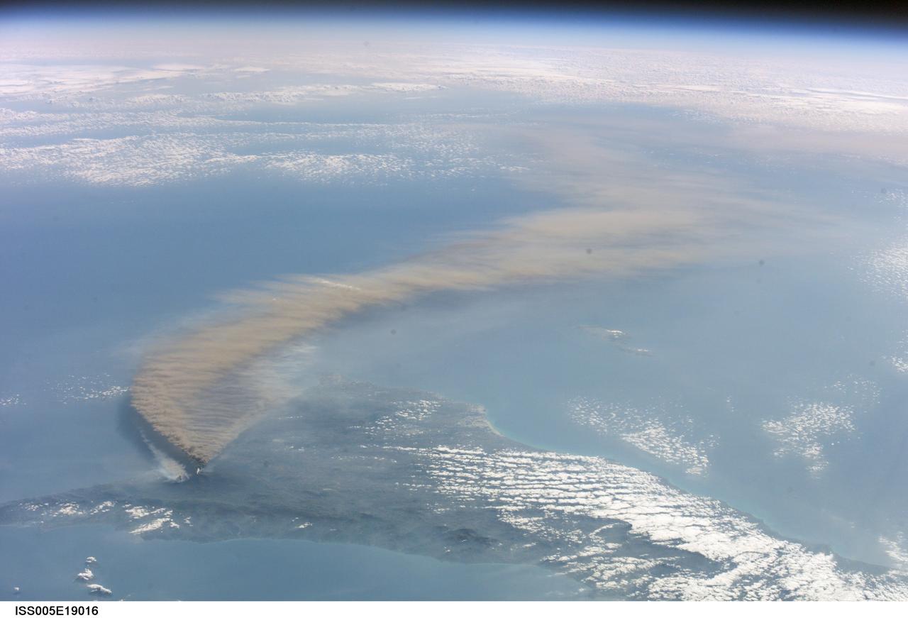
ISS005-E-19016 (30 October 2002) --- The three-member crew of the Expedition Five mission onboard the International Space Station was able to observe Mt. Etna’s spectacular eruption, and photograph the details of the eruption plume and smoke from fires triggered by the lava as it flowed down the 11,000 ft mountain. This image and a second image (ISS005-E-19024) are looking obliquely to the southeast over the island of Sicily. This wide view shows the ash plume curving out toward the horizon, caught first by low-level winds blowing to the southeast, and to the south toward Africa at higher altitudes. Ashfall was reported in Libya, more than 350 miles away. The lighter-colored plumes downslope and north of the summit (see detailed view taken the same day, ISS005-E-19024) are produced by forest fires set by lava flowing into the pine forests on the slope of the mountain. The detailed image provides a more three-dimensional profile of the eruption plume. This eruption was one of Etna’s most vigorous in years, volcanologists reported this week. The eruption was triggered by a series of earthquakes on October 27, 2002, they said. These images were taken on October 30. Although schools were closed and air traffic was diverted because of the ash, no towns or villages were reported to have been threatened by the lava flow.
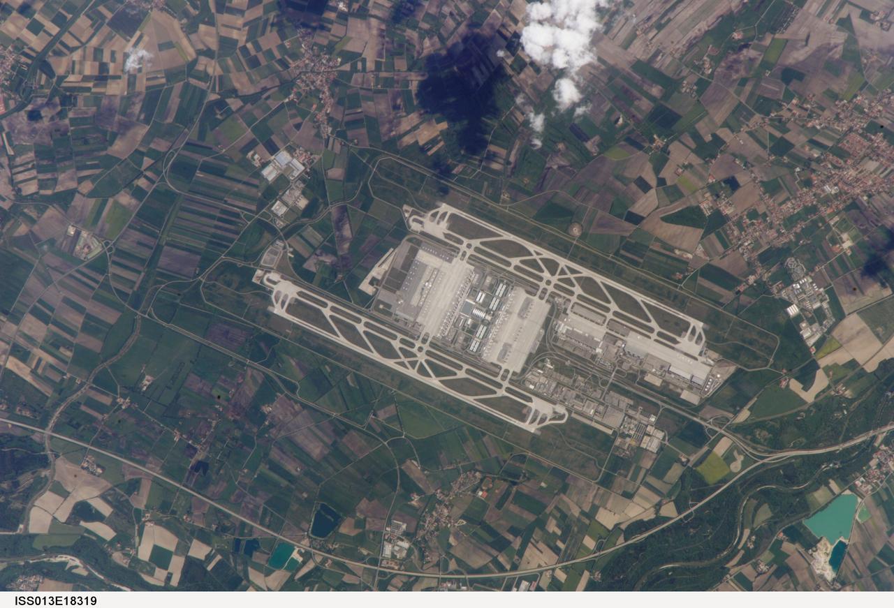
ISS013-E-18319 (12 May 2006) --- Munich International Airport, Germany is featured in this image photographed by an Expedition 13 crewmember on the International Space Station. The Franz Joseph Strauss, or Munich, International Airport served 29 million passengers in 2005, making it the second-busiest airport (behind Frankfurt) in Germany. It is the busiest airport in Germany in terms of domestic passengers, serving over 9 million travelers during 2005. The airport serves the Bayern (Bavaria) region of southeastern Germany, and is a hub for the Lufthansa airline. Like other large international airports around the world, the facility occupies portions of multiple municipalities: Freising, Oberding, Hallbergmoos, and Marzling. The village of Franzheim was demolished, and its 500 residents relocated, during the airport construction. The airport is located 31 kilometers to the northeast of Munich; rather than being an extension of the metropolis, it is surrounded by agricultural fields and small towns. Expansion of the airport occurred in 2003 with the additional of Terminal 2, designed specifically to accommodate the needs of Lufthansa and its partner airlines. This view taken is sufficiently detailed to distinguish individual airplanes on the terminal apron as well as the dark gray-blue rooftop of Terminal 2. The white concrete airport runways are 4 kilometers in length. Surrounding agricultural fields in active use are a variety of shades of green, while the exposed soil of fallow fields are brown to tan.
STS078-726-000A (20 June - 7 July 1996) --- Though the Space Shuttle program has been ongoing since 1981, few pictures have been taken from Earth-orbit that show the Toledo area featured in this 70mm frame from the STS-78/LMS-1 mission. The muddy Maumee River flows through Toledo into the west end of Lake Erie. Toledo is the seat (1835) of Lucas county, northwestern Ohio, and is a principal Great Lakes port, being the hub of a metropolitan complex that includes Ottawa Hills, Maumee, Oregon, Sylvania, Perrysburg, and Rossford. Fort Industry (1803-05) was located at the mouth of Swan Creek (now downtown Toledo), where permanent settlement was made after the War of 1812. Two villages, Port Lawrence (1817) and Vistula (1832), were consolidated in 1833 and named for Toledo, Spain. The united community was incorporated as a city in 1837. Its population in 1990 was 332,943. There are many smaller Ohio cities in the photo including Bowling Green, Findlay, Tiffin, Fremont, Fostoria, and Sandusky (right edge).
2013 image of Adler and the newly created Olympic Coastal Cluster. This false color satellite image reveals a largely agricultural area that was transformed into the Coastal Olympic Cluster with the nearby Olympic Village and Rail Station with transport to the Mountain Cluster. A spanking new breakwater structure was installed to create a harbor for cruise ships. The airport also received an expansion to handle the increased traffic. Caption and image provided by Tim Assal, US Geological Survey – Fort Collins Science Center Credit: NASA/Landsat <b><a href="http://www.nasa.gov/audience/formedia/features/MP_Photo_Guidelines.html" rel="nofollow">NASA image use policy.</a></b> <b><a href="http://www.nasa.gov/centers/goddard/home/index.html" rel="nofollow">NASA Goddard Space Flight Center</a></b> enables NASA’s mission through four scientific endeavors: Earth Science, Heliophysics, Solar System Exploration, and Astrophysics. Goddard plays a leading role in NASA’s accomplishments by contributing compelling scientific knowledge to advance the Agency’s mission. <b>Follow us on <a href="http://twitter.com/NASAGoddardPix" rel="nofollow">Twitter</a></b> <b>Like us on <a href="http://www.facebook.com/pages/Greenbelt-MD/NASA-Goddard/395013845897?ref=tsd" rel="nofollow">Facebook</a></b> <b>Find us on <a href="http://instagram.com/nasagoddard?vm=grid" rel="nofollow">Instagram</a></b>
This image of the Nyiragonga volcano eruption in the Congo was acquired on January 28, 2002 by the Advanced Spaceborne Thermal Emission and Reflection Radiometer (ASTER) on NASA's Terra satellite. With its 14spectral bands from the visible to the thermal infrared wavelength region, and its high spatial resolution of 15 to 90 meters about 50 to 300 feet ), ASTER will image Earth for the next 6 years to map and monitor the changing surface of our planet. Image: A river of molten rock poured from the Nyiragongo volcano in the Congo on January 18, 2002, a day after it erupted, killing dozens, swallowing buildings and forcing hundreds of thousands to flee the town of Goma. The flow continued into Lake Kivu. The lave flows are depicted in red on the image indicating they are still hot. Two of them flowed south form the volcano's summit and went through the town of Goma. Another flow can be seen at the top of the image, flowing towards the northwest. One of Africa's most notable volcanoes, Nyiragongo contained an active lava lake in its deep summit crater that drained catastrophically through its outer flanks in 1977. Extremely fluid, fast-moving lava flows draining from the summit lava lake in 1977 killed 50 to 100 people, and several villages were destroyed. The image covers an area of 21 x 24 km and combines a thermal band in red, and two infrared bands in green and blue. http://photojournal.jpl.nasa.gov/catalog/PIA03462

ISS020-E-009011 (12 June 2009) --- Pohang, South Korea is featured in this image photographed by an Expedition 20 crew member on the International Space Station. The port city of Pohang is located on the eastern coastline of South Korea and provides access to the East Sea and Sea of Japan. While the Pohang area has been occupied by small fishing villages since approximately 1500 BC, development of an urban area only began in 1930 when harbor facilities were constructed. The Pohang Iron and Steel Company, or POSCO began construction of a large steel mill and associated facilities in 1968, with production of steel products commencing in 1972. The steel industry is still a major component of the city?s economic base, but recent efforts to lessen dependence on heavy industry has fostered new interest in environmentalism and culture within Pohang. The urban fabric of Pohang is strikingly divided by the Hyeongsan River. To the west of the river, residential and commercial development is characterized by small footprint, gray and white-roofed buildings connected by a dense road network. The eastern side of the river is dominated by industrial development associated with the POSCO steelyard. This development is characterized by large rectilinear factory and storage buildings with striking light blue and light red rooftops at center. Green vegetated hills and mountains border the urban area to the east, west, and south, with several vegetated hills located with the industrial development area. Numerous boat wakes are also visible to the east-northeast of the POSCO steelyard docks.
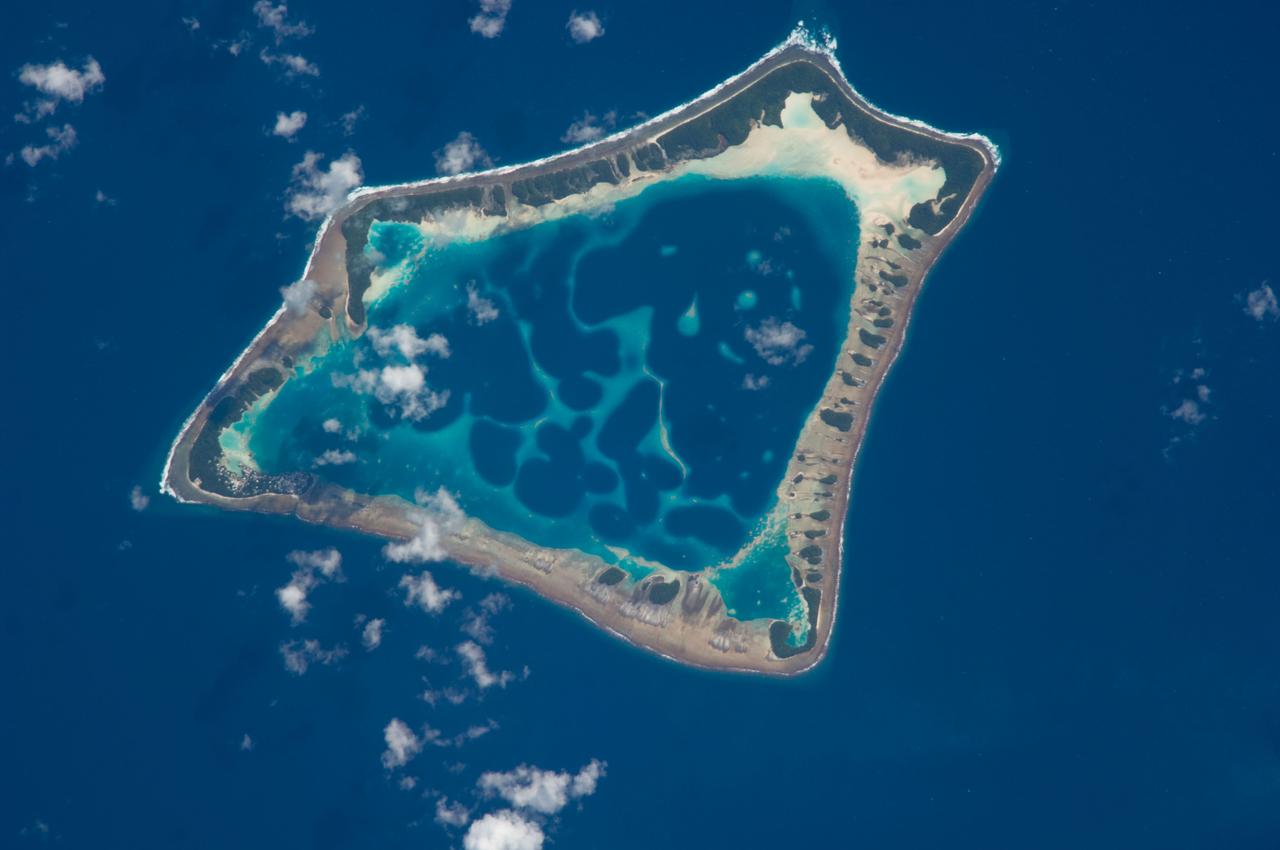
ISS018-E-018129 (6 Jan. 2009) --- Atafu Atoll in the Southern Pacific Ocean is featured in this image photographed by an Expedition 18 crewmember on the International Space Station. At roughly eight kilometers wide, Atafu Atoll is the smallest of three atolls (with Nukunonu and Fakaofo atolls to the southeast, not shown) comprising the Tokelau Islands group located in the southern Pacific Ocean. Swains Island to the south (not shown) is also considered part of the Tokelau group. The political entity of Tokelau is currently a territory of New Zealand. In recent years, public referendums on independence within the islands have been held, but have not received sufficient support to move forward. The primary settlement on Atafu is a village located at the northwestern corner of the atoll ? indicated by an area of light gray dots in this photograph. The typical ring shape of the atoll is the result of coral reefs building up around a former volcanic island. Over geologic time, the central volcano has subsided beneath the water surface, leaving the fringing reefs and a central lagoon that contains submerged coral reefs. Erosion and soil development on the surfaces of the exposed fringing reefs has lead to formation of tan to light brown beach deposits (southern and western sides of the atoll) and green vegetation cover (northern and eastern sides of the atoll). The Tokelau Islands, including Atafu Atoll, suffered significant inundation and erosion during Tropical Cyclone Percy in 2005. The approximate elevation of Atafu Atoll is only two meters above the tidal high water level. Vulnerability to tropical cyclones and potential sea level rise makes the long-term habitability of the atoll uncertain.
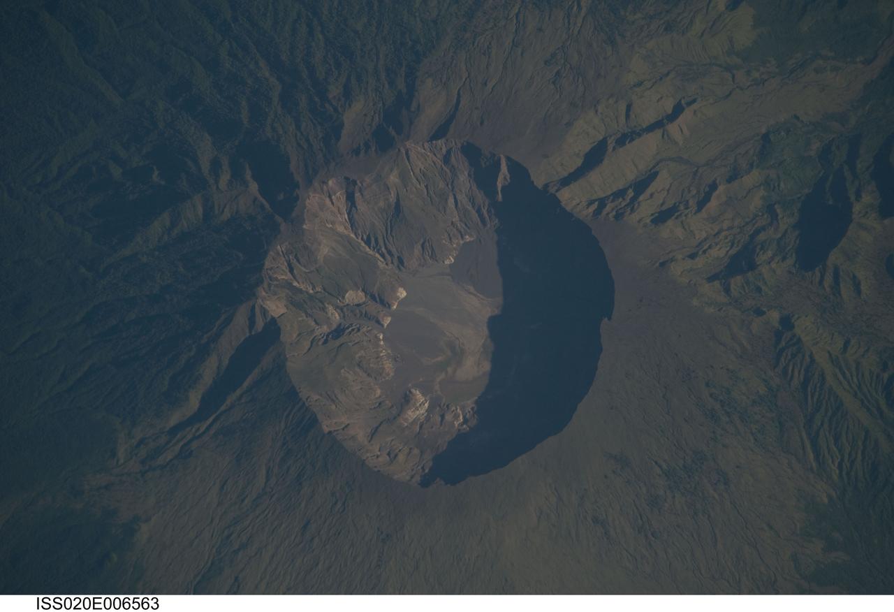
ISS020-E-006563 (3 June 2009) --- Mount Tambora Volcano, Sumbawa Island in Indonesia is featured in this image photographed by an Expedition 20 crew member on the International Space Station. On April 10, 1815 the Tambora volcano produced the largest eruption in history. An estimated 150 cubic kilometers of tephra ? exploded rock and ash ? was produced, with ash from the eruption recognized at least 1,300 kilometers away to the northwest. While the April 10 eruption was catastrophic, historical records and geological analysis of eruption deposits indicate that the volcano had been active between 1812 and 1815. Enough ash was input into the atmosphere from the April 10 eruption to reduce incident sunlight on Earth?s surface and cause global cooling, resulting in the 1816 ?year without a summer?. This detailed photograph depicts the summit caldera of the volcano. The huge caldera ? six kilometers in diameter and 1,100 meters deep ? formed when Tambora?s estimated 4,000 meter-high peak was removed, and the magma chamber below emptied, during the April 10 eruption. Today the crater floor is occupied by an ephemeral fresh-water lake, recent sedimentary deposits, and minor lava flows and domes emplaced during the 19th and 20th centuries. Layered tephra deposits are visible along the northwestern crater rim. Active fumaroles, or steam vents, are still present within the caldera. In 2004 scientists discovered the remains of a village and two adults buried under approximately three meters of ash in a gully on Tambora?s flank - remnants of the former Kingdom of Tambora preserved by the 1815 eruption that destroyed it. The similarity of the Tambora remains to those associated with the 79 AD eruption of Mount Vesuvius has led to the site being called ?the Pompeii of the East.?
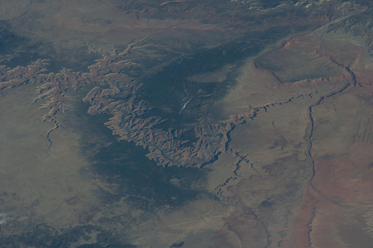
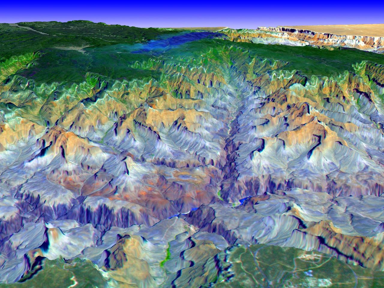
ISS039-E-005258 (25 March 2014) --- Not only do millions of tourists have special attractions to the Grand Canyon, but also through the years astronauts and cosmonauts in space. One of the Expedition 39 crew members aboard the Earth-orbiting International Space Station aimed his camera, equipped with a 180mm lens, at the iconic feature. The steep walls of the Colorado River canyon and its many side canyons make an intricate landscape that contrasts with the dark green, forested plateau to the north and south. The Colorado River has done all the erosional work of carving away cubic kilometers of rock in a geologically short period of time. Visible as a darker line snaking along the bottom of the canyon, the river lies at an altitude of 715 meters (2,345 feet), thousands of meters below the North and South Rims. Temperatures are furnace-like on the river banks in the summer. But Grand Canyon Village, the classic outlook point for visitors, enjoys a milder climate at an altitude of 2,100 meters (6,890 feet). The Grand Canyon has become a geologic icon?a place where, geologists say, one can almost sense the invisible tectonic forces within the Earth. The North and South Rims are part of the Kaibab Plateau, a gentle tectonic swell in the landscape. The uplift of the plateau had two pronounced effects on the landscape that show up in this image. First, in drier parts of the world, forests usually indicate higher places; higher altitudes are cooler and wetter, conditions that allow trees to grow. The other geologic lesson on view is the canyon itself. Geologists now know that a river can cut a canyon only if the Earth surface rises vertically. If such uplift is not rapid, a river can maintain its course by eroding huge quantities of rock and forming a canyon.
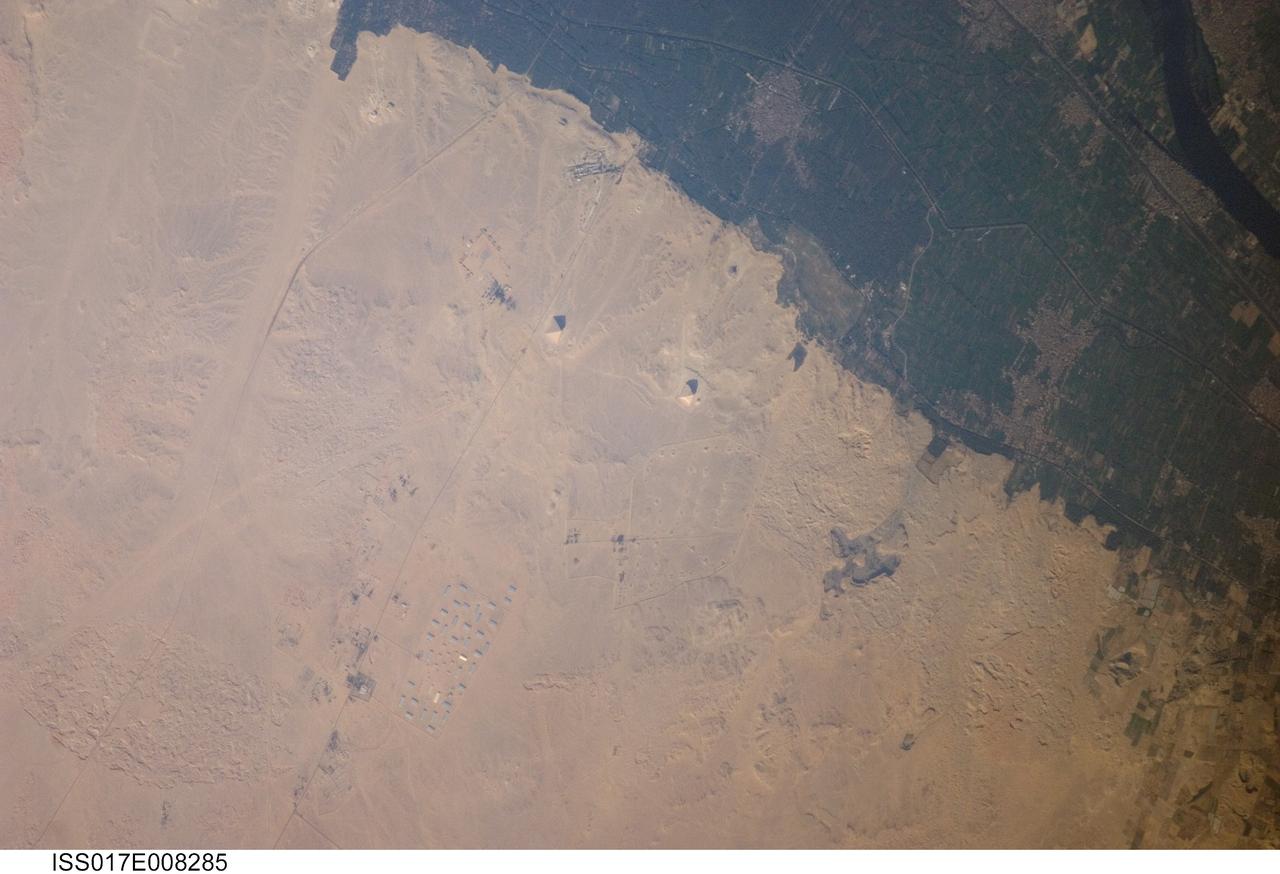
ISS017-E-008285 (30 May 2008) --- Pyramids of Dashur, Egypt are featured in this image photographed by an Expedition 17 crewmember on the International Space Station. While the pyramids of Giza are perhaps the most famous, there are several other ancient Egyptian royal necropolis ("city of the dead") sites situated along the Nile River and its delta. One of these sites is located near the village of Dashur (upper right). The gray-brown built area of Dashur is surrounded by green agricultural land of the Nile Delta, which forms a distinct boundary with the tan desert to the west. It is in the desert that the monuments of the ancient rulers of Egypt are found. Several monuments are visible in this image, including the large Red and Bent Pyramids built by Snofru, first king of the 4th Dynasty that lasted from 2575-2465 BC. Other visible monuments include the pyramid complexes of Amenemhat III and Sesostris III, both kings of the 12th Dynasty (1991-1783 BC). Both of these complexes are poorly preserved, due both to unstable ground conditions, and dismantling of the limestone blocks forming the outer pyramid casings during later historical periods. The Bent Pyramid (lower right) is so called as the slope of the outer face was lessened halfway through construction, leading to a distinctive "bent" profile -- explanations for why this was done include decreasing the mass of the pyramid to prevent collapse, or to reduce the work necessary to complete it. The Red Pyramid to the north (center) was built after the Bent Pyramid, and is named for the coloration of the building stone at the structure's core. An irregular dark feature to the southeast of the Bent Pyramid is not a shadow cast by a monument; it is an irrigation feature extending into the desert.
The islands and coral atolls of French Polynesia, located in the southern Pacific Ocean, epitomize the idea of tropical paradise: white sandy beaches, turquoise lagoons, and palm trees. Even from the distance of space, the view of these atolls is beautiful. This image from the Advanced Land Imager on NASA’s Earth Observing-1 (EO-1) satellite shows the southern part of Tikehau Atoll, one of the 78 coral atolls that make up the Tuamotu Archipelago. Patches of coral make star-like spots across the turquoise expanse of the lagoon. A line of tree-covered islets encircles the lagoon. At the southernmost tip of the atoll, a large islet accommodates a small village and an air strip. NASA image created by Jesse Allen, using EO-1 ALI data provided courtesy of the NASA EO-1 Team. Caption by Rebecca Lindsey. <b><a href="http://www.nasa.gov/audience/formedia/features/MP_Photo_Guidelines.html" rel="nofollow">NASA image use policy.</a></b> <b><a href="http://www.nasa.gov/centers/goddard/home/index.html" rel="nofollow">NASA Goddard Space Flight Center</a></b> enables NASA’s mission through four scientific endeavors: Earth Science, Heliophysics, Solar System Exploration, and Astrophysics. Goddard plays a leading role in NASA’s accomplishments by contributing compelling scientific knowledge to advance the Agency’s mission. <b>Follow us on <a href="http://twitter.com/NASAGoddardPix" rel="nofollow">Twitter</a></b> <b>Like us on <a href="http://www.facebook.com/pages/Greenbelt-MD/NASA-Goddard/395013845897?ref=tsd" rel="nofollow">Facebook</a></b> <b>Find us on <a href="http://instagrid.me/nasagoddard/?vm=grid" rel="nofollow">Instagram</a></b>

CAPE CANAVERAL, Fla. – An educational news conference to explore "Why Mars Excites and Inspires Us" begins in NASA Kennedy Space Center's Press Site auditorium in Florida during prelaunch activities for the agency’s Mars Science Laboratory (MSL) launch. Participants are, from left, Leland Melvin, NASA associate administrator for Education; Clara Ma, student, NASA contest winner for naming Curiosity, Shawnee Mission East High School, Prairie Village, Kansas; Scott Anderson, teacher and science department chairman, Da Vinci School for Science and the Arts, El Paso, Texas; Lauren Lyons, graduate student, Harvard University, FIRST robotics alumna; and Veronica McGregor, manager, Media Relations Office, NASA Jet Propulsion Laboratory. MSL's car-sized Martian rover, Curiosity, has 10 science instruments designed to search for signs of life, including methane, and help determine if the gas is from a biological or geological source. Ma's entry was selected the winner from 9,000 entries in NASA's nationwide student contest to name the rover. At the time, she was a twelve-year-old sixth-grade student at the Sunflower Elementary school in Lenexa, Kansas. Liftoff of MSL aboard a United Launch Alliance Atlas V rocket from Space Launch Complex-41 on Cape Canaveral Air Force Station is planned during a launch window which extends from 10:02 a.m. to 11:45 a.m. EST on Nov. 26. For more information, visit http://www.nasa.gov/msl. Photo credit: NASA/Kim Shiflett

CAPE CANAVERAL, Fla. – Leland Melvin, NASA associate administrator for Education; Clara Ma, student, NASA contest winner for naming Curiosity, Shawnee Mission East High School, Prairie Village, Kansas; Scott Anderson, teacher and science department chairman Da Vinci School for Science and the Arts, El Paso, Texas, take a moment pose for the camera before the start of an educational news conference to explore "Why Mars Excites and Inspires Us" in NASA Kennedy Space Center's Press Site auditorium in Florida during prelaunch activities for the agency’s Mars Science Laboratory (MSL) launch. MSL's car-sized Martian rover, Curiosity, has 10 science instruments designed to search for signs of life, including methane, and help determine if the gas is from a biological or geological source. Ma's entry was selected the winner from 9,000 entries in NASA's nationwide student contest to name the rover. At the time, she was a twelve-year-old sixth-grade student at the Sunflower Elementary school in Lenexa, Kansas. Liftoff of MSL aboard a United Launch Alliance Atlas V rocket from Space Launch Complex-41 on Cape Canaveral Air Force Station is planned during a launch window which extends from 10:02 a.m. to 11:45 a.m. EST on Nov. 26. For more information, visit http://www.nasa.gov/msl. Photo credit: NASA/Kim Shiflett

CAPE CANAVERAL, Fla. – An educational news conference to explore "Why Mars Excites and Inspires Us" is under way in NASA Kennedy Space Center's Press Site auditorium in Florida during prelaunch activities for the agency’s Mars Science Laboratory (MSL) launch. Participants are, from left, moderator George Diller, NASA Public Affairs, NASA Kennedy Space Center; Leland Melvin, NASA associate administrator for Education; Clara Ma, student, NASA contest winner for naming Curiosity, Shawnee Mission East High School, Prairie Village, Kansas; Scott Anderson, teacher and science department chairman, Da Vinci School for Science and the Arts, El Paso, Texas; Lauren Lyons, graduate student, Harvard University, FIRST robotics alumna; and Veronica McGregor, manager, Media Relations Office, NASA Jet Propulsion Laboratory. MSL's car-sized Martian rover, Curiosity, has 10 science instruments designed to search for signs of life, including methane, and help determine if the gas is from a biological or geological source. Ma's entry was selected the winner from 9,000 entries in NASA's nationwide student contest to name the rover. At the time, she was a twelve-year-old sixth-grade student at the Sunflower Elementary school in Lenexa, Kansas. Liftoff of MSL aboard a United Launch Alliance Atlas V rocket from Space Launch Complex-41 on Cape Canaveral Air Force Station is planned during a launch window which extends from 10:02 a.m. to 11:45 a.m. EST on Nov. 26. For more information, visit http://www.nasa.gov/msl. Photo credit: NASA/Kim Shiflett
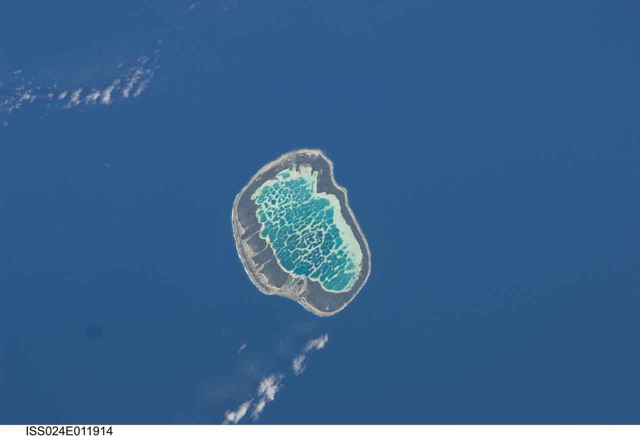
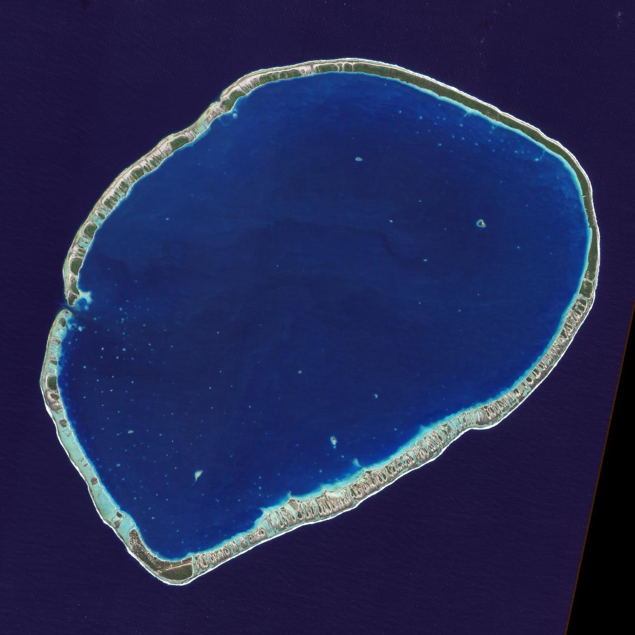
ISS024-E-011914 (13 Aug. 2010) --- Mataiva Atoll, Tuamotu Archipelago in the South Pacific Ocean is featured in this image photographed by an Expedition 24 crew member on the International Space Station. The Tuamotu Archipelago is part of French Polynesia, and forms the largest chain of atolls in the world. This photograph features Mataiva Atoll, the westernmost atoll of the Tuamotu chain. An atoll is a ring-shaped island that encloses a central lagoon. This distinctive morphology is usually associated with oceanic islands formed by volcanoes; coral reefs become established around the partially submerged volcanic cone. Over geologic time the central volcano becomes extinct, followed by erosion and subsidence beneath the sea surface, leaving the coral reefs as a ring around (or cap on) the submerged island remnant. Coral reefs exposed above the sea surface in turn experience erosion, sedimentation and soil formation, leading to the establishment of vegetation and complex ecosystems – including in many cases human habitation. Mataiva Atoll is notable in that its central lagoon includes a network of ridges (white, center) and small basins formed from eroded coral reefs. Mataiva means “nine eyes” in Tuamotuan, an allusion to nine narrow channels on the south-central portion of the island. The atoll is sparsely populated, with only a single village – Pahua – located on either side of the only pass providing constant connection between the shallow (light blue) water of the lagoon and the deeper (dark blue) adjacent Pacific Ocean. Much of the 10 kilometer-long atoll is covered with forest (greenish brown); vanilla and copra (dried coconut) are major exports from the atoll, but tourism is becoming a greater economic factor.
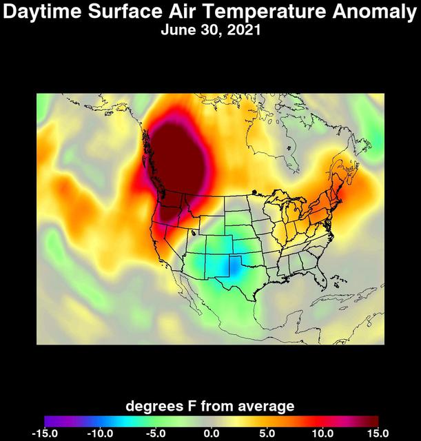
An unprecedented heat wave that started around June 26, 2021, smashed numerous all-time temperature records in the Pacific Northwest and western Canada. NASA's Atmospheric Infrared Sounder (AIRS), aboard the Aqua satellite, captured the progression of this slow-moving heat dome across the region from June 21 to 30. This animation of AIRS data shows surface air temperature anomalies, or values above or below long-term averages. Surface air temperature is something that people directly feel when they are outside. Some of the temperature anomalies were greater than 20 degrees Fahrenheit above the long-term average. On June 28, Quillayute, Washington, set an all-time high temperature record of 110 degrees Fahrenheit (43 degrees Celsius), shattering the old record of 99 degrees Fahrenheit (37 degrees Celsius). In British Columbia, the village of Lytton set a new all-time record for Canada at 119 degrees Fahrenheit (48 degrees Celsius) on June 29, only to break it the next day with a reading of 121 degrees Fahrenheit (49 degrees Celsius). The AIRS instrument recorded similar temperature anomalies at an altitude of about 10,000 feet (3,000 meters), showing that the extreme heat also affected mountainous regions. And temperature anomalies at roughly 18,000 feet (5,500 meters) demonstrated that the heat dome extended high into Earth's troposphere, creating the conditions for intense heat at the planet's surface that are normally found further south. Animation available at https://photojournal.jpl.nasa.gov/catalog/PIA24537

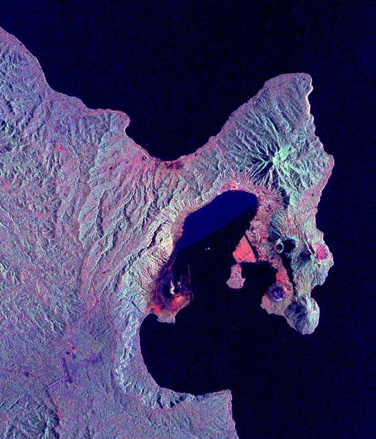
SL3-87-355 (July-September 1973) --- A vertical view of the eastern coast of Sicily area is seen in this Skylab 3 Earth Resources Experiments Package S190-B (five-inch earth terrain camera) infrared photograph taken from the Skylab space station in Earth orbit. Mount Etna, the highest volcano in Europe (10,958 feet), is still active as evidenced by the thin plume of smoke emanating from its crest. (The altitude is approximate because the height of the volcano changes with each eruption). On the flanks of Etna recent lava flows appear black in contrast to the older flows and volcanic debris that are red. Numerous small, circular cinder cones on the flanks represent sites of previous eruptions. Catania, on the Mediterranean coast south of Etna, is the largest of several cities and villages which appear as light-gray patches on the lower slopes of the volcano. Plano de Catania, south of the city of Catania, is outlined by polygonal light and dark agricultural tracts. Several lakes, the largest of which is Lake Pozzillo, show up as dark blue in the photograph. The unusual colors in the picture are due to the use of color infrared film in which vegetation appears red. This is very evident on the slopes of Etna, in the Monti Nebrodi area at upper let, and in the local areas in the lower part of the picture. Studies of Mount Etna and related volcanic features will be undertaken by Professor Roberto Cassinis of Servizio Geologio d?Italia, Rome. Federal agencies participating with NASA on the EREP project are the Departments of Agriculture, Commerce, Interior, the Environmental Protection Agency and the Corps of Engineers. All EREP photography is available to the public through the Department of Interior?s Earth Resources Observation Systems Data Center, Sioux Falls, South Dakota, 57198. Photo credit: NASA
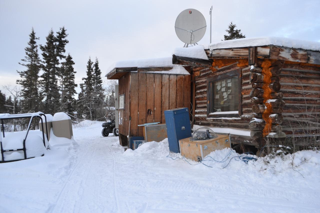
The NASA-funded Ground-to-Rocket Electron-Electrodynamics Correlative Experiment, or GREECE, wants to understand aurora. Specifically, it will study classic auroral curls that swirl through the sky like cream in a cup of coffee. The GREECE instruments travel on a sounding rocket that launches for a ten-minute ride right through the heart of the aurora reaching its zenith over the native village of Venetie, Alaska. To study the curl structures, GREECE consists of two parts: ground-based imagers located in Venetie to track the aurora from the ground and the rocket to take measurements from the middle of the aurora itself. At their simplest, auroras are caused when particles from the sun funnel over to Earth's night side, generate electric currents, and trigger a shower of particles that strike oxygen and nitrogen some 60 to 200 miles up in Earth's atmosphere, releasing a flash of light. But the details are always more complicated, of course. Researchers wish to understand the aurora, and movement of plasma in general, at much smaller scales including such things as how different structures are formed there. This is a piece of information, which in turn, helps paint a picture of the sun-Earth connection and how energy and particles from the sun interact with Earth's own magnetic system, the magnetosphere. GREECE is a collaborative effort between SWRI, which developed particle instruments and the ground-based imaging, and the University of California, Berkeley, measuring the electric and magnetic fields. The launch is supported by a sounding rocket team from NASA’s Wallops Flight Facility, Wallops Island, Va. The Poker Flat Research Range is operated by the University of Alaska, Fairbanks. Credit: NASA Goddard <b><a href="http://www.nasa.gov/audience/formedia/features/MP_Photo_Guidelines.html" rel="nofollow">NASA image use policy.</a></b> <b><a href="http://www.nasa.gov/centers/goddard/home/index.html" rel="nofollow">NASA Goddard Space Flight Center</a></b> enables NASA’s mission through four scientific endeavors: Earth Science, Heliophysics, Solar System Exploration, and Astrophysics. Goddard plays a leading role in NASA’s accomplishments by contributing compelling scientific knowledge to advance the Agency’s mission. <b>Follow us on <a href="http://twitter.com/NASAGoddardPix" rel="nofollow">Twitter</a></b> <b>Like us on <a href="http://www.facebook.com/pages/Greenbelt-MD/NASA-Goddard/395013845897?ref=tsd" rel="nofollow">Facebook</a></b> <b>Find us on <a href="http://instagram.com/nasagoddard?vm=grid" rel="nofollow">Instagram</a></b>
The NASA-funded Ground-to-Rocket Electron-Electrodynamics Correlative Experiment, or GREECE, wants to understand aurora. Specifically, it will study classic auroral curls that swirl through the sky like cream in a cup of coffee. The GREECE instruments travel on a sounding rocket that launches for a ten-minute ride right through the heart of the aurora reaching its zenith over the native village of Venetie, Alaska. To study the curl structures, GREECE consists of two parts: ground-based imagers located in Venetie to track the aurora from the ground and the rocket to take measurements from the middle of the aurora itself. At their simplest, auroras are caused when particles from the sun funnel over to Earth's night side, generate electric currents, and trigger a shower of particles that strike oxygen and nitrogen some 60 to 200 miles up in Earth's atmosphere, releasing a flash of light. But the details are always more complicated, of course. Researchers wish to understand the aurora, and movement of plasma in general, at much smaller scales including such things as how different structures are formed there. This is a piece of information, which in turn, helps paint a picture of the sun-Earth connection and how energy and particles from the sun interact with Earth's own magnetic system, the magnetosphere. GREECE is a collaborative effort between SWRI, which developed particle instruments and the ground-based imaging, and the University of California, Berkeley, measuring the electric and magnetic fields. The launch is supported by a sounding rocket team from NASA’s Wallops Flight Facility, Wallops Island, Va. The Poker Flat Research Range is operated by the University of Alaska, Fairbanks. Credit: NASA Goddard <b><a href="http://www.nasa.gov/audience/formedia/features/MP_Photo_Guidelines.html" rel="nofollow">NASA image use policy.</a></b> <b><a href="http://www.nasa.gov/centers/goddard/home/index.html" rel="nofollow">NASA Goddard Space Flight Center</a></b> enables NASA’s mission through four scientific endeavors: Earth Science, Heliophysics, Solar System Exploration, and Astrophysics. Goddard plays a leading role in NASA’s accomplishments by contributing compelling scientific knowledge to advance the Agency’s mission. <b>Follow us on <a href="http://twitter.com/NASAGoddardPix" rel="nofollow">Twitter</a></b> <b>Like us on <a href="http://www.facebook.com/pages/Greenbelt-MD/NASA-Goddard/395013845897?ref=tsd" rel="nofollow">Facebook</a></b> <b>Find us on <a href="http://instagram.com/nasagoddard?vm=grid" rel="nofollow">Instagram</a></b>
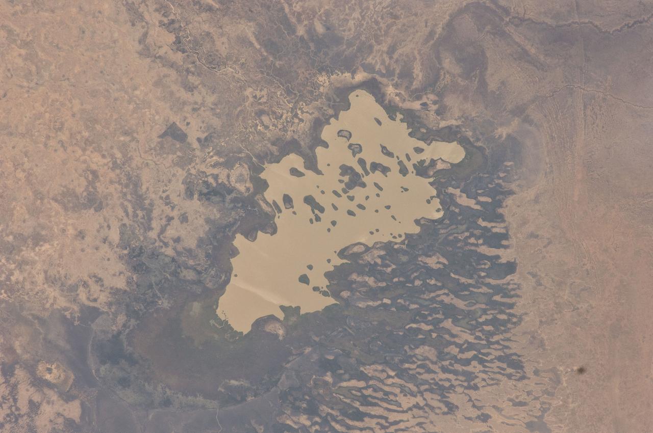
ISS030-E-059398 (19 Jan. 2012) --- Lake Fitri, Chad is featured in this image photographed by an Expedition 30 crew member on the International Space Station. Lake Fitri is an endorheic, or terminal lake in a desert basin in the southern Sahara Desert. Muddy yellow-brown water marks the center of the depression (center), with a ring of dark brown muds and burnt vegetation on the exposed lake floor to the north. The lake shoreline supports a thin line of reed and floating grass vegetation which appears as dark green in the image. Deserts have so little rainfall that many rivers cannot reach the sea, but end at local low points where they form lakes. Here the usually dry Wadi Batha empties into Lake Fitri. Over time, water flow in Wadi Batha has created a large delta, which occupies the entire top left third of the image—a sense of scale is given by the 23–kilometer length of the lake. The lake has been designated under the Ramsar Convention as a wetland of international importance. Other features visible in the image reveal evidence of significant climate change. The dry part of the present lake shows that the lake has been larger in the last several decades. But, as NASA scientists point out, the lake was once many times larger than its present surface area, as shown by numerous sweeping curves of ancient beaches which are now situated many kilometers from the present shoreline, at higher altitudes (upper right). Inland lakes are highly sensitive to the exact equilibrium between the amount of inflow from contributing rivers like Wadi Batha and evaporation. Each beach ridge therefore shows a different lake level and thus a different balance in the lake-river-climate system. A smaller river enters from the south (top right) and cuts through the beach reaches on its way to the lake. The irregular, elongated, tan patches to the west of the lake are linear dunes aligned parallel to the dominant winds which blow from the northeast. The dunes have all formed on the downwind side (southwest) side of the lake since the lake bed and delta provide the sands which have built the dunes. The dunes indicate that during past climatic phases the lake has been almost or completely dry on repeated occasions—often enough for these great dunes, many kilometers long and several meters high, to form even in the lowest parts of the lake. The islands visible in the center of the lake are likewise remnants of dunes. These dunes are smaller than those on the lake margin, presumably because waves from the lake have eroded them. Villages occupy the points of some major dunes, and some islands, where fishermen can gain easy access to the lake.
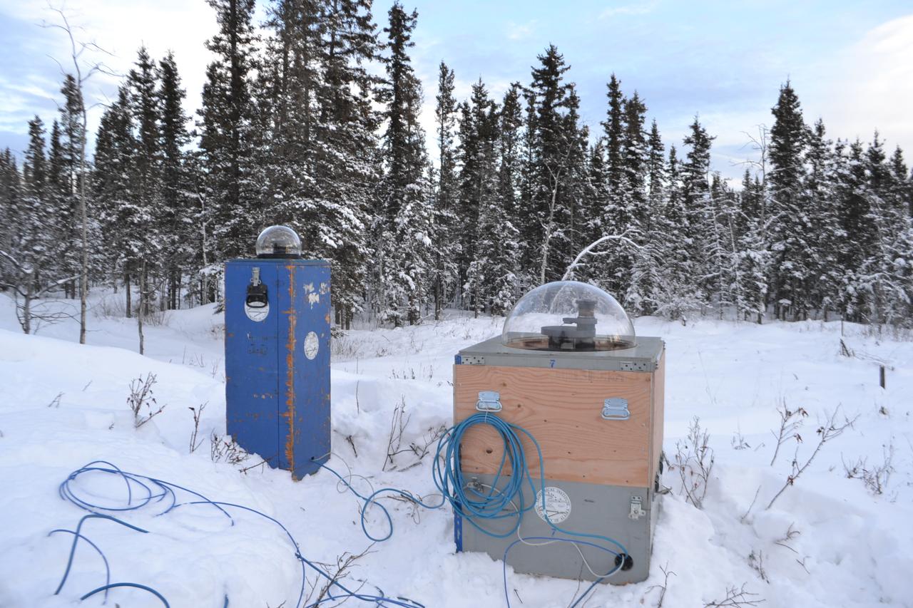
The NASA-funded Ground-to-Rocket Electron-Electrodynamics Correlative Experiment, or GREECE, wants to understand aurora. Specifically, it will study classic auroral curls that swirl through the sky like cream in a cup of coffee. The GREECE instruments travel on a sounding rocket that launches for a ten-minute ride right through the heart of the aurora reaching its zenith over the native village of Venetie, Alaska. To study the curl structures, GREECE consists of two parts: ground-based imagers located in Venetie to track the aurora from the ground and the rocket to take measurements from the middle of the aurora itself. At their simplest, auroras are caused when particles from the sun funnel over to Earth's night side, generate electric currents, and trigger a shower of particles that strike oxygen and nitrogen some 60 to 200 miles up in Earth's atmosphere, releasing a flash of light. But the details are always more complicated, of course. Researchers wish to understand the aurora, and movement of plasma in general, at much smaller scales including such things as how different structures are formed there. This is a piece of information, which in turn, helps paint a picture of the sun-Earth connection and how energy and particles from the sun interact with Earth's own magnetic system, the magnetosphere. GREECE is a collaborative effort between SWRI, which developed particle instruments and the ground-based imaging, and the University of California, Berkeley, measuring the electric and magnetic fields. The launch is supported by a sounding rocket team from NASA’s Wallops Flight Facility, Wallops Island, Va. The Poker Flat Research Range is operated by the University of Alaska, Fairbanks. Credit: NASA Goddard <b><a href="http://www.nasa.gov/audience/formedia/features/MP_Photo_Guidelines.html" rel="nofollow">NASA image use policy.</a></b> <b><a href="http://www.nasa.gov/centers/goddard/home/index.html" rel="nofollow">NASA Goddard Space Flight Center</a></b> enables NASA’s mission through four scientific endeavors: Earth Science, Heliophysics, Solar System Exploration, and Astrophysics. Goddard plays a leading role in NASA’s accomplishments by contributing compelling scientific knowledge to advance the Agency’s mission. <b>Follow us on <a href="http://twitter.com/NASAGoddardPix" rel="nofollow">Twitter</a></b> <b>Like us on <a href="http://www.facebook.com/pages/Greenbelt-MD/NASA-Goddard/395013845897?ref=tsd" rel="nofollow">Facebook</a></b> <b>Find us on <a href="http://instagram.com/nasagoddard?vm=grid" rel="nofollow">Instagram</a></b>