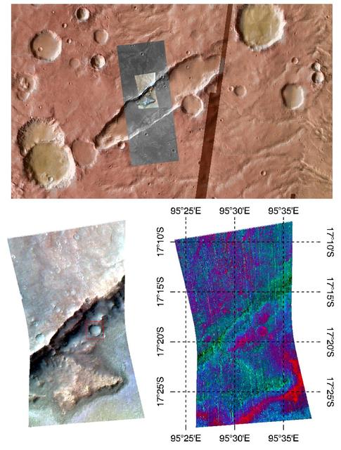
Durham, North Carolina, Students Study Martian Volcanism
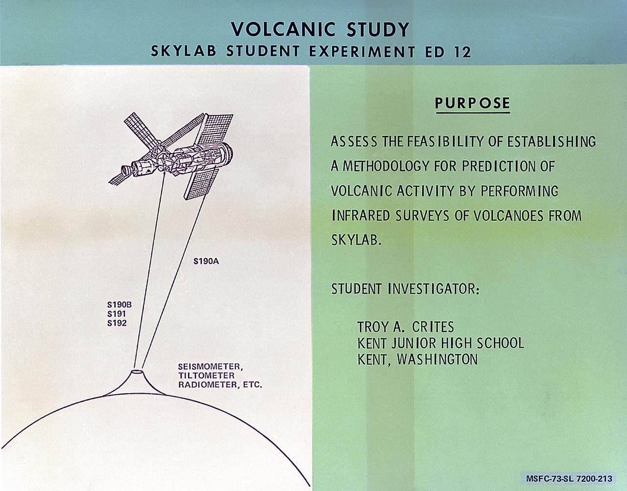
This chart describes the Skylab student experiment Volcanic Study, proposed by Troy A. Crites of Kent, Washington. This experiment utilized Skylab's Earth Resources Experiment sensors to determine if volcanic activity can be predicted using infrared surveys from orbit. In March 1972, NASA and the National Science Teachers Association selected 25 experiment proposals for flight on Skylab. Science advisors from the Marshall Space Flight Center aided and assisted the students in developing the proposals for flight on Skylab.
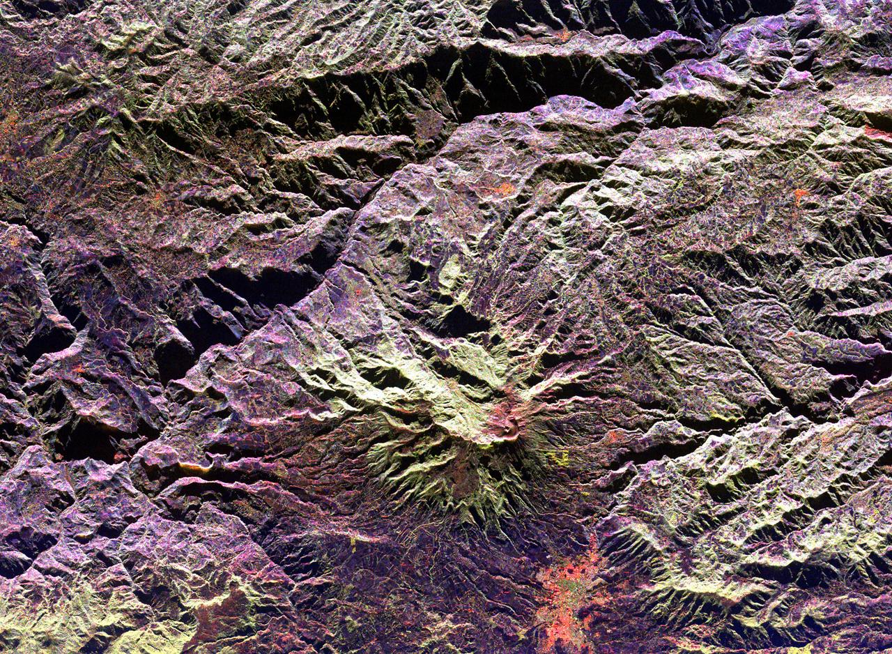
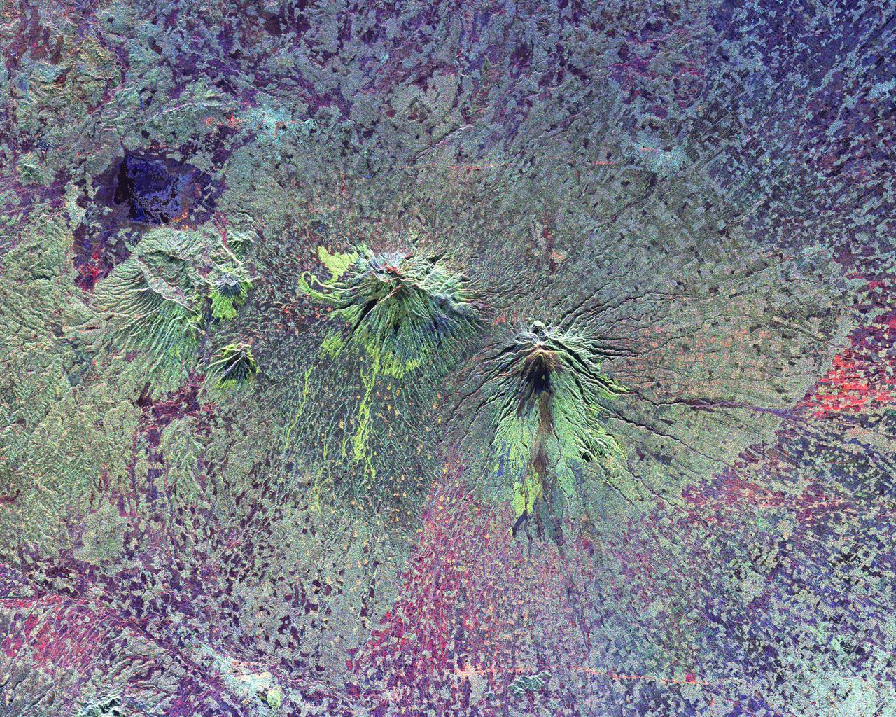
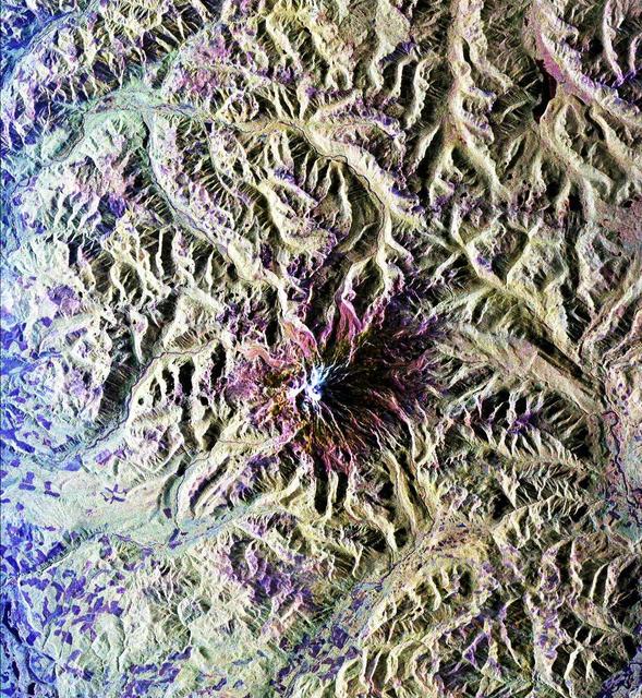
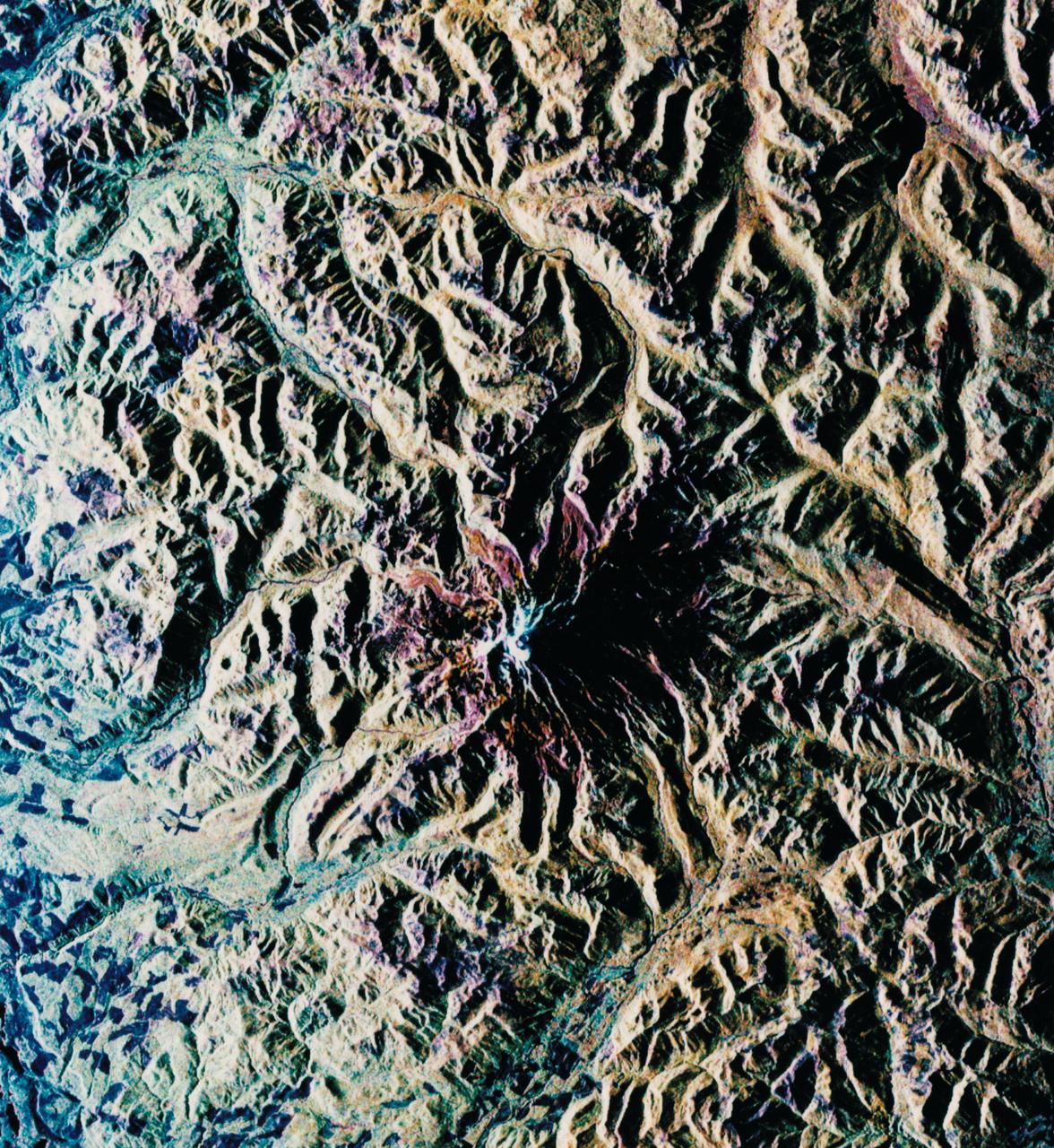
This radar image of the area surrounding the Galeras volcano in southern Colombia shows the ability of a multi-frequency radar to map volcanic structures that can be dangerous to study on the ground.

The volcanic ash distribution spider, shown here in the inlet of the engine while running, was used to send the ultra-fine particles of ash through the engine.
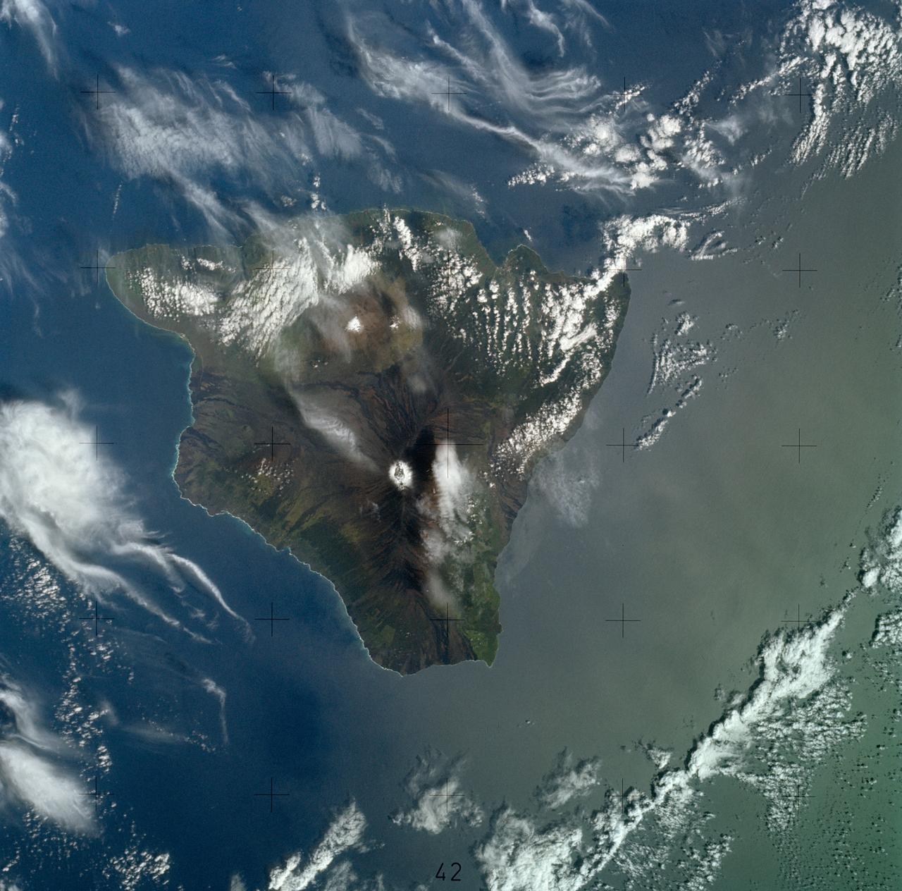
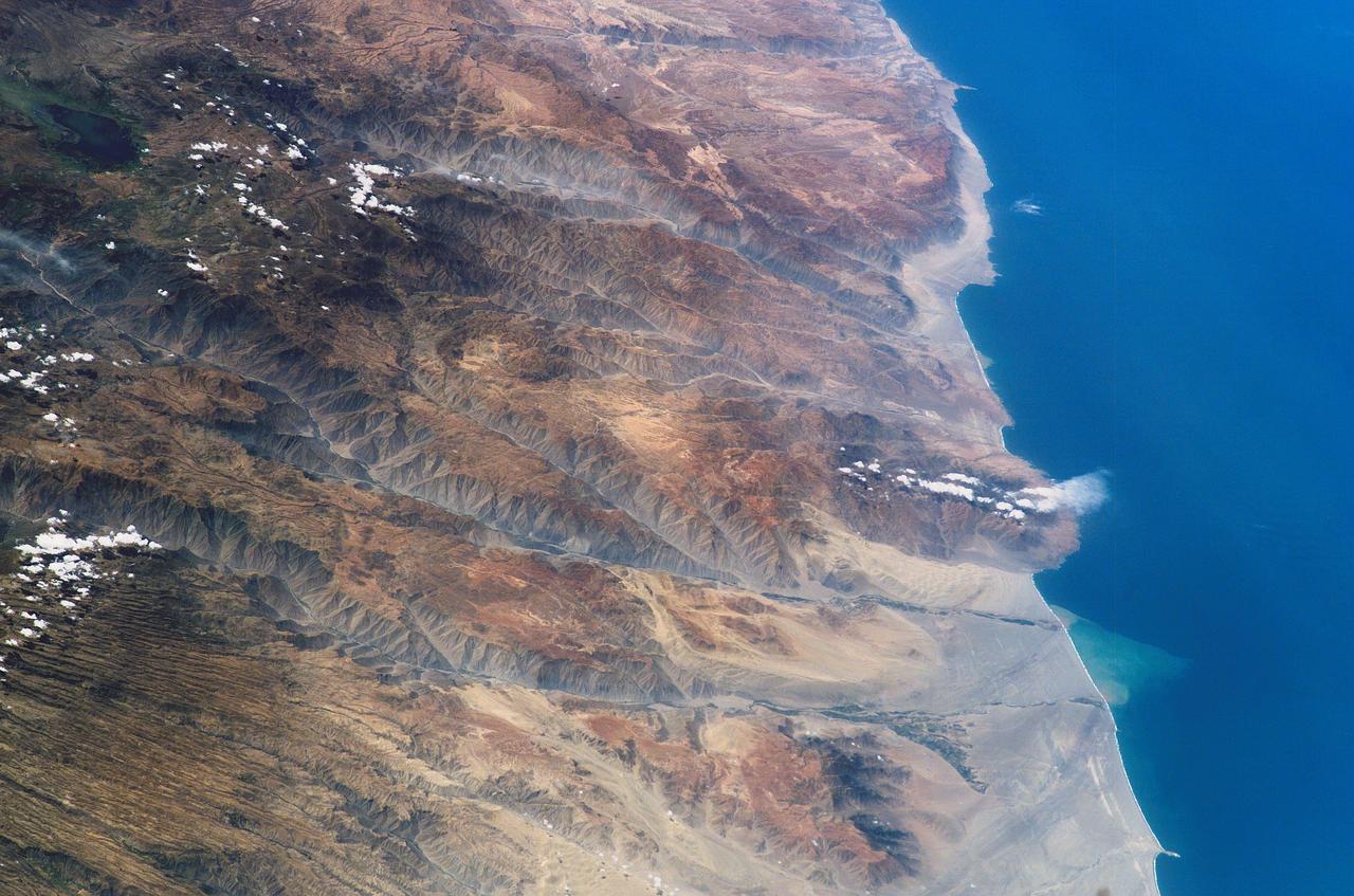
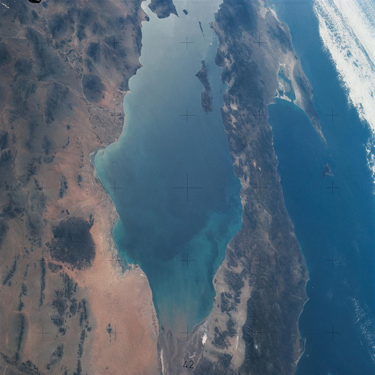
SL4-139-3997 (8 Jan. 1974) --- A vertical view of the Island of Hawaii, State of Hawaii, as photographed from the Skylab space station in Earth orbit by a Skylab 4 crewman. The camera used was a hand-held Hasselblad camera, with SO-368 medium-speed Ektachrome film. This photograph, taken on Jan. 8, 1974, is very useful in studies of volcanic areas. Prominent volcanic features such as the summit caldera on Mauna Loa, the extinct volcano Mauna Kea, the Kilauea caldera, and the pit crater at Halo mau mau within the caldera are easily identified. (Kilauea was undergoing frequent eruption during the mission). Detailed features such as the extent and delineation of historic lava flows on Mauna Loa can be determined and are important parameters in volcanic studies. Photo credit: NASA
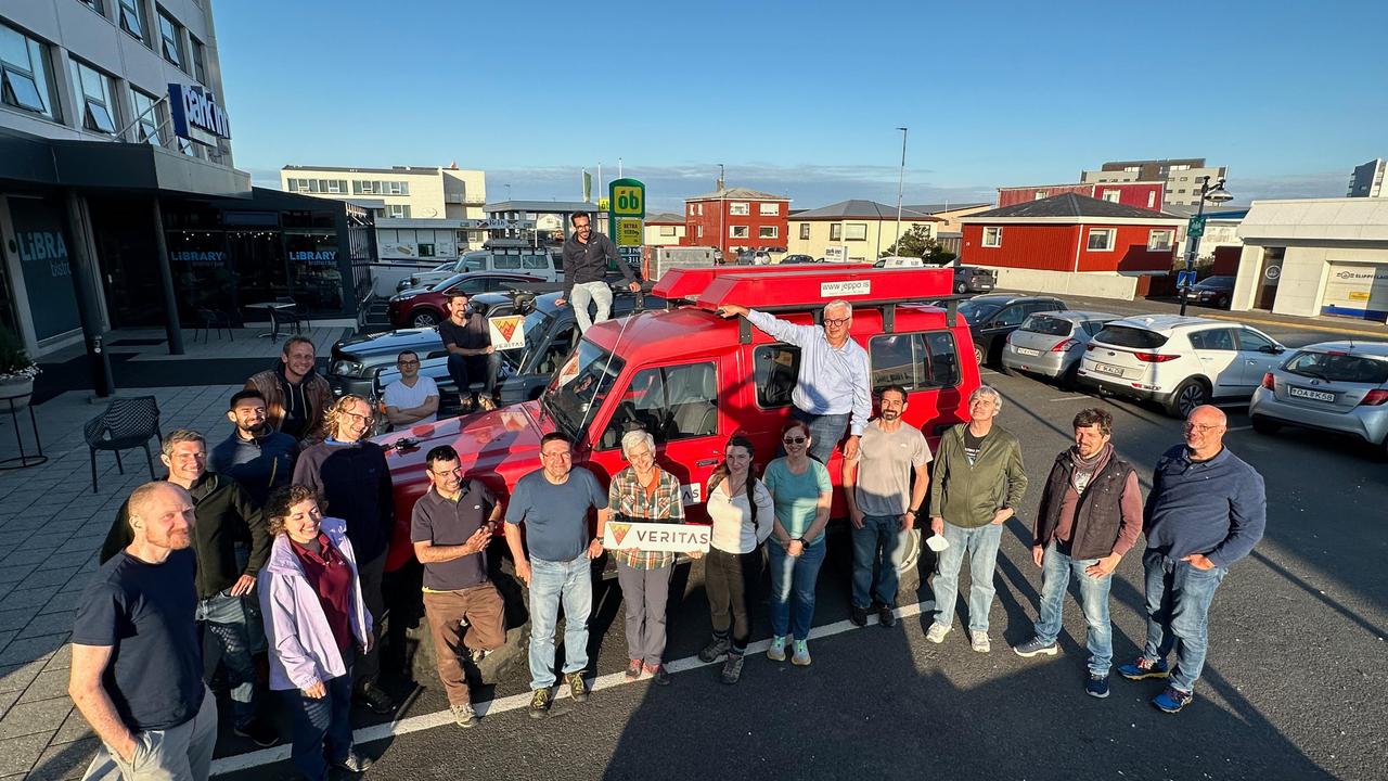
Members of the VERITAS science team pause for a photograph on July 31, 2023, after arriving in Iceland to begin a two-week campaign to study the volcanic island's geology to help the team prepare for NASA's VERITAS (short for Venus Emissivity, Radio science, InSAR, Topography, And Spectroscopy) mission to Venus. From July 30 to Aug. 14, 2023, the international science team, including local participation from the University of Iceland, worked to lay the groundwork for the science that will ultimately be done from Venus orbit. At center, holding the VERITAS mission identifier is the mission's principal investigator and the science team lead, Sue Smrekar, of NASA's Jet Propulsion Laboratory in Southern California. Flanking her are science team members from multiple U.S., Italian, and German institutions, including members of the German Aerospace Center (DLR) Flugzeug Synthetic Aperture Radar (F-SAR) airplane team. The DLR F-SAR team was tasked with collecting synthetic-aperture radar data of the regions studied by the field team. A key objective of the campaign is to refine change detection algorithms that will be used to look for global surface change (such as volcanic activity) between NASA's Magellan radar mission from the 1990s and VERITAS, as well as between VERITAS and the ESA (European Space Agency) EnVision mission to Venus, both of which are targeting the early 2030s for launch. NASA's VERITAS is an orbiter designed to peer through Venus' thick atmosphere with a suite of powerful instruments to create global maps of the planet's surface, including topography, radar images, rock type, and gravity, as well as detect surface changes. VERITAS is designed to understand what processes are currently active, search for evidence of past and current interior water, and understand the geologic evolution of the planet, illuminating how rocky planets throughout the galaxy evolve. VERITAS and NASA's Deep Atmosphere Venus Investigation of Noble gases, Chemistry, and Imaging (DAVINCI) mission were selected in 2021 under NASA's Discovery Program as the agency's next missions to Venus. The Discovery Program is managed by the Planetary Missions Program Office at NASA's Marshall Space Flight Center in Huntsville, Alabama, for the Planetary Science Division of NASA's Science Mission Directorate in Washington. https://photojournal.jpl.nasa.gov/catalog/PIA25835
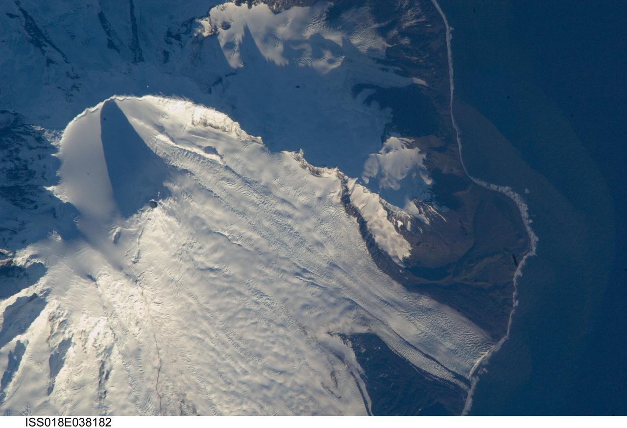
ISS018-E-038182 (28 Feb. 2009) --- Mawson Peak, Heard Island is featured in this image photographed by an Expedition 18 crewmember on the International Space Station. Heard Island is located in the southern Indian Ocean, approximately 1,550 kilometers to the north of Antarctica. The island is a visible part of the Kerguelen Plateau, a submerged feature on the seafloor formed by large amounts of volcanic rock erupted over a geologically short time period within an oceanic tectonic plate ? features like these are termed large igneous provinces by geologists. Most of Heard Island is formed from volcanic rocks associated with the Big Ben stratovolcano. The northeastern slopes of the volcano are visible in shadow at the top left of this detailed astronaut photograph. Recent observed volcanic activity at Heard Island has occurred at 2,745 meters high Mawson Peak, which sits within a breached caldera (collapsed and empty magma chamber beneath a volcano) on the southwestern side of the Big Ben volcano ? the shadow cast by Mawson Peak in the image points directly to the crescent-shaped caldera rim. Detailed geologic study of the Big Ben volcano is made difficult by the presence of several glaciers, including Gotley and Lied Glaciers on the southwestern slopes. This image, taken during Southern Hemisphere summer, also reveals some of the non-glaciated, light to dark brown volcanic rock forming the island on either side of Gotley Glacier.
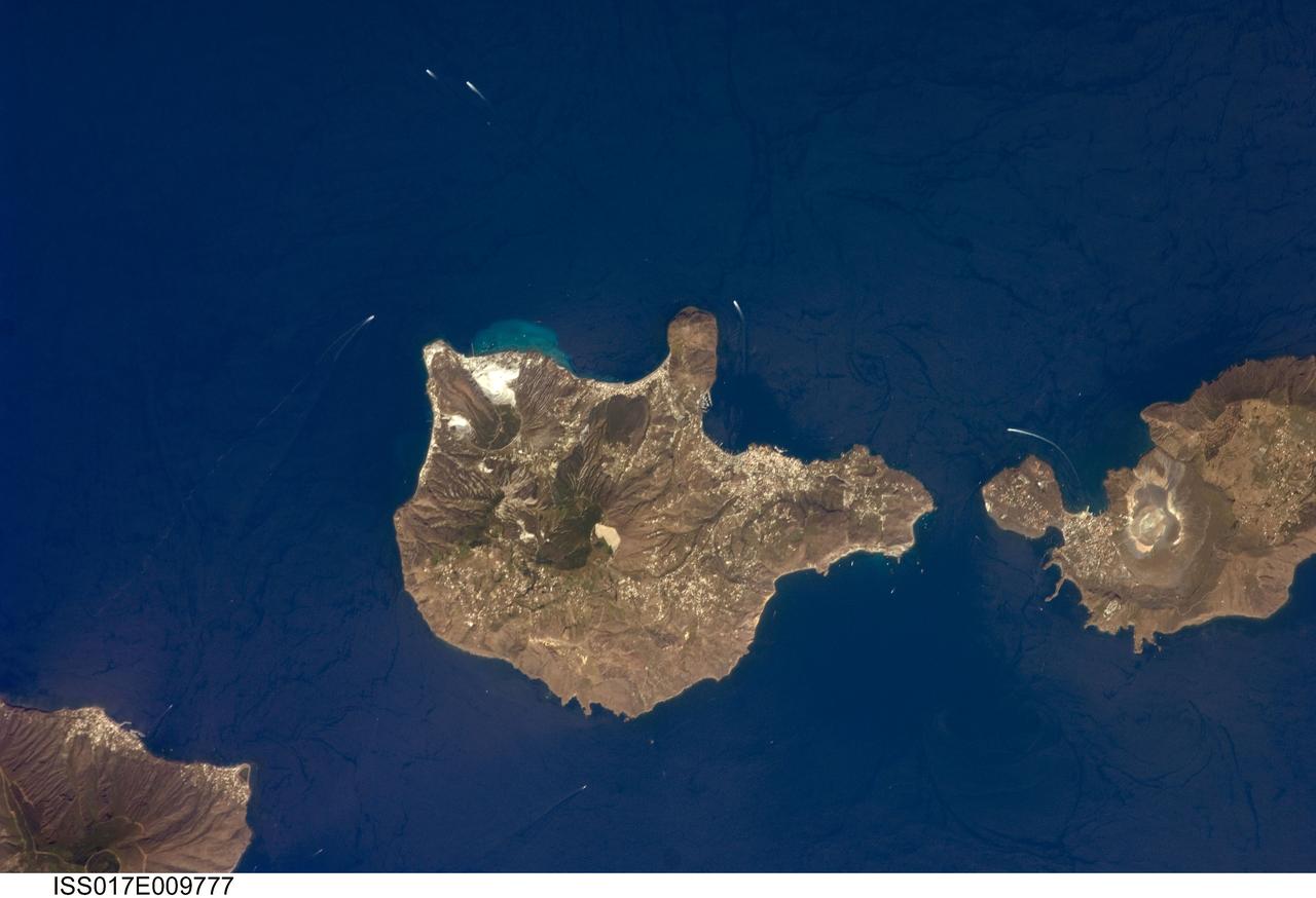
ISS017-E-009777 (24 June 2008) --- Aeolian Islands, Italy are featured in this image photographed by an Expedition 17 crewmember on the International Space Station. The Aeolian Islands formed from a chain of volcanoes in the Tyrrhenian Sea to the north of the island of Sicily. The islands have been studied by geologists and vulcanologists since the 18th century, and were accorded UNESCO World Heritage Site status in 2000 in recognition of their continuing value to study of volcanic processes. Two types of volcanic eruption, Vulcanian and Strombolian, were defined based on study and observation of geologic processes on the islands of Vulcano and Stromboli (not shown). This detailed view features the island of Lipari and the northern portion of the island of Vulcano. Tan, speckled areas on both islands are urban areas and towns. Lipari is the largest of the Aeolian Islands, and is a popular tourist destination due to its rugged volcanic topography and beaches (several boat wakes are visible in the image around the islands). White pumice beaches and caves are located along the northern and northeastern coastlines of Lipari; black sand beaches derived from lava flows can also be found on the island. The most recent eruptive activity on Lipari took place between approximately 580-729. The island of Vulcano (right) is comprised of two calderas -- large craters formed when explosive eruptions empty a magma chamber, followed by collapse of the overlying material into the newly-formed void -- the Caldera della Fossa to the north and the Caldera del Piano to the south. The volcanic cone of La Fossa, located with the Caldera della Fossa, has been the site of much of the historical eruptive activity on the island. The last eruption on Vulcano Island took place during 1898-1900.
STS059-81-095 (9-20 April 1994) --- View southwestward across the Kamchatka Peninsula. The cluster of volcanoes in the middle distance are active, including Klutchevskaya whose summit reaches 15,580 feet. Changes in volcanic deposits, snow, and ice are being studied by Russian and American SRL investigators. Seasonal changes in sea ice are also of interest, for example, in Kamchatskiy Bay (upper left). Hasselblad camera, 40mm lens.

iss073e0251619 (June 26, 2025) --- Axiom Mission 4 crew members Peggy Whitson (foreground) from Axiom Space and Sławosz Uznański-Wiśniewski from ESA (European Space Agency) work inside the International Space Station's Columbus laboratory module. The private astronaut duo swapped research hardware supporting the Space Volcanic Algae biotechnology study and the Experiment Cube #25 data processing and algorithm investigation.
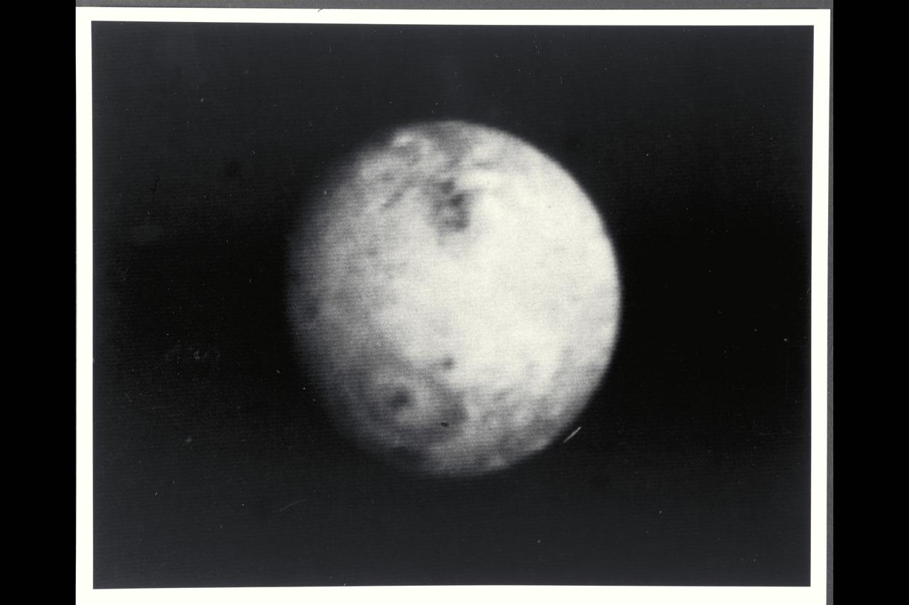
P-21739 BW Range: 4.7 million kilometers (2.9 million miles) This picture of Io was taken as Voyager 2 closes in on the Jovian system. Scientists are studying these distant views of Io for evidences of changes since Voyager 1 observations in March of 79. Voyager 1 discovered that Io, the innermost of the Galilean satellites, is the most volcanically active body yet seen in the solar system, surpassing even earth. In this picture, the first volcano discovered by Voyager 1 is again visible in the lower left portion of the disk as a dark oval with a dark spot in the center. In March, this volcano appeared as a heart-shaped marking, not a symmetrical oval. Scientists believe that the non-symmetric markings earlier resulted from a constriction in the mouth of the volcanic vent causing erupting material to extrude preferentially in certain directions. Apparently, the volcanic eruptive activity, which sends material to altitudes of 280 kilometers (175 miles) or more above this volcano, has changed the vent geometry or dislodged an obstruction. Such changes in the form of eruptive fountains are common in terrestial volcanos, although on a much smaller scale than on Io.
STS072-709-063 (11-20 Jan. 1996) --- The astronauts aboard the Space Shuttle Endeavour exposed this 70mm frame of the Air Mountains, located in the country of Niger. These Sahara Desert structures are granitic intrusions. They are resistant to erosion and are very prominent in the lighter colored sands of the area. According to NASA geologists studying the photo collection, the ring-like structure on the lower left-hand edge of the photograph is probably a Quaternary volcanic feature. The highest peaks in the range approach 1,800 meters (6,000 feet). Deep valleys in the range are used by the Tuaregs for pasturage. Uranium and other minerals are being mined in the massif.
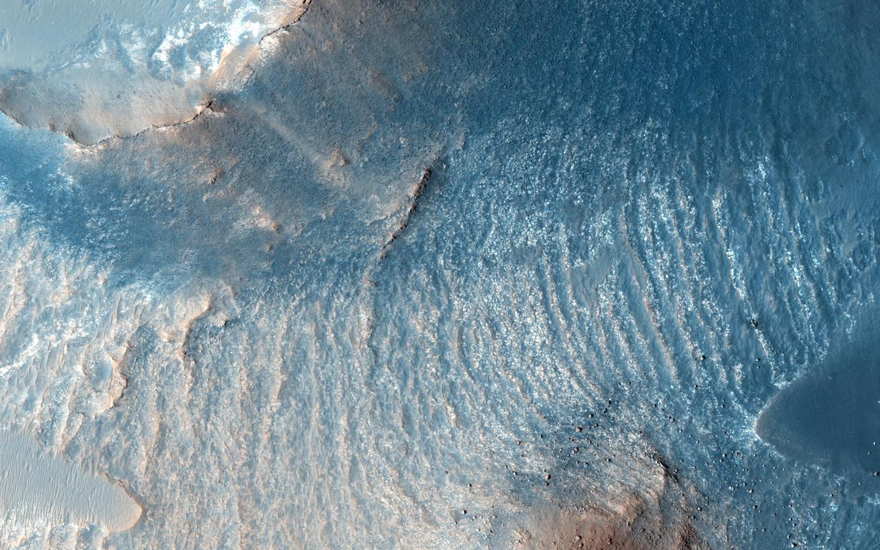
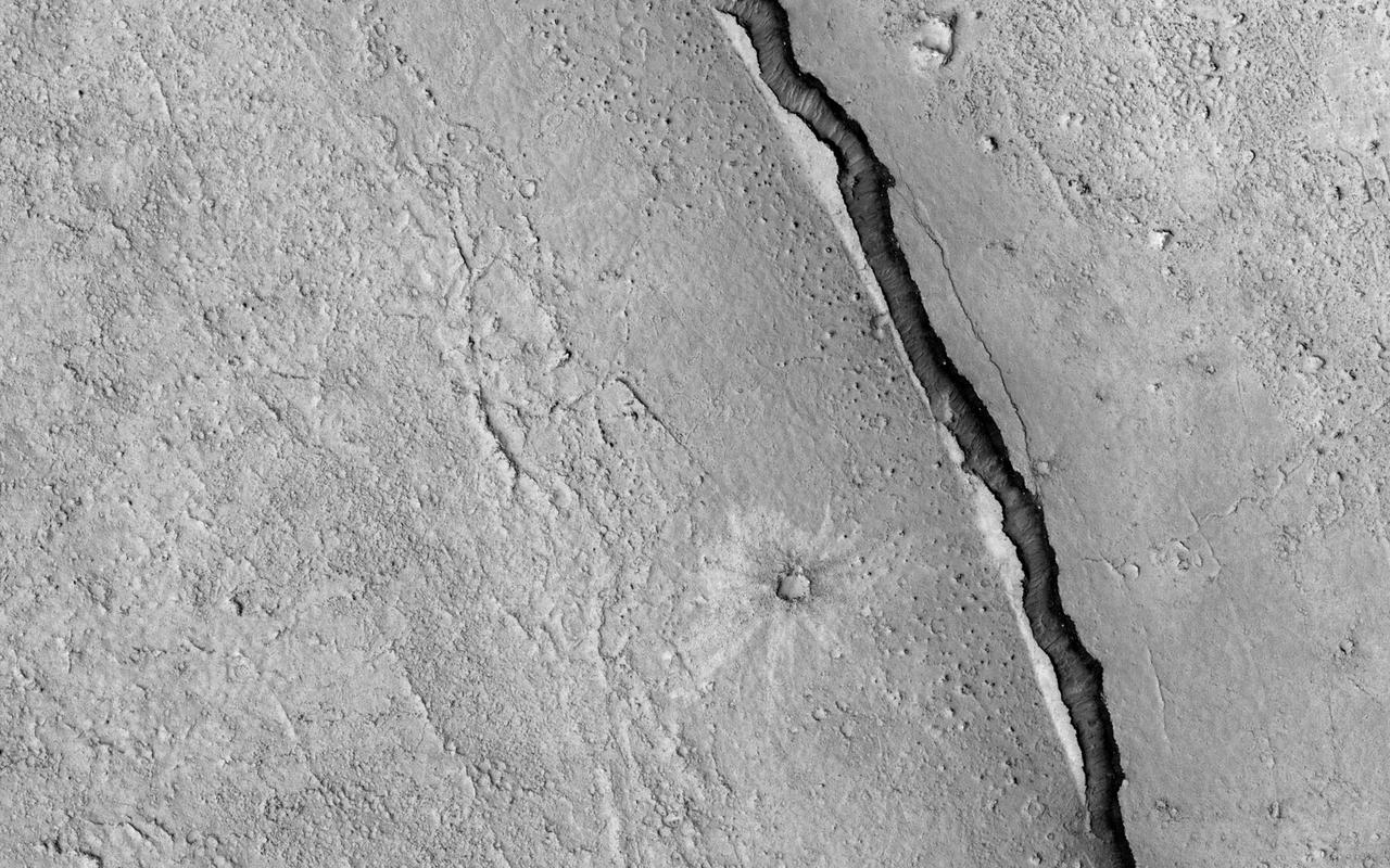
Located east of Eumenides Dorsum, this VIS image contains evidence of long term wind action and erosion. This area of Mars is dominated by poorly cemented surface material that is easily eroded by the wind. Unidirectional winds have created the linear ridge/valley system at the top half of this image. These features are called yardangs. Studies of this area propose volcanic ash eruptions from nearby volcanoes are the source of the surface material. Orbit Number: 81078 Latitude: -2.2665 Longitude: 205.439 Instrument: VIS Captured: 2020-03-25 04:51 https://photojournal.jpl.nasa.gov/catalog/PIA23929
STS093-704-087 (23-27 July 1999) --- This low angle, early morning shot over Chile was photographed from the Earth-orbiting Space Shuttle Columbia during the STS-93 mission. In the words of one of the scientists studying the STS-93 Earth imagery, Laguna Verde, in the Atacama Province of Chile (near the Argentine border), lies like a turquoise jewel among the stark black and white snow covered volcanic peaks of the High Andes. The ambient elevation in this part of the Andes is 16,000 feet (4,877 meters) with the highest local peak, Nevada Ojas de Salado (just to the right of the lake), reaching to 23,240 feet. (7084 meters.)
STS100-710-182 (19 April-1 May 2001) --- Easily recognizable in this STS-100 70mm frame are phenomena known as the von Karman vortices, which were forming in the stratocumulus field downwind from the volcanic island of Rishiri-to in the northern Sea of Japan off the northwest coast of Hokkaido, Japan. According to NASA scientists studying the STS-100 photo collection, these features form when a stable atmosphere with low clouds flows past a relatively small obstacle with a height greater than the depth of the cloud layer. Because the atmosphere is stable, a series of eddies form in the moving cloud field.
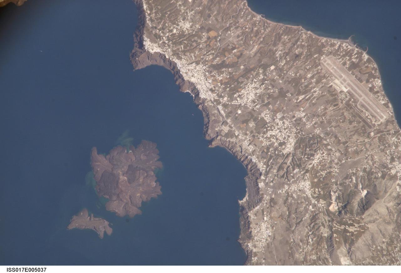
ISS017-E-005037 (19 April 2008) --- Santorini Volcano, Greece is featured in this image photographed by an Expedition 17 crewmember on the International Space Station. According to scientists, one of the largest volcanic eruptions in the past 10,000 years occurred approximately 1620 BC on the volcanic island of Santorini in the Aegean Sea. This view illustrates the center of Santorini Volcano, located approximately 118 kilometers to the north of Crete (not shown). Prior to 1620 BC, the island of Santorini -- now known as Thera -- had been built up by layers of lava created by overlapping shield volcanoes, and had experienced three significant eruptions that formed overlapping calderas, or collapsed magma chambers. Around 1620 BC, the fourth (and latest) major eruption created the present-day islands and caldera bay of Santorini Volcano. The caldera rim is clearly visible in this image as a steep cliff forming the western shoreline of the island of Thera. Following the 1620 BC eruption, much of the previous island of Santorini was destroyed or submerged. The white rooftops of cities and towns trace the caldera rim on the island of Thera, and overlook the young central islands of Nea Kameni and Palaea Kameni -- both, according to scientists, formed from lava domes and flows that started erupting approximately 1400 years after the last major caldera-forming event. Several of these flows are visible in the image as brown to dark-brown irregular masses forming Nea Kameni (left). The most recent volcanic activity in the Kameni islands occurred in 1950, and included some small explosions and production of lava. The extent of development and location of an airport (upper right) on Thera illustrate the popularity of Santorini Volcano as a tourist destination. Today, volcanic activity is closely monitored by the Institute for the Study and Monitoring of the Santorini Volcano, or ISMOSAV.
Situated in the southern Andes Mountains, the Payún volcanic field of Argentina is a complex landscape that formed over hundreds of thousands of years. Sprawling over 5,200 square kilometers (2,000 square miles), Payún is a massive shield volcano—a broad formation resembling an ancient warrior shield. This false-color image is a composite of observations acquired on February 7 and March 20, 2001 by the Enhanced Thematic Mapper Plus on the Landsat 7 satellite. It was made from a combination of visible and infrared light, where green indicates vegetation, black indicates lava flows, and orange is bare rock rich in iron oxides. Part of the back-arc volcanism of the Andes, Payún lies about 530 kilometers (330 miles) east from where the Nazca plate subducts below the South America plate. Not surprisingly, a volcanic zone extends over some 1,000 kilometers (600 miles) north-to-south in this region. According to a study published in 2010, the regional geology and chemical composition of the rocks indicate that the volcanic field likely formed within the past 300,000 years. The dominant feature of the volcanic field is Payún Matru, an elliptical caldera measuring roughly 9 by 7 kilometers (6 by 4 miles). Geologists surmise that the caldera formed after the old magma chamber emptied and the summit collapsed. Southwest of the caldera is a stratovolcano composed of alternating layers of compacted ash, hardened lava, and rocks ejected during previous eruptions. This stratovolcano, Payún, rises to 3,680 meters (12,073 feet) above sea level. (The entire volcanic field sits at 2,000 meters, or 6,600 feet.) The stratovolcano may be the most prominent feature in the volcanic field but it is by no means the only one. More than 300 eruptive features litter the shield volcano, most of them occupying an east-west line. West of Payún Matru is an area known as Los Volcanes, a mass of strombolian cones and basaltic lava flows. Image courtesy Michael P. Taylor, Landsat Data Continuity Mission Project Office, NASA Goddard Space Flight Center. Caption by Michon Scott with information from Michael Abrams, NASA Jet Propulsion Laboratory. Instrument: Landsat 7 - ETM+ To read more go to: <a href="http://1.usa.gov/UO8CbF" rel="nofollow">1.usa.gov/UO8CbF</a> Credit: <b><a href="http://www.earthobservatory.nasa.gov/" rel="nofollow"> NASA Earth Observatory</a></b> <b><a href="http://www.nasa.gov/audience/formedia/features/MP_Photo_Guidelines.html" rel="nofollow">NASA image use policy.</a></b> <b><a href="http://www.nasa.gov/centers/goddard/home/index.html" rel="nofollow">NASA Goddard Space Flight Center</a></b> enables NASA’s mission through four scientific endeavors: Earth Science, Heliophysics, Solar System Exploration, and Astrophysics. Goddard plays a leading role in NASA’s accomplishments by contributing compelling scientific knowledge to advance the Agency’s mission. <b>Follow us on <a href="http://twitter.com/NASA_GoddardPix" rel="nofollow">Twitter</a></b> <b>Like us on <a href="http://www.facebook.com/pages/Greenbelt-MD/NASA-Goddard/395013845897?ref=tsd" rel="nofollow">Facebook</a></b> <b>Find us on <a href="http://instagram.com/nasagoddard?vm=grid" rel="nofollow">Instagram</a></b>

On September 19, 2021 volcanic activity permanently altered the coastline of the small island of La Palma, located off the coast of northwestern Africa. Within seven hours of the initial eruption, the lava flow traveled about 6km to the Atlantic Coast where it continues to extend the coastline out into the ocean. This image taken by the ECOSTRESS module aboard the International Space Station captured the initial Laval flow several hours after the eruption. Dark spots along the coastline represent locations where lava flowed into the ocean, increasing the surface temperature. ECOSTRESS's primary mission is to detect small changes in the temperature of plants to measure evapotranspiration rates. It can use the same instrumentation to detect changes in surface temperature associated with events such as volcanic eruptions. ECOSTRESS observations have a spatial resolution of about 70x70 meters, which enables researchers to study surface-temperature conditions down to the size of a football field. The mission can acquire images of the same region at different times of the day. This is advantageous when monitoring plant stress in the same area throughout the day, for example. https://photojournal.jpl.nasa.gov/catalog/PIA24916
Range : 1.2 million kilometers (750,000 miles) This picture of Io is one of the last sequence of 'volcano watch' pictures planned as a time lapse study of the nearest of Jupiter's Galilean satellites. The sunlit crescent of Io is seen at the left, and the night side illuminated by light reflected from Jupiter can also be seen. Three volcanic eruption plumes are visible on the limb. All three were previously seen by Voyager 1. On the bright limb Plume 5 (upper) and Plume 6 (lower) are about 100 km high, while Plume 2 on the dark limb is about 185 km high and 325 km wide. The dimensions of Plume 2 are about 1 1/2 times greater than during the Boyager 1 encounter, indicating that the intensity of the eruptions has increased during the four-month time interval between the Boyager encounters. The three volcanic eruptions and at least three others have apparently been active at roughly the same intesity or greater for a period of at least four months.
The summits of two large volcanoes in Central Java, Indonesia are shown in the center of this radar image. Lava flows of different ages and surface roughness appear in shades of green and yellow surrounding the summit of Mt. Merbabu (mid-center) and Mt. Merapi (lower center). Mt. Merapi erupted on November 28, 1994 about six weeks after this image was taken. The eruption killed more than 60 people and forced the evacuation of more than 6,000 others. Thousands of other residents were put on alert due to the possibility of volcanic debris mudflows, called lahars, that threatened nearby towns. Mt. Merapi is located approximately 40 kilometers (25 miles) north of Yogyakarta, the capital of Central Java. The older volcano at the top of the image is unnamed. Lake Rawapening is the dark blue feature in the upper right. The light blue area southeast of the lake is the city of Salatiga. Directly south of Salatiga and southeast of Mt. Merapi is the city of Boyolali. Scientists are studying Mt. Merapi as part of the international "Decade Volcanoes" project, because of its recent activity and potential threat to local populations. The radar data are being used to identify and distinguish a variety of volcanic features. http://photojournal.jpl.nasa.gov/catalog/PIA01782
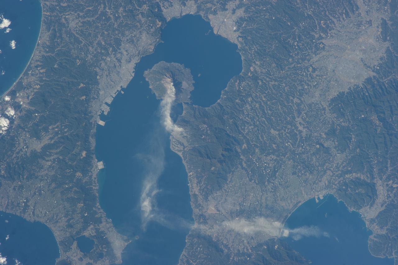
ISS034-E-027139 (10 Jan. 2013) --- Sakurajima Volcano in Kyushu, Japan is featured in this image photographed by an Expedition 34 crew member on the International Space Station. This photograph highlights Sakurajima, one of Japan’s most active volcanoes (center). There are several eruption craters near the 1,117 meter summit of Sakurajima; according to scientists, Kita-dake to the north last erupted approximately 5,000 years ago, while Minami-dake and Showa crater to the south have been the site of frequent eruptions since at least the 8th century. The ash plume visible near the volcano summit and extending to the southeast may have originated from either Minami-dake or Showa craters. Scientists believe that Sakurajima began forming approximately 13,000 years ago; prior to 1914, the volcano was an island in Kagoshima Bay—it was joined to the mainland by volcanic material following a major eruption in 1914. The image highlights the proximity of several large urban areas (Aira, Kagoshima, Kanoya, Kirishima, and Miyakonojo are readily visible) to Sakurajima. This has prompted studies of potential health hazards presented by the volcanic ash (Hillman et al. 2012), which are particularly important if more powerful explosive eruptive activity resumes at the volcano. The Tokyo Volcanic Ash Advisory Center (VAAC) of the Japan Meteorological Agency issues advisories when eruptions occur. An advisory on the activity captured in this image was issued less than one hour before the crew member took the photograph, by which time the plume tail had encountered northeast-trending upper-level winds (bottom center).
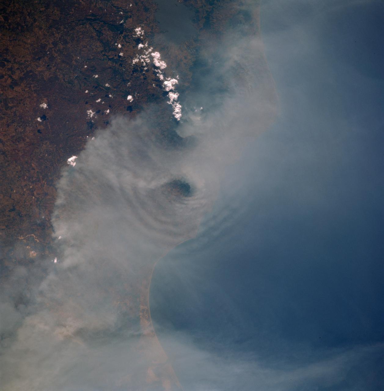
SL4-139-3971 (8 Jan. 1974) --- An oblique view of Japan as seen from the Skylab space station in Earth orbit. The Island of Kyushu is at center left. The Island of Honshu is in the right background. The Korean Peninsula is in the left background. This picture was taken by one of the Skylab 4 crewmen using a hand-held 70mm Hasselblad camera with a 100mm lens. The plume form Kyushu's volcano Sakurajima is clearly seen in this photograph. Volcanic activity at Sakurajima is known to have occurred for over 1,200 years (first recorded in the year 708 A.D.) but for the first time the entire volcanic plume can be documented at one time. Skylab photographs and crew descriptions are much more detailed then information available from other satellites. The volcano and its plume were observed at least seven times during Skylab 4, and photographed and documented with television. In repeated observations the plume was seen to stream out to the south or southeast and become increasingly diffuse away from the volcano. As the plume reached the open ocean cast of Kyushu it changed direction, sometimes abruptly, and fanned out to the northeast. In this photograph it extends about 80 kilometers (50 miles) east from the volcano; the distribution and dispersion of particulate materials and volcanic gasses will be studied in this and similar Skylab photographs. Although the plume is primarily water vapor, it contains significant quantities of oxides of carbon, sulphur and nitrogen. These gases are considered pollutants, and understanding their abundance and distribution will help to evaluate the relative effect and significance of man-made atmospheric pollutants. Photo credit: NASA
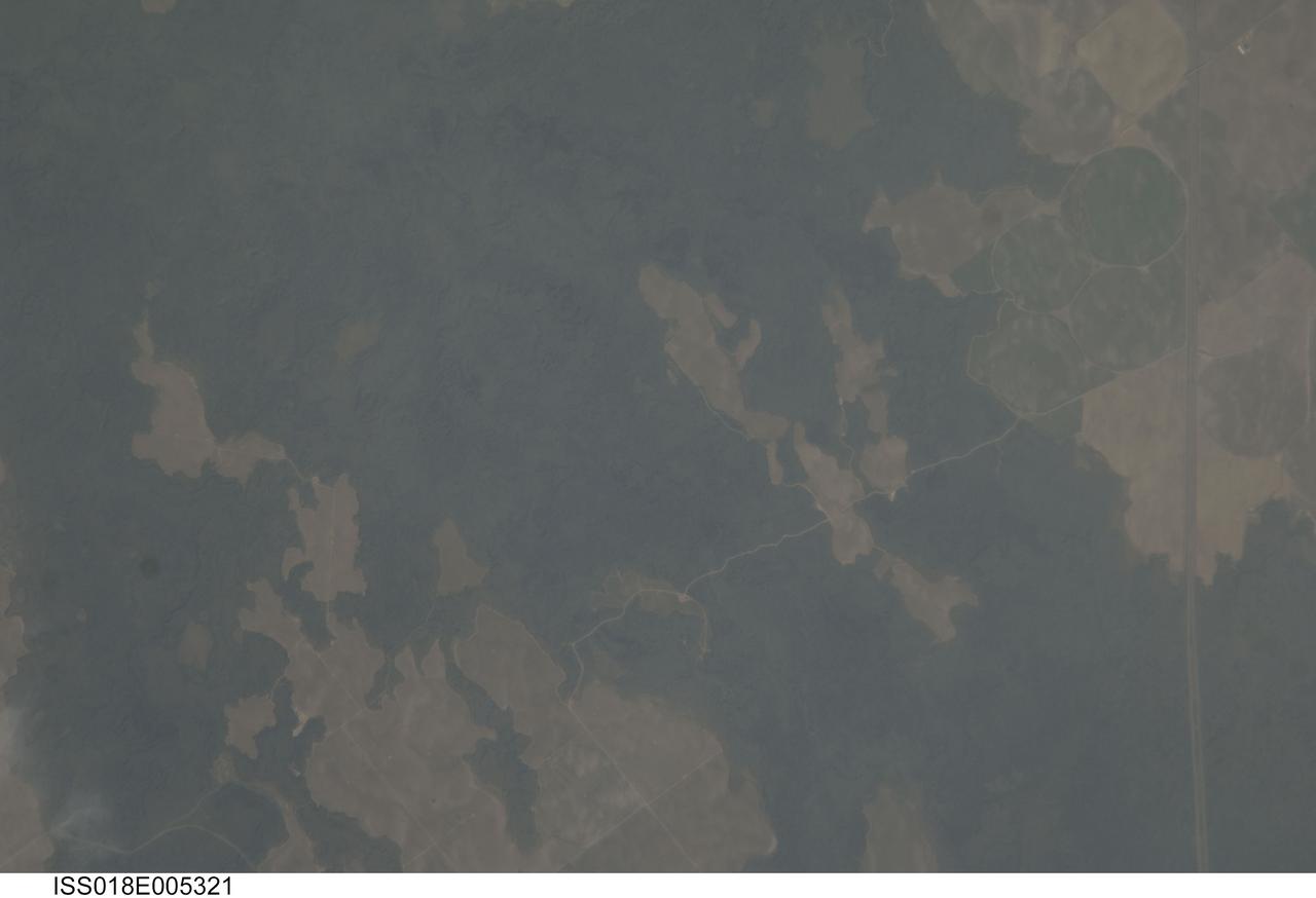
ISS018-E-005321 (24 Oct. 2008) --- The Hell's Half Acre Lava Field in Idaho is featured in this image photographed by an Expedition 18 crewmember on the International Space Station. Located in eastern Idaho, the Hell's Half Acre Lava Field is the easternmost large field associated with the Snake River Plain that arcs across the center of the state. The abundant lava flows and other volcanic rocks of the Snake River Plain are thought to be the result of southwest passage of the North American tectonic plate over a fixed mantle plume or "hotspot". According to scientists, Volcanism attributed to the hotspot began approximately 15 million years ago in the western portion of the Plain, with lava fields becoming younger to the east -- with lavas erupted approximately 4,100 years ago, Hell's Half Acre is one of the youngest lava fields. Today, the center of hotspot volcanism is located in Yellowstone National Park and feeds the extensive geyser system there. Portions of the Hell's Half Acre Lava Field are designated as a National Natural Landmark and Wilderness Study Area. This detailed photograph illustrates the forbidding landscape of the basaltic lava field -- the complex ridge patterns of the black to grey-green flow surfaces, comprised of ropy pahoehoe and blocky A a lava, are clearly visible. Regions of tan soil surrounded by lava are known as kipukas -- these "islands" are windows onto the older underlaying soil surface as they were never covered by lava. The kipukas are used for agriculture (both crops and grazing) -- several green fields are visible to the northwest of Interstate Highway 15 (right). Light to dark mottling visible in the kipukas is most likely due to variations in moisture and disturbance by agricultural activities.
A variety of diverse morphological features are present in this image (21 by 5.5 kilometers) located in the southeastern area of the Nili Fossae region and just northeast of Syrtis Major. This particular region has been studied intensely due to the presence of volcanics from Syrtis Major and impact ejecta from the Isidis Basin. The region is rich in unaltered mafic deposits, in contact with diverse altered deposits rich in clays, carbonates, and sulfates. These deposits make the Nili Fossae region one of the most colorful regions on Mars, which is most distinctive in infrared color composites (IRB). HiRISE IRB color aids in chemical and mineral-type mapping, especially when correlated with other MRO instruments such as CRISM. http://photojournal.jpl.nasa.gov/catalog/PIA19940
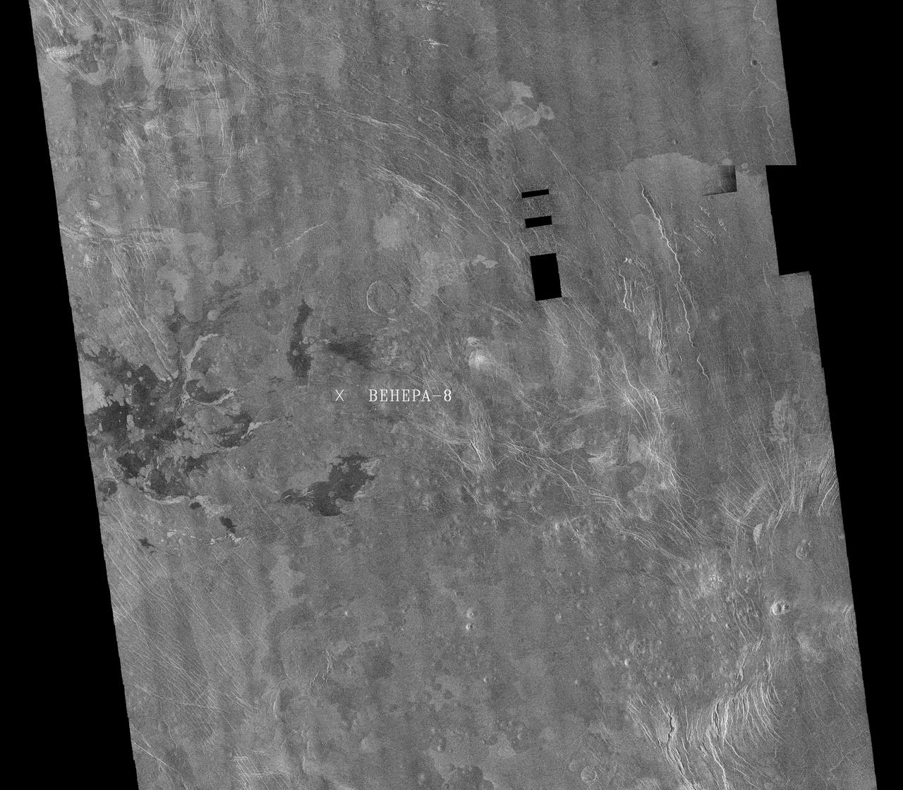
This image is a mosaic of 24 orbits of the Navka region of Venus. The image is centered at about 10 degrees south latitude and 335 degrees east longitude. The image is about 400 km (240 miles) across. 'Behepa 8' marks the approximate landing site of the Soviet Venera 8 lander, which took measurements at the surface of Venus in 1972. The Venera 8 lander measured granitic or continental-like materials at the landing site. Magellan data reveals the landing site to lie in a region of plains cut by tectonic ridges and troughs. Volcanic domes and flows are seen throughout the region. Studying the regional setting of the Venera landing sites is important in linking information about surface composition to surface morphology seen in radar images. Resolution of the Magellan data is about 120 meters (400 feet). http://photojournal.jpl.nasa.gov/catalog/PIA00460
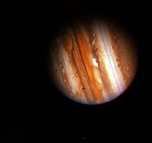
On February 5, 1979, Voyager 1 made its closest approach to Jupiter since early 1974 and 1975 when Pioneers 10 and 11 made their voyages to Jupiter and beyond. Voyager 1 completed its Jupiter encounter in early April, after taking almost 19,000 pictures and recording many other scientific measurements. Although astronomers had studied Jupiter from Earth for several centuries, scientists were surprised by many of Voyager 1 and 2's findings. They now understand that important physical, geological, and atmospheric processes go on that they had never observed from Earth. Discovery of active volcanism on the satellite Io was probably the greatest surprise. It was the first time active volcanoes had been seen on another body in the solar system. Voyager also discovered a ring around Jupiter. Thus Jupiter joins Saturn, Uranus, and Neptune as a ringed planet -- although each ring system is unique and distinct from the others.
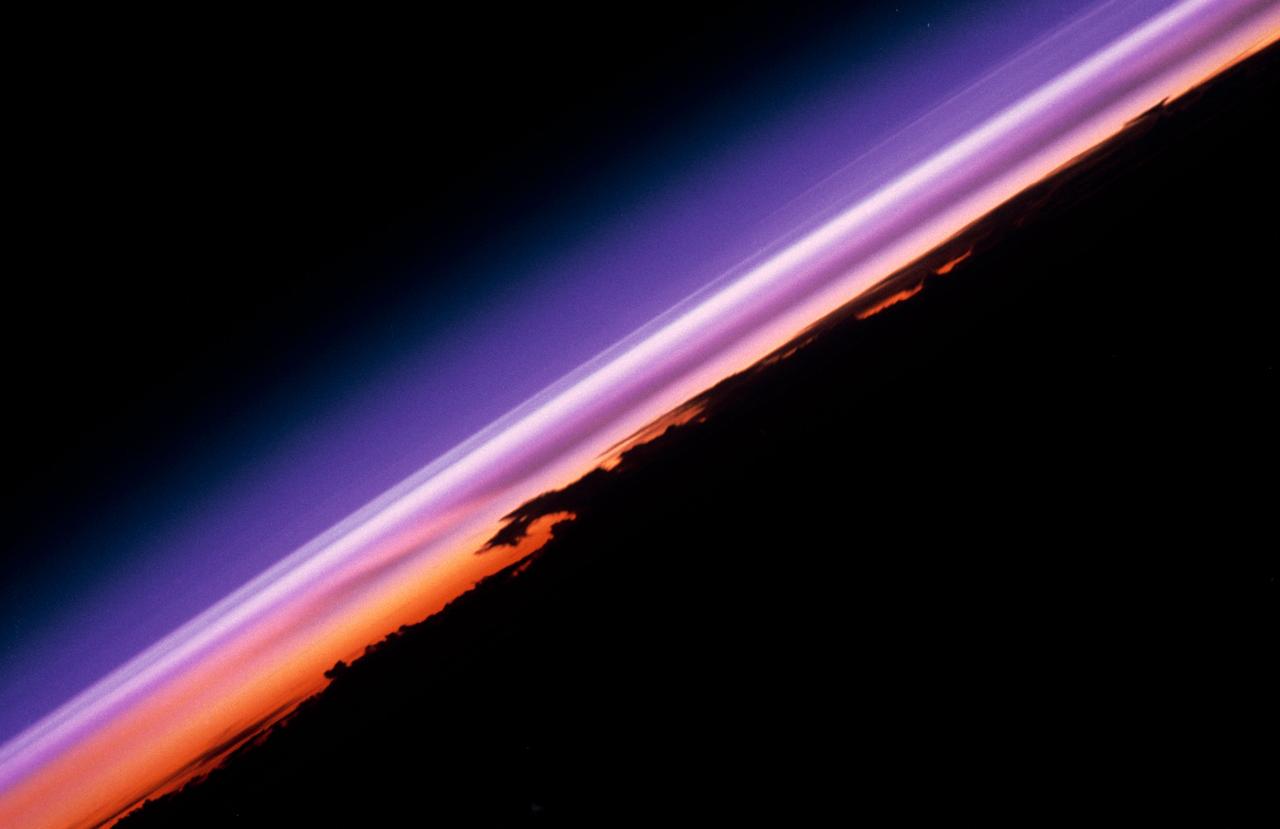
STS047-54-016 (12 - 20 Sept 1992) --- The colors in this photograph provide insight into the relative density of the atmosphere. The crew members had many opportunities to witness sunrises and sunsets, considering they orbit the Earth every 90 minutes, but few, they said, compared to this scene. It captures the silhouette of several mature thunderstorms with their cirrus anvil tops spreading out against the tropopause (the top of the lowest layer of Earth's atmosphere) at sunset. The lowest layer (troposphere) is the densest and refracts light at the red end of the visible spectrum (7,400 Angstroms), while the blues (4,000 Angstroms) are separated in the least dense portion of the atmosphere (middle and upper atmosphere, or stratosphere and mesosphere). Several layers of blue can be seen. NASA scientists studying the photos believe this stratification to be caused by the scattering of light by particulate trapped in the stratosphere and mesosphere particulate that generally originate from volcanic eruptions, such as those of Mt. Pinatubo in the Philippines and, most recently, Mt. Spurr in Alaska.
STS091-725-088 (2-12 June 1998)--- In this 70mm picture photographed during one of Discovery's passes over Mexico, waves generated by the volcanic peaks are seen as the wind carrying the smoke moves by the peaks. Along the coast of the Bay of Campeche, the fires burn around the peak of the Cerro San Martin (5,577 feet), which is west and higher than the peak with the waves around it. Lago Catemaco is on the west, center edge of the photo. Fires across Mexico and Central America created heavy smoke plumes for a few weeks in May and June, 1998. The smoke circulated around a high pressure system over the Gulf of Mexico and brought thick smoke and soot to the south central United States. Scientists are looking at burning regions like this around the world to study the smokes affect on the albedo or the reflectance of the suns rays and how it may influence our world's climate.
Ophir Chasma forms the northern portion of Valles Marineris, and this image from NASA Mars Reconnaissance Orbiter spacecraft features a small part of its wall and floor. The wall rock shows many sedimentary layers and the floor is covered with wind-blown ridges, which are intermediate in size between sand ripples and sand dunes. Rocks protruding on the floor could be volcanic intrusions of once-molten magma that have pushed aside the surrounding sedimentary layers and "froze" in place. Images like this can help geologists study the formation mechanisms of large tectonic systems like Valles Marineris. (The word "tectonics" does not mean the same thing as "plate tectonics." Tectonics simply refers to large stresses and strains in a planet's crust. Plate tectonics is the main type of tectonics that Earth has; Mars does not have plate tectonics.) http://photojournal.jpl.nasa.gov/catalog/PIA20044

STS047-54-018 (12-20 Sept. 1992) --- The colors in this photograph provide insight into the relative density of the atmosphere. The crew members had many opportunities to witness sunrises and sunsets, considering they orbit the Earth every 90 minutes, but few, they said, compared to this scene. It captures the silhouette of several mature thunderstorms with their cirrus anvil tops spreading out against the tropopause (the top of the lowest layer of Earth's atmosphere) at sunset. The lowest layer (troposphere) is the densest and refracts light at the red end of the visible spectrum (7,400 Angstroms), while the blues (4,000 Angstroms) are separated in the least dense portion of the atmosphere (middle and upper atmosphere, or stratosphere and mesosphere). Several layers of blue can be seen. NASA scientists studying the photos believe this stratification to be caused by the scattering of light by particulate trapped in the stratosphere and mesosphere particulate that generally originate from volcanic eruptions, such as those of Mt. Pinatubo in the Philippines and, most recently, Mt. Spurr in Alaska.
The summit of the Mount Etna volcano on the island of Sicily, Italy, one of the most active volcanoes in the world, is shown near the center of this radar image. Lava flows of different ages and surface roughness appear in shades of purple, green, yellow and pink surrounding the four small craters at the summit. Etna is one of the best-studied volcanoes in the world and scientists are using this radar image to identify and distinguish a variety of volcanic features. Etna has erupted hundreds of times in recorded history, with the most recent significant eruption in 1991-1993. Scientists are studying Etna as part of the international "Decade Volcanoes" project, because of its high level of activity and potential threat to local populations. This image was acquired on October 11, 1994 by the Spaceborne Imaging Radar-C/X-Band Synthetic Aperture Radar (SIR-C/X-SAR) aboard the space shuttle Endeavour. SIR-C/X-SAR, a joint mission of the German, Italian and the United States space agencies, is part of NASA's Mission to Planet Earth. The image is centered at 37.8 degrees North latitude and 15.1 degrees East longitude and covers an area of 51.2 kilometers by 22.6 kilometers (31.7 miles by 14.0 miles). http://photojournal.jpl.nasa.gov/catalog/PIA01776
Completed: 07-16-2009 Straddling the equator approximately 1000 kilometers to the west of the South American mainland, the Galapagos Islands lie within the heart of the equatorial current system. Rising from the sea floor, the volcanic islands of the Galapagos are set on top of a large submarine platform. The main portion of the Galapagos platform is relatively flat and less than 1000 meters in depth. The steepest slopes are found along the western and southern flanks of the platform with a gradual slope towards the east. The interactions of the Galapagos and the oceanic currents create vastly different environmental regimes which not only isolates one part of the Archipelago from the other but allows penguins to live along the equator on the western part of the Archipelago and tropical corals around the islands to the north. The islands are relatively new in geologic terms with the youngest islands in the west still exhibiting periodic eruptions from their massive volcanic craters. Please give credit for this item to: NASA/Goddard Space Flight Center, The SeaWiFS Project and GeoEye, Scientific Visualization Studio. NOTE: All SeaWiFS images and data presented on this web site are for research and educational use only. All commercial use of SeaWiFS data must be coordinated with GeoEye (http://www.geoeye.com). To download this video go to: <a href="http://svs.gsfc.nasa.gov/goto?3628" rel="nofollow">svs.gsfc.nasa.gov/goto?3628</a> <b><a href="http://www.nasa.gov/centers/goddard/home/index.html" rel="nofollow">NASA Goddard Space Flight Center</a></b> is home to the nation's largest organization of combined scientists, engineers and technologists that build spacecraft, instruments and new technology to study the Earth, the sun, our solar system, and the universe.
ISS006-E-38306 (14 March 2003) --- The Arid Coast of Peru is featured in this digital image photographed by an Expedition 6 crewmember on the International Space Station (ISS). This oblique, south-looking view shows the dramatic canyons of Peru’s southern coast (15.5 – 17 degrees S). According to NASA scientists studying ISS imagery, these are relatively young features carved by rivers mainly over the past 8 million years following the last major upheaval of the Andes Mountains. The canyons are some of the steepest and deepest on Earth—lake Laguna Parincocha (top left corner) lies on the Andean plateau about 3,250 meters above sea level, only 80 kilometers from the coast. A sheet of volcanic rock (known as an ignimbrite deposit) emplaced during an explosive eruptive event is scored with a dense pattern of parallel dry streams in the lower left corner of the image. Volcanic source regions for the ignimbrite lie outside the left margin of the view. The Yauca and Acarí rivers feed small tan-colored sediment plumes into the sea (lower right). Dark green agricultural fields cluster along the lower courses of the rivers. Strong southerly winds have generated sand dunes and dark wind streaks along the coast, whose alignments re-curve inland into the lower river valleys (lower right). The coast and canyons are commonly hazy due to oceanic air and blowing dust. Yellow lines parallel with the coast and near the small peninsula, according to scientists, are raised shorelines probably caused by tectonic uplift of the coastline.
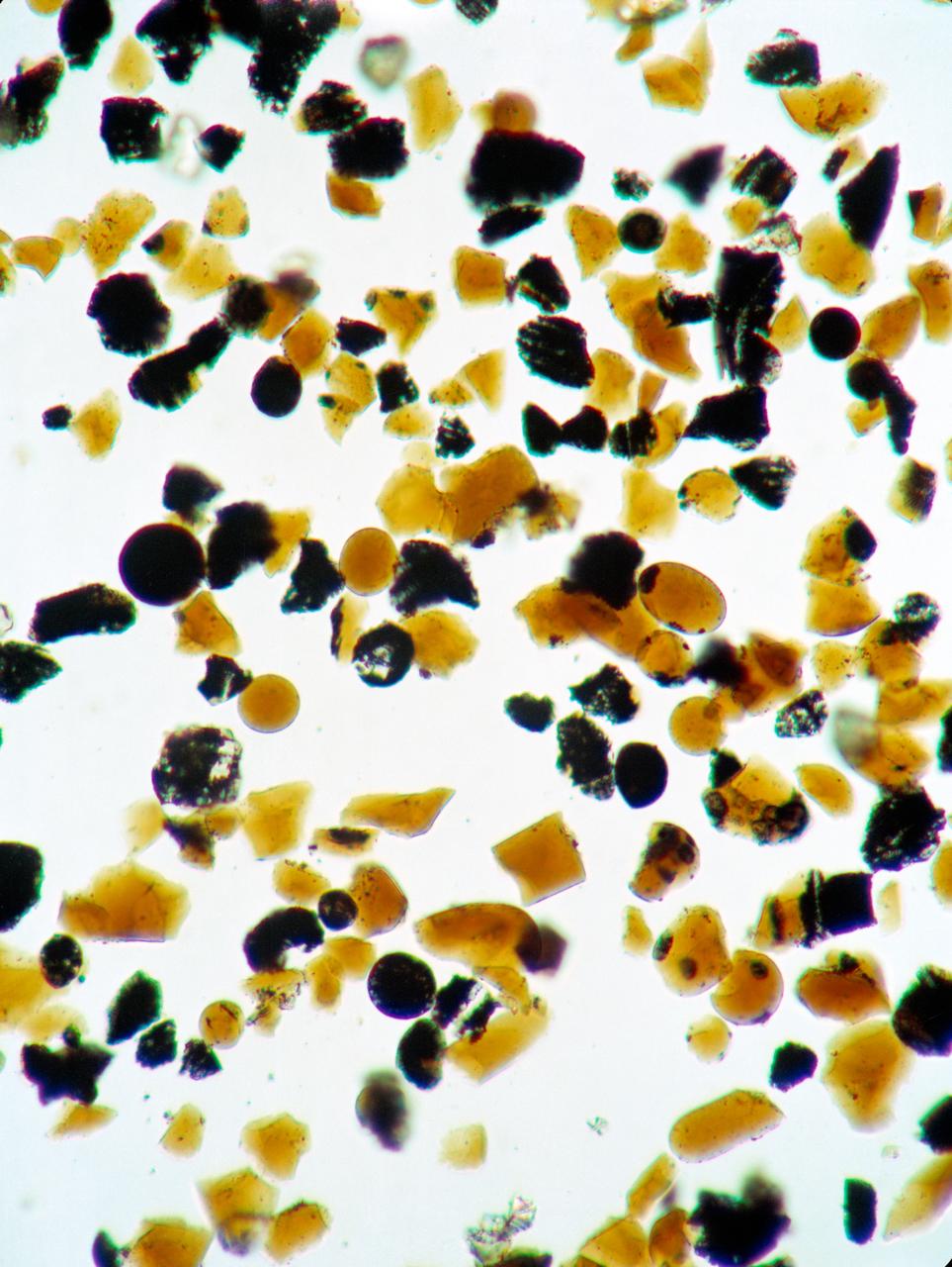
S73-15171 (4 Jan. 1973) --- These orange glass spheres and fragments are the finest particles ever brought back from the moon. Ranging in size from 20 to 45 microns (about 1/1000 of an inch) the particles are magnified 160 times in this photomicrograph made in the Lunar Receiving Laboratory at the Manned Spacecraft Center. The orange soil was brought back from the Taurus-Littrow landing site by the Apollo 17 crewmen. Scientist-astronaut Harrison H. "Jack" Schmitt discovered the orange soil at Shorty Crater during the second Apollo 17 extravehicular activity (EVA). This lunar material is being studied and analyzed by scientists in the LRL. The orange particles in this photomicrograph, which are intermixed with black and black-speckled grains, are about the same size as the particles that compose silt on Earth. Chemical analysis of the orange soil material has shown the sample to be similar to some of the samples brought back from the Apollo 11 (Sea of Tranquility) site several hundred miles to the southwest. Like those samples, it is rich in titanium (8%) and iron oxide (22%). But unlike the Apollo 11 samples, the orange soil is unexplainably rich in zinc ? an anomaly that has scientists in a quandary. This Apollo 17 sample is not high in volatile elements, nor do the minerals contain substantial amounts of water. These would have provided strong evidence of volcanic activity. On the other hand, the lack of agglutinates (rocks made up of a variety of minerals cemented together) indicates that the orange glass is probably not the product of meteorite impact -- strengthening the argument that the glass was produced by volcanic activity.
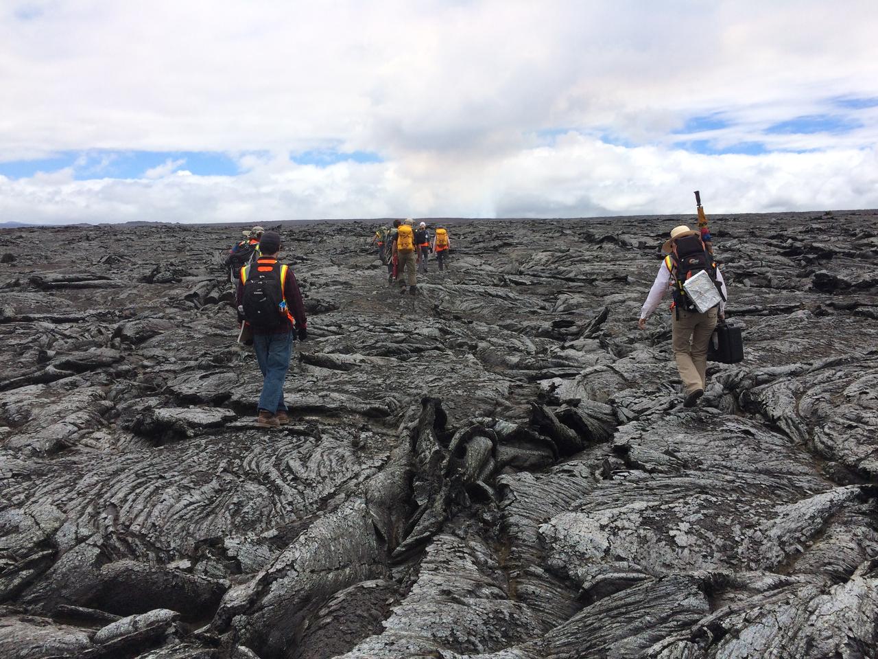
Lava formations The science and journalism teams make their way across the ropey, twisted, broken crust of the 1978 lava flow. These patterns formed as flowing lava exposed at the surface cooled and solidified, while hot lava continued to flow beneath. The dark cloud in the distance is the active volcanic plume. Credit: NASA/GSFC/Andrea Jones In June, five student journalists from Stony Brook University packed their hiking boots and hydration packs and joined a NASA-funded science team for 10 days on the lava fields of Kilauea, an active Hawaiian volcano. Kilauea’s lava fields are an ideal place to test equipment designed for use on Earth’s moon or Mars, because volcanic activity shaped so much of those terrains. The trip was part of an interdisciplinary program called RIS4E – short for Remote, In Situ, and Synchrotron Studies for Science and Exploration – which is designed to prepare for future exploration of the moon, near-Earth asteroids and the moons of Mars. To read reports from the RIS4E journalism students about their experiences in Hawaii, visit <a href="http://ReportingRIS4E.com" rel="nofollow">ReportingRIS4E.com</a> <b><a href="http://www.nasa.gov/audience/formedia/features/MP_Photo_Guidelines.html" rel="nofollow">NASA image use policy.</a></b> <b><a href="http://www.nasa.gov/centers/goddard/home/index.html" rel="nofollow">NASA Goddard Space Flight Center</a></b> enables NASA’s mission through four scientific endeavors: Earth Science, Heliophysics, Solar System Exploration, and Astrophysics. Goddard plays a leading role in NASA’s accomplishments by contributing compelling scientific knowledge to advance the Agency’s mission. <b>Follow us on <a href="http://twitter.com/NASAGoddardPix" rel="nofollow">Twitter</a></b> <b>Like us on <a href="http://www.facebook.com/pages/Greenbelt-MD/NASA-Goddard/395013845897?ref=tsd" rel="nofollow">Facebook</a></b> <b>Find us on <a href="http://instagrid.me/nasagoddard/?vm=grid" rel="nofollow">Instagram</a></b>

SL3-87-355 (July-September 1973) --- A vertical view of the eastern coast of Sicily area is seen in this Skylab 3 Earth Resources Experiments Package S190-B (five-inch earth terrain camera) infrared photograph taken from the Skylab space station in Earth orbit. Mount Etna, the highest volcano in Europe (10,958 feet), is still active as evidenced by the thin plume of smoke emanating from its crest. (The altitude is approximate because the height of the volcano changes with each eruption). On the flanks of Etna recent lava flows appear black in contrast to the older flows and volcanic debris that are red. Numerous small, circular cinder cones on the flanks represent sites of previous eruptions. Catania, on the Mediterranean coast south of Etna, is the largest of several cities and villages which appear as light-gray patches on the lower slopes of the volcano. Plano de Catania, south of the city of Catania, is outlined by polygonal light and dark agricultural tracts. Several lakes, the largest of which is Lake Pozzillo, show up as dark blue in the photograph. The unusual colors in the picture are due to the use of color infrared film in which vegetation appears red. This is very evident on the slopes of Etna, in the Monti Nebrodi area at upper let, and in the local areas in the lower part of the picture. Studies of Mount Etna and related volcanic features will be undertaken by Professor Roberto Cassinis of Servizio Geologio d?Italia, Rome. Federal agencies participating with NASA on the EREP project are the Departments of Agriculture, Commerce, Interior, the Environmental Protection Agency and the Corps of Engineers. All EREP photography is available to the public through the Department of Interior?s Earth Resources Observation Systems Data Center, Sioux Falls, South Dakota, 57198. Photo credit: NASA
NASA image acquired June 16, 2010. Papua New Guinea’s Manam Volcano released a thin, faint plume on June 16, 2010, as clouds clustered at the volcano’s summit. The Advanced Land Imager (ALI) on NASA’s Earth Observing-1 (EO-1) satellite took this picture the same day. Rivulets of brown rock interrupt the carpet of green vegetation on the volcano’s slopes. Opaque white clouds partially obscure the satellite’s view of Manam. The clouds may result from water vapor from the volcano, but may also have formed independent of volcanic activity. The volcanic plume appears as a thin, blue-gray veil extending toward the northwest over the Bismarck Sea. Located 13 kilometers (8 miles) off the coast of mainland Papua New Guinea, Manam forms an island 10 kilometers (6 miles) wide. It is a stratovolcano. The volcano has two summit craters, and although both are active, most historical eruptions have arisen from the southern crater. NASA Earth Observatory image created by Jesse Allen, using EO-1 ALI data provided courtesy of the NASA EO-1 team. Caption by Michon Scott. Instrument: EO-1 - ALI To view the full image go to: <a href="http://earthobservatory.nasa.gov/NaturalHazards/view.php?id=44307&src=nhrss" rel="nofollow">earthobservatory.nasa.gov/NaturalHazards/view.php?id=4430...</a> <b><a href="http://www.nasa.gov/centers/goddard/home/index.html" rel="nofollow">NASA Goddard Space Flight Center</a></b> is home to the nation's largest organization of combined scientists, engineers and technologists that build spacecraft, instruments and new technology to study the Earth, the sun, our solar system, and the universe.
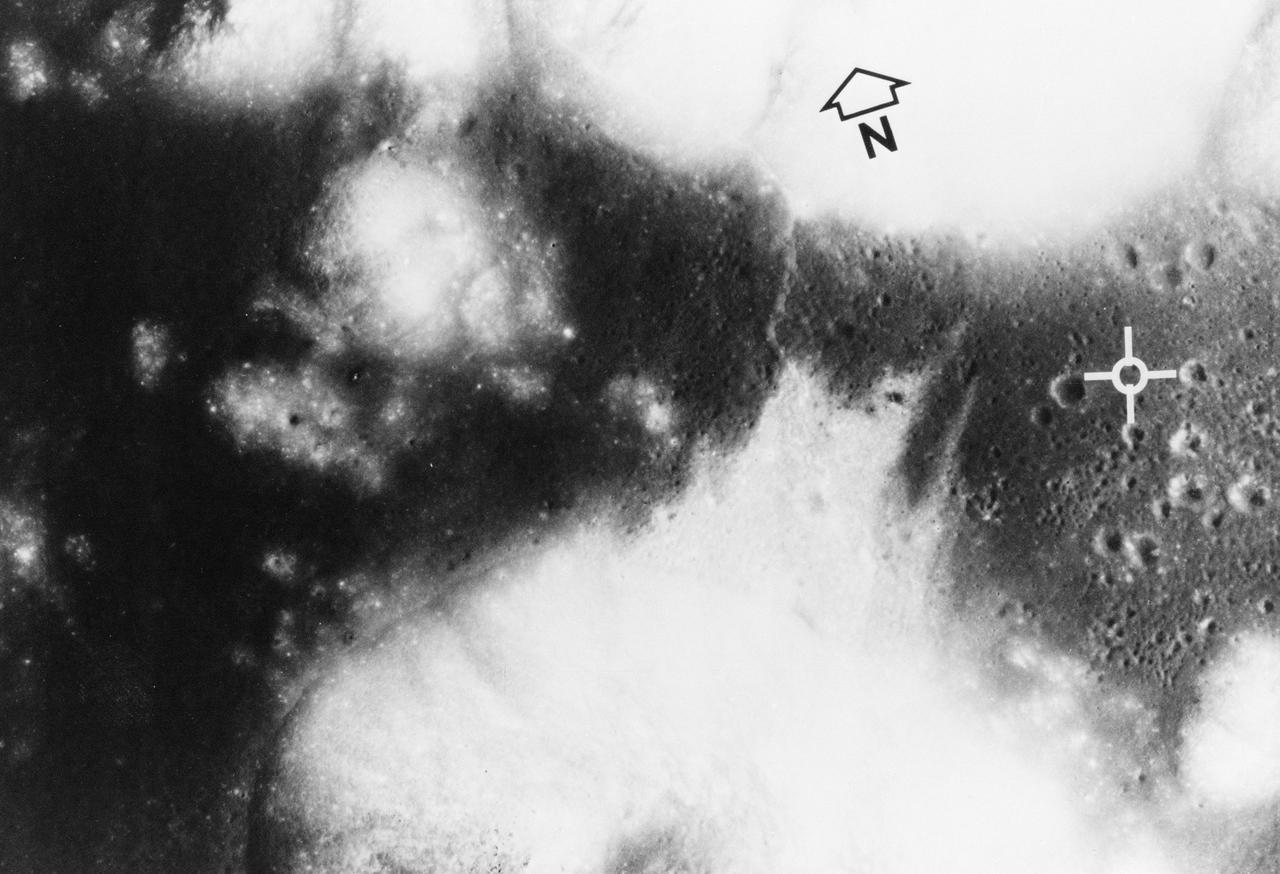
S72-35010 (April 1972) --- The Apollo Program's final manned landing on the moon will explore a site designated Taurus-Littrow on the southeastern rim of the Sea of Serenity. This photograph from the Apollo 15 Metric Camera gives a vertical view of the Apollo 17 landing site at 20 degrees north latitude and 30 degrees east longitude. The site (white cross) is on a dark-cratered plain at the base of light-colored highland mountains. The major scientific objective is to study the highlands for new knowledge about what is believed to be representative of the most ancient part of the moon. The darker material forms a bay amid steep-sided mountains that rise almost 2 kilometers (1 1/4 miles) above the adjacent plain or basin. Mountain slopes in excess of 25 degrees are common. The individual mountain masses and ridges are believed to represent very old highland crustal blocks structurally separated by various basin-forming events. The basin and parts of the highlands are mantled (covered) with dark deposits that may be fragmented rocks of volcanic origin. The dark mantle, a very low albedo, (low light-reflective) loose material which covers pre-existing terrain, is extensively developed in this region. Sampling of the dark deposits is given a high priority since its age and composition wouls shed light on the thermal history of the moon. Panoramic photography and command module pilot observations on Apollo 15 documented the presence here of a number of cinder cones which may be related to the dark mantle. It might be dust blown out by a volcanic eruption. Radar maps indicate this dark mantle is different because of its scarcity of block material. The photo covers 22 kilometers (13.5 miles) from east to west and 15 kilometers (9 miles) north to south. A ridge-like feature snakes from north to south across the basin and highlands about 6 kilometers (3.7 miles) west of the landing point, and is partly covered by a northward debris flow from the base of a mountain southwest
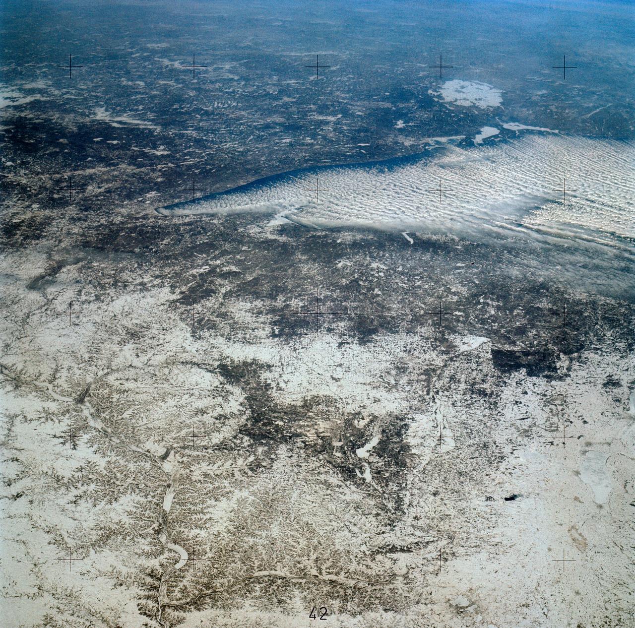
SL4-139-3953 (7 Jan. 1974) --- An oblique view of a portion of the Middle West looking northeastward toward Lake Superior and Ontario, Canada, as seen from the Skylab space station in Earth orbit. This picture was taken by one of the Skylab 4 crewmen with a hand-held 70mm Hasselblad camera using a 100mm lens. Most of the land mass in the foreground is Wisconsin. Iowa is in the lower left corner. Minnesota is at left and upper left. Ontario is in the far right background. Michigan is at right center. Note the circular-shaped feature at center left which was first observed by the Skylab 4 crewmen. The feature is 85 kilometers (55 miles) in diameter, and it is centered near 91.5 degrees west longitude and 44.5 degrees north latitude. The Mississippi River Valley forms the southwest side of the circular feature. The City of La Crosse, Wisconsin, is just south of the near side of the circle, and the Black River completes the southern and eastern part. The City of Eau Claire is at the north edge of the circle. The most likely origin of circular features of this magnitude are (1) volcanic, (2) structural, or (3) meteorite impact. The feature is not volcanic -- the rocks are the wrong type. Possibly it is structural, formed by slight warping of layered rocks into a basin or dome, followed by erosion of all but the most subtle trace of the structure. The feature could be a severely eroded meteorite impact crater. If so, a thorough study of the area may yield evidence of the extreme pressure and temperature the rocks were subjected to by the shock of an impacting meteorite. Photo credit: NASA
This is a radar image of Mount Rainier in Washington state. The volcano last erupted about 150 years ago and numerous large floods and debris flows have originated on its slopes during the last century. Today the volcano is heavily mantled with glaciers and snowfields. More than 100,000 people live on young volcanic mudflows less than 10,000 years old and, consequently, are within the range of future, devastating mudslides. This image was acquired by the Spaceborne Imaging Radar-C and X-band Synthetic Aperture Radar (SIR-C/X-SAR) aboard the space shuttle Endeavour on its 20th orbit on October 1, 1994. The area shown in the image is approximately 59 kilometers by 60 kilometers (36.5 miles by 37 miles). North is toward the top left of the image, which was composed by assigning red and green colors to the L-band, horizontally transmitted and vertically, and the L-band, horizontally transmitted and vertically received. Blue indicates the C-band, horizontally transmitted and vertically received. In addition to highlighting topographic slopes facing the space shuttle, SIR-C records rugged areas as brighter and smooth areas as darker. The scene was illuminated by the shuttle's radar from the northwest so that northwest-facing slopes are brighter and southeast-facing slopes are dark. Forested regions are pale green in color; clear cuts and bare ground are bluish or purple; ice is dark green and white. The round cone at the center of the image is the 14,435-foot (4,399-meter) active volcano, Mount Rainier. On the lower slopes is a zone of rock ridges and rubble (purple to reddish) above coniferous forests (in yellow/green). The western boundary of Mount Rainier National Park is seen as a transition from protected, old-growth forest to heavily logged private land, a mosaic of recent clear cuts (bright purple/blue) and partially regrown timber plantations (pale blue). The prominent river seen curving away from the mountain at the top of the image (to the northwest) is the White River, and the river leaving the mountain at the bottom right of the image (south) is the Nisqually River, which flows out of the Nisqually glacier on the mountain. The river leaving to the left of the mountain is the Carbon River, leading west and north toward heavily populated regions near Tacoma. The dark patch at the top right of the image is Bumping Lake. Other dark areas seen to the right of ridges throughout the image are radar shadow zones. Radar images can be used to study the volcanic structure and the surrounding regions with linear rock boundaries and faults. In addition, the recovery of forested lands from natural disasters and the success of reforestation programs can also be monitored. Ultimately this data may be used to study the advance and retreat of glaciers and other forces of global change. http://photojournal.jpl.nasa.gov/catalog/PIA01727
This is an image of the Colima volcano in Jalisco, Mexico, a vigorously active volcano that erupted as recently as July 1994. The eruption partially destroyed a lava dome at the summit and deposited a new layer of ash on the volcano's southern slopes. Surrounding communities face a continuing threat of ash falls and volcanic mudflows from the volcano, which has been designated one of 15 high-risk volcanoes for scientific study during the next decade. This image was acquired by the Spaceborne Imaging Radar-C and X-band Synthetic Aperture Radar (SIR-C/X-SAR) aboard the space shuttle Endeavour on its 24th orbit on October 1, 1994. The image is centered at 19.4 degrees north latitude, 103.7 degrees west longitude. The area shown is approximately 35.7 kilometers by 37.5 kilometers (22 miles by 23 miles). This single-frequency, multi-polarized SIR-C image shows: red as L-band horizontally transmitted and received; green as L-band horizontally transmitted and vertically received; and blue as the ratio of the two channels. The summit area appears orange and the recent deposits fill the valleys along the south and southwest slopes. Observations from space are helping scientists understand the behavior of dangerous volcanoes and will be used to mitigate the effects of future eruptions on surrounding populations. http://photojournal.jpl.nasa.gov/catalog/PIA01739
SL4-142-4548 (27 Jan. 1974) --- An oblique view of northwestern Mexico, as photographed from the Skylab space station in Earth orbit by one of the Skylab 4 crewmen. The camera used was a hand-held 70mm Hasselblad, with SO-368 medium-speed Ektachrome film. This photograph was taken on a sweep down the coast to document the fault patterns of southern California and northwest Mexico. SL4-142-4532 gives an excellent overview of the entire region. The specific reason for this picture was an attempt to see if the Agua Blanca Fault in Baja California extends to the east toward the Gulf of California. Several attempts were made by the Skylab 4 crew to visually detect such an extension, but none was found. The report was that the fault disappeared into an area of sand and heavily eroded material that obscured any feature that might be present deeper. This area of sand and loose material is the light-colored area in the center of Baja at the extreme north part of the photograph. In addition to this geology the Pinacate volcanic field in Sonora, the sand dunes in Sonora, and the sediment flow patterns of the Colorado River entering the Gulf are additional areas of study utilizing this photograph. Photo credit: NASA
Given enough time, impact craters on Mars tend to fill up with different materials. For instance, some craters on Mars had lakes inside them in the past. When these lakes dried out, they left behind traces of their past existence, such as sedimentary deposits (materials that were carried along with the running water into the lake inside the crater and then settled down). Some craters, especially in high latitudes, contain ice deposits that filled the crater when an earlier ice age allowed ice to extend into the crater's latitude. Here, NASA's Mars Reconnaissance Orbiter spies a crater that lies close to Elysium, a major volcanic system on Mars. The whole region surrounding the crater was at some point covered by lava from the volcano creating vast lava plains, and in the process, flooding impact craters in their way. When the lava eventually cooled down, it solidified and began to shrink in size. This shrinking led to formation of cracks on the surface of the lava that grew in a circular pattern matching the shape of the crater it was filling. Scientists can study these fractures and estimate how much it shrank in volume to better understand the properties of the lava (such as its temperature) during the time it filled the crater. https://photojournal.jpl.nasa.gov/catalog/PIA21596
March 31, 2010..The volcanic eruption near Eyjafjallajökull persists into its second week, with continued lava fountaining and lava flows spilling into nearby canyons. The eruption is located at the Fimmvörduháls Pass between the Eyjafjallajökull ice field to the west (left) and the Mýrdalsjökull ice field to the east (right). This natural-color satellite image was acquired on March 26, 2010, by the MODIS aboard NASA’s Terra satellite. Dark ash and scoria cover the northern half of the Fimmvörduháls Pass. White snow covers the rest of the pass, sandwiched between white glaciers. Snow-free land is tan, brown, or dark gray, devoid of vegetation in early spring. To download a high res version of this image go to: <a href="http://modis.gsfc.nasa.gov/gallery/individual.php?db_date=2010-03-31" rel="nofollow">modis.gsfc.nasa.gov/gallery/individual.php?db_date=2010-0...</a> <b><a href="http://www.nasa.gov/centers/goddard/home/index.html" rel="nofollow">NASA Goddard Space Flight Center</a></b> is home to the nation's largest organization of combined scientists, engineers and technologists that build spacecraft, instruments and new technology to study the Earth, the sun, our solar system, and the universe.
In this image from NASA Mars Mars Reconnaissance Orbiter, we can see quite a spectacular layering pattern inside an impact crater called Spallanzani. Seeing layering is always exciting to geologists because it implies that the region has experienced multiple climatic conditions or geologic processes through time. The study of layering is so important in geology that it has its own dedicated branch of study: stratigraphy! Commonly, layering implies different lithologies (i.e., rock types). However, sometimes the layers could be of very similar composition but formed in different periods of time. This could happen for example in the case of annual flood deposits from rivers, multiple volcanic eruptions, or annual or periodic deposition of ice-rich material. We can also see in this image another feature called terracing, which happens when the layers form distinctive planes on top of one another like terraces. This could imply that the layers are being eroded with time but some of the layers are being eroded quicker than others because they are less resistant to erosion. So what is the composition of these layers? Spallanzani Crater lies in the high latitudes of the Southern hemisphere (around 60 degrees in latitude) so there is a good possibility that the deposits are ice-rich. If we look more closely we will notice fractured mounds, which sometimes indicate the presence of subsurface ice. Another interesting observation is the presence of grooves in the shaded slopes of some of the layers. Perhaps these grooves formed because of the sublimation (the direct transfer of solid ice to water vapor) of ice from these slopes since slopes tend to get warmer than the surrounding terrains. A close inspection of this image may help answer this question and investigate the multiple cycles in which these deposits were laid down as well as the duration of these individual cycles. http://photojournal.jpl.nasa.gov/catalog/PIA19367
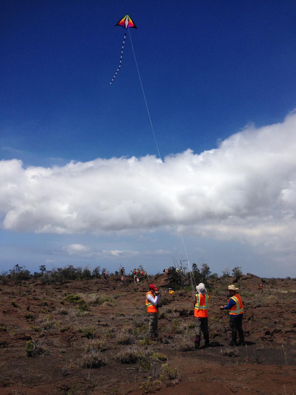
Team kite This kite was part of the scientific tool kit. It carried a camera that can be used to make high-resolution mosaics of the study site. Credit: NASA/GSFC/Jacob Bleacher In June, five student journalists from Stony Brook University packed their hiking boots and hydration packs and joined a NASA-funded science team for 10 days on the lava fields of Kilauea, an active Hawaiian volcano. Kilauea’s lava fields are an ideal place to test equipment designed for use on Earth’s moon or Mars, because volcanic activity shaped so much of those terrains. The trip was part of an interdisciplinary program called RIS4E – short for Remote, In Situ, and Synchrotron Studies for Science and Exploration – which is designed to prepare for future exploration of the moon, near-Earth asteroids and the moons of Mars. To read reports from the RIS4E journalism students about their experiences in Hawaii, visit <a href="http://ReportingRIS4E.com" rel="nofollow">ReportingRIS4E.com</a> <b><a href="http://www.nasa.gov/audience/formedia/features/MP_Photo_Guidelines.html" rel="nofollow">NASA image use policy.</a></b> <b><a href="http://www.nasa.gov/centers/goddard/home/index.html" rel="nofollow">NASA Goddard Space Flight Center</a></b> enables NASA’s mission through four scientific endeavors: Earth Science, Heliophysics, Solar System Exploration, and Astrophysics. Goddard plays a leading role in NASA’s accomplishments by contributing compelling scientific knowledge to advance the Agency’s mission. <b>Follow us on <a href="http://twitter.com/NASAGoddardPix" rel="nofollow">Twitter</a></b> <b>Like us on <a href="http://www.facebook.com/pages/Greenbelt-MD/NASA-Goddard/395013845897?ref=tsd" rel="nofollow">Facebook</a></b> <b>Find us on <a href="http://instagrid.me/nasagoddard/?vm=grid" rel="nofollow">Instagram</a></b>

Capri Chasma is located in the eastern portion of the Valles Marineris canyon system, the largest known canyon system in the Solar System. Deeply incised canyons such as this are excellent targets for studying the Martian crust, as the walls may reveal many distinct types of bedrock. This section of the canyon was targeted by HiRISE based on a previous spectral detection of hematite-rich deposits in the area. Hematite, a common iron-oxide mineral, was first identified here by the Mars Global Surveyor Thermal Emission Spectrometer (TES). In this TES image, red pixels indicate higher abundances of hematite, while the blue and green pixels represent different types of volcanic rocks (e.g., basalt). Hematite in the Meridiani Planum region was also detected with the TES instrument (which we can see with the bright red spot on the Global TES mineral map). As a consequence, Meridiani Planum was the first landing site selected on Mars due to the spectral detection of a mineral that may have formed in the presence of liquid water. Shortly after landing, the Opportunity rover detected the presence of hematite in the form of concretions called "blueberries." The blueberries are found in association with layers of sulfate salt-rich rocks. The salts are hypothesized to have formed through the raising and lowering of the groundwater table. During one such an event, the rock altered to form the hematite-rich blueberries. As the rock was eroded away, the more resistant hematite-rich blueberries were plucked out and concentrated on the plains as a "lag" deposit. Martian blueberries are observed to be scattered across the plains of Meridiani along Opportunity's traverse from Eagle Crater to Endeavor Crater, where Opportunity continues to explore after its mission began over 10 years ago. This infrared-color image close-up highlights what is possibly the hematite-rich deposits nestled between different types of bedrock terraces in Capri Chasma. The bluish terrace is likely volcanic in origin, possibly basaltic, whereas the greenish rocks remain unidentified. The central reddish terrace is possibly where some of the hematite may be concentrated. The higher elevation terrace with the lighter-colored materials is likely a sulfate-rich rock (based on CRISM data in the area). Given the presence of both sulfate salts and hematite in this area, akin to the deposits and associations explored by the Opportunity rover in Meridiani Planum, it might be that these materials in Capri Chasma may share a similar origin. The yellow rectangular box shown on the TES spectral map outlines the corresponding location of the HiRISE image. Although the outline does not appear to contain a high hematite abundance, we note that the lower resolution of TES (about 3 to 6 kilometers per pixel) may exclude smaller exposures and finer sub-pixel details not-yet captured, but could be with HiRISE. A follow-up observation by the CRISM spectrometer may reveal additional details and a spectral signature for hematite in the vicinity at a finer resolution than TES. http://photojournal.jpl.nasa.gov/catalog/PIA21274

NASA Image acquired March 24, 2010 To learn more and to download a high res version of this image go here: <a href="http://earthobservatory.nasa.gov/IOTD/view.php?id=43252" rel="nofollow">earthobservatory.nasa.gov/IOTD/view.php?id=43252</a> Iceland’s Eyjafjallajökull Volcano burst into life for the first time in 190 years on March 20, 2010. A 500-meter- (2,000-foot) long fissure opened in the Fimmvörduháls pass to the west of the ice-covered summit of Eyjafjallajökull. Lava fountains erupted fluid magma, which quickly built several hills of bubble-filled lava rocks (scoria) along the vent. A lava flow spread northeast, spilling into Hrunagil Gully. This natural-color satellite image shows lava fountains, lava flows, a volcanic plume, and steam from vaporized snow. The image was acquired on March 24, 2010, by the Advanced Land Imager (ALI) aboard NASA’s Earth Observing-1 (EO-1) satellite. The lava fountains are orange-red, barely visible at the 10-meter (33-foot) resolution of the satellite. The scoria cones surrounding the fissure are black, as is the lava flow extending to the northeast. White volcanic gases escape from the vent and erupting lava, while a steam plume rises where the hot lava meets snow. (The bright green color along the edge of the lava flow is an artifact of the sensor.) The eruption of Eyjafjallajökull was presaged by a series of earthquakes starting in early March. Over time, the earthquakes rose towards the surface, and land near the volcano rose at least 40 millimeters (2 inches)—both indications that magma was moving underneath the volcano. The eruption continued through at least March 26th, and may continue for several more months. Previous eruptions in the area have caused flooding due to the melting of glacial ice (a Jökulhlaup), but the current eruption is in an area covered by winter snow, not permanent ice. Although some past eruptions of Eyjafjallajökull were followed by larger, explosive eruptions at nearby Katla Volcano, there is currently no sign of activity at Katla. NASA image by Robert Simmon, using ALI data from the EO-1 team. Caption by Robert Simmon. Instrument: EO-1 - ALI <b><a href="http://www.nasa.gov/centers/goddard/home/index.html" rel="nofollow">NASA Goddard Space Flight Center</a></b> is home to the nation's largest organization of combined scientists, engineers and technologists that build spacecraft, instruments and new technology to study the Earth, the sun, our solar system, and the universe.
STS068-S-052 (3 October 1994) --- This is a radar image of Mount Rainier in Washington state. The volcano last erupted about 150 years ago and numerous large floods and debris flows have originated on its slopes during the last century. Today the volcano is heavily mantled with glaciers and snow fields. More than 100,000 people live on young volcanic mud flows less than 10,000 years old and, are within the range of future, devastating mud slides. This image was acquired by the Spaceborne Imaging Radar-C/X-Band Synthetic Aperture Radar (SIR-C/X-SAR) aboard the Space Shuttle Endeavour on its 20th orbit on October 1, 1994. The area shown in the image is approximately 59 by 60 kilometers (36.5 by 37 miles). North is toward the top left of the image, which was composed by assigning red and green colors to the L-Band, horizontally transmitted and vertically, and the L-Band, horizontally transmitted and vertically received. Blue indicates the C-Band, horizontally transmitted and vertically received. In addition to highlighting topographic slopes facing the Space Shuttle, SIR-C records rugged areas as brighter and smooth areas as darker. The scene was illuminated by the Shuttle's radar from the northwest so that northwest-facing slopes are brighter and southeast-facing slopes are dark. Forested regions are pale green in color, clear cuts and bare ground are bluish or purple; ice is dark green and white. The round cone at the center of the image is the 14,435 feet (4,399 meters) active volcano, Mount Rainier. On the lower slopes is a zone of rock ridges and rubble (purple to reddish) above coniferous forests (in yellow/green). The western boundary of Mount Rainier National Park is seen as a transition from protected, old-growth forest to heavily logged private land, a mosaic of recent clear cuts (bright purple/blue) and partially re-grown timber plantations (pale blue). The prominent river seen curving away from the mountain at the top of the image (to the northwest) is the White River, and the river leaving the mountain at the bottom right of the image (south) is the Nisqually River, which flows out of the Nisqually glacier on the mountain. The river leaving to the left of the mountain is the Carbon River, leading west and north toward heavily populated regions near Tacoma. The dark patch at the top right of the image is Bumping Lake. Other dark areas seen to the right of ridges throughout the image are radar shadow zones. Radar images can be used to study the volcanic structure and the surrounding regions with linear rock boundaries and faults. In addition, the recovery of forested lands from natural disasters and the success of re-forestation programs can also be monitored. Ultimately this data may be used to study the advance and retreat of glaciers and other forces of global change. Spaceborne Imaging Radar-C/X-Band Synthetic Aperture Radar (SIR-C/X-SAR) is part of NASA's Mission to Planet Earth. (P-44703)
ISS016-E-018385 (23 Dec. 2008) --- Luquillo Mountains, Puerto Rico are featured in this image photographed by an Expedition 16 crewmember on the International Space Station. The Luquillo Mountains are located in the northeastern portion of Puerto Rico and rise to elevations of 1,075 meters. According to scientists, the mountains are comprised mainly of volcanic rock material that was uplifted by tectonism - Puerto Rico is located between the junction of the North American and Caribbean plates - approximately 37--28 million years ago. Prevailing easterly winds bring moisture from the Caribbean Sea that falls as precipitation as they cross the mountains. Higher elevations receive more rainfall than lower elevations, leading to subtropical forest types in the lowlands and montane forest types near the summits. This image, taken during the rainy season, illustrates the rich vegetation cover of the mountains. The rapid change in ecosystems with elevation, land use history, and exposure to frequent natural disturbances (such as hurricanes) makes the Luquillo Mountains as ideal location for ecological study. The Luquillo Experimental Forest Long Term Ecological Research (LTER) site is contained within the Luquillo National Forest, covering much of the mountains to the southwest of the city of Luquillo (center). Historical human land uses in the Forest -- such as logging, agriculture, charcoal production, and coffee plantations - have determined much of the current ecosystem structure. Results of LTER site research indicates that the forest ecosystems recover more rapidly from natural disturbances (like hurricanes) than they do from human disturbance.
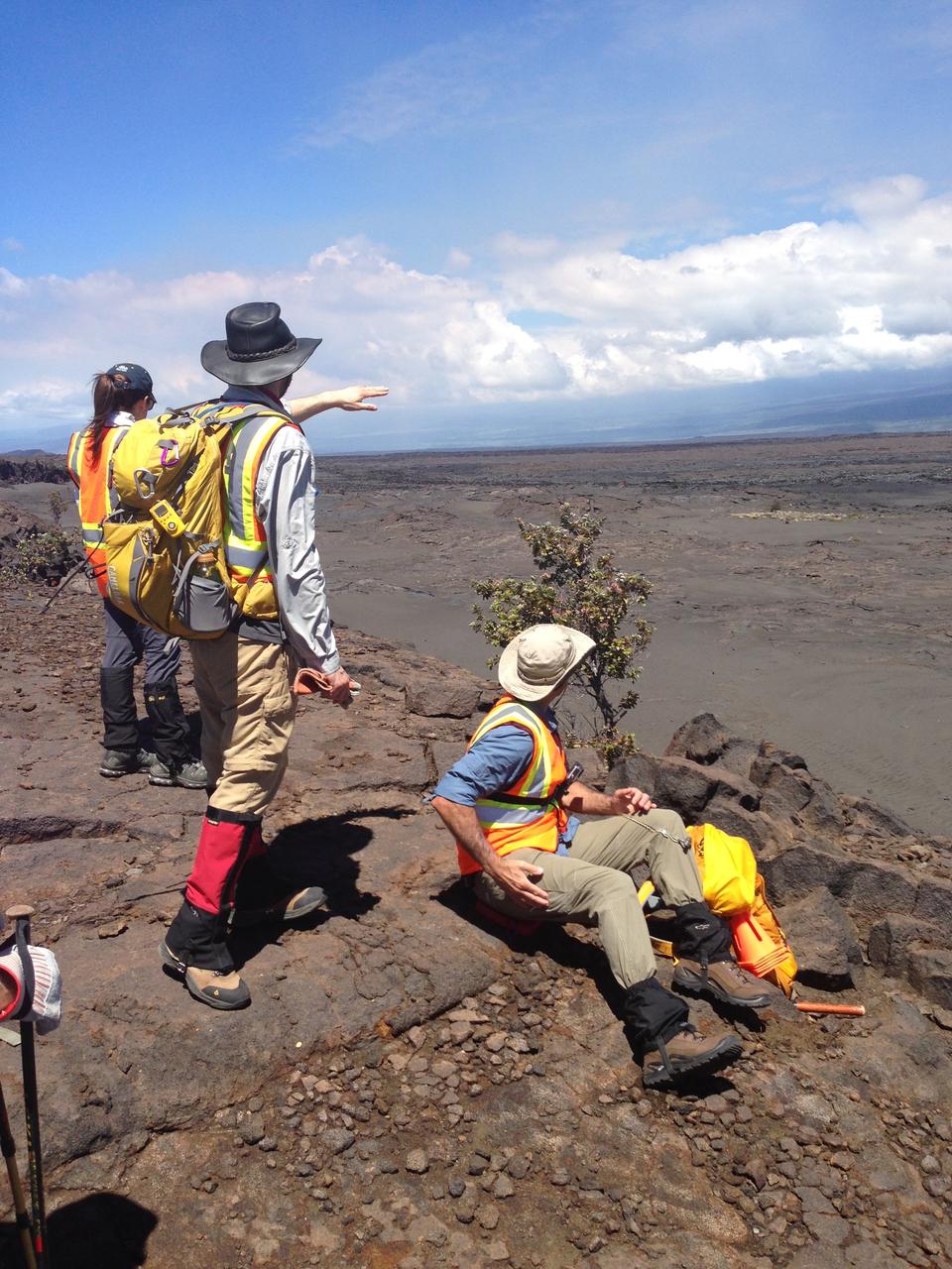
Briefing Hiking a lava field demands good preparation. Here, the team leaders brief the crew, scientists and student journalists on the route they’ll take down a scarp to the site of Kilauea’s December 1974 eruption. Credit: NASA/GSFC/Lora Bleacher In June, five student journalists from Stony Brook University packed their hiking boots and hydration packs and joined a NASA-funded science team for 10 days on the lava fields of Kilauea, an active Hawaiian volcano. Kilauea’s lava fields are an ideal place to test equipment designed for use on Earth’s moon or Mars, because volcanic activity shaped so much of those terrains. The trip was part of an interdisciplinary program called RIS4E – short for Remote, In Situ, and Synchrotron Studies for Science and Exploration – which is designed to prepare for future exploration of the moon, near-Earth asteroids and the moons of Mars. To read reports from the RIS4E journalism students about their experiences in Hawaii, visit <a href="http://ReportingRIS4E.com" rel="nofollow">ReportingRIS4E.com</a> <b><a href="http://www.nasa.gov/audience/formedia/features/MP_Photo_Guidelines.html" rel="nofollow">NASA image use policy.</a></b> <b><a href="http://www.nasa.gov/centers/goddard/home/index.html" rel="nofollow">NASA Goddard Space Flight Center</a></b> enables NASA’s mission through four scientific endeavors: Earth Science, Heliophysics, Solar System Exploration, and Astrophysics. Goddard plays a leading role in NASA’s accomplishments by contributing compelling scientific knowledge to advance the Agency’s mission. <b>Follow us on <a href="http://twitter.com/NASAGoddardPix" rel="nofollow">Twitter</a></b> <b>Like us on <a href="http://www.facebook.com/pages/Greenbelt-MD/NASA-Goddard/395013845897?ref=tsd" rel="nofollow">Facebook</a></b> <b>Find us on <a href="http://instagrid.me/nasagoddard/?vm=grid" rel="nofollow">Instagram</a></b>
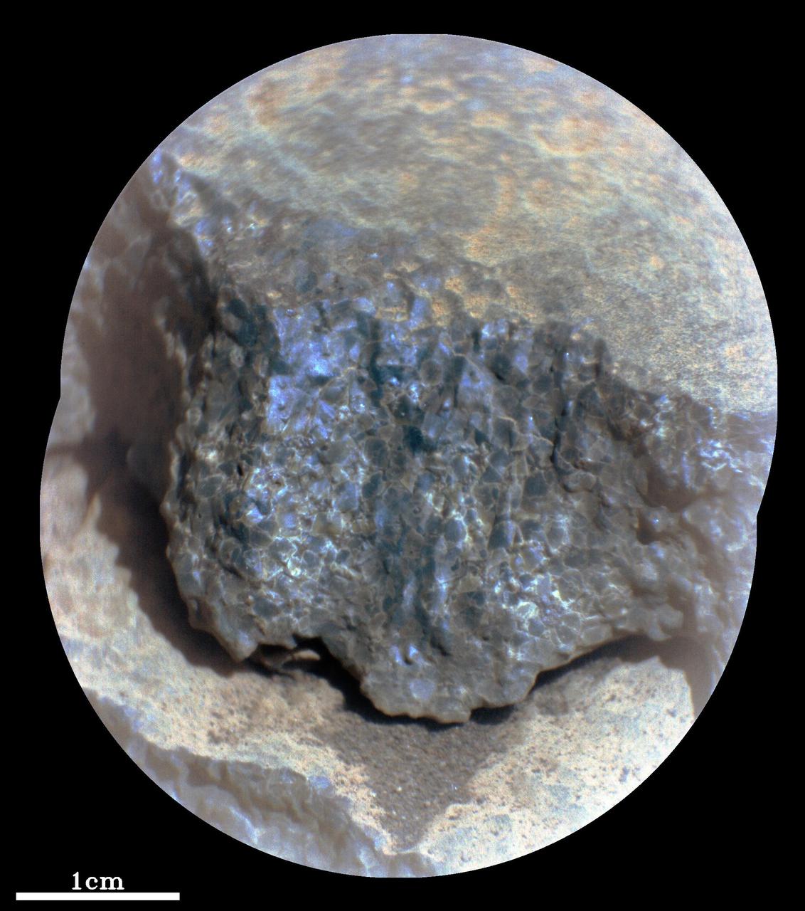
This enhanced-color close-up of a rock target called "Cine" was captured by the SuperCam instrument aboard NASA's Perseverance Mars rover on Sept. 17, 2021, the 206th Martian day, or sol, of rover's mission. SuperCam’s Remote Microscopic Imager took two images that were later combined to form this close-up. The target is 92 inches (2 meters) away, seen from the rover's mast. The image shows a rock layer made up of tightly packed millimeter-size gray, angular grains, or crystals. The image on the right shows a detail of the grain/crystal texture. The composition of this rock target was investigated with SuperCam's laser and spectrometer, along with the Mastcam-Z camera. Using these instruments, scientists can study the chemical composition of rocks from a distance. Analysis of "Cine" showed that it is rich in the mineral olivine. After the image was taken, the mission’s science team debated whether the rock is igneous (volcanic) or consists of fine sedimentary grains of igneous material that were cemented together in a watery environment. SuperCam is led by Los Alamos National Laboratory in New Mexico, where the instrument's body unit was developed. That part of the instrument includes several spectrometers as well as control electronics and software. The mast unit, including the Remote Microscopic Imager used for these images, was developed and built by several laboratories of the CNRS (the French research center) and French universities under the contracting authority of Centre National d'Etudes Spatiales (CNES), the French space agency. A key objective for Perseverance's mission on Mars is astrobiology, including the search for signs of ancient microbial life. The rover will characterize the planet's geology and past climate, pave the way for human exploration of the Red Planet, and be the first mission to collect and cache Martian rock and regolith (broken rock and dust). Subsequent NASA missions, in cooperation with ESA (European Space Agency), would send spacecraft to Mars to collect these sealed samples from the surface and return them to Earth for in-depth analysis. The Mars 2020 Perseverance mission is part of NASA's Moon to Mars exploration approach, which includes Artemis missions to the Moon that will help prepare for human exploration of the Red Planet. https://photojournal.jpl.nasa.gov/catalog/PIA24936
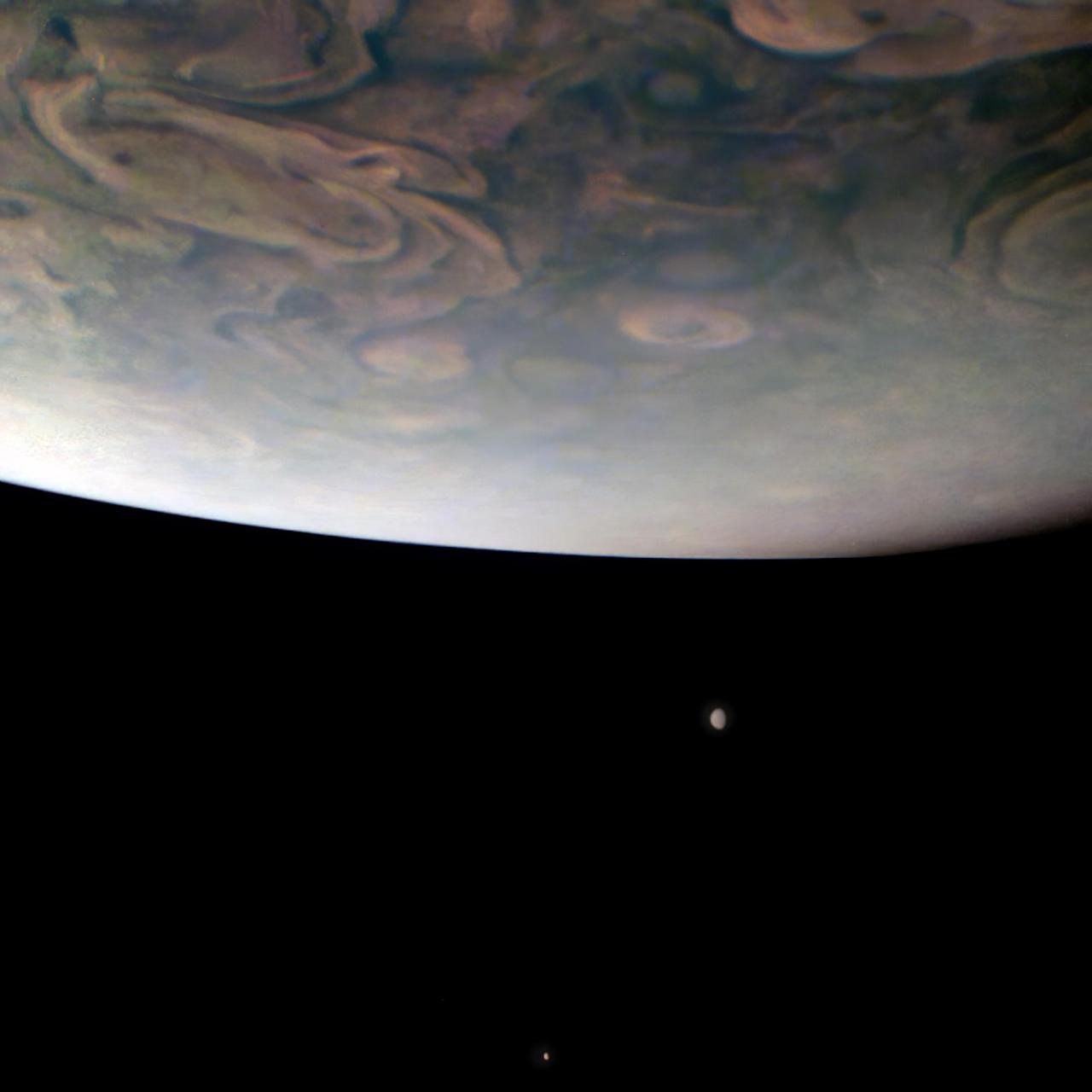
On Nov. 29, 2021, NASA's Juno mission completed its 38th close flyby of Jupiter. As the spacecraft sped low over the giant planet's cloud tops, its JunoCam instrument captured this look at two of Jupiter's largest moons. In the foreground, hurricane-like spiral wind patterns called vortices can be seen spinning in the planet's north polar region. These powerful storms can be over 30 miles (50 kilometers) in height and hundreds of miles across. Below Jupiter's curving horizon, two Jovian moons make an appearance: Callisto (below) and Io (above). Juno will make close flybys of Io in December 2023 and February 2024, the first such close encounters with this intriguing moon in over two decades. Io is the most volcanic body in our solar system, and its eruptions leave a trail of material behind that both fills Jupiter's magnetosphere and creates a torus of gas and dust around Jupiter. During the flybys, Juno will study Io's volcanoes and geology, search for signs of a magma ocean, and investigate how Io interacts with Jupiter's giant magnetosphere. Citizen scientist Gerald Eichstädt used raw JunoCam data to make the original version of this image, and then another citizen scientist, Thomas Thomopoulos, further processed it, zooming in and making color enhancements. In this view, north is down. At the time the image was taken, Juno was about 8,700 miles (14,000 kilometers) above Jupiter's cloud tops, at a latitude of about 69 degrees, traveling at a speed of about 123,000 mph (198,000 kilometers per hour) relative to the planet. https://photojournal.jpl.nasa.gov/catalog/PIA25019
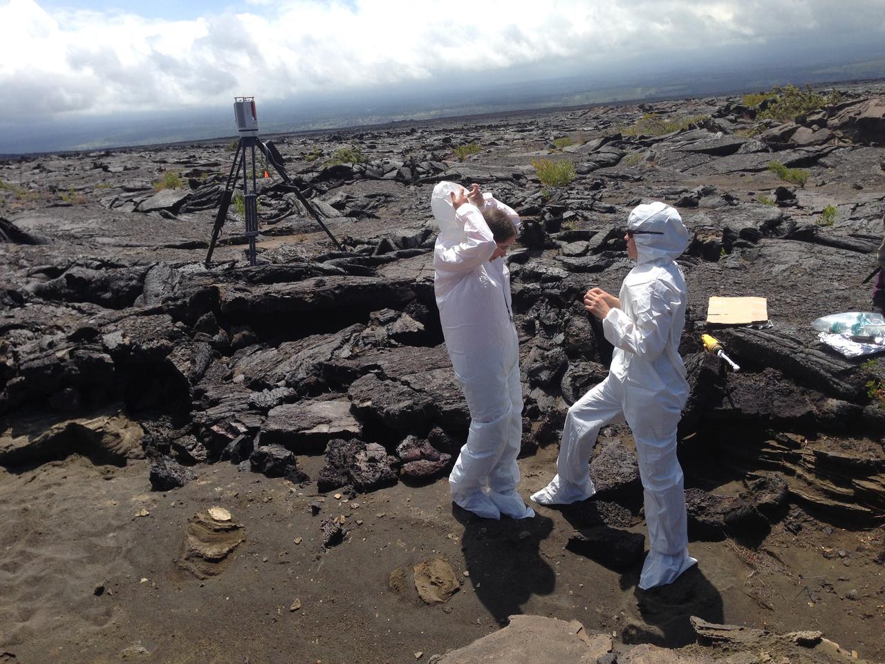
Bunny suits Scientists put on “bunny suits” before they collect samples at one of the selected sites. The suits protect the area and collected samples from contamination when investigating biological processes. Credit: NASA/GSFC/Lora Bleacher In June, five student journalists from Stony Brook University packed their hiking boots and hydration packs and joined a NASA-funded science team for 10 days on the lava fields of Kilauea, an active Hawaiian volcano. Kilauea’s lava fields are an ideal place to test equipment designed for use on Earth’s moon or Mars, because volcanic activity shaped so much of those terrains. The trip was part of an interdisciplinary program called RIS4E – short for Remote, In Situ, and Synchrotron Studies for Science and Exploration – which is designed to prepare for future exploration of the moon, near-Earth asteroids and the moons of Mars. To read reports from the RIS4E journalism students about their experiences in Hawaii, visit <a href="http://ReportingRIS4E.com" rel="nofollow">ReportingRIS4E.com</a> <b><a href="http://www.nasa.gov/audience/formedia/features/MP_Photo_Guidelines.html" rel="nofollow">NASA image use policy.</a></b> <b><a href="http://www.nasa.gov/centers/goddard/home/index.html" rel="nofollow">NASA Goddard Space Flight Center</a></b> enables NASA’s mission through four scientific endeavors: Earth Science, Heliophysics, Solar System Exploration, and Astrophysics. Goddard plays a leading role in NASA’s accomplishments by contributing compelling scientific knowledge to advance the Agency’s mission. <b>Follow us on <a href="http://twitter.com/NASAGoddardPix" rel="nofollow">Twitter</a></b> <b>Like us on <a href="http://www.facebook.com/pages/Greenbelt-MD/NASA-Goddard/395013845897?ref=tsd" rel="nofollow">Facebook</a></b> <b>Find us on <a href="http://instagrid.me/nasagoddard/?vm=grid" rel="nofollow">Instagram</a></b>

NASA's 2001 Mars Odyssey orbiter used its Thermal Emission Imaging System (THEMIS) to capture this view of Arsia Mons, an ancient volcano, while studying the Red Planet's atmosphere, which appears here as a greenish haze above the scene. THEMIS took the image well before dawn on May 2, 2025. The image has been stretched and brightened to improve contrast and processed to remove instrument noise. The southernmost of the three Tharsis volcanoes, Arsia Mons is 270 miles (450 kilometers) in diameter and almost 12 miles (20 kilometers) high. For comparison, the largest volcano on Earth is Mauna Loa, which measures 75 miles (121 kilometers) in diameter and roughly 6 miles (9 kilometers) high from its base on the seafloor. A large crater known as a caldera, produced by massive volcanic explosions and collapse, is located at the summit of all of the Tharsis volcanoes. At 72 miles (120 kilometers) wide, the Arsia Mons summit caldera is larger than many volcanoes on Earth. This type of image shows Mars' "limb," the edge of the planet's horizon. By flipping on its side while in orbit, Odyssey can point THEMIS head-on at the limb and capture images of the Martian atmosphere. This unique view allows scientists to see the structure and shape of dust and water-ice cloud layers and observe how they change over the course of seasons. Understanding Mars' clouds is particularly important for understanding Martian weather and how phenomena like dust storms occur. This is THEMIS' fourth limb observation since it began pursuing this new kind of science in 2023. When possible, the camera's team has tried to include an interesting surface feature such as Olympus Mons, the tallest volcano in the solar system. https://photojournal.jpl.nasa.gov/catalog/PIA26557
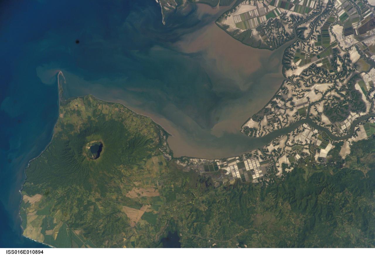
ISS016-E-010894 (17 Nov. 2007) --- Cosiguina Volcano, Nicaragua is featured in this image photographed by an Expedition 16 crewmember on the International Space Station. Three Central American countries (El Salvador, Honduras, and Nicaragua) include coastline along the Gulf of Fonseca that opens into the Pacific Ocean. The southern boundary of the Gulf is a peninsula formed by the Cosiguina volcano illustrated in this view. Cosiguina is a stratovolcano, typically tall cone-shaped structures formed by alternating layers of solidified lava and volcanic rocks (ash, pyroclastic flows, breccias) produced by explosive eruptions. The summit crater is filled with a lake (Laguna Cosiguina). The volcano last erupted in 1859, but its most famous activity occurred in 1835 when it produced the largest historical eruption in Nicaragua. Ash from the 1835 eruption has been found in Mexico, Costa Rica, and Jamaica. The volcano has been quiet since 1859, only an instant in terms of geological time. An earthquake swarm was measured near Cosiguina in 2002, indicating that tectonic forces are still active in the region although the volcano is somewhat isolated from the line of more recently active Central American volcanoes to the northwest and southeast. Intermittently observed gas bubbles in Laguna Cosiguina, and a hot spring along the eastern flank of the volcano are the only indicators of hydrothermal activity at the volcano. The fairly uniform vegetation cover (green) on the volcano's sides also attest to a general lack of gas emissions or "hot spots" on the 872 meter high cone, according to NASA scientists who study the photos downlinked from the orbital outpost.
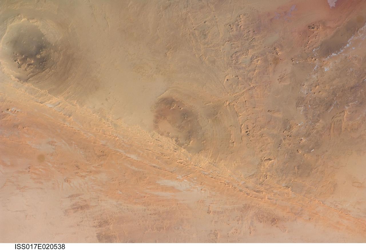
ISS017-E-020538 (21 Oct. 2008) --- Arkenu Craters 1 and 2 in Libya are featured in this image photographed by an Expedition 17 crewmember on the International Space Station. Geologists often study features on Earth, such as impact craters, to gain insight into processes that occur on other planets. On Earth, more than 150 impact craters have been identified on the continents, but only a few of these are classified as double impact craters. One such example, the Arkenu Craters in northern Africa, is shown in this image. Arkenu 1 and 2 are double impact structures located in eastern Libya (22.04 degrees north latitude and 23.45 degrees east longitude) in the Sahara desert, with diameters of approximately 6.8 kilometers and 10.3 kilometers, respectively. The craters are unusual in that they both exhibit concentric annular ridge structures (gray circles in the image indicate the position of the outermost visible ridges). In many terrestrial complex craters these features are highly eroded and no longer visible. While the circular structure of these features had been noted, the impact origin hypothesis was strengthened in December 2003 when a field team observed shatter cones -- conical-shaped features in rocks created by the high shock pressures generated during impact. Large outcrops of impact breccias -- a jumble of rock fragments generated at the impact site that are now cemented together into an identifiable rock layer -- were also observed by the field team. Two impactors, each approximately 500 meters in diameter, are thought to have created the craters. According to scientists, the age of the impact event has been dated as occurring less than 140 million years ago. While the presence of shatter cones and impact breccias is generally considered to be strong evidence for meteor impact, some scientists now question the interpretation of these features observed at the Arkenu structures and suggest that they were caused by erosive and volcanic processes. At present, both craters are being crossed by linear dunes extending northeast-southwest -- the superposition of the dunes across the annular ridges indicates that they are much younger than the craters.
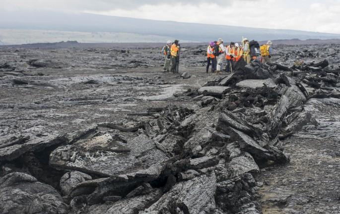
March across pahoehoe The team hikes across Kilauea’s lava fields to reach designated test sites. Several types of lava make up the fields, primarily smooth pahoehoe, which can harden into a ropy, shelly or slabby (pictured here) texture. Some of the most dangerous lava to walk on is a’a – unstable piles of jagged rock. Credit: NASA/GSFC/Jasmine Blennau In June, five student journalists from Stony Brook University packed their hiking boots and hydration packs and joined a NASA-funded science team for 10 days on the lava fields of Kilauea, an active Hawaiian volcano. Kilauea’s lava fields are an ideal place to test equipment designed for use on Earth’s moon or Mars, because volcanic activity shaped so much of those terrains. The trip was part of an interdisciplinary program called RIS4E – short for Remote, In Situ, and Synchrotron Studies for Science and Exploration – which is designed to prepare for future exploration of the moon, near-Earth asteroids and the moons of Mars. To read reports from the RIS4E journalism students about their experiences in Hawaii, visit <a href="http://ReportingRIS4E.com" rel="nofollow">ReportingRIS4E.com</a> <b><a href="http://www.nasa.gov/audience/formedia/features/MP_Photo_Guidelines.html" rel="nofollow">NASA image use policy.</a></b> <b><a href="http://www.nasa.gov/centers/goddard/home/index.html" rel="nofollow">NASA Goddard Space Flight Center</a></b> enables NASA’s mission through four scientific endeavors: Earth Science, Heliophysics, Solar System Exploration, and Astrophysics. Goddard plays a leading role in NASA’s accomplishments by contributing compelling scientific knowledge to advance the Agency’s mission. <b>Follow us on <a href="http://twitter.com/NASAGoddardPix" rel="nofollow">Twitter</a></b> <b>Like us on <a href="http://www.facebook.com/pages/Greenbelt-MD/NASA-Goddard/395013845897?ref=tsd" rel="nofollow">Facebook</a></b> <b>Find us on <a href="http://instagrid.me/nasagoddard/?vm=grid" rel="nofollow">Instagram</a></b>
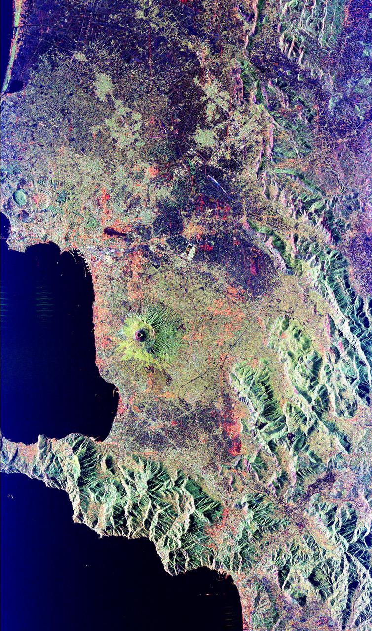
Mt. Vesuvius, one of the best known volcanoes in the world primarily for the eruption that buried the Roman city of Pompeii, is shown in the center of this radar image. The central cone of Vesuvius is the dark purple feature in the center of the volcano. This cone is surrounded on the northern and eastern sides by the old crater rim, called Mt. Somma. Recent lava flows are the pale yellow areas on the southern and western sides of the cone. Vesuvius is part of a large volcanic zone which includes the Phalagrean Fields, the cluster of craters seen along the left side of the image. The Bay of Naples, on the left side of the image, is separated from the Gulf of Salerno, in the lower left, by the Sorrento Peninsula. Dense urban settlement can be seen around the volcano. The city of Naples is above and to the left of Vesuvius; the seaport of the city can be seen in the top of the bay. Pompeii is located just below the volcano on this image. The rapid eruption in 79 A.D. buried the victims and buildings of Pompeii under several meters of debris and killed more than 2,000 people. Due to the violent eruptive style and proximity to populated areas, Vesuvius has been named by the international scientific community as one of fifteen Decade Volcanoes which are being intensively studied during the 1990s. The image is centered at 40.83 degrees North latitude, 14.53 degrees East longitude. It shows an area 100 kilometers by 55 kilometers (62 miles by 34 miles.) This image was acquired on April 15, 1994 by the Spaceborne Imaging Radar-C/X-Band Synthetic Aperture Radar (SIR-C/X-SAR) aboard the Space Shuttle Endeavour. SIR-C/X-SAR, a joint mission of the German, Italian and the United States space agencies, is part of NASA's Mission to Planet Earth. http://photojournal.jpl.nasa.gov/catalog/PIA01780
ISS018-E-011127 (6 Dec. 2008) --- Raven Ridge, Colorado is featured in this image photographed by an Expedition 18 crewmember on the International Space Station. An important way to unravel Earth?s history is to find and study old rocks that have been turned up and exposed on the surface through Earth?s tectonic activity. This image of Raven Ridge, Colorado provides a beautiful example of such a place that allows geologists to walk across rocks formed about 65 million years ago, now known as the ?K-T (or Cretaceous-Tertiary) Boundary?, according to scientists. The ridge is a dramatic topographic feature in northwestern Colorado formed by layered sedimentary rocks that span this boundary in geologic time. These sedimentary layers, originally deposited in a near-shore or marine environment as flat-lying beds, were later tilted on end to an almost vertical position by tectonic forces. The tilted beds are visible in this view as hard, resistant ridges of tan, buff, and white rocks, with a less resistant gray layer in the center of Raven Ridge (extending from left to right). The K-T Boundary is most famously known as the geological threshold where dinosaurs ? and a large number of other animal and plant species, both terrestrial and marine ? disappeared from the fossil record in a mass extinction event 66 ? 65 million years ago, according to scientists. Various hypotheses have been advanced to explain the mass extinction event - perhaps the best known being a large meteor impact that sparked widespread climate change or widespread volcanism that likewise produced significant climate change unfavorable for the existing plants and animals. The approximate location of the K-T Boundary is depicted in this image as a dotted white line ? rock layers to the south of the line belong to the Tertiary Period (lower half of image), while rocks to the north of the line are part of the Cretaceous and older Periods (upper half of image). A prominent topographic break in the ridgeline, Mormon Gap, provides road access across the Ridge. To the northwest of the Gap, several landslides formed in relatively soft Tertiary claystone, shale, and sandstone extend southwards from the crest of the Ridge.
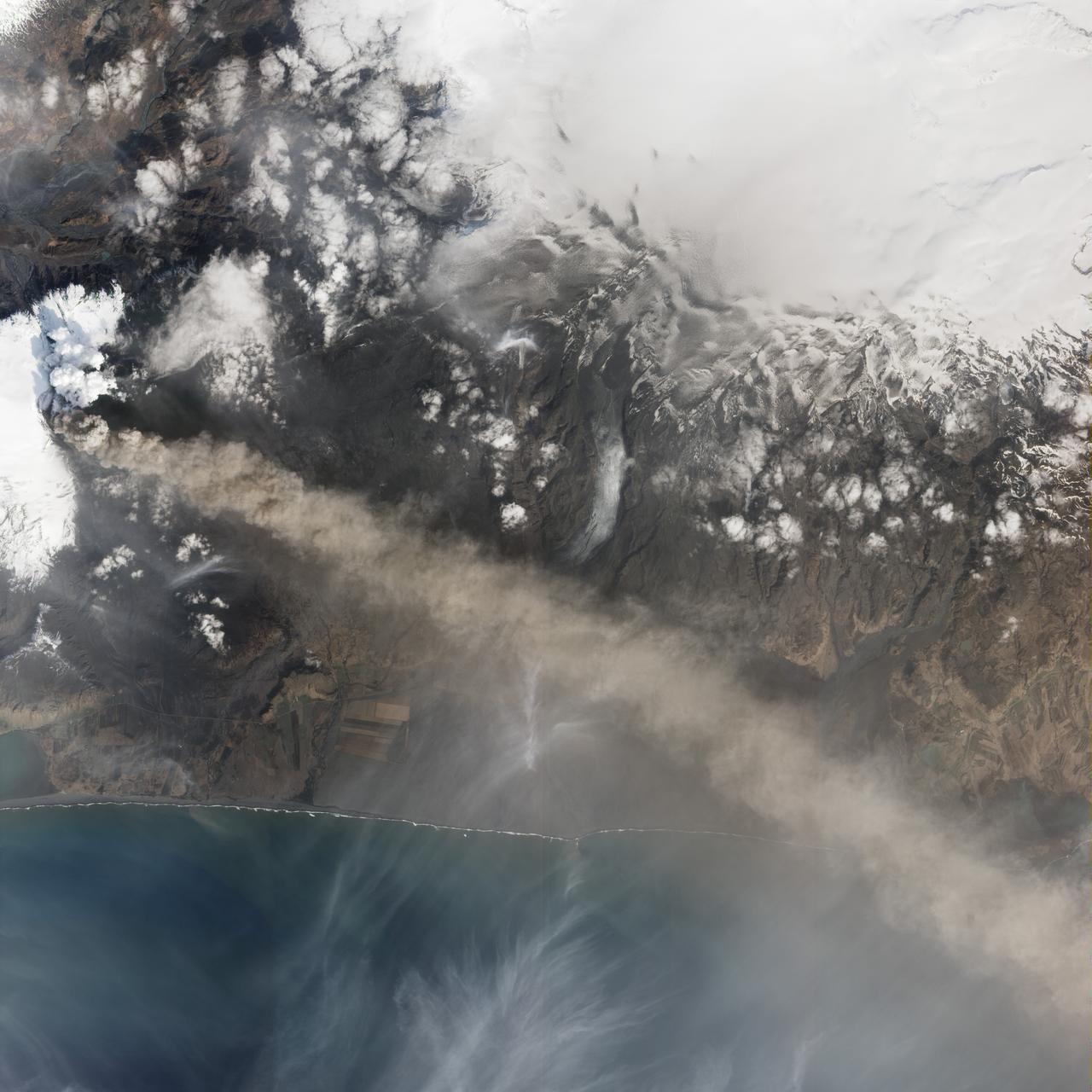
NASA satellite image acquired May 2, 2010 To view a detail of this image go to: <a href="http://www.flickr.com/photos/gsfc/4584266734/">www.flickr.com/photos/gsfc/4584266734/</a> Ash and steam continued billowing from Eyjafjallajökull Volcano in early May 2010. The Advanced Land Imager (ALI) on NASA’s Earth Observing-1 (EO-1) satellite captured this natural-color image on May 2, 2010. The volcano’s summit is near the left edge of this image, capped by a dark plume. The plume is dull gray-brown, indicating that its principal visible component is volcanic ash. Ash from the plume blows toward the east-southeast, passing over a charcoal-colored ash field on the land surface. Just to the north of Eyjafjallajökull’s summit are white puffs of steam, likely from surface lava flows vaporizing snow and glacial ice. On May 4, 2010, the Icelandic Meteorological Office warned that Eyjafjallajökull showed no signs of ending its eruptive activity in the near future. The Met Office reported that ash from the volcano had reached a height of 5.8 to 6.0 kilometers (19,000 to 20,000 feet) above sea level, and had spread 65 to 80 kilometers (40 to 50 miles) east-southeast of the volcano, where it impeded visibility for local residents. The Met Office also reported that lava continued flowing down a steep hill north of the crater. NASA image by Robert Simmon, using ALI data from the EO-1 team. Caption by Michon Scott. Instrument: EO-1 – ALI To view other images from the Earth Observatory go to: <a href="http://earthobservatory.nasa.gov/" rel="nofollow">earthobservatory.nasa.gov/</a> <b><a href="http://www.nasa.gov/centers/goddard/home/index.html" rel="nofollow">NASA Goddard Space Flight Center</a></b> is home to the nation's largest organization of combined scientists, engineers and technologists that build spacecraft, instruments and new technology to study the Earth, the sun, our solar system, and the universe.
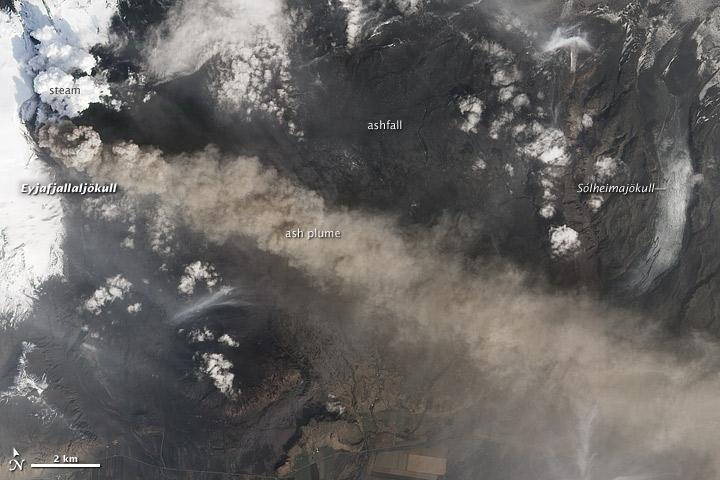
NASA satellite image acquired May 2, 2010 To see the full view of this image go to: <a href="http://www.flickr.com/photos/gsfc/4584266582/">www.flickr.com/photos/gsfc/4584266582/</a> Ash and steam continued billowing from Eyjafjallajökull Volcano in early May 2010. The Advanced Land Imager (ALI) on NASA’s Earth Observing-1 (EO-1) satellite captured this natural-color image on May 2, 2010. The volcano’s summit is near the left edge of this image, capped by a dark plume. The plume is dull gray-brown, indicating that its principal visible component is volcanic ash. Ash from the plume blows toward the east-southeast, passing over a charcoal-colored ash field on the land surface. Just to the north of Eyjafjallajökull’s summit are white puffs of steam, likely from surface lava flows vaporizing snow and glacial ice. On May 4, 2010, the Icelandic Meteorological Office warned that Eyjafjallajökull showed no signs of ending its eruptive activity in the near future. The Met Office reported that ash from the volcano had reached a height of 5.8 to 6.0 kilometers (19,000 to 20,000 feet) above sea level, and had spread 65 to 80 kilometers (40 to 50 miles) east-southeast of the volcano, where it impeded visibility for local residents. The Met Office also reported that lava continued flowing down a steep hill north of the crater. NASA image by Robert Simmon, using ALI data from the EO-1 team. Caption by Michon Scott. Instrument: EO-1 – ALI To view other images from the Earth Observatory go to: <a href="http://earthobservatory.nasa.gov/" rel="nofollow">earthobservatory.nasa.gov/</a> <b><a href="http://www.nasa.gov/centers/goddard/home/index.html" rel="nofollow">NASA Goddard Space Flight Center</a></b> is home to the nation's largest organization of combined scientists, engineers and technologists that build spacecraft, instruments and new technology to study the Earth, the sun, our solar system, and the universe.

Mark Pestana is a research pilot and project manager at the NASA Dryden Flight Research Center, Edwards, Calif. He is a pilot for the Beech B200 King Air, the T-34C and the Predator B. He flies the F-18 Hornet as a co-pilot and flight test engineer. Pestana has accumulated more than 4,000 hours of military and civilian flight experience. He was also a flight engineer on the NASA DC-8 flying laboratory. Pestana was the project manager and pilot for the Hi–rate Wireless Airborne Network Demonstration flown on the NASA B200 research aircraft. He flew B200 research missions for the X-38 Space Integrated Inertial Navigation Global Positioning System experiment. Pestana also participated in several deployments of the DC-8, including Earth science expeditions ranging from hurricane research over the Caribbean Sea to ozone studies over the North Pole, atmospheric chemistry over the South Pacific, rain forest health in Central America, Rocky Mountain ice pack assessment, and volcanic and tectonic activity around the Pacific Rim. He came to Dryden as a DC-8 mission manager in June 1998 from NASA Johnson Space Center, Houston, where he served as the Earth and Space Science discipline manager for the International Space Station Program at Johnson. Pestana also served as a flight crew operations engineer in the Astronaut Office, developing the controls, displays, tools, crew accommodations and procedures for on-orbit assembly, test, and checkout of the International Space Station. He led the analysis and technical negotiations for modification of the Russian Soyuz spacecraft as an emergency crew return vehicle for space station crews. He joined the U.S. Air Force Reserve in 1991 and held various positions as a research and development engineer, intelligence analyst, and Delta II launch vehicle systems engineer. He retired from the U.S. Air Force Reserve with the rank of colonel in 2005. Prior to 1990, Pestana was on active duty with the U.S. Air Force as the director of mi

This frame from a video depicts artist concepts of each of the seven planets orbiting TRAPPIST-1, an ultra-cool dwarf stars. Over 21 days, NASA's Spitzer Space Telescope measured the drop in light as each planet passed in front of the star. Spitzer was able to identify a total of seven rocky worlds, including three in the habitable zone where life is possible. The study established the planets' size, distance from their sun and, for some of them, their approximate mass and density. It also established that some, if not all, these planets are tidally locked, meaning one face of the planet permanently faces their sun. The planets appear in the order of innermost to outermost planets. These artist's concepts were designed as follows: TRAPPIST-1b, closest to the star, was modeled on Jupiter's moon Io, which has volcanic features due to strong gravitational tugs. TRAPPIST-1c is shown as a rocky, warm world with a small ice cap on the side that never faces the star. TRAPPSIT-1d is rocky and has water only in a thin band along the terminator, dividing the day side and night side. TRAPPIST-1e and TRAPPIST-1f are both shown covered in water, but with progressively larger ice caps on the night side. TRAPPIST-1g is portrayed with an atmosphere like Neptune's, although it is still a rocky world. The farthest planet, TRAPPIST-1h, is shown as covered in ice, similar to Jupiter's icy moon Europa. The background stars are what you would see if you were in the TRAPPIST-1 system. Orion passes behind the planets, recognizable but distorted from what we're familiar with, in addition to Taurus and Pleiades. A video is available at http://photojournal.jpl.nasa.gov/catalog/PIA21468
STS097-715-061 (10 December 2000) This view over the Central Andes Mountains in Argentina and Chile was taken on December 10, 2000 by one of the astronauts aboard the Earth-orbiting Space Shuttle Endeavour. Extending 5500 miles (8850 kilometers) along the western coast of South America from northern Colombia to Cape Horn in southern Chile, the Andes are the longest mountain range, above sea level, and the second highest range in the world. According to NASA scientists studying the STS-97 photo collection, this immense system came into existence nearly 70 million years ago. With numerous active volcanoes and a slow uplift, the building of the Andes Mountains continues today rising four inches (10 centimeters) per century, the scientists say. In this north-looking view, snow covers the higher peaks of the range, some of which rise to over 20000 feet (6100 meters) above sea level. Along the left or western portion of the view, clouds can be seen along coastal areas of Chile. In the bottom left quadrant of the scene, the blue waters of the Paloma Reservoir, a recreational lake, are visible. The folded Tontal Range (bottom center) and the Valle Fertil Range (upper right quadrant and partially cloud covered) of western Argentina can be seen. The rocks of these ranges, the scientists point out, are ancient compared to the younger volcanic peaks and ranges of the Andes. The city of San Juan, Argentina is visible on the eastern (right) base of the Tontal Range in the lower right quadrant of the view.
Prepared Everyone carried a respirator into the field, in case the plume from the volcano blew their way. Credit: NASA/GSFC/Andrea Jones In June, five student journalists from Stony Brook University packed their hiking boots and hydration packs and joined a NASA-funded science team for 10 days on the lava fields of Kilauea, an active Hawaiian volcano. Kilauea’s lava fields are an ideal place to test equipment designed for use on Earth’s moon or Mars, because volcanic activity shaped so much of those terrains. The trip was part of an interdisciplinary program called RIS4E – short for Remote, In Situ, and Synchrotron Studies for Science and Exploration – which is designed to prepare for future exploration of the moon, near-Earth asteroids and the moons of Mars. To read reports from the RIS4E journalism students about their experiences in Hawaii, visit <a href="http://ReportingRIS4E.com" rel="nofollow">ReportingRIS4E.com</a> <b><a href="http://www.nasa.gov/audience/formedia/features/MP_Photo_Guidelines.html" rel="nofollow">NASA image use policy.</a></b> <b><a href="http://www.nasa.gov/centers/goddard/home/index.html" rel="nofollow">NASA Goddard Space Flight Center</a></b> enables NASA’s mission through four scientific endeavors: Earth Science, Heliophysics, Solar System Exploration, and Astrophysics. Goddard plays a leading role in NASA’s accomplishments by contributing compelling scientific knowledge to advance the Agency’s mission. <b>Follow us on <a href="http://twitter.com/NASAGoddardPix" rel="nofollow">Twitter</a></b> <b>Like us on <a href="http://www.facebook.com/pages/Greenbelt-MD/NASA-Goddard/395013845897?ref=tsd" rel="nofollow">Facebook</a></b> <b>Find us on <a href="http://instagrid.me/nasagoddard/?vm=grid" rel="nofollow">Instagram</a></b>
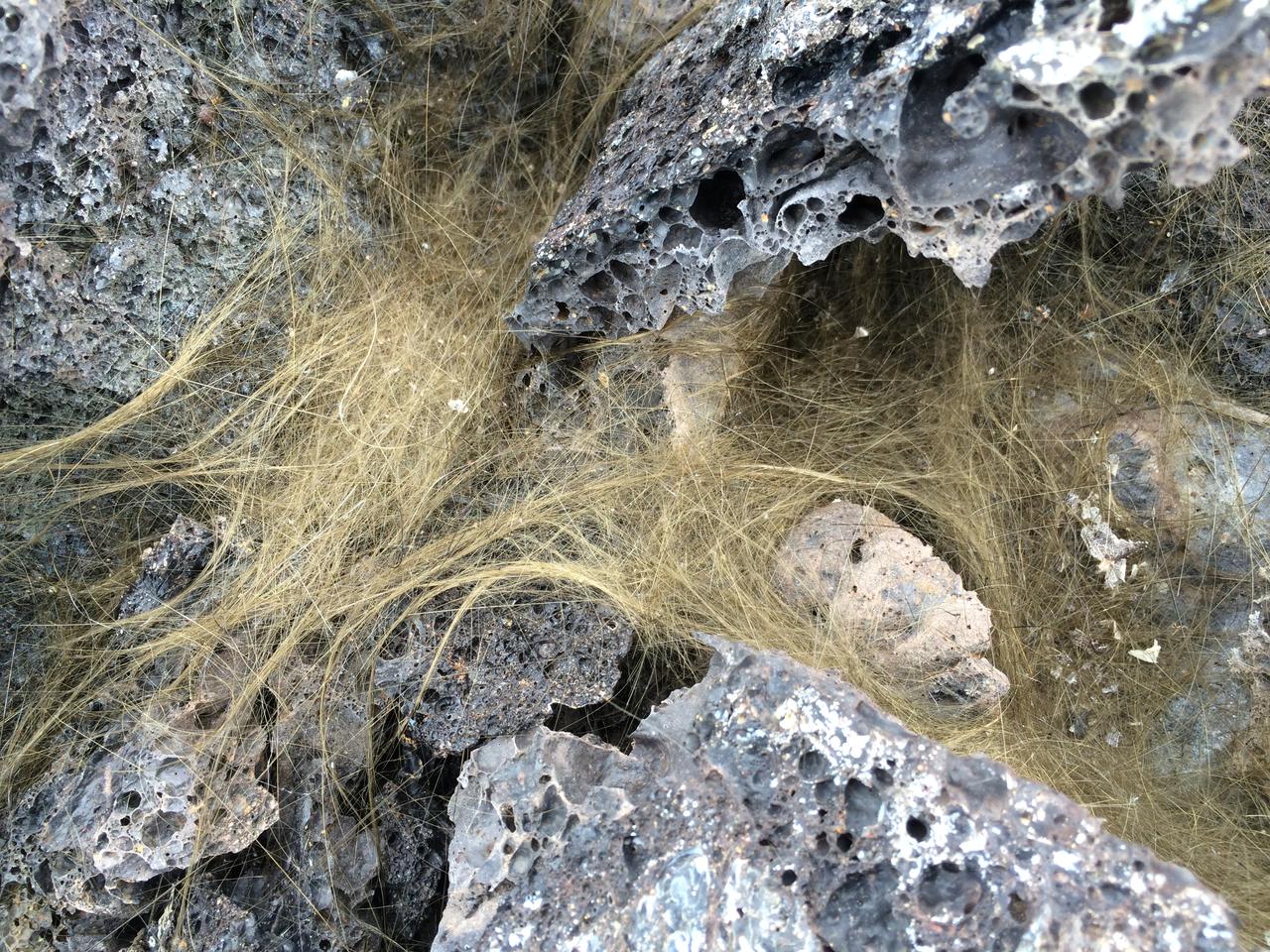
Pele’s hair Greenish-gold strands of Pele’s hair form when bubbles in hot lava pop and throw droplets into the wind. The droplets can elongate into perfectly straight, glassy strands that are as thin as human hair. Credit: NASA/GSFC/Andrea Jones In June, five student journalists from Stony Brook University packed their hiking boots and hydration packs and joined a NASA-funded science team for 10 days on the lava fields of Kilauea, an active Hawaiian volcano. Kilauea’s lava fields are an ideal place to test equipment designed for use on Earth’s moon or Mars, because volcanic activity shaped so much of those terrains. The trip was part of an interdisciplinary program called RIS4E – short for Remote, In Situ, and Synchrotron Studies for Science and Exploration – which is designed to prepare for future exploration of the moon, near-Earth asteroids and the moons of Mars. To read reports from the RIS4E journalism students about their experiences in Hawaii, visit <a href="http://ReportingRIS4E.com" rel="nofollow">ReportingRIS4E.com</a> <b><a href="http://www.nasa.gov/audience/formedia/features/MP_Photo_Guidelines.html" rel="nofollow">NASA image use policy.</a></b> <b><a href="http://www.nasa.gov/centers/goddard/home/index.html" rel="nofollow">NASA Goddard Space Flight Center</a></b> enables NASA’s mission through four scientific endeavors: Earth Science, Heliophysics, Solar System Exploration, and Astrophysics. Goddard plays a leading role in NASA’s accomplishments by contributing compelling scientific knowledge to advance the Agency’s mission. <b>Follow us on <a href="http://twitter.com/NASAGoddardPix" rel="nofollow">Twitter</a></b> <b>Like us on <a href="http://www.facebook.com/pages/Greenbelt-MD/NASA-Goddard/395013845897?ref=tsd" rel="nofollow">Facebook</a></b> <b>Find us on <a href="http://instagrid.me/nasagoddard/?vm=grid" rel="nofollow">Instagram</a></b>
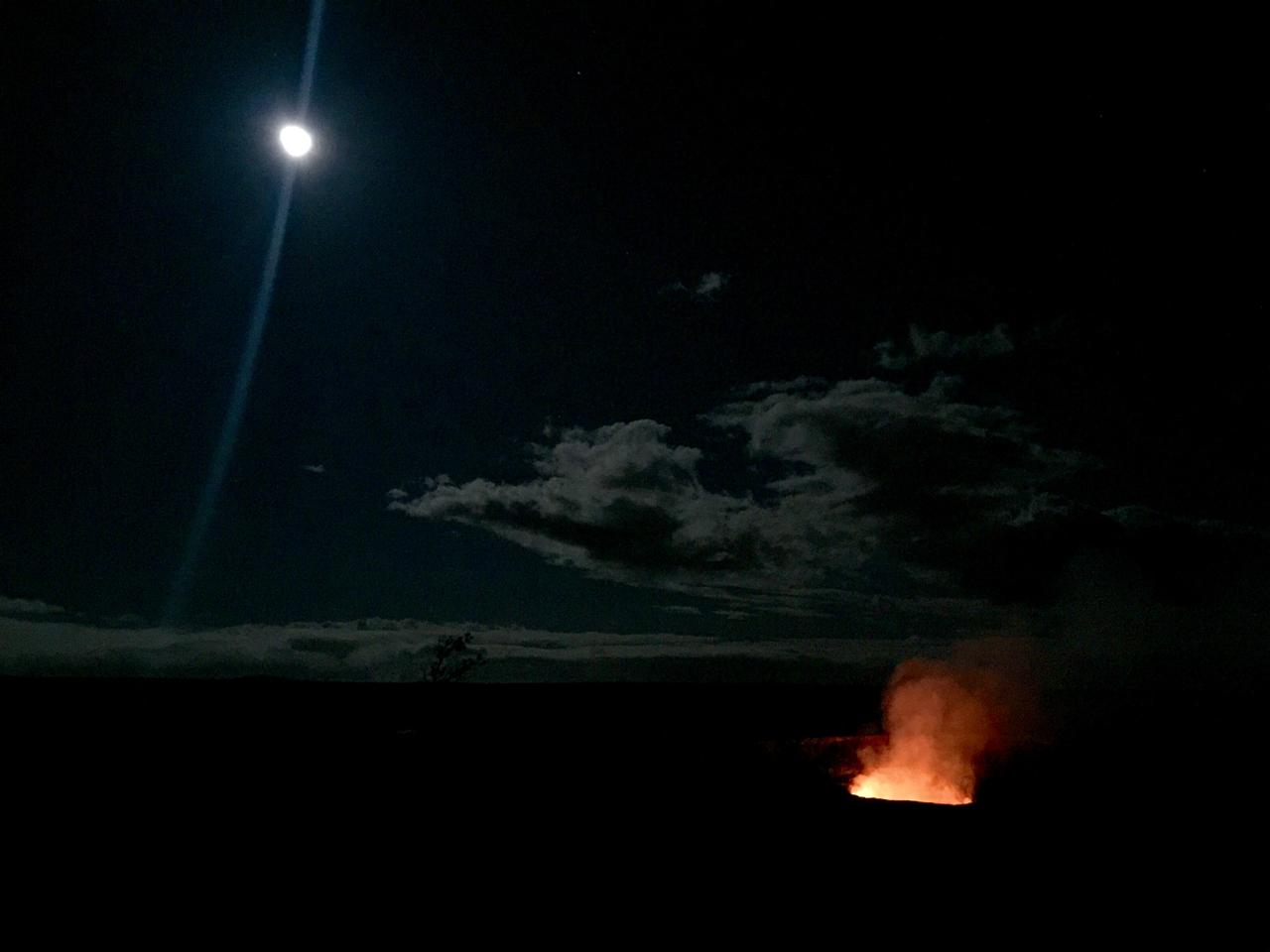
Full moon over lava lake The inspiring views at remote locations, such as Halema’uma’u Crater in Hawaii Volcanoes National Park, are an extra reward for making the trip. Credit: NASA/GSFC/Kelsey Young In June, five student journalists from Stony Brook University packed their hiking boots and hydration packs and joined a NASA-funded science team for 10 days on the lava fields of Kilauea, an active Hawaiian volcano. Kilauea’s lava fields are an ideal place to test equipment designed for use on Earth’s moon or Mars, because volcanic activity shaped so much of those terrains. The trip was part of an interdisciplinary program called RIS4E – short for Remote, In Situ, and Synchrotron Studies for Science and Exploration – which is designed to prepare for future exploration of the moon, near-Earth asteroids and the moons of Mars. To read reports from the RIS4E journalism students about their experiences in Hawaii, visit <a href="http://ReportingRIS4E.com" rel="nofollow">ReportingRIS4E.com</a> <b><a href="http://www.nasa.gov/audience/formedia/features/MP_Photo_Guidelines.html" rel="nofollow">NASA image use policy.</a></b> <b><a href="http://www.nasa.gov/centers/goddard/home/index.html" rel="nofollow">NASA Goddard Space Flight Center</a></b> enables NASA’s mission through four scientific endeavors: Earth Science, Heliophysics, Solar System Exploration, and Astrophysics. Goddard plays a leading role in NASA’s accomplishments by contributing compelling scientific knowledge to advance the Agency’s mission. <b>Follow us on <a href="http://twitter.com/NASAGoddardPix" rel="nofollow">Twitter</a></b> <b>Like us on <a href="http://www.facebook.com/pages/Greenbelt-MD/NASA-Goddard/395013845897?ref=tsd" rel="nofollow">Facebook</a></b> <b>Find us on <a href="http://instagrid.me/nasagoddard/?vm=grid" rel="nofollow">Instagram</a></b>
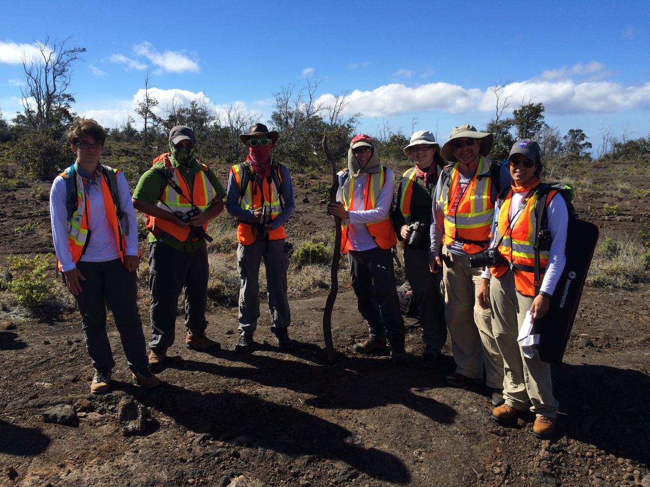
Ready to roll The five student journalists and two faculty members are ready for a day in the field. NASA/GSFC/Andrea Jones In June, five student journalists from Stony Brook University packed their hiking boots and hydration packs and joined a NASA-funded science team for 10 days on the lava fields of Kilauea, an active Hawaiian volcano. Kilauea’s lava fields are an ideal place to test equipment designed for use on Earth’s moon or Mars, because volcanic activity shaped so much of those terrains. The trip was part of an interdisciplinary program called RIS4E – short for Remote, In Situ, and Synchrotron Studies for Science and Exploration – which is designed to prepare for future exploration of the moon, near-Earth asteroids and the moons of Mars. To read reports from the RIS4E journalism students about their experiences in Hawaii, visit <a href="http://ReportingRIS4E.com" rel="nofollow">ReportingRIS4E.com</a> <b><a href="http://www.nasa.gov/audience/formedia/features/MP_Photo_Guidelines.html" rel="nofollow">NASA image use policy.</a></b> <b><a href="http://www.nasa.gov/centers/goddard/home/index.html" rel="nofollow">NASA Goddard Space Flight Center</a></b> enables NASA’s mission through four scientific endeavors: Earth Science, Heliophysics, Solar System Exploration, and Astrophysics. Goddard plays a leading role in NASA’s accomplishments by contributing compelling scientific knowledge to advance the Agency’s mission. <b>Follow us on <a href="http://twitter.com/NASAGoddardPix" rel="nofollow">Twitter</a></b> <b>Like us on <a href="http://www.facebook.com/pages/Greenbelt-MD/NASA-Goddard/395013845897?ref=tsd" rel="nofollow">Facebook</a></b> <b>Find us on <a href="http://instagrid.me/nasagoddard/?vm=grid" rel="nofollow">Instagram</a></b>
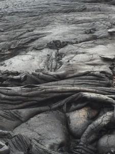
Smooth pahoehoe A member of the journalism team captures the alluring beauty of a pahoehoe flow. Credit: NASA/GSFC/Anthony Denicola In June, five student journalists from Stony Brook University packed their hiking boots and hydration packs and joined a NASA-funded science team for 10 days on the lava fields of Kilauea, an active Hawaiian volcano. Kilauea’s lava fields are an ideal place to test equipment designed for use on Earth’s moon or Mars, because volcanic activity shaped so much of those terrains. The trip was part of an interdisciplinary program called RIS4E – short for Remote, In Situ, and Synchrotron Studies for Science and Exploration – which is designed to prepare for future exploration of the moon, near-Earth asteroids and the moons of Mars. To read reports from the RIS4E journalism students about their experiences in Hawaii, visit <a href="http://ReportingRIS4E.com" rel="nofollow">ReportingRIS4E.com</a> <b><a href="http://www.nasa.gov/audience/formedia/features/MP_Photo_Guidelines.html" rel="nofollow">NASA image use policy.</a></b> <b><a href="http://www.nasa.gov/centers/goddard/home/index.html" rel="nofollow">NASA Goddard Space Flight Center</a></b> enables NASA’s mission through four scientific endeavors: Earth Science, Heliophysics, Solar System Exploration, and Astrophysics. Goddard plays a leading role in NASA’s accomplishments by contributing compelling scientific knowledge to advance the Agency’s mission. <b>Follow us on <a href="http://twitter.com/NASAGoddardPix" rel="nofollow">Twitter</a></b> <b>Like us on <a href="http://www.facebook.com/pages/Greenbelt-MD/NASA-Goddard/395013845897?ref=tsd" rel="nofollow">Facebook</a></b> <b>Find us on <a href="http://instagrid.me/nasagoddard/?vm=grid" rel="nofollow">Instagram</a></b>
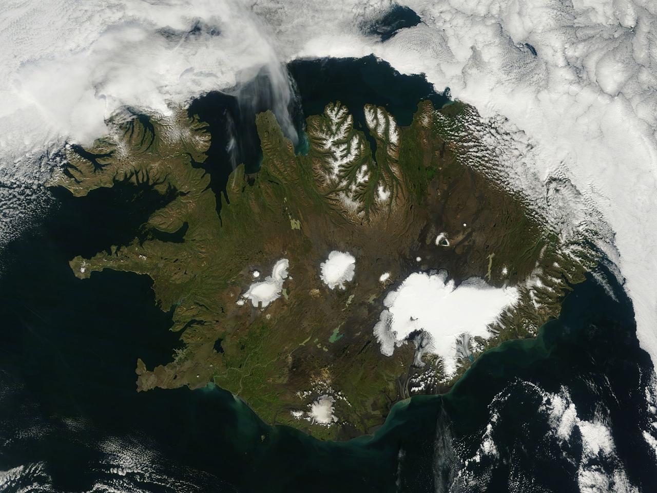
On August 22, 2014 the Moderate Resolution Imaging Spectroradiometer (MODIS) aboard NASA’s Terra satellite captured a true-color image of a sunny summer day in Iceland. While most of the winter snow has melted to reveal green vegetation, the rugged northern peaks retain a snow cap. Further south bright white marks the location of glaciers. Situated in the southeast is Vatnajökull – the largest glacier in Europe and the site of Iceland’s highest mountain, Hvannadalshnjúkur. On August 20, scientists from the Icelandic Met Office closed all roads into the north of Vatnajökull Glacier due to increase seismic activity from the Bardarbunga volcano which lies under the ice cap in this area. On August 23, a small eruption was detected in Bardarbunga and the airspace near the activity was closed as a precautionary measure. Further study of the data suggested that no eruption had in fact occurred and airspace was opened under a code orange alert. Seismic activity remained high. On August 29, an eruption occurred north of Vatnajökull Glacier when a fissure, close to 1 km in length, opened up, and emitted lava at a slow pace. The eruption was short-lived, but on August 31 an eruption was confirmed in the same remote, uninhabited area. The Icelandic Meteorological Office reported that as of September 11 that eruption continued unabated. There has been no significant explosive activity, but lava flow has been the primary feature. High concentrations of sulfuric gases from the volcanic activity accompany the eruption, and are the primary health concern. Credit: NASA/GSFC/Jeff Schmaltz/MODIS Land Rapid Response Team <b><a href="http://www.nasa.gov/audience/formedia/features/MP_Photo_Guidelines.html" rel="nofollow">NASA image use policy.</a></b> <b><a href="http://www.nasa.gov/centers/goddard/home/index.html" rel="nofollow">NASA Goddard Space Flight Center</a></b> enables NASA’s mission through four scientific endeavors: Earth Science, Heliophysics, Solar System Exploration, and Astrophysics. Goddard plays a leading role in NASA’s accomplishments by contributing compelling scientific knowledge to advance the Agency’s mission. <b>Follow us on <a href="http://twitter.com/NASAGoddardPix" rel="nofollow">Twitter</a></b> <b>Like us on <a href="http://www.facebook.com/pages/Greenbelt-MD/NASA-Goddard/395013845897?ref=tsd" rel="nofollow">Facebook</a></b> <b>Find us on <a href="http://instagram.com/nasagoddard?vm=grid" rel="nofollow">Instagram</a></b>

This is a composite image of Uranus by Voyager 2 and two different observations made by Hubble — one for the ring and one for the auroras. Ever since Voyager 2 beamed home spectacular images of the planets in the 1980s, planet-lovers have been hooked on auroras on other planets. Auroras are caused by streams of charged particles like electrons that come from various origins such as solar winds, the planetary ionosphere, and moon volcanism. They become caught in powerful magnetic fields and are channeled into the upper atmosphere, where their interactions with gas particles, such as oxygen or nitrogen, set off spectacular bursts of light. The auroras on Jupiter and Saturn are well-studied, but not much is known about the auroras of the giant ice planet Uranus. In 2011, the NASA/ESA Hubble Space Telescope became the first Earth-based telescope to snap an image of the auroras on Uranus. In 2012 and 2014 a team led by an astronomer from Paris Observatory took a second look at the auroras using the ultraviolet capabilities of the Space Telescope Imaging Spectrograph (STIS) installed on Hubble. They tracked the interplanetary shocks caused by two powerful bursts of solar wind traveling from the sun to Uranus, then used Hubble to capture their effect on Uranus’ auroras — and found themselves observing the most intense auroras ever seen on the planet. By watching the auroras over time, they collected the first direct evidence that these powerful shimmering regions rotate with the planet. They also re-discovered Uranus’ long-lost magnetic poles, which were lost shortly after their discovery by Voyager 2 in 1986 due to uncertainties in measurements and the featureless planet surface. Credit: ESA/Hubble & NASA, L. Lamy / Observatoire de Paris <b><a href="http://www.nasa.gov/audience/formedia/features/MP_Photo_Guidelines.html" rel="nofollow">NASA image use policy.</a></b> <b><a href="http://www.nasa.gov/centers/goddard/home/index.html" rel="nofollow">NASA Goddard Space Flight Center</a></b> enables NASA’s mission through four scientific endeavors: Earth Science, Heliophysics, Solar System Exploration, and Astrophysics. Goddard plays a leading role in NASA’s accomplishments by contributing compelling scientific knowledge to advance the Agency’s mission. <b>Follow us on <a href="http://twitter.com/NASAGoddardPix" rel="nofollow">Twitter</a></b> <b>Like us on <a href="http://www.facebook.com/pages/Greenbelt-MD/NASA-Goddard/395013845897?ref=tsd" rel="nofollow">Facebook</a></b> <b>Find us on <a href="http://instagrid.me/nasagoddard/?vm=grid" rel="nofollow">Instagram</a></b>
inal Caption Released with Image: The colored regions of this map show the extent of digital elevation data recently released by the Shuttle Radar Topography Mission (SRTM). This release includes data for most of Europe and Asia plus numerous islands in the Indian and Pacific Oceans. SRTM flew on board the Space Shuttle Endeavour in February 2000 and used an interferometric radar system to map the topography of Earth's landmass between latitudes 56 degrees south and 60 degrees north. The data were processed into geographic "tiles," each of which represents one by one degree of latitude and longitude. A degree of latitude measures 111 kilometers (69 miles) north-south, and a degree of longitude measures 111 kilometers or less east-west, decreasing away from the equator. The data are being released to the public on a continent-by-continent basis. This Eurasia segment includes 5,940 tiles, more than a third of the total data set. Previous releases covered North America and South America. Forthcoming releases will include Africa-Arabia and Australia plus an "Islands" release for those islands not included in the continental releases. Together these data releases constitute the world's first high-resolution, near-global elevation model. The resolution of the publicly released data is three arcseconds (1/1,200 of a degree of latitude and longitude), which is about 90 meters (295 feet). European coverage in the current data release stretches eastward from the British Isles and the Iberian Peninsula in the west, across the Alps and Carpathian Mountains, as well as the Northern European Plain, to the Ural and Caucasus Mountains bordering Asia. The Asian coverage includes a great diversity of landforms, including the Tibetan Plateau, Tarin Basin, Mongolian Plateau, and the mountains surrounding Lake Baikal, the world's deepest lake. Mt. Everest in the Himalayas, at 8,848 meters (29,029 feet) is the world's highest mountain. From India's Deccan Plateau, to Southeast Asia, coastal China, and Korea, various landforms place constraints upon land use planning for a great population. Volcanoes in the East Indies, the Philippines, Japan, and the Kamchatka Peninsula form the western part of the "Ring of Fire" around the Pacific Ocean. Many of these regions were previously very poorly mapped due to persistent cloud cover or the inaccessibility of the terrain. Digital elevation data, such as provided by SRTM, are particularly in high demand by scientists studying earthquakes, volcanism, and erosion patterns for use in mapping and modeling hazards to human habitation. But the shape of Earth's surface affects nearly every natural process and human endeavor that occurs there, so elevation data are used in a wide range of applications. In this index map color-coding is directly related to topographic height, with green at the lower elevations, rising through yellow and tan, to white at the highest elevations. The large, very dark green feature in western Asia is the Caspian Sea, which is below sea level. Blue areas on the map represent water within the mapped tiles, each of which includes shorelines or islands. http://photojournal.jpl.nasa.gov/catalog/PIA03398

NASA image release March 11, 2011 Caption: The lunar farside as never seen before! LROC WAC orthographic projection centered at 180° longitude, 0° latitude. Credit: NASA/Goddard/Arizona State University. Because the moon is tidally locked (meaning the same side always faces Earth), it was not until 1959 that the farside was first imaged by the Soviet Luna 3 spacecraft (hence the Russian names for prominent farside features, such as Mare Moscoviense). And what a surprise - unlike the widespread maria on the nearside, basaltic volcanism was restricted to a relatively few, smaller regions on the farside, and the battered highlands crust dominated. A different world from what we saw from Earth. Of course, the cause of the farside/nearside asymmetry is an interesting scientific question. Past studies have shown that the crust on the farside is thicker, likely making it more difficult for magmas to erupt on the surface, limiting the amount of farside mare basalts. Why is the farside crust thicker? That is still up for debate, and in fact several presentations at this week's Lunar and Planetary Science Conference attempt to answer this question. The Clementine mission obtained beautiful mosaics with the sun high in the sky (low phase angles), but did not have the opportunity to observe the farside at sun angles favorable for seeing surface topography. This WAC mosaic provides the most complete look at the morphology of the farside to date, and will provide a valuable resource for the scientific community. And it's simply a spectacular sight! The Lunar Reconnaissance Orbiter Camera (LROC) Wide Angle Camera (WAC) is a push-frame camera that captures seven color bands (321, 360, 415, 566, 604, 643, and 689 nm) with a 57-km swath (105-km swath in monochrome mode) from a 50 km orbit. One of the primary objectives of LROC is to provide a global 100 m/pixel monochrome (643 nm) base map with incidence angles between 55°-70° at the equator, lighting that is favorable for morphological interpretations. Each month, the WAC provides nearly complete coverage of the Moon under unique lighting. As an added bonus, the orbit-to-orbit image overlap provides stereo coverage. Reducing all these stereo images into a global topographic map is a big job, and is being led by LROC Team Members from the German Aerospace Center (Deutsches Zentrum für Luft- und Raumfahrt; DLR). Several preliminary WAC topographic products have appeared in LROC featured images over the past year (Orientale basin, Sinus Iridum). For a sneak preview of the WAC global DEM with the WAC global mosaic, view a rotating composite moon (70 MB video from ASU's LROC website). The WAC topographic dataset will be completed and released later this year. The global mosaic released today is comprised of over 15,000 WAC images acquired between November 2009 and February 2011. The non-polar images were map projected onto the GLD100 shape model (WAC derived 100 m/pixel DTM), while polar images were map projected on the LOLA shape model. In addition, the LOLA derived crossover corrected ephemeris, and an improved camera pointing, provide accurate positioning (better than 100 m) of each WAC image. As part of the March 2011 PDS release, the LROC team posted the global map in ten regional tiles. Eight of the tiles are equirectangular projections that encompass 60° latitude by 90° longitude. In addition, two polar stereographic projections are available for each pole from ±60° to the pole. These reduced data records (RDR) products will be available for download on March 15, 2011. As the mission progresses, and our knowledge of the lunar photometric function increases, improved and new mosaics will be released! Work your way around the moon with these six orthographic projections constructed from WAC mosaics. The nearside view linked below is different from that released on 21 February. To read more con't here: <a href="http://www.nasa.gov/mission_pages/LRO/news/lro-farside.html" rel="nofollow">www.nasa.gov/mission_pages/LRO/news/lro-farside.html</a> <b><a href="http://www.nasa.gov/centers/goddard/home/index.html" rel="nofollow">NASA Goddard Space Flight Center</a></b> enables NASA’s mission through four scientific endeavors: Earth Science, Heliophysics, Solar System Exploration, and Astrophysics. Goddard plays a leading role in NASA’s accomplishments by contributing compelling scientific knowledge to advance the Agency’s mission. <b>Follow us on <a href="http://twitter.com/NASA_GoddardPix" rel="nofollow">Twitter</a></b> <b>Join us on <a href="http://www.facebook.com/pages/Greenbelt-MD/NASA-Goddard/395013845897?ref=tsd" rel="nofollow">Facebook</a></b>