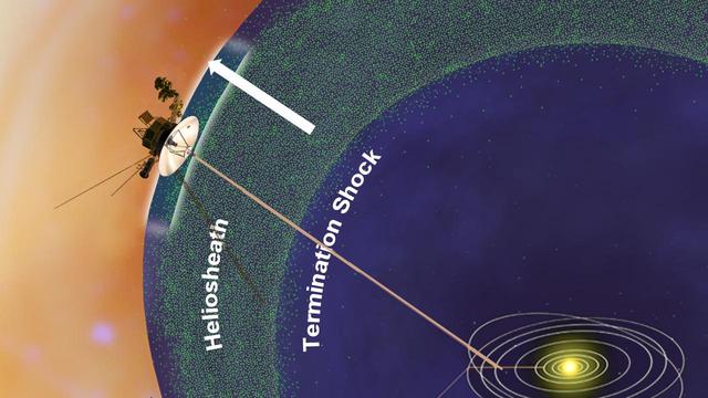
This image from a set of animations show NASA Voyager 1 spacecraft exploring a new region in our solar system called the magnetic highway.
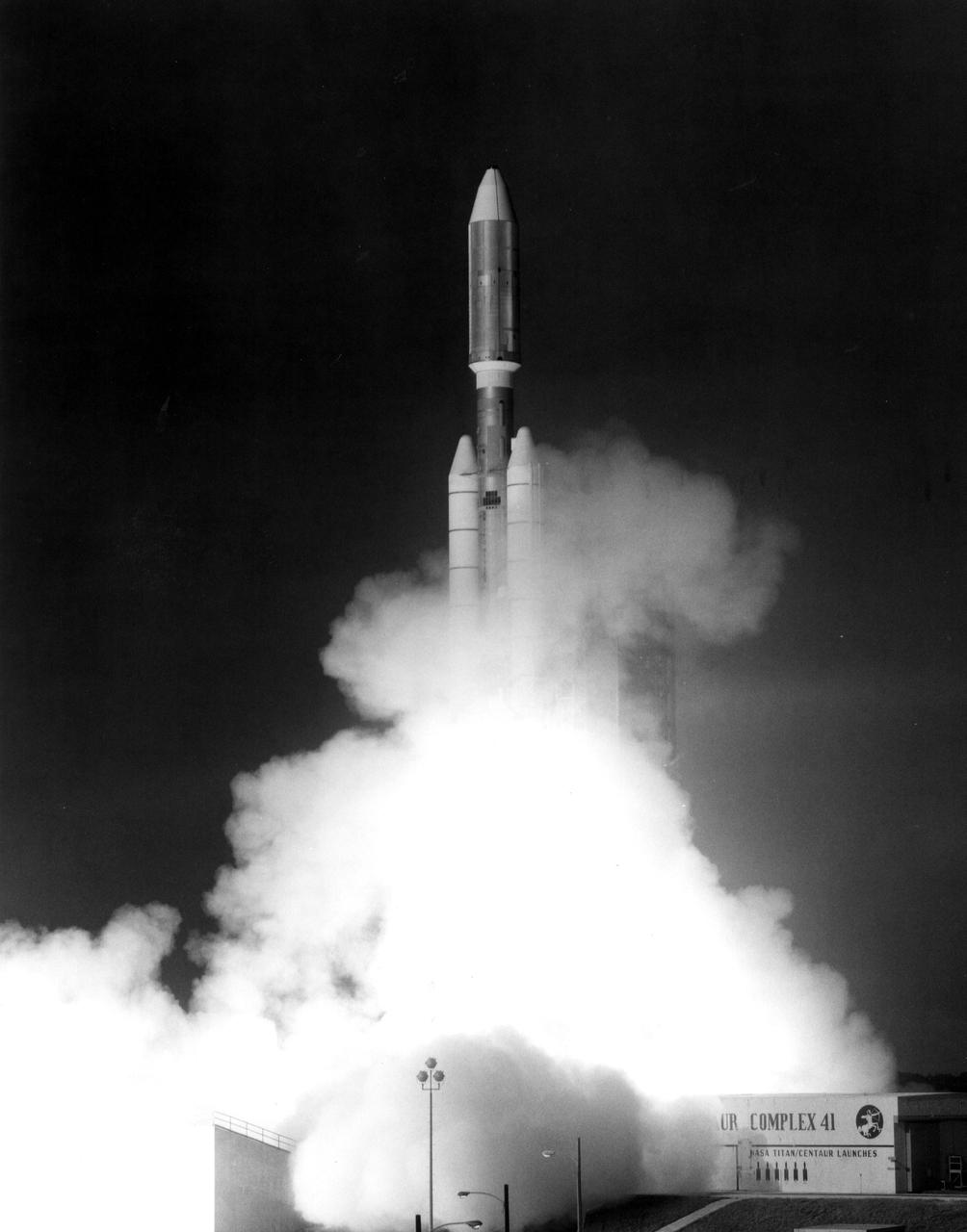
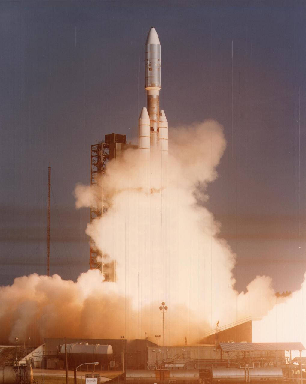
This photograph from Sept. 5, 1977, shows the launch of NASA Voyager 1 spacecraft from NASA Kennedy Space Center at Cape Canaveral, Fla.
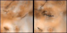
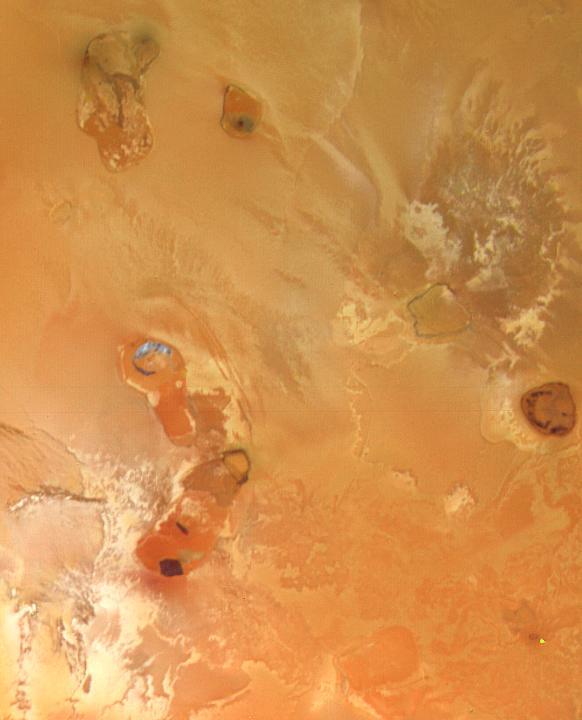
Changes on Io around Volund between Voyager 1 and Galileo Second Orbit
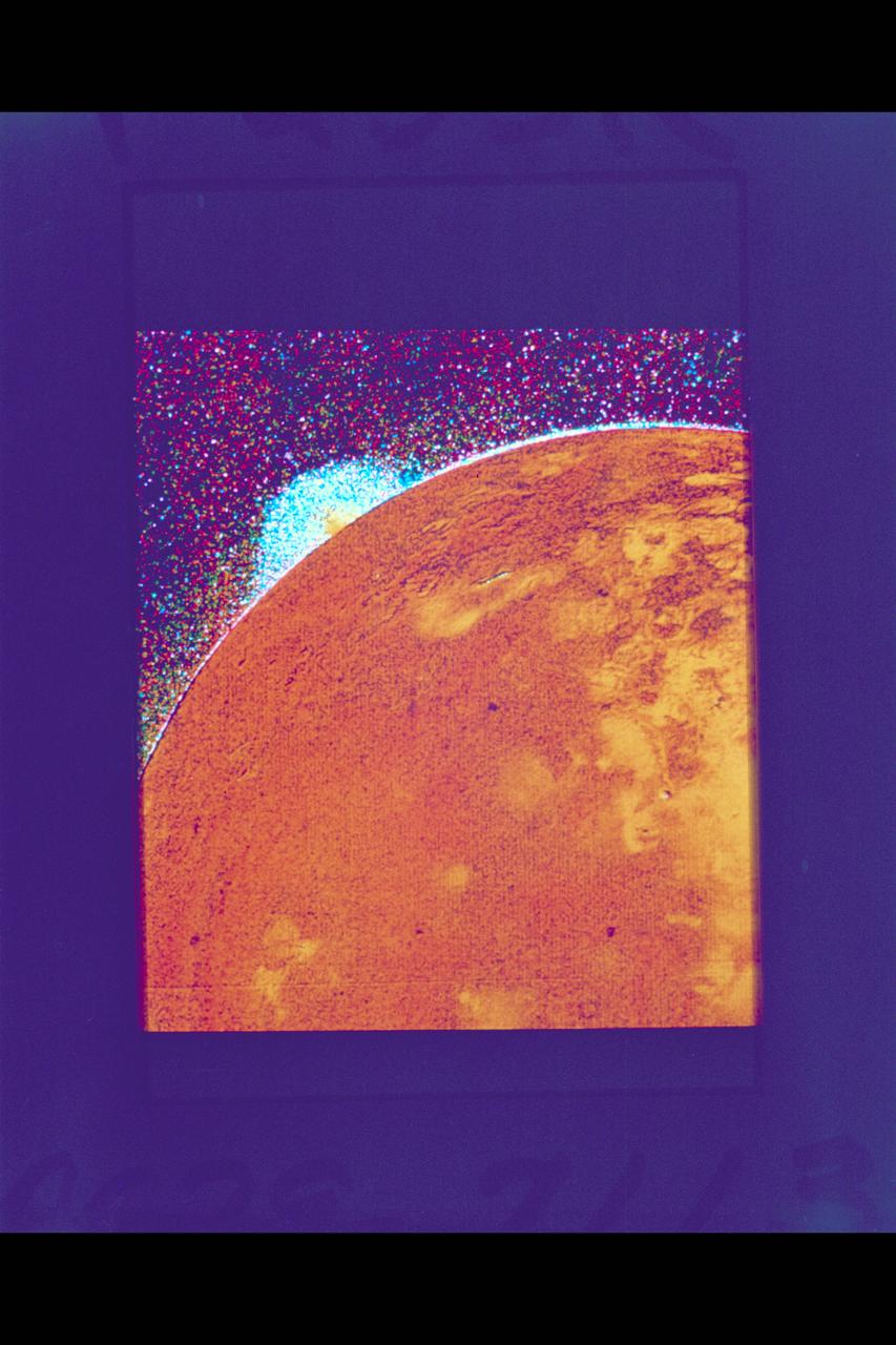
P-21738 BW Raange: 4.76 million kilometers (2.9 million miles) This Voyager 2 picture of Io was taken in ultraviolet light and shows one of the volcanic eruption plumes first photographed by Voyager 1. (the bright spot on the right limb) The plume is more than 200 kilometers (124 miles) high. The volcano apparently has been erupting since it was observed by Voyager 1 in March, 1979. This suggests that the volcanoes on Io probably are in continuous eruption.

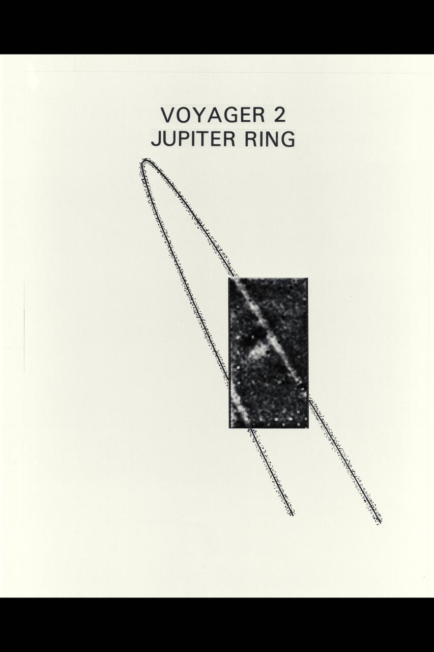
Voyager 1 views of Jupiter's rings

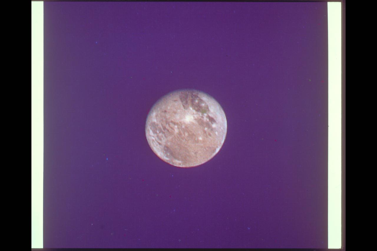
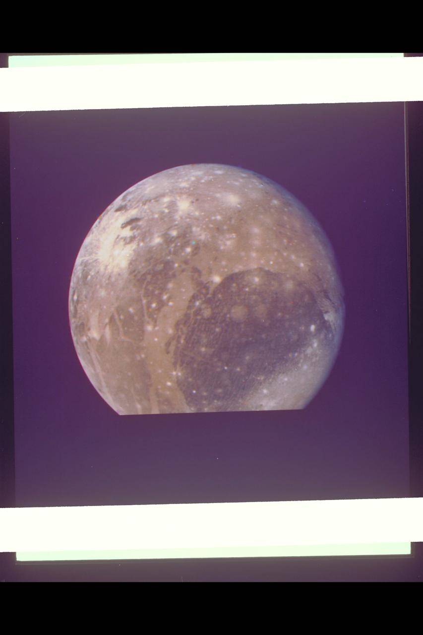
Voyager 1 spacecraft Jupiter moon Ganymede
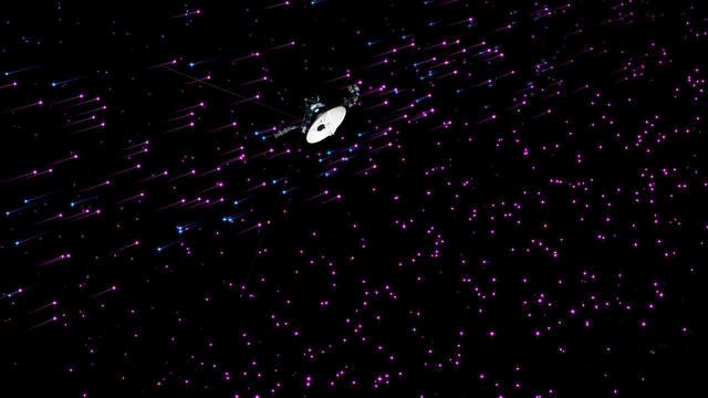
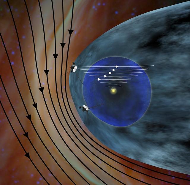
This artist concept shows plasma flows around NASA Voyager 1 spacecraft as it approaches interstellar space. Voyager 1 low-energy charged particle instrument detects the speed of the wind of plasma, or hot ionized gas, streaming off the sun.
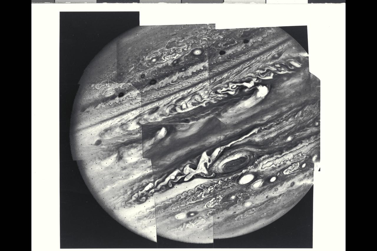
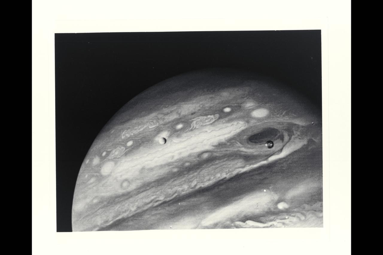
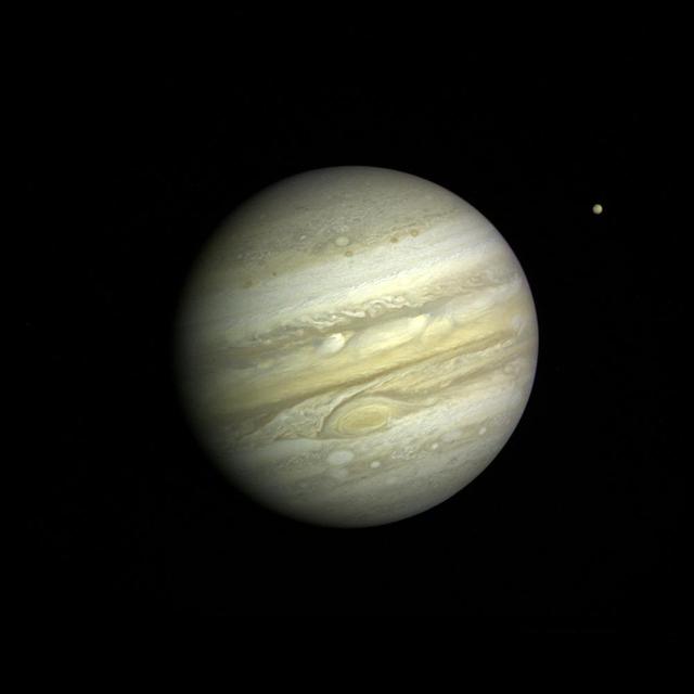
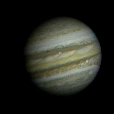
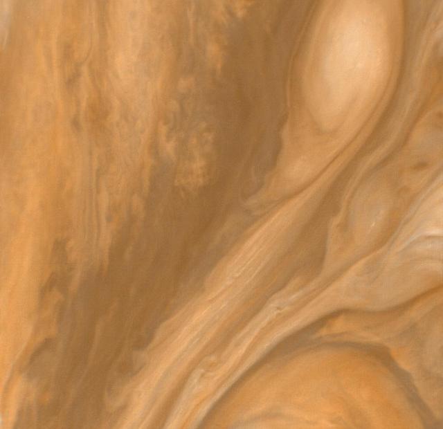
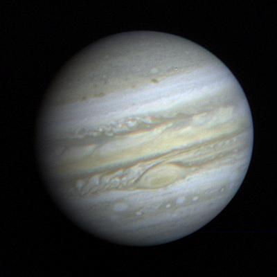
Jupiter as seen by Voyager 1, mosaic of planet. (JPL ref. No. P-21147)
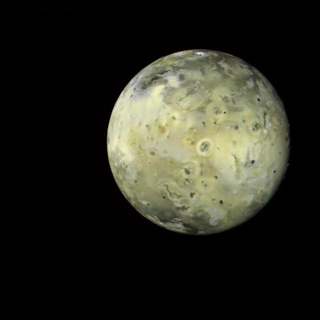
Voyager 1 view Io in its orbit around Jupiter
Voyager 1 catches volcanic eruption on Jupiter's moon Io JPL - no available
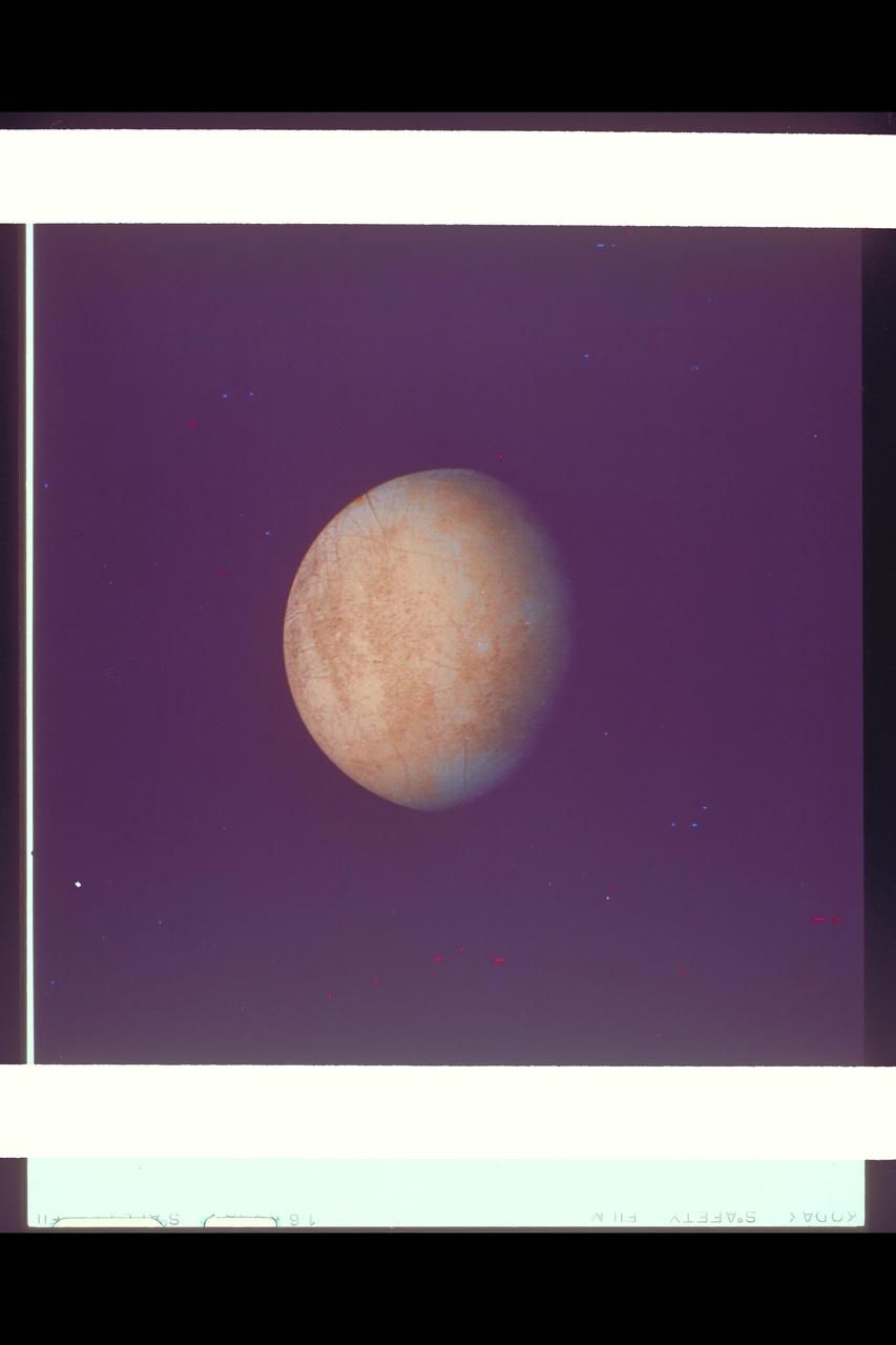
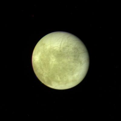
Range : 5.9 million kilometers (3.66 million miles) Europa is Jupiter's 2nd Galilean satellites from the planet and the brightest. Photo taken early morning through violet filter. Faint swirls and linear patterns show in the equatorial region (which shows darker than the poles). This hemisphere always faces Jupiter. North is up. Density and size comparable to Earth's Moon and seems to show water ice or ground water on its surface. JPL Reference # P-21163.
Voyager 1's look at Jupiter's moon Io JPL ref No. P-21457
Voyager 1 catches volcanic eruption on Jupiter's moon Io JPL ref No. P-21334
Jupiter as seen by Voyager 1, mosaic of Jupiter's Satellite Io. (JPL ref. No. P-21206)
Voyager 1 close up image of Jupiter moon Io JPL ref. No. P-21277

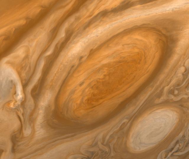
Jupiter as seen by Voyager 1, mosic of Great Red Spot. (JPL ref. No. P-21203)
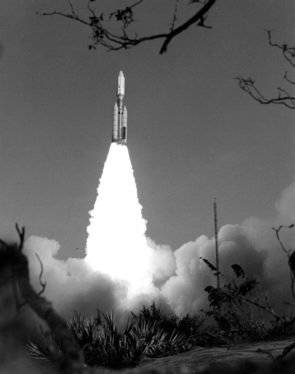
NASA's Voyager 1 spacecraft launched atop its Titan/Centaur-6 launch vehicle from the Kennedy Space Center Launch Complex in Florida on September 5, 1977, at 8:56 a.m. local time. https://photojournal.jpl.nasa.gov/catalog/PIA21746
NASA's Voyager 1 spacecraft launched atop its Titan/Centaur-6 launch vehicle from the Kennedy Space Center Launch Complex in Florida on September 5, 1977, at 8:56 a.m. local time. https://photojournal.jpl.nasa.gov/catalog/PIA21747
P-21752 BW Range: 1.2 million kilometers This image of Europa shows detail about 20 kilometers across and is somewhat higher resolution than the best Voyager 1 image. The part of Europa shown is the hemisphere that will be viewed at even higher resolution during another Voyager 2 encounter with Europa. Color reconstruction in this image was slightly enhanced to bring out detail in the complicated mottled region on the west limb, containing some of the linear fracture-like features discovered by Voyager 1. The regions in the north and south polar areas which appear bluish in this version are in fact white.
P-21752 C Range: 1.2 million kilometers This image of Europa shows detail about 20 kilometers across and is somewhat higher resolution than the best Voyager 1 image. The part of Europa shown is the hemisphere that will be viewed at even higher resolution during another Voyager 2 encounter with Europa. Color reconstruction in this image was slightly enhanced to bring out detail in the complicated mottled region on the west limb, containing some of the linear fracture-like features discovered by Voyager 1. The regions in the north and south polar areas which appear bluish in this version are in fact white.
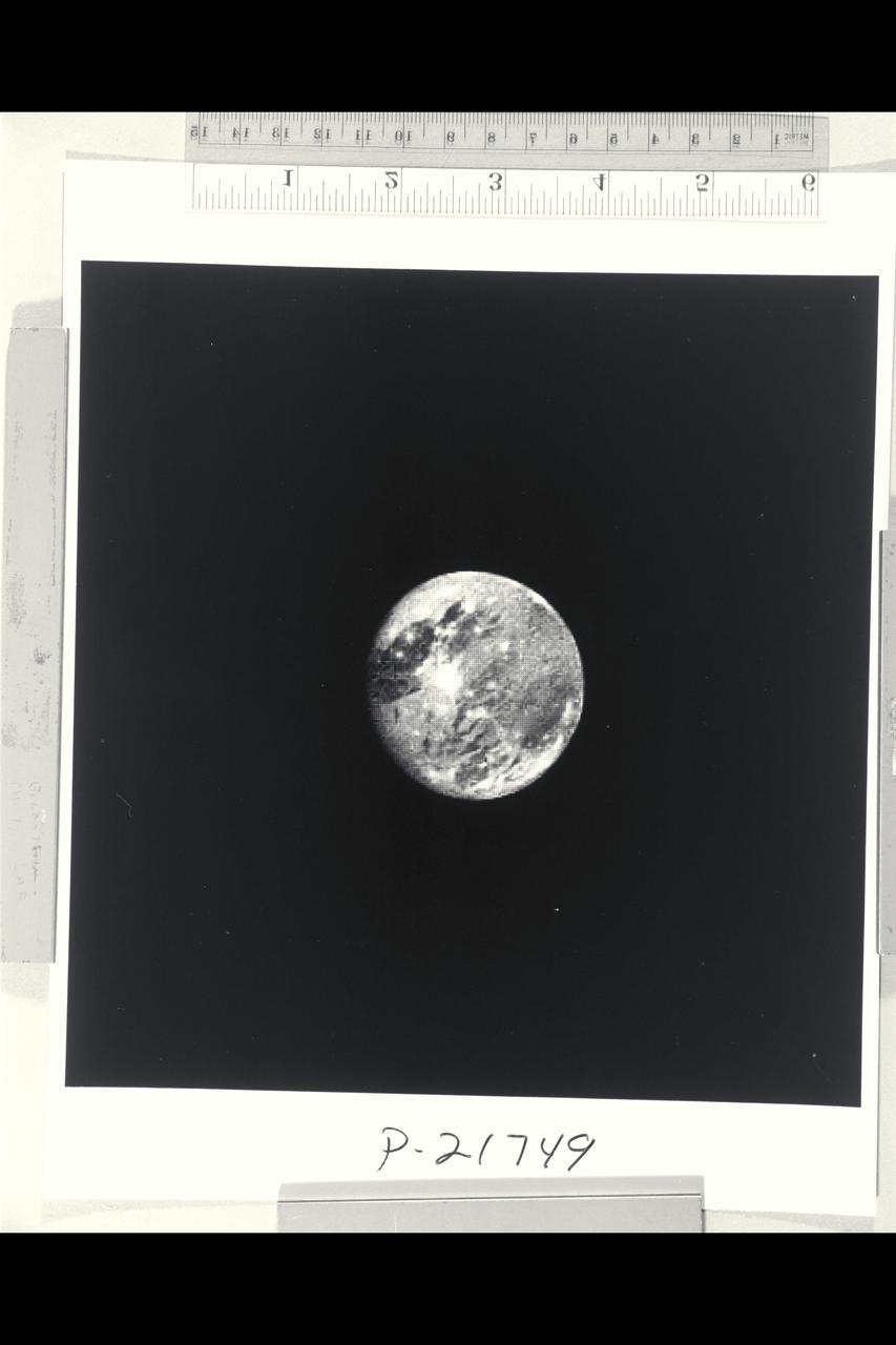
P-21749 BW Range: 6 million kilometers (4 million miles) This photograph of Ganymede, the largest satellite of Jupiter, is shown at approximately the same distance as that photographed at close range by Voyager 1 in March. This picture, taken by Voyager 2, illustrates well the light, bluish regions near the north and south poles. It is known that there is exposed water ice on the surface of Ganymede, and pehaps these polar caps are composed of a light covering of water ice or frost. Voyager 2 will pass within 63,000 kilometers (39,000 miles) of Ganymede.
P-21749 C Range: 6 million kilometers (4 million miles) This photograph of Ganymede, the largest satellite of Jupiter, is shown at approximately the same distance as that photographed at close range by Voyager 1 in March. This picture, taken by Voyager 2, illustrates well the light, bluish regions near the north and south poles. It is known that there is exposed water ice on the surface of Ganymede, and pehaps these polar caps are composed of a light covering of water ice or frost. Voyager 2 will pass within 63,000 kilometers (39,000 miles) of Ganymede.
This simulated view, made using NASA's Eyes on the Solar System app, approximates Voyager 1's perspective when it took its final series of images known as the "Family Portrait of the Solar System," including the "Pale Blue Dot" image. https://photojournal.jpl.nasa.gov/catalog/PIA23681
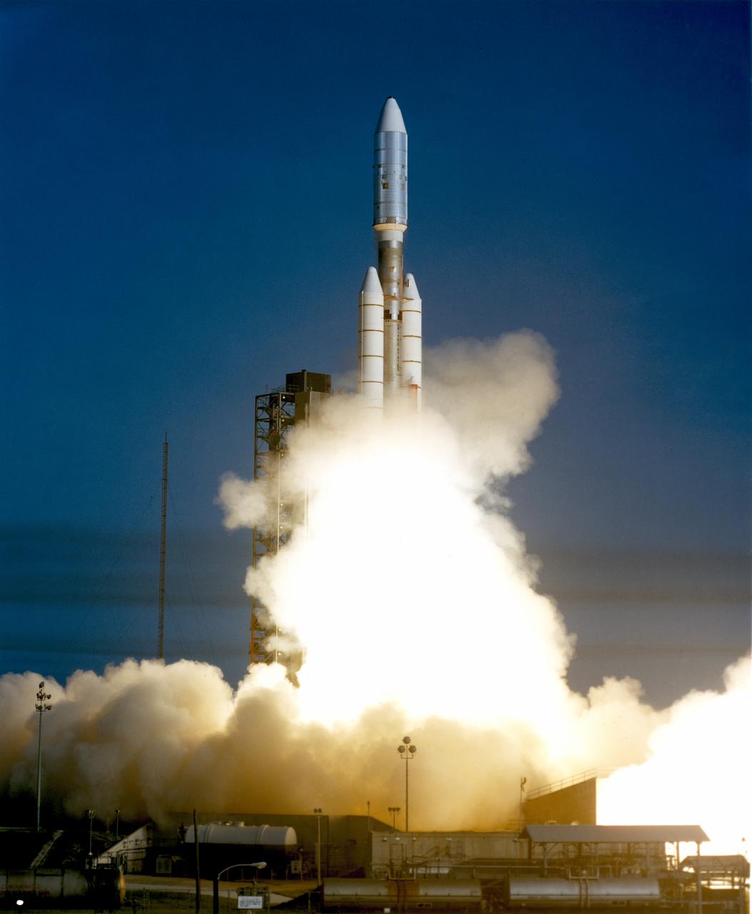
The Voyager 1 aboard the Titan III/Centaur lifted off on September 5, 1977, joining its sister spacecraft, the Voyager 2, on a mission to the outer planets.
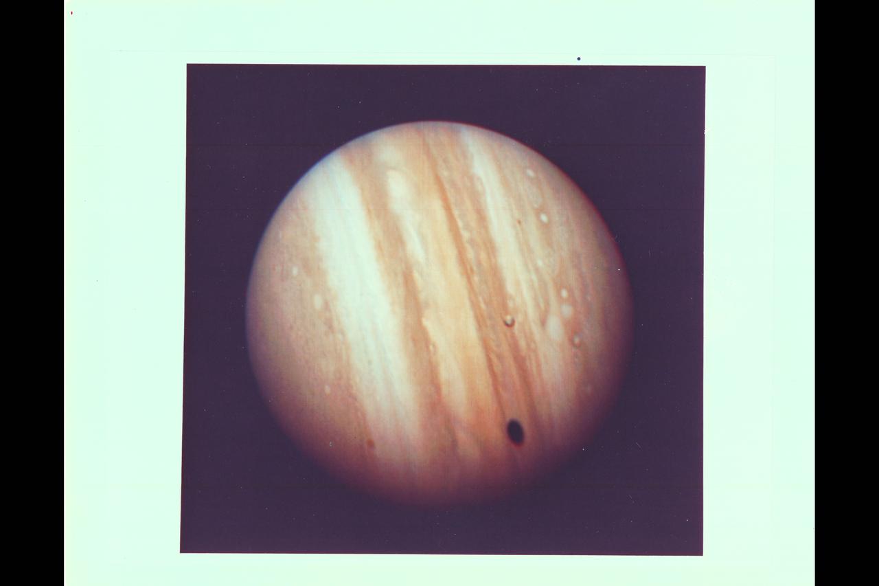
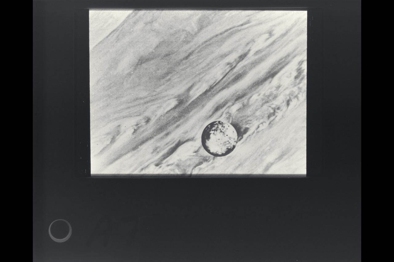
Photo by Voyager 1 Jupiter's satellite Io poses before the giant planet in this photo returned Jan 17, 1979 from a distance of 29 million miles (47 million kilometers). The satellite's shadow can be seen falling on the face of Jupiter at left. Io is traveling from left to right in its one-and-three-quarter-day orbit around Jupiter. Even from this great distance the image of Io shows dark poles and bright equatorial region. Voyager 1 will make its closest approach to Jupiter 174, 000 miles (280,000 kilometer) on March 5. It will then continue to Saturn in November 1980. This color photo was assembled at Jet Propulsion Laboratory's Image Processing Lab from three black and white images taken through filters. The Voyagers are managed for NASA's Office of Space Science by Jet Propulsion Laboratory. (JPL Ref: P-20946C)

This artist concept depicts NASA Voyager 1 spacecraft entering interstellar space. Interstellar space is dominated by the plasma, or ionized gas, that was ejected by the death of nearby giant stars millions of years ago.
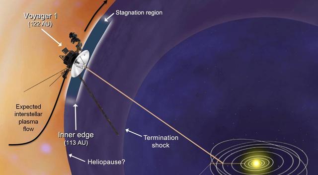
NASA Voyager 1 spacecraft has entered a new region between our solar system and interstellar space, which scientists are calling the stagnation region as depicted in this artist rendering.
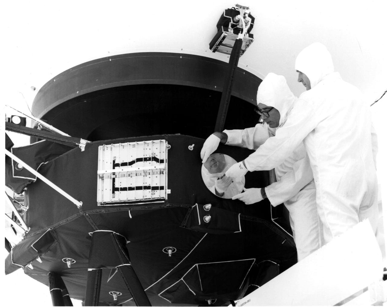
Engineers secure the cover over the Voyager 1 Golden Record in this archival image from 1977. https://photojournal.jpl.nasa.gov/catalog/PIA21740
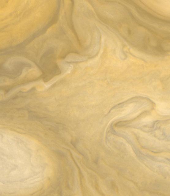
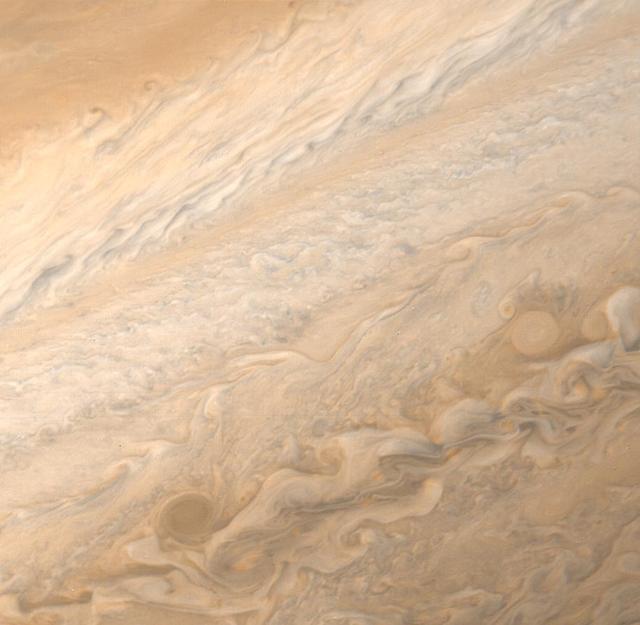
These Jupiter photographs are part of a set taken by NASA Voyager 1 on December 10 and 11, 1978 from a distance of 83 million km 52 million miles or more than half the distance from the Earth to the sun. At this range, Voyager 1 is able to record more detail on the giant planet than the very best ground-based telescopes. The highest resolution ever obtained on the Jovian disk was recorded by Pioneer 11 four years ago. Voyager, however, has longer focal-length optics than Pioneer, and while nearly three months from encounter (~ March 1979) was able to achieve higher resolution than that obtained by Pioneer only 24 hours from its encounter on 3 December 1974. Jupiter's colorful and turbulent atmosphere is evident in these photographs. The entire visible surface of the planet is made up of multiple layers of clouds, composed primarily of ammonia ice crystals colored by small amounts of materials of unknown composition. The Great Red Spot, seen to the lower left of 2 and lower right of 3, is now recovering from a period of relative inconspicuousness. An atmospheric system larger than the Earth and more than 100 years old, the Great Red Spot remains a mystery and a challenge to Voyager instruments. A bright convective cloud (center of and right of center in 4) displays a plume which has been swept westward (to the left) by local currents in the planet's equatorial wind system. Below and to the left and right of the Great Red Spot are a pair of white oval clouds; a third can be seen in 1. All three were formed almost 40 years ago and are the second oldest class of discrete features identified in the Jovian atmosphere. Each of the pictures was produced from blue, green, and orange originals in JPL's Image Processing Laboratory. http://photojournal.jpl.nasa.gov/catalog/PIA00454
NASAS Voyager 1 took this picture of the planet Jupiter on Jan. 6, 1979, the first in its three-month-long, close-up investigation of the largest planet.
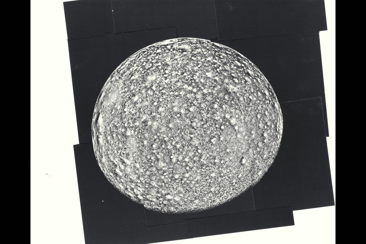
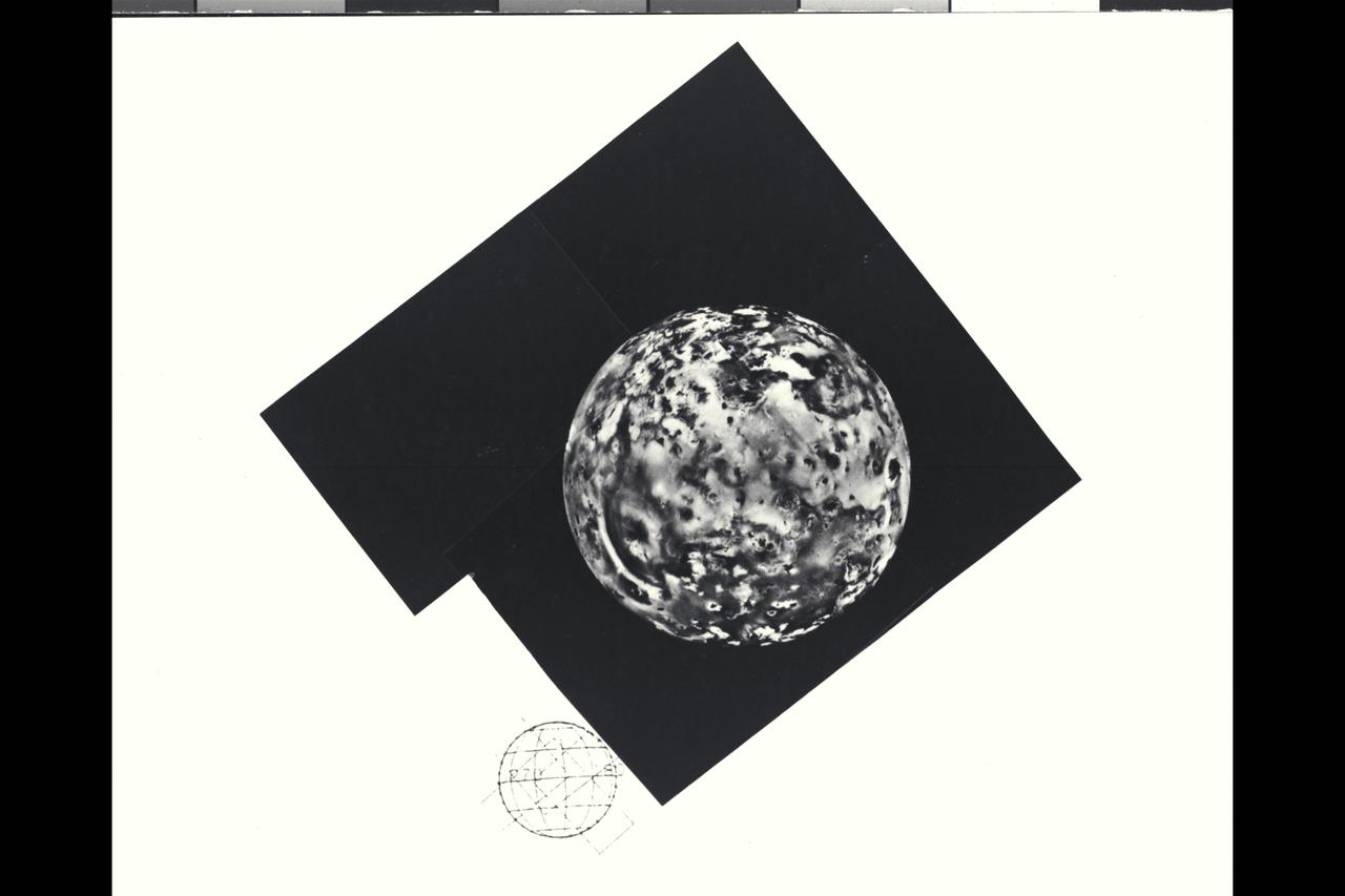
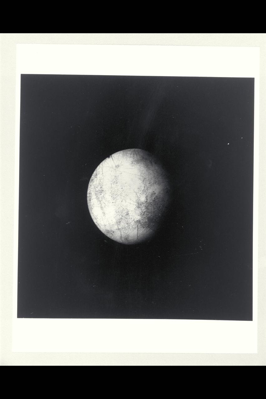
P-21746 BW Range: 390,000 kilometers (245,000 miles) This photomosaic of Callisto is composed of nine frames. The impact crater distribution is very uniform across the disk. Notable are the very bright rayed craters that probably are very young. Near the limb is a giant probable impact structure. Several large structures were discovered by Voyager 1. This one is smaller than the largest one found by Voyager 1 but is more clearly shown. About 15 concentric rings surround the bright central spot. Many hundreds of moderate sized impacts are also seen, a few with bright radial ray patterns. The limb is very smooth confirming that no high topography has been seen on the satellite, and observation consistent with its icy composition.
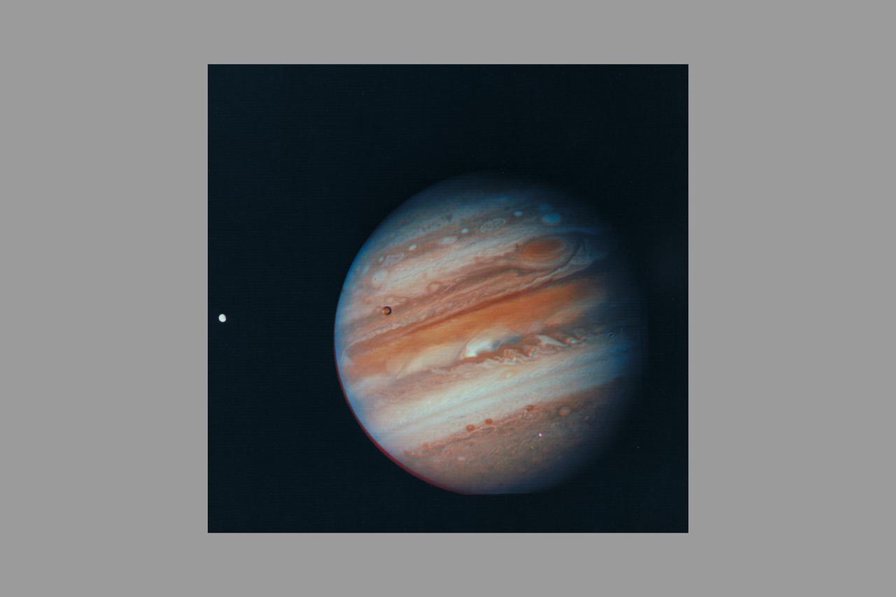
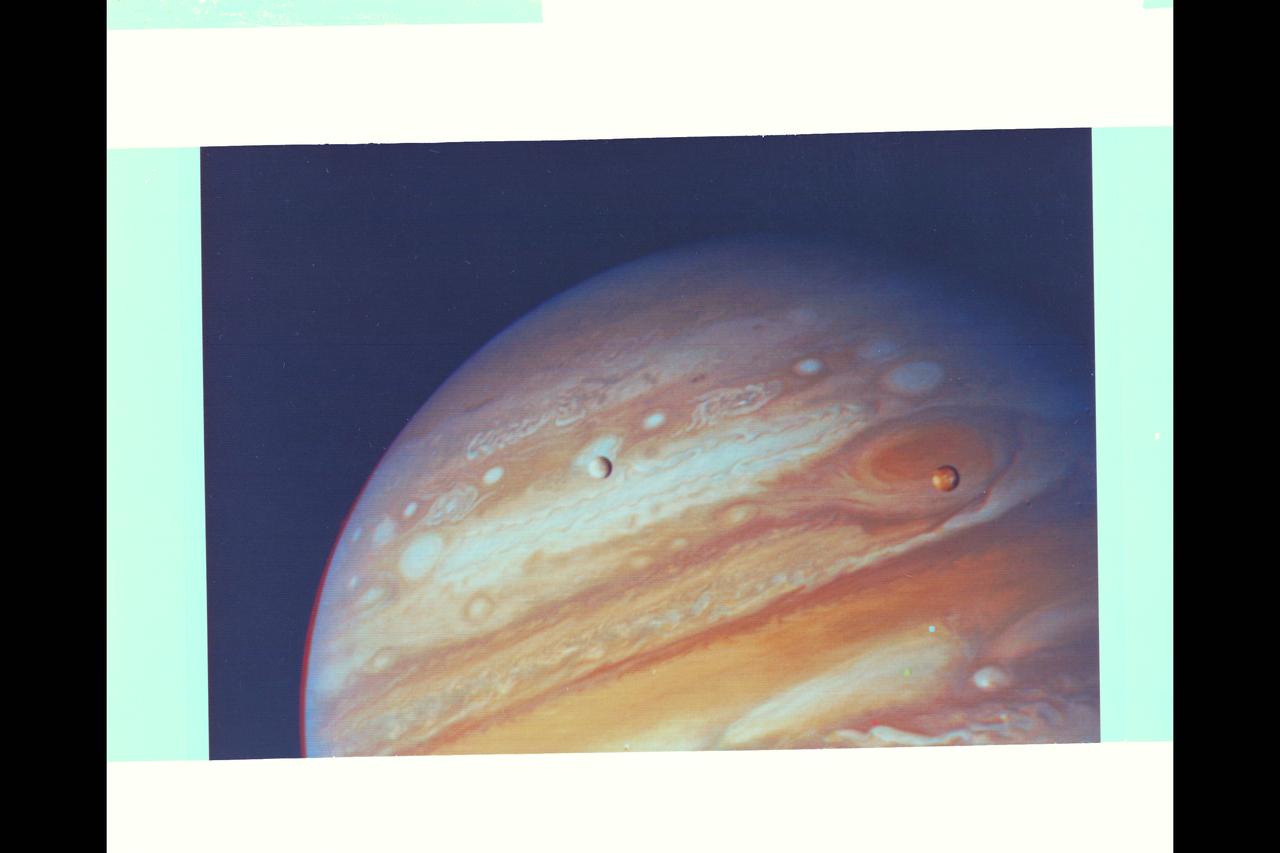
Photo by Voyager 1 (JPL) Jupiter, its Great Red Spot and three of its four largest satellites are visible in this photo taken Feb 5, 1979 by Voyager 1. The spacecraft was 28.4 million kilomters (17.5 million miles) from the planet at the time. The inner-most large satellite, Io, can be seen against Jupiter's disk. Io is distinguished by its bright, brown-yellow surface. To the right of Jupiter is the satellite Europa, also very bright but with fainter surface markings. The darkest satellite, Callisto (still nearly twice as bright as Earth's Moon), is barely visible at the bottom left of the picture. Callisto shows a bright patch in its northern hemisphere. All tThree orbit Jupiter in the equatorial plane, and appear in their present position because Voyageris above the plane. All three satellites show the same face to Jupiter always -- just as Earth's Moon always shows us the same face. In this photo we see the sides of the satellites that always face away from the planet. Jupiter's colorfully banded atmosphere displays complex patterns highlighted by the Great Red Spot, a large, circulating atmospheric disturbance. This photo was assembled from three black and white negatives by the Image Processing Lab at Jet Propulsion Laboratory. JPL manages and controls the Voyage Project for NASA's Office of Space Science. (ref: P-21083)
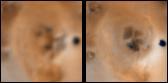
Changes on Io between Voyager 1 and Galileo Second Orbit Around an Unnamed Vent North of Prometheus
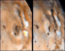
Changes on Io around Maui and Amirani between Voyager 1 and Galileo Second Orbit
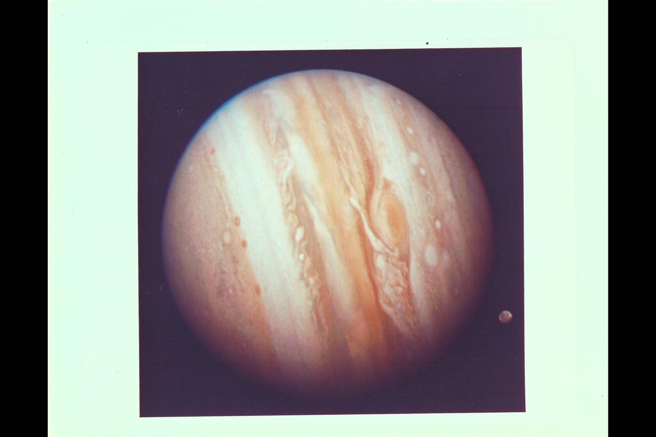
Photo by Voyager 1 (JPL) The spacecraft took this photo of the planet Jupiter on Jan 24, while still more than 25 million miles (40 million kilometers) away. As the spacecraft draws closer to the planet (about 1 million kilometers a day) more details are emergng in the turbulent clouds. The Great Red Spot shows prominently below center, surrounded by what scientists call a remarkably complex region of the giant planet's atmosphere. An elongated yellow cloud within the Great Red Spot is swirling around the spot's interior boundary in a counterclockwise direction with a period of a little less than six days, confirming the whirlpool-like circulation that astronomers have suspected from ground-based photographs. Ganymede, Jupiter's largest satellite, can be seen to the lower left of the planet. Ganymede is a planet-sized body larger than Mercury. This color photo was assembled at Jet Propulsion Laboratory's Image Processing Lab from there black and white images taken through filters. The Voyagers are managed for NASA's Office of Space Science by Jet Propulsion Laboratory. (ref: P-20945C Mission Image 1-9)
P-21751 C Range: 1.2 million kilometers This Voyager 2 color photo of Ganymede, the largest Galilean satellite, shows a large dark circular feature about 3200 kilometers in diameter with narrow closely-spaced light bands traversing its surface. The bright spots dotting the surface are relatively recent impact craters, while the lighter circular areas may be older impact areas. The light branching bands are ridged and grooved terrain first seen on Voyager 1 and are younger than the more heavily cratered dark regions. The nature of the brightish region covering the northern part of the dark circular fature is uncertain, but it may be some type of condensate. Most of the features seen on the surface of Ganymede are probably both internal and external responses of the very thick icy layer which comprises the crust of this satellite.
P-21757 BW Range: 2 million kilometers (1.25 million miles) Jupiter's thin ring of particles was photographed by Voyager 2 on its approach to the giant planet. The spacecraft was 2.5° above the plane of the ring. Segments of both sides of the faint ring were captured in this picture. The ring was first photographed in an edge-on configuration by Voyager 1 and was measured then to have a radial extent of about 55, 000 kilometers (34,000 miles) from Jupiter's cloud tops. With this picture, it is possible to determine that the ring is much narrower radially than the individual rings of Saturn. This image has had an extreme contrast enhancement process applied to it which brought out some white blotches in the central region and makes the ring appear discontinuous and non-uniform in brightness. These effects are all artifacts of the processing.
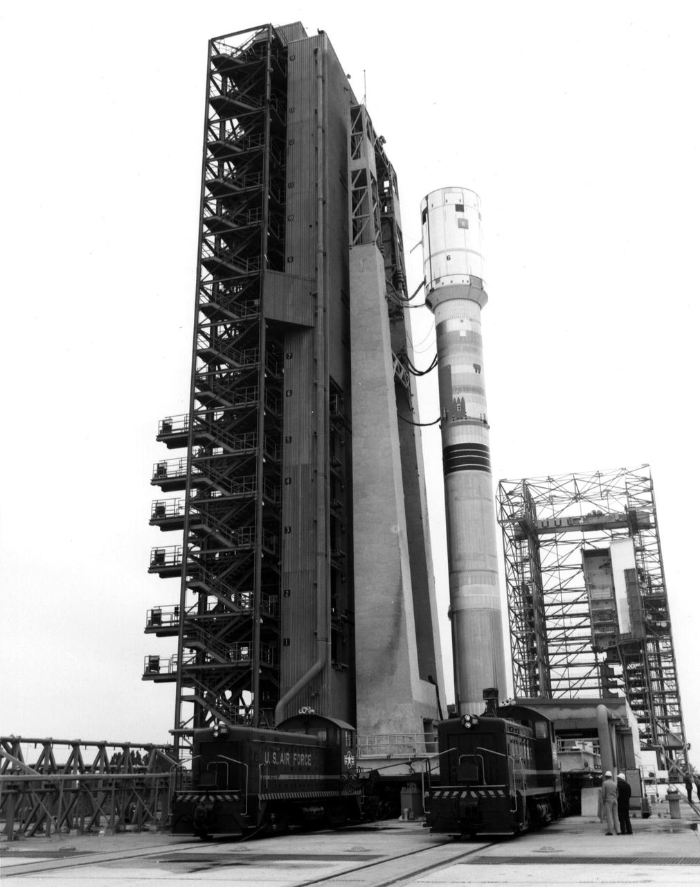
The Titan/Centaur-6 launch vehicle was moved to Launch Complex 41 at Kennedy Space Center in Florida to complete checkout procedures in preparation for launch. The photo is dated January 1977. This launch vehicle carried Voyager 1 into space on September 5, 1977. https://photojournal.jpl.nasa.gov/catalog/PIA21739
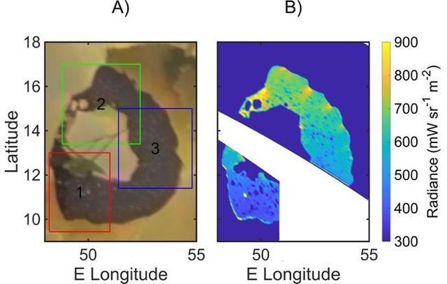
A map of infrared radiance in Loki Patera on Jupiter's moon Io, as measured by the Jovian Infrared Auroral Mapper (JIRAM) instrument aboard NASA's Juno spacecraft, right, and by NASA's Voyager 1, left. https://photojournal.jpl.nasa.gov/catalog/PIA26525
This visual represents sounds captured of interstellar space by NASA Voyager 1 spacecraft. Voyager 1 plasma wave instrument detected the vibrations of dense interstellar plasma.
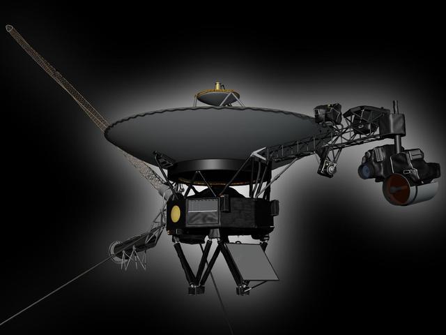
This artist rendering shows NASA Voyager spacecraft. Voyager 2 was launched on Aug. 20, 1977. Voyager 1 was launched on Sept. 5, 1977.
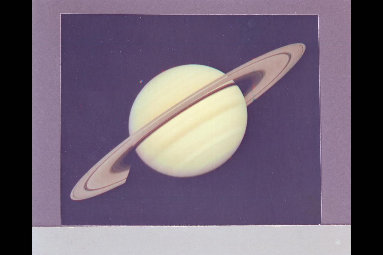
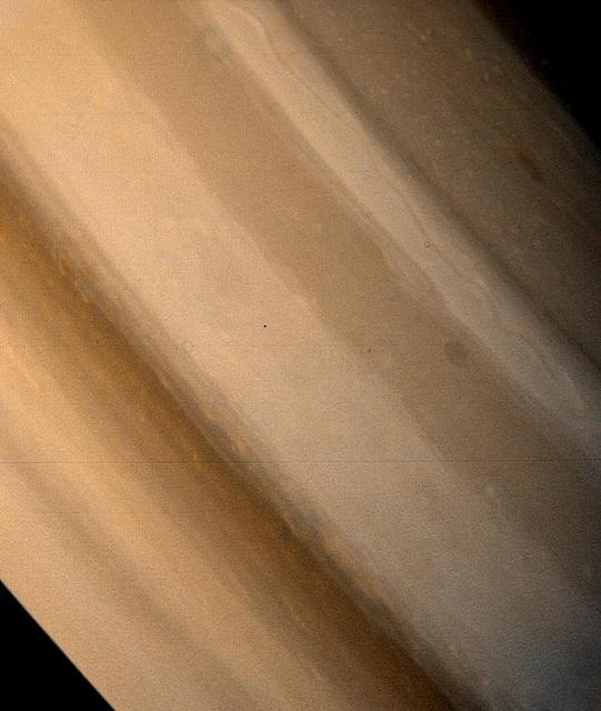
Range : 34 million km. ( 21.1 million miles) P-22993C This Voyager 1 photograph of Saturn was taken on the last day it could be captured within a single narrow angle camera frame as the spacecraft neared the planet for it's closest approach on Nov. 12, 1980. Dione, one of Saturn's innermost satellites, appears as three color spots just below the planet's south pole. An abundance of previously unseen detail is apparent in the rings. For example, a gap in the dark, innermst ring, C-ring or Crepe Ring, is clearly shown. Also, material is seen inside the relatively wide Cassini Division, seperating the middle, B-ring from the outermost ring, the A-ring. The Encke division is shown near the outer edge of A-ring. The detail in the ring's shadows cast on the planet is of particular interest. The broad dark band near the equator is the shadow of B-ring. The thinner, brighter line just to the south is the shadow of the less dense A-ring.
P-21756 BW only Range: 120,000 km (right) 169,000 km (left) Right: In the foreground of this picture taken by Voyager 2, the part of the surface of Ganymede shown is the typical grooved terrain as seen by Voyager 1. It consists of mutually intersecting bands of closely-spaced, parallel ridges and grooves. In the background is newly-cratered dark terrain across which can be traced several widely spaced parellel linear features. When viewed from a distance the line features appear to trace broad circular areas. The features resemble the circular ridges on Callisto that surround an almost complete annealed impact basin. The feature on Ganymede may be of similar origin but all traces of the impact itself have been destroyed. Left: This picture of Ganymede shows that the dark contrast terrain is separated by bright bands of grooved terain. The band of closely spaced linear grooves in the foreground is 150 km across and appears to be offset by another narrow band at right angles, as though by faulting. A variety of ray patterns are seen around the craters. One is in the left of the picture, it has prominent dark rays around an inner bright halo. Other craters have dark haloes; others have diffuse bright rays. The variation of albedo patterns around the craters may be indications of layering in the surface materials. The intensity of the craters suggests the dark areas are extremely old. The bright grooved terrain is less cratered and probably somewhat younger.
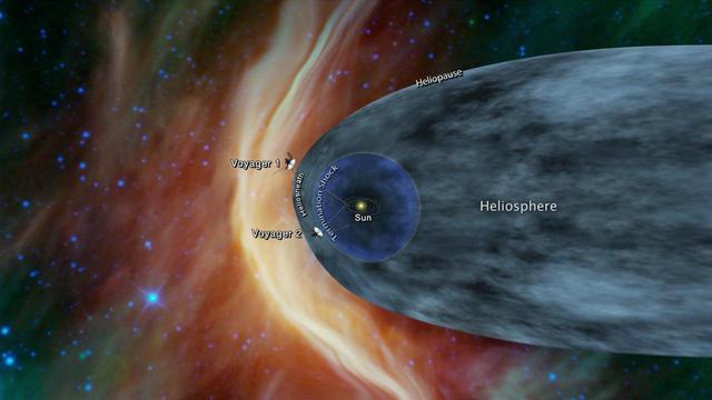
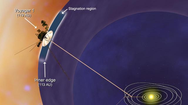
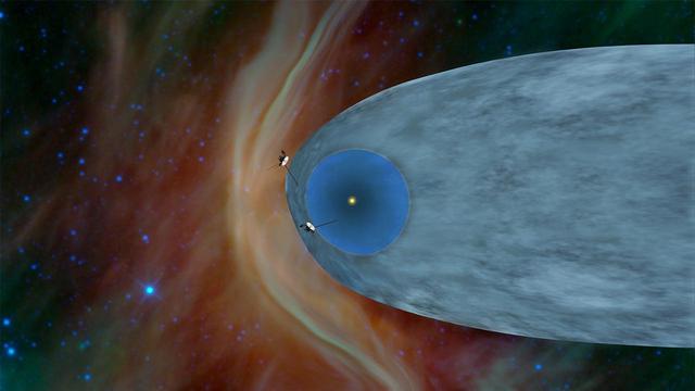
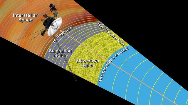
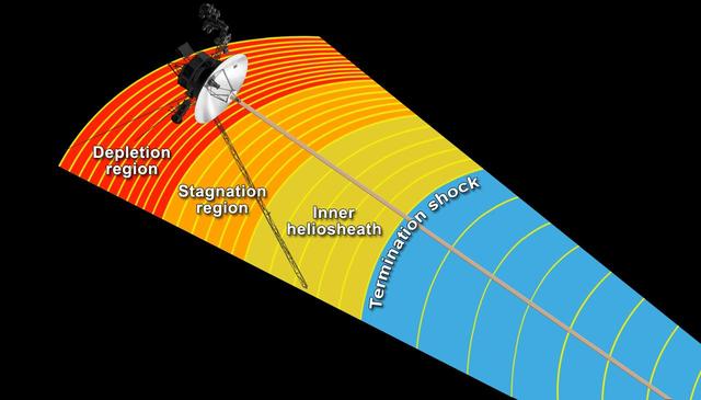
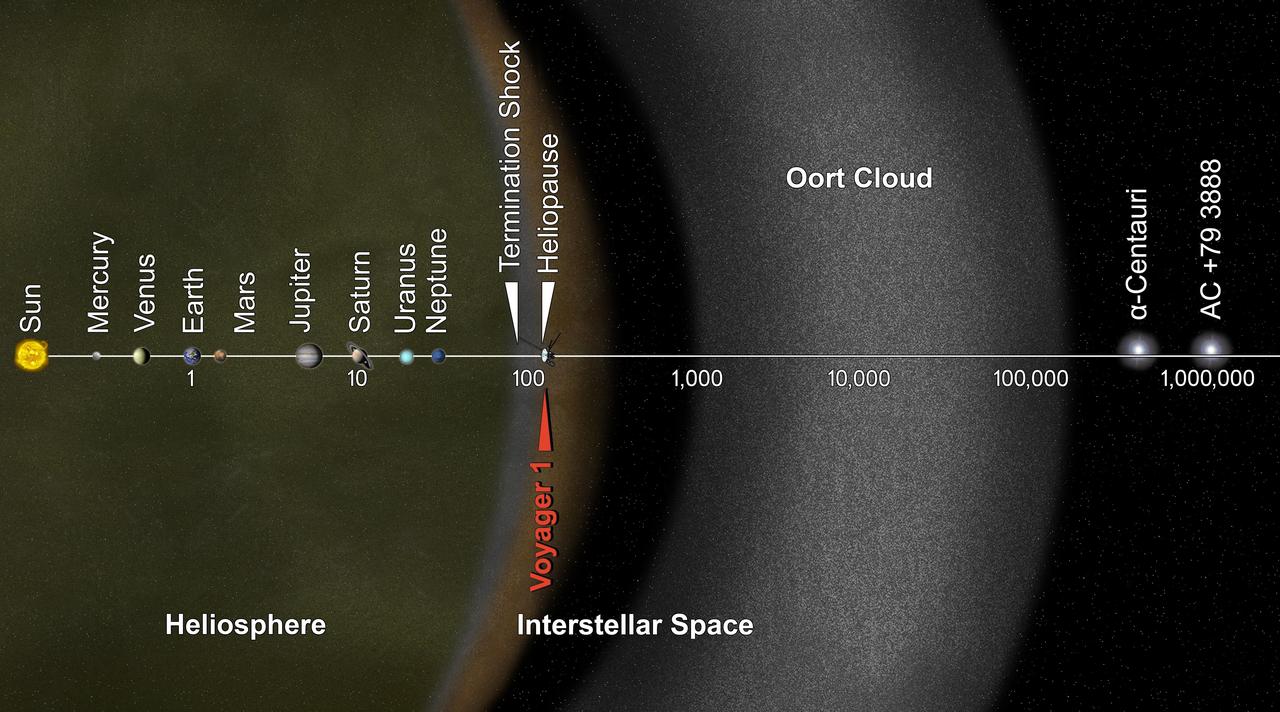
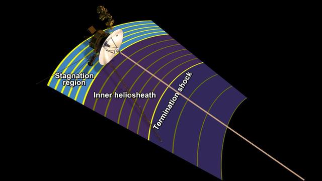
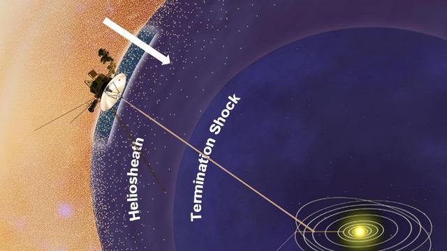
This graphic shows the position of the Voyager 1 and Voyager 2 probes, relative to the heliosphere, a protective bubble created by the Sun that extends well past the orbit of Pluto. Voyager 1 crossed the heliopause, or the edge of the heliosphere, in 2012. Voyager 2 is still in the heliosheath, or the outermost part of the heliosphere. https://photojournal.jpl.nasa.gov/catalog/PIA22566
Voyager 1 Image of Jupiter and two of its satellites (Io, left, and Europa). Io is about 350,000 kilometers (220,000 miles) above Jupiter's Great Red Spot; Europa is about 600,000 kilometers (375,000 miles) above Jupiter's clouds. Although both satellites have about the same brightness, Io's color is very different from Europa's. Io's equatorial region show two types of material -- dark orange, broken by several bright spots -- producing a mottled appearance. The poles are darker and reddish. Preliminary evidence suggests color variations within and between the polar regions. Io's surface composition is unknown, but scientists believe it may be a mixture of salts and sulfur. Erupoa is less strongly colored, although still relatively dark at short wavelengths. Markings on Eruopa are less evident that on the other satellites, although this picture shows darker regions toward the trailing half of the visible disk. Jupiter at this point is about 20 million kilometers (12.4 million miles) from the spacecraft. At this resolution (about 400 kimometers or 250 miles) there is evidence of circular motion in Jupiter's atmosphere. While the dominant large-scale motions are west-to-east, small-scale movement includes eddy-like circulation within and between the bands. (JPL ref: P-21082)
Voyager 1 Image of Jupiter and two of its satellites (Io, left, and Europa). Io is about 350,000 kilometers (220,000 miles) above Jupiter's Great Red Spot; Europa is about 600,000 kilometers (375,000 miles) above Jupiter's clouds. Although both satellites have about the same brightness, Io's color is very different from Europa's. Io's equatorial region show two types of material -- dark orange, broken by several bright spots -- producing a mottled appearance. The poles are darker and reddish. Preliminary evidence suggests color variations within and between the polar regions. Io's surface composition is unknown, but scientists believe it may be a mixture of salts and sulfur. Erupoa is less strongly colored, although still relatively dark at short wavelengths. Markings on Eruopa are less evident that on the other satellites, although this picture shows darker regions toward the trailing half of the visible disk. Jupiter at this point is about 20 million kilometers (12.4 million miles) from the spacecraft. At this resolution (about 400 kimometers or 250 miles) there is evidence of circular motion in Jupiter's atmosphere. While the dominant large-scale motions are west-to-east, small-scale movement includes eddy-like circulation within and between the bands. (JPL ref: P-21082)

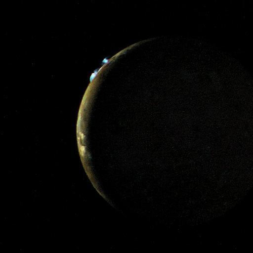
This crescent view of Jupiter was taken by NASA Voyager 1 on Mar. 24, 1979.
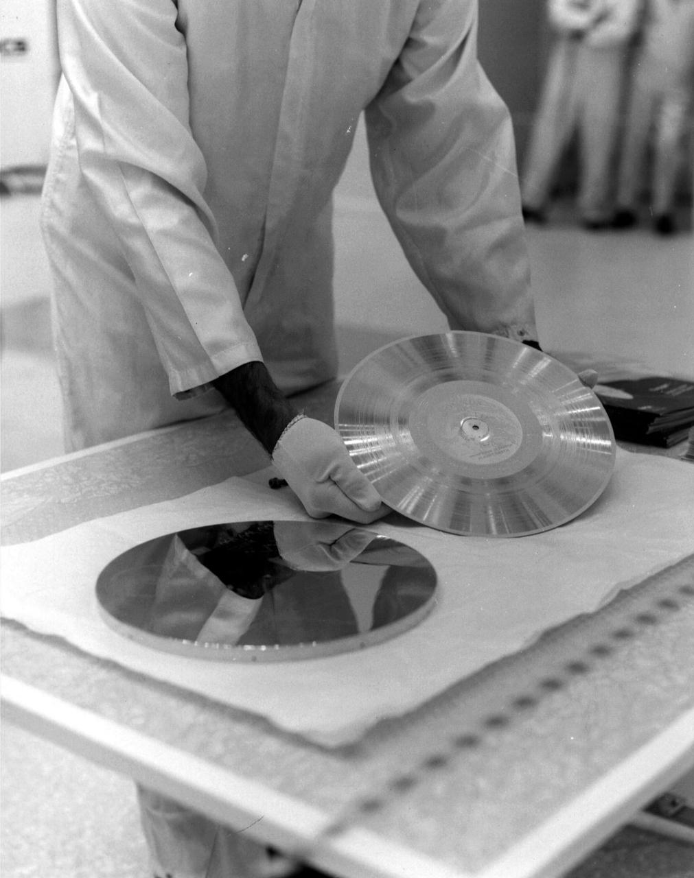
The Voyager 1 Golden Record is prepared for installation on the spacecraft in this archival image from 1977. https://photojournal.jpl.nasa.gov/catalog/PIA21741
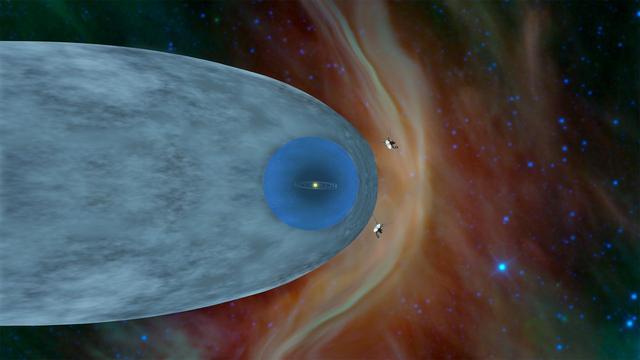
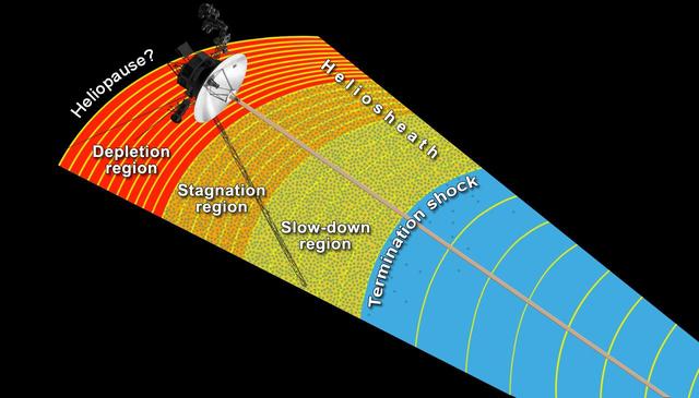
This illustration shows the position of NASA's Voyager 1 and Voyager 2 probes, outside of the heliosphere, a protective bubble created by the Sun that extends well past the orbit of Pluto. Voyager 1 crossed the heliopause, or the edge of the heliosphere, in August 2012. Heading in a different direction, Voyager 2 crossed another part of the heliopause in November 2018. https://photojournal.jpl.nasa.gov/catalog/PIA22835
NASA Voyager 1 took this photo of Jupiter Feb. 1, 1979. Voyager scientists saw that different colors in clouds around the Great Red Spot imply that the clouds swirl around the spot at varying altitudes. http://photojournal.jpl.nasa.gov/catalog/PIA00235
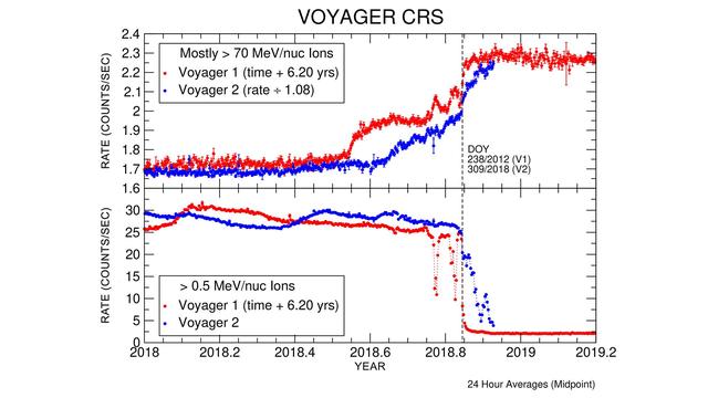
These graphs compare data from identical instruments onboard NASA's Voyager 1 and Voyager 2 spacecraft as they each exited the heliosphere. Voyager 1 exited in 2012, and Voyager 2 exited in 2018. The cosmic ray subsystem (CRS) measures the rate of energetic particles hitting the radiation detector on the instrument. The top graph shows high energy particles (called cosmic rays) that originate outside the heliosphere. The CRS instruments on both spacecraft observed similar, but not identical, increases in the cosmic ray rate as they both crossed the heliopause (the outer edge of the heliosphere). The lower graph shows slightly lower energy particles that originate inside the heliosphere. Both spacecraft detected a similar but not identical decrease in these lower energy particles when they crossed the heliopause and immediately after. https://photojournal.jpl.nasa.gov/catalog/PIA22916
Saturn storms observed by NASA Voyager, Aug. 5, 2004. Voyager 1 and 2 observed radio signals from lightning which were interpreted as being from a persistent, low-latitude storm system.
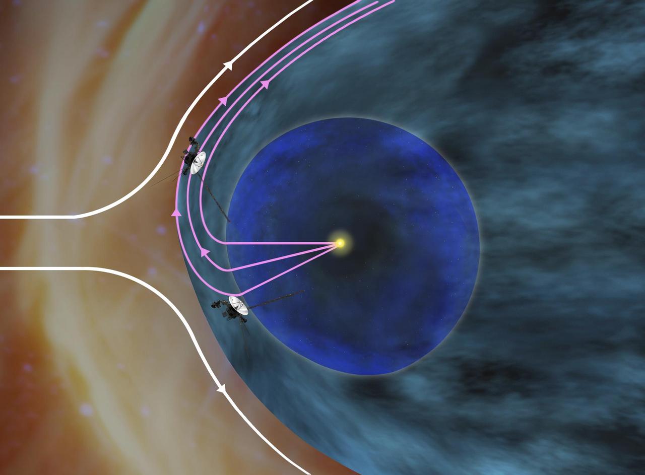
This artist concept shows the general locations of NASA two Voyager spacecraft. Voyager 1 top has sailed beyond our solar bubble into interstellar space. Voyager 2 bottom is still exploring the outer layer of the solar bubble.
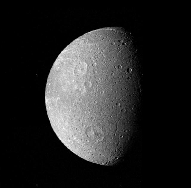
Many impact craters -- the record of the collision of cosmic debris -- are shown in this mosaic from NASA Voyager 1 of Saturn moon Dione.

This photo of Jupiter Great Red Spot was taken by Voyager 1 in early March 1979.
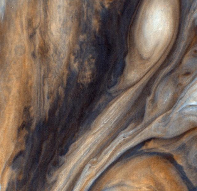
This view from NASA Voyager 1 in 1979 is of the region just to the east of the Red Spot, seen in greatly exaggerated color. http://photojournal.jpl.nasa.gov/catalog/PIA00020
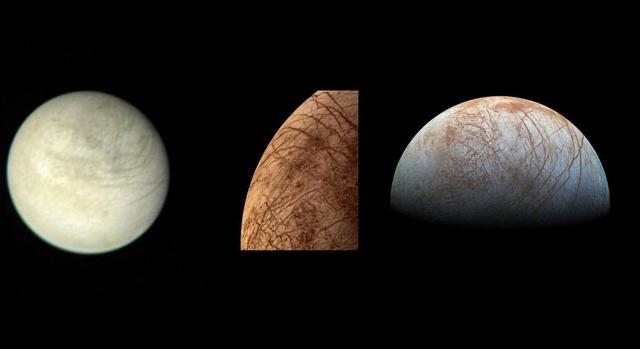
On the left is a view of Jupiter's moon Europa taken on March 2, 1979, by NASA's Voyager 1 spacecraft. In the middle is a color image of Europa taken by NASA's Voyager 2 spacecraft during its close encounter on July 9, 1979. On the right is a view of Europa made from images taken by NASA's Galileo spacecraft in the late 1990s. https://photojournal.jpl.nasa.gov/catalog/PIA24895

This computer generated map of Jupiter was made from 10 color images of Jupiter taken Feb. 1, 1979, by NASA Voyager 1, during a single, 10 hour rotation of the planet. http://photojournal.jpl.nasa.gov/catalog/PIA00011

This photo of Jupiter was taken by NASA Voyager 1 on March 1, 1979. The photo shows Jupiter Great Red Spot upper right and the turbulent region immediately to the west. http://photojournal.jpl.nasa.gov/catalog/PIA00359
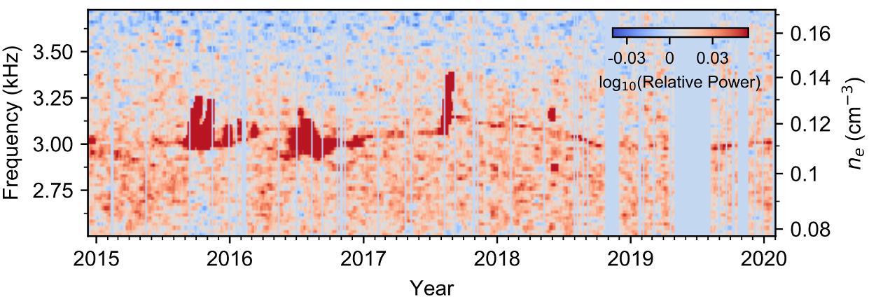
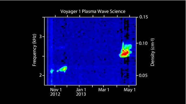
Weak but nearly continuous plasma oscillation events — visible as a thin red line in this graphic — connect stronger events in Voyager 1's Plasma Wave Subsystem data. https://photojournal.jpl.nasa.gov/catalog/PIA24572
NASA Voyager 1 took this picture of the planet Jupiter on Jan. 6, 1979, the first in its three-month-long, close-up investigation of the largest planet.
This full-disk image of Jupiter satellite Io was made from several frames taken by NASA Voyager 1 on Mar. 4, 1979, as the spacecraft neared the satellite.
This photograph of Jupiter satellite Io taken by NASA Voyager 1 shows what appears to be a volcanic caldera that is venting gasses the bright blue patch at left center.
This artist concept shows the outer layers of our solar bubble, or heliosphere, and nearby interstellar space. NASA Voyager 1 is currently exploring a region of interstellar space.
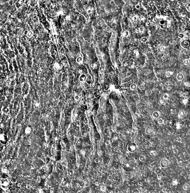
The concentric rings surrounding Valhalla are perhaps the most distinctive geological feature on Callisto. This NASA Voyager 1 close-up shows a segment of the ridged terrain.

For the 30th anniversary of one of the most iconic images taken by NASA's Voyager mission, a new version of the image known as "the Pale Blue Dot." Planet Earth is visible as a bright speck within the sunbeam just right of center and appears softly blue, as in the original version published in 1990 (see PIA00452). This updated version uses modern image-processing software and techniques to revisit the well-known Voyager view while attempting to respect the original data and intent of those who planned the images. In 1990, the Voyager project planned to shut off the Voyager 1 spacecraft's imaging cameras to conserve power and because the probe, along with its sibling Voyager 2, would not fly close enough to any other objects to take pictures. Before the shutdown, the mission commanded the probe to take a series of 60 images designed to produce what they termed the "Family Portrait of the Solar System." Executed on Valentine's Day 1990, this sequence returned images for making color views of six of the solar system's planets and also imaged the Sun in monochrome. The popular name of this view is traced to the title of the 1994 book by Voyager imaging scientist Carl Sagan, who originated the idea of using Voyager's cameras to image the distant Earth and played a critical role in enabling the family portrait images to be taken. The image of Earth was originally published by NASA in 1990. It is republished here to commemorate the 30th anniversary of the Family Portrait of the Solar System (see PIA00451) and the Pale Blue Dot image in particular. The planet occupies less than a single pixel in the image and thus is not fully resolved. (The actual width of the planet on the sky was less than one pixel in Voyager's camera.) By contrast, Jupiter and Saturn were large enough to fill a full pixel in their family portrait images. The direction of the Sun is toward the bottom of the view (where the image is brightest). Rays of sunlight scattered within the camera optics stretch across the scene. One of those light rays happens to have intersected dramatically with Earth. From Voyager 1's vantage point — a distance of approximately 3.8 billion miles (6 billion kilometers) — Earth was separated from the Sun by only a few degrees. The close proximity of the inner planets to the Sun was a key factor preventing these images from being taken earlier in the mission, as our star was still close and bright enough to damage the cameras with its blinding glare. The view is a color composite created by combining images taken using green, blue and violet spectral filters by the Voyager 1 Narrow-Angle Camera. They were taken at 4:48 GMT on Feb. 14, 1990, just 34 minutes before Voyager 1 powered off its cameras forever. Like the original version, this is technically a "false-color" view, as the color-filter images used were mapped to red, green and blue, respectively. The brightness of each color channel was balanced relative to the others, which is likely why the scene appears brighter but less grainy than the original. In addition, the color was balanced so that the main sunbeam (which overlays Earth) appears white, like the white light of the Sun. At its original resolution, the newly processed color image is 666 by 659 pixels in size; this is Figure A. The main image is an enlarged version. The image was processed by JPL engineer and image processing enthusiast Kevin M. Gill with input from two of the image's original planners, Candy Hansen and William Kosmann. https://photojournal.jpl.nasa.gov/catalog/PIA23645
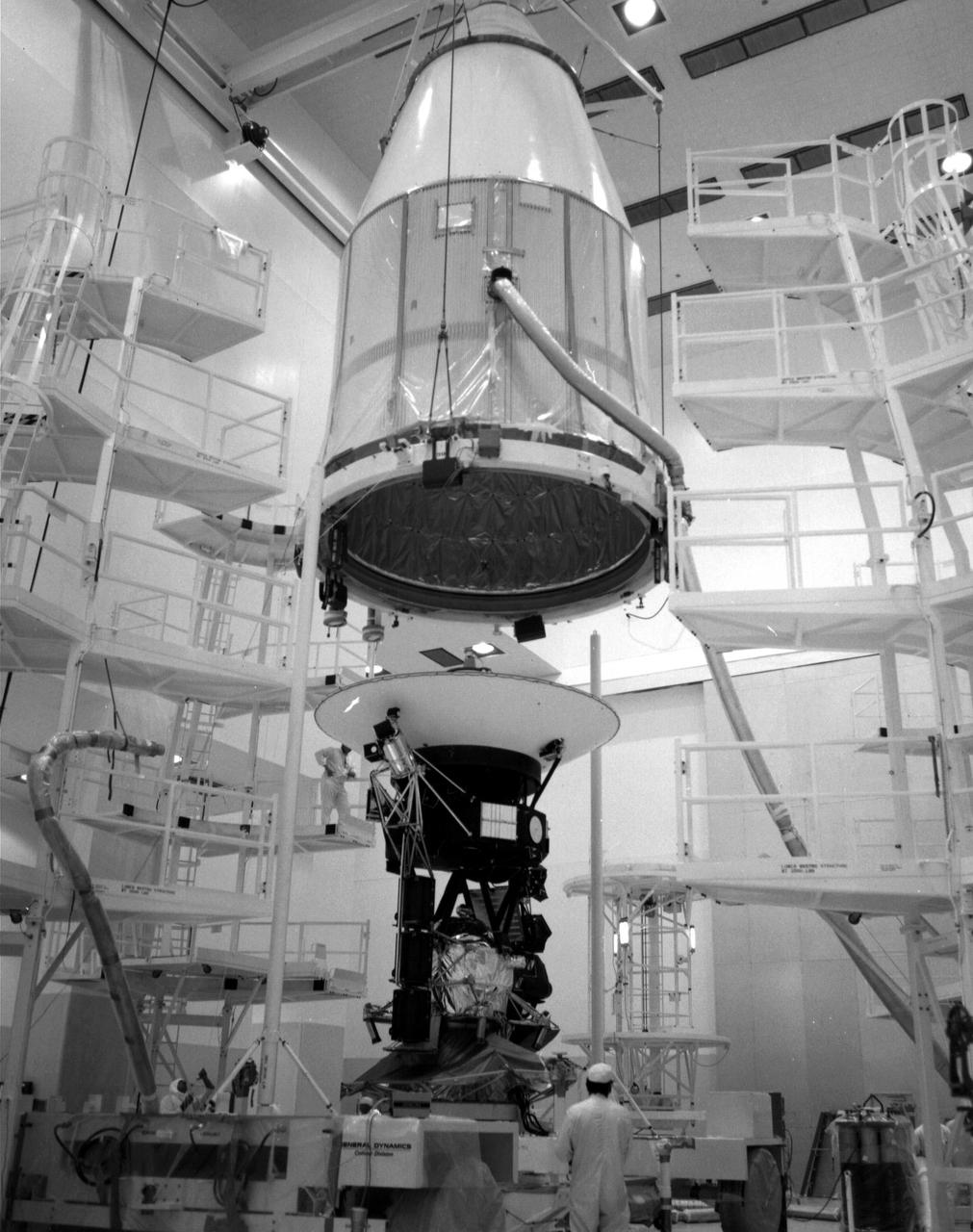
The Voyager 2 spacecraft, which was the first of the two Voyagers to launch, is seen at the Spacecraft Assembly and Encapsulation Facility-1 at NASA's Kennedy Space Center in Cape Canaveral, Florida. This archival photo is from August 1977. The spacecraft was put into this shroud on August 2, 1977, to protect it during flight through the atmosphere. https://photojournal.jpl.nasa.gov/catalog/PIA21743
This view of the region just to the Southeast of the Great Red Spot was taken by NASA Voyager 1 on March 4, 1979 at a distance of 1,100,000 miles 1,800,000 km. http://photojournal.jpl.nasa.gov/catalog/PIA00017
A high resolution image of the Jovian mid-latitudes taken by NASA Voyager 1 spacecraft on March 2, 1979, shows distinctly differing characteristics of the planet meteorology. http://photojournal.jpl.nasa.gov/catalog/PIA00360
This color view of the region just to the East of the Great Red Spot was taken by NASA Voyager 1 on March 4, 1979 at a distance of 1,000,000 miles 1,800,000 km. http://photojournal.jpl.nasa.gov/catalog/PIA00019
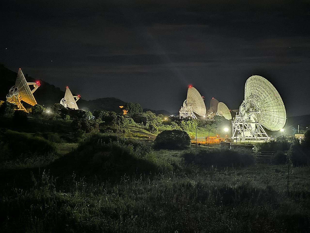
In a historic first, all six radio frequency antennas at the Madrid Deep Space Communication Complex – part of NASA's Deep Space Network (DSN) – carried out a test to receive data from the agency's Voyager 1 spacecraft at the same time on April 20, 2024. Known as "arraying," combining the receiving power of several antennas allows the DSN to collect the very faint signals from faraway spacecraft. A five-antenna array is currently needed to downlink science data from the spacecraft's Plasma Wave System (PWS) instrument. As Voyager gets further way, six antennas will be needed. The Voyager team is currently working to fix an issue on the spacecraft that has prevented it from sending back science data since November. Though the antennas located at the DSN's three complexes – Goldstone in California, Canberra in Australia, and Madrid – have been arrayed before, this is the first instance of six antennas being arrayed at once. Madrid is the only deep space communication complex currently with six operational antennas (the other two complexes have four apiece). Each complex consists of one 70-meter (230-foot) antenna and several 34-meter (112-foot) antennas. Voyager 1 is over 15 billion miles (24 billion kilometers) away, so its signal on Earth is far fainter than any other spacecraft with which the DSN communicates. It currently takes Voyager 1's signal over 22 ½ hours to travel from the spacecraft to Earth. To better receive Voyager 1's radio communications, a large antenna – or an array of multiple smaller antennas – can be used. Voyager 1 and its twin, Voyager 2, are the only spacecraft ever to fly in interstellar space (the space between stars). https://photojournal.jpl.nasa.gov/catalog/PIA26147
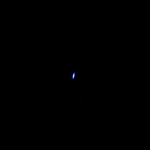
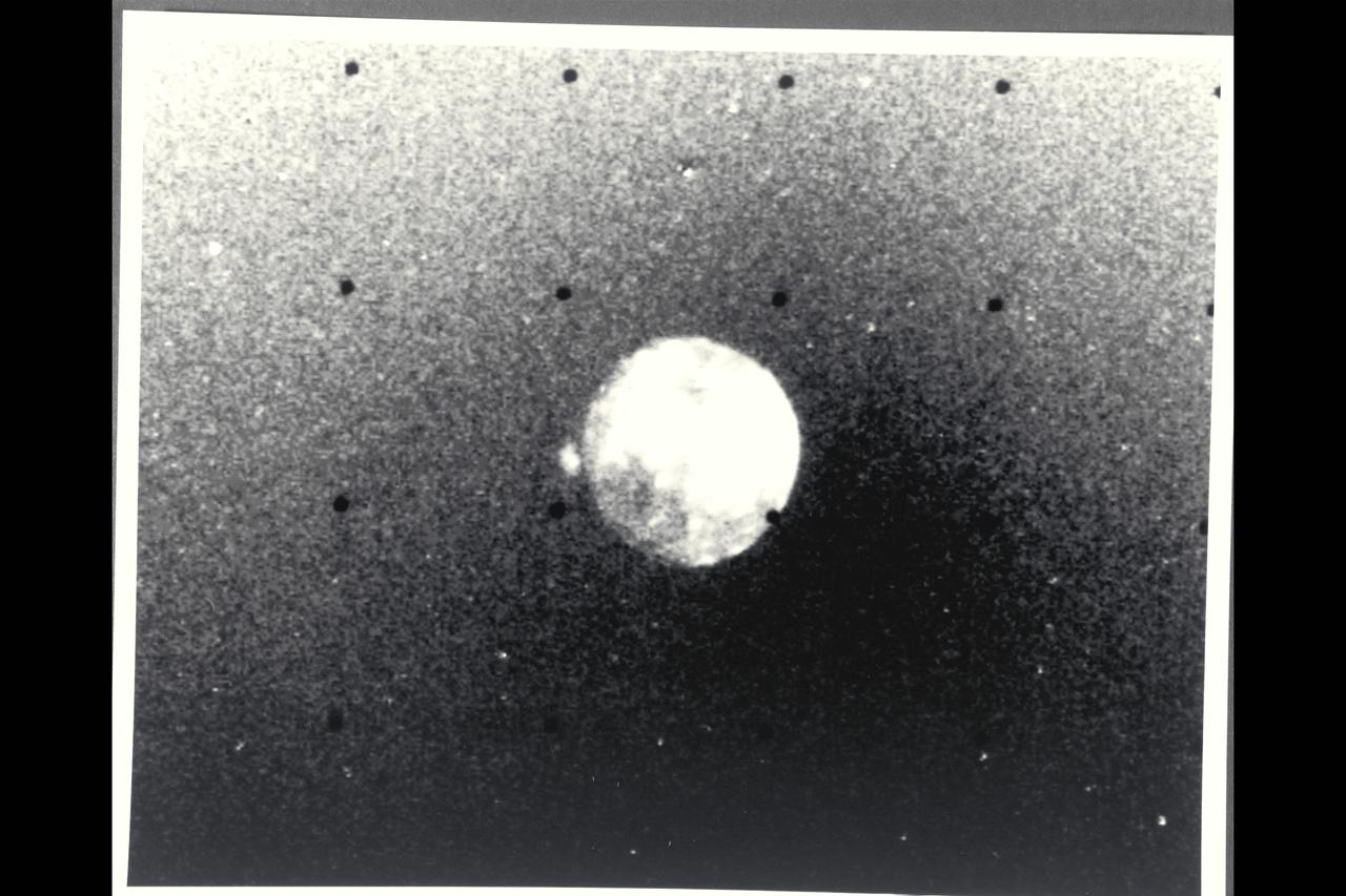
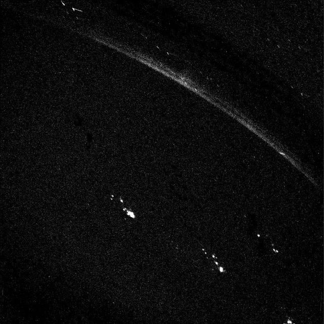
Radio telescopes cannot see Voyager 1 in visible light, but rather see the spacecraft signal in radio light. This image of Voyager 1 signal on Feb. 21, 2013. At the time, Voyager 1 was 11.5 billion miles 18.5 billion kilometers away.
Two brown ovals, at right, some 10,000 km 6,000 miles across, were found at approximately 40 latitude in Saturn northern hemisphere by NASA Voyager 1. The photo was taken on November 7, 1980.
This artist concept shows NASA Voyager 1 spacecraft in a new region at the edge of our solar system where there are fewer low energy particles that originate from inside our solar system.
This artist concept shows NASA Voyager 1 spacecraft in a new region at the edge of our solar system where the magnetic field lines generated by our sun are piling up and intensifying.
This artist concept shows NASA Voyager 1 spacecraft exploring a region called the depletion region or magnetic highway at the outer limits of our heliosphere, the bubble the sun blows around itself.
This false-color image of Saturn southern hemisphere taken by NASA Voyager 1 on Nov. 6, 1980, shows the unique red oval cloud feature located at 55 degrees south latitude.

This image of the Earth is one of 60 frames taken by NASA Voyager 1 spacecraft on Feb. 14, 1990 from a distance of approximately 4 billion miles and about 32 degrees above the ecliptic plane.
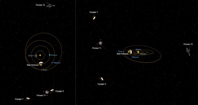
This graphic shows the relative positions of NASA most distant spacecraft in early 2011, looking at the solar system from the side. Voyager 1 is the most distant spacecraft, 10.9 billion miles away from the sun at a northward angle.
This picture of Europa, the smallest Galilean satellite, was taken in the afternoon of March 4, 1979, from a distance of about 2 million kilometers 1.2 million miles by NASA Voyager 1. http://photojournal.jpl.nasa.gov/catalog/PIA00016
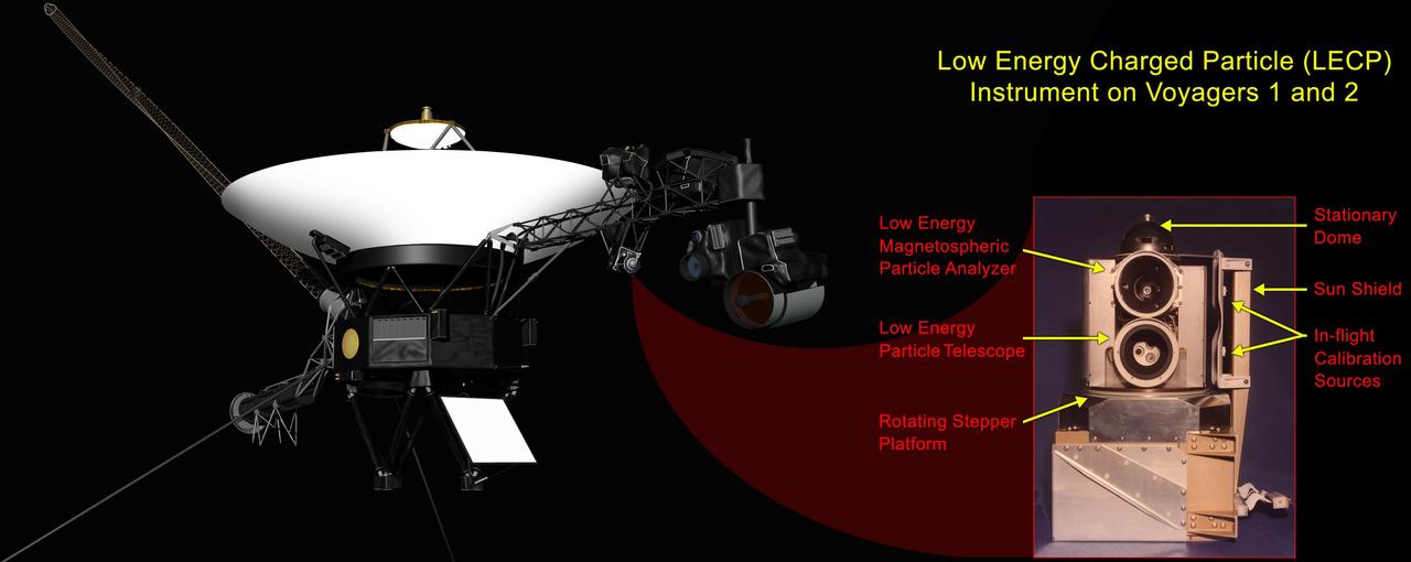
This graphic shows the NASA Voyager 1 spacecraft and the location of its low-energy charged particle instrument. A labeled close-up of the low-energy charged particle instrument appears as the inset image.
This is a frame from an animation of a rotating globe of Jupiter moon Ganymede, with a geologic map superimposed over a global color mosaic, incorporating the best available imagery from NASA Voyager 1 and 2 spacecraft, and Galileo spacecraft.
This NASA Voyager 1 image was taken of Jupiter darkside on March 5, 1979 when the spacecraft was in Jupiter shadow, about 6 hours after closest approach to the planet at a distance of 320,000 miles. http://photojournal.jpl.nasa.gov/catalog/PIA00204

Saturn and two of its moons, Tethys above and Dione, were photographed by Voyager 1 on November 3, 1980, from 13 million kilometers 8 million miles.
This photo, taken on Jan. 9, 1979 by NASA Voyager 1, is dominated by the Great Red Spot. Swirling, storm-like features possibly associated with wind shear can be seen both to the left and above the Red Spot.
Voyager 1 has entered interstellar space. NASA spacecraft, which rose from Earth on a September morning 36 years ago, has traveled farther than anyone, or anything, in history.
This artist concept shows how NASA Voyager 1 spacecraft is bathed in solar wind from the southern hemisphere flowing northward. This phenomenon creates a layer of giant bubble of solar ions just inside the outer boundary of the heliosphere.
This artist concept shows the different expected directions of the magnetic fields in interstellar space black lines and the magnetic field emanating from our sun white lines as NASA Voyager 1 spacecraft travels northward out of the heliosphere.
This mosaic of Jupiter Great Red Spot taken by NASA Voyager 1, shows the area around the northern boundary where a white cloud is seen which extends to east of the region. http://photojournal.jpl.nasa.gov/catalog/PIA00065
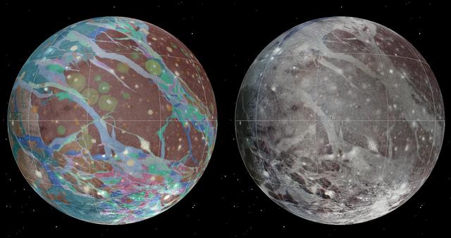
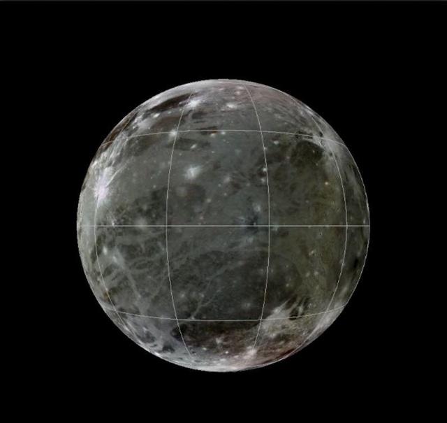
To present the best information in a single view of Jupiter moon Ganymede, a global image mosaic was assembled, incorporating the best available imagery from NASA Voyager 1 and 2 spacecraft and NASA Galileo spacecraft.
This artist concept shows NASA Voyager 1 spacecraft in a new region at the edge of our solar system where the magnetic field lines generated by our sun are piling up and intensifying.
This artist concept shows NASA Voyager 1 spacecraft in a new region at the edge of our solar system where the amount of high-energy particles diffusing into our solar system from outside has increased.
A vortex, or large atmospheric storm, is visible in this color composite of NASA Voyager 2 Saturn images obtained Aug. 25, 1979 from a range of 1 million kilometers 620,000 miles.

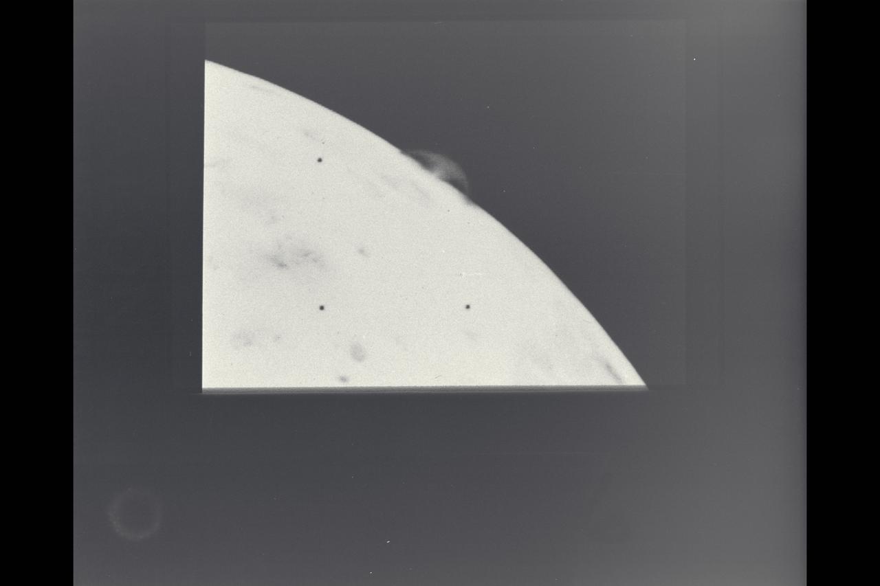
This picture of a crescent-shaped Earth and Moon -- the first of its kind ever taken by a spacecraft -- was recorded Sept. 18, 1977, by NASA Voyager 1 when it was 7.25 million miles 11.66 million kilometers from Earth.
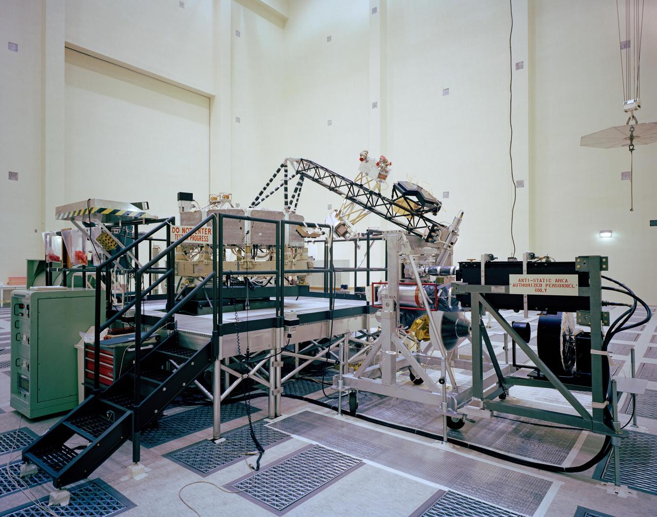
This archival photo shows the system test configuration for Voyager on October 1, 1976. The spacecraft's 10-sided bus is visible behind the catwalk railing in the foreground. The boom that holds several of the spacecraft's science instruments arches above the railing. https://photojournal.jpl.nasa.gov/catalog/PIA21729

In a conference room at NASA's Jet Propulsion Laboratory in Southern California, members of the Voyager mission team gathered April 20, 2024, to find out if an issue on Voyager 1 had been partially resolved. Just after 6:40 a.m., a cheer went up around the room as the group heard back from the spacecraft: It was returning engineering data for the first time since November 2023. Nearly two full days earlier, the team had sent a series of commands to move a section of software code used by the flight data subsystem (FDS) computer to a new location. The physical location where the code was previously stored has been damaged, causing the mission to go five months without receiving science or engineering data. But the commands were a success, and the team received data about the health and status of the spacecraft, prompting celebration. The commands were sent on April 18, 2024. Due to Voyager 1's distance from Earth – over 15 billion miles or 24 billion kilometers – a radio signal takes about 22 ½ hours to travel to the spacecraft, and 22 ½ hours to return to Earth. https://photojournal.jpl.nasa.gov/catalog/PIA26275
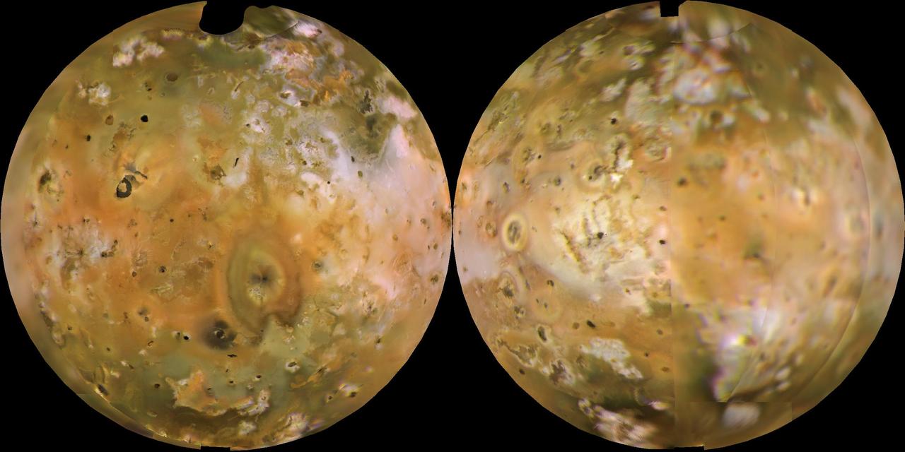
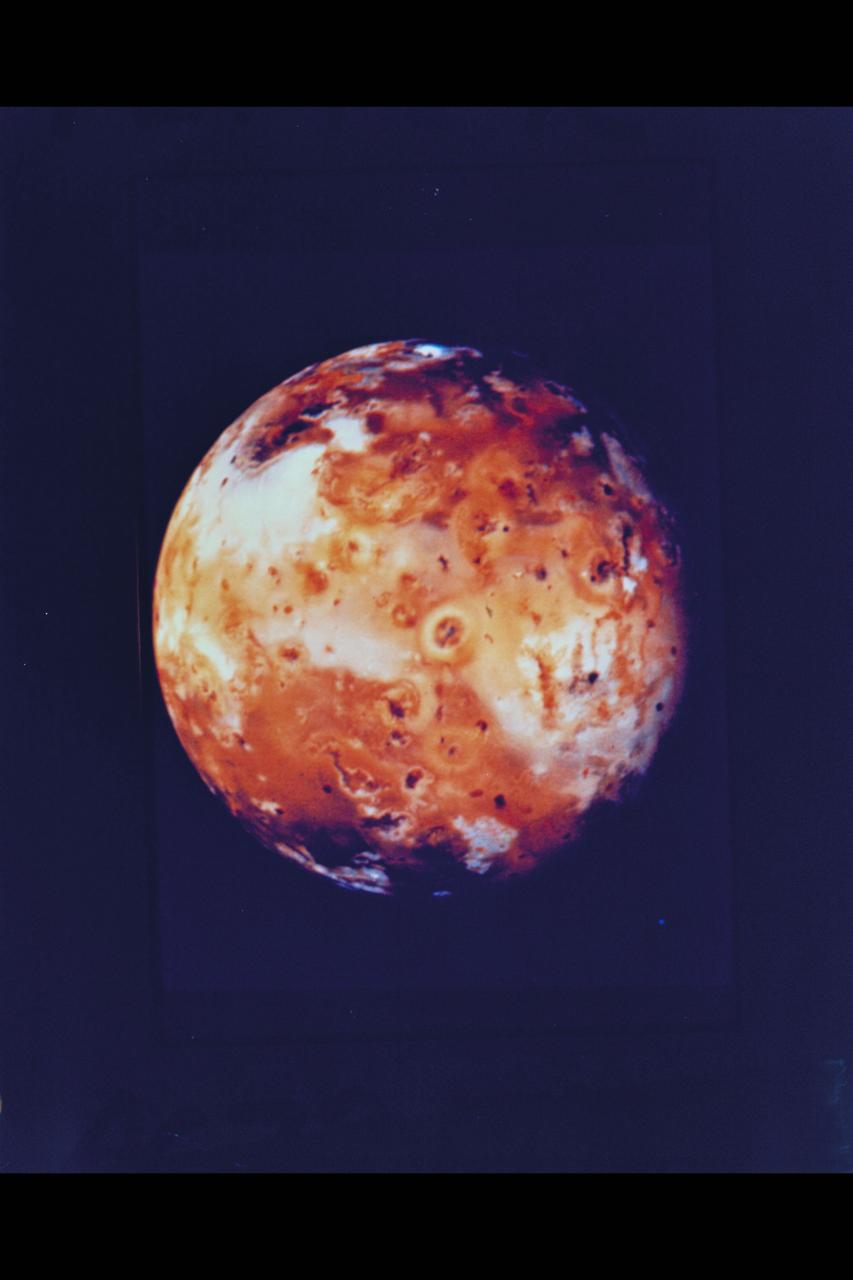
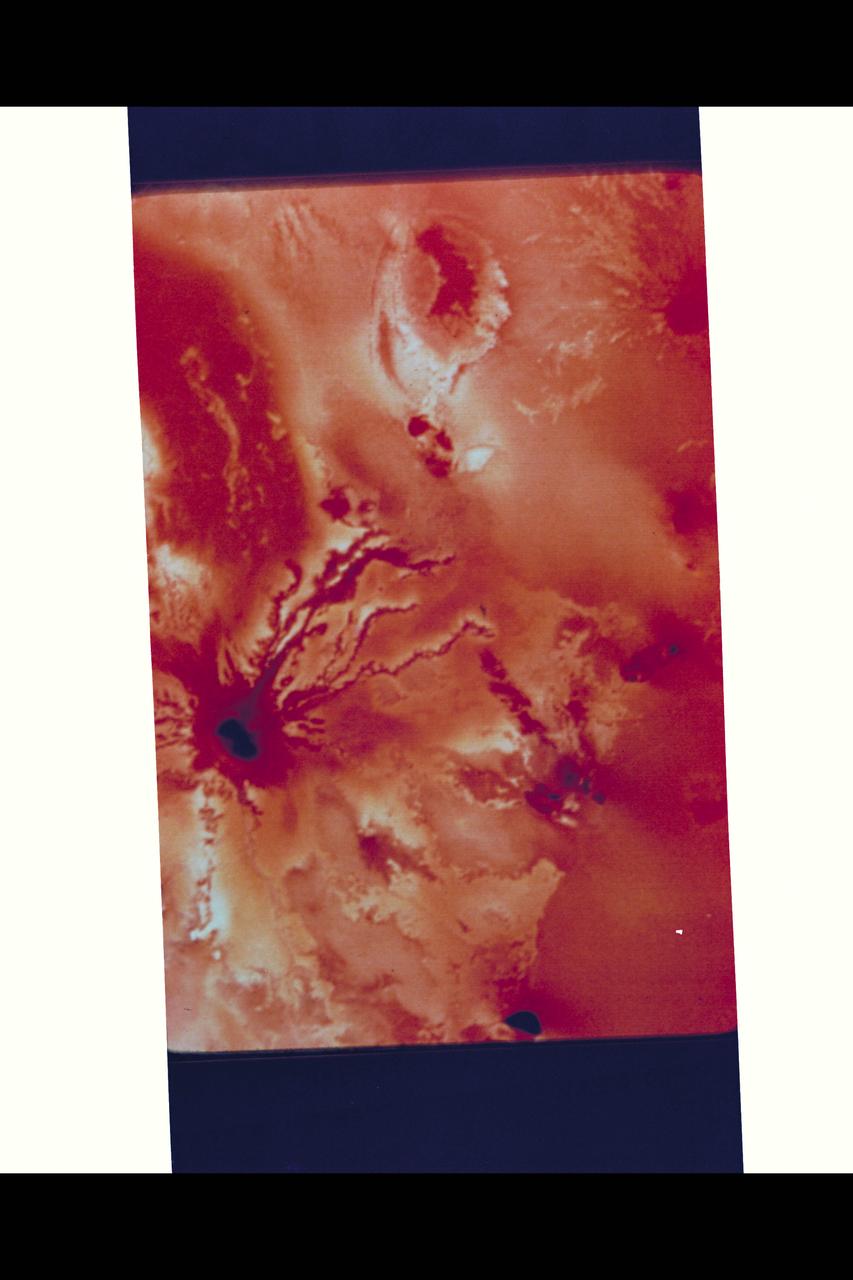
NASA's Voyager 1 computer color mosaics, shown in approximately natural color and in Lambertian equal-area projections, show the Eastern (left) and Western (right) hemispheres of Io. This innermost of Jupiter's 4 major satellites is the most volcanically active object in the solar system. Io is 2263 mi (3640 km) in diameter, making it a little bigger than Earth's moon. Almost all the features visible here have volcanic origins, including several calderas and eruption plumes that were active at the time of the Voyager 1 encounter. http://photojournal.jpl.nasa.gov/catalog/PIA00318
Voyager 2 took this picture of Io on the evening of July 9, 1979, from a range of 1.2 million kilometers. On the limb of Io are two blue volcanic eruption plumes about 100 kilometers high. These two plumes were first seen by Voyager 1 in March, 1979, and are designated Plume 5 (upper) and Plume 6 (lower). They have apparently been erupting for a period of at least 4 months and probably longer. A total of six plumes have been seen by Voyager 2, all of which were first seen by Voyager 1. The largest plume viewed by Voyager 1 (Plume 1) is no longer erupting. Plume 4 was not viewed on the edge of the moon's disc by Voyager 2 and therefore it is not known whether or not it is still erupting. This picture is one of a series taken to monitor the eruptions over a 6 hour period. http://photojournal.jpl.nasa.gov/catalog/PIA01362

Alan Cummings, Voyager researcher, Caltech, speaks at an event to celebrate the 40th Anniversary of the launch of the Voyager 1 and 2 missions, Tuesday, September 5, 2017 at Smithsonian's National Air and Space Museum in Washington. Voyager 1 was launched September 5, 1977, with a mission to study Jupiter and Saturn, but now the twin Voyager spacecrafts are on a journey into interstellar space to search for the heliopause, a region never reached by any other spacecraft. Photo Credit: (NASA/Aubrey Gemignani)

Ed Stone, Voyager project scientist, speaks at an event to celebrate the 40th Anniversary of the launch of the Voyager 1 and 2 missions, Tuesday, September 5, 2017 at Smithsonian's National Air and Space Museum in Washington. Voyager 1 was launched September 5, 1977, with a mission to study Jupiter and Saturn, but now the twin Voyager spacecrafts are on a journey into interstellar space to search for the heliopause, a region never reached by any other spacecraft. Photo Credit: (NASA/Aubrey Gemignani)