In Her Wake

In the Moon Wake
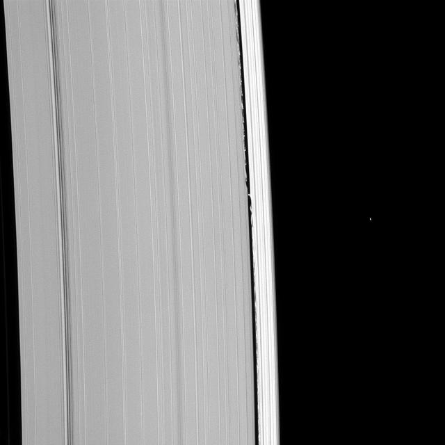
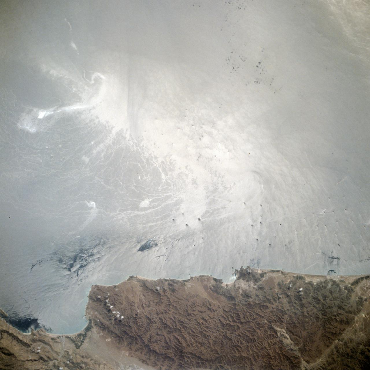
Waking the A Ring
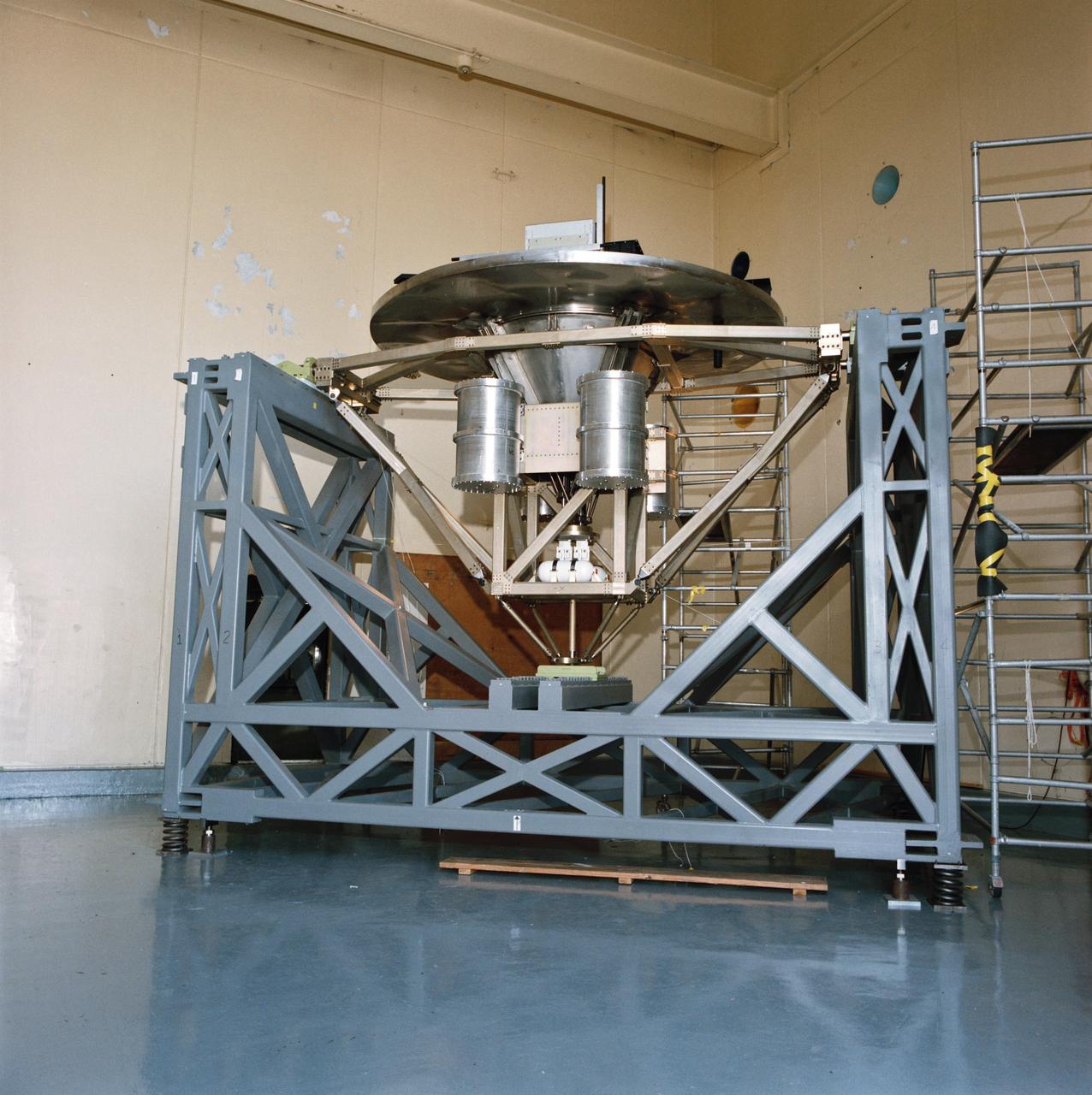
Pictured on a test stand at JSC is the Wake Shield Facility scheduled to fly on STS-60.
Wake Vortex behind a helicopter (Illustration)
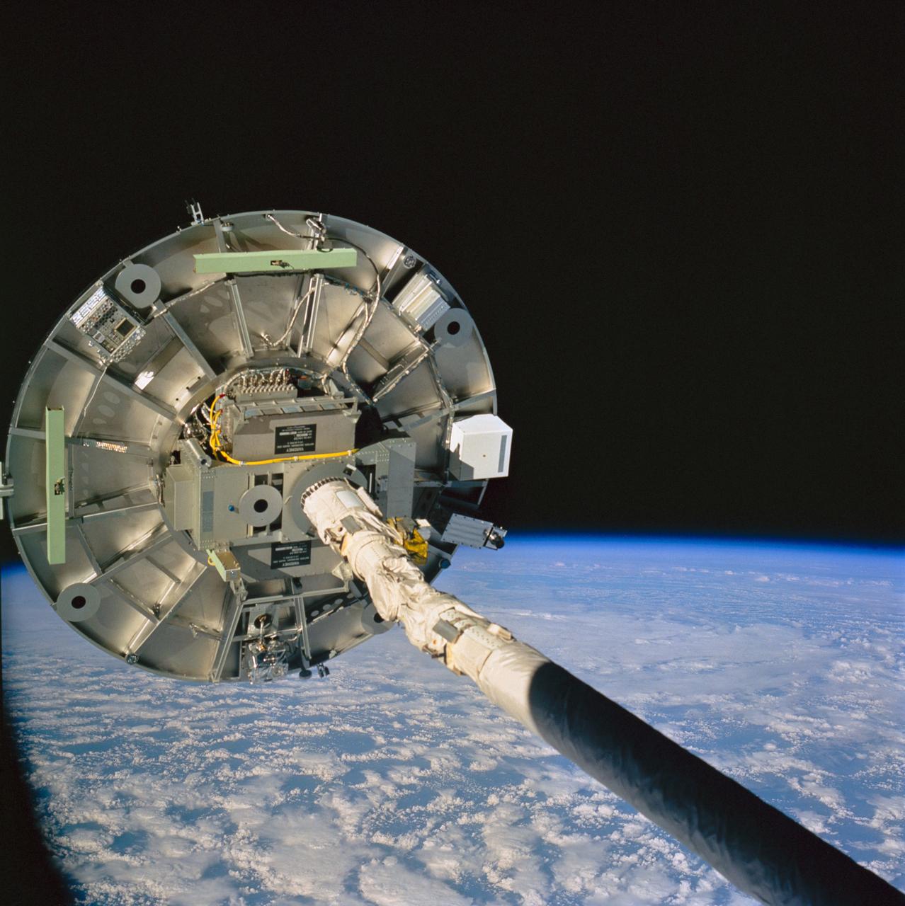
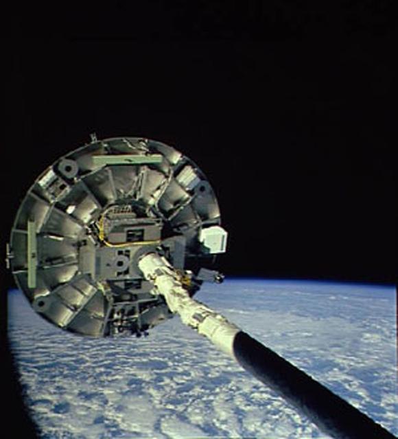
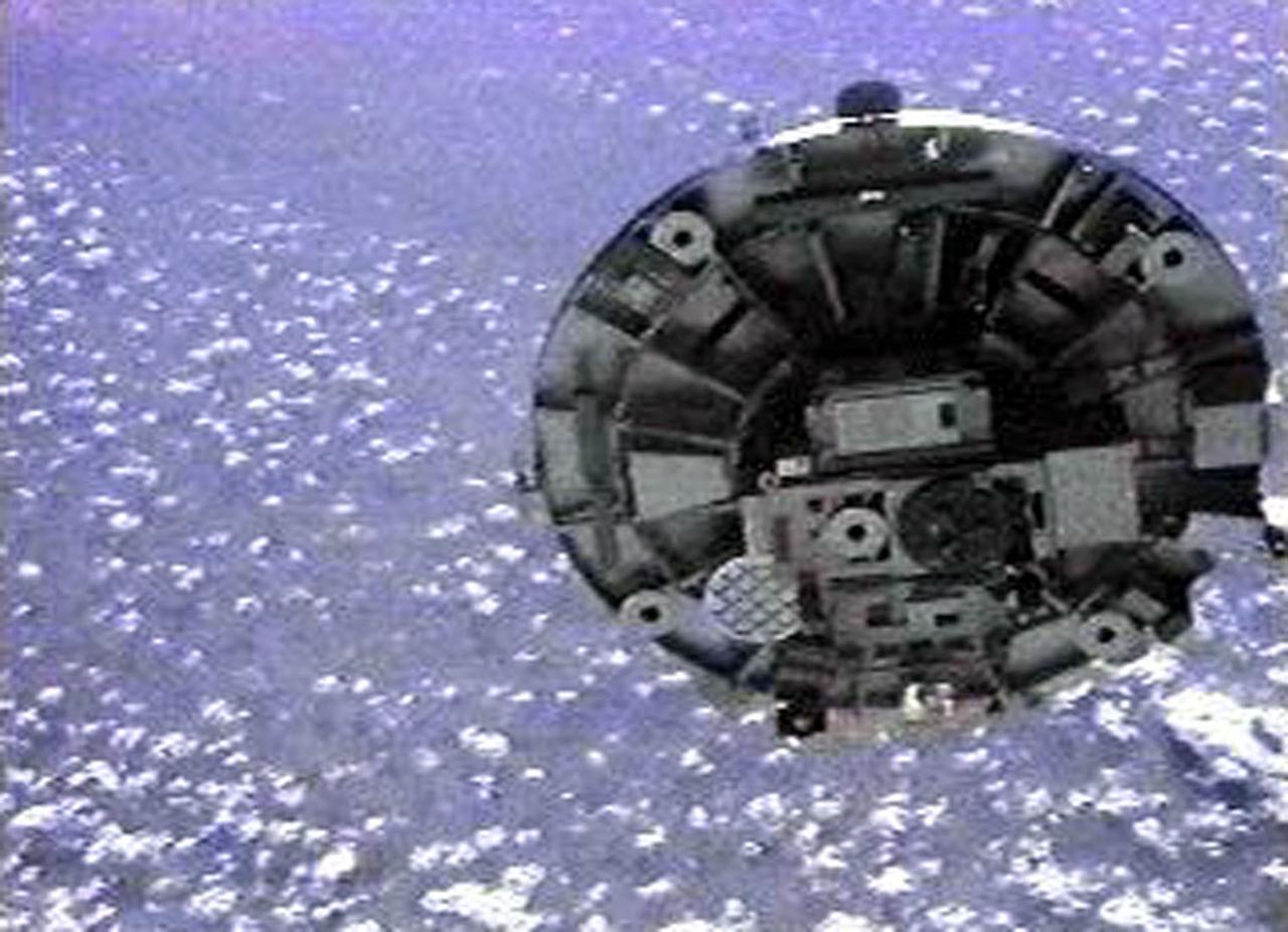
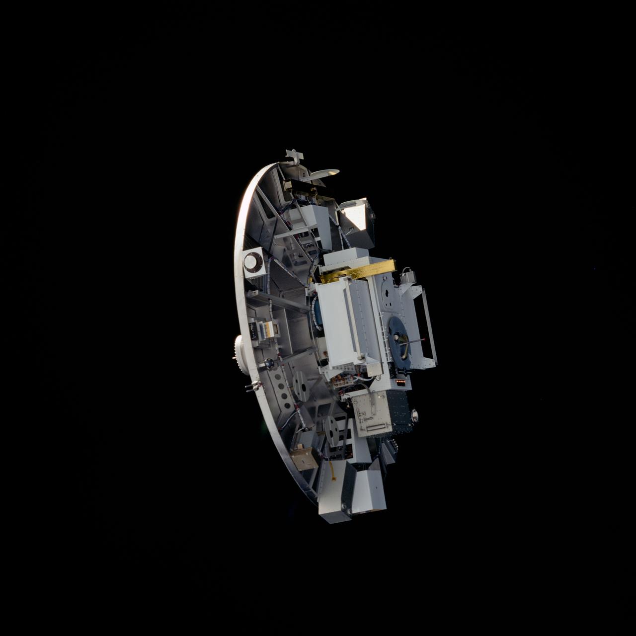
STS060-76-095 (3-11 Feb 1994) --- The ram side of the Wake Shield Facility (WSF) in the grasp of the Space Shuttle Discovery's Remote Manipulator System (RMS) arm is featured in this 70mm frame. Clouds over the Atlantic Ocean and the blackness of space share the backdrop for the picture. Five NASA astronauts and a Russian cosmonaut spent eight days in Earth orbit in support of the STS-60 mission.
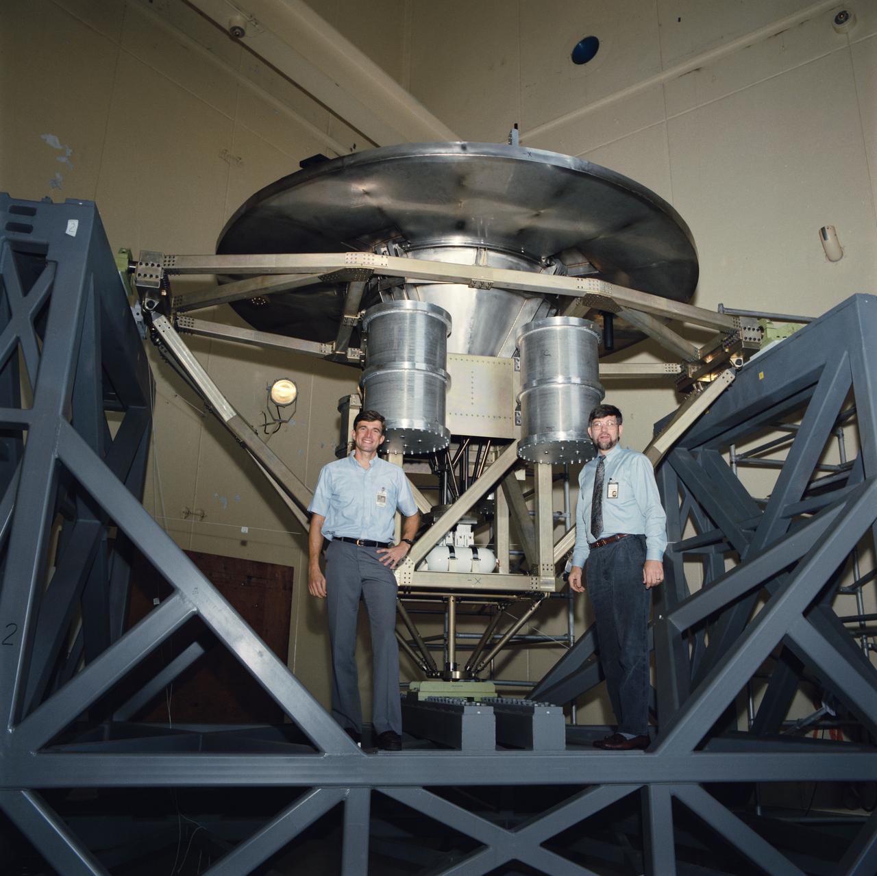
The Wake Shield Facility is displayed on a test stand at JSC. Astronaut Ronald M. Sega, mission specialist for STS-60, is seen with the facility during a break in testing in the acoustic and vibration facility at JSC.

Wake Vortex behind a helicopter describing Longitudinal Cores (Secondary Vortes Generation) from Aviatsiya / Kosmonautika, 1973 (Illustration)

On June 15, NASA's Swift caught the onset of a rare X-ray outburst from a stellar-mass black hole in the binary system V404 Cygni. Astronomers around the world are watching the event. In this system, a stream of gas from a star much like the sun flows toward a 10 solar mass black hole. Instead of spiraling toward the black hole, the gas accumulates in an accretion disk around it. Every couple of decades, the disk switches into a state that sends the gas rushing inward, starting a new outburst. Read more: <a href="http://www.nasa.gov/feature/goddard/nasa-missions-monitor-a-waking-black-hole" rel="nofollow">www.nasa.gov/feature/goddard/nasa-missions-monitor-a-waki...</a> Credits: NASA's Goddard Space Flight Center Download this video in HD formats from NASA Goddard's Scientific Visualization Studio <a href="http://svs.gsfc.nasa.gov/cgi-bin/details.cgi?aid=11110" rel="nofollow">svs.gsfc.nasa.gov/cgi-bin/details.cgi?aid=11110</a>

STS054-72-056 (13-19 Jan 1993) --- A ship wake in the Bay of Bengal is noticeable in this 70mm frame. The sun glint pattern on the ocean reveals many patterns of sea surface roughness related to currents, waves, wind roughening, and biology that and are not apparent when the ocean is viewed away from the Sun's reflection. In this view of the Bay of Bengal, southeast of Madras, India, sun glint highlights convergence zones between ocean currents (bright, linear features), a eddy, and the wake of a ship. In several locations where the ship has passed areas of current shear, the ship wake is distorted, indicating the relative current direction.
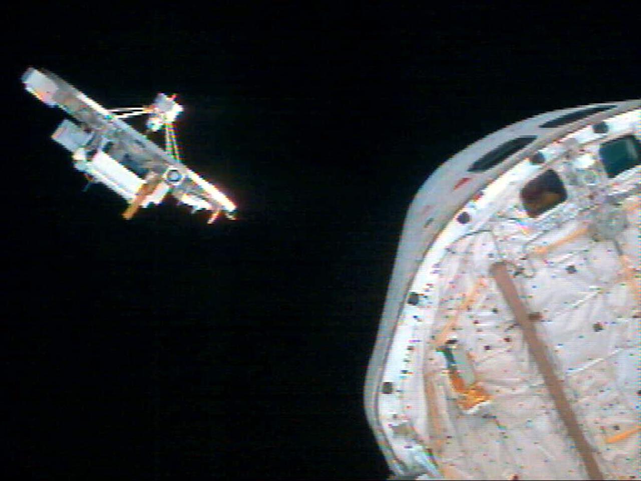
STS060-74-054 (3-11 Feb 1994) --- The Wake Shield Facility (WSF) is held in the grasp of Discovery's Remote Manipulator System (RMS). The 70mm image, backdropped against the blackness of space, also shows the SPACEHAB module in the forward cargo area.
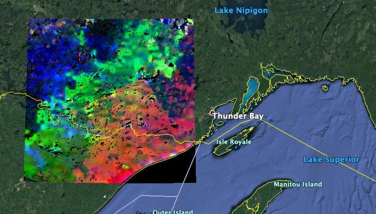
The image shows plants "waking up" west of Lake Superior near the U.S.-Canada border. Plants in the red and pink areas began to wake up around 7 a.m. local time. Those in green areas became active closer to 8 am., while those in blue areas did so closer to 9 a.m. The mission team collected and combined all of ECOSTRESS's morning data for the summer season. In doing so, they observed that the earliest risers were near the lake, with plant activity spreading gradually northwestward as the morning progressed. https://photojournal.jpl.nasa.gov/catalog/PIA23430

Long ago, a large lava flow passed through the Athabasca Valles region of Mars. We can tell which direction it was flowing by examining the surface of the flow and the remaining "lava wakes." Although you can't sail a boat on a sea of lava, hills and craters that stick up higher than the lava flow act like barriers. When a boat is driven through the water, there is a bow wave at the front of the boat, and a wake that trails off behind that indicates which way the boat is moving. In a lava flow, when a hill sticks up, the lava piles up on the upstream side (just like a bow wave) and can leave a wake on the downstream side, so we can tell which way the lava was moving against the stationary hill. This image has a large crater and some nearby smaller hills. The large crater has a pile up of lava on one side, but is so big that it doesn't really have a clear wake. However, there are smaller hills with lava pileup that have beautiful linear features trailing off in the same direction. These lava wakes show us which direction the lava was moving against these hills. https://photojournal.jpl.nasa.gov/catalog/PIA25558
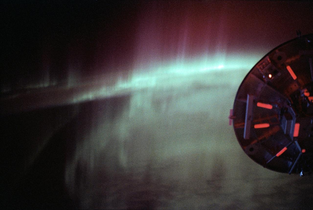
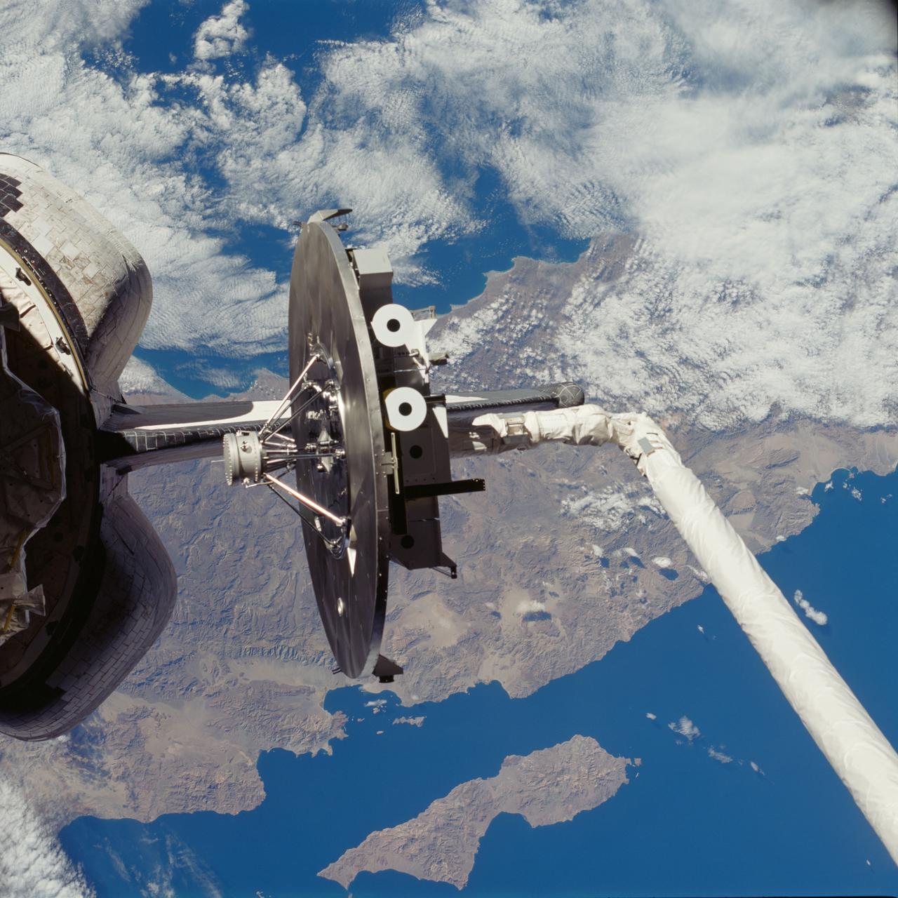
STS060-09-024 (3-11 Feb 1994) --- As the Space Shuttle Discovery flew over a point between New Zealand and Australia, one of the STS-60 crew members used a 35mm camera to capture this image featuring three-fourths of the disc of the Wake Shield Facility (WSF) back dropped against the Southern Lights. The WSF was in the grasp of the Remote Manipulator System (RMS) end effector (out of frame at right).
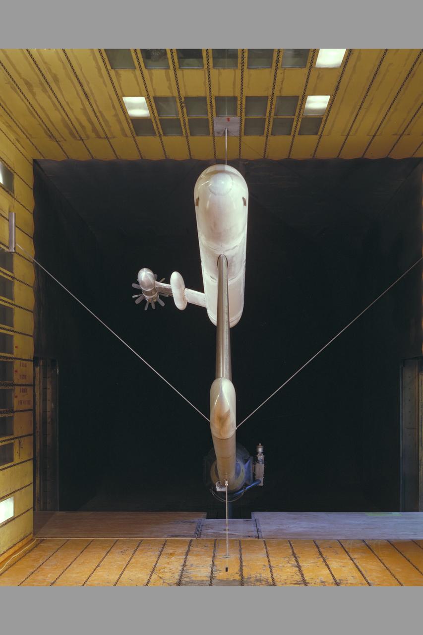
The Wake Shield Facility (WSF) is a free-flying research and development facility that is designed to use the pure vacuum of space to conduct scientific research in the development of new materials. The thin film materials technology developed by the WSF could some day lead to applications such as faster electronics components for computers.
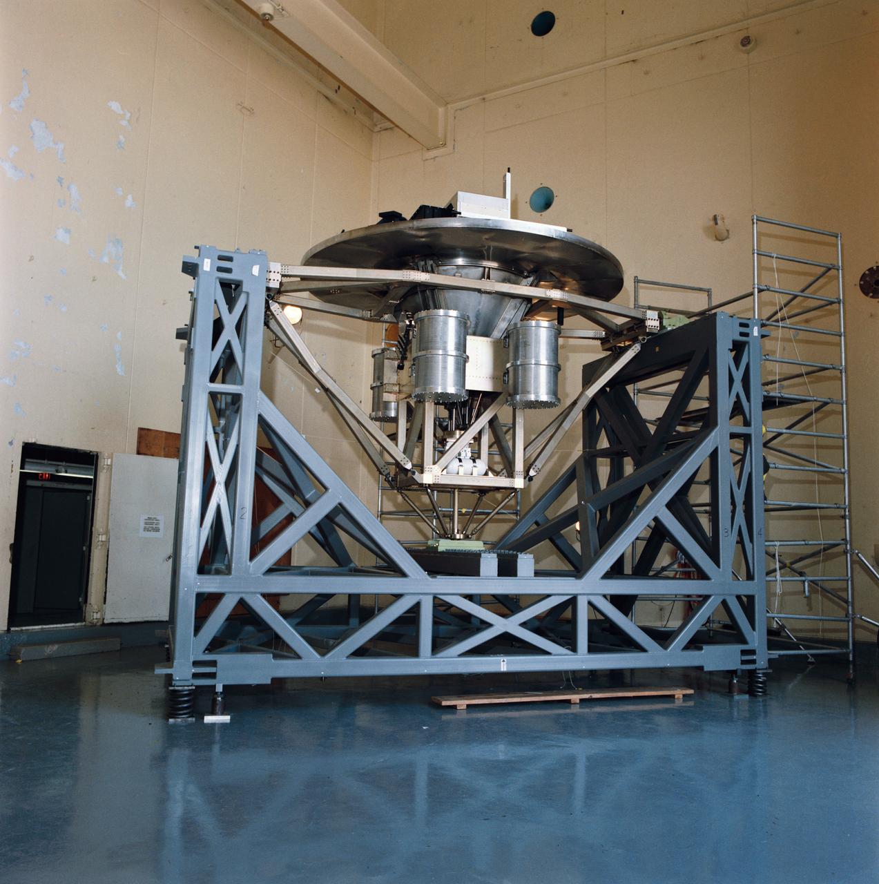
Pictured on a test stand at JSC is the Wake Shield Facility scheduled to fly on STS-60.
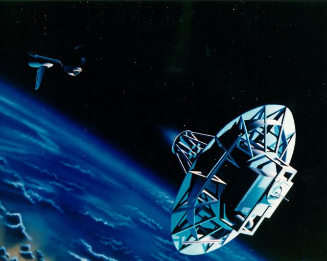
The Wake Shield Facility is a free-flying research and development facility that is designed to use the pure vacuum of space to conduct scientific research in the development of new materials. The thin film materials technology developed by the WSF could some day lead to applications such as faster electronics components for computers. The WSF Free-Flyer is a 12-foot-diameter stainless steel disk that, while traveling in orbit at approximately 18,000 mph, leaves in its wake a vacuum 1,000 to 10,000 times better than the best vacuums currently achieved on Earth. While it is carried into orbit by the Space Shuttle, the WSF is a fully equipped spacecraft in its own right, with cold gas propulsion for separation from the orbiter and a momentum bias attitude control system. All WSF functions are undertaken by a spacecraft computer with the WSF remotely controlled from the ground. The ultra vacuum, nearly empty of all molecules, is then used to conduct a series of thin film growths by a process called epitaxy which produces exceptionally pure and atomically ordered thin films of semiconductor compounds such as gallium arsenide. Using this process, the WSF offers the potential of producing thin film materials, and the devices they will make possible.
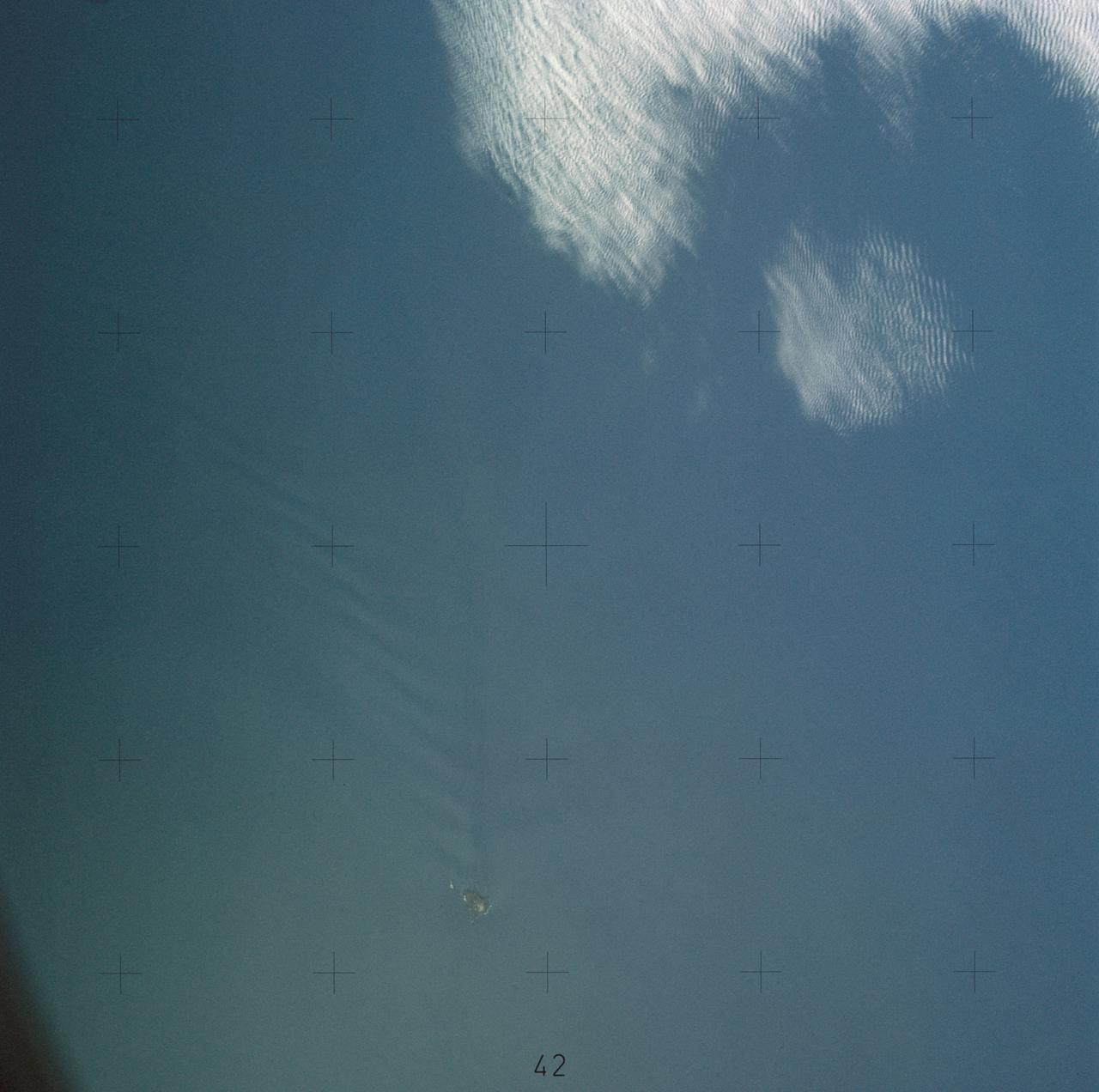
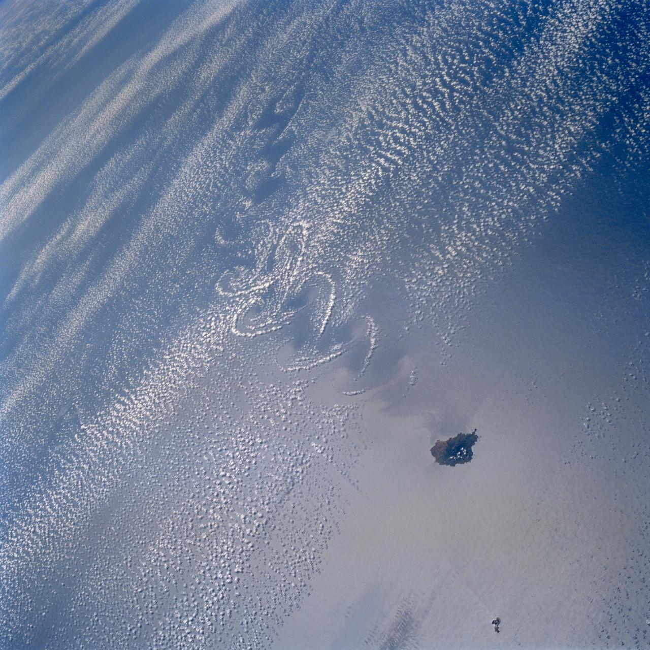
SL4-137-3655 (16 Dec. 1973) --- An island wake produced by the Antipodes Islands in the ocean current south of New Zealand is seen in this photograph taken from the Skylab space station in Earth orbit. A Skylab 4 crewmen took the picture with a hand-held 70mm Hasselblad camera. The bow wave pattern is quite evident and can be used to determine the current speed from the angle of the bow wave if the propagation speed of the surface wave is known. Also, evident is the darker band extending downstream from the island tens of miles. This is the actual wake of the island. The existence of water color differences from within to outside a turbulent island wake may indicate a temperature difference, with cooler water being stirred to the surface in the wake. This temperature difference could be used to drive a thermo-electric type generator to reduce small islands' dependence on imported oil for power generation. Photo credit: NASA
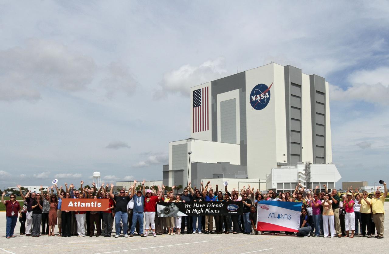
CAPE CANAVERAL, Fla. -- Employees at NASA's Kennedy Space Center in Florida gathered in the Press Site parking lot, with the towering Vehicle Assembly Building in the background on June 27, 2011, to record a wake-up call to Atlantis' STS-135 crew members on NASA’s last voyage aboard a space shuttle. Use of music to awaken astronauts on space missions dates back at least to the Apollo Program, when astronauts returning from the moon were serenaded by their colleagues in mission control with lyrics from popular songs that seemed appropriate for the occasion. Usually picked by flight controllers or by crew members’ friends and family members, most wake-up calls are musical, but sometimes include dialog from movies or TV shows. The recording is usually followed by a call from the CAPCOM in Mission Control, wishing the crew a good morning but because this is the final mission for the Space Shuttle Program many of the NASA centers were given the opportunity to choose a phrase that most represents their best wishes and gratitude for a successful mission. The common element of all these selections is that they promote a sense of camaraderie and esprit de corps among the astronauts and ground support personnel. Photo credit: Cory Huston
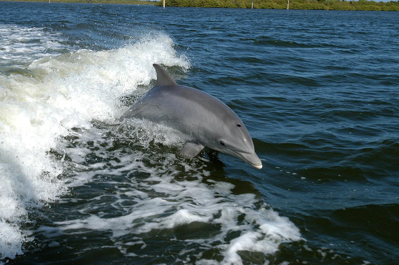
KENNEDY SPACE CENTER, FLA. - A dolphin surfs the wake of a research boat on the Banana River.
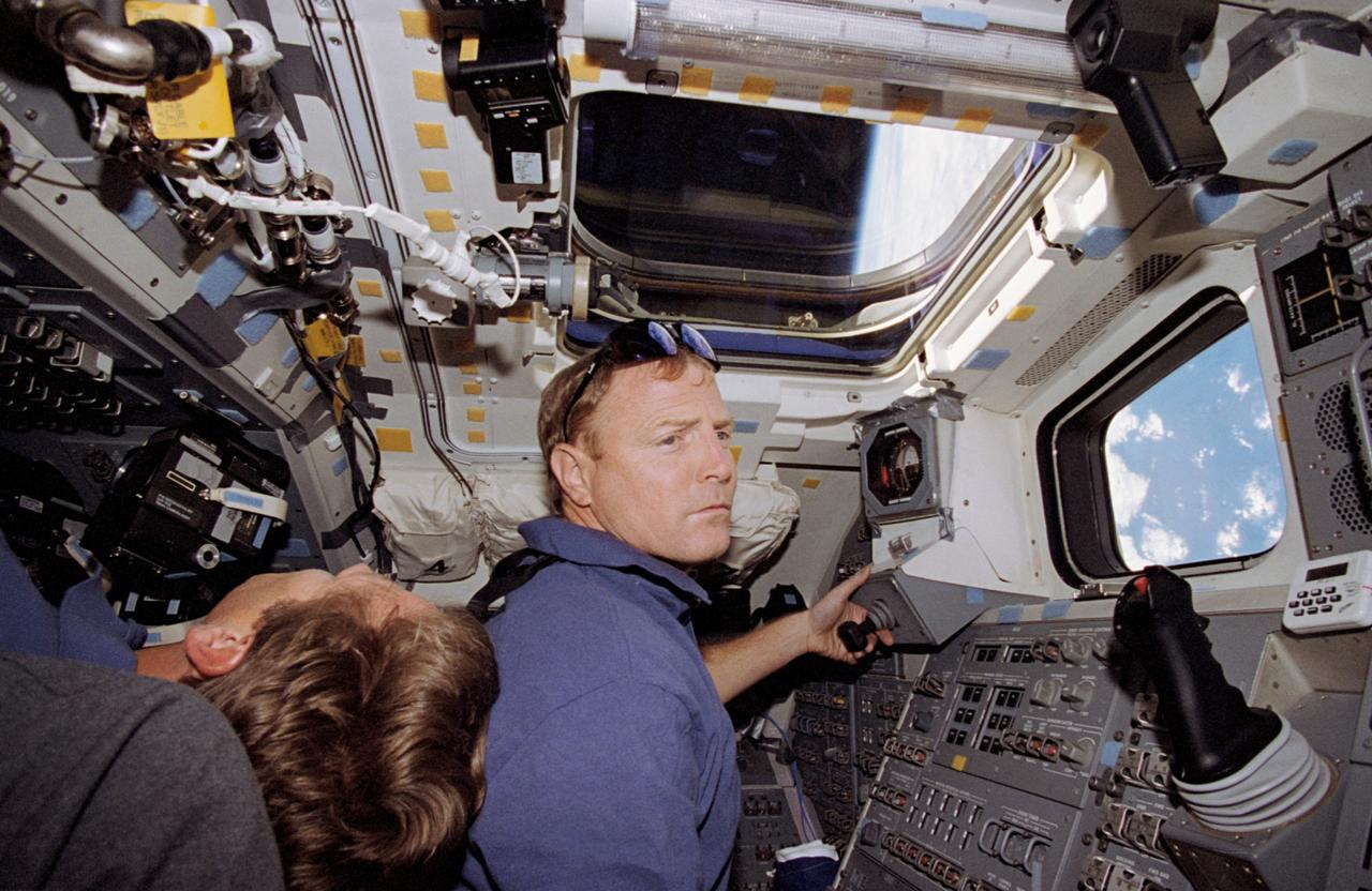
STS060-57-033 (3-11 Feb 1994) --- Astronaut Ronald M. Sega suspends himself in the weightlessness aboard the Space Shuttle Discovery's crew cabin, as the Remote Manipulator System (RMS) arm holds the Wake Shield Facility (WSF) aloft. The mission specialist is co-principal investigator on the WSF project.
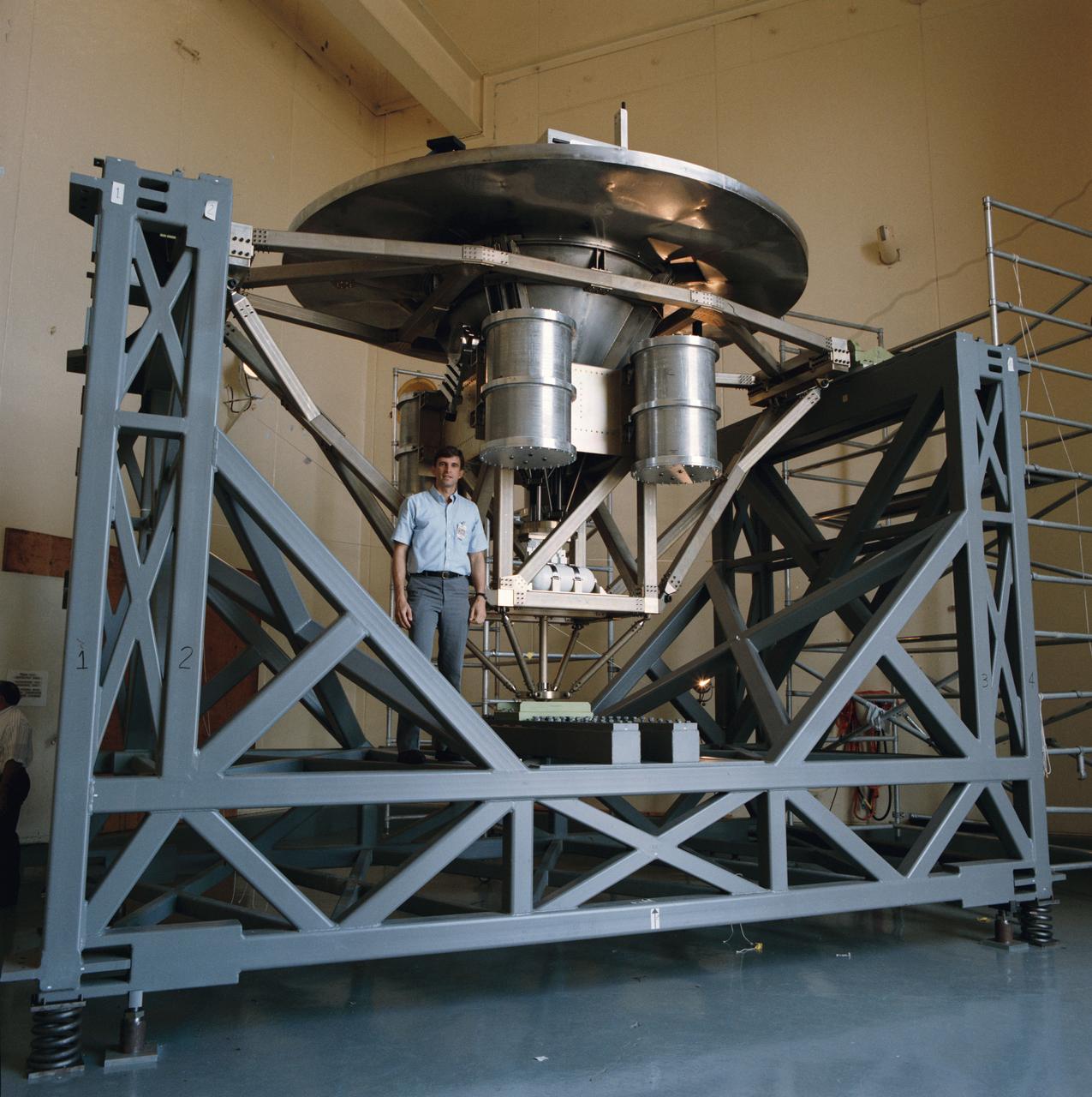
Astronaut Ronald M. Sega stands beside the University of Houston's Wake Shield Facility before it undergoes a Modal Survey Test in the Vibration and Acoustic Test Facility Building 49, prior to being flown on space shuttle mission STS-60.
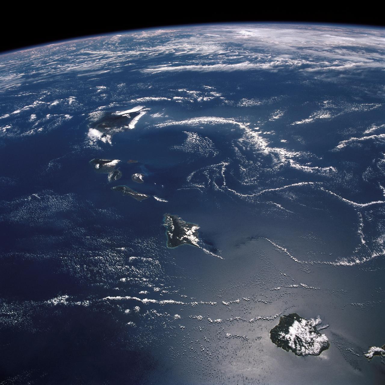
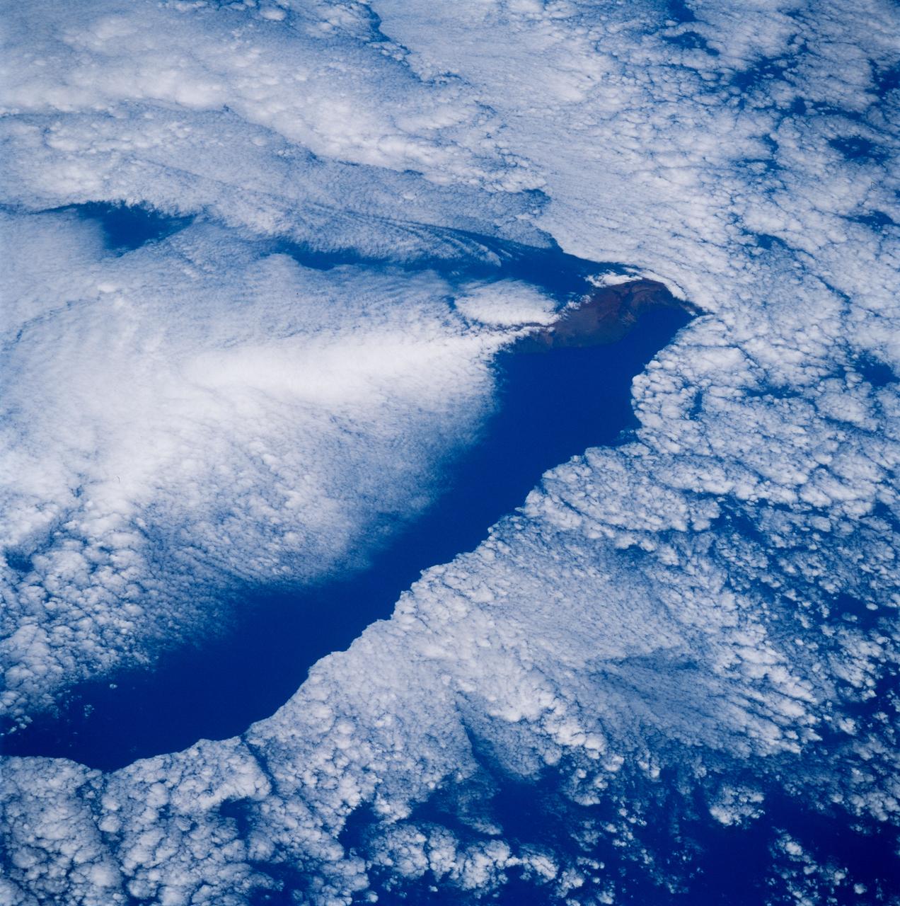
STS026-43-082 (29 Sept. - 3 Oct. 1988) --- This 70mm northerly oriented frame over the Pacific Ocean features the Hawaiian Islands chain. The islands perturb the prevailing northeasterly winds producing extensive cloud wakes in the lee of the islands. Photo experts feel that atmospheric haze in the Hawaii wake is probably a result of the continuing eruptions of Kilauea volcano on the southeast coast. From the lower right corner in a diagonal directed upward to the north are the islands of Nihau, Kauai, Oahu, Molokai, Lanai, Maui, Kahoolawe, and Hawaii. This photo was shown during the post-flight press conference on October 11, 1988 by the STS-26 astronauts, who at one time during the flight wore Hawaiian attire to pay tribute to the working staff of the Hawaii tracking station.
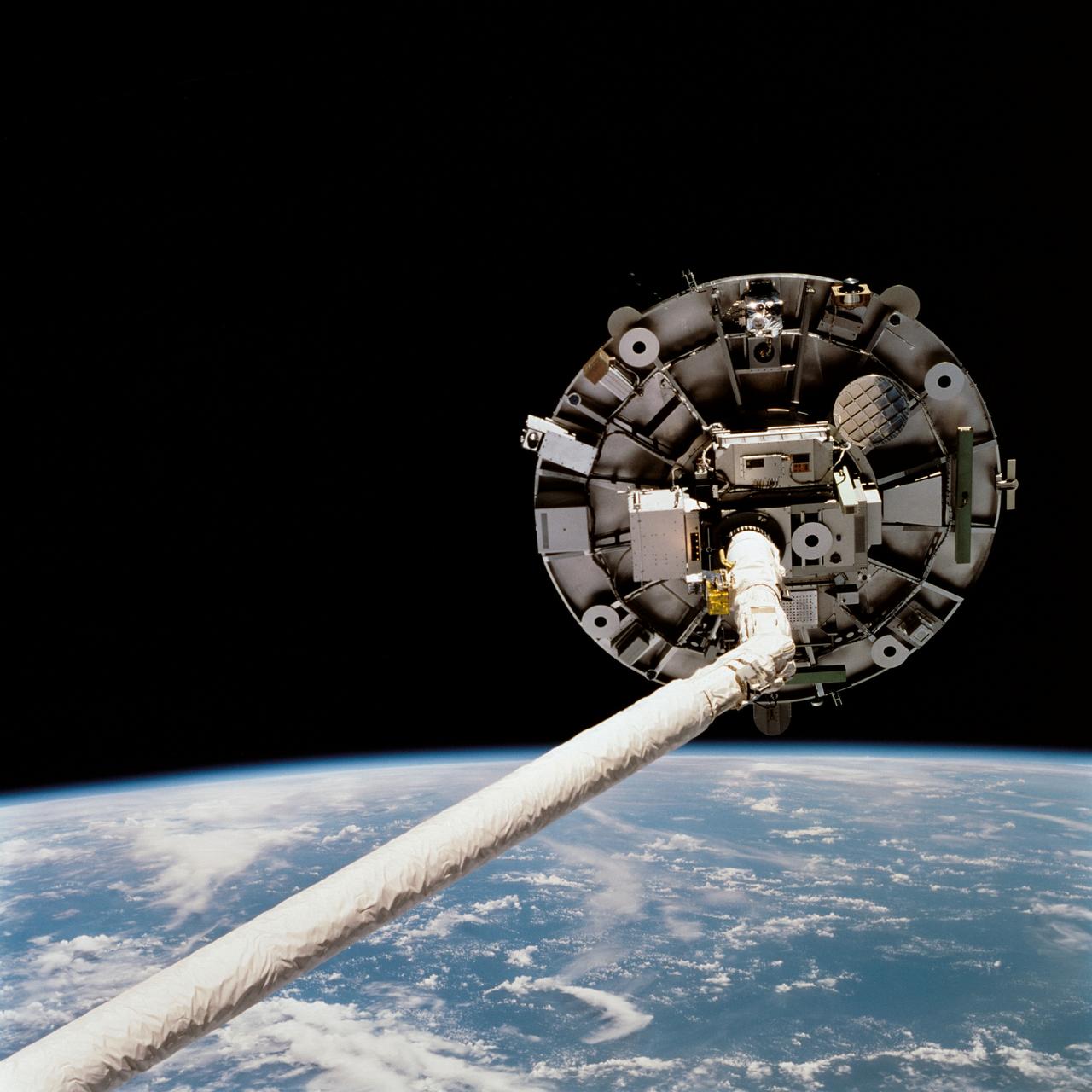
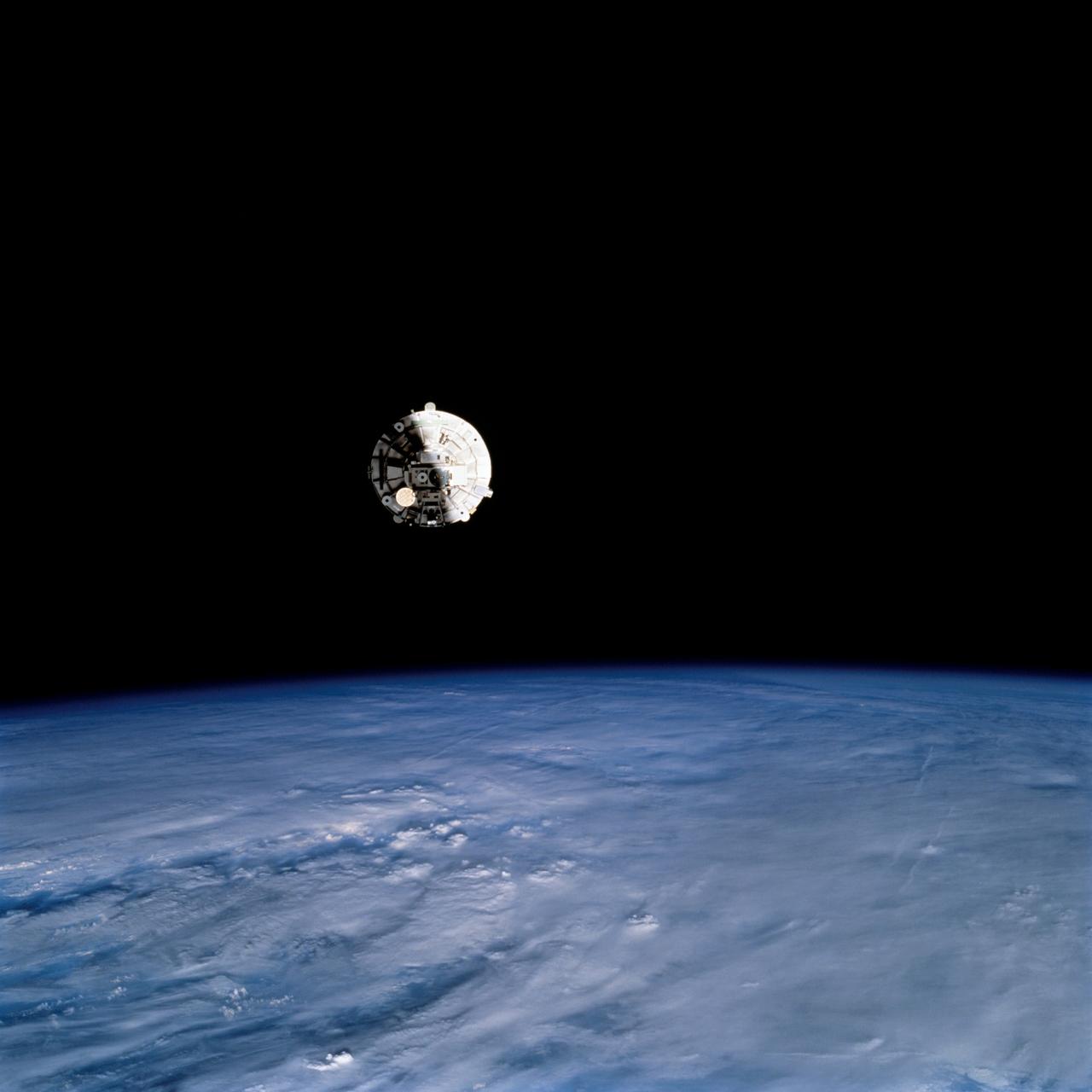
STS069-723-072 (11 September 1995) --- Prior to being released by Space Shuttle Endeavour's Remote Manipulator System (RMS) for a period of time, the Wake Shield Facility (WSF) is backdropped against the darkness of space over a blue and white Earth. The picture was taken shortly after midnight Houston time on September 11, 1995. The Endeavour, with a five-member crew, launched on September 7, 1995, from the Kennedy Space Center (KSC) and ended its mission there on September 18, 1995, with a successful landing on Runway 33. The multifaceted mission carried a crew of astronauts David M. Walker, mission commander; Kenneth D. Cockrell, pilot; and James S. Voss (payload commander), James H. Newman and Michael L. Gernhardt, all mission specialists.
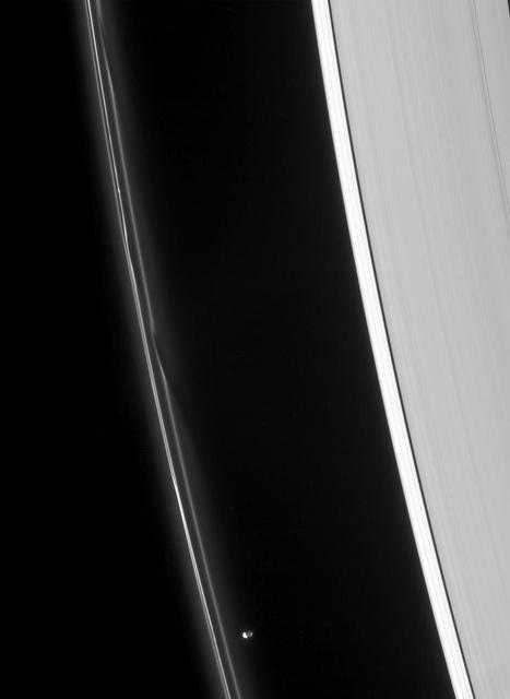
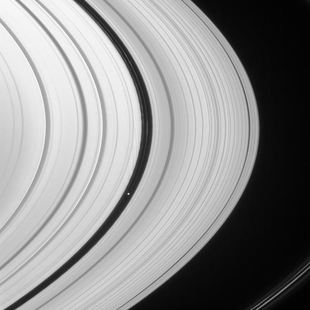
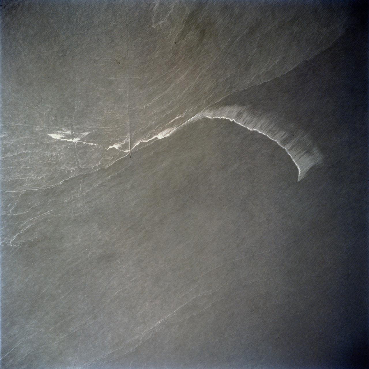
Prometheus speeds ahead of two dark gores in the F ring inner edge. The ring bright core swerves and twirls in its wake
Space Vacuum Epitaxy Center works with industry and government laboratories to develop advanced thin film materials and devices by utilizing the most abundant free resource in orbit: the vacuum of space. SVEC, along with its affiliates, is developing semiconductor mid-IR lasers for environmental sensing and defense applications, high efficiency solar cells for space satellite applications, oxide thin films for computer memory applications, and ultra-hard thin film coatings for wear resistance in micro devices. Performance of these vacuum deposited thin film materials and devices can be enhanced by using the ultra-vacuum of space for which SVEC has developed the Wake Shield Facility---a free flying research platform dedicated to thin film materials development in space.
Space Vacuum Epitaxy Center works with industry and government laboratories to develop advanced thin film materials and devices by utilizing the most abundant free resource in orbit: the vacuum of space. SVEC, along with its affiliates, is developing semiconductor mid-IR lasers for environmental sensing and defense applications, high efficiency solar cells for space satellite applications, oxide thin films for computer memory applications, and ultra-hard thin film coatings for wear resistance in micro devices. Performance of these vacuum deposited thin film materials and devices can be enhanced by using the ultra-vacuum of space for which SVEC has developed the Wake Shield Facility---a free flying research platform dedicated to thin film materials development in space.
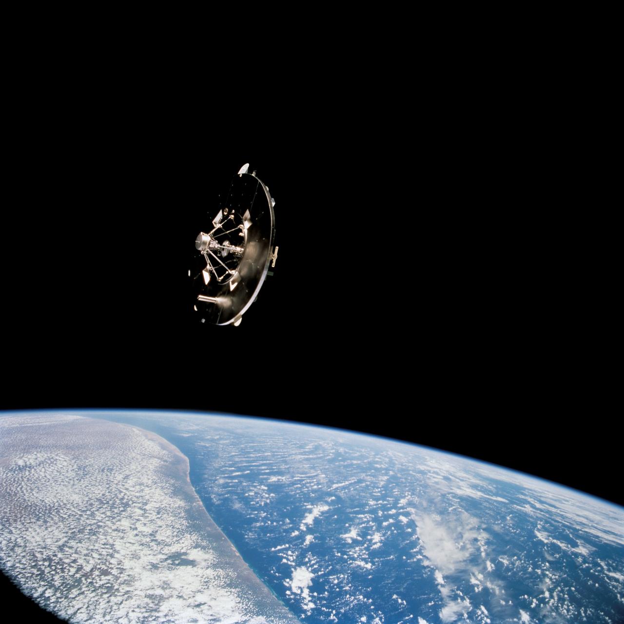
STS069-724-095 (7-18 September 1995) --- Prior to being re-captured by Space Shuttle Endeavour's Remote Manipulator System (RMS), the Wake Shield Facility (WSF) was recorded on film, backdropped against the darkness of space over a heavily cloud-covered Earth. Endeavour, with a five-member crew, launched on September 7, 1995, from the Kennedy Space Center (KSC) and ended its mission there on September 18, 1995, with a successful landing on Runway 33. The multifaceted mission carried a crew of astronauts David M. Walker, mission commander; Kenneth D. Cockrell, pilot; and James S. Voss (payload commander), James H. Newman and Michael L. Gernhardt, all mission specialists.
STS069-732-048 (11 September 1995) --- Having earlier been released by the Space Shuttle Endeavour's Remote Manipulator System (RMS), the Wake Shield Facility (WSF) moves away from the Space Shuttle. The coast of Somalia can be seen in the lower left quadrant of the frame. STS-69 and the Space Shuttle Endeavour, with a five-member crew, launched on September 7, 1995, from the Kennedy Space Center (KSC) and ended its mission there on September 18, 1995, with a successful landing on Runway 33. The multifaceted mission carried a crew of astronauts David M. Walker, mission commander; Kenneth D. Cockrell, pilot; and James S. Voss (payload commander), James H. Newman and Michael L. Gernhardt, all mission specialists.

jsc2024e043915 (6/17/2024) --- Maturation of Vascularized Liver Tissue Construct in Zero Gravity (MVP Cell-07) examines the behavior in microgravity of bioprinted or engineered liver tissue constructs that contain blood vessels. This preflight image shows A) Bioprinted vascularized construct with a gyroid design consisting of interconnected channels. B) Bioprinted human liver tissue construct fabricated using a digital light projection (DLP) printer. C) The tissue construct-containing flow chamber is connected to a perfusion system. Data from this vascularized liver tissue construct helps support the development of clinically relevant organs on Earth. Image courtesy of the Wake Forest Institute for Regenerative Medicine.

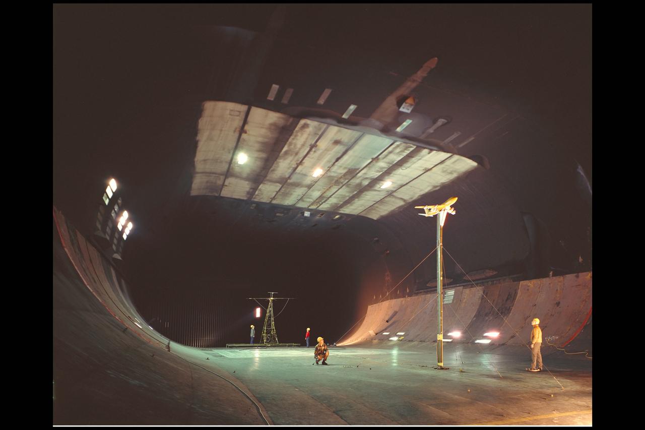
Galileo Wake probe: 6x6ft w.t. testing
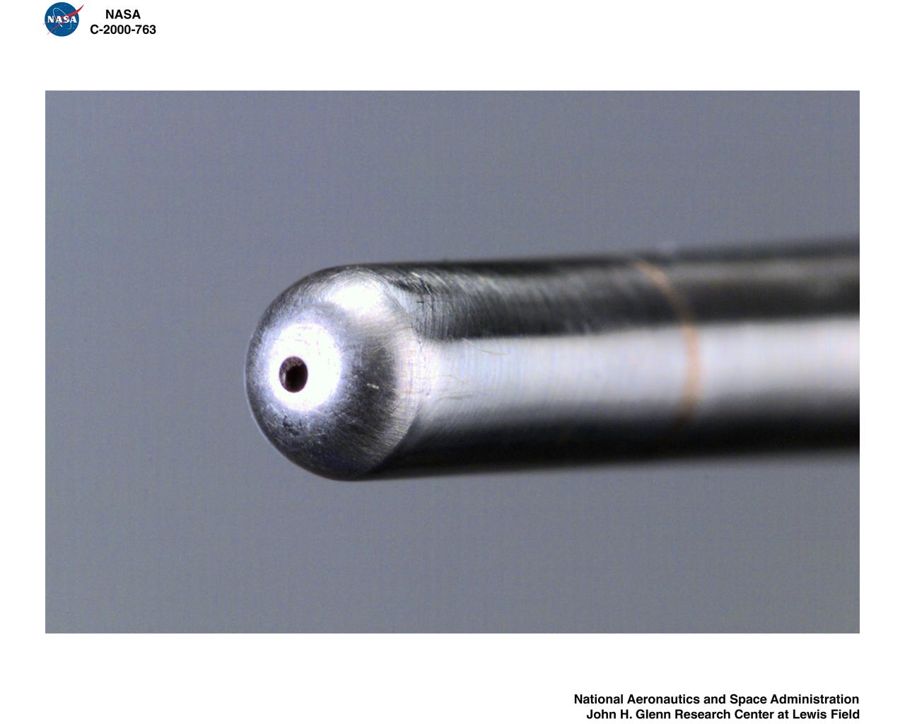
IRT - ICING RESEARCH TUNNEL WAKE SURVEY PROBE

Galileo Wake probe: 6x6ft w.t. testing
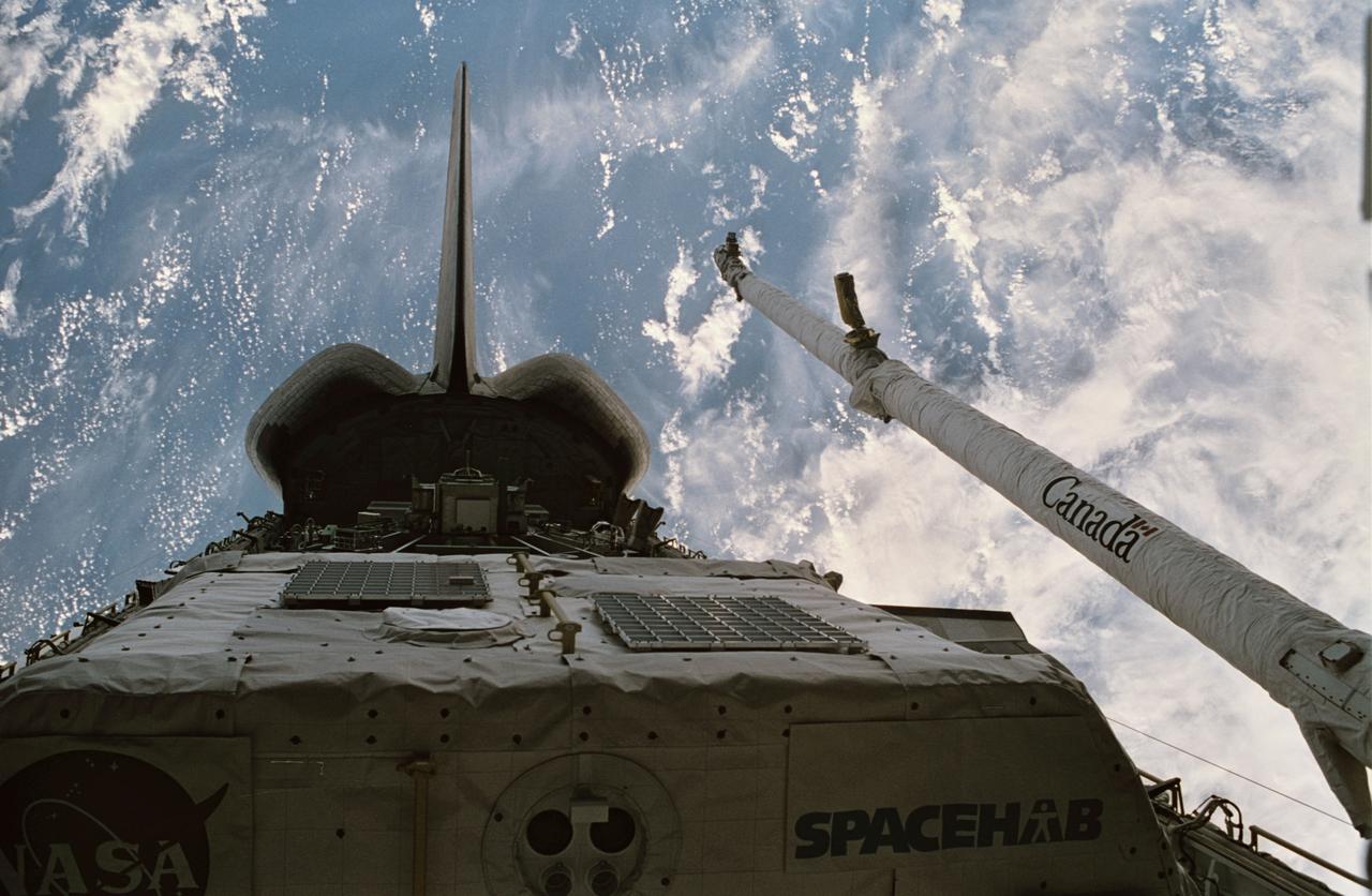
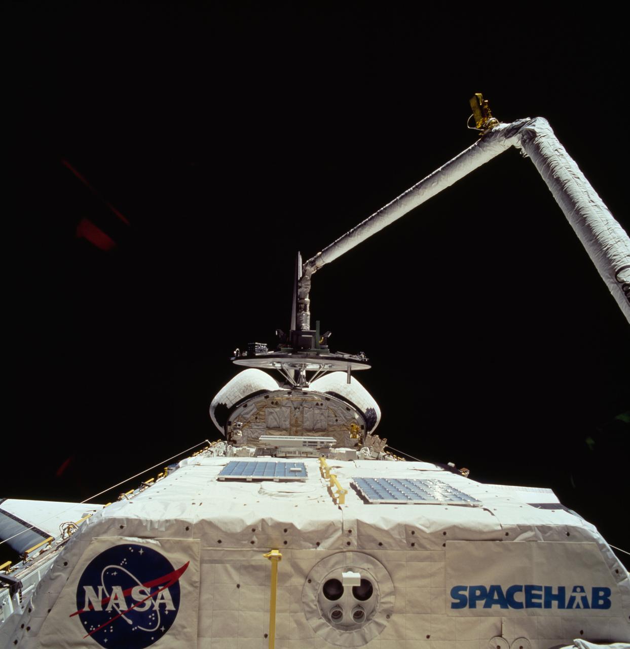
STS060-15-003 (3-11 Feb 1994) --- This 35mm frame shows the major payloads of the Space Shuttle Discovery's STS-60 mission, backdropped against clouds over the Atlantic Ocean. In the foreground is the SPACEHAB module, with the Wake Shield Facility (WSF) partially visible in its berthed position near the Orbital Maneuvering System (OMS) pods and the vertical stabilizer. Television cameras on the Remote Manipulator System (RMS) were being used for a survey of the cargo. Five NASA astronauts and a Russian cosmonaut went on to spend eight days in Earth orbit in support of the mission.
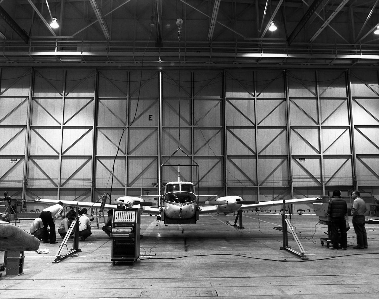
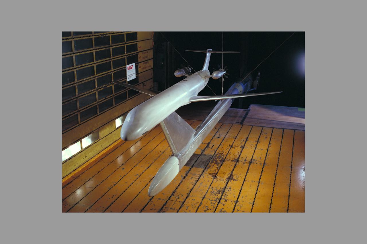
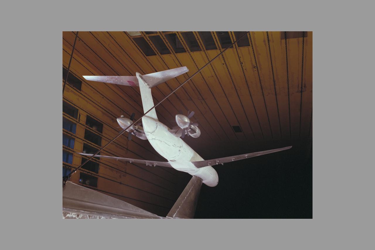
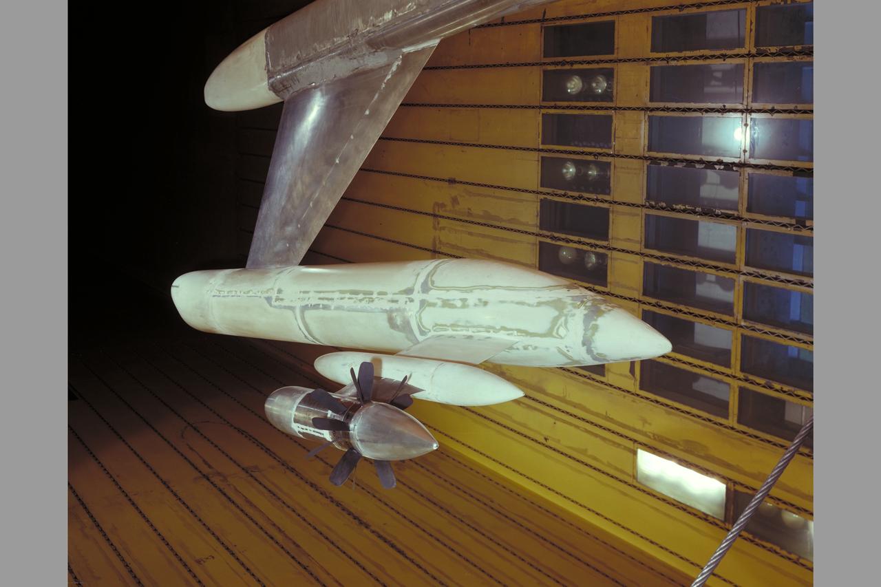
Technicians check instrumentation and systems on NASA 808, a PA-30 aircraft, prior to a research flight. The aircraft was used as the testbed in development of control systems for remotely piloted vehicles that were "flown" from the ground. The concept led to highly successful programs such as the HiMAT and the subscale F-15 remotely piloted vehicles. Over the years, NASA 808 has also been used for spin and stall research related to general aviation aircraft and also research to alleviate wake vortices behind large jetliners. This 1980 photograph taken inside a hangar shows technicians measuring moment of inertia.
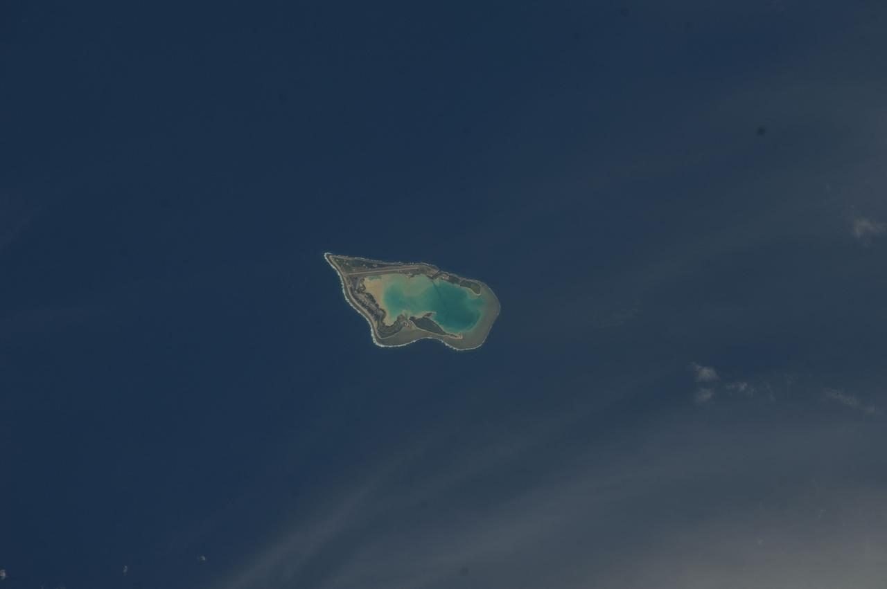
ISS033-E-007873 (27 Sept. 2012) --- Wake Island is featured in this image photographed by an Expedition 33 crew member on the International Space Station. The atoll of Wake Island is located in the central Pacific Ocean approximately 4,000 kilometers to the west-southwest of Hawaii and 2,400 kilometers to the northwest of Guam. In addition to Wake Island, the atoll includes the smaller Peale and Wilkes Island for a total land surface area of 6.5 square kilometers. Like many atolls in the Pacific, the islands and associated reefs formed around a submerged volcano. The lagoon in the center of the islands—characterized by shallow, light blue water in contrast to the surrounding darker, deeper Pacific Ocean waters—marks the approximate location of the summit crater of the volcano.
STS083-749-079 (4-8 April 1997) --- Cloud wake covers the Leeward Islands. Like a ship making a wake in the water, Guadeloupe Island is making a wake in the clouds. Seeing certain weather features tells us information as to what the conditions were at the time the photo was taken. For instance, a solid cloud area is formed behind the island in this photo so the winds are under or at 5 meters per second (mps). If the winds were greater Von Karman Vortices would develop. Formation of Von Karman Vortices requires wind speeds of 5 and 13 mps and a strong low level temperature inversion below the highest peak of the island.
Boeing 747 wake vortex test-440 in thr 40x80ft. w.t. with Rufiange, Vern Rossow, Eloy Martinez
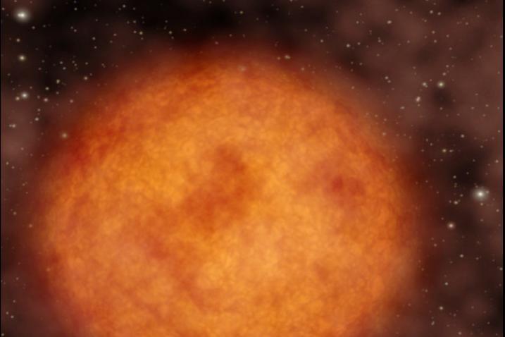
This artist concept illustrates a star flying through our galaxy at supersonic speeds, leaving a 13-light-year-long trail of glowing material in its wake. The star, named Mira pronounced my-rah after the latin word for wonderful.
![Amazonis Planitia is a broad plain on Mars, covered with ancient lava. This image shows an interesting feature of an old lava flow. When it was mostly liquid, the lava had a crust of cooled debris floating on the surface. Here, the crust just barely scraped over some hills. The flow was able to make it past the hills, but the rubble crust was caught and piled up, forming thick masses of debris. Downstream from the hills, there was no crust left and the lava formed a smoother, fresh surface. Observations like this tell us about the scale of the lava flow (which must have been a huge sheet) and also which direction it was moving at the time when the crust interacted with the hills. The map is projected here at a scale of 50 centimeters (19.7 inches) per pixel. [The original image scale is 59.0 centimeters (23.2 inches) per pixel (with 2 x 2 binning); objects on the order of 177 centimeters (69.7 inches) across are resolved.] North is up. http://photojournal.jpl.nasa.gov/catalog/PIA21460](https://images-assets.nasa.gov/image/PIA21460/PIA21460~medium.jpg)
Amazonis Planitia is a broad plain on Mars, covered with ancient lava. This image shows an interesting feature of an old lava flow. When it was mostly liquid, the lava had a crust of cooled debris floating on the surface. Here, the crust just barely scraped over some hills. The flow was able to make it past the hills, but the rubble crust was caught and piled up, forming thick masses of debris. Downstream from the hills, there was no crust left and the lava formed a smoother, fresh surface. Observations like this tell us about the scale of the lava flow (which must have been a huge sheet) and also which direction it was moving at the time when the crust interacted with the hills. The map is projected here at a scale of 50 centimeters (19.7 inches) per pixel. [The original image scale is 59.0 centimeters (23.2 inches) per pixel (with 2 x 2 binning); objects on the order of 177 centimeters (69.7 inches) across are resolved.] North is up. http://photojournal.jpl.nasa.gov/catalog/PIA21460
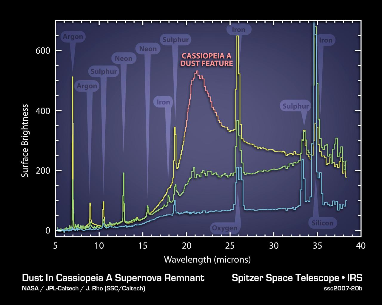
The elements and molecules that flew out of the Cassiopeia A star when it exploded about 300 years ago can be seen clearly for the first time in this plot of data, called a spectrum, taken by NASA Spitzer Space Telescope.
McDonnell Douglas Hub (Ultra-High Bypass) Model and SAAB Wake Rake Test 14ft W.T. Test-060-1-14, Turbo Fan Configuration
McDonnell Douglas Hub (Ultra-High Bypass) Model and SAAB Wake Rake Test 14ft W.T. Test-060-1-14, Turbo Fan Configuration
McDonnell Douglas Hub (Ultra-High Bypass) Model and SAAB Wake Rake Test 14ft W.T. Test-060-1-14, Turbo Fan Configuration
McDonnell Douglas Hub (Ultra-High Bypass) Model and SAAB Wake Rake Test 14ft W.T. Test-060-1-14, Turbo Fan Configuration
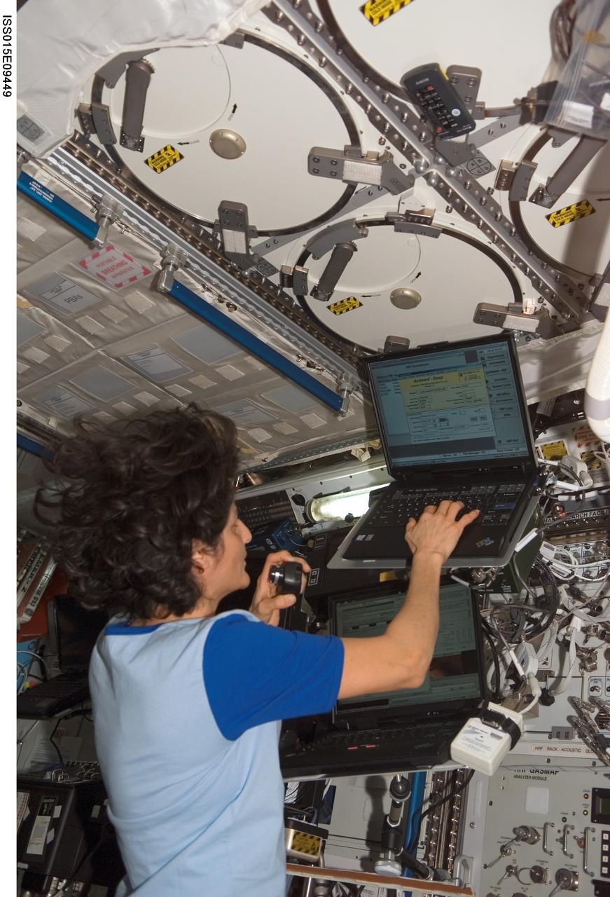
ISS015-E-09449 (24 May 2007) --- Astronaut Sunita L. Williams, Expedition 15 flight engineer, enters data in a computer for the Sleep-Wake Actigraphy and Light Exposure During Spaceflight-Long (Sleep-Long) experiment in the Destiny laboratory of the International Space Station. Sleep-Long will examine the effects of spaceflight and ambient light exposure on the sleep-wake cycles of the crewmembers during long-duration stays on the station.
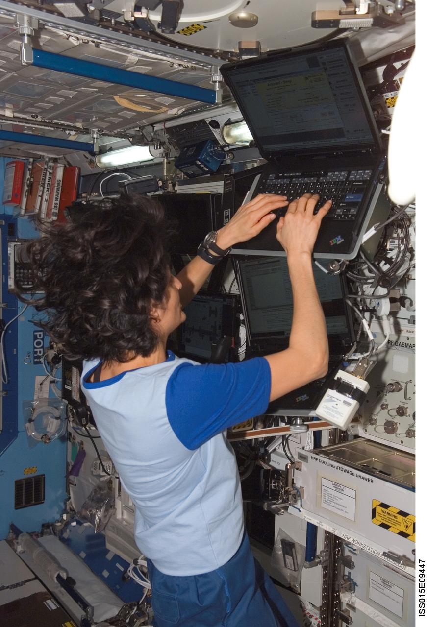
ISS015-E-09447 (24 May 2007) --- Astronaut Sunita L. Williams, Expedition 15 flight engineer, enters data in a computer for the Sleep-Wake Actigraphy and Light Exposure During Spaceflight-Long (Sleep-Long) experiment in the Destiny laboratory of the International Space Station. Sleep-Long will examine the effects of spaceflight and ambient light exposure on the sleep-wake cycles of the crewmembers during long-duration stays on the station.
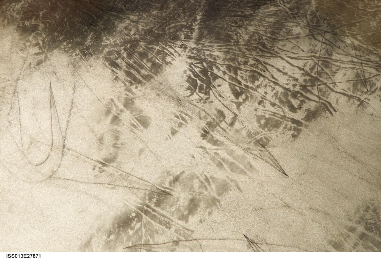
ISS013-E-27871 (28 May 2006) --- Considerable sunglint emphasizes features on Lake Erie in this image photographed by an Expedition 13 crewmember on the International Space Station. This detailed, south-looking image shows features on the surface of Lake Erie, about 30 miles west of Cleveland, Ohio. At left, a thin, V-shaped wake curves back towards the shore. This type of wake is typically created by a small, light craft such as a speedboat or sailboat under power.

STS080-762-049 (19 Nov.-7 Dec. 1996) --- Taken with a 70mm handheld camera, this photograph captures the berthing by the space shuttle Columbia's Remote Manipulator System (RMS) of the Wake Shield Facility (WSF).
STS080-755-016 (19 Nov.-7 Dec. 1996) --- Taken with a 70mm handheld camera, this photograph captures the Wake Shield Facility (WSF) in free flight backdropped against the blackness of space.
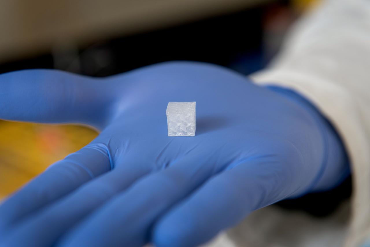
jsc2024e050836 (3/16/2022) --- Maturation of Vascularized Liver Tissue Construct in Zero Gravity (MVP Cell-07) examines the behavior in microgravity of bioprinted or engineered liver tissue constructs that contain blood vessels. The liver tissue constructs with a surface dimension of 1cm x 1cm x 1cm are bioprinted with a gyroid-shaped architecture with interconnected channels, allowing for uniform flow and surface shear stress that adequately covers the entire inner surfaces of cell-laden tissue constructs. The investigation sheds light on the formation of small blood vessels in engineered tissue. Image courtesy of Wake Forest Institute for Regenerative Medicine.
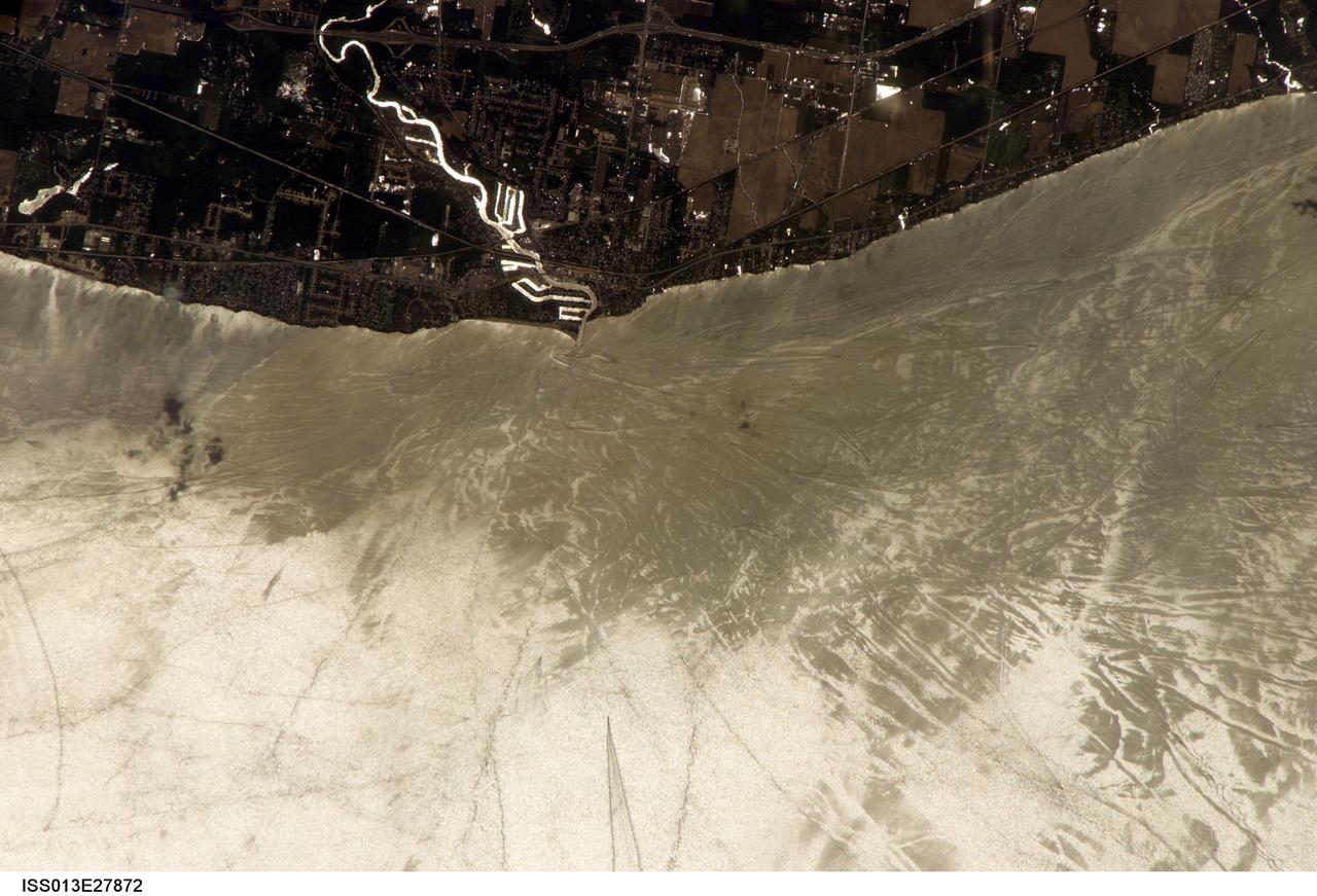
ISS013-E-27872 (28 May 2006) --- Considerable sunglint emphasizes features on Lake Erie in this image photographed by an Expedition 13 crewmember on the International Space Station. This detailed, south-looking image shows features on the surface of Lake Erie, about 30 miles west of Cleveland, Ohio. This view shows the Vermilion River in strong sunglint. The angular water bodies along the river are likely marinas. The main part of the image show numerous ship wakes in the zone of partial glint around the disk of the Sun's reflection point. The wakes radiate from the mouth of the Vermilion River, with many of them heading northwest in the direction of Detroit, Michigan.
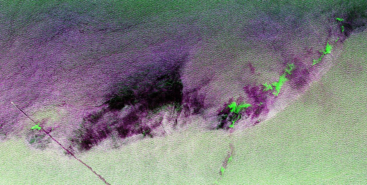
This is a radar image showing surface features on the open ocean in the northeast Atlantic Ocean. There is no land mass in this image. The purple line in the lower left of the image is the stern wake of a ship. The ship creating the wake is the bright white spot on the middle, left side of the image. The ship's wake is about 28 kilometers (17 miles) long in this image and investigators believe that is because the ship may be discharging oil. The oil makes the wake last longer and causes it to stand out in this radar image. A fairly sharp boundary or front extends from the lower left to the upper right corner of the image and separates two distinct water masses that have different temperatures. The different water temperature affects the wind patterns on the ocean. In this image, the light green area depicts rougher water with more wind, while the purple area is calmer water with less wind. The dark patches are smooth areas of low wind, probably related to clouds along the front, and the bright green patches are likely due to ice crystals in the clouds that scatter the radar waves. The overall "fuzzy" look of this image is caused by long ocean waves, also called swells. Ocean radar imagery allows the fine detail of ocean features and interactions to be seen, such as the wake, swell, ocean front and cloud effects, which can then be used to enhance the understanding of ocean dynamics on smaller and smaller scales. The image is centered at 42.8 degrees north latitude, 26.2 degrees west longitude and shows an area approximately 35 kilometers by 65 kilometers (22 by 40 miles). The colors in the image are assigned to different frequencies and polarizations of the radar as follows: red is L-band horizontally transmitted, horizontally received; green is C-band horizontally transmitted, horizontally received; blue is L-band vertically transmitted, vertically received. This image was acquired by the Spaceborne Imaging Radar-C/X-band Synthetic Aperture Radar (SIR-C/X-SAR) imaging radar when it flew aboard the space shuttle Endeavour on April 11, 1994. SIR-C/X-SAR, a joint mission of the German, Italian and United States space agencies, is part of NASA's Mission to Planet Earth. http://photojournal.jpl.nasa.gov/catalog/PIA01799
STS080-708-065 (19 Nov.-7 Dec. 1996) --- Backdropped against part of Baja California, the Wake Shield Facility (WSF) is about to be re-berthed in the cargo bay of the Earth-orbiting space shuttle Columbia. Columbia's Remote Manipulator System (RMS) was used extensively during operations with the experiment.
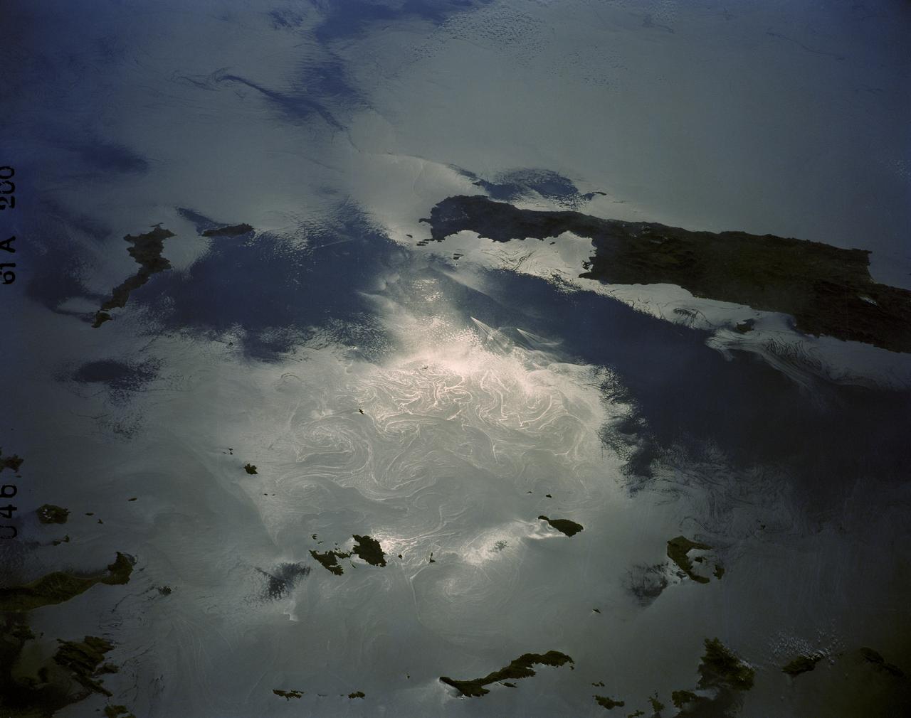
61A-200-046 (30 Oct--6 Nov 1985) --- A low-sun angle view of the eastern Mediterranean Sea showing the east tip of the island of Crete and the Sporades Islands of the Agean Sea. Numberous sprial eddies and island wakes are also highlighted in the sunglint--a delight to oceanographers. pg.26-2
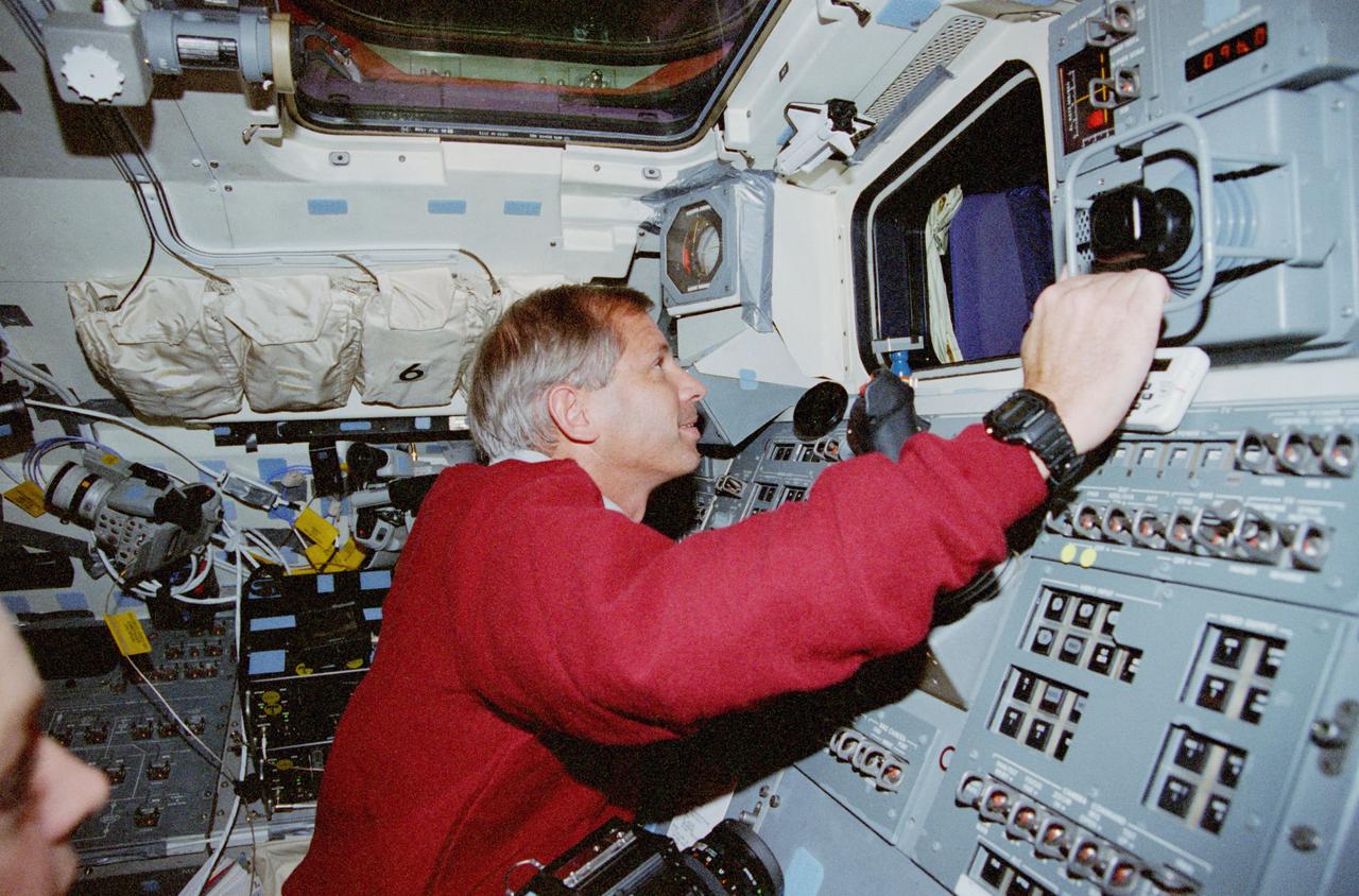
STS080-337-026 (19 Nov.-7 Dec. 1996) --- Astronaut Thomas D. Jones, STS-80 mission specialist, uses the controls of the space shuttle Columbia's Remote Manipulator System (RMS) to conduct a test with the captured Wake Shield Facility (WSF) seen through window at frame center.
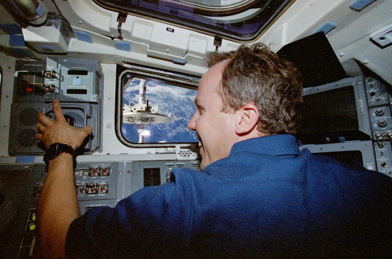
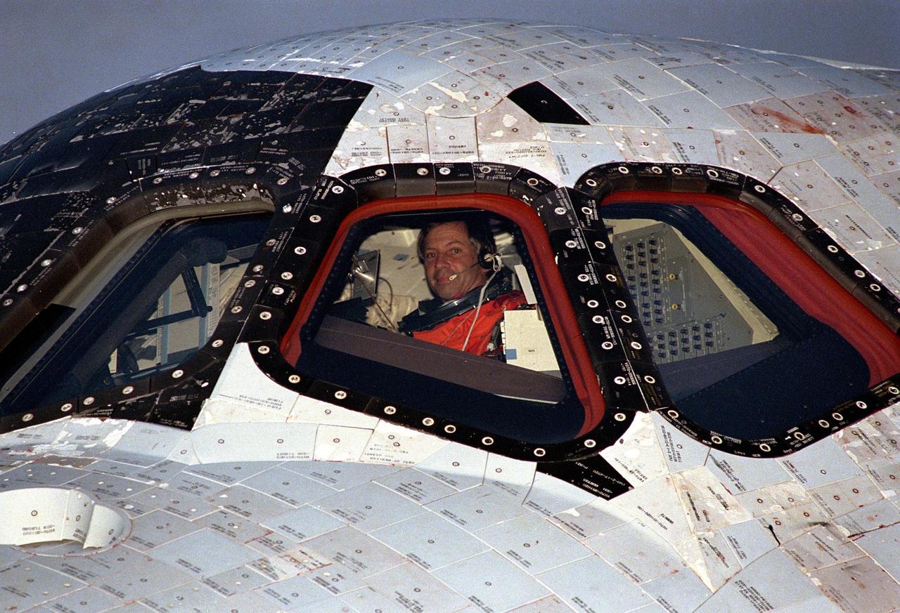
STS080-334-002 (19 Nov.-7 Dec. 1996) --- Astronaut Kenneth D. Cockrell, STS-80 mission commander, looks through a window on the space shuttle Columbia's aft flight deck during rendezvous operations with the Wake Shield Facility (WSF).
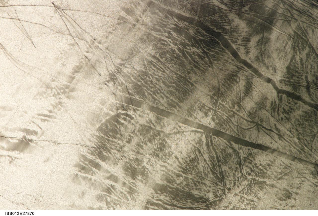
ISS013-E-27870 (28 May 2006) --- Considerable sunglint emphasizes features on Lake Erie in this image photographed by an Expedition 13 crewmember on the International Space Station. This detailed, south-looking image shows features on the surface of Lake Erie, about 30 miles west of Cleveland, Ohio. This view shows tight-V-shaped wakes of small craft. It also shows broad patterns of larger craft, probably large freighters carrying cargo that displace and disturb more water during passage. These larger wakes are aligned with the direct course between Detroit (out of frame) and Cleveland (out of frame). Some of the broad, ill-defined swaths of light and dark are streaks of wind-roughened water, which reflect the Sun differently.

Designed by the mission crew members, the patch for STS-69 symbolizes the multifaceted nature of the flight's mission. The primary payload, the Wake Shield Facility (WSF), is represented in the center by the astronaut emblem against a flat disk. The astronaut emblem also signifies the importance of human beings in space exploration, reflected by the planned space walk to practice for International Space Station (ISS) activities and to evaluate space suit design modifications. The two stylized Space Shuttles highlight the ascent and entry phases of the mission. Along with the two spiral plumes, the stylized Space Shuttles symbolize a NASA first, the deployment and recovery on the same mission of two spacecraft (both the Wake Shield Facility and the Spartan). The constellations Canis Major and Canis Minor represent the astronomy objectives of the Spartan and International Extreme Ultraviolet Hitchhiker (IEH) payload. The two constellations also symbolize the talents and dedication of the support personnel who make Space Shuttle missions possible.
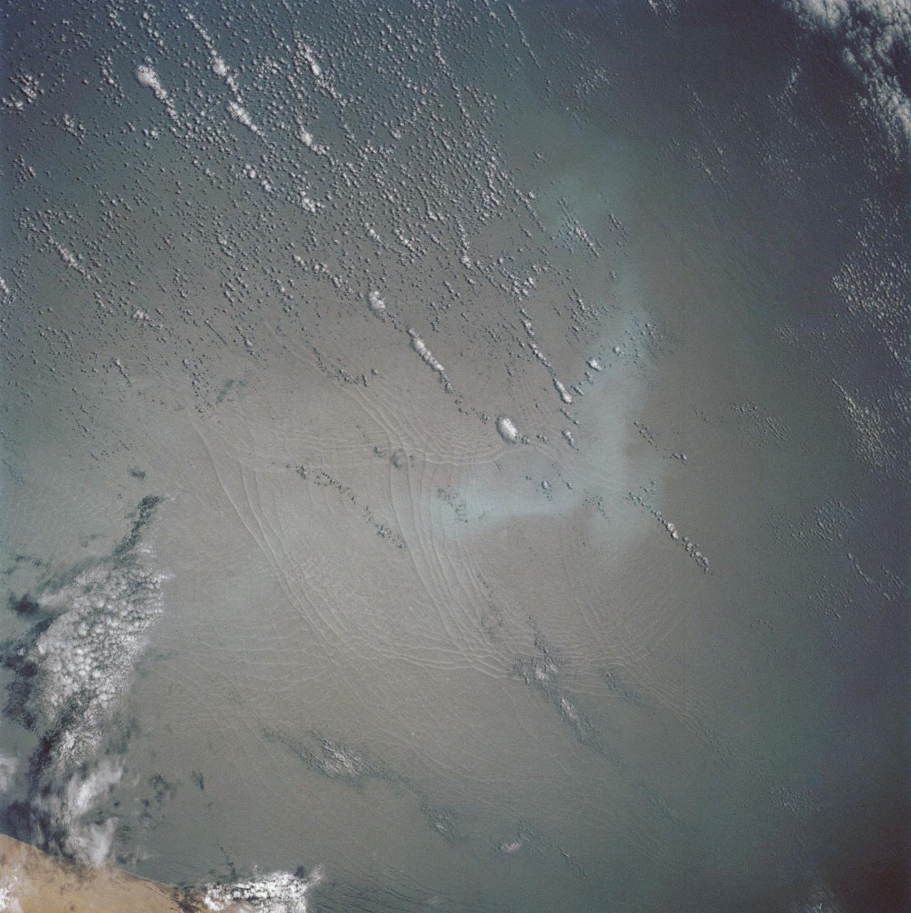
STS062-86-196 (4-18 March 1994) --- This photo depicts many of the types of ocean features seen when illuminated by sunglint. These features include a shear line, bilge dump, currents and ship wakes. Winds, currents and oils effect the smoothness of the surface of the water. The oils smooth the water which reflect the sun more than the rougher surround water. This is seen in the bright curved line which is a bilge dump of oily water from a ship. The oils then start to take the form of the currents and in this case are also being blown by the surface winds. The shear line is approximately 240 miles west of Bombay, India. This shear line appears to be a result of two water masses, moving at slightly different speeds, having converged. Ship wakes, such as those in the photo, which cross a shear line, often give us an indication of the relative strenght of a a shear.
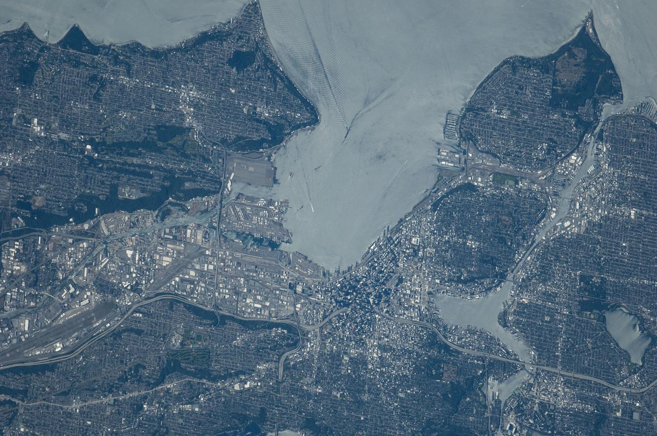
ISS040-E-124198 (6 Sept. 2014) --- Puget Sound is partly reflecting the sun in this detailed image taken by an Expedition 40 crew member on the International Space Station. Patterns of boat wakes are prominent in the sun’s partial reflection zone. The difference between the boat wakes in this view relates to the speed of the boat and the particular patterns (of several) that happen to be captured in the specific light reflection angles at the time the image was taken. The land areas show parts of Seattle. The darkest areas with rectangular grids are suburbs richly covered with trees. The broadly gray zones of the central city (bottom center) are brighter where structures are lower, as in the harbor zone (Harbor Island), and darker where the shadows of high-rise buildings downtown cast black shadows. Interstate Highway 5 bisects downtown.
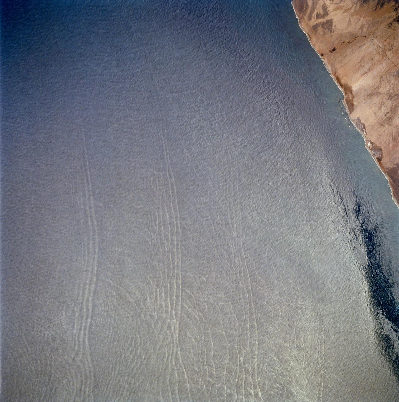
STS040-614-047 (5-14 June 1991) --- This image is of the Norfolk, Virginia -- Southern Delmarva Peninsula Southern Chesapeake Bay Area as seen in sunlight. The exposure is adjusted to emphasize the water patterns present. The outgoing tide generates considerable turbulence as it passes through the mouth of the bay. This is displayed by differences in reflective properties of the water surface due to differences in slope and turbidity. Ship wakes and the wakes of subsurface structures are seen clearly. The bridge tunnel system linking Norfolk with the peninsula and its effect on the system is quite apparent. Sunglint images over land areas were also acquired which emphasize land-water boundaries as demonstrated here in the small Delmarva inlets as a tool for wetland mapping, and river, lake and even pond description. During the first few days of the STS-40 mission the Eastern Seaboard of the United States was free of clouds and haze providing excellent photography of many of the major cities and the countryside of that area as well as the Gulf Stream.

This observation from NASA Mars Reconnaissance Orbiter covers a portion of the Martian equatorial plains called Elysium Planitia. In this location, lava that was once flowing across the surface interacted with multiple obstructions.
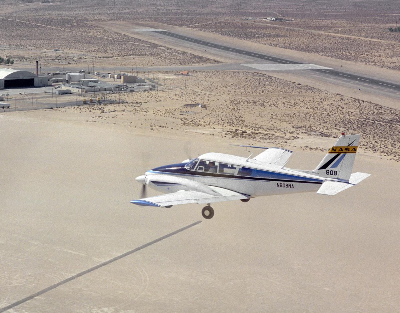
Dryden Flight Research Center's Piper PA-30 Twin Commanche, which helped validate the RPRV concept, descends to a remotely controlled landing on Rogers Dry Lake, unassisted by the onboard pilot. A Piper PA-30 Twin Commanche, known as NASA 808, was used at the NASA Dryden Flight Research Center as a rugged workhorse in a variety of research projects associated with both general aviation and military projects. In the early 1970s, the PA-30, serial number 301498, was used to test a flight technique used to fly Remotely Piloted Research Vehicles (RPRV's). The technique was first tested with the cockpit windows of the light aircraft blacked out while the pilot flew the aircraft utilizing a television monitor which gave him a "pilot's eye" view ahead of the aircraft. Later pilots flew the aircraft from a ground cockpit, a procedure used with all RPRV's. TV and two-way telemetry allow the pilot to be in constant control of the aircraft. The apparatus mounted over the cockpit is a special fish eye lens camera, used to obtain images that are transmitted to the ground based cockpit. This project paved the way for sophisticated, highly successful research programs involving high risk spin, stall, and flight control conditions, such as the HiMAT and the subscale F-15 remotely piloted vehicles. Over the years, NASA 808 has also been used for spin and stall research related to general aviation aircraft and also research to alleviate wake vortices behind large jetliners.
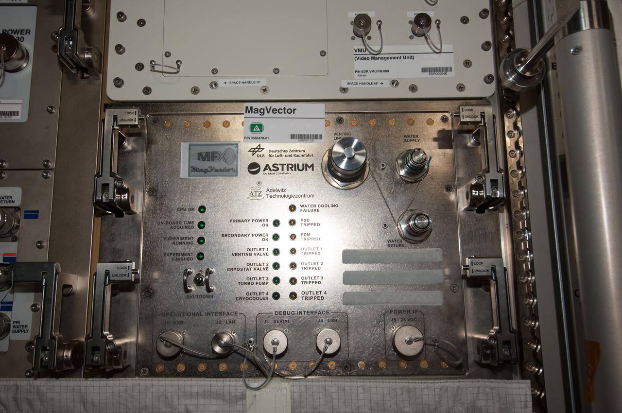
iss040e108291 (8/26/2014) --- Photographic documentation of final installation of MAGVECTOR hardware in the Columbus module aboard the International Space Station (ISS). MAGVECTOR qualitatively investigates the interaction between a moving magnetic field and an electrical conductor. The set up will provide initial insights regarding the principal feasibility on board the ISS,future improvements and phenomenological trends and dependencies. The expected changes in the magnetic field structure on the Ram and Wake side of the electrical conductor are of interest for technical applications as well as for astrophysical research.
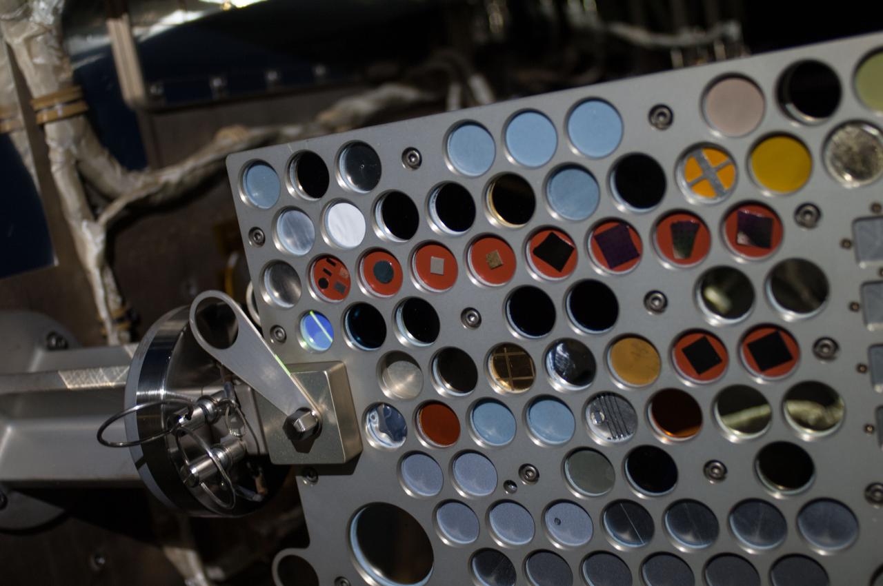
iss036e016736 (7/9/2013) --- Close-up view of the Optical Reflector Materials Experiment III Ram/Wake (ORMatE-III R/W) which is part of the Materials on International Space Station Experiment - 8 (MISSE-8) installed on the starboard truss. View was taken during a session of extravehicular activity (EVA) 22 as work continues on the International Space Station.

STS109-719-076 (1-12 March 2002) --- The astronauts on board the Space Shuttle Columbia took this 70mm picture featuring part of the eastern sea board. The oblique view looks northward from South Florida to the southern Appalachians. Most of the southeastern United States appears in crisp, clear air in the wake of a cold front that has pushed well off the mainland. Only a few jet stream and low-level clouds remain over South Florida and Gulf Stream.
STS080-330-023 (19 Nov.-7 Dec. 1996) --- Astronaut Thomas D. Jones, STS-80 mission specialist, operates the Remote Manipulator System (RMS) controls during operations with the Wake Shield Facility (WSF). When this picture was taken, the part time free-flying WSF was in the grasp of the RMS' end effector, as evidenced by the scene on the space shuttle Columbia's aft flight deck monitor in upper right.
STS077-744-046 (19-29 May 1996) --- This view shows ship wakes off the coast of Fort Myers, Florida. The Sun glint reflecting off the ocean surfaces allowed man-made features to be seen and photographed by the astronaut crew members. When a ship or boat goes through the water it disturbs the surface of the water which causes the Sun?s rays to reflect back differently than the surrounding waters. Photographed on a weekend, this image illustrates how popular recreational boating is around the Fort Myers area.

S86-28458 (28 Feb. 1986) --- Astronaut Michael L. Coats participates in a rehearsal for his assigned flight at the commander's station of the Shuttle Mission Simulator (SMS) at the Johnson Space Center (JSC). NOTE: Coats, a veteran of spaceflight, originally trained for STS 61-H, which was cancelled in the wake of the Challenger accident. Following the Janaury 1986 accident he was named to serve on a mock crew (STS-61M) for personnel training and simulation purposes. Photo credit: NASA
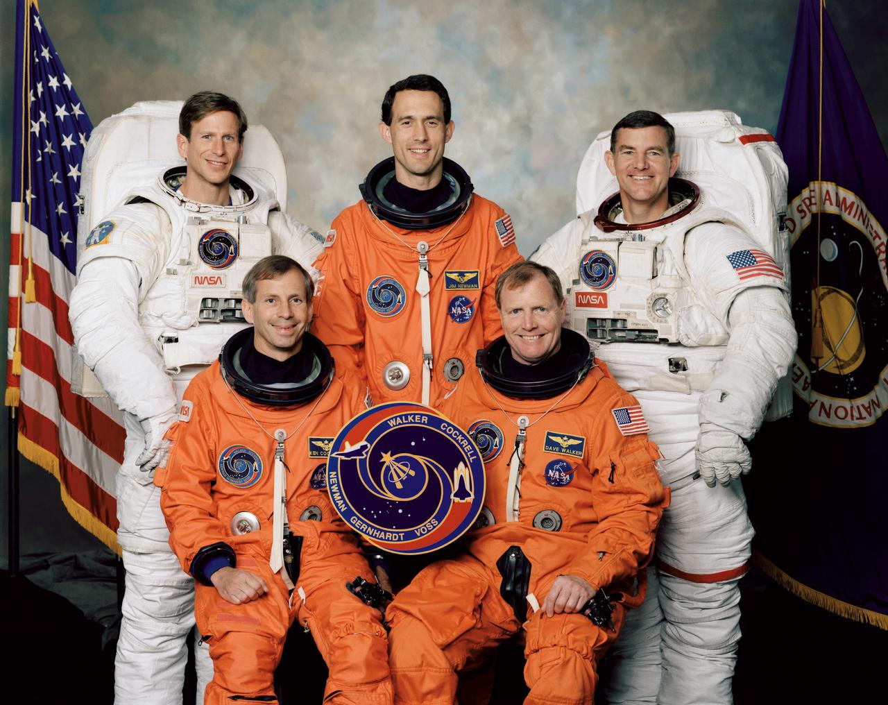
These five NASA astronauts were the crew members for the STS-69 mission that launched aboard the Space Shuttle Endeavour September 7, 1995. Pictured on the front row (left to right) are David M. Walker, mission commander; and Kenneth D. Cockrell, pilot. On the back row (left to right) are Michael L. Gernhardt and James H. Newman, both mission specialists; and James S. Voss, payload commander. The mission’s two primary payloads included the Spartan 201-3 and Wake Shield Facility-2 (WSF-2).
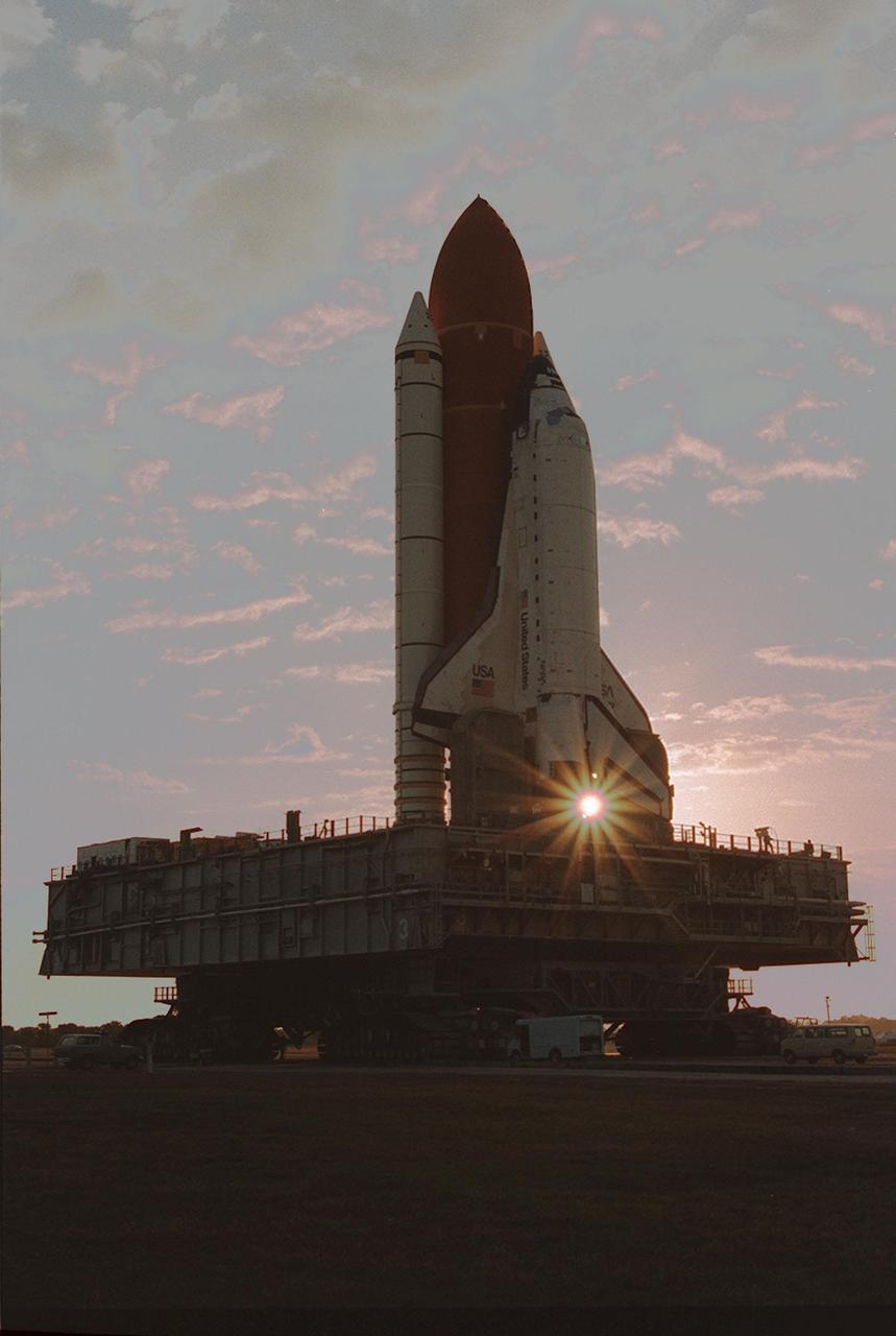
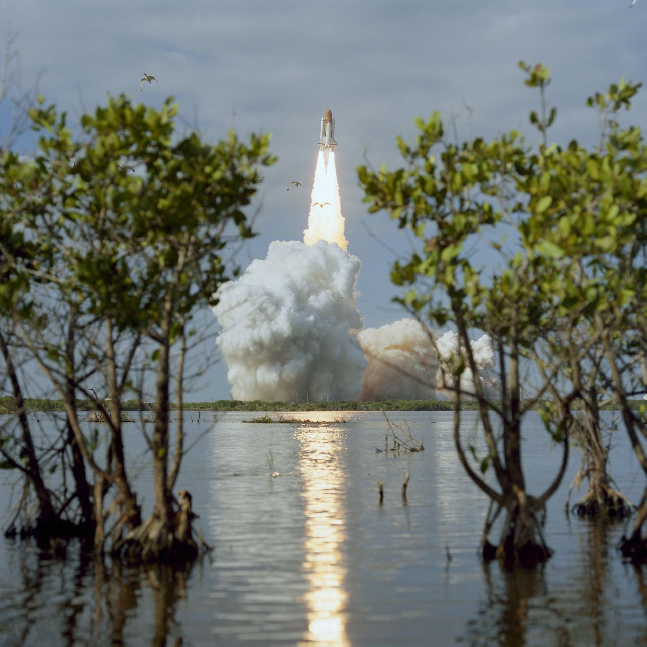
KENNEDY SPACE CENTER, FLA. -- Leaving the Vehicle Assembly Building for Launch Pad 39A on a crisp, clear winter day, the Space Shuttle Discovery makes the final Earth-bound leg of a journey into space. Once at the pad, two of the payloads for Discovery's upcoming flight, mission STS-60, will be installed. The Wake Shield Facility-1 and Get Away Special bridge assembly will be joining SPACEHAB-2 in the orbiter's payload bay. Liftoff of the first Space Shuttle flight of 1994 is currently targeted for around Feb. 3

STS080-708-084 (19 Nov.-7 Dec. 1996) --- Backdropped against the blackness of space and a cloud covered portion of Earth, the Wake Shield Facility (WSF) is turned loose by the space shuttle Columbia's Remote Manipulator System (RMS) to begin a period of free-flight. The image was photographed with a handheld 70mm camera aimed through windows on Columbia's aft flight deck.
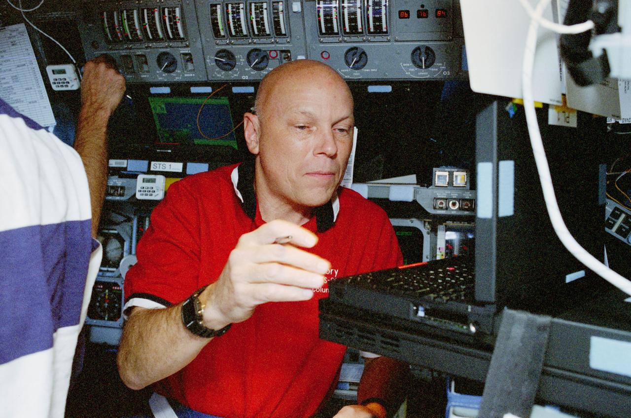
STS080-314-003 (19 Nov.-7 Dec. 1996) --- Astronaut Story Musgrave, STS-80 mission specialist, works with a pair of computers dedicated to Wake Shield Facility (WSF) operations onboard the space shuttle Columbia's flight deck. Musgrave marked his sixth appearance on a space shuttle flight during this duration record-setting space flight.
STS080-360-002 (19 Nov.-7 Dec. 1996) --- From the commander's station on the port side of the space shuttle Columbia's forward flight deck, astronaut Kenneth D. Cockrell prepares for a minor firing of Reaction Control System (RCS) engines during operations with the Wake Shield Facility (WSF). The activity was recorded with a 35mm camera on flight day seven. The commander is attired in a liquid-cooled biological garment.
STS099-703-007 (11-22 February 2000) ---A distinct cumulus cloud pattern marks the island wake within a weak northerly wind field in the vicinity of Isla Socorro, south of the Baja Peninsula of Mexico. The photo was taken by one of the astronauts aboard the Space Shuttle Endeavour as it orbited Earth in February 2000. A smaller companion island, San Benedicto, is visible to the north-northeast. Socorro rises to just over 3,400 feet and disrupts the winds which apparently are not strong or persistent enough to form closed vortices.
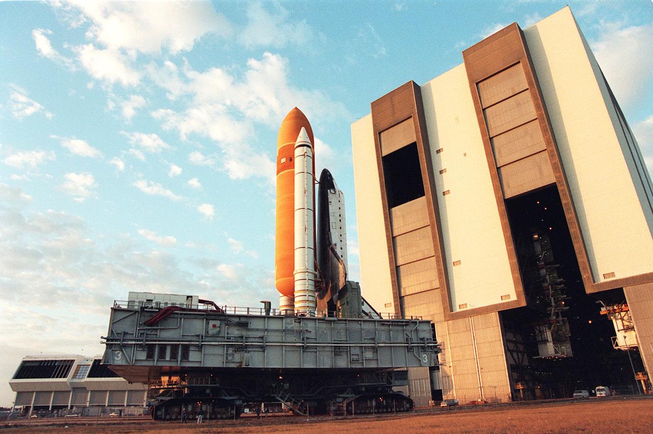
KENNEDY SPACE CENTER, FLA. -- Leaving the Vehicle Asembly Building for Launch Pad 39A on a crisp, clear winter day, the Space Shuttle Discovery makes the final Earth-bound leg of a journey into space. Once at the pad, two of the payloads for Discovery's upcoming flight, mission STS-60, will be installed. The Wake Shield Facility-1 and Get Away Special bridge assembly will be joining SPACEHAB-2 in the orbiter's payload bay. Liftoff of the first Space Shuttle flight of 1994 is currently targeted for around Feb. 3

ISS007-E-12858 (17 August 2003) --- This view was taken by an Expedition 7 crewmember onboard the International Space Station (ISS). Sunlight reflects off of the lakes of Quetico Provincial Park, Ontario. The area lies between Lake Superior and Lake of the Woods, just north of the USA-Canadian border. The long vertical clouds in the image are condensation trails produced in the wake of jet airplanes.
STS062-153-226 (4-18 March 1994) --- Though it did not reproduce well, this photo gives scientific information to aid in studying all types of earth's processes. It documents ocean features in the sunglint in the Gulf of California, off the Isla Cerralvo, souther Baja, California. Biological oils collect on the surface and shows current patterns, eddies and ship wakes. The small bright spot on the edge of the eddy is a ship dumping oily water from its bilges. The line in the brighter area is a light wind gust roughening the surface.
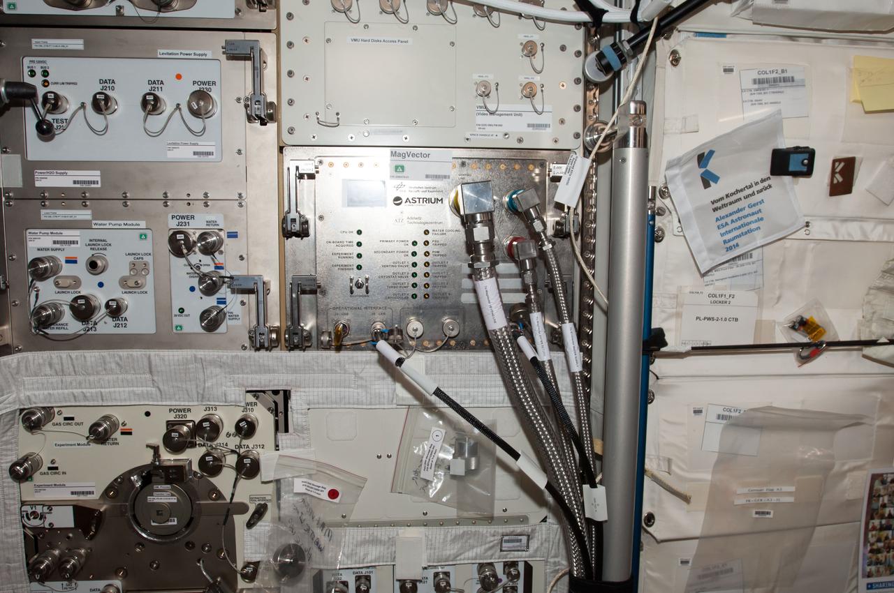
iss040e123621 (9/4/2014) --- Photographic documentation of final installation of MAGVECTOR hardware in the Columbus module aboard the International Space Station (ISS). MAGVECTOR qualitatively investigates the interaction between a moving magnetic field and an electrical conductor. The set up will provide initial insights regarding the principal feasibility on board the ISS,future improvements and phenomenological trends and dependencies. The expected changes in the magnetic field structure on the Ram and Wake side of the electrical conductor are of interest for technical applications as well as for astrophysical research.
STS006-44-532 (4-9 April 1983) --- This is one of a series of photographs taken through the “ceiling” windows of the Earth-orbiting space shuttle Challenger by members of the STS-6 crew on its five-day mission in space. Many unused oil tankers lie in the roadstead along the coast of U.A.E. between the ports of Khawn Fakkan and Fujayrah. The sunglint on the Gulf of Oman permits the viewer to see the surface features much clearer. Such surface features as gynes, slicks, wakes, and sea state are clearly seen. Photo credit: NASA
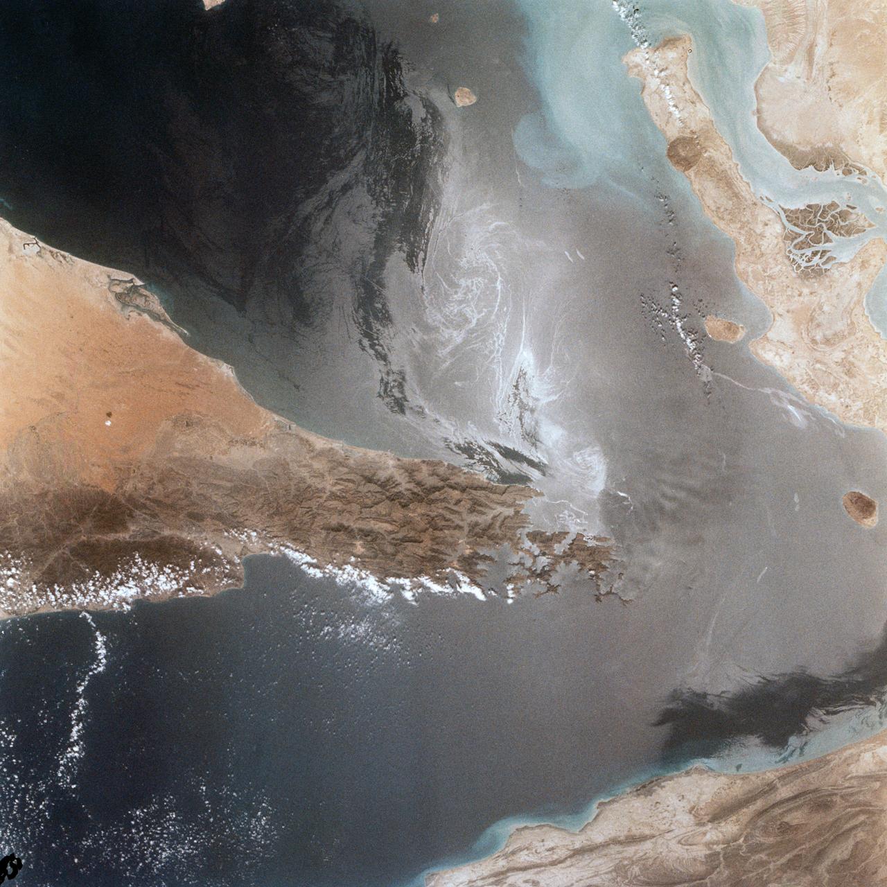
Portions of Oman, The United Arab Emirates and Iran are seen at the Strait of Hormuz (26.0N, 56.0E) in this view. A number of ship wakes can be seen in the area of the strait. Sunglint in the Persian Gulf to the northwest, accentuates the complex currents and oil slicks, seen as dark toned blue streaks on the surface. Qeshm Island, just off the coast of Iran, can be seen on the edge of the photo.

Swift currents flow through the Strait of Gibraltar, producing complicated patterns in the surface waters. Some of those patterns are highlighted in the sunglint in this photograph. The Mediterranian Sea is on the upper right, the Atlantic Ocean in in the lower left. Few features can be seen on the Mediterranian side, but current shears (straight lines coming off Spain), several sets of internal waves (impinging on the Spanish continental shelf) and ship wakes can be seen on the Atlantic side, west of Cadiz. Both Tangier and Cadiz show up in the sunglint as well.
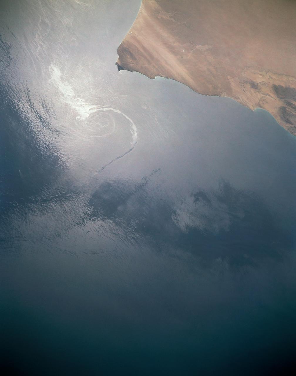
In this sunglint view of the Arabian Seacoast of Oman (19.0N, 59.0E) an oil slick is highlighted on the water's surface by sunglint lighting conditions. Nearly 50 percent of the oil transported worldwide passes through the Gulf of Oman, en route from the Persian Gulf and numerous ship wakes can be seen in this view. The oil slick, rounding the tip of Cape Ras Al Hadd, has formed a counterclockwise bright spiral indicating the local ocean currents.
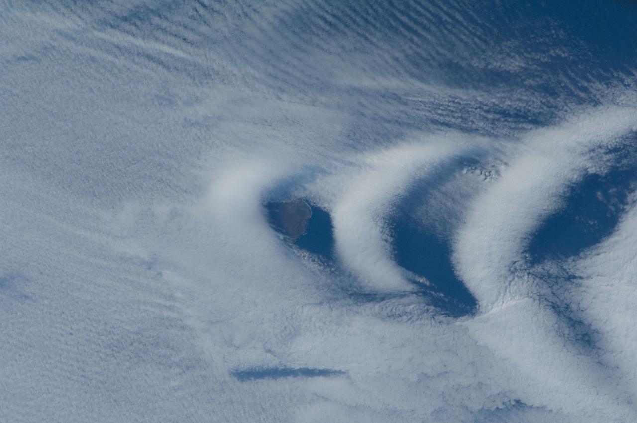
ISS030-E-193144 (25 March 2012) --- Wave clouds near Ile aux Cochons are featured in this image photographed by an Expedition 30 crew member on the International Space Station. This photograph illustrates the formation of wave clouds in the wake—or downwind side—of Ile aux Cochons (“Isle of Pigs”) located in the Southern Indian Ocean. The island is approximately located 3,000 kilometers southeast of the southern tip of the African continent and 2,300 kilometers northwest of Antarctica. The island itself, of which only a part of the eastern coastline is visible at center, is volcanic in origin with a summit elevation of 775 meters above sea level. According to scientists, the Ile aux Cochons stratovolcano is thought to have erupted within the last 12,000 years; however no historical activity has been recorded. The summit elevation is high enough for the land surface to interact with cloud layers and winds flowing past the island. Two major cloud layers are visible; a lower, more uniform layer consists of roughly parallel cloud “streets” that suggest a westerly flow pattern of air. When the air mass encounters the Ile aux Cochons, moisture-laden air rises and cools, causing more water vapor to condense into clouds. As the air mass passes over the summit of Ile aux Cochons and descends, it may encounter alternating moist and dry air layers, enabling the formation of the discontinuous chevron-shaped wave clouds in the wake of the island. While their appearance suggests that the clouds are forming in the wake of the island and moving eastwards, in fact it is the air mass that is moving, with clouds forming in regions of moist air and dissipating in dry regions. Ile aux Cochons is the westernmost of the islands that form the subantarctic Crozet Archipelago (part of the French Southern and Antarctic Lands). Accept for occasional research visits, the island is uninhabited. The island is an important breeding site for seabirds, including the world’s largest King Penguin colony.

STS069-S-001 (May 1995) --- Designed by the crew members, the patch for STS-69 symbolizes the multifaceted nature of the flight's mission. The primary payload, Wake Shield Facility (WSF), is represented in the center by the astronaut emblem against a flat disk. The astronaut emblem also signifies the importance of human beings in space exploration, reflected by the planned spacewalk supporting space station assembly. The two stylized space shuttles highlight the ascent and entry phases of the mission. Along with the two spiral plumes, the stylized space shuttles symbolize a NASA first - the deployment and recovery on the same mission of two spacecraft (both the Wake Shield Facility and the Spartan). The constellations Canis Major and Canis Minor represent the astronomy objectives of the Spartan and International Extreme Ultraviolet Hitchhiker (IEH) payload. The two constellations also symbolize the talents and dedication of the support personnel who make space shuttle missions possible. The NASA insignia design for space shuttle flights is reserved for use by the astronauts and for other official use as the NASA Administrator may authorize. Public availability has been approved only in the forms of illustrations by the various news media. When and if there is any change in this policy, which is not anticipated, the change will be publicly announced. Photo credit: NASA
These open ocean Internal Waves were seen off the Namibia Coast, Africa (19.5S, 11.5E). The periodic and regularly spaced sets of incoming internal appear to be diffracting against the coastline and recombining to form a network of interference patterns. They seem to coincide with tidal periods about 12 hours apart and wave length (distance from crest to crest) varies between 1.5 and 5.0 miles and the crest lengths stretch beyond the image.
These open ocean Internal Waves were seen off the Namibia Coast, Africa (23.0S, 14.0E). The periodic and regularly spaced sets of internal waves most likely coincide with tidal periods about 12 hours apart. The wave length (distance from crest to crest) varies between 1.5 and 5.0 miles and the crest lengths stretch across and beyond the distance of the photo. The waves are intersecting the Namibia coastline at about a 30 degree angle.

STS073-351-035 (20 October - 5 November 1995) --- Three crew members are captured on camera at the end of their sleep shift on the middeck of the Earth-orbiting Space Shuttle Columbia. Pictured are (left to right) astronaut Catherine G. Coleman, mission specialist; payload specialist Fred W. Leslie and astronaut Michael E. Lopez-Alegria, mission specialist. The trio joined four other crewmembers for 16 days of in-space research in support of the United States Microgravity Laboratory (USML-2) mission.
STS069-355-023 (7-18 September 1995) --- Astronauts David M. Walker (right), mission commander, and Michael L. Gernhardt, mission specialist, busy themselves on Space Shuttle Endeavour’s flight deck during rendezvous operations involving one of two temporarily free-flying craft. Endeavour, with a five-member crew, launched on September 7, 1995, from the Kennedy Space Center (KSC). The multifaceted mission ended September 18, 1995, with a successful landing on Runway 33 at KSC.
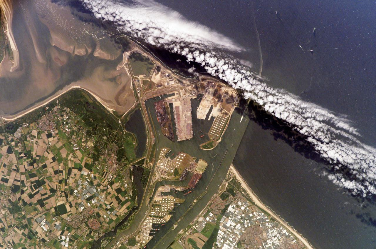
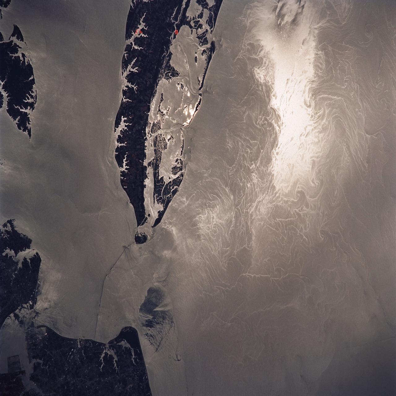
ISS011-E-07380 (28 May 2005) --- The Port of Rotterdam, Netherlands, is featured in this image photographed by an Expedition 11 crewmember on the International Space Station (ISS). The Port of Rotterdam, also known as Europoort (Eurogate), has been an important trading center since approximately 1250 A.D. This image illustrates the close proximity of the Europoort with the surrounding cities of Hoek van Holland, Oostvoorne, Brielle, and agricultural fields to the south. The presence of the port and its seawalls interrupts southward-flowing coastal currents, leading to accumulation of sediment to the south (upper left of image). Numerous ship wakes are visible within the port complex itself and in the upper right of the image.
KENNEDY SPACE CENTER, FLA. -- STS-80 Commander Kenneth D. Cockrell peers out the window of the orbiter Columbia minutes after guiding the spacecraft to a successful landing on KSC’s Runway 33. Main gear touchdown occurred at 6:49:04 a.m. EST, Dec. 7. On board with Cockrell are four fellow crew members, Pilot Kent V. Rominger, and Mission Specialists Story Musgrave, Thomas D. Jones, and Tamara E. Jernigan, and the two primary payloads of the mission, the Wake Shield Facility-3 (WSF-3) and the Orbiting and Retrievable Far and Extreme Ultraviolet Spectrometer-Shuttle Pallet Satellite II (ORFEUS-SPAS II).
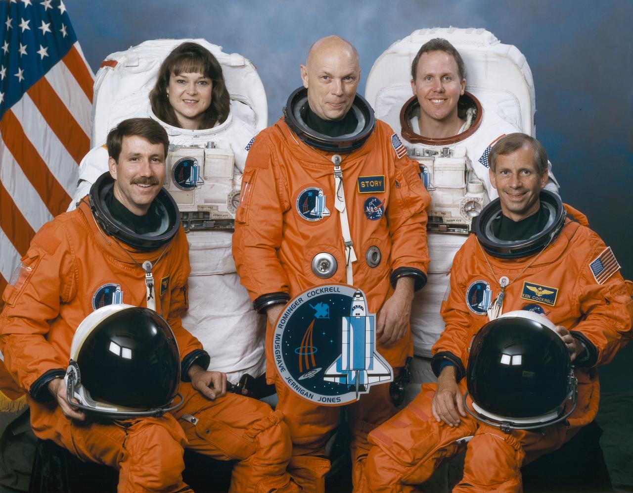
The crew assigned to the STS-79 mission included (seated left to right) Kent V. Rominger, pilot; and Kenneth D. Cockrell, commander. Standing (left to right) are mission specialists Tamara E. Jernigan, F. Story Musgrave, and Thomas D. Jones. Launched aboard the Space Shuttle Columbia on November 19, 1996 at 2:55:47 pm (EST), the STS-80 mission marked the final flight of 1996. The crew successfully deployed and operated the Orbiting and Retrievable Far and Extreme Ultraviolet Spectrometer-Shuttle Pallet Satellite II (ORFEUS-SPAS II), and deployed and retrieved the Wake Shield Facility-3 (WSF-3).
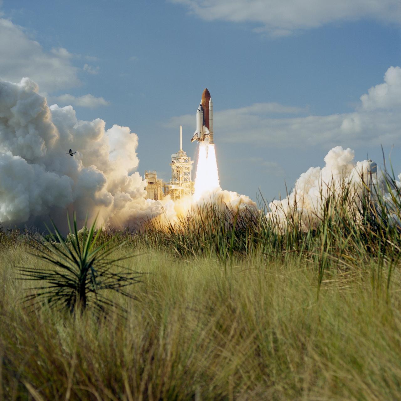
STS080-S-005 (19 Nov. 1996) --- The space shuttle Columbia lifts off from the Kennedy Space Center's (KSC) Launch Pad 39B at 2:55:47 p.m. (EST), Nov. 19, 1996. Onboard are astronauts Kenneth D. Cockrell, mission commander; Kent V. Rominger, pilot; along with Story Musgrave, Tamara E. Jernigan and Thomas D. Jones, all mission specialists. The two primary payloads for STS-80 stowed in Columbia's cargo bay for later deployment and testing are the Wake Shield Facility (WSF-3) and the Orbiting and Retrievable Far and Extreme Ultraviolet Spectrometer (ORFEUS) with its associated Shuttle Pallet Satellite (SPAS).
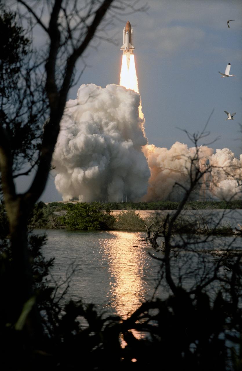
STS080-S-003 (19 Nov. 1996) --- The space shuttle Columbia lifts off from the Kennedy Space Center's (KSC) Launch Pad 39B at 2:55:47 p.m. (EST), November 19, 1996. Onboard are astronauts Kenneth D. Cockrell, mission commander; Kent V. Rominger, pilot; along with Story Musgrave, Tamara E. Jernigan and Thomas D. Jones, all mission specialists. The two primary payloads for STS-80 stowed in Columbia's cargo bay for later deployment and testing are the Wake Shield Facility (WSF-3) and the Orbiting and Retrievable Far and Extreme Ultraviolet Spectrometer (ORFEUS) with its associated Shuttle Pallet Satellite (SPAS).
STS080-S-006 (19 Nov. 1996) --- The space shuttle Columbia lifts off from the Kennedy Space Center's (KSC) Launch Pad 39B at 2:55:47 p.m. (EST), Nov. 19, 1996. Onboard are astronauts Kenneth D. Cockrell, mission commander; Kent V. Rominger, pilot; along with Story Musgrave, Tamara E. Jernigan and Thomas D. Jones, all mission specialists. The two primary payloads for STS-80 stowed in Columbia's cargo bay for later deployment and testing are the Wake Shield Facility (WSF-3) and the Orbiting and Retrievable Far and Extreme Ultraviolet Spectrometer (ORFEUS) with its associated Shuttle Pallet Satellite (SPAS).
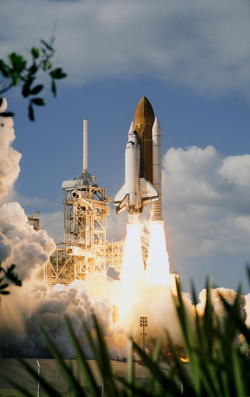
STS080-S-004 (19 Nov. 1996) --- The space shuttle Columbia lifts off from the Kennedy Space Center's (KSC) Launch Pad 39B at 2:55:47 p.m. (EST), Nov. 19, 1996. Onboard are astronauts Kenneth D. Cockrell, STS-80 mission commander; Kent V. Rominger, pilot; along with Story Musgrave, Tamara E. Jernigan and Thomas D. Jones, all mission specialists. The two primary payloads for STS-80 stowed in Columbia's cargo bay for later deployment and testing are the Wake Shield Facility (WSF-3) and the Orbiting and Retrievable Far and Extreme Ultraviolet Spectrometer (ORFEUS) with its associated Shuttle Pallet Satellite (SPAS).

Images of the Milky Way and the Large Magellanic Cloud (LMC) are overlaid on a map of the surrounding area, our galaxy's galactic halo. Dark blue represents a low concentration of stars; lighter blues indicate increasing stellar density. The map spans from about 200,000 light-years to 325,000 light-years from the galactic center and provides the first clear view of the major features in this region. The LMC is orbiting the Milky Way and will eventually merge with it. The high concentration in the lower half is a wake created by the LMC as it sails through the galactic halo. In the upper half of the image, astronomers observed an apparent excess of stars compared to the southern hemisphere. This is evidence that the Large Magellanic Cloud has pulled the Milky Way disk significantly off-center. The galactic halo can be thought of as a bubble surrounding the disk. The number of stars per area is highest near the center of the bubble, and drops off moving away from the center. If the Milky Way were in the center of the halo, astronomers would see an approximately equal number of stars in both hemispheres. But because the Milky Way has been pulled away from the center, when astronomers look into the northern hemisphere, they see more of the central, highly populated area. Comparing these two views, there is an apparent excess of stars in the northern hemisphere. The image of the Milky Way used here is from the ESA (European Space Agency) Gaia mission: https://www.eso.org/public/images/eso1908e/. https://photojournal.jpl.nasa.gov/catalog/PIA24571
STS080-742-070 (19 Nov.-7 Dec. 1996) --- A view of the Tongue of the Ocean in the Bahama Islands east of Florida. The lines leading from the flat bottom of the Great Bahama Bank, leading into the Tongue, are caused by rapid transfer of ocean water caused by both temperature changes in the water and hurricanes that periodically cross the area. The water is about 30 feet deep on the Great Bahama Bank, and nearly a mile deep in the tongue. To the left is the Exuma Sound, over a mile deep, and a series of islands along its edge with Great Exuma Island the easiest to see. Green Cay, the small dot lower left, leaving a wake to the southeast of light colored coral. The deep blue area to the top right center is the southeastern edge of the Great Bahama Bank.
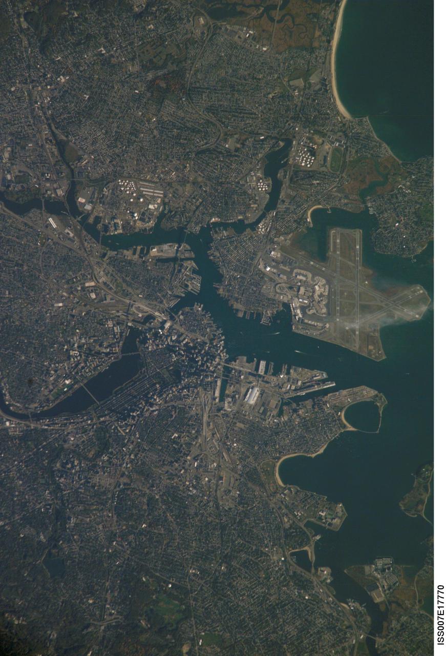
ISS007-E-17770 (20 October 2003) --- Boston, Massachusetts was featured in this image taken by one of the Expedition 7 crewmembers onboard the International Space Station (ISS). The image provides a good view of the center of the city, including famous colonial and independence locations extending from Boston Common to the North End. Wispy clouds hover over the south end of Logan Airport. Ship traffic in the Charles and Mystic Rivers is marked by wakes of the ships. And highly reflective construction locations, including the new I-93 and the bridge over the Charles River, and highway exchanges at Logan Airport mark the new elements of Boston's Big Dig, which is the local transportation project that is now believed to be the largest civil engineering endeavor in U.S. history.