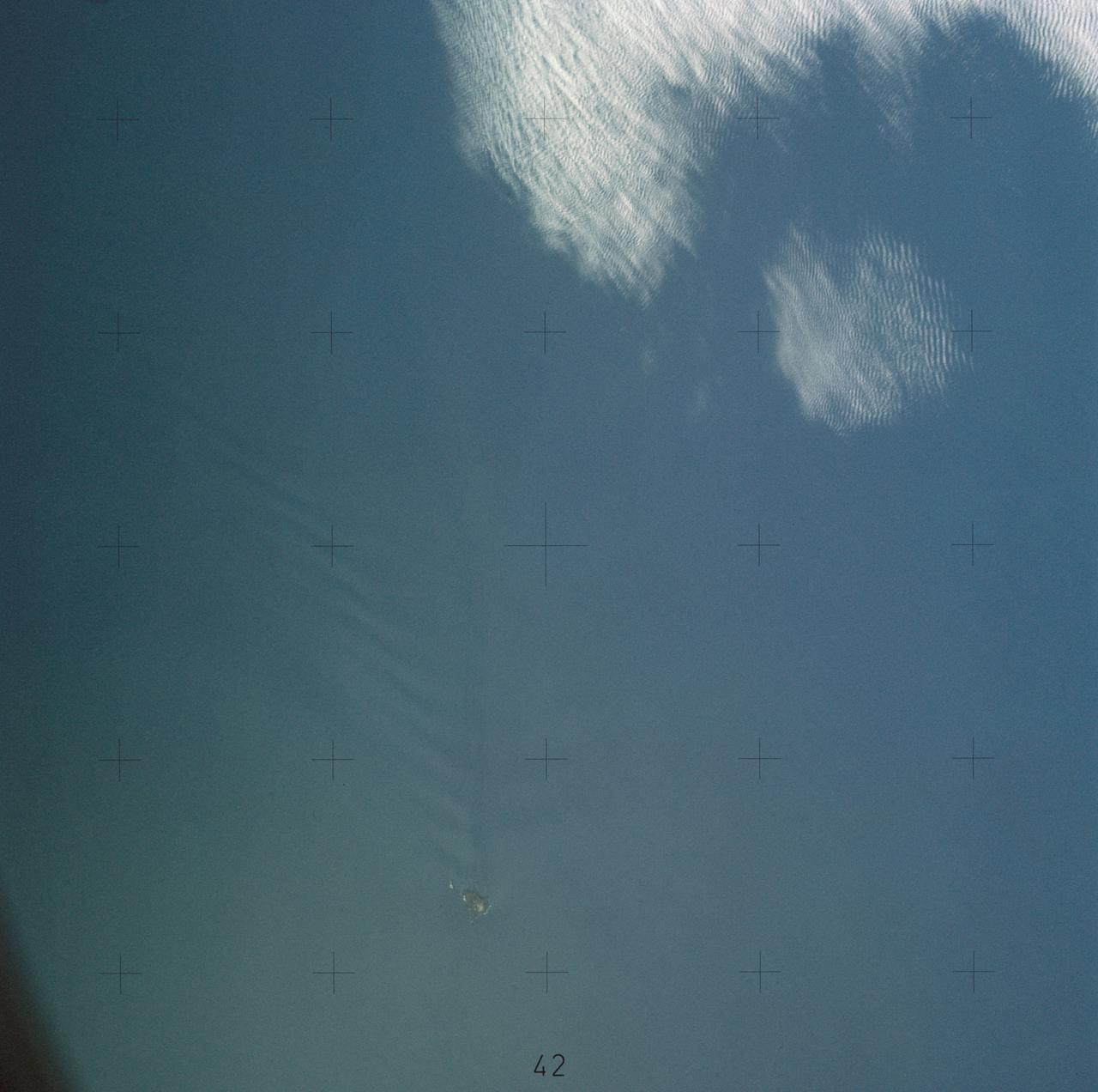
SL4-137-3655 (16 Dec. 1973) --- An island wake produced by the Antipodes Islands in the ocean current south of New Zealand is seen in this photograph taken from the Skylab space station in Earth orbit. A Skylab 4 crewmen took the picture with a hand-held 70mm Hasselblad camera. The bow wave pattern is quite evident and can be used to determine the current speed from the angle of the bow wave if the propagation speed of the surface wave is known. Also, evident is the darker band extending downstream from the island tens of miles. This is the actual wake of the island. The existence of water color differences from within to outside a turbulent island wake may indicate a temperature difference, with cooler water being stirred to the surface in the wake. This temperature difference could be used to drive a thermo-electric type generator to reduce small islands' dependence on imported oil for power generation. Photo credit: NASA

Long ago, a large lava flow passed through the Athabasca Valles region of Mars. We can tell which direction it was flowing by examining the surface of the flow and the remaining "lava wakes." Although you can't sail a boat on a sea of lava, hills and craters that stick up higher than the lava flow act like barriers. When a boat is driven through the water, there is a bow wave at the front of the boat, and a wake that trails off behind that indicates which way the boat is moving. In a lava flow, when a hill sticks up, the lava piles up on the upstream side (just like a bow wave) and can leave a wake on the downstream side, so we can tell which way the lava was moving against the stationary hill. This image has a large crater and some nearby smaller hills. The large crater has a pile up of lava on one side, but is so big that it doesn't really have a clear wake. However, there are smaller hills with lava pileup that have beautiful linear features trailing off in the same direction. These lava wakes show us which direction the lava was moving against these hills. https://photojournal.jpl.nasa.gov/catalog/PIA25558
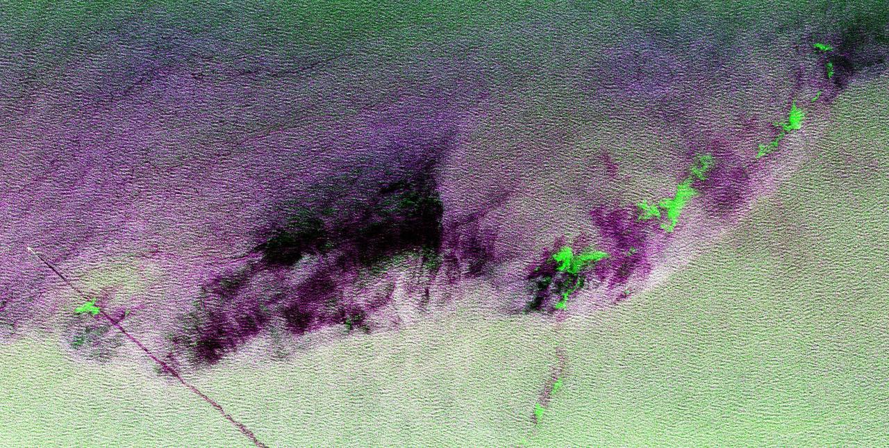
This is a radar image showing surface features on the open ocean in the northeast Atlantic Ocean. There is no land mass in this image. The purple line in the lower left of the image is the stern wake of a ship. The ship creating the wake is the bright white spot on the middle, left side of the image. The ship's wake is about 28 kilometers (17 miles) long in this image and investigators believe that is because the ship may be discharging oil. The oil makes the wake last longer and causes it to stand out in this radar image. A fairly sharp boundary or front extends from the lower left to the upper right corner of the image and separates two distinct water masses that have different temperatures. The different water temperature affects the wind patterns on the ocean. In this image, the light green area depicts rougher water with more wind, while the purple area is calmer water with less wind. The dark patches are smooth areas of low wind, probably related to clouds along the front, and the bright green patches are likely due to ice crystals in the clouds that scatter the radar waves. The overall "fuzzy" look of this image is caused by long ocean waves, also called swells. Ocean radar imagery allows the fine detail of ocean features and interactions to be seen, such as the wake, swell, ocean front and cloud effects, which can then be used to enhance the understanding of ocean dynamics on smaller and smaller scales. The image is centered at 42.8 degrees north latitude, 26.2 degrees west longitude and shows an area approximately 35 kilometers by 65 kilometers (22 by 40 miles). The colors in the image are assigned to different frequencies and polarizations of the radar as follows: red is L-band horizontally transmitted, horizontally received; green is C-band horizontally transmitted, horizontally received; blue is L-band vertically transmitted, vertically received. This image was acquired by the Spaceborne Imaging Radar-C/X-band Synthetic Aperture Radar (SIR-C/X-SAR) imaging radar when it flew aboard the space shuttle Endeavour on April 11, 1994. SIR-C/X-SAR, a joint mission of the German, Italian and United States space agencies, is part of NASA's Mission to Planet Earth. http://photojournal.jpl.nasa.gov/catalog/PIA01799
Swift currents flow through the Strait of Gibraltar, producing complicated patterns in the surface waters. Some of those patterns are highlighted in the sunglint in this photograph. The Mediterranian Sea is on the upper right, the Atlantic Ocean in in the lower left. Few features can be seen on the Mediterranian side, but current shears (straight lines coming off Spain), several sets of internal waves (impinging on the Spanish continental shelf) and ship wakes can be seen on the Atlantic side, west of Cadiz. Both Tangier and Cadiz show up in the sunglint as well.
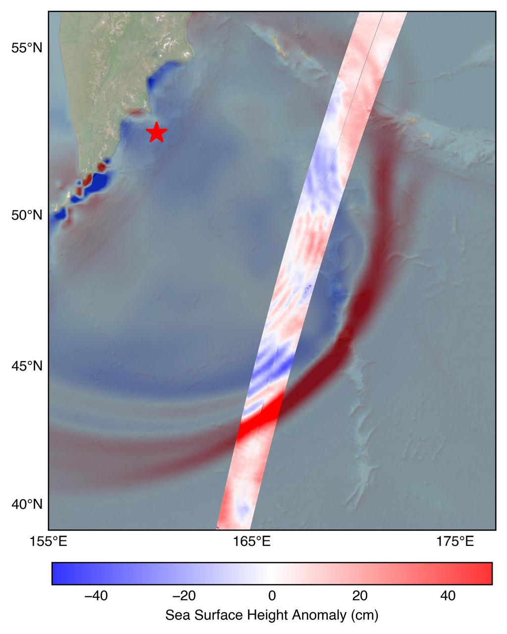
The U.S.-French SWOT (Surface Water and Ocean Topography) satellite captured the leading edge of a tsunami wave that rolled through the Pacific Ocean on July 30, 2025 (11:25 a.m. local time), in the wake of a magnitude 8.8 earthquake that struck Russia's Kamchatka Peninsula. The satellite captured the data about 70 minutes after the earthquake struck. The SWOT sea level measurements, shown in the highlighted swath from the satellite's ground track, is plotted against a tsunami forecast model from the National Oceanic and Atmospheric Administration (NOAA) Center for Tsunami Research in the background. A red star marks the location of the earthquake. The measurements show a wave height exceeding 1.5 feet (45 centimeters) as well as a look at the shape and direction of travel of the leading edge of the wave (indicated in red). Researchers noted that while the wave height might seem small, tsunamis extend from the seafloor to the ocean surface. A seemingly small wave in the open ocean can become much larger in shallower coastal waters. https://photojournal.jpl.nasa.gov/catalog/PIA26652

STS054-72-056 (13-19 Jan 1993) --- A ship wake in the Bay of Bengal is noticeable in this 70mm frame. The sun glint pattern on the ocean reveals many patterns of sea surface roughness related to currents, waves, wind roughening, and biology that and are not apparent when the ocean is viewed away from the Sun's reflection. In this view of the Bay of Bengal, southeast of Madras, India, sun glint highlights convergence zones between ocean currents (bright, linear features), a eddy, and the wake of a ship. In several locations where the ship has passed areas of current shear, the ship wake is distorted, indicating the relative current direction.
ISS030-E-193144 (25 March 2012) --- Wave clouds near Ile aux Cochons are featured in this image photographed by an Expedition 30 crew member on the International Space Station. This photograph illustrates the formation of wave clouds in the wake—or downwind side—of Ile aux Cochons (“Isle of Pigs”) located in the Southern Indian Ocean. The island is approximately located 3,000 kilometers southeast of the southern tip of the African continent and 2,300 kilometers northwest of Antarctica. The island itself, of which only a part of the eastern coastline is visible at center, is volcanic in origin with a summit elevation of 775 meters above sea level. According to scientists, the Ile aux Cochons stratovolcano is thought to have erupted within the last 12,000 years; however no historical activity has been recorded. The summit elevation is high enough for the land surface to interact with cloud layers and winds flowing past the island. Two major cloud layers are visible; a lower, more uniform layer consists of roughly parallel cloud “streets” that suggest a westerly flow pattern of air. When the air mass encounters the Ile aux Cochons, moisture-laden air rises and cools, causing more water vapor to condense into clouds. As the air mass passes over the summit of Ile aux Cochons and descends, it may encounter alternating moist and dry air layers, enabling the formation of the discontinuous chevron-shaped wave clouds in the wake of the island. While their appearance suggests that the clouds are forming in the wake of the island and moving eastwards, in fact it is the air mass that is moving, with clouds forming in regions of moist air and dissipating in dry regions. Ile aux Cochons is the westernmost of the islands that form the subantarctic Crozet Archipelago (part of the French Southern and Antarctic Lands). Accept for occasional research visits, the island is uninhabited. The island is an important breeding site for seabirds, including the world’s largest King Penguin colony.
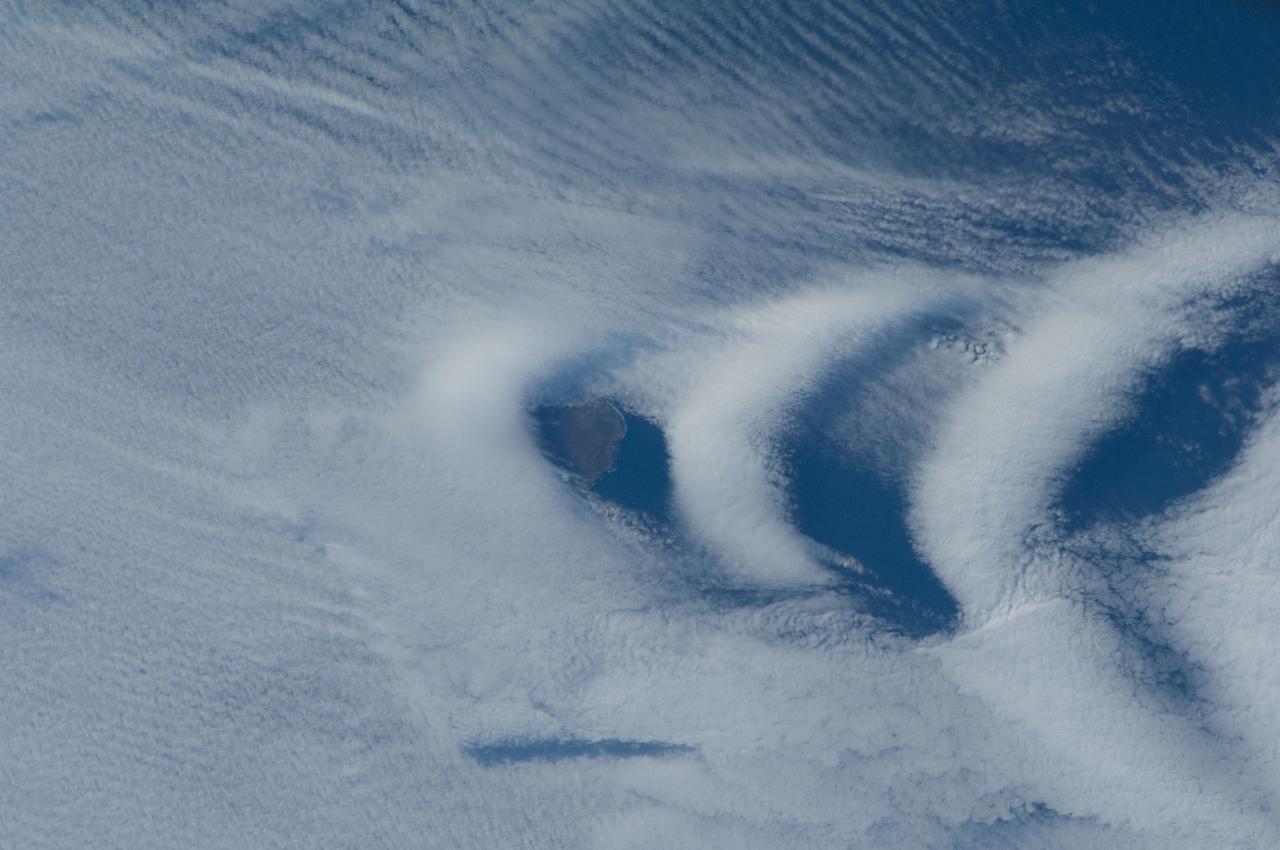
STS089-743-004 (22-31 Jan. 1998) --- This picture showing Auckland Island, New Zealand was photographed with a 70mm handheld camera from the Earth-orbiting space shuttle Endeavour. A spectacular occurrence of internal waves in the ocean is visible in the wake of the island. These waves can be generated by currents or, in some cases, wind across the island. In this case, the observation was that these waves were visible after the sunglint disappeared, suggesting current generated effects. If so, the circum-polar current that moves west-east around Antarctica would generate the scalloped appearance in the water east of the island. There is characteristically very little surface expression to these waves so they would not be noticed by a ship in this region. Fundamental processes of oceanic circulation and interaction are poorly understood. These shots help oceanographers model the dynamics of the open ocean and work out mixing models for ocean layer and ocean-air interaction (important for modeling CO2 budget, for example). The long linear valleys and bays have been excavated by glaciers cutting into this long-extinct volcano. This island is located on the submerged Campbell Plateau, which is an area almost as large as the exposed land of South Island, New Zealand. Scientists report that the plateau was submerged when New Zealand, Antarctica and Australia separated "around 75 million years ago." This could be viewed as one of the tallest mountains on the plateau. Usually the weather in this area is bad so this photo opportunity was considered a "great catch." Photo credit: NASA
![On June 26, 2016, the Moderate Resolution Imaging Spectroradiometer (MODIS) on NASA’s Terra satellite acquired this natural-color image of cloud gravity waves off the coast of Angola and Namibia. “I [regularly] look at this area on Worldview because you quite often have these gravity waves,” said Bastiaan Van Diedenhoven, a researcher for Columbia University and NASA's Goddard Institute for Space Studies interested in cloud formations. “On this day, there was so much going on—so many different waves from different directions—that they really started interfering.” A distinctive criss-cross pattern formed in unbroken stretches hundreds of kilometers long. Similar to a boat’s wake, which forms as the water is pushed upward by the boat and pulled downward again by gravity, these clouds are formed by the rise and fall of colliding air columns. Off of west Africa, dry air coming off the Namib desert—after being cooled by the night—moves out under the balmy, moist air over the ocean and bumps it upwards. As the humid air rises to a higher altitude, the moisture condenses into droplets, forming clouds. Gravity rolls these newly formed clouds into a wave-like shape. When moist air goes up, it cools, and then gravity pushes it down again. As it plummets toward the earth, the moist air is pushed up again by the dry air. Repeated again and again, this process creates gravity waves. Clouds occur at the upward wave motions, while they evaporate at the downward motions. Such waves will often propagate in the morning and early afternoon, said Van Diedenhoven. During the course of the day, the clouds move out to sea and stretch out, as the dry air flowing off the land pushes the moist ocean air westward. NASA Earth Observatory image by Jesse Allen, using data from the Land Atmosphere Near real-time Capability for EOS (LANCE). via @NASAEarth <a href="http://go.nasa.gov/29Btxcy" rel="nofollow">go.nasa.gov/29Btxcy</a> <b><a href="http://go.nasa.gov/29BtHR6" rel="nofollow">NASA image use policy.</a></b> <b><a href="http://go.nasa.gov/29BtDku" rel="nofollow">NASA Goddard Space Flight Center</a></b> enables NASA’s mission through four scientific endeavors: Earth Science, Heliophysics, Solar System Exploration, and Astrophysics. Goddard plays a leading role in NASA’s accomplishments by contributing compelling scientific knowledge to advance the Agency’s mission. <b>Follow us on <a href="http://go.nasa.gov/29BtVrn" rel="nofollow">Twitter</a></b> <b>Like us on <a href="http://go.nasa.gov/29BtygK" rel="nofollow">Facebook</a></b> <b>Find us on <a href="http://go.nasa.gov/29Bu0vu" rel="nofollow">Instagram</a></b>](https://images-assets.nasa.gov/image/GSFC_20171208_Archive_e000269/GSFC_20171208_Archive_e000269~medium.jpg)
On June 26, 2016, the Moderate Resolution Imaging Spectroradiometer (MODIS) on NASA’s Terra satellite acquired this natural-color image of cloud gravity waves off the coast of Angola and Namibia. “I [regularly] look at this area on Worldview because you quite often have these gravity waves,” said Bastiaan Van Diedenhoven, a researcher for Columbia University and NASA's Goddard Institute for Space Studies interested in cloud formations. “On this day, there was so much going on—so many different waves from different directions—that they really started interfering.” A distinctive criss-cross pattern formed in unbroken stretches hundreds of kilometers long. Similar to a boat’s wake, which forms as the water is pushed upward by the boat and pulled downward again by gravity, these clouds are formed by the rise and fall of colliding air columns. Off of west Africa, dry air coming off the Namib desert—after being cooled by the night—moves out under the balmy, moist air over the ocean and bumps it upwards. As the humid air rises to a higher altitude, the moisture condenses into droplets, forming clouds. Gravity rolls these newly formed clouds into a wave-like shape. When moist air goes up, it cools, and then gravity pushes it down again. As it plummets toward the earth, the moist air is pushed up again by the dry air. Repeated again and again, this process creates gravity waves. Clouds occur at the upward wave motions, while they evaporate at the downward motions. Such waves will often propagate in the morning and early afternoon, said Van Diedenhoven. During the course of the day, the clouds move out to sea and stretch out, as the dry air flowing off the land pushes the moist ocean air westward. NASA Earth Observatory image by Jesse Allen, using data from the Land Atmosphere Near real-time Capability for EOS (LANCE). via @NASAEarth <a href="http://go.nasa.gov/29Btxcy" rel="nofollow">go.nasa.gov/29Btxcy</a> <b><a href="http://go.nasa.gov/29BtHR6" rel="nofollow">NASA image use policy.</a></b> <b><a href="http://go.nasa.gov/29BtDku" rel="nofollow">NASA Goddard Space Flight Center</a></b> enables NASA’s mission through four scientific endeavors: Earth Science, Heliophysics, Solar System Exploration, and Astrophysics. Goddard plays a leading role in NASA’s accomplishments by contributing compelling scientific knowledge to advance the Agency’s mission. <b>Follow us on <a href="http://go.nasa.gov/29BtVrn" rel="nofollow">Twitter</a></b> <b>Like us on <a href="http://go.nasa.gov/29BtygK" rel="nofollow">Facebook</a></b> <b>Find us on <a href="http://go.nasa.gov/29Bu0vu" rel="nofollow">Instagram</a></b>
There are special places on Earth that sometimes write their personal signature in the clouds. The Crozet Islands are one such place, thanks to the tall volcanic peaks that grace the islands. When air flows around these tall peaks, it gets pushed around the islands as well as up and over the peak. The net effect of the flowing air flowing around the solid, tall peaks is much like the solid bow of a ship cutting through standing water. In each case v-shaped waves are formed behind the motion. In liquid, this is called a wake; in the atmosphere, when clouds are present or created, they are known as ship-wave-shaped clouds. The Moderate Resolution Imaging Spectroradiometer (MODIS) aboard NASA’s Terra satellite captured this true-color image as it passed over the Crozet Islands on November 26, 2014. Three distinct waves are seen behind the three largest islands. From west to east these are Pig Island, Possession Island and East Island. Credit: NASA/GSFC/Jeff Schmaltz/MODIS Land Rapid Response Team <b><a href="http://www.nasa.gov/audience/formedia/features/MP_Photo_Guidelines.html" rel="nofollow">NASA image use policy.</a></b> <b><a href="http://www.nasa.gov/centers/goddard/home/index.html" rel="nofollow">NASA Goddard Space Flight Center</a></b> enables NASA’s mission through four scientific endeavors: Earth Science, Heliophysics, Solar System Exploration, and Astrophysics. Goddard plays a leading role in NASA’s accomplishments by contributing compelling scientific knowledge to advance the Agency’s mission. <b>Follow us on <a href="http://twitter.com/NASAGoddardPix" rel="nofollow">Twitter</a></b> <b>Like us on <a href="http://www.facebook.com/pages/Greenbelt-MD/NASA-Goddard/395013845897?ref=tsd" rel="nofollow">Facebook</a></b> <b>Find us on <a href="http://instagram.com/nasagoddard?vm=grid" rel="nofollow">Instagram</a></b>
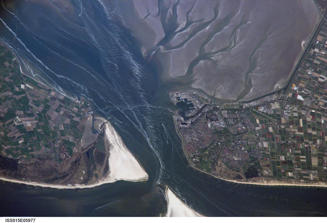
ISS015-E-05977 (1 May 2007) --- Den Helder, Netherlands is featured in this image photographed by an Expedition 15 crewmember on the International Space Station. The city and harbor of Den Helder in the northern Netherlands has been the home port of the Dutch Royal Navy for over 175 years. Its favorable location provides access to the North Sea, and has made it an important commercial shipping port in addition to its strategic role. Bright red agricultural fields to the south of Den Helder indicate another noteworthy aspect of the region--commercial farming of tulips and hyacinth. This image is an oblique view--the camera is oriented at an angle relative to "straight down"--of the Den Helder region taken from the space station, which was located to the southeast, near Dulmen, Germany (approximately 225 kilometers away in terms of ground distance) when the image was acquired. In addition to the manmade structures of the Den Helder urban area (reddish gray to gray street grids) and dockyards to the east of the city, several striking geomorphic features are visible. The extensive gray mudflats, with their prominent branching pattern (top right), indicate that this image was acquired at low tide, and suggest the general low elevation of the region. Parallel wave patterns along the mudflats and in the Marsdiep strait are formed as water interacts with the sea bottom between Den Helder and Texel Island during tidal flow. Some ship wakes are also visible. According to scientists, the bright white-gray triangular region at the southern tip of Texel Island (bottom center) is a dune field, consisting mainly of eolian (windborne) sands deposited during the last Ice Age. Subsequent sea level rise and shoreline processes have mobilized and re-deposited these sands into their current configuration -- including a new dune field island to the southwest of Texel (bottom center).