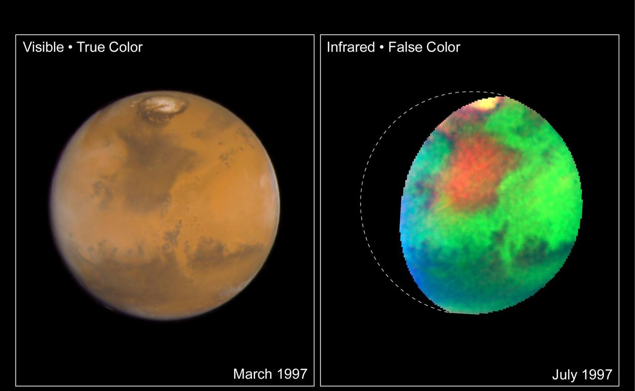
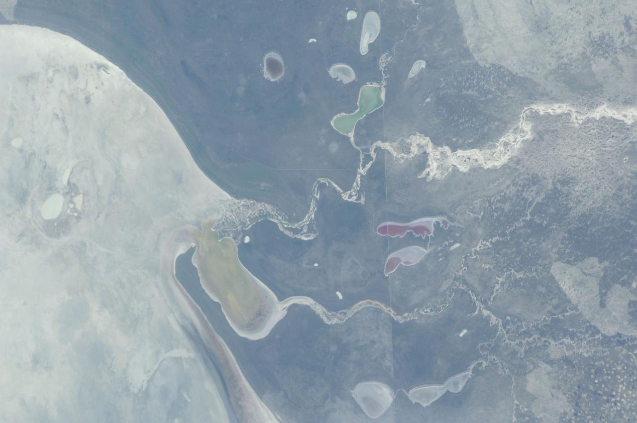
Martian Colors Provide Clues About Martian Water
STS034-10-014 (18-23 Oct. 1989) --- An onboard 35mm camera provides a closeup view of an STS-34 beverage container doubling as an experiment module for a test involving iodine concentration in onboard water. The examination called for the adding of starch to a specimen of Atlantis' fuel-cell produced water. The liquid was then compared against the color chart for determining the degree of iodine content. The experiment was designed by Terry H. Slezak of JSC's Photographic Technology and Television Division.
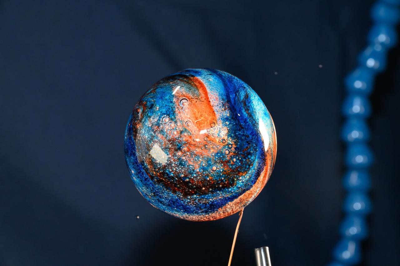
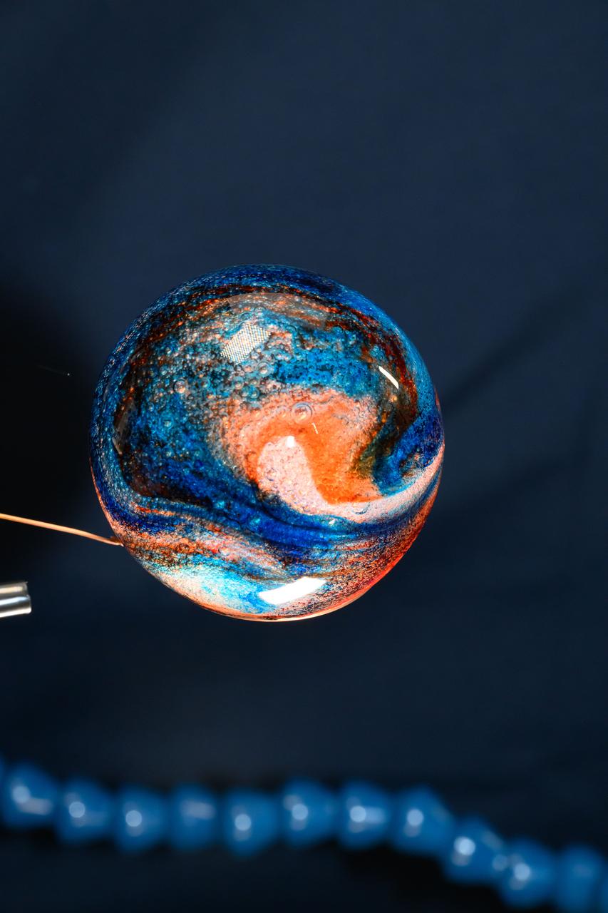
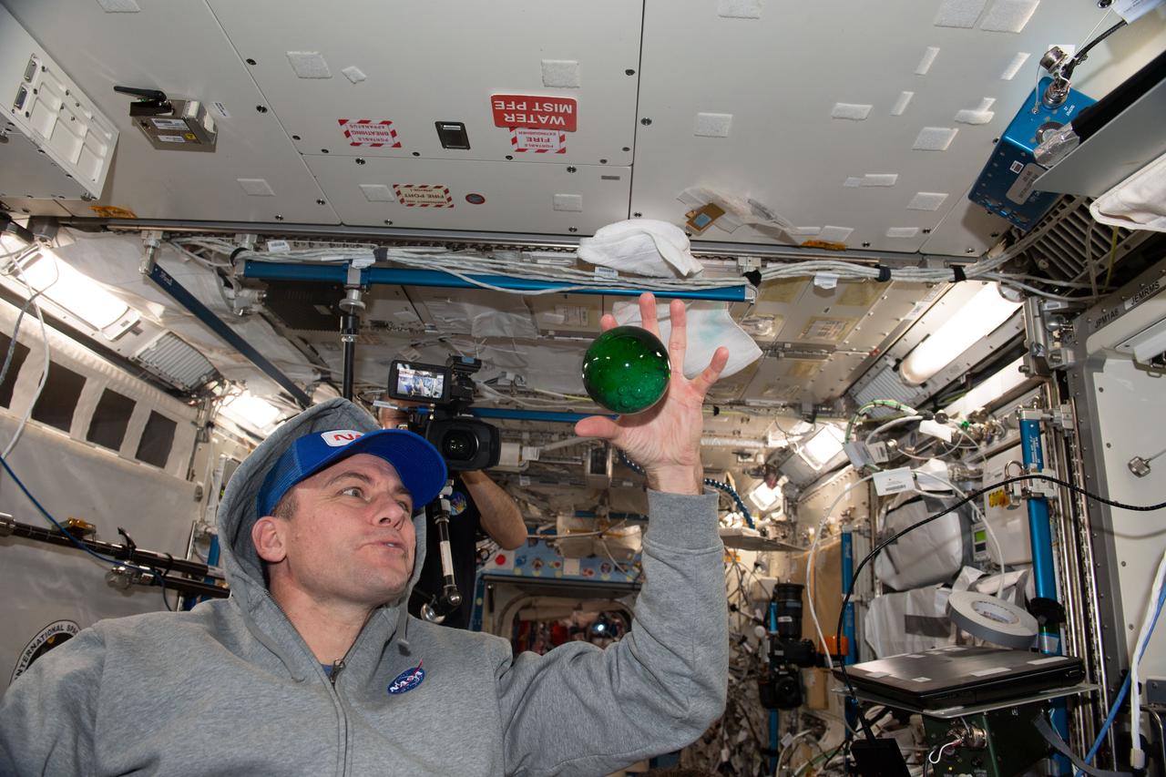
iss072e069593 (Oct. 19, 2024) --- Space science is fun! NASA astronaut and Expedition 72 Flight Engineer Don Pettit filled this sphere of water with food coloring creating a Jupiter-like effect in the microgravity environment of the International Space Station.
iss072e069592 (Oct. 19, 2024) --- Space science is fun! NASA astronaut and Expedition 72 Flight Engineer Don Pettit filled this sphere of water with food coloring creating a Jupiter-like effect in the microgravity environment of the International Space Station.
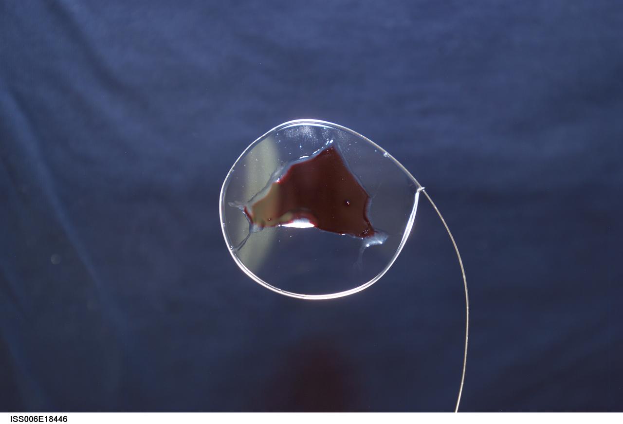
ISS006-E-18446 (19 January 2003) --- View of surface tension demonstration using water that is being held in place by a metal loop. Food coloring has been added to the water for demonstration purposes only. Astronaut Donald R. Pettit, Expedition Six NASA ISS science officer, photographed these demonstrations for educational purposes. The experiment took place in the Destiny laboratory on the International Space Station (ISS).
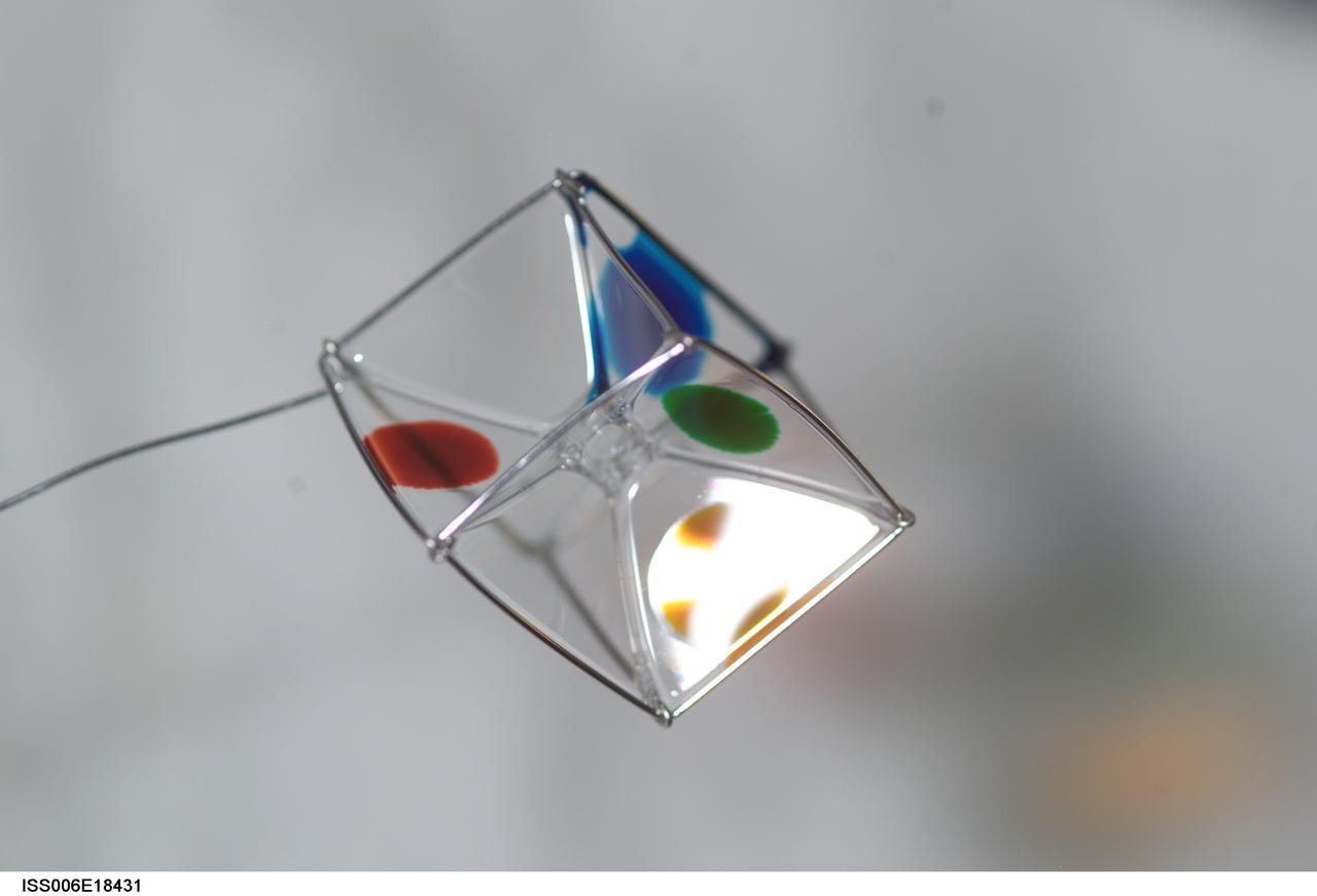
ISS006-E-18431 (19 January 2003) --- View of surface tension demonstration using water that is being held in place by a metal loop. Food coloring has been added to the water for demonstration purposes only. Astronaut Donald R. Pettit, Expedition Six NASA ISS science officer, photographed these demonstrations for educational purposes. The experiment took place in the Destiny laboratory on the International Space Station (ISS).
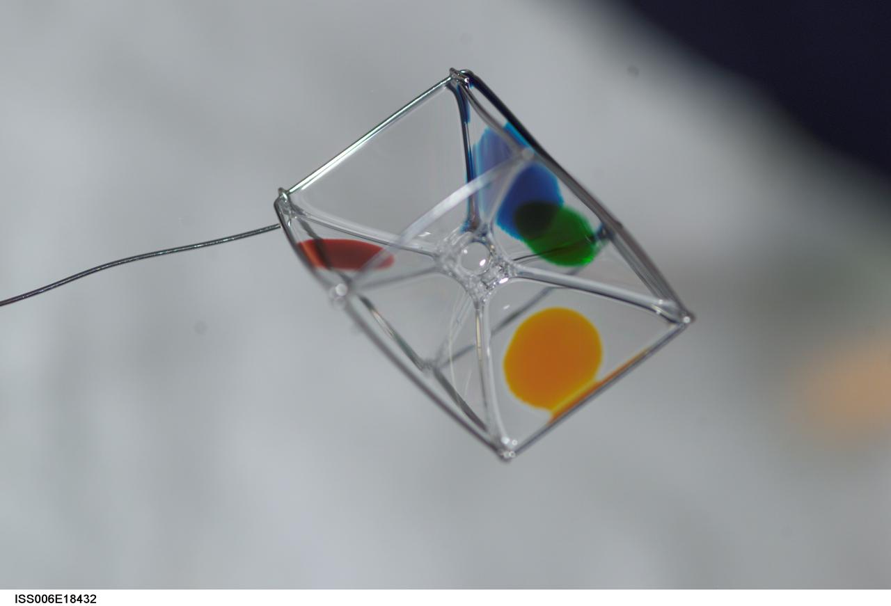
ISS006-E-18432 (19 January 2003) --- View of surface tension demonstration using water that is being held in place by a metal loop. Food coloring has been added to the water for demonstration purposes only. Astronaut Donald R. Pettit, Expedition Six NASA ISS science officer, photographed these demonstrations for educational purposes. The experiment took place in the Destiny laboratory on the International Space Station (ISS).
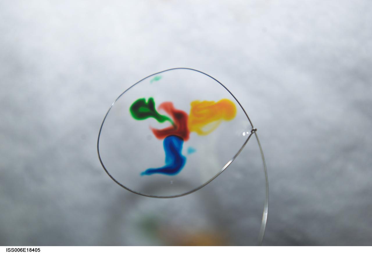
ISS006-E-18405 (19 January 2003) --- View of surface tension demonstration using water that is being held in place by a metal loop. Food coloring has been added to the water for demonstration purposes only. Astronaut Donald R. Pettit, Expedition Six NASA ISS science officer, photographed these demonstrations for educational purposes. The experiment took place in the Destiny laboratory on the International Space Station (ISS).
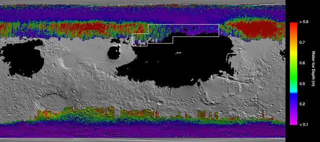
This rainbow-colored map shows underground water ice on Mars. Cool colors represent less than one foot (30 centimeters) below the surface; warm colors are over two feet (60 centimeters) deep. Sprawling black zones on the map represent areas where a landing spacecraft would sink into fine dust. The outlined box represents the ideal region to send astronauts for them to be able to dig up water ice. The map was created by combining data from multiple NASA orbiters, including the Mars Reconnaissance Orbiter and its Mars Climate Sounder instrument; Mars Odyssey and its Thermal Emission Imaging System; and the Mars Global Surveyor. https://photojournal.jpl.nasa.gov/catalog/PIA23514

Color coding in this image of Mars represents differences in elevation, measured by NASA Mars Global Surveyor. While surface liquid water is rare and ephermal on modern Mars.

Water ice mixed with dust form the residual north polar ice cap brown color in these images from NASA's Viking Orbiter 2. http://photojournal.jpl.nasa.gov/catalog/PIA00152

Colors were mapped onto infrared data from NASA's Galileo mission in this image revealing locations around a crater on the Jovian moon Europa called Manannán where there are signatures of water. Manannán was created when a comet or asteroid hit the surface of Europa. The blue colors in this image indicate higher concentrations of water ice in the material thrown out of the crater during impact. Yellow and red show the locations of hydrates, chemically altered forms of water that can bind to other elements. The background black-and-white image was taken by the Galileo solid-state imaging camera, which took images in visible light. The colors correspond to wavelengths of light that are not detectable to the human eye but were observed by Galileo's near-infrared mapping spectrometer. Galileo orbited Jupiter for almost eight years, concluding its mission in 2003. https://photojournal.jpl.nasa.gov/catalog/PIA26104
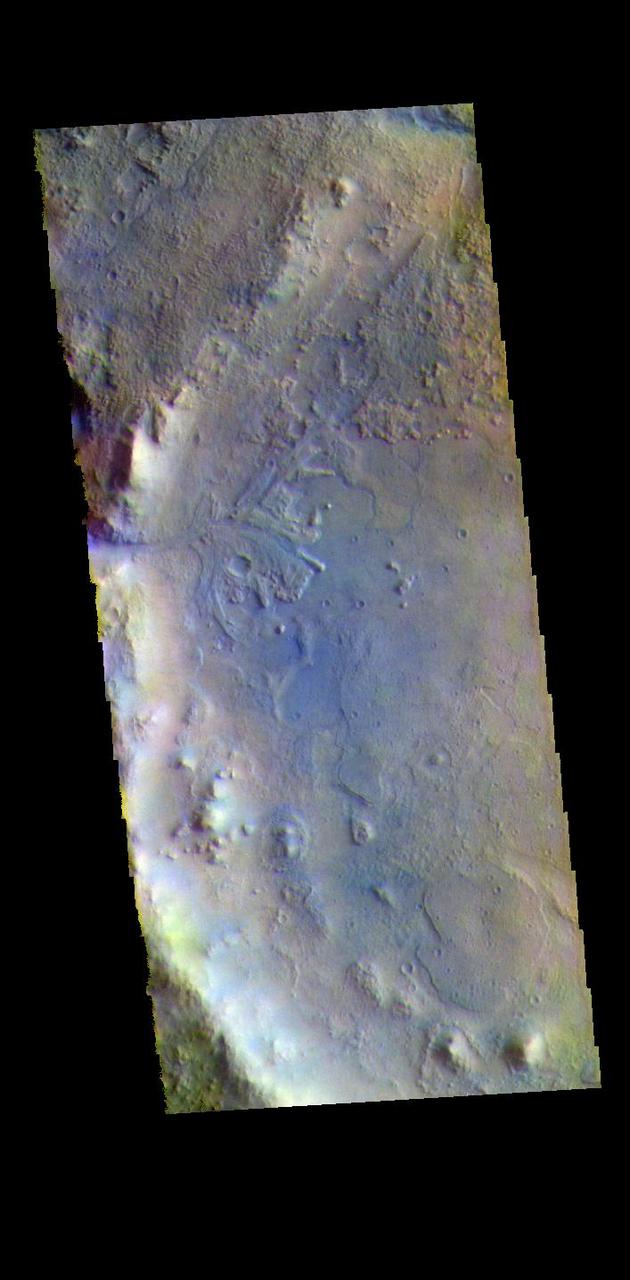
This image from NASA Mars Reconnaissance Orbiter spacecraft the valley networks on Mars are terrains eroded by flowing water billions of years ago. Where bedrock is well exposed, a variety of colors due to altered minerals and polygonal patterns.
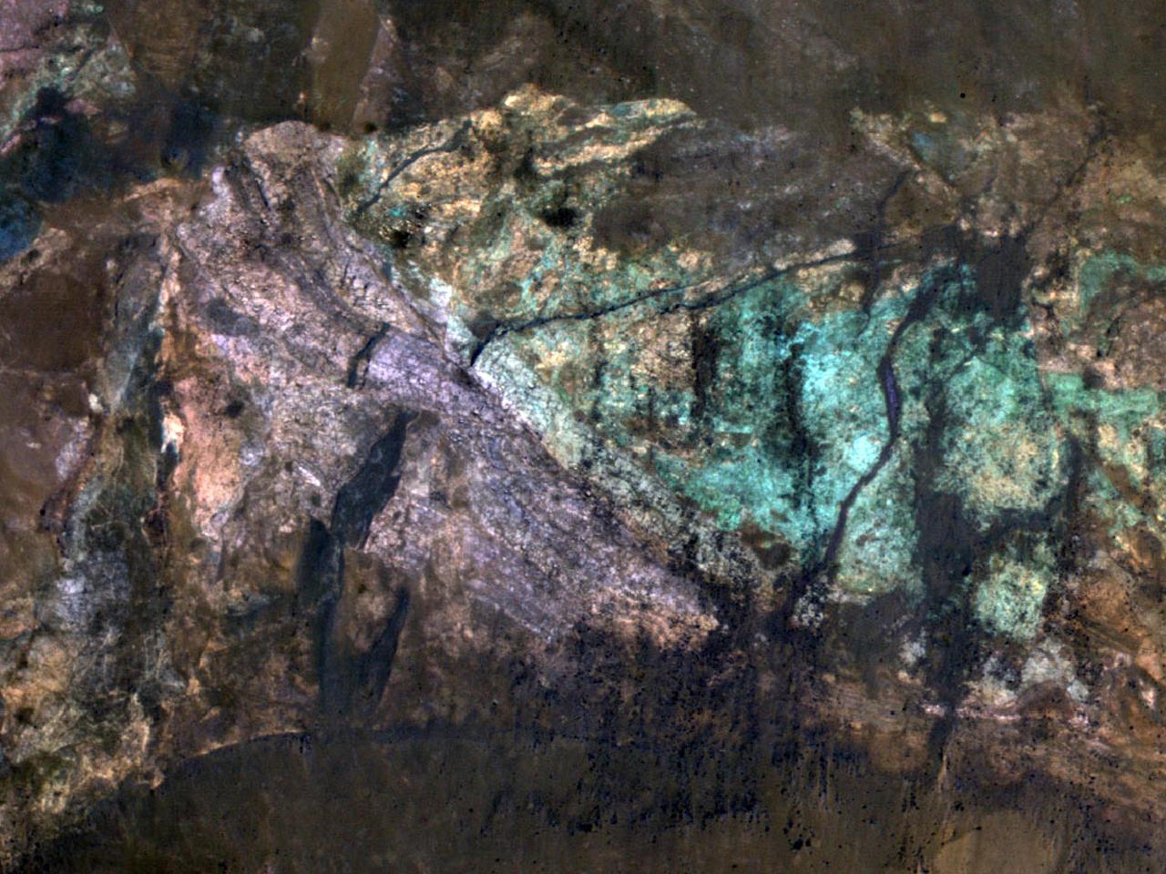
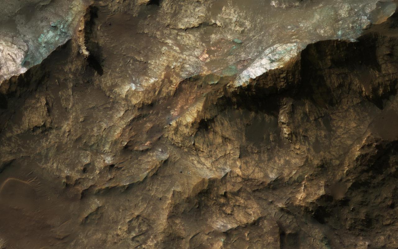
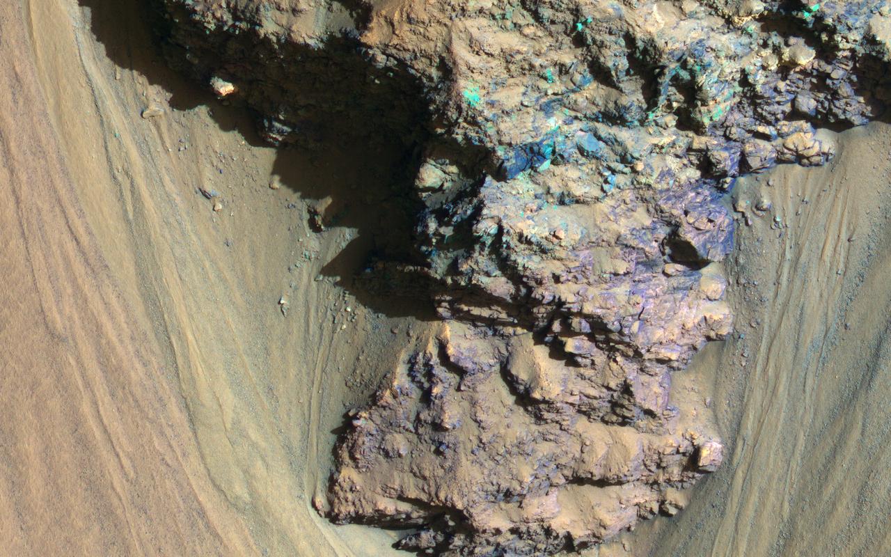
The colorful rocks exposed in the central peak visible in this image from NASA Mars Reconnaissance Orbiter probably reflect variations in mineral content that were caused by water activity early in Mars history.
The colorful rocks exposed in the central peak visible in this image from NASA Mars Reconnaissance Orbiter probably reflect variations in mineral content that were caused by water activity early in Mars history.
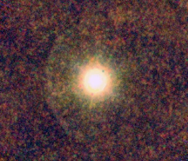
This ESA Herschel image shows IRC+10216, also known as CW Leonis, a star rich in carbon where astronomers were surprised to find water. This color-coded image shows the star, surrounded by a clumpy envelope of dust.
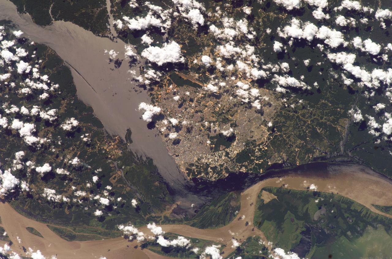
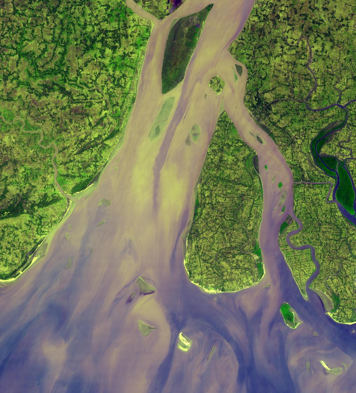
ISS009-E-15488 (7 July 2004) --- Solimoes-Negro River confluence at Manaus, Amazonia is featured in this image photographed by an Expedition 9 crewmember on the International Space Station (ISS). The largest river on the planet, the Amazon, forms from the confluence of the Solimoes (the upper Amazon River) and the Negro at the Brazilian city of Manaus in central Amazonas. At the river conjunction, the muddy, tan colored waters of the Solimoes meet the “black” water of the Negro River. The unique mixing zone where the waters meet extends downstream through the rainforest for hundreds of kilometers, and is a famous attraction for tourists all over the world. It is the vast quantity of sediment eroded from the Andes Mountains that gives the Solimoes its tan color. By comparison, water in the Negro derives from the low jungles where reduced physical erosion of rock precludes mud entering the river. In place of sediment, organic matter from the forest floor stains the river the color of black tea.
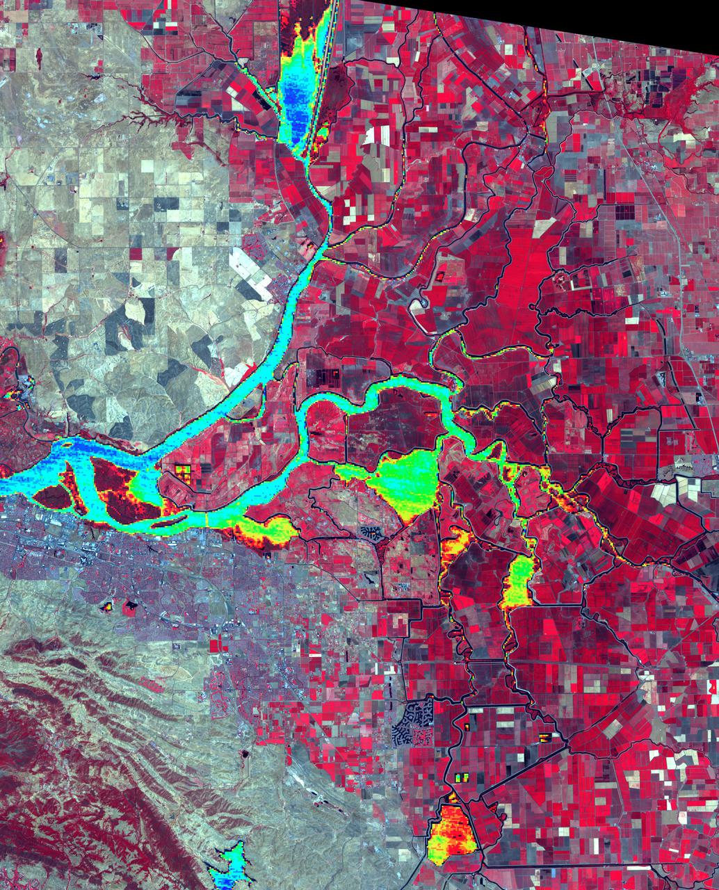
The Sacramento-San Joaquin River Delta, CA (or California Delta) has an area of about 3000 km2, and provides a large fraction of all the water used in California. The Delta drains about 50% of the water coming from the Sierra Nevada Mountains, and channels it through San Francisco's Golden Gate to the Pacific Ocean. Thousands of miles of levees now carefully control the Delta's flow, to maximize water use. The image combines a false color infrared composite (with vegetation depicted in red) with a colorized thermal infrared band to show the water temperature for the larger water bodies. Warmer temperatures are red and yellow, cooler water temperatures are blue and green. The image was acquired July 3, 2012, covers an area of 46.5 by 57.5 km, and is located at 38.1 degrees north, 121.3 degrees west. https://photojournal.jpl.nasa.gov/catalog/PIA24691
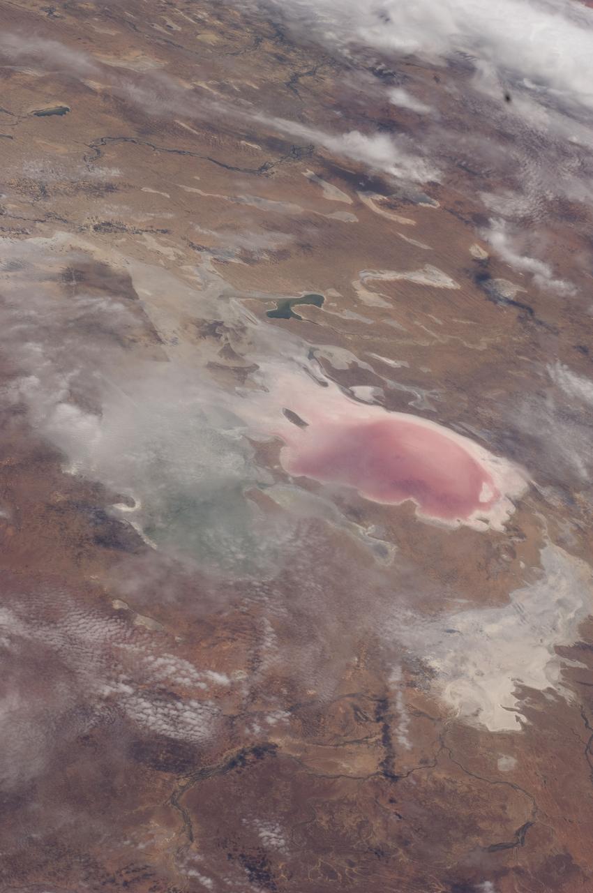
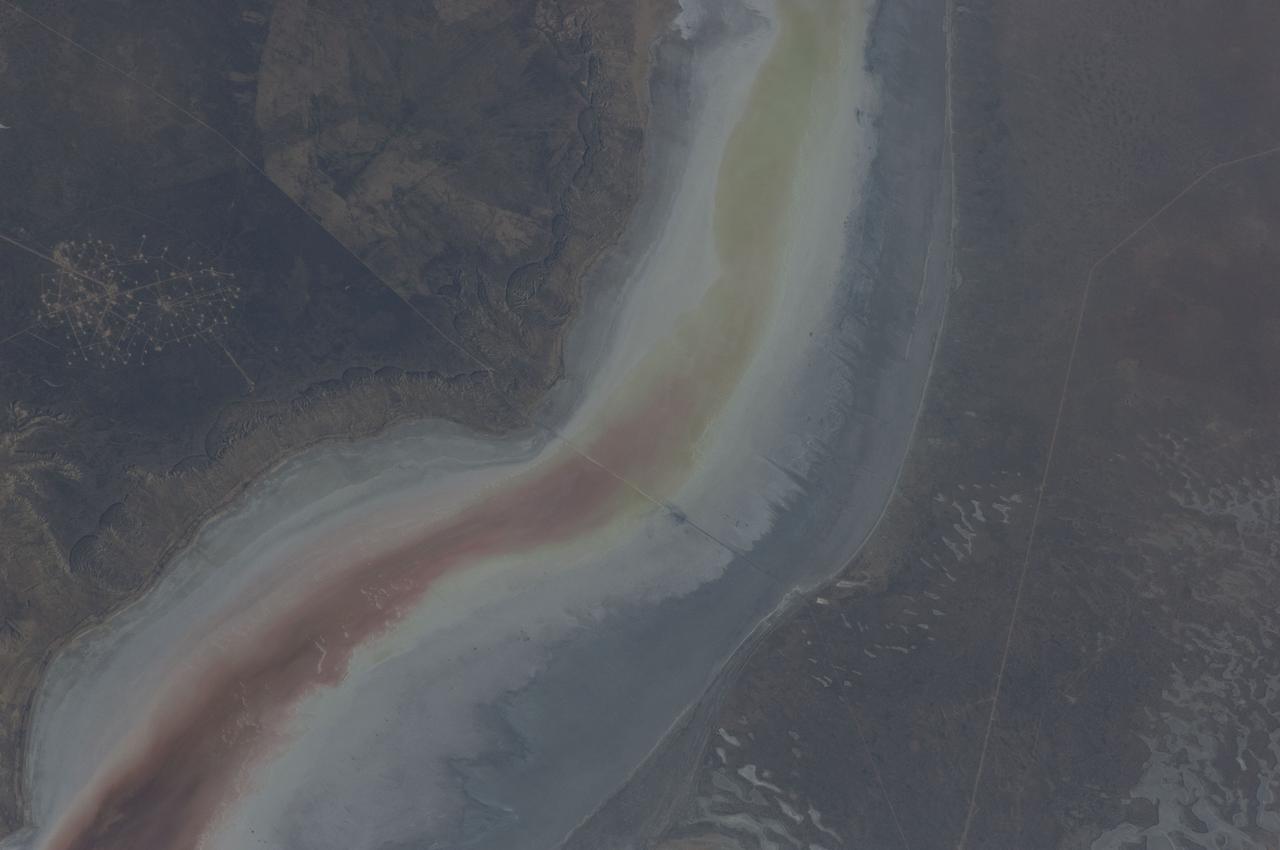
ISS030-E-009271 (5 Dec. 2011) --- Lake Eyre floods in South Australia are featured in this image photographed by an Expedition 30 crew member on the International Space Station. Heavy rain in early March 2011 produced the comparatively unusual event of water entering Lake Eyre. The southernmost and deepest lobes, Belt Bay and Lake Eyre South, were filled first. In this northeast-looking view from the space station, water can be seen in the southern basins of Lake Eyre, especially in Belt Bay where it appears green, and in Madigan Gulf where it appears in shades of pink and red. Despite some cloud, water is also apparent in narrow Jackboot Bay and at the estuary where Cooper Creek, one of the most important inflow rivers, fills a small, dark green lake. The varying water colors result from the effects of water depth and resident organisms. The green coloration of Belt Bay is likely related to its depth, which was reported in early December 2011 to be just less than one meter. The red color of Madigan Bay on the other hand, appears to be related to salt-loving bacteria. At half the depth of Belt Bay (0.4 meters), evaporation had apparently raised salt concentrations high enough to allow salt-loving bacteria to flourish when this image was taken. In Australian lake waters with salinities from about 30 percent upwards the majority of microbes are haloarchaea. The density of microbes that live in Australia?s salt lakes can reach 10⁷ ? 10⁸ cells/milliliters?so dense in fact, that the pink-red carotenoid pigments in the cell membranes appear to color the water. By August 2011 more than half the lake floor was covered by shallow water, with local creeks continuing to deliver water to the lake. Lake Eyre is an internal drainage basin, which means that all the water accumulates in the lake since it has no outlet to the sea. Any water that reaches the lake evaporates in the course of subsequent months. Water levels were reported to be falling everywhere in late 2011, when this image was acquired. The bright white salt of the floor of Lake Eyre South shows that this lake is entirely dry.
ISS030-E-234965 (30 Dec. 2011) --- The Etosha Pan in Namibia is featured in this image photographed by an Expedition 30 crew member on the International Space Station. This photograph shows the white, salt-covered floor of the northwest corner of the great dry lake in northern Namibia known as the Etosha Pan (left margin). Two rivers, the Ekuma and Oshigambo, transport water from the north down to the Etosha Pan proper. In a relatively rare event, water from recent rains has flowed down the larger Ekuma River?in which it appears as a thin blue line within the generally light grey-green floodplain?and fills a lobe of the lake with light green water (lower right quarter of image). Water has also flowed into a small offshoot dry lake where it appears a brighter green (upper right quarter of image). Other smaller lakes at center and top center show red and brown water colors. The different colors of lake water are determined by the interplay of water depth and resident organisms such as algae; the algae color varies depending on water temperature and salinity. A similar process is observed in pink and red floodwaters ponded in Lake Eyre, a usually dry lake in Australia?s arid center. In this case it is known that the coloration is indeed due to algae growth. Typically, little river water or sediment reaches the floor of the Etosha dry lake because water seeps into the riverbeds along their courses. The floor of the pan itself is seldom seen with even a thin sheet of water. In this image, there was enough surface flow to reach the pan, but too little to flow beyond the inlet bay. A prior flood event, when water entered the pan via the Oshigambo River, was documented in astronaut imagery in 2006. The straight line that crosses the image from top center to bottom is the northern fence line of Namibia?s Etosha National Park. This straight, three-meter-high fence keeps wildlife from crossing into the numerous small farms of the relatively densely populated Owambo region of Namibia, north of the pan. The large Etosha dry lakebed (120 kilometers or 75 miles long) is the center of Namibia?s largest wildlife park, a major tourist attraction.
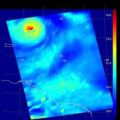
This false-color image shows the amount of atmospheric water vapor observed by AIRS two weeks prior to the passage of Hurricane Isabel, and then when it was a Category 5 storm. The region shown includes parts of South America and the West Indies. Puerto Rico is the large island below the upper left corner. Total water vapor represents the depth of a layer if all the water vapor in the atmosphere were to condense and fall to the surface. The color bar on the right sides of the plots give the thickness of this layer in millimeters (mm). The first image, from August 28, shows typical tropical water vapor amounts over the ocean: between roughly 25 and 50 mm, or 1 to 2 inches. The highest values of roughly 80 mm, seen as a red blob over South America, corresponds to intense thunderstorms. Thunderstorms pull in water vapor from surrounding regions and concentrate it, with much of it then falling as rain. http://photojournal.jpl.nasa.gov/catalog/PIA00430
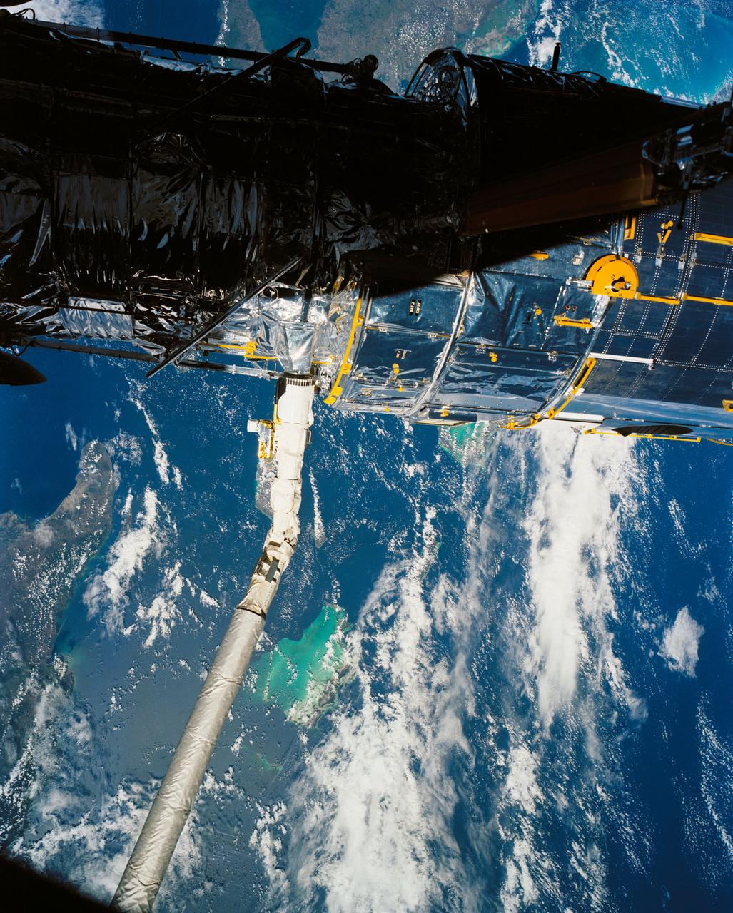
A close up deploy view of the Hubble Space Telescope on the end of the space shuttle remote manipulator system (RMS) with Eastern Cuba, (20.0N, 74.0W) seen on the left side of the telescope and northern Haiti seen on the right side of the telescope. The light colored blue feature in the water north of Haiti is the shallow waters of the Caicos Bank.
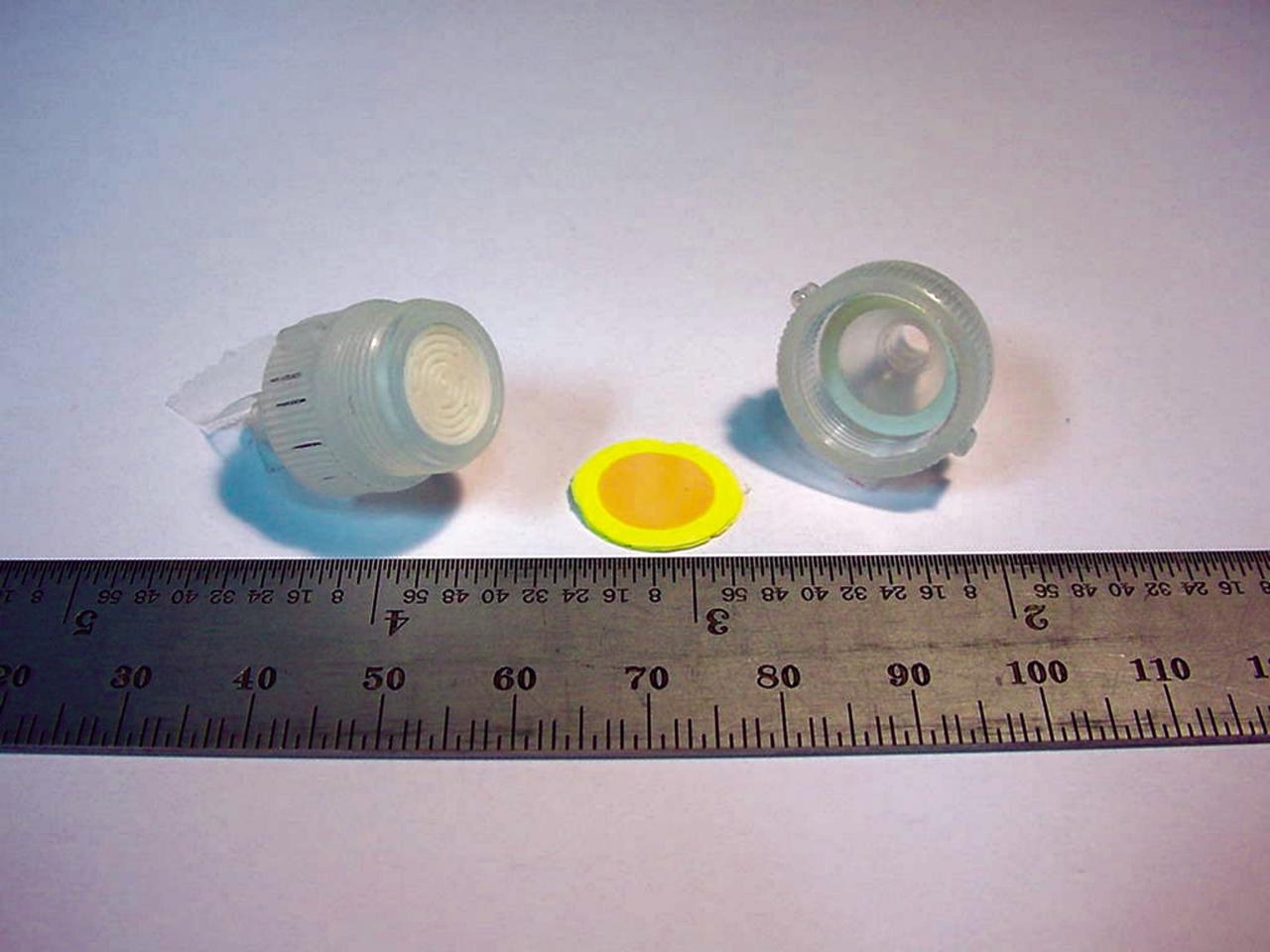
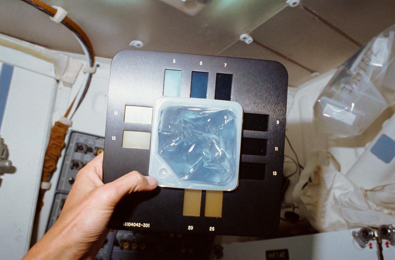
The heart of a colorimetric solid phase extractor (CSPE) test kit quickly measures the concentration of the biocides silver or iodine in astronauts’ drinking water to determine whether concentrations are safe. When 10 milliliters (ml) of water is drawn through the disk, the disk will turn color (yellow in this picture for iodine) indicating the presence of the biocides. The device could someday be used to test water safety at reservoirs and water treatment plants on Earth. (photo credit: Microanalytical Instrumentation Center, Iowa State University).

iss068e051617 (Feb. 12, 2023) --- Roscosmos cosmonaut and Expedition 68 Flight Engineer Anna Kikina plays with a sphere of water flying in microgravity that has been dyed with green food coloring and is bubbling due to an antacid that was placed inside.
iss068e051621 (Feb. 12, 2023) --- NASA astronaut and Expedition 68 Flight Engineer Josh Cassada plays with a sphere of water flying in microgravity that has been dyed with green food coloring and is bubbling due to an antacid that was placed inside.
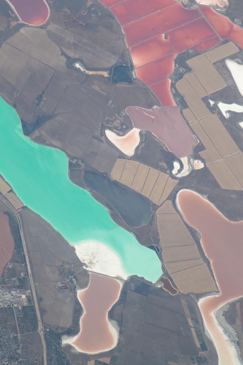
ISS031-E-030896 (11 May 2012) --- The Sor Kaydak near the northeast Caspian Sea in Kazakhstan are featured in this image photographed by an Expedition 31 crew member on the International Space Station. This striking image shows saline water of different colors in the Sor Kaydak, a salt marsh that leads into the northeast bulb of the Caspian Sea. The central 50 kilometers of this 180 kilometer-long depression is shown in this photograph. The Sor Kaydak depression is inundated on occasion by water from the Caspian Sea since it lies at the same elevation?that is, 29 meters below global sea level?though separated from the Sea by a low bar of land that is 1?2 meters high. The different colors of marsh water (brown to pink to light green, northeast to southwest) result from the interplay of water depth and resident organisms such as algae. Algae color varies depending on water temperature and salinity. The irregular gray areas at bottom right are wet zones between low sand dunes. These interdune flats are whitened with salt derived by evaporation of Caspian Sea water (the sea is just outside the image bottom right). The jagged line following the colored water (crossing the center of the image top to bottom) is the limit of the wetting zone (or perimeter), an irregular zone influenced by wind and the depth of water in the marsh. Small cliffs can be seen marking the east margin of the depression that contains Sor Kaydak. Above the cliffs a plateau surface (approximately 200 meters above the salt marsh, approximately 160 meters above global sea level) extends eastward for hundreds of kilometers. Here the plateau is occupied by a dense pattern of well heads which appear as a geometric pattern of tan dots. By contrast, the west margin (right) rises less than 10 meters above the marsh altitude. The straight line visible at center is a pipeline built across the salt marsh which takes oil to a terminal on the Caspian shore 100 kilometers northwest of the area shown here.
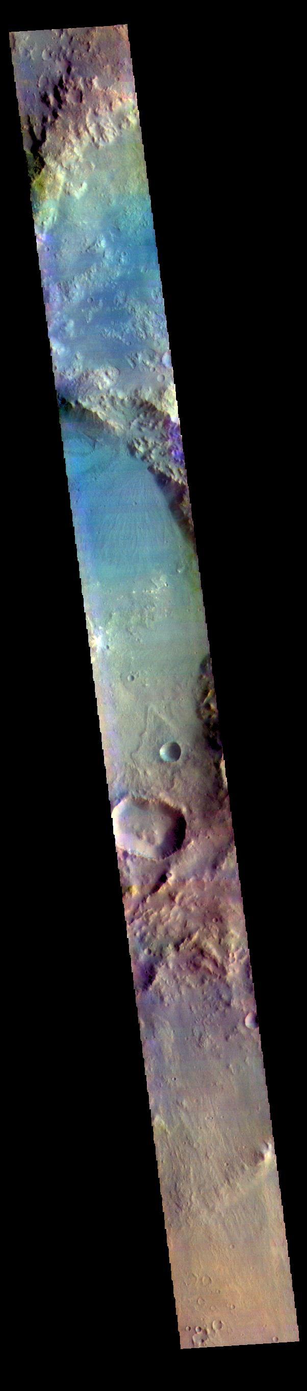
The most habitable places on Mars now and in the past are underground, where water is or was much more stable than at the surface and protected from energetic particle radiation. Large impact craters have central rebounds that uplift buried strata from miles below the surface. Often these central uplifts reveal colorful rocks with diverse minerals, including ones altered by prolonged contact with water. Alga Crater is located in the southern highlands near a large flood-channel called Ladon Valles. The image cutout shows enhanced (infrared-shifted) color. https://photojournal.jpl.nasa.gov/catalog/PIA23479
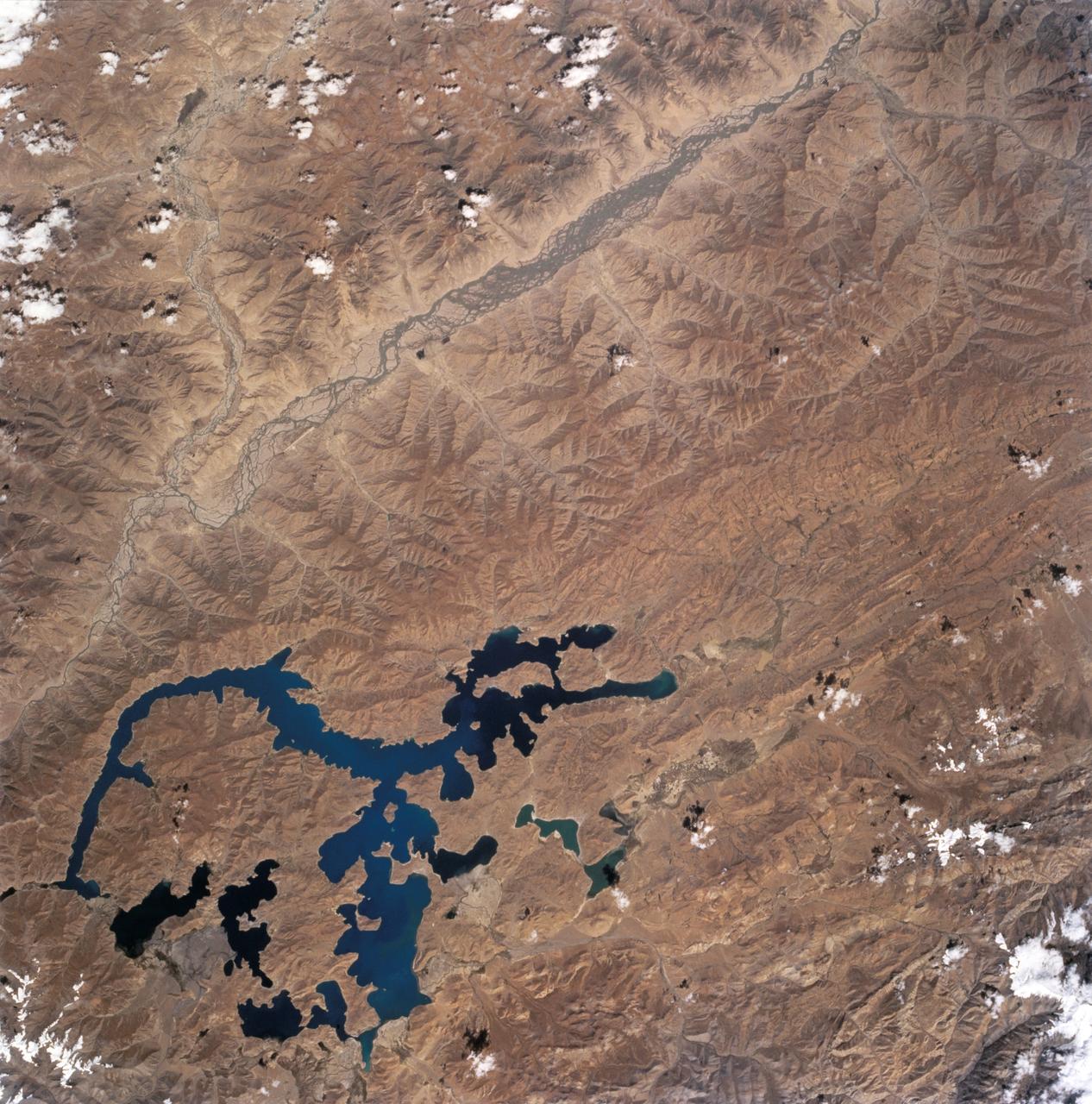
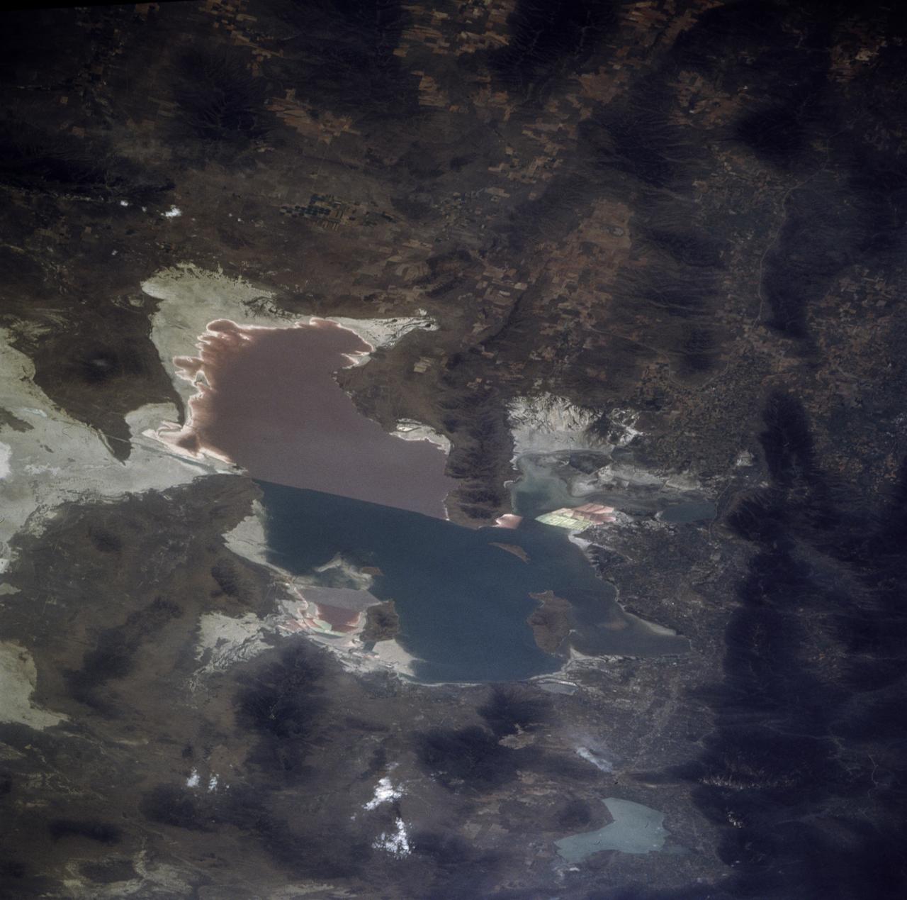
STS068-243-012 (30 September-11 October 1994) --- This nadir view of the southern Tibetan Plateau shows the plateau in late summer without snow. It also shows large, irregular Lake Yamzho Yumco, which has the unusual feature of different water color in different places, the darkest water apparently related to the remotest bays, and the lighter color resulting from sediment flowing into the lake from a stream bottom left. The multiple-channeled upper Brahmaputra River cuts the top left corner of the frame, flowing east (to the top right). The tributary entering the frame near the top left corner is the Lhasa River: Lhasa lies on this river just outside the frame.
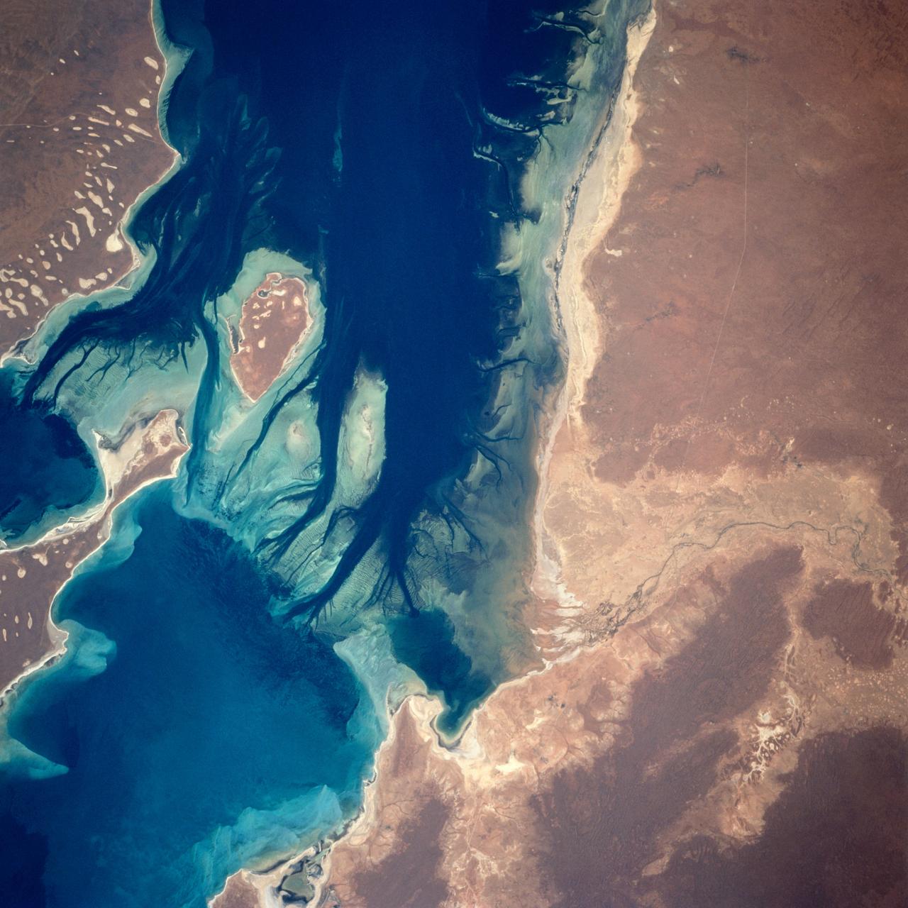
A nearly vertical view of Disappointment Reach and surroundings. Ripple-like patterns extending at right angles to the tidal flow can be discerned on shoals. Relict sand dune patterns, crests unvegetated, are evident on the western side of the estuary. Red mud brought down the Mooramel River on the east side of the estuary does extend into the shallow water of the inter-tidal lagoons. Most of the light-colored water along the coast, represents shoals of lime sediment. Patterns of sediment distribution by tides, waves, streams, and wind combine to create a complex and colorful scene.

ISS038-E-033884 (22 Jan. 2014) --- In the International Space Station's Kibo laboratory, NASA astronaut Mike Hopkins, Expedition 38 flight engineer, holds a plastic container partially filled with green-colored water which will be used in a new experiment using the soccer-ball-sized, free-flying satellites known as Synchronized Position Hold, Engage, Reorient, Experimental Satellites, or SPHERES, which are already on the station. For the SPHERES-Slosh experiment, two SPHERES robots are attached to opposite ends of a metal frame holding the plastic tank with the green-colored water. The new hardware for the SPHERES-Slosh study was delivered to the station aboard Orbital Sciences' Cygnus cargo craft on Jan. 12.

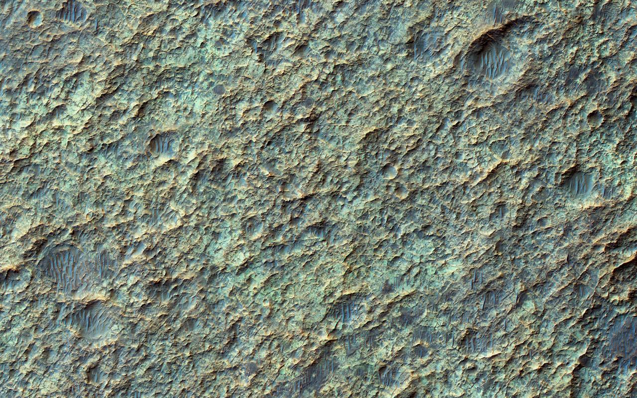
The THEMIS VIS camera contains 5 filters. The data from different filters can be combined in multiple ways to create a false color image. These false color images may reveal subtle variations of the surface not easily identified in a single band image. Today's false color image is located in Aram Chaos. Aram Chaos was initially formed by a large impact. Over time the crater interior was modified by several different processes, including liquid water. Located near Ares Vallis, a narrow channel links the Aram Chaos crater with Ares Vallis indicating a substantial amount of water was located in the crater. Chaos forms from erosion of the surface into mesa features. With time the valleys expand creating the jumble of hills seen in the image. Orbit Number: 79214 Latitude: 2.40411 Longitude: 340.023 Instrument: VIS Captured: 2019-10-23 19:10 https://photojournal.jpl.nasa.gov/catalog/PIA24659

AS09-26A-3781A (11 March 1969) --- Colored infrared photograph of the mouth of the Colorado River in northern Baja California and Sonora, Mexico, as seen from Apollo 9 spacecraft during its 121st revolution of Earth. Photographed from an altitude of 130 nautical miles, at 16:14 GMT, on March 11, 1969. Color infrared film is designed to render healthy green foliage as tones of red, such as the red checker-board patterns in the irrigated farm lands along the Colorado River. Red hues of vegetation can be seen in the valleys and on the slopes of the San Pedro Martia and Juarez Mountains, at left. White ribbon-like salt lakes near the river mouth and the wide expanse of sand dunes in the Great Desert, at right, are evidence of the arid climate. Light colors of silt bands in the waters of the Gulf of California reflect currents and water depths. The town of San Felipe is on the Gulf coast at lower left.
The dark sand dune at the center of this observation is covered in a blanket of white seasonal ice in the winter. In this Martian springtime image, the western slope of the dune is partly defrosted. Bright patches of frost (white in enhanced color) are clearly visible and are made up of water and carbon dioxide ices. Dark streaks of sand have flowed down the dune's slope that sometimes covers the frost. These flows are caused by the rapid transformation of the frost from ice to gas as the sun heats the dune in the spring. We can also see how these flows are diverted by the ripples on the dune. (The width of the cutout is around 520 meters.) https://photojournal.jpl.nasa.gov/catalog/PIA25188
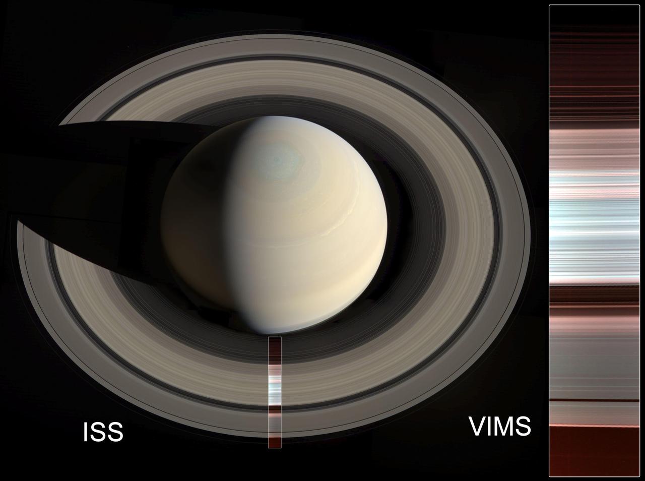
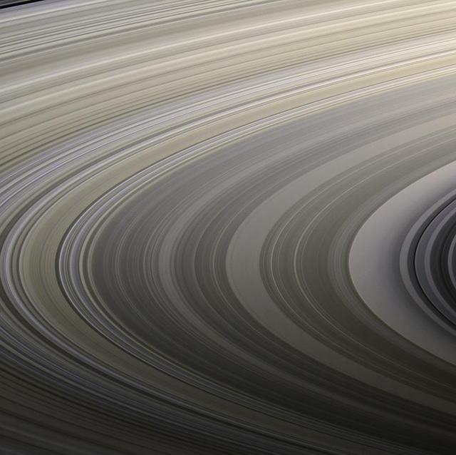
The false-color image at right shows spectral mapping of Saturn's A, B and C rings, captured by Cassini's Visible and Infrared Mapping Spectrometer (VIMS). It displays an infrared view of the rings, rather than an image in visible light. The blue-green areas are the regions with the purest water ice and/or largest grain size (primarily the A and B rings), while the reddish color indicates increasing amounts of non-icy material and/or smaller grain sizes (primarily in the C ring and Cassini Division). At left, the same image is overlaid on a natural-color mosaic of Saturn taken by Cassini's Imaging Science Subsystem. https://photojournal.jpl.nasa.gov/catalog/PIA23170
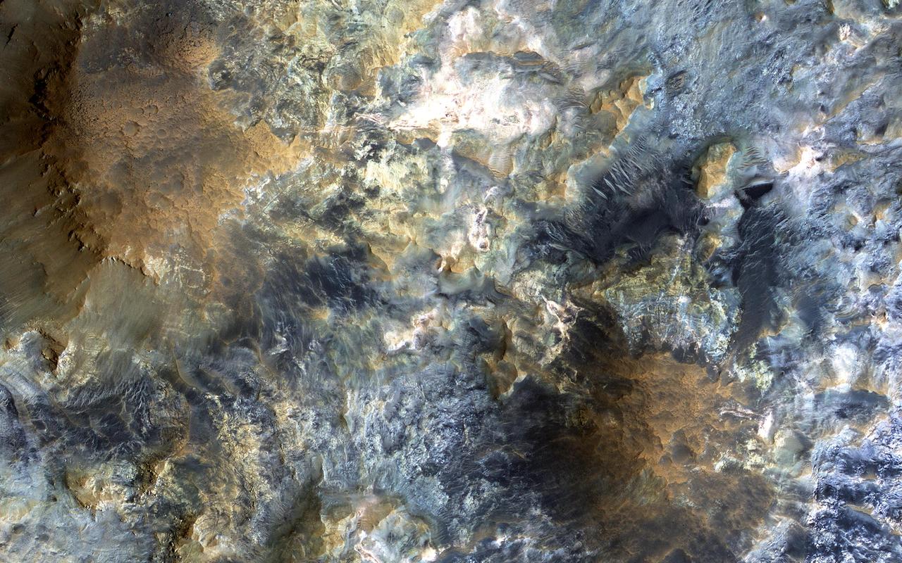
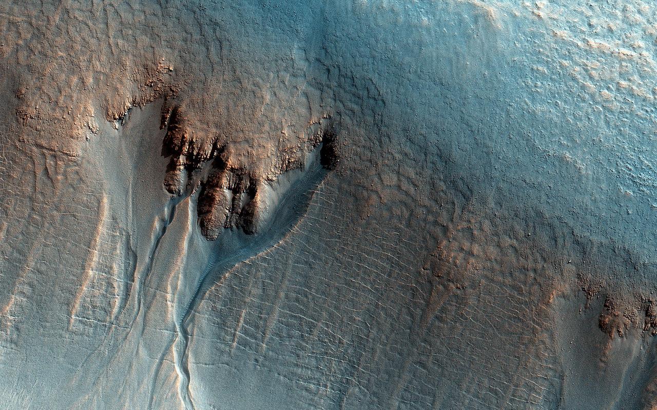
This image shows the southern wall of Coprates Chasma, in the equatorial canyon system of Valles Marineris. While much of the lower slopes are covered by sand, exposed bedrock is clearly visible in the upper canyon walls. In an enhanced color image, the varying colors – shades of white, cyan, and purple – are suggestive of multiple minerals being present within the bedrock, indicating a complicated geologic history, possibly involving alteration by water. (In this cutout, north is down.) https://photojournal.jpl.nasa.gov/catalog/PIA25985
There is a candidate landing site in the Mawrth Vallis region for the European Space Agency's ExoMars rover, planned to launch in 2020. This is one of the HiRISE images acquired to evaluate this site. Mawrth Vallis has some of the most spectacular color variations seen anywhere on Mars. This color variability is due to a range of hydrated minerals -- water caused alteration of these ancient deposits -- which is why this site is of interest to study the past habitability of Mars. http://photojournal.jpl.nasa.gov/catalog/PIA21029
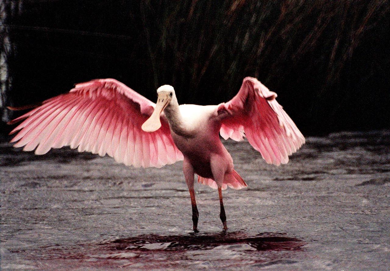
![KENNEDY SPACE CENTER, FLA. -- A Roseate Spoonbill takes flight. The colorful birds are seen often throughout KSC and nearby wetlands. The birds, named for their brilliant pink color and paddle-shaped bill, usually feed in shallow water by swinging their bill back and forth, scooping up small fish and crustaceans. They typically inhabit mangroves on the coasts of southern Florida, Louisiana and Texas. [Photo by Mike Brown]](https://images-assets.nasa.gov/image/KSC-02pd0550/KSC-02pd0550~medium.jpg)
KENNEDY SPACE CENTER, FLA. -- A Roseate Spoonbill takes flight. The colorful birds are seen often throughout KSC and nearby wetlands. The birds, named for their brilliant pink color and paddle-shaped bill, usually feed in shallow water by swinging their bill back and forth, scooping up small fish and crustaceans. They typically inhabit mangroves on the coasts of southern Florida, Louisiana and Texas. [Photo by Mike Brown]
An enhanced-color image from NASA's Mars Reconnaissance Orbiter (MRO) reveals bedrock that is several kilometers below the top of the giant Valles Marineris canyons. The upper layers have relatively little diversity of colors and textures, but deeper levels show more complex processes. The upper layers could be mostly volcanic while the lower layers were influenced by the period of heavy bombardment and greater interactions with water. https://photojournal.jpl.nasa.gov/catalog/PIA22238
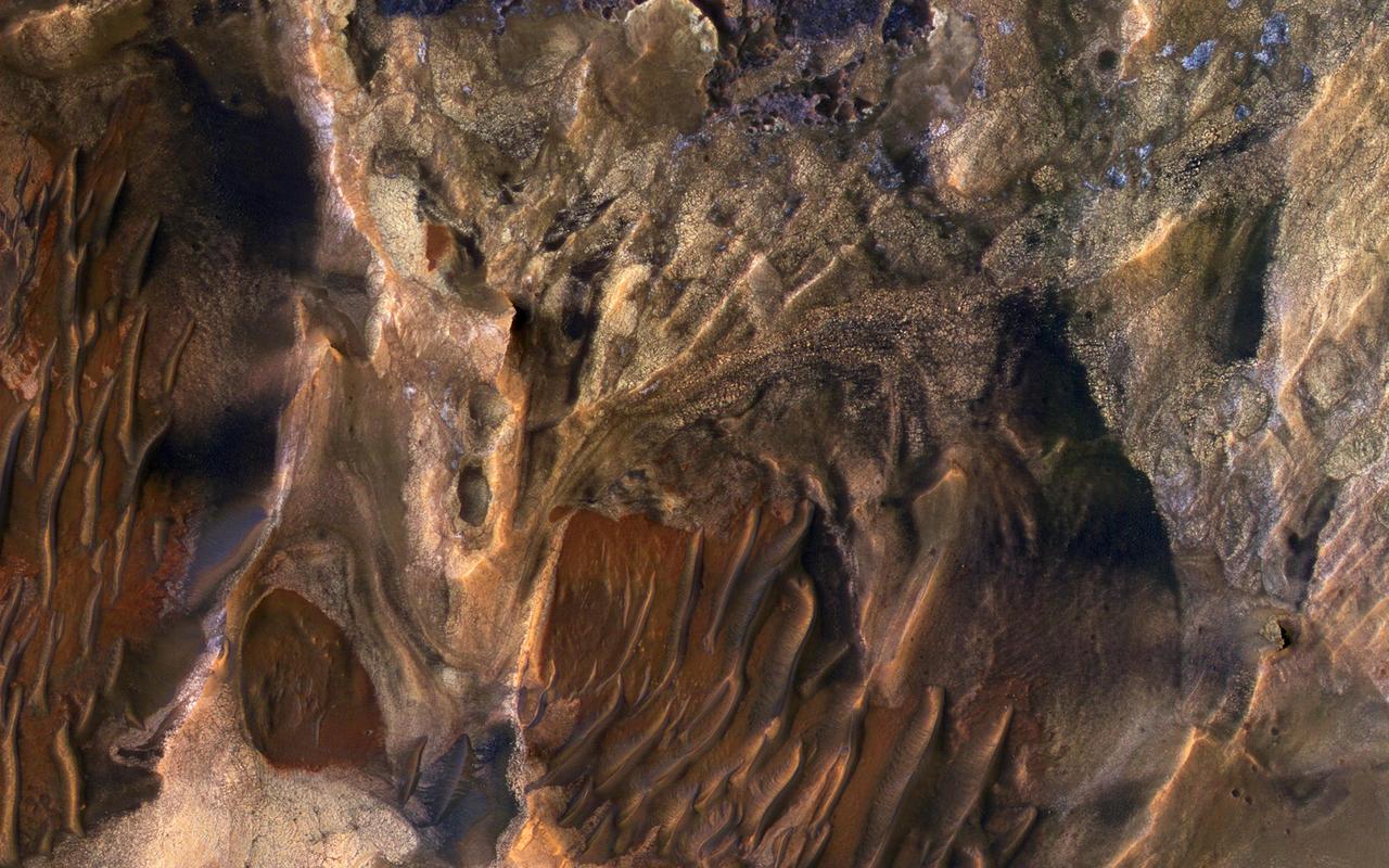
This scene captured by NASA Mars Reconnaissance Orbiter includes chaotic deposits with a wide range of colors. The deposits are distinctive with both unique colors and small-scale textures such as fracture patterns. These are probably sedimentary rocks, transported and deposited in water or air. The original layers may have been jumbled in a landslide. Dark or reddish sand dunes cover some of the bedrock. http://photojournal.jpl.nasa.gov/catalog/PIA19860
STS039-87-012 (28 April-6 May 1991) --- A handheld 70mm camera onboard the Space Shuttle Discovery exposed this infrared frame showing oil fires near the Kuwait coast as well as south-bound oil slicks in the Gulf. Pools of oil on the land are recognized as white objects near the burning wells.
The THEMIS VIS camera contains 5 filters. The data from different filters can be combined in multiple ways to create a false color image. These false color images may reveal subtle variations of the surface not easily identified in a single band image. Today's false color image shows the western half of Jezero Crater. The Perserverance Rover is located in this part of the crater – near the delta deposit formed by the influx of silt laden water into the crater at a time during Mars' past that was wetter. The crater most likely hosted a lake for a period of time. Jezero Crater is 47km (29 miles) in diameter. The THEMIS VIS camera is capable of capturing color images of the Martian surface using five different color filters. In this mode of operation, the spatial resolution and coverage of the image must be reduced to accommodate the additional data volume produced from using multiple filters. To make a color image, three of the five filter images (each in grayscale) are selected. Each is contrast enhanced and then converted to a red, green, or blue intensity image. These three images are then combined to produce a full color, single image. Because the THEMIS color filters don't span the full range of colors seen by the human eye, a color THEMIS image does not represent true color. Also, because each single-filter image is contrast enhanced before inclusion in the three-color image, the apparent color variation of the scene is exaggerated. Nevertheless, the color variation that does appear is representative of some change in color, however subtle, in the actual scene. Note that the long edges of THEMIS color images typically contain color artifacts that do not represent surface variation. Orbit Number: 95046 Latitude: 18.449 Longitude: 77.436 Instrument: VIS Captured: 2023-05-19 09:28 https://photojournal.jpl.nasa.gov/catalog/PIA26140
This image from NASA's Mars Reconnaissance Orbiter (MRO) shows white material believed to be dusty water ice lining the edges of Martian gullies in a region named Terra Sirenum. Scientists believe dust particles within this ice act similarly to dust that falls onto glaciers on Earth, warming up in sunlight and causing subsurface pockets of meltwater to form. On Earth, the dust that builds up on glaciers is called cryoconite, and the pockets it forms are called cryoconite holes. These pockets of water on our planet are often teeming with simple life, including algae, fungi, and cyanobacteria. Scientists believe similar shallow pools of water could exist on Mars, and may also be excellent places to search for life on the Red Planet today. This enhanced-color image was captured by MRO's HiRISE (High-Resolution Imaging Science Experiment) camera on Dec. 25, 2016. The blue color at the bottom of the gullies is likely coarse sand (not ice); the hue would not actually be perceptible to the human eye. HiRISE is able to detect this color by looking at the scene in far-infrared wavelengths. https://photojournal.jpl.nasa.gov/catalog/PIA26407

KENNEDY SPACE CENTER, FLA. -- A tri-colored heron stands sentry in the marshes around KSC. It has slate blue feathers on most of its body except for a white chest and belly and a rust-colored neck. It has long yellow legs, a white stripe that runs up its neck and long pointed yellow bill. The bill turns blue during breeding season.The heron is one of 310 species of birds that inhabit the Merritt Island National Wildlife Refuge, which shares a boundary with KSC. The marshes and open water of the refuge also provide wintering areas for 23 species of migratory waterfowl, as well as a year-round home for great egrets, wood storks, cormorants, brown pelicans and other species of marsh and shore birds.
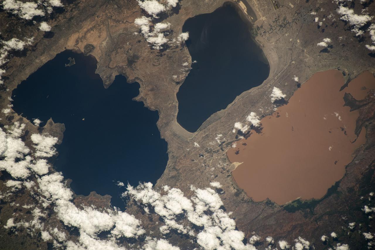
iss071e132461 (May 27, 2024) -- A trio of lakes in the Ethiopian Rift Valley were pictured from the International Space Station as it orbited 259 miles above. From left are Lakes Shala, Abijatta (both alkaline bodies of water), and Langano, which gets its brown color from high sulfur levels and other minerals.
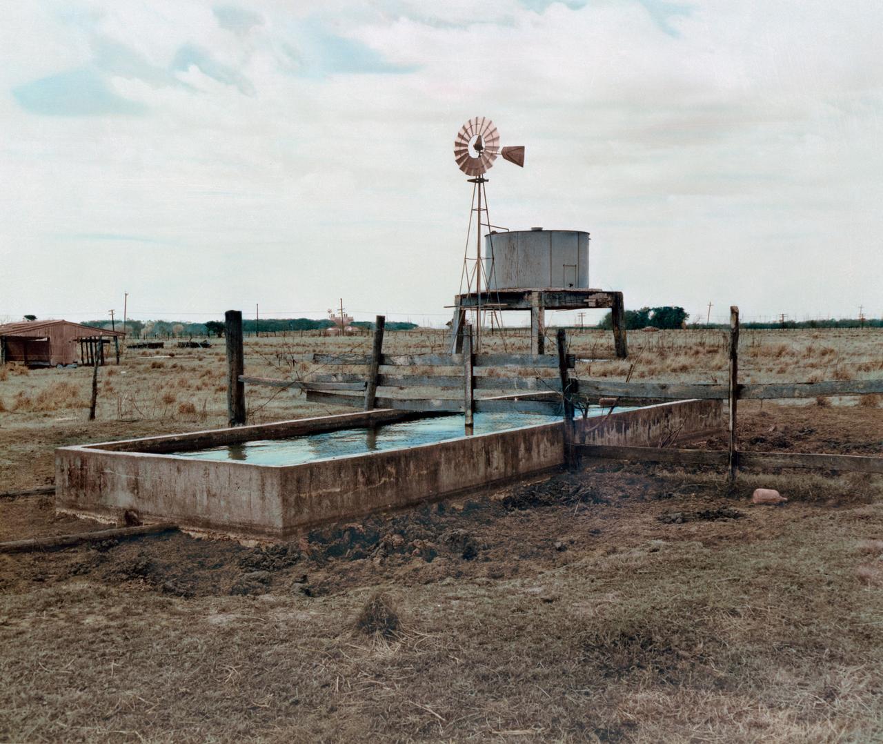
S76-32986 (March 1962) --- A color enhancement of a black and white photograph of a water trough, windmill, grazing area and feed lot on the future site of the Manned Spacecraft Center, Houston, Texas. NOTE: The Manned Spacecraft Center was named Lyndon B. Johnson Space Center in memory of the late President following his death.
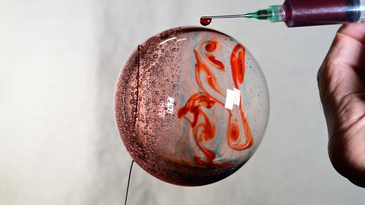
iss072e069543 (Oct. 19, 2024) --- Space science is fun! NASA astronaut and Expedition 72 Flight Engineer Don Pettit fills this sphere of water with food coloring creating a Jupiter-like effect in the microgravity environment of the International Space Station.
iss056e032828 (June 24, 2018) --- An Expedition 56 crew member aboard the International Space Station pictured lagoons in the Crimea between the Sea of Azov and the Black Sea which appear different colors due to shallow waters and their varied chemical composition.
Agricultural patterns are distinctly visible in this near-vertical false color infrared photography taken in November 1994. The area depicted on the photograph is south of Khartoum between the White and Blue Nile Rivers. By far the most important irrigation project in sub-Saharan Africa, both large and small scale agricultural enterprises have been developed using water transported from the perennial Nile Rivers. Hundreds of small rectangular fields and water-filled canals can be seen in this photograph.
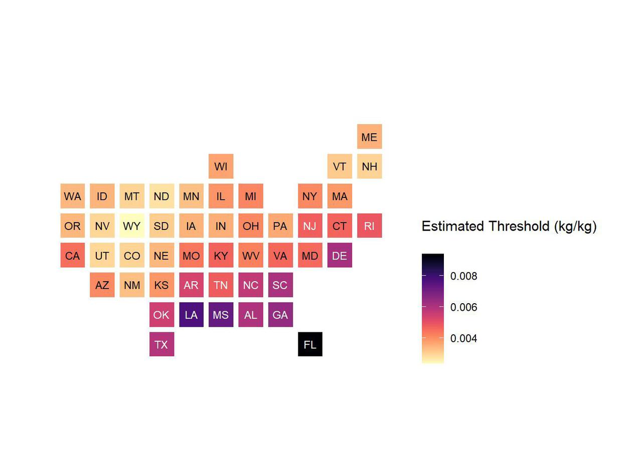
This chart shows low-humidity thresholds that signal flu outbreaks in 48 U.S. states, calculated using water vapor data from NASA's Atmospheric Infrared Sounder (AIRS) instrument on the Aqua satellite with data on U.S. flu cases from 2003 to 2015. The color range from lighter to darker indicates lower to higher humidity thresholds, with the driest state, Wyoming, having the lowest threshold and Florida the highest. Units are kilograms of water per kilogram of air. https://photojournal.jpl.nasa.gov/catalog/PIA24986
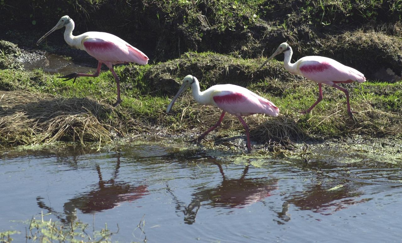
KENNEDY SPACE CENTER, FLA. -- Roseate Spoonbills march alongside a pool of water near KSC. The birds, named for their brilliant pink color and paddle-shaped bill, usually feed in shallow water by swinging their bill back and forth, scooping up small fish and crustaceans. They typically inhabit mangroves on the coasts of southern Florida, Louisiana and Texas. [Photo by Mike Brown
iss071e582300 (Sept. 2, 2024) -- Lake Cardiel is pictured from the International Space Station as it orbited 268 miles above Argentina. The lake is highly favored by fisherman as its alkaline water creates a rich habitat for salmon and other species to live. Its color results from nearby glaciers grinding rock into "glacial flour." The sediment is picked up by meltwater streams that feed into the lake and are slow to sink to the bottom, making the water appear a bright turquoise.
![KENNEDY SPACE CENTER, FLA. -- A small flock of Roseate Spoonbills wade in the water near KSC while two others take flight. The birds, named for their brilliant pink color and paddle-shaped bill, usually feed in shallow water by swinging their bill back and forth, scooping up small fish and crustaceans. They typically inhabit mangroves on the coasts of southern Florida, Louisiana and Texas. [Photo by Mike Brown]](https://images-assets.nasa.gov/image/KSC-02pd0551/KSC-02pd0551~medium.jpg)
KENNEDY SPACE CENTER, FLA. -- A small flock of Roseate Spoonbills wade in the water near KSC while two others take flight. The birds, named for their brilliant pink color and paddle-shaped bill, usually feed in shallow water by swinging their bill back and forth, scooping up small fish and crustaceans. They typically inhabit mangroves on the coasts of southern Florida, Louisiana and Texas. [Photo by Mike Brown]
SL2-16-174 (22 June 1973) --- Norfolk and the lower Chesapeake Bay, VA (37.5N, 75.5W) at the interface of the Atlantic Ocean can be seen to be a mixture of complex currents. Outgoing tides from the bay generate considerable turbulence as they encounter coastal currents and can be observed by the sediment plumes stirred up as a result of current dynamics. Smooth flowing water has less sediment and appears darker. Turbulent water has lots of sediment and appears lighter in color. Photo credit: NASA
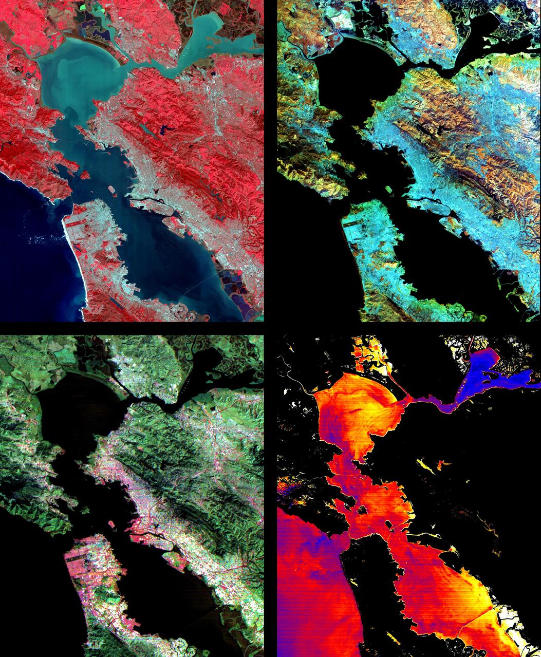
These images of the San Francisco Bay region were acquired on March 3, 2000 by the Advanced Spaceborne Thermal Emission and Reflection Radiometer (ASTER) on NASA's Terra satellite. Each covers an area 60 kilometers (37 miles) wide and 75 kilometers (47 miles) long. With its 14 spectral bands from the visible to the thermal infrared wavelength region, and its high spatial resolution of 15 to 90 meters (about 50 to 300 feet), ASTER will image the Earth for the next 6 years to map and monitor the changing surface of our planet. Upper Left: The color infrared composite uses bands in the visible and reflected infrared. Vegetation is red, urban areas are gray; sediment in the bays shows up as lighter shades of blue. Thanks to the 15 meter (50-foot) spatial resolution, shadows of the towers along the Bay Bridge can be seen. Upper right: A composite of bands in the short wave infrared displays differences in soils and rocks in the mountainous areas. Even though these regions appear entirely vegetated in the visible, enough surface shows through openings in the vegetation to allow the ground to be imaged. Lower left: This composite of multispectral thermal bands shows differences in urban materials in varying colors. Separation of materials is due to differences in thermal emission properties, analogous to colors in the visible. Lower right: This is a color coded temperature image of water temperature, derived from the thermal bands. Warm waters are in white and yellow, colder waters are blue. Suisun Bay in the upper right is fed directly from the cold Sacramento River. As the water flows through San Pablo and San Francisco Bays on the way to the Pacific, the waters warm up. http://photojournal.jpl.nasa.gov/catalog/PIA02605
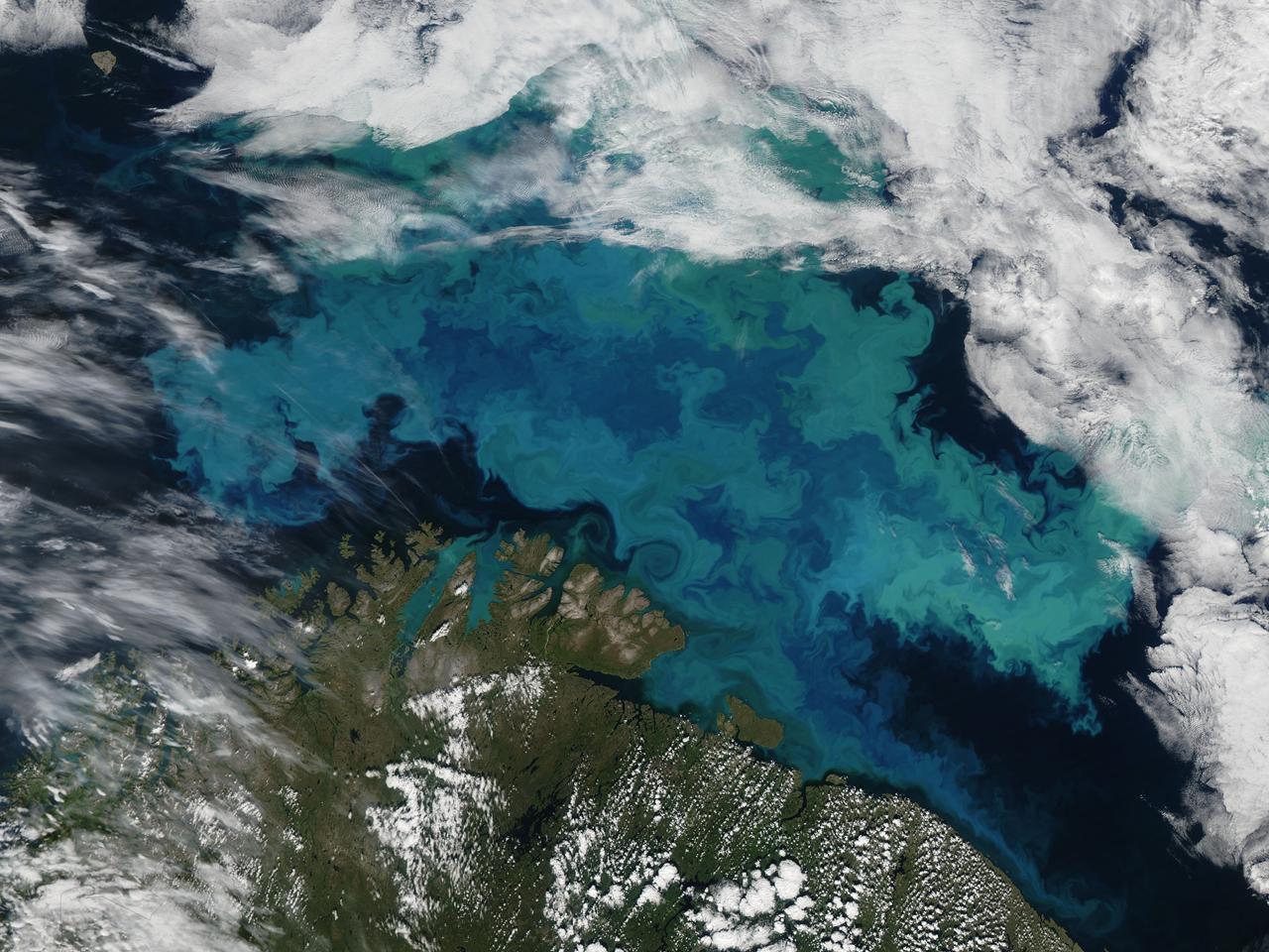
Phytoplankton bloom in the Barents Sea captured August 14, 2011. At times nature exceeds the ability of the artist’s brush to blend brilliant colors, interweave textures and combine patterns to create stunning panoramas, while using only the palette of land, water, cloud and vegetation. This stunning and artistic image of a phytoplankton bloom in the Barents Sea was by the Moderate Resolution Imaging Spectroradiometer (MODIS) aboard the Aqua satellite was captured on August 14, 2011. The peacock-hued swirls of blues and green that paint the navy-blue sea water are created by light reflecting off of millions of phytoplankton, microscopic plants that grow in the sunlit surface water of the world’s oceans. Different types of phytoplankton reflect different colored light, so a multi-color bloom such as this typically contains multiple species. The depth of the bloom also affects coloration – the deeper the organism, the less light is reflected and the duller the color. Coccolithophores, a type of phytoplankton which flourish in nutrient-poor, sub-polar waters, have unique limestone (calcite) scales. This white coating makes the plant highly reflective, and thus a bloom can appear to be a bright, almost iridescent blue. The chalky coating can also cause whitish swirls in the water, making the blues washed out with a milky hue. August is a highly active month for phytoplankton blooms in the Barents Sea, but the timing, development, abundance and species composition is variable in this area. The distribution of phytoplankton is largely controlled by the polar front, ice cover, freshwater runoff and ice melting. Each water source – the Artic, the Atlantic and the coastal water – all bring their own characteristic species into the Barents Sea, creating a multi-specie and multi-color spectacle. Because phytoplankton are the base of the marine food chain, places were blooms are large and frequent often support a thriving marine population. This is certainly the case in the Barents Sea where the fisheries, particularly the cod fisheries, are of great importance for both Norway and Russia. The coastlines of both of these countries can be seen in the bottom of the image. Russia forms the south-eastern most coast, while the remaining three-quarters of the coastline belongs to Norway. Two fjords in the west, Porsangerfjorden and Laksefjord are tinted bright blue with phytoplankton. Just to the east of these fjords, freshwater from the Tana River flows through Tanafjord, turning the waters here are a duller blue. As fresh water flows into the Barents Sea, phytoplankton bloom is affected by the flowing water, creating paisley-like patterns in the coastal eddies. Credit: NASA/GSFC/Jeff Schmaltz/MODIS Land Rapid Response Team <b><a href="http://www.nasa.gov/centers/goddard/home/index.html" rel="nofollow">NASA Goddard Space Flight Center</a></b> enables NASA’s mission through four scientific endeavors: Earth Science, Heliophysics, Solar System Exploration, and Astrophysics. Goddard plays a leading role in NASA’s accomplishments by contributing compelling scientific knowledge to advance the Agency’s mission. <b>Follow us on <a href="http://twitter.com/NASA_GoddardPix" rel="nofollow">Twitter</a></b> <b>Like us on <a href="http://www.facebook.com/pages/Greenbelt-MD/NASA-Goddard/395013845897?ref=tsd" rel="nofollow">Facebook</a></b> <b>Find us on <a href="http://web.stagram.com/n/nasagoddard/?vm=grid" rel="nofollow">Instagram</a></b>

ISS035-E-025019 (20 April 2013) --- One of the Expedition 35 crew members aboard the Earth-orbiting International Space Station used a 400 millimeter lens to record this photograph highlighting water of different color within sub basins of the Laguna (lake) Verde in the high Andes of northwest Argentina. The lake floor as a local low point lies at 4095 meters (13,438 feet) above sea level, whereas the peak of the local volcano west of the lake (not shown) reaches almost 3000 meters higher (or about 6818 meters, 22,368 feet). Laguna Verde (58 kilo meters wide, 36 kilometers long) often appears green, giving rise to its formal name. The image shows the turquoise tint in the central sub basin (image center), with a yellow to black tinge to water in the southern sub basin at image left (also known locally as Laguna Negra). The northernmost basin at image right appears quite black, and the large gray zone comprising much of the rest of Laguna Verde is likely a combination of shallow water, only inches deep, and sunglint reflecting off the water surface. The reason for the color differences lays in the fact the many different families of salt-loving organisms occupy hypersaline lakes such as Laguna Verde. These appear as different colors ? often bright -- depending on the salinities and temperatures of each water body or sub basin. The rest of the lake floor is dry and appears white from the build-up of thick salt deposits. Parallel lines around the southern sub basin (Laguna Negro) indicate prior shorelines of this shrinking water body ? evaporation removes water but leaves ephemeral shorelines marked with white salt.
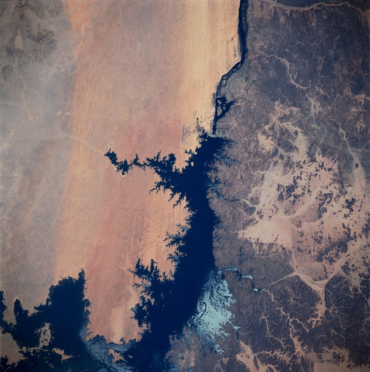
STS083-747-026 (4-8 April 1997) --- Aswan Dam and Lake Nasser along the Nile River, Egypt. The Aswan Dam controls the flow of the Nile River forming Lake Nasser. Lake Nasser is reaching relatively high water levels due to the plentiful rains since December 1996 in Kenya, near the headwaters of the Nile river. The light colored areas in the Lake are where the sun is reflecting off the surface of the water. These areas are fairly calm and not disturbed by wind gusts enabling the sunglint to show water current patterns on the surface. The Aswan runway is seen as a dark set of lines west of the Aswan Dam.

ISS033-E-009153 (2 Oct. 2012) --- Japan Aerospace Exploration Agency astronaut Aki Hoshide, Expedition 33 flight engineer, performs a removal and replacement of the DKiV water pump and the E-K pre-treat tank with its hose in the Tranquility node of the International Space Station. E-K contains five liters of pre-treat solution, i.e., a mix of H2SO4 (sulfuric acid), CrO3 (chromium oxide, for oxidation and purple color) and H2O (water). The pre-treat liquid is mixed with water in the DKiV dispenser and used for toilet flushing.

ISS013-E-74843 (2 Sept. 2006) --- Rio Negro in Amazonia, Brazil is featured in this image photographed by an Expedition 13 crewmember onboard the International Space Station. The wide, multi-island zone in the Rio Negro (Black River) shown in this image is one of two, long "archipelagoes" upstream of the city of Manaus (not shown) in central Amazonia. Ninety kilometers of the total 120 kilometers length of this archipelago appear in this view. On the day the photo was taken, air temperatures over the cooler river water of the archipelago were just low enough to prevent cloud formation. Over the neighboring rainforest, temperatures were warm enough to produce small convection-related clouds, known to pilots as "popcorn" cumulus. Several zones of deforestation, represented by lighter green zones along the river banks, are also visible. Two different types of river appear in this image. Flowing east-southeast (left to right) is the multi-island, Rio Negro, 20 kilometers wide near the right of the view. Two other "black" rivers, Rio Caures and Rio Jufari, join Rio Negro downstream. The second river type is the Rio Branco (White River; right) which is the largest tributary of the Rio Negro. The difference in water color is controlled by the source regions: black-water rivers derive entirely from soils of lowland forests. Water in these rivers has the color of weak tea, which appears black in images from space. By contrast, white-water rivers like the Branco carry a load of sand and mud particles, mudding the waters. The reason for the tan color is that white-water rivers rise in mountainous country where headwater streams erode exposed rock. The Amazon itself rises in the Andes Mts., where very high erosion occurs, and it is thus the most famous white river in Amazonia. This image was taken in September, near low-water stage. Pictures taken at other times show the channels much wider during high-water season (May--July) when water levels rise several meters. It was discovered recently, from high resolution GPS measurements at Manaus, that the land surface actually rises vertically a small amount in compensation when this vast mass of water drains away each season. Although small, the vertical displacement--50-70 mm--was unexpectedly large according to the scientists who performed the study.
Today's VIS image is located in Aram Chaos. Aram Chaos was initially formed by a large impact. Over time the crater interior was modified by several different processes, including liquid water. Located near Ares Vallis, a narrow channel links the Aram Chaos crater with Ares Vallis indicating a substantial amount of water was located in the crater. Chaos forms from erosion of the surface into mesa features. With time the valleys expand creating the jumble of hills seen in the image. The THEMIS VIS camera contains 5 filters. The data from different filters can be combined in multiple ways to create a false color image. These false color images may reveal subtle variations of the surface not easily identified in a single band image. Orbit Number: 62100 Latitude: 4.04973 Longitude: 340.137 Instrument: VIS Captured: 2015-12-14 01:59 https://photojournal.jpl.nasa.gov/catalog/PIA23107
KENNEDY SPACE CENTER, FLA. -- A female roseate spoonbill displays her colorful wings in a mating ritual in Merritt Island National Wildlife Refuge. The birds, named for their brilliant pink color and paddle-shaped bill, feed in shallow water by swinging their bill back and forth, scooping up small fish and crustaceans. They typically inhabit mangroves on the coasts of southern Florida, Louisiana and Texas. The 92,000-acre refuge, which shares a boundary with Kennedy Space Center, is a habitat for more than 330 species of birds, 31 mammals, 117 fishes and 65 amphibians and reptiles. The marshes and open water of the refuge provide wintering areas for 23 species of migratory waterfowl, as well as a year-round home for great blue herons, great egrets, wood storks, cormorants, brown pelicans and other species of marsh and shore birds
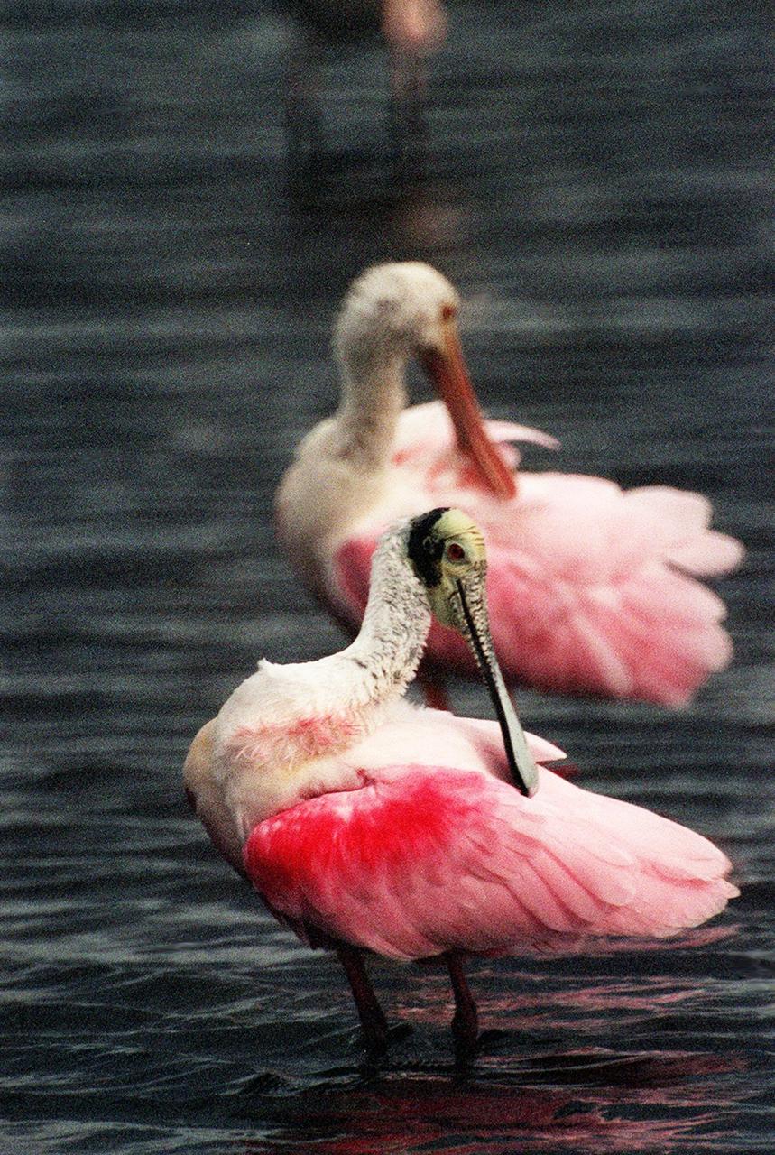
KENNEDY SPACE CENTER, FLA. -- In the Merritt Island National Wildlife Refuge, two roseate spoonbills mirror each other as they preen their lipstick-colored feathers. The birds, named for their brilliant pink color and paddle-shaped bill, feed in shallow water by swinging their bill back and forth, scooping up small fish and crustaceans. They typically inhabit mangroves on the coasts of southern Florida, Louisiana and Texas. The 92,000-acre refuge, which shares a boundary with Kennedy Space Center, is a habitat for more than 330 species of birds, 31 mammals, 117 fishes and 65 amphibians and reptiles. The marshes and open water of the refuge provide wintering areas for 23 species of migratory waterfowl, as well as a year-round home for great blue herons, great egrets, wood storks, cormorants, brown pelicans and other species of marsh and shore birds

KENNEDY SPACE CENTER, FLA. -- In the Merritt Island National Wildlife Refuge, two roseate spoonbills mirror each other as they preen their lipstick-colored feathers. The birds, named for their brilliant pink color and paddle-shaped bill, feed in shallow water by swinging their bill back and forth, scooping up small fish and crustaceans. They typically inhabit mangroves on the coasts of southern Florida, Louisiana and Texas. The 92,000-acre refuge, which shares a boundary with Kennedy Space Center, is a habitat for more than 330 species of birds, 31 mammals, 117 fishes and 65 amphibians and reptiles. The marshes and open water of the refuge provide wintering areas for 23 species of migratory waterfowl, as well as a year-round home for great blue herons, great egrets, wood storks, cormorants, brown pelicans and other species of marsh and shore birds

KENNEDY SPACE CENTER, FLA. -- A female roseate spoonbill displays her colorful wings in a mating ritual in Merritt Island National Wildlife Refuge. The birds, named for their brilliant pink color and paddle-shaped bill, feed in shallow water by swinging their bill back and forth, scooping up small fish and crustaceans. They typically inhabit mangroves on the coasts of southern Florida, Louisiana and Texas. The 92,000-acre refuge, which shares a boundary with Kennedy Space Center, is a habitat for more than 330 species of birds, 31 mammals, 117 fishes and 65 amphibians and reptiles. The marshes and open water of the refuge provide wintering areas for 23 species of migratory waterfowl, as well as a year-round home for great blue herons, great egrets, wood storks, cormorants, brown pelicans and other species of marsh and shore birds
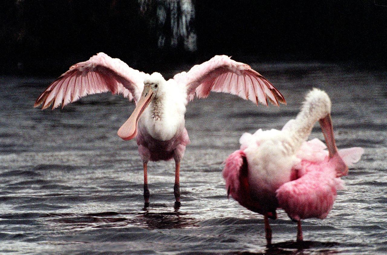
KENNEY SPACE CENTER, FLA. -- A female roseate spoonbill (left) displays her colorful wings to the male at right in a mating ritual in Merritt Island National Wildlife Refuge. The birds, named for their brilliant pink color and paddle-shaped bill, feed in shallow water by swinging their bill back and forth, scooping up small fish and crustaceans. They typically inhabit mangroves on the coasts of southern Florida, Louisiana and Texas. The 92,000-acre refuge, which shares a boundary with Kennedy Space Center, is a habitat for more than 330 species of birds, 31 mammals, 117 fishes and 65 amphibians and reptiles. The marshes and open water of the refuge provide wintering areas for 23 species of migratory waterfowl, as well as a year-round home for great blue herons, great egrets, wood storks, cormorants, brown pelicans and other species of marsh and shore birds

KENNEY SPACE CENTER, FLA. -- A female roseate spoonbill (left) displays her colorful wings to the male at right in a mating ritual in Merritt Island National Wildlife Refuge. The birds, named for their brilliant pink color and paddle-shaped bill, feed in shallow water by swinging their bill back and forth, scooping up small fish and crustaceans. They typically inhabit mangroves on the coasts of southern Florida, Louisiana and Texas. The 92,000-acre refuge, which shares a boundary with Kennedy Space Center, is a habitat for more than 330 species of birds, 31 mammals, 117 fishes and 65 amphibians and reptiles. The marshes and open water of the refuge provide wintering areas for 23 species of migratory waterfowl, as well as a year-round home for great blue herons, great egrets, wood storks, cormorants, brown pelicans and other species of marsh and shore birds

This view shows Mercury's north polar region, colored by the maximum biannual surface temperature, which ranges from >400 K (red) to 50 K (purple). As expected for the Solar System's innermost planet, areas of Mercury's surface that are sunlit reach high temperatures, and hence most of this image is colored red! In contrast, some craters near Mercury's poles have regions that remain permanently in shadow, and in these regions even the maximum temperatures can be extremely low. Evidence from MESSENGER and Earth-based observations indicate that water ice deposits are present in these cold craters. The craters nearest Mercury' poles have surface temperatures less than 100 K (-173°C, -280°F), and water ice is stable on the surface, such as in Prokofiev. However, many craters near but somewhat farther from Mercury's poles have cold, permanently shadowed interiors, but the maximum temperature is too high for water ice to persist at the surface. In these craters, water ice is present but is buried beneath a thin, low-reflectance volatile layer likely consisting of organic-rich material, such as in Berlioz crater. http://photojournal.jpl.nasa.gov/catalog/PIA19247
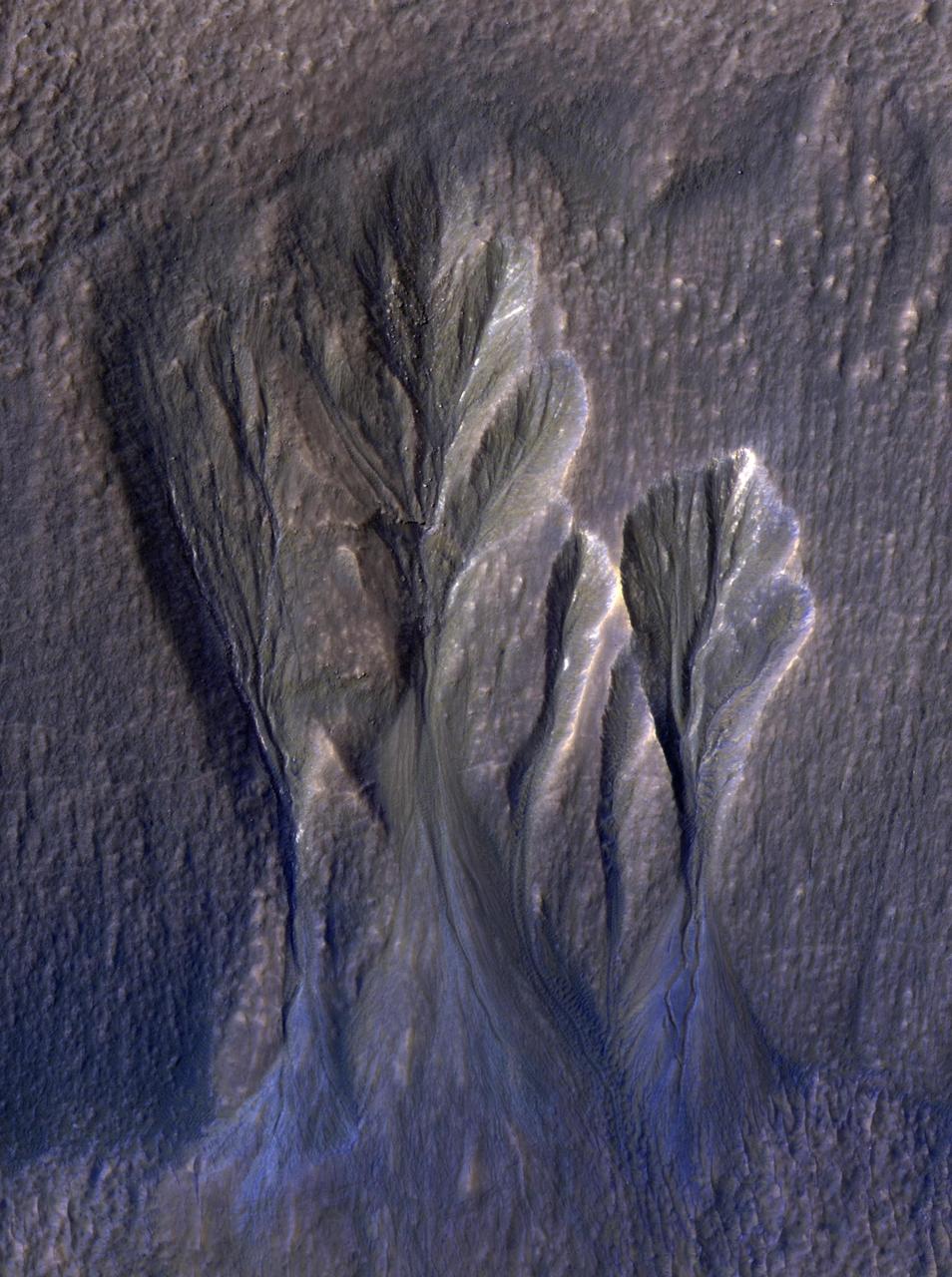
This enhanced-color image from NASA Mars Reconnaissance Orbiter shows gullies in the northern wall of an unnamed crater in Utopia Planitia. The banked, sinuous shape of the gully channels suggest that water was involved in their formation. The source of this water however is a subject of debate. Hypotheses include melting of snow or near-surface ground ice. Other features also suggest the past (and possibly present) presence of snow or ground ice in this region. For example, the "mantle" deposit on the crater wall displays polygonal fractures. Polygons on Earth are associated with periglacial activity. This refers to processes that occur from the presence of ground ice, which interacts with surface and subsurface materials, as well as the Martian atmosphere as a function of climate and seasons). The mantle itself may be the remains of a dusty snowpack deposited in Mars' recent past. At the base of the mantle are fractures associated with the slumping of these deposits under their own weight and Martian gravity. The largest gullies cut into these mantling deposits, and in some places obscure the underlying fractures at the base of the crater wall. This indicates that the largest gullies are younger than both the mantle and the fractures. http://photojournal.jpl.nasa.gov/catalog/PIA19862
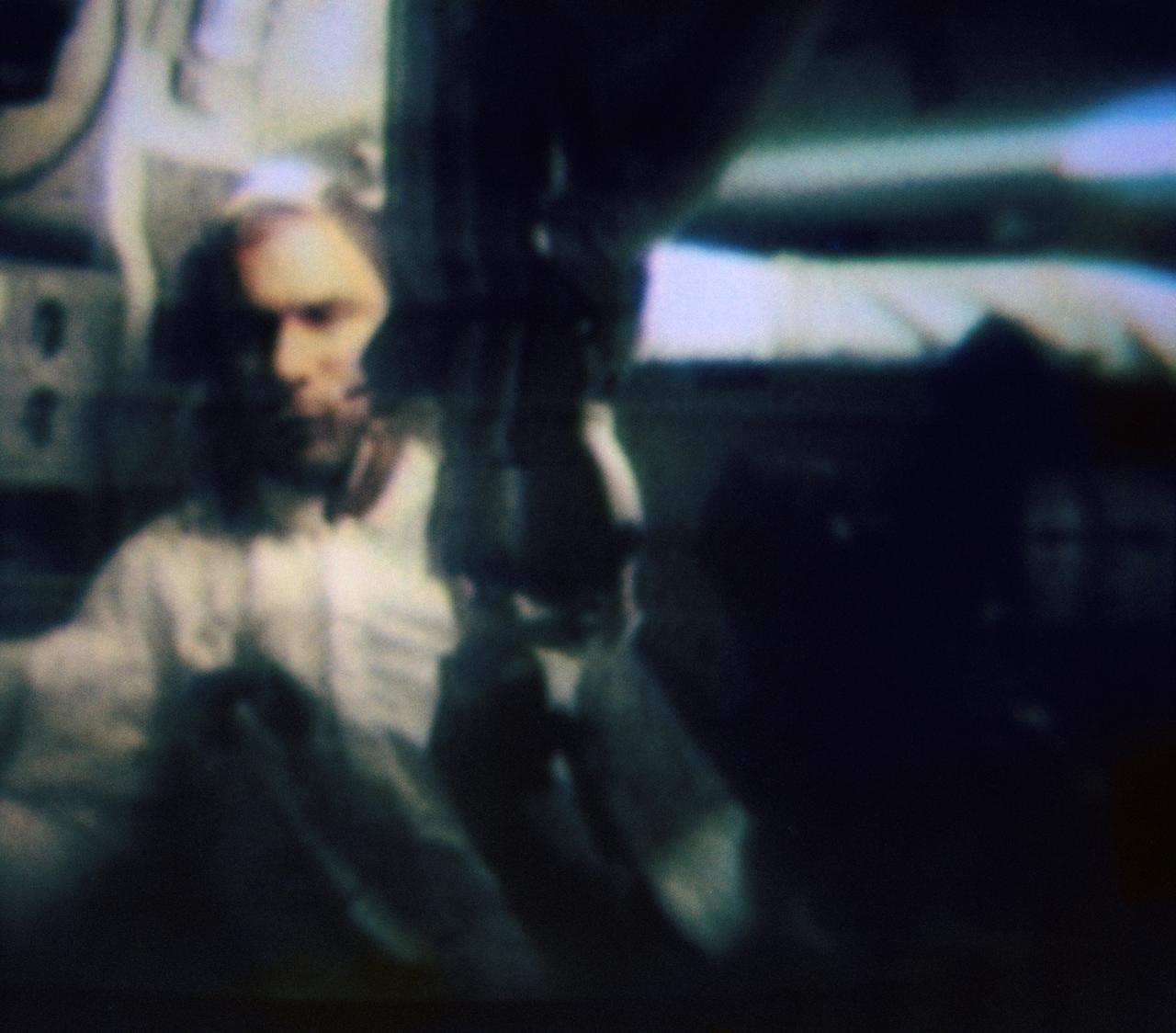
S69-34313 (20 May 1969) --- Astronaut Eugene A. Cernan is shown spinning a water bag to demonstrate the collection of hydrogen bubbles in this color reproduction taken from the fifth telecast made by the color television camera aboard the Apollo 10 spacecraft. When this picture was made the Apollo 10 spacecraft was approximately 175,300 nautical miles from Earth, and only 43,650 nautical miles from the moon. Cernan is the Apollo 10 lunar module pilot. Also, aboard Apollo 10 were astronauts Thomas P. Stafford, commander; and John W. Young, command module pilot.
The western-most part of the Ganges Delta is seen in this 54.5 by 60 km ASTER sub-scene acquired on January 6, 2005. The Hugli River branches off from the Ganges River 300 km to the north, and flows by the city of Calcutta before emptying into the Bay of Bengal. High sediment load is evident by the light tan colors in the water, particularly downstream from off-shore islands. The deep green colors of some of these islands are mangrove swamps. The image is centered at 21.9 degrees north latitude, 88 degrees east longitude. http://photojournal.jpl.nasa.gov/catalog/PIA11158
STS039-83-091 (28 April-6 May 1991) --- (HOLD PHOTO WITH BARRIER ISLANDS ALONG THE LEFT SIDE). This photograph of the water sunglint pattern along the Outer Banks of North Carolina was taken with a 70mm handheld camera equipped with color visible film and a 250mm lens. The islands appear as dark areas along the left side of the frame and Cape Hatteras is seen to the left and slightly above frame center. Sunglint is composed of light reflected from the water surface and the patterns seen in this photo are largely the result of sea surface roughness. Smooth water has a mirror-like reflectance and is represented in the photo as a bright area. Rough water, on the other hand, tends to disperse the light reflected from the water surface and, therefore, appears dark. Water currents in this area are extremely dynamic because the swift, northward flowing Gulf Stream (the offshore darker water along the right side of the photo) diverges from the coastline north of Cape Hatteras. The sharp line between bright and dark water is the western boundary of the Gulf Stream.
NASA image acquired August 31, 2010 To see a detail of this image go to: <a href="http://www.flickr.com/photos/gsfc/4971318856/">www.flickr.com/photos/gsfc/4971318856/</a> In this natural-color image from August 31, 2010, the ocean’s canvas swirls with turquoise, teal, navy, and green, the abstract art of the natural world. The colors were painted by a massive phytoplankton bloom made up of millions of tiny, light-reflecting organisms growing in the sunlit surface waters of the Barents Sea. Such blooms peak every August in the Barents Sea. The variations in color are caused by different species and concentrations of phytoplankton. The bright blue colors are probably from coccolithophores, a type of phytoplankton that is coated in a chalky shell that reflects light, turning the ocean a milky turquoise. Coccolithophores dominate the Barents Sea in August. Shades of green are likely from diatoms, another type of phytoplankton. Diatoms usually dominate the Barents Sea earlier in the year, giving way to coccolithophores in the late summer. However, field measurements of previous August blooms have also turned up high concentrations of diatoms. The Barents Sea is a shallow sea sandwiched between the coastline of northern Russia and Scandinavia and the islands of Svalbard, Franz Josef Land, and Novaya Zemlya. Within the shallow basin, currents carrying warm, salty water from the Atlantic collide with currents carrying cold, fresher water from the Arctic. During the winter, strong winds drive the currents and mix the waters. When winter’s sea ice retreats and light returns in the spring, diatoms thrive, typically peaking in a large bloom in late May. The shift between diatoms and coccolithophores occurs as the Barents Sea changes during the summer months. Throughout summer, perpetual light falls on the waters, gradually warming the surface. Eventually, the ocean stratifies into layers, with warm water sitting on top of cooler water. The diatoms deplete most of the nutrients in the surface waters and stop growing. Coccolithophores, on the other hand, do well in warm, nutrient-depleted water with a lot of light. In the Barents Sea, these conditions are strongest in August. The shifting conditions and corresponding change in species lead to strikingly beautiful multicolored blooms such as this one. The Moderate Resolution Imaging Spectroradiometer (MODIS) on NASA’s Aqua satellite acquired this image. NASA image courtesy Norman Kuring, NASA Ocean Color Group. Caption by Holli Riebeek. Instrument: Aqua - MODIS Click here to see more images from <b><a href="#//earthobservatory.nasa.gov/" rel="nofollow"> NASA Goddard’s Earth Observatory</a></b> <b><a href="http://www.nasa.gov/centers/goddard/home/index.html" rel="nofollow">NASA Goddard Space Flight Center</a></b> is home to the nation's largest organization of combined scientists, engineers and technologists that build spacecraft, instruments and new technology to study the Earth, the sun, our solar system, and the universe. <b>Follow us on <a href="http://twitter.com/NASA_GoddardPix" rel="nofollow">Twitter</a></b> <b>Join us on <a href="http://www.facebook.com/pages/Greenbelt-MD/NASA-Goddard/395013845897?ref=tsd" rel="nofollow">Facebook</a></b>
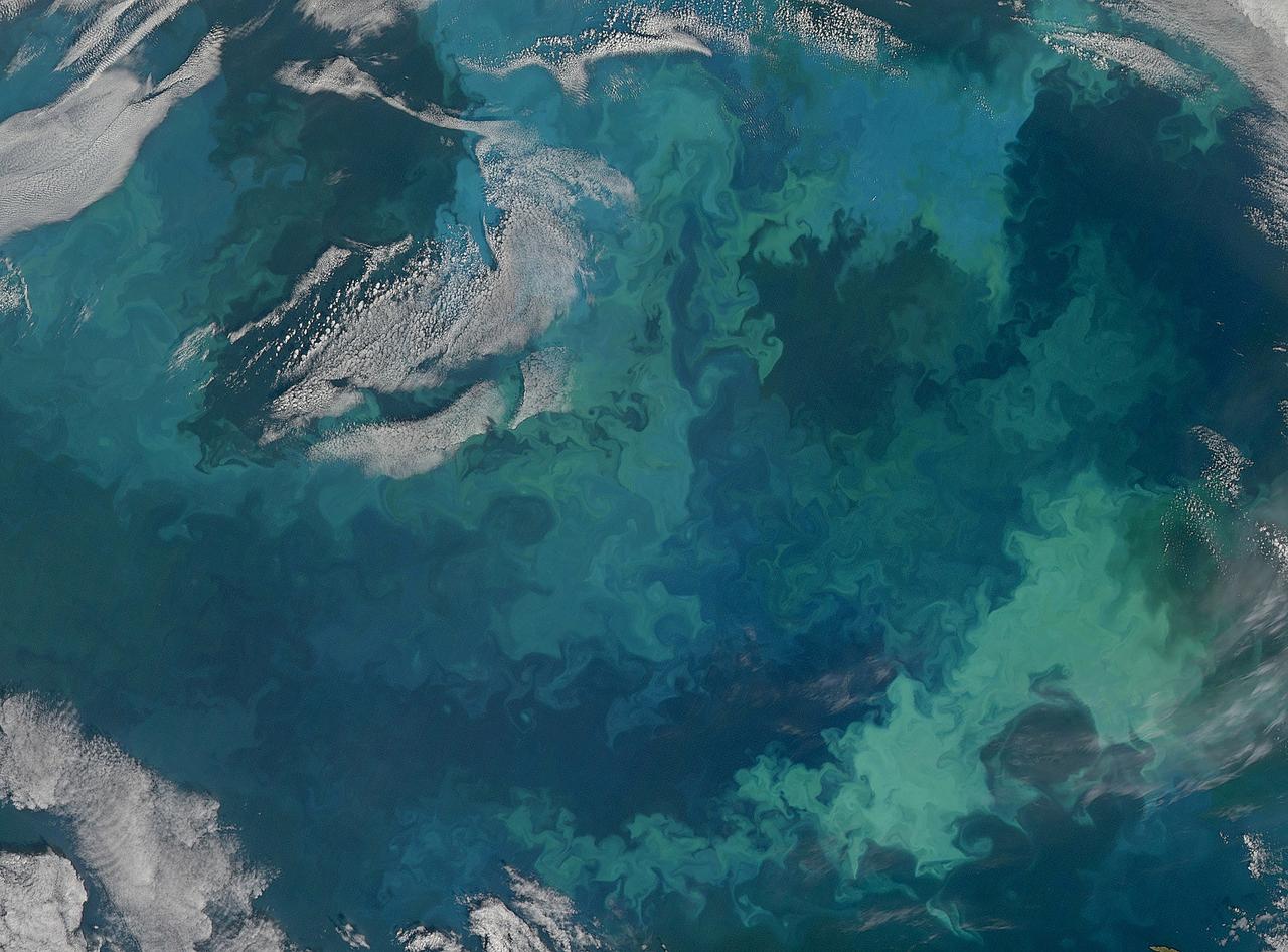
NASA image acquired August 31, 2010 To see the full view of this image go to: <a href="http://www.flickr.com/photos/gsfc/4970549945">www.flickr.com/photos/gsfc/4970549945</a> In this natural-color image from August 31, 2010, the ocean’s canvas swirls with turquoise, teal, navy, and green, the abstract art of the natural world. The colors were painted by a massive phytoplankton bloom made up of millions of tiny, light-reflecting organisms growing in the sunlit surface waters of the Barents Sea. Such blooms peak every August in the Barents Sea. The variations in color are caused by different species and concentrations of phytoplankton. The bright blue colors are probably from coccolithophores, a type of phytoplankton that is coated in a chalky shell that reflects light, turning the ocean a milky turquoise. Coccolithophores dominate the Barents Sea in August. Shades of green are likely from diatoms, another type of phytoplankton. Diatoms usually dominate the Barents Sea earlier in the year, giving way to coccolithophores in the late summer. However, field measurements of previous August blooms have also turned up high concentrations of diatoms. The Barents Sea is a shallow sea sandwiched between the coastline of northern Russia and Scandinavia and the islands of Svalbard, Franz Josef Land, and Novaya Zemlya. Within the shallow basin, currents carrying warm, salty water from the Atlantic collide with currents carrying cold, fresher water from the Arctic. During the winter, strong winds drive the currents and mix the waters. When winter’s sea ice retreats and light returns in the spring, diatoms thrive, typically peaking in a large bloom in late May. The shift between diatoms and coccolithophores occurs as the Barents Sea changes during the summer months. Throughout summer, perpetual light falls on the waters, gradually warming the surface. Eventually, the ocean stratifies into layers, with warm water sitting on top of cooler water. The diatoms deplete most of the nutrients in the surface waters and stop growing. Coccolithophores, on the other hand, do well in warm, nutrient-depleted water with a lot of light. In the Barents Sea, these conditions are strongest in August. The shifting conditions and corresponding change in species lead to strikingly beautiful multicolored blooms such as this one. The Moderate Resolution Imaging Spectroradiometer (MODIS) on NASA’s Aqua satellite acquired this image. NASA image courtesy Norman Kuring, NASA Ocean Color Group. Caption by Holli Riebeek. Instrument: Aqua - MODIS Click here to see more images from <b><a href="#//earthobservatory.nasa.gov/" rel="nofollow"> NASA Goddard’s Earth Observatory</a></b> <b><a href="http://www.nasa.gov/centers/goddard/home/index.html" rel="nofollow">NASA Goddard Space Flight Center</a></b> is home to the nation's largest organization of combined scientists, engineers and technologists that build spacecraft, instruments and new technology to study the Earth, the sun, our solar system, and the universe. <b>Follow us on <a href="http://twitter.com/NASA_GoddardPix" rel="nofollow">Twitter</a></b> <b>Join us on <a href="http://www.facebook.com/pages/Greenbelt-MD/NASA-Goddard/395013845897?ref=tsd" rel="nofollow">Facebook</a></b>

This artist's concept represents the "Follow the Water" theme of NASA's Mars Reconnaissance Orbiter mission. The orbiter's science instruments monitor the present water cycle in the Mars atmosphere and the associated deposition and sublimation of water ice on the surface, while probing the subsurface to see how deep the water-ice reservoir detected by Mars Odyssey extends. At the same time, Mars Reconnaissance Orbiter will search for surface features and minerals (such as carbonates and sulfates) that record the extended presence of liquid water on the surface earlier in the planet's history. The instruments involved are the Shallow Subsurface Radar, the Compact Reconnaissance Imaging Spectrometer for Mars, the Mars Color Imager, the High Resolution Imaging Science Experiment, the Context Camera and the Mars Climate Sounder. To the far left, the radar antenna beams down and "sees" into the first few hundred feet (up to 1 kilometer) of Mars' crust. Just to the right of that, the next beam highlights the data received from the imaging spectrometer, which identifies minerals on the surface. The next beam represents the high-resolution camera, which can "zoom in" on local targets, providing the highest-resolution orbital images yet of features such as craters and gullies and rocks. The beam that shines almost horizontally is that of the Mars Climate Sounder. This instrument is critical to analyzing the current climate of Mars since it observes the temperature, humidity, and dust content of the martian atmosphere, and their seasonal and year-to-year variations. Meanwhile, the Mars Color Imager observes ice clouds, dust clouds and hazes, and the ozone distribution, producing daily global maps in multiple colors to monitor daily weather and seasonal changes. The electromagnetic spectrum is represented on the top right and individual instruments are placed where their capability lies. http://photojournal.jpl.nasa.gov/catalog/PIA07241
STS085-705-062 (7 - 19 August 1997) --- The Great Salt is one of the most saline inland bodies of water in the world and is the largest inland body of salt water in the Western Hemisphere. The lake is fed by three rivers (Bear, Weber and Jordon) and has no outlet. The water level varies with the amount of rainfall and evaporation in the basin. The distinct line across the center of the lake is the Lucin Cutoff. It is a 30 mile (48 kilometers), east-west causeway built in 1959 to support a rail line. The causeway connects the cities of Ogden and Lucin and affects the water level of the lake. Because the lake's main tributaries enter from the south, the water level of the southern section is several inches higher than that of the northern part. The Great Salt Lake's record high levels in the mid-1980's threatened the Lucin Cutoff, highways and sewage-treatment plants along the shore -- in 1987 pumps were installed that began draining some of the excess water into the Great Salt Lake Desert to the west. The resulting new body of water was called the Newfoundland Evaporation Basin -- it contains dissolved minerals, primarily sodium and chloride along with sulfate, magnesium, and potassium. The dissolved minerals, turbidity and microorganisms which can survive in saline water give the lake its varying colors. In this photo the north portion is dark red. The crew said that it looked like dirt when they first saw it. Crews can not remember the north portion ever looking so red -- it is usually a light blue color.
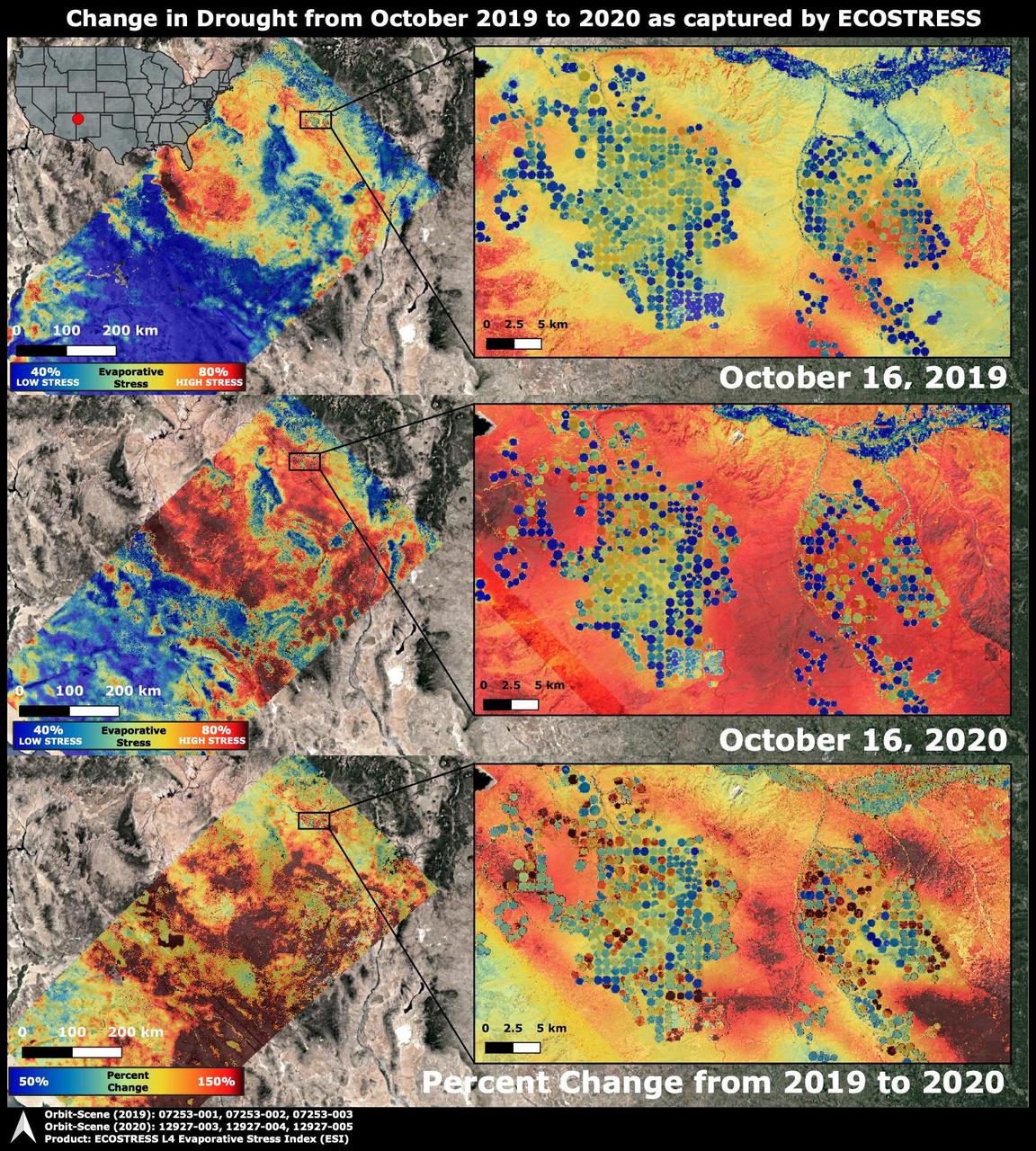
The Western United States has been entrenched in an Extreme and Exceptional drought that has extended from the summer and into the fall of 2020. NASA's ECOsystem Spaceborne Thermal Radiometer Experiment on Space Station (ECOSTRESS) imaged the drought on Oct. 16, 2020, and compared the same area to an image from ECOSTRESS taken a year earlier on Oct. 16, 2019. The bottom image shows the percentage change in plant water stress from 2019 to 2020. The images at left zoom into the Arizona and New Mexico border and Navajo Nation Territory area, featuring the ECOSTRESS Evaporative Stress Index (ESI), which shows plant water stress. The inset images on the right zoom further into the region, showing circular agricultural fields that have been irrigated. Blue colors represent low stress and high water use, whereas red colors represent high stress and low water use. Irrigation is able to alleviate plant water stress in many of the fields while the surrounding landscape suffers from the drought, though numerous agricultural fields are shut down in the drought image. The primary mission of ECOSTRESS, which launched to the International Space Station in June 2018, is to provide insight into plants' health, especially in a drought, by taking their temperature. Plants regulate their temperature by releasing water through tiny pores on their leaves. With sufficient water, they can maintain their temperature. When they lack water, their temperatures rise; ECOSTRESS can measure this change. https://photojournal.jpl.nasa.gov/catalog/PIA24132
STS059-213-009 (9-20 April 1994) --- San Francisco Bay. Orient with the sea up. The delta of the combined Sacramento and San Joaquin Rivers occupies the foreground, San Francisco Bay the middle distance, and the Pacific Ocean the rest. Variations in water color caused both by sediment load and by wind streaking strike the eye. Man-made features dominate this scene. The Lafayette/Concord complex is left of the bay head, Vallejo is to the right, the Berkeley/Oakland complex rims the shoreline of the main bay, and San Francisco fills the peninsula beyond. Salt-evaporation ponds contain differently-colored algae depending on salinity. The low altitude (less than 120 nautical miles) and unusually-clear air combine to provide unusually-strong green colors in this Spring scene. Hasselblad camera.
Range : 35,000 miles plus. This color image of the Simpson Desert in Australia was obtained by the Galileo spacecraft at aboaut 2:30 pm PST. The color composite was made from images taken through the red, green and violet filters. The area shown, about 280 miles wide by about 340 miles north-to-south, is southeast of Alice Springs. At lower left is Lake Eyre, a salt lake below sea level, subject to seasonal water-level fluctuations; when this image was acquired the lake was nearly dry. At lower right is the greenish Lake Blanche. Fields of linear sand dunes stretch north and east of Lake Eyre, shaped by prevailing winds from the south and showing, in different colors, the various sources and/or ages of their sands.
Saturn's rings display their subtle colors in this view captured on Aug. 22, 2009, by NASA's Cassini spacecraft. The particles that make up the rings range in size from smaller than a grain of sand to as large as mountains, and are mostly made of water ice. The exact nature of the material responsible for bestowing color on the rings remains a matter of intense debate among scientists. Images taken using red, green and blue spectral filters were combined to create this natural color view. Cassini's narrow-angle camera took the images at a distance of approximately 1.27 million miles (2.05 million kilometers) from the center of the rings. The Cassini spacecraft ended its mission on Sept. 15, 2017 https://photojournal.jpl.nasa.gov/catalog/PIA22418
This enhanced-color image shows a 45-meter-diameter crater that formed sometime between October 2010 and May 2012 in so-called "brain" terrain on Mars. HiRISE has been monitoring this crater to look for changes in the bright icy material exposed in the crater wall and some of the ejecta blocks. This material is interpreted as water ice because its extent changes with time, consistent with slow sublimation caused by solar heating. (Sublimation is the process when a solid converts directly into a gaseous state.) By comparing this image with another one (ESP_046707_2220) taken in July 2016, we see that some of the ejecta blocks have vanished since then. It appears that fresh ice has been exposed on the east wall of the crater since 2016, perhaps due to slumping of dirty material. When we apply different color enhancements to these two images, we see that the color of the scene did not actually change much. https://photojournal.jpl.nasa.gov/catalog/PIA23477
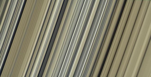
These are the highest-resolution color images of any part of Saturn's rings, to date, showing a portion of the inner-central part of the planet's B Ring. The view is a mosaic of two images that show a region that lies between 61,300 and 65,600 miles (98,600 and 105,500 kilometers) from Saturn's center. This image is a natural color composite, created using images taken with red, green and blue spectral filters. The pale tan color is generally not perceptible with the naked eye in telescope views, especially given that Saturn has a similar hue. The material responsible for bestowing this color on the rings -- which are mostly water ice and would otherwise appear white -- is a matter of intense debate among ring scientists that will hopefully be settled by new in-situ observations before the end of Cassini's mission. The different ringlets seen here are part of what is called the "irregular structure" of the B ring. Cassini radio occultations of the rings have shown that these features have extremely sharp boundaries on even smaller scales (radially, or along the direction outward from Saturn) than the camera can resolve here. Closer to Saturn, the irregular structures become fuzzier and more rounded, less opaque, and their color contrast diminishes. The narrow ringlets in the middle of this scene are each about 25 miles (40 kilometers) wide, and the broader bands at right are about 200 to 300 miles (300 to 500 kilometers) across. It remains unclear exactly what causes the variable brightness of these ringlets and bands -- the basic brightness of the ring particles themselves, shadowing on their surfaces, their absolute abundance, and how densely the particles are packed, may all play a role. The second image (Figure 1) is a color-enhanced version. Blue colors represent areas where the spectrum at visible wavelengths is less reddish (meaning the spectrum is flatter toward red wavelengths), while red colors represent areas that are spectrally redder (meaning the spectrum has a steeper spectrum toward red wavelengths). Observations from the Voyager mission and Cassini's visual and infrared mapping spectrometer previously showed these color variations at lower resolution, but it was not known that such well-defined color contrasts would be this sharply defined down to the scale (radial scale) of a couple of miles or kilometers, as seen here. Analysis of additional images from this observation, taken using infrared spectral filters sensitive to absorption of light by water ice, indicates that the areas that appear more visibly reddish in the color-enhanced version are also richer in water ice. The third image (Figure 2) is a composite of the "true" and "enhanced" color images for easy comparison. This image was taken on July 6, 2017, with the Cassini spacecraft narrow-angle camera. The image was acquired on the sunlit side of the rings from a distance of 47,000 miles (76,000 kilometers) away from the area pictured. The image scale is about 2 miles (3 kilometers) per pixel. The phase angle, or sun-ring-spacecraft angle, is 90 degrees. https://photojournal.jpl.nasa.gov/catalog/PIA21628
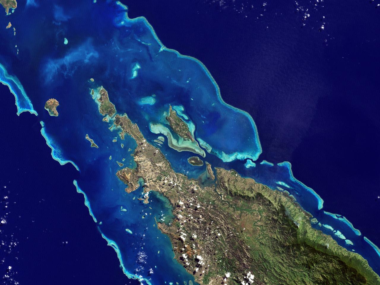
NASA image acquired May 10, 2001 In July 2008, the United Nations Educational, Scientific, and Cultural Organization (UNESCO) added 27 new areas to its list of World Heritage sites. One of those areas included the lagoons of New Caledonia. Some 1,200 kilometers (750 miles) east of Australia, this French-governed archipelago contains the world’s third-largest coral reef structure. The coral reefs enclose the waters near the islands in shallow lagoons of impressive biodiversity. On May 10, 2001, the Enhanced Thematic Mapper Plus on NASA’s Landsat 7 satellite captured this image of Île Balabio, off the northern tip of Grande Terra, New Caledonia’s main island. In this natural-color image, the islands appear in shades of green and brown—mixtures of vegetation and bare ground. The surrounding waters range in color from pale aquamarine to deep blue, and the color differences result from varying depths. Over coral reef ridges and sand bars, the water is shallowest and palest in color. Darker shades of blue characterize deeper waters. Reef-enclosed, shallow waters surround Île Balabio, and a larger, semi-enclosed lagoon appears immediately east of that island. Immediately north of Grande Terra, unenclosed, deeper waters predominate. The coral reefs around New Caledonia support an unusual diversity of species, including large numbers of predators and big fish, turtles, and the world’s third-largest dugong population. NASA image created by Jesse Allen, using Landsat data provided by the United States Geological Survey. Caption by Michon Scott. Instrument: Landsat 7 - ETM+ Credit: NASA/GSFC/Landsat <b><a href="http://www.nasa.gov/centers/goddard/home/index.html" rel="nofollow">NASA Goddard Space Flight Center</a></b> enables NASA’s mission through four scientific endeavors: Earth Science, Heliophysics, Solar System Exploration, and Astrophysics. Goddard plays a leading role in NASA’s accomplishments by contributing compelling scientific knowledge to advance the Agency’s mission. <b>Follow us on <a href="http://twitter.com/NASA_GoddardPix" rel="nofollow">Twitter</a></b> <b>Join us on <a href="http://www.facebook.com/pages/Greenbelt-MD/NASA-Goddard/395013845897?ref=tsd" rel="nofollow">Facebook</a></b>
This false color image shows part of Harris crater (center of image) and an unnamed crater (top of image). These craters are located north of Hellas Planitia. At the upper right part of the Harris Crater rim, there is a fan shaped form. Fans can be created by different processes. Delta deposit fans are created under water, when a river flow slows down and drops sediments from the water column. These sediments are typically fine grained silts. Deltas form over time and can take many shapes as the river changes channels. The Mississippi River delta is formed this way. Alluvial fans are created in dry climates with short fluid seasons. In this case a single stream hits a topographic opening (think ravine) and sheds the rocks and sand down hill. The alluvial fan shape is created from the single opening. Either way, fans form by the action of a fluid. The THEMIS VIS camera contains 5 filters. The data from different filters can be combined in multiple ways to create a false color image. These false color images may reveal subtle variations of the surface not easily identified in a single band image. Orbit Number: 64642 Latitude: -21.9957 Longitude: 67.2664 Instrument: VIS Captured: 2016-07-10 10:43 https://photojournal.jpl.nasa.gov/catalog/PIA23611
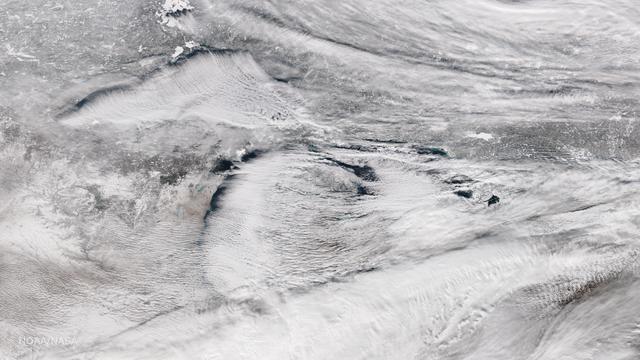
Bands of lake effect snow drift eastward from the western Great Lakes in this true-color image captured by the NOAA/NASA Suomi NPP satellite's Visible Infrared Imaging Radiometer Suite (VIIRS) instrument on January 5, 2017. National Weather Service forecasters expect light to moderate lake effect snow showers to continue throughout the day today and into Saturday (1/7). Lake-effect snow forms when cold air passes over the warmer waters of a lake. This causes some lake water to evaporate into the air and warm it. This warmer, wetter air rises and cools as it moves away from the lake. When it cools, it releases that moisture and, if it’s cold enough, that moisture turns into snow. Although true-color images like this may appear to be photographs of Earth, they aren't. They are created by combining data from the three color channels on the VIIRS instrument sensitive to the red, green and blue (or RGB) wavelengths of light into one composite image. In addition, data from several other channels are often also included to cancel out or correct atmospheric interference that may blur parts of the image. Credit: NOAA/NASA/Suomi NPP via NOAA's Environmental Visualization Laboratory
![The puzzling, fascinating surface of Jupiter icy moon Europa looms large in this newly-reprocessed [sic] color view, made from images taken by NASA Galileo spacecraft in the late 1990s. This is the color view of Europa from Galileo that shows the largest portion of the moon's surface at the highest resolution. The view was previously released as a mosaic with lower resolution and strongly enhanced color (see PIA02590). To create this new version, the images were assembled into a realistic color view of the surface that approximates how Europa would appear to the human eye. The scene shows the stunning diversity of Europa's surface geology. Long, linear cracks and ridges crisscross the surface, interrupted by regions of disrupted terrain where the surface ice crust has been broken up and re-frozen into new patterns. Color variations across the surface are associated with differences in geologic feature type and location. For example, areas that appear blue or white contain relatively pure water ice, while reddish and brownish areas include non-ice components in higher concentrations. The polar regions, visible at the left and right of this view, are noticeably bluer than the more equatorial latitudes, which look more white. This color variation is thought to be due to differences in ice grain size in the two locations. Images taken through near-infrared, green and violet filters have been combined to produce this view. The images have been corrected for light scattered outside of the image, to provide a color correction that is calibrated by wavelength. Gaps in the images have been filled with simulated color based on the color of nearby surface areas with similar terrain types. This global color view consists of images acquired by the Galileo Solid-State Imaging (SSI) experiment on the spacecraft's first and fourteenth orbits through the Jupiter system, in 1995 and 1998, respectively. Image scale is 1 mile (1.6 kilometers) per pixel. North on Europa is at right. http://photojournal.jpl.nasa.gov/catalog/PIA19048](https://images-assets.nasa.gov/image/PIA19048/PIA19048~medium.jpg)
The puzzling, fascinating surface of Jupiter icy moon Europa looms large in this newly-reprocessed [sic] color view, made from images taken by NASA Galileo spacecraft in the late 1990s. This is the color view of Europa from Galileo that shows the largest portion of the moon's surface at the highest resolution. The view was previously released as a mosaic with lower resolution and strongly enhanced color (see PIA02590). To create this new version, the images were assembled into a realistic color view of the surface that approximates how Europa would appear to the human eye. The scene shows the stunning diversity of Europa's surface geology. Long, linear cracks and ridges crisscross the surface, interrupted by regions of disrupted terrain where the surface ice crust has been broken up and re-frozen into new patterns. Color variations across the surface are associated with differences in geologic feature type and location. For example, areas that appear blue or white contain relatively pure water ice, while reddish and brownish areas include non-ice components in higher concentrations. The polar regions, visible at the left and right of this view, are noticeably bluer than the more equatorial latitudes, which look more white. This color variation is thought to be due to differences in ice grain size in the two locations. Images taken through near-infrared, green and violet filters have been combined to produce this view. The images have been corrected for light scattered outside of the image, to provide a color correction that is calibrated by wavelength. Gaps in the images have been filled with simulated color based on the color of nearby surface areas with similar terrain types. This global color view consists of images acquired by the Galileo Solid-State Imaging (SSI) experiment on the spacecraft's first and fourteenth orbits through the Jupiter system, in 1995 and 1998, respectively. Image scale is 1 mile (1.6 kilometers) per pixel. North on Europa is at right. http://photojournal.jpl.nasa.gov/catalog/PIA19048
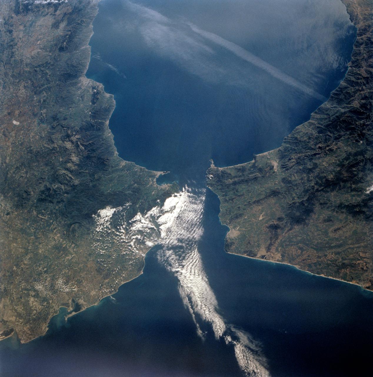
STS-56 Earth observation taken aboard Discovery, Orbiter Vehicle (OV) 103, is of the Strait of Gibraltar. A small bank of clouds marks the passage between Spain and Morocco at the western edge of the Mediterranean Sea. This passage, one of the two Pilars of Hercules of the Ancient Greeks, is now known as the Strait of Gibraltar. The cities of Cadiz on the Atlantic Coast of Spain and Malaga on the Mediterranean coast, as well as Tangier, Morocco (facing the strait), can be seen. According to NASA scientists studying the STS-56 photos, a subtle difference in the water color on the Atlantic side suggests that a pulse of surface water had recently flowed out of the Mediterranean into the Atlantic.
KENNEDY SPACE CENTER, FLA. - Distinctive with its black and white coloring and very long red legs, this stilt heads for deeper water in a marsh near KSC, which shares a boundary with the Merritt Island National Wildlife Refuge. Stilts inhabit salt marshes and shallow coastal bays in the East. The marshes and open water of the refuge provide wintering areas for 23 species of migratory waterfowl, as well as a year-round home for great blue herons, great egrets, wood storks, cormorants, brown pelicans and other species of marsh and shore birds.
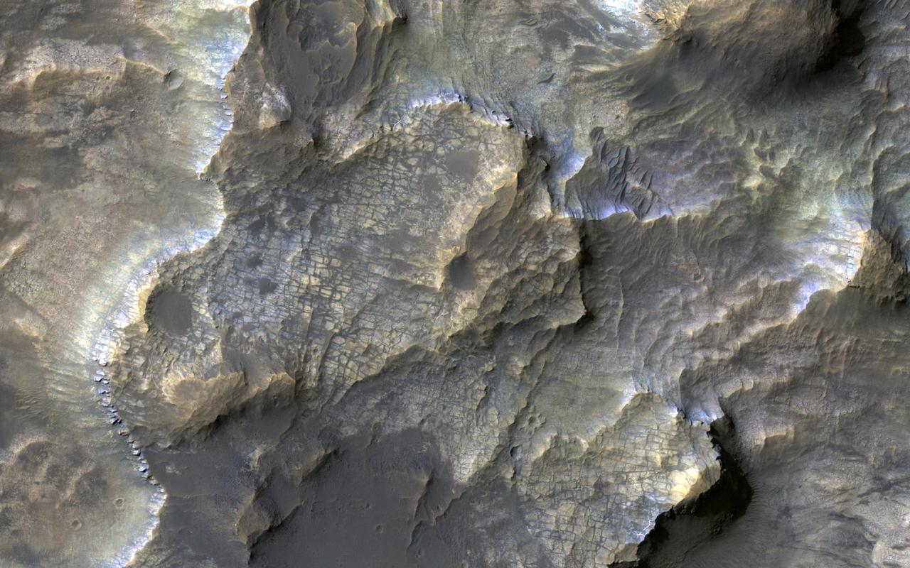
This colorful image, acquired on May 21, 2018 by NASA's Mars Reconnaissance Orbiter, shows clays within the Eridania basin region. Many scientists using orbital data have proposed that a large lake may have once existed here during the Late Noachian through Early Hesperian time periods, and then much of the water drained out to the north via Ma'adim Vallis. Understanding where and what kind of clay exists within this region using CRISM data can help scientists learn more about how long the postulated lake existed and the water chemistry within the lake. More information is available at https://photojournal.jpl.nasa.gov/catalog/PIA22588
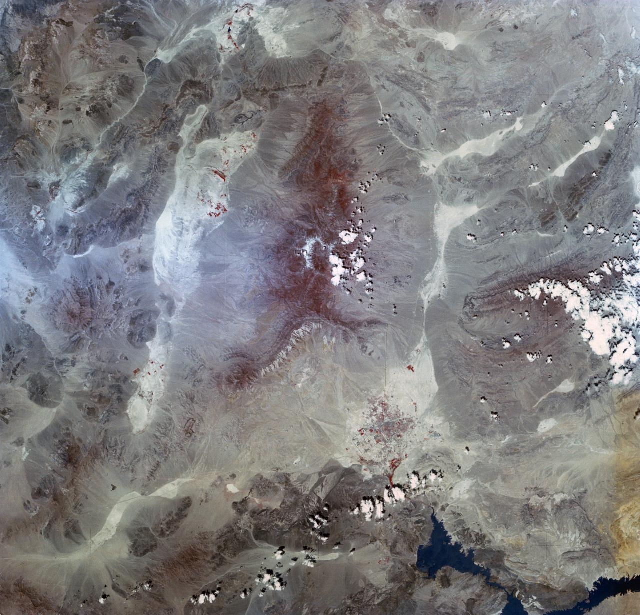
SL2-03-192 (22 June 1973) --- Lake Mead, Nevada, (36.0N, 114.5E) where the water from the Colorado River empties after it's 273 mile journey through the Grand Canyon of Arizona is the subject of this photo. Other features of interest are Hoover Dam on the south shore of Lake Mead where cheap hydroelectric power is secondary to the water resources made available in this northern desert region and the resort city of Las Vegas, just to the west of Lake Mead. In this harsh desert environment, color infrared photography readily penetrates haze, detects and portrays vegetation as shades of red. Photo credit: NASA
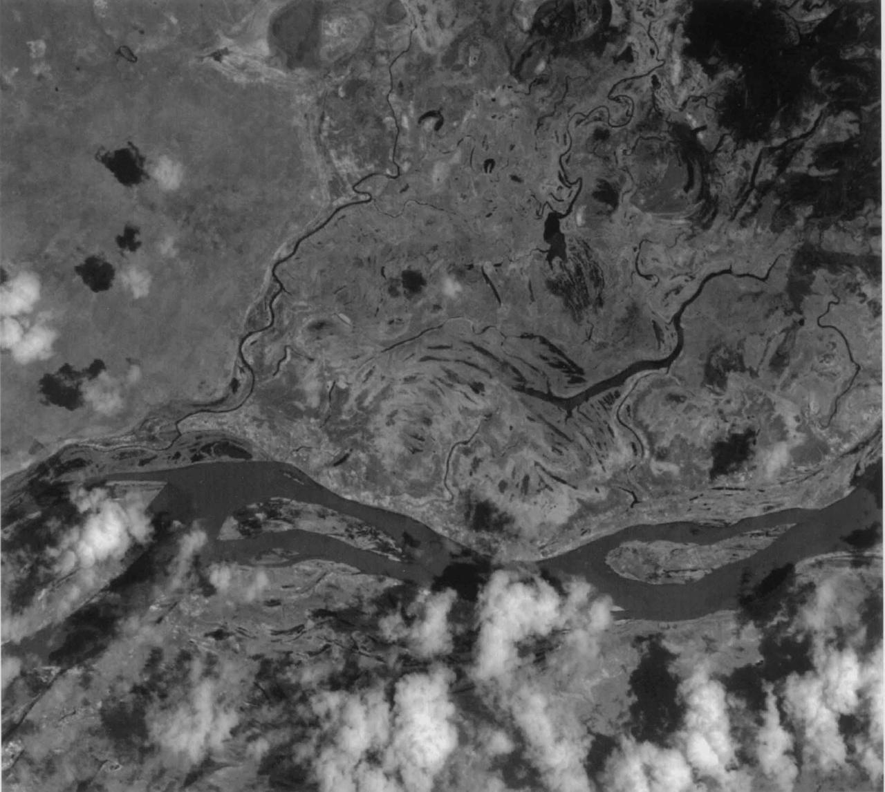
This image of the San Francisco River channel, and its surrounding flood zone, in Brazil was acquired by band 3N of ASTER's Visible/Near Infrared sensor. The surrounding area along the river channel in light gray to white could be covered by dense tropical rain forests. The water surface of the San Francisco River shows rather gray color as compared to small lakes and tributaries, which could indicate that the river water is contaminated by suspended material. The size of image: 20 km x 20 km approx., ground resolution 15 m x 15 m approximately. http://photojournal.jpl.nasa.gov/catalog/PIA02451
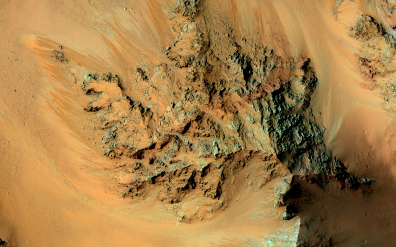
Recurring slope lineae are active flows on warm Martian slopes that might be caused by seeping water. One of the most active sites known is in the central peaks of Hale Crater as seen by NASA Mars Reconnaissance Orbiter. This image shows RSL extending downhill from bedrock cliffs, mostly towards the northwest (upper left). This image was acquired in middle summer when RSL are most active in the southern mid latitudes. The RSL in Hale have an unusually "reddish" color compared to most RSL, perhaps due to oxidized iron compounds, like rust. Since HiRISE color is shifted to infra-red wavelengths, they are actually especially bright the near-infrared just beyond the range of human vision. The Hale RSL are also unusual because they began activity much earlier than most RSL sites in the middle southern latitudes, and were well-developed in the early spring (see ESP_038073_1440). If seeping water causes RSL in Hale crater, it must be rich in salts to lower its freezing point significantly below the freezing point of pure water. http://photojournal.jpl.nasa.gov/catalog/PIA19359
The above images, derived from NASA QuikScat satellite data, show the extensive pattern of rain water deposited by Hurricanes Katrina and Rita on land surfaces over several states in the southern and eastern United States. These results demonstrate the capability of satellite scatterometers to monitor changes in surface water on land. The color scale depicts increases in radar backscatter (in decibels) between the current measurement and the mean of measurements obtained during the previous two weeks. The backscatter can be calibrated to measure increases in surface soil moisture resulting from rainfall. The yellow color corresponds to an increase of approximately 10 percent or more in surface soil moisture according to the calibration site of Lonoke, Ark. The two hurricanes deposited excessive rainfall over extensive regions of the Mississippi River basin. Basins the size of the Mississippi can take up to several weeks before such excess rainfall significantly increases the amount of river discharge in large rivers such as the Mississippi. With hurricane season not over until November 30, the potential exists for significant flooding, particularly if new rain water is deposited by new hurricanes when river discharge peaks up as a result of previous rainfalls. River discharge should be closely monitored to account for this factor in evaluating potential flood conditions in the event of further hurricanes. http://photojournal.jpl.nasa.gov/catalog/PIA03029
Today's VIS image shows a section of Cerberus Fossae. Located southeast of the Elysium Planitia volcanic complex, the linear graben in the image were created by tectonic forces related to the volcanic activity. The graben are sources of both channels and significant volcanic flows. The Cerberus Fossae graben cut across features such as hills, indicating the relative youth of the tectonic activity. Graben form where extensional tectonic forces allows blocks of material to subside between paired faults. Cerberus Fossae are 270km (168 miles) long. Just off the image to the right is the start of Athabasca Valles, which is seen flowing below the graben to the bottom left of the image. Arising from Cerberus Fossae, the formation mode of this channel is still being debated. While the channel features are similar to water flow, other features are similar to lava flows, and yet other features have an appearance of slabs of material that floated on an underlying fluid. It is thought that Athabasca Valles is the youngest outflow channel system on Mars. Athabasca Valles is just one of the complex channel formations in the Elysium Planitia region. The THEMIS VIS camera is capable of capturing color images of the Martian surface using five different color filters. In this mode of operation, the spatial resolution and coverage of the image must be reduced to accommodate the additional data volume produced from using multiple filters. To make a color image, three of the five filter images (each in grayscale) are selected. Each is contrast enhanced and then converted to a red, green, or blue intensity image. These three images are then combined to produce a full color, single image. Because the THEMIS color filters don't span the full range of colors seen by the human eye, a color THEMIS image does not represent true color. Also, because each single-filter image is contrast enhanced before inclusion in the three-color image, the apparent color variation of the scene is exaggerated. Nevertheless, the color variation that does appear is representative of some change in color, however subtle, in the actual scene. Note that the long edges of THEMIS color images typically contain color artifacts that do not represent surface variation. Orbit Number: 86770 Latitude: 10.3516 Longitude: 156.539 Instrument: VIS Captured: 2021-07-06 22:48 https://photojournal.jpl.nasa.gov/catalog/PIA24994

On February 4, 2014 the Moderate Resolution Imaging Spectroradiometer (MODIS) flying aboard NASA’s Aqua satellite captured a true-color image of sea ice off of western Alaska. In this true-color image, the snow and ice covered land appears bright white while the floating sea ice appears a duller grayish-white. Snow over the land is drier, and reflects more light back to the instrument, accounting for the very bright color. Ice overlying oceans contains more water, and increasing water decreases reflectivity of ice, resulting in duller colors. Thinner ice is also duller. The ocean waters are tinted with green, likely due to a combination of sediment and phytoplankton. Alaska lies to the east in this image, and Russia to the west. The Bering Strait, covered with ice, lies between to two. South of the Bering Strait, the waters are known as the Bering Sea. To the north lies the Chukchi Sea. The bright white island south of the Bering Strait is St. Lawrence Island. Home to just over 1200 people, the windswept island belongs to the United States, but sits closer to Russia than to Alaska. To the southeast of the island a dark area, loosely covered with floating sea ice, marks a persistent polynya – an area of open water surrounded by more frozen sea ice. Due to the prevailing winds, which blow the sea ice away from the coast in this location, the area rarely completely freezes. The ice-covered areas in this image, as well as the Beaufort Sea, to the north, are critical areas for the survival of the ringed seal, a threatened species. The seals use the sea ice, including ice caves, to rear their young, and use the free-floating sea ice for molting, raising the young and breeding. In December 2014, the National Oceanic and Atmospheric Administration (NOAA) proposed that much of this region be set aside as critical, protected habitat for the ringed seal. Credit: NASA/GSFC/Jeff Schmaltz/MODIS Land Rapid Response Team <b><a href="http://www.nasa.gov/audience/formedia/features/MP_Photo_Guidelines.html" rel="nofollow">NASA image use policy.</a></b> <b><a href="http://www.nasa.gov/centers/goddard/home/index.html" rel="nofollow">NASA Goddard Space Flight Center</a></b> enables NASA’s mission through four scientific endeavors: Earth Science, Heliophysics, Solar System Exploration, and Astrophysics. Goddard plays a leading role in NASA’s accomplishments by contributing compelling scientific knowledge to advance the Agency’s mission. <b>Follow us on <a href="http://twitter.com/NASAGoddardPix" rel="nofollow">Twitter</a></b> <b>Like us on <a href="http://www.facebook.com/pages/Greenbelt-MD/NASA-Goddard/395013845897?ref=tsd" rel="nofollow">Facebook</a></b> <b>Find us on <a href="http://instagram.com/nasagoddard?vm=grid" rel="nofollow">Instagram</a></b>
Range : 50,000 miles This multispectral map of Australia, and surrounding seas was obtained by the Galileo spacecraft's Near Infrared Mapping Spectrometer shortly after closest approach. The image shows various ocean, land and atmospheric cloud features as they appear in three of the 408 infrared colors or wavelengths sensed by the instrument. The wavelength of 0.873 micron, represented as blue in the photo, shows regions of enhanced liquid water absorption, i.e. the Pacific and Indian oceans. The 0.984-micron band, represented as red, shows areas of enhanced ground reflection as on the Australian continent. This wavelength is also s ensitive to the reflectivity of relatively thick clouds. The 0.939-micron wavelength, shown as green, is a strong water-vapor-absorbing band, and is used to accentuate clouds lying above the strongly absorbing lower atmosphere. When mixed with the red indicator of cloud reflection, the green produces a yellowish hue; this indicates thick clouds. The distinctive purplish color off the northeast coast marks the unusually shallow waters of the Great Barrier Reef and the Coral Sea. Here the blue denoting water absorption combines with the red denoting reflection from coral and surface marine organisms to produce thiss unusual color. The Near Infrared Mapping Spectrometer (NIMS) on the Galileo spacecraft is a combines mapping (imaging) and spectral instrument. It can sense 408 contiguous wavelengths from 0.7 micron (deep red) to 5.2 microns, and can construct a map or image by mechanical scanning. It can spectroscopically analyze atmospheres and surfaces and construct thermal and chemical maps.
STS080-742-070 (19 Nov.-7 Dec. 1996) --- A view of the Tongue of the Ocean in the Bahama Islands east of Florida. The lines leading from the flat bottom of the Great Bahama Bank, leading into the Tongue, are caused by rapid transfer of ocean water caused by both temperature changes in the water and hurricanes that periodically cross the area. The water is about 30 feet deep on the Great Bahama Bank, and nearly a mile deep in the tongue. To the left is the Exuma Sound, over a mile deep, and a series of islands along its edge with Great Exuma Island the easiest to see. Green Cay, the small dot lower left, leaving a wake to the southeast of light colored coral. The deep blue area to the top right center is the southeastern edge of the Great Bahama Bank.
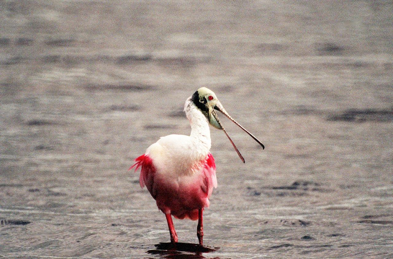
KENNEDY SPACE CENTER, FLA. -- In the shallow waters of the Merritt Island National Wildlife Refuge, a roseate spoonbill squawks at nearby intruders. The birds, named for their brilliant pink color and paddle-shaped bill, feed in shallow water by swinging their bill back and forth, scooping up small fish and crustaceans. They typically inhabit mangroves on the coasts of southern Florida, Louisiana and Texas. The 92,000-acre refuge, which shares a boundary with Kennedy Space Center, is a habitat for more than 330 species of birds, 31 mammals, 117 fishes and 65 amphibians and reptiles. The marshes and open water of the refuge provide wintering areas for 23 species of migratory waterfowl, as well as a year-round home for great blue herons, great egrets, wood storks, cormorants, brown pelicans and other species of marsh and shore birds

This mosaic taken by NASA's Mars Curiosity rover looks uphill at Mount Sharp, which Curiosity has been climbing. Highlighted in white is an area with clay-bearing rocks that scientists are eager to explore; it could shed additional light on the role of water in creating Mount Sharp. The mosaic was assembled from dozens of images taken by Curiosity's Mast Camera (Mastcam). It was taken on Sol 1931 back in January. Mount Sharp stands in the middle of Gale Crater, which is 96 miles (154 kilometers) in diameter. This mound, which Curiosity has been climbing since 2014, likely formed in the presence of water at various points of time in Mars ancient history. That makes it an ideal place to study how water influenced the habitability of Mars billions of years ago. The scene has been white-balanced so the colors of the rock materials resemble how they would appear under daytime lighting conditions on Earth. https://photojournal.jpl.nasa.gov/catalog/PIA22312
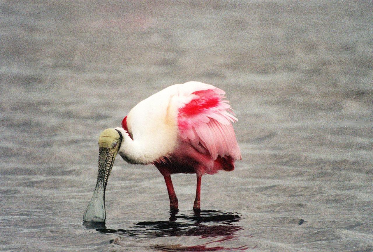
KENNEDY SPACE CENTER, FLA. -- In the Merritt Island National Wildlife Refuge, a roseate spoonbill searches the water for food. The birds, named for their brilliant pink color and paddle-shaped bill, feed in shallow water by swinging their bill back and forth, scooping up small fish and crustaceans. They typically inhabit mangroves on the coasts of southern Florida, Louisiana and Texas. The 92,000-acre refuge, which shares a boundary with Kennedy Space Center, is a habitat for more than 330 species of birds, 31 mammals, 117 fishes and 65 amphibians and reptiles. The marshes and open water of the refuge provide wintering areas for 23 species of migratory waterfowl, as well as a year-round home for great blue herons, great egrets, wood storks, cormorants, brown pelicans and other species of marsh and shore birds

KENNEDY SPACE CENTER, FLA. -- Two roseate spoonbills wade in the waters of the Merritt Island National Wildlife Refuge, which shares a boundary with Kennedy Space Center. The birds, named for their brilliant pink color and paddle-shaped bill, feed in shallow water by swinging their bill back and forth, scooping up small fish and crustaceans. They typically inhabit mangroves on the coasts of southern Florida, Louisiana and Texas. The 92,000-acre wildlife refuge is a habitat for more than 310 species of birds, 25 mammals, 117 fishes and 65 amphibians and reptiles. The marshes and open water of the refuge also provide wintering areas for 23 species of migratory waterfowl, as well as a year-round home for great blue herons, great egrets, wood storks, cormorants, brown pelicans and other species of marsh and shore birds