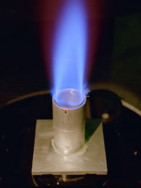
The Ring Flame Stabilizer has been developed in conjunction with Lewis Research Center. This device can lower pollutant emissions (which contribute to smog and air pollution) from natural-gas appliances such as furnaces and water heaters by 90 percent while improving energy efficiency by 2 percent.
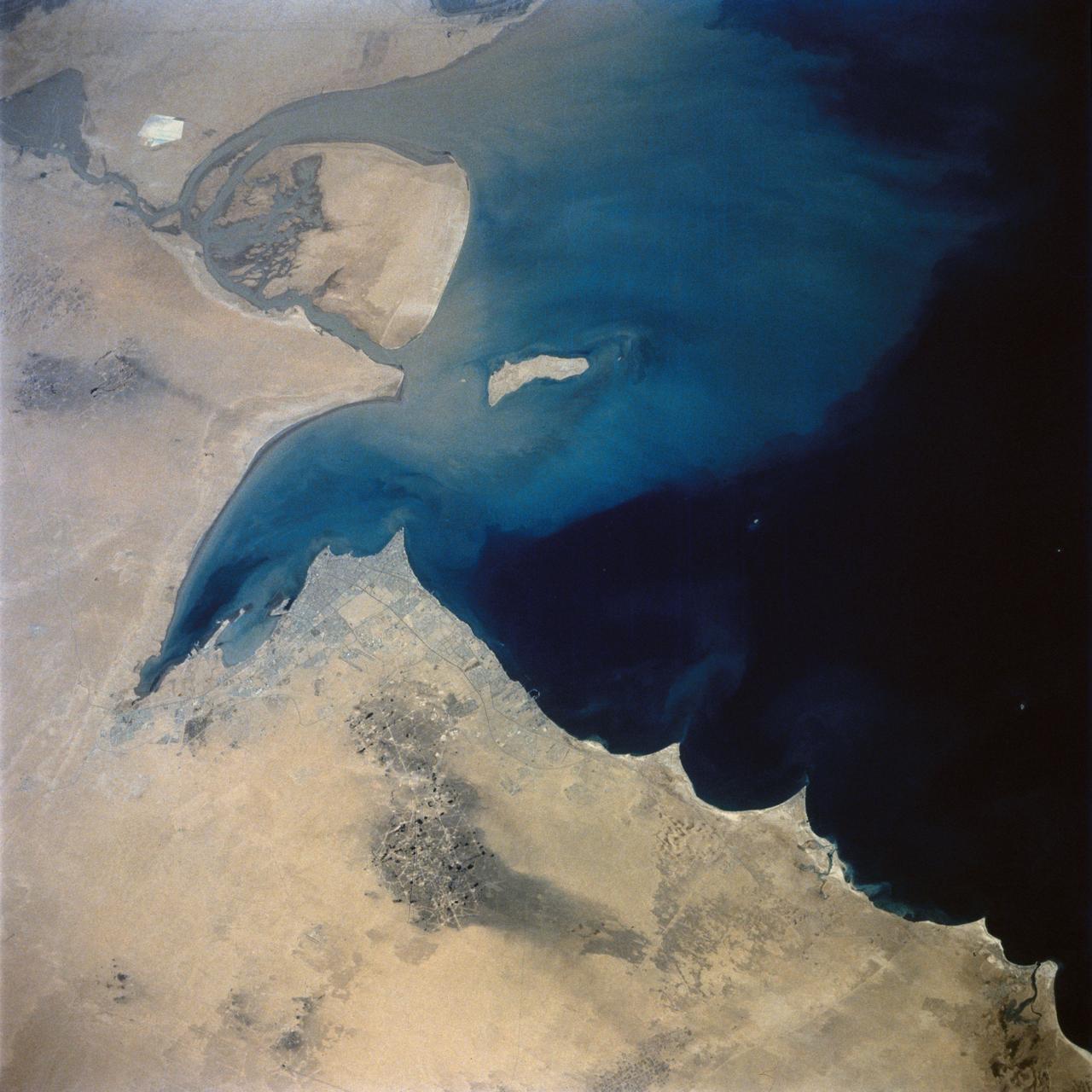
This view of the northern Persian Gulf shows Kuwait City and the Tigris and Euphrates River Deltas (29.5N, 48.5E). The oil laden sands and oil lakes of the Kuwait Oil Fields to the north and south of the city are clearly visible as dark patches surrounded by oil free desert sands. Comparison with earlier photos indicate that the oil laden sands are slowly being covered with clean sand carried by strong NW winds called Shmals.
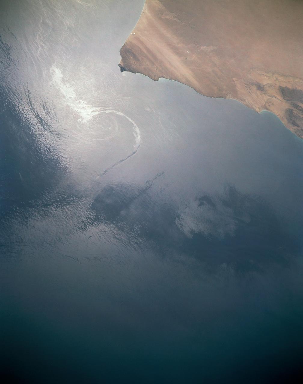
In this sunglint view of the Arabian Seacoast of Oman (19.0N, 59.0E) an oil slick is highlighted on the water's surface by sunglint lighting conditions. Nearly 50 percent of the oil transported worldwide passes through the Gulf of Oman, en route from the Persian Gulf and numerous ship wakes can be seen in this view. The oil slick, rounding the tip of Cape Ras Al Hadd, has formed a counterclockwise bright spiral indicating the local ocean currents.
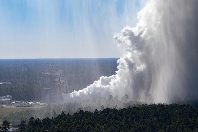
The cloud of steam is visible at NASA’s Stennis Space Center during the Oct. 17 hot fire, which marks the first test in the critical series to support future SLS (Space Launch System) missions to deep space. The steam released during the full duration, 550-second test is water and does not pollute the atmosphere.
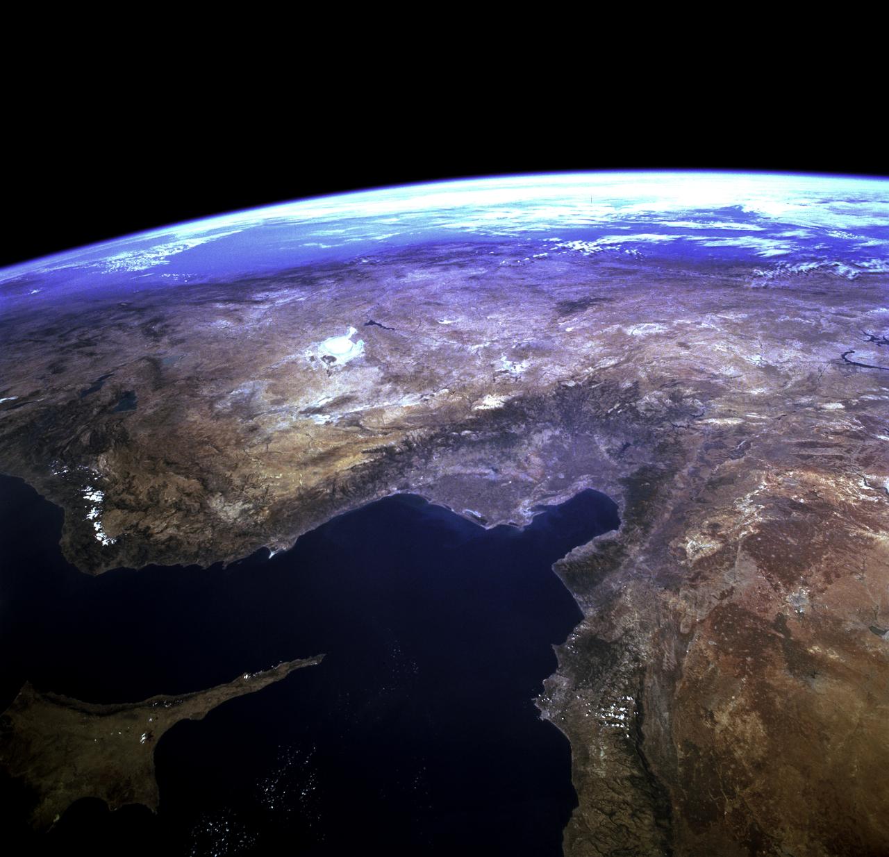
STS073-723-054 (21 October 1995) --- Central Turkey dominates this north-looking panorama, with the long fingered island of Cyprus lower left, surrounded by the deep blue waters of the Mediterranean Sea. Turkey's capital, Ankara, lies just north of the white bed of a dry lake in the center of the view. The city is supplied with water from the neighboring blue lake. The coast of Syria and Lebanon appear bottom right. Man-made lakes on the upper Euphrates River in eastern Turkey appear extreme right. According to scientists studying the STS-73 photo collection, the striking difference in visibility to north and south of Turkey suggests a pollution event over the Black Sea. Air pollution from East European industry flows down into the Black Sea basin, especially at the west end (haze top left) as shown in this view (compare clearer air top right).
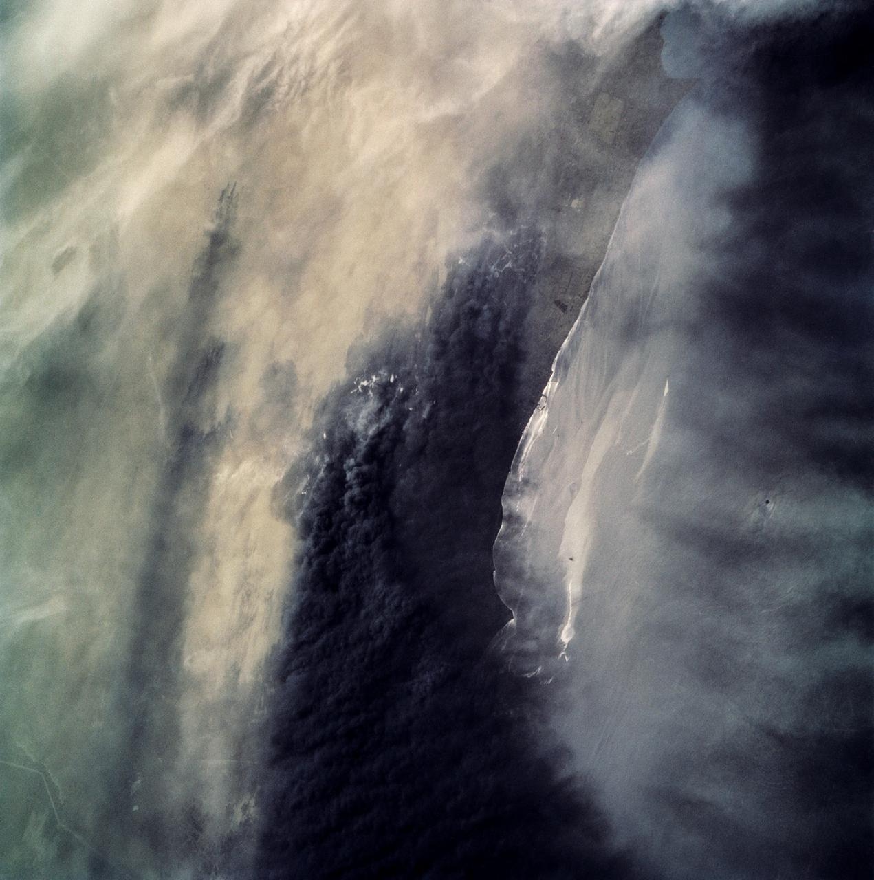
STS039-87-012 (28 April-6 May 1991) --- A handheld 70mm camera onboard the Space Shuttle Discovery exposed this infrared frame showing oil fires near the Kuwait coast as well as south-bound oil slicks in the Gulf. Pools of oil on the land are recognized as white objects near the burning wells.
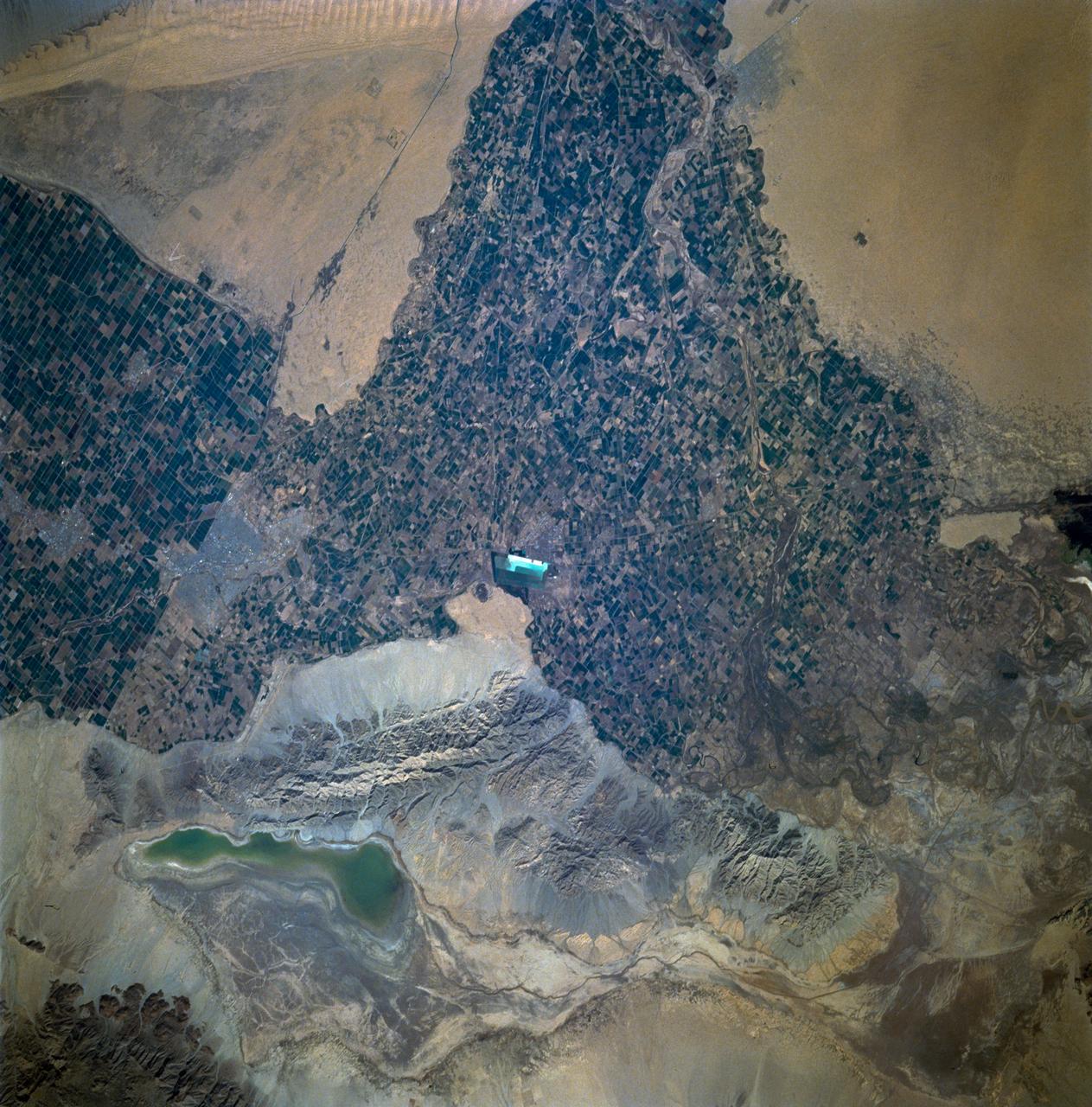
STS060-93-081 (3-11 Feb 1994)--- The Imperial Valley was documented using three films - color visible (seen here), the American infrared film (Kodak Aerochrome 2443), and the Russian panchromatic infrared film (SN-10). Results of this test still await detailed science analysis. However it does appear that good data was acquired of the region, and this data will be complemented by photography acquired by the Mir cosmonauts. In this frame, the U.S.-Mexico border goes from the upper left to the middle right. It is discernible as a vegetation line between Calexico, California and Mexicali, Mexico. The darker vegetation north of that line is due to different agricultural practices, heavier uses of fertilizers and pesticides, and lined (tiled) agricultural fields allowing subterraneean runoff of saline irrigation runoff. South of the line, the more polluted water draining out of the U.S. agricultural areas into the Mexican area has resulted in higher soil salinities and a consequent reduction in agricultural productivity. At the center of the frame, a large settling and desalinization plant has been built to attempt to purify, to some degree, the polluted irrigation waters draining south out of California. The All-American Canal, which brings in water from the Colorado River (off the frame, to the right), is located in the middle right hand portion of the frame. To the upper left is the normally dry Laguna Salada.
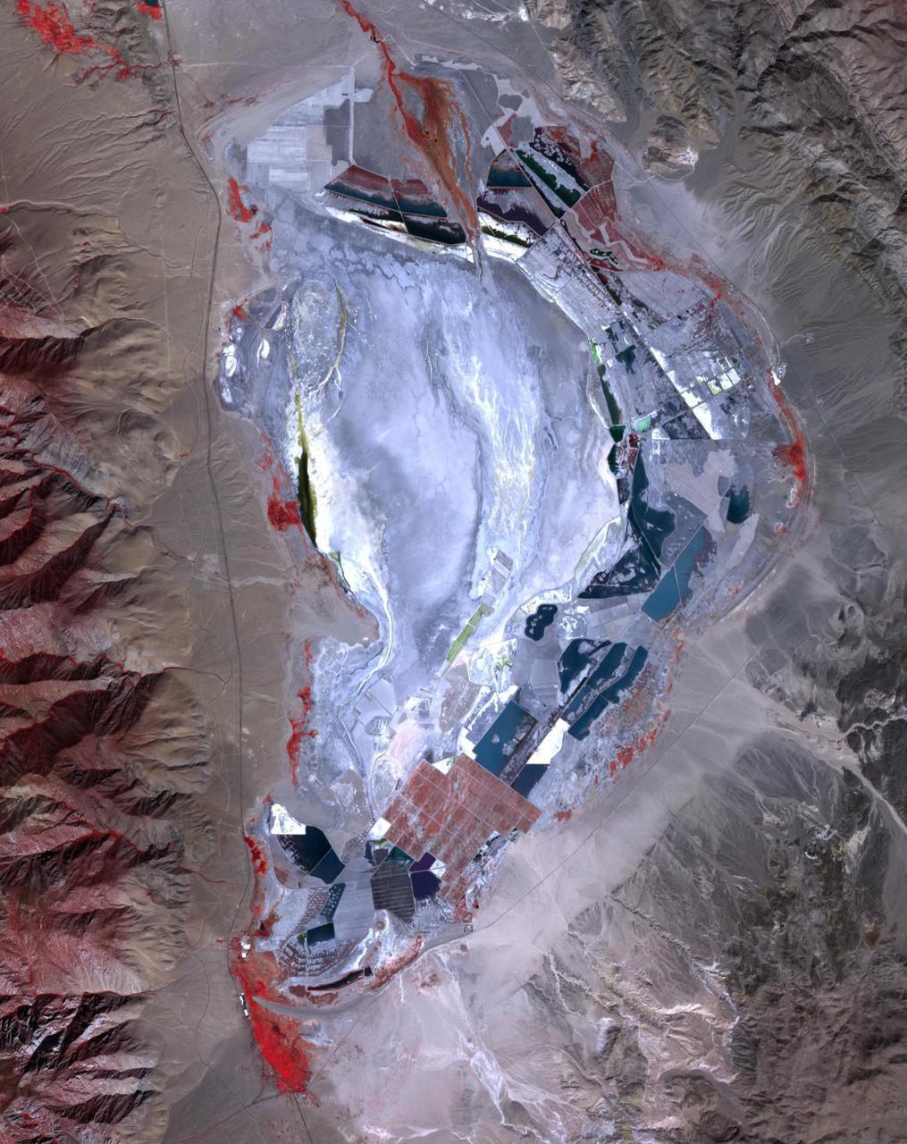
Prior to 1913, Owens Lake in eastern California had water up to a depth of 15 m, and covered an area of 280 km2. With the construction of the Los Angeles Aqueduct, all of the water from the Owens River was diverted to Los Angeles, and the lake dessicated, leading to dust storms that caused the worst air pollution in the state. Starting in 2002, various mitigation efforts were undertaken, including re-vegetation, flooding to create shallow ponds, and surface saturation to rehydrate the top layers. The ASTER image was acquired on September 29, 2020. It covers an area of 25.6 by 32.3 km, and is located at 36.4 degrees north, 117.9 degrees west. https://photojournal.jpl.nasa.gov/catalog/PIA24733

jsc2025e036188 (2/3/2025) --- A preflight image of the Exploration Aerosol Monitors (ExAM) hardware which includes the Moderated Aerosol Growth with Internal water Cycling (MAGIC) particle counter, the OPto-electrical Realtime Aerosol classifier (OPERA), the Mobile Aerosol Reference Samplers (MARS). Aerosol Monitors demonstrates technologies to continuously monitor the concentration of airborne pollutant particles, which must be kept within safe ranges, inside the International Space Station. Image courtesy of BioServe.
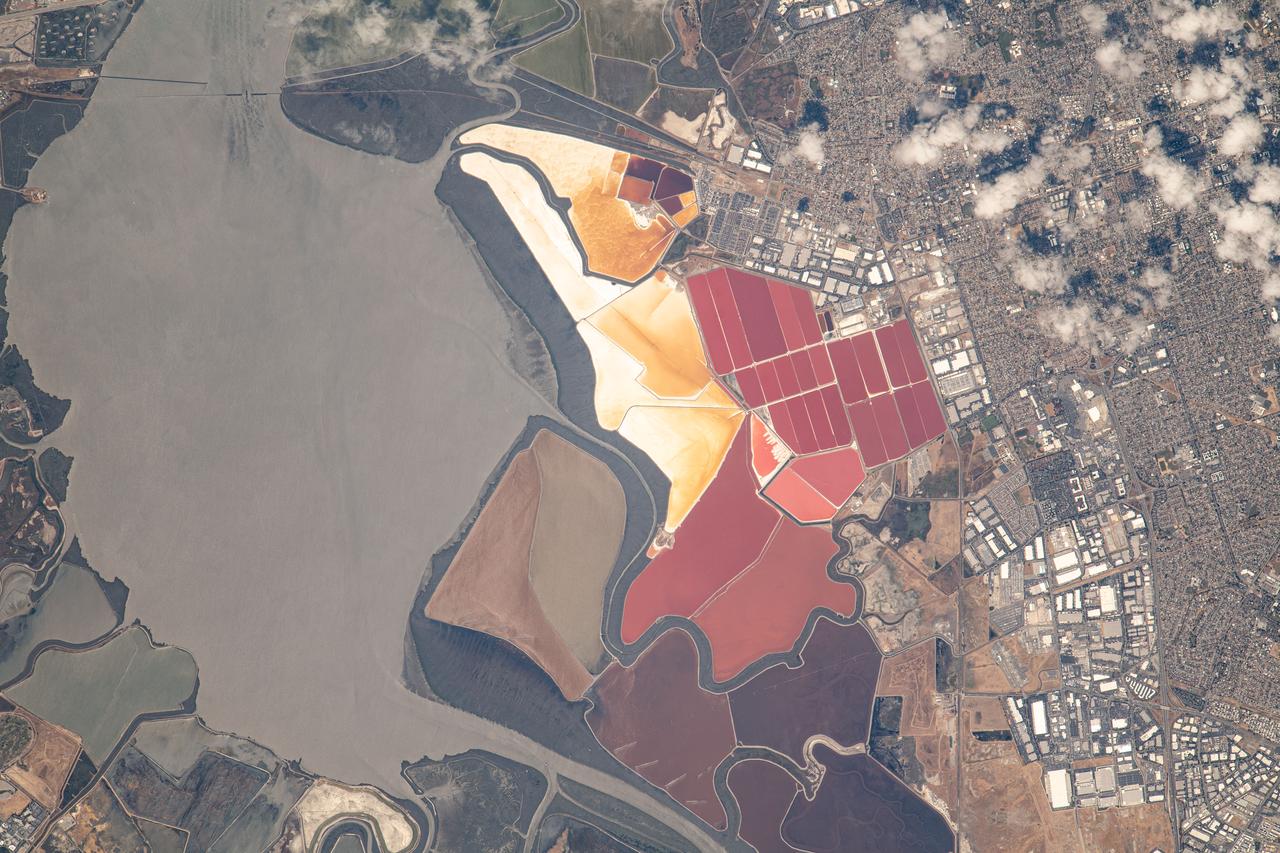
iss069e053745 (August 3, 2023) -- The South Bay Salt Ponds in the city of Newark, California show their vivid red and yellow-orange colors that primarily come from the microorganisms and brine shrimp in the waters. More than 16,500 acres are part of a restoration project— the largest in the West Coast—that includes pollution reduction, habitat expansion, and flood control. Expedition 69 Flight Engineer Woody Hoburg captured this image as the International Space Station orbited 260 miles above the coast of the Bay Area.
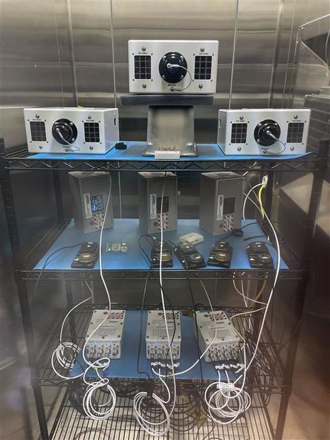
jsc2025e036187 (4/4/2025) --- The Exploration Aerosol Monitors (ExAM) hardware in BioServe Space Technologies’ environmental chamber: the Moderated Aerosol Growth with Internal water Cycling (MAGIC) particle counter (x3; top), the OPto-electrical Realtime Aerosol classifier (OPERA, x3; middle, back), the Mobile Aerosol Reference Samplers (MARS, x5; middle, front); power supplies (bottom). Aerosol Monitors demonstrates technologies to continuously monitor the concentration of airborne pollutant particles, which must be kept within safe ranges, inside the International Space Station.
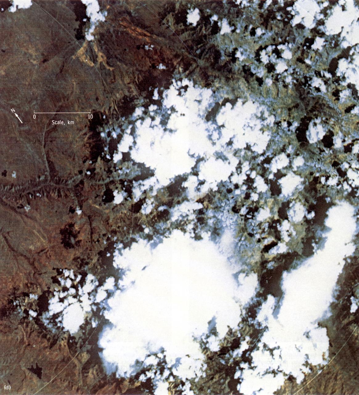
This Earth Resource Experiment Package (EREP) photograph of the Uncompahgre area of Colorado was electronically acquired in September of 1973 by the Multi-spectral Scarner, Skylab Experiment S192. EREP images were used to analyze the vegetation conditions and landscape characteristic of this area. Skylab's Earth sensors played the dual roles of gathering information about the planet and perfecting instruments and techniques for future satellites and manned stations. An array of six fixed cameras, another for high resolution, and the astronauts' handheld cameras photographed surface features. Other instruments, recording on magnetic tape, measured the reflectivity of plants, soils, and water. Radar measured the altitude of land and water surfaces. The sensors' objectives were to survey croplands and forests, identify soils and rock types, map natural features and urban developments, detect sediments and the spread of pollutants, study clouds and the sea, and determine the extent of snow and ice cover.

A researcher sets up equipment in the Space Power Chamber at National Aeronautics and Space Administration’s (NASA) Plum Brook Station to study the effects of contaminants on clouds. Drs. Rosa and Jorge Pena of Pennsylvania State University's Department of Meteorology initiated the program in an effort to develop methods of creating stable, long-lasting clouds in a test chamber in order to study their composition and formation. The researchers then wanted to use the artificially-created clouds to determine how they were affected by pollution. The 100-foot diameter and 122-foot high Space Power Chamber is the largest vacuum chamber in the world. The researchers covered the circular walls with muslin. A recirculating water system saturated the cloth. The facility engineers then reduced the chamber’s pressure which released the water from the muslin and generated a cloud. The researchers produced five different clouds in this first portion of this study. They discovered that they could not create stable clouds because of the heat generated by the water-pumping equipment. Nonetheless, they felt confident enough to commence planning the second phase of the program using a heat exchanger to cool the equipment.
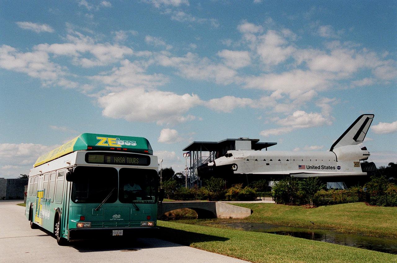
The Zero Emissions (ZE) transit bus passes a mock-up orbiter named Explorer on a trek through the KSC Visitor Complex. Provided by dbb fuel cell engines inc. of Vancouver, Canada, the ZE bus was brought to KSC as part of the Center's Alternative Fuel Initiatives Program. The bus uses a Proton Exchange Membrane fuel cell in which hydrogen and oxygen, from atmospheric air, react to produce electricity that powers an electric motor drive system. The by-product "exhaust" from the fuel cell is water vapor, thus zero harmful emissions. A typical diesel-powered bus emits more than a ton of harmful pollutants from its exhaust every year. The ZE bus is being used on tour routes at the KSC Visitor Complex for two days to introduce the public to the concept
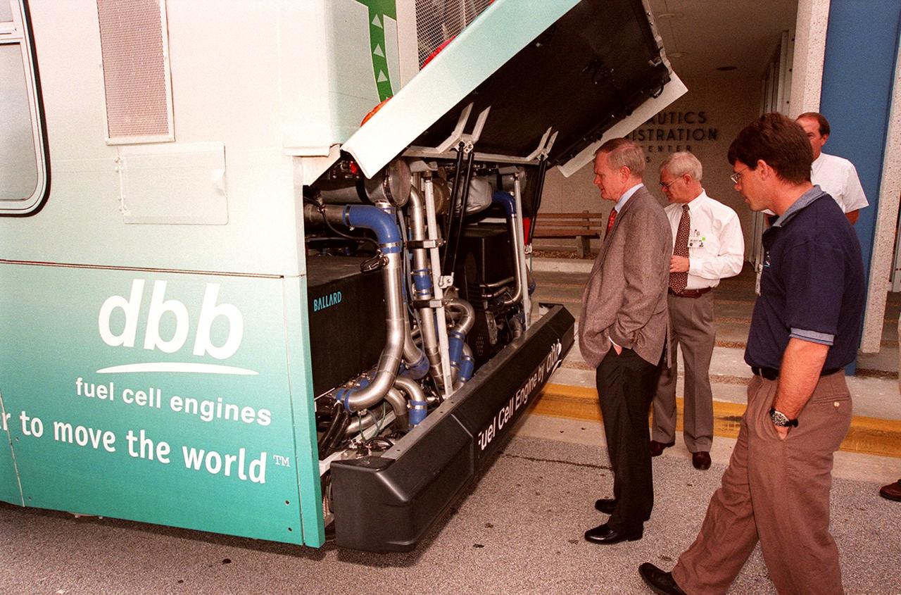
In front of the Headquarters Building at KSC, Center Director Roy Bridges (left) looks at the hydrogen-oxygen driven engine powering a Zero Emissions (ZE) transit bus. Provided by dbb fuel cell engines inc. of Vancouver, Canada, the ZE bus was brought to KSC as part of the Center's Alternative Fuel Initiatives Program. The bus uses a Proton Exchange Membrane fuel cell in which hydrogen and oxygen, from atmospheric air, react to produce electricity that powers an electric motor drive system. The by-product "exhaust" from the fuel cell is water vapor, thus zero harmful emissions. A typical diesel-powered bus emits more than a ton of harmful pollutants from its exhaust every year. Available for viewing by employees, the ZE bus is also being used on tour routes at the KSC Visitor Complex Oct. 26-27

On view in front of the Headquarters Building, the Zero Emissions (ZE) transit bus attracts an interested group of employees, including Center Director Roy Bridges (second from left in foreground). Provided by dbb fuel cell engines inc. of Vancouver, Canada, the ZE bus was brought to KSC as part of the Center's Alternative Fuel Initiatives Program. The bus uses a Proton Exchange Membrane fuel cell in which hydrogen and oxygen, from atmospheric air, react to produce electricity that powers an electric motor drive system. The by-product "exhaust" from the fuel cell is water vapor, thus zero harmful emissions. A typical diesel-powered bus emits more than a ton of harmful pollutants from its exhaust every year. Available for viewing by employees, the ZE bus is also being used on tour routes at the KSC Visitor Complex Oct. 26-27
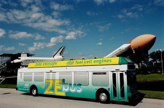
The Zero Emissions (ZE) transit bus tours the KSC Visitor Complex for a test ride. In the background are a mock-up orbiter named Explorer (left) and a stack of solid rocket boosters and external tank (right), typically used on Shuttle launches. Provided by dbb fuel cell engines inc. of Vancouver, Canada, the ZE bus was brought to KSC as part of the Center's Alternative Fuel Initiatives Program. The bus uses a Proton Exchange Membrane fuel cell in which hydrogen and oxygen, from atmospheric air, react to produce electricity that powers an electric motor drive system. The by-product "exhaust" from the fuel cell is water vapor, thus zero harmful emissions. A typical diesel-powered bus emits more than a ton of harmful pollutants from its exhaust every year. The ZE bus is being used on tour routes at the KSC Visitor Complex for two days to introduce the public to the concept

KSC employees, along with Center Director Roy Bridges (second from left), view the hydrogen-oxygen driven engine powering a Zero Emissions (ZE) transit bus. Provided by dbb fuel cell engines inc. of Vancouver, Canada, the ZE bus was brought to KSC as part of the Center's Alternative Fuel Initiatives Program. The bus uses a Proton Exchange Membrane fuel cell in which hydrogen and oxygen, from atmospheric air, react to produce electricity that powers an electric motor drive system. The by-product "exhaust" from the fuel cell is water vapor, thus zero harmful emissions. A typical diesel-powered bus emits more than a ton of harmful pollutants from its exhaust every year. Available for viewing by employees, the ZE bus is also being used on tour routes at the KSC Visitor Complex Oct. 26-27

KSC workers, with Center Director Roy Bridges (at right next to bus), head for the open door of the Zero Emissions (ZE) transit bus and a ride around the center. Provided by dbb fuel cell engines inc. of Vancouver, Canada, the ZE bus was brought to KSC as part of the Center's Alternative Fuel Initiatives Program. The bus uses a Proton Exchange Membrane fuel cell in which hydrogen and oxygen, from atmospheric air, react to produce electricity that powers an electric motor drive system. The by-product "exhaust" from the fuel cell is water vapor, thus zero harmful emissions. A typical diesel-powered bus emits more than a ton of harmful pollutants from its exhaust every year. Available to employees for viewing and a ride, the ZE bus is also being used on tour routes at the KSC Visitor Complex Oct. 26-27
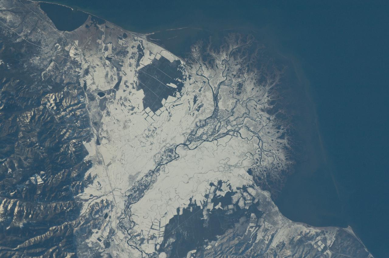
ISS029-E-037915 (3 Nov. 2011) --- Snowfall on the Selenga River Delta, Russian Federation is featured in this image photographed by an Expedition 29 crew member on the International Space Station. This photograph illustrates the Selenga River Delta built out into Lake Baikal in Russia. The Selenga River delta (center) is lobate in form, with an intricate network of distributary channels and levees surrounded by marshlands building out into Lake Baikal. This suggests that development of the delta is governed by the sediment load carried by the river, and any modifications of form due to lake tides or waves are relatively minor. Further out, dark brown depositional bars are visible forming a rough arc marking the edge of the delta. Snow cover on the river floodplain highlights numerous secondary channels, as well as channels previously occupied by the river but now abandoned. The regular outlines of agricultural fields to the southwest and northeast of the river are also highlighted by the snow cover. Lake Baikal is a World Heritage Site. The Selenga River is the major contributor of water to Lake Baikal; it occupies approximately 82 per cent of the watershed area for the lake. The wetlands of the Selenga River delta are designated as a RAMSAR site and provide valuable habitat for more than 170 species of birds, including many that are migrating. Like Baikal, the Selenga Delta is home to unique ecosystems, including more than 70 rare or endangered species of plants and animals. Waters of the Selenga River serve many (and differing) uses in both Mongolia and Russia, including support of agriculture, provision of drinking water, light industry, mining, recreation, and tourism. These uses also contribute to degradation of the river water quality, downstream availability of water, and ecological impacts. For example, a pulp and paper plant in the city of Selenginsk (lower left) has been tied to high levels of pollution in the river. International efforts to integrate management of the Selenga River basin for both ecological and economic sustainability are ongoing.

ISS019-E-005501 (9 April 2009) --- Split Region in Croatia is featured in this image photographed by an Expedition 19 crewmember on the International Space Station. One the world?s most rugged coastlines are located in Croatia along the Adriatic Sea. This view features the Dalmatian coastline of Croatia around the city of Split. Much of the region can be characterized by northwest-southeast oriented linear islands and embayments of the Adriatic Sea. This distinctive coastal geomorphology is the result of faulting caused by tectonic activity in the region and sea level rise. Split has a long history - the Roman Emperor Diocletian retired to Spalatum (the present-day Split) in 305, and his palace constitutes the core of the city today. The city is a popular resort destination for its historic sites, Mediterranean climate, and ready access to the Adriatic islands (such as Brac to the south). Other large cities in the region include Kastela and Trogir; together with Split, these form an almost continuous urban area bordering the coast (visible as pink regions). A thin zone marking a water boundary is visible in this image between Split and the island of Brac. It may represent a local plankton bloom, or a line of convergence between water masses creating rougher water. A unique combination of geography -- including dramatic topography that channels local winds, the complicated coastline, input of fresh water from rivers, and ample nutrients and surface oils -- makes for interesting mesoscale surface dynamics throughout the Adriatic Sea. Over the years, astronauts have taken images of the Split region using sunglint and changes in water color to highlight features like eddies, water boundaries and mixing zones between fresh waters flowing into the saltier (denser) waters of the Adriatic, and wind-driven surface currents. Split is an important transit center connecting islands in the Adriatic Sea to the Italian peninsula, and an important regional manufacturing center of goods such as solar cells, plastics, and paper products. The city was heavily industrialized during the post World War II period as a member state of Yugoslavia. By the 1980s, the marine environment bordered by Split, Kastela, and Trogir (known as Kastela Bay) had been identified as one of the most polluted areas of the Adriatic from both sewage and industrial wastes. Concerted efforts by the Croatian government and international partners to improve waste handling and treatment infrastructure over the past 10 years seem to have been successful ? both marine species and water polo players have returned to the area.
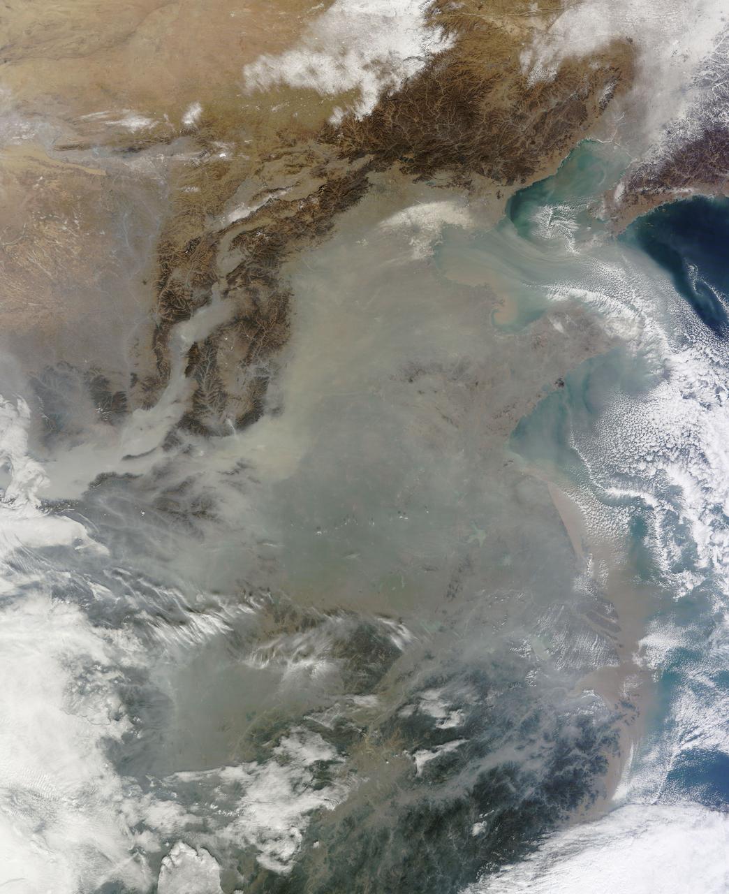
The skies over northern China were shrouded with a thick haze in late December, 2013. The Moderate Resolution Imaging Spectroradiometer (MODIS) aboard the Terra satellite captured this true-color image on December 23. The dense, gray haze obscures almost all the land and much of the coastal waters from view south and east of the Taihang Mountains. Clearer air covers the region north of the mountains, although fingers of haze roll through most river valleys. The cities of Beijing and Hebei, both west of the Bohai Sea are complete enshrouded. By December 24 the smog levels in some area exceeded World Health Organization-recommended levels by 30 times, according to Bloomberg News. The concentration of PM2.5, which are fine air particulates, were reported at 421 micrograms per cubic meter at 2 p.m. near Tiananmen Square in Beijing, while levels were 795 in Xi’an and 740 in Zhengzhou. The World Health Organization (WHO) recommends 24-hour exposure to PM2.5 concentrations no higher than 25 micrograms per cubic meter. While not the sole cause of haze and pollution, the use of coal as a very cheap energy source adds to the problem, particularly north of the Huai River. Prior to 1980, the government policy provided free coal for fuel boilers for all people living north of the Huai River. The widespread use of coal allows people in the north to stay warm in winter, but they have paid a price in air quality. According to Michael Greenstone, a Professor of Environmental Economics at Massachusetts Institute of Technology (MIT), whose research team published a paper on sustained exposure to air pollution on life expectancy in the region, air pollution, as measured by total suspended particulates, was about 55% higher north of the Huai River than south of it, for a difference of around 184 micrograms of particulate matter per cubic meter. The research, published in Proceedings of the National Academy of Sciences in July, 2013, also noted life expectancies were about 5.5 years lower in the north, owing to an increased incidence of cardiorespiratory mortality. Air pollution is an on-going issue for the government of China, and Beijing’s Five-Year Clean Air Action Plan aims to reduce overall particle density by over 25 percent on the PM2.5 scale by 2017, and also takes aim at shutting down all coal-burning plants. Credit: NASA/GSFC/Jeff Schmaltz/MODIS Land Rapid Response Team <b><a href="http://www.nasa.gov/audience/formedia/features/MP_Photo_Guidelines.html" rel="nofollow">NASA image use policy.</a></b> <b><a href="http://www.nasa.gov/centers/goddard/home/index.html" rel="nofollow">NASA Goddard Space Flight Center</a></b> enables NASA’s mission through four scientific endeavors: Earth Science, Heliophysics, Solar System Exploration, and Astrophysics. Goddard plays a leading role in NASA’s accomplishments by contributing compelling scientific knowledge to advance the Agency’s mission. <b>Follow us on <a href="http://twitter.com/NASA_GoddardPix" rel="nofollow">Twitter</a></b> <b>Like us on <a href="http://www.facebook.com/pages/Greenbelt-MD/NASA-Goddard/395013845897?ref=tsd" rel="nofollow">Facebook</a></b> <b>Find us on <a href="http://instagram.com/nasagoddard?vm=grid" rel="nofollow">Instagram</a></b>
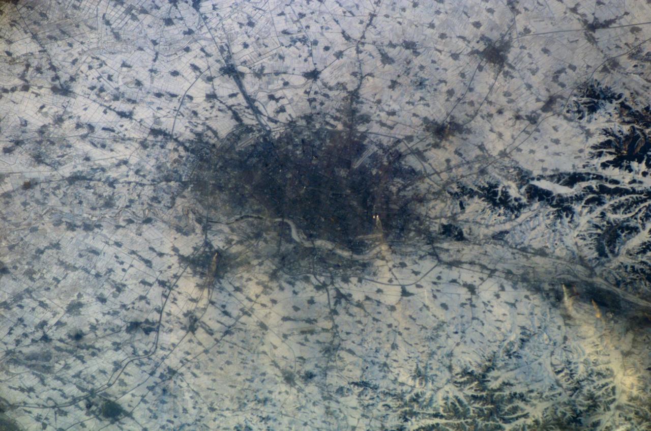
ISS010-E-13807 (18 January 2005) --- Shenyang, China is featured in this image photographed by an Expedition 10 crewmember on the International Space Station (ISS). The city of Shenyang is China’s sixth largest city with a population of over 4 million residents in the urban core. The city is the major industrial, commercial, and cultural center of northeast China (the region historically known as Manchuria). Its geographic location on the floodplains of the Hun and Liao Rivers ensured an early agrarian economy that was later replaced by industrialization and natural resource extraction. Shenyang was first settled as a Mongol trading center in the 10th century, and served as the capitol of the Manchu government from the 17th through 20th centuries. Currently the city serves as the capital of Liaoning Province. Snow cover provides a clear contrast between urbanized (dark grey, center of image) and rural regions (white to light grey). The major portion of the local economy is devoted to industries such as metal smelting, coal mining, and petrochemical processing. Several southeast-trending plumes from industrial facilities are visible in the image. According to NASA scientists studying the Expedition 10 imagery, the high density of industrial land use in the Shenyang metropolitan area has lead to significant air, water, and soil pollution in the region. Recently, several initiatives to reduce pollution levels and establish environmentally-sound development guidelines have begun with support from local government and the United Nations.
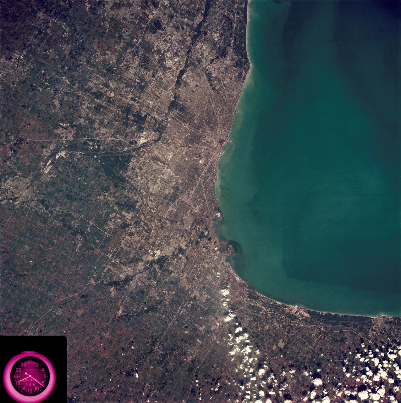
SL3-88-222 (18 Sept. 1973) --- The metropolitan area of Chicago is encompassed in this Skylab 3 Earth Resources Experiments Package (EREP) S190-B photograph taken on Sept. 18, 1973 from the Skylab space station cluster in Earth orbit. The surrounding major cities of Aurora and Joliet, Illinois; Hammond, Gary and East Chicago, Indiana, are easily delineated. The photograph reveals the following: (1) Cultural differentiation of commercial, industrial and residential areas for use in population and social studies in micro-macro community planning and in cultural pattern studies in the improvement of urban areas. (Aurora is one of 27 census cities of interest to Robert Alexander, a principal investigator. Alexander is with the U.S. Geological Survey). (2) The transportation network with major corridors and their interchanges, primary and feeder streets for use in network analysis and in the development of models for population movement and land use projection. (3) The agricultural lands for land use identification on crop inventory analysis; airports for use in delineation of service and infringement of major man-made features that affect ecosystem balance (support to environmental impact studies). (4) Air and water plumes for use in case studies, natural and man-made differentiation of pollution sources, in support of model development and in ecosystem research studies on the effects of pollution. (5) Recreational centers for use in relating recreational centers to population centers, establishing possible demands and in development of possible future recreational centers to support the demand. All EREP photography is available to the public through the Department of Interior?s Earth Resources Observations Systems Data Center, Sioux Falls, South Dakota, 57198. Photo credit: NASA
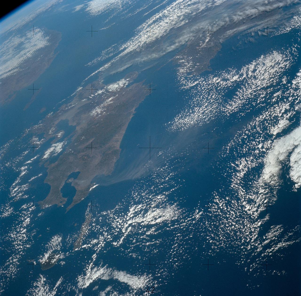
SL4-139-3971 (8 Jan. 1974) --- An oblique view of Japan as seen from the Skylab space station in Earth orbit. The Island of Kyushu is at center left. The Island of Honshu is in the right background. The Korean Peninsula is in the left background. This picture was taken by one of the Skylab 4 crewmen using a hand-held 70mm Hasselblad camera with a 100mm lens. The plume form Kyushu's volcano Sakurajima is clearly seen in this photograph. Volcanic activity at Sakurajima is known to have occurred for over 1,200 years (first recorded in the year 708 A.D.) but for the first time the entire volcanic plume can be documented at one time. Skylab photographs and crew descriptions are much more detailed then information available from other satellites. The volcano and its plume were observed at least seven times during Skylab 4, and photographed and documented with television. In repeated observations the plume was seen to stream out to the south or southeast and become increasingly diffuse away from the volcano. As the plume reached the open ocean cast of Kyushu it changed direction, sometimes abruptly, and fanned out to the northeast. In this photograph it extends about 80 kilometers (50 miles) east from the volcano; the distribution and dispersion of particulate materials and volcanic gasses will be studied in this and similar Skylab photographs. Although the plume is primarily water vapor, it contains significant quantities of oxides of carbon, sulphur and nitrogen. These gases are considered pollutants, and understanding their abundance and distribution will help to evaluate the relative effect and significance of man-made atmospheric pollutants. Photo credit: NASA
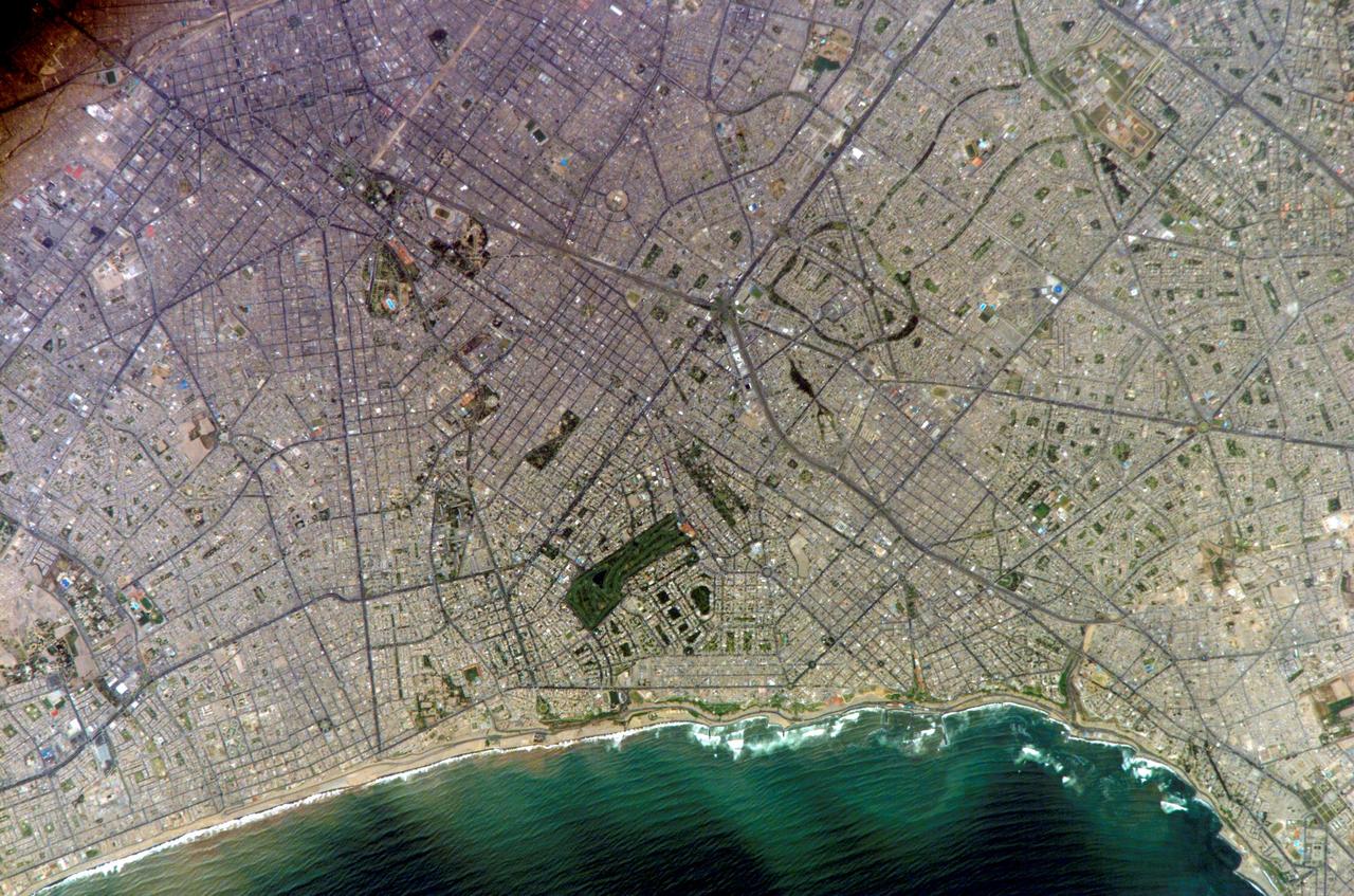
ISS010-E-20111 (15 March 2005) --- Lima, Peru is featured in this image photographed by an Expedition 10 crewmember on the International Space Station (ISS). Located on the broad alluvial fan of the Rimac River, Lima is the capital of Peru and the only mega city (7.7 million inhabitants in 2002) located on the western coastline of South America. The city was established by Francisco Pizarro in 1535 and became an important colonial port linking silver mines of the Altiplano of the high Andes to the east with the burgeoning Spanish empire. During the mid-20th century a significant relocation of people from rural mountain communities into the Lima metropolitan area led to its growth into a mega city. Problems now facing the metropolitan region include development of adequate water resources, control of pollution, and the potential effects of natural hazards such as earthquakes and landslides. This photograph depicts the wealthier San Isidro and Mira Flores quarters of Lima. This part of the metropolitan area is characterized by numerous vegetated parks, golf courses (such as the Lima Golf Course—approximately 1 kilometer long), and greenbelts interspersed with residential and commercial areas. The higher proportion of dark asphalt in the street grid of the residential and commercial areas lends a purple coloration to the left portion of the image (downtown Lima is to the north). Regions with fewer built materials and vegetation are light tan. Wave patterns are visible approaching beaches, popular tourist destinations, in the lower half of the image.
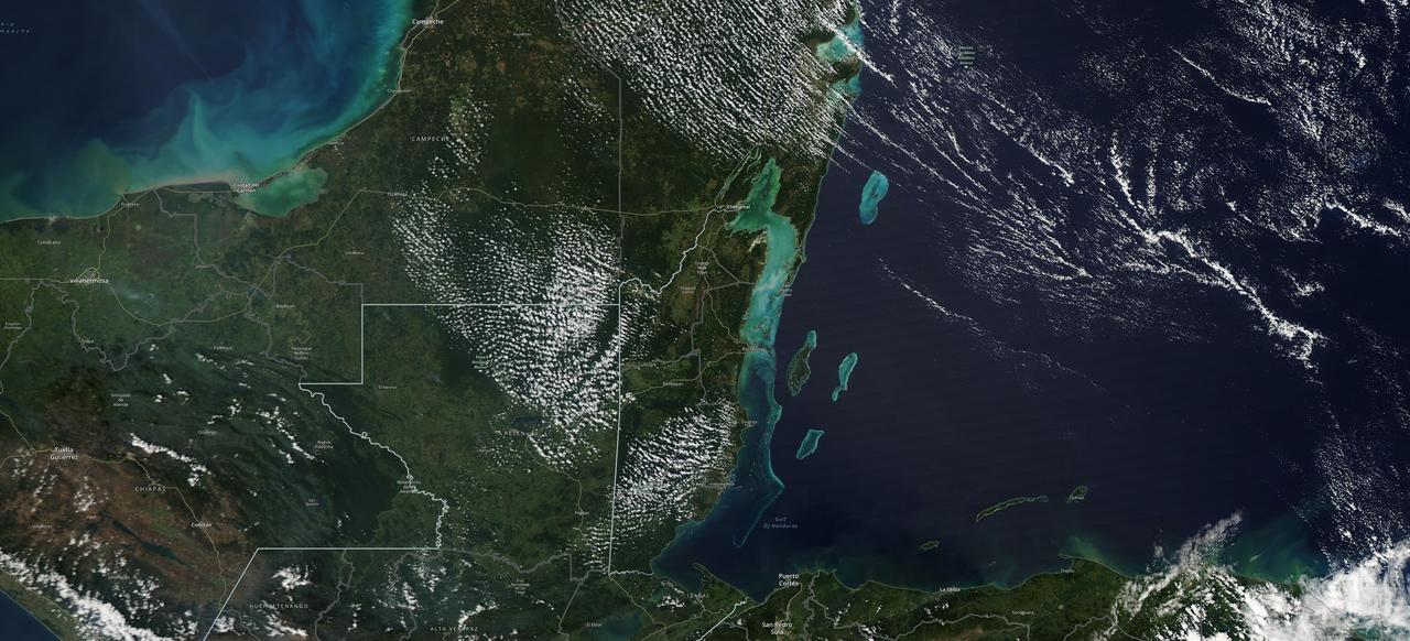
The Moderate Resolution Imaging Spectroradiometer (MODIS) instrument aboard NASA's Aqua satellite captured this image of the Yucatán Peninsula on Feb. 3, 2022. At the center is Belize, a country whose Caribbean coast is home to the Belize Barrier Reef Reserve System, which encompasses a vibrant network of marine environments that supports thousands of animal and plant species and drives Belize's largest industry, tourism. The barrier reef system is among about 1,200 UNESCO World Heritage sites around the world. In a paper published in November 2022 in Frontiers in Remote Sensing, researchers used data from Aqua MODIS to rank 24 protected marine areas off the Belizean coast based on the risks coral face from murky water and rising temperatures. The research also outlined how researchers at NASA's Jet Propulsion Laboratory in Southern California and counterparts in Belize used free, cloud-based data on Google Earth Engine in their analysis. Analyzing imagery from 2002 to 2022, researchers developed a coral vulnerability index – a score between 2 and 12 that characterizes the risk to coral, with higher scores signifying greater risk. Their findings could help management authorities protect the reefs from human impacts such as development, overfishing, pollution, and climate change. https://photojournal.jpl.nasa.gov/catalog/PIA25861
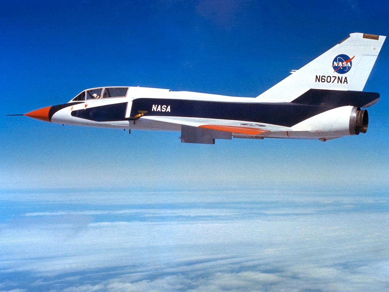
The National Aeronautics and Space Administration (NASA) Lewis Research Center’s Convair F-106B Delta Dart equipped with air sampling equipment in the mid-1970s. NASA Lewis created and managed the Global Air Sampling Program (GASP) in 1972 in partnership with several airline companies. NASA researchers used the airliners’ Boeing 747 aircraft to gather air samples to determine the amount of pollution present in the stratosphere. Private companies developed the air sampling equipment for the GASP program, and Lewis created a particle collector. The collector was flight tested on NASA Lewis’ F-106B in the summer of 1973. The sampling equipment was automatically operated once the proper altitude was achieved. The sampling instruments collected dust particles in the air so their chemical composition could be analyzed. The equipment analyzed one second’s worth of data at a time. The researchers also monitored carbon monoxide, monozide, ozone, and water vapor. The 747 flights began in December 1974 and soon included four airlines flying routes all over the globe. The F-106B augmented the airline data with sampling of its own, seen here. It gathered samples throughout this period from locations such as New Mexico, Texas, Michigan, and Ohio. In July 1977 the F-106B flew eight GASP flights in nine days over Alaska to supplement the earlier data gathered by the airlines.
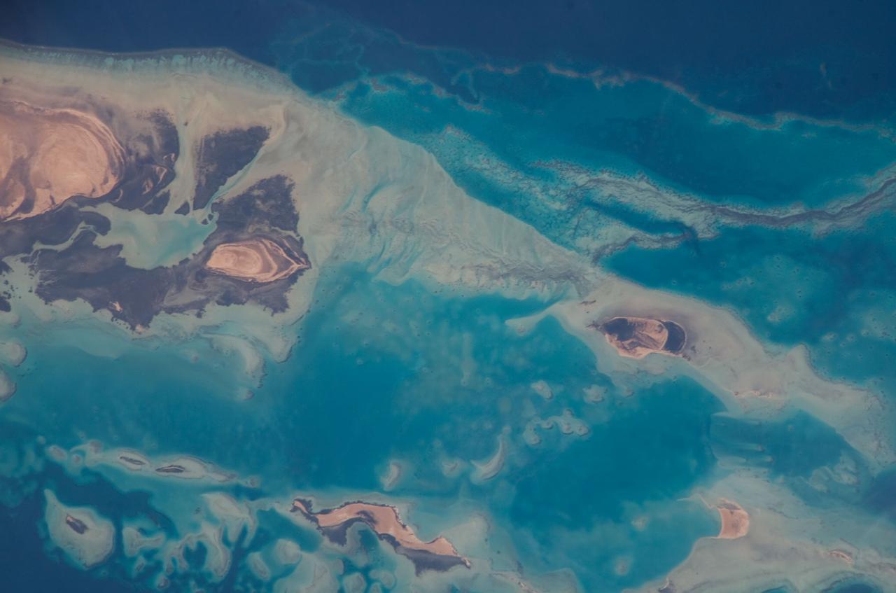
ISS016-E-019394 (30 Dec. 2007) --- Al Wadj Bank, Saudi Arabia is featured in this image photographed by an Expedition 16 crewmember on the International Space Station. Saudi Arabia boasts the most coral reefs of any Middle Eastern country, as it includes coastline along both the Red Sea and Gulf of Arabia. This high resolution image depicts a portion of the Al Wadj Bank, located along the northern Red Sea coast. Despite the relatively high salinity of Red Sea water (compared to other oceans), approximately 260 species of coral are found here, according to scientists. Large tracts of the Saudi Arabian coastline are undeveloped, and reefs in these areas are in generally good ecological health. However, reefs located near large urban centers like Jeddeh have suffered degradation due to land reclamation, pollution, and increased terrigeneous sediment input. The Al Wadj Bank includes a healthy and diverse reef system, extensive seagrass beds, and perhaps the largest population of dugong -- a marine mammal similar to the North American manatee -- in the eastern Red Sea. The portion of the Bank in this image illustrates the complex form and topography of the reef system. Several emergent islands (tan) - surrounded primarily by dark green seagrass - are visible, the largest located at top left. Only the islands are above the waterline -- over the reef structures the water color ranges from light teal (shallow) to turquoise (increasing depth). The southern edge of the reef is well indicated by the deep, dark blue water of the Red Sea at image top.
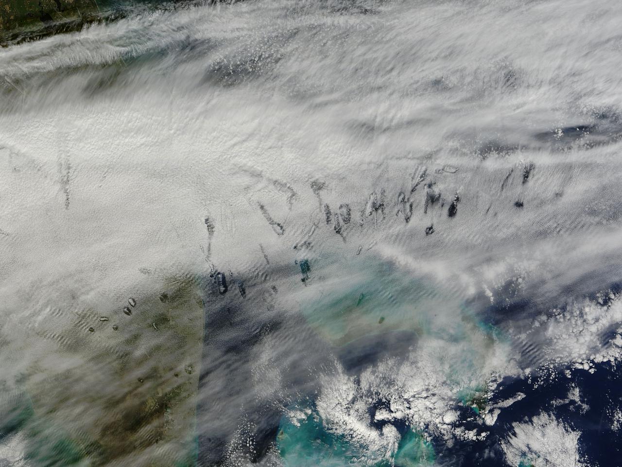
In elementary school, students learn that water freezes at 0 degrees Celsius (32 degrees Fahrenheit). That is true most of the time, but there are exceptions to the rule. For instance, water with very few impurities (such as dust or pollution particles, fungal spores, bacteria) can be chilled to much cooler temperatures and still remain liquid—a process known as supercooling. Supercooling may sound exotic, but it occurs pretty routinely in Earth’s atmosphere. Altocumulus clouds, a common type of mid-altitude cloud, are mostly composed of water droplets supercooled to a temperature of about -15 degrees C. Altocumulus clouds with supercooled tops cover about 8 percent of Earth’s surface at any given time. Supercooled water droplets play a key role in the formation of hole-punch and canal clouds, the distinctive clouds shown in these satellite images. Hole-punch clouds usually appear as circular gaps in decks of altocumulus clouds; canal clouds look similar but the gaps are longer and thinner. This true-color image shows hole-punch and canal clouds off the coast of Florida, as observed on December 12, 2014, by the Moderate Resolution Imaging Spectroradiometer (MODIS) on NASA’s Terra satellite. Both types of cloud form when aircraft fly through cloud decks rich with supercooled water droplets and produce aerodynamic contrails. Air expands and cools as it moves around the wings and past the propeller, a process known as adiabatic cooling. Air temperatures over jet wings often cool by as much as 20 degrees Celsius, pushing supercooled water droplets to the point of freezing. As ice crystals form, they absorb nearby water droplets. Since ice crystals are relatively heavy, they tend to sink. This triggers tiny bursts of snow or rain that leave gaps in the cloud cover. Whether a cloud formation becomes a hole-punch or canal depends on the thickness of the cloud layer, the air temperature, and the degree of horizontal wind shear. Both descending and ascending aircraft—including jets and propeller planes—can trigger hole-punch and canal clouds. The nearest major airports in the images above include Miami International, Fort Lauderdale International, Grand Bahama International, and Palm Beach International. Credit: NASA/GSFC/Jeff Schmaltz/MODIS Land Rapid Response Team <b><a href="http://www.nasa.gov/audience/formedia/features/MP_Photo_Guidelines.html" rel="nofollow">NASA image use policy.</a></b> <b><a href="http://www.nasa.gov/centers/goddard/home/index.html" rel="nofollow">NASA Goddard Space Flight Center</a></b> enables NASA’s mission through four scientific endeavors: Earth Science, Heliophysics, Solar System Exploration, and Astrophysics. Goddard plays a leading role in NASA’s accomplishments by contributing compelling scientific knowledge to advance the Agency’s mission. <b>Follow us on <a href="http://twitter.com/NASAGoddardPix" rel="nofollow">Twitter</a></b> <b>Like us on <a href="http://www.facebook.com/pages/Greenbelt-MD/NASA-Goddard/395013845897?ref=tsd" rel="nofollow">Facebook</a></b> <b>Find us on <a href="http://instagram.com/nasagoddard?vm=grid" rel="nofollow">Instagram</a></b>
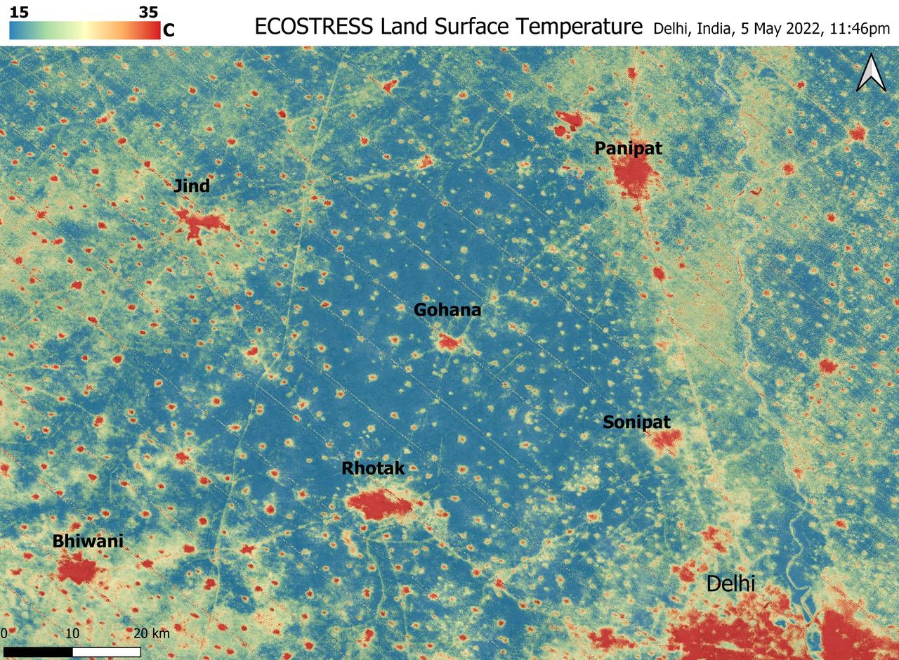
A relentless heat wave has blanketed India and Pakistan since mid-March 2022, causing dozens of deaths, fires, increased air pollution, and reduced crop yields. NASA's Ecosystem Spaceborne Thermal Radiometer Experiment on Space Station instrument (ECOSTRESS) has been measuring these temperatures from space, at the highest spatial resolution of any satellite instrument. This image, taken shortly before local midnight on May 5, shows urban areas and agricultural lands northwest of Delhi that are home to about 28 million people. The image covers about 4,800 square miles (12,350 square kilometers). Cities are usually markedly warmer than the surrounding countryside due to human activities and the materials used in the built environment. The image clearly delineates these urban "heat islands." Nighttime temperatures in Delhi and several smaller villages were above 95 degrees Fahrenheit (35 degrees Celsius), peaking at about 102 degrees F (39 degrees C), while the rural fields nearby had cooled to around 60 degrees F (15 degrees C). This data suggests that city dwellers are experiencing considerably higher temperatures than the average temperatures reported for their regions. ECOSTRESS measures the temperature of the ground itself, which is very similar to air temperature at night (though the ground may be warmer than the air in daylight hours). The instrument launched to the space station in 2018. Its primary mission is to identify plants' thresholds for water use and water stress, giving insight into their ability to adapt to a warming climate. However, ECOSTRESS also records other heat-related phenomena like this heat wave. Its high-resolution images, with a pixel size of about 225 feet (70 meters) by 125 feet (38 meters), are a powerful tool for understanding aspects of the weather event that might be overlooked by traditional observation networks. https://photojournal.jpl.nasa.gov/catalog/PIA24987

Super typhoon Mangkhut slammed into the northern Philippines on September 15 with wind speeds equivalent to a category 5 hurricane. South of where the eye made landfall, the storm's effects could be seen clearly five days later. The ASTER image of Dagupan and the Lingayen Gulf shows flooded and water-saturated areas in dark blue. Sediment-laden waters from swollen rivers enter the ocean and appear as blue-green plumes. The image was acquired September 22, 2018, covers an area of 51.4 by 61.2 kilometers, and is located at 16.2 degrees north, 120.3 degrees east. With its 14 spectral bands from the visible to the thermal infrared wavelength region and its high spatial resolution of about 50 to 300 feet (15 to 90 meters), ASTER images Earth to map and monitor the changing surface of our planet. ASTER is one of five Earth-observing instruments launched Dec. 18, 1999, on Terra. The instrument was built by Japan's Ministry of Economy, Trade and Industry. A joint U.S./Japan science team is responsible for validation and calibration of the instrument and data products. The broad spectral coverage and high spectral resolution of ASTER provides scientists in numerous disciplines with critical information for surface mapping and monitoring of dynamic conditions and temporal change. Example applications are monitoring glacial advances and retreats; monitoring potentially active volcanoes; identifying crop stress; determining cloud morphology and physical properties; wetlands evaluation; thermal pollution monitoring; coral reef degradation; surface temperature mapping of soils and geology; and measuring surface heat balance. https://photojournal.jpl.nasa.gov/catalog/PIA22705
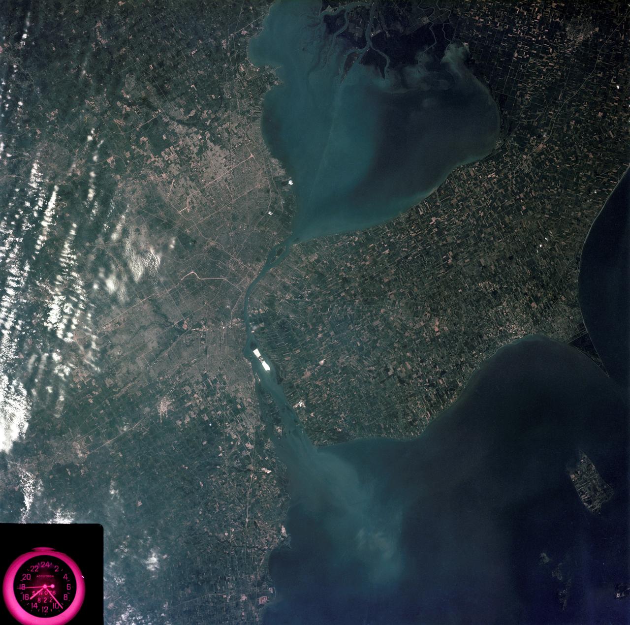
SL3-83-0152 (July-September 1973) --- A near vertical view of the metropolitan Detroit, Michigan area is seen in this Skylab 3 Earth Resources Experiments Package S190-B (five-inch Earth terrain camera) photograph taken from the Skylab space station in Earth orbit. The 25-mile long Detroit River drains the smaller body of water (Lake St. Clair) and flows southwestward separating Detroit from Windsor, Ontario, and empties into Lake Erie. The Detroit River handles a great deal of Great Lakes barge and ship traffic. Major streets and thoroughfares radiating from the city are clearly visible. Fighting Island is the highly reflective, white area located almost in the center of the picture. This high reflectivity is caused by the functional use of the island-disposal ponds for chemical salts. Sedimentation and/or pollution patterns in the area provide interesting visual phenomena for speculation and analysis. Distinct and rather unique cultivated field patterns can be observed south and east of Windsor, Ontario. This is a direct result of an English survey and land tenure system which was utilized when the area was settled. New areas of residential development are fairly easy to differentiate from older, established residential areas. Vegetation and extent of area coverage can be determined. The Oakland County Planning Commission and the Federal Bureau of Outdoor Recreation working closely with Irv Sattinger of the Environmental Research Institute of Michigan (University of Michigan) are presently processing and analyzing photographic and Multispectral scanner data to determine its usefulness for recreation and open space site studies for this area. Photo credit: NASA
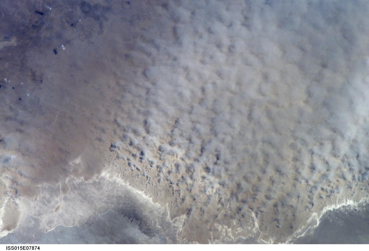
ISS015-E-07874 (12 May 2007) --- A major dust storm (center right) along the east side of the Aral Sea, Kazakhstan, is featured in this image photographed by an Expedition 15 crewmember on the International Space Station while passing over central Asia. The white, irregular lines along the bottom of the image are salt and clay deposits on the present coastline. On the spring day when the ISS crew shot the image, winds were blowing from the west (lower left). The gray, puffy appearance is typical of dust clouds, allowing scientists to distinguish dust from fog and smog. The dust in this image is rising from the sea bed of the Aral Sea, from a point close to the middle of the original Aral Sea of 40--50 years ago, then the fourth largest inland sea on Earth. Heavy extraction of water from the main supply river, the Amu Dary'a, has resulted in rapid shrinking of the sea. According to scientists, dust storms have been occurring in the Aral Sea region for thousands of years, but since the drastic shrinking of the sea over the past half-century an important change in dust composition has occurred. The dust now includes fertilizer and pesticide washed into the Sea from the extensive cotton fields of the Amu Dary'a floodplain. Years of liberal application of agricultural chemicals have resulted in concentration of these pollutants on the sea bed. These are now exposed to the wind and transported hundreds of kilometers in a generally easterly direction. Research suggests that the remobilized chemicals are the cause of high rates of many diseases in the populations along the north, east and southern margins of the Aral Sea. This is one of the unintended consequences of the shrinking of the sea, which has made international news for many years due to the loss of the fishing industry and other significant ecological problems.
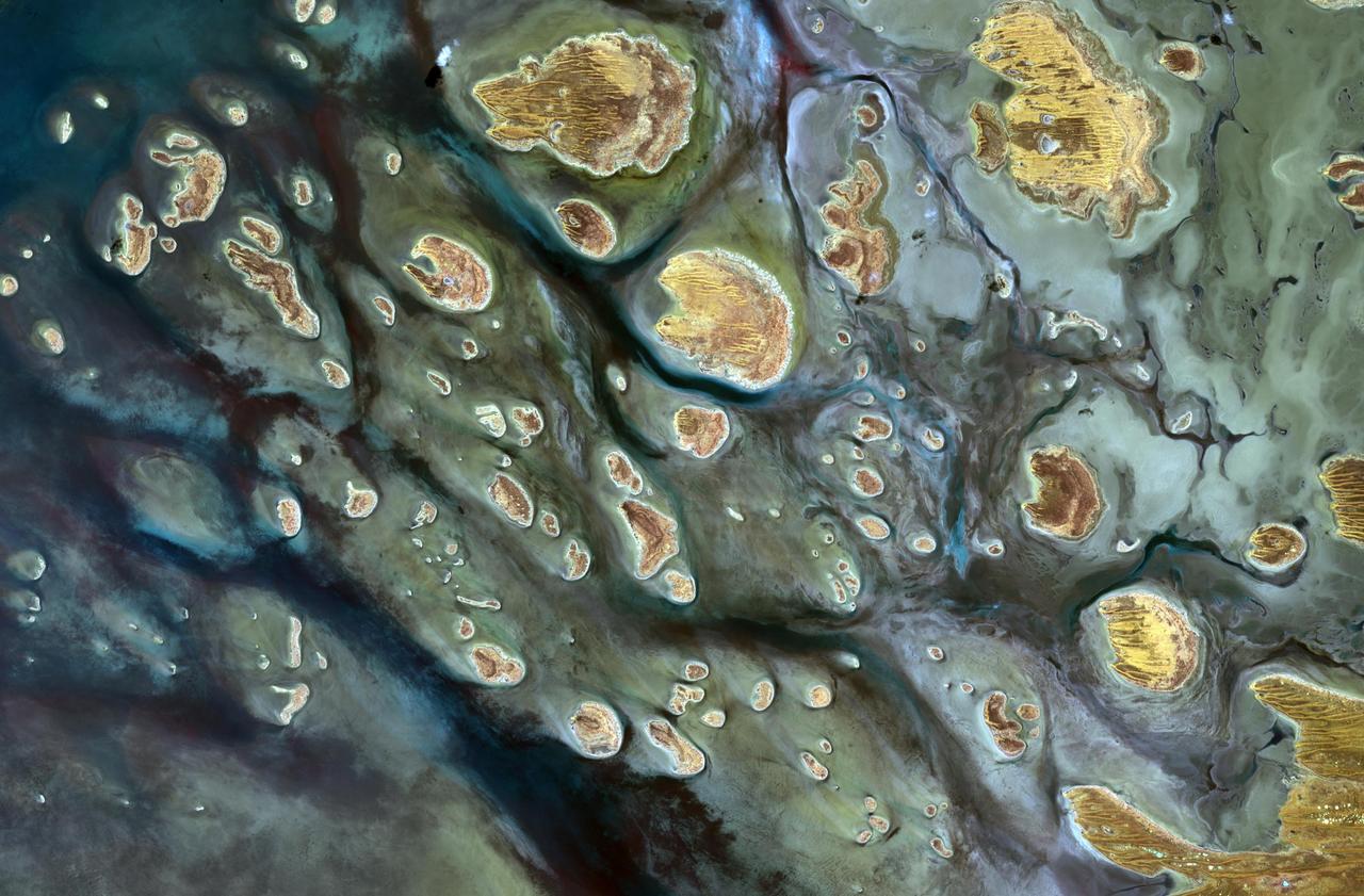
Lake Mackay is the largest of hundreds of ephemeral lakes scattered throughout Western Australia and the Northern Territory, and is the second largest lake in Australia. The darker areas indicate some form of desert vegetation or algae, moisture within the soils, and lowest elevations where water pools. The image was acquired on September 19, 2010 and covers an area of 27 x 41 km. With its 14 spectral bands from the visible to the thermal infrared wavelength region and its high spatial resolution of 15 to 90 meters (about 50 to 300 feet), ASTER images Earth to map and monitor the changing surface of our planet. ASTER is one of five Earth-observing instruments launched Dec. 18, 1999, on Terra. The instrument was built by Japan's Ministry of Economy, Trade and Industry. A joint U.S./Japan science team is responsible for validation and calibration of the instrument and data products. The broad spectral coverage and high spectral resolution of ASTER provides scientists in numerous disciplines with critical information for surface mapping and monitoring of dynamic conditions and temporal change. Example applications are: monitoring glacial advances and retreats; monitoring potentially active volcanoes; identifying crop stress; determining cloud morphology and physical properties; wetlands evaluation; thermal pollution monitoring; coral reef degradation; surface temperature mapping of soils and geology; and measuring surface heat balance. The U.S. science team is located at NASA's Jet Propulsion Laboratory, Pasadena, Calif. The Terra mission is part of NASA's Science Mission Directorate, Washington, D.C. More information about ASTER is available at <a href="http://asterweb.jpl.nasa.gov/" rel="nofollow">asterweb.jpl.nasa.gov/</a>. Image Credit: NASA/GSFC/METI/ERSDAC/JAROS, and U.S./Japan ASTER Science Team
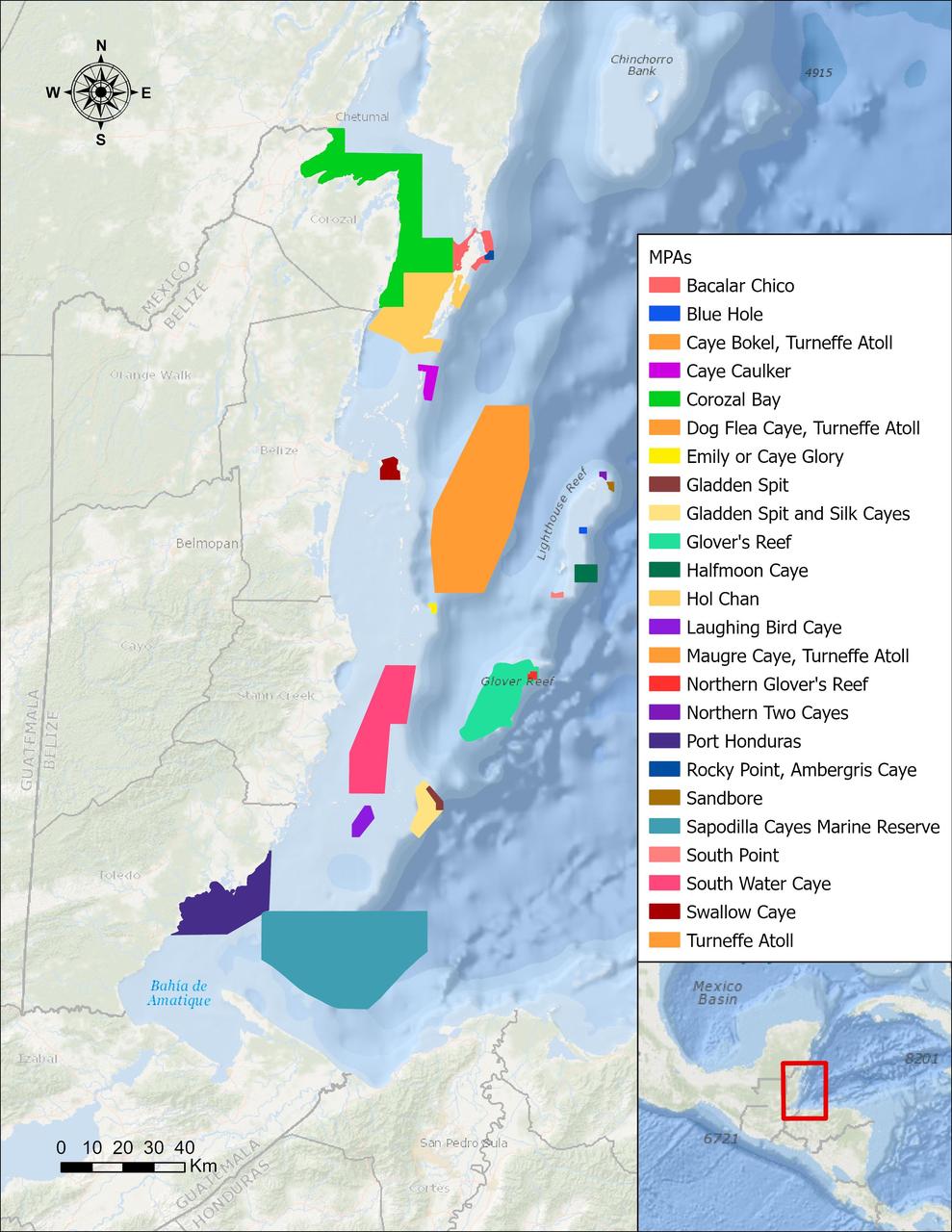
In a paper published in November 2022 in Frontiers in Remote Sensing, researchers at NASA's Jet Propulsion Laboratory, with colleagues in Belize, used data from the Moderate Resolution Imaging Spectroradiometer (MODIS) instrument aboard NASA's Aqua satellite to rank 24 protected marine areas off the Belizean coast based on the risks coral face from murky water and rising temperatures. All the areas are part of the 185-mile-long (298-kilometer-long) Belize Barrier Reef Reserve System, which encompasses a vibrant network of marine environments that supports thousands of animal and plant species and drives the Central American country's largest industry, tourism. The system is one of about 1,200 UNESCO World Heritage sites around the world. Analyzing imagery from 2002 to 2022, researchers developed a coral vulnerability index – a score between 2 and 12 that characterizes the risk to coral, with higher scores signifying greater risk. Their findings could help management authorities protect the reefs from human impacts such as development, overfishing, pollution, and climate change. Port Honduras Marine Reserve, a 156-square-mile (40,000-hectare) protected area in southern Belize, showed the highest coral vulnerability score: 10 out of 12. Based on the index, the study flags Port Honduras, Swallow Caye Wildlife Sanctuary, Sapodilla Cayes Marine Reserve, and Corozal Bay Wildlife Sanctuary as areas for concern. https://photojournal.jpl.nasa.gov/catalog/PIA25862
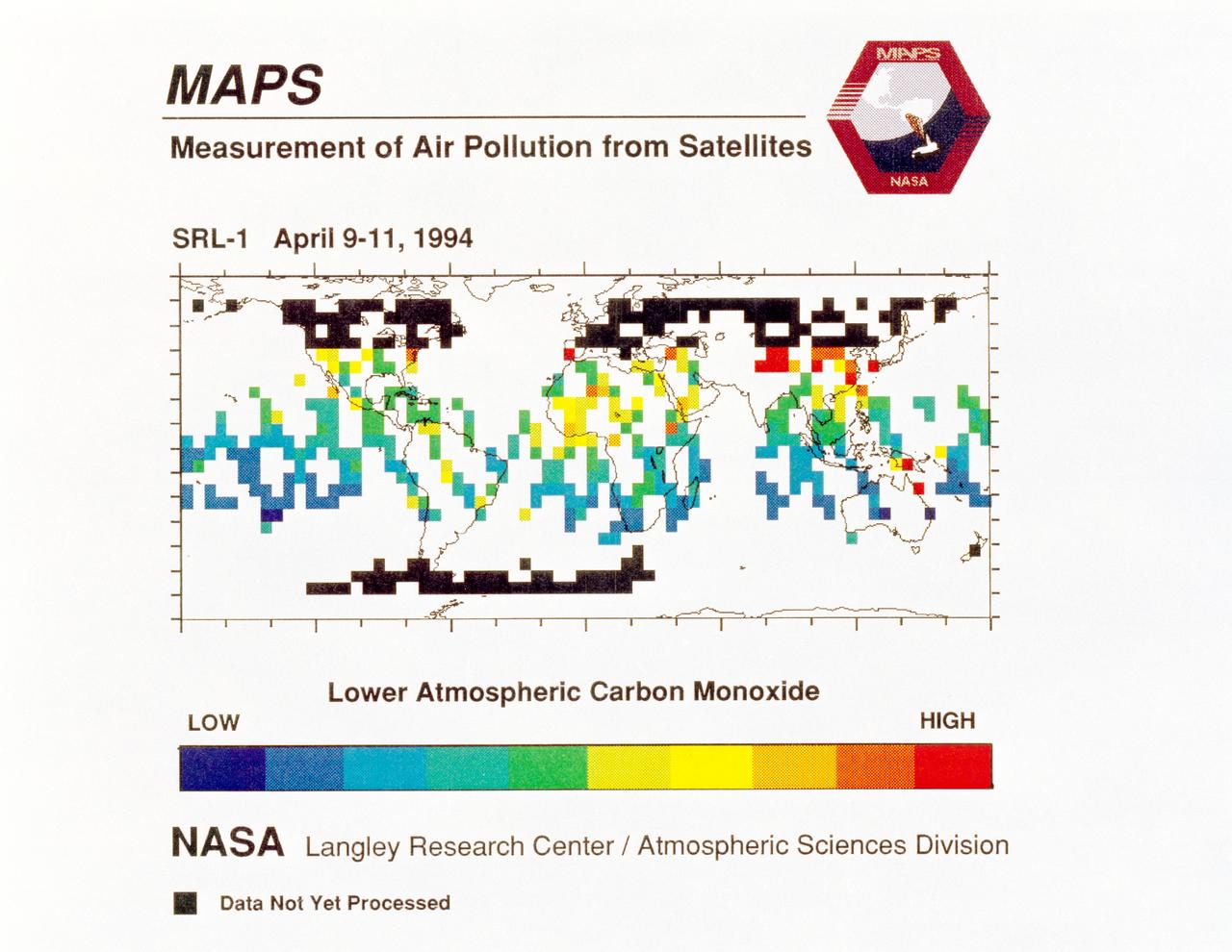
STS059-S-040 (12 April 1994) --- STS-59's MAPS (Measurement of Air Pollution from Satellites) experiment is sending real-time data that provides the most comprehensive view of carbon monoxide concentrations on Earth ever recorded. This computer image shows a summary of "quick look" data obtained by the MAPS instrument during its first days of operations as part of the Space Shuttle Endeavour's SRL-1 payload. This data will be processed using more sophisticated techniques following the flight. The color red indicates areas with the highest levels of carbon monoxide. These Northern Hemisphere springtime carbon monoxide values are generally significantly higher than the values found in the Southern Hemisphere. This is in direct contrast to the data obtained by the MAPS experiment during November 1981 and October 1984, i.e. during Northern Hemisphere fall. The astronauts aboard Endeavour have seen fires in most of the areas showing higher carbon monoxide values (China, Eastern Australia, and equatorial Africa). The relationship between the observed fires and the higher carbon monoxide values will be investigated following SRL-1 by combining the MAPS data with meteorological data, surface imagery, and Space Shuttle hand-held photographs. By the end of SRL-1, MAPS will have acquired data over most of the globe between 57 degrees north and 57 degrees south latitudes. The entire data set will be carefully analyzed using sophisticated post-flight data processing techniques. The data will then be applied in a variety of scientific studies concerning chemistry and transport processes in the atmosphere. The MAPS experiment measures the carbon monoxide in the lower atmosphere. This gas is produced both as a result of natural processes and as a result of human activities. The primary human resources of carbon monoxide are automobiles and industry and the burning of plant materials. The primary natural source is the interaction of sunlight with naturally occurring ozone and water vapor. The strength of all of these sources changes seasonally.
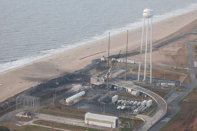
An aerial view of the Wallops Island launch facilities taken by the Wallops Incident Response Team Oct. 29 following the failed launch attempt of Orbital Science Corp.'s Antares rocket Oct. 28. Credit: NASA/Terry Zaperach --- The Wallops Incident Response Team completed today an initial assessment of Wallops Island, Virginia, following the catastrophic failure of Orbital Science Corp.’s Antares rocket shortly after liftoff at 6:22 p.m. EDT Tuesday, Oct. 28, from Pad 0A of the Mid-Atlantic Regional Spaceport at NASA’s Wallops Flight Facility in Virginia. “I want to praise the launch team, range safety, all of our emergency responders and those who provided mutual aid and support on a highly-professional response that ensured the safety of our most important resource -- our people,” said Bill Wrobel, Wallops director. “In the coming days and weeks ahead, we'll continue to assess the damage on the island and begin the process of moving forward to restore our space launch capabilities. There's no doubt in my mind that we will rebound stronger than ever.” The initial assessment is a cursory look; it will take many more weeks to further understand and analyze the full extent of the effects of the event. A number of support buildings in the immediate area have broken windows and imploded doors. A sounding rocket launcher adjacent to the pad, and buildings nearest the pad, suffered the most severe damage. At Pad 0A the initial assessment showed damage to the transporter erector launcher and lightning suppression rods, as well as debris around the pad. The Wallops team also met with a group of state and local officials, including the Virginia Department of Environmental Quality, the Virginia Department of Emergency Management, the Virginia Marine Police, and the U.S. Coast Guard. The Wallops environmental team also is conducting assessments at the site. Preliminary observations are that the environmental effects of the launch failure were largely contained within the southern third of Wallops Island, in the area immediately adjacent to the pad. Immediately after the incident, the Wallops’ industrial hygienist collected air samples at the Wallops mainland area, the Highway 175 causeway, and on Chincoteague Island. No hazardous substances were detected at the sampled locations. Additional air, soil and water samples will be collected from the incident area as well as at control sites for comparative analysis. The Coast Guard and Virginia Marine Resources Commission reported today they have not observed any obvious signs of water pollution, such as oil sheens. Furthermore, initial assessments have not revealed any obvious impacts to fish or wildlife resources. The Incident Response Team continues to monitor and assess. Following the initial assessment, the response team will open the area of Wallops Island, north of the island flagpole opposite of the launch pad location, to allow the U.S. Navy to return back to work. Anyone who finds debris or damage to their property in the vicinity of the launch mishap is cautioned to stay away from it and call the Incident Response Team at 757-824-1295. Further updates on the situation and the progress of the ongoing investigation will be available at: <a href="http://www.orbital.com" rel="nofollow">www.orbital.com</a> and <a href="http://www.nasa.gov/orbital" rel="nofollow">www.nasa.gov/orbital</a> <b><a href="http://www.nasa.gov/audience/formedia/features/MP_Photo_Guidelines.html" rel="nofollow">NASA image use policy.</a></b> <b><a href="http://www.nasa.gov/centers/goddard/home/index.html" rel="nofollow">NASA Goddard Space Flight Center</a></b> enables NASA’s mission through four scientific endeavors: Earth Science, Heliophysics, Solar System Exploration, and Astrophysics. Goddard plays a leading role in NASA’s accomplishments by contributing compelling scientific knowledge to advance the Agency’s mission. <b>Follow us on <a href="http://twitter.com/NASAGoddardPix" rel="nofollow">Twitter</a></b> <b>Like us on <a href="http://www.facebook.com/pages/Greenbelt-MD/NASA-Goddard/395013845897?ref=tsd" rel="nofollow">Facebook</a></b> <b>Find us on <a href="http://instagram.com/nasagoddard?vm=grid" rel="nofollow">Instagram</a></b>