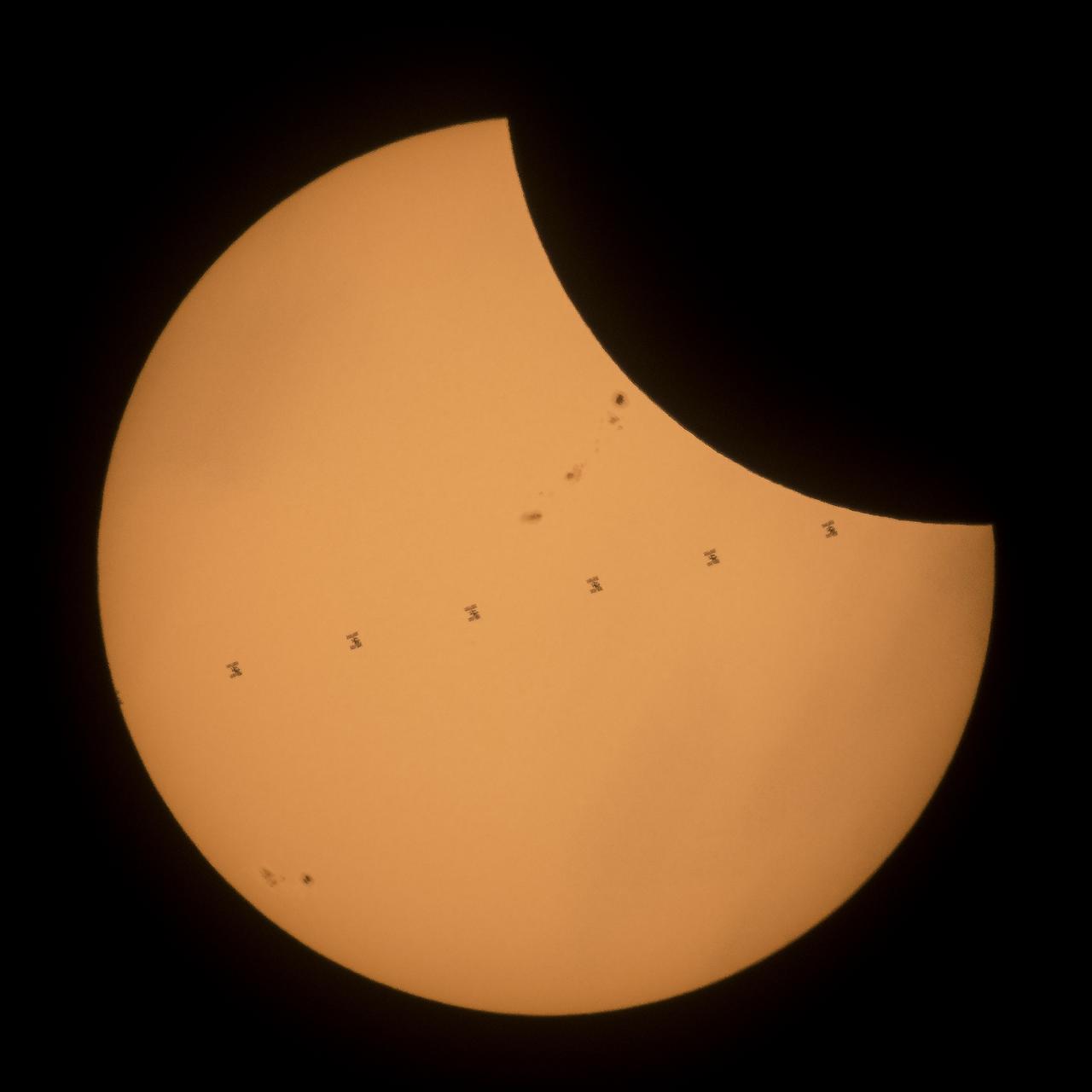
This composite image, made from seven frames, shows the International Space Station, with a crew of six onboard, as it transits the Sun at roughly five miles per second during a partial solar eclipse, Monday, Aug. 21, 2017 near Banner, Wyoming. Onboard as part of Expedition 52 are: NASA astronauts Peggy Whitson, Jack Fischer, and Randy Bresnik; Russian cosmonauts Fyodor Yurchikhin and Sergey Ryazanskiy; and ESA (European Space Agency) astronaut Paolo Nespoli. A total solar eclipse swept across a narrow portion of the contiguous United States from Lincoln Beach, Oregon to Charleston, South Carolina. A partial solar eclipse was visible across the entire North American continent along with parts of South America, Africa, and Europe. Photo Credit: (NASA/Joel Kowsky)
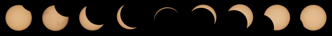
This composite image of nine pictures shows the progression of a partial solar eclipse near Banner, Wyoming on Monday, Aug. 21, 2017. A total solar eclipse swept across a narrow portion of the contiguous United States from Lincoln Beach, Oregon to Charleston, South Carolina. A partial solar eclipse was visible across the entire North American continent along with parts of South America, Africa, and Europe. Photo Credit: (NASA/Joel Kowsky)

The Moon is seen passing in front of the Sun at the point of the maximum of the partial solar eclipse near Banner, Wyoming on Monday, Aug. 21, 2017. A total solar eclipse swept across a narrow portion of the contiguous United States from Lincoln Beach, Oregon to Charleston, South Carolina. A partial solar eclipse was visible across the entire North American continent along with parts of South America, Africa, and Europe. Photo Credit: (NASA/Joel Kowsky)
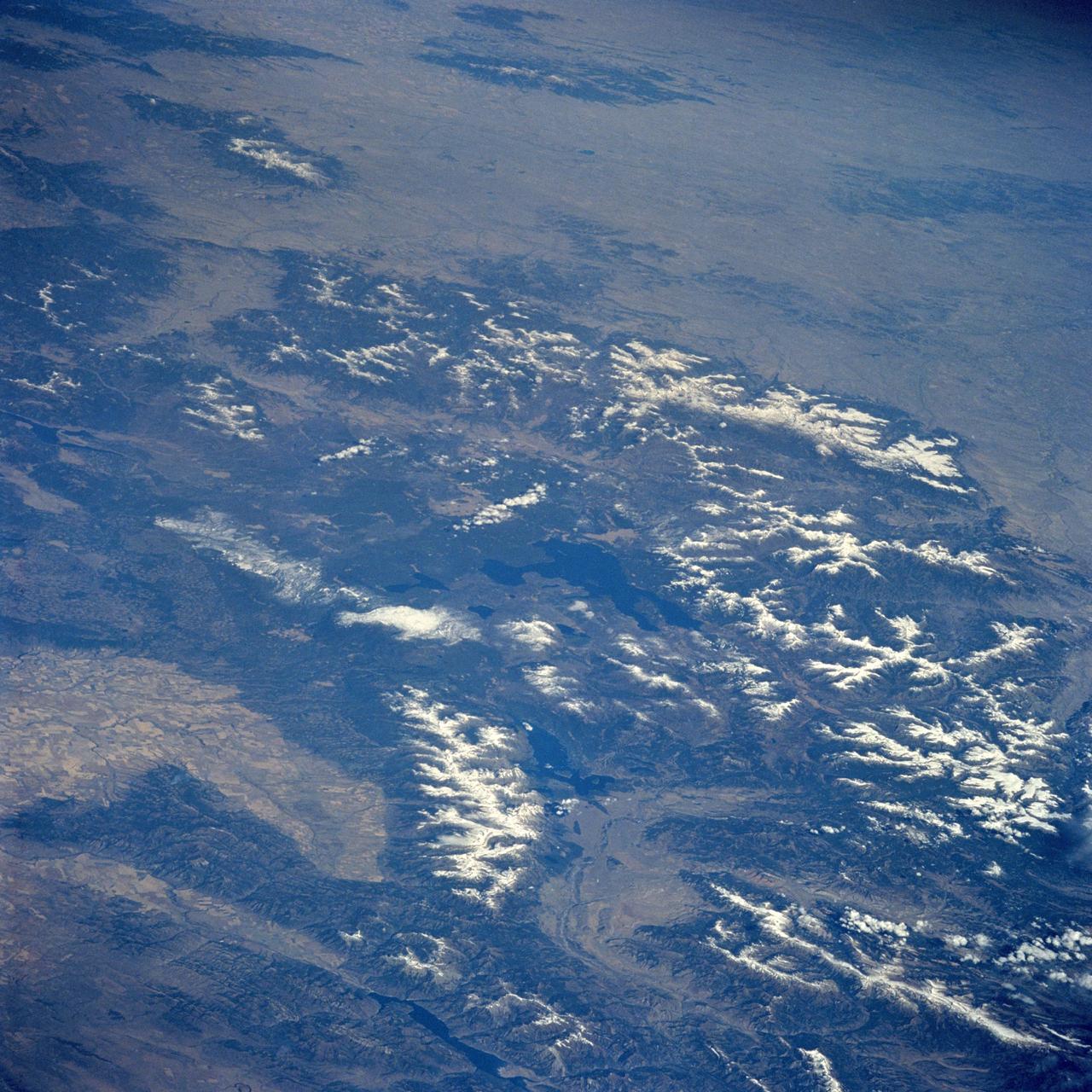
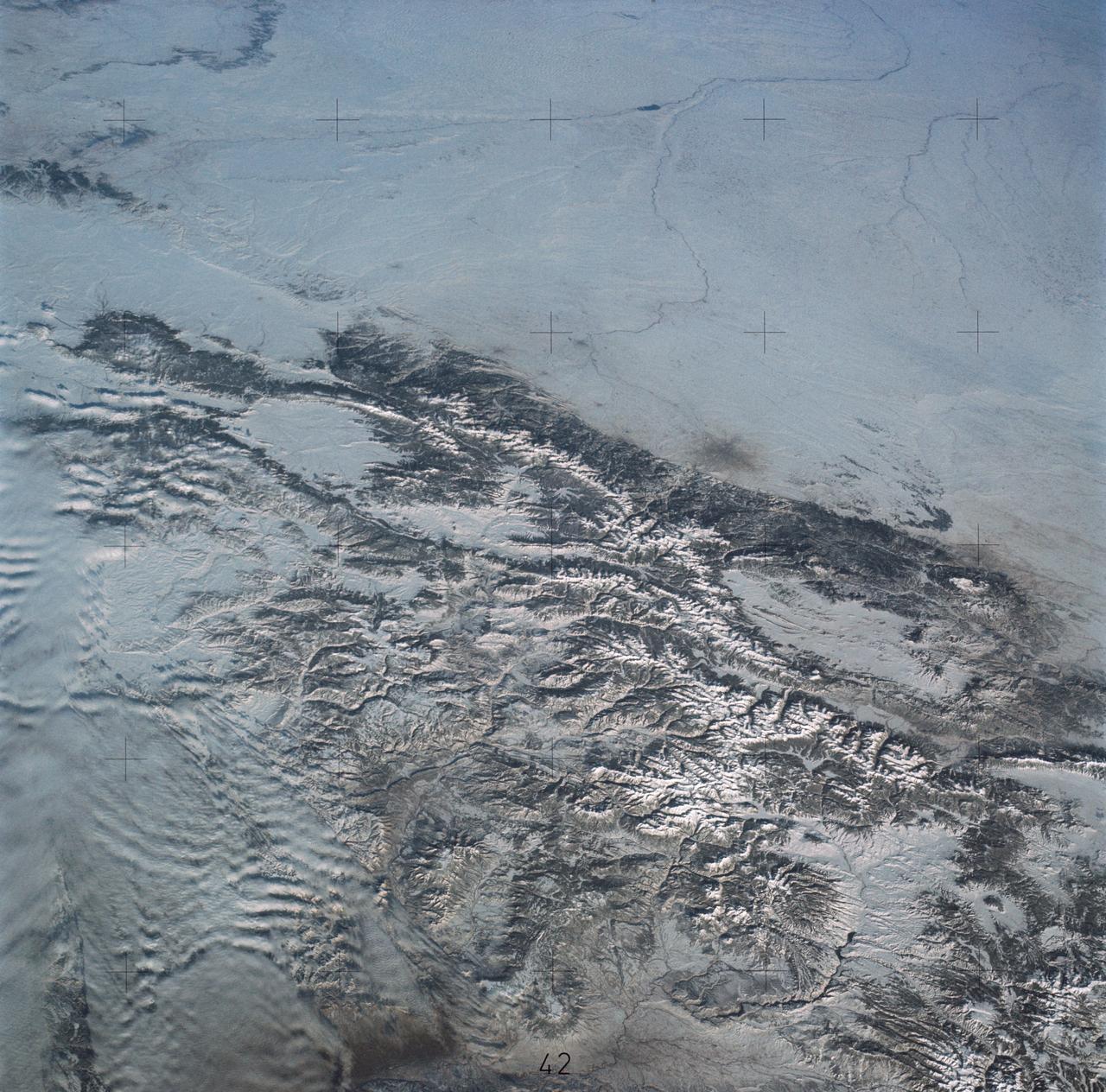
STS058-085-091 (18 Oct-1 Nov 1993) --- Yellowstone Lake and the surrounding Plateau are centered in this scene of northwestern Wyoming, and adjacent Idaho and Montana. The view extends across the Absaroka Range to Billings, on the Yellowstone River at the upper right edge of the photograph. Jackson Lake, Jackson Hole (valley) and the Grand Tetons extend from the Yellowstone Plateau toward the camera.
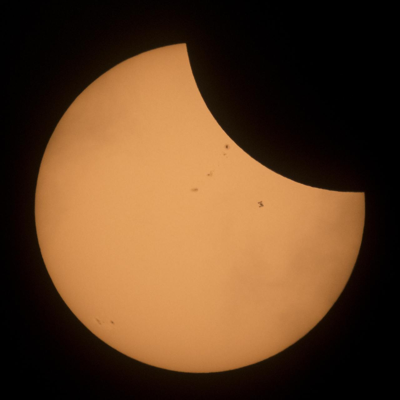
The International Space Station, with a crew of six onboard, is seen in silhouette as it transits the Sun at roughly five miles per second during a partial solar eclipse, Monday, Aug. 21, 2017 near Banner, Wyoming. Onboard as part of Expedition 52 are: NASA astronauts Peggy Whitson, Jack Fischer, and Randy Bresnik; Russian cosmonauts Fyodor Yurchikhin and Sergey Ryazanskiy; and ESA (European Space Agency) astronaut Paolo Nespoli. A total solar eclipse swept across a narrow portion of the contiguous United States from Lincoln Beach, Oregon to Charleston, South Carolina. A partial solar eclipse was visible across the entire North American continent along with parts of South America, Africa, and Europe. Photo Credit: (NASA/Joel Kowsky)
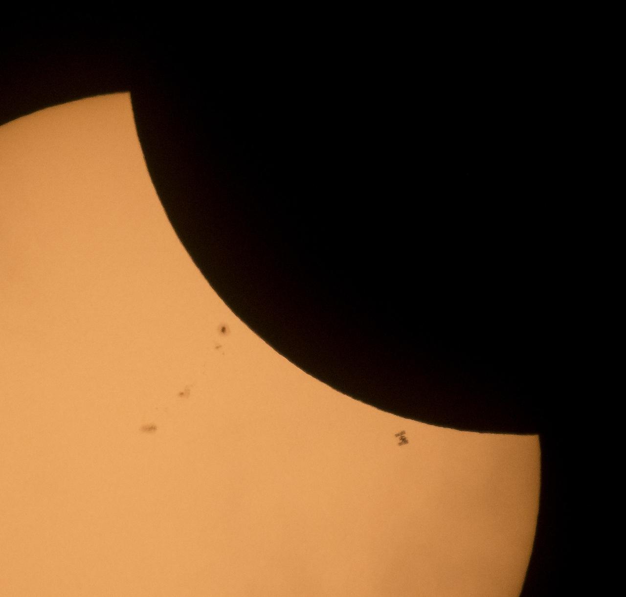
The International Space Station, with a crew of six onboard, is seen in silhouette as it transits the Sun at roughly five miles per second during a partial solar eclipse, Monday, Aug. 21, 2017 near Banner, Wyoming. Onboard as part of Expedition 52 are: NASA astronauts Peggy Whitson, Jack Fischer, and Randy Bresnik; Russian cosmonauts Fyodor Yurchikhin and Sergey Ryazanskiy; and ESA (European Space Agency) astronaut Paolo Nespoli. A total solar eclipse swept across a narrow portion of the contiguous United States from Lincoln Beach, Oregon to Charleston, South Carolina. A partial solar eclipse was visible across the entire North American continent along with parts of South America, Africa, and Europe. Photo Credit: (NASA/Joel Kowsky)
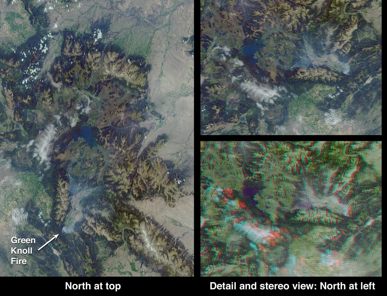
This anaglyph from the MISR instrument aboard NASA Terra spacecraft shows the area around Jackson Hole, Wyoming, where the Green Knoll forest fire raged for many days in July, 2001. 3D glasses are necessary to view this image.
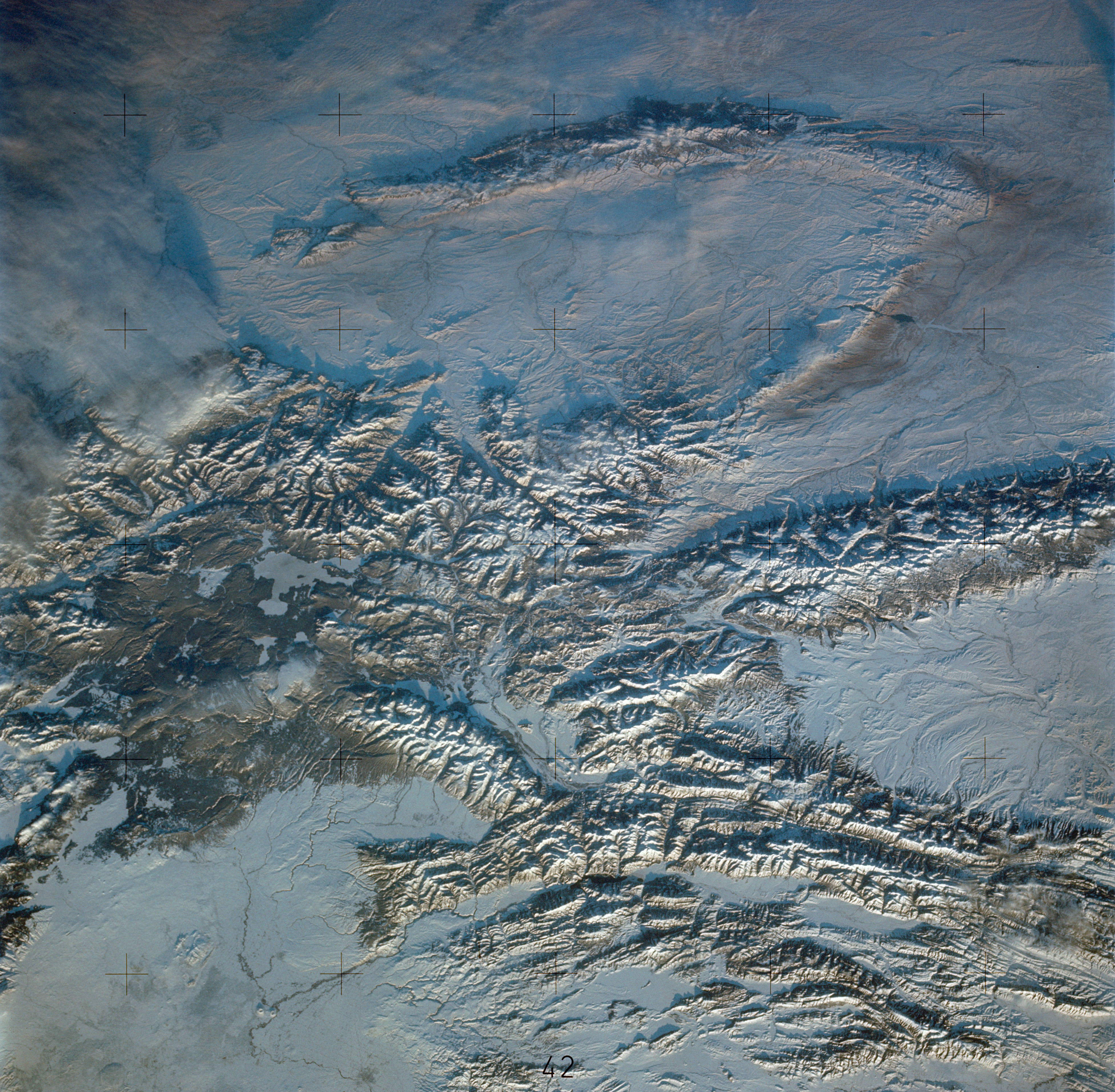
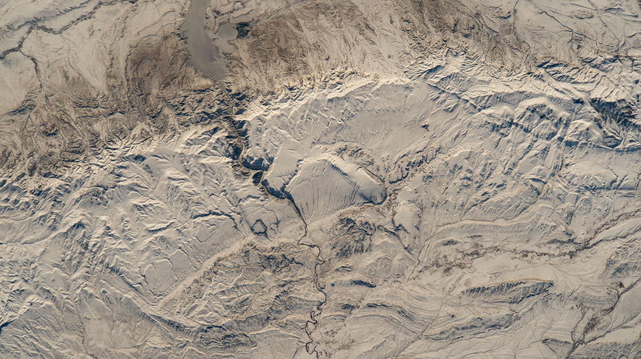
SL4-138-3846 (February 1974) --- A near vertical view of the snow-covered northwest corner of Wyoming as seen from the Skylab space station in Earth orbit. A Skylab 4 crewman used a hand-held 70mm Hasselblad camera to take this picture. A small portion of Montana and Idaho is seen in this photograph also. The dark area is Yellowstone National Park. The largest body of water is Yellowstone Lake. The Absaroka Range is immediately east and northeast of Yellowstone Lake. The elongated range in the eastern part of the picture is the Big Horn Mountain range. The Wind River Range is at bottom center. The Grand Teton National Park area is almost straight south of Yellowstone Lake. Approximately 30 per cent of the state of Wyoming can be seen in this photograph. Photo credit: NASA
S73-35081 (July-September 1973) --- A view of approximately 3,600 square miles of north central Wyoming and southern Montana is seen in this Skylab 3 Earth Resources Experiments Package S190-B (five-inch Earth terrain camera) photograph taken from the Skylab space station in Earth orbit. The Big Horn River following northward crosses between the northwest trending Big Horn Mountains and the Pryor Mountains. Yellowtail Reservoir, named after a former chief of the Crow Indian tribe in the center of the picture is impounded by a dam across the small rectangular crop area along the Big Horn River (upper right) and the strip farming (yellow) practiced on the rolling hill along the Big Horn River and its tributaries (upper left corner and right edge). The low sun angle enhances the structural features of the mountains as well as the drainage patterns in the adjacent basins. Rock formation appears in this color photograph as they would to the eye from this altitude. The distinctive redbeds can be traced along the front of the Pryor Mountains and indicate the folding that occurred during mountain building. EREP investigators, Dr. Houston of the University of Wyoming and Dr. Hoppin of the University of Iowa, will analyze the photograph and use the results in geological mapping and mineral resource studies. Lowell, Wyoming (lower left corner) and Hardin, Montana (upper right corner) can be recognized. Federal agencies participating with NASA on the EREP project are the Departments of Agriculture, Commerce, Interior, the Environmental Protection Agency and the Corps of Engineers. All EREP photography is available to the public through the Department of Interior?s Earth Resources Observations Systems Data Center, Sioux Falls, South Dakota, 57198. (Alternate number SL3-86-337) Photo credit: NASA
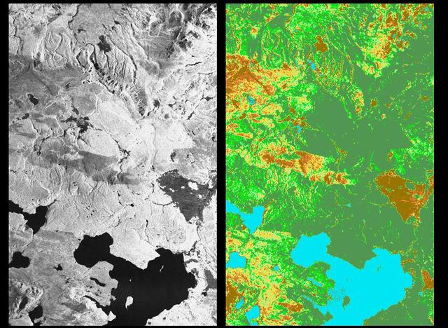
These two radar images show the majestic Yellowstone National Park, Wyoming, the oldest national park in the United States and home to the world's most spectacular geysers and hot springs. The region supports large populations of grizzly bears, elk and bison. In 1988, the park was burned by one of the most widespread fires to occur in the northern Rocky Mountains in the last 50 years. Surveys indicated that 793,880 acres of land burned. Of that, 41 percent was burned forest, with tree canopies totally consumed by the fire; 35 percent was a combination of unburned, scorched and blackened trees; 13 percent was surface burn under an unburned canopy; 6 percent was non-forest burn; and 5 percent was undifferentiated burn. Six years later, the burned areas are still clearly visible in these false-color radar images obtained by the Spaceborne Imaging Radar-C/X-band Synthetic Aperture Radar on board the space shuttle Endeavour. The image at the left was obtained using the L-band radar channel, horizontally received and vertically transmitted, on the shuttle's 39th orbit on October 2, 1994. The area shown is 45 kilometers by 71 kilometers (28 miles by 44 miles) in size and centered at 44.6 degrees north latitude, 110.7 degrees west longitude. North is toward the top of the image (to the right). Most trees in this area are lodge pole pines at different stages of fire succession. Yellowstone Lake appears as a large dark feature at the bottom of the scene. At right is a map of the forest crown, showing its biomass, or amount of vegetation, which includes foliage and branches. The map was created by inverting SIR-C data and using in situ estimates of crown biomass gathered by the Yellowstone National Biological Survey. The map is displayed on a color scale from blue (rivers and lakes with no biomass) to brown (non-forest areas with crown biomass of less than 4 tons per hectare) to light brown (areas of canopy burn with biomass of between 4 and 12 tons per hectare). Yellow indicates areas of canopy burn and mixed burn with a biomass of between 12 to 20 tons per hectare; light green is mixed burn and on-burn forest with a biomass of 20 to 35 tons per hectare; and green is non-burned forest with a biomass of greater than 35 tons per hectare. Forest recovery from the fire seems to depend on fire intensity and soil conditions. In areas of severe canopy burn and poor soil conditions, crown biomass was still low in 1994 (indicated by the brown areas at the center left), whereas in areas of mixed burn with nutrient-rich soils, seen west of Yellowstone Lake, crown biomass has increased significantly in six years (indicated by the yellow and light green areas). Imaging fire-affected regions with spaceborne radar illustrates SIR-C/X-SAR's keen abilities to monitor regrowth after a fire. Knowing the amount of carbon accumulated in the atmosphere by regenerating forest in the 20 to 50 years following a fire disturbance is also a significant factor in understanding the global carbon cycle. Measuring crown biomass is necessary to evaluate the effects of past and future fires in specific regions. http://photojournal.jpl.nasa.gov/catalog/PIA01741
Despite good rainfall and record-setting snowstorms in the spring of 2005, most of northeastern Wyoming, the Black Hills, and western South Dakota remained in the midst of a severe drought. These images are from NASA Terra spacecraft.
This anaglyph from the MISR instrument aboard NASA Terra spacecraft include portions of southern Wyoming, central Colorado, and western Nebraska. 3D glasses are necessary to view this image.
The blue dots in this field of galaxies, known as the COSMOS field, show galaxies that contain supermassive black holes emitting high-energy X-rays. The black holes were detected by NASA's Nuclear Spectroscopic Array, or NuSTAR, which spotted 32 such black holes in this field and has observed hundreds across the whole sky so far. The other colored dots are galaxies that host black holes emitting lower-energy X-rays, and were spotted by NASA's Chandra X-ray Observatory. Chandra data show X-rays with energies between 0.5 to 7 kiloelectron volts, while NuSTAR data show X-rays between 8 to 24 kiloelectron volts. http://photojournal.jpl.nasa.gov/catalog/PIA20865
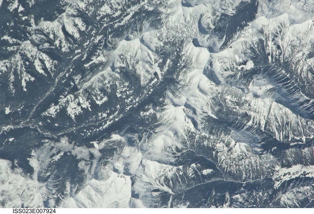
iss023e007925 (March 21, 2010) --- Yellowstone National Park in Wyoming is pictured from the International Space Station as it orbited about 250 miles above.
iss059e099103 (June 10, 2019) --- An Expedition 59 crewmember photographed Ocean Lake in Wyoming from an altitude of 256 miles above the United States.
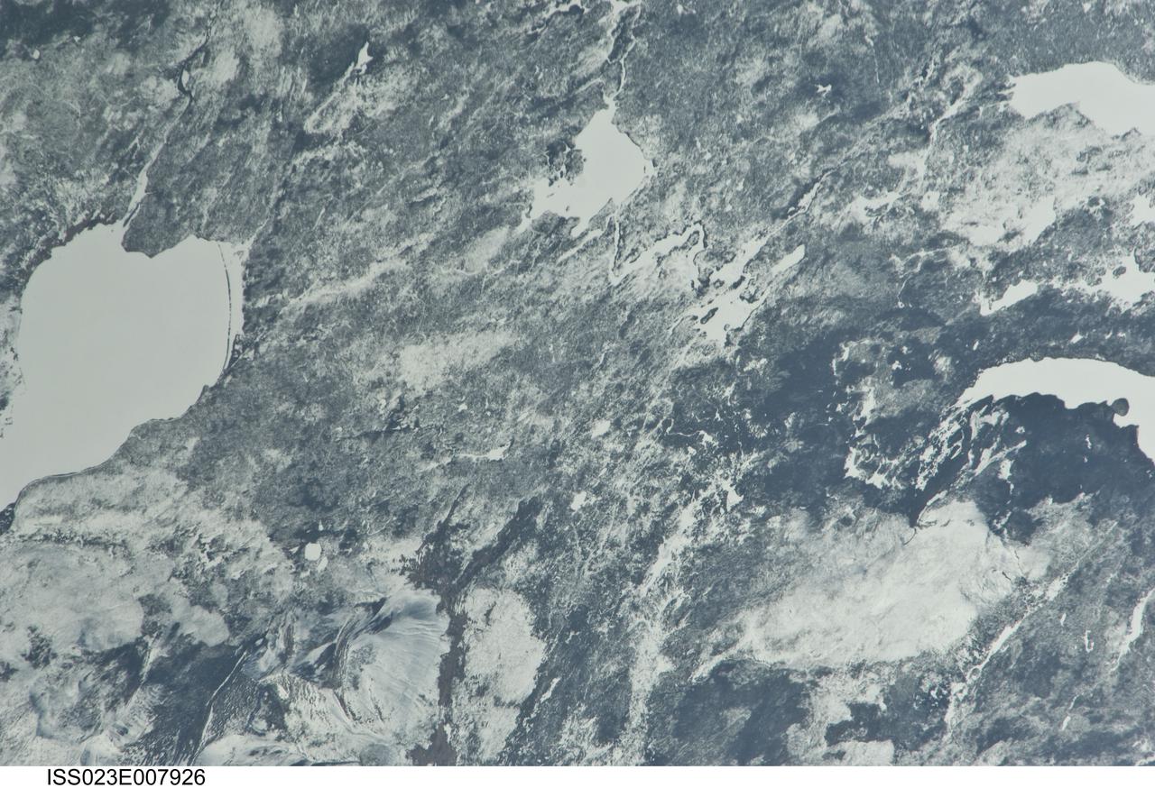
iss023e007926 (March 21, 2010) --- Yellowstone National Park in Wyoming is pictured from the International Space Station as it orbited about 250 miles above.
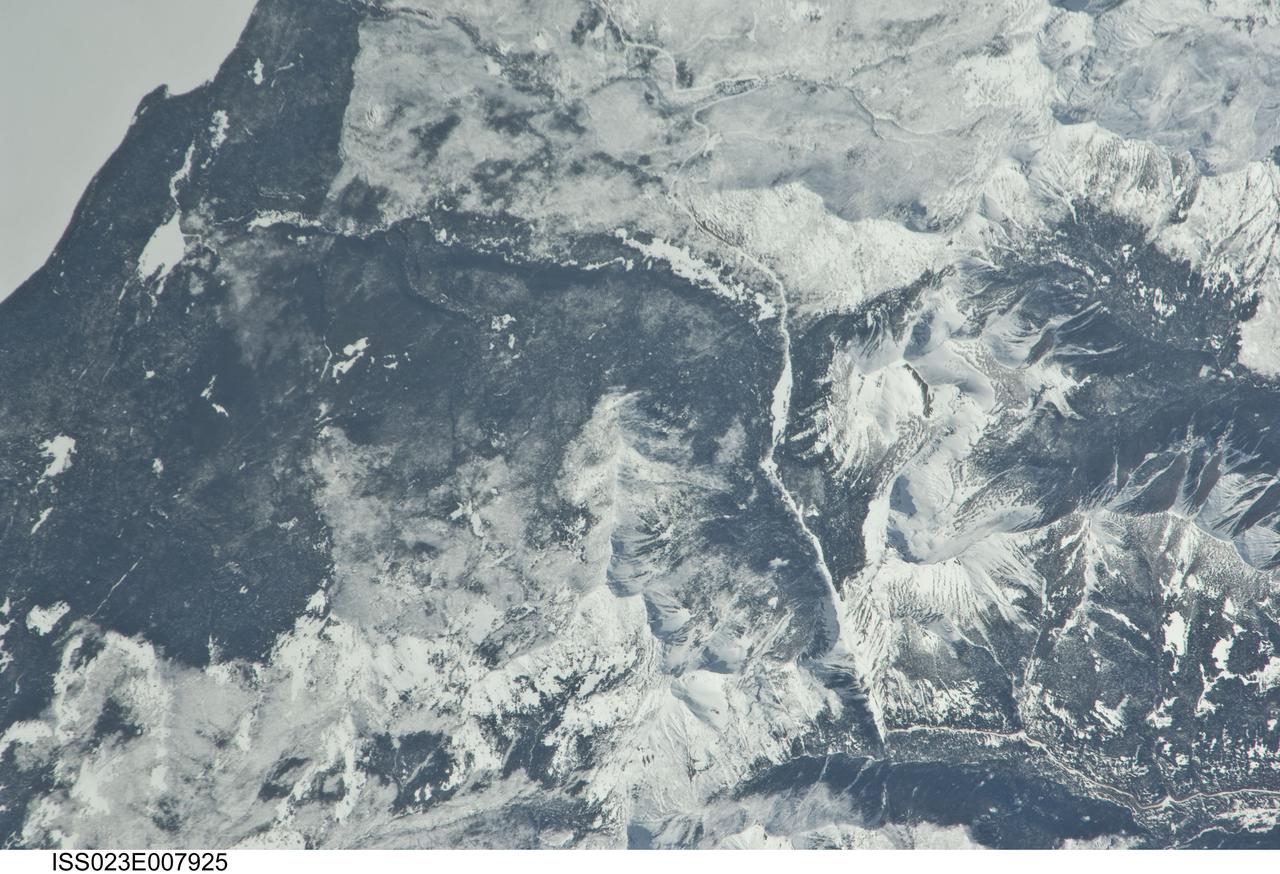
iss023e007924 (March 21, 2010) --- Yellowstone National Park in Wyoming is pictured from the International Space Station as it orbited about 250 miles above.
iss068e030993 (Dec. 17, 2022) --- A snow-covered Boysen State Park and a frozen Boysen Reservoir in Wyoming are pictured from the International Space Station as it orbited 261 miles above the western United States.
iss071e216801 (June 25, 2024) --- Towns and farmland along the Bighorn River and near the Bighorn National Forest (upper left) in Wyoming are pictured from the International Space Station as it orbited 264 miles above.
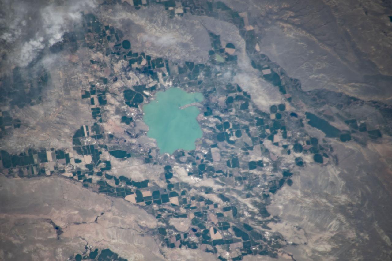
iss069e025528 (June 26, 2023) --- Ocean Lake located in Wyoming's Wind River Reservation is pictured from the International Space Station as it orbited 260 miles above the United States.

Earth observation taken during a day pass by an Expedition 37 crew member on board the International Space Station (ISS). Identified via Twitter message as Wyoming to British Columbia.
iss073e0420598 (Aug. 3, 2025) --- Bighorn National Forest in Wyoming and Custer National Forest in Montana, located in the Rocky Mountains region of the United States, are pictured from the International Space Station as it orbited 261 miles above.
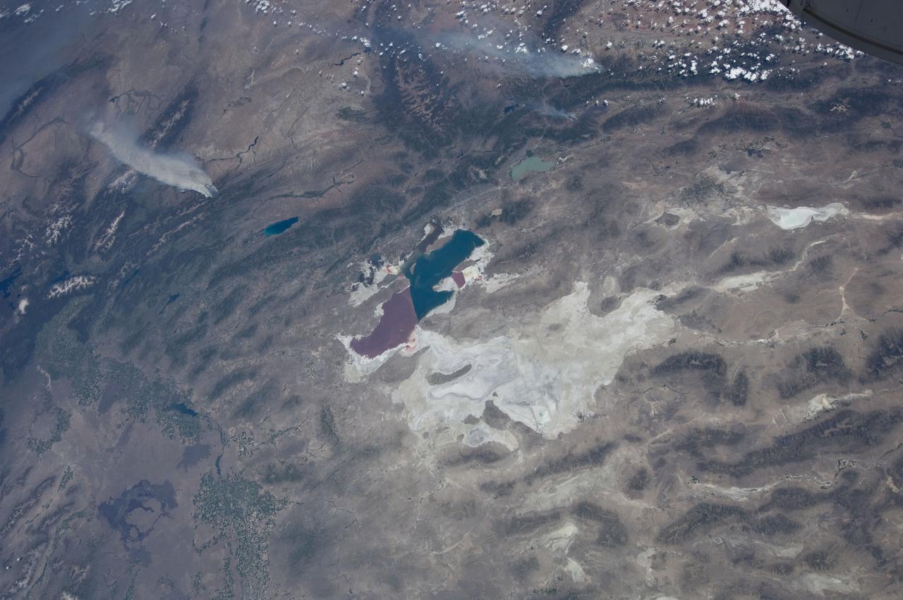
ISS031-E-146397 (27 June 2012) --- An Expedition 31 crew member aboard the International Space Station, flying approximately 240 miles above Earth, recorded a series of images of the current wild fires in the western and southwestern United States. These particular fires, of unknown cause, are burning at the south end of the Wyoming Range in southwestern Wyoming, and have affected 17,000 acres. The fires have produced two major smoke plumes, seen at upper left of the 18mm frame. Winds transport the smoke in a northeasterly direction. Utah?s Great Salt Lake (center) is about 120 miles away. Bear Lake and Utah Lake (very light blue or gray) are also visible in the frame.
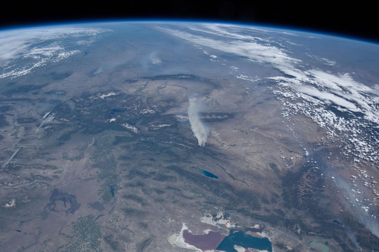
ISS031-E-146391 (27 June 2012) --- An Expedition 31 crew member aboard the International Space Station, flying approximately 240 miles above Earth, recorded a series of images of the current wild fires in the western and southwestern United States. These particular fires, of unknown cause, are burning at the south end of the Wyoming Range in southwestern Wyoming, and have affected 17,000 acres. The fires have produced two major smoke plumes, seen at center of the frame. Utah?s Great Salt Lake (bottom center) is about 120 miles away. Winds transport the smoke in a northeasterly direction.
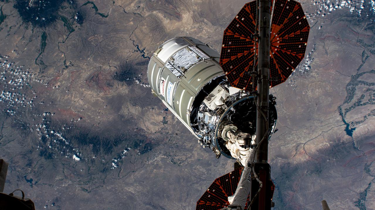
iss065e152560 (June 29, 2021) --- The Cygnus space freighter from Northrop Grumman is pictured the moment it was released from the Canadarm2 robotic arm over southern Wyoming in the United States completing a four-month cargo mission at the International Space Station.
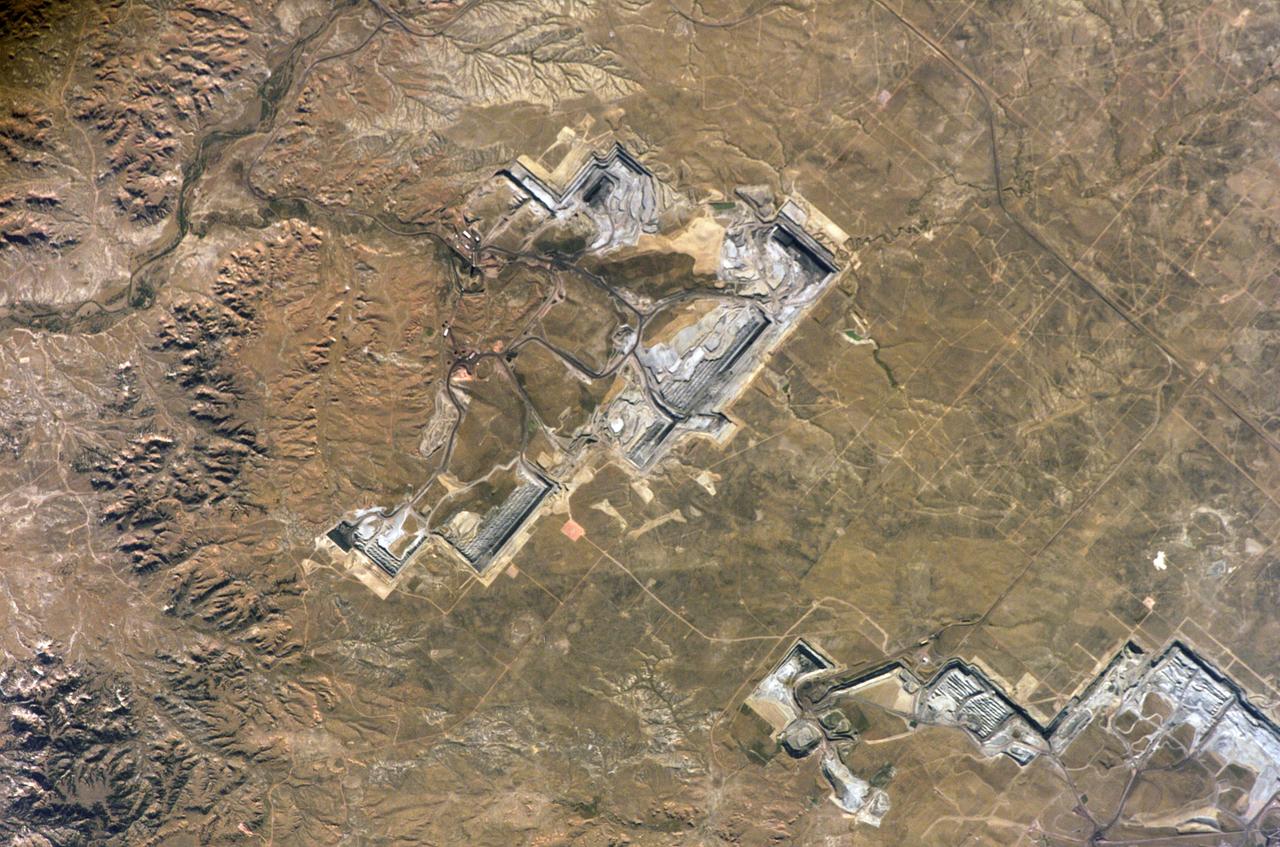
ISS011-E-12863 (11 September 2005) --- North Antelope Rochelle Coal Mine, Wyoming is featured in this image photographed by an Expedition 11 crewmember on the international space station. This area, according to NASA scientists studying the Expedition 11 photos, is a major coal producer.

iss072e977423 (April 9, 2025) --- The Soyuz MS-26 (foreground) and MS-27 crew ships are pictured docked to the International Space Station's Rassvet module and Prichal module, respectively. The orbital outpost was soaring 261 miles above Wyoming at the time of this photograph.
SL4-138-3875 (February 1974) --- A color oblique photograph looking east over the Rocky Mountains and Great Plains. This view covers a portion of the States of Colorado, Wyoming, and Nebraska. A Skylab 4 crewmen took this picture with a hand-held 70mm Hasselblad camera. This entire region, covered with a blanket of snow, depicts much of the structural and topographic features of the Rocky Mountain chain. Man's only apparent change to the snow pattern seen here is the (right center) metropolitan areas of Denver and Colorado Springs, Colorado, which can be observed along the eastern edge of the mountain front. Grand Junction, Colorado on the western slope of the Rocky Mountains is just off the photograph at left center bottom. The major inter-montane valleys of South Park (right center), Middle Park (center), and North Park (left center) are clearly visible and separate the Colorado Rockies Front Range from the high rugged mountains can be discovered such as Pikes Peak near right border (center), Mt. Cunnison region, circular feature accentuated by the Cunnison River (dark) in the right center (bottom) of the photograph. The snow covered peaks of Mts. Harvard, Princeton and Yale form the high region of the Collegiate Range which is the pronounced mountain area in the right center. Snow cover not only enhances mountain features but also the drainage patterns. East of Denver (right corner) the sinuous trace of the South Platte River (center) and its junction with the North Platte River near North Platte, Nebraska. Lake McConaughy in Nebraska is the body of water (black) near the river intersection. The trace of the Republic River in southern Nebraska is visible near the right corner of the photography. Geologic and hydro logic studies using this photograph will be conducted by Dr. Roger Morrison, U.S. Geological Survey. Photo credit: NASA
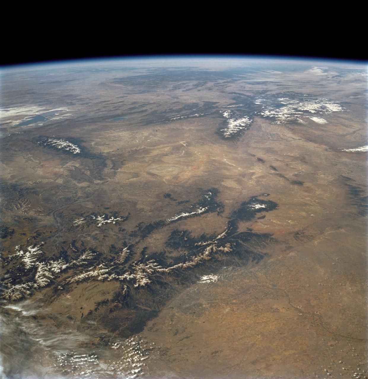
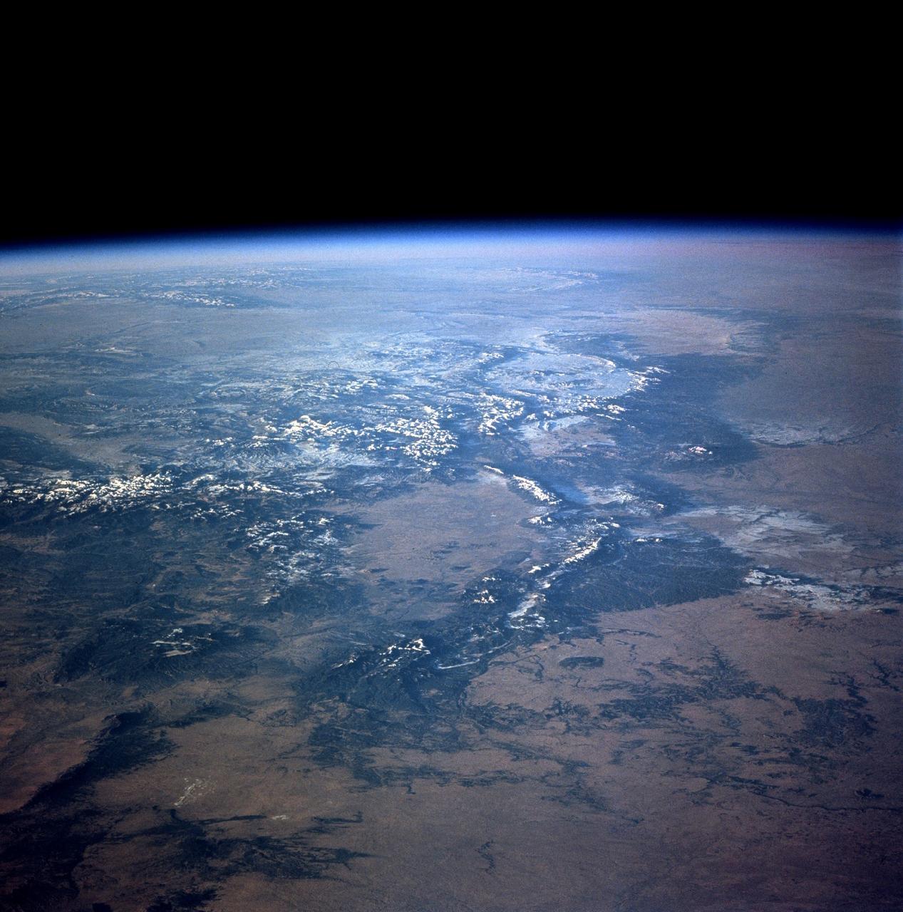
STS112-708-002 (7-18 October 2002) --- This image, photographed from the Earth-orbiting Space Shuttle Atlantis, covers parts of Utah, Colorado, Wyoming and Idaho. The Front Range of the Rockies is the dark range crossing the bottom of the view, with Denver and neighboring cities (grays) situated in the gentle embayment of the mountains (bottom center of the view). Great Salt Lake in Utah appears as two colors of blue top left, with the snow-covered Uinta Mountains just below, in this northwesterly view. Most of the view encompasses the brown plains of western Wyoming (center) and the cluster of mountains around Yellowstone (top center, top right, with snow). Beyond the brown Snake River Plain, black rocks of the Sawtooth Mountains and neighboring ranges of central Idaho appear top center.
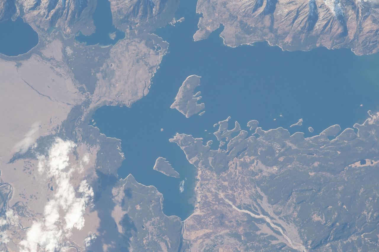
iss057e055571 (Oct. 22, 2018) --- Jackson Lake, in the state of Wyoming's Grand Teton National Park, is a natural remnant of glacial gouging and was enlarged by the construction of the Jackson Lake Dam in the early 20th century. The International Space Station was orbiting nearly 256 miles above North America when this photograph was taken by an Expedition 57 crew member.

ISS007-E-17557 (17 October 2003) --- This sweeping view of the Rocky Mountains and the western US was taken when the International Space Station (ISS) traveled over eastern Washington on October 17, 2003. The POV of the Station was looking southeast over the mountains of Idaho (foreground) and Wyoming (Yellowstone, the Tetons and the Wind River Range are just right and above the center of the image). Great Salt Lake is in the lower right of the image.

This chart shows low-humidity thresholds that signal flu outbreaks in 48 U.S. states, calculated using water vapor data from NASA's Atmospheric Infrared Sounder (AIRS) instrument on the Aqua satellite with data on U.S. flu cases from 2003 to 2015. The color range from lighter to darker indicates lower to higher humidity thresholds, with the driest state, Wyoming, having the lowest threshold and Florida the highest. Units are kilograms of water per kilogram of air. https://photojournal.jpl.nasa.gov/catalog/PIA24986

S75-20108 (September 1974) --- Cosmonaut Aleksey A. Leonov (right), commander of the first (prime) crew of Soviet cosmonauts on the planned Apollo-Soyuz Test Project (ASTP), enjoys a tribal welcome from Shoshone Indians during a hunting trip in the Lander, Wyoming area. Leonov was in the United States to take part in joint crew training at the Johnson Space Center.
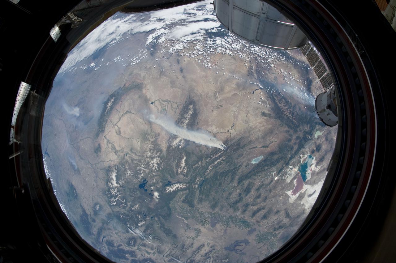
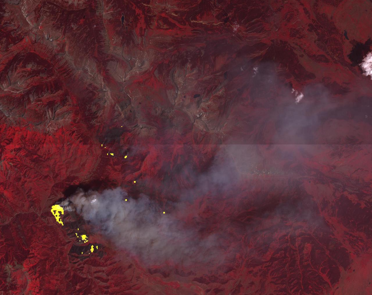
ISS031-E-146344 (27 June 2012) --- An Expedition 31 crew member aboard the International Space Station, flying approximately 240 miles above Earth, recorded a series of images of the current wild fires in the southwestern United States. For this particular image, taken from the station?s Cupola, he used a 16mm lens, which gives this view a ?fisheye? affect. The fires give rise to thick smoke plumes on the southernmost extremity of the Wyoming Range, which occupies the center of the image. Slopes of the central Salt River Range appear at left. Three helicopters and more than 100 personnel are fighting the fire, which is being managed by the Bridger?Teton National Forest.
![ISS031-E-146306 (27 June 2012) --- An Expedition 31 crew member aboard the International Space Station, flying approximately 240 miles (386 kilometers) above Earth, captured this view of the Fontenelle fire on June 27, 2012. The fire, burning in Wyoming 18 miles (29 kilometers) west of Big Piney, was discovered on June 24. [Editor?s update --- By the morning of June 28, the fire had burned 25,000 acres (101 square kilometers). By July 6, the area burned had more than doubled to 57,324 acres (232 square kilometers), and the fire was 25 percent contained].](https://images-assets.nasa.gov/image/iss031e146306/iss031e146306~medium.jpg)
ISS031-E-146306 (27 June 2012) --- An Expedition 31 crew member aboard the International Space Station, flying approximately 240 miles (386 kilometers) above Earth, captured this view of the Fontenelle fire on June 27, 2012. The fire, burning in Wyoming 18 miles (29 kilometers) west of Big Piney, was discovered on June 24. [Editor?s update --- By the morning of June 28, the fire had burned 25,000 acres (101 square kilometers). By July 6, the area burned had more than doubled to 57,324 acres (232 square kilometers), and the fire was 25 percent contained].
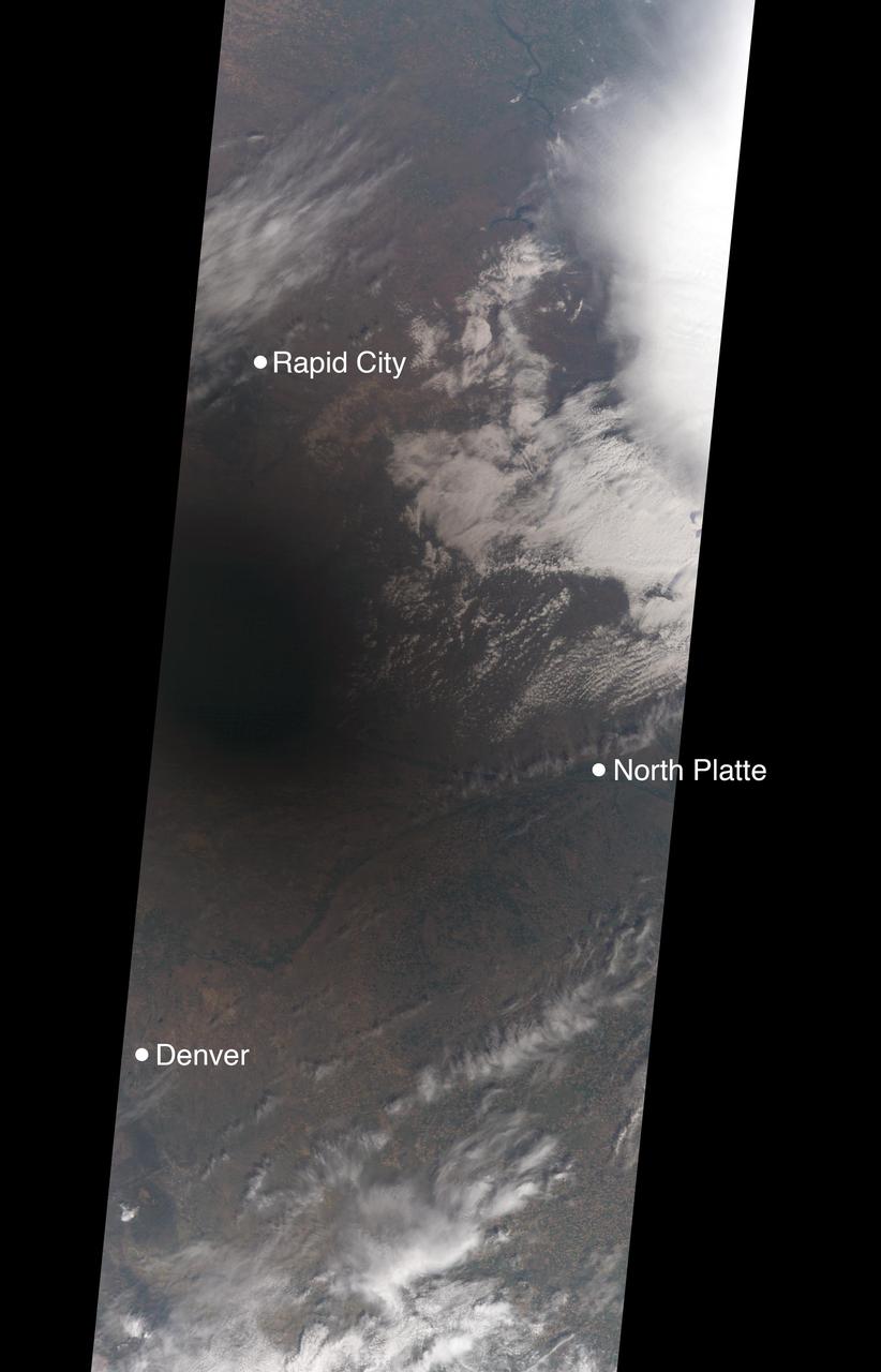
On Aug. 21, 2017, a total solar eclipse swept across the United States -- the first such eclipse in the contiguous 48 states since 1979, and the first cross-country eclipse since 1918. A partial eclipse was visible in all 50 states, and initial estimates suggest that upwards of 20 million people observed the Moon completely obscuring the Sun in the 70-mile-wide (113-kilometer-wide) path of totality. While viewing a total solar eclipse from the ground is an amazing experience, satellites orbiting Earth see the eclipse from a unique perspective. As the Moon's shadow passed through the United States, the Multi-angle Imaging SpectroRadiometer (MISR) instrument aboard NASA's Terra satellite was capturing images of eastern Wyoming and western Nebraska from its altitude of 438 miles (705 kilometers) above the surface. MISR gathers images on a strip about 249 miles (400 kilometers) wide directly below the path of the satellite. Incredibly, given that the shadow of the Moon took only 90 minutes to cross the entire United States, and Terra itself moves at a brisk 16,700 miles per hour from north to south, MISR happened to be in exactly the right place at the right time to capture totality. From the ground, the moment of totality appears suddenly, sweeping over the sky in just a few seconds. "I was unprepared for just how dark it actually was," says Mika Tosca, a researcher who works with MISR data and who observed the eclipse in Nebraska. "The streetlights even turned on. Everything fell silent, and I swear the temperature dropped." From the vantage point of space, however, it’s possible to see the entire shadow of the Moon, with the completely dark, circular umbra and the more diffuse penumbra. MISR contains nine cameras oriented at different angles, viewing forward, downward, and backward along the flight path, resulting in an approximate seven-minute interval for all nine cameras to image a single location on Earth's surface. This animation combines these nine images into a movie showing the motion of the Moon's shadow during this seven-minute period. In the first image, captured by the camera pointing farthest ahead of the satellite, totality has not quite begun in the area seen by MISR. From the second camera onward, totality sweeps across the image area from west to east, beginning just west of the town of Jay Em, Wyoming, and proceeding about halfway across the MISR swath to the town of Alliance, Nebraska. The motion of the lunar shadow in different pairs of images leads to estimates of the local ground speed ranging between 1,480 and 1,820 miles per hour (2,382 and 2,929 kilometers per hour). The spread in values is a measure of the uncertainty of the estimate. At this location, the predicted speed of the eclipse calculated from lunar orbital motion is about 1,658 miles per hour (2,668 kilometers per hour), which falls in the middle of the range estimated from the MISR images. Tosca's observation that the temperature dropped during the eclipse is a well-known phenomenon. The GLOBE Observer, a phone application dedicated to citizen science and sponsored by NASA, encouraged eclipse-goers to record the local air temperature at regular intervals. Data collected by nearby observers in the path of totality show that, on average, temperatures dropped by 9.3 degrees Fahrenheit (5.2 degrees Celsius) during the eclipse. This compares to an average of 5.4 degrees Fahrenheit drop measured at several Nebraska Mesonet weather stations within the path of totality. The decrease in the amount of sunlight reaching Earth affected more than temperatures. Areas that get a large portion of their power from solar energy were naturally concerned about shortages during the eclipse -- the state of California, though not in the path of totality, estimated that 6,000 megawatts of solar power would be lost during the eclipse. An animation is available at https://photojournal.jpl.nasa.gov/catalog/PIA21957
STS103-730-032 (19-27 December 1999) --- One of the astronauts aboard the Earth-orbiting Space Shuttle Discovery used a handheld 70mm camera to capture the southern to middle Rocky Mountains in low sunlight. The middle Rockies include the Big Horn range of Wyoming (snow capped range almost center of horizon) and the Unita Mountains of northeastern Utah (snow capped range left side of horizon). The southern Rockies includes the Front Range, Sangre de Cristo Mountains, Sawatch Ranges, and the San Juan Mountains. The eastern (Front Range, Sangre de Cristo) and western ranges (Sawatch, San Juan's) are separated by intermontane basins. The southernmost basin (near center of the image) is the San Luis Valley of Colorado. On the eastern edge of the San Luis Valley are the Sangre de Cristo Mountains.
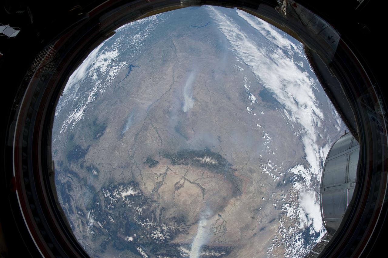
ISS031-E-146343 (27 June 2012) --- An Expedition 31 crew member aboard the International Space Station, flying approximately 240 miles above Earth, recorded a series of images of the current wild fires in the west and southwestern United States. For this particular image, taken from the station?s Cupola, he used a 16mm lens, which gives this view a ?fisheye? affect. The fires give rise to thick smoke plumes on the southernmost extremity of the Wyoming Range, which occupies the bottom left portion of the image. Three helicopters and more than 100 personnel are fighting the fire, which is being managed by the Bridger?Teton National Forest. Part of a docked Russian Soyuz spacecraft and the Multi-Purpose Logistics Module (MPLM) are at lower right.
ISS043E128768 (04/21/2015) --- NASA astronaut Scott Kelly on the International Space Station May 6, 2015 tweeted this image out of an Earth observation as part of his Space Geo trivia contest. Scott tweeted this comment and clue: "#SpaceGeo! A serpent is known for deceptive traits, but don’t let this snake pull the wool over your eyes. Name it!” Congratulations to @splinesmith for correctly identifying this image first, : #BighornRiver Montana/Wyoming named in 1805 for Bighorn sheep along its banks. He will receive an autographed copy of this image when Scott returns to Earth in March 2016. Learn more about #SpaceGeo and play along every Wednesday for your chance to win: http://www.nasa.gov/feature/where-over-the-world-is-astronaut-scott-kelly
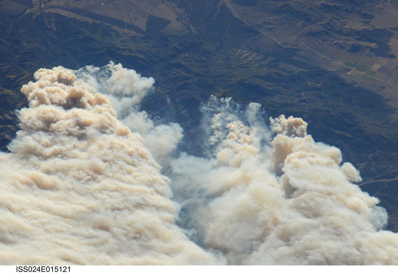
ISS024-E-015121 (20 Sept. 2010) --- Twitchell Canyon Fire in central Utah is featured in this image photographed by an Expedition 24 crew member on the International Space Station (ISS). The Twitchell Canyon Fire near central Utah?s Fishlake National Forest is reported to have an area of approximately 13,383 hectares (approximately 134 square kilometers, or 33,071 acres). This detailed image shows smoke plumes generated by several fire spots close to the southwestern edge of the burned area. The fire was started by a lightning strike on July 20, 2010. Whereas many of the space station images of Earth are looking straight down (nadir), this photograph was exposed at an angle. The space station was located over a point approximately 509 kilometers (316 miles) to the northeast, near the Colorado/Wyoming border, at the time the image was taken on Sept. 20. Southwesterly winds were continuing to extend smoke plumes from the fire to the northeast. While the Twitchell Canyon region is sparsely populated, Interstate Highway 15 is visible at upper left.

Astronomers using NASA's Hubble Space Telescope have found compelling evidence of a planet forming 7.5 billion miles away from its star, a finding that may challenge current theories about planet formation. Of the almost 900 planets outside our solar system that have been confirmed to date, this is the first to be found at such a great distance from its star. The suspected planet is orbiting the diminutive red dwarf TW Hydrae, a popular astronomy target located 176 light-years away from Earth in the constellation Hydra the Sea Serpent. Read more: <a href="http://1.usa.gov/196B6lZ" rel="nofollow">1.usa.gov/196B6lZ</a> NASA, ESA, J. Debes (STScI), H. Jang-Condell (University of Wyoming), A. Weinberger (Carnegie Institution of Washington), A. Roberge (Goddard Space Flight Center), G. Schneider (University of Arizona/Steward Observatory), and A. Feild (STScI/AURA) <b><a href="http://www.nasa.gov/audience/formedia/features/MP_Photo_Guidelines.html" rel="nofollow">NASA image use policy.</a></b> <b><a href="http://www.nasa.gov/centers/goddard/home/index.html" rel="nofollow">NASA Goddard Space Flight Center</a></b> enables NASA’s mission through four scientific endeavors: Earth Science, Heliophysics, Solar System Exploration, and Astrophysics. Goddard plays a leading role in NASA’s accomplishments by contributing compelling scientific knowledge to advance the Agency’s mission. <b>Follow us on <a href="http://twitter.com/NASA_GoddardPix" rel="nofollow">Twitter</a></b> <b>Like us on <a href="http://www.facebook.com/pages/Greenbelt-MD/NASA-Goddard/395013845897?ref=tsd" rel="nofollow">Facebook</a></b> <b>Find us on <a href="http://instagram.com/nasagoddard?vm=grid" rel="nofollow">Instagram</a></b>
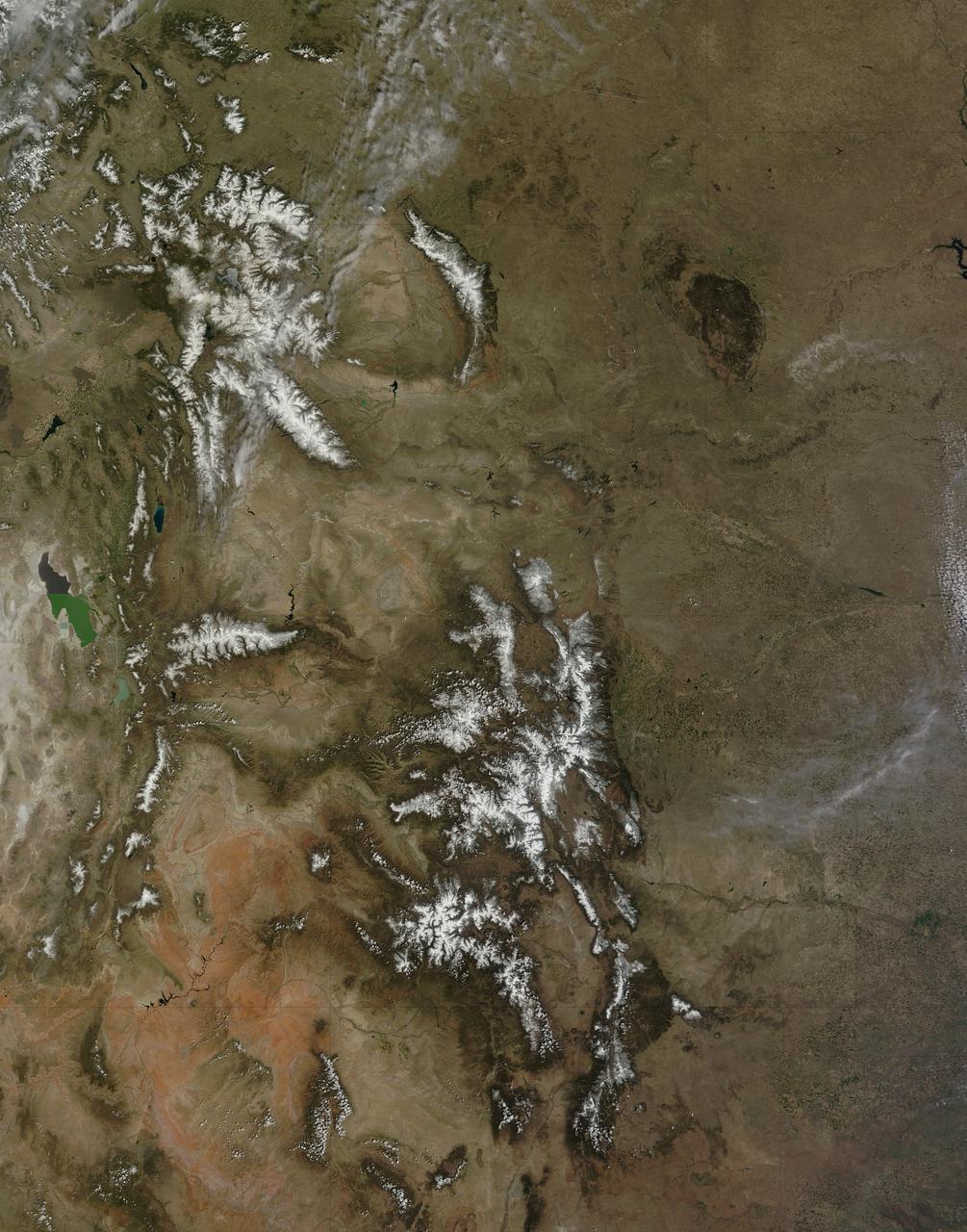
On April 29, 2015 the Moderate Resolution Imaging Spectroradiometer (MODIS) aboard NASA’s Terra satellite captured a true-color image of a typical spring scene in the western United State: snow-crowned Rocky Mountains rising above the faintly greening plains. The Rocky Mountains stretch from British Columbia, Canada to the Rio Grande in New Mexico, a span of roughly 3,000 miles, and contains many of the highest peaks in the continental United States. The tallest, Mount Elbert, rises 14,400 ft. (4,401 m) above sea level, and is located in the San Isabel National Forest, near Leadville, Colorado. This image covers seven Rocky Mountain states. From north to south they are: Montana and Idaho, Wyoming; Utah (with the Great Salt Lake visible) and Colorado; Arizona and New Mexico. To the east, the Great Plain states captured are, from north to south: North Dakota, South Dakota, Nebraska, Kansas, Oklahoma and northwestern Texas. Credit: NASA/GSFC/Jeff Schmaltz/MODIS Land Rapid Response Team <b><a href="http://www.nasa.gov/audience/formedia/features/MP_Photo_Guidelines.html" rel="nofollow">NASA image use policy.</a></b> <b><a href="http://www.nasa.gov/centers/goddard/home/index.html" rel="nofollow">NASA Goddard Space Flight Center</a></b> enables NASA’s mission through four scientific endeavors: Earth Science, Heliophysics, Solar System Exploration, and Astrophysics. Goddard plays a leading role in NASA’s accomplishments by contributing compelling scientific knowledge to advance the Agency’s mission. <b>Follow us on <a href="http://twitter.com/NASAGoddardPix" rel="nofollow">Twitter</a></b> <b>Like us on <a href="http://www.facebook.com/pages/Greenbelt-MD/NASA-Goddard/395013845897?ref=tsd" rel="nofollow">Facebook</a></b> <b>Find us on <a href="http://instagrid.me/nasagoddard/?vm=grid" rel="nofollow">Instagram</a></b>
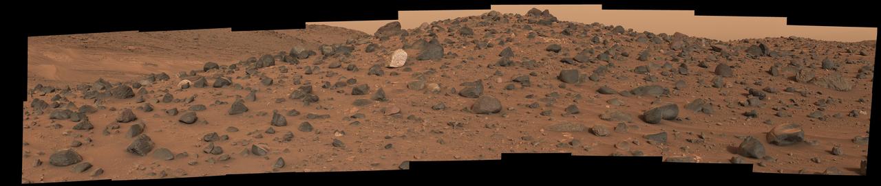
Composed of 18 images, this natural-color mosaic shows a boulder field on "Mount Washburn" (named after a mountain in Wyoming) in Mars' Jezero Crater. The Perseverance science team nicknamed the light-toned boulder with dark speckles near the center of the mosaic "Atoko Point" (after a feature in the eastern Grand Canyon). The images were acquired by NASA's Perseverance Mars rover on May 27, 2024, the 1,162nd Martian day, or sol, of the mission. Analysis by the rover's SuperCam and Mastcam-Z instruments indicate Atoko Point is composed of the mineral pyroxene, similar to some boulders the rover has encountered elsewhere in Jezero Crater. In terms of the size, shape, and arrangement of its mineral grains and crystals – and potentially its chemical composition – Atoko Point is different from any of the rocks the rover has encountered before. Some Perseverance scientists speculate the minerals that make up Atoko Point were produced in a subsurface body of magma that is possibly exposed now on the crater rim. Others on the team wonder if the boulder, which stands about 18 inches (45 centimeters) wide and 14 inches (35 centimeters) tall, had been created far beyond the walls of Jezero and transported there by swift Martian waters eons ago. Arizona State University leads the operations of the Mastcam-Z instrument, working in collaboration with Malin Space Science Systems in San Diego, on the design, fabrication, testing, and operation of the cameras, and in collaboration with the Niels Bohr Institute of the University of Copenhagen on the design, fabrication, and testing of the calibration targets. A key objective for Perseverance's mission on Mars is astrobiology, including the search for signs of ancient microbial life. The rover will characterize the planet's geology and past climate, pave the way for human exploration of the Red Planet, and be the first mission to collect and cache Martian rock and regolith (broken rock and dust). Subsequent NASA missions, in cooperation with ESA (European Space Agency), would send spacecraft to Mars to collect these sealed samples from the surface and return them to Earth for in-depth analysis. The Mars 2020 Perseverance mission is part of NASA's Moon to Mars exploration approach, which includes Artemis missions to the Moon that will help prepare for human exploration of the Red Planet. https://photojournal.jpl.nasa.gov/catalog/PIA26333
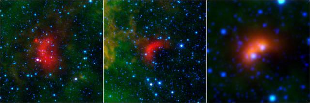
Bow shocks thought to mark the paths of massive, speeding stars are highlighted in these images from NASA's Spitzer Space Telescope and Wide-field Infrared Survey Explorer, or WISE. Cosmic bow shocks occur when massive stars zip through space, pushing material ahead of them in the same way that water piles up in front of a race boat. The stars also produce high-speed winds that smack into this compressed material. The end result is pile-up of heated material that glows in infrared light. In these images, infrared light has been assigned the colored red. Green shows wispy dust in the region and blue shows stars. The two images at left are from Spitzer, and the one on the right is from WISE. The speeding stars thought to be creating the bow shocks can be seen at the center of each arc-shaped feature. The image at right actually consists of two bow shocks and two speeding stars. All the speeding stars are massive, ranging from about 8 to 30 times the mass of our sun. http://photojournal.jpl.nasa.gov/catalog/PIA20062