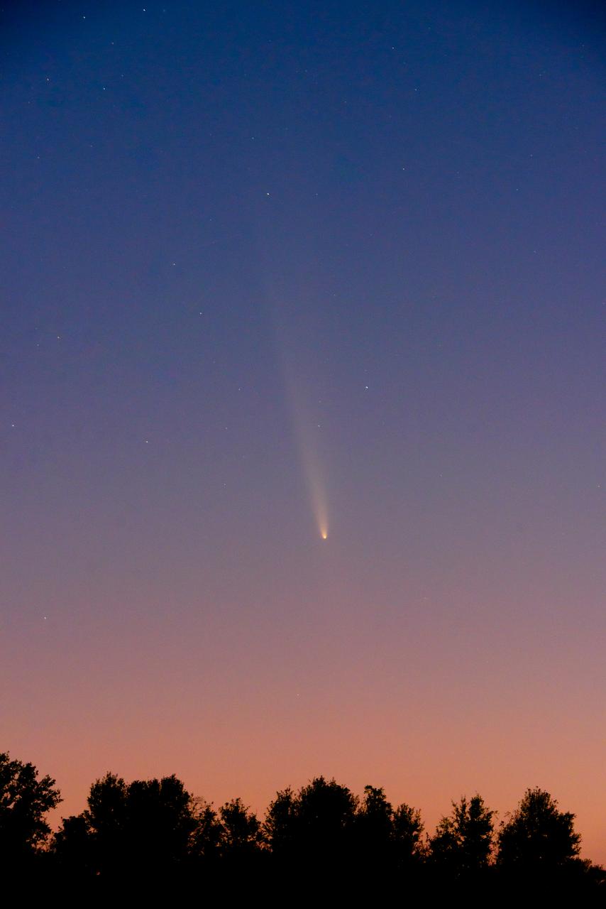
The Oort Cloud comet, called C/2023 A3 Tsuchinshan-ATLAS, passes over Southeast Louisiana near New Orleans, home of NASA’s Michoud Assembly Facility, Sunday, Oct. 13, 2024. The comet is making its first appearance in documented human history; it was last seen in the night sky 80,000 years ago. The Tsuchinshan-ATLAS comet made its first close pass by Earth in mid-October and will remain visible to viewers in the Northern Hemisphere just between the star Arcturus and planet Venus through early November.
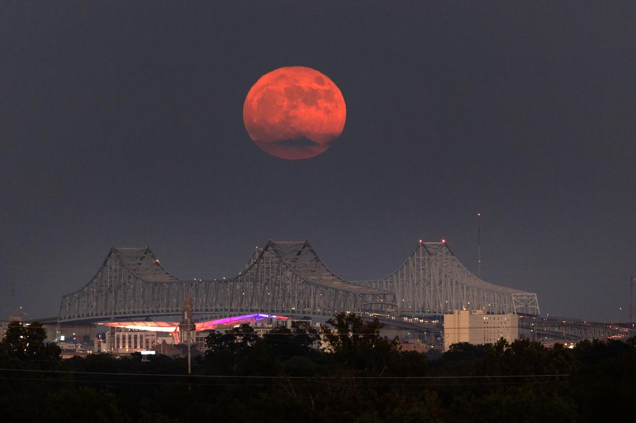
A Super Blue Moon rises above the Mississippi River and the Crescent City Connection Bridge in New Orleans, Aug. 30. The full moon is “super” because it’s slightly closer to Earth and “blue” because it’s the second full moon in a month. About 25% of all full moons are supermoons, but only 3% of full moons are blue moons. The next super blue moons will occur in a pair in January and March 2037. New Orleans is home to NASA’s Michoud Assembly Facility, where stages for NASA’s SLS (Space Launch System) rocket and structures for Orion spacecraft are produced for the Artemis missions.
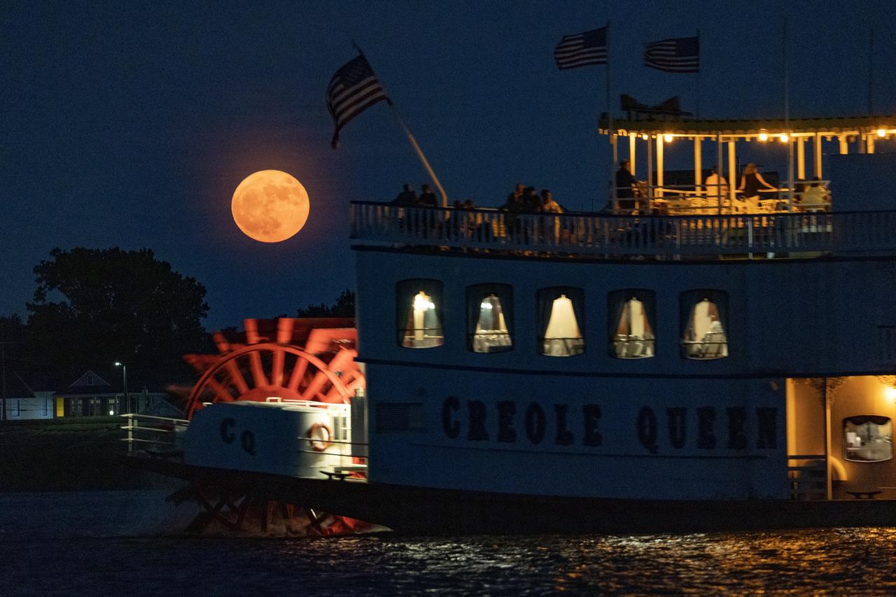
A supermoon rises over the Mississippi River and the Crescent City Aug. 1. The early August full Moon is the second largest in Earth’s skies for 2023. Later in August, a full Moon will appear in the skies for a second time. New Orleans is home to NASA’s Michoud Assembly Facility, where stages for NASA’s SLS (Space Launch System) rocket and structures for Orion spacecraft are produced for the Artemis missions.

A supermoon rises over Huntsville, Alabama, home to NASA’s Marshall Space Flight Center, Aug. 19. Visible through Wednesday, Aug. 21, the full Moon is both a supermoon and a Blue Moon. Supermoons are the biggest and brightest full Moons of the year because the Moon is within 90% of its closest point to Earth. While not blue in color, the third full Moon in a season with four full Moons is called a “Blue Moon.” Huntsville is known as the “Rocket City” because of its proximity to NASA Marshall, which manages vital propulsion systems and hardware, launch vehicles, engineering technologies, and cutting-edge science for the agency.

A supermoon rises over Huntsville, Alabama, home to NASA’s Marshall Space Flight Center, Aug. 19. Visible through Wednesday, Aug. 21, the full Moon is both a supermoon and a Blue Moon. Supermoons are the biggest and brightest full Moons of the year because the Moon is within 90% of its closest point to Earth. While not blue in color, the third full Moon in a season with four full Moons is called a “Blue Moon.” Huntsville is known as the “Rocket City” because of its proximity to NASA Marshall, which manages vital propulsion systems and hardware, launch vehicles, engineering technologies, and cutting-edge science for the agency.

A supermoon rises over Huntsville, Alabama, home to NASA’s Marshall Space Flight Center, Aug. 19. Visible through Wednesday, Aug. 21, the full Moon is both a supermoon and a Blue Moon. Supermoons are the biggest and brightest full Moons of the year because the Moon is within 90% of its closest point to Earth. While not blue in color, the third full Moon in a season with four full Moons is called a “Blue Moon.” Huntsville is known as the “Rocket City” because of its proximity to NASA Marshall, which manages vital propulsion systems and hardware, launch vehicles, engineering technologies, and cutting-edge science for the agency.
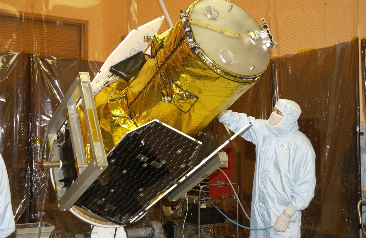
KENNEDY SPACE CENTER, FLA. -A worker in the Multi-Payload Processing Facility watches closely as NASA's Galaxy Evolution Explorer spacecraft is rotated in preparation for mating with the Pegasus XL launch vehicle. The GALEX, set to launch April 2 from Cape Canaveral Air Force Station, will carry into space an orbiting telescope that will observe a million galaxies across 10 billion years of cosmic history to help astronomers determine when the stars and elements we see today had their origins. From its orbit high above Earth, the spacecraft will sweep the skies for 28 months using state-of-the-art ultraviolet detectors. Looking in the ultraviolet will single out galaxies dominated by young, hot, short-lived stars that give off a great deal of energy at that wavelength. These galaxies are actively creating stars, and therefore provide a window into the history and causes of star formation in galaxies.
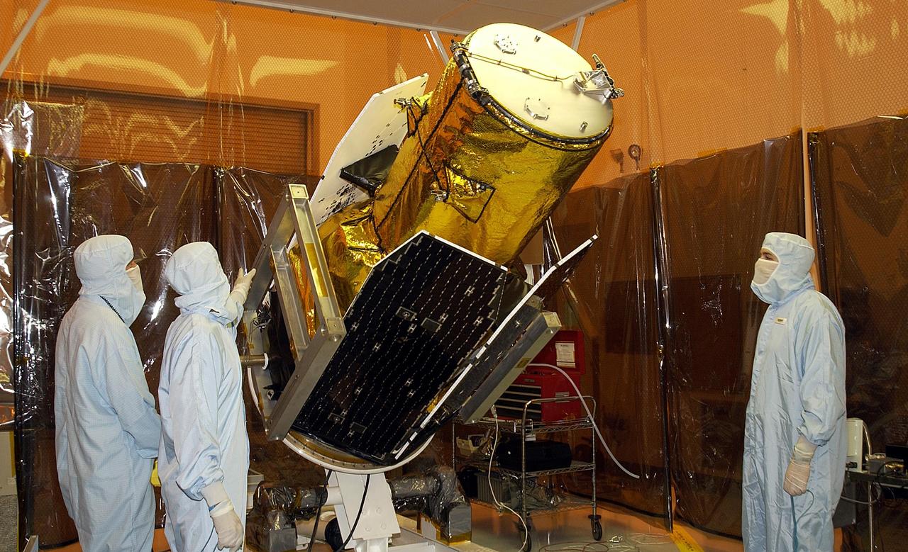
KENNEDY SPACE CENTER, FLA. - Workers in the Multi-Payload Processing Facility watch as NASA's Galaxy Evolution Explorer spacecraft is rotated in preparation for mating with the Pegasus XL launch vehicle. The GALEX, set to launch April 2 from Cape Canaveral Air Force Station, will carry into space an orbiting telescope that will observe a million galaxies across 10 billion years of cosmic history to help astronomers determine when the stars and elements we see today had their origins. From its orbit high above Earth, the spacecraft will sweep the skies for 28 months using state-of-the-art ultraviolet detectors. Looking in the ultraviolet will single out galaxies dominated by young, hot, short-lived stars that give off a great deal of energy at that wavelength. These galaxies are actively creating stars, and therefore provide a window into the history and causes of star formation in galaxies.

CAPE CANAVERAL, Fla. -- High above the skies at NASA's Kennedy Space Center in Florida a Coast Guard helicopter keeps watch on and around the Atlantic Ocean including space shuttle Atlantis on its seaside launch pad awaiting liftoff on its STS-135 mission. Atlantis and its crew of four; Commander Chris Ferguson, Pilot Doug Hurley, Mission Specialists Sandy Magnus and Rex Walheim are scheduled to lift off at 11:26 a.m. EDT on July 8 to deliver the Raffaello multi-purpose logistics module packed with supplies and spare parts for the International Space Station. Atlantis also will fly the Robotic Refueling Mission experiment that will investigate the potential for robotically refueling existing satellites in orbit. In addition, Atlantis will return with a failed ammonia pump module to help NASA better understand the failure mechanism and improve pump designs for future systems. STS-135 is the 33rd flight of Atlantis, the 37th shuttle mission to the space station, and the 135th and final mission of NASA's Space Shuttle Program. For more information, visit www.nasa.gov/mission_pages/shuttle/shuttlemissions/sts135/index.html. Photo credit: Ken Thornsley

The Polar Vortex is a whirling and persistent large area of low pressure, found typically over both north and south poles. The northern Polar Vortex is pushing southward over western Wisconsin/eastern Minnesota today, Monday, January 6, 2014 and is bringing frigid temperatures to half of the continental United States. It is expected to move northward back over Canada toward the end of the week. This image was captured by NOAA's GOES-East satellite on January 6, 2014 at 1601 UTC/11:01 a.m. EST. A frontal system that brought rain to the coast is draped from north to south along the U.S. East Coast. Behind the front lies the clearer skies bitter cold air associated with the Polar Vortex. The GOES image also revealed snow on the ground in Minnesota, Wisconsin, Illinois, Indiana, Ohio, Michigan, Iowa and Missouri, stretching into the Great Plains. Cloudiness over Texas is associated with a low pressure system centered over western Oklahoma that is part of the cold front connected to the movement of the Polar Vortex. The GOES image was created at NASA's GOES Project, located at NASA's Goddard Space Flight Center in Greenbelt, Md. Both the northern and southern polar vortices are located in the middle and upper troposphere (lowest level of the atmosphere) and the stratosphere (next level up in the atmosphere). The polar vortex is a winter phenomenon. It develops and strengthens in its respective hemisphere's winter as the sun sets over the polar region and temperatures cool. They weaken in the summer. In the northern hemisphere, they circulate in a counter-clockwise direction, so the vortex sitting over western Wisconsin is sweeping in cold Arctic air around it. The Arctic Polar Vortex peaks in the Northern Hemisphere's wintertime and has already moved southward several times this winter. In the past, it has also moved southward over Europe.On January 21, 1985, the National Oceanic and Atmospheric Administration Daily Weather Map series showed a strong polar vortex centered over Maine. The Polar Vortex also affects ozone. For more information on the Polar Vortex and how it affects ozone, visit NASA's Ozone Watch page: <a href="http://ozonewatch.gsfc.nasa.gov/facts/vortex_NH.html" rel="nofollow">ozonewatch.gsfc.nasa.gov/facts/vortex_NH.html</a> Rob Gutro NASA's Goddard Space Flight Center <b><a href="http://goes.gsfc.nasa.gov/" rel="nofollow">Credit: NOAA/NASA GOES Project</a></b> <b><a href="http://www.nasa.gov/audience/formedia/features/MP_Photo_Guidelines.html" rel="nofollow">NASA image use policy.</a></b> <b><a href="http://www.nasa.gov/centers/goddard/home/index.html" rel="nofollow">NASA Goddard Space Flight Center</a></b> enables NASA’s mission through four scientific endeavors: Earth Science, Heliophysics, Solar System Exploration, and Astrophysics. Goddard plays a leading role in NASA’s accomplishments by contributing compelling scientific knowledge to advance the Agency’s mission. <b>Follow us on <a href="http://twitter.com/NASA_GoddardPix" rel="nofollow">Twitter</a></b> <b>Like us on <a href="http://www.facebook.com/pages/Greenbelt-MD/NASA-Goddard/395013845897?ref=tsd" rel="nofollow">Facebook</a></b> <b>Find us on <a href="http://instagram.com/nasagoddard?vm=grid" rel="nofollow">Instagram</a></b>
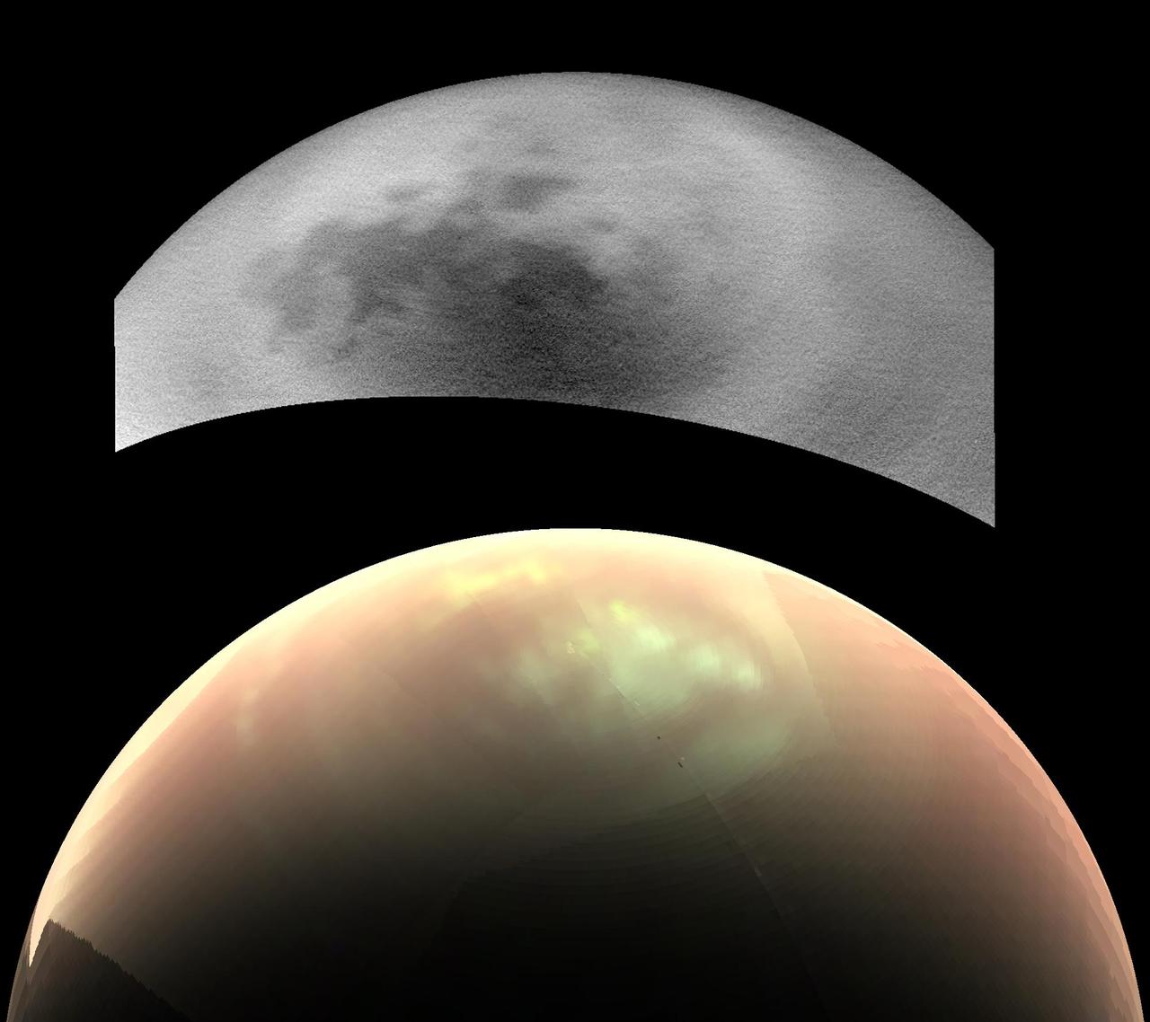
This comparison of two views from NASA's Cassini spacecraft, taken fairly close together in time, illustrates a peculiar mystery: Why would clouds on Saturn's moon Titan be visible in some images, but not in others? In the top view, a near-infrared image from Cassini's imaging cameras, the skies above Saturn's moon Titan look relatively cloud free. But in the bottom view, at longer infrared wavelengths, Cassini sees a large field of bright clouds. Even though these views were taken at different wavelengths, researchers would expect at least a hint of the clouds to show up in the upper image. Thus they have been trying to understand what's behind the difference. As northern summer approaches on Titan, atmospheric models have predicted that clouds will become more common at high northern latitudes, similar to what was observed at high southern latitudes during Titan's late southern summer in 2004. Cassini's Imaging Science Subsystem (ISS) and Visual and Infrared Mapping Spectrometer (VIMS) teams have been observing Titan to document changes in weather patterns as the seasons change, and there is particular interest in following the onset of clouds in the north polar region where Titan's lakes and seas are concentrated. Cassini's "T120" and "T121" flybys of Titan, on June 7 and July 25, 2016, respectively, provided views of high northern latitudes over extended time periods -- more than 24 hours during both flybys. Intriguingly, the ISS and VIMS observations appear strikingly different from each other. In the ISS observations (monochrome image at top), surface features are easily identifiable and only a few small, isolated clouds were detected. In contrast, the VIMS observations (color image at bottom) suggest widespread cloud cover during both flybys. The observations were made over the same time period, so differences in illumination geometry or changes in the clouds themselves are unlikely to be the cause for the apparent discrepancy: VIMS shows persistent atmospheric features over the entire observation period and ISS consistently detects surface features with just a few localized clouds. The answer to what could be causing the discrepancy appears to lie with Titan's hazy atmosphere, which is much easier to see through at the longer infrared wavelengths that VIMS is sensitive to (up to 5 microns) than at the shorter, near-infrared wavelength used by ISS to image Titan's surface and lower atmosphere (0.94 microns). High, thin cirrus clouds that are optically thicker than the atmospheric haze at longer wavelengths, but optically thinner than the haze at the shorter wavelength of the ISS observations, could be detected by VIMS and simultaneously lost in the haze to ISS -- similar to trying to see a thin cloud layer on a hazy day on Earth. This phenomenon has not been seen again since July 2016, but Cassini has several more opportunities to observe Titan over the last months of the mission in 2017, and scientists will be watching to see if and how the weather changes. These two images were taken as part of the T120 flyby on June 7 (VIMS) and 8 (ISS), 2016. The distance to Titan was about 28,000 miles (45,000 kilometers) for the VIMS image and about 398,000 miles (640,000 kilometers) for the ISS image. The VIMS image has been processed to enhance the visibility of the clouds; in this false-color view, clouds appear nearly white, atmospheric haze is pink, and surface areas would appear green. http://photojournal.jpl.nasa.gov/catalog/PIA21054