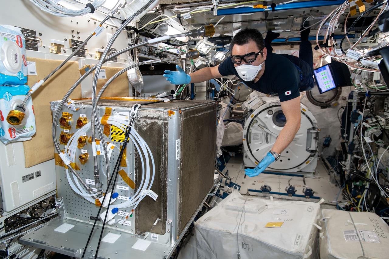
iss065e333421 (8/30/2021) --- Japan Aerospace Exploration Agency (JAXA) astronaut Akihiko Hoshide is photographed during the Japanese Experiment Module (JEM) Water Recovery System (JWRS) Gas Trap and Bypass Line Installation. Future water recovery systems will require high recovery rates, a more compact size, and less power consumption than conventional systems. The JWRS demonstrates new technologies on orbit, aboard the International Space Station (ISS), to meet these requirements.
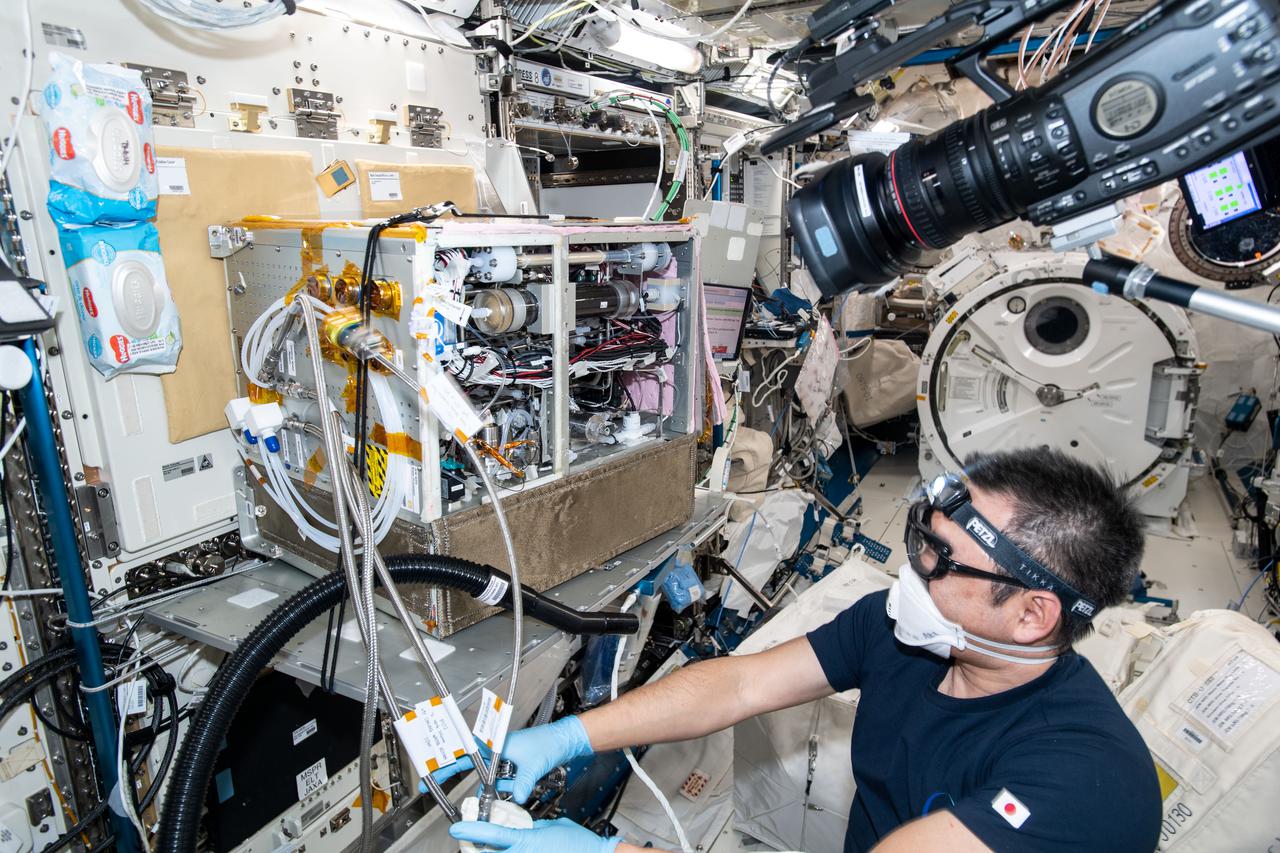
iss065e333427 (8/30/2021) --- Japan Aerospace Exploration Agency (JAXA) astronaut Akihiko Hoshide is photographed during the Japanese Experiment Module (JEM) Water Recovery System (JWRS) Gas Trap and Bypass Line Installation. Future water recovery systems will require high recovery rates, a more compact size, and less power consumption than conventional systems. The JWRS demonstrates new technologies on orbit, aboard the International Space Station (ISS), to meet these requirements.
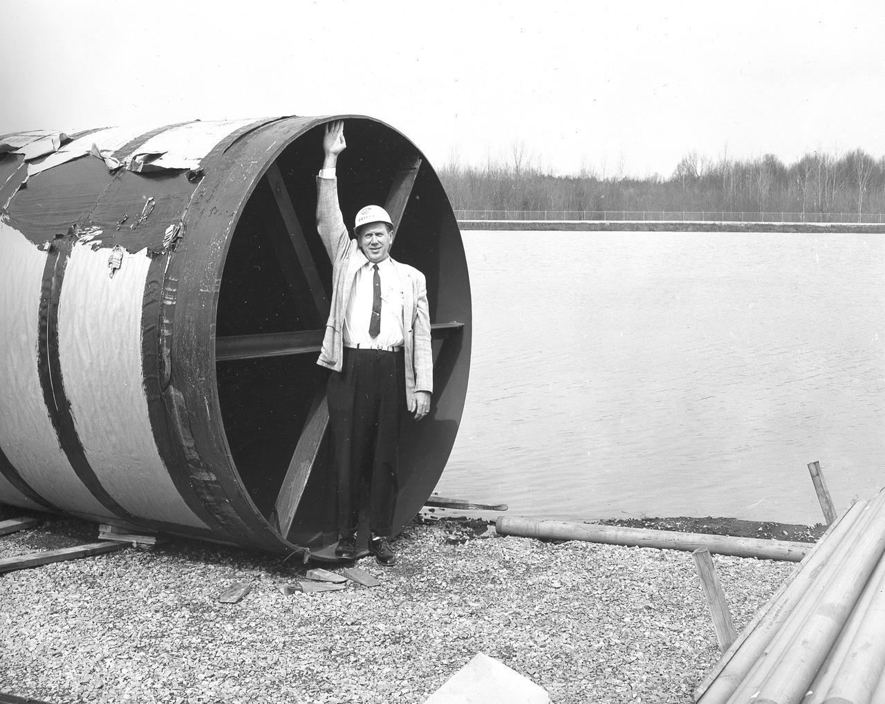
At its founding, the Marshall Space Flight Center (MSFC) inherited the Army’s Jupiter and Redstone test stands, but much larger facilities were needed for the giant stages of the Saturn V. From 1960 to 1964, the existing stands were remodeled and a sizable new test area was developed. The new comprehensive test complex for propulsion and structural dynamics was unique within the nation and the free world, and they remain so today because they were constructed with foresight to meet the future as well as on going needs. Construction of the S-IC Static test stand complex began in 1961 in the west test area of MSFC, and was completed in 1964. The S-IC static test stand was designed to develop and test the 138-ft long and 33-ft diameter Saturn V S-IC first stage, or booster stage, weighing in at 280,000 pounds. Required to hold down the brute force of a 7,500,000-pound thrust produced by 5 F-1 engines, the S-IC static test stand was designed and constructed with the strength of hundreds of tons of steel and 12,000,000 pounds of cement, planted down to bedrock 40 feet below ground level. The foundation walls, constructed with concrete and steel, are 4 feet thick. The base structure consists of four towers with 40-foot-thick walls extending upward 144 feet above ground level. The structure was topped by a crane with a 135-foot boom. With the boom in the upright position, the stand was given an overall height of 405 feet, placing it among the highest structures in Alabama at the time. In addition to the stand itself, related facilities were constructed during this time. Built directly east of the test stand was the Block House, which served as the control center for the test stand. The two were connected by a narrow access tunnel which housed the cables for the controls. Again to the east, just south of the Block House, was a newly constructed Pump House. Its function was to provide water to the stand to prevent melting damage during testing. The water was sprayed through small holes in the stand’s 1900 ton water deflector at the rate of 320,000 gallons per minute. In this photo, NASA employee Orville Driver is demonstrating the size of the 8 foot diameter water lines used for this purpose.
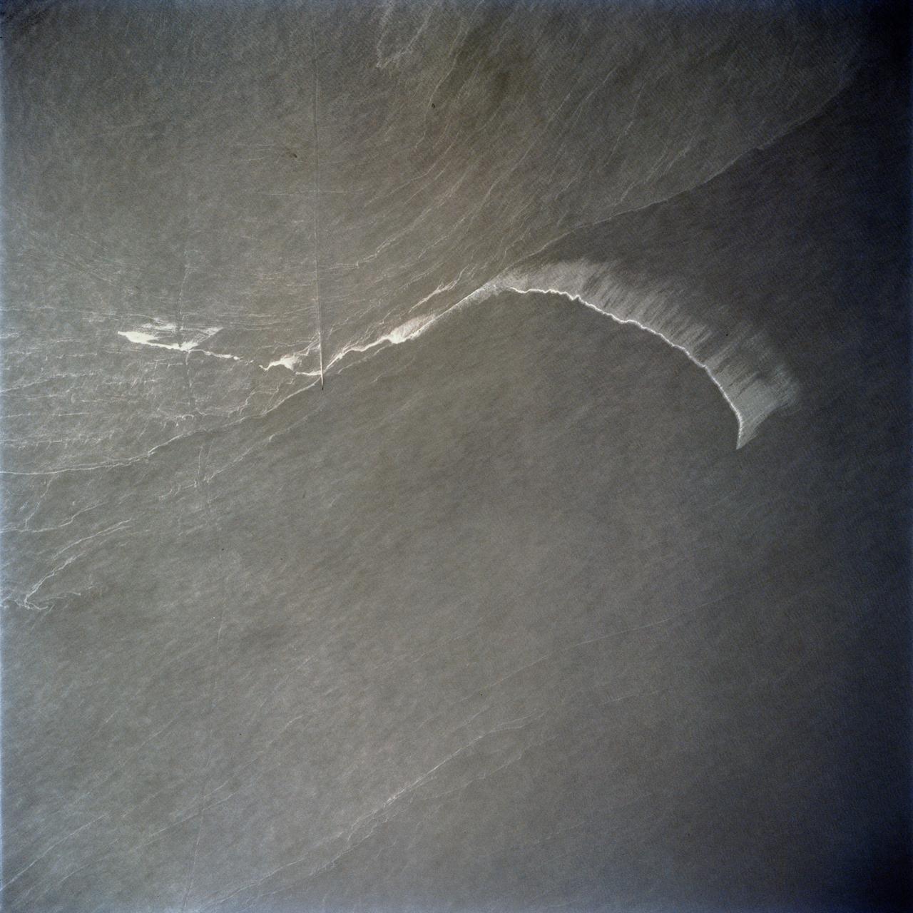
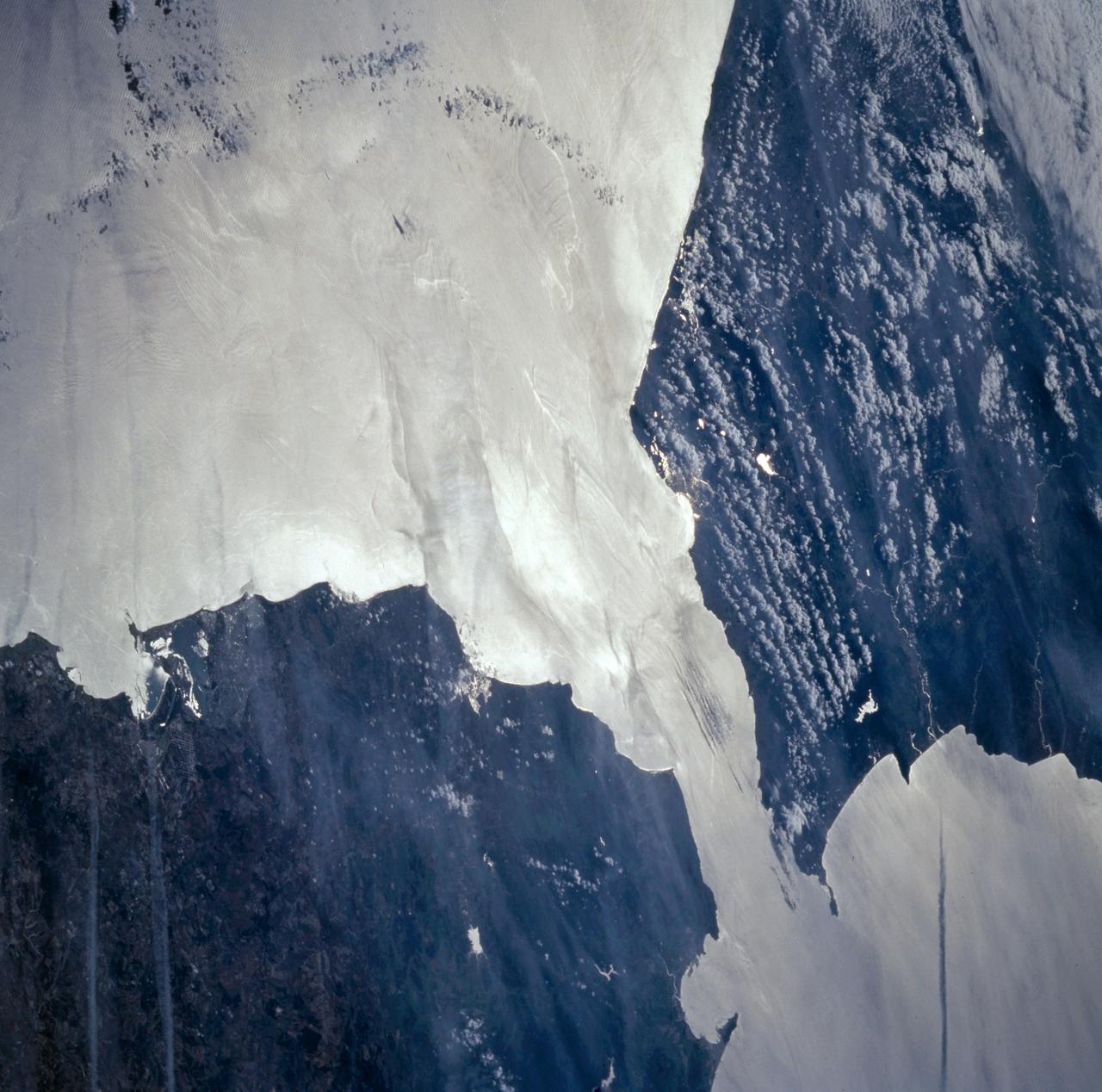
Pools of warm water known as Kelvin waves can be seen traveling eastward along the equator black line in this image from the NASA/French Space Agency Ocean Surface Topography Mission/Jason-2 satellite.
STS062-86-196 (4-18 March 1994) --- This photo depicts many of the types of ocean features seen when illuminated by sunglint. These features include a shear line, bilge dump, currents and ship wakes. Winds, currents and oils effect the smoothness of the surface of the water. The oils smooth the water which reflect the sun more than the rougher surround water. This is seen in the bright curved line which is a bilge dump of oily water from a ship. The oils then start to take the form of the currents and in this case are also being blown by the surface winds. The shear line is approximately 240 miles west of Bombay, India. This shear line appears to be a result of two water masses, moving at slightly different speeds, having converged. Ship wakes, such as those in the photo, which cross a shear line, often give us an indication of the relative strenght of a a shear.
Yesterday, NASA decided to postpone for 24-hours the launch of Columbia on mission STS-83 due to a requirement to add additional thermal insulation to water coolant lines in the orbiter's payload bay. The water coolant lines are seen here winding their way around the window on the left. Managers determined that the lines, which cool various electronics on the orbiter, were not properly insulated and could possibly freeze during Columbia's 16-days in space. Columbia's launch is now set for 2:00 p.m. EST on Friday, April 4, 1997
STS035-12-005 (2-10 Dec 1990) --- During STS-35, middeck stowage volume G and a contingency water container (CWC) were utilized to remedy a problem onboard Columbia, Orbiter Vehicle (OV) 102. A hose connecting OV-102's waste water system to the CWC was used in order to bypass a suspected clog in the line from the waste water tank to the exit nozzle. On flight day seven, Pilot Guy S. Gardner carried out an inflight maintenance (IFM) procedure by connecting a spare hose from the line to the container. The CWC is a rubber-lined duffle bag that holds about 95 pounds of water and is used in situations where water cannot be dumped overboard normally.
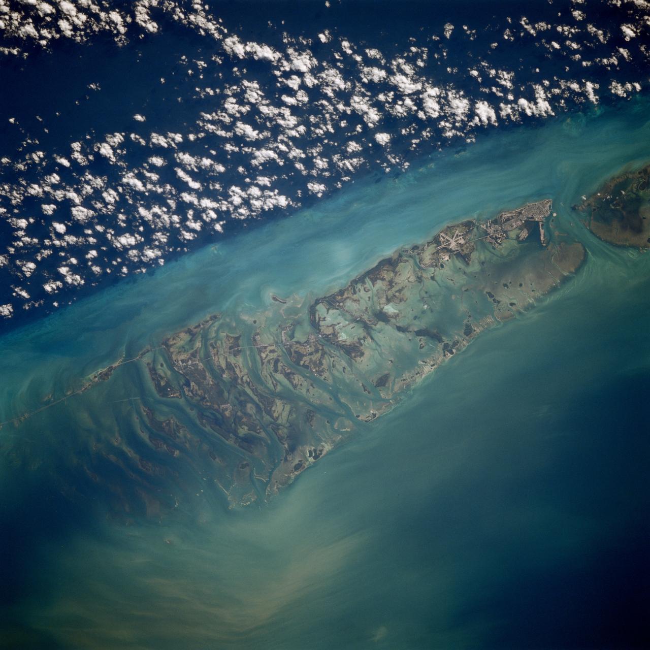
STS080-709-094 (19 Nov.-7 Dec. 1996) --- This is a view of the western portion of the Florida Keys. The view shows the city of Key West, bottom mid-right, with Marathon Key, near top middle left, and the edge of the Straits of Florida, the dark water on the right edge. Clouds form over the cooler waters of the strait. The runways at Boca Chica Key Naval Air Station are seen near Key West. The bottom can be seen clearly in the shallow water, the deeper water has depths of over a half a mile. The thin line of the Overseas Highway can be traced east from Key West. Prior to a hurricane in 1935, this route was a railway line.
iss066e130323 (Jan. 28, 2022) --- NASA astronaut and Expedition 66 Flight Engineer Kayla Barron cleans cooling loops and water lines inside a pair of U.S. spacesuits aboard the International Space Station's Quest airlock.
STS060-93-081 (3-11 Feb 1994)--- The Imperial Valley was documented using three films - color visible (seen here), the American infrared film (Kodak Aerochrome 2443), and the Russian panchromatic infrared film (SN-10). Results of this test still await detailed science analysis. However it does appear that good data was acquired of the region, and this data will be complemented by photography acquired by the Mir cosmonauts. In this frame, the U.S.-Mexico border goes from the upper left to the middle right. It is discernible as a vegetation line between Calexico, California and Mexicali, Mexico. The darker vegetation north of that line is due to different agricultural practices, heavier uses of fertilizers and pesticides, and lined (tiled) agricultural fields allowing subterraneean runoff of saline irrigation runoff. South of the line, the more polluted water draining out of the U.S. agricultural areas into the Mexican area has resulted in higher soil salinities and a consequent reduction in agricultural productivity. At the center of the frame, a large settling and desalinization plant has been built to attempt to purify, to some degree, the polluted irrigation waters draining south out of California. The All-American Canal, which brings in water from the Colorado River (off the frame, to the right), is located in the middle right hand portion of the frame. To the upper left is the normally dry Laguna Salada.
STS054-80-024 (13-19 Jan 1993) --- As the Shuttle was passing southeast over the coast of India, approaching the Bay of Bengal, Endeavour's crew took this picture of the Godavari River Delta. The sun glint pattern was centered directly over the delta and highlighted well the intricate drainage pattern. Offshore, water features associated with current boundaries and river plumes are readily visible. The line of clouds along the coast south of the delta suggest that surface winds are blowing onshore from the Bay of Bengal. As the air passes over the warmer coastal water and land, it is warmed and begins to rise. The moisture in the air condenses, forming a line of low-level clouds.
ISS030-E-234965 (30 Dec. 2011) --- The Etosha Pan in Namibia is featured in this image photographed by an Expedition 30 crew member on the International Space Station. This photograph shows the white, salt-covered floor of the northwest corner of the great dry lake in northern Namibia known as the Etosha Pan (left margin). Two rivers, the Ekuma and Oshigambo, transport water from the north down to the Etosha Pan proper. In a relatively rare event, water from recent rains has flowed down the larger Ekuma River?in which it appears as a thin blue line within the generally light grey-green floodplain?and fills a lobe of the lake with light green water (lower right quarter of image). Water has also flowed into a small offshoot dry lake where it appears a brighter green (upper right quarter of image). Other smaller lakes at center and top center show red and brown water colors. The different colors of lake water are determined by the interplay of water depth and resident organisms such as algae; the algae color varies depending on water temperature and salinity. A similar process is observed in pink and red floodwaters ponded in Lake Eyre, a usually dry lake in Australia?s arid center. In this case it is known that the coloration is indeed due to algae growth. Typically, little river water or sediment reaches the floor of the Etosha dry lake because water seeps into the riverbeds along their courses. The floor of the pan itself is seldom seen with even a thin sheet of water. In this image, there was enough surface flow to reach the pan, but too little to flow beyond the inlet bay. A prior flood event, when water entered the pan via the Oshigambo River, was documented in astronaut imagery in 2006. The straight line that crosses the image from top center to bottom is the northern fence line of Namibia?s Etosha National Park. This straight, three-meter-high fence keeps wildlife from crossing into the numerous small farms of the relatively densely populated Owambo region of Namibia, north of the pan. The large Etosha dry lakebed (120 kilometers or 75 miles long) is the center of Namibia?s largest wildlife park, a major tourist attraction.
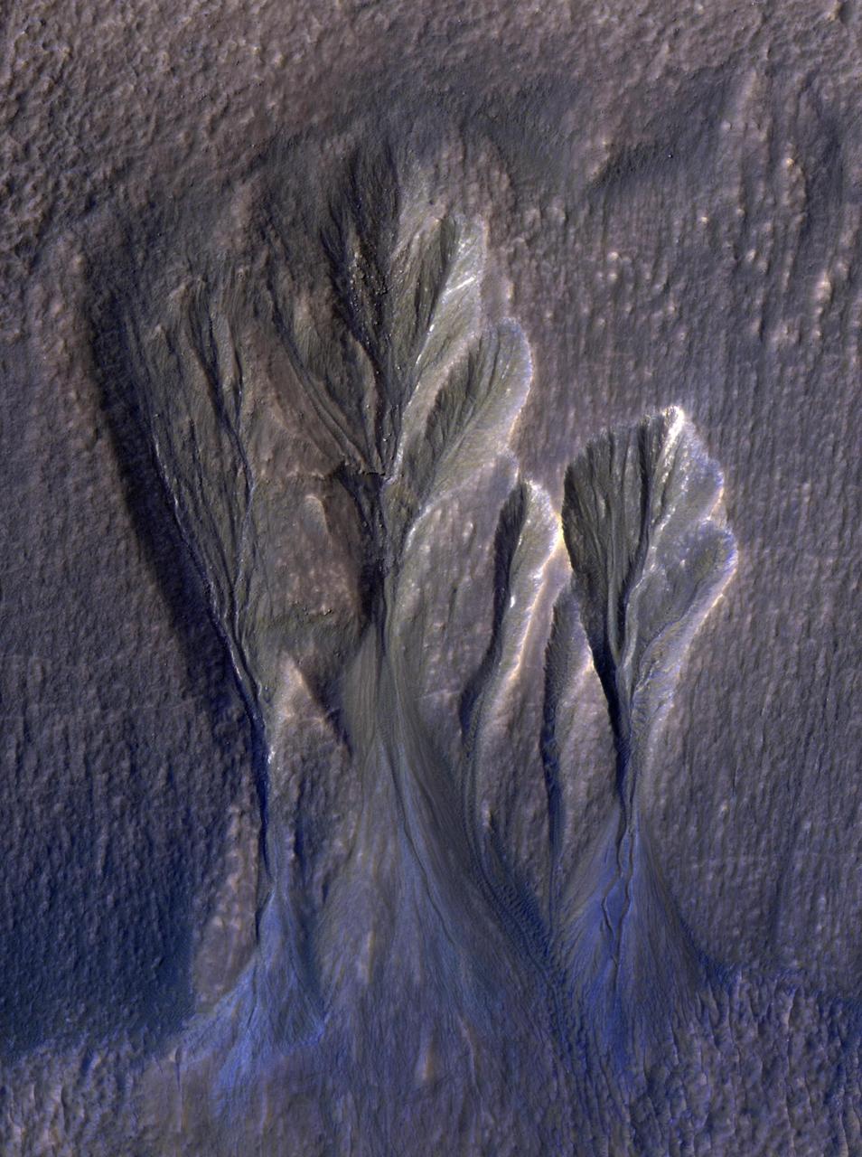
This image from NASA's Mars Reconnaissance Orbiter (MRO) shows white material believed to be dusty water ice lining the edges of Martian gullies in a region named Terra Sirenum. Scientists believe dust particles within this ice act similarly to dust that falls onto glaciers on Earth, warming up in sunlight and causing subsurface pockets of meltwater to form. On Earth, the dust that builds up on glaciers is called cryoconite, and the pockets it forms are called cryoconite holes. These pockets of water on our planet are often teeming with simple life, including algae, fungi, and cyanobacteria. Scientists believe similar shallow pools of water could exist on Mars, and may also be excellent places to search for life on the Red Planet today. This enhanced-color image was captured by MRO's HiRISE (High-Resolution Imaging Science Experiment) camera on Dec. 25, 2016. The blue color at the bottom of the gullies is likely coarse sand (not ice); the hue would not actually be perceptible to the human eye. HiRISE is able to detect this color by looking at the scene in far-infrared wavelengths. https://photojournal.jpl.nasa.gov/catalog/PIA26407
This is a view of the Great Salt Lake and nearby Bonneville Salt Flats, UT, (41.0N, 112.5W). A railroad causeway divides the lake with a stark straight line changing the water level and chemistry of the lake as a result. Fresh water runoff enters from the south adding to the depth and reducing the salinity. The north half receives little frsh water and is more saline and shallow. The Bonnieville Salt Flats is the lakebed of a onetime larger lake.

As easy to read as a home pregnancy test, three Quantifiable Lateral Flow Assay (QLFA) strips used to test water for E. coli show different results. The brightly glowing control line on the far right of each strip indicates that all three tests ran successfully. But the glowing test line on the middle left and bottom strips reveal their samples were contaminated with E. coli bacteria at two different concentrations. The color intensity correlates with concentration of contamination.
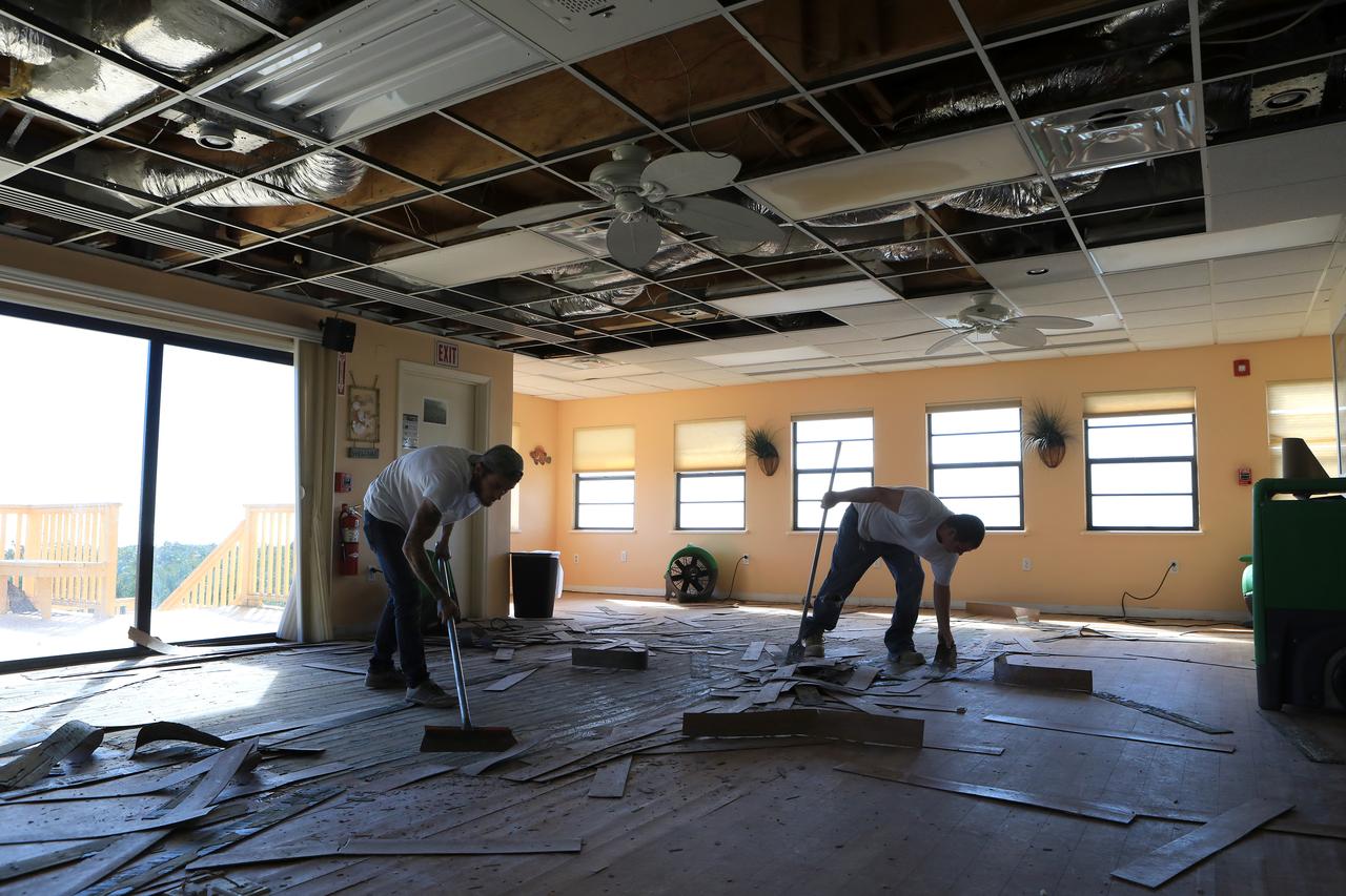
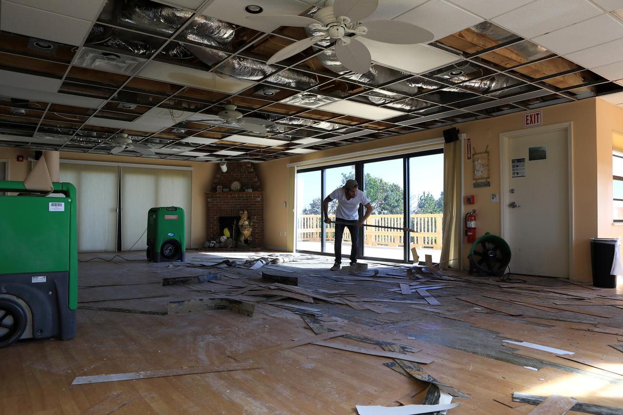
Plant debris caused by Hurricane Matthew is strewn across the dune line along the Atlantic shoreline at NASA’s Kennedy Space Center in Florida. Although some sections of shoreline suffered erosion, recently restored portions of beach fared well. Hurricane Matthew, a Category 3 storm, passed to the east of Kennedy on Oct. 6 and 7, 2016. The center received some isolated roof damage, damaged support buildings, a few downed power lines, and limited water intrusion.
ISS018-E-024949 (31 Jan. 2009) --- The All-American Canal, the largest irrigation canal in the world and a key landmark along the California-Mexico border, is featured in this image photographed by an Expedition 18 crewmember on the International Space Station. This image captures about 15 kilometers of the important infrastructure corridor just west of Yuma, AZ. The prominent dark line crossing the image is the Canal which is crossed, in this view, by Interstate Highway 8. The canal carries 740.6 cubic meters (26,155 cubic feet) of water per second from the Colorado River westward to support the intensive agriculture of California?s Imperial Valley to the northwest, and to nine cities including San Diego, CA. The canal system is the Imperial Valley?s only source of water, and allows irrigation of more than 2,000 square kilometers (500,000 acres) of agricultural fields. The Coachella Canal, one of four main branch canals, leads water north to Imperial Valley. This section of the canal requires constant maintenance. Approximately 68,000 acre-feet of water per year are lost by seepage from the All-American Canal - especially where the canal crosses the great Algodones Dune Field, a portion of which is visible extending from top to bottom in the center of the image. Additionally, dune sand is constantly blown to the southeast, and into the canal. As part of California?s Colorado River Water Use Plan, 37 kilometers (23 miles) of the canal is being lined to prevent water loss by seepage. A recently opened sector parallels the old canal (right) and new lined sectors are under construction (bright lines, center). Engineers have sited new sections of the canal to avoid the worst areas of dune-sand invasion, so that the new configuration will be significantly cheaper to maintain and operate. A new road crosses the dunes and marks the US?Mexico border as part of border fence construction efforts. The margin of the Colorado River floodplain in Mexico is just visible two kilometers south of the border (lower left corner). This floodplain is Mexico?s equivalent of the Imperial Valley in terms of its enormous irrigated agricultural production.
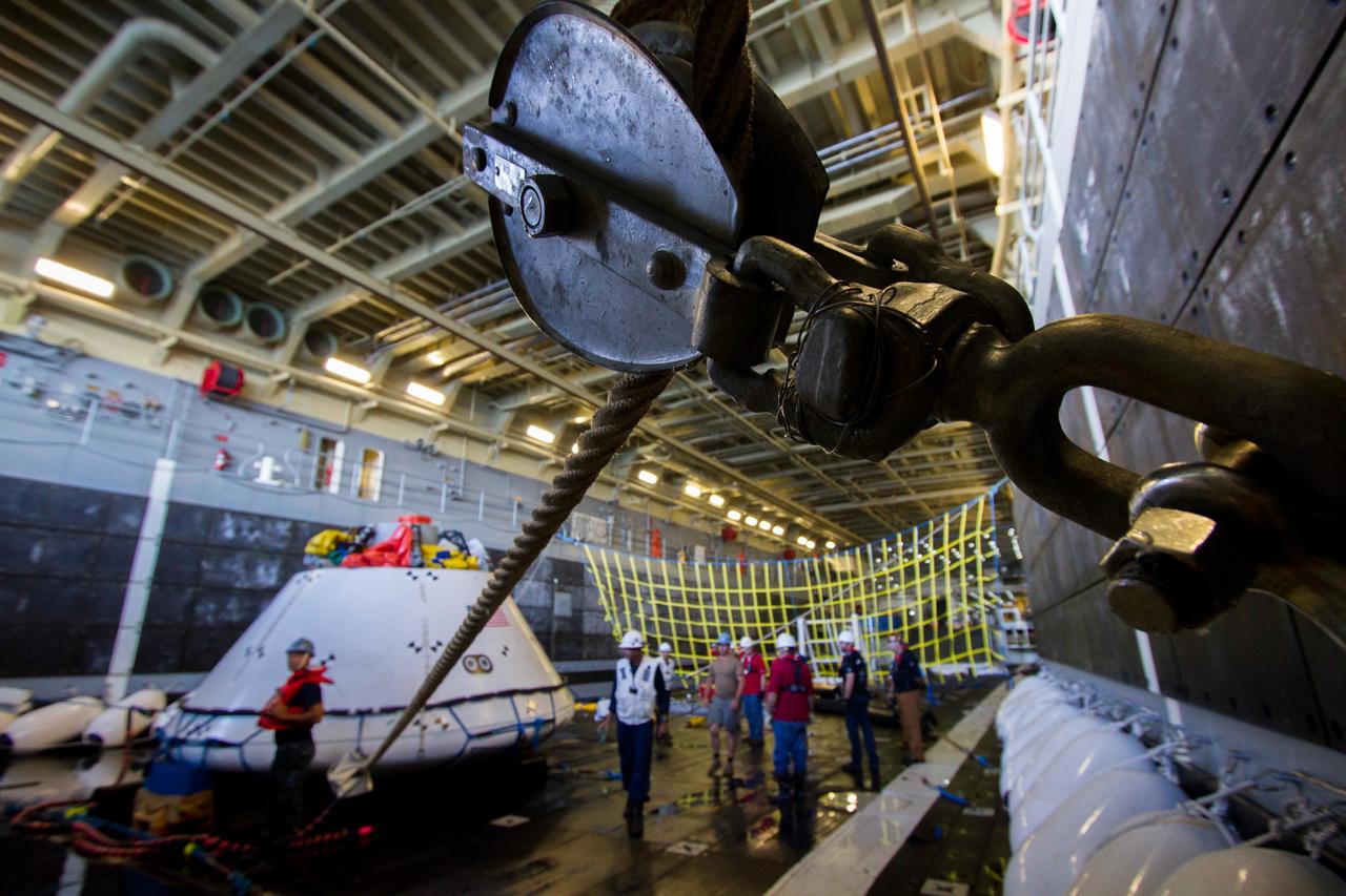
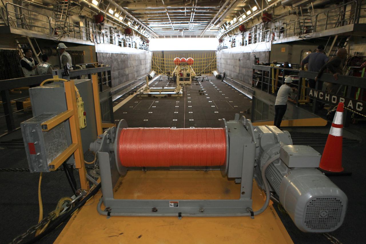
Lines secure a test version of Orion inside of the USS Anchorage's well deck during recovery tests off the coast of California on Sept. 15, 2014. The well deck can be flooded with water to allow Orion to float in following its splashdown when it returns from space. Part of Batch image transfer from Flickr.

iss073e0416805 (July 25, 2025) --- NASA astronaut and Expedition 73 Flight Engineer Jonny Kim performs maintenance on the Destiny laboratory module's fluid servicer system used to maintain and repair rack water lines and systems throughout the International Space Station.
A delta is a pile of sediment dumped by a river where it enters a standing body of water. Evidence for deltas that formed billions of years ago on Mars has been mounting in recent years. One line of evidence not yet investigated is to search for what are called clinoforms. In geology, a clinoform refers to a steep slope of sediment on the outer margin of a delta. This image seeks to test whether those features are visible and help confirm that Mars in ancient times had a standing body of water in this location. http://photojournal.jpl.nasa.gov/catalog/PIA19848
The island of Java (8.0S, 112.0E), perhaps better than any other, illustrates the volcanic origin of Pacific Island groups. Seen in this single view are at least a dozen once active volcano craters. Alignment of the craters even defines the linear fault line of Java as well as the other some 1500 islands of the Indonesian Archipelago. Deep blue water of the Indian Ocean to the south contrasts to the sediment laden waters of the Java Sea to the north.
iss064e002379 (1/15/2017) --- Photo documentation of Inertial Spreading with Vibration and Water Coalescence (Drop Vibration) experiment hardware set up inside the Microgravity Science Glovebox (MSG) aboard the International Space Station (ISS). Inertial Spreading with Vibration and Water Coalescence (Drop Vibration) examines the behavior of big liquid drops whose perimeter of contact, called the contact line, moves rapidly as the drops change shape either forced by vibration or freely by merger.
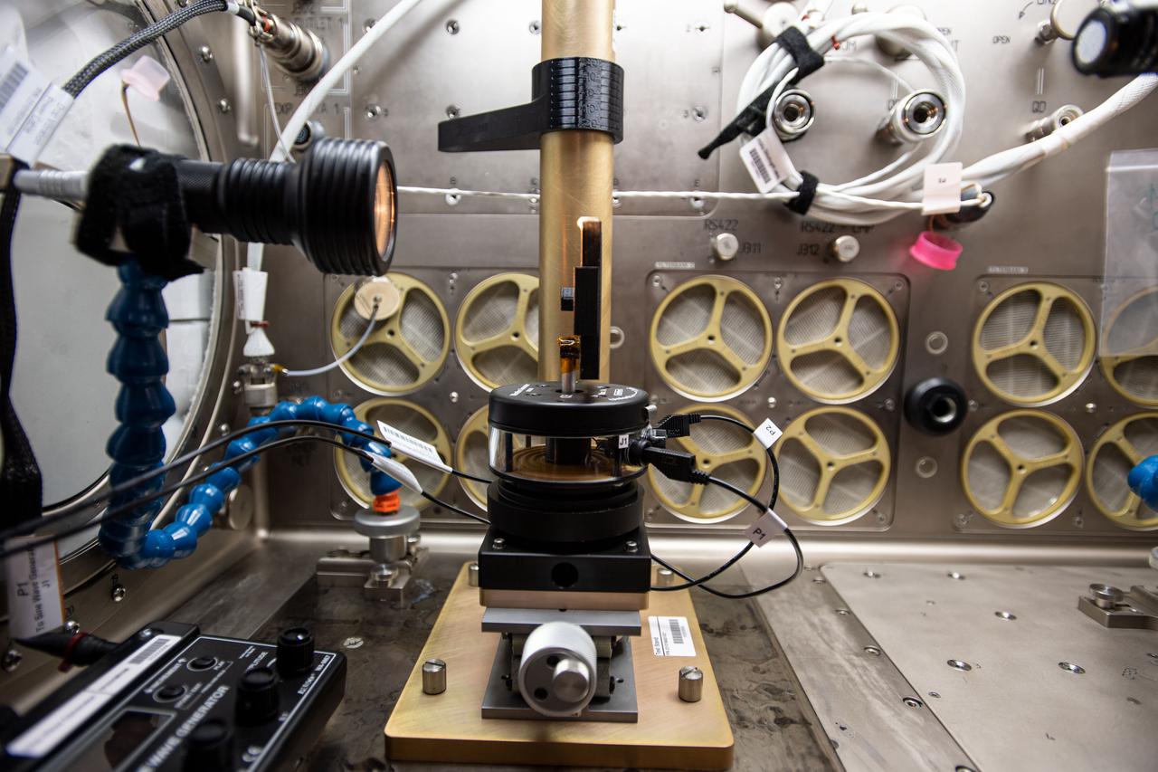
iss064e002375 (1/15/2017) --- Photo documentation of Inertial Spreading with Vibration and Water Coalescence (Drop Vibration) experiment hardware set up inside the Microgravity Science Glovebox (MSG) aboard the International Space Station (ISS). Inertial Spreading with Vibration and Water Coalescence (Drop Vibration) examines the behavior of big liquid drops whose perimeter of contact, called the contact line, moves rapidly as the drops change shape either forced by vibration or freely by merger.
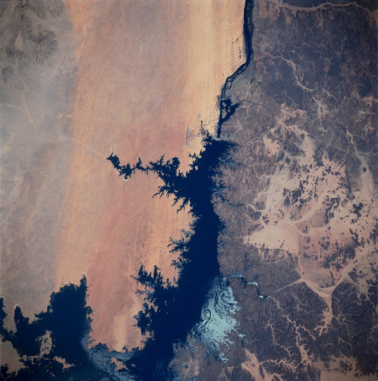
STS083-747-026 (4-8 April 1997) --- Aswan Dam and Lake Nasser along the Nile River, Egypt. The Aswan Dam controls the flow of the Nile River forming Lake Nasser. Lake Nasser is reaching relatively high water levels due to the plentiful rains since December 1996 in Kenya, near the headwaters of the Nile river. The light colored areas in the Lake are where the sun is reflecting off the surface of the water. These areas are fairly calm and not disturbed by wind gusts enabling the sunglint to show water current patterns on the surface. The Aswan runway is seen as a dark set of lines west of the Aswan Dam.
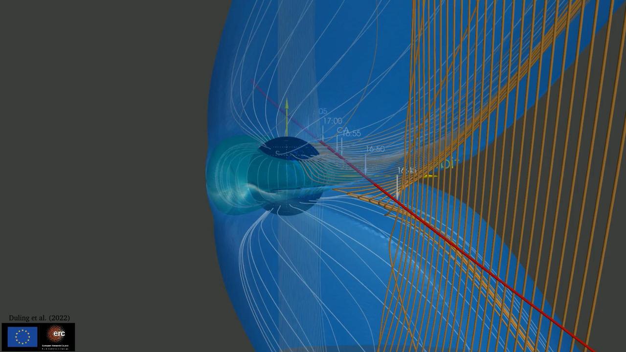
This animation illustrates how the magnetic field surrounding Jupiter's moon Ganymede (represented by the blue lines) interacts with and disrupts the magnetic field surrounding Jupiter (represented by the orange lines). During the June 2021 close approach to Ganymede by NASA's Juno spacecraft, the Magnetic Field (MAG) and Jovian Auroral Distributions Experiment (JADE) instruments aboard the spacecraft recorded data showing evidence of the breaking and reforming of magnetic field connections between Jupiter and Ganymede. Studying Ganymede's magnetic field can provide scientists with clues about the nature of the salty water reservoir suspected to exist deep under the moon's surface. Animation available at https://photojournal.jpl.nasa.gov/catalog/PIA25724
Damaged power lines are seen during an aerial survey of NASA's Kennedy Space Center in Florida on Saturday. The survey was performed to identify structures and facilities that may have sustained damage from Hurricane Matthew as the storm passed to the east of Kennedy on Oct. 6 and 7, 2016. Officials determined that the center received some isolated roof damage, damaged support buildings, a few downed power lines, and limited water intrusion. Beach erosion also occurred, although the storm surge was less than expected. NASA closed the center ahead of the storm’s onset and only a small team of specialists known as the Rideout Team was on the center as the storm approached and passed.
STS054-151-015 (13-19 Jan 1993) --- The Makgadikgadi Salt Pan is one of the largest features in Botswana visible from space. Any water that spills out of the Okavango Swamplands flows down to the Makgadikgadi where it evaporates. An ancient beach line can be seen as a smooth line around the west (left) side of the Pan. Orapa diamond mine can be detected due south of the pan as a small rectangle. The large geological feature known as the Great Dike of Zimbabwe can be seen far right. This large panorama shows clouds in southern Angola, Zambia and Zimbabwe in the distance.
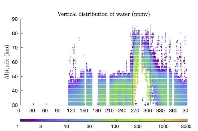
Rising air during a 2007 global dust storm on Mars lofted water vapor into the planet's middle atmosphere, researchers learned from data graphed here, derived from observations by the Mars Climate Sounder instrument on NASA's Mars Reconnaissance Orbiter. The two vertical black lines in the right half of the graph (at about 260 and 310 on the horizontal scale) mark the beginning and end of the most recent global dust storm on Mars, which burst from regional scale to globe-encircling scale in July 2007. The presence of more colored dots, particularly green ones, in the upper portion of the graph between those lines, compared to the upper portion of the graph outside those lines, documents the uplift of water vapor in connection with the global dust storm. The vertical scale is altitude, labeled at left in kilometers above the surface of Mars (50 kilometers is about 30 miles; 80 kilometers is about 50 miles). The color bar below the graph gives the key to how much water vapor each dot represents, in parts per million, by volume, in Mars' atmosphere. Note that green to yellow represents about 100 times as much water as purple does. The horizontal axis of the graph is time, from January 2006 to February 2008. It is labeled with numbers representing the 360 degrees of Mars' orbit around the Sun, from zero to 360 degrees and then further on to include the first 30 degrees of the following Martian year. (The zero point is autumnal equinox -- end of summer -- in Mars' northern hemisphere.) This graph, based on Mars Reconnaissance Orbiter observations, was used in a January 2018 paper in Nature Astronomy by Nicholas Heavens of Hampton University in Hampton, Virginia, and co-authors. The paper presents Martian dust storms' uplifting effect on water vapor as a factor in seasonal patterns that other spacecraft have detected in the rate of hydrogen escaping from the top of Mars' atmosphere. https://photojournal.jpl.nasa.gov/catalog/PIA22080
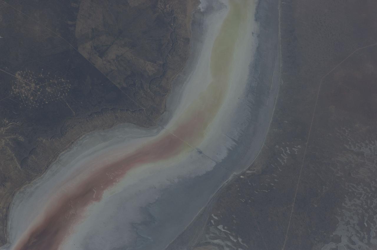
ISS031-E-030896 (11 May 2012) --- The Sor Kaydak near the northeast Caspian Sea in Kazakhstan are featured in this image photographed by an Expedition 31 crew member on the International Space Station. This striking image shows saline water of different colors in the Sor Kaydak, a salt marsh that leads into the northeast bulb of the Caspian Sea. The central 50 kilometers of this 180 kilometer-long depression is shown in this photograph. The Sor Kaydak depression is inundated on occasion by water from the Caspian Sea since it lies at the same elevation?that is, 29 meters below global sea level?though separated from the Sea by a low bar of land that is 1?2 meters high. The different colors of marsh water (brown to pink to light green, northeast to southwest) result from the interplay of water depth and resident organisms such as algae. Algae color varies depending on water temperature and salinity. The irregular gray areas at bottom right are wet zones between low sand dunes. These interdune flats are whitened with salt derived by evaporation of Caspian Sea water (the sea is just outside the image bottom right). The jagged line following the colored water (crossing the center of the image top to bottom) is the limit of the wetting zone (or perimeter), an irregular zone influenced by wind and the depth of water in the marsh. Small cliffs can be seen marking the east margin of the depression that contains Sor Kaydak. Above the cliffs a plateau surface (approximately 200 meters above the salt marsh, approximately 160 meters above global sea level) extends eastward for hundreds of kilometers. Here the plateau is occupied by a dense pattern of well heads which appear as a geometric pattern of tan dots. By contrast, the west margin (right) rises less than 10 meters above the marsh altitude. The straight line visible at center is a pipeline built across the salt marsh which takes oil to a terminal on the Caspian shore 100 kilometers northwest of the area shown here.
STS085-705-062 (7 - 19 August 1997) --- The Great Salt is one of the most saline inland bodies of water in the world and is the largest inland body of salt water in the Western Hemisphere. The lake is fed by three rivers (Bear, Weber and Jordon) and has no outlet. The water level varies with the amount of rainfall and evaporation in the basin. The distinct line across the center of the lake is the Lucin Cutoff. It is a 30 mile (48 kilometers), east-west causeway built in 1959 to support a rail line. The causeway connects the cities of Ogden and Lucin and affects the water level of the lake. Because the lake's main tributaries enter from the south, the water level of the southern section is several inches higher than that of the northern part. The Great Salt Lake's record high levels in the mid-1980's threatened the Lucin Cutoff, highways and sewage-treatment plants along the shore -- in 1987 pumps were installed that began draining some of the excess water into the Great Salt Lake Desert to the west. The resulting new body of water was called the Newfoundland Evaporation Basin -- it contains dissolved minerals, primarily sodium and chloride along with sulfate, magnesium, and potassium. The dissolved minerals, turbidity and microorganisms which can survive in saline water give the lake its varying colors. In this photo the north portion is dark red. The crew said that it looked like dirt when they first saw it. Crews can not remember the north portion ever looking so red -- it is usually a light blue color.
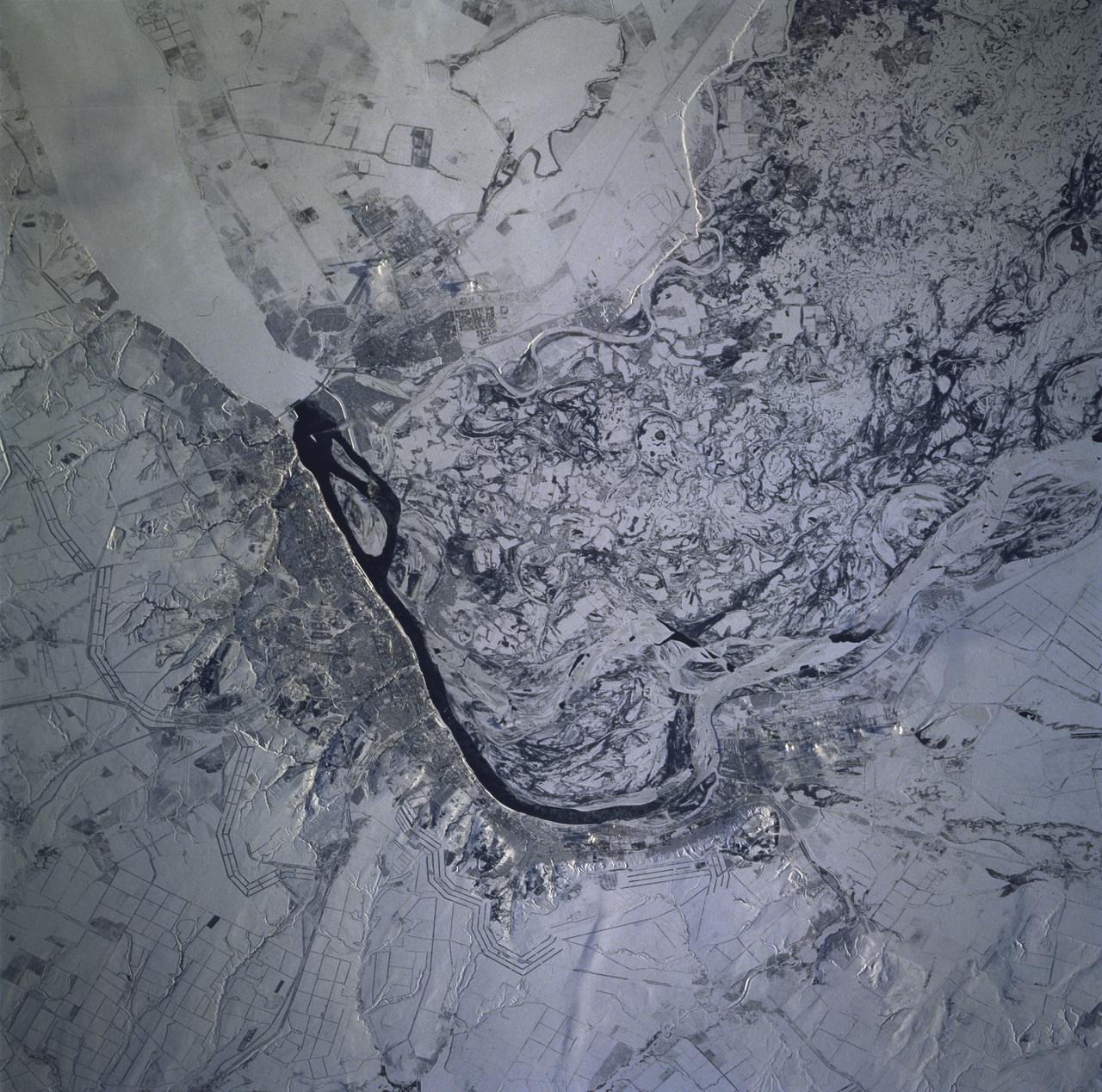
STS081-715-004 (12-22 Jan. 1997) --- As photographed with a 70mm camera aboard the Space Shuttle Atlantis, this scene features the Volga River and Volgograd under snow. Contrast in brightness shows up many features in this near-vertical view of the great bend of the Volga River's dark, open strip of water, center. The Volga flows south into the view from top right, then southeast from the center to the bottom. Volgograd appears as the gray zone along the left (west) side of the open water. Presumably the ice-free part of the river opposite Volgograd relates to the slightly warmer water which is spilled from prominent, ice-covered Lake Volgograd (top right). The wide patterns of swirls, center to lower right, are numerous meander bends on the Volga's floodplain (up to 20 miles wide), highlighted by snow. The main course of the Volga is once again ice covered in this floodplain belt. The Volga-Don Canal can be seen leaving the river just south of the bend, exiting the view center left. This canal, with others in the Moscow region, allows barge traffic to move through the Russian heartland, from the Black Sea to the Baltic at Leningrad. The long parallel lines in threes and fours are lines of trees used as wind breaks. They stretch across Russia for hundreds of miles.
STS039-83-091 (28 April-6 May 1991) --- (HOLD PHOTO WITH BARRIER ISLANDS ALONG THE LEFT SIDE). This photograph of the water sunglint pattern along the Outer Banks of North Carolina was taken with a 70mm handheld camera equipped with color visible film and a 250mm lens. The islands appear as dark areas along the left side of the frame and Cape Hatteras is seen to the left and slightly above frame center. Sunglint is composed of light reflected from the water surface and the patterns seen in this photo are largely the result of sea surface roughness. Smooth water has a mirror-like reflectance and is represented in the photo as a bright area. Rough water, on the other hand, tends to disperse the light reflected from the water surface and, therefore, appears dark. Water currents in this area are extremely dynamic because the swift, northward flowing Gulf Stream (the offshore darker water along the right side of the photo) diverges from the coastline north of Cape Hatteras. The sharp line between bright and dark water is the western boundary of the Gulf Stream.
CAPE CANAVERAL, Fla. - A line of spotted sandpipers gather along the water's edge on NASA's Kennedy Space Center in Florida. It is one of 310 species of birds that inhabit the National Merritt Island Wildlife Refuge, which shares a boundary with Kennedy. The marshes and open water of the refuge also provide wintering areas for 23 species of migratory waterfowl, as well as a year-round home for great blue herons, great egrets, wood storks, cormorants, brown pelicans and other species of marsh and shore birds. Photo credit: NASA/Dimitri Gerondidakis
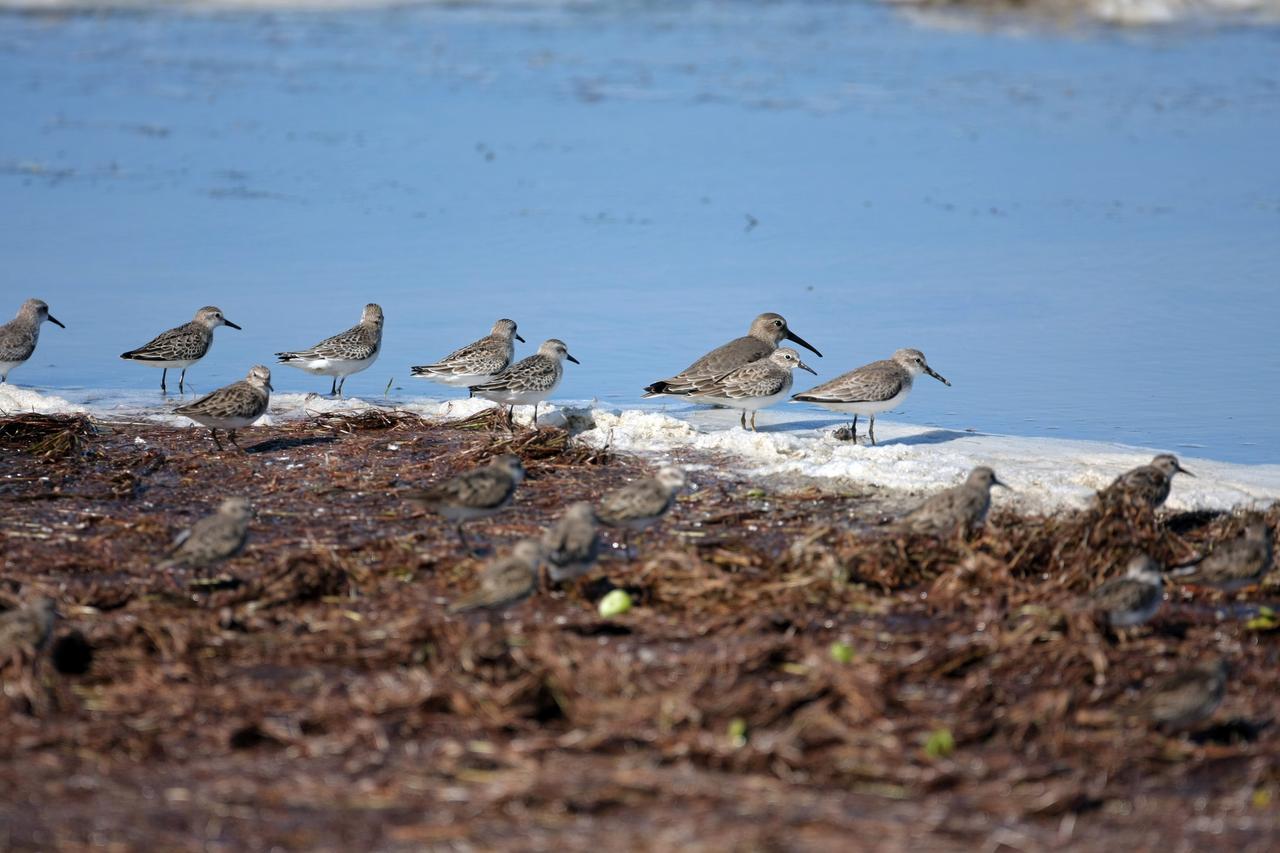
CAPE CANAVERAL, Fla. - A line of spotted sandpipers gather along the water's edge on NASA's Kennedy Space Center in Florida. It is one of 310 species of birds that inhabit the National Merritt Island Wildlife Refuge, which shares a boundary with Kennedy. The marshes and open water of the refuge also provide wintering areas for 23 species of migratory waterfowl, as well as a year-round home for great blue herons, great egrets, wood storks, cormorants, brown pelicans and other species of marsh and shore birds. Photo credit: NASA/Dimitri Gerondidakis
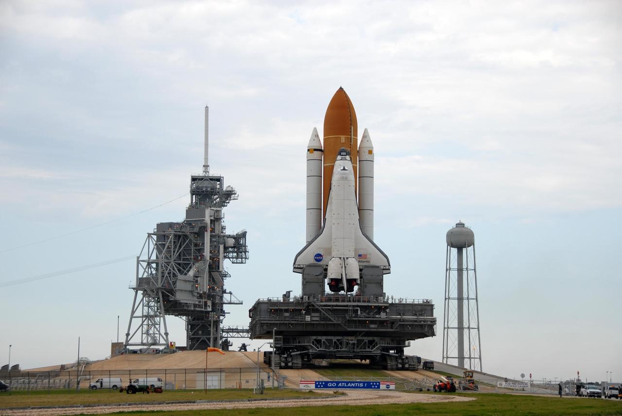
KENNEDY SPACE CENTER, FLA. -- Lined up on the horizon are Space Shuttle Atlantis, the rotating and fixed service structures of Launch Pad 39A, Launch Pad 39B, and the 300-gallon water tower of Pad 39A. The shuttle has spent six hours rolling out to Pad 39A, leaving the Vehicle Assembly Building at 8:19 a.m. The body of water in the foreground is the Banana River. The mission payload aboard Space Shuttle Atlantis is the S3/S4 integrated truss structure, along with a third set of solar arrays and batteries. The crew of six astronauts will install the truss to continue assembly of the International Space Station. Launch is targeted for March 15. Photo credit: NASA/Ken Thornsley
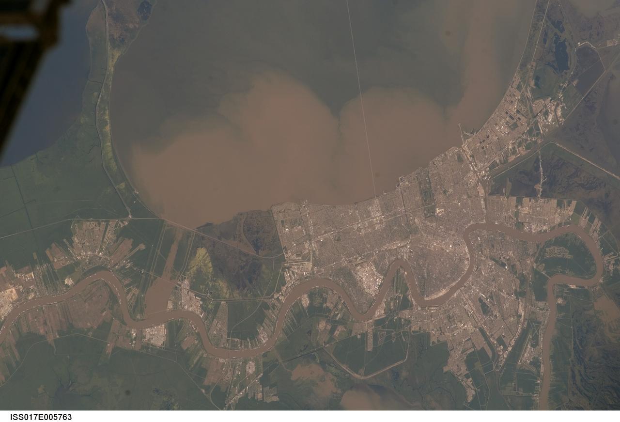
ISS017-E-005763 (29 April 2008) --- Lake Pontchartrain and the Bonnet Carre Spillway, Louisiana, are featured in this image photographed by an Expedition 17 crewmember on the International Space Station. Lake Pontchartrain, a big body of water immediately north of New Orleans, occupies the upper part of this view, with the winding course of the muddy Mississippi River snaking across the bottom of the image (flow is east, from left to right). The city of New Orleans is sandwiched between the lake and river. Heavy rain in March and April 2008 in the Mississippi's catchment area raised water levels in the river sufficiently to make the Army Corps of Engineers take action. To reduce the volume of the river where it passes through New Orleans, the Corps opened the Bonnet Carre Spillway (lower left), a major engineering structure 18 kilometers upriver from New Orleans. The spillway, a 1.6 kilometer-wide gap in the developments along the Mississippi levees, is an integral part of the river and canal system that allows Mississippi river water to flow into Lake Pontchartrain. The spillway control structure itself is visible as a thin, discontinuous, white line along the river's edge in this image. The spillway has only been opened eight times since 1937. News of the opening in April 2008 was transmitted to crewmembers aboard the International Space Station who managed to capture the immediate effect of muddy water flowing down the spillway and into Lake Pontchartrain, where it forms great brown lobes in the otherwise green water. These lobes moved slowly east along the New Orleans shoreline, where the line of the Lake Pontchartrain Causeway, the longest bridge in the U.S., can be seen, top right. Opening the spillway protects New Orleans in various ways. First, it reduces pressure on the levees, which famously collapsed at some points during the onslaught of Hurricane Katrina in 2005. Keeping water levels below critical high levels also helps the river channel to accommodate the discharge of water, and reduces both the speed of flow and cross currents in the river which can interfere with vessels navigating the river -- or even cause collisions with levees.
ISS040-E-008209 (6 June 2014) --- Okavango inland delta in northern Botswana is featured in this image photographed by an Expedition 40 crew member on the International Space Station. The great Okavango delta in the Kalahari Desert is illuminated in the sun?s reflection point in this panorama. Using this sun glint technique, crew members can image fine detail of water bodies. Here the bright line of the Okavango River shows the annual summer flood advancing from the well-watered Angolan Highlands (upper margin) to the delta. Then the flood water slowly seeps across the 150 kilometer-long delta, supplying forests and wetlands, finally reaching the fault-bounded lower margin of the delta in the middle of winter. Most of the water of this large river is used up by the forests, or evaporates in the dry air. Only two percent of the river?s water actually exits the delta. The wetland supports high biodiversity in the middle of the otherwise semiarid Kalahari Desert, and is now one of the most famous tourist sites in Africa. This view also shows the small quantity of water in the Boteti River. Okavango water only reaches the dry lake floors (lower right) in the wettest years. Part of one of the station?s solar arrays is visible at right.
ISS012-E-15050 (12 Jan. 2006) --- Sandusky Bay is featured in this image photographed by an Expedition 12 crew member on the International Space Station. Sandusky Bay appears with brown muddy water (left) in this view. The bay leads out into southern Lake Erie (top). The small city of Sandusky occupies the northeastern shore of the bay (center of the image). Highway 6 can be seen arcing around the south side of the city. Ferries connect Sandusky to Pelee Island (not visible) in the middle of the lake. In earlier days, Sandusky Bay was known as one of the best protected port sites in the Great Lakes. The most striking aspect of this image is the flow lines of the brown water in and out of the mouth of the bay. Slight movement of lake surface water, driven mainly by wind, causes a small ebb and flow of bay water. Sediment-charged water is derived from agricultural fields along the Sandusky River upstream. Mud plumes in Lake Erie originate from prior pulses of muddy water from the bay. According to scientists studying the station photos, it appears that water was flowing into the bay when this image was taken. Sandusky lies midway between Toledo and Cleveland, both about an hour’s drive away.
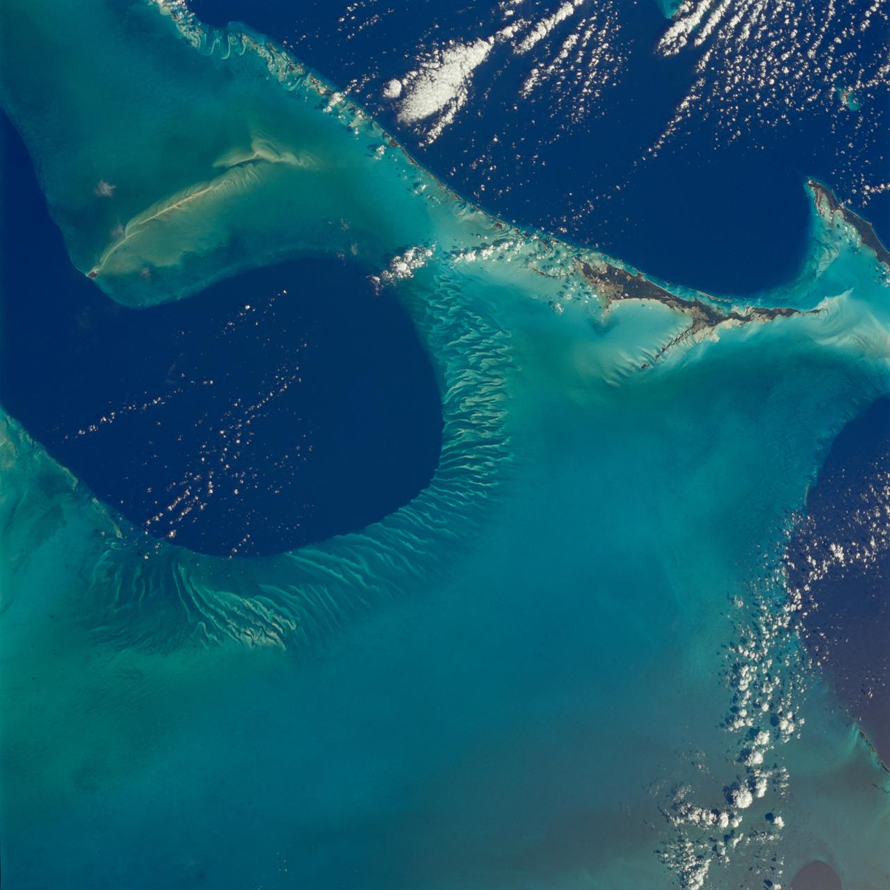
STS080-742-070 (19 Nov.-7 Dec. 1996) --- A view of the Tongue of the Ocean in the Bahama Islands east of Florida. The lines leading from the flat bottom of the Great Bahama Bank, leading into the Tongue, are caused by rapid transfer of ocean water caused by both temperature changes in the water and hurricanes that periodically cross the area. The water is about 30 feet deep on the Great Bahama Bank, and nearly a mile deep in the tongue. To the left is the Exuma Sound, over a mile deep, and a series of islands along its edge with Great Exuma Island the easiest to see. Green Cay, the small dot lower left, leaving a wake to the southeast of light colored coral. The deep blue area to the top right center is the southeastern edge of the Great Bahama Bank.
STS054-95-042 (13-19 Jan 1993) --- The Equatorial Pacific Ocean is represented in this 70mm view. The international oceanographic research community is presently conducting a program called Joint Global Ocean Flux Study (JGOFS) to study the global ocean carbon budget. A considerable amount of effort within this program is presently being focused on the Equatorial Pacific Ocean because of the high annual average biological productivity. The high productivity is the result of nearly constant easterly winds causing cool, nutrient-rich water to well up at the equator. In this view of the sun glint pattern was photographed at about 2 degrees north latitude, 103 degrees west longitude, as the Space Shuttle passed over the Equatorial Pacific. The long narrow line is the equatorial front, which defines the boundary between warm surface equatorial water and cool, recently upwelled water. Such features are of interest to the JGOFS researchers and it is anticipated that photographs such as this will benefit the JGOFS program.
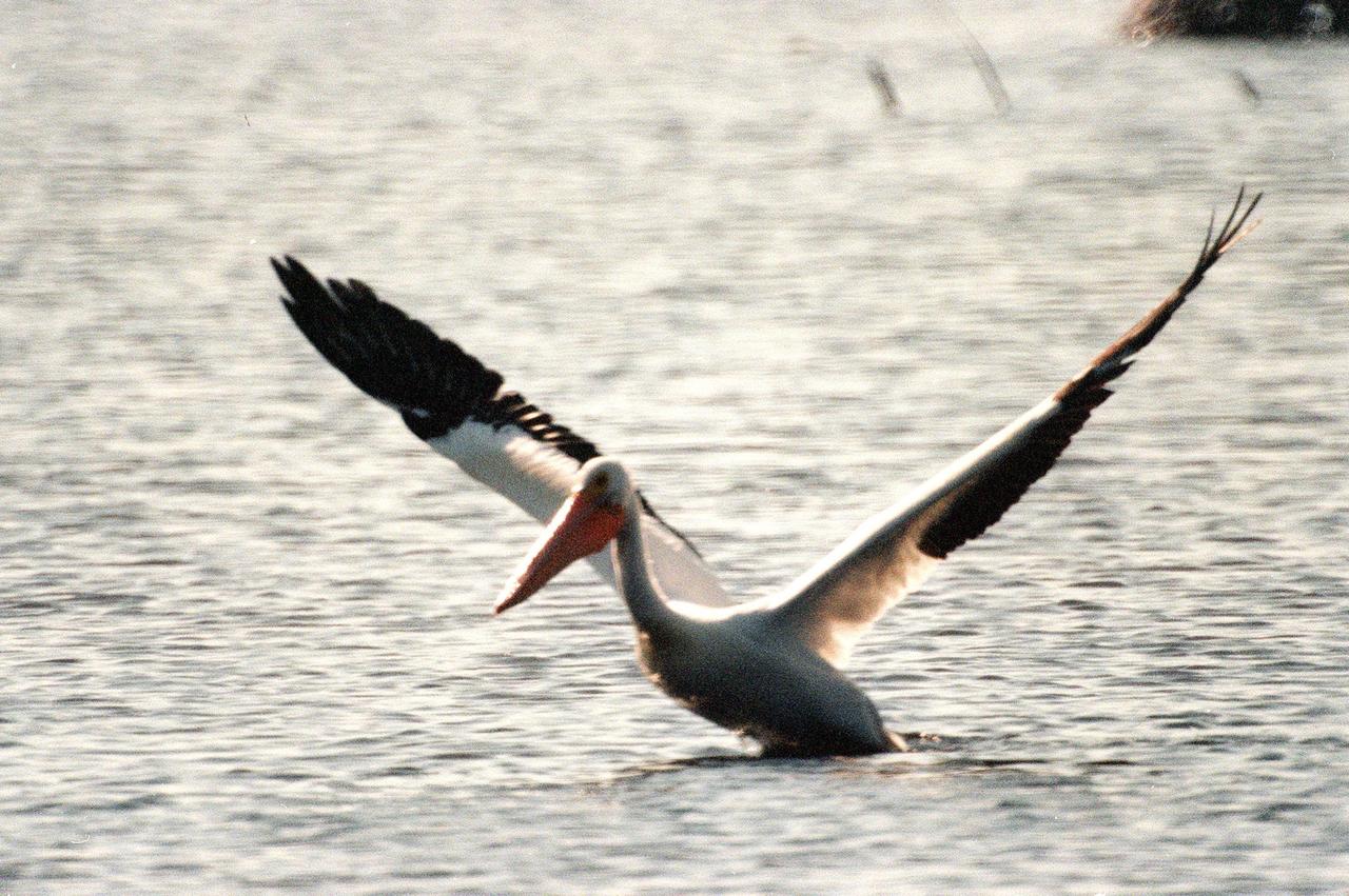
KENNEDY SPACE CENTER, FLA. -- A white pelican stretches its eight-foot wing span as it prepares for flight. The black wing feathers, hidden when folded, appear as shadows against the dappled waters of the Merritt Island National Wildlife Refuge. The habitat of white pelicans are marshy lakes along the Pacific and Texas coasts, wintering chiefly in coastal lagoons such as this one. They often capture fish cooperatively, forming a long line, beating their wings and driving the prey into shallow water. The 92,000-acre refuge, which shares a boundary with Kennedy Space Center, is a habitat for more than 310 species of birds, 25 mammals, 117 fishes and 65 amphibians and reptiles. The marshes and open water of the refuge also provide wintering areas for 23 species of migratory waterfowl, as well as a year-round home for great blue herons, great egrets, wood storks, cormorants, brown pelicans and other species of marsh and shore birds
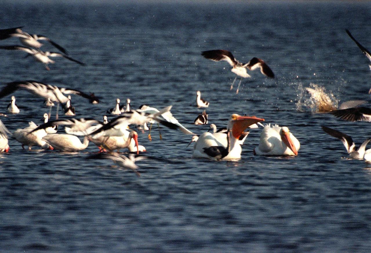
KENNEDY SPACE CENTER, FLA. -- White pelicans are joined by a few egrets at a feeding frenzy in the waters of the Merritt Island National Wildlife Refuge, which shares a boundary with Kennedy Space Center. Pelicans in flight display their black wing tips, which are hidden when folded. The habitat of white pelicans are marshy lakes along the Pacific and Texas coasts, wintering chiefly in coastal lagoons such as this one. They often capture fish cooperatively, forming a long line, beating their wings and driving the prey into shallow water. The 92,000-acre refuge is a habitat for more than 310 species of birds, 25 mammals, 117 fishes and 65 amphibians and reptiles. The marshes and open water of the refuge also provide wintering areas for 23 species of migratory waterfowl, as well as a year-round home for great blue herons, great egrets, wood storks, cormorants, brown pelicans and other species of marsh and shore birds
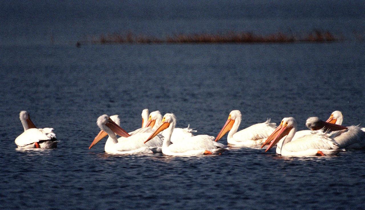
KENNEDY SPACE CENTER, FLA. -- White pelicans search for a meal in the waters of the Merritt Island National Wildlife Refuge, which shares a boundary with Kennedy Space Center. The habitat of white pelicans are marshy lakes along the Pacific and Texas coasts, wintering chiefly in coastal lagoons such as this one. They often capture fish cooperatively, forming a long line, beating their wings and driving the prey into shallow water. The 92,000-acre refuge is a habitat for more than 310 species of birds, 25 mammals, 117 fishes and 65 amphibians and reptiles. The marshes and open water of the refuge also provide wintering areas for 23 species of migratory waterfowl, as well as a year-round home for great blue herons, great egrets, wood storks, cormorants, brown pelicans and other species of marsh and shore birds
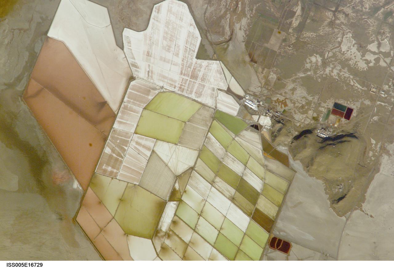
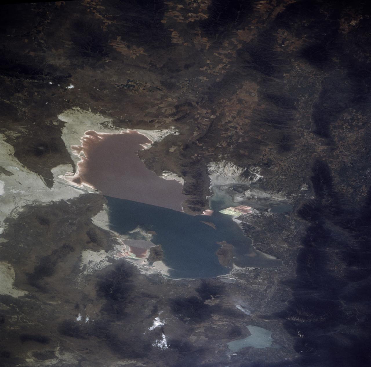
ISS005-E-16729 (7 October 2002) --- Great Salt Lake, Utah, is featured in this image photographed by an Expedition 5 crewmember on the International Space Station (ISS). Great Salt Lake serves as a striking visual marker for crewmembers orbiting over North America. A sharp line across its center is caused by the restriction in water flow from the railroad causeway. The eye-catching colors of the lake stem from the fact that Great Salt Lake is hyper saline, typically 3-5 times saltier than the ocean, and the high salinities support sets of plants and animals that affect the light-absorbing qualities of the water. North of the causeway salinities are higher, and the water turns red from the pigments of halophilic bacteria. In the shallower corner of the lake, earthen dikes mark large salt evaporation works, which take on the jewel tones of turquoise, russet, tamber and pearl white.
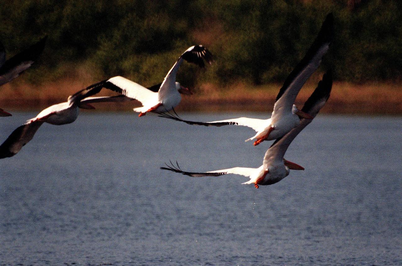
KENNEDY SPACE CENTER, FLA. -- White pelicans soaring over the waters of the Merritt Island National Wildlife Refuge reveal the black wing feathers that are hidden when folded. The habitat of white pelicans are marshy lakes along the Pacific and Texas coasts, wintering chiefly in coastal lagoons such as this one. They often capture fish cooperatively, forming a long line, beating their wings and driving the prey into shallow water. The 92,000-acre refuge, which shares a boundary with Kennedy Space Center, is a habitat for more than 310 species of birds, 25 mammals, 117 fishes and 65 amphibians and reptiles. The marshes and open water of the refuge also provide wintering areas for 23 species of migratory waterfowl, as well as a year-round home for great blue herons, great egrets, wood storks, cormorants, brown pelicans and other species of marsh and shore birds

ISS030-E-034228 (14 Jan. 2012) --- The Great Salt Lake in Utah serves as a striking visual marker for the Expedition 30 crew members orbiting over the western states aboard the International Space Station. A sharp line across the lake's center is caused by the restriction in water flow from the railroad causeway. The eye-catching colors of the lake stem from the fact that Great Salt Lake is hypersaline, typically 3-5 times saltier than the ocean.
Roofing materials, blown loose by Hurricane Matthew, lie on the ground behind the Beach House at NASA’s Kennedy Space Center in Florida. Members of the Disaster Assessment and Recovery Team (DART) are working on repairs to the facility following Hurricane Matthew, which passed to the east of Kennedy on Oct. 6 and 7, 2016. The center received some isolated roof damage, damaged support buildings, a few downed power lines, and limited water intrusion. Beach erosion also occurred, although the storm surge was less than expected.

A Delta plane, carrying an all-female crew and 130 young women ages 11 to 18, received a “water salute” upon arrival on Friday, Sept. 20, 2024, at the Launch and Landing Facility at NASA’s Kennedy Space Center in Florida. Part of the Delta Air Lines’ Women Inspiring Our Next Generation (WING) flight, the young women from the Atlanta, Georgia area, learned about the various women-led STEM (science, technology, engineering, and math) careers available at the Florida spaceport.
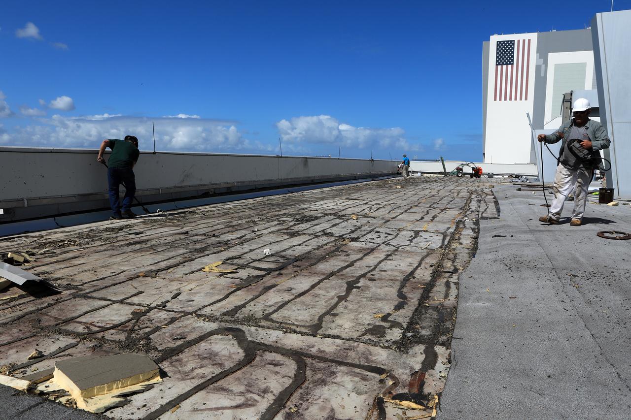
Members of the Disaster Assessment and Recovery Team (DART) repair a section of roof atop the Operations Support Building II at NASA’s Kennedy Space Center in Florida. The effort is part of the spaceport’s ongoing recovery from Hurricane Matthew, which passed to the east of Kennedy on Oct. 6 and 7, 2016. The center received some isolated roof damage, damaged support buildings, a few downed power lines, and limited water intrusion. Beach erosion also occurred, although the storm surge was less than expected.
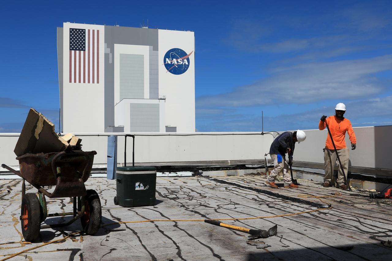
Members of the Disaster Assessment and Recovery Team (DART) repair a section of roof atop the Operations Support Building II at NASA’s Kennedy Space Center in Florida. The effort is part of the spaceport’s ongoing recovery from Hurricane Matthew, which passed to the east of Kennedy on Oct. 6 and 7, 2016. The center received some isolated roof damage, damaged support buildings, a few downed power lines, and limited water intrusion. Beach erosion also occurred, although the storm surge was less than expected.
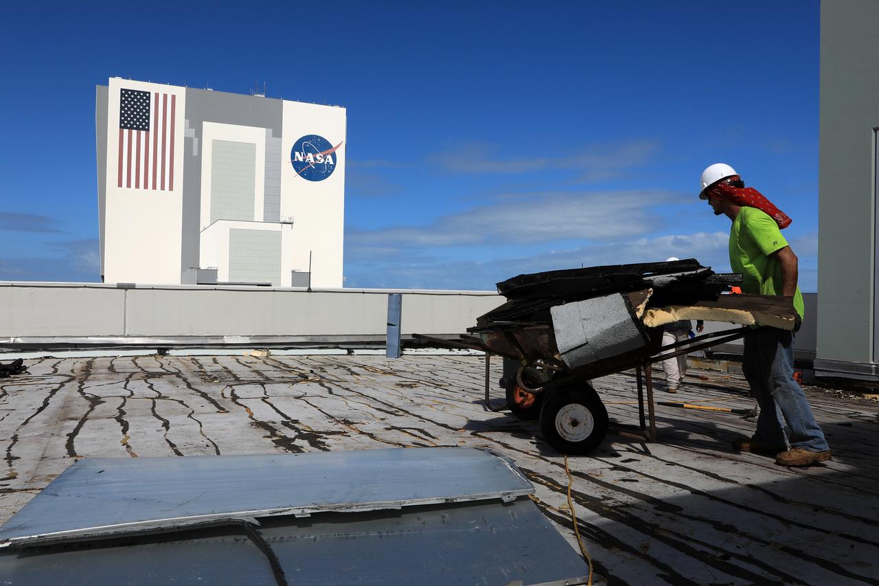
Members of the Disaster Assessment and Recovery Team (DART) repair a section of roof atop the Operations Support Building II at NASA’s Kennedy Space Center in Florida. The effort is part of the spaceport’s ongoing recovery from Hurricane Matthew, which passed to the east of Kennedy on Oct. 6 and 7, 2016. The center received some isolated roof damage, damaged support buildings, a few downed power lines, and limited water intrusion. Beach erosion also occurred, although the storm surge was less than expected.
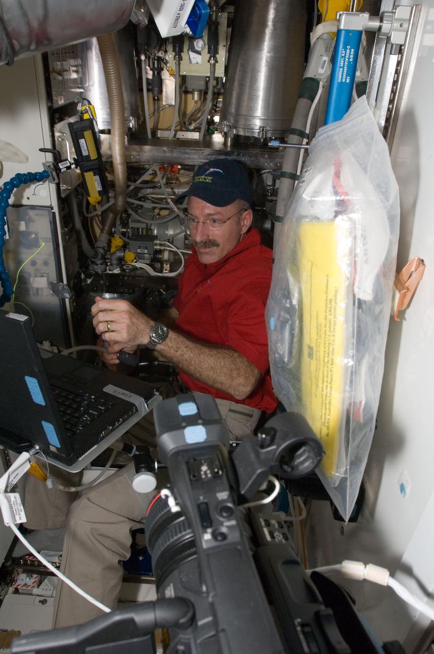
ISS030-E-032750 (11 Jan. 2012) --- NASA astronaut Dan Burbank, Expedition 30 flight commander, performs the Waste and Hygiene Compartment (WHC) yearly maintenance in the Tranquility node of the International Space Station. The maintenance included removing and replacing the urine hydraulic components which include urine lines, urine valve block and urine pressure sensors, and removing and replacing the Flush Water Tank Pressure Sensor.
Members of the Disaster Assessment and Recovery Team (DART) work on flooring repairs to the Beach House at NASA’s Kennedy Space Center in Florida. The effort is part of the spaceport’s ongoing recovery from Hurricane Matthew, which passed to the east of Kennedy on Oct. 6 and 7, 2016. The center received some isolated roof damage, damaged support buildings, a few downed power lines, and limited water intrusion. Beach erosion also occurred, although the storm surge was less than expected.
Tubing provides ventilation through boarded-up windows on the Operations Support Building II at NASA’s Kennedy Space Center in Florida. Members of the Disaster Assessment and Recovery Team (DART) are working on repairs to the facility following Hurricane Matthew, which passed to the east of Kennedy on Oct. 6 and 7, 2016. The center received some isolated roof damage, damaged support buildings, a few downed power lines, and limited water intrusion. Beach erosion also occurred, although the storm surge was less than expected.
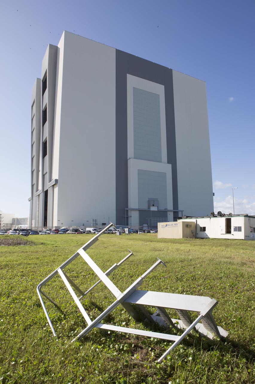
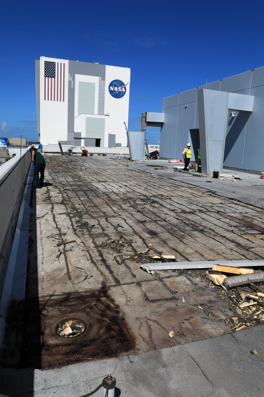
A small staircase, toppled and relocated by Hurricane Matthew, is seen in front of the Vehicle Assembly Building at NASA's Kennedy Space Center in Florida. Assessments and repairs are in progress at various structures and facilities across the spaceport, part of the ongoing recovery from Hurricane Matthew, which passed to the east of Kennedy on Oct. 6 and 7, 2016. The center received some isolated roof damage, damaged support buildings, a few downed power lines, and limited water intrusion. Beach erosion also occurred, although the storm surge was less than expected.
Tubing provides ventilation through boarded-up windows on the Operations Support Building II at NASA’s Kennedy Space Center in Florida. Members of the Disaster Assessment and Recovery Team (DART) are working on repairs to the facility following Hurricane Matthew, which passed to the east of Kennedy on Oct. 6 and 7, 2016. The center received some isolated roof damage, damaged support buildings, a few downed power lines, and limited water intrusion. Beach erosion also occurred, although the storm surge was less than expected.
Members of the Disaster Assessment and Recovery Team (DART) repair a section of roof atop the Operations Support Building II at NASA’s Kennedy Space Center in Florida. The effort is part of the spaceport’s ongoing recovery from Hurricane Matthew, which passed to the east of Kennedy on Oct. 6 and 7, 2016. The center received some isolated roof damage, damaged support buildings, a few downed power lines, and limited water intrusion. Beach erosion also occurred, although the storm surge was less than expected.
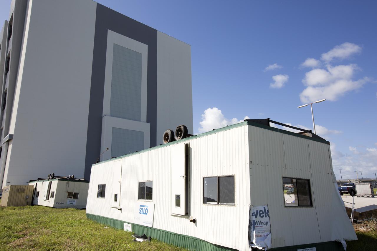
A construction trailer damaged by Hurricane Matthew is seen in the Launch Complex 39 area at NASA's Kennedy Space Center in Florida. Assessments and repairs are in progress at various structures and facilities across the spaceport, part of the ongoing recovery from Hurricane Matthew, which passed to the east of Kennedy on Oct. 6 and 7, 2016. The center received some isolated roof damage, damaged support buildings, a few downed power lines, and limited water intrusion. Beach erosion also occurred, although the storm surge was less than expected.
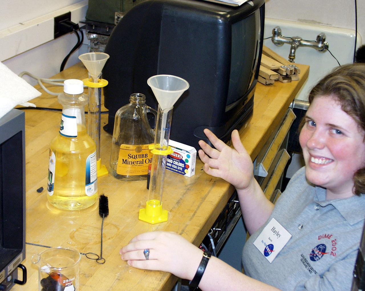
A Bay High School team member prepares the oil and water samples for their next drop operation as part of the second Dropping in a Microgravity Environment (DIME) competition held April 23-25, 2002, at NASA's Glenn Research Center. Competitors included two teams from Sycamore High School, Cincinnati, OH, and one each from Bay High School, Bay Village, OH, and COSI Academy, Columbus, OH. DIME is part of NASA's education and outreach activities. Details are on line at http://microgravity.grc.nasa.gov/DIME_2002.html.
This view shows the pipe (center top) leading toward Endeavour from the side of the White Room at Launch Pad 39B. A loose bracket observed hanging down from the pipe delayed loading of Endeavour's external tank by several hours to allow technicians to remove it. A "U" bolt connects the bracket to a fire suppression water line attached to the exterior of the White Room. The loose bolt could have possibly created a debris hazard
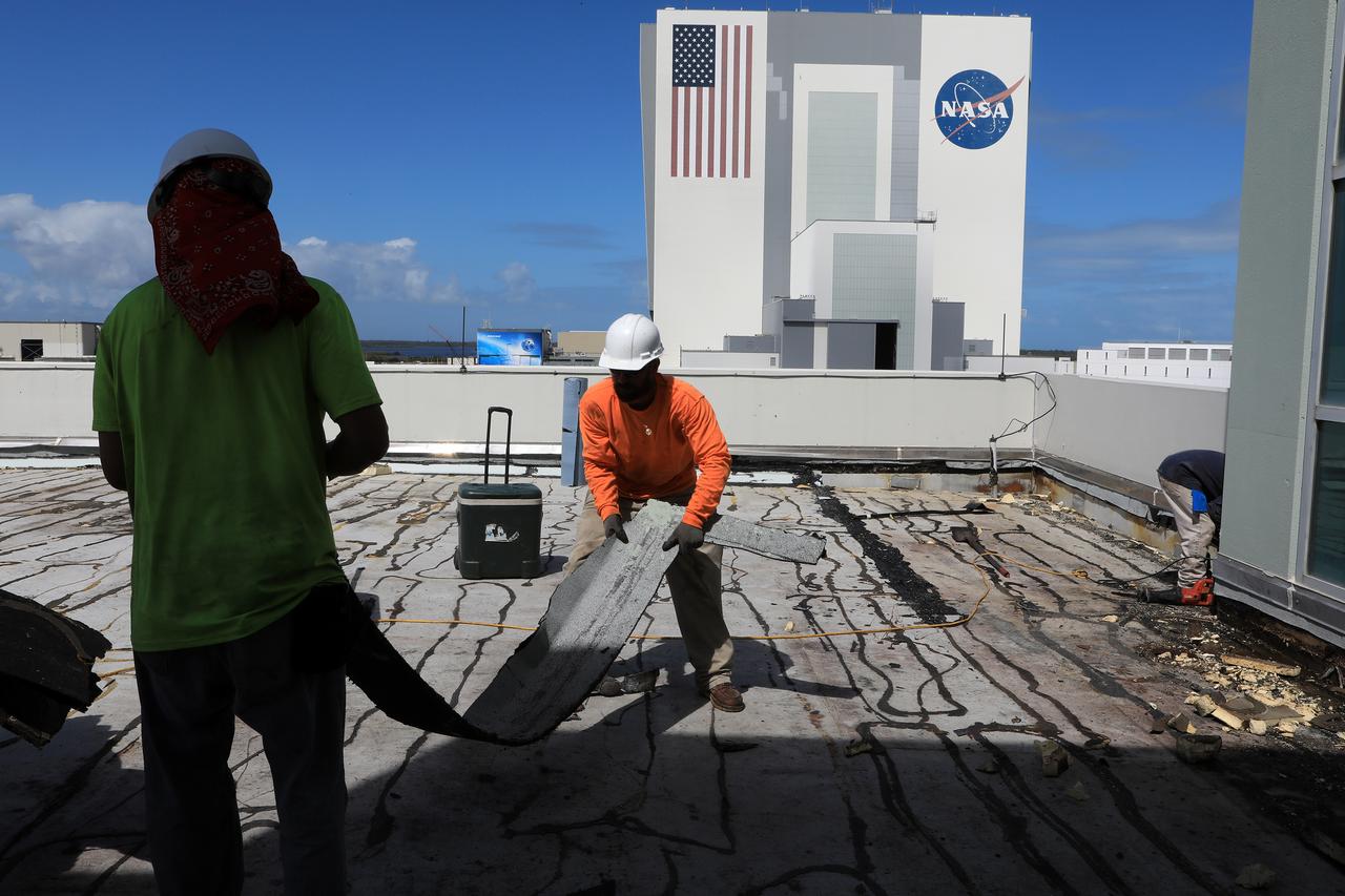
Members of the Disaster Assessment and Recovery Team (DART) repair a section of roof atop the Operations Support Building II at NASA’s Kennedy Space Center in Florida. The effort is part of the spaceport’s ongoing recovery from Hurricane Matthew, which passed to the east of Kennedy on Oct. 6 and 7, 2016. The center received some isolated roof damage, damaged support buildings, a few downed power lines, and limited water intrusion. Beach erosion also occurred, although the storm surge was less than expected.
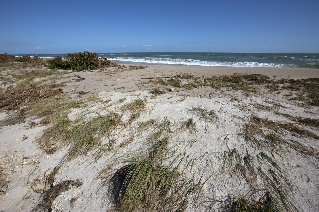
Beach erosion caused by Hurricane Matthew is visible along the Atlantic shoreline at NASA’s Kennedy Space Center in Florida. Although some sections of shoreline suffered erosion, recently restored portions of beach fared well. Hurricane Matthew, a Category 3 storm, passed to the east of Kennedy on Oct. 6 and 7, 2016. The center received some isolated roof damage, damaged support buildings, a few downed power lines, and limited water intrusion.
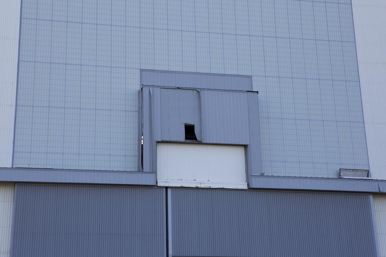
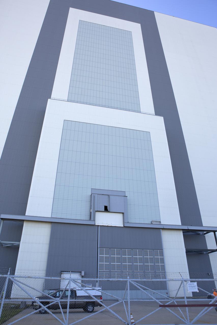
A hole caused by Hurricane Matthew is visible in a section of door on the Vehicle Assembly Building at NASA's Kennedy Space Center in Florida. Assessments and repairs are in progress at various structures and facilities across the spaceport, part of the ongoing recovery from Hurricane Matthew, which passed to the east of Kennedy on Oct. 6 and 7, 2016. The center received some isolated roof damage, damaged support buildings, a few downed power lines, and limited water intrusion. Beach erosion also occurred, although the storm surge was less than expected.
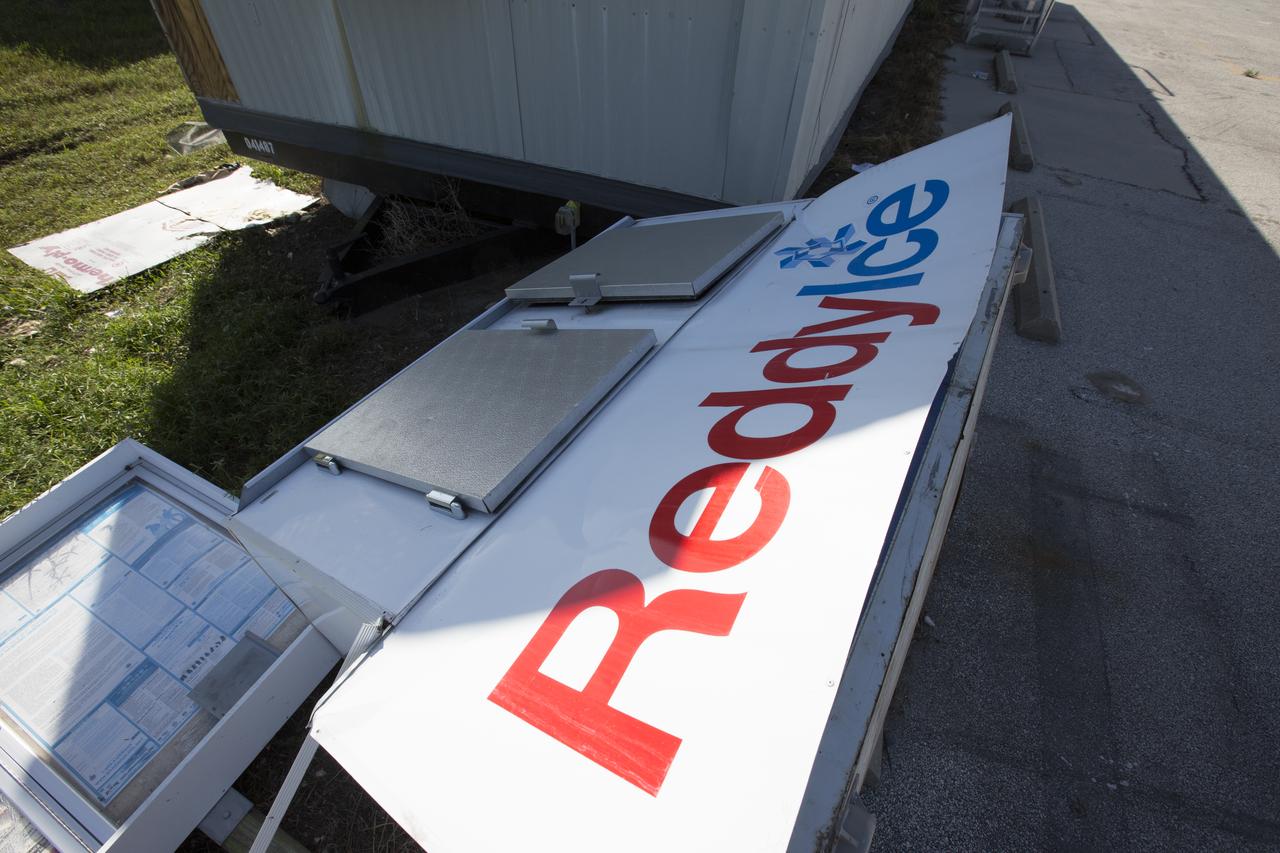
An ice dispenser damaged by Hurricane Matthew is seen in the Launch Complex 39 area at NASA's Kennedy Space Center in Florida. Assessments and repairs are in progress at various structures and facilities across the spaceport, part of the ongoing recovery from Hurricane Matthew, which passed to the east of Kennedy on Oct. 6 and 7, 2016. The center received some isolated roof damage, damaged support buildings, a few downed power lines, and limited water intrusion. Beach erosion also occurred, although the storm surge was less than expected.
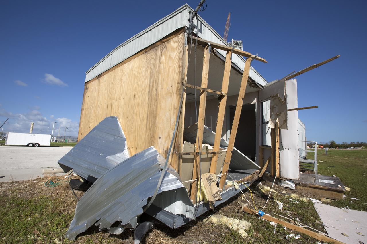
A construction trailer damaged by Hurricane Matthew is seen in the Launch Complex 39 area at NASA's Kennedy Space Center in Florida. Assessments and repairs are in progress at various structures and facilities across the spaceport, part of the ongoing recovery from Hurricane Matthew, which passed to the east of Kennedy on Oct. 6 and 7, 2016. The center received some isolated roof damage, damaged support buildings, a few downed power lines, and limited water intrusion. Beach erosion also occurred, although the storm surge was less than expected.

Members of the Disaster Assessment and Recovery Team (DART) repair a section of roof atop the Operations Support Building II at NASA’s Kennedy Space Center in Florida. The effort is part of the spaceport’s ongoing recovery from Hurricane Matthew, which passed to the east of Kennedy on Oct. 6 and 7, 2016. The center received some isolated roof damage, damaged support buildings, a few downed power lines, and limited water intrusion. Beach erosion also occurred, although the storm surge was less than expected.
S135-E-006466 (9 July 2011) --- As in the case of many previous space missions, the Great Salt Lake in Utah serves as a striking visual marker for the STS-135 astronauts orbiting over North America in the space shuttle Atlantis. A sharp line across the lake's center is caused by the restriction in water flow from the railroad causeway. The eye-catching colors of the lake stem from the fact that Great Salt Lake is hypersaline, typically 3-5 times saltier than the ocean. Photo credit: NASA
Long regarded as one of the best photo of Houston, Texas (29.5N, 95.0W), this view from space shows the entire greater Houston/Galveston region in remarkable detail and clarity. The dark north/south line in the water between Houston and Galveston is the Houston Ship Channel. NASA's Johnson Space Center and Mission Control is located on the north shore of Clear Lake west of the channel. The extensive road and highway network can be seen in great detail.
Members of the Disaster Assessment and Recovery Team (DART) work on repairs to the Operations Support Building II at NASA’s Kennedy Space Center in Florida. The effort is part of the spaceport’s ongoing recovery from Hurricane Matthew, which passed to the east of Kennedy on Oct. 6 and 7, 2016. The center received some isolated roof damage, damaged support buildings, a few downed power lines, and limited water intrusion. Beach erosion also occurred, although the storm surge was less than expected.
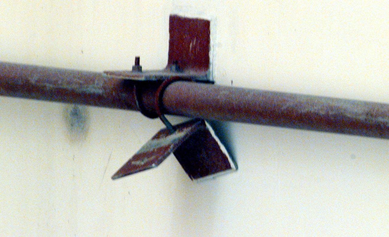
A close-up reveals the loose bracket, observed hanging down from the side of the White Room at Launch Pad 39B, that delayed loading of Endeavour's external tank by several hours to allow technicians to remove it. A "U" bolt connects the bracket to a fire suppression water line attached to the exterior of the White Room. The loose bolt could have possibly created a debris hazard
STS062-153-226 (4-18 March 1994) --- Though it did not reproduce well, this photo gives scientific information to aid in studying all types of earth's processes. It documents ocean features in the sunglint in the Gulf of California, off the Isla Cerralvo, souther Baja, California. Biological oils collect on the surface and shows current patterns, eddies and ship wakes. The small bright spot on the edge of the eddy is a ship dumping oily water from its bilges. The line in the brighter area is a light wind gust roughening the surface.
Members of the Disaster Assessment and Recovery Team (DART) work on flooring repairs to the Beach House at NASA’s Kennedy Space Center in Florida. The effort is part of the spaceport’s ongoing recovery from Hurricane Matthew, which passed to the east of Kennedy on Oct. 6 and 7, 2016. The center received some isolated roof damage, damaged support buildings, a few downed power lines, and limited water intrusion. Beach erosion also occurred, although the storm surge was less than expected.
Members of the Disaster Assessment and Recovery Team (DART) repair a section of roof atop the Operations Support Building II at NASA’s Kennedy Space Center in Florida. The effort is part of the spaceport’s ongoing recovery from Hurricane Matthew, which passed to the east of Kennedy on Oct. 6 and 7, 2016. The center received some isolated roof damage, damaged support buildings, a few downed power lines, and limited water intrusion. Beach erosion also occurred, although the storm surge was less than expected.
Members of the Disaster Assessment and Recovery Team (DART) work on flooring repairs to the Beach House at NASA’s Kennedy Space Center in Florida. The effort is part of the spaceport’s ongoing recovery from Hurricane Matthew, which passed to the east of Kennedy on Oct. 6 and 7, 2016. The center received some isolated roof damage, damaged support buildings, a few downed power lines, and limited water intrusion. Beach erosion also occurred, although the storm surge was less than expected.
STS059-154-160 (9-20 April 1994) --- Orient with Mono Lake, California at the lower right; then the view is westward across the Sierra Nevada into the San Joaquin River drainage. A tiny network of ski trails can be seen on the Mono Lake side of the Sierras, on a line between Mono Lake and the snow-free San Joaquin headwaters. The ski trails mark Mammoth Mountain, where SRL investigators are studying microwave measurements of the water content of snowpacks. Linhof camera.
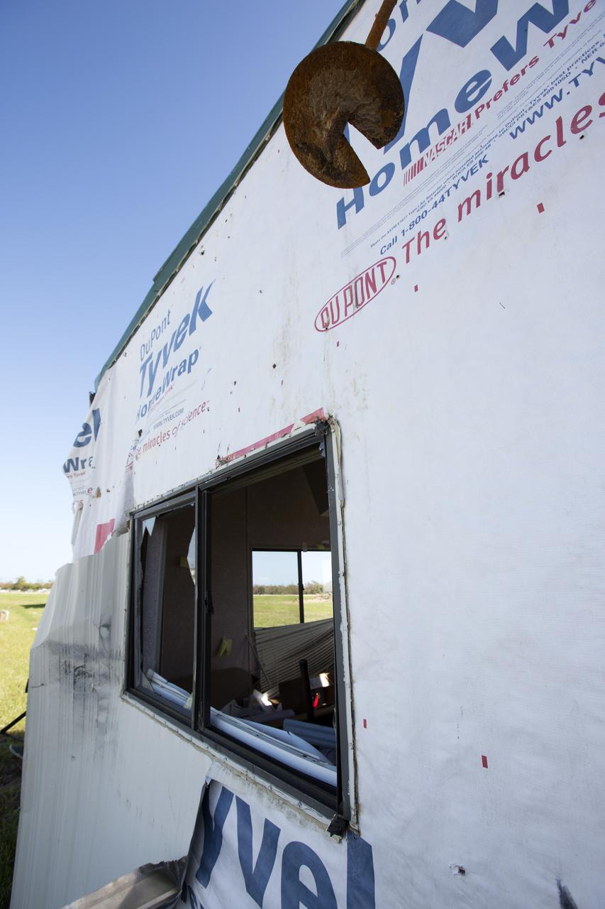
A construction trailer damaged by Hurricane Matthew is seen in the Launch Complex 39 area at NASA's Kennedy Space Center in Florida. Assessments and repairs are in progress at various structures and facilities across the spaceport, part of the ongoing recovery from Hurricane Matthew, which passed to the east of Kennedy on Oct. 6 and 7, 2016. The center received some isolated roof damage, damaged support buildings, a few downed power lines, and limited water intrusion. Beach erosion also occurred, although the storm surge was less than expected.
SL2-81-189 (22 June 1973) --- The well defined meanderings of the Mississippi River, just to the south of St. Louis, MO (38.5N, 90.5W) can easily be seen as curved lines and loops roughly paralleling the present river in this view showing the former water channels. The vegetated bluffs on either side of the river define the limits of the meanders where the rich river flood plain offers some of the most fertile land for agriculture although flooding remains a constant threat. Photo credit: NASA
A hole caused by Hurricane Matthew is visible in a section of door on the Vehicle Assembly Building at NASA's Kennedy Space Center in Florida. Assessments and repairs are in progress at various structures and facilities across the spaceport, part of the ongoing recovery from Hurricane Matthew, which passed to the east of Kennedy on Oct. 6 and 7, 2016. The center received some isolated roof damage, damaged support buildings, a few downed power lines, and limited water intrusion. Beach erosion also occurred, although the storm surge was less than expected.
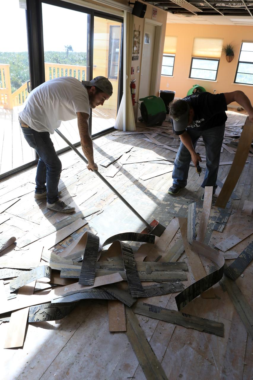
Members of the Disaster Assessment and Recovery Team (DART) work on flooring repairs to the Beach House at NASA’s Kennedy Space Center in Florida. The effort is part of the spaceport’s ongoing recovery from Hurricane Matthew, which passed to the east of Kennedy on Oct. 6 and 7, 2016. The center received some isolated roof damage, damaged support buildings, a few downed power lines, and limited water intrusion. Beach erosion also occurred, although the storm surge was less than expected.
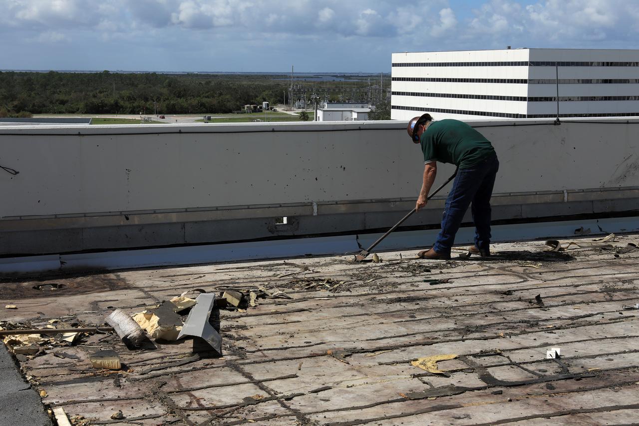
Members of the Disaster Assessment and Recovery Team (DART) repair a section of roof atop the Operations Support Building II at NASA’s Kennedy Space Center in Florida. The effort is part of the spaceport’s ongoing recovery from Hurricane Matthew, which passed to the east of Kennedy on Oct. 6 and 7, 2016. The center received some isolated roof damage, damaged support buildings, a few downed power lines, and limited water intrusion. Beach erosion also occurred, although the storm surge was less than expected.
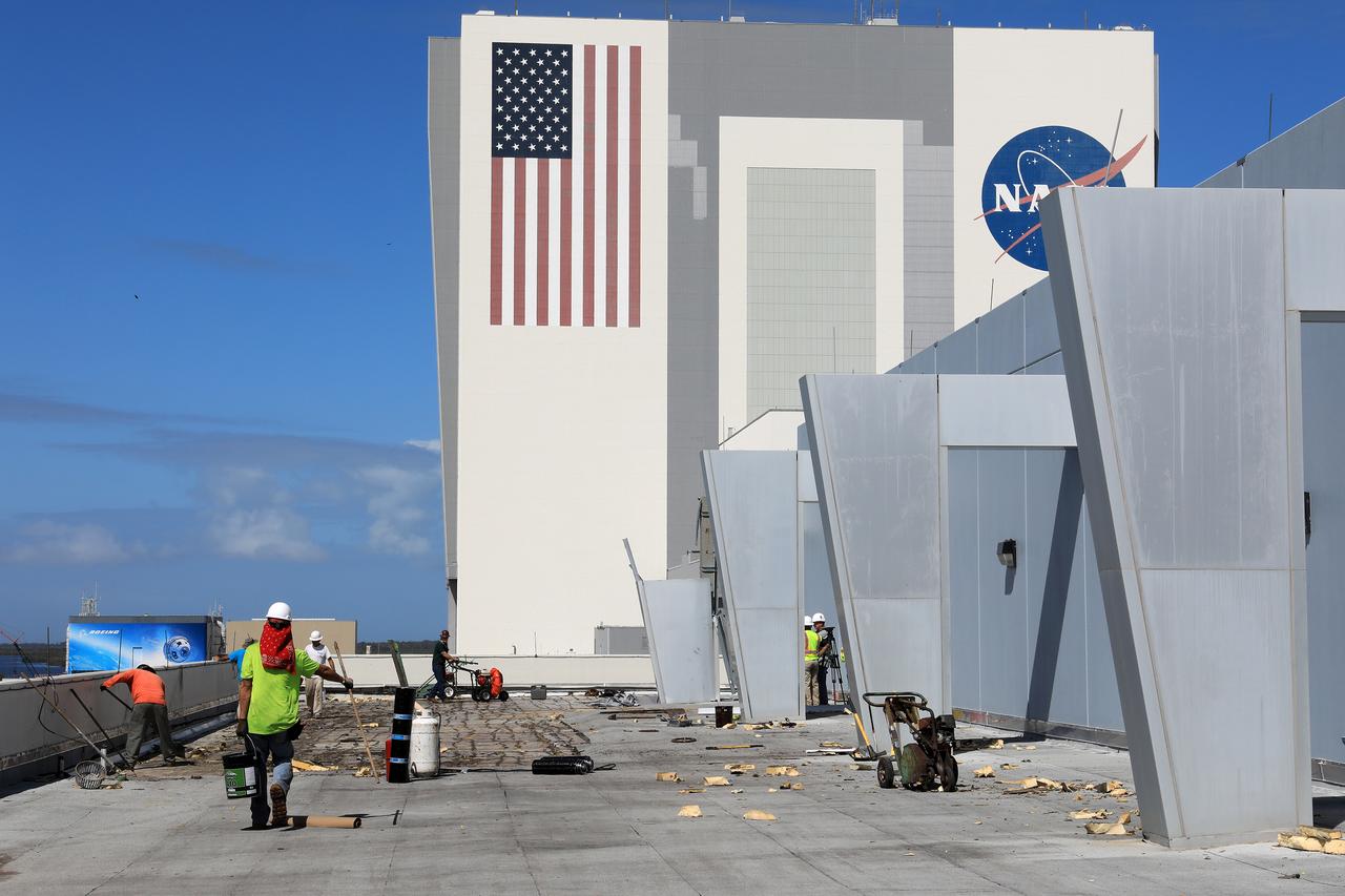
Members of the Disaster Assessment and Recovery Team (DART) repair a section of roof atop the Operations Support Building II at NASA’s Kennedy Space Center in Florida. The effort is part of the spaceport’s ongoing recovery from Hurricane Matthew, which passed to the east of Kennedy on Oct. 6 and 7, 2016. The center received some isolated roof damage, damaged support buildings, a few downed power lines, and limited water intrusion. Beach erosion also occurred, although the storm surge was less than expected.
Swift currents flow through the Strait of Gibraltar, producing complicated patterns in the surface waters. Some of those patterns are highlighted in the sunglint in this photograph. The Mediterranian Sea is on the upper right, the Atlantic Ocean in in the lower left. Few features can be seen on the Mediterranian side, but current shears (straight lines coming off Spain), several sets of internal waves (impinging on the Spanish continental shelf) and ship wakes can be seen on the Atlantic side, west of Cadiz. Both Tangier and Cadiz show up in the sunglint as well.
Roofing materials, blown loose by Hurricane Matthew, are visible on the ground below the deck of the Beach House at NASA’s Kennedy Space Center in Florida. Members of the Disaster Assessment and Recovery Team (DART) are working on repairs to the facility following Hurricane Matthew, which passed to the east of Kennedy on Oct. 6 and 7, 2016. The center received some isolated roof damage, damaged support buildings, a few downed power lines, and limited water intrusion. Beach erosion also occurred, although the storm surge was less than expected.
This loose bracket, observed hanging down from the side of the White Room at Launch Pad 39B, delayed loading of Endeavour's external tank by several hours to allow technicians to remove it. A "U" bolt connects the bracket to a fire suppression water line attached to the exterior of the White Room. The loose bolt could have possibly created a debris hazard
ISS031-E-148455 (21 June 2012) --- Toshka Lakes in southern Egypt are featured in this image photographed by an Expedition 31 crew member on the International Space Station. The Toshka Lakes (center) were formed in the Sahara Desert of Egypt by water from the River Nile conveyed from Lake Nasser by a canal to the Toshka Depression. Flooding of the Toshka Depression had created the four main lakes with a maximum surface area in 2002 of approximately 1,450 square kilometers ? around 25.26 billion cubic meters of water. By 2006 the stored water was reduced by 50 per cent and by 2012 shows open water only in the lowest parts of the main western and eastern basins?representing a reduction in surface area to 307 square kilometers?nearly 80 per cent smaller than the 2002 surface area. Standing water is almost completely absent from the central basin. From space, astronauts documented the first lake?the easternmost one?in 1998. The lakes progressively grew in depressions to the west, the westernmost filling between 2000 and 2001. This image shows lines of center-point agricultural fields near the east-basin lake nearest Lake Nasser. Sunglint on the western lake makes the water surface appear both light and dark, depending on which parts of the surface were ruffled by the wind at the moment the image was taken.
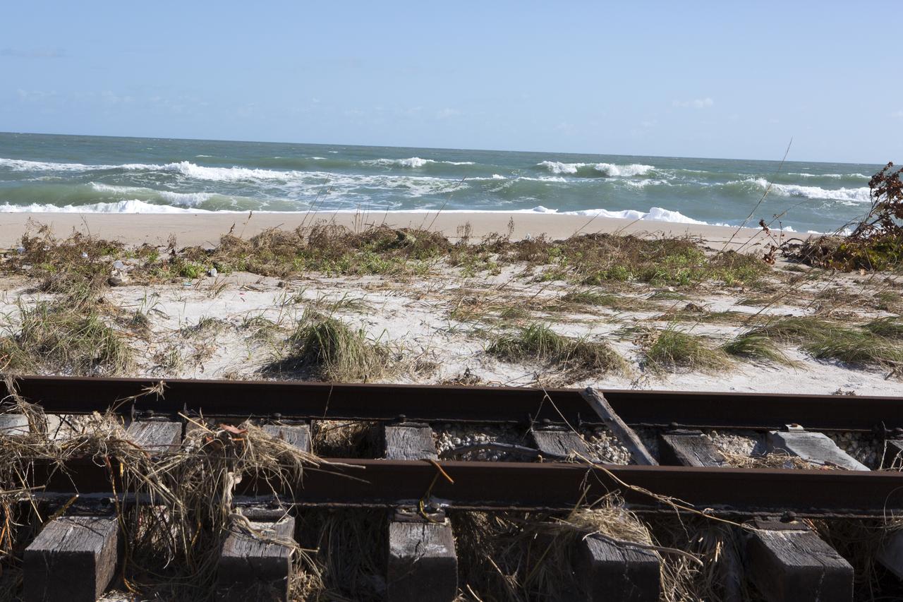
Plant debris left behind by Hurricane Matthew covers a stretch of the NASA Railroad near Launch Pads 39A and B at Kennedy Space Center in Florida. A portion of the line near the ocean was used during the Apollo era, although some portions were used to deliver commodities to the nearby Cape Canaveral Air Force Station through the end of the Titan program. NASA determined it was financially and ecologically advantageous to leave the tracks in place. Hurricane Matthew, a Category 3 storm, passed to the east of Kennedy on Oct. 6 and 7, 2016. The center received some isolated roof damage, damaged support buildings, a few downed power lines, and limited water intrusion. Beach erosion also occurred, although the storm surge was less than expected.

Plant debris left behind by Hurricane Matthew covers a stretch of the NASA Railroad at Kennedy Space Center in Florida. A portion of the line near the ocean was used during the Apollo era, although some portions were used to deliver commodities to the nearby Cape Canaveral Air Force Station through the end of the Titan program. NASA determined it was financially and ecologically advantageous to leave the tracks in place. Hurricane Matthew, a Category 3 storm, passed to the east of Kennedy on Oct. 6 and 7, 2016. The center received some isolated roof damage, damaged support buildings, a few downed power lines, and limited water intrusion. Beach erosion also occurred, although the storm surge was less than expected.
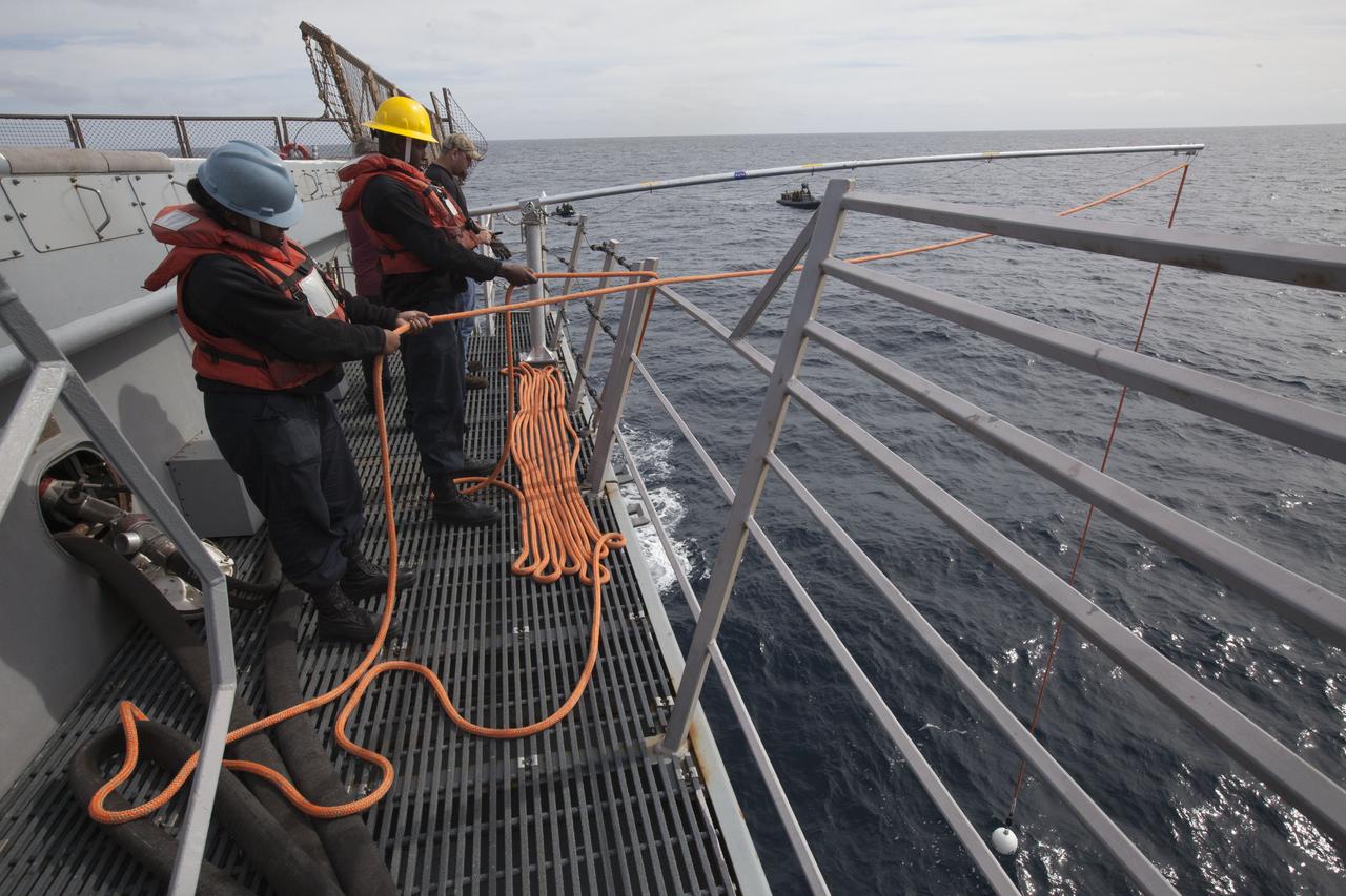
U.S. Navy personnel check tether lines and a winch line on the deck of the USS San Diego in the Pacific Ocean off the coast of California. NASA's Ground Systems Development and Operations Program and the U.S. Navy are conducting a series of tests, called Underway Recovery Test 5, using the ship's well deck and a test version of the Orion crew module to prepare for recovery of Orion on its return from deep space missions. The testing will allow the team to demonstrate and evaluate recovery processes, procedures, hardware and personnel in open waters. Orion is the exploration spacecraft designed to carry astronauts to destinations not yet explored by humans, including an asteroid and NASA's Journey to Mars. It will have emergency abort capability, sustain the crew during space travel and provide safe re-entry from deep space return velocities. Orion is scheduled to launch on NASA's Space Launch System in late 2018. For more information, visit http://www.nasa.gov/orion.
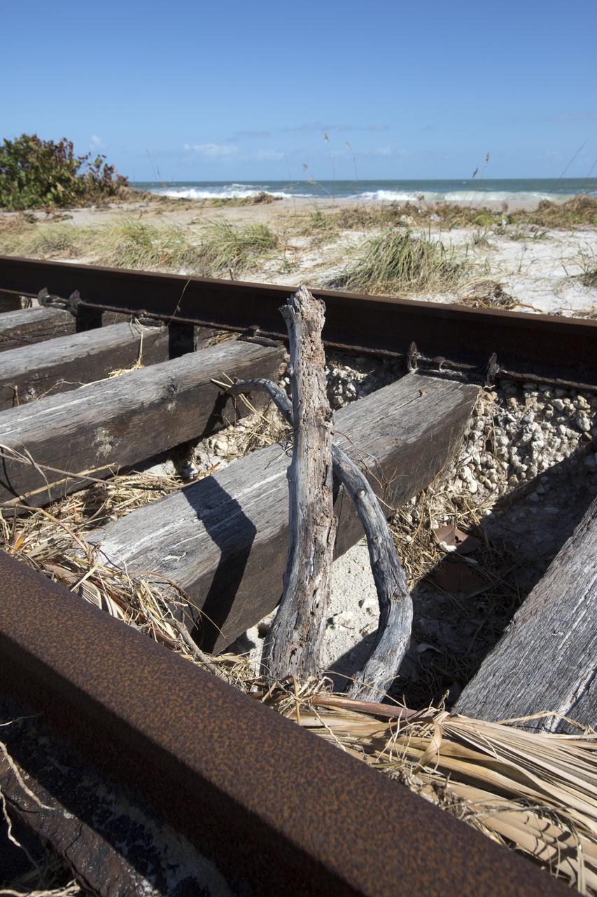
Plant debris and ground erosion left behind by Hurricane Matthew affect a stretch of the NASA Railroad at Kennedy Space Center in Florida. A portion of the line near the ocean was used during the Apollo era, although some portions were used to deliver commodities to the nearby Cape Canaveral Air Force Station through the end of the Titan program. NASA determined it was financially and ecologically advantageous to leave the tracks in place. Hurricane Matthew, a Category 3 storm, passed to the east of Kennedy on Oct. 6 and 7, 2016. The center received some isolated roof damage, damaged support buildings, a few downed power lines, and limited water intrusion. Beach erosion also occurred, although the storm surge was less than expected.
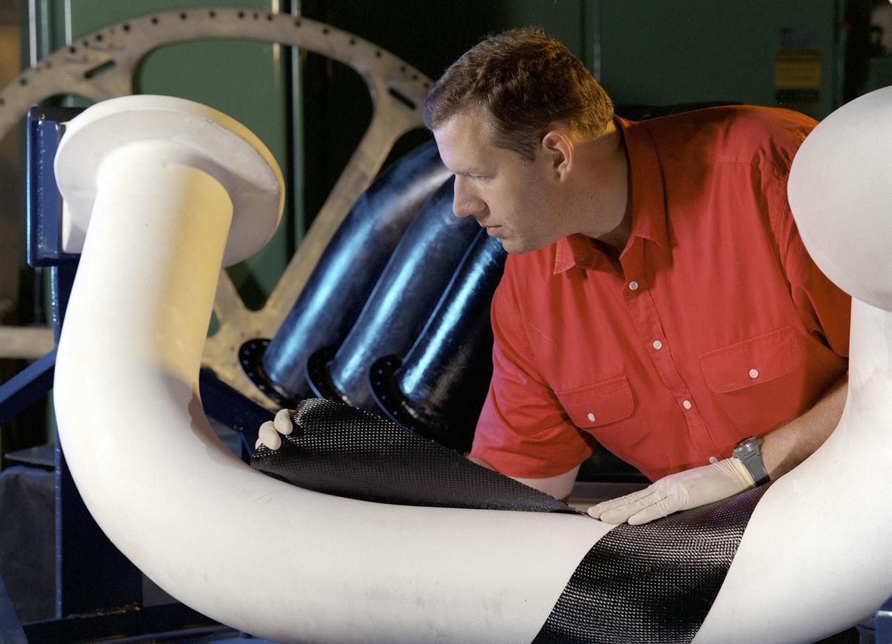
Engineers at Marshall Space Flight Center (MSFC) in Huntsville, Alabama, are working with industry partners to develop a new generation of more cost-efficient space vehicles. Lightweight fuel tanks and components under development will be the critical elements in tomorrow's reusable launch vehicles and will tremendously curb the costs of getting to space. In this photo, Tom DeLay, a materials processes engineer for MSFC, uses a new graphite epoxy technology to create lightweight cryogenic fuel lines for futuristic reusable launch vehicles. He is wrapping a water-soluble mandrel, or mold, with a graphite fabric coated with an epoxy resin. Once wrapped, the pipe will be vacuum-bagged and autoclave-cured. The disposable mold will be removed to reveal a thin-walled fuel line. In addition to being much lighter and stronger than metal, this material won't expand or contract as much in the extreme temperatures encountered by launch vehicles.
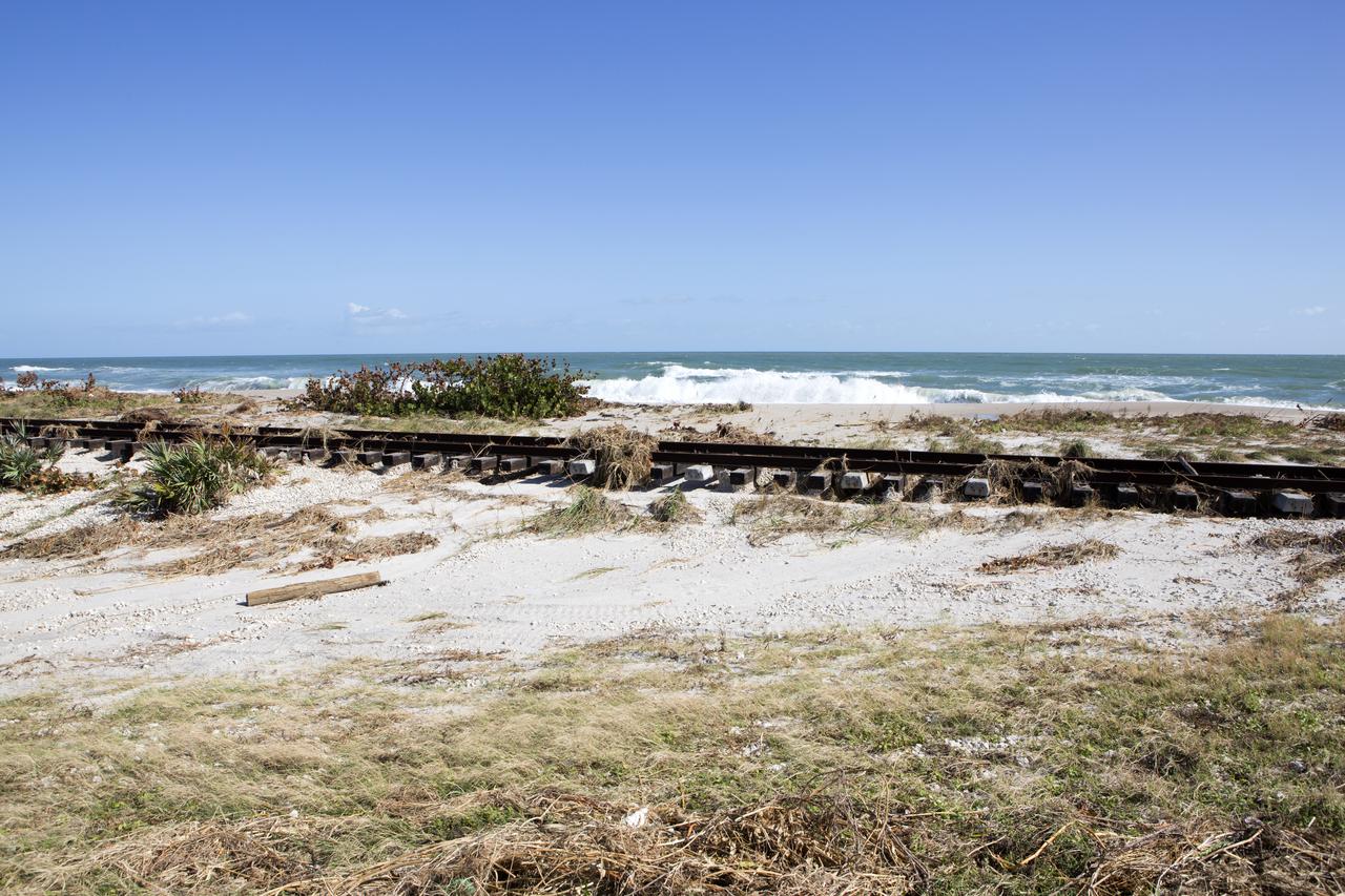
Plant debris left behind by Hurricane Matthew covers a stretch of the NASA Railroad near Launch Pads 39A and B at Kennedy Space Center in Florida. A portion of the line near the ocean was used during the Apollo era, although some portions were used to deliver commodities to the nearby Cape Canaveral Air Force Station through the end of the Titan program. NASA determined it was financially and ecologically advantageous to leave the tracks in place. Hurricane Matthew, a Category 3 storm, passed to the east of Kennedy on Oct. 6 and 7, 2016. The center received some isolated roof damage, damaged support buildings, a few downed power lines, and limited water intrusion. Beach erosion also occurred, although the storm surge was less than expected.
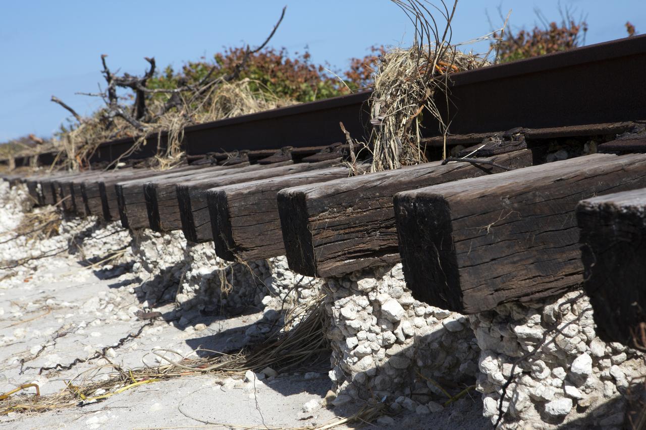
Plant debris and ground erosion left behind by Hurricane Matthew affect a stretch of the NASA Railroad at Kennedy Space Center in Florida. A portion of the line near the ocean was used during the Apollo era, although some portions were used to deliver commodities to the nearby Cape Canaveral Air Force Station through the end of the Titan program. NASA determined it was financially and ecologically advantageous to leave the tracks in place. Hurricane Matthew, a Category 3 storm, passed to the east of Kennedy on Oct. 6 and 7, 2016. The center received some isolated roof damage, damaged support buildings, a few downed power lines, and limited water intrusion. Beach erosion also occurred, although the storm surge was less than expected.

This graph shows the ratio of concentrations of several elements in four different pairs of targets examined by Alpha Particle X-ray Spectrometer (APXS) instruments on NASA Mars rovers Curiosity and Spirit. For each pair of targets, one shows evidence of mineral alteration and the other is an unaltered counterpart. The first three pairs (with ratios shown by green, blue and red lines) are targets in Gale Crater analyzed by Curiosity's APXS. The fourth pair (with ratio shown by the black line) is in Gusev Crater and was analyzed by Spirit's APXS. Similar profiles are observed, suggesting the possibility of related formation processes. As with examples of silica enrichment found by Curiosity, the origin of high-silica nodular deposits found by Spirit also remains unresolved: Either acidic weathering or silica addition could be responsible. It is clear, however, that liquid water was involved in either alteration scenario. http://photojournal.jpl.nasa.gov/catalog/PIA20276
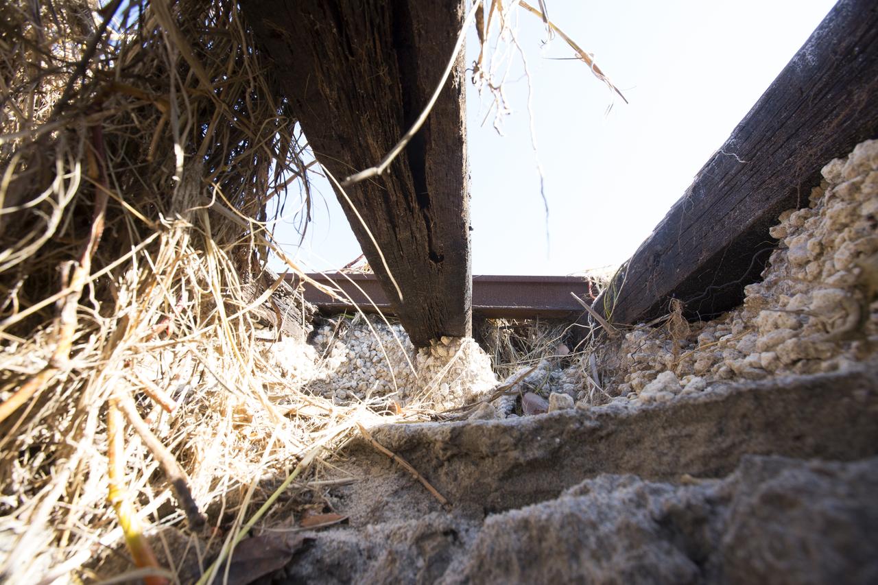
Erosion caused by Hurricane Matthew has worn away sections of the ground beneath the NASA Railroad at Kennedy Space Center in Florida. A portion of the line near the ocean was used during the Apollo era, although some portions were used to deliver commodities to the nearby Cape Canaveral Air Force Station through the end of the Titan program. NASA determined it was financially and ecologically advantageous to leave the tracks in place. Hurricane Matthew, a Category 3 storm, passed to the east of Kennedy on Oct. 6 and 7, 2016. The center received some isolated roof damage, damaged support buildings, a few downed power lines, and limited water intrusion. Beach erosion also occurred, although the storm surge was less than expected.
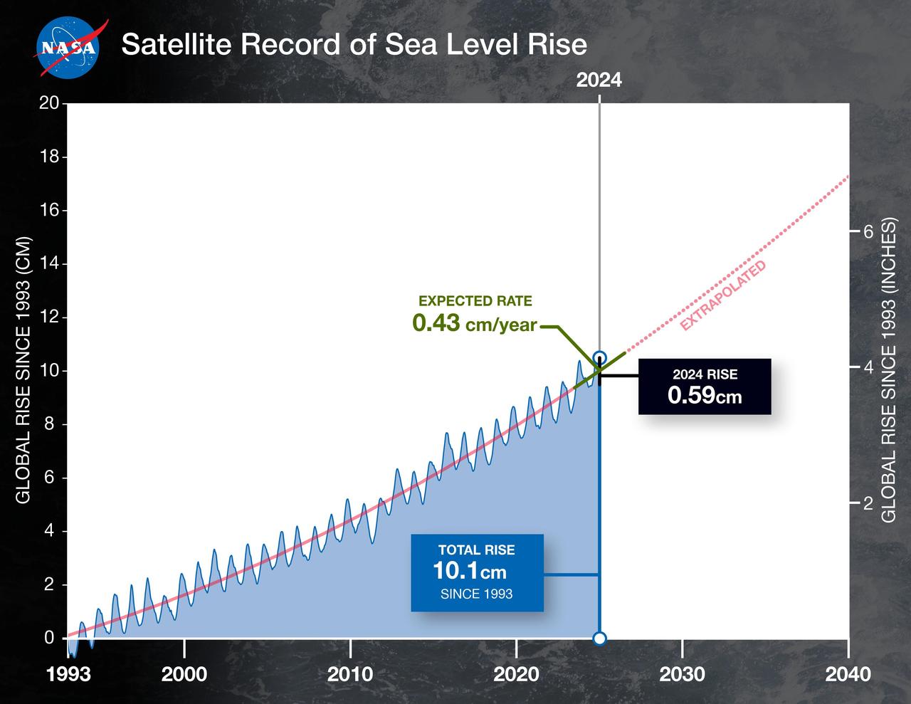
This graph shows the rise in global mean sea level from 1993 to 2024 based on data from a series of five international satellites. The solid red line indicates the trajectory of this increase, which has more than doubled over the three decades. The dotted red line projects future sea level rise. Global sea level rose faster than expected in 2024 due mostly to ocean water expanding as it warms, or thermal expansion. According to a NASA-led analysis, last year's rate of rise was 0.23 inches (0.59 centimeters) per year, compared to the expected rate of 0.17 inches (0.43 centimeters) per year. In recent years, about two-thirds of sea level rise was due to the addition of water from land into the ocean by melting ice sheets and glaciers. About a third came from thermal expansion of seawater. But in 2024, those contributions flipped, with two-thirds of sea level rise coming from thermal expansion. This NASA-led analysis is based on a sea level dataset featuring more than 30 years of satellite observations, starting with the U.S.-French TOPEX/Poseidon mission, which launched in 1992. The Sentinel-6 Michael Freilich mission, which launched in November 2020, is the latest in the series of satellites that have contributed to this sea level record. https://photojournal.jpl.nasa.gov/catalog/PIA26189
SAN DIEGO, Calif. – Inside the well deck of the U.S. Navy's USS Anchorage, the Orion boilerplate test vehicle is secured on its cradle before the start of a portion of Underway Recovery Test 2. A winch line leads to the test vehicle and tether lines have been attached to control Orion. The bright orange stabilizers have been readied to keep Orion upright in the water if needed. NASA, Lockheed Martin and the U.S. Navy are conducting the test in the Pacific Ocean off the coast of San Diego to prepare for recovery of the Orion crew module on its return from a deep space mission. The underway recovery test will allow the team to demonstrate and evaluate the recovery processes, procedures, new hardware and personnel in open waters. The Ground Systems Development and Operations Program is conducting the underway recovery test. Orion is the exploration spacecraft designed to carry astronauts to destinations not yet explored by humans, including an asteroid and Mars. It will have emergency abort capability, sustain the crew during space travel and provide safe re-entry from deep space return velocities. The first unpiloted test flight of the Orion is scheduled to launch in 2014 atop a Delta IV rocket and in 2017 on NASA’s Space Launch System rocket. For more information, visit http://www.nasa.gov/orion. Photo credit: NASA/Kim Shiflett

Labs on chips are manufactured in many shapes and sizes and can be used for numerous applications, from medical tests to water quality monitoring to detecting the signatures of life on other planets. The eight holes on this chip are actually ports that can be filled with fluids or chemicals. Tiny valves control the chemical processes by mixing fluids that move in the tiny channels that look like lines, connecting the ports. Scientists at NASA's Marshall Space Flight Center (MSFC) in Huntsville, Alabama designed this chip to grow biological crystals on the International Space Station. Through this research, they discovered that this technology is ideally suited for solving the challenges of the Vision for Space Exploration. For example, thousands of chips the size of dimes could be loaded on a Martian rover looking for biosignatures of past or present life. Other types of chips could be placed in handheld devices used to monitor microbes in water or to quickly conduct medical tests on astronauts. (NASA/MSFC/D.Stoffer)
A construction trailer damaged by Hurricane Matthew is seen in front of the Mobile Launcher within the Launch Complex 39 area at NASA's Kennedy Space Center in Florida. Assessments and repairs are in progress at various structures and facilities across the spaceport, part of the ongoing recovery from Hurricane Matthew, which passed to the east of Kennedy on Oct. 6 and 7, 2016. The center received some isolated roof damage, damaged support buildings, a few downed power lines, and limited water intrusion. Beach erosion also occurred, although the storm surge was less than expected.

Following Hurricane Matthew, repairs have been made to the roof of the Operations Support Building (OSB) II in the Launch Complex 39 area at NASA's Kennedy Space Center in Florida. Assessments and repairs continue on various structures and facilities across the spaceport, part of the ongoing recovery from the storm, which passed to the east of Kennedy on Oct. 6 and 7, 2016. The center received some isolated roof damage, damaged support buildings, a few downed power lines, and limited water intrusion. Beach erosion also occurred, although the storm surge was less than expected.

In the Press Site auditorium of NASA's Kennedy Space Center in Florida, NASA officials speak to media about efforts to recover from Hurricane Matthew. From the left are Bob Holl, chief of the Kennedy Damage Assessment and Recovery Team, Center Director Bob Cabana and Mike Curie of NASA Communications. Officials determined that the center received some isolated roof damage, damaged support buildings, a few downed power lines, and limited water intrusion. Beach erosion also occurred, although the storm surge was less than expected. NASA closed the center ahead of the storm’s onset and only a small team of specialists known as the Ride-out Team was on the center as the storm approached and passed.