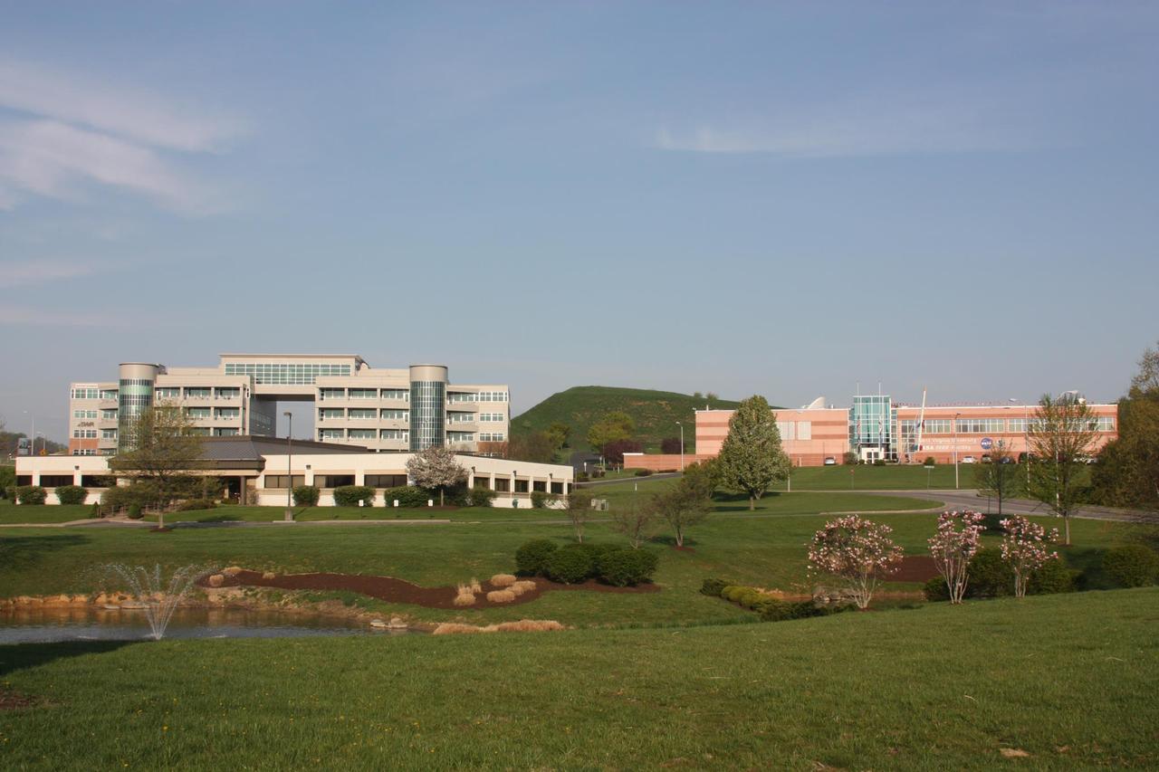
NASA's Katherine Johnson Independent Verification and Validation Facility in Fairmont, West Virginia. Credit: NASA

In this 30 second exposure, a meteor streaks across the sky during the annual Perseid meteor shower, Tuesday, Aug. 10, 2021, in Spruce Knob, West Virginia. Photo Credit: (NASA/Bill Ingalls)

In this 30 second exposure, a meteor streaks across the sky during the annual Perseid meteor shower, Wednesday, Aug. 11, 2021, in Spruce Knob, West Virginia. Photo Credit: (NASA/Bill Ingalls)

In this 30 second exposure, a meteor streaks across the sky during the annual Perseid meteor shower, Wednesday, Aug. 11, 2021, in Spruce Knob, West Virginia. Photo Credit: (NASA/Bill Ingalls)

In this 30 second exposure, a meteor streaks across the sky during the annual Perseid meteor shower, Wednesday, Aug. 11, 2021, in Spruce Knob, West Virginia. Photo Credit: (NASA/Bill Ingalls)
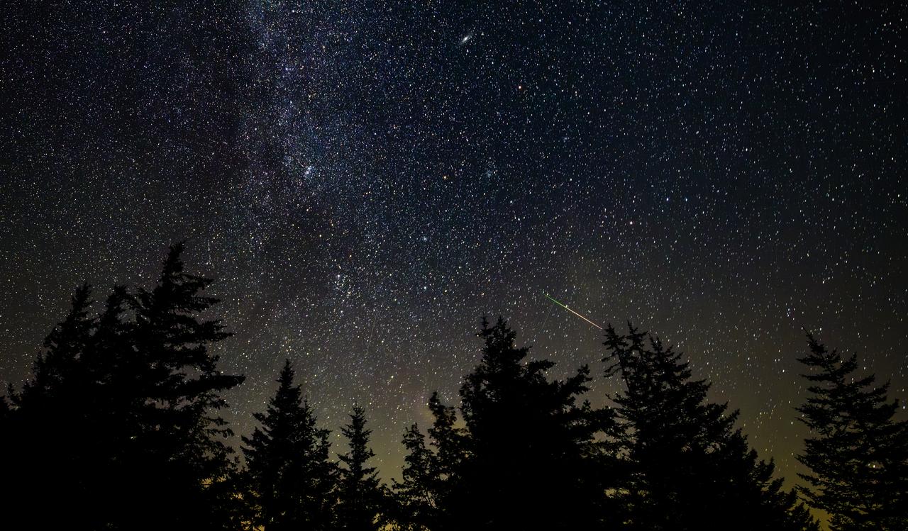
In this 30 second exposure photograph, a meteor streaks across the sky during the annual Perseid and Alpha Capricornids meteor showers, Sunday, Aug. 3, 2025, in Spruce Knob, West Virginia. Photo Credit: (NASA/Bill Ingalls)

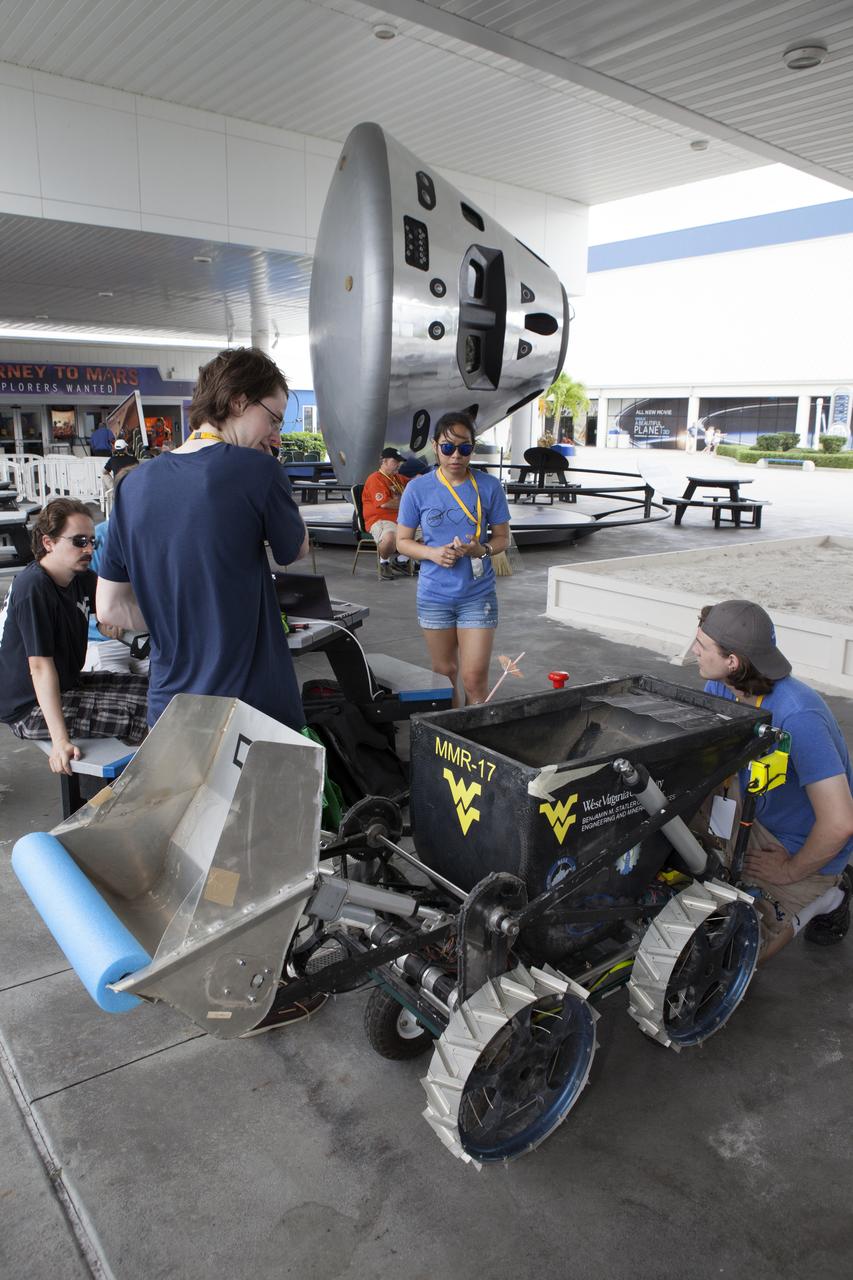
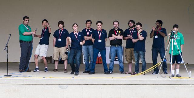
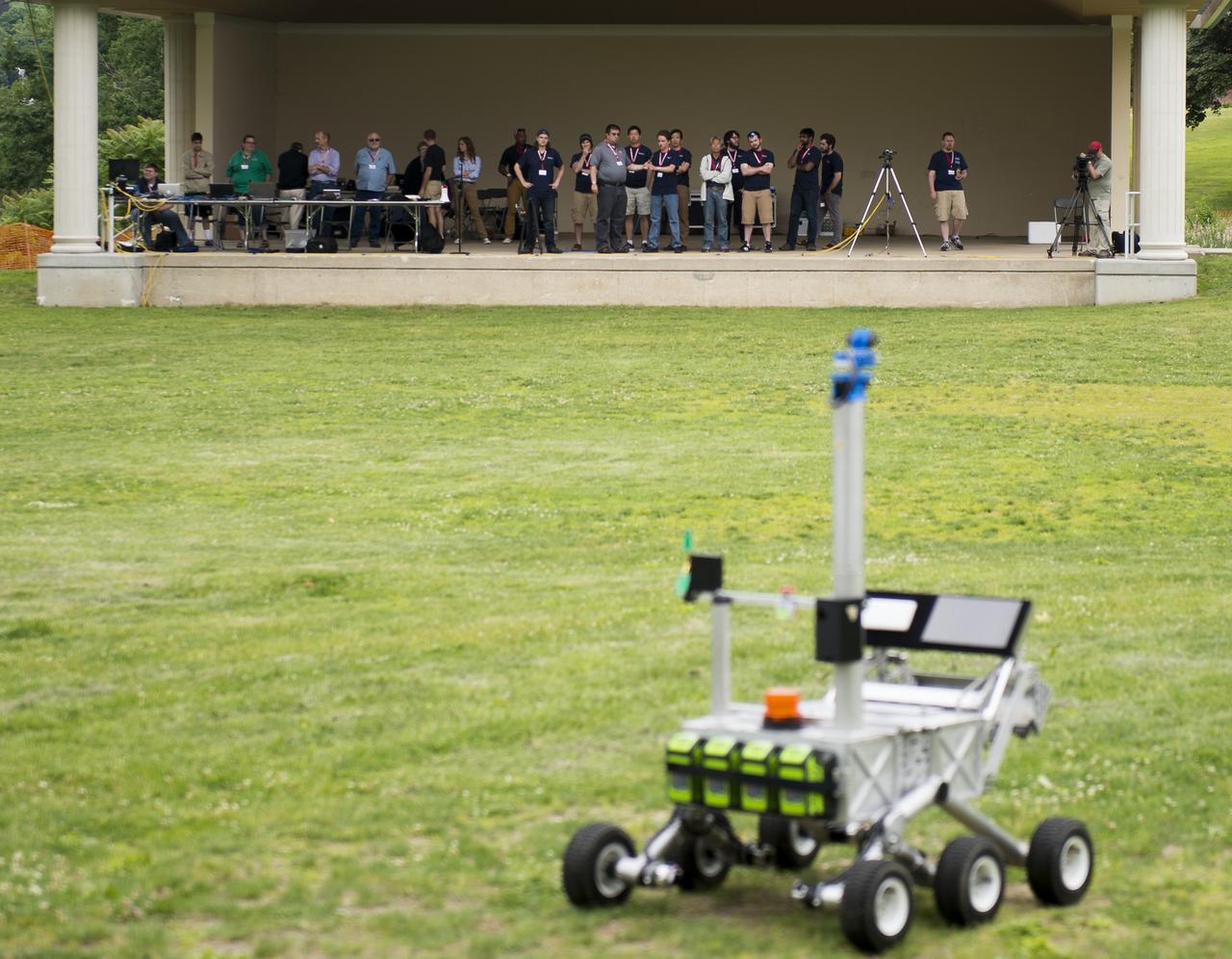
As the size of a satellite is scaled down to the form factor of a CubeSat, the hardware must scale down as well. Unfortunately, the software inside does not follow the same trend. Simulation-to-Flight 1 (STF-1) aims to solve this problem by providing a simulation of the CubeSat that can be used for developing and testing the software on any laptop or desktop computer. Additionally, STF-1 hosts payloads that aim to increase the accuracy of navigation for CubeSats, monitor Space Weather over the North and South Poles, and test the durability of new materials used for Light Emitting Diodes (LEDs). The first spacecraft built in the state of West Virginia, STF-1, is a collaborative effort between the NASA Independent Verification and Validation Program, West Virginia University, and West Virginia small businesses.

As the size of a satellite is scaled down to the form factor of a CubeSat, the hardware must scale down as well. Unfortunately, the software inside does not follow the same trend. Simulation-to-Flight 1 (STF-1) aims to solve this problem by providing a simulation of the CubeSat that can be used for developing and testing the software on any laptop or desktop computer. Additionally, STF-1 hosts payloads that aim to increase the accuracy of navigation for CubeSats, monitor Space Weather over the North and South Poles, and test the durability of new materials used for Light Emitting Diodes (LEDs). The first spacecraft built in the state of West Virginia, STF-1, is a collaborative effort between the NASA Independent Verification and Validation Program, West Virginia University, and West Virginia small businesses.

As the size of a satellite is scaled down to the form factor of a CubeSat, the hardware must scale down as well. Unfortunately, the software inside does not follow the same trend. Simulation-to-Flight 1 (STF-1) aims to solve this problem by providing a simulation of the CubeSat that can be used for developing and testing the software on any laptop or desktop computer. Additionally, STF-1 hosts payloads that aim to increase the accuracy of navigation for CubeSats, monitor Space Weather over the North and South Poles, and test the durability of new materials used for Light Emitting Diodes (LEDs). The first spacecraft built in the state of West Virginia, STF-1, is a collaborative effort between the NASA Independent Verification and Validation Program, West Virginia University, and West Virginia small businesses.
NASA Research Specialist Michael Brandon, left, demonstrates a visualization tool to NASA Acting Chief Technologist Douglas Terrier during the Boy Scouts of America National Jamboree, Tuesday, July 25, 2017 at the Summit Bechtel Reserve in Glen Jean, West Virginia. Photo Credit: (NASA/Bill Ingalls)
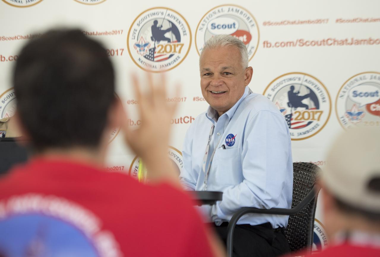
NASA Acting Chief Technologist Douglas Terrier leads a discussion titled “NASA Technologies for Explorers on Earth” during the Boy Scouts of America National Jamboree, Tuesday, July 25, 2017 at the Summit Bechtel Reserve in Glen Jean, West Virginia. Photo Credit: (NASA/Bill Ingalls)
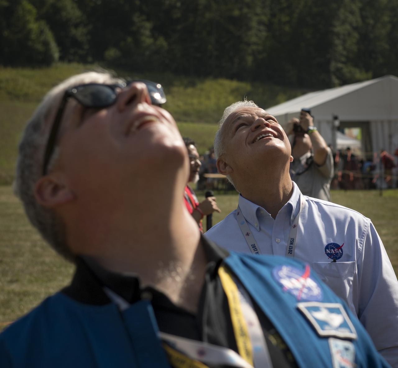
Greg “Box” Johnson, executive director of Center for the Advancement of Science in Space (CASIS) and former astronaut, foreground, and NASA Acting Chief Technologist Douglas Terrier watch as attendees of the Boy Scouts of America National Jamboree launch a weather balloon, Tuesday, July 25, 2017 at the Summit Bechtel Reserve in Glen Jean, West Virginia. Photo Credit: (NASA/Bill Ingalls)
Earth observation taken during a day pass by the Expedition 37 crew. Per Twitter message: Early morning fog in the river valleys of Ohio and West Virginia.
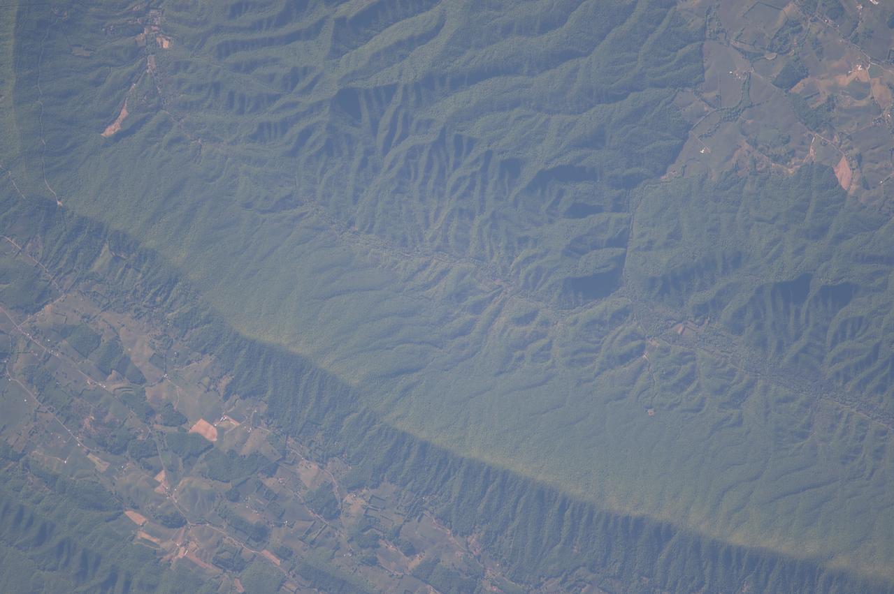
STS073-728-010 (22 October 1995) --- Photographed by the astronauts aboard the Space Shuttle Columbia orbiting at 146 nautical miles above Earth is this scene over West Virginia featuring the Appalachian Mountains. Center point coordinates are 37.5 degrees north latitude and 80.5 degrees west longitude.
iss070e132878 (March 31, 2024) --- Expedition 70 Flight Engineers (from left) Mike Barratt, Matthew Dominick, and Loral O'Hara participate in an Earth photography session inside the cupola, the International Space Station's "window to the world." The orbital complex was soaring 259 miles above West Virginia in the United States at the time of this photograph.
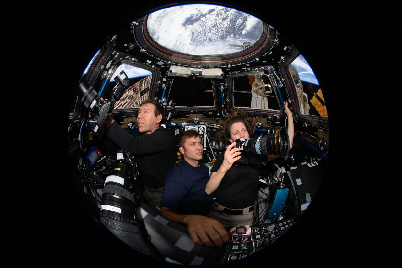
iss070e132878 (March 31, 2024) --- Expedition 70 Flight Engineers (from left) Mike Barratt, Matthew Dominick, and Loral O'Hara participate in an Earth photography session inside the cupola, the International Space Station's "window to the world." The orbital complex was soaring 259 miles above West Virginia in the United States at the time of this photograph.
ISS043E249636 (05/24/2015) --- The southern US state of West Virginia was captured by cameras aboard the International Space Station and NASA astronaut Scott Kelly tweeted it out with this comment: "Good morning #WestVirginia! It looks like if you were pounded flat you'd be bigger than Texas. #YearInSpace".
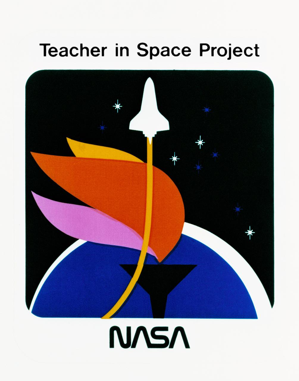
S85-38312 (September 1985) --- Logo designed for use by the 10 finalists in NASA’s Teacher in Space Project, who were at JSC for training and orientation the week of July 8–12, 1985. They are David M. Marquart, Boise High, Boise, Idaho; Michael W. Metcalf, Hazen Union School, Hardwick, Vermont; Judith Marie Garcia, Thomas Jefferson School for Science and Technology, Alexandria, Virginia; Peggy J. Lathlaen, Westwood Elementary, Friendswood, Texas; Niki Mason Wenger, Vandevender Junior High, Parkersburg, West Virginia; Barbara R. Morgan, McCall-Donnelly Elementary, McCall, Idaho; Kathleen Anne Beres, Kenwood High, Baltimore, Maryland; Richard A. Methia, New Bedford High, New Bedford, Mass.; Sharon Christa McAuliffe, Concord High, Concord, New Hampshire; and Robert S. Foerster, Cumberland Elementary School, West Lafayette, Indiana. Photo credit: NASA
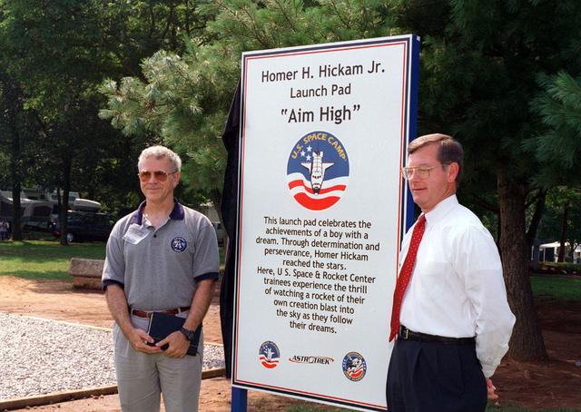
Noted author and previous Marshall Space Flight Center employee Mr. Homer Hickam Jr. poses in front of a placque commemorating his achievement in realizing his dreams of becoming a rocket scientist. The dedication site is located at the U. S. Space and Rocket Center in Huntsville, AL, and is used by amature rocket builders attending the Space Camp to launch their self-made rockets like Mr. Hickam did as a youth growing up in rural West Virginia. Posing with Mr. Hickam is the Madison County Commissioner Mr. Mike Gillispie.
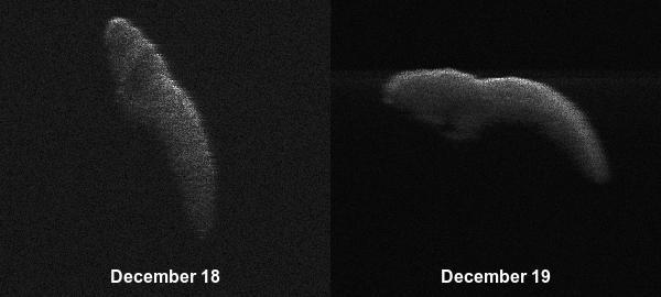
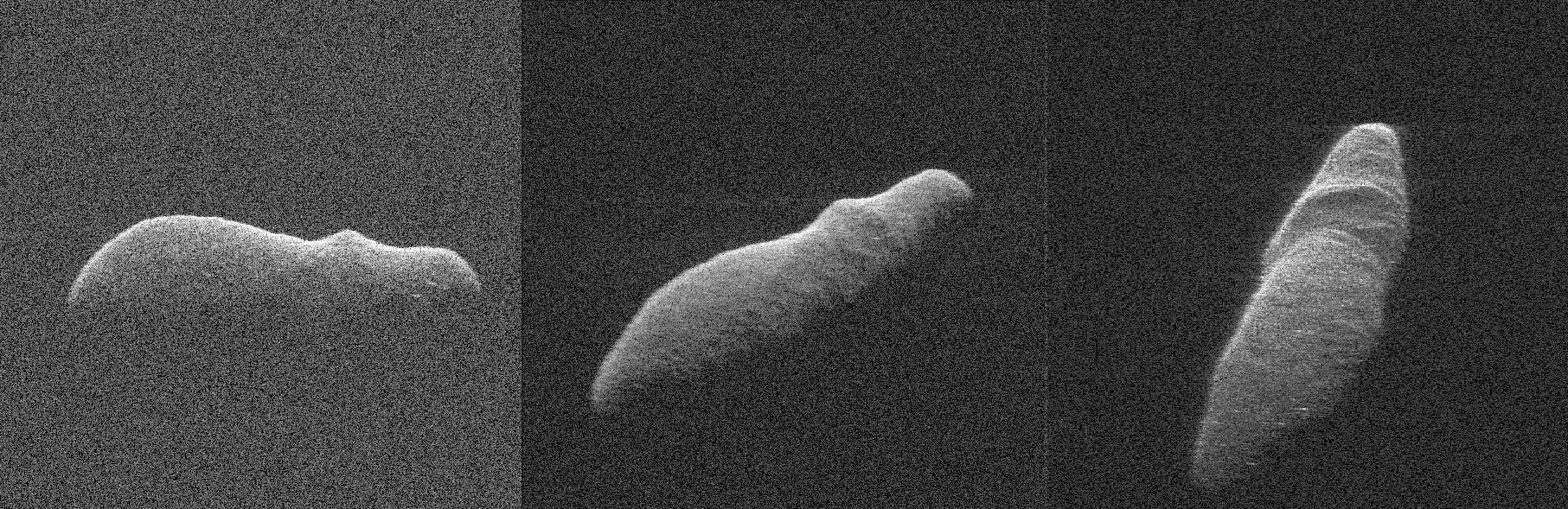
These two radar images of near-Earth asteroid 2003 SD220 were obtained on Dec. 18 and 19 by coordinating observations with the Arecibo Observatory's 1,000-foot (305-meter) antenna in Puerto Rico and the National Science Foundation's (NSF) 330-foot (100-meter) Green Bank Telescope in West Virginia. The radar images reveal the asteroid is at least one mile (1.6 kilometers) long. https://photojournal.jpl.nasa.gov/catalog/PIA22969
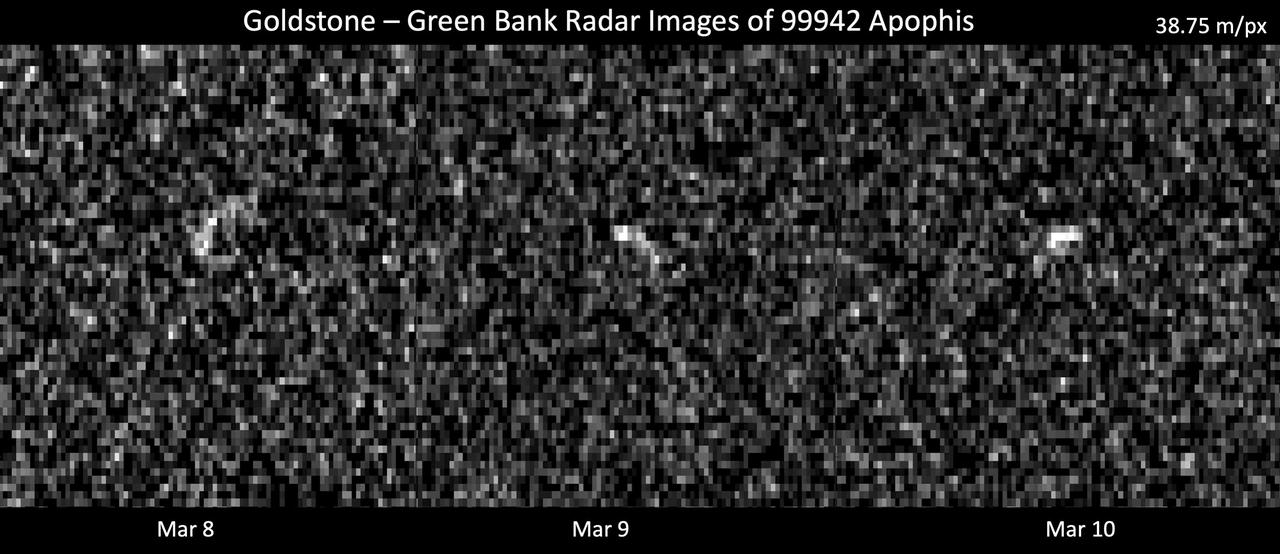
These images represent radar observations of asteroid 99942 Apophis on March 8, 9, and 10, 2021, as it made its last close approach before its 2029 Earth encounter that will see the object pass our planet by less than 20,000 miles (32,000 kilometers). The 70-meter radio antenna at the Deep Space Network's Goldstone Deep Space Communications Complex near Barstow, California, and the 100-meter Green Bank Telescope in West Virginia used radar to precisely track Apophis' motion. At the time of these observations, Apophis was about 10.6 million miles (17 million kilometers) from Earth, and each pixel has a resolution of 127 feet (38.75 meters). These observations helped scientists of the Center for Near Earth Object Studies (CNEOS), managed by NASA's Jet Propulsion Laboratory, precisely determine the 1,100-feet-wide (340-meter-wide) asteroid's orbit around the Sun, ruling out any Earth impact threat for the next hundred years or more. As a result of these observations, Apophis was removed from the Sentry Impact Risk Table. The radar team will continue to analyze these observations to determine more information about Apophis' size, shape, and rate of spin. Relying on optical telescopes and ground-based radar to help characterize every near-Earth object's orbit to improve long-term hazard assessments, CNEOS computes high-precision orbits in support of NASA's Planetary Defense Coordination Office. https://photojournal.jpl.nasa.gov/catalog/PIA24168
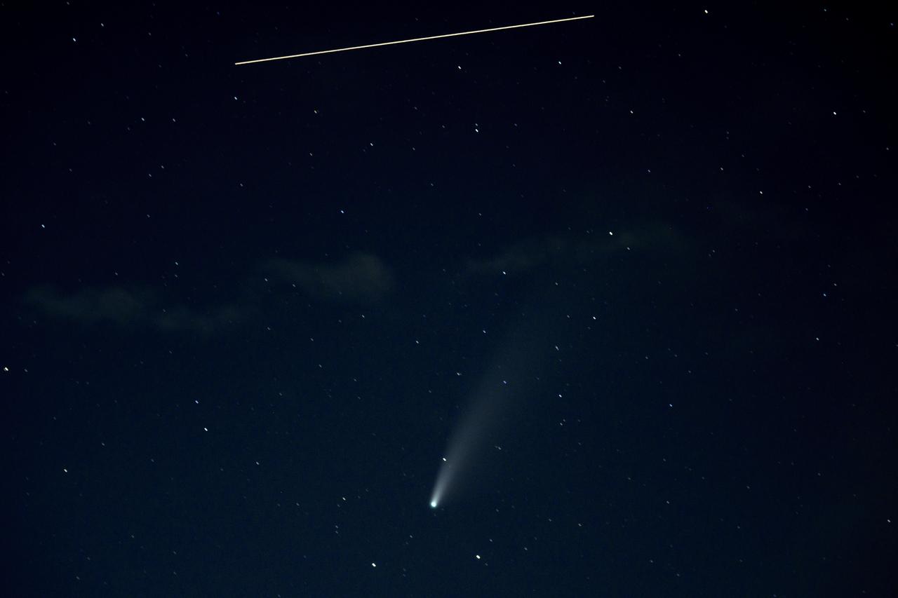
The International Space Station, with a crew of five onboard, is seen in this 10 second exposure above comet NEOWISE, Saturday, July 18, 2020 from Keys Gap, W.Va. The comet was discovered by NASA’s Near-Earth Object Wide-field Infrared Survey Explorer, or NEOWISE, on March 27. Since then, the comet — called comet C/2020 F3 NEOWISE and nicknamed comet NEOWISE — has been spotted by several NASA spacecraft, including Parker Solar Probe, NASA’s Solar and Terrestrial Relations Observatory, the ESA/NASA Solar and Heliospheric Observatory, and astronauts aboard the International Space Station. Onboard the International Space Station are Expedition 63 NASA astronauts Chris Cassidy, Douglas Hurley, Robert Behnken, and Roscosmos cosmonauts Anatoly Ivanishin and Ivan Vagner. Photo Credit: (NASA/Bill Ingalls)

The Florida Keys are a chain of islands, islets and reefs extending from Virginia Key to the Dry Tortugas for about 309 kilometers (192 miles). The keys are chiefly limestone and coral formations. The larger islands of the group are Key West (with its airport), Key Largo, Sugarloaf Key, and Boca Chica Key. A causeway extends from the mainland to Key West. This image was acquired on October 28, 2001, by the Advanced Spaceborne Thermal Emission and Reflection Radiometer (ASTER) on NASA's Terra satellite. With its 14 spectral bands from the visible to the thermal infrared wavelength region, and its high spatial resolution of 15 to 90 meters (about 50 to 300 feet), ASTER images Earth to map and monitor the changing surface of our planet. http://photojournal.jpl.nasa.gov/catalog/PIA03890

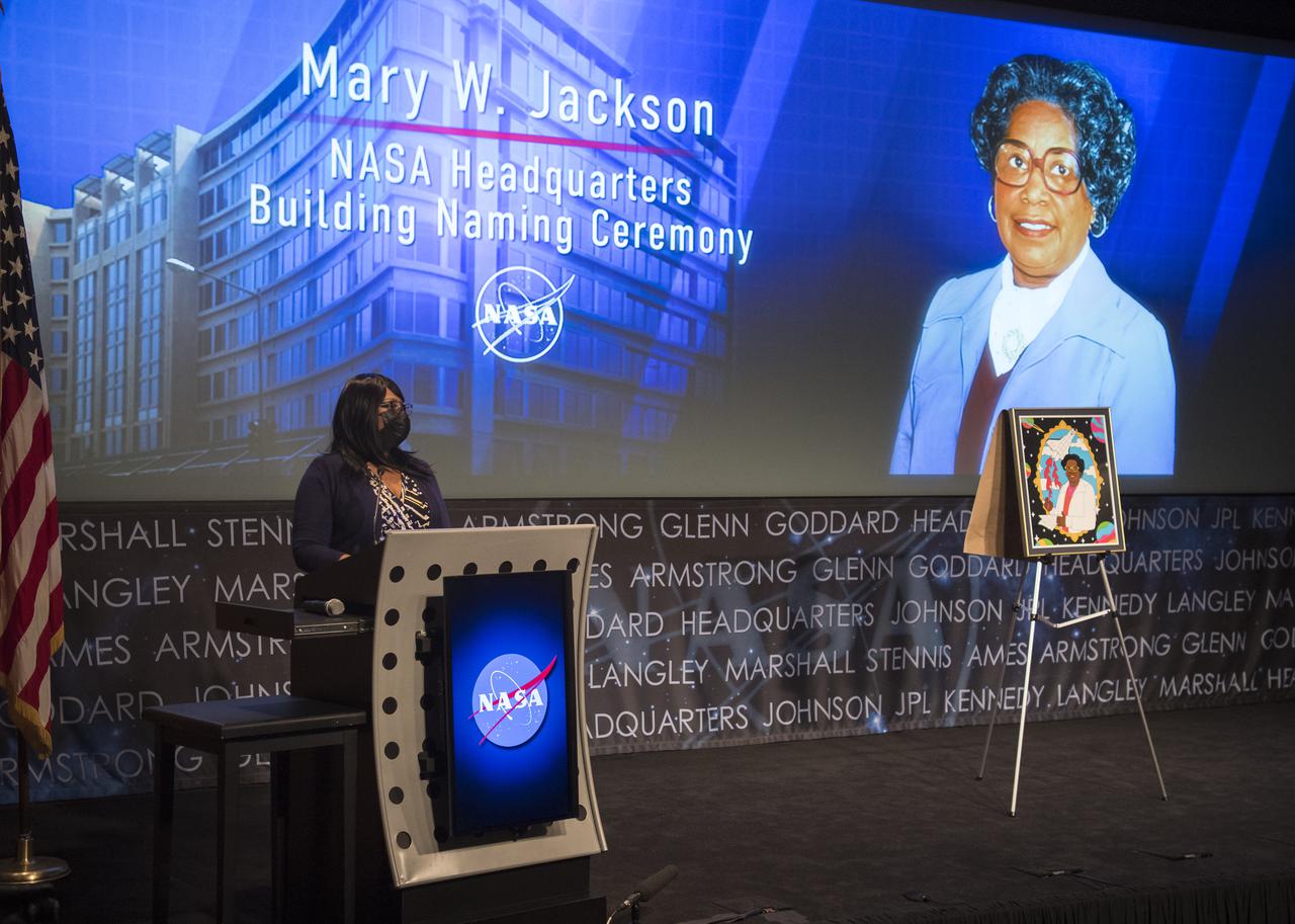
Artist Tenbeete Solomon, also known as Trap Bob, speaks during a ceremony officially naming the NASA Headquarters building in honor of Mary W. Jackson, Friday, Feb. 26, 2021, at NASA Headquarters in Washington, DC. Mary W. Jackson, the first African American female engineer at NASA, began her career with the agency in the segregated West Area Computing Unit of NASA’s Langley Research Center in Hampton, Virginia. The mathematician and aerospace engineer went on to lead programs influencing the hiring and promotion of women in NASA's science, technology, engineering, and mathematics careers. In 2019, she posthumously received the Congressional Gold Medal. Photo Credit: (NASA/Joel Kowsky)
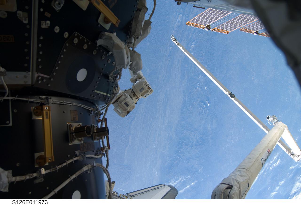
S126-E-011973 (26 Nov. 2008) --- The Canadian-built Orbiter Boom Sensor System (OBSS), in its parked position, and part of the International Space Station are featured in this image, photographed over the Blue Ridge Mountains of West Virginia and Tennessee by one of the Endeavour crew members on the eve of Thanksgiving. The OBSS, on the end of the Canadarm, awaits the final part of its STS-126 role when it will inspect the shuttle one more time, following separation of the orbiter from the space station in a couple of days. When that task is complete, it will be stowed across the payload bay from the robot arm.

Wanda Jackson, granddaughter of Mary W. Jackson, speaks during a ceremony officially naming the NASA Headquarters building in honor of Mary W. Jackson, Friday, Feb. 26, 2021, at NASA Headquarters in Washington, DC. Mary W. Jackson, the first African American female engineer at NASA, began her career with the agency in the segregated West Area Computing Unit of NASA’s Langley Research Center in Hampton, Virginia. The mathematician and aerospace engineer went on to lead programs influencing the hiring and promotion of women in NASA's science, technology, engineering, and mathematics careers. In 2019, she posthumously received the Congressional Gold Medal. Photo Credit: (NASA/Joel Kowsky)

Bryan Jackson, grandson of Mary W. Jackson, speaks during a ceremony officially naming the NASA Headquarters building in honor of Mary W. Jackson, Friday, Feb. 26, 2021, at NASA Headquarters in Washington, DC. Mary W. Jackson, the first African American female engineer at NASA, began her career with the agency in the segregated West Area Computing Unit of NASA’s Langley Research Center in Hampton, Virginia. The mathematician and aerospace engineer went on to lead programs influencing the hiring and promotion of women in NASA's science, technology, engineering, and mathematics careers. In 2019, she posthumously received the Congressional Gold Medal. Photo Credit: (NASA/Joel Kowsky)

The Mary W. Jackson NASA Headquarters sign is installed ahead of the building naming ceremony, Thursday, Feb. 25, 2021, at NASA Headquarters in Washington, DC. Mary W. Jackson, the first African American female engineer at NASA, began her career with the agency in the segregated West Area Computing Unit of NASA’s Langley Research Center in Hampton, Virginia. The mathematician and aerospace engineer went on to lead programs influencing the hiring and promotion of women in NASA's science, technology, engineering, and mathematics careers. In 2019, she posthumously received the Congressional Gold Medal. Photo Credit: (NASA/Joel Kowsky)

The Mary W. Jackson NASA Headquarters sign is installed ahead of the building naming ceremony, Thursday, Feb. 25, 2021, at NASA Headquarters in Washington, DC. Mary W. Jackson, the first African American female engineer at NASA, began her career with the agency in the segregated West Area Computing Unit of NASA’s Langley Research Center in Hampton, Virginia. The mathematician and aerospace engineer went on to lead programs influencing the hiring and promotion of women in NASA's science, technology, engineering, and mathematics careers. In 2019, she posthumously received the Congressional Gold Medal. Photo Credit: (NASA/Joel Kowsky)

The Mary W. Jackson NASA Headquarters sign is installed ahead of the building naming ceremony, Thursday, Feb. 25, 2021, at NASA Headquarters in Washington, DC. Mary W. Jackson, the first African American female engineer at NASA, began her career with the agency in the segregated West Area Computing Unit of NASA’s Langley Research Center in Hampton, Virginia. The mathematician and aerospace engineer went on to lead programs influencing the hiring and promotion of women in NASA's science, technology, engineering, and mathematics careers. In 2019, she posthumously received the Congressional Gold Medal. Photo Credit: (NASA/Joel Kowsky)

Christine Darden, retired NASA engineer and "Hidden Figure,” speaks during a ceremony officially naming the NASA Headquarters building in honor of Mary W. Jackson, Friday, Feb. 26, 2021, at NASA Headquarters in Washington, DC. Mary W. Jackson, the first African American female engineer at NASA, began her career with the agency in the segregated West Area Computing Unit of NASA’s Langley Research Center in Hampton, Virginia. The mathematician and aerospace engineer went on to lead programs influencing the hiring and promotion of women in NASA's science, technology, engineering, and mathematics careers. In 2019, she posthumously received the Congressional Gold Medal. Photo Credit: (NASA/Joel Kowsky)
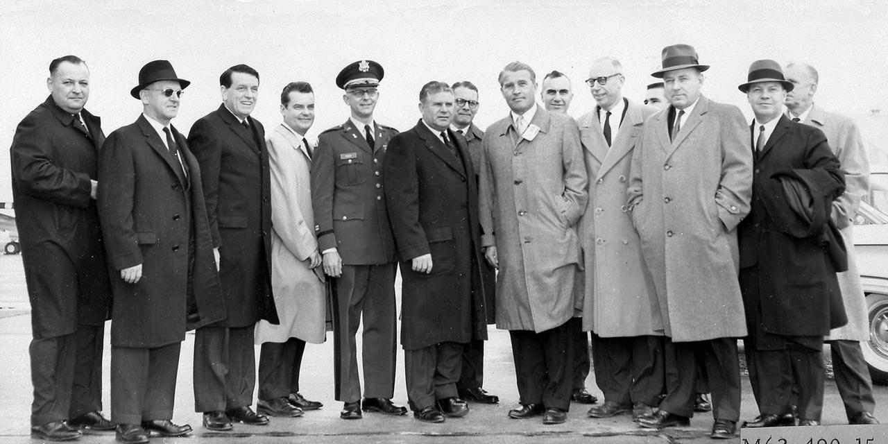
The members of the House Committee on Science and Astronautics visited the Marshall Space Flight Center (MSFC) on March 9, 1962 to gather first-hand information of the nation's space exploration program. The congressional group was composed of members of the Subcommittee on Marned Space Flight. Headed by Representative Olin E. Teague of Texas, other members were James G. Fulton, Pennsylvania; Ken Heckler, West Virginia; R. Walter Riehlman, New York; Richard L. Roudebush,, Indiana; John W. Davis, Georgia; James C. Corman, California; Joseph Waggoner, Louisiana; J. Edgar Chenoweth, Colorado; and William G. Bray, Indiana.
Wanda Jackson, granddaughter of Mary W. Jackson, speaks during a ceremony officially naming the NASA Headquarters building in honor of Mary W. Jackson, Friday, Feb. 26, 2021, at NASA Headquarters in Washington, DC. Mary W. Jackson, the first African American female engineer at NASA, began her career with the agency in the segregated West Area Computing Unit of NASA’s Langley Research Center in Hampton, Virginia. The mathematician and aerospace engineer went on to lead programs influencing the hiring and promotion of women in NASA's science, technology, engineering, and mathematics careers. In 2019, she posthumously received the Congressional Gold Medal. Photo Credit: (NASA/Joel Kowsky)
STS078-760-010 (20 June - 7 July 1996) --- As photographed with color infrared film by the crew of the Space Shuttle Columbia, the capital of the United States of America (the right of center) is located at the head of the navigable portion of the Potomac River. The Potomac separates the capital from Virginia to the southwest. It covers an area of 68-square-mile (177-square-kilometers). Andrews Air Force Base is seen east southwest of Washington D.C. at the right edge of the photo. Dulles International Airport is located west of the city on the left edge of the photo. Green vegetation shows up as red in the color infrared image.

Clayton Turner, Director of NASA's Langley Research Center, speaks during a ceremony officially naming the NASA Headquarters building in honor of Mary W. Jackson, Friday, Feb. 26, 2021, at NASA Headquarters in Washington, DC. Mary W. Jackson, the first African American female engineer at NASA, began her career with the agency in the segregated West Area Computing Unit of NASA’s Langley Research Center in Hampton, Virginia. The mathematician and aerospace engineer went on to lead programs influencing the hiring and promotion of women in NASA's science, technology, engineering, and mathematics careers. In 2019, she posthumously received the Congressional Gold Medal. Photo Credit: (NASA/Joel Kowsky)
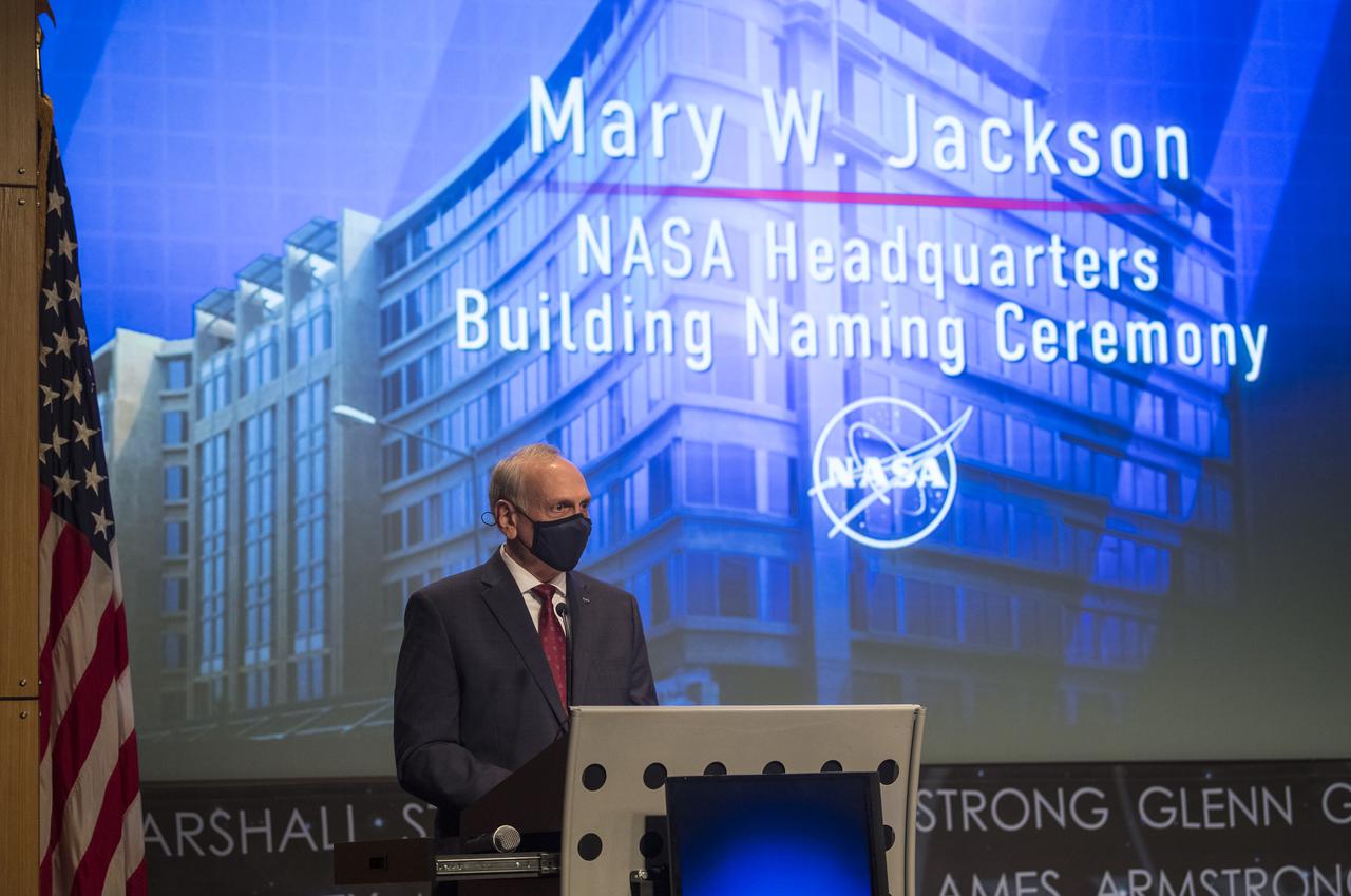
Acting NASA Administrator Steve Jurzyck speaks during a ceremony officially naming the NASA Headquarters building in honor of Mary W. Jackson, Friday, Feb. 26, 2021, at NASA Headquarters in Washington, DC. Mary W. Jackson, the first African American female engineer at NASA, began her career with the agency in the segregated West Area Computing Unit of NASA’s Langley Research Center in Hampton, Virginia. The mathematician and aerospace engineer went on to lead programs influencing the hiring and promotion of women in NASA's science, technology, engineering, and mathematics careers. In 2019, she posthumously received the Congressional Gold Medal. Photo Credit: (NASA/Joel Kowsky)

Rep. Bobby Scott (D-Va.), is seen onscreen in a pre-recorded message during a ceremony officially naming the NASA Headquarters building in honor of Mary W. Jackson, Friday, Feb. 26, 2021, at NASA Headquarters in Washington, DC. Mary W. Jackson, the first African American female engineer at NASA, began her career with the agency in the segregated West Area Computing Unit of NASA’s Langley Research Center in Hampton, Virginia. The mathematician and aerospace engineer went on to lead programs influencing the hiring and promotion of women in NASA's science, technology, engineering, and mathematics careers. In 2019, she posthumously received the Congressional Gold Medal. Photo Credit: (NASA/Joel Kowsky)

Wanda Jackson, granddaughter of Mary W. Jackson, speaks during a ceremony officially naming the NASA Headquarters building in honor of Mary W. Jackson, Friday, Feb. 26, 2021, at NASA Headquarters in Washington, DC. Mary W. Jackson, the first African American female engineer at NASA, began her career with the agency in the segregated West Area Computing Unit of NASA’s Langley Research Center in Hampton, Virginia. The mathematician and aerospace engineer went on to lead programs influencing the hiring and promotion of women in NASA's science, technology, engineering, and mathematics careers. In 2019, she posthumously received the Congressional Gold Medal. Photo Credit: (NASA/Joel Kowsky)
The members of the House Committee on Science and Astronautics visited the Marshall Space Flight Center (MSFC) on March 9, 1962 to gather first-hand information of the nation's space exploration program. The congressional group was composed of members of the Subcommittee on Marned Space Flight. Headed by Representative Olin E. Teague of Texas, other members were James G. Fulton, Pennsylvania; Ken Heckler, West Virginia; R. Walter Riehlman, New York; Richard L. Roudebush, Indiana; John W. Davis, Georgia; James C. Corman, California; Joseph Waggoner, Louisiana; J. Edgar Chenoweth, Colorado; and William G. Bray, Indiana.

Yolanda Shea, a physical research scientist at NASA's Langley Research Center, speaks during a ceremony officially naming the NASA Headquarters building in honor of Mary W. Jackson, Friday, Feb. 26, 2021, at NASA Headquarters in Washington, DC. Mary W. Jackson, the first African American female engineer at NASA, began her career with the agency in the segregated West Area Computing Unit of NASA’s Langley Research Center in Hampton, Virginia. The mathematician and aerospace engineer went on to lead programs influencing the hiring and promotion of women in NASA's science, technology, engineering, and mathematics careers. In 2019, she posthumously received the Congressional Gold Medal. Photo Credit: (NASA/Joel Kowsky)
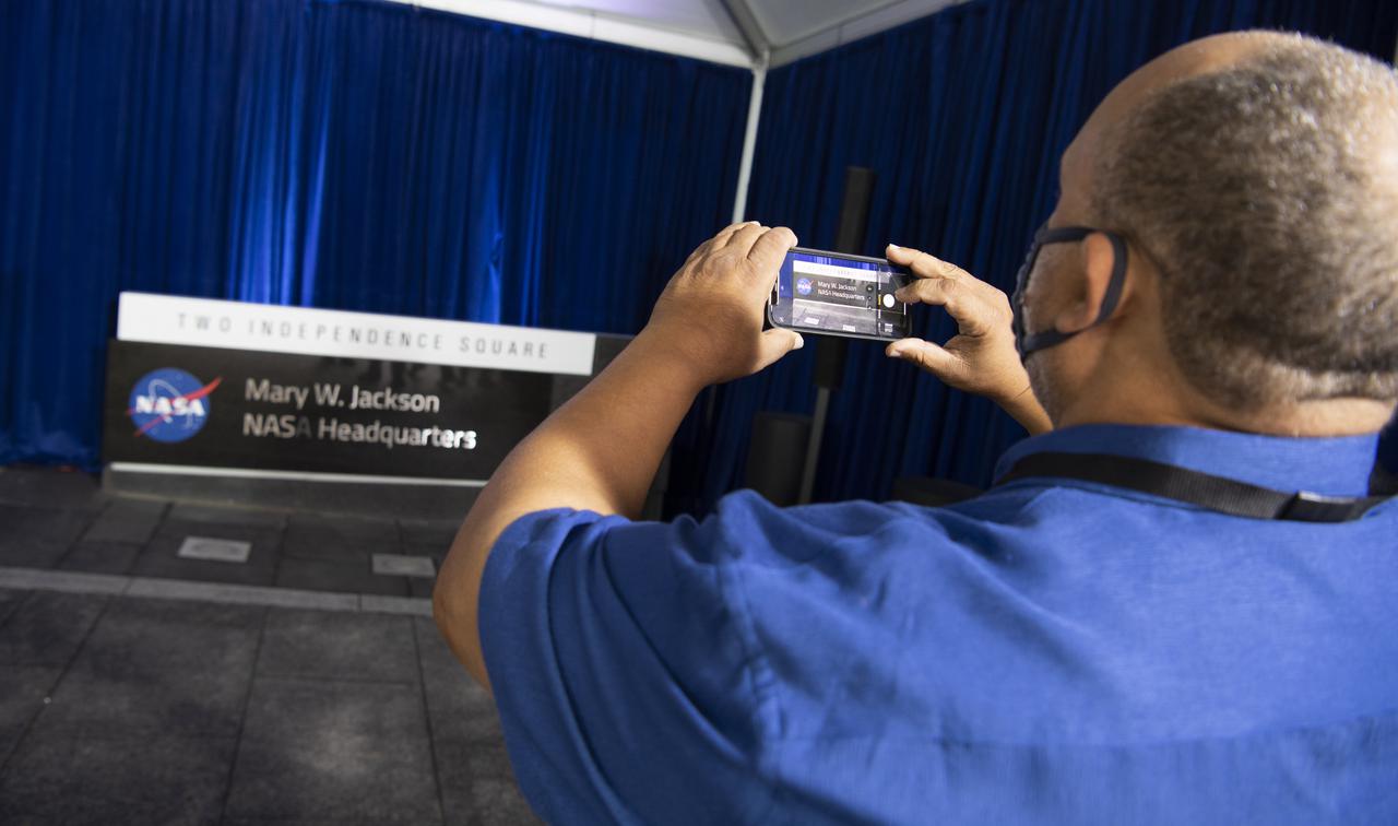
Raymond Lewis, son-in-law of Mary W. Jackson, takes a picture of the Mary W. Jackson NASA Headquarters sign following a ceremony officially naming the building, Friday, Feb. 26, 2021, at NASA Headquarters in Washington, DC. Mary W. Jackson, the first African American female engineer at NASA, began her career with the agency in the segregated West Area Computing Unit of NASA’s Langley Research Center in Hampton, Virginia. The mathematician and aerospace engineer went on to lead programs influencing the hiring and promotion of women in NASA's science, technology, engineering, and mathematics careers. In 2019, she posthumously received the Congressional Gold Medal. Photo Credit: (NASA/Joel Kowsky)

Clayton Turner, Director of NASA's Langley Research Center, speaks during a ceremony officially naming the NASA Headquarters building in honor of Mary W. Jackson, Friday, Feb. 26, 2021, at NASA Headquarters in Washington, DC. Mary W. Jackson, the first African American female engineer at NASA, began her career with the agency in the segregated West Area Computing Unit of NASA’s Langley Research Center in Hampton, Virginia. The mathematician and aerospace engineer went on to lead programs influencing the hiring and promotion of women in NASA's science, technology, engineering, and mathematics careers. In 2019, she posthumously received the Congressional Gold Medal. Photo Credit: (NASA/Joel Kowsky)

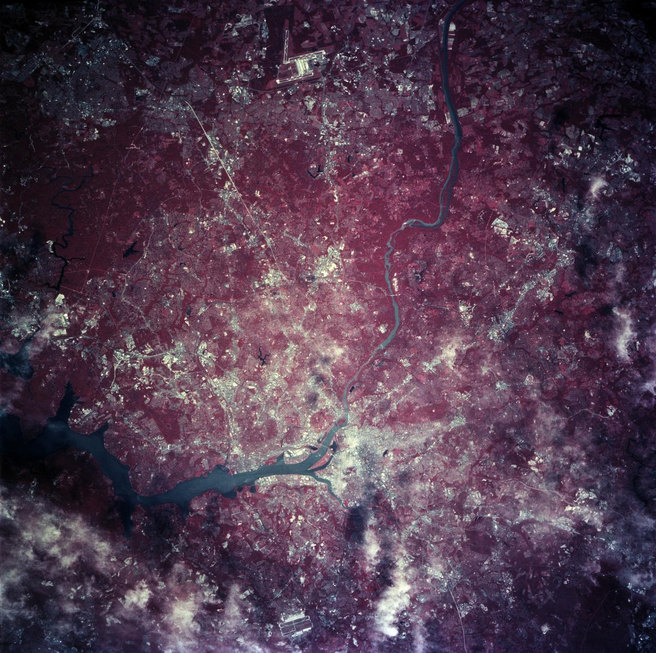
ISS013-E-13549 (2 May 2006) --- Washington, DC is featured in this image photographed by an Expedition 13 crewmember on the International Space Station. When the image was exposed, the orbital outpost was located over the western border of Maryland and West Virginia. The resolution and extent of the true-color, handheld image is similar to the 15-meter/pixel data obtained by sensors onboard the unmanned Landsat-7 and Terra satellites. This resolution is sufficient to capture the sunglint off the Capitol Building's dome. Other major landmarks that are visible include the Washington Monument, the Pentagon (bottom left, southwest of the Potomac River), and the Lincoln Memorial, along the northwest bank of the Potomac.

Christine Darden, retired NASA engineer and "Hidden Figure,” speaks during a ceremony officially naming the NASA Headquarters building in honor of Mary W. Jackson, Friday, Feb. 26, 2021, at NASA Headquarters in Washington, DC. Mary W. Jackson, the first African American female engineer at NASA, began her career with the agency in the segregated West Area Computing Unit of NASA’s Langley Research Center in Hampton, Virginia. The mathematician and aerospace engineer went on to lead programs influencing the hiring and promotion of women in NASA's science, technology, engineering, and mathematics careers. In 2019, she posthumously received the Congressional Gold Medal. Photo Credit: (NASA/Joel Kowsky)

Bryan Jackson, grandson of Mary W. Jackson, speaks during a ceremony officially naming the NASA Headquarters building in honor of Mary W. Jackson, Friday, Feb. 26, 2021, at NASA Headquarters in Washington, DC. Mary W. Jackson, the first African American female engineer at NASA, began her career with the agency in the segregated West Area Computing Unit of NASA’s Langley Research Center in Hampton, Virginia. The mathematician and aerospace engineer went on to lead programs influencing the hiring and promotion of women in NASA's science, technology, engineering, and mathematics careers. In 2019, she posthumously received the Congressional Gold Medal. Photo Credit: (NASA/Joel Kowsky)

Deputy Mayor Lucinda M. Babers speaks during a ceremony officially naming the NASA Headquarters building in honor of Mary W. Jackson, Friday, Feb. 26, 2021, at NASA Headquarters in Washington, DC. Mary W. Jackson, the first African American female engineer at NASA, began her career with the agency in the segregated West Area Computing Unit of NASA’s Langley Research Center in Hampton, Virginia. The mathematician and aerospace engineer went on to lead programs influencing the hiring and promotion of women in NASA's science, technology, engineering, and mathematics careers. In 2019, she posthumously received the Congressional Gold Medal. Photo Credit: (NASA/Joel Kowsky)

Acting NASA Administrator Steve Jurzyck speaks during a ceremony officially naming the NASA Headquarters building in honor of Mary W. Jackson, Friday, Feb. 26, 2021, at NASA Headquarters in Washington, DC. Mary W. Jackson, the first African American female engineer at NASA, began her career with the agency in the segregated West Area Computing Unit of NASA’s Langley Research Center in Hampton, Virginia. The mathematician and aerospace engineer went on to lead programs influencing the hiring and promotion of women in NASA's science, technology, engineering, and mathematics careers. In 2019, she posthumously received the Congressional Gold Medal. Photo Credit: (NASA/Joel Kowsky)
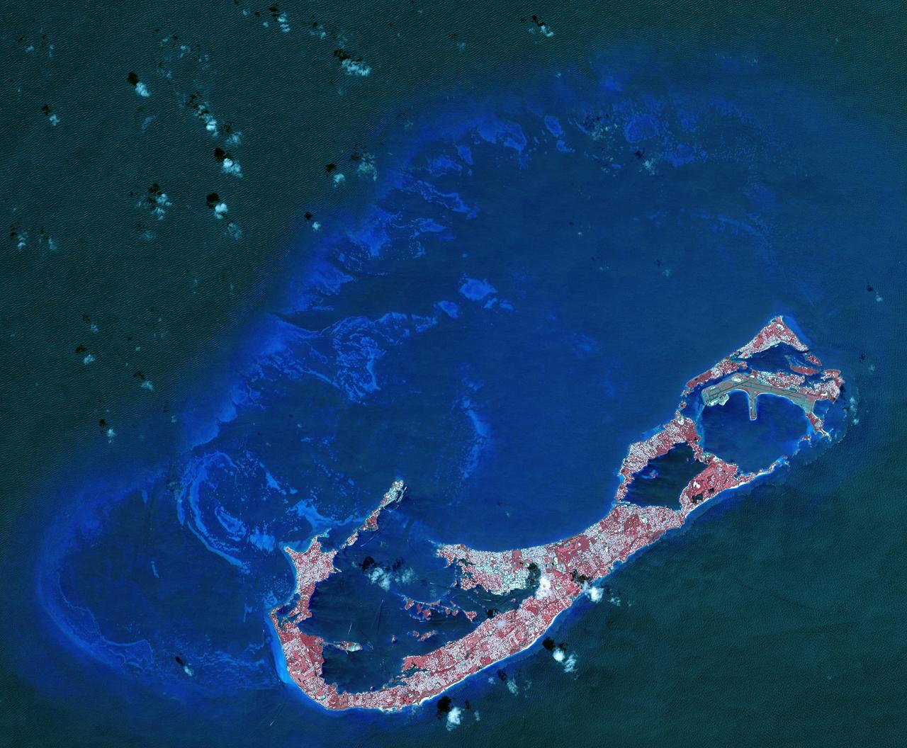
Bermuda is a British Overseas Territory in the western Atlantic off the east coast of North America. The uninhabited islands were first discovered in 1503 by the Spanish explorer Juan de Bermudez. In 1609 the English Virginia Colony settled Bermuda, and it has remained a British colony for over 400 years. Bermuda's economy is dominated by offshore insurance, and tourism, resulting in a very high GDP per capita. The image was acquired April 19, 2009, covers an area of 29.4 by 40.7 kilometers, and is located at 32.3 degrees north, 64.8 degrees west. http://photojournal.jpl.nasa.gov/catalog/PIA21315
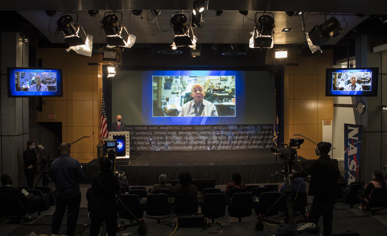
Poet Nikki Giovanni is seen onscreen in a pre-recorded video during a ceremony officially naming the NASA Headquarters building in honor of Mary W. Jackson, Friday, Feb. 26, 2021, at NASA Headquarters in Washington, DC. Mary W. Jackson, the first African American female engineer at NASA, began her career with the agency in the segregated West Area Computing Unit of NASA’s Langley Research Center in Hampton, Virginia. The mathematician and aerospace engineer went on to lead programs influencing the hiring and promotion of women in NASA's science, technology, engineering, and mathematics careers. In 2019, she posthumously received the Congressional Gold Medal. Photo Credit: (NASA/Joel Kowsky)

Acting NASA Administrator Steve Jurzyck speaks during a ceremony officially naming the NASA Headquarters building in honor of Mary W. Jackson, Friday, Feb. 26, 2021, at NASA Headquarters in Washington, DC. Mary W. Jackson, the first African American female engineer at NASA, began her career with the agency in the segregated West Area Computing Unit of NASA’s Langley Research Center in Hampton, Virginia. The mathematician and aerospace engineer went on to lead programs influencing the hiring and promotion of women in NASA's science, technology, engineering, and mathematics careers. In 2019, she posthumously received the Congressional Gold Medal. Photo Credit: (NASA/Joel Kowsky)

CAPE CANAVERAL, Fla. – Members of the West Virginia University color guard stand at attention during presentation of the U.S. Flag at the opening ceremony of NASA’s 2014 Robotics Mining Competition at the Kennedy Space Center Visitor Complex in Florida. More than 35 teams from around the U.S. have designed and built remote-controlled robots for the mining competition. The competition is a NASA Human Exploration and Operations Mission Directorate project designed to engage and retain students in science, technology, engineering and mathematics, or STEM, fields by expanding opportunities for student research and design. Teams use their remote-controlled robotics to maneuver and dig in a supersized sandbox filled with a crushed material that has characteristics similar to Martian soil. The objective of the challenge is to see which team’s robot can collect and move the most regolith within a specified amount of time. For more information, visit www.nasa.gov/nasarmc. Photo credit: NASA/Frankie Martin
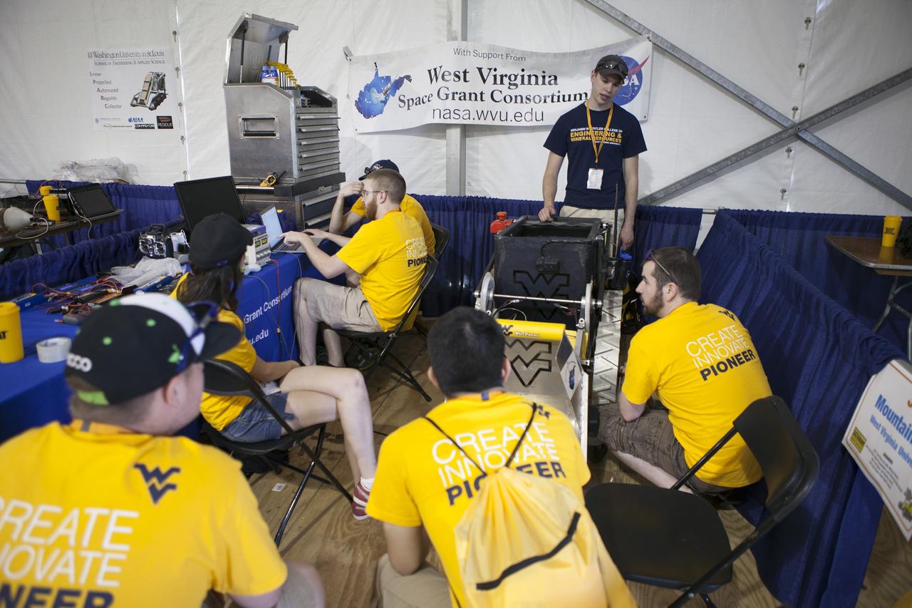
CAPE CANAVERAL, Fla. – Students from West Virginia University prepare their robot for NASA’s Robotics Mining Competition at the Kennedy Space Center Visitor Complex in Florida. More than 35 teams from around the U.S. have designed and built remote-controlled robots for the mining competition. The competition is a NASA Human Exploration and Operations Mission Directorate project designed to engage and retain students in science, technology, engineering and mathematics, or STEM, fields by expanding opportunities for student research and design. Teams use their remote-controlled robotics to maneuver and dig in a supersized sandbox filled with a crushed material that has characteristics similar to Martian soil. The objective of the challenge is to see which team’s robot can collect and move the most regolith within a specified amount of time. For more information, visit www.nasa.gov/nasarmc. Photo credit: NASA/Ben Smegelsky
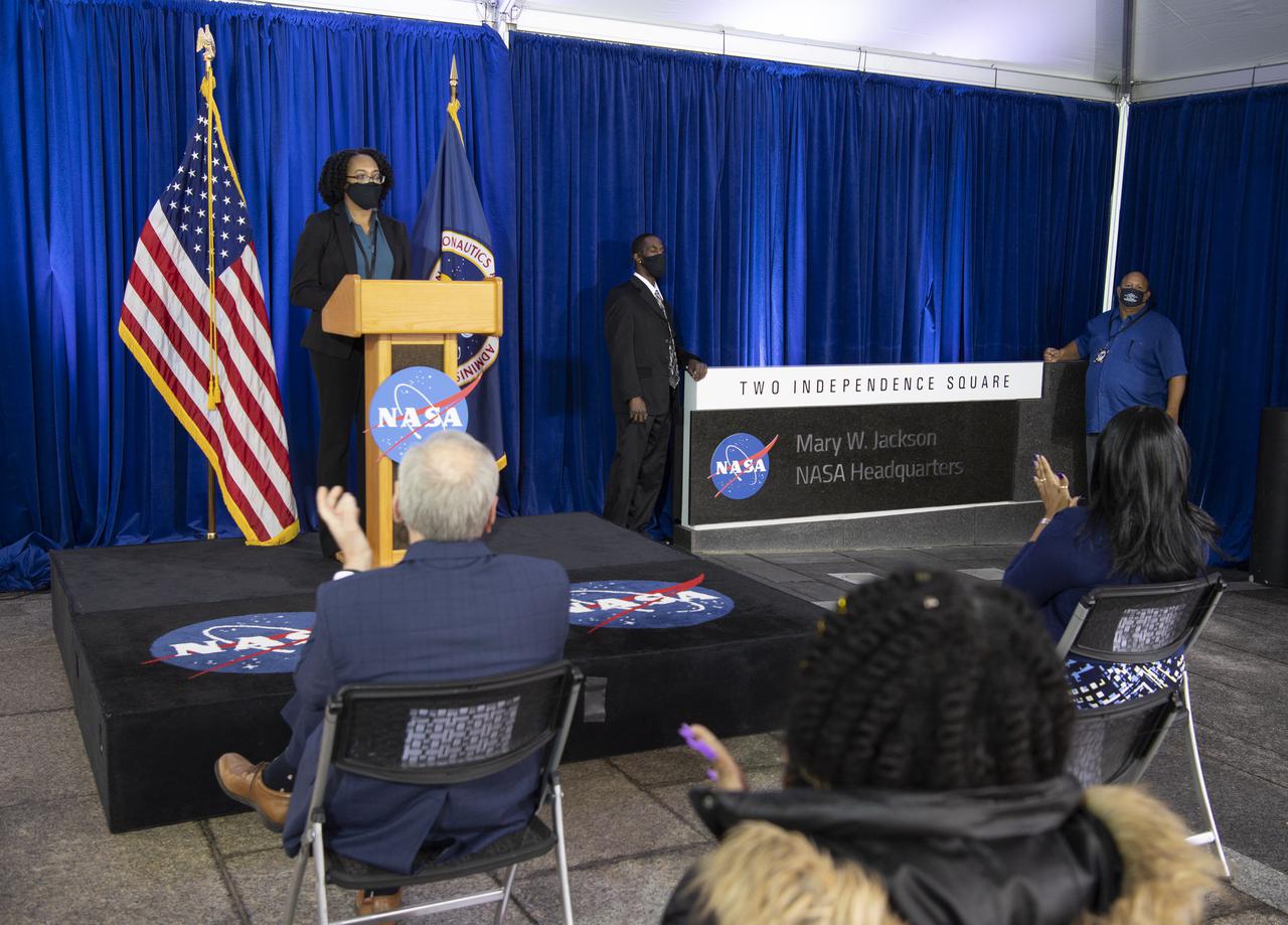
The Mary W. Jackson NASA Headquarters sign is seen after being unveiled by Bryan Jackson, grandson of Mary W. Jackson, and Raymond Lewis, son-in-law of Mary W. Jackson, during a ceremony officially naming the building, Friday, Feb. 26, 2021, at NASA Headquarters in Washington, DC. Mary W. Jackson, the first African American female engineer at NASA, began her career with the agency in the segregated West Area Computing Unit of NASA’s Langley Research Center in Hampton, Virginia. The mathematician and aerospace engineer went on to lead programs influencing the hiring and promotion of women in NASA's science, technology, engineering, and mathematics careers. In 2019, she posthumously received the Congressional Gold Medal. Photo Credit: (NASA/Joel Kowsky)
Team members from West Virginia University prepare their mining robot for a test run in a giant sandbox before their scheduled mining run in the arena during NASA's 8th Annual Robotic Mining Competition at the Kennedy Space Center Visitor Complex in Florida. More than 40 student teams from colleges and universities around the U.S. are using their uniquely-designed mining robots to dig in a supersized sandbox filled with BP-1, or simulated Martian soil, and participate in other competition requirements. The Robotic Mining Competition is a NASA Human Exploration and Operations Mission Directorate project designed to encourage students in science, technology, engineering and math, or STEM fields. The project provides a competitive environment to foster innovative ideas and solutions that could be used on NASA's Journey to Mars.
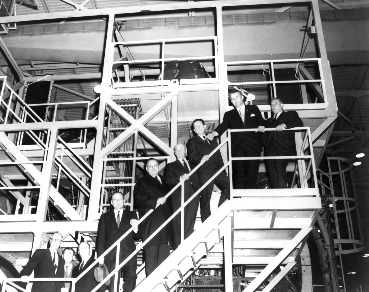
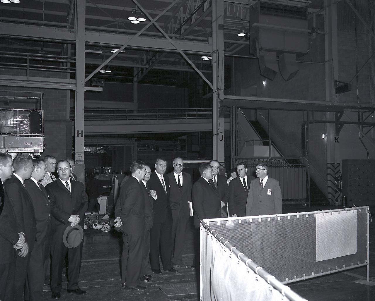
The members of the House Committee on Science and Astronautics visited the Marshall Space Flight Center (MSFC) on March 9, 1962 to gather firsthand information of the nation’s space exploration program. The congressional group was composed of members of the Subcommittee on Manned Space Flight. Pictured from left-to-right are Congressman Ken Hechler, Democratic representative of West Virginia; Dieter Grau, MSFC; Congressman John W. Davis, Democratic representative of Georgia; Congressman Joe Waggoner, Democratic representative of Louisiana; Congressman Richard L. Roudebush, Republican representative of Indiana; Congressman R. Walter Riehlman, Republican representative of New York; Congressman James G. Fulton, Republican representative of Pennsylvania; Dr. Wernher von Braun, MSFC; and Congressman Olin E. Teague, Democratic representative of Texas.

Artist Tenbeete Solomon, also known as Trap Bob, right, presents her artwork honoring Mary W. Jackson to Wanda Jackson, granddaughter of Mary W. Jackson, left, during a ceremony officially naming the NASA Headquarters building in honor of Mary W. Jackson, Friday, Feb. 26, 2021, at NASA Headquarters in Washington, DC. Mary W. Jackson, the first African American female engineer at NASA, began her career with the agency in the segregated West Area Computing Unit of NASA’s Langley Research Center in Hampton, Virginia. The mathematician and aerospace engineer went on to lead programs influencing the hiring and promotion of women in NASA's science, technology, engineering, and mathematics careers. In 2019, she posthumously received the Congressional Gold Medal. Photo Credit: (NASA/Joel Kowsky)
Members of the Mountaineers team from West Virginia University celebrate after their robot returned to the starting platform after picking up the sample during a rerun of the level one challenge during the 2014 NASA Centennial Challenges Sample Return Robot Challenge, Saturday, June 14, 2014, at the Worcester Polytechnic Institute (WPI) in Worcester, Mass. Eighteen teams are competing for a $1.5 million NASA prize purse. Teams will be required to demonstrate autonomous robots that can locate and collect samples from a wide and varied terrain, operating without human control. The objective of this NASA-WPI Centennial Challenge is to encourage innovations in autonomous navigation and robotics technologies. Innovations stemming from the challenge may improve NASA's capability to explore a variety of destinations in space, as well as enhance the nation's robotic technology for use in industries and applications on Earth. Photo Credit: (NASA/Joel Kowsky)

CAPE CANAVERAL, Fla. – Members of the West Virginia University color guard present the U.S. Flag during the opening ceremony of NASA’s 2014 Robotics Mining Competition at the Kennedy Space Center Visitor Complex in Florida. More than 35 teams from around the U.S. have designed and built remote-controlled robots for the mining competition. The competition is a NASA Human Exploration and Operations Mission Directorate project designed to engage and retain students in science, technology, engineering and mathematics, or STEM, fields by expanding opportunities for student research and design. Teams use their remote-controlled robotics to maneuver and dig in a supersized sandbox filled with a crushed material that has characteristics similar to Martian soil. The objective of the challenge is to see which team’s robot can collect and move the most regolith within a specified amount of time. For more information, visit www.nasa.gov/nasarmc. Photo credit: NASA/Frankie Martin
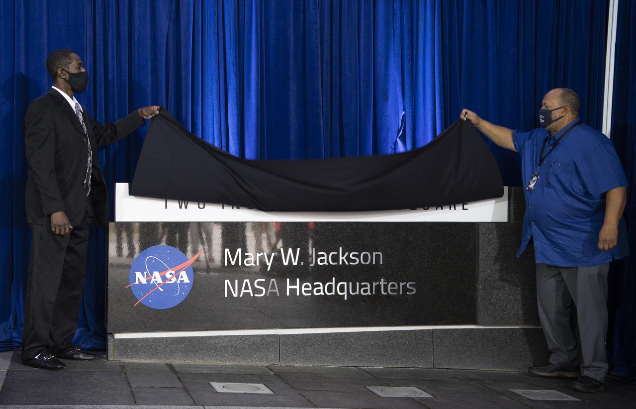
Bryan Jackson, grandson of Mary W. Jackson, left, and Raymond Lewis, son-in-law of Mary W. Jackson, right, unveil the Mary W. Jackson NASA Headquarters sign during a ceremony officially naming the building, Friday, Feb. 26, 2021, at NASA Headquarters in Washington, DC. Mary W. Jackson, the first African American female engineer at NASA, began her career with the agency in the segregated West Area Computing Unit of NASA’s Langley Research Center in Hampton, Virginia. The mathematician and aerospace engineer went on to lead programs influencing the hiring and promotion of women in NASA's science, technology, engineering, and mathematics careers. In 2019, she posthumously received the Congressional Gold Medal. Photo Credit: (NASA/Joel Kowsky)
The Mountaineers team from West Virginia University, watches as their robot attempts the level one challenge during the 2014 NASA Centennial Challenges Sample Return Robot Challenge, Wednesday, June 11, 2014, at the Worcester Polytechnic Institute (WPI) in Worcester, Mass. Eighteen teams are competing for a $1.5 million NASA prize purse. Teams will be required to demonstrate autonomous robots that can locate and collect samples from a wide and varied terrain, operating without human control. The objective of this NASA-WPI Centennial Challenge is to encourage innovations in autonomous navigation and robotics technologies. Innovations stemming from the challenge may improve NASA's capability to explore a variety of destinations in space, as well as enhance the nation's robotic technology for use in industries and applications on Earth. Photo Credit: (NASA/Joel Kowsky)
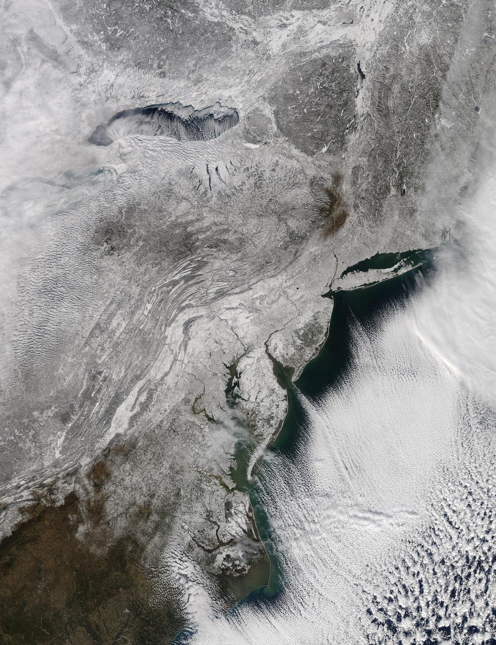
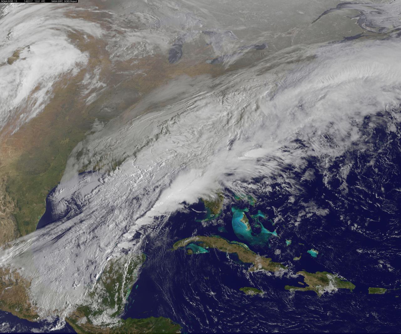
The storm system that moved through the northeastern U.S. dropped large snowfall totals up to a foot in southern New England to a couple of inches in Virginia. On January 22, 2014, the day after the event, the Moderate Resolution Imaging Spectroradiometer instrument that flies aboard NASA's Aqua satellite captured this image of the snowfall at 18:10 UTC/1:10 p.m. EST. In the image, snowfall covers the ground in all six New England states, New York, Pennsylvania, New Jersey, Delaware, Maryland, West Virginia, Ohio, Virginia, Washington, D.C. and North Carolina. Image Credit: NASA Goddard MODIS Rapid Response Team Text: Rob Gutro, NASA Goddard Space Flight Center <b><a href="http://www.nasa.gov/audience/formedia/features/MP_Photo_Guidelines.html" rel="nofollow">NASA image use policy.</a></b> <b><a href="http://www.nasa.gov/centers/goddard/home/index.html" rel="nofollow">NASA Goddard Space Flight Center</a></b> enables NASA’s mission through four scientific endeavors: Earth Science, Heliophysics, Solar System Exploration, and Astrophysics. Goddard plays a leading role in NASA’s accomplishments by contributing compelling scientific knowledge to advance the Agency’s mission. <b>Follow us on <a href="http://twitter.com/NASAGoddardPix" rel="nofollow">Twitter</a></b> <b>Like us on <a href="http://www.facebook.com/pages/Greenbelt-MD/NASA-Goddard/395013845897?ref=tsd" rel="nofollow">Facebook</a></b> <b>Find us on <a href="http://instagram.com/nasagoddard?vm=grid" rel="nofollow">Instagram</a></b>
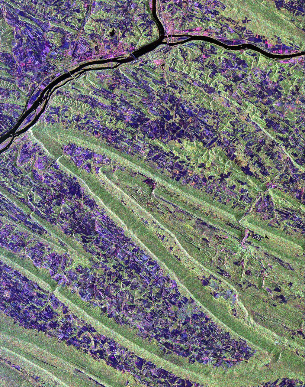
Scientists are using this radar image of the area surrounding Sunbury, Pennsylvania to study the geologic structure and land use patterns in the Appalachian Valley and Ridge province. This image was collected on October 6, 1994 by the Spaceborne Imaging Radar-C/ X-Band Synthetic Aperture Radar (SIR-C/X-SAR) on orbit 102 of the space shuttle Endeavour. The image is centered on latitude 40.85 degrees North latitude and 76.79 degrees West longitude. The area shown is approximately 30.5 km by 38 km. (19 miles by 24 miles). North is towards the upper right of the image. The Valley and Ridge province occurs in the north-central Appalachians, primarily in Pennsylvania, Maryland, and Virginia. It is an area of adjacent valleys and ridges that formed when the Appalachian mountain were created some 370 to 390 million years ago. During the continental collision that formed the Appalachians, the rocks in this area were pushed from the side and buckled much like a rug when pushed from one end. Subsequent erosion has produced the landscape we see in this image. The more resistant rocks, such as sandstone, form the tops of the ridges which appear as forested greenish areas on this image. The less resistant rocks, such as limestone, form the lower valleys which are cleared land and farm fields and are purple in this image. Smaller rivers and streams in the area flow along the valleys and in places cut across the ridges in "water gaps." In addition to defining the geography of this region, the Valley and Ridge province also provides this area with natural resources. The valleys provide fertile farmland and the folded mountains form natural traps for oil and gas accumulation; coal deposits are also found in the mountains. The colors in the image are assigned to different frequencies and polarizations of the SIR-C radar as follows: red is L-band horizontally transmitted, horizontally received; green is L-band horizontally transmitted, vertically received; blue is C-band horizontally transmitted, horizontally received. The river junction near the top of the image is where the West Branch River flows into the Susquehanna River, which then flows to the south-southwest past the state capitol of Harrisburg, 70 km (43 miles) to the south and not visible in this image. The town of Sunbury is shown along the Susquehanna on the east just to the southeast of the junction with West Branch. Three structures that cross the Susquehanna; the northern and southern of these structures are bridges and middle structure is the Shamokin Dam which confines the Susquehanna just south of the junction with West Branch. The prominent S-shaped mountain ridge in the center of the image is, from north to south, Little Mountain (the top of the S), Line Mountain (the middle of the S), and Mahantango Mountain (the bottom of the S). http://photojournal.jpl.nasa.gov/catalog/PIA01306
The green of St. Patrick's Day in the Mid-Atlantic was covered by white snow as a result of a late winter snow storm. The covering of the green was captured in a movie made at NASA using NOAA's GOES satellite data. The winter storm dropped snow totals from 6" to 12" of snow from Baltimore, Md. to Richmond, Va. The storm arrived during the evening of March 16 and continued through March 17. As of 1 p.m. EDT, light bands of snow continued to fall throughout the Washington, D.C. area. NOAA's GOES-East satellite captured the path the storm took through the Mid-Atlantic as it moved in from the west on March 15 and dropped snow March 16 and 17. NOAA's GOES-East satellite sits in a fixed orbit in space and captures visible and infrared imagery of all weather over the eastern U.S. and Atlantic Ocean. As of 1 p.m. EDT on March 17, the National Weather Service still maintained a Winter Storm Warning from Cecil County in northeastern Maryland that stretched west to Frederick County. The warning continued in Virginia counties including Clarke, Warren, Rappahannock, Madison and stretched to Albemarle and southwest. Southeastern counties in Virginia south of the city of Fredericksburg remained under a Winter Weather Advisory. GOES satellites provide the kind of continuous monitoring necessary for intensive data analysis. Geostationary describes an orbit in which a satellite is always in the same position with respect to the rotating Earth. This allows GOES to hover continuously over one position on Earth's surface, appearing stationary. As a result, GOES provide a constant vigil for the atmospheric "triggers" for severe weather conditions such as tornadoes, flash floods, hail storms and hurricanes. For updated information about the storm system, visit NOAA's NWS website: <a href="http://www.weather.gov" rel="nofollow">www.weather.gov</a> For more information about GOES satellites, visit: <a href="http://www.goes.noaa.gov/" rel="nofollow">www.goes.noaa.gov/</a> or goes.gsfc.nasa.gov/ Rob Gutro NASA's Goddard Space Flight Center <b><a href="http://www.nasa.gov/audience/formedia/features/MP_Photo_Guidelines.html" rel="nofollow">NASA image use policy.</a></b> <b><a href="http://www.nasa.gov/centers/goddard/home/index.html" rel="nofollow">NASA Goddard Space Flight Center</a></b> enables NASA’s mission through four scientific endeavors: Earth Science, Heliophysics, Solar System Exploration, and Astrophysics. Goddard plays a leading role in NASA’s accomplishments by contributing compelling scientific knowledge to advance the Agency’s mission. <b>Follow us on <a href="http://twitter.com/NASAGoddardPix" rel="nofollow">Twitter</a></b> <b>Like us on <a href="http://www.facebook.com/pages/Greenbelt-MD/NASA-Goddard/395013845897?ref=tsd" rel="nofollow">Facebook</a></b> <b>Find us on <a href="http://instagram.com/nasagoddard?vm=grid" rel="nofollow">Instagram</a></b>
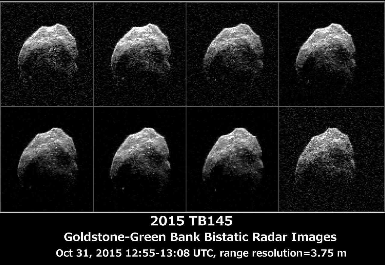
The 230-foot 70-meter DSS-14 antenna at Goldstone, Ca. obtained these radar images of asteroid 2015 TB145 on Oct. 31, 2015. Asteroid 2015 TB145 is depicted in eight individual radar images collected on Oct. 31, 2015 between 5:55 a.m. PDT (8:55 a.m. EDT) and 6:08 a.m. PDT (9:08 a.m. EDT). At the time the radar images were taken, the asteroid was between 440,000 miles (710,000 kilometers) and about 430,000 miles (690,000 kilometers) distant. Asteroid 2015 TB145 safely flew past Earth on Oct. 31, at 10:00 a.m. PDT (1 p.m. EDT) at about 1.3 lunar distances (300,000 miles, 480,000 kilometers). To obtain the radar images, the scientists used the 230-foot (70-meter) DSS-14 antenna at Goldstone, California, to transmit high power microwaves toward the asteroid. The signal bounced of the asteroid, and their radar echoes were received by the National Radio Astronomy Observatory's 100-meter (330-foot) Green Bank Telescope in West Virginia. The images achieve a spatial resolution of about 13 feet (4 meters) per pixel. http://photojournal.jpl.nasa.gov/catalog/PIA20043
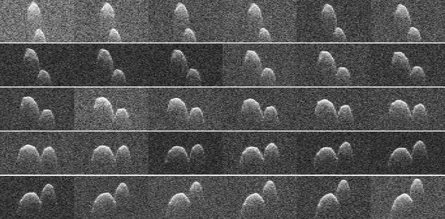
This collage of radar images of near-Earth asteroid 1999 JD6 was collected by NASA scientists on July 25, 2015. The images show the rotation of the asteroid, which made its closest approach on July 24 at 9:55 p.m. PDT (12:55 a.m. EDT on July 25) at a distance of about 4.5 million miles (7.2 million kilometers, or about 19 times the distance from Earth to the moon). The asteroid appears to be a contact binary -- an asteroid with two lobes that are stuck together. These views, which are radar echoes, were obtained by pairing NASA's 230-foot-wide (70-meter) Deep Space Network antenna at Goldstone, California, with the 330-foot (100-meter) National Science Foundation Green Bank Telescope in West Virginia. Using this approach, the Goldstone antenna beams a radar signal at an asteroid and Green Bank receives the reflections. The technique, referred to as a bistatic observation, dramatically improves the amount of detail that can be seen in radar images. The new views obtained with the technique show features as small as about 25 feet (7.5 meters) wide. The images show the asteroid is highly elongated, with a length of approximately 1.2 miles (2 kilometers) on its long axis. http://photojournal.jpl.nasa.gov/catalog/PIA19647

The members of the House Committee on Science and Astronautics visited the Marshall Space Flight Center (MSFC) on March 9, 1962 to gather firsthand information of the nation’s space exploration program. The congressional group was composed of members of the Subcommittee on Manned Space Flight. The subcommittee was briefed on MSFC’s manned space efforts earlier in the day and then inspected mockups of the Saturn I Workshop and the Apollo Telescope Mount, two projects developed by MSFC for the post-Apollo program. In this photograph, MSFC Director, Dr. Wernher von Braun meets with Congressmen in the MSFC boardroom. Pictured from left to right are: Jack Cramer, NASA Headquarters; Joe Waggoner, Democratic representative of Louisiana; John W. Davis, Democratic representative of Georgia; R. Walter Riehlman, Republican representative of New York; Olin E. Teague, Democratic representative of Texas; Dr. Wernher von Braun, Director of MSFC; James G. Fulton, Republican representative of Pennsylvania; Ken Hechler, Democratic representative of West Virginia; and Erich Neubert of MSFC.
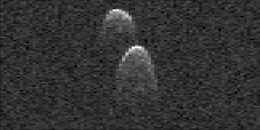
This frame from a movie made from radar images of asteroid 1999 JD6 was collected by NASA scientists on July 25, 2015. The images show the rotation of the asteroid, which made its closest approach on July 24 at 9:55 p.m. PDT (12:55 a.m. EDT on July 25) at a distance of about 4.5 million miles (7.2 million kilometers, or about 19 times the distance from Earth to the moon). The asteroid appears to be a contact binary -- an asteroid with two lobes that are stuck together. The radar images show the asteroid is highly elongated, with a length of approximately 1.2 miles (2 kilometers) on its long axis. These images are radar echoes, which are more like a sonogram than a photograph. The views were obtained by pairing NASA's 230-foot-wide (70-meter) Deep Space Network antenna at Goldstone, California, with the 330-foot (100-meter) National Science Foundation Green Bank Telescope in West Virginia. Using this approach, the Goldstone antenna beams a radar signal at an asteroid and Green Bank receives the reflections. The technique, referred to as a bistatic observation, dramatically improves the amount of detail that can be seen in radar images. The new views obtained with the technique show features as small as about 25 feet (7.5 meters) wide. http://photojournal.jpl.nasa.gov/catalog/PIA19646
On the left is a radar image of asteroid 1998 WT24 taken in December 2001 by scientists using NASA's the 230-foot (70-meter) DSS-14 antenna at Goldstone, California. On the right is a radar image of the same asteroid acquired on Dec. 11, 2015, during the asteroid's most recent Earth flyby. The radar images from 2001 (on the left), have a resolution of about 60 feet (19 meters) per pixel. The radar image from 2015 (on the right) achieved a spatial resolution as fine as 25 feet (7.5 meters) per pixel. The 2015 radar image was obtained using the same DSS-14 antenna at Goldstone to transmit high-power microwaves toward the asteroid. However, this time, the radar echoes bounced off the asteroid were received by the National Radio Astronomy Observatory's 100-meter (330-foot) Green Bank Telescope in West Virginia. The next visit of asteroid 1998 WT24 to Earth's neighborhood will be on Nov. 11, 2018, when it will make a distant pass at about 12.5-million miles (52 lunar distances). http://photojournal.jpl.nasa.gov/catalog/PIA20216
A winter storm that moved through the Mid-Atlantic on Feb. 16 and 17, 2015 extended the northeastern U.S. snowcover farther south. Until this storm hit, southern New Jersey and southeastern Pennsylvania appeared snow-free on satellite imagery from the previous week. The overnight storm blanketed the entire states of New Jersey and Pennsylvania, as seen on this Feb. 16 image. The image was taken from the MODIS or Moderate Resolution Imaging Spectroradiometer instrument that flies aboard NASA's Terra satellite. The snow cover from the storm actually extended even farther south than the image. Snowfall also blanketed West Virginia, Kentucky, Maryland, Delaware and Virginia, while freezing rain and icy conditions affected the Carolinas, Tennessee and Georgia. On Feb. 17, 2015, NOAA's National Weather Service noted "The winter storm that brought widespread snow, sleet and freezing rain to parts of the south-central U.S. and Mid-Atlantic will wind down as it moves offshore Tuesday. Lingering snow and freezing rain is possible early Tuesday for parts of the Northeast and mid-Atlantic, with rain across parts of the Southeast." Credit: NASA/GSFC/Jeff Schmaltz/MODIS Land Rapid Response Team <b><a href="http://www.nasa.gov/audience/formedia/features/MP_Photo_Guidelines.html" rel="nofollow">NASA image use policy.</a></b> <b><a href="http://www.nasa.gov/centers/goddard/home/index.html" rel="nofollow">NASA Goddard Space Flight Center</a></b> enables NASA’s mission through four scientific endeavors: Earth Science, Heliophysics, Solar System Exploration, and Astrophysics. Goddard plays a leading role in NASA’s accomplishments by contributing compelling scientific knowledge to advance the Agency’s mission. <b>Follow us on <a href="http://twitter.com/NASAGoddardPix" rel="nofollow">Twitter</a></b> <b>Like us on <a href="http://www.facebook.com/pages/Greenbelt-MD/NASA-Goddard/395013845897?ref=tsd" rel="nofollow">Facebook</a></b> <b>Find us on <a href="http://instagram.com/nasagoddard?vm=grid" rel="nofollow">Instagram</a></b>
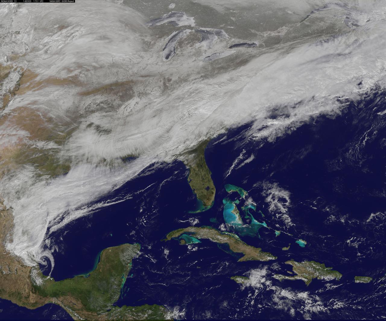
On March 3, a major winter storm brought snow to the mid-Atlantic, freezing rain to the Carolinas and rain and some freezing rain to the Gulf Coast states. NOAA's GOES-East satellite captured an image of the clouds associated with the winter storm on March 3 at 12:45 p.m. EST (1745 UTC)/ as it continued on its march over the mid-Atlantic. Bands of snow and sometimes heavy snow affected the Washington, D.C., region, Delaware and central Virginia, stretching west into West Virginia and eastern Kentucky. Snow also stretched back into the Ohio and Tennessee valleys while rain and freezing rain affected the Carolinas, and while the Gulf Coast states received rain. National Weather Service Winter Storm Warnings remained in effect until 6 p.m. EST on March 3 for Washington, D.C., and Baltimore, Md. In Richmond and Norfolk, Va., the Winter Storm warnings were in effect for six additional hours ending at midnight. On March 3, NOAA's National Weather Prediction Center in College Park, Md., noted the late-season winter storm will continue to shift eastward through the Tennessee Valley and the mid-Atlantic today, making for hazardous travel conditions. NOAA noted that unseasonably cold temperatures more typical of January will prevail east of the Rocky Mountains for the next few days keeping winter around for a while longer. The clouds are associated with a cold front that stretched from eastern Maine through Maryland and west into the Tennessee Valley. At NASA/NOAA's GOES Project at NASA's Goddard Space Flight Center in Greenbelt, Md., the cloud data from NOAA's GOES-East satellite were overlaid on a true-color image of land and ocean created by data from the Moderate Resolution Imaging Spectroradiometer, or MODIS, instrument that flies aboard NASA's Aqua and Terra satellites. Together, those data created the entire picture of the position of this major winter storm. GOES satellites provide the kind of continuous monitoring necessary for intensive data analysis. Geostationary describes an orbit in which a satellite is always in the same position with respect to the rotating Earth. This allows GOES to hover continuously over one position on Earth's surface, appearing stationary. As a result, GOES provide a constant vigil for the atmospheric "triggers" for severe weather conditions such as tornadoes, flash floods, hail storms and hurricanes. For updated information about the storm system, visit NOAA's NWS website: <a href="http://www.weather.gov" rel="nofollow">www.weather.gov</a> For more information about GOES satellites, visit: <a href="http://www.goes.noaa.gov/" rel="nofollow">www.goes.noaa.gov/</a> or goes.gsfc.nasa.gov/ Rob Gutro NASA's Goddard Space Flight Center, Greenbelt, Md. <b><a href="http://www.nasa.gov/audience/formedia/features/MP_Photo_Guidelines.html" rel="nofollow">NASA image use policy.</a></b> <b><a href="http://www.nasa.gov/centers/goddard/home/index.html" rel="nofollow">NASA Goddard Space Flight Center</a></b> enables NASA’s mission through four scientific endeavors: Earth Science, Heliophysics, Solar System Exploration, and Astrophysics. Goddard plays a leading role in NASA’s accomplishments by contributing compelling scientific knowledge to advance the Agency’s mission. <b>Follow us on <a href="http://twitter.com/NASAGoddardPix" rel="nofollow">Twitter</a></b> <b>Like us on <a href="http://www.facebook.com/pages/Greenbelt-MD/NASA-Goddard/395013845897?ref=tsd" rel="nofollow">Facebook</a></b> <b>Find us on <a href="http://instagram.com/nasagoddard?vm=grid" rel="nofollow">Instagram</a></b>
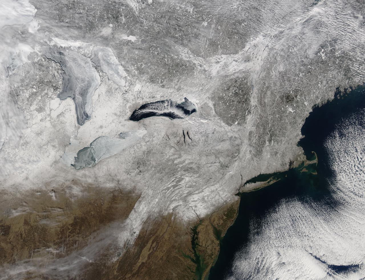
Snow covered the northeastern United States on last day of meteorological winter, 2014. Climatologists and meteorologists break seasons down into three-month groups, based on annual temperature and our calendar. This method is helpful for weather observing and forecasting, and for planning consistent agricultural dates, such as expected first frosts or best planting date. Meteorological winter – the season where temperatures are, on average, coldest and when snow is most likely to fall – runs from December 1 to February 28 in the United States and Canada. Winter can also be defined by the astronomical calendar, which is based on the rotation of the Earth around the sun. In this method, the seasons are defined by two solstices (times when the sun’s path is furthest from the Earth’s equator) and two equinoxes (the times when the sun passes directly above the equator). In the Northern Hemisphere, winter begins on the winter solstice, which falls on or around December 22 and ends on or around March 21, at the vernal (spring) equinox. On February 28, 2014, the Moderate Resolution Imaging Spectroradiometer aboard NASA’s Aqua satellite captured this true-color image of a sunny winter day in the northeastern United States. Snow stretches from Maine west to Indiana and south along the ridges of the Appalachian Mountains well into West Virginia. In Canada, the landscape appears greener, primarily because snow lies on conifers (evergreen) trees in the boreal forest regions. The Great Lakes, with the exception of Lake Ontario, are almost completely covered with ice. Credit: NASA/GSFC/Jeff Schmaltz/MODIS Land Rapid Response Team <b><a href="http://www.nasa.gov/audience/formedia/features/MP_Photo_Guidelines.html" rel="nofollow">NASA image use policy.</a></b> <b><a href="http://www.nasa.gov/centers/goddard/home/index.html" rel="nofollow">NASA Goddard Space Flight Center</a></b> enables NASA’s mission through four scientific endeavors: Earth Science, Heliophysics, Solar System Exploration, and Astrophysics. Goddard plays a leading role in NASA’s accomplishments by contributing compelling scientific knowledge to advance the Agency’s mission. <b>Follow us on <a href="http://twitter.com/NASAGoddardPix" rel="nofollow">Twitter</a></b> <b>Like us on <a href="http://www.facebook.com/pages/Greenbelt-MD/NASA-Goddard/395013845897?ref=tsd" rel="nofollow">Facebook</a></b> <b>Find us on <a href="http://instagram.com/nasagoddard?vm=grid" rel="nofollow">Instagram</a></b>
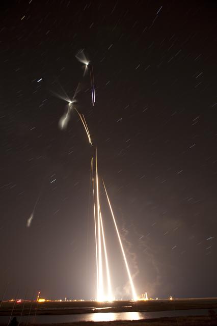
NASA image captured March 27, 2012 NASA successfully launched five suborbital sounding rockets this morning from its Wallops Flight Facility in Virginia as part of a study of the upper level jet stream. The first rocket was launched at 4:58 a.m. EDT and each subsequent rocket was launched 80 seconds apart. Each rocket released a chemical tracer that created milky, white clouds at the edge of space. Tracking the way the clouds move can help scientists understand the movement of the winds some 65 miles up in the sky, which in turn will help create better models of the electromagnetic regions of space that can damage man-made satellites and disrupt communications systems. The launches and clouds were reported to be seen from as far south as Wilmington, N.C.; west to Charlestown, W. Va.; and north to Buffalo, N.Y. Credit: NASA/Wallops <b>To watch a video of the launch and to read more go to: <a href="http://www.nasa.gov/mission_pages/sunearth/missions/atrex-launches.html" rel="nofollow">www.nasa.gov/mission_pages/sunearth/missions/atrex-launch...</a> </b> <b><a href="http://www.nasa.gov/audience/formedia/features/MP_Photo_Guidelines.html" rel="nofollow">NASA image use policy.</a></b> <b><a href="http://www.nasa.gov/centers/goddard/home/index.html" rel="nofollow">NASA Goddard Space Flight Center</a></b> enables NASA’s mission through four scientific endeavors: Earth Science, Heliophysics, Solar System Exploration, and Astrophysics. Goddard plays a leading role in NASA’s accomplishments by contributing compelling scientific knowledge to advance the Agency’s mission. <b>Follow us on <a href="http://twitter.com/NASA_GoddardPix" rel="nofollow">Twitter</a></b> <b>Like us on <a href="http://www.facebook.com/pages/Greenbelt-MD/NASA-Goddard/395013845897?ref=tsd" rel="nofollow">Facebook</a></b> <b>Find us on <a href="http://instagrid.me/nasagoddard/?vm=grid" rel="nofollow">Instagram</a></b>
NASA image captured March 27, 2012 NASA successfully launched five suborbital sounding rockets this morning from its Wallops Flight Facility in Virginia as part of a study of the upper level jet stream. The first rocket was launched at 4:58 a.m. EDT and each subsequent rocket was launched 80 seconds apart. Each rocket released a chemical tracer that created milky, white clouds at the edge of space. Tracking the way the clouds move can help scientists understand the movement of the winds some 65 miles up in the sky, which in turn will help create better models of the electromagnetic regions of space that can damage man-made satellites and disrupt communications systems. The launches and clouds were reported to be seen from as far south as Wilmington, N.C.; west to Charlestown, W. Va.; and north to Buffalo, N.Y. Credit: NASA/Wallops <b>To watch a video of the launch and to read more go to: <a href="http://www.nasa.gov/mission_pages/sunearth/missions/atrex-launches.html" rel="nofollow">www.nasa.gov/mission_pages/sunearth/missions/atrex-launch...</a> </b> <b><a href="http://www.nasa.gov/audience/formedia/features/MP_Photo_Guidelines.html" rel="nofollow">NASA image use policy.</a></b> <b><a href="http://www.nasa.gov/centers/goddard/home/index.html" rel="nofollow">NASA Goddard Space Flight Center</a></b> enables NASA’s mission through four scientific endeavors: Earth Science, Heliophysics, Solar System Exploration, and Astrophysics. Goddard plays a leading role in NASA’s accomplishments by contributing compelling scientific knowledge to advance the Agency’s mission. <b>Follow us on <a href="http://twitter.com/NASA_GoddardPix" rel="nofollow">Twitter</a></b> <b>Like us on <a href="http://www.facebook.com/pages/Greenbelt-MD/NASA-Goddard/395013845897?ref=tsd" rel="nofollow">Facebook</a></b> <b>Find us on <a href="http://instagrid.me/nasagoddard/?vm=grid" rel="nofollow">Instagram</a></b>
NASA image captured March 27, 2012 NASA successfully launched five suborbital sounding rockets this morning from its Wallops Flight Facility in Virginia as part of a study of the upper level jet stream. The first rocket was launched at 4:58 a.m. EDT and each subsequent rocket was launched 80 seconds apart. Each rocket released a chemical tracer that created milky, white clouds at the edge of space. Tracking the way the clouds move can help scientists understand the movement of the winds some 65 miles up in the sky, which in turn will help create better models of the electromagnetic regions of space that can damage man-made satellites and disrupt communications systems. The launches and clouds were reported to be seen from as far south as Wilmington, N.C.; west to Charlestown, W. Va.; and north to Buffalo, N.Y. Credit: NASA/Wallops <b>To watch a video of the launch and to read more go to: <a href="http://www.nasa.gov/mission_pages/sunearth/missions/atrex-launches.html" rel="nofollow">www.nasa.gov/mission_pages/sunearth/missions/atrex-launch...</a> </b> <b><a href="http://www.nasa.gov/audience/formedia/features/MP_Photo_Guidelines.html" rel="nofollow">NASA image use policy.</a></b> <b><a href="http://www.nasa.gov/centers/goddard/home/index.html" rel="nofollow">NASA Goddard Space Flight Center</a></b> enables NASA’s mission through four scientific endeavors: Earth Science, Heliophysics, Solar System Exploration, and Astrophysics. Goddard plays a leading role in NASA’s accomplishments by contributing compelling scientific knowledge to advance the Agency’s mission. <b>Follow us on <a href="http://twitter.com/NASA_GoddardPix" rel="nofollow">Twitter</a></b> <b>Like us on <a href="http://www.facebook.com/pages/Greenbelt-MD/NASA-Goddard/395013845897?ref=tsd" rel="nofollow">Facebook</a></b> <b>Find us on <a href="http://instagrid.me/nasagoddard/?vm=grid" rel="nofollow">Instagram</a></b>
These three radar images of near-Earth asteroid 2003 SD220 were obtained on Dec. 15-17, by coordinating observations with NASA's 230-foot (70-meter) antenna at the Goldstone Deep Space Communications Complex in California and the National Science Foundation's (NSF) 330-foot (100-meter) Green Bank Telescope in West Virginia. The radar image on the left was obtained on Dec. 15 when asteroid 2003 SD220 was 2.8 million miles (4.5 million kilometers) from Earth. The radar image in the middle was generated from data collected on Dec. 16 when the asteroid was 2.5 million miles (4.0 million kilometers) from Earth. The image on the right was obtained on Dec. 17 when 2003 SD220 was 2.2 million miles (3.6 million kilometers) from Earth. The spatial resolution on the images is as fine as 12 feet (3.7 meters) per pixel. The radar images reveal the asteroid is at least one mile (1.6 kilometers) long. Asteroid 2003 SD220 was discovered on Sept. 29, 2003, by astronomers at the Lowell Observatory Near-Earth-Object Search (LONEOS) in Flagstaff, Arizona -- an early Near-Earth Object (NEO) survey project supported by NASA that is no longer in operation. The asteroid will fly safely past Earth on Saturday, Dec. 22, 2018, at a distance of about 1.8 million miles (2.9 million kilometers). This will be the asteroid's closest approach in more than 400 years and the closest until 2070, when the asteroid will safely fly by slightly closer. https://photojournal.jpl.nasa.gov/catalog/PIA22970
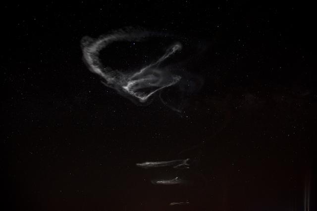
NASA image captured March 27, 2012 NASA successfully launched five suborbital sounding rockets this morning from its Wallops Flight Facility in Virginia as part of a study of the upper level jet stream. The first rocket was launched at 4:58 a.m. EDT and each subsequent rocket was launched 80 seconds apart. Each rocket released a chemical tracer that created milky, white clouds at the edge of space. Tracking the way the clouds move can help scientists understand the movement of the winds some 65 miles up in the sky, which in turn will help create better models of the electromagnetic regions of space that can damage man-made satellites and disrupt communications systems. The launches and clouds were reported to be seen from as far south as Wilmington, N.C.; west to Charlestown, W. Va.; and north to Buffalo, N.Y. Credit: NASA/Wallops <b>To watch a video of the launch and to read more go to: <a href="http://www.nasa.gov/mission_pages/sunearth/missions/atrex-launches.html" rel="nofollow">www.nasa.gov/mission_pages/sunearth/missions/atrex-launch...</a> </b> <b><a href="http://www.nasa.gov/audience/formedia/features/MP_Photo_Guidelines.html" rel="nofollow">NASA image use policy.</a></b> <b><a href="http://www.nasa.gov/centers/goddard/home/index.html" rel="nofollow">NASA Goddard Space Flight Center</a></b> enables NASA’s mission through four scientific endeavors: Earth Science, Heliophysics, Solar System Exploration, and Astrophysics. Goddard plays a leading role in NASA’s accomplishments by contributing compelling scientific knowledge to advance the Agency’s mission. <b>Follow us on <a href="http://twitter.com/NASA_GoddardPix" rel="nofollow">Twitter</a></b> <b>Like us on <a href="http://www.facebook.com/pages/Greenbelt-MD/NASA-Goddard/395013845897?ref=tsd" rel="nofollow">Facebook</a></b> <b>Find us on <a href="http://instagrid.me/nasagoddard/?vm=grid" rel="nofollow">Instagram</a></b>
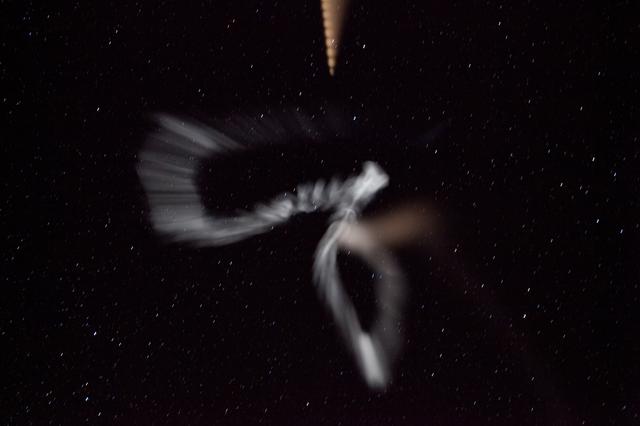
NASA image captured March 27, 2012 NASA successfully launched five suborbital sounding rockets this morning from its Wallops Flight Facility in Virginia as part of a study of the upper level jet stream. The first rocket was launched at 4:58 a.m. EDT and each subsequent rocket was launched 80 seconds apart. Each rocket released a chemical tracer that created milky, white clouds at the edge of space. Tracking the way the clouds move can help scientists understand the movement of the winds some 65 miles up in the sky, which in turn will help create better models of the electromagnetic regions of space that can damage man-made satellites and disrupt communications systems. The launches and clouds were reported to be seen from as far south as Wilmington, N.C.; west to Charlestown, W. Va.; and north to Buffalo, N.Y. Credit: NASA/Wallops <b>To watch a video of the launch and to read more go to: <a href="http://www.nasa.gov/mission_pages/sunearth/missions/atrex-launches.html" rel="nofollow">www.nasa.gov/mission_pages/sunearth/missions/atrex-launch...</a> </b> <b><a href="http://www.nasa.gov/audience/formedia/features/MP_Photo_Guidelines.html" rel="nofollow">NASA image use policy.</a></b> <b><a href="http://www.nasa.gov/centers/goddard/home/index.html" rel="nofollow">NASA Goddard Space Flight Center</a></b> enables NASA’s mission through four scientific endeavors: Earth Science, Heliophysics, Solar System Exploration, and Astrophysics. Goddard plays a leading role in NASA’s accomplishments by contributing compelling scientific knowledge to advance the Agency’s mission. <b>Follow us on <a href="http://twitter.com/NASA_GoddardPix" rel="nofollow">Twitter</a></b> <b>Like us on <a href="http://www.facebook.com/pages/Greenbelt-MD/NASA-Goddard/395013845897?ref=tsd" rel="nofollow">Facebook</a></b> <b>Find us on <a href="http://instagrid.me/nasagoddard/?vm=grid" rel="nofollow">Instagram</a></b>

This image of the Andromeda galaxy, or M31, includes data from the ESA (European Space Agency) Herschel mission, supplemented with data from ESA's retired Planck observatory and two retired NASA missions: the Infrared Astronomical Satellite (IRAS) and Cosmic Background Explorer (COBE). Operated from 2009 to 2013, Herschel detected wavelengths of light in the far-infrared and microwave ranges, and was ideal for studying dust in nearby galaxies because it could capture small-scale structures in the dust clouds in high resolution. However, Herschel often couldn't detect light from diffuse dust clouds – especially in the outer regions of galaxies, where the gas and dust become sparse and thus fainter. As a result, the mission missed up to 30% of all the light given off by dust. Combining the Herschel observations with data from other observatories creates a more complete picture of the dust in the galaxy. In the image, red indicates hydrogen gas; green indicates cold dust; and warmer dust is shown in blue. Launched in 1983, IRAS was the first space telescope to detect infrared light, setting the stage for future observatories like NASA's Spitzer Space Telescope and James Webb Space Telescope. The Planck observatory, launched in 2009, and COBE, launched in 1989, both studied the cosmic microwave background, or light left over from the big bang. Red indicates hydrogen gas detected using the Green Bank Telescope in West Virginia, the Westerbork Synthesis Radio Telescope in the Netherlands, and the Institute for Radio Astronomy in the Millimeter Range 30-meter telescope in Spain. https://photojournal.jpl.nasa.gov/catalog/PIA25163
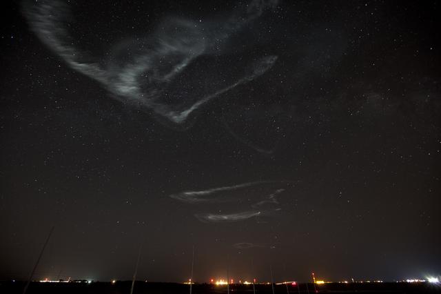
NASA image captured March 27, 2012 NASA successfully launched five suborbital sounding rockets this morning from its Wallops Flight Facility in Virginia as part of a study of the upper level jet stream. The first rocket was launched at 4:58 a.m. EDT and each subsequent rocket was launched 80 seconds apart. Each rocket released a chemical tracer that created milky, white clouds at the edge of space. Tracking the way the clouds move can help scientists understand the movement of the winds some 65 miles up in the sky, which in turn will help create better models of the electromagnetic regions of space that can damage man-made satellites and disrupt communications systems. The launches and clouds were reported to be seen from as far south as Wilmington, N.C.; west to Charlestown, W. Va.; and north to Buffalo, N.Y. Credit: NASA/Wallops <b>To watch a video of the launch and to read more go to: <a href="http://www.nasa.gov/mission_pages/sunearth/missions/atrex-launches.html" rel="nofollow">www.nasa.gov/mission_pages/sunearth/missions/atrex-launch...</a> </b> <b><a href="http://www.nasa.gov/audience/formedia/features/MP_Photo_Guidelines.html" rel="nofollow">NASA image use policy.</a></b> <b><a href="http://www.nasa.gov/centers/goddard/home/index.html" rel="nofollow">NASA Goddard Space Flight Center</a></b> enables NASA’s mission through four scientific endeavors: Earth Science, Heliophysics, Solar System Exploration, and Astrophysics. Goddard plays a leading role in NASA’s accomplishments by contributing compelling scientific knowledge to advance the Agency’s mission. <b>Follow us on <a href="http://twitter.com/NASA_GoddardPix" rel="nofollow">Twitter</a></b> <b>Like us on <a href="http://www.facebook.com/pages/Greenbelt-MD/NASA-Goddard/395013845897?ref=tsd" rel="nofollow">Facebook</a></b> <b>Find us on <a href="http://instagrid.me/nasagoddard/?vm=grid" rel="nofollow">Instagram</a></b>
NASA image captured March 27, 2012 NASA successfully launched five suborbital sounding rockets this morning from its Wallops Flight Facility in Virginia as part of a study of the upper level jet stream. The first rocket was launched at 4:58 a.m. EDT and each subsequent rocket was launched 80 seconds apart. Each rocket released a chemical tracer that created milky, white clouds at the edge of space. Tracking the way the clouds move can help scientists understand the movement of the winds some 65 miles up in the sky, which in turn will help create better models of the electromagnetic regions of space that can damage man-made satellites and disrupt communications systems. The launches and clouds were reported to be seen from as far south as Wilmington, N.C.; west to Charlestown, W. Va.; and north to Buffalo, N.Y. Credit: NASA/Wallops <b>To watch a video of the launch and to read more go to: <a href="http://www.nasa.gov/mission_pages/sunearth/missions/atrex-launches.html" rel="nofollow">www.nasa.gov/mission_pages/sunearth/missions/atrex-launch...</a> </b> <b><a href="http://www.nasa.gov/audience/formedia/features/MP_Photo_Guidelines.html" rel="nofollow">NASA image use policy.</a></b> <b><a href="http://www.nasa.gov/centers/goddard/home/index.html" rel="nofollow">NASA Goddard Space Flight Center</a></b> enables NASA’s mission through four scientific endeavors: Earth Science, Heliophysics, Solar System Exploration, and Astrophysics. Goddard plays a leading role in NASA’s accomplishments by contributing compelling scientific knowledge to advance the Agency’s mission. <b>Follow us on <a href="http://twitter.com/NASA_GoddardPix" rel="nofollow">Twitter</a></b> <b>Like us on <a href="http://www.facebook.com/pages/Greenbelt-MD/NASA-Goddard/395013845897?ref=tsd" rel="nofollow">Facebook</a></b> <b>Find us on <a href="http://instagrid.me/nasagoddard/?vm=grid" rel="nofollow">Instagram</a></b>
This image of the Triangulum galaxy, or M33, includes data from the ESA (European Space Agency) Herschel mission, supplemented with data from ESA's retired Planck observatory and two retired NASA missions: the Infrared Astronomical Satellite (IRAS) and Cosmic Background Explorer (COBE). Operated from 2009 to 2013, Herschel detected wavelengths of light in the far-infrared and microwave ranges, and was ideal for studying dust in nearby galaxies because it could capture small-scale structures in the dust clouds in high resolution. However, Herschel often couldn't detect light from diffuse dust clouds – especially in the outer regions of galaxies, where the gas and dust become sparse and thus fainter. As a result, the mission missed up to 30% of all the light given off by dust. Combining the Herschel observations with data from other observatories creates a more complete picture of the dust in the galaxy. In the image, red indicates hydrogen gas; green indicates cold dust; and warmer dust is shown in blue. Launched in 1983, IRAS was the first space telescope to detect infrared light, setting the stage for future observatories like NASA's Spitzer Space Telescope and James Webb Space Telescope. The Planck observatory, launched in 2009, and COBE, launched in 1989, both studied the cosmic microwave background, or light left over from the big bang. The hydrogen gas was detected using the Green Bank Telescope in West Virginia, the Karl G. Jansky Very Large Array in New Mexico, and the Institute for Radio Astronomy in the Millimeter Range 30-meter telescope in Spain. https://photojournal.jpl.nasa.gov/catalog/PIA25165
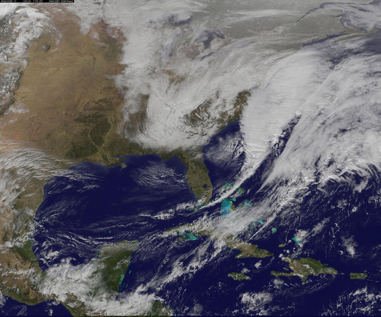
National Weather Service forecasters have been tracking a low pressure area that moved from the Midwest into the Atlantic Ocean today, and is expected to become a strong nor'easter that will bring blizzard conditions to the northeastern U.S. The path of the system was captured in a NASA movie of NOAA's GOES-East satellite imagery. On Monday, January 26, 2015, the National Weather Service noted: A storm system off the East Coast will continue to strengthen as it develops into a major nor'easter on Monday. As the storm moves up the coast, it is expected to bring snowfall of 1-3 feet or more to many parts of the Northeast through Tuesday evening, including New York City and Boston. Strong, gusty winds will combine with the snow to create blizzard conditions along and near the coast. Winter storm warnings are in effect for the panhandles of West Virginia and Maryland, much of interior New England down to the northern Mid-Atlantic as well as for Nantucket Island, Massachusetts. Winter weather advisories are in effect for portions of the Ohio Valley, Mid-Atlantic and the southern Appalachians as well as a narrow area across interior New England. To create the video and imagery, NASA/NOAA's GOES Project located at NASA's Goddard Space Flight Center in Greenbelt, Maryland overlays the cloud data from NOAA's GOES-East satellite on a true-color image of land and ocean created by data from the Moderate Resolution Imaging Spectroradiometer, or MODIS, instrument that flies aboard NASA's Aqua and Terra satellites. Together, these data create the entire animation of the storm and show its movement. GOES satellites provide the kind of continuous monitoring necessary for intensive data analysis. Geostationary describes an orbit in which a satellite is always in the same position with respect to the rotating Earth. This allows GOES to hover continuously over one position on Earth's surface, appearing stationary. As a result, GOES provide a constant vigil for the atmospheric "triggers" for severe weather conditions such as tornadoes, flash floods, hail storms and hurricanes. For updated information about the storm system, visit NOAA's NWS website: <a href="http://www.weather.gov" rel="nofollow">www.weather.gov</a> For more information about GOES satellites, visit: <a href="http://www.goes.noaa.gov/" rel="nofollow">www.goes.noaa.gov/</a> or goes.gsfc.nasa.gov/ Rob Gutro NASA's Goddard Space Flight Center
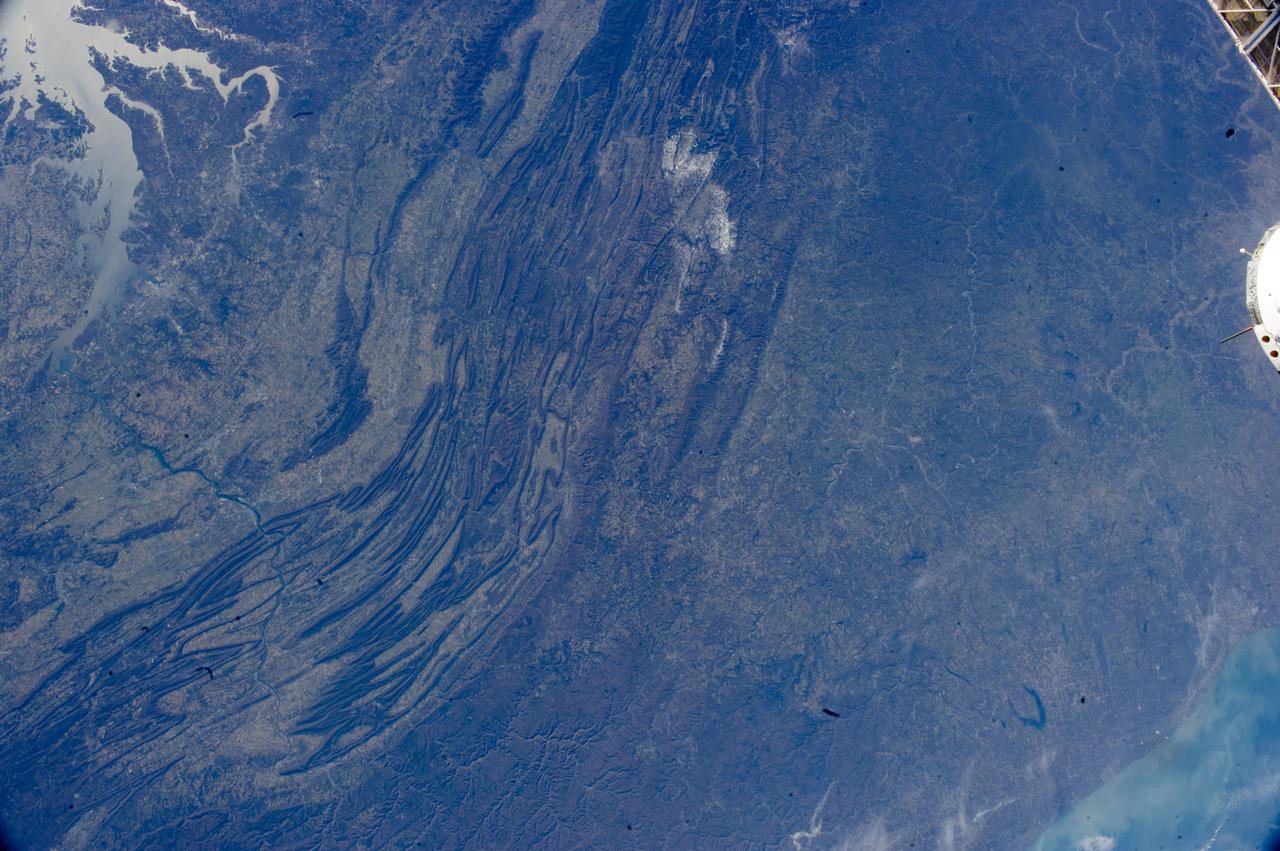
ISS033-E-022378 (17 Nov. 2012) --- The Appalachian Mountains in the eastern Unites States are featured in this image photographed by an Expedition 33 crew member on the International Space Station. This regional view shows the striking visual effect of the valley-and-ridge topography of the Appalachian Mountains as viewed from orbit. The view shows more than 300 miles (500 kilometers) of this low mountain chain, from northeast Pennsylvania (lower left) to southern West Virginia, where a dusting of snow can be seen (top center). Sunglint reflections reveal detail of Chesapeake Bay and the great bend of the Potomac River. Cities are difficult to detect from space during daylight hours, so the sickle-shaped bend of the river is a good visual guide for station crew members trying to photograph the nation?s capital, Washington D.C. (upper left). The farm-dominated Piedmont Plateau is the light-toned area between the mountains and the bay. The Appalachian Mountains appear striped because the ridges are forested; providing a dense and dark canopy cover, while the valleys are farmed with crops that generally appear as lighter-toned areas. Geologically the valleys are the softer, more erodible rock layers, much the preferred places for human settlement. Not only do the larger rivers occupy the valley floors, but all the larger rivers flow in them, soils are thicker, slopes are gentle, and valleys are better protected from winter winds. According to scientists, rocks that form the valley-and-ridge province, as it is known, are relatively old (540-300 million years old), and were laid down in horizontal layers when North America was attached to Europe as the ancient supercontinent of Laurasia. During this time Gondwanaland ? an ancient supercontinent that included present-day Africa, India, South America, Australia and Antarctica - was approaching Laurasia under the influence of plate tectonics. The northwest coastline of modern Africa was the section of Gondwanaland that ?bumped up? against modern North America over a long period (320 ? 260 million years ago), according to scientists. The net result of the tectonic collision was the building of a major mountain chain, much higher than the present Appalachian range?in the process of which the flat-lying rock layers were crumpled up into a series of tight folds, at right angles to the advance of Gondwanaland. The collision also formed the singular supercontinent of Pangaea. The scientists say that, over the following 200 million years, Pangaea broke apart; the modern Atlantic Ocean formed; and erosion wore down the high mountains. What is left to see are the coastline of North America, and the eroded stumps of the mountain chain as the relatively low, but visually striking present-day Appalachian Mountains.
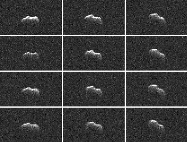
On March 21, 2021, the large asteroid 2001 FO32 made a close approach with our planet, passing at a distance of about 1.25 million miles (2 million kilometers) — or 5 1/4 times the distance from Earth to the Moon. While there was no risk of the near-Earth asteroid colliding with Earth as its orbit is very well known, scientists at NASA's Jet Propulsion Laboratory in Southern California took the opportunity to capture these radar images of the asteroid as it tumbled past. Using NASA's 34-meter (111.5-feet) Deep Space Station 13 (DSS-13) radio antenna at the Deep Space Network's Goldstone Deep Space Communication Complex near Barstow, California, radio signals were transmitted to 2001 FO32. The signals then bounced off the surface of the asteroid and were received by the 100-meter (328-feet) Green Bank Telescope in West Virginia. Such radar observations can offer additional insight into the asteroid's orbit, provide a better estimate of its dimensions and rotation rate, and help glimpse surface features (like large boulders or craters). Other radar observations were carried out by scientists using the 34-meter DSS-43 antenna at the Deep Space Network's Canberra Deep Space Communication Complex in Australia. Along with the Commonwealth Scientific and Industrial Research Organisation's Australia Telescope Compact Array near Narrabri in New South Wales, both antennas worked together to track 2001 FO32. Asteroid 2001 FO32 was discovered in March 2001 by the Lincoln Near-Earth Asteroid Research (LINEAR) program in Socorro, New Mexico, and had been estimated, based on optical measurements, to be roughly 3,000 feet (1 kilometer) wide. In more recent follow-up observations by NEOWISE, 2001 FO32 appears to be faint when observed in infrared wavelengths, which suggests the object is likely less than 1 kilometer in diameter. Analysis by the NEOWISE team shows that it is between 1,300 to 2,230 feet (440 to 680 meters) wide. Further analysis of data from the radar campaign will better refine the size of the asteroid and increase the precision of its orbital calculations. For more information about 2001 FO32 and observing campaign, read: https://www.jpl.nasa.gov/news/asteroid-2001-fo32-will-safely-pass-by-earth-march-21 https://photojournal.jpl.nasa.gov/catalog/PIA24561
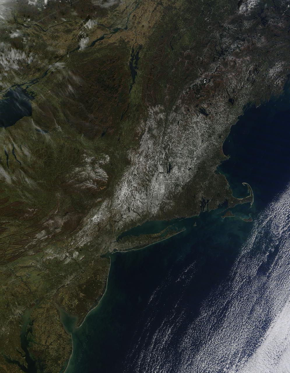
Last weekend's late October snow may have melted in Maryland, Delaware, parts of Pennsylvania and New Jersey, but residents in north central Connecticut are still dealing with the effects of the storm. According to Connecticut Light and Power, 430,868 residents were still without power today, Nov. 3, 2011. For estimated restoration times, visit their website at: <a href="http://www.cl-p.com/stormcenter/estimates/" rel="nofollow">www.cl-p.com/stormcenter/estimates/</a>. A late October snowstorm from a Nor'easter blanketed the eastern U.S. from West Virginia to Maine and broke records the weekend before Halloween Monday. NASA's Aqua satellite flew over the region on October 30 after the snow was ending in New England and captured the ghostly blanket of white. When NASA's Aqua satellite passed over the northeastern U.S. on November 2, 2011 at 2:00 p.m. EDT, the Moderate Resolution Imaging Spectroradiometer (MODIS) instrument captured a detailed image of the remaining snowfall. Snow still covers the ground in western and central Connecticut, southeastern New York, western and central Massachusetts, and parts of Vermont, New Hampshire and Maine. Over the Atlantic, cirrocumulus clouds create a diagonal border. The image was created at NASA's Goddard Space Flight Center in Greenbelt, Md. Image Credit: NASA Goddard MODIS Rapid Response Team; Caption: NASA Goddard, Rob Gutro <b><a href="http://www.nasa.gov/audience/formedia/features/MP_Photo_Guidelines.html" rel="nofollow">NASA image use policy.</a></b> <b><a href="http://www.nasa.gov/centers/goddard/home/index.html" rel="nofollow">NASA Goddard Space Flight Center</a></b> enables NASA’s mission through four scientific endeavors: Earth Science, Heliophysics, Solar System Exploration, and Astrophysics. Goddard plays a leading role in NASA’s accomplishments by contributing compelling scientific knowledge to advance the Agency’s mission. <b>Follow us on <a href="http://twitter.com/NASA_GoddardPix" rel="nofollow">Twitter</a></b> <b>Like us on <a href="http://www.facebook.com/pages/Greenbelt-MD/NASA-Goddard/395013845897?ref=tsd" rel="nofollow">Facebook</a></b> <b>Find us on <a href="http://instagrid.me/nasagoddard/?vm=grid" rel="nofollow">Instagram</a></b>
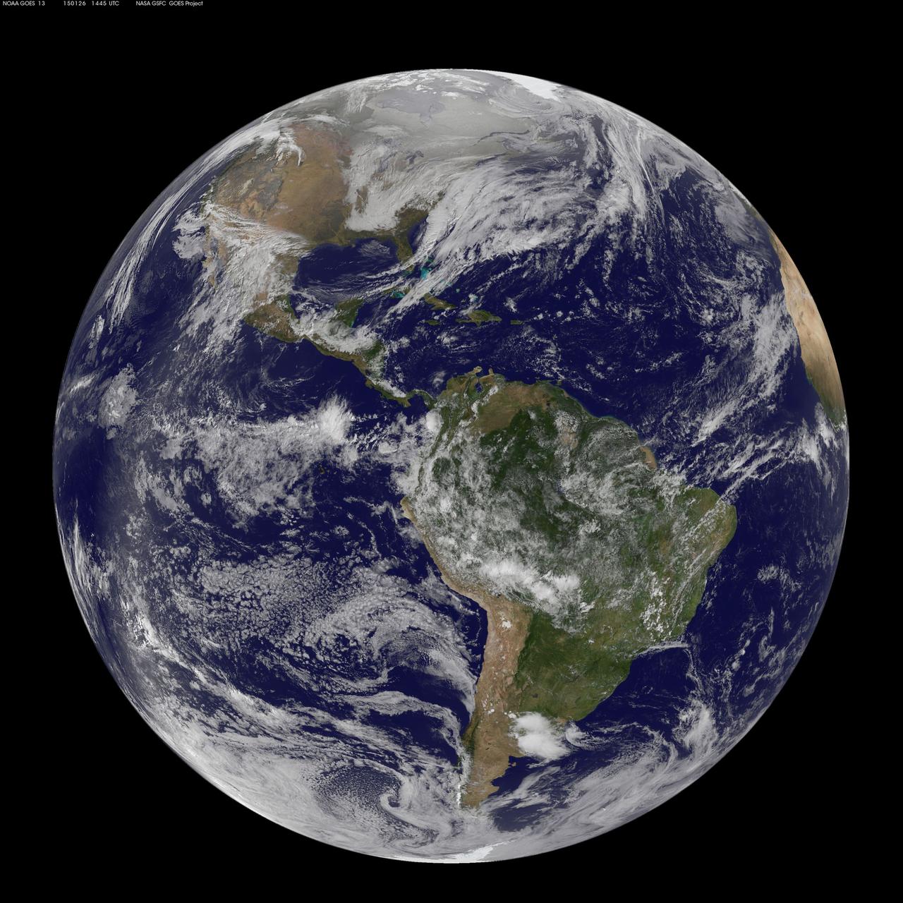
National Weather Service forecasters have been tracking a low pressure area that moved from the Midwest into the Atlantic Ocean today, and is expected to become a strong nor'easter that will bring blizzard conditions to the northeastern U.S. The path of the system was captured in a NASA movie of NOAA's GOES-East satellite imagery. (This GOES 13 image was captured on January 26, 2015 at 1445 UTC.) On Monday, January 26, 2015, the National Weather Service noted: A storm system off the East Coast will continue to strengthen as it develops into a major nor'easter on Monday. As the storm moves up the coast, it is expected to bring snowfall of 1-3 feet or more to many parts of the Northeast through Tuesday evening, including New York City and Boston. Strong, gusty winds will combine with the snow to create blizzard conditions along and near the coast. Winter storm warnings are in effect for the panhandles of West Virginia and Maryland, much of interior New England down to the northern Mid-Atlantic as well as for Nantucket Island, Massachusetts. Winter weather advisories are in effect for portions of the Ohio Valley, Mid-Atlantic and the southern Appalachians as well as a narrow area across interior New England. To create the video and imagery, NASA/NOAA's GOES Project located at NASA's Goddard Space Flight Center in Greenbelt, Maryland overlays the cloud data from NOAA's GOES-East satellite on a true-color image of land and ocean created by data from the Moderate Resolution Imaging Spectroradiometer, or MODIS, instrument that flies aboard NASA's Aqua and Terra satellites. Together, these data create the entire animation of the storm and show its movement. GOES satellites provide the kind of continuous monitoring necessary for intensive data analysis. Geostationary describes an orbit in which a satellite is always in the same position with respect to the rotating Earth. This allows GOES to hover continuously over one position on Earth's surface, appearing stationary. As a result, GOES provide a constant vigil for the atmospheric "triggers" for severe weather conditions such as tornadoes, flash floods, hail storms and hurricanes. For updated information about the storm system, visit NOAA's NWS website: <a href="http://www.weather.gov" rel="nofollow">www.weather.gov</a> For more information about GOES satellites, visit: <a href="http://www.goes.noaa.gov/" rel="nofollow">www.goes.noaa.gov/</a> or goes.gsfc.nasa.gov/ Rob Gutro NASA's Goddard Space Flight Center
Release date: July 1, 2008 This image is a composite of visible (or optical), radio, and X-ray data of the full shell of the supernova remnant from SN 1006. The radio data show much of the extent that the X-ray image shows. In contrast, only a small linear filament in the northwest corner of the shell is visible in the optical data. The object has an angular size of roughly 30 arcminutes (0.5 degree, or about the size of the full moon), and a physical size of 60 light-years (18 parsecs) based on its distance of nearly 7,000 light-years. The small green box along the bright filament at the top of the image corresponds to the dimensions of the Hubble release image. The optical data was obtained at the University of Michigan's 0.9-meter Curtis Schmidt telescope at the National Science Foundation's Cerro Tololo Inter-American Observatory (CTIO) near La Serena, Chile. H-alpha, continuum-subtracted data were provided by F. Winkler (Middlebury COllege) et al. The X-ray data were acquired from the Chandra X-ray Observatory's AXAF CCD Imaging Spectrometer (ACIS) at 0.5-3keV, and were provided by J. Hughes (Rutgers University) et al. The radio data, supplied by K. Dyer (NRAO, Socorro) et al., were a composite from the National Radio Astronomy Observatory's Very Large Array (NRAO/VLA) in Socorro, New Mexico, along with the Green Bank Telescope (GBT) in Green Bank, West Virginia. Data of the supernova remnant were blended on a visible-light stellar background created using the Digitized Sky Survey's Anglo-Australian Observatory (AAO2) blue and red plates. Photo Credit: NASA, ESA, and Z. Levay (STScI) Science Credit: Radio: NRAO/AUI/NSF GBT+VLA 1.4 GHz mosaic (Dyer, Maddalena and Cornwell, NRAO); X-ray: NASA/CXC/Rutgers/G. Cassam-Chenai and J. Hughes et al.; Optical: F.Winkler/Middlebury College and NOAO/AURA/NSF; and DSS To learn more about the Hubble Space Telescope go here: <a href="http://www.nasa.gov/mission_pages/hubble/main/index.html" rel="nofollow">www.nasa.gov/mission_pages/hubble/main/index.html</a> <b><a href="http://www.nasa.gov/centers/goddard/home/index.html" rel="nofollow">NASA Goddard Space Flight Center</a></b> is home to the nation's largest organization of combined scientists, engineers and technologists that build spacecraft, instruments and new technology to study the Earth, the sun, our solar system, and the universe. <b>Follow us on <a href="http://twitter.com/NASAGoddardPix" rel="nofollow">Twitter</a></b> <b>Join us on <a href="http://www.facebook.com/pages/Greenbelt-MD/NASA-Goddard/395013845897?ref=tsd" rel="nofollow">Facebook</a><b> </b></b>
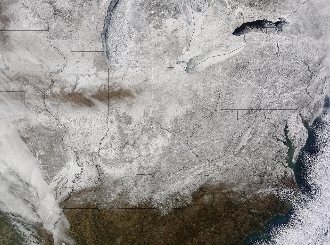
NASA's Terra satellite captured an image of the snow-covered eastern U.S. that looks like the states have been sitting in a freezer. In addition to the snow cover, Arctic and Siberian air masses have settled in over the Eastern U.S. triggering many record low temperatures in many states. On Feb. 19 at 16:40 UTC (11:40 a.m. EST), the Moderate Resolution Imaging Spectroradiometer (MODIS) instrument that flies aboard NASA's Terra satellite captured a picture of the snowy landscape. The snow cover combined with the frosty air mass made the eastern U.S. feel like the inside of freezer. The MODIS image was created at NASA's Goddard Space Flight Center in Greenbelt, Maryland. On the morning of Feb. 20, NOAA's Weather Prediction Center (WPC) noted, "There were widespread subzero overnight lows Thursday night (Feb. 19) extending from Illinois to western Virginia, and numerous record lows were set. Bitterly-cold arctic air is setting numerous temperature records across the eastern U.S. and will keep temperatures well below normal on Friday (Feb. 20)." In Baltimore, Maryland, a low temperature of 1F broke the record low for coldest morning recorded at the Thurgood Marshall Baltimore Washington-International Airport. In Louisville, Kentucky, temperatures dropped to -6F, breaking the old record low of 0F, according to meteorologist Brian Goode of WAVE-TV. Meanwhile, Richmond Kentucky bottomed out at a frigid -32F. In North Carolina, a record low temperature was set at Charlotte where the overnight temperature bottomed out at 7F breaking the old record of 13F in 1896. In Asheville, temperatures dropped to just 4F breaking the old record of 10F in 1979. Temperature records for Asheville extend back to 1876. Several records were also broken in Georgia, according to Matt Daniel, a meteorologist at WMAZ-TV, Macon Georgia, who cited data from the National Weather Service. Daniel said that Macon set a new record low when the temperature dropped to 18F, beating the previous record of 21F set in 1958. Athens broke a new record low, too dropping to 14F and beating the old record of 18F set in 1958/1928. NOAA's NPC noted that "Highs on Friday (Feb. 20) will struggle to get out of the teens from the Ohio Valley to the Mid-Atlantic region. After Friday, temperatures are forecast to moderate and get closer to February averages as a storm system approaches from the west." Image Credit: NASA Goddard MODIS Rapid Response Team <b><a href="http://www.nasa.gov/audience/formedia/features/MP_Photo_Guidelines.html" rel="nofollow">NASA image use policy.</a></b> <b><a href="http://www.nasa.gov/centers/goddard/home/index.html" rel="nofollow">NASA Goddard Space Flight Center</a></b> enables NASA’s mission through four scientific endeavors: Earth Science, Heliophysics, Solar System Exploration, and Astrophysics. Goddard plays a leading role in NASA’s accomplishments by contributing compelling scientific knowledge to advance the Agency’s mission. <b>Follow us on <a href="http://twitter.com/NASAGoddardPix" rel="nofollow">Twitter</a></b> <b>Like us on <a href="http://www.facebook.com/pages/Greenbelt-MD/NASA-Goddard/395013845897?ref=tsd" rel="nofollow">Facebook</a></b> <b>Find us on <a href="http://instagram.com/nasagoddard?vm=grid" rel="nofollow">Instagram</a></b>
National Weather Service forecasters have been tracking a low pressure area that moved from the Midwest into the Atlantic Ocean today, and is expected to become a strong nor'easter that will bring blizzard conditions to the northeastern U.S. The path of the system was captured in a NASA movie of NOAA's GOES-East satellite imagery. An animation of visible and infrared imagery from NOAA's Geostationary Operational Environmental or GOES satellite captured over the period of January 24 through 26 showed the progression of the developing nor'easter. The satellite animation began on Jan. 24 when clouds associated with a cold front preceding the low, pushed off the U.S. East coast. The front was followed by a low pressure area that moved from the Midwest to the southeast. That low moved over the Carolinas and exited into the Atlantic Ocean on Jan. 26. NOAA's National Weather Service forecast calls for the low to intensify along the Eastern Seaboard and bring blizzard conditions to the northeastern U.S. on Monday night, January 26 and Tuesday, January 27. On Monday, January 26, 2015, the National Weather Service noted: A storm system off the East Coast will continue to strengthen as it develops into a major nor'easter on Monday. As the storm moves up the coast, it is expected to bring snowfall of 1-3 feet or more to many parts of the Northeast through Tuesday evening, including New York City and Boston. Strong, gusty winds will combine with the snow to create blizzard conditions along and near the coast. Winter storm warnings are in effect for the panhandles of West Virginia and Maryland, much of interior New England down to the northern Mid-Atlantic as well as for Nantucket Island, Massachusetts. Winter weather advisories are in effect for portions of the Ohio Valley, Mid-Atlantic and the southern Appalachians as well as a narrow area across interior New England. To create the video and imagery, NASA/NOAA's GOES Project located at NASA's Goddard Space Flight Center in Greenbelt, Maryland overlays the cloud data from NOAA's GOES-East satellite on a true-color image of land and ocean created by data from the Moderate Resolution Imaging Spectroradiometer, or MODIS, instrument that flies aboard NASA's Aqua and Terra satellites. Together, these data create the entire animation of the storm and show its movement. GOES satellites provide the kind of continuous monitoring necessary for intensive data analysis. Geostationary describes an orbit in which a satellite is always in the same position with respect to the rotating Earth. This allows GOES to hover continuously over one position on Earth's surface, appearing stationary. As a result, GOES provide a constant vigil for the atmospheric "triggers" for severe weather conditions such as tornadoes, flash floods, hail storms and hurricanes. For updated information about the storm system, visit NOAA's NWS website: <a href="http://www.weather.gov" rel="nofollow">www.weather.gov</a> For more information about GOES satellites, visit: <a href="http://www.goes.noaa.gov/" rel="nofollow">www.goes.noaa.gov/</a> or goes.gsfc.nasa.gov/ Rob Gutro NASA's Goddard Space Flight Center