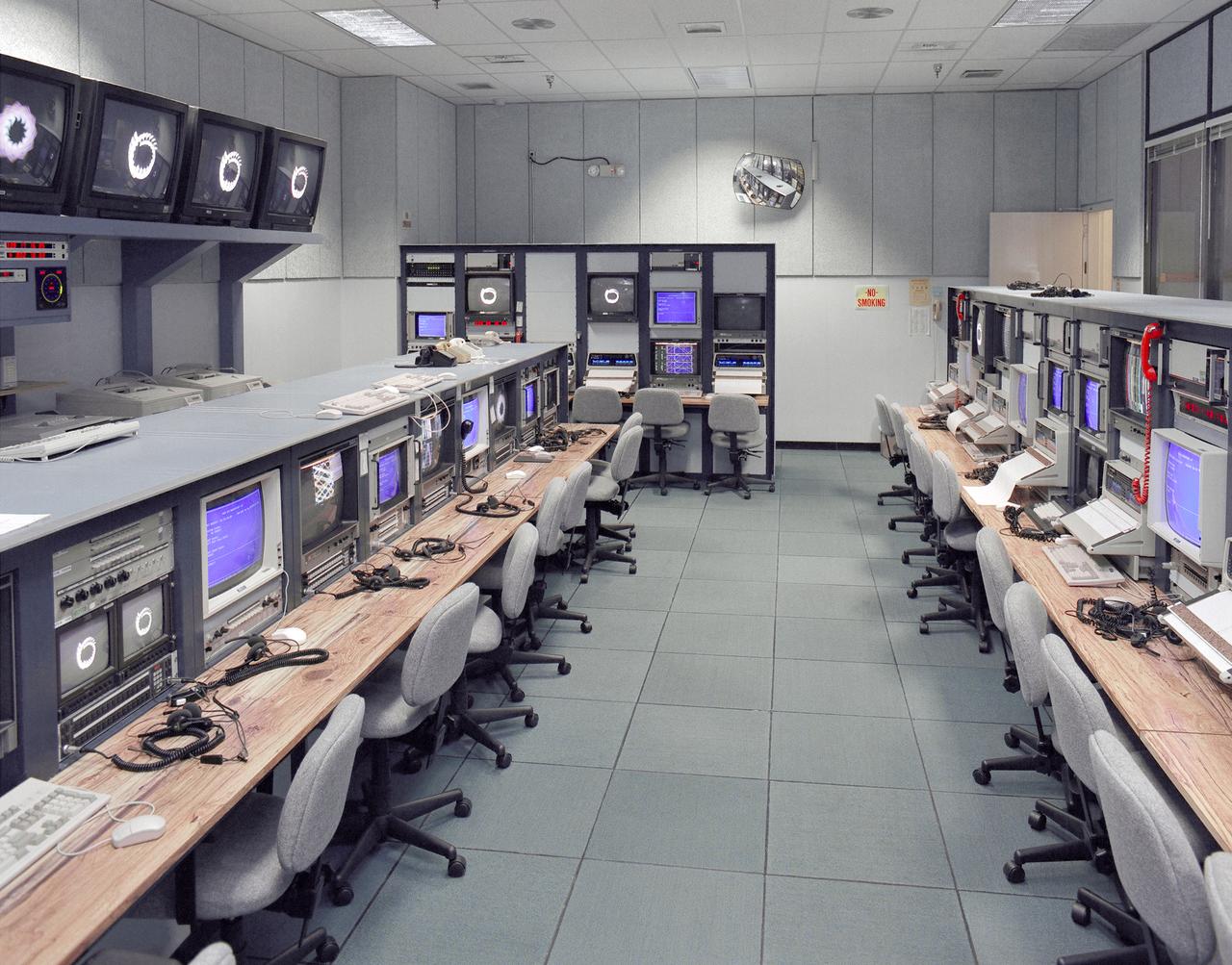
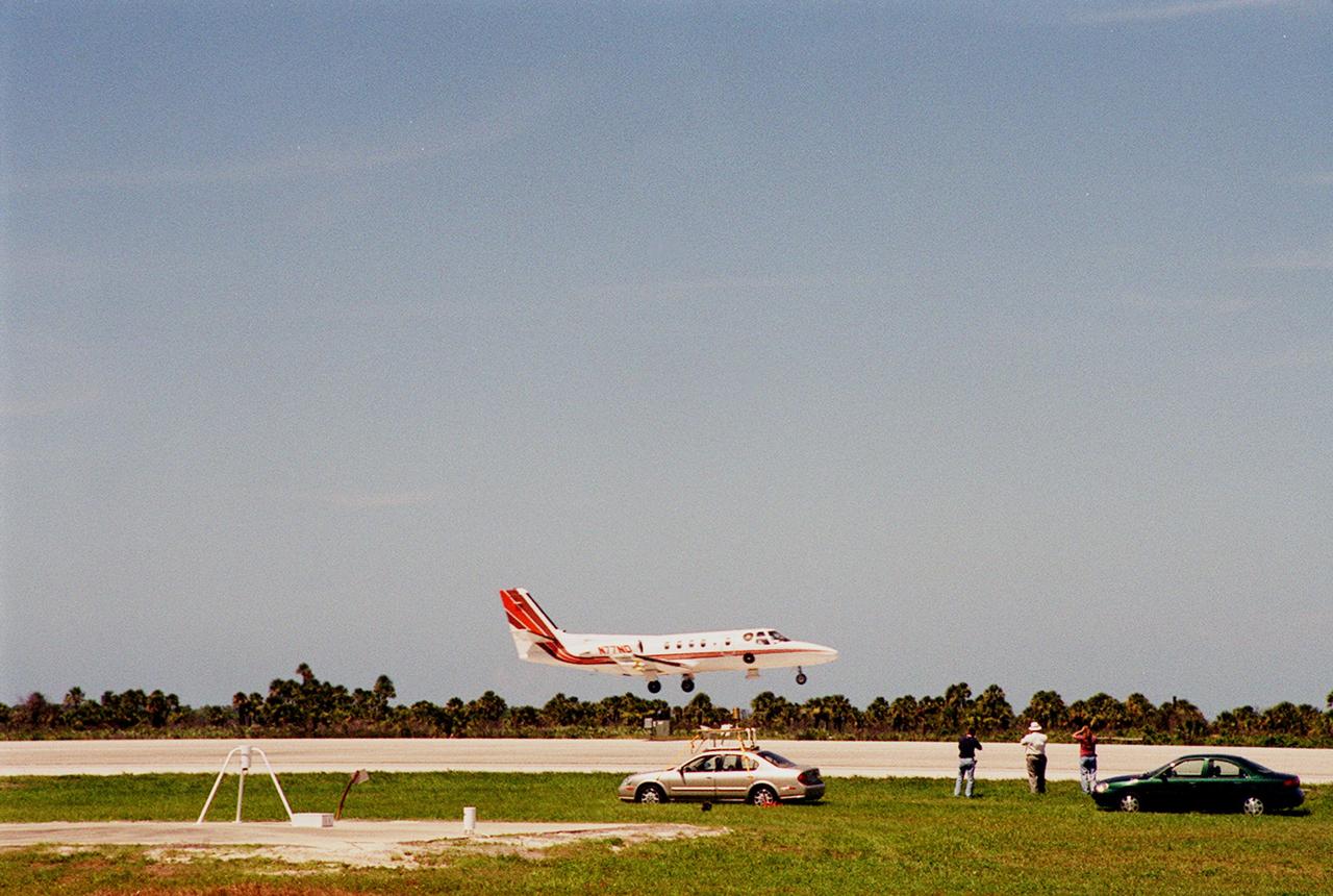
Mission control Blue Room, seen here, in building 4800 at NASA's Dryden Flight Research Center, is part of the Western Aeronautical Test Range (WATR). All aspects of a research mission are monitored from one of two of these control rooms at Dryden. The WATR consists of a highly automated complex of computer controlled tracking, telemetry, and communications systems and control room complexes that are capable of supporting any type of mission ranging from system and component testing, to sub-scale and full-scale flight tests of new aircraft and reentry systems. Designated areas are assigned for spin/dive tests, corridors are provided for low, medium, and high-altitude supersonic flight, and special STOL/VSTOL facilities are available at Ames Moffett and Crows Landing. Special use airspace, available at Edwards, covers approximately twelve thousand square miles of mostly desert area. The southern boundary lies to the south of Rogers Dry Lake, the western boundary lies midway between Mojave and Bakersfield, the northern boundary passes just south of Bishop, and the eastern boundary follows about 25 miles west of the Nevada border except in the northern areas where it crosses into Nevada.
The oval shaped basin of the sedimentary rocks of the Hammersley Range, northern Western Australia (23.0S, 119.0E) dominates the center of this near nadir view. The Fortescue River is the remarkably straight, fault controlled feature bordering the Hammersley on the north. Sand dunes are the main surface features in the northeast and southwest. Many dry lakebeds can be seen to the east as light grey colored patches along the watercourses.
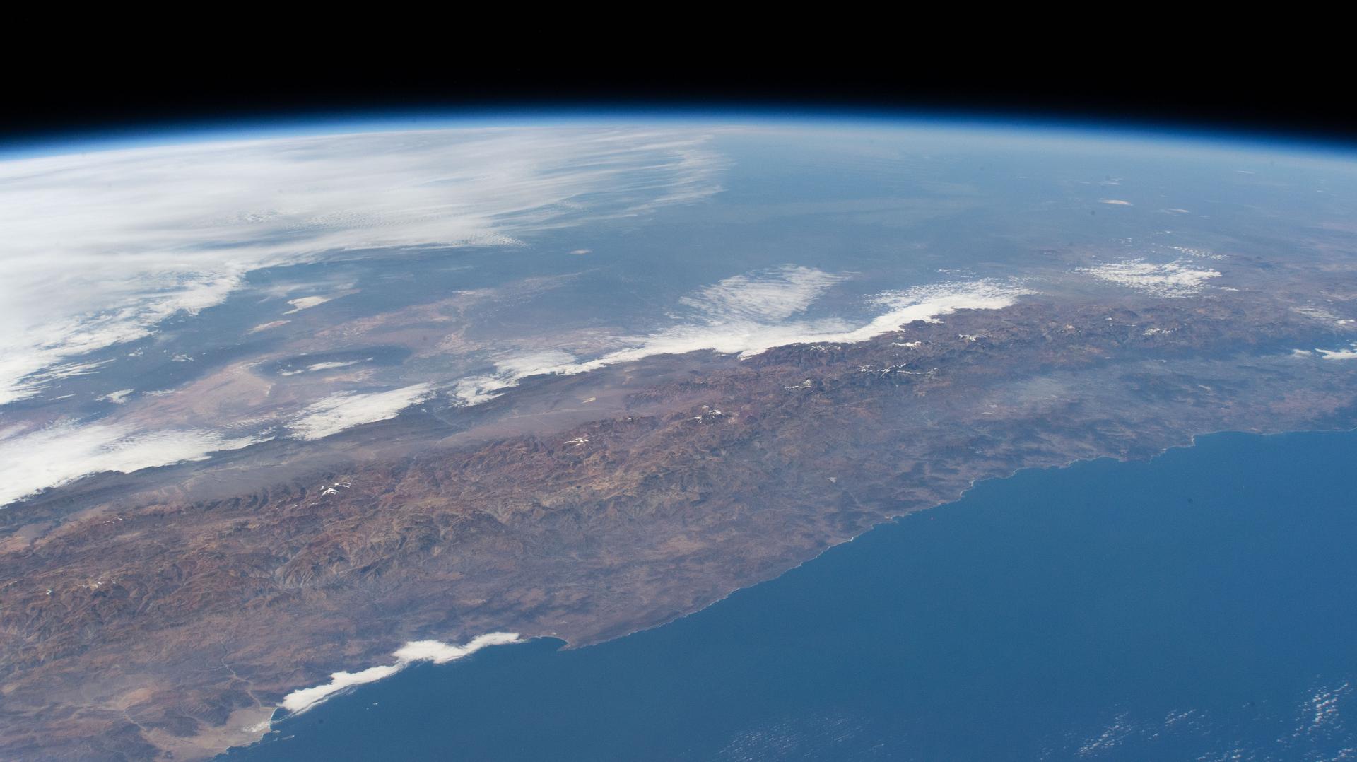
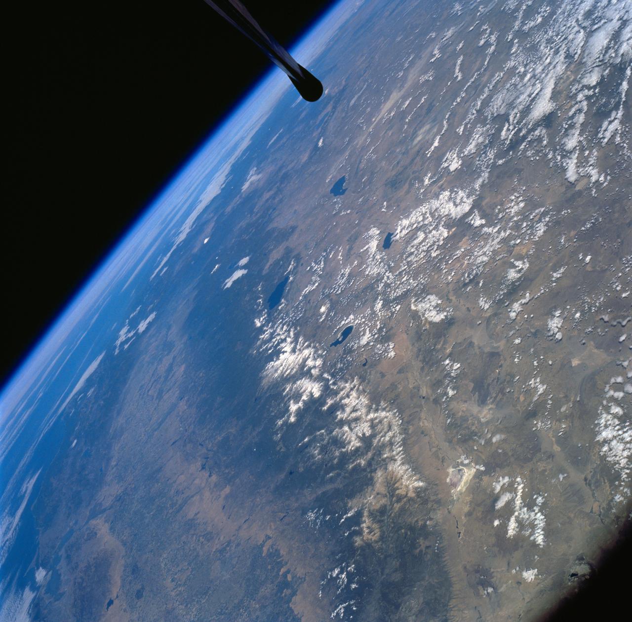
iss074e0315889 (Feb. 16, 2026) --- A portion of the rugged Zagros Mountain range, featuring narrow valleys and rocky outcrops in the semi-arid region of western Iran, is pictured from the International Space Station as it orbited 259 miles above Earth. Credit: NASA/Chris Williams
The northwest-southeast trending, snow-covered, linear mountain range is the King Ata Tag Mountain, located in extreme western most China. Highest peaks are just over 20,100 feet above sea level. The town or village of Muji is located in the largest river valley that is south of this range of mountains. This area includes part of the country of Tajikistan. The center point of the photo is approximately 39.30 degrees north and 74.30 degrees easth.
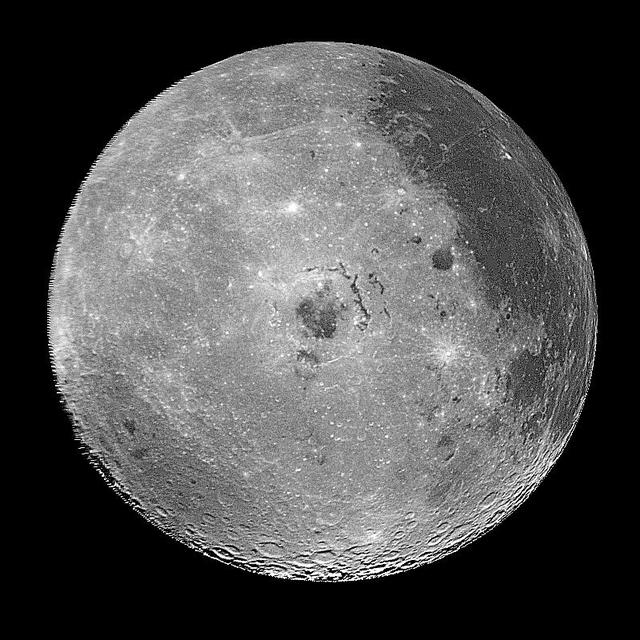
This image of the western hemisphere of the Moon was taken through a green filter by NASA's Galileo spacecraft at 9:35 a.m. PST Dec. 9 at a range of about 350,000 miles. In the center is the Orientale Basin. http://photojournal.jpl.nasa.gov/catalog/PIA00120

iss063e032032 (June 22, 2020) --- The International Space Station orbits above Tajikistan near the western border of China with the K2 mountain, the world's second-highest peak, below in the Karakoram range.
iss059e067738 (May 19, 2018) --- Snow-capped mountain tops are pictured as the International Space Station orbited 257 miles above the Andes mountain range along the western coast of South America.
STS097-715-061 (10 December 2000) This view over the Central Andes Mountains in Argentina and Chile was taken on December 10, 2000 by one of the astronauts aboard the Earth-orbiting Space Shuttle Endeavour. Extending 5500 miles (8850 kilometers) along the western coast of South America from northern Colombia to Cape Horn in southern Chile, the Andes are the longest mountain range, above sea level, and the second highest range in the world. According to NASA scientists studying the STS-97 photo collection, this immense system came into existence nearly 70 million years ago. With numerous active volcanoes and a slow uplift, the building of the Andes Mountains continues today rising four inches (10 centimeters) per century, the scientists say. In this north-looking view, snow covers the higher peaks of the range, some of which rise to over 20000 feet (6100 meters) above sea level. Along the left or western portion of the view, clouds can be seen along coastal areas of Chile. In the bottom left quadrant of the scene, the blue waters of the Paloma Reservoir, a recreational lake, are visible. The folded Tontal Range (bottom center) and the Valle Fertil Range (upper right quadrant and partially cloud covered) of western Argentina can be seen. The rocks of these ranges, the scientists point out, are ancient compared to the younger volcanic peaks and ranges of the Andes. The city of San Juan, Argentina is visible on the eastern (right) base of the Tontal Range in the lower right quadrant of the view.
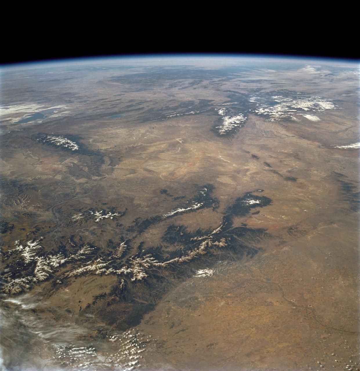
STS103-730-032 (19-27 December 1999) --- One of the astronauts aboard the Earth-orbiting Space Shuttle Discovery used a handheld 70mm camera to capture the southern to middle Rocky Mountains in low sunlight. The middle Rockies include the Big Horn range of Wyoming (snow capped range almost center of horizon) and the Unita Mountains of northeastern Utah (snow capped range left side of horizon). The southern Rockies includes the Front Range, Sangre de Cristo Mountains, Sawatch Ranges, and the San Juan Mountains. The eastern (Front Range, Sangre de Cristo) and western ranges (Sawatch, San Juan's) are separated by intermontane basins. The southernmost basin (near center of the image) is the San Luis Valley of Colorado. On the eastern edge of the San Luis Valley are the Sangre de Cristo Mountains.
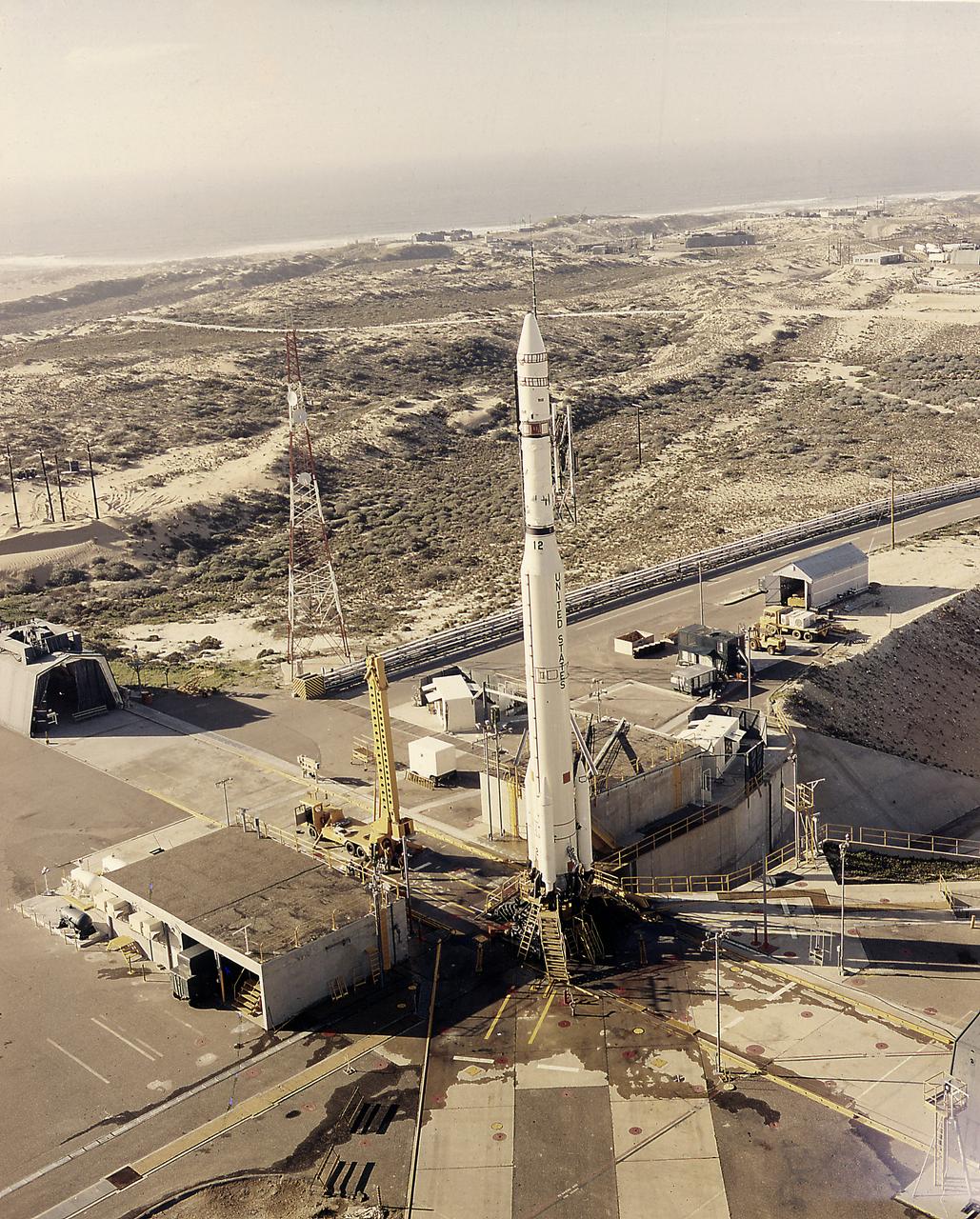
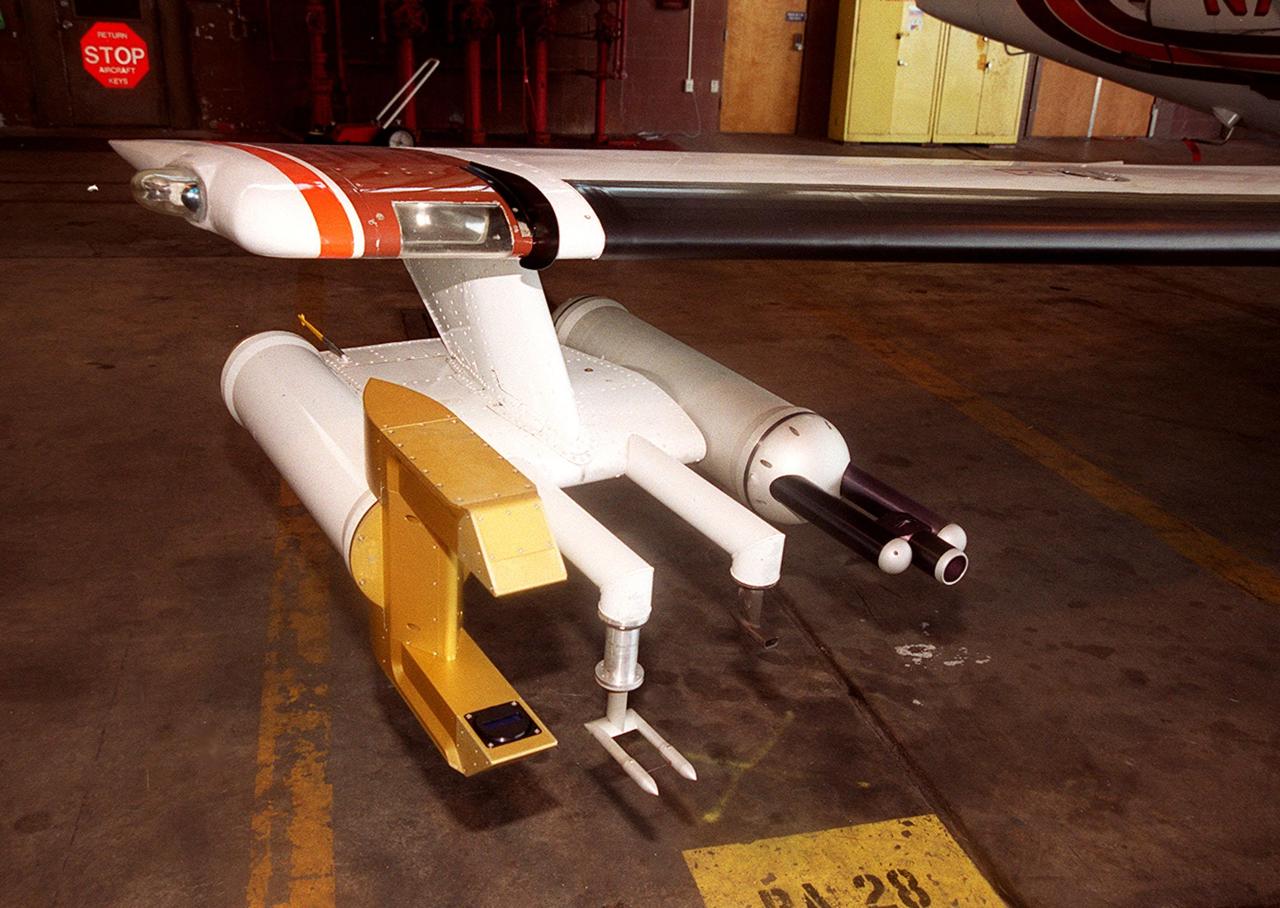
The Thorad-Agena launch vehicle with the SERT-2 (Space Electric Rocket Test-2) spacecraft on launch pad at the Western Test Range in California. The SERT-2 was launched on February 4, 1970 and tested the capability of an electric ion thruster system.
iss069e071176 (Aug. 20, 2023) --- Ka Nasi Lake (lower left) and Ake Kule Lake (upper right), in China's Altai Mountain range near Mongolia's far western border, are pictured in this photograph as the International Space Station orbited 265 miles above.
iss054e006869 (Dec. 27, 2017) --- This photograph taken by Expedition 54 crew members aboard the International Space Station reveals striking climate differences of Nepal and the Himalayan mountain range, including Mount Everest (left) and the Tibetan highlands of western China (right).
AS07-07-1832 (15 Oct. 1968) --- Toba, Kakar, Fort Sandeman, Sulaiman Range area in (West) Pakistan, as seen from the Apollo 7 spacecraft during its 84th revolution of Earth. Note geological features such as folded mountain structures, anticlines and synclines. Photographed from an altitude of 108 nautical miles, at ground elapsed time of 132 hours and 30 minutes.
iss074e0349412 (March 3, 2026) --- The Andes mountain range running between Chile and Argentina creates distinct differences in climate and geography between the two South American nations. Chile’s Pacific coastline contributes to its moderate temperatures, with the Atacama Desert in the north being one of the driest places on Earth, while its central and southern regions are cooler and wetter. Argentina’s western side is more arid because the Andes block moisture from the Pacific Ocean, while the country’s Atlantic coastline receives more precipitation than its interior and western regions. Credit: NASA
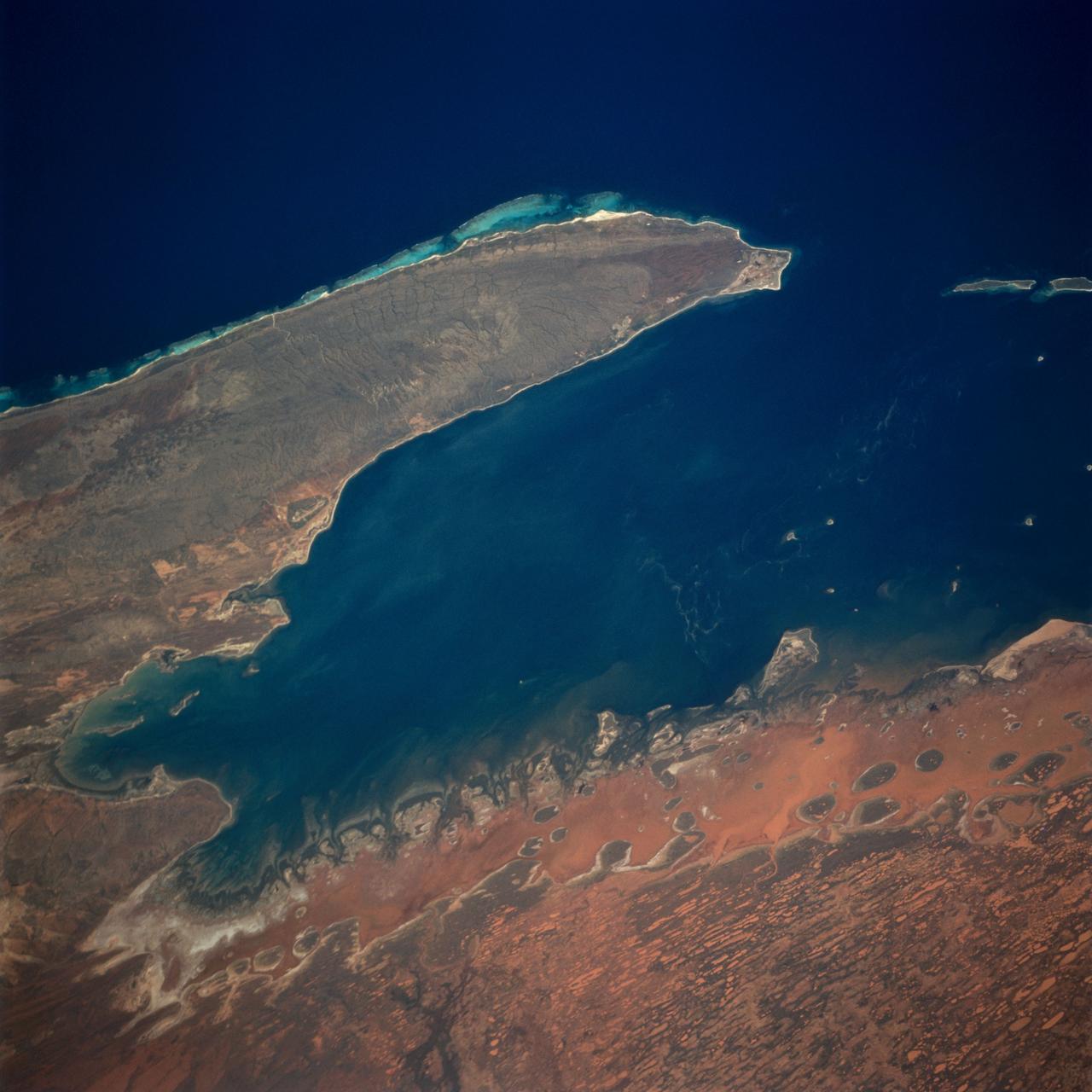
The Exmouth Gulf, western Australia, is bounded on the west by the Cape Ranges; near the base of the peninsula the Learmonth Airfield, site of a solar observatory, can be seen. Spit-accretion ridges formed on ancient beaches extend along the western edge of the peninsula, which today is lined by the Ningaloo Reef. Red mud carried by floodwaters, the result of Hurricane Bobby the previous week, cover flat coastal land along the eastern side of the gulf. The mud is mixing slowly with marine water as it filters through passes between mangrove-covered islands. A filamentous pattern in the gulf probably indicates a plankton bloom. Island paleodunes stretching from south to north cover the landscape.
STS112-708-002 (7-18 October 2002) --- This image, photographed from the Earth-orbiting Space Shuttle Atlantis, covers parts of Utah, Colorado, Wyoming and Idaho. The Front Range of the Rockies is the dark range crossing the bottom of the view, with Denver and neighboring cities (grays) situated in the gentle embayment of the mountains (bottom center of the view). Great Salt Lake in Utah appears as two colors of blue top left, with the snow-covered Uinta Mountains just below, in this northwesterly view. Most of the view encompasses the brown plains of western Wyoming (center) and the cluster of mountains around Yellowstone (top center, top right, with snow). Beyond the brown Snake River Plain, black rocks of the Sawtooth Mountains and neighboring ranges of central Idaho appear top center.

ISS011-E-13889 (30 September 2005) --- Wasatch Range, Utah is featured in this image photographed by an Expedition 11 crewmember on the international space station. The Wasatch Range forms an impressive backdrop to the Salt Lake City metropolitan area, and is a frequent destination for hikers, backpackers, and skiers. The range is considered to be the westernmost part of the Rocky Mountains, and rises to elevations of approximately 3600 meters (12,000 feet) above sea level. This photograph, taken at the end of September, captures red- (maple trees) and gold-mantled (aspen trees) hill slopes along the western mountain front to the south of Salt Lake City. Other common tree species at these elevations include pine, fir, spruce, willow, birch, and oak. A portion of Draper City is visible in the left half of the image. The elevation of Lone Peak, visible at upper right, is approximately 3410 meters (11,253 feet).

In the Kennedy Space Center's Press Site auditorium, Damon Penn, assistant administrator for response at the Federal Emergency Management Agency, speaks to the media during a mission briefing on the Geostationary Operational Environmental Satellite (GOES-R). GOES-R is the first satellite in a series of next-generation GOES satellites for NOAA, the National Oceanographic and Atmospheric Administration. It will launch to a geostationary orbit over the western hemisphere to provide images of storms and help meteorologists predict severe weather conditionals and develop long-range forecasts.

In the Kennedy Space Center's Press Site auditorium, Sandra Cauffman, deputy director of NASA's Earth Science Division, speaks to the media during a mission briefing on the Geostationary Operational Environmental Satellite (GOES-R). GOES-R is the first satellite in a series of next-generation GOES satellites for NOAA, the National Oceanographic and Atmospheric Administration. It will launch to a geostationary orbit over the western hemisphere to provide images of storms and help meteorologists predict severe weather conditionals and develop long-range forecasts.
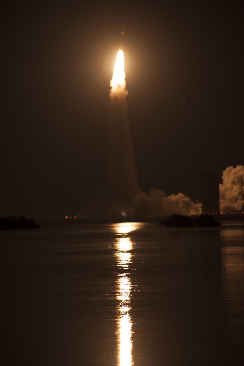
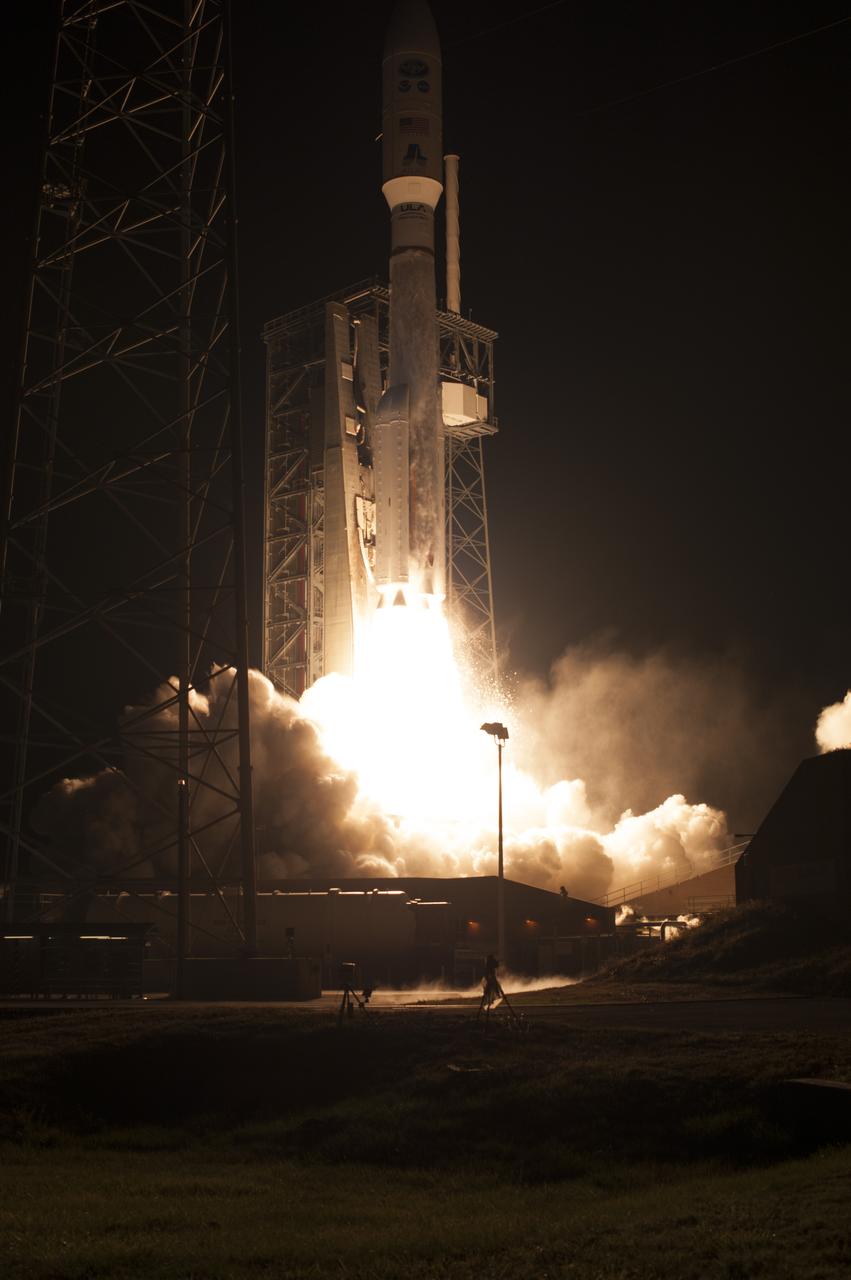
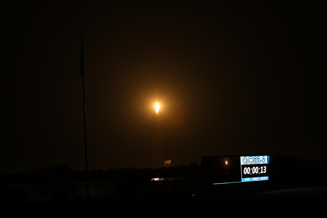
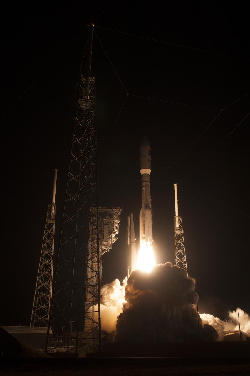
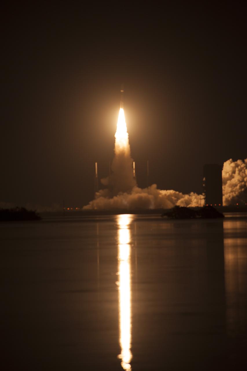
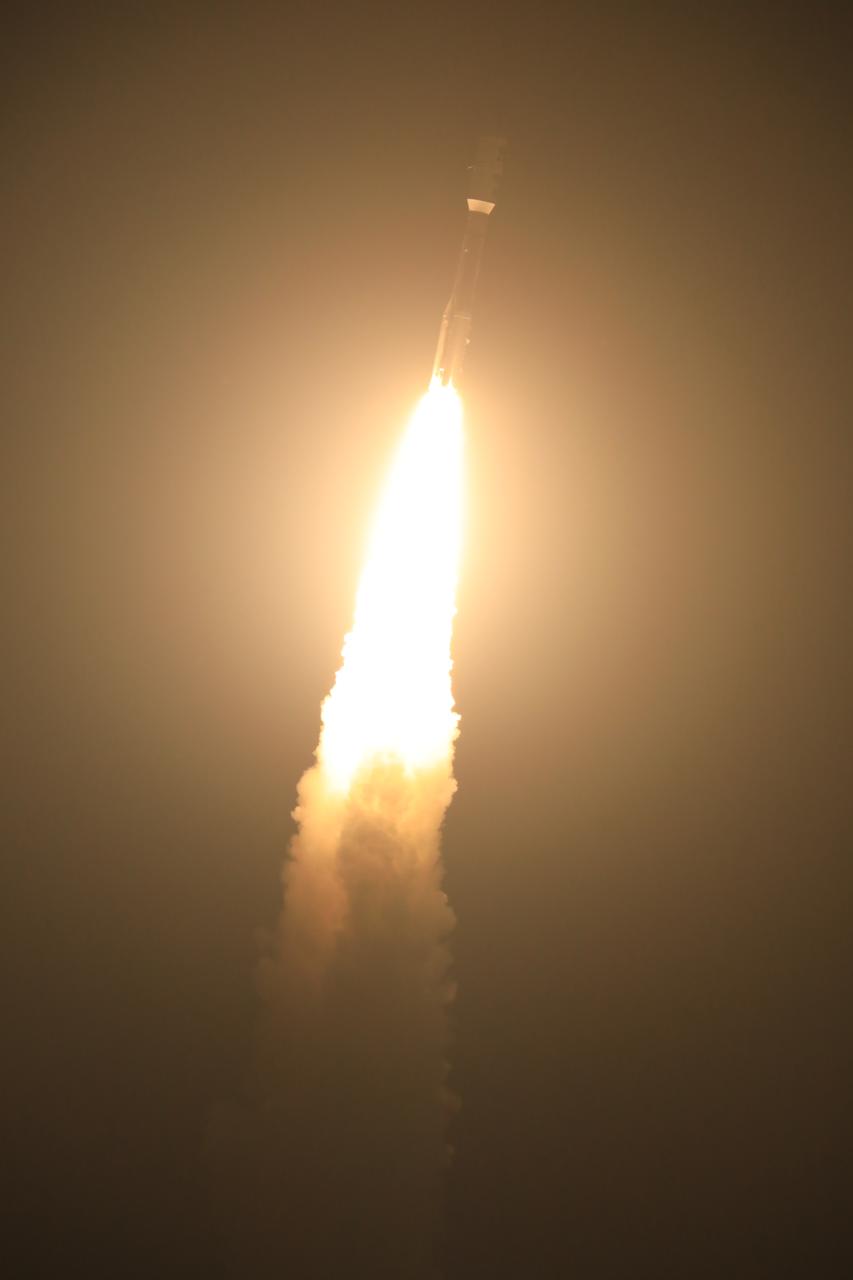
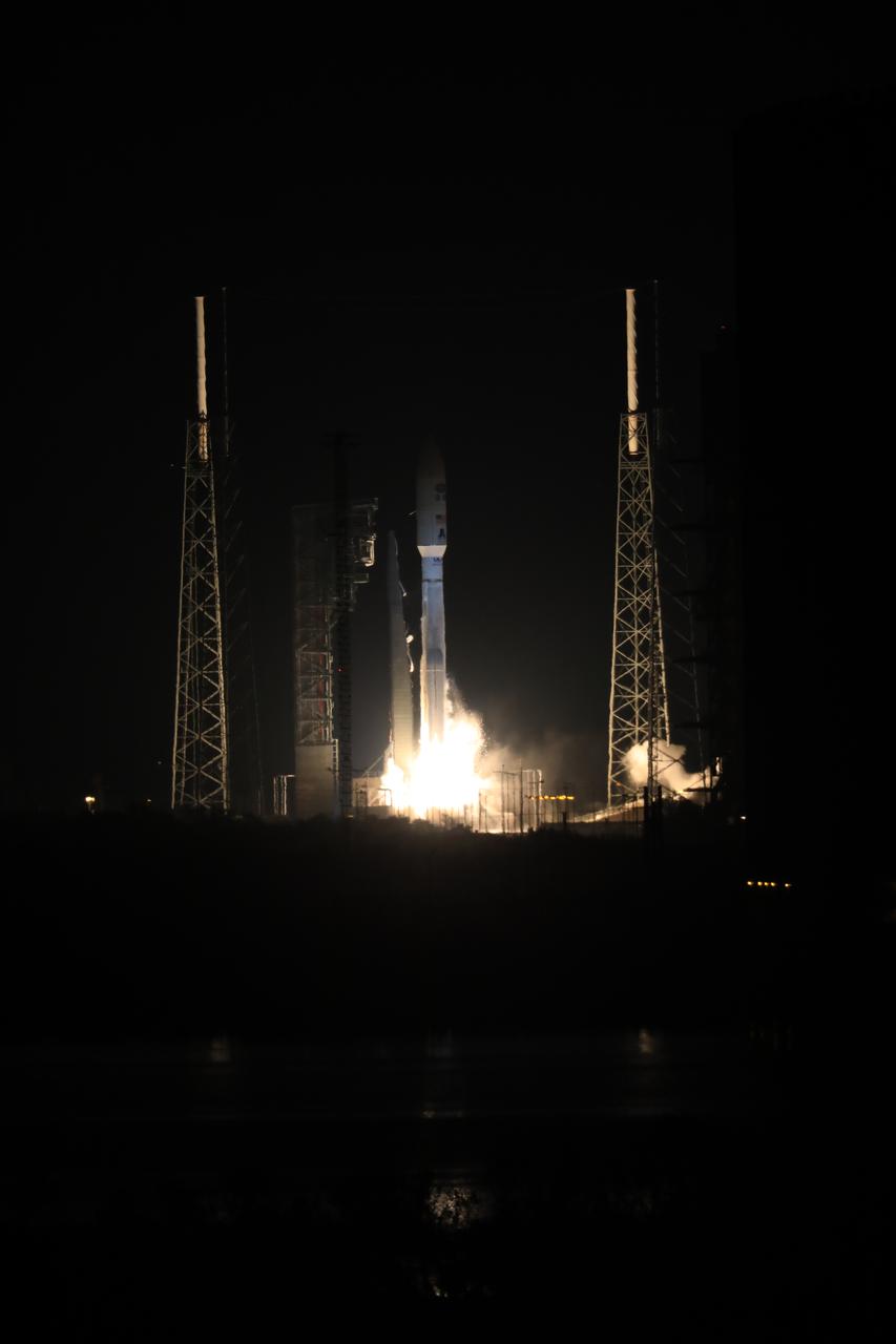
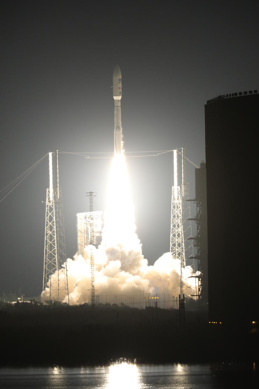
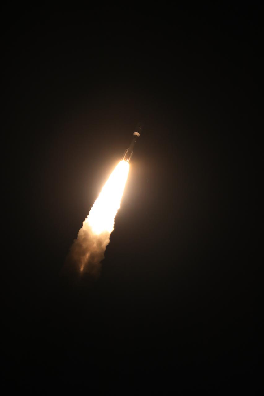
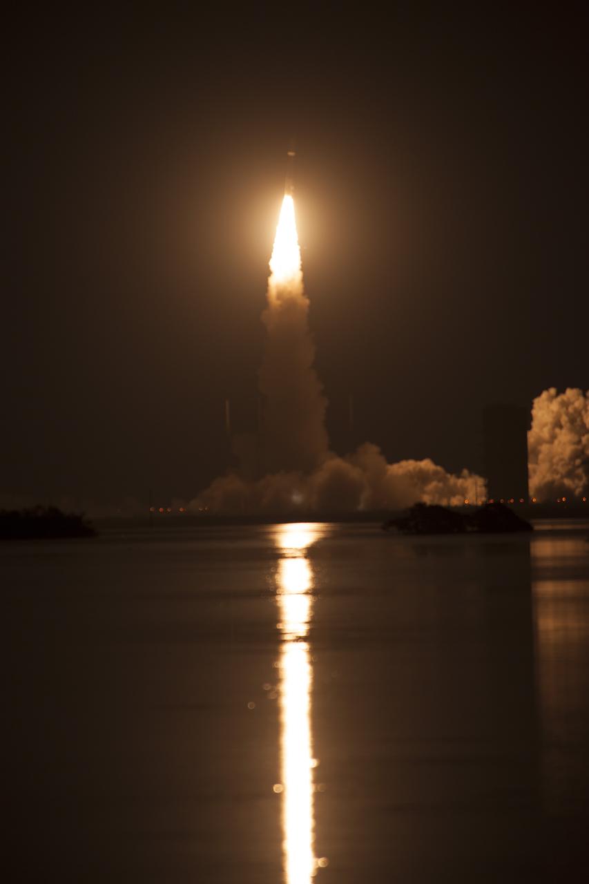
At Cape Canaveral Air Force Station's Space Launch Complex 41, an Atlas V rocket with NOAA's Geostationary Operational Environmental Satellite, or GOES-R, lifts off at 6:42 p.m. EST. GOES-R is the first satellite in a series of next-generation GOES satellites for NOAA, the National Oceanographic and Atmospheric Administration. It will launch to a geostationary orbit over the western hemisphere to provide images of storms and help meteorologists predict severe weather conditionals and develop long-range forecasts.

In the Kennedy Space Center's Press Site auditorium, Damon Penn, assistant administrator for response at the Federal Emergency Management Agency, speaks to the media during a mission briefing on the Geostationary Operational Environmental Satellite (GOES-R). GOES-R is the first satellite in a series of next-generation GOES satellites for NOAA, the National Oceanographic and Atmospheric Administration. It will launch to a geostationary orbit over the western hemisphere to provide images of storms and help meteorologists predict severe weather conditionals and develop long-range forecasts.
STS058-102-018 (18 Oct-1 Nov 1993) --- A cloud-free, wide-angle view from above western Tennessee to the northern edge of Lake Michigan. The view extends from Saint Louis, Missouri near the lower left-hand corner, past Evansville, Indiana and Louisville, Kentucky to Cincinnati, Ohio. A range of hills covered by trees in Fall foliage extends from the Ohio River toward Lake Michigan, ending just southwest of Indianapolis, Indiana.

In the Kennedy Space Center's Press Site auditorium, Sean Potter of NASA Communications, moderates a mission briefing on the Geostationary Operational Environmental Satellite (GOES-R). GOES-R is the first satellite in a series of next-generation GOES satellites for NOAA, the National Oceanographic and Atmospheric Administration. It will launch to a geostationary orbit over the western hemisphere to provide images of storms and help meteorologists predict severe weather conditionals and develop long-range forecasts.
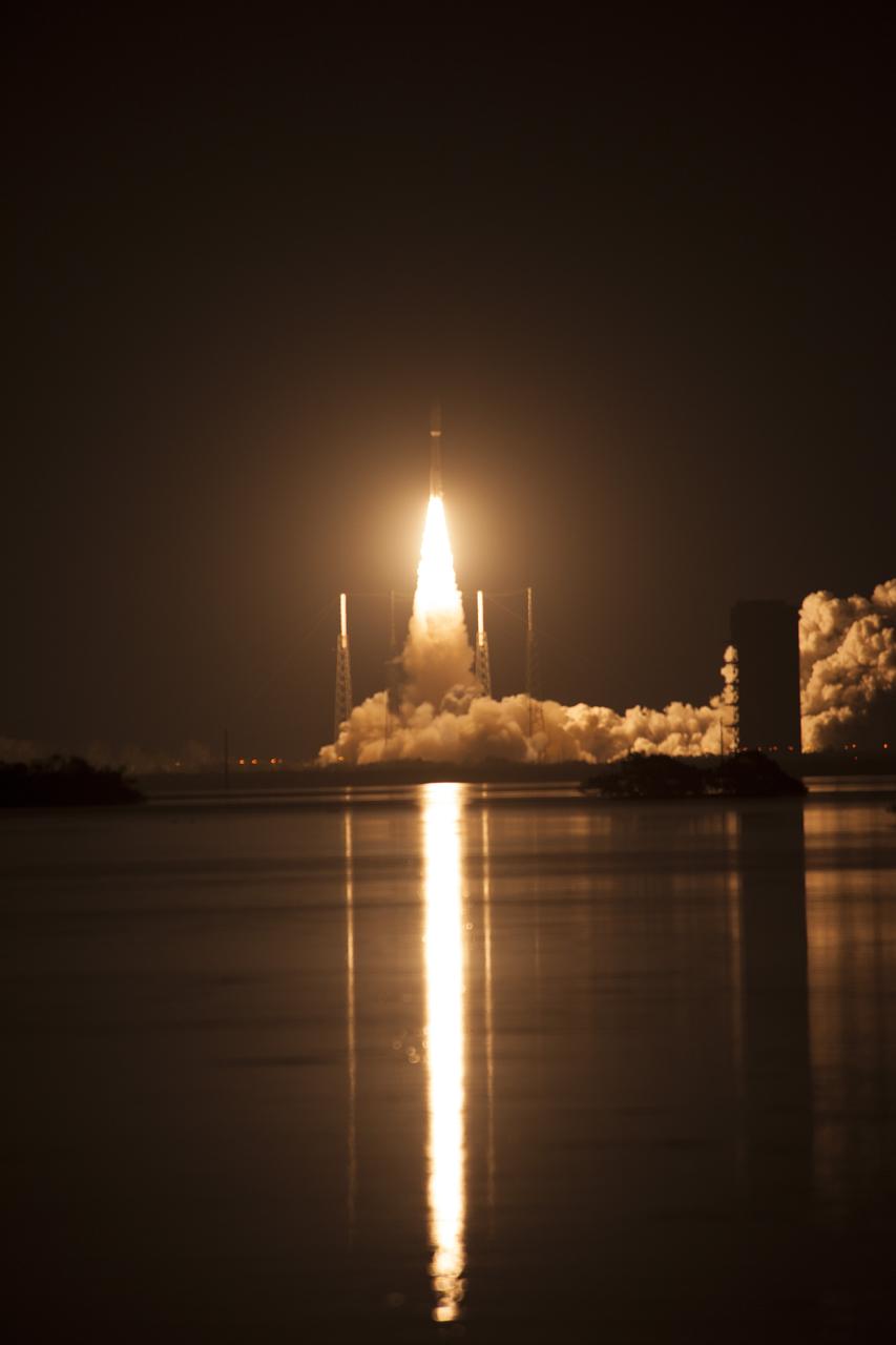
At Cape Canaveral Air Force Station's Space Launch Complex 41, an Atlas V rocket with NOAA's Geostationary Operational Environmental Satellite, or GOES-R, lifts off at 6:42 p.m. EST. GOES-R is the first satellite in a series of next-generation GOES satellites for NOAA, the National Oceanographic and Atmospheric Administration. It will launch to a geostationary orbit over the western hemisphere to provide images of storms and help meteorologists predict severe weather conditionals and develop long-range forecasts.
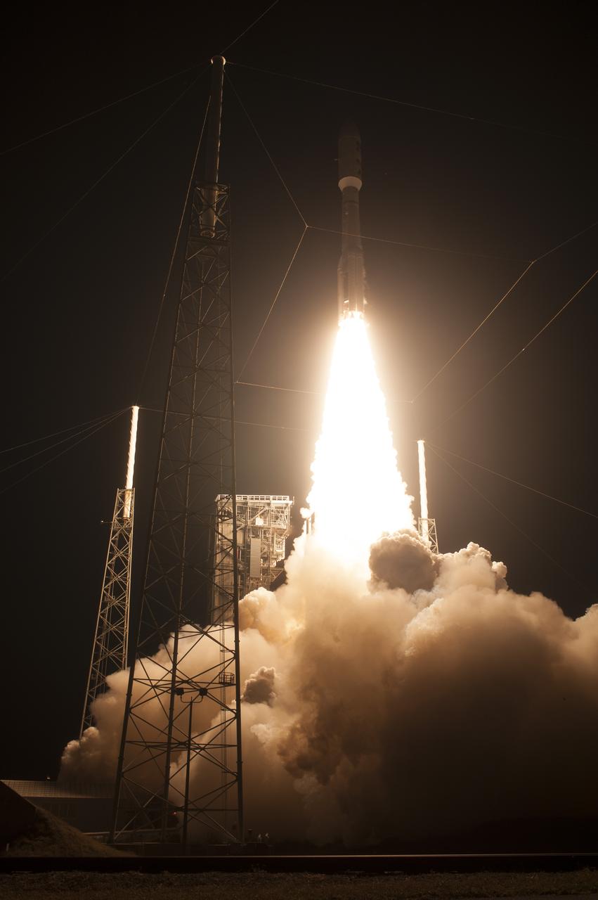
At Cape Canaveral Air Force Station's Space Launch Complex 41, an Atlas V rocket with NOAA's Geostationary Operational Environmental Satellite, or GOES-R, lifts off at 6:42 p.m. EST. GOES-R is the first satellite in a series of next-generation GOES satellites for NOAA, the National Oceanographic and Atmospheric Administration. It will launch to a geostationary orbit over the western hemisphere to provide images of storms and help meteorologists predict severe weather conditionals and develop long-range forecasts.
At Cape Canaveral Air Force Station's Space Launch Complex 41, an Atlas V rocket with NOAA's Geostationary Operational Environmental Satellite, or GOES-R, lifts off at 6:42 p.m. EST. GOES-R is the first satellite in a series of next-generation GOES satellites for NOAA, the National Oceanographic and Atmospheric Administration. It will launch to a geostationary orbit over the western hemisphere to provide images of storms and help meteorologists predict severe weather conditionals and develop long-range forecasts.
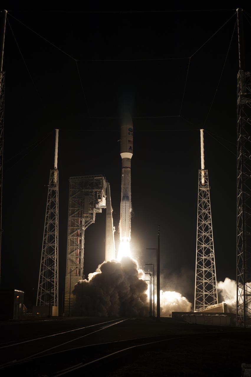
At Cape Canaveral Air Force Station's Space Launch Complex 41, an Atlas V rocket with NOAA's Geostationary Operational Environmental Satellite, or GOES-R, lifts off at 6:42 p.m. EST. GOES-R is the first satellite in a series of next-generation GOES satellites for NOAA, the National Oceanographic and Atmospheric Administration. It will launch to a geostationary orbit over the western hemisphere to provide images of storms and help meteorologists predict severe weather conditionals and develop long-range forecasts.

During the countdown for the launch of NOAA's Geostationary Operational Environmental Satellite, or GOES-R, Stephanie Martin of NASA Communications, right, interviews Al Roker, weather forecaster on NBC's "Today Show." GOES-R is the first satellite in a series of next-generation GOES satellites for NOAA, the National Oceanographic and Atmospheric Administration. It will launch to a geostationary orbit over the western hemisphere to provide images of storms and help meteorologists predict severe weather conditionals and develop long-range forecasts.

In the Kennedy Space Center's Press Site auditorium, Steven Goodman, NOAA's GOES-R program scientist, speaks to the media during a mission briefing on the Geostationary Operational Environmental Satellite (GOES-R). GOES-R is the first satellite in a series of next-generation GOES satellites for NOAA, the National Oceanographic and Atmospheric Administration. It will launch to a geostationary orbit over the western hemisphere to provide images of storms and help meteorologists predict severe weather conditionals and develop long-range forecasts.

During the countdown for the launch of NOAA's Geostationary Operational Environmental Satellite, or GOES-R, Stephanie Martin of NASA Communications, left, interviews Al Roker, weather forecaster on NBC's "Today Show." GOES-R is the first satellite in a series of next-generation GOES satellites for NOAA, the National Oceanographic and Atmospheric Administration. It will launch to a geostationary orbit over the western hemisphere to provide images of storms and help meteorologists predict severe weather conditionals and develop long-range forecasts.

At Cape Canaveral Air Force Station's Space Launch Complex 41, an Atlas V rocket with NOAA's Geostationary Operational Environmental Satellite, or GOES-R, lifts off at 6:42 p.m. EST. GOES-R is the first satellite in a series of next-generation GOES satellites for NOAA, the National Oceanographic and Atmospheric Administration. It will launch to a geostationary orbit over the western hemisphere to provide images of storms and help meteorologists predict severe weather conditionals and develop long-range forecasts.
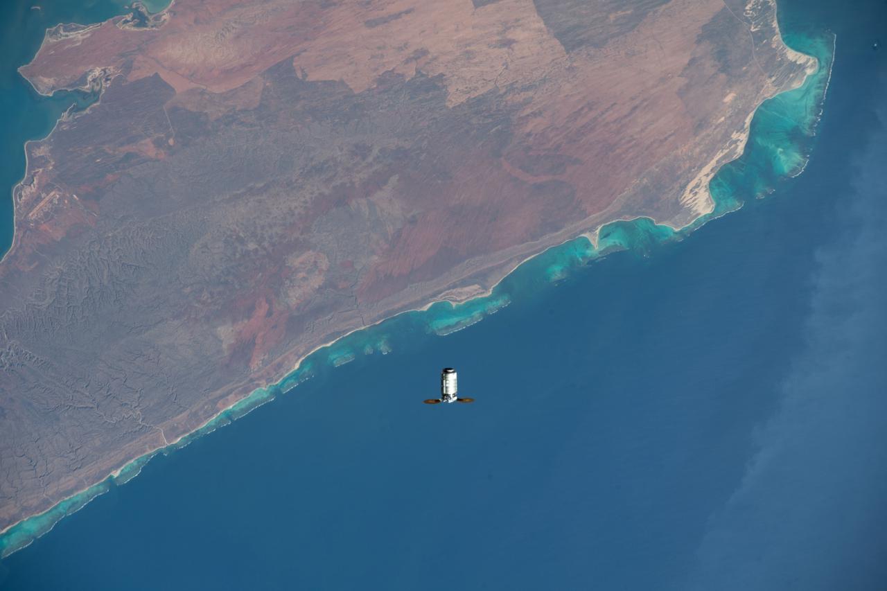
iss066e147492 (Feb. 21, 2022) --- Northrop Grumman's Cygnus space freighter is pictured approaching the International Space Station as both spacecraft orbited 262 miles above Cape Range National Park in Western Australai on the Indian Ocean coast. This is Northrop Grumman’s 17th contracted resupply mission under the second Commercial Resupply Services contract with NASA.
At Cape Canaveral Air Force Station's Space Launch Complex 41, an Atlas V rocket with NOAA's Geostationary Operational Environmental Satellite, or GOES-R, lifts off at 6:42 p.m. EST. GOES-R is the first satellite in a series of next-generation GOES satellites for NOAA, the National Oceanographic and Atmospheric Administration. It will launch to a geostationary orbit over the western hemisphere to provide images of storms and help meteorologists predict severe weather conditionals and develop long-range forecasts.

In the Kennedy Space Center's Press Site auditorium, Joseph A. Pica, director of the National Weather Service Office of Observations, speaks to the media during a mission briefing on the Geostationary Operational Environmental Satellite (GOES-R). GOES-R is the first satellite in a series of next-generation GOES satellites for NOAA, the National Oceanographic and Atmospheric Administration. It will launch to a geostationary orbit over the western hemisphere to provide images of storms and help meteorologists predict severe weather conditionals and develop long-range forecasts.
At Cape Canaveral Air Force Station's Space Launch Complex 41, an Atlas V rocket with NOAA's Geostationary Operational Environmental Satellite, or GOES-R, lifts off at 6:42 p.m. EST. GOES-R is the first satellite in a series of next-generation GOES satellites for NOAA, the National Oceanographic and Atmospheric Administration. It will launch to a geostationary orbit over the western hemisphere to provide images of storms and help meteorologists predict severe weather conditionals and develop long-range forecasts.
At Cape Canaveral Air Force Station's Space Launch Complex 41, an Atlas V rocket with NOAA's Geostationary Operational Environmental Satellite, or GOES-R, lifts off at 6:42 p.m. EST. GOES-R is the first satellite in a series of next-generation GOES satellites for NOAA, the National Oceanographic and Atmospheric Administration. It will launch to a geostationary orbit over the western hemisphere to provide images of storms and help meteorologists predict severe weather conditionals and develop long-range forecasts.
At Cape Canaveral Air Force Station's Space Launch Complex 41, an Atlas V rocket with NOAA's Geostationary Operational Environmental Satellite, or GOES-R, lifts off at 6:42 p.m. EST. GOES-R is the first satellite in a series of next-generation GOES satellites for NOAA, the National Oceanographic and Atmospheric Administration. It will launch to a geostationary orbit over the western hemisphere to provide images of storms and help meteorologists predict severe weather conditionals and develop long-range forecasts.
At Cape Canaveral Air Force Station's Space Launch Complex 41, an Atlas V rocket with NOAA's Geostationary Operational Environmental Satellite, or GOES-R, lifts off at 6:42 p.m. EST. GOES-R is the first satellite in a series of next-generation GOES satellites for NOAA, the National Oceanographic and Atmospheric Administration. It will launch to a geostationary orbit over the western hemisphere to provide images of storms and help meteorologists predict severe weather conditionals and develop long-range forecasts.
At Cape Canaveral Air Force Station's Space Launch Complex 41, an Atlas V rocket with NOAA's Geostationary Operational Environmental Satellite, or GOES-R, lifts off at 6:42 p.m. EST. GOES-R is the first satellite in a series of next-generation GOES satellites for NOAA, the National Oceanographic and Atmospheric Administration. It will launch to a geostationary orbit over the western hemisphere to provide images of storms and help meteorologists predict severe weather conditionals and develop long-range forecasts.
At Cape Canaveral Air Force Station's Space Launch Complex 41, an Atlas V rocket with NOAA's Geostationary Operational Environmental Satellite, or GOES-R, lifts off at 6:42 p.m. EST. GOES-R is the first satellite in a series of next-generation GOES satellites for NOAA, the National Oceanographic and Atmospheric Administration. It will launch to a geostationary orbit over the western hemisphere to provide images of storms and help meteorologists predict severe weather conditionals and develop long-range forecasts.
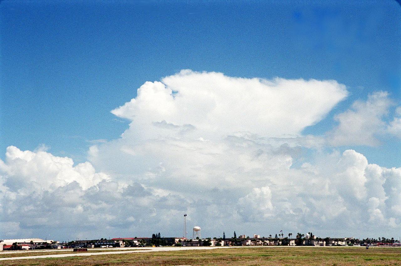
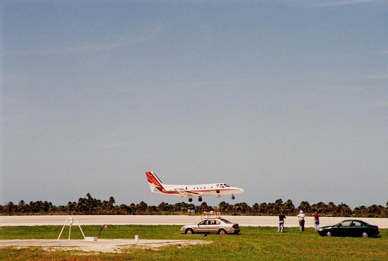
This anvil-shaped cloud over the Central Florida coast is part of a NASA study measuring electric fields in this type of cloud. A specially equipped Cessna Citation aircraft is being flown into anvil clouds in the KSC area . The weather study could lead to improved lightning avoidance rules and fewer launch scrubs for the Space Shuttle and other launch vehicles on the Eastern and Western ranges.; More information about the study can be found in <a href="http://www-pao.ksc.nasa.gov/kscpao/release/2000/56-00.htm">Release No. 56-00</a>
At Cape Canaveral Air Force Station's Space Launch Complex 41, an Atlas V rocket with NOAA's Geostationary Operational Environmental Satellite, or GOES-R, lifts off at 6:42 p.m. EST. GOES-R is the first satellite in a series of next-generation GOES satellites for NOAA, the National Oceanographic and Atmospheric Administration. It will launch to a geostationary orbit over the western hemisphere to provide images of storms and help meteorologists predict severe weather conditionals and develop long-range forecasts.
At Cape Canaveral Air Force Station's Space Launch Complex 41, an Atlas V rocket with NOAA's Geostationary Operational Environmental Satellite, or GOES-R, lifts off at 6:42 p.m. EST. GOES-R is the first satellite in a series of next-generation GOES satellites for NOAA, the National Oceanographic and Atmospheric Administration. It will launch to a geostationary orbit over the western hemisphere to provide images of storms and help meteorologists predict severe weather conditionals and develop long-range forecasts.
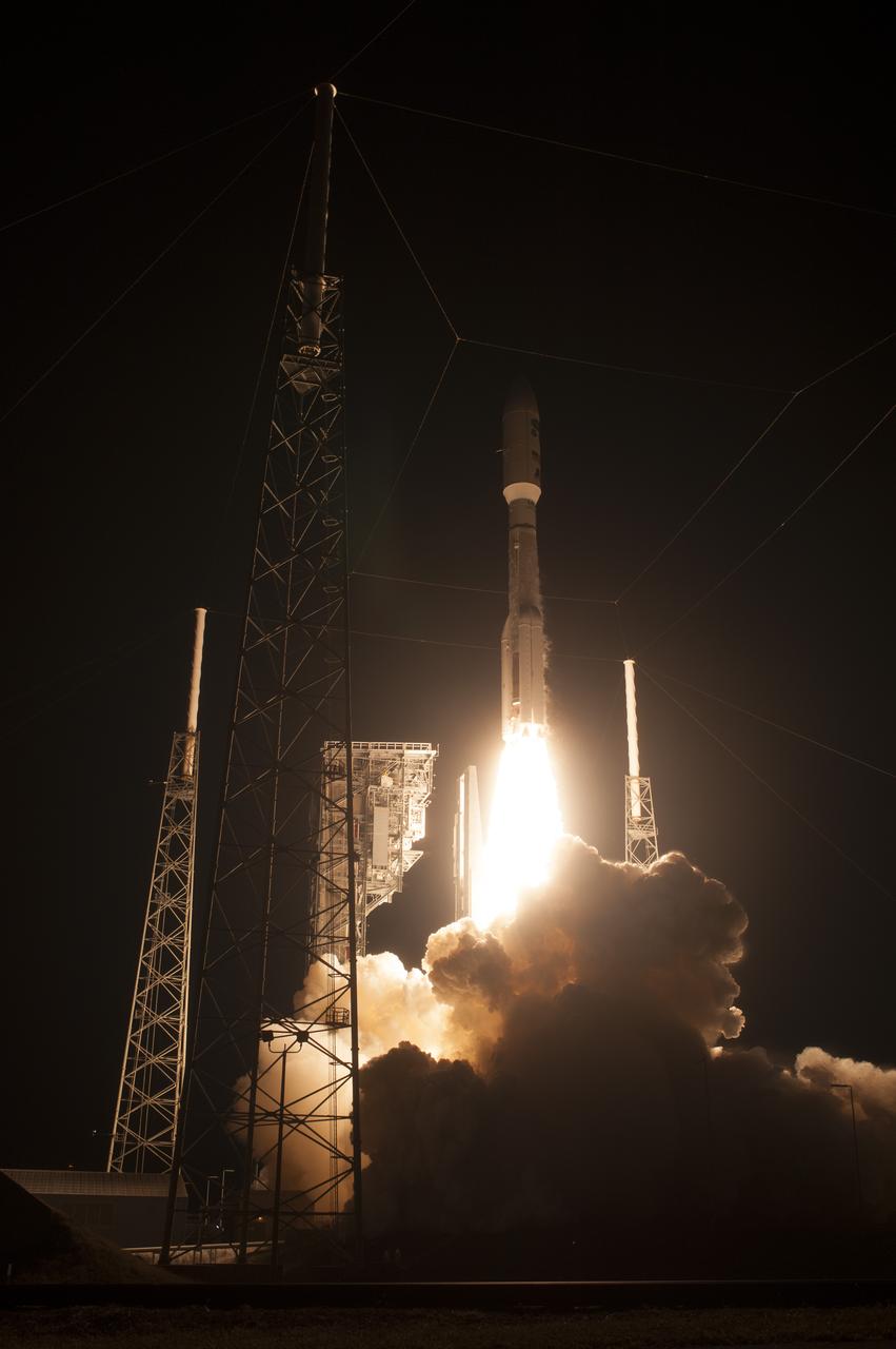
At Cape Canaveral Air Force Station's Space Launch Complex 41, an Atlas V rocket with NOAA's Geostationary Operational Environmental Satellite, or GOES-R, lifts off at 6:42 p.m. EST. GOES-R is the first satellite in a series of next-generation GOES satellites for NOAA, the National Oceanographic and Atmospheric Administration. It will launch to a geostationary orbit over the western hemisphere to provide images of storms and help meteorologists predict severe weather conditionals and develop long-range forecasts.

ISS007-E-17557 (17 October 2003) --- This sweeping view of the Rocky Mountains and the western US was taken when the International Space Station (ISS) traveled over eastern Washington on October 17, 2003. The POV of the Station was looking southeast over the mountains of Idaho (foreground) and Wyoming (Yellowstone, the Tetons and the Wind River Range are just right and above the center of the image). Great Salt Lake is in the lower right of the image.
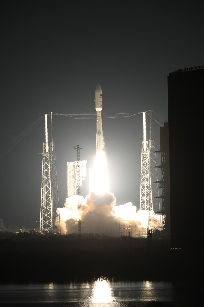
At Cape Canaveral Air Force Station's Space Launch Complex 41, an Atlas V rocket with NOAA's Geostationary Operational Environmental Satellite, or GOES-R, lifts off at 6:42 p.m. EST. GOES-R is the first satellite in a series of next-generation GOES satellites for NOAA, the National Oceanographic and Atmospheric Administration. It will launch to a geostationary orbit over the western hemisphere to provide images of storms and help meteorologists predict severe weather conditionals and develop long-range forecasts.
This image covers the western portion of a well-preserved (recent) impact crater in Ladon Basin. Ladon is filled by diverse materials including chemically-altered sediments and unaltered lava, so the impact event ejected and deposited a wide range of elements. This image is the first of a pair of images for stereo coverage, so check out the stereo anaglyph when completed. https://photojournal.jpl.nasa.gov/catalog/PIA23079
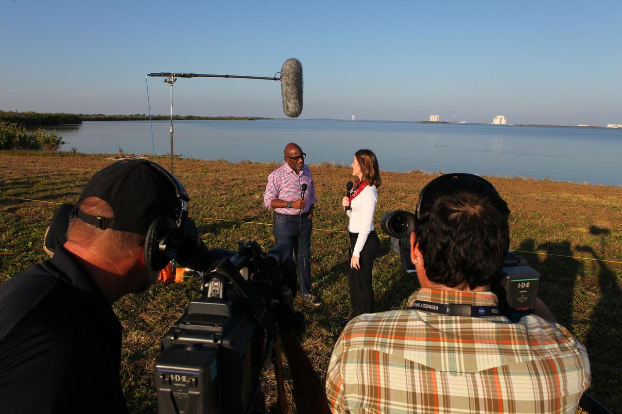
During the countdown for the launch of NOAA's Geostationary Operational Environmental Satellite, or GOES-R, Stephanie Martin of NASA Communications, right, interviews Al Roker, weather forecaster on NBC's "Today Show." GOES-R is the first satellite in a series of next-generation GOES satellites for NOAA, the National Oceanographic and Atmospheric Administration. It will launch to a geostationary orbit over the western hemisphere to provide images of storms and help meteorologists predict severe weather conditionals and develop long-range forecasts.
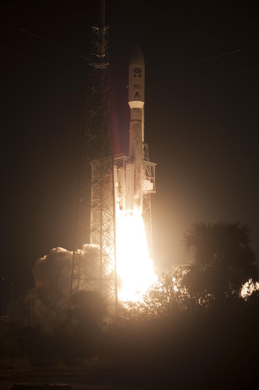
At Cape Canaveral Air Force Station's Space Launch Complex 41, an Atlas V rocket with NOAA's Geostationary Operational Environmental Satellite, or GOES-R, lifts off at 6:42 p.m. EST. GOES-R is the first satellite in a series of next-generation GOES satellites for NOAA, the National Oceanographic and Atmospheric Administration. It will launch to a geostationary orbit over the western hemisphere to provide images of storms and help meteorologists predict severe weather conditionals and develop long-range forecasts.
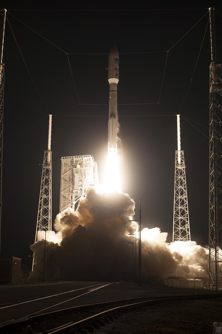
At Cape Canaveral Air Force Station's Space Launch Complex 41, an Atlas V rocket with NOAA's Geostationary Operational Environmental Satellite, or GOES-R, lifts off at 6:42 p.m. EST. GOES-R is the first satellite in a series of next-generation GOES satellites for NOAA, the National Oceanographic and Atmospheric Administration. It will launch to a geostationary orbit over the western hemisphere to provide images of storms and help meteorologists predict severe weather conditionals and develop long-range forecasts.
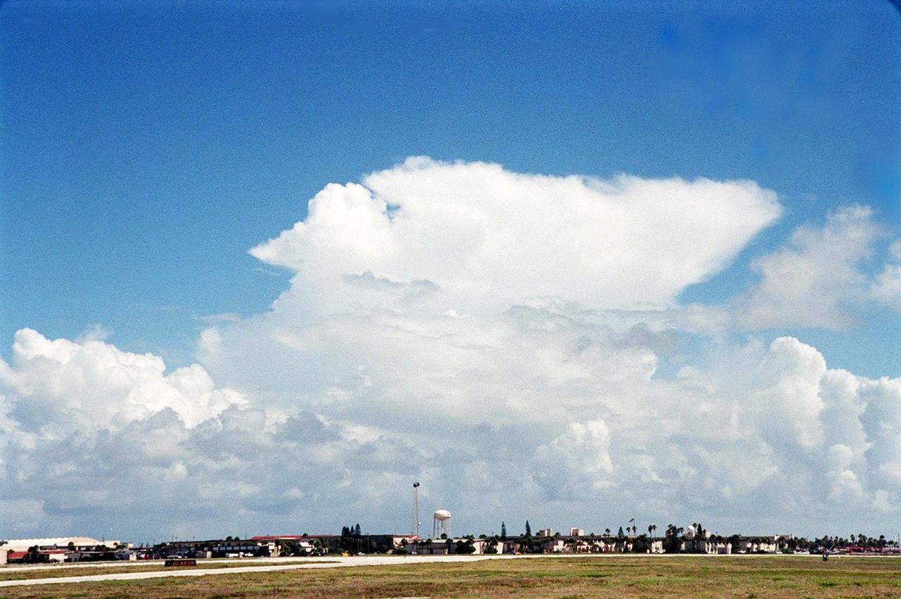
This anvil-shaped cloud over the Central Florida coast is part of a NASA study measuring electric fields in this type of cloud. A specially equipped Cessna Citation aircraft is being flown into anvil clouds in the KSC area . The weather study could lead to improved lightning avoidance rules and fewer launch scrubs for the Space Shuttle and other launch vehicles on the Eastern and Western ranges.; More information about the study can be found in <a href="http://www-pao.ksc.nasa.gov/kscpao/release/2000/56-00.htm">Release No. 56-00</a>

The Hellespontus Montes is a rugged mountain range located on the western rim of one of the largest impact basins in the Solar System: Hellas Basin. The 7-kilometer depth of Hellas and its location in the Southern Hemisphere form an active atmospheric system that directly impacts local landscape evolution. Hellespontus has a large accumulation of sand dunes and other wind-created bedforms that have been migrating on a continual basis since HiRISE began imaging Mars. A dune's steepest area, called a "slip face," indicates the down-wind side of the dune and its migration direction as driven by local winds. At this location, there are many dunes influenced by eastward winds that were draining into Hellas. Meanwhile, other locations show that migration had shifted towards the opposite direction to the west. In certain cases, we see these opposing dune directions in proximity. The complex patterns are not due to winds that are constant in magnitude or direction, but rather they wax and wane over the course of the Martian year. https://photojournal.jpl.nasa.gov/catalog/PIA25899
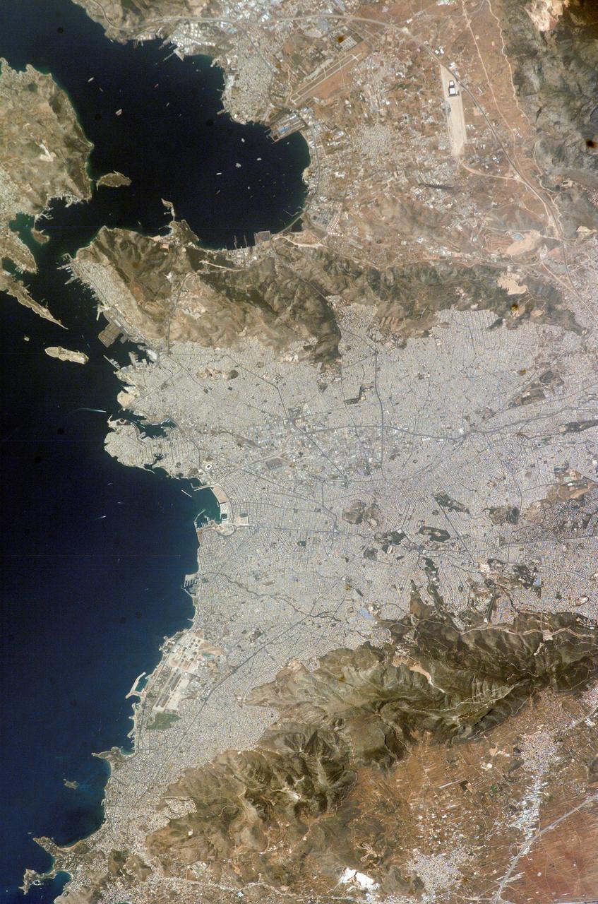
ISS009-E-11537 (12 June 2004) --- Athens, Greece is featured in this image photographed by an Expedition 9 crewmember on the International Space Station (ISS). This photo includes areas of new construction or renovation for the Olympic Games, such as the Faliro Coastal Zone Olympic Complex and Helliniko Olympic Complex. The image also demonstrates the control of bounding mountain ranges (Mts. Aigeleos and Hymettos) on the western and southern expansion of the Athens urban area. Athens is located in the Central Plains region of Attica in eastern Greece. The large basin in which Athens is located was formed by faulting and has accumulated thick deposits of clays and alluvium.
KENNEDY SPACE CENTER, FLA. -- At KSC's Shuttle Landing Facility, a specially equipped Cessna Citation aircraft flies over the runway to calibrate the Cesna's field mills with field mills on the ground (on the tripod at left) and on the car parked nearby (at center). Field mills measure electric fields. The aircraft is also equipped with cloud physics probes that measure the size, shape and number of ice and water particles in clouds. The plane is being flown into anvil clouds in the KSC area as part of a study to review and possibly modify lightning launch commit criteria. The weather study could lead to improved lightning avoidance rules and fewer launch scrubs for the Space Shuttle and other launch vehicles on the Eastern and Western ranges.
Attached to the wing of a Cessna Citation aircraft are cloud physics probes that measure the size, shape and number of ice and water particles in clouds. The plane is also equipped with field mills, used to measure electric fields. The plane is being flown into anvil clouds in the KSC area as part of a study to review and possibly modify lightning launch commit criteria. The weather study could lead to improved lightning avoidance rules and fewer launch scrubs for the Space Shuttle and other launch vehicles on the Eastern and Western ranges.; More information about the study can be found in <a href="http://www-pao.ksc.nasa.gov/kscpao/release/2000/56-00.htm">Release No. 56-00</a>
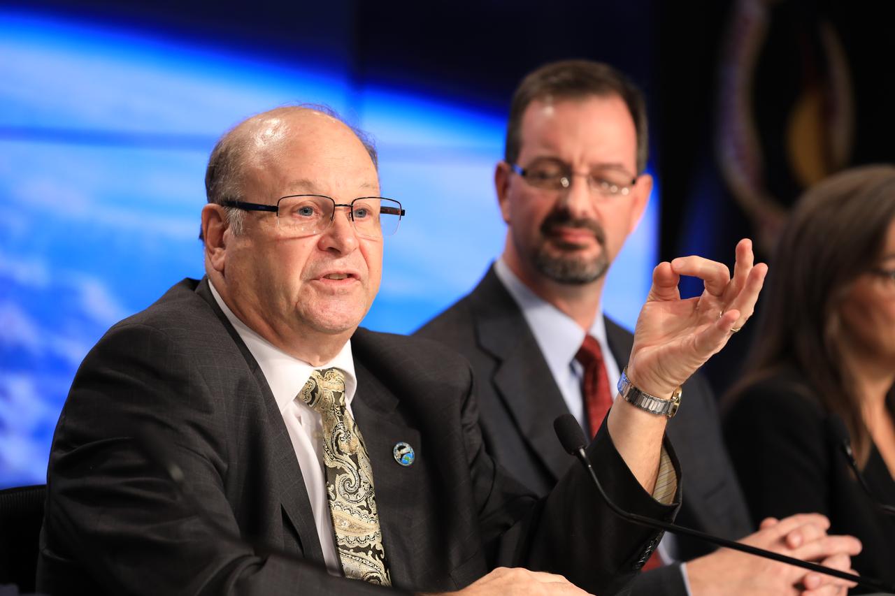
In the Kennedy Space Center's Press Site auditorium, members of the media participate in a mission briefing on the Geostationary Operational Environmental Satellite (GOES-R). Briefing participants included Steven Goodman, NOAA's GOES-R program scientist, and Joseph A. Pica, director of the National Weather Service Office of Observations. GOES-R is the first satellite in a series of next-generation GOES satellites for NOAA, the National Oceanographic and Atmospheric Administration. It will launch to a geostationary orbit over the western hemisphere to provide images of storms and help meteorologists predict severe weather conditionals and develop long-range forecasts.

In the Kennedy Space Center's Press Site auditorium, members of the media participate in a mission briefing on the Geostationary Operational Environmental Satellite (GOES-R). Briefing participants from left are: Steven Goodman, NOAA's GOES-R program scientist; Joseph A. Pica, director of the National Weather Service Office of Observations; and Sandra Cauffman, deputy director of NASA's Earth Science Division. GOES-R is the first satellite in a series of next-generation GOES satellites for NOAA, the National Oceanographic and Atmospheric Administration. It will launch to a geostationary orbit over the western hemisphere to provide images of storms and help meteorologists predict severe weather conditionals and develop long-range forecasts.
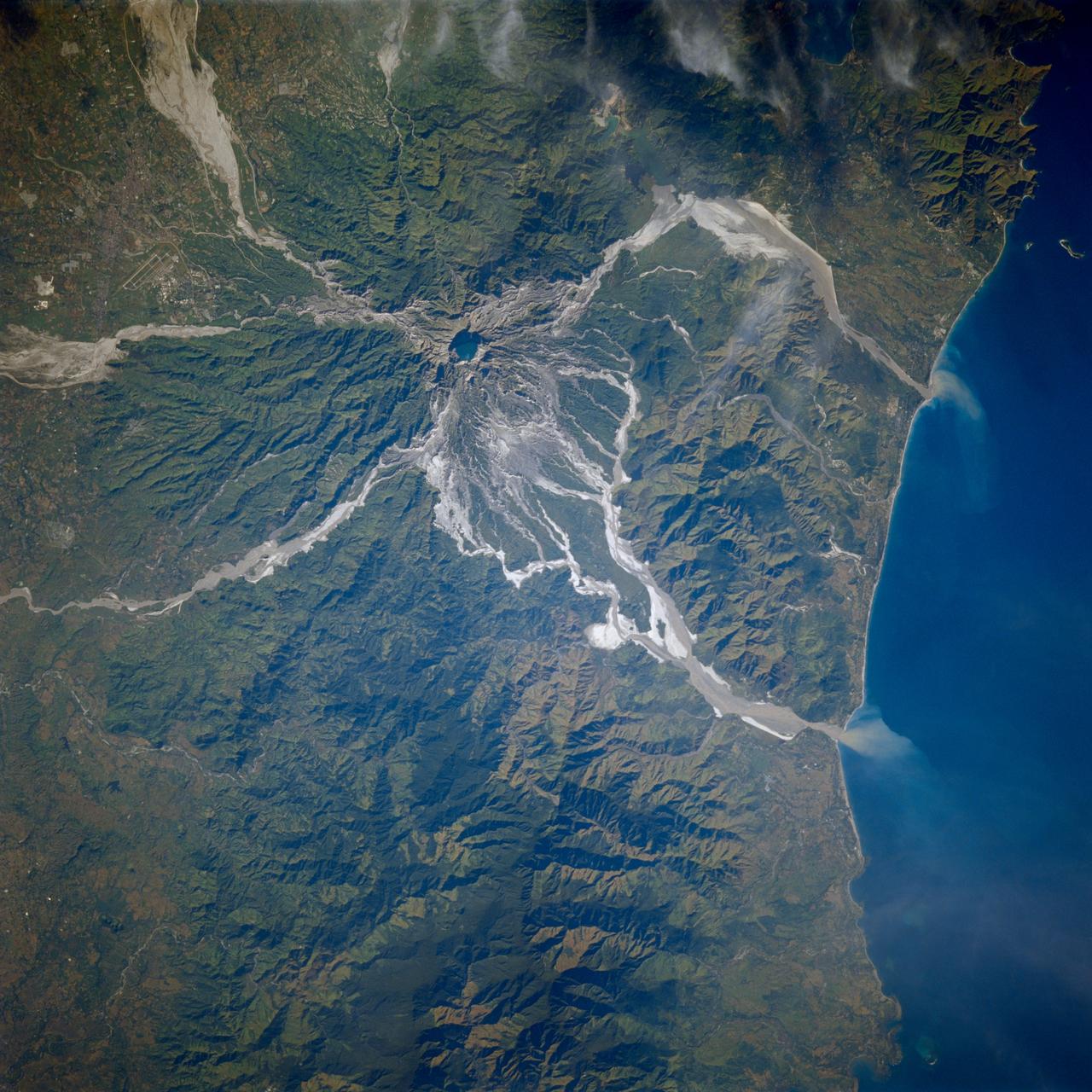
STS080-706-044 (19 Nov.-7 Dec. 1996) --- This view shows Mount Pinatubo, an active volcano in the Zambales Mountains range of western Luzon, the main island of the Philippines. Mud flows radiate out from the active volcano, which has erupted in recent years, coming down the mountain. After the eruption a lot of the vegetation was removed, causing the mountain to erode at a more rapid pace than an older mountain that has its vegetation in place. In two cases the flows reach the South China Sea, and flow down three valleys to the east. The now abandoned Clark Air Force Base is to the upper left corner. Pinatubo is about 80 miles northwest of Manila.

Range : 3.4 million km This pair of images shows two of the long-lived white oval clouds which have resided in the Jovian southern hemisphere for nearly 40 years. The upper picture shows the cloud that is at a longitude west of the Great Red Spot, and the lower frame, the cloud at a longitude east of this feature. The third oval is currently just south of the Great Red Spot. The clouds show very similar internal structures. To the east of each of them, recirculation currents are clearly seen. In the lower frame, a similar structure is seen to the west of the cloud. Although a recirculation current is associated with the upper western region of the cloud, it is further away from this feature and not seen in the image. This photo was taken by Voyager 2.
Attached to the wing of a Cessna Citation aircraft are cloud physics probes that measure the size, shape and number of ice and water particles in clouds. The plane is also equipped with field mills, used to measure electric fields. The plane is being flown into anvil clouds in the KSC area as part of a study to review and possibly modify lightning launch commit criteria. The weather study could lead to improved lightning avoidance rules and fewer launch scrubs for the Space Shuttle and other launch vehicles on the Eastern and Western ranges.; More information about the study can be found in <a href="http://www-pao.ksc.nasa.gov/kscpao/release/2000/56-00.htm">Release No. 56-00</a>
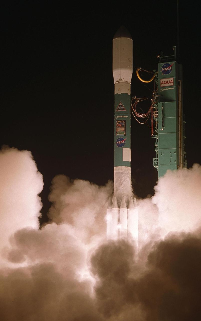
VANDENBERG AIR FORCE BASE, CALIF. -- NASA's latest Earth observing satellite, Aqua, successfully launches aboard a Delta II rocket at 2:55 a.m. PDT. Aqua is dedicated to advancing our understanding of Earth's water cycle and our environment. Launching the Aqua spacecraft marks a major milestone in support of NASA's mission to help us better understand and protect our planet. The Aqua spacecraft lifted off from the Western Test Range of Vandenberg Air Force Base, Calif. Spacecraft separation occurred at 3:54 a.m. PDT. inserting Aqua into a 438-mile (705-kilometer) orbit. [Photo by Bill Ingalls
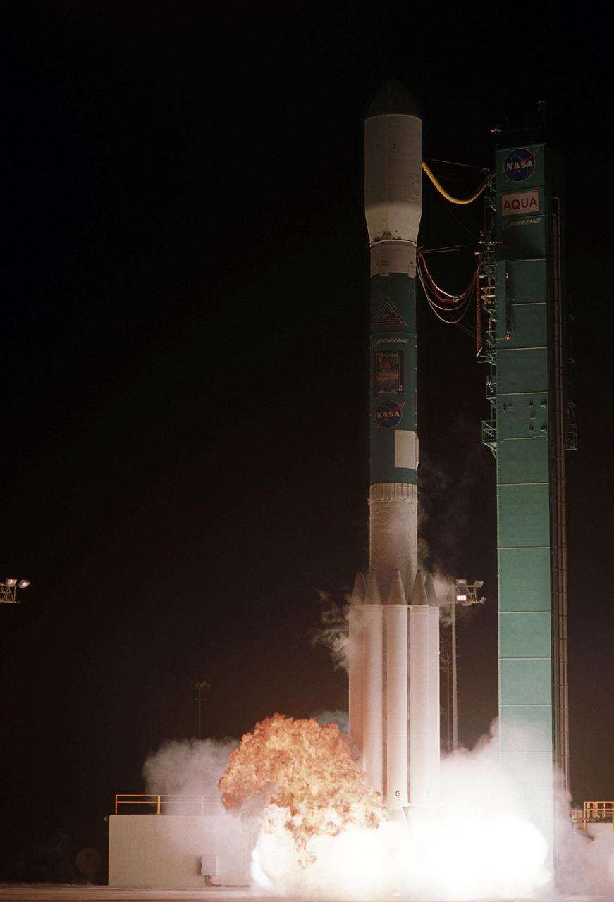
VANDENBERG AIR FORCE BASE, CALIF. -- NASA's latest Earth observing satellite, Aqua, lifts off from the Western Test Range of Vandenberg Air Force Base, Calif., aboard a Delta II rocket at 2:55 a.m. PDT. Aqua is dedicated to advancing our understanding of Earth's water cycle and our environment. Launching the Aqua spacecraft marks a major milestone in support of NASA's mission to help us better understand and protect our planet. Spacecraft separation occurred at 3:54 a.m. PDT, inserting Aqua into a 438-mile (705-kilometer) orbit. [Photo by Bill Ingalls
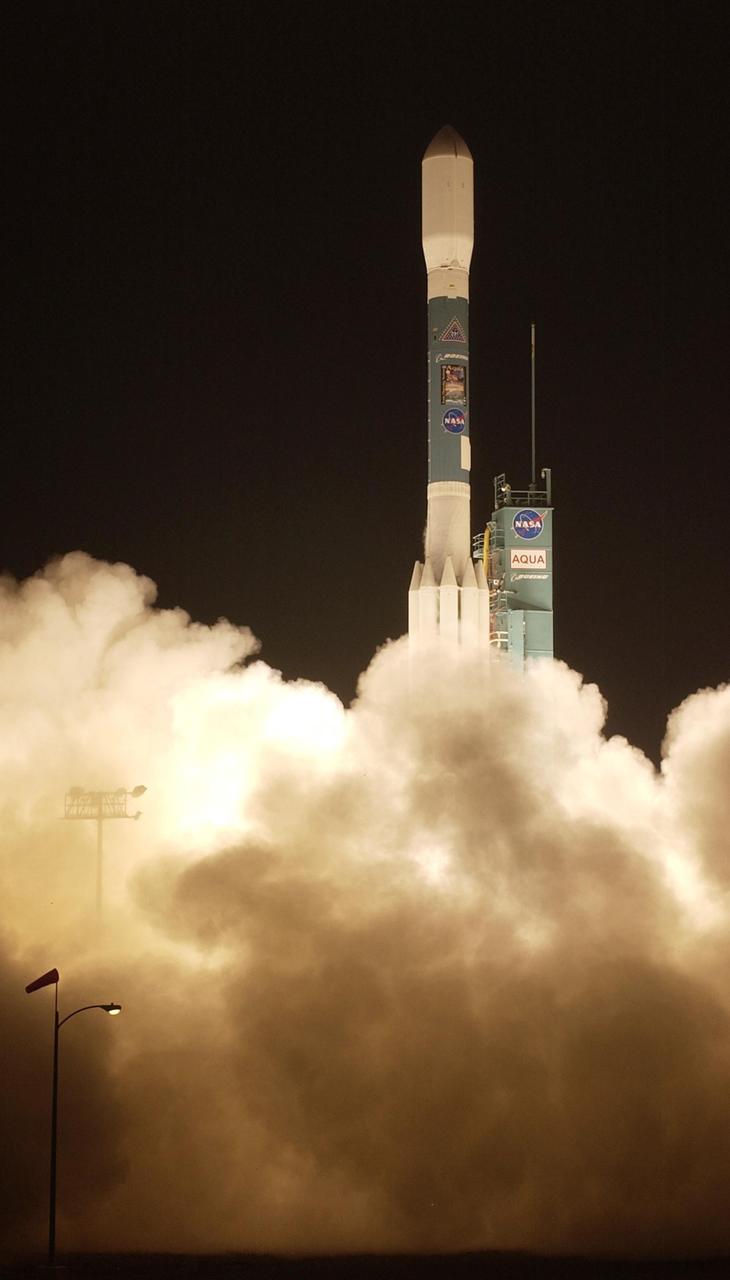
VANDENBERG AIR FORCE BASE, CALIF. -- NASA's latest Earth observing satellite, Aqua, successfully launches aboard a Delta II rocket at 2:55 a.m. PDT. Aqua is dedicated to advancing our understanding of Earth's water cycle and our environment. Launching the Aqua spacecraft marks a major milestone in support of NASA's mission to help us better understand and protect our planet. The Aqua spacecraft lifted off from the Western Test Range of Vandenberg Air Force Base, Calif. Spacecraft separation occurred at 3:54 a.m. PDT. inserting Aqua into a 438-mile (705-kilometer) orbit. [Photo by Bill Ingalls
KENNEDY SPACE CENTER, FLA. -- At KSC's Shuttle Landing Facility, a specially equipped Cessna Citation aircraft flies over the runway to calibrate the Cesna's field mills with field mills on the ground (on the tripod at left) and on the car parked nearby (at center). Field mills measure electric fields. The aircraft is also equipped with cloud physics probes that measure the size, shape and number of ice and water particles in clouds. The plane is being flown into anvil clouds in the KSC area as part of a study to review and possibly modify lightning launch commit criteria. The weather study could lead to improved lightning avoidance rules and fewer launch scrubs for the Space Shuttle and other launch vehicles on the Eastern and Western ranges.
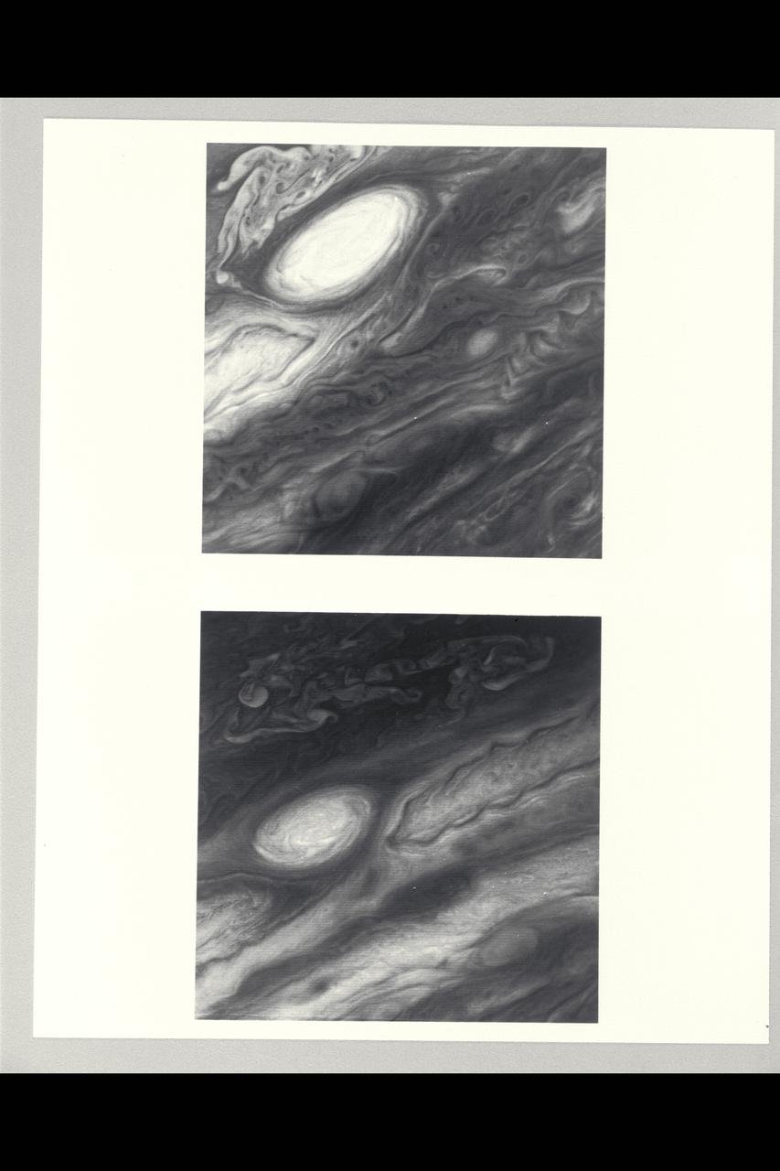
Range : 3.4 million km This pair of images shows two of the long-lived white oval clouds which have resided in the Jovian southern hemisphere for nearly 40 years. The upper picture shows the cloud that is at a longitude west of the Great Red Spot, and the lower frame, the cloud at a longitude east of this feature. The third oval is currently just south of the Great Red Spot. The clouds show very similar internal structures. To the east of each of them, recirculation currents are clearly seen. In the lower frame, a similar structure is seen to the west of the cloud. Although a recirculation current is associated with the upper western region of the cloud, it is further away from this feature and not seen in the image. This photo was taken by Voyager 2.
This image from NASA Terra spacecraft shows the Ural Mountains, which run 2500 km north-south through western Russia, and form the boundary between Europe and Asia. Since the 17th century, the mountains were exploited for their deposits of iron, copper, gold, coal, oil, mica and gemstones. The Urals are among the world's oldest existing mountain ranges, having been formed about 275 million years ago due to the collision of the Laurussia supercontinent with the continent of Kazakhstania. The image was acquired July 13, 2011, covers an area of 39 by 62 km, and is located near 65.5 degrees north, 59.9 degrees east. http://photojournal.jpl.nasa.gov/catalog/PIA19795
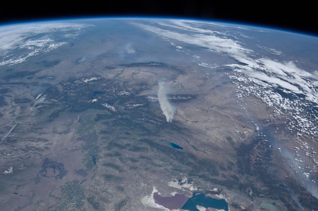
ISS031-E-146391 (27 June 2012) --- An Expedition 31 crew member aboard the International Space Station, flying approximately 240 miles above Earth, recorded a series of images of the current wild fires in the western and southwestern United States. These particular fires, of unknown cause, are burning at the south end of the Wyoming Range in southwestern Wyoming, and have affected 17,000 acres. The fires have produced two major smoke plumes, seen at center of the frame. Utah?s Great Salt Lake (bottom center) is about 120 miles away. Winds transport the smoke in a northeasterly direction.
ISS031-E-146397 (27 June 2012) --- An Expedition 31 crew member aboard the International Space Station, flying approximately 240 miles above Earth, recorded a series of images of the current wild fires in the western and southwestern United States. These particular fires, of unknown cause, are burning at the south end of the Wyoming Range in southwestern Wyoming, and have affected 17,000 acres. The fires have produced two major smoke plumes, seen at upper left of the 18mm frame. Winds transport the smoke in a northeasterly direction. Utah?s Great Salt Lake (center) is about 120 miles away. Bear Lake and Utah Lake (very light blue or gray) are also visible in the frame.
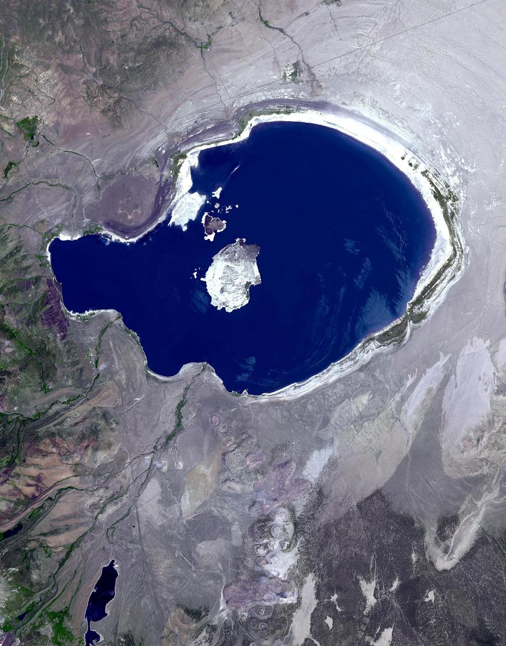
In eastern California, along the western edge of the Great Basin, sits Mono Lake. This is a salty remnant of a wetter era. Estimates are that the lake existed for at least 760,000 years. Now surrounded by mountain ranges, however, Mono Lake has no outlet; water entering the lake can only evaporate away, so Mono Lake is saltier than the ocean. South of the lake appear some of the geologic features known as Mono Craters. Geologists estimate that the Mono Craters last erupted about 650 years ago. The image was acquired July 7, 2016, covers an area of 22.6 by 34 km, and is located at 37.9 degrees north, 119 degrees west. http://photojournal.jpl.nasa.gov/catalog/PIA21518
Attached to the wing of a Cessna Citation aircraft are cloud physics probes that measure the size, shape and number of ice and water particles in clouds. The plane is also equipped with field mills, used to measure electric fields. The plane is being flown into anvil clouds in the KSC area as part of a study to review and possibly modify lightning launch commit criteria. The weather study could lead to improved lightning avoidance rules and fewer launch scrubs for the Space Shuttle and other launch vehicles on the Eastern and Western ranges.; More information about the study can be found in <a href="http://www-pao.ksc.nasa.gov/kscpao/release/2000/56-00.htm">Release No. 56-00</a>
Attached to the wing of a Cessna Citation aircraft are cloud physics probes that measure the size, shape and number of ice and water particles in clouds. The plane is also equipped with field mills, used to measure electric fields. The plane is being flown into anvil clouds in the KSC area as part of a study to review and possibly modify lightning launch commit criteria. The weather study could lead to improved lightning avoidance rules and fewer launch scrubs for the Space Shuttle and other launch vehicles on the Eastern and Western ranges.; More information about the study can be found in <a href="http://www-pao.ksc.nasa.gov/kscpao/release/2000/56-00.htm">Release No. 56-00</a>
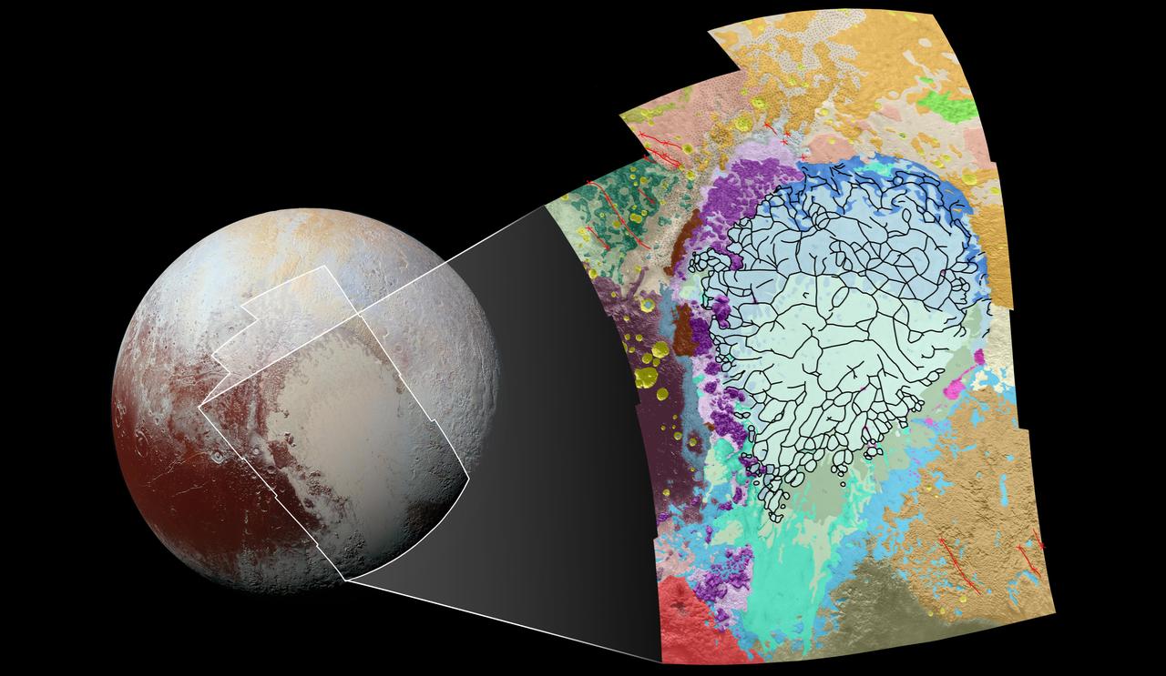
This geological map covers a portion of Pluto's surface that measures 1,290 miles (2,070 kilometers) from top to bottom, and includes the vast nitrogen-ice plain informally named Sputnik Planum and surrounding terrain. The map is overlain with colors that represent different geological terrains. Each terrain, or unit, is defined by its texture and morphology -- smooth, pitted, craggy, hummocky or ridged, for example. How well a unit can be defined depends on the resolution of the images that cover it. All of the terrain in this map has been imaged at a resolution of approximately 1,050 feet (320 meters) per pixel or better, meaning scientists can map units with relative confidence. The various blue and greenish units that fill the center of the map represent different textures seen across Sputnik Planum, from the cellular terrain in the center and north, to the smooth and pitted plains in the south. The black lines represent the troughs that mark the boundaries of cellular regions in the nitrogen ice. The purple unit represents the chaotic, blocky mountain ranges that line Sputnik's western border, and the pink unit represents the scattered, floating hills at its eastern edge. The possible cryovolcanic feature informally named Wright Mons is mapped in red in the southern corner of the map. The rugged highlands of the informally named Cthulhu Regio is mapped in dark brown along the western edge, and is pockmarked by many large impact craters, mapped in yellow. The base map for this geologic map is a mosaic of 12 images obtained by the Long Range Reconnaissance Imager (LORRI) at a resolution of 1,280 feet (about 390 meters) per pixel. The mosaic was obtained at a range of approximately 48,000 miles (77,300 kilometers) from Pluto, about an hour and 40 minutes before New Horizons' closest approach on July 14, 2015. http://photojournal.jpl.nasa.gov/catalog/PIA20465

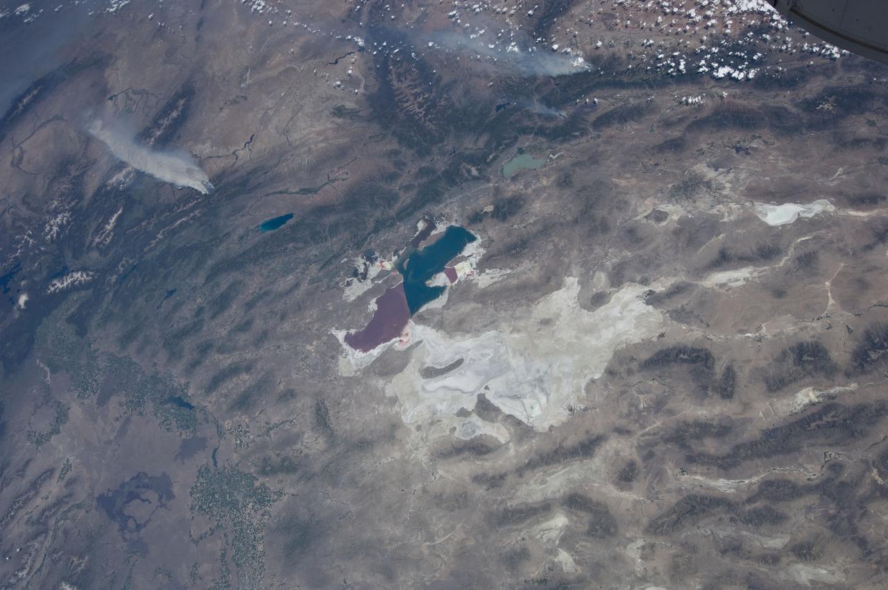
ISS032-E-010487 (29 July 2012) --- Walker Lake, Nevada is featured in this image photographed by an Expedition 32 crew member on the International Space Station. According to scientists, the Pleistocene landscape of western Nevada approximately 15,000 years ago was one of narrow mountain ranges and numerous interconnected lakes that together formed the extensive glacial Lake Lahontan. Scientists believe drying and warming of the regional climate since the last Ice Age led to the disappearance of the glaciers feeding meltwater to Lake Lahontan, and eventual disappearance of the lake itself. Today, few remnants of Lahontan remain; most of its arms have become dry enclosed basins known as playas. This photograph highlights Walker Lake, one of only two remnant lakes that contain water throughout the year (Pyramid Lake in Nevada is the other). The lake is located in an enclosed basin bounded by the Wassuk Range to the west and the Gillis Range to the east. It is fed by the Walker River flowing from the north. The current dimensions of the lake are approximately 21 kilometers north-south by 9 kilometers east-west. Shoreline deposits at higher elevations than the current lake level form concentric bands that are just visible in the image (bottom center) ? these record varying lake levels in the geologic past. The nearest town is Hawthorne, Nevada to the southeast. To the southwest the highest peak of the Wassuk Range, Mount Grant (elevation 3,496 meters above sea level), dominates the skyline. Green agricultural fields, primarily alfalfa, located to the west of the Wassuk Range (lower right) provide a striking contrast to the surrounding Great Basin desert. These fields are irrigated using water from the nearby East Fork of the Walker River (right, just visible alongside the fields).
ISS011-E-09620 (26 June 2005) --- Grasberg Mine, Indonesia is featured in this image photographed by an Expedition 11 crewmember on the International Space Station. Located in the Sudirman Mountains of the Irian Jaya province of Indonesia, the Grasberg complex (also known as the Freeport Mine) is one of the largest gold and copper mining operations in the world. The Sudirman Mountains form the western portion of the Maoke Range that extend across Irian Jaya from west to the east-southeast. According to scientists, these ranges were formed by ongoing collision of the northward-moving Australian and westward-moving Pacific tectonic plates. Intrusion of hot magma into sedimentary rock layers during uplift of the mountains resulted in the formation of copper- and gold-bearing ore bodies. Rich copper ore bodies were discovered in the area in 1936, and the Grasberg gold-bearing ore bodies were discovered in 1988. This image illustrates the approximately 4 kilometers-wide open-pit portion of the mine complex; there are also extensive underground mine workings. Access roads for trucks hauling ore and waste rock are visible along the sides of the pit.
At KSC’s Shuttle Landing Facility, a specially equipped Cessna Citation aircraft approaches the runway to calibrate the Cessna’s field mills with field mills on the ground (on the tripod at left) and on the car parked nearby (at right). Field mills measure electric fields. The aircraft is also equipped with cloud physics probes that measure the size, shape and number of ice and water particles in clouds. The plane is being flown into anvil clouds in the KSC area as part of a study to review and possibly modify lightning launch commit criteria. The weather study could lead to improved lightning avoidance rules and fewer launch scrubs for the Space Shuttle and other launch vehicles on the Eastern and Western ranges.; More information on this study can be found in <a href="http://www-pao.ksc.nasa.gov/kscpao/release/2000/56-00.htm">Release No. 56-00</a>

A specially equipped Cessna Citation aircraft flies over KSC during a calibration test of field mills used to measure electric fields. The aircraft is also equipped with cloud physics probes that measure the size, shape and number of ice and water particles in clouds. The plane is being flown into anvil clouds in the KSC area as part of a study to review and possibly modify lightning launch commit criteria. The weather study could lead to improved lightning avoidance rules and fewer launch scrubs for the Space Shuttle and other launch vehicles on the Eastern and Western ranges.; More information on this study can be found in <a href="http://www-pao.ksc.nasa.gov/kscpao/release/2000/56-00.htm">Release No. 56-00</a>
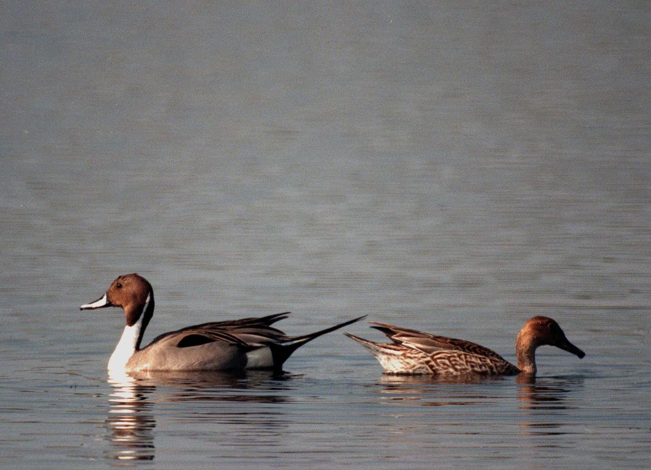
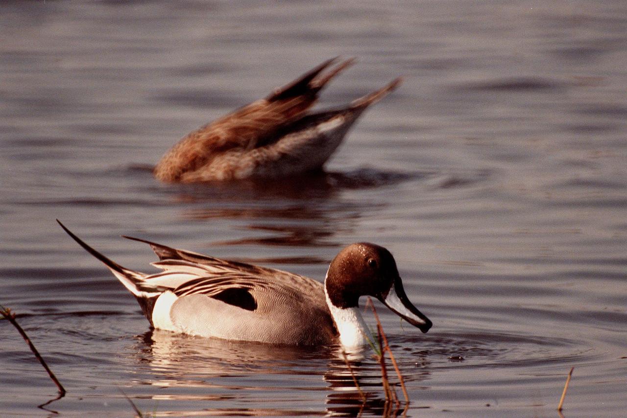
KENNEDY SPACE CENTER, FLA. -- A male pintail duck (left) and female pintail (right) look like bookends on a glass-topped table in the winter waters of the Merritt Island National Wildlife Refuge at Kennedy Space Center. The pintails can be found in the marshes, prairie ponds and tundra of Alaska, Greenland and north and western United States; in the winter they range south and east to Central America and the West Indies, sometimes in salt marshes such as the refuge offers. The open water of the refuge provides wintering areas for 23 species of migratory waterfowl, as well as a year-round home for great blue herons, great egrets, wood storks, cormorants, brown pelicans and other species of marsh and shore birds. The 92,000-acre refuge is also habitat for more than 310 species of birds, 25 mammals, 117 fishes and 65 amphibians and reptiles

In the Kennedy Space Center's Press Site auditorium, members of the media participate in a mission briefing on the Geostationary Operational Environmental Satellite (GOES-R). Briefing participants from left are: Steven Goodman, NOAA's GOES-R program scientist; Joseph A. Pica, director of the National Weather Service Office of Observations; Sandra Cauffman, deputy director of NASA's Earth Science Division; and Damon Penn, assistant administrator for response at the Federal Emergency Management Agency. GOES-R is the first satellite in a series of next-generation GOES satellites for NOAA, the National Oceanographic and Atmospheric Administration. It will launch to a geostationary orbit over the western hemisphere to provide images of storms and help meteorologists predict severe weather conditionals and develop long-range forecasts.
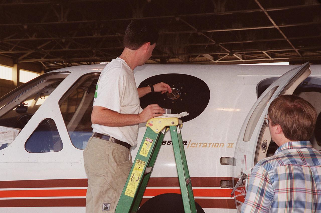
In a hangar at Cape Canaveral Air Force Station, a weather researcher checks a field mill measuring device on the Cessna Citation. The aircraft is being used for NASA’s airborne field mill study. The plane also carries cloud physics probes (under the body and wings) that measure the size, shape and number of ice and water particles in clouds. The plane is being flown into anvil clouds in the KSC area as part of a study to review and possibly modify lightning launch commit criteria. The weather study could lead to improved lightning avoidance rules and fewer launch scrubs for the Space Shuttle and other launch vehicles on the Eastern and Western ranges.; More information about the study can be found in <a href="http://www-pao.ksc.nasa.gov/kscpao/release/2000/56-00.htm">Release No. 56-00</a>

STS077-732-089 (19-29 May 1996) --- This photograph encompasses an area comprising 99 percent of the Egyptian population of close to 60 million people. North is roughly to the right side of the photograph. Cairo, the capital and principal city, lies at the apex of the Nile Delta. Alexandria is in the top right corner of the frame. The Suez Canal connects the Red Sea and the Mediterranean Sea and is in the bottom of the photograph. The Delta itself is 100 miles long and 160 miles wide at the coast. This view brings out the details of the Eastern Desert that rises abruptly from the Nile valley. This desert supports some vegetation in contrast to the sandier Western desert. It has more relief with some of the peaks rising to 6,000 feet. Rainfall in the region ranges from a high of 7 inches at Alexandria to 0.1 inch in the Eastern Desert. Most of Egypt’s mineral resources are concentrated in this area.
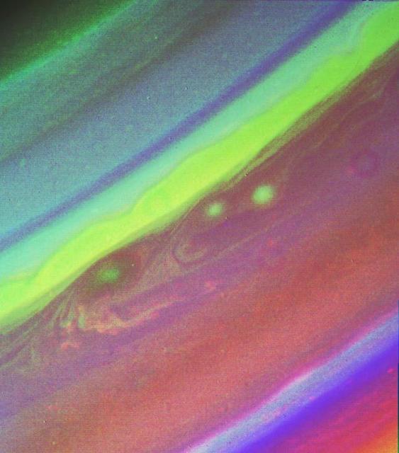
This false color picture of Saturn’s northern hemisphere was assembled from ultraviolet, violet and green images obtained Aug. 19 by Voyager 2 from a range of 7.1 million kilometers (4.4 million miles). The several weather patterns evident include three spots flowing westward at about 15 meters-per-second (33 mph). Although the cloud system associated with the western-most spot is part of this flow, the spot itself moves eastward at about 30 meters-per-second (65 mph). Their joint flow shows the anti-cyclonic rotation of the spot, which is about 3,000 km. (1,900 mi.) in diameter. The ribbon- like feature to the north marks a high-speed jet where wind speeds approach 150 meters-per-second (330 mph). http://photojournal.jpl.nasa.gov/catalog/PIA01365
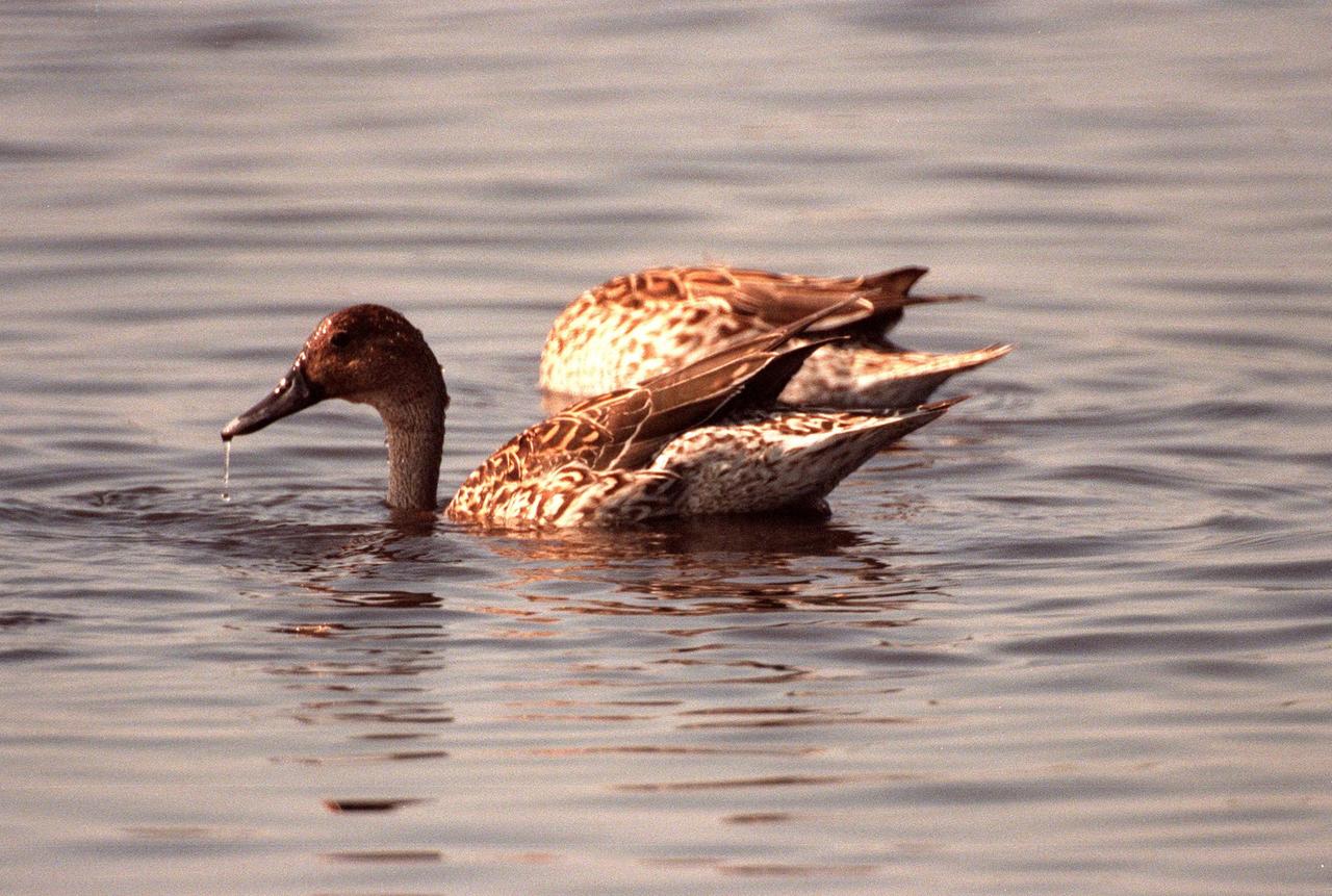
KENNEDY SPACE CENTER, FLA. -- Two female pintail ducks search for food in the winter waters of the Merritt Island National Wildlife Refuge at Kennedy Space Center. The pintails can be found in the marshes, prairie ponds and tundra of Alaska, Greenland and north and western United States; in the winter they range south and east to Central America and the West Indies, sometimes in salt marshes such as the refuge offers. The open water of the refuge provides wintering areas for 23 species of migratory waterfowl, as well as a year-round home for great blue herons, great egrets, wood storks, cormorants, brown pelicans and other species of marsh and shore birds. The 92,000-acre refuge is also habitat for more than 310 species of birds, 25 mammals, 117 fishes and 65 amphibians and reptiles

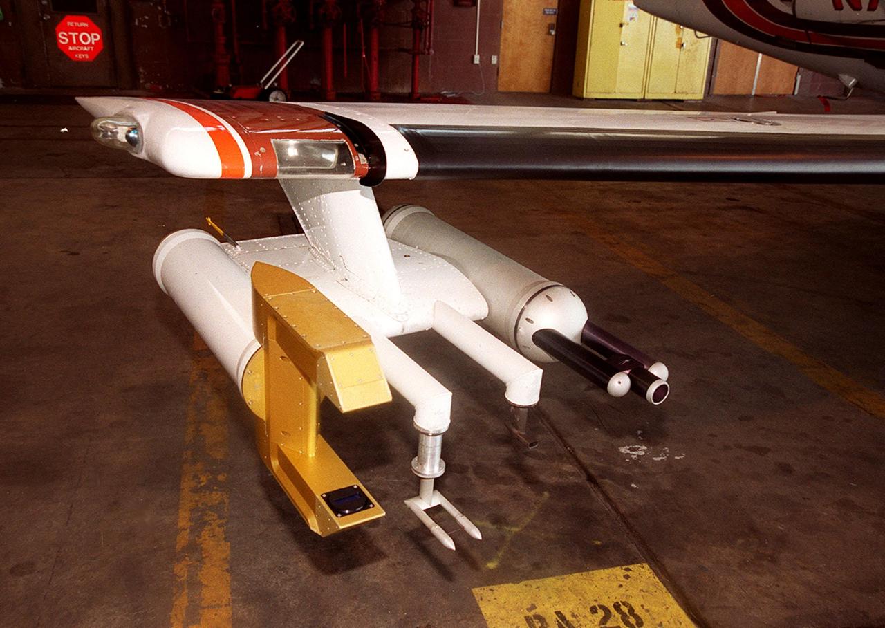
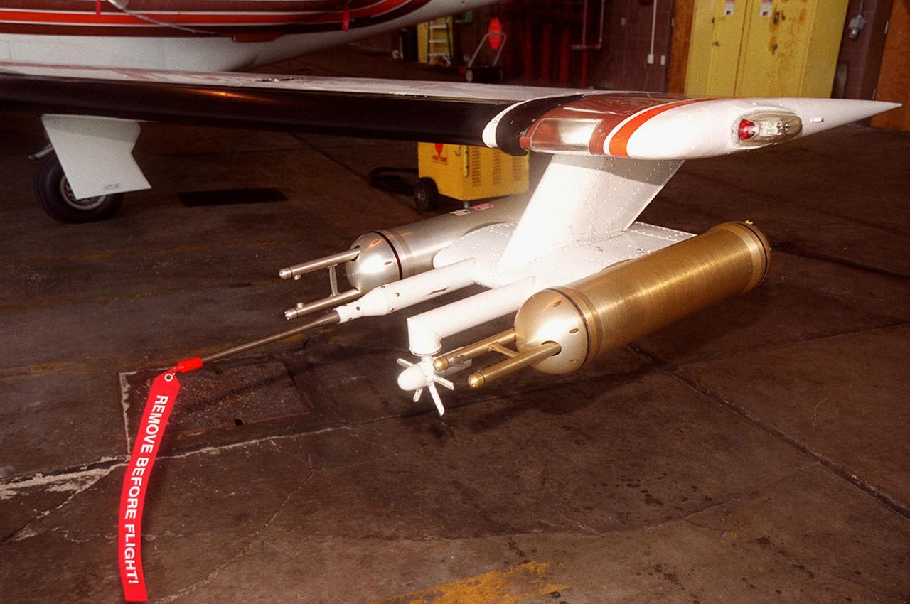
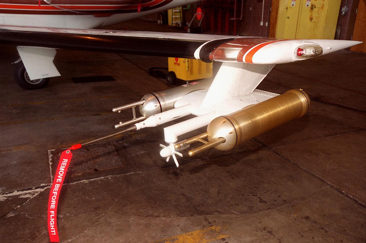
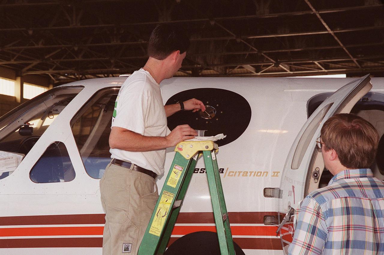
In a hangar at Cape Canaveral Air Force Station, a Cessna Citation aircraft has been fitted on the wings with devices that measure electric fields (black circles shown behind the open door) and with cloud physics probes (under the body and wings) that measure the size, shape and number of ice and water particles in clouds. The plane is being flown into anvil clouds in the KSC area as part of a study to review and possibly modify lightning launch commit criteria. The weather study could lead to improved lightning avoidance rules and fewer launch scrubs for the Space Shuttle and other launch vehicles on the Eastern and Western ranges.; More information about the study can be found in <a href="http://www-pao.ksc.nasa.gov/kscpao/release/2000/56-00.htm">Release No. 56-00</a>
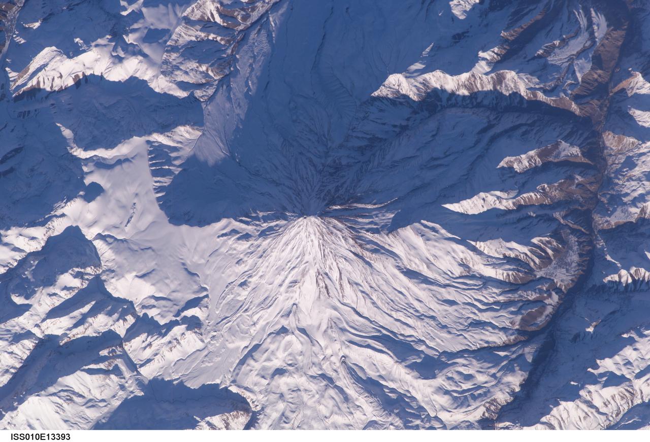
ISS010-E-13393 (15 January 2005) --- Mt. Damavand, Iran is featured in this image photographed by an Expedition 10 crewmember on the International Space Station (ISS). Located approximately 50 kilometers to the northeast of Tehran, Mt. Damavand is an impressive stratovolcano that reaches 5,670 meters (18,598 feet) in elevation. Damavand, which is part of the Alborz mountain range that borders the Caspian Sea to the north, is believed by scientists to be a young volcano that has mostly formed during the Holocene Epoch (over approximately the last 10,000 years). The western flank of the volcano includes solidified lava flows with flow levees – “walls” formed as the side edges of flowing lava cooled rapidly, forming a chute that channeled the hotter interior lava. Two such flows with well-defined levees are highlighted by snow on the mountainside (center). Damavand is the highest peak in Iran and the highest volcano in the Middle East.
Lightning field study devices are visible on a Cessna Citation aircraft during flight over Central Florida. The center of the black circle contains one of six field mills, used to measure electric fields, located on the body of the plane. Below the circle is one of several cloud physics probes attached to the plane that measure the size, shape and number of ice and water particles in clouds. The Cessna is being flown into anvil clouds in the KSC area as part of a study to review and possibly modify lightning launch commit criteria. The weather study could lead to improved lightning avoidance rules and fewer launch scrubs for the Space Shuttle and other launch vehicles on the Eastern and Western ranges.; More information about the study can be found in <a href="http://www-pao.ksc.nasa.gov/kscpao/release/2000/56-00.htm">Release No. 56-00</a>
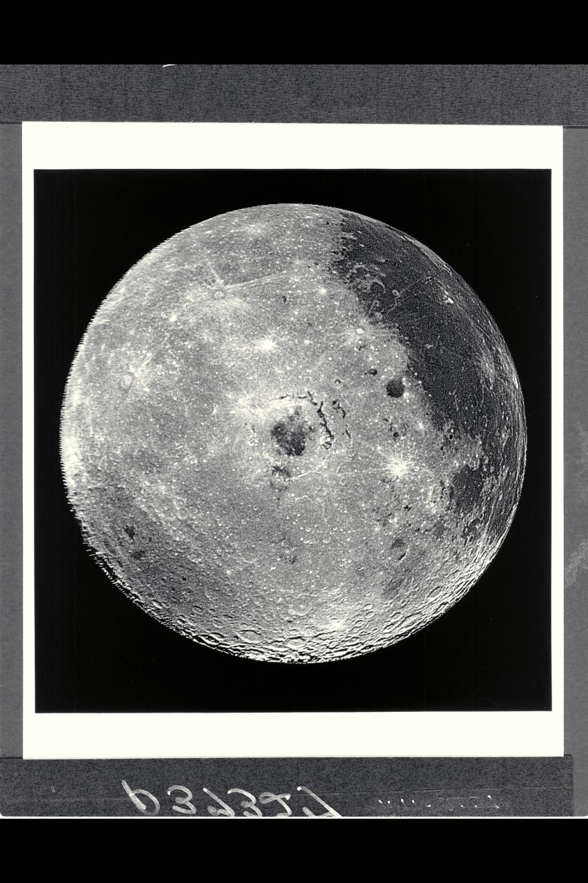
Range : 350,000 miles This image of the western hemisphere of the Moon was taken through a green filter by Galileo at 9:35 am PST. In the center is the Orientale Basin, 600 miles in diameter, formed about 3.8 billion years ago by the impact of an streroid-size body. Orientale's dark center is a small mare. To the right is the lunar near side with the great, dark Oceanus Procellarum above and the small, circular, dark Mare Humorum Below. Maria are broad plains formed mostly over 3 billion years ago as vast bassaltic lava flows. To the left is the lunar far side with fewer maria, but, at lower left, the South-Pole-Aitken basin, about 1200 miles in diameter, which resemble Orientale but is much older and more weathered and battered by cratering. The intervening cratered highlands of both sides, as well as the maria, are dotted with bright, young craters. This image was 'reprojected' so as to center visibility of small features.
Lightning field study devices are visible on a Cessna Citation aircraft during flight over Central Florida. The center of the black circle contains one of six field mills, used to measure electric fields, located on the body of the plane. Below the circle is one of several cloud physics probes attached to the plane that measure the size, shape and number of ice and water particles in clouds. The Cessna is being flown into anvil clouds in the KSC area as part of a study to review and possibly modify lightning launch commit criteria. The weather study could lead to improved lightning avoidance rules and fewer launch scrubs for the Space Shuttle and other launch vehicles on the Eastern and Western ranges.; More information about the study can be found in <a href="http://www-pao.ksc.nasa.gov/kscpao/release/2000/56-00.htm">Release No. 56-00</a>
At KSC’s Shuttle Landing Facility, a specially equipped Cessna Citation aircraft flies over the runway to calibrate the Cessna’s field mills with field mills on the ground (on the tripod at left) and on the car parked nearby (at right). Field mills measure electric fields. The aircraft is also equipped with cloud physics probes that measure the size, shape and number of ice and water particles in clouds. The plane is being flown into anvil clouds in the KSC area as part of a study to review and possibly modify lightning launch commit criteria. The weather study could lead to improved lightning avoidance rules and fewer launch scrubs for the Space Shuttle and other launch vehicles on the Eastern and Western ranges.; More information about this study can be found in <a href="http://www-pao.ksc.nasa.gov/kscpao/release/2000/56-00.htm">Release No. 56-00</a>
KENNEDY SPACE CENTER, FLA. -- A male pintail duck (foreground) paddles in the waters of the Merritt Island National Wildlife Refuge at Kennedy Space Center while a female behind him bobs for food. The pintails can be found in the marshes, prairie ponds and tundra of Alaska, Greenland and north and western United States; in the winter they range south and east to Central America and the West Indies, sometimes in salt marshes such as the refuge offers. The open water of the refuge provides wintering areas for 23 species of migratory waterfowl, as well as a year-round home for great blue herons, great egrets, wood storks, cormorants, brown pelicans and other species of marsh and shore birds. The 92,000-acre refuge is also habitat for more than 310 species of birds, 25 mammals, 117 fishes and 65 amphibians and reptiles

At KSC’s Shuttle Landing Facility, a specially equipped Cessna Citation aircraft approaches the runway to calibrate the Cessna’s field mills with field mills on the ground (on the tripod at left) and on the car parked nearby (at right). Field mills measure electric fields. The aircraft is also equipped with cloud physics probes that measure the size, shape and number of ice and water particles in clouds. The plane is being flown into anvil clouds in the KSC area as part of a study to review and possibly modify lightning launch commit criteria. The weather study could lead to improved lightning avoidance rules and fewer launch scrubs for the Space Shuttle and other launch vehicles on the Eastern and Western ranges.; More information on this study can be found in <a href="http://www-pao.ksc.nasa.gov/kscpao/release/2000/56-00.htm">Release No. 56-00</a>

ISS040-E-089959 (8 Aug. 2014) --- King Sound on the northwest coast of Australia is featured in this image photographed by an Expedition 40 crew member on the International Space Station. The Fitzroy River, one of Australia's largest, empties into the Sound, a large gulf in Western Australia (approximately 120 kilometers long). King Sound has the highest tides in Australia, in the range of 11-12 meters, the second highest in the world after the Bay of Fundy on the east coast of North America. The strong brown smudge at the head of the Sound contrasts with the clearer blue water along the rest of the coast. This is mud stirred up by the tides and also supplied by the Fitzroy River. The bright reflection point of the sun obscures the blue water of the Indian Ocean (top left). Just to the west of the Sound, thick plumes of wildfire smoke, driven by northeast winds, obscure the coastline. A wide field of “popcorn cumulus” clouds (right) is a common effect of daily heating of the ground surface.
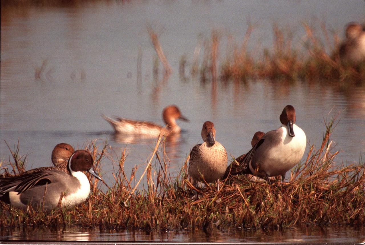
KENNEDY SPACE CENTER, FLA. -- Male (foreground) and female pintail ducks climb onto a grassy spot in the waters of the Merritt Island National Wildlife Refuge at Kennedy Space Center. The pintails can be found in the marshes, prairie ponds and tundra of Alaska, Greenland and north and western United States; in the winter they range south and east to Central America and the West Indies, sometimes in salt marshes such as the refuge offers. The open water of the refuge provides wintering areas for 23 species of migratory waterfowl, as well as a year-round home for great blue herons, great egrets, wood storks, cormorants, brown pelicans and other species of marsh and shore birds. The 92,000-acre refuge is also habitat for more than 310 species of birds, 25 mammals, 117 fishes and 65 amphibians and reptiles
At KSC’s Shuttle Landing Facility, a specially equipped Cessna Citation aircraft flies over the runway to calibrate the Cessna’s field mills with field mills on the ground (on the tripod at left) and on the car parked nearby (at right). Field mills measure electric fields. The aircraft is also equipped with cloud physics probes that measure the size, shape and number of ice and water particles in clouds. The plane is being flown into anvil clouds in the KSC area as part of a study to review and possibly modify lightning launch commit criteria. The weather study could lead to improved lightning avoidance rules and fewer launch scrubs for the Space Shuttle and other launch vehicles on the Eastern and Western ranges.; More information about this study can be found in <a href="http://www-pao.ksc.nasa.gov/kscpao/release/2000/56-00.htm">Release No. 56-00</a>

In a hangar at Cape Canaveral Air Force Station, a Cessna Citation aircraft has been fitted on the wings with devices that measure electric fields (black circles shown behind the open door) and with cloud physics probes (under the body and wings) that measure the size, shape and number of ice and water particles in clouds. The plane is being flown into anvil clouds in the KSC area as part of a study to review and possibly modify lightning launch commit criteria. The weather study could lead to improved lightning avoidance rules and fewer launch scrubs for the Space Shuttle and other launch vehicles on the Eastern and Western ranges.; More information about the study can be found in <a href="http://www-pao.ksc.nasa.gov/kscpao/release/2000/56-00.htm">Release No. 56-00</a>
In a hangar at Cape Canaveral Air Force Station, a weather researcher checks a field mill measuring device on the Cessna Citation. The aircraft is being used for NASA’s airborne field mill study. The plane also carries cloud physics probes (under the body and wings) that measure the size, shape and number of ice and water particles in clouds. The plane is being flown into anvil clouds in the KSC area as part of a study to review and possibly modify lightning launch commit criteria. The weather study could lead to improved lightning avoidance rules and fewer launch scrubs for the Space Shuttle and other launch vehicles on the Eastern and Western ranges.; More information about the study can be found in <a href="http://www-pao.ksc.nasa.gov/kscpao/release/2000/56-00.htm">Release No. 56-00</a>
A specially equipped Cessna Citation aircraft flies over KSC during a calibration test of field mills used to measure electric fields. The aircraft is also equipped with cloud physics probes that measure the size, shape and number of ice and water particles in clouds. The plane is being flown into anvil clouds in the KSC area as part of a study to review and possibly modify lightning launch commit criteria. The weather study could lead to improved lightning avoidance rules and fewer launch scrubs for the Space Shuttle and other launch vehicles on the Eastern and Western ranges.; More information on this study can be found in <a href="http://www-pao.ksc.nasa.gov/kscpao/release/2000/56-00.htm">Release No. 56-00</a>
Noctis Labyrinthus is a highly tectonized region immediately to the west of Valles Marineris. It formed when Mars' crust stretched itself apart. In this region, the crust first stretched in a north-south direction (as evidenced by the east-west trending scarp) and then in an east-west direction (as evidenced by the north-south trending smaller scarps). This sort of tectonic stretching creates faults in the crust (cracks along with masses of rock slide. This process is totally unrelated to Earth's plate tectonics.). The lower portions between faults are called "grabens" and the interspersed higher portions are called "horsts." The Basin and Range tectonic province of the western United States is a close Earth analog to Noctis Labyrinthus, which is Latin for "labyrinth of the night." http://photojournal.jpl.nasa.gov/catalog/PIA20740
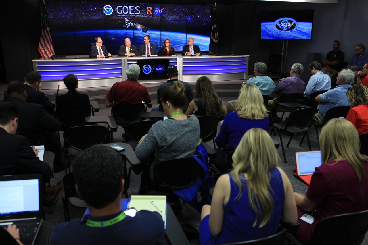
In the Kennedy Space Center's Press Site auditorium, members of the media participate in a mission briefing on the Geostationary Operational Environmental Satellite (GOES-R). Briefing participants from left are: Sean Potter of NASA Communications; Steven Goodman, NOAA's GOES-R program scientist; Joseph A. Pica, director of the National Weather Service Office of Observations; Sandra Cauffman, deputy director of NASA's Earth Science Division; and Damon Penn, assistant administrator for response at the Federal Emergency Management Agency. GOES-R is the first satellite in a series of next-generation GOES satellites for NOAA, the National Oceanographic and Atmospheric Administration. It will launch to a geostationary orbit over the western hemisphere to provide images of storms and help meteorologists predict severe weather conditionals and develop long-range forecasts.
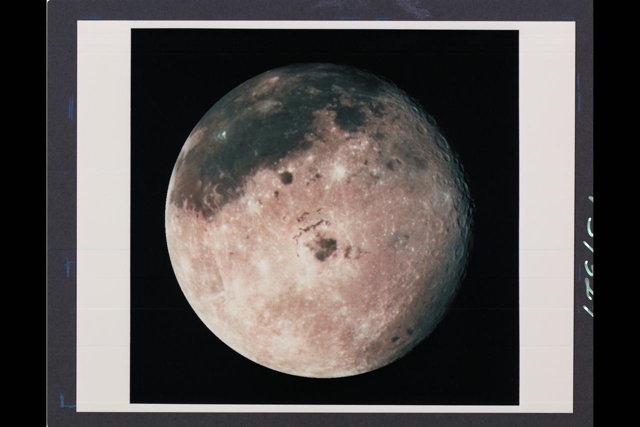
Range : 350,000 miles (JPL Ref: P-37329) This image of the western hemisphere of the Moon was taken through a green filter by Galileo at 9:35 am PST. In the center is the Orientale Basin, 600 miles in diameter, formed about 3.8 billion years ago by the impact of an streroid-size body. Orientale's dark center is a small mare. To the right is the lunar near side with the great, dark Oceanus Procellarum above and the small, circular, dark Mare Humorum Below. Maria are broad plains formed mostly over 3 billion years ago as vast bassaltic lava flows. To the left is the lunar far side with fewer maria, but, at lower left, the South-Pole-Aitken basin, about 1200 miles in diameter, which resemble Orientale but is much older and more weathered and battered by cratering. The intervening cratered highlands of both sides, as well as the maria, are dotted with bright, young craters. This image was 'reprojected' so as to center visibility of small features.
STS058-72-004 (18 Oct-1 Nov 1993) --- The Sierra Nevada Mountain Range can be seen in this north-looking high oblique view taken in October, 1993, by the STS-58 crew. Visible in the view to the west of the Sierra Nevada are the San Joaquin and Sacramento Valleys of central California. The San Francisco/Oakland Bay Area can be seen to the west of the valley at the extreme left of the photograph. To the east or right of the Sierra Nevada, the basin and Range Region of central and northern Nevada is visible. Mono Lake, Lake Tahoe and Pyramid Lake are also visible in this scene. The long northwest/southeast trending Walker Lane Shear Zone, which lies just to the east (right) of the Sierra Nevada is also visible. Near the top of the view (near the horizon), the snow covered volcanic peak Mount Shasta can be seen. Over 645 kilometers (400 miles) long and from 65 to 130 kilometers (40 to 80 miles) wide, the Sierra Nevada have many peaks in excess of 3,300 meters (11,000 feet) above sea level. A titled fault block in structure (the largest in the United States) and shaped by glaciers during the last ice age over 12,000 years ago, the Sierra Nevada eastern front rises sharply from the Great Basin of Nevada, while its western slope descends gradually to the hills bordering the Central Valley of California. Snow-fed streams supply much of the irrigation water to the Central Valley and to western Nevada and also generate hydroelectricity. Recent above normal precipitation (snowfall) of the last two years has helped in alleviating the drought conditions that had prevailed throughout most of California in the mid and late 1980's and early 1990's.