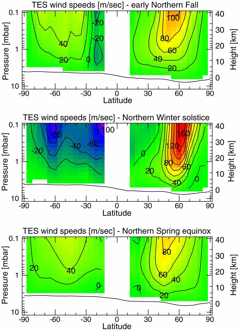
Measurements of the Martian Winds for Three Seasons
NASA's SMAP radiometer instrument measured Hurricane Matthew's wind speeds at 4:52 a.m. PDT (7:52 a.m. EDT) at up to 132 miles per hour (59 meters per second). SMAP has excellent sensitivity to extreme winds, far beyond that of typical scatterometer instruments now in orbit. http://photojournal.jpl.nasa.gov/catalog/PIA21096
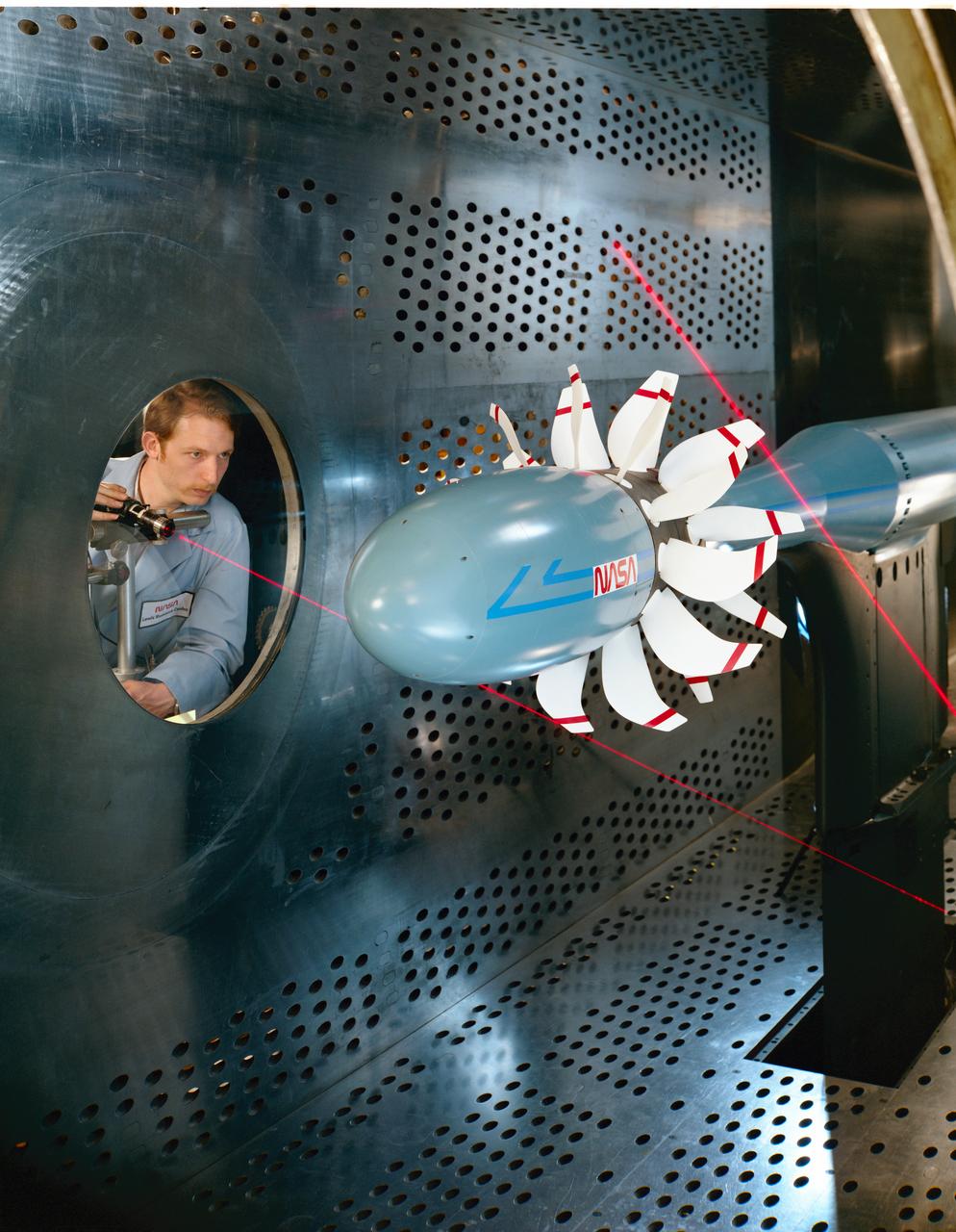
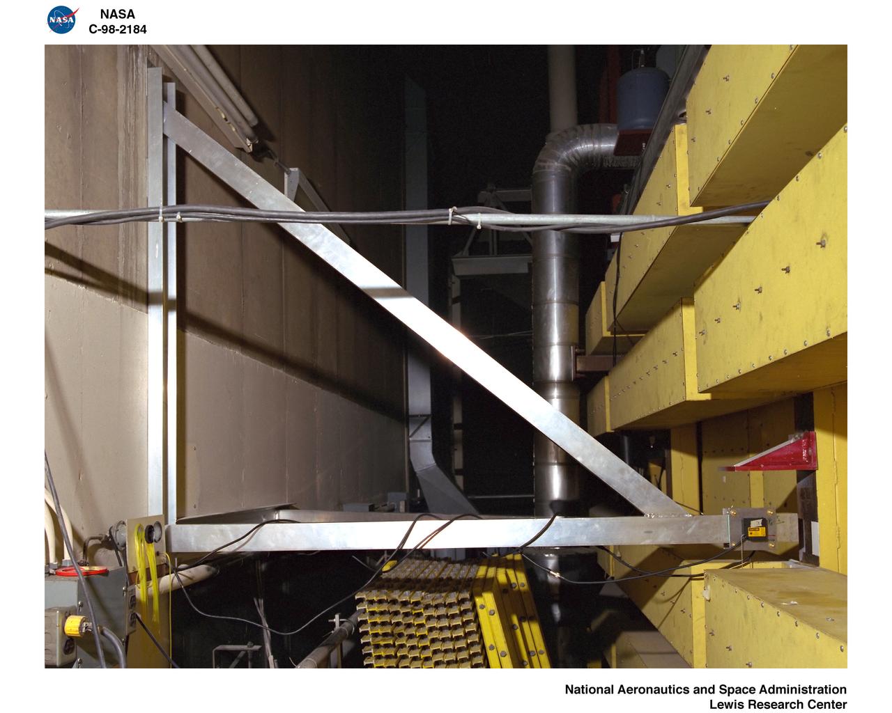
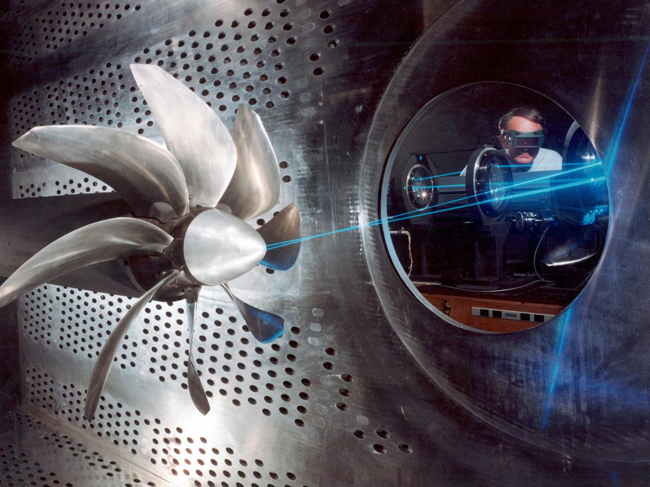
Laser based blade deflection measurement system on Counter Rotation Pusher Propeller model in 8x6 SWT (Supersonic Wind Tunnel)
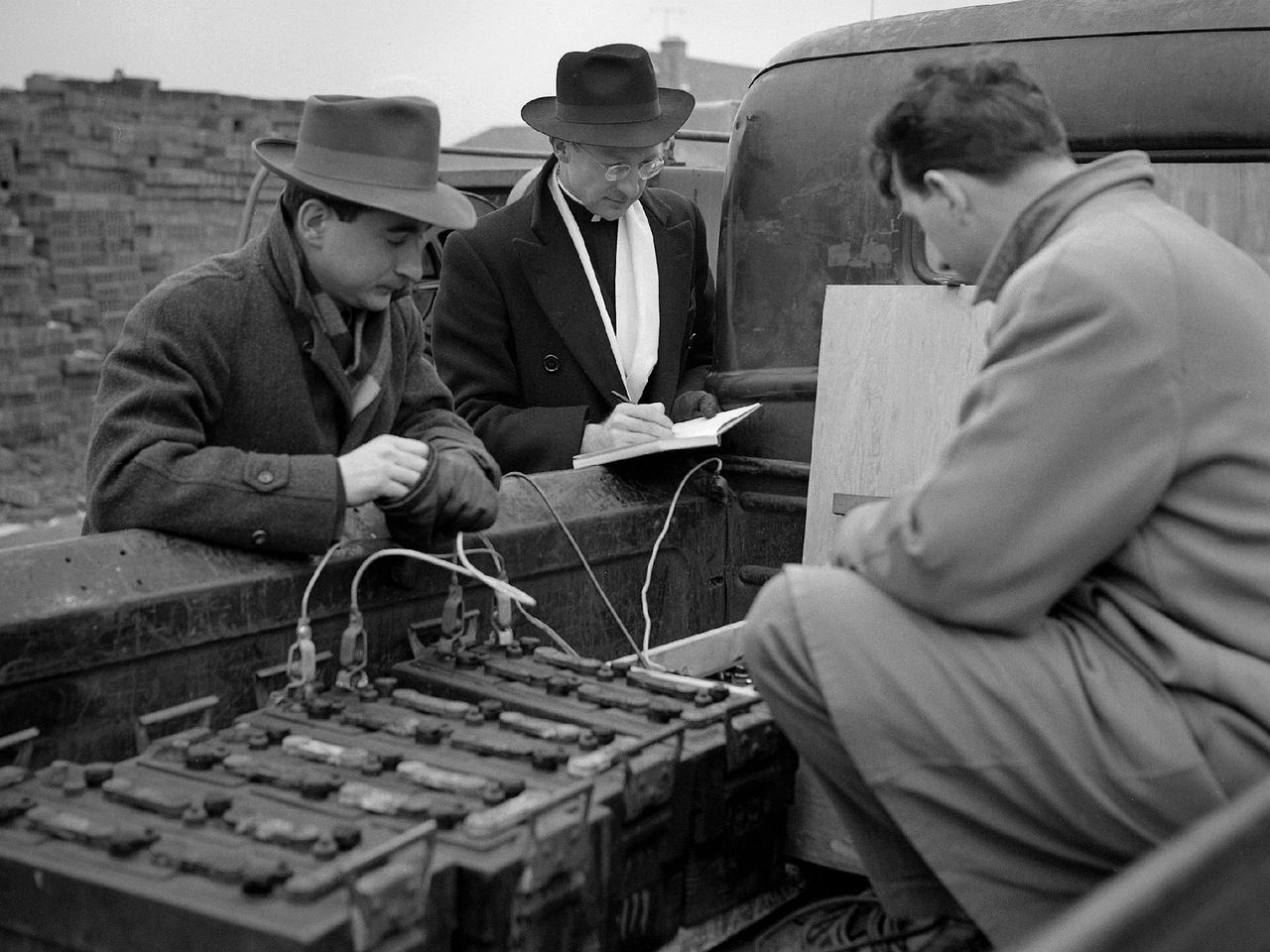
Reverend Henry Birkenhauer and E.F. Carome measure ground vibrations on West 220th Street caused by the operation of the 8- by 6-Foot Supersonic Wind Tunnel at the National Advisory Committee for Aeronautics (NACA) Lewis Flight Propulsion Laboratory. The 8- by 6 was the laboratory’s first large supersonic wind tunnel. It was also the NACA’s most powerful supersonic tunnel, and the NACA’s first facility capable of running an engine at supersonic speeds. The 8- by 6 was originally an open-throat and non-return tunnel. This meant that the supersonic air flow was blown through the test section and out the other end into the atmosphere. Complaints from the local community led to the installation of a muffler at the tunnel exit and the eventual addition of a return leg. Reverend Brikenhauer, a seismologist, and Carome, an electrical technician were brought in from John Carroll University to take vibration measurements during the 8- by 6 tunnel’s first run with a supersonic engine. They found that the majority of the vibrations came from the air and not the ground. The tunnel’s original muffler offered some relief during the facility checkout runs, but it proved inadequate during the operation of an engine in the test section. Tunnel operation was suspended until a new muffler was designed and installed. The NACA researchers, however, were pleased with the tunnel’s operation. They claimed it was the first time a jet engine was operated in an airflow faster than Mach 2.
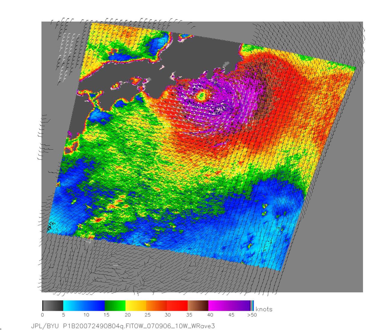
NASA QuikScat satellite acquired this image of Category One Typhoon Fitow on Sept. 6, 2007, prior to the storm making landfall in Japan.
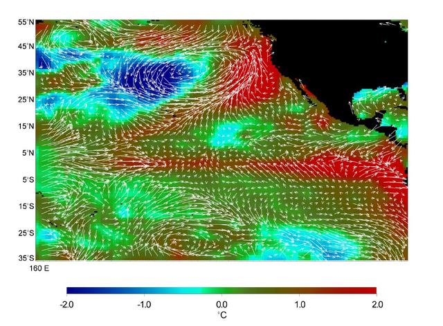
This image displays wind measurements taken by the satellite-borne NASA Scatterometer NSCAT during the last 10 days of May 1997, showing the relationship between the ocean and the atmosphere at the onset of the 1997-98 El Niño condition.
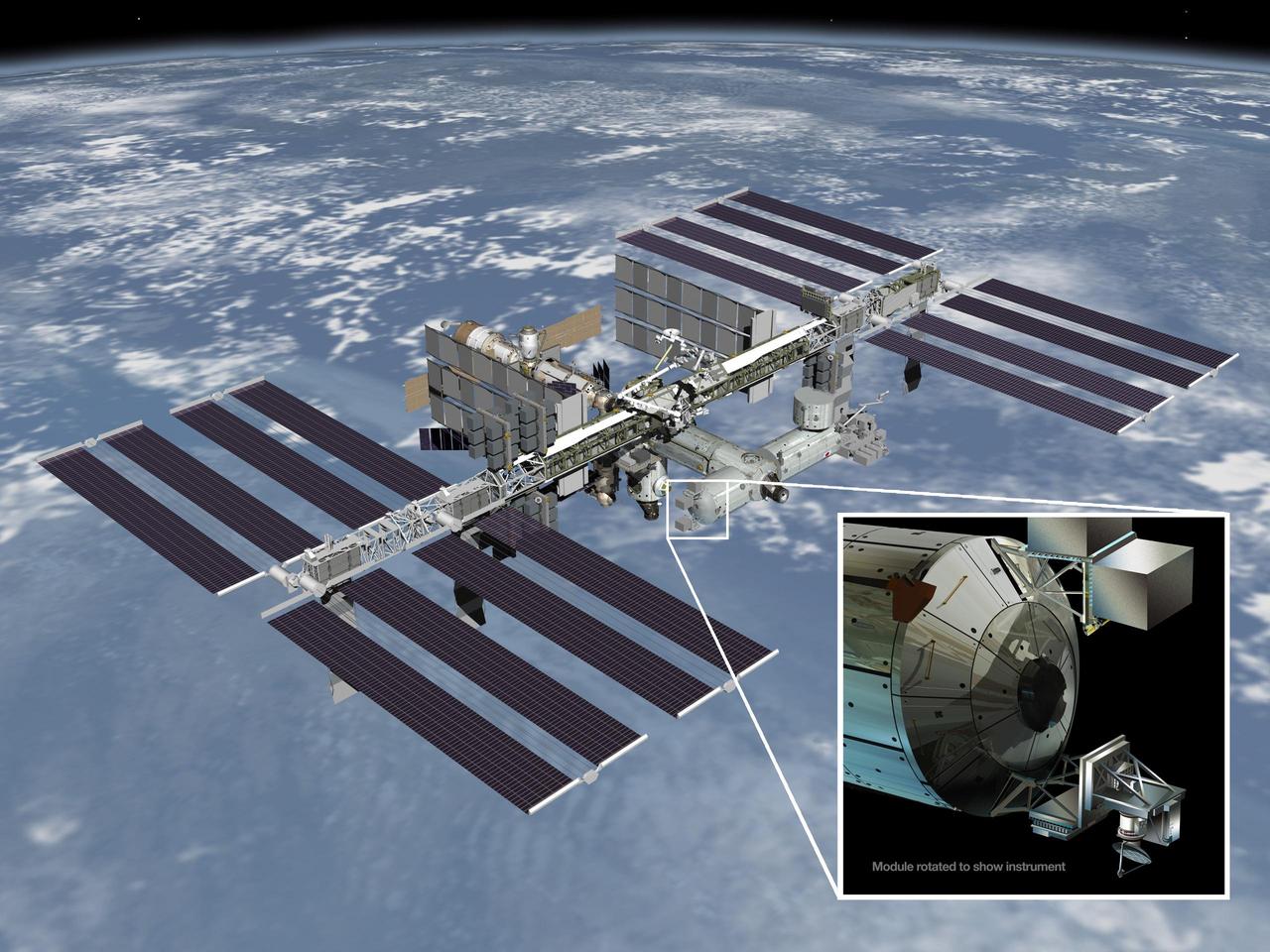
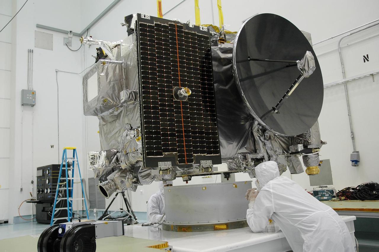
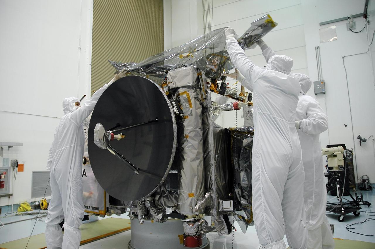
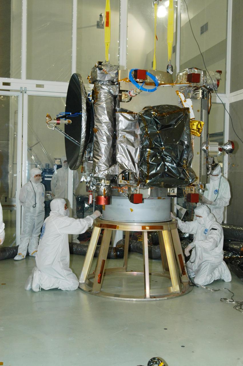
Artist rendering of NASA ISS-RapidScat instrument inset, which will launch to the International Space Station in 2014 to measure ocean surface wind speed and direction and help improve weather forecasts, including hurricane monitoring.
Launched Sept. 21, 2014, to the International Space Station, NASA newest Earth-observing mission, the International Space Station-RapidScat scatterometer to measure global ocean near-surface wind speeds and directions.
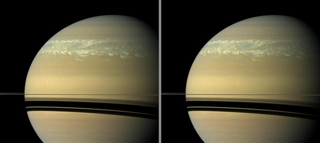
These two natural color views taken 11 hours -- one Saturn day -- apart by NASA Cassini spacecraft help scientists measure wind speeds in the huge storm seen here in the planet northern hemisphere.

LASER DISPLACEMENT MEASUREMENTS IN THE 9X15 FOOT WIND TUNNEL TEST SECTION
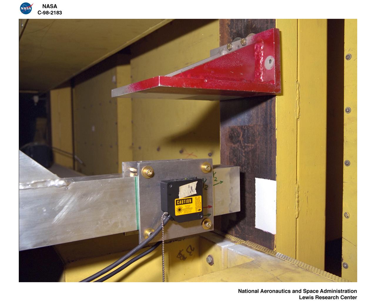
LASER DISPLACEMENT MEASUREMENTS IN THE 9X15 FOOT WIND TUNNEL TEST SECTION
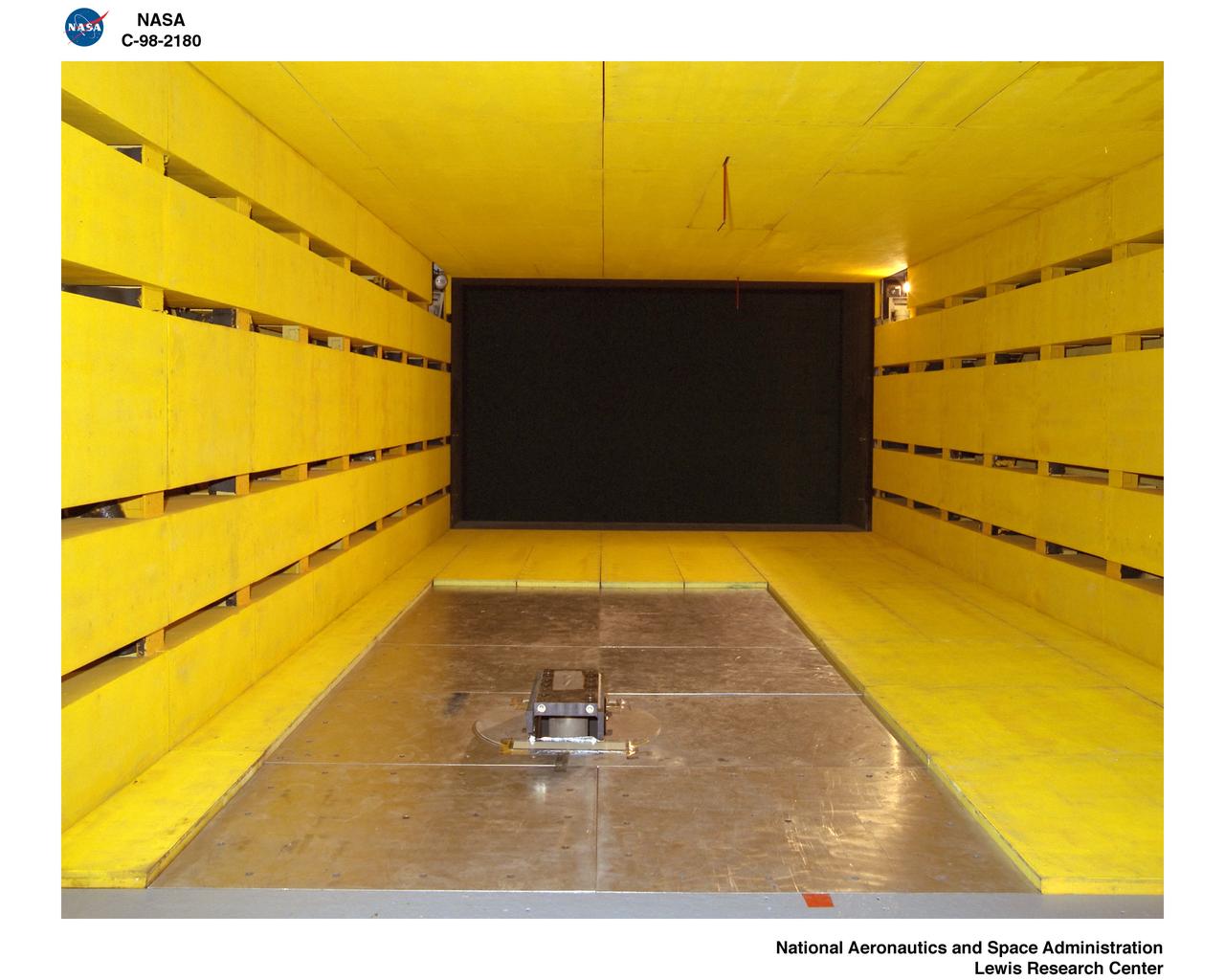
LASER DISPLACEMENT MEASUREMENTS IN THE 9X15 FOOT WIND TUNNEL TEST SECTION
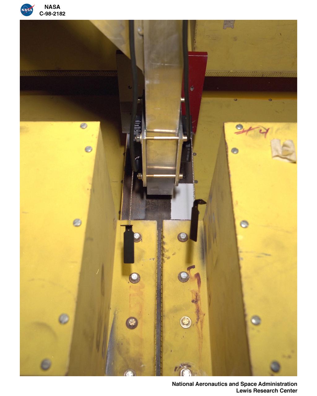
LASER DISPLACEMENT MEASUREMENTS IN THE 9X15 FOOT WIND TUNNEL TEST SECTION
LASER DISPLACEMENT MEASUREMENTS IN THE 9X15 FOOT WIND TUNNEL TEST SECTION
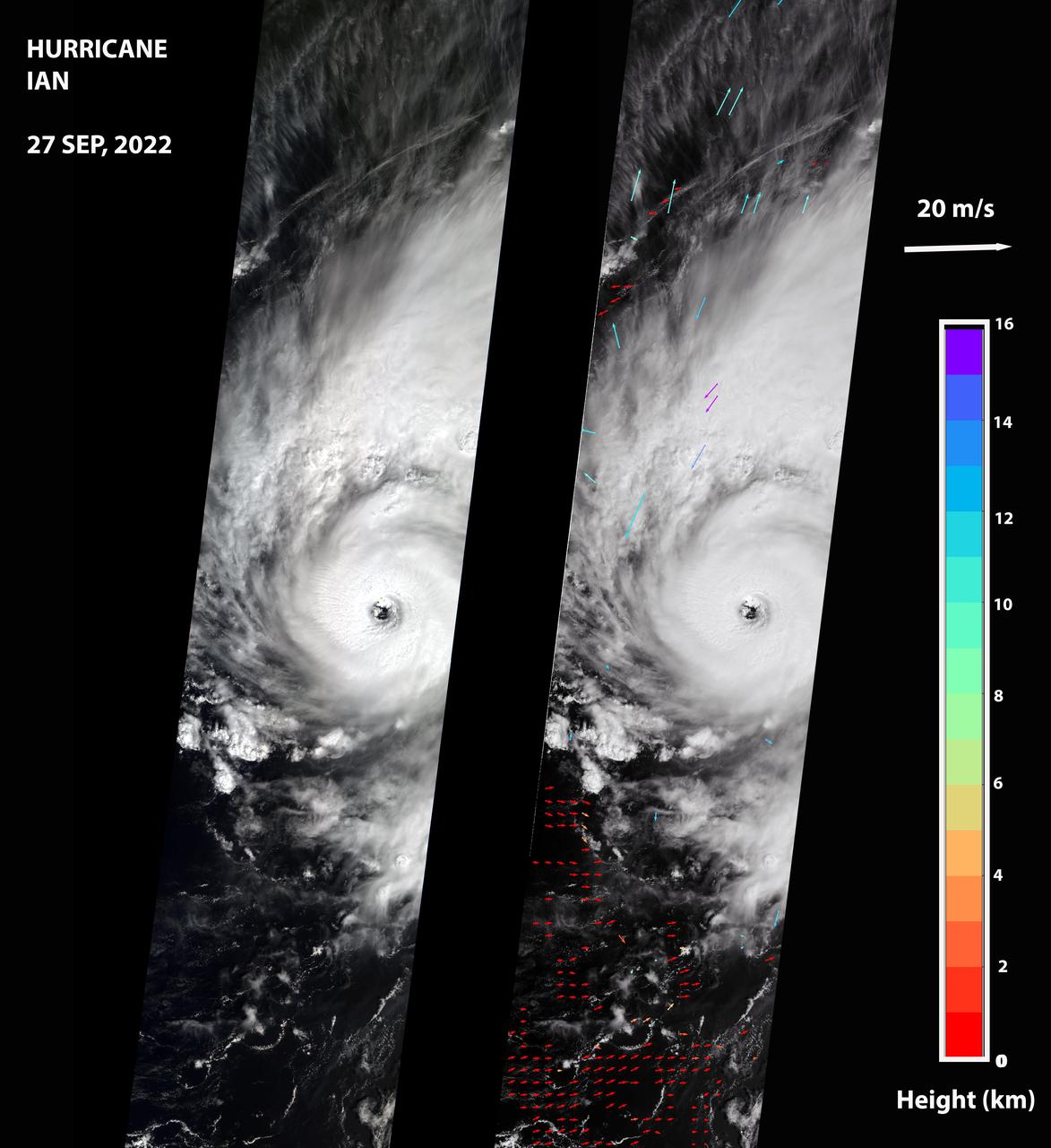
NASA's Multi-angle Imaging SpectroRadiometer (MISR) captured an optical image of Hurricane Ian, as well as measurements of the storm's wind speed, at noon local time Sept. 27, 2022. The storm, a Category 3 hurricane at that time, had maximum sustained winds of 115 mph (185 kph). The eye of the storm was located off the northern coast of Cuba, approximately 70 miles (110 kilometers) west of Havana, after passing over the island in the morning hours. The MISR instrument, flying aboard NASA's Terra satellite, carries nine cameras that observe the Earth at different angles. It takes approximately seven minutes for all the cameras to observe the same location on the Earth, and the motion of clouds during that time is used to calculate wind speed at the cloud tops. The left-hand panel of the first figure shows an image of the storm as viewed by MISR's central, downward-looking camera. The panel on the right shows the wind speeds derived from MISR data superimposed on the image. The length of the arrows is proportional to the wind speed, while their color shows the altitudes of the cloud tops in kilometers. The MISR data shows that the cloud-top winds near the center of the storm reached approximately 108 mph (174 kph), with maximum cloud-top wind speed reaching 123 mph (198 kph). The wind data shows that the lowest clouds are moving counterclockwise, while the high clouds north of the hurricane's center are rotating clockwise. The anaglyph reveals high clouds associated with strong thunderstorms in the eyewall of Hurricane Ian as well as individual strong thunderstorms in the outer rainbands. https://photojournal.jpl.nasa.gov/catalog/PIA24909
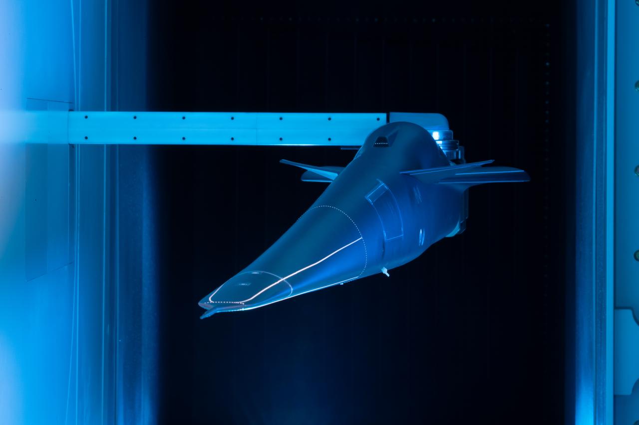
Event: Forebody and Nose - Windtunnel Testing A model of the X-59 forebody is shown in the Lockheed Martin Skunk Works’ wind tunnel in Palmdale, California. These tests gave the team measurements of wind flow angle around the aircraft’s nose and confirmed computer predictions made using computational fluid dynamics (CFD) software tools. The data will be fed into the aircraft flight control system to tell the pilot the aircraft’s altitude, speed and angle. This is part of NASA’s Quesst mission which plans to help enable supersonic air travel over land.
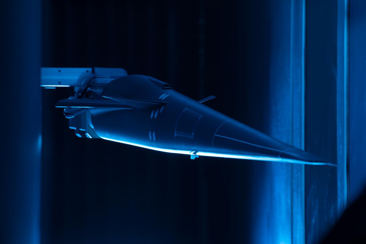
Event: Forebody and Nose - Windtunnel Testing A model of the X-59 forebody is shown in the Lockheed Martin Skunk Works’ wind tunnel in Palmdale, California. These tests gave the team measurements of wind flow angle around the aircraft’s nose and confirmed computer predictions made using computational fluid dynamics (CFD) software tools. The data will be fed into the aircraft flight control system to tell the pilot the aircraft’s altitude, speed and angle. This is part of NASA’s Quesst mission which plans to help enable supersonic air travel over land.
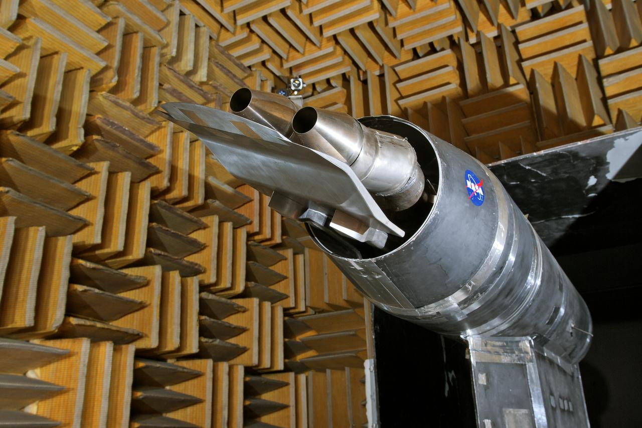
LSAWT\Twin Jet Test with HWB Model\JEDA Measurements Low Speed Aeroacoustic Wind Tunnel\Twin Jet Model System \Hybrid Wing Model Installed\ Measurement Technique: Jet Directional Array (JEDA)
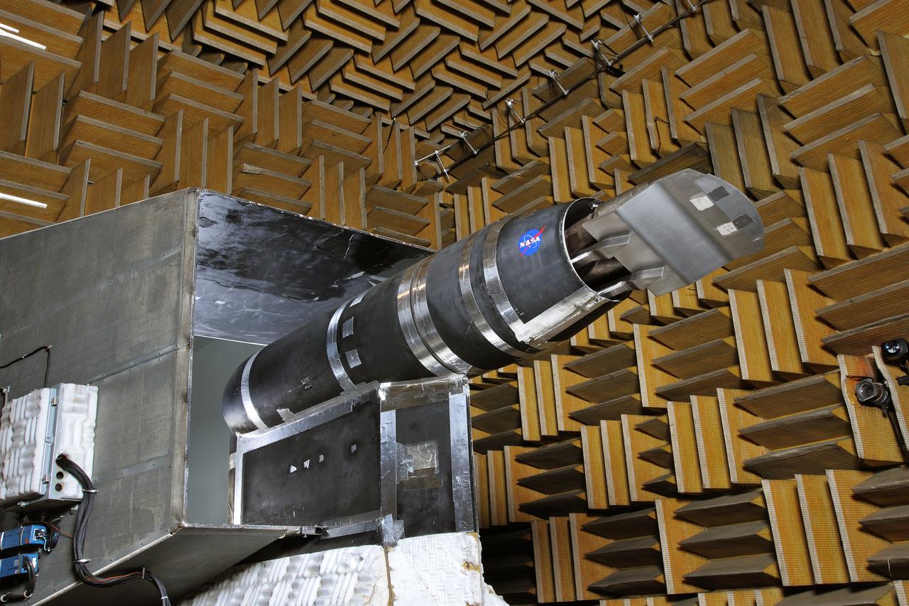
LSAWT\Twin Jet Test with HWB Model\JEDA Measurements Low Speed Aeroacoustic Wind Tunnel\Twin Jet Model System \Hybrid Wing Model Installed\ Measurement Technique: Jet Directional Array (JEDA)
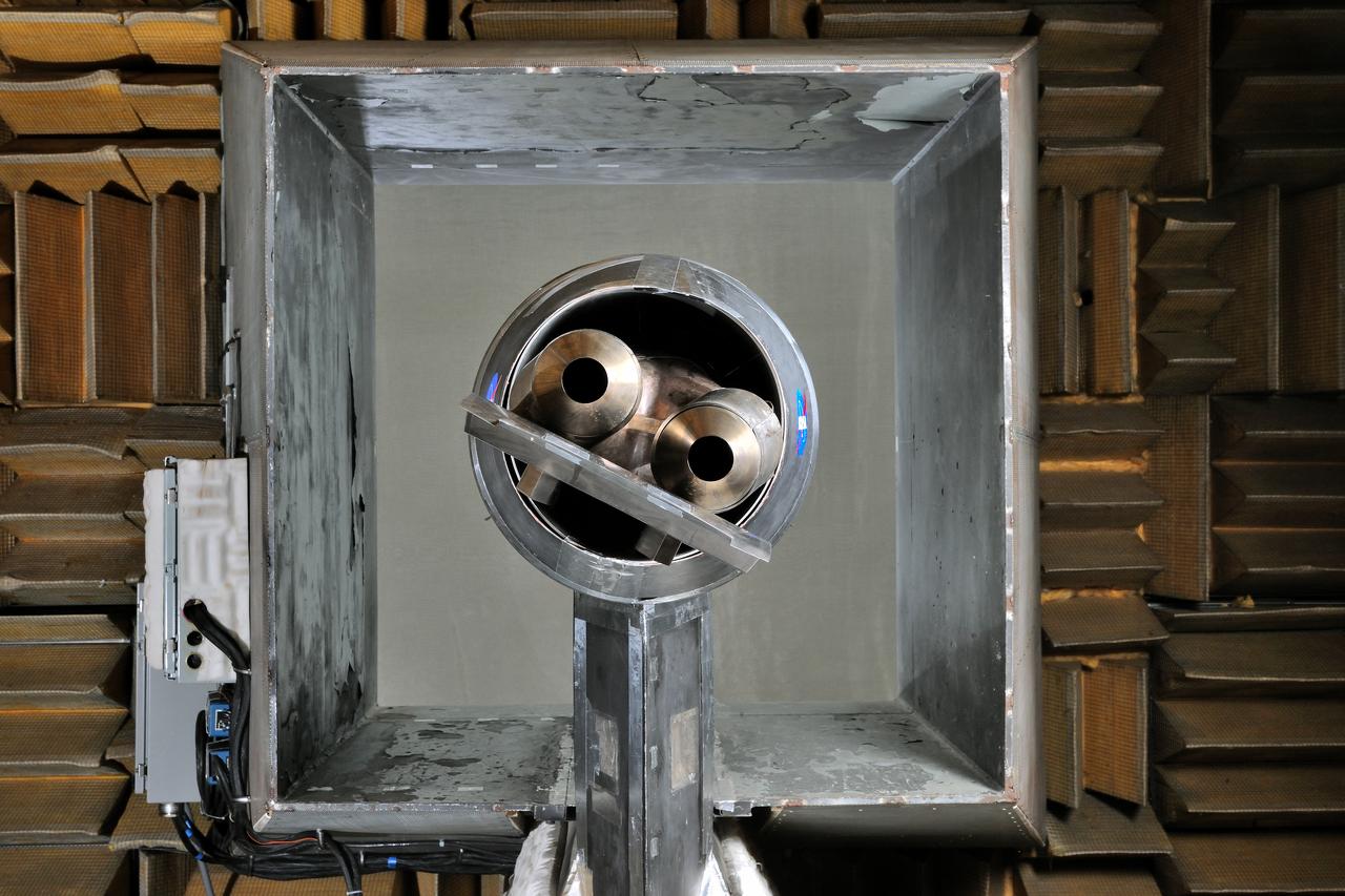
LSAWT\Twin Jet Test with HWB Model\JEDA Measurements Low Speed Aeroacoustic Wind Tunnel\Twin Jet Model System \Hybrid Wing Model Installed\ Measurement Technique: Jet Directional Array (JEDA)
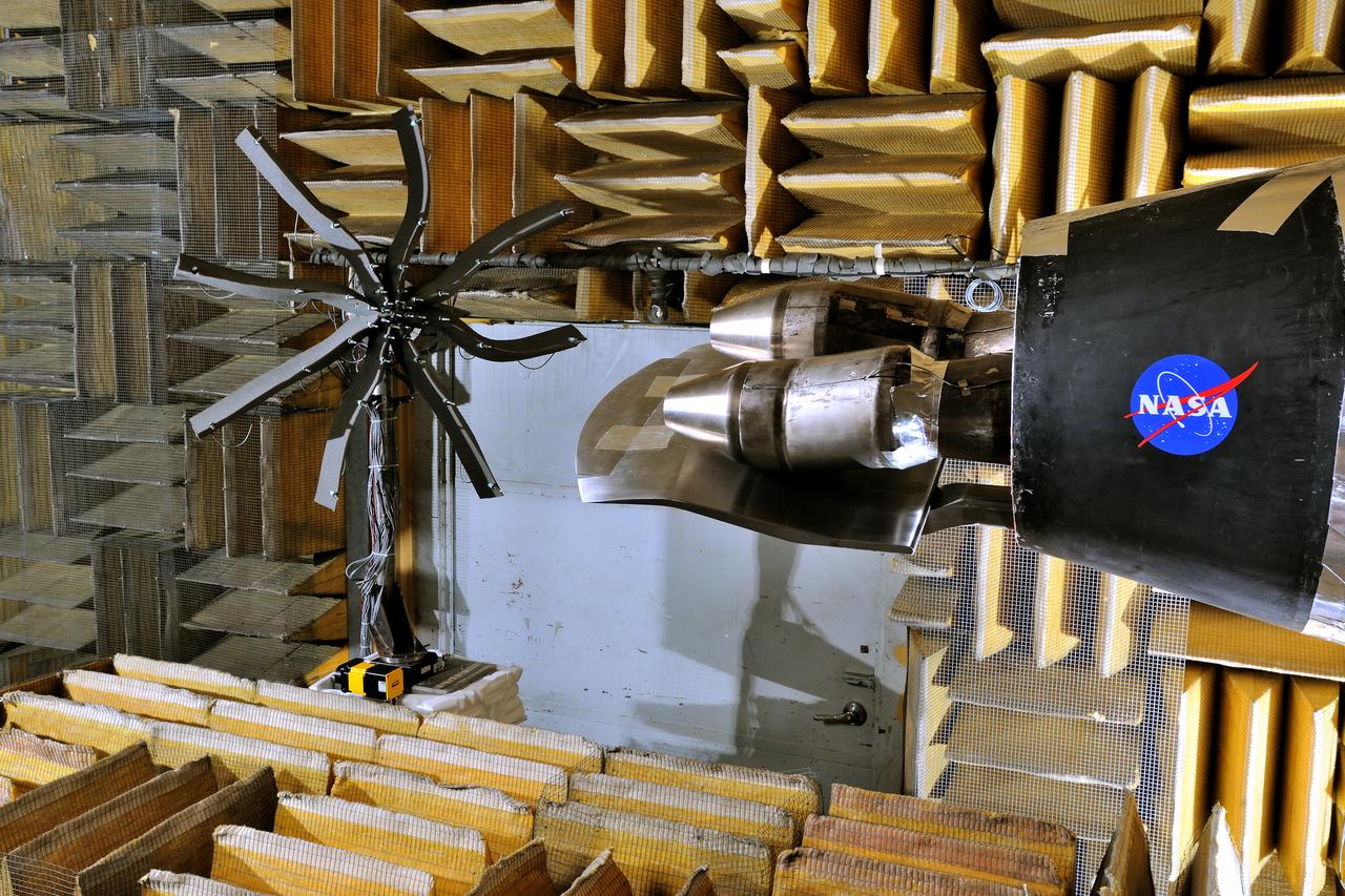
LSAWT\Twin Jet Test with HWB Model\JEDA Measurements Low Speed Aeroacoustic Wind Tunnel\Twin Jet Model System \Hybrid Wing Model Installed\ Measurement Technique: Jet Directional Array (JEDA)
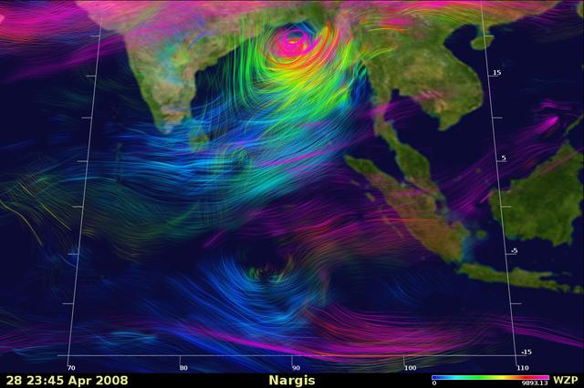
Shen_Nargis: Snapshot of a very large simulation showing the altitude and velocity of wind speeds within the 2008 Cyclone Nargis. Top wind speeds for the storm were measured at 135 mph. The lowest altitude winds are shown in blue, while the highest altitude winds are shown in pink. Wind speed is shown by color density: higher density denotes stronger winds, slightly transparent color indicates slower wind speeds. Credit: Bryan Green, NASA Ames Research Center; Bo-wen Shen, NASA Goddard Space Flight Center.
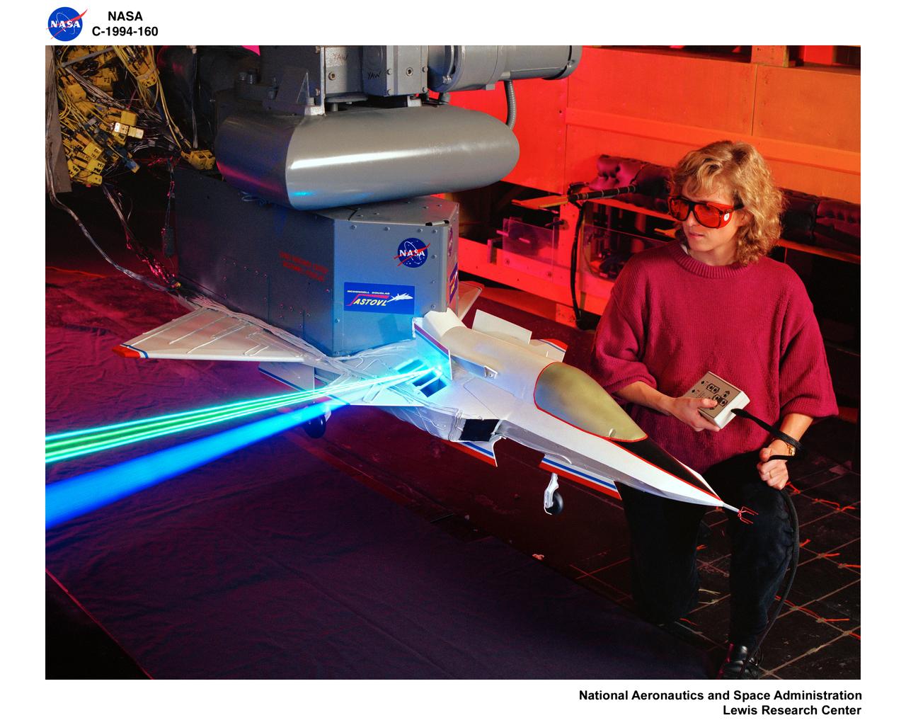
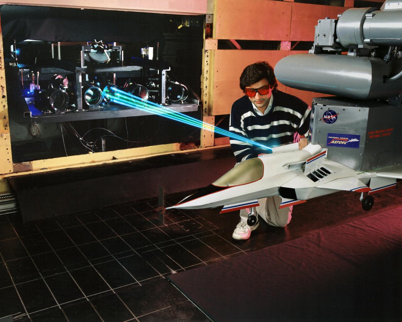
LASER Velocimetry System for Flow Measurement. Advanced Short Takeoff and Vertical Landing, ASTOVL model n the 9x15 foot Low Speed Wind Tunnel, LSWT
Event: Forebody and Nose - Windtunnel Testing A technician works on the X-59 model during testing in the low-speed wind tunnel at Lockheed Martin Skunk Works in Palmdale, California. These tests gave the team measurements of wind flow angle around the aircraft’s nose and confirmed computer predictions made using computational fluid dynamics (CFD) software tools. The data will be fed into the aircraft flight control system to tell the pilot the aircraft’s altitude, speed, and angle. This is part of NASA’s Quesst mission which plans to help enable supersonic air travel over land.

CAPE CANAVERAL, Fla. – Felix Gamez and Jacob Walls, right, of Qinetiq North America take measurements as they prepare to install an antenna in the antenna field for NASA Kennedy Space Center’s Doppler radar wind profiler. Located near the spaceport’s Shuttle Landing Facility runway, the profiler is being upgraded to a new, state-of-the-art version that will help forecasters and launch teams characterize upper-level winds in the area. This profiler will help in the detection of wind-shear conditions during launch. Photo credit: NASA/Ben Smegelsky
NASA Langley Research Center's Kris Bedka, pictured here on the DC-8 flying laboratory, is the lead for an airborne mission called Aeoulus that is advancing laser-based technologies for measuring winds in the lower atmosphere.
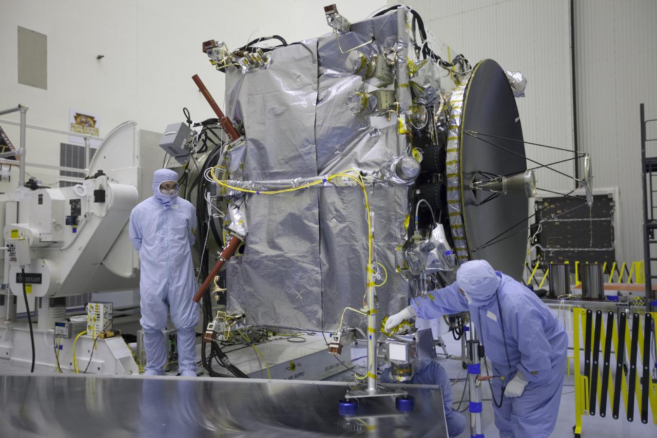
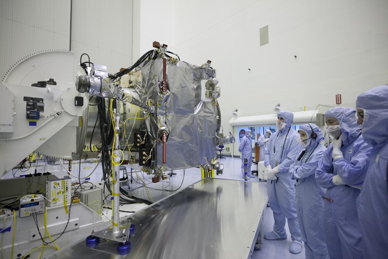
CAPE CANAVERAL, Fla. -- At Cape Canaveral Air Force Station in Florida, technicians in NASA’s AO Building on Cape Canaveral Air Station move the Wind spacecraft to a work stand. Wind is scheduled for launch on a Delta II expendable launch vehicle. Wind is the first of two missions of the Global Geospace Science Initiative, part of the worldwide collaboration for the International Solar-Terrestrial Physics ISTP program. It will carry six U.S. instruments, one French instrument and the first Russian instrument to ever fly on an American satellite, as part of an effort to measure properties of the solar wind before it reaches Earth. Photo Credit: NASA
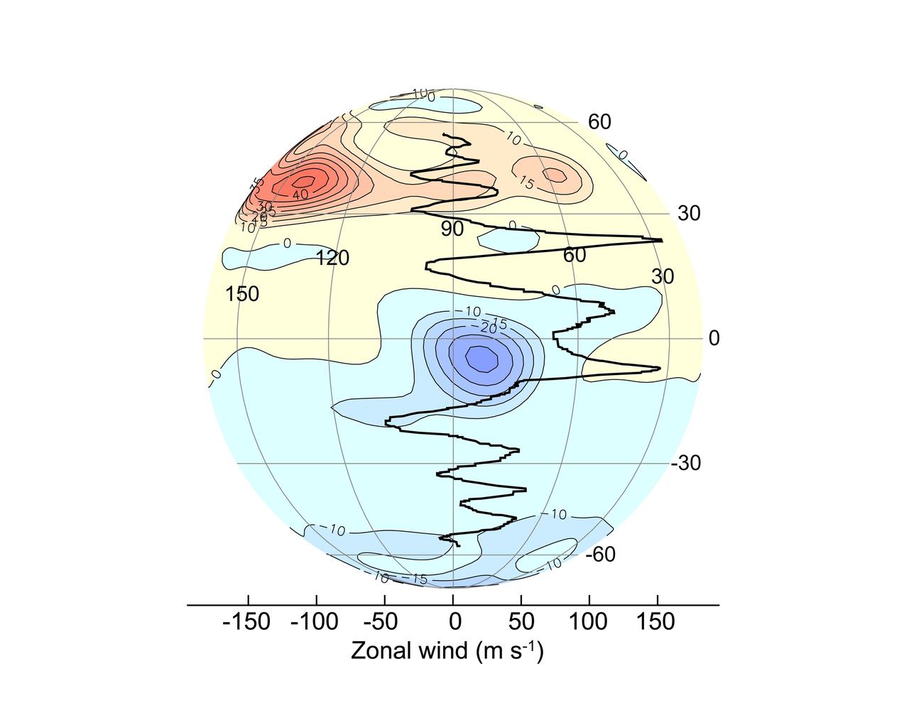
A new, highly detailed map of Jupiter's magnetic field based on data from NASA's Juno spacecraft renders in high resolution a mysterious region of the field nicknamed the Great Blue Spot (GBS), an isolated and intense patch of magnetic flux at the planet's equator. This orthographic plot shows the radial magnetic field from a vantage point above the GBS, compared to zonal winds measured by tracking the movement of surface features. The GBS appears to be distorted by the winds, with westward zonal winds south of the GBS pulling the field to the west and eastward zonal winds north of the GBS stretching the field toward the east. https://photojournal.jpl.nasa.gov/catalog/PIA25035
To verify the lidar data they're collecting on the DC-8 airborne science laboratory, Aeolus mission scientists will use dropsondes, which are devices they'll drop from this tube in the aircraft to collect wind and water vapor data.
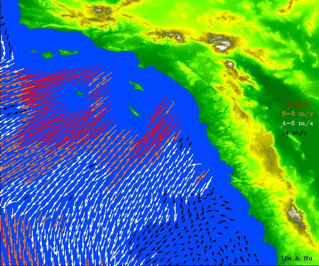
While El Niño events have a significant impact on the entire Earth System, they are most easily visible in measurements of sea surface temperature (SST), sea surface height (SSH) and ocean winds near the surface. In fact, the precursor and the main driver of El Niño events is manifested in the weakening of the normally westward blowing trade winds, or even their complete reversal to blow from west to east, in the Western and Central tropical Pacific. http://photojournal.jpl.nasa.gov/catalog/PIA20365

The Tropospheric Doppler Radar Wind Profiler (TDRWP), located at Kennedy Space Center, is the only instrument of its kind in operation. Consisting of 640 antennae and occupying five acres near the Launch and Landing Facility, the TDRWP operates at nearly 50 MHz. It will be used as a primary instrument to measure upper level winds for NASA’s Artemis missions, which will launch from the Florida spaceport. The instrument has the ability to provide data from 6,000 to 62,000 feet, every five minutes, far outpacing weather balloons.
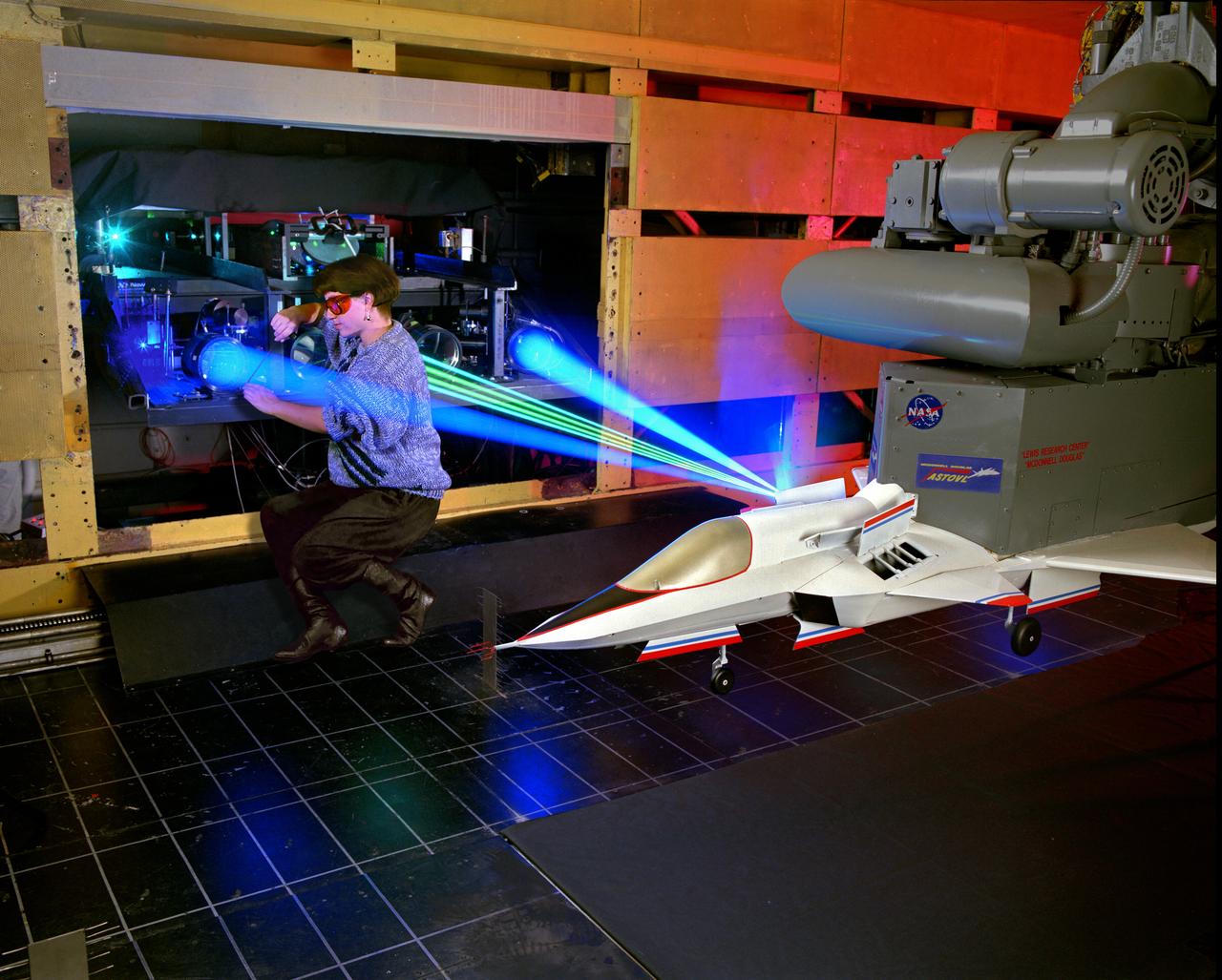
The 9x15 low speed tunnel tests take off and landing of aircraft. The laser velocimetry system for flow measurement show here, with the color blue and green lasers, measures engine exhaust that comes back up from the ground. The STOVL model n the 9x15 low speed wind tunnel, building 39, is similar to the British Harrier aircraft.
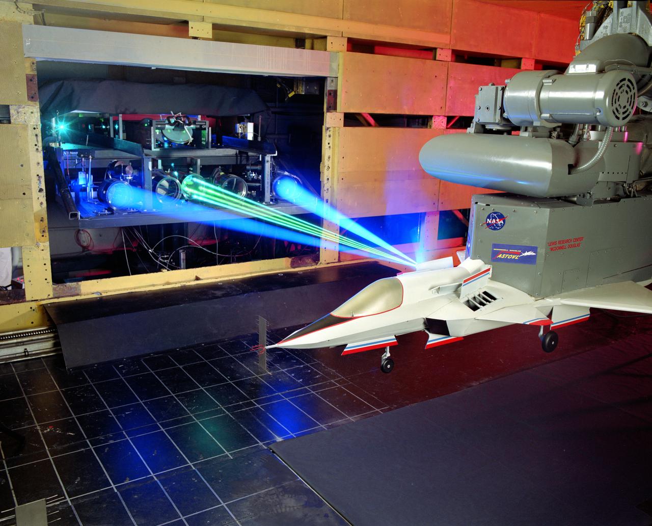
The 9x15 low speed tunnel tests take off and landing of aircraft. The laser velocimetry system for flow measurement show here, with the color blue and green lasers, measures engine exhaust that comes back up from the ground. The STOVL model n the 9x15 low speed wind tunnel, building 39, is similar to the British Harrier aircraft.
A spectrally resolved Rayleigh/Mie scattering diagnostic was developed to measure temperature and wing span wise velocity in the vicinity of an ASTOVL aircraft model tested in the Lewis, now Glenn, 9x15 Low Speed Wind Tunnel. Shown is a Fabry-Perot interferometer that uses only the blue light from a laser to measure static temperature and velocity near the lift nozzles and suction systems.
These two images show Hurricane Isabel as viewed by AIRS and SeaWinds scatterometers on NASA ADEOS-2 and QuikScat satellites in September, 2003. AIRS data are used to create global three-dimensional maps of temperature, humidity and clouds, while scatterometers measure surface wind speed and direction. http://photojournal.jpl.nasa.gov/catalog/PIA00429
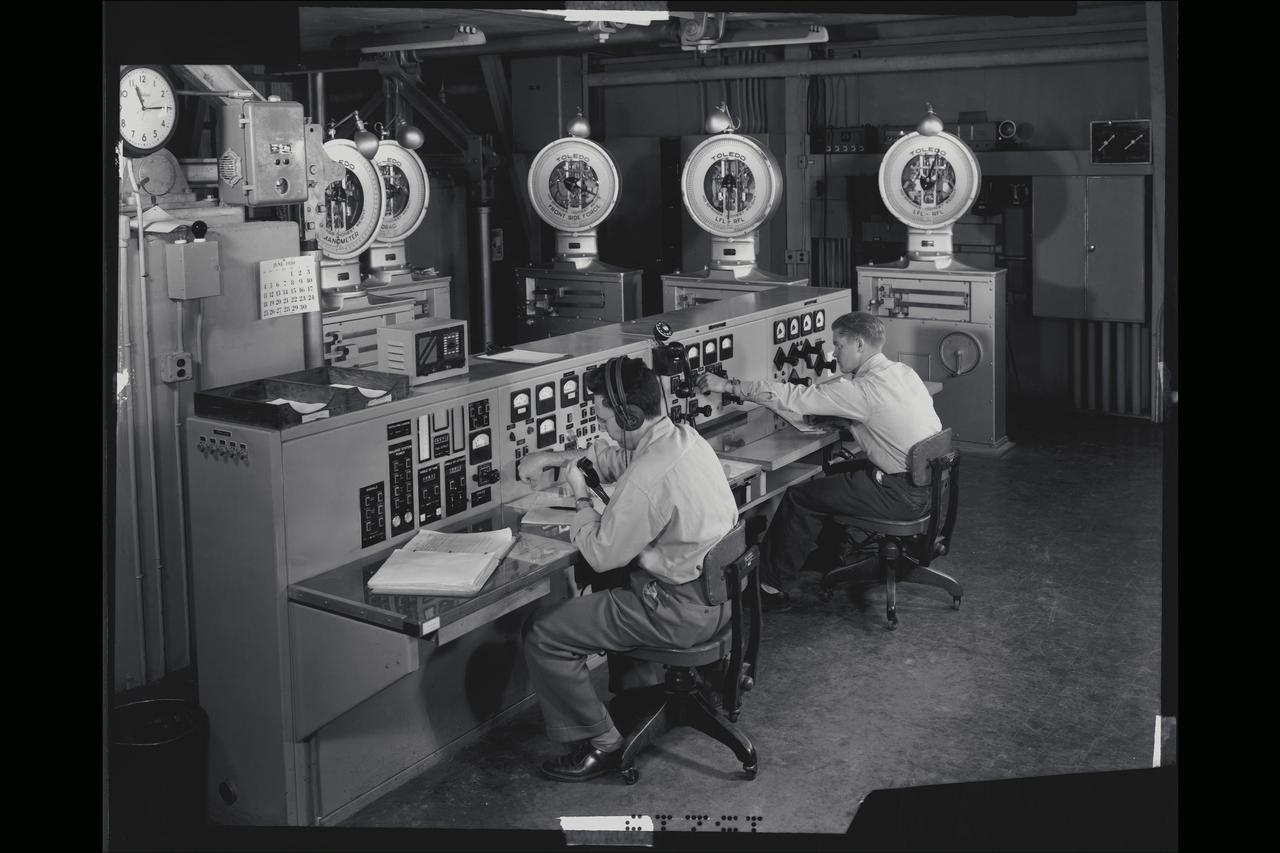
40x80 wind tunnel manometers control room at NACA's Ames Research Center. Control panel (called the bench board) showing five of the seven scale heads which measured the forces on the model (ie. Lift, drag, side force etc.)
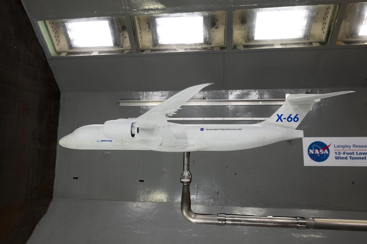
A model of the X-66 aircraft with a wingspan of almost 6 feet was placed in the 12-Foot Low-Speed Wind Tunnel at NASA’s Langley Research Center in Hampton, Virginia on October 30, 2024. During the tests, the team captured measurements of forces such as lift and drag over many aerodynamic configurations and flight conditions.

Particle-image velocimetry (PIV) is performed on the upper surface of a pitching airfoil in the NASA Glenn Icing Research Tunnel. PIV is a laser-based flow velocity measurement technique used widely in wind tunnels. These experiments were conducted as part of a research project focused on enhancing rotorcraft speed, efficiency and maneuverability by suppressing dynamic stall.
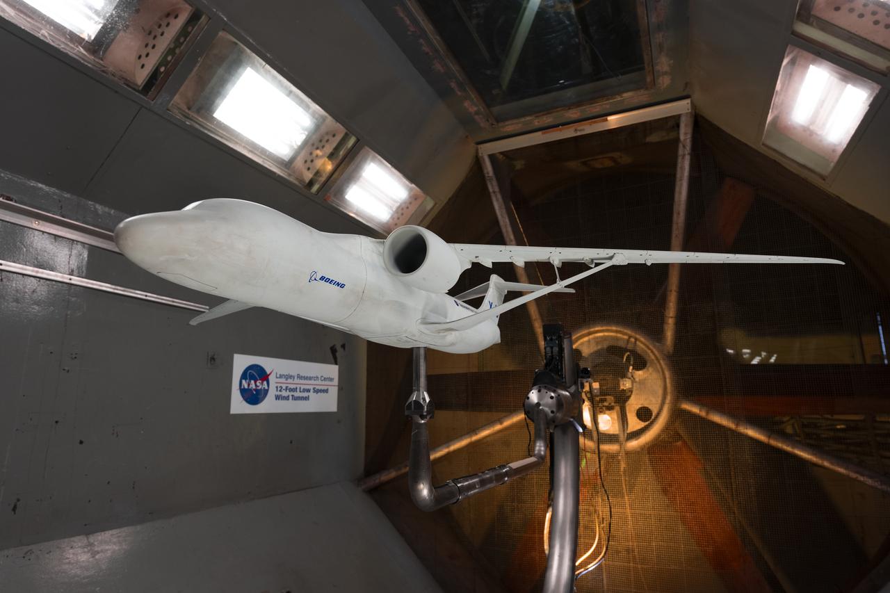
A model of the X-66 aircraft with a wingspan of almost 6 feet was placed in the 12-Foot Low-Speed Wind Tunnel at NASA’s Langley Research Center in Hampton, Virginia on October 30, 2024. During the tests, the team captured measurements of forces such as lift and drag over many aerodynamic configurations and flight conditions.

Researchers Anna Noe and Eric Altman check out the Doppler Aerosol Wind Lidar (DAWN), an airborne instrument that uses pulsed lasers to detect the movement of atmospheric aerosols such as dust or sea salt. In detecting those movements, it can profile wind vector — both speed and direction. Researchers are testing DAWNs capabilities during flights over the eastern Pacific.
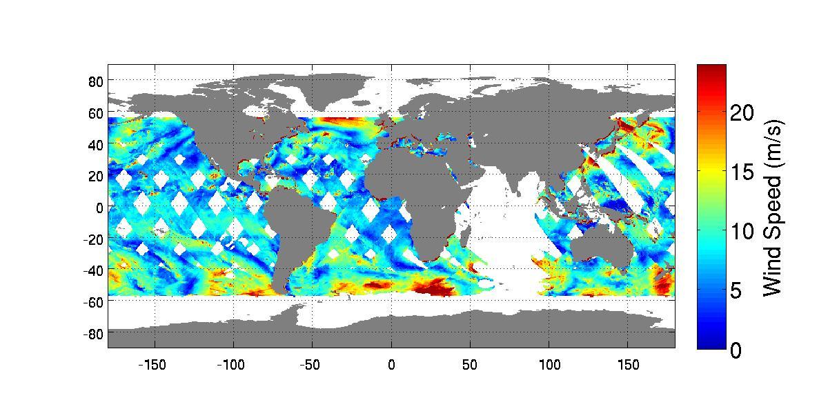
High-resolution ocean surface wind data from NASA's Quick Scatterometer (QuikScat) illustrate the strength of Santa Ana winds that pounded Southern California this week, causing damage and spreading brush fires. The colored arrows represent various ranges of wind speed, which were still well in excess of 30 knots (34 miles per hour), even after reaching the ocean and weakening. Santa Ana winds are offshore and down-slope winds unique to Southern California that are usually channeled through mountain gaps. These Santa Ana winds extend more than 500 kilometers (310 miles) offshore before changing direction to flow along the shore. The wind speeds and directions are retrieved from range-compressed backscatter data measured by QuikScat that has much higher spatial resolution than QuikScat's standard data products. Useful applications of high-resolution science-quality wind products derived from range-compressed backscatter have been demonstrated in two scientific papers: one on Hurricane Floyd and the other on Catalina Eddies. This is the first demonstration on near-real-time retrieval applications. http://photojournal.jpl.nasa.gov/catalog/PIA03892
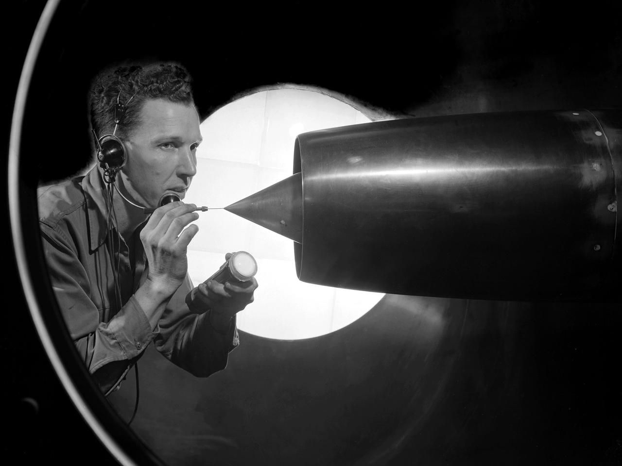
NASA Lewis Research Center researcher, John S. Sarafini, uses a laser doppler velocimeter to analyze a Hamilton Standard SR-2 turboprop design in the 8- by 6-Foot foot Supersonic Wind Tunnel. Lewis researchers were analyzing a series of eight-bladed propellers in their wind tunnels to determine their operating characteristics at speeds up to Mach 0.8. The program, which became the Advanced Turboprop (ATP), was part of a NASA-wide Aircraft Energy Efficiency Program undertaken to reduce aircraft fuel costs by 50 percent. The ATP concept was different from the turboprops in use in the 1950s. The modern versions had at least eight blades and were swept back for better performance. Bell Laboratories developed the laser doppler velocimeter technology in the 1960s to measure velocity of transparent fluid flows or vibration motion on reflective surfaces. Lewis researchers modified the device to measure the flow field of turboprop configurations in the transonic speed region. The modifications were necessary to overcome the turboprop’s vibration and noise levels. The laser beam was split into two beams which were crossed at a specific point. This permits researchers to measure two velocity components simultaneously. This data measures speeds both ahead and behind the propeller blades. Researchers could use this information as they sought to advance flow fields and to verify computer modeling codes.
CAPE CANAVERAL, Fla. – Inside the Payload Hazardous Servicing Facility at NASA's Kennedy Space Center in Florida, engineers and technicians deploy the Solar Wind Electron Analyzer boom on the Mars Atmosphere and Volatile Evolution, or MAVEN, spacecraft. The analyzer will measure the solar wind and electrons in the ionosphere of the Red Planet. MAVEN is being prepared for its scheduled launch in November from Cape Canaveral Air Force Station, Fla. atop a United Launch Alliance Atlas V rocket. Positioned in an orbit above the Red Planet, MAVEN will study the upper atmosphere of Mars in unprecedented detail. For more information, visit: http://www.nasa.gov/mission_pages/maven/main/index.html Photo credit: NASA/Kim Shiflett
CAPE CANAVERAL, Fla. – Inside the Payload Hazardous Servicing Facility at NASA's Kennedy Space Center in Florida, engineers and technicians prepare to deploy the Solar Wind Electron Analyzer boom on the Mars Atmosphere and Volatile Evolution, or MAVEN, spacecraft. The analyzer will measure the solar wind and electrons in the ionosphere of the Red Planet. MAVEN is being prepared for its scheduled launch in November from Cape Canaveral Air Force Station, Fla. atop a United Launch Alliance Atlas V rocket. Positioned in an orbit above the Red Planet, MAVEN will study the upper atmosphere of Mars in unprecedented detail. For more information, visit: http://www.nasa.gov/mission_pages/maven/main/index.html Photo credit: NASA/Kim Shiflett
CAPE CANAVERAL, Fla. – Inside the Payload Hazardous Servicing Facility at NASA's Kennedy Space Center in Florida, engineers and technicians deploy the Solar Wind Electron Analyzer boom on the Mars Atmosphere and Volatile Evolution, or MAVEN, spacecraft. The analyzer will measure the solar wind and electrons in the ionosphere of the Red Planet. MAVEN is being prepared for its scheduled launch in November from Cape Canaveral Air Force Station, Fla. atop a United Launch Alliance Atlas V rocket. Positioned in an orbit above the Red Planet, MAVEN will study the upper atmosphere of Mars in unprecedented detail. For more information, visit: http://www.nasa.gov/mission_pages/maven/main/index.html Photo credit: NASA/Kim Shiflett
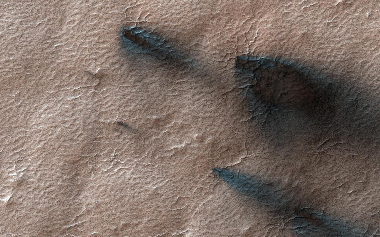
Every Martian spring, fans of dust are blown out from under the seasonal layer of carbon dioxide ice that forms a polar cap over the winter. Gas blowing out from under the ice carries with it a load of dust that is deposited on the surface in a direction determined by the wind at the time of the eruption. Like windsocks, these fans in a polar area we've dubbed Macclesfield, record the direction that the wind was blowing. A citizen science task at Planet Four enlists the public to outline the fans. Their measurements go into a data base that will ultimately help us to understand weather on Mars. https://photojournal.jpl.nasa.gov/catalog/PIA23954
CAPE CANAVERAL, Fla. – Inside the Payload Hazardous Servicing Facility at NASA's Kennedy Space Center in Florida, engineers and technicians deploy the Solar Wind Electron Analyzer boom on the Mars Atmosphere and Volatile Evolution, or MAVEN, spacecraft. The analyzer will measure the solar wind and electrons in the ionosphere of the Red Planet. MAVEN is being prepared for its scheduled launch in November from Cape Canaveral Air Force Station, Fla. atop a United Launch Alliance Atlas V rocket. Positioned in an orbit above the Red Planet, MAVEN will study the upper atmosphere of Mars in unprecedented detail. For more information, visit: http://www.nasa.gov/mission_pages/maven/main/index.html Photo credit: NASA/Kim Shiflett
CAPE CANAVERAL, Fla. – Inside the Payload Hazardous Servicing Facility at NASA's Kennedy Space Center in Florida, engineers and technicians deploy the Solar Wind Electron Analyzer boom on the Mars Atmosphere and Volatile Evolution, or MAVEN, spacecraft. The analyzer will measure the solar wind and electrons in the ionosphere of the Red Planet. MAVEN is being prepared for its scheduled launch in November from Cape Canaveral Air Force Station, Fla. atop a United Launch Alliance Atlas V rocket. Positioned in an orbit above the Red Planet, MAVEN will study the upper atmosphere of Mars in unprecedented detail. For more information, visit: http://www.nasa.gov/mission_pages/maven/main/index.html Photo credit: NASA/Kim Shiflett
CAPE CANAVERAL, Fla. – Inside the Payload Hazardous Servicing Facility at NASA's Kennedy Space Center in Florida, engineers and technicians prepare to deploy the Solar Wind Electron Analyzer boom on the Mars Atmosphere and Volatile Evolution, or MAVEN, spacecraft. The analyzer will measure the solar wind and electrons in the ionosphere of the Red Planet. MAVEN is being prepared for its scheduled launch in November from Cape Canaveral Air Force Station, Fla. atop a United Launch Alliance Atlas V rocket. Positioned in an orbit above the Red Planet, MAVEN will study the upper atmosphere of Mars in unprecedented detail. For more information, visit: http://www.nasa.gov/mission_pages/maven/main/index.html Photo credit: NASA/Kim Shiflett
CAPE CANAVERAL, Fla. – Inside the Payload Hazardous Servicing Facility at NASA's Kennedy Space Center in Florida, engineers and technicians deploy the Solar Wind Electron Analyzer boom on the Mars Atmosphere and Volatile Evolution, or MAVEN, spacecraft. The analyzer will measure the solar wind and electrons in the ionosphere of the Red Planet. MAVEN is being prepared for its scheduled launch in November from Cape Canaveral Air Force Station, Fla. atop a United Launch Alliance Atlas V rocket. Positioned in an orbit above the Red Planet, MAVEN will study the upper atmosphere of Mars in unprecedented detail. For more information, visit: http://www.nasa.gov/mission_pages/maven/main/index.html Photo credit: NASA/Kim Shiflett
CAPE CANAVERAL, Fla. – Inside the Payload Hazardous Servicing Facility at NASA's Kennedy Space Center in Florida, engineers and technicians deploy the Solar Wind Electron Analyzer boom on the Mars Atmosphere and Volatile Evolution, or MAVEN, spacecraft. The analyzer will measure the solar wind and electrons in the ionosphere of the Red Planet. MAVEN is being prepared for its scheduled launch in November from Cape Canaveral Air Force Station, Fla. atop a United Launch Alliance Atlas V rocket. Positioned in an orbit above the Red Planet, MAVEN will study the upper atmosphere of Mars in unprecedented detail. For more information, visit: http://www.nasa.gov/mission_pages/maven/main/index.html Photo credit: NASA/Kim Shiflett
CAPE CANAVERAL, Fla. – Inside the Payload Hazardous Servicing Facility at NASA's Kennedy Space Center in Florida, engineers and technicians deploy the Solar Wind Electron Analyzer boom on the Mars Atmosphere and Volatile Evolution, or MAVEN, spacecraft. The analyzer will measure the solar wind and electrons in the ionosphere of the Red Planet. MAVEN is being prepared for its scheduled launch in November from Cape Canaveral Air Force Station, Fla. atop a United Launch Alliance Atlas V rocket. Positioned in an orbit above the Red Planet, MAVEN will study the upper atmosphere of Mars in unprecedented detail. For more information, visit: http://www.nasa.gov/mission_pages/maven/main/index.html Photo credit: NASA/Kim Shiflett
The X-59 Commercial Supersonic Transport model is installed upside down in the test section of the GRC 8x6 Supersonic wind tunnel. The blade hanging from the top of the tunnel will be measuring the shock waves coming from the bottom of the model during testing. The shock waves coming from the bottom of the model represent the sonic boom reaching the ground during flight. The shape of the model is designed so as to greatly reduce the shock waves to prevent the typical boom coming from a supersonic aircraft. Commercial Supersonic Transport, CST Project, X-59 Sonic Boom Test Model, in the 8x6-foot Supersonic Wind Tunnel, SWT
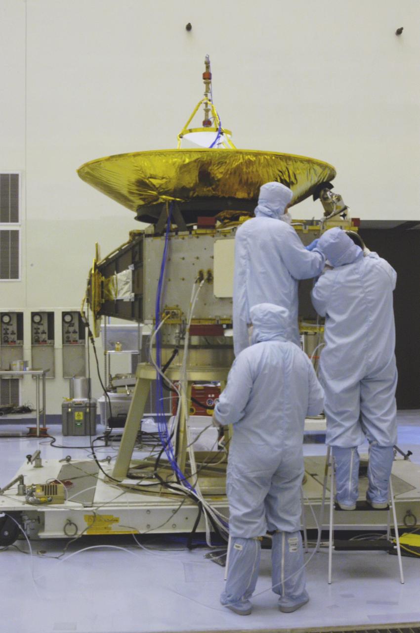
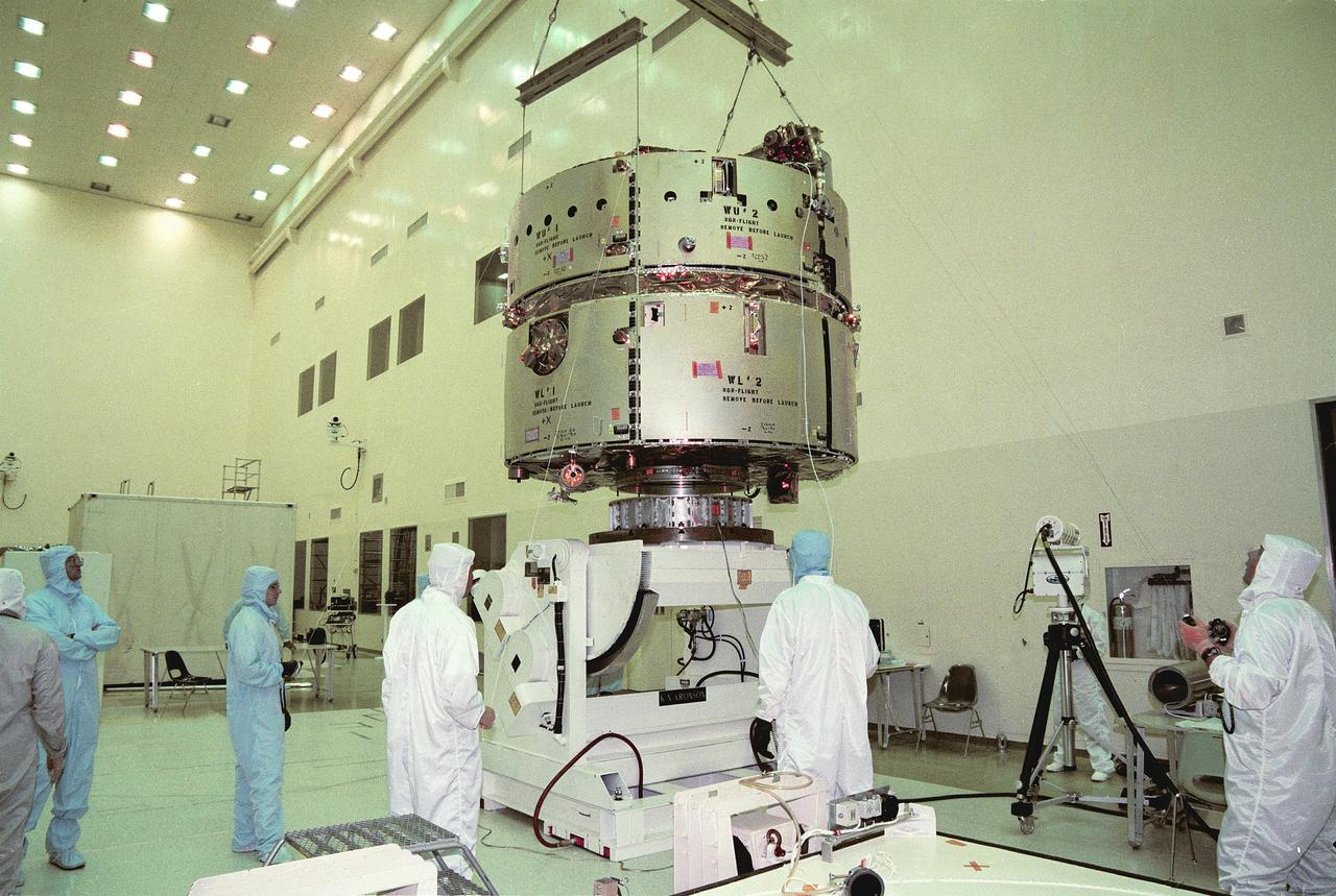
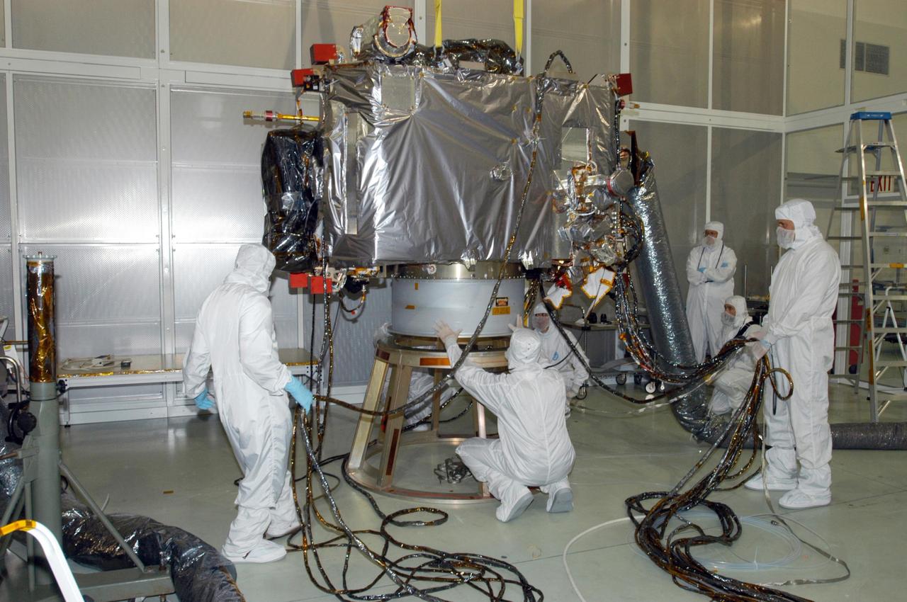
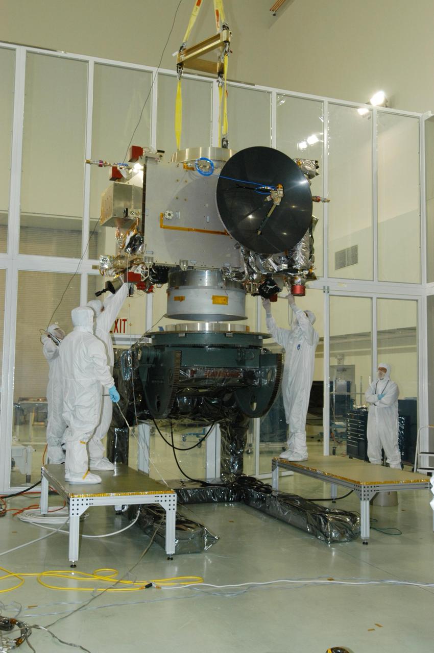
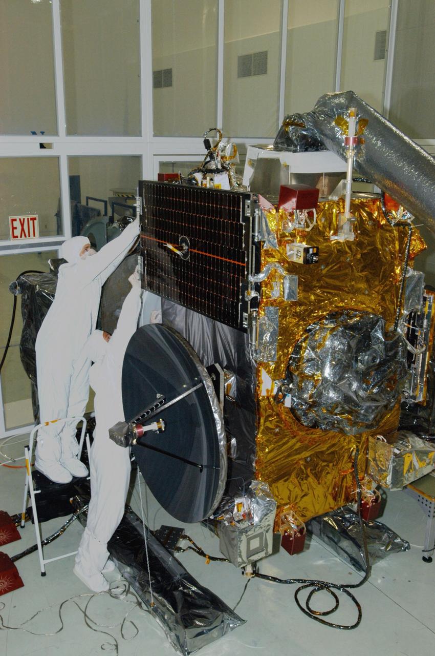
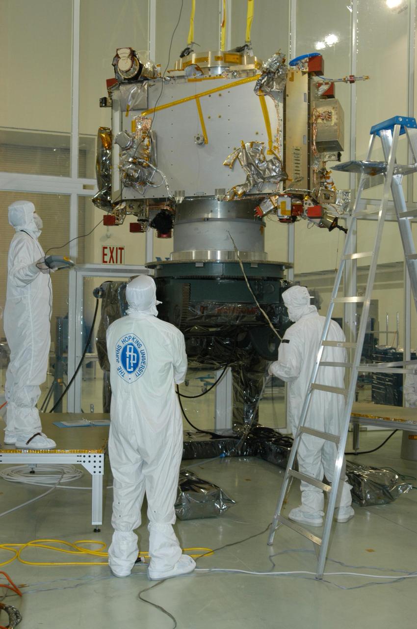
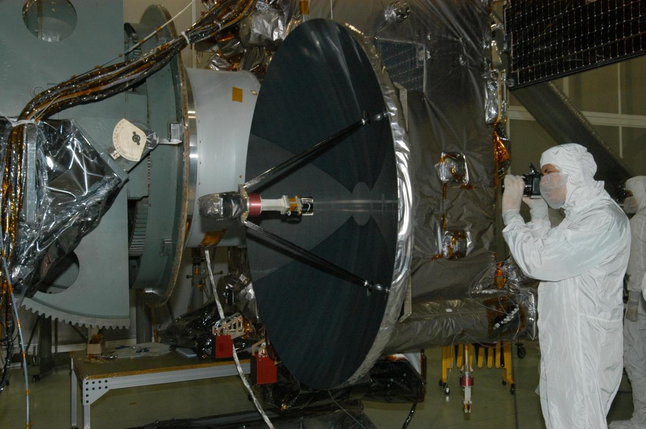
KENNEDY SPACE CENTER, FLA. - In the NASA Kennedy Space Center’s Payload Hazardous Servicing Facility, technicians are installing the Solar Wind Around Pluto (SWAP) instrument on the New Horizons spacecraft. New Horizons will make the first reconnaissance of Pluto and Charon - a "double planet" and the last planet in our solar system to be visited by spacecraft. The mission will then visit one or more objects in the Kuiper Belt region beyond Neptune. SWAP is a solar wind and plasma spectrometer that measures atmospheric “escape rate” and will observe Pluto’s interaction with the solar wind. New Horizons is scheduled to launch in January 2006, swing past Jupiter for a gravity boost and scientific studies in February or March 2007, and reach Pluto and its moon, Charon, in July 2015.
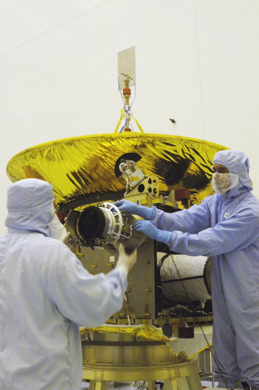
KENNEDY SPACE CENTER, FLA. - In the NASA Kennedy Space Center’s Payload Hazardous Servicing Facility, the Solar Wind Around Pluto (SWAP) instrument is tested after being mounted on the corner of the New Horizons spacecraft. New Horizons will make the first reconnaissance of Pluto and Charon - a "double planet" and the last planet in our solar system to be visited by spacecraft. The mission will then visit one or more objects in the Kuiper Belt region beyond Neptune. SWAP is a solar wind and plasma spectrometer that measures atmospheric “escape rate” and will observe Pluto’s interaction with the solar wind. New Horizons is scheduled to launch in January 2006, swing past Jupiter for a gravity boost and scientific studies in February or March 2007, and reach Pluto and its moon, Charon, in July 2015.
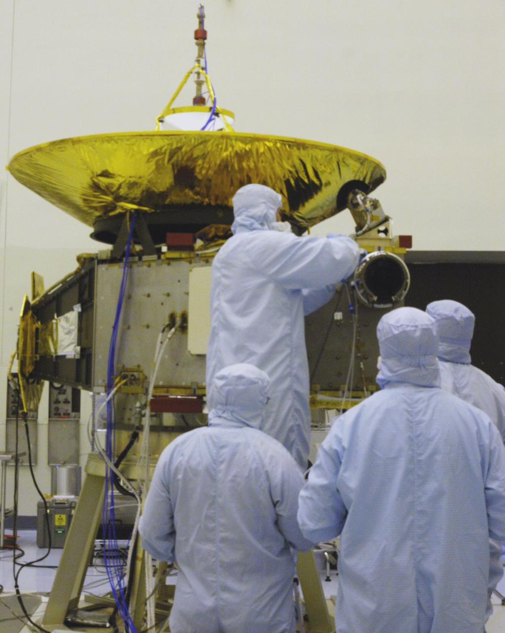
KENNEDY SPACE CENTER, FLA. - In the NASA Kennedy Space Center’s Payload Hazardous Servicing Facility, technicians are installing the Solar Wind Around Pluto (SWAP) instrument on the New Horizons spacecraft. New Horizons will make the first reconnaissance of Pluto and Charon - a "double planet" and the last planet in our solar system to be visited by spacecraft. The mission will then visit one or more objects in the Kuiper Belt region beyond Neptune. SWAP is a solar wind and plasma spectrometer that measures atmospheric “escape rate” and will observe Pluto’s interaction with the solar wind. New Horizons is scheduled to launch in January 2006, swing past Jupiter for a gravity boost and scientific studies in February or March 2007, and reach Pluto and its moon, Charon, in July 2015.
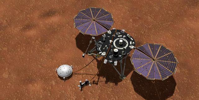
This artist's concept shows NASA's InSight lander with its instruments deployed on the Martian surface. InSight's package of weather sensors, called the Auxiliary Payload Subsystem (APSS), includes an air pressure sensor inside the lander -- its inlet is visible on InSight's deck -- and two air temperature and wind sensors on the deck. Under the deck's edge is a magnetometer, provided by UCLA, to measure changes in the local magnetic field that could also influence SEIS. InSight's air temperature and wind sensors are actually refurbished spares built for Curiosity's Rover Environmental Monitoring Station (REMS). Called Temperature and Wind for InSight, or TWINS, these two east- and west-facing booms sit on the lander's deck and were provided by Spain's Centro de Astrobiología (CAB). https://photojournal.jpl.nasa.gov/catalog/PIA22957

KENNEDY SPACE CENTER, FLA. - In the NASA Kennedy Space Center’s Payload Hazardous Servicing Facility, the Solar Wind Around Pluto (SWAP) instrument has been mounted on the corner of the New Horizons spacecraft. New Horizons will make the first reconnaissance of Pluto and Charon - a "double planet" and the last planet in our solar system to be visited by spacecraft. The mission will then visit one or more objects in the Kuiper Belt region beyond Neptune. SWAP is a solar wind and plasma spectrometer that measures atmospheric “escape rate” and will observe Pluto’s interaction with the solar wind. New Horizons is scheduled to launch in January 2006, swing past Jupiter for a gravity boost and scientific studies in February or March 2007, and reach Pluto and its moon, Charon, in July 2015.
KENNEDY SPACE CENTER, FLA. - In the NASA Kennedy Space Center’s Payload Hazardous Servicing Facility, technicians work on the Solar Wind Around Pluto (SWAP) instrument that is part of the New Horizons spacecraft. New Horizons will make the first reconnaissance of Pluto and Charon - a "double planet" and the last planet in our solar system to be visited by spacecraft. The mission will then visit one or more objects in the Kuiper Belt region beyond Neptune. SWAP is a solar wind and plasma spectrometer that measures atmospheric “escape rate” and will observe Pluto’s interaction with the solar wind. New Horizons is scheduled to launch in January 2006, swing past Jupiter for a gravity boost and scientific studies in February or March 2007, and reach Pluto and its moon, Charon, in July 2015.

ISS043E078169 (03/31/2015) --- This close up of the huge Typhoon Maysak "eye" of the category 5 (hurricane status on the Saffir-Simpson Wind Scale) was captured by astronauts on board the International Space Station Mar. 31, 2015. The massive Typhoon is headed toward the Philippines and expected to land on the upcoming Easter weekend. The Tropical Rainfall Measuring Mission (TRMM) and Global Precipitation Measurement (GPM) satellites, both co-managed by NASA and the Japan Aerospace Exploration Agency, captured rainfall and cloud data that revealed very heavy rainfall and high thunderstorms in the still strengthening storm.
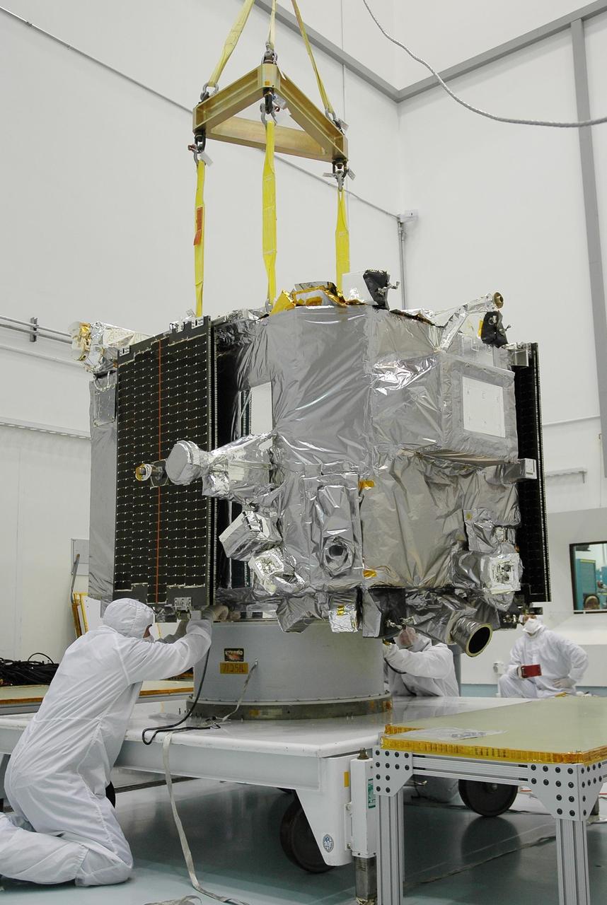
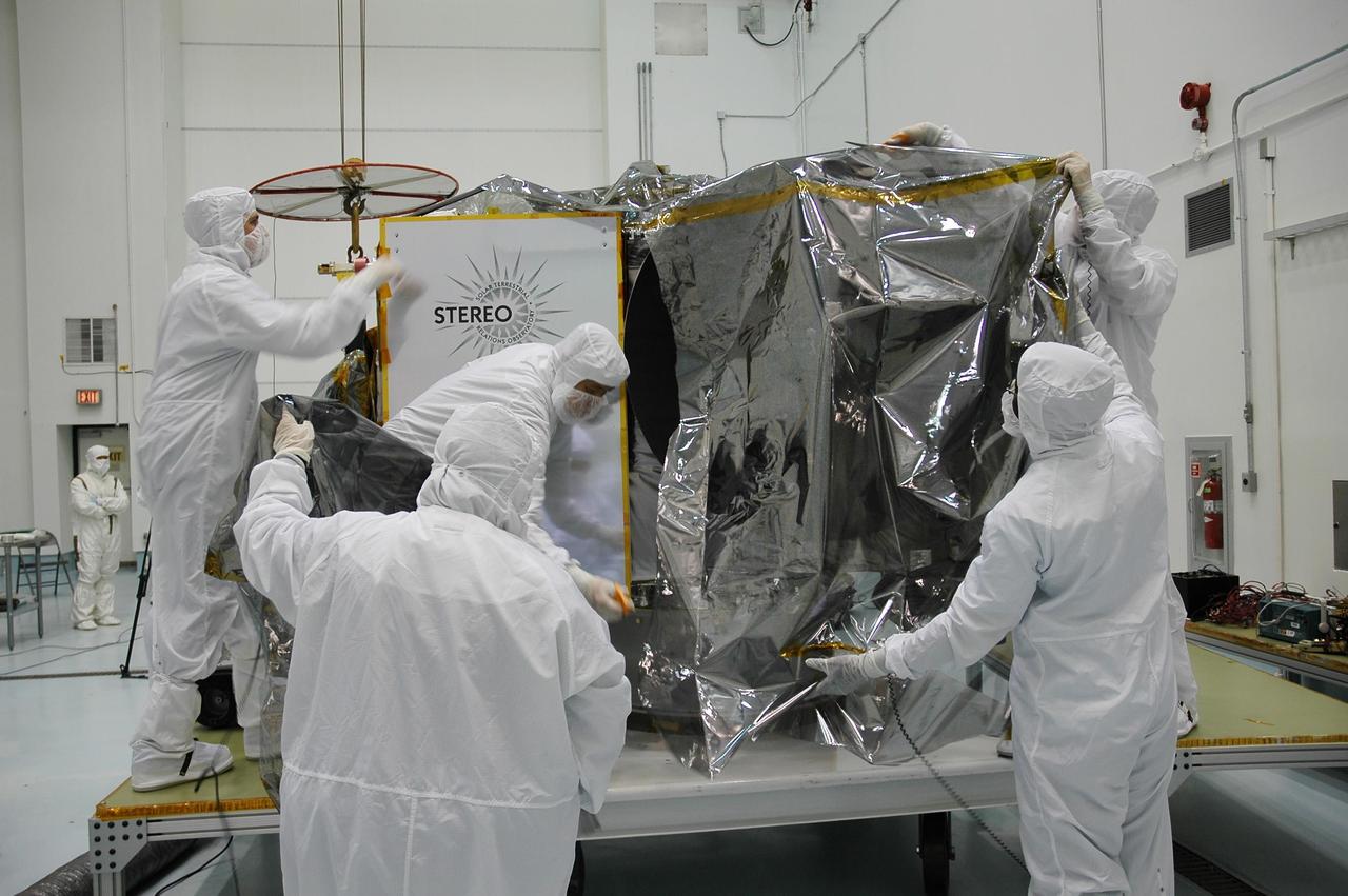
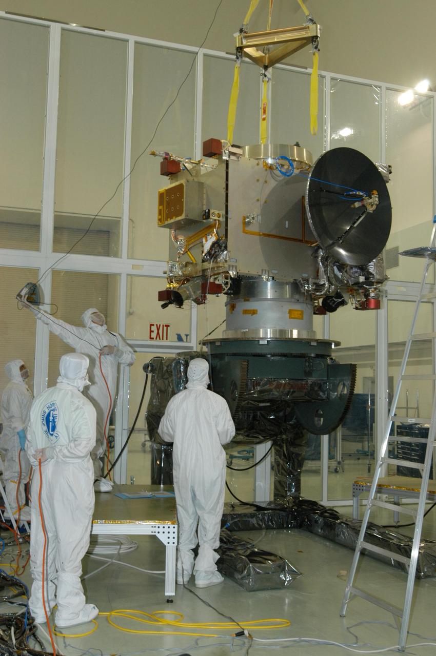
KENNEDY SPACE CENTER, FLA. - In the hazardous processing facility at Astrotech Space Operations in Titusville, Fla., technicians check Observatory A before lifting onto a scale for weight measurements. The observatory is one of two in the STEREO spacecraft and later will be fueled. STEREO stands for Solar Terrestrial Relations Observatory. The STEREO mission is the first to take measurements of the sun and solar wind in 3-dimension. This new view will improve our understanding of space weather and its impact on the Earth. STEREO is expected to lift off aboard a Boeing Delta II rocket no earlier than Aug. 1. Photo credit: NASA/Jack Pfaller
KENNEDY SPACE CENTER, FLA. - In the hazardous processing facility at Astrotech Space Operations in Titusville, Fla., technicians begin removing the protective cover from Observatory A of the STEREO spacecraft. The observatory will be lifted onto a scale for weight measurements and later will be fueled. STEREO stands for Solar Terrestrial Relations Observatory. The STEREO mission is the first to take measurements of the sun and solar wind in 3-dimension. This new view will improve our understanding of space weather and its impact on the Earth. STEREO is expected to lift off aboard a Boeing Delta II rocket no earlier than Aug. 1. Photo credit: NASA/Jack Pfaller

KENNEDY SPACE CENTER, FLA. - In the hazardous processing facility at Astrotech Space Operations in Titusville, Fla., technicians begin removing the protective cover from Observatory A of the STEREO spacecraft. The observatory will be lifted onto a scale for weight measurements and later will be fueled. STEREO stands for Solar Terrestrial Relations Observatory. The STEREO mission is the first to take measurements of the sun and solar wind in 3-dimension. This new view will improve our understanding of space weather and its impact on the Earth. STEREO is expected to lift off aboard a Boeing Delta II rocket no earlier than Aug. 1. Photo credit: NASA/Jack Pfaller
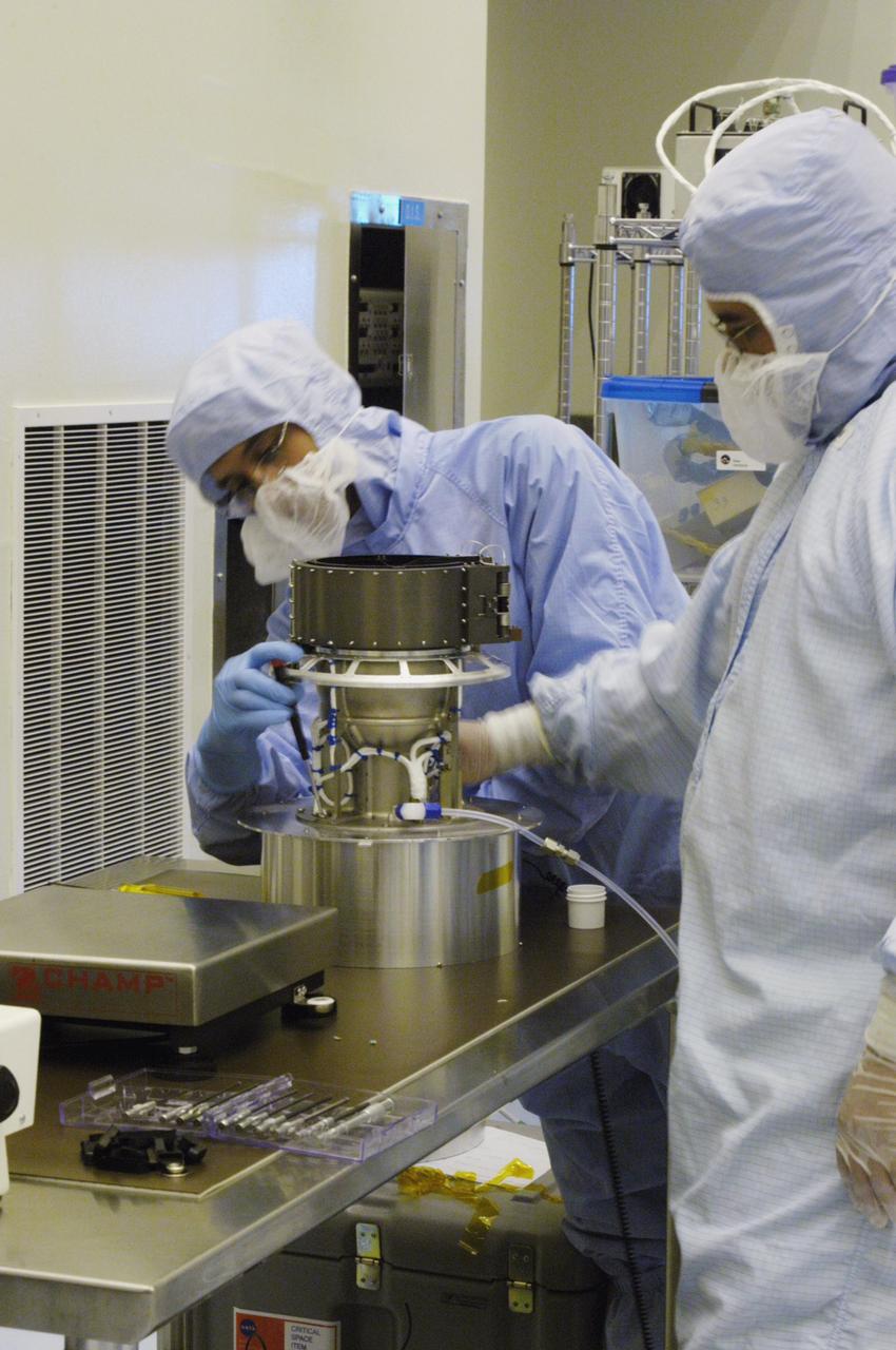
KENNEDY SPACE CENTER, FLA. - At Astrotech Space Operations in Titusville, Fla., the Solar Electron and Proton Telescope (SEPT) is seen on the STEREO observatory "B." SEPT is part of the Solar Energetic Particles Package of four telescopes, all part of the In situ Measurements of Particles & CME Transients (IMPACT) instrument suite. STEREO, which stands for Solar Terrestrial Relations Observatory, consists of two spacecraft whose mission is to take measurements of the sun and solar wind in 3-D, for the first time. This new view will improve our understanding of space weather and its impact on the Earth. Preparations are under way for a liftoff aboard a Delta rocket no earlier than July 30. Photo credit: NASA/George Shelton
KENNEDY SPACE CENTER, FLA. - In the hazardous processing facility at Astrotech Space Operations in Titusville, Fla., technicians begin attaching an overhead crane to Observatory A of the STEREO spacecraft. The observatory will be lifted onto a scale for weight measurements and later will be fueled. STEREO stands for Solar Terrestrial Relations Observatory. The STEREO mission is the first to take measurements of the sun and solar wind in 3-dimension. This new view will improve our understanding of space weather and its impact on the Earth. STEREO is expected to lift off aboard a Boeing Delta II rocket no earlier than Aug. 1. Photo credit: NASA/Jack Pfaller
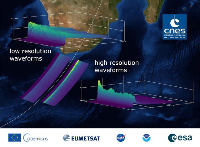
This graphic, released on Dec. 10, 2020, shows the basic radar measurements, called waveforms, collected by the instrument that monitors sea level on the Sentinel-6 Michael Freilich satellite, which launched Nov. 21, 2020. The instrument, called an altimeter, works by bouncing a radar signal off the ocean surface and measuring how long it takes to go out and return. The higher-resolution waveforms focus on a smaller area of the ocean than the lower-resolution waveforms, allowing researchers to resolve smaller ocean features such as currents closer to the coast. The waveform provides information not only on sea level, but also on wave height and wind speed. https://photojournal.jpl.nasa.gov/catalog/PIA24136
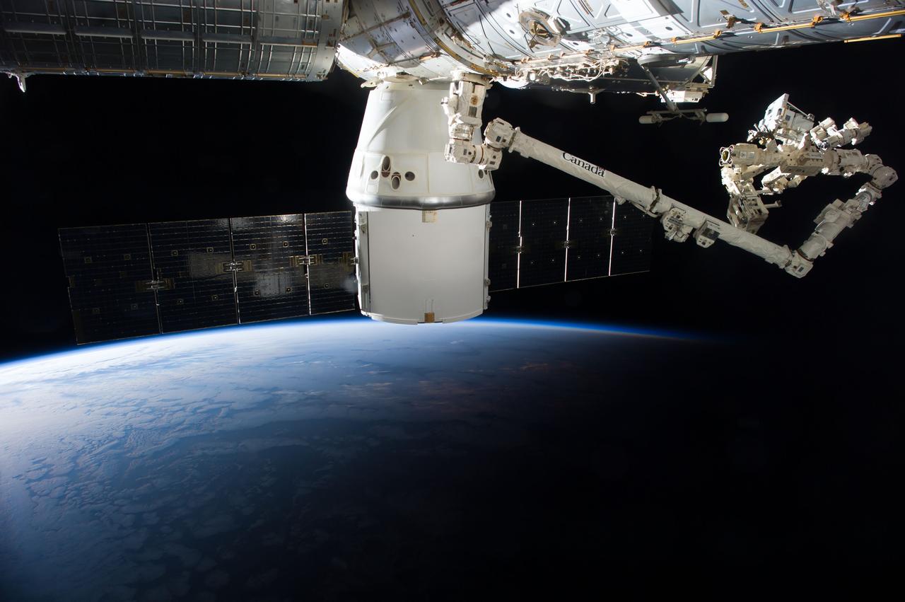
iss041e047260 (9/29/2014) --- A view of the removal of the RapidScat Nadir Adapter from the SpaceX-4 Dragon trunk and installation of the adapter onto the Columbus Exposed Facility Unit (EFU). ISS-RapidScat is a space-based scatterometer that replaces the inoperable SeaWinds payload aboard the QuickSCAT satellite. Scatterometers are radar instruments that measure wind speed and direction over the ocean, and are useful for weather forecasting, hurricane monitoring, and observations of large-scale climate phenomena such as El Niño. The ISS RapidScat instrument enhances measurements from other international scatterometers by cross-checking their data, and demonstrates a unique way to replace an instrument aboard an aging satellite. External Caption
KENNEDY SPACE CENTER, FLA. - In the hazardous processing facility at Astrotech Space Operations in Titusville, Fla., technicians remove the protective cover from the top of Observatory A, one of two STEREO spacecraft. The observatory will be lifted onto a scale for weight measurements and later will be fueled. STEREO stands for Solar Terrestrial Relations Observatory. The STEREO mission is the first to take measurements of the sun and solar wind in 3-dimension. This new view will improve our understanding of space weather and its impact on the Earth. STEREO is expected to lift off aboard a Boeing Delta II rocket no earlier than Aug. 1. Photo credit: NASA/Jack Pfaller
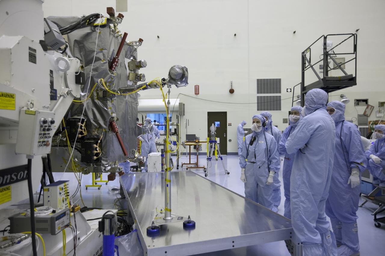
The end of 2014 marks two decades of data from a NASA mission called Wind. Wind -- along with 17 other missions – is part of what's called the Heliophysics Systems Observatory, a fleet of spacecraft dedicated to understanding how the sun and its giant explosions affect Earth, the planets and beyond. Wind launched on Nov. 1, 1994, with the goal of characterizing the constant stream of particles from the sun called the solar wind. With particle observations once every 3 seconds, and 11 magnetic measurements every second, Wind measurements were – and still are – the highest cadence solar wind observations for any near-Earth spacecraft. <b><a href="http://www.nasa.gov/audience/formedia/features/MP_Photo_Guidelines.html" rel="nofollow">NASA image use policy.</a></b> <b><a href="http://www.nasa.gov/centers/goddard/home/index.html" rel="nofollow">NASA Goddard Space Flight Center</a></b> enables NASA’s mission through four scientific endeavors: Earth Science, Heliophysics, Solar System Exploration, and Astrophysics. Goddard plays a leading role in NASA’s accomplishments by contributing compelling scientific knowledge to advance the Agency’s mission. <b>Follow us on <a href="http://twitter.com/NASAGoddardPix" rel="nofollow">Twitter</a></b> <b>Like us on <a href="http://www.facebook.com/pages/Greenbelt-MD/NASA-Goddard/395013845897?ref=tsd" rel="nofollow">Facebook</a></b> <b>Find us on <a href="http://instagrid.me/nasagoddard/?vm=grid" rel="nofollow">Instagram</a></b>
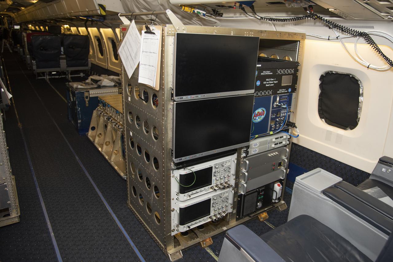
The High Altitude Lidar Observatory (HALO) system electronics and diagnostic tools are integrated onto the DC-8 airborne science laboratory at NASA Armstrong Flight Research Center in Edwards, California. The lidar system control electronics are on the right hand side of the rack. The large monitors on the left are used to display real-time images of water vapor and aerosol profiles, which are used by the science team to guide in-flight decisions and navigation. The compact HALO instrument head can be seen directly behind the electronics rack.
Aerosol data from the High Altitude Lidar Observatory (HALO), pictured here, will give mission scientists a better sense how Doppler Aerosol Wind Lidar (DAWN) is working and what its strengths and weaknesses are.

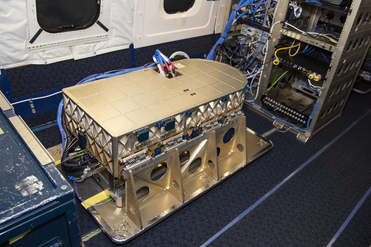
The High Altitude Lidar Observatory (HALO) instrument head, which houses the lidar instrument, is installed onto the DC-8 airborne science laboratory at NASA Armstrong Flight Research Center in Edwards, California. The gold and blue casing holds the laser, optics, detectors, and electronics, which are at the heart of the lidar.
KENNEDY SPACE CENTER, FLA. - At Astrotech Space Operations in Titusville, Fla., the STEREO spacecraft, seen here, is ready for installation of solar arrays. STEREO consists of two spacecraft whose mission is the first to take measurements of the sun and solar wind in 3-D. This new view will improve our understanding of space weather and its impact on the Earth. Preparations are under way for a liftoff aboard a Delta rocket no earlier than July 22. Photo credit: NASA/George Shelton
KENNEDY SPACE CENTER, FLA. - At Astrotech Space Operations in Titusville, Fla., technicians check the STEREO spacecraft "B" as it is lifted off a tilt table. STEREO stands for Solar Terrestrial Relations Observatory. The STEREO mission is the first to take measurements of the sun and solar wind in 3-dimension. This new view will improve our understanding of space weather and its impact on the Earth. STEREO is expected to lift off aboard a Boeing Delta II rocket on July 22. Photo credit: NASA/George Shelton
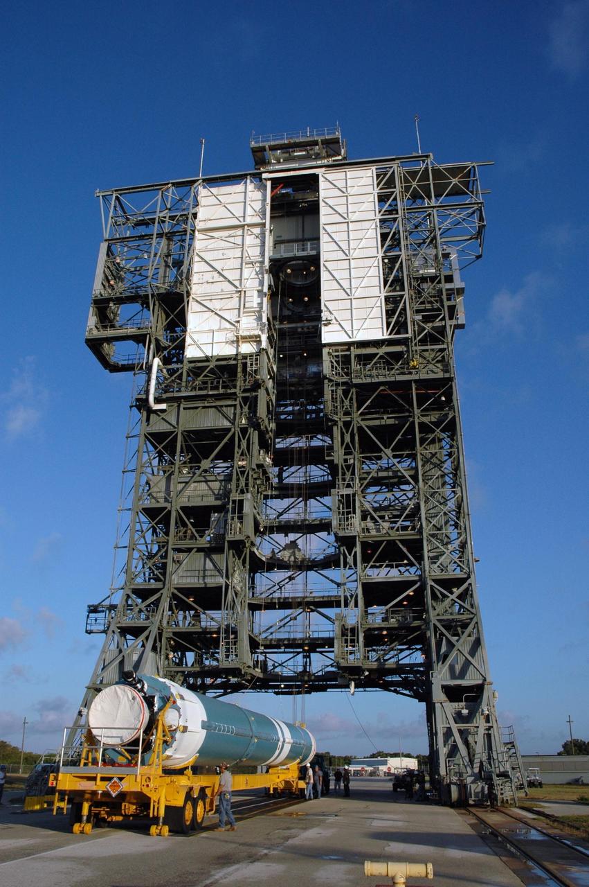
KENNEDY SPACE CENTER, FLA. - The first stage of the Boeing Delta II rocket, slated to launch NASA's Solar Terrestrial Relations Observatory (STEREO), arrives at Pad 17B on Cape Canaveral Air Force Station. Preparations are under way for a liftoff no earlier than July 22. STEREO consists of two spacecraft whose mission is the first to take measurements of the sun and solar wind in 3-D. This new view will improve our understanding of space weather and its impact on the Earth. Photo credit: NASA/Jim Grossmann
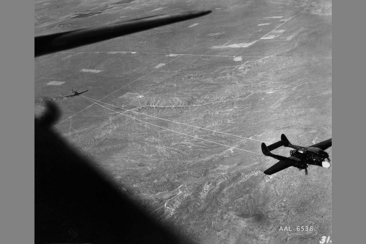
NACA photographer Northrop P-61A Black Widow towing P-51B to release altitude of 28,000 ft over Muroc Dry Lake, California for in flight validating of wind tunnel measurements of drag. After the pilot released the tow cable, drag measurementrs were obtained at various airspeeds in a 20-minute unpowered flight. Note: Used in publication in Flight Research at Ames; 57 Years of Development and Validation of Aeronautical Technology NASA SP-1998-3300 Fig. 17

KENNEDY SPACE CENTER, FLA. - At Astrotech Space Operations in Titusville, Fla., technicians check the STEREO spacecraft "B" as it is lowered toward a stand on the floor. STEREO stands for Solar Terrestrial Relations Observatory. The STEREO mission is the first to take measurements of the sun and solar wind in 3-dimension. This new view will improve our understanding of space weather and its impact on the Earth. STEREO is expected to lift off aboard a Boeing Delta II rocket on July 22. Photo credit: NASA/George Shelton
KENNEDY SPACE CENTER, FLA. - At Astrotech Space Operations in Titusville, Fla., engineers perform testing on the solar panel on the STEREO observatory "A." STEREO, which stands for Solar Terrestrial Relations Observatory, consists of two spacecraft whose mission is to take measurements of the sun and solar wind in 3-D, for the first time. This new view will improve our understanding of space weather and its impact on the Earth. Preparations are under way for a liftoff aboard a Delta rocket no earlier than July 30. Photo credit: NASA/George Shelton
KENNEDY SPACE CENTER, FLA. - At Astrotech Space Operations in Titusville, Fla., technicians prepare to deploy the solar panel on the STEREO observatory "A." STEREO, which stands for Solar Terrestrial Relations Observatory, consists of two spacecraft whose mission is to take measurements of the sun and solar wind in 3-D, for the first time. This new view will improve our understanding of space weather and its impact on the Earth. Preparations are under way for a liftoff aboard a Delta rocket no earlier than July 30. Photo credit: NASA/George Shelton

An aerospace research engineer and technicians inspect the X-59 Commercial Supersonic Transport model’s installation and alignment before testing. The blade hanging from the top of the tunnel will be measuring the shock waves coming from the model during testing. The intent is to develop a supersonic aircraft with less sonic boom. Commercial Supersonic Transport, CST Project, X-59 Sonic Boom Test Model, in the 8x6-foot Supersonic Wind Tunnel, SWT
KENNEDY SPACE CENTER, FLA. - At Astrotech Space Operations in Titusville, Fla., the STEREO spacecraft "B" is being moved to a another stand nearby for testing. STEREO stands for Solar Terrestrial Relations Observatory. The STEREO mission is the first to take measurements of the sun and solar wind in 3-dimension. This new view will improve our understanding of space weather and its impact on the Earth. STEREO is expected to lift off aboard a Boeing Delta II rocket on July 22. Photo credit: NASA/George Shelton

jsc2024e016249 (11/23/2023) --- Fully assembled Nanoracks-Killick-1 CubeSat with its Global Navigation Satellite System Reflectometry (GNSS-R) antenna deployed. Nanoracks-Killick-1 measures sea ice using GNSS-R. Potential applications of GNSS-R include providing data for weather and climate models and improving understanding of ocean phenomena such as surface winds and storm surge. Image courtesy of C-CORE and Memorial University.
KENNEDY SPACE CENTER, FLA. - At Astrotech Space Operations in Titusville, Fla., the deployed solar panel on the STEREO observatory "A" undergoes testing. STEREO, which stands for Solar Terrestrial Relations Observatory, consists of two spacecraft whose mission is to take measurements of the sun and solar wind in 3-D, for the first time. This new view will improve our understanding of space weather and its impact on the Earth. Preparations are under way for a liftoff aboard a Delta rocket no earlier than July 30. Photo credit: NASA/George Shelton
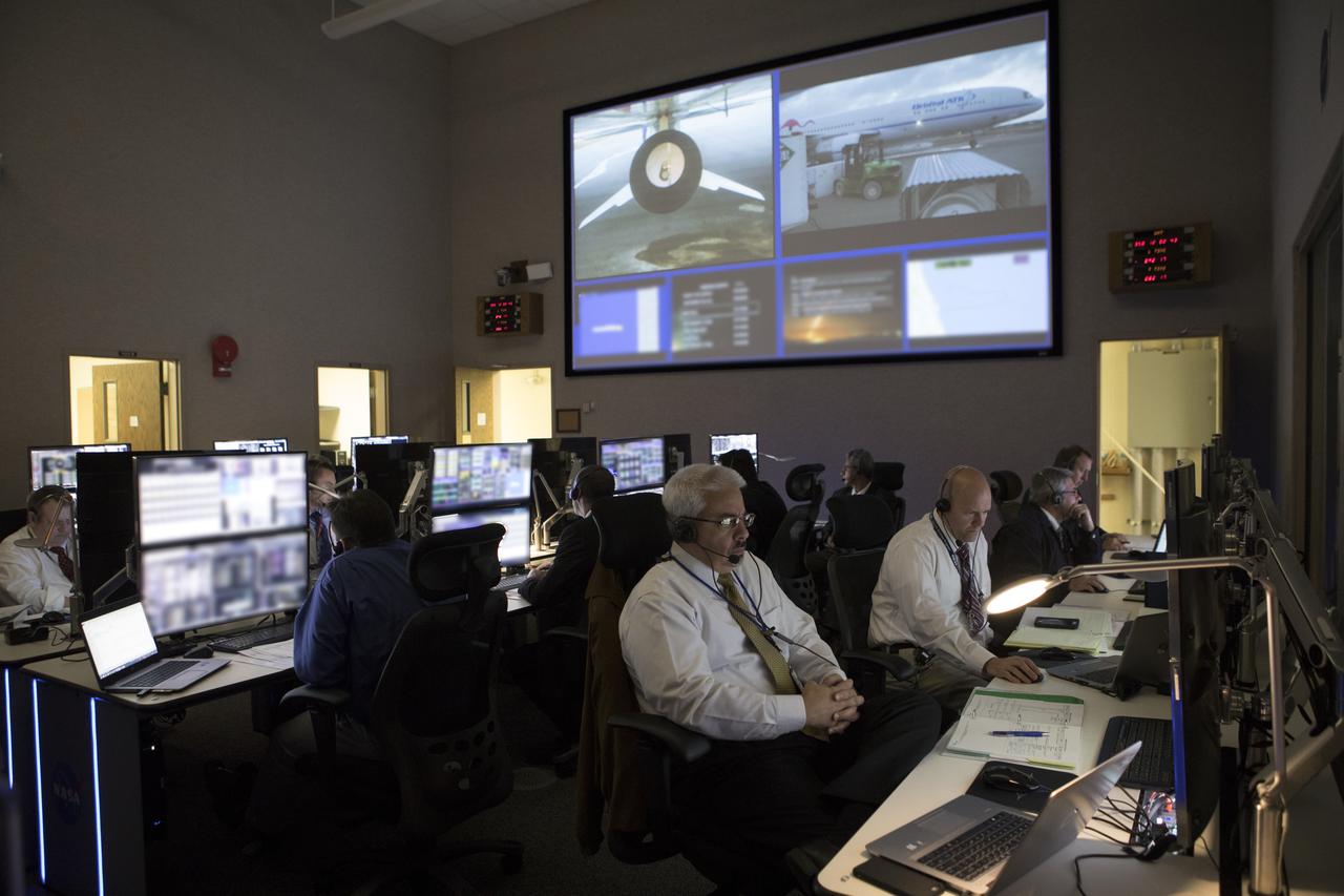
In the Mission Director's Center at Cape Canaveral Air Force Station, members of the launch team monitor the progress of preparations to launch eight Cyclone Global Navigation Satellite System, or CYGNSS, spacecraft. The CYGNSS satellites will make frequent and accurate measurements of ocean surface winds throughout the life cycle of tropical storms and hurricanes. The data that CYGNSS provides will enable scientists to probe key air-sea interaction processes that take place near the core of storms, which are rapidly changing and play a crucial role in the beginning and intensification of hurricanes.
In the Mission Director's Center at Cape Canaveral Air Force Station, members of the launch team monitor the progress of preparations to launch eight Cyclone Global Navigation Satellite System, or CYGNSS, spacecraft. The CYGNSS satellites will make frequent and accurate measurements of ocean surface winds throughout the life cycle of tropical storms and hurricanes. The data that CYGNSS provides will enable scientists to probe key air-sea interaction processes that take place near the core of storms, which are rapidly changing and play a crucial role in the beginning and intensification of hurricanes.
KENNEDY SPACE CENTER, FLA. - At Astrotech Space Operations in Titusville, Fla., a technician works a guideline to the overhead crane as the STEREO spacecraft "B" is being moved to a stand nearby for testing. STEREO stands for Solar Terrestrial Relations Observatory. The STEREO mission is the first to take measurements of the sun and solar wind in 3-dimension. This new view will improve our understanding of space weather and its impact on the Earth. STEREO is expected to lift off aboard a Boeing Delta II rocket on July 22. Photo credit: NASA/George Shelton
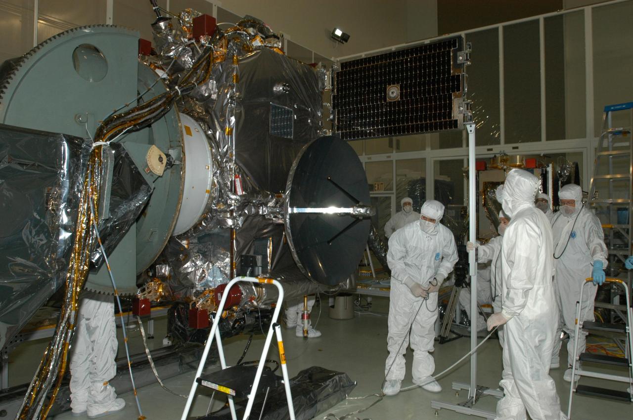
KENNEDY SPACE CENTER, FLA. - At Astrotech Space Operations in Titusville, Fla., the solar panel on the STEREO observatory "A" has been deployed for testing. STEREO, which stands for Solar Terrestrial Relations Observatory, consists of two spacecraft whose mission is to take measurements of the sun and solar wind in 3-D, for the first time. This new view will improve our understanding of space weather and its impact on the Earth. Preparations are under way for a liftoff aboard a Delta rocket no earlier than July 30. Photo credit: NASA/George Shelton
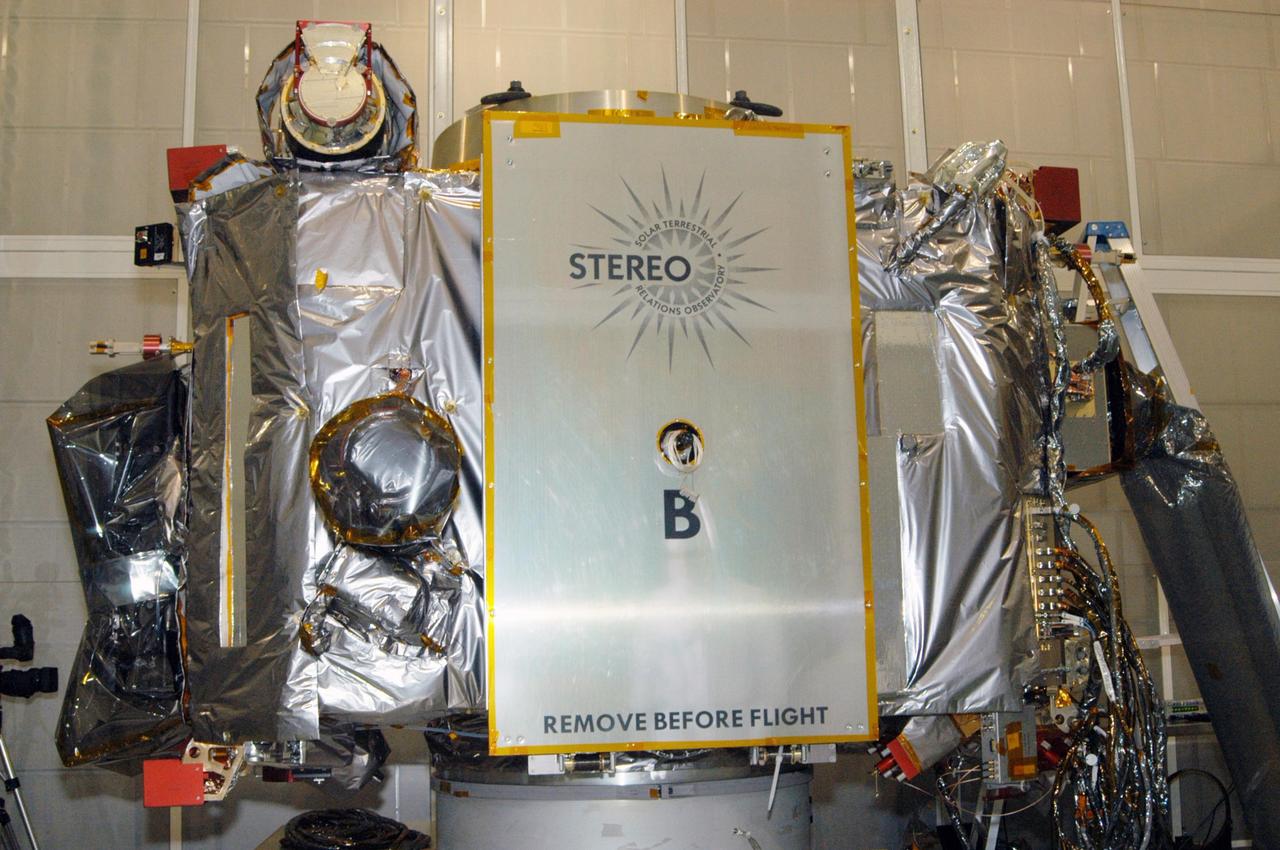
KENNEDY SPACE CENTER, FLA. - At Astrotech Space Operations in Titusville, Fla., the STEREO observatory "B" will undergo testing. STEREO, which stands for Solar Terrestrial Relations Observatory, consists of two spacecraft whose mission is to take measurements of the sun and solar wind in 3-D, for the first time. This new view will improve our understanding of space weather and its impact on the Earth. Preparations are under way for a liftoff aboard a Delta rocket no earlier than July 30. Photo credit: NASA/George Shelton

This large tabular iceberg, broken off from the Antarctic Ice Sheet, was spotted in the South Atlantic Ocean (57.0S, 57.0W) southeast of the tip of South America as it was slowly being moved north and east by wind, current and tidal influences. This type of iceberg, never to be seen in the northern hemisphere, is typical for Antarctica. Although some such icebergs are as large as 100 km in length, this one measures about 35 by 69 km.
KENNEDY SPACE CENTER, FLA. - At Astrotech Space Operations in Titusville, Fla., technicians check the STEREO spacecraft "B" is secure on the stand. STEREO stands for Solar Terrestrial Relations Observatory. The STEREO mission is the first to take measurements of the sun and solar wind in 3-dimension. This new view will improve our understanding of space weather and its impact on the Earth. STEREO is expected to lift off aboard a Boeing Delta II rocket on July 22. Photo credit: NASA/George Shelton
In the Mission Director's Center at Cape Canaveral Air Force Station, members of the launch team monitor the progress of preparations to launch eight Cyclone Global Navigation Satellite System, or CYGNSS, spacecraft. The CYGNSS satellites will make frequent and accurate measurements of ocean surface winds throughout the life cycle of tropical storms and hurricanes. The data that CYGNSS provides will enable scientists to probe key air-sea interaction processes that take place near the core of storms, which are rapidly changing and play a crucial role in the beginning and intensification of hurricanes.

This artist's concept shows a brown dwarf, an object that is at least 13 times the mass of Jupiter but not massive enough to begin nuclear fusion in its core, which is the defining characteristic of a star. Scientist using NASA's Spitzer Space Telescope recently made the first ever direct measurement of wind on a brown dwarf. https://photojournal.jpl.nasa.gov/catalog/PIA23684
KENNEDY SPACE CENTER, FLA. - At Astrotech Space Operations in Titusville, Fla., engineers get ready to install the solar array in front of them on the STEREO spacecraft. STEREO consists of two spacecraft whose mission is the first to take measurements of the sun and solar wind in 3-D. This new view will improve our understanding of space weather and its impact on the Earth. Preparations are under way for a liftoff aboard a Delta rocket no earlier than July 22. Photo credit: NASA/George Shelton
A spectrally resolved Rayleigh/Mie scattering diagnostic was developed to measure temperature and wingspan wise velocity in the vicinity of an ASTOVL aircraft model tested in the Lewis, now Glenn, 9x15 Low Speed Wind Tunnel. This was done for the Phase III hot gas ingestion study of ground-effect flow-field on such aircraft during hover or vertical landing.
A technician at the National Advisory Committee for Aeronautics (NACA) Lewis Flight Propulsion Laboratory cleans the pitot tube on a 16-inch diameter ramjet in the 8- by 6-Foot Supersonic Wind Tunnel. Pitot tubes are a measurement device used to determine the flow velocity at a specific location in the air stream, not the average velocity of the entire wind stream. NACA Lewis was in the midst of a multi-year program to determine the feasibility of ramjets and design improvements that could be employed for all models. The advantage of the ramjet was its ability to process large volumes of combustion air, resulting in the burning of fuel at the optimal stoichiometric temperatures. This was not possible with turbojets. The higher the Mach number, the more efficient the ramjet operated. The 8- by 6 Supersonic Wind Tunnel had been in operation for just over one year when this photograph was taken. The facility was the NACA’s largest supersonic tunnel and the only facility capable of running an engine at supersonic speeds. The 8- by 6 tunnel was also equipped with a Schlieren camera system that captured the air flow gradient as it passes over the test setup. The ramjet tests in the 8- by 6 tunnel complemented the NACA Lewis investigations using aircraft, the Altitude Wind Tunnel and smaller supersonic tunnels. Researchers studied the ramjet’s performance at different speeds and varying angles -of -attack.
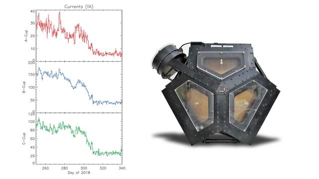
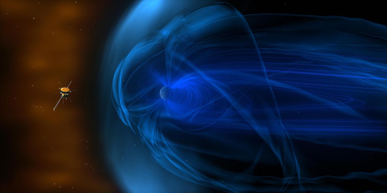
The set of graphs on the left illustrates the drop in electrical current detected in three directions by Voyager 2's plasma science experiment (PLS) to background levels. They are among the key pieces of data that Voyager scientists used to determine that Voyager 2 entered interstellar space, the space between stars, in November 2018. The disappearance in electrical current in the sunward-looking detectors indicates the spacecraft is no longer in the outward flow of solar wind plasma. It is instead in a new plasma environment -- interstellar medium plasma. The image on the right shows the Faraday cups of the PLS. The three sunward pointed cups point in slightly different directions in order to measure the direction of the solar wind. The fourth cup (on the upper left) points perpendicular to the others. https://photojournal.jpl.nasa.gov/catalog/PIA22922
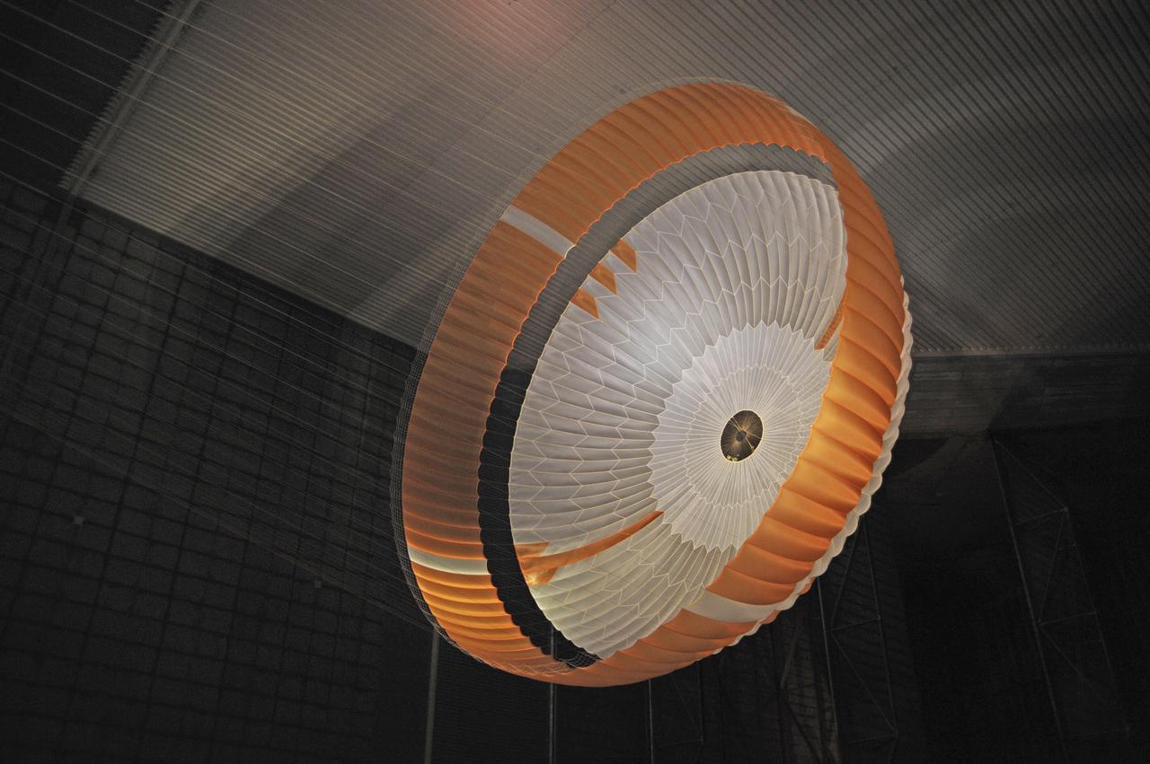
Testing during March and April 2009 inside the world largest wind tunnel, at NASA Ames Research Center, Moffett Field, Calif., qualified the parachute for NASA next Mars rover. The parachute for NASA's Mars Science Laboratory mission, to be launched in 2011 and land on Mars in 2012, is the largest ever built to fly on an extraterrestrial mission. This image shows the qualification-test parachute beginning to open a few seconds after it was launched from a mortar into an 80-mile-per-hour (36-meter-per-second) wind. The parachute uses a configuration called disk-gap-band. It has 80 suspension lines, measures more than 50 meters (165 feet) in length, and opens to a diameter of nearly 16 meters (51 feet). Most of the orange and white fabric is nylon, though a small disk of heavier polyester is used near the vent in the apex of the canopy due to higher stresses there. http://photojournal.jpl.nasa.gov/catalog/PIA11993
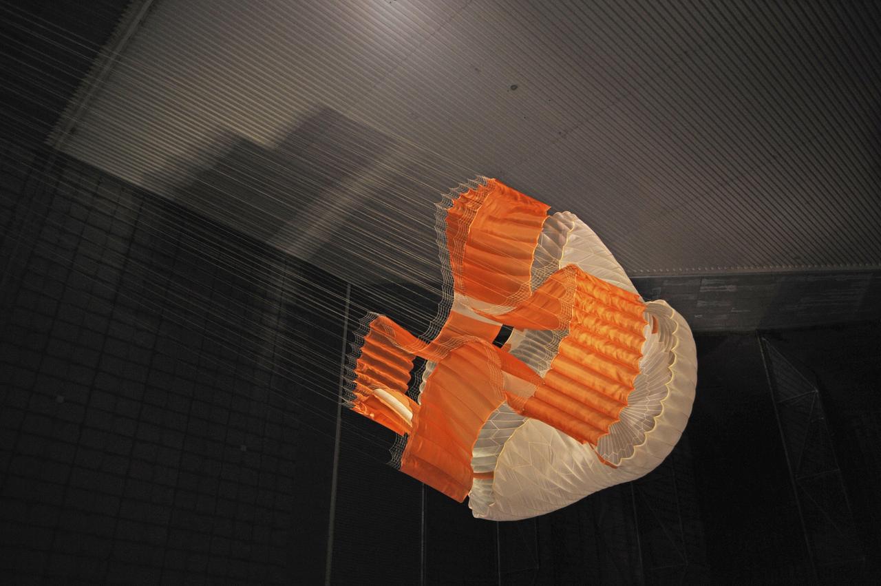
Testing during March and April 2009 inside the world largest wind tunnel, at NASA Ames Research Center, Moffett Field, Calif., qualified the parachute for NASA next Mars rover. The parachute for NASA's Mars Science Laboratory mission, to be launched in 2011 and land on Mars in 2012, is the largest ever built to fly on an extraterrestrial mission. This image shows the qualification-test parachute beginning to open a few seconds after it was launched from a mortar into an 80-mile-per-hour (36-meter-per-second) wind. The parachute uses a configuration called disk-gap-band. It has 80 suspension lines, measures more than 50 meters (165 feet) in length, and opens to a diameter of nearly 16 meters (51 feet). Most of the orange and white fabric is nylon, though a small disk of heavier polyester is used near the vent in the apex of the canopy due to higher stresses there. http://photojournal.jpl.nasa.gov/catalog/PIA11992

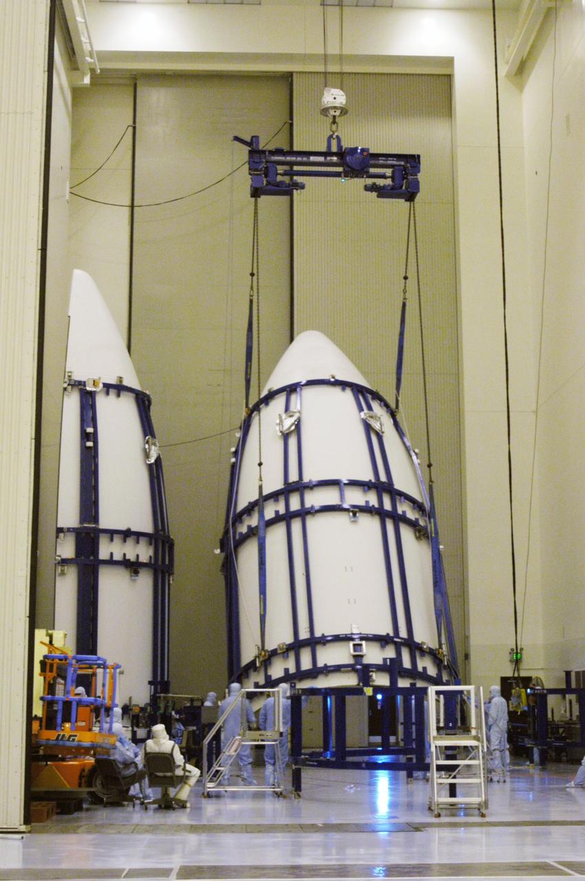
KENNEDY SPACE CENTER, FLA. - In the NASA Kennedy Space Center’s Payload Hazardous Servicing Facility, both parts of the Lockheed Martin Atlas V rocket fairing to be placed around the New Horizons spacecraft are moved into place for encapsulation. The fairing encloses the spacecraft to protect it during launch and flight through the atmosphere. Once out of the atmosphere, the fairing is jettisoned. New Horizons will make the first reconnaissance of Pluto and Charon - a "double planet" and the last planet in our solar system to be visited by spacecraft. The mission will then visit one or more objects in the Kuiper Belt region beyond Neptune. SWAP is a solar wind and plasma spectrometer that measures atmospheric “escape rate” and will observe Pluto’s interaction with the solar wind. New Horizons is scheduled to launch in January 2006, swing past Jupiter for a gravity boost and scientific studies in February or March 2007, and reach Pluto and its moon, Charon, in July 2015.
KENNEDY SPACE CENTER, FLA. - In the NASA Kennedy Space Center’s Payload Hazardous Servicing Facility, one part of the fairing to be placed around the New Horizons spacecraft is lifted from a stand. The fairing encapsulates the spacecraft to protect it during launch and flight through the atmosphere. Once out of the atmosphere, the fairing is jettisoned. New Horizons will make the first reconnaissance of Pluto and Charon - a "double planet" and the last planet in our solar system to be visited by spacecraft. The mission will then visit one or more objects in the Kuiper Belt region beyond Neptune. SWAP is a solar wind and plasma spectrometer that measures atmospheric “escape rate” and will observe Pluto’s interaction with the solar wind. New Horizons is scheduled to launch in January 2006, swing past Jupiter for a gravity boost and scientific studies in February or March 2007, and reach Pluto and its moon, Charon, in July 2015.