
NASA Glenn's Spotlight on the Stars, 10 Years and Counting was held at Windows on the River in Cleveland, OH on November 20th, 2024. Sponsorship organized by the Ohio Aerospace Institute. Welcome by Dennis Andersh, CEO and President, Parallax Advanced Research, Ohio Aerospace Institute. Remarks by Terrence Slaybaugh, Vice President of Sites and Infrastructure, JobsOhio. Introduction of 10th Anniversary Video, Dr. Wanda Peters, Acting Deputy Director, NASA Glenn Research Center. Remarks/Introduction of Presenters, Dr. James Kenyon, Director, NASA Glenn Research Center. Keynote Speakers: Nikki Welch, NASA Glenn Communications, Connecting People to the Mission. Timothy Smith, NASA Glenn's Superalloy Achievements. Carlos Garcia-Galan, Dreaming of Going to the Moon.

NASA Glenn's Spotlight on the Stars, 10 Years and Counting was held at Windows on the River in Cleveland, OH on November 20th, 2024. Sponsorship organized by the Ohio Aerospace Institute. Welcome by Dennis Andersh, CEO and President, Parallax Advanced Research, Ohio Aerospace Institute. Remarks by Terrence Slaybaugh, Vice President of Sites and Infrastructure, JobsOhio. Introduction of 10th Anniversary Video, Dr. Wanda Peters, Acting Deputy Director, NASA Glenn Research Center. Remarks/Introduction of Presenters, Dr. James Kenyon, Director, NASA Glenn Research Center. Keynote Speakers: Nikki Welch, NASA Glenn Communications, Connecting People to the Mission. Timothy Smith, NASA Glenn's Superalloy Achievements. Carlos Garcia-Galan, Dreaming of Going to the Moon. Photo Credit: (NASA/Sara Lowthian-Hanna)

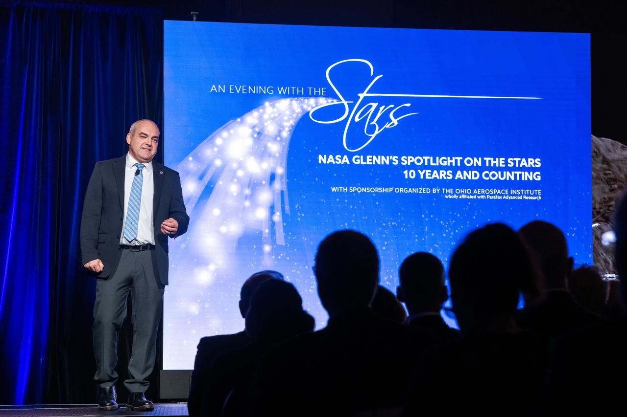
NASA Glenn's Spotlight on the Stars, 10 Years and Counting was held at Windows on the River in Cleveland, OH on November 20th, 2024. Sponsorship organized by the Ohio Aerospace Institute. Pictured from left to right: Timothy Smith, Nikki Welch, Center Director Dr. James Kenyon, Acting Deputy Center Director Dr. Wanda Peters, Carlos Garcia-Galan. Welcome by Dennis Andersh, CEO and President, Parallax Advanced Research, Ohio Aerospace Institute. Remarks by Terrence Slaybaugh, Vice President of Sites and Infrastructure, JobsOhio. Introduction of 10th Anniversary Video, Dr. Wanda Peters, Acting Deputy Director, NASA Glenn Research Center. Remarks/Introduction of Presenters, Dr. James Kenyon, Director, NASA Glenn Research Center. Keynote Speakers: Nikki Welch, NASA Glenn Communications, Connecting People to the Mission. Timothy Smith, NASA Glenn's Superalloy Achievements. Carlos Garcia-Galan, Dreaming of Going to the Moon.
NASA Glenn's Spotlight on the Stars, 10 Years and Counting was held at Windows on the River in Cleveland, OH on November 20th, 2024. Sponsorship organized by the Ohio Aerospace Institute. Welcome by Dennis Andersh, CEO and President, Parallax Advanced Research, Ohio Aerospace Institute. Remarks by Terrence Slaybaugh, Vice President of Sites and Infrastructure, JobsOhio. Introduction of 10th Anniversary Video, Dr. Wanda Peters, Acting Deputy Director, NASA Glenn Research Center. Remarks/Introduction of Presenters, Dr. James Kenyon, Director, NASA Glenn Research Center. Keynote Speakers: Nikki Welch, NASA Glenn Communications, Connecting People to the Mission. Timothy Smith, NASA Glenn's Superalloy Achievements. Carlos Garcia-Galan, Dreaming of Going to the Moon.

NASA Glenn's Spotlight on the Stars, 10 Years and Counting. Sponsorship organized by the Ohio Aerospace Institute was held at Windows on the River in Cleveland, OH on November 20th, 2024. Here, keynote speaker, Nikki Welch is on stage during Evening with the Stars 2024 Welcome by Dennis Andersh, CEO and President, Parallax Advanced Research, Ohio Aerospace Institute. Remarks by Terrence Slaybaugh, Vice President of Sites and Infrastructure, JobsOhio. Introduction of 10th Anniversary Video, Dr. Wanda Peters, Acting Deputy Director, NASA Glenn Research Center. Remarks/Introduction of Presenters, Dr. James Kenyon, Director, NASA Glenn Research Center. Keynote Speakers: Nikki Welch, NASA Glenn Communications, Connecting People to the Mission. Timothy Smith, NASA Glenn's Superalloy Achievements. Carlos Garcia-Galan, Dreaming of Going to the Moon. Photo Credit: (NASA/Sara Lowthian-Hanna)

NASA Glenn's Spotlight on the Stars, 10 Years and Counting was held at Windows on the River in Cleveland, OH on November 20th, 2024. Sponsorship organized by the Ohio Aerospace Institute. Welcome by Dennis Andersh, CEO and President, Parallax Advanced Research, Ohio Aerospace Institute. Remarks by Terrence Slaybaugh, Vice President of Sites and Infrastructure, JobsOhio. Introduction of 10th Anniversary Video, Dr. Wanda Peters, Acting Deputy Director, NASA Glenn Research Center. Remarks/Introduction of Presenters, Dr. James Kenyon, Director, NASA Glenn Research Center. Keynote Speakers: Nikki Welch, NASA Glenn Communications, Connecting People to the Mission. Timothy Smith, NASA Glenn's Superalloy Achievements. Carlos Garcia-Galan, Dreaming of Going to the Moon. Photo Credit: (NASA/Sara Lowthian-Hanna)

NASA Glenn's Spotlight on the Stars, 10 Years and Counting was held at Windows on the River in Cleveland, OH on November 20th, 2024. Sponsorship organized by the Ohio Aerospace Institute. Welcome by Dennis Andersh, CEO and President, Parallax Advanced Research, Ohio Aerospace Institute. Remarks by Terrence Slaybaugh, Vice President of Sites and Infrastructure, JobsOhio. Introduction of 10th Anniversary Video, Dr. Wanda Peters, Acting Deputy Director, NASA Glenn Research Center. Remarks/Introduction of Presenters, Dr. James Kenyon, Director, NASA Glenn Research Center. Keynote Speakers: Nikki Welch, NASA Glenn Communications, Connecting People to the Mission. Timothy Smith, NASA Glenn's Superalloy Achievements. Carlos Garcia-Galan, Orion Program’s European Service Module Integration Office at Glenn Research Center, Dreaming of Going to the Moon.
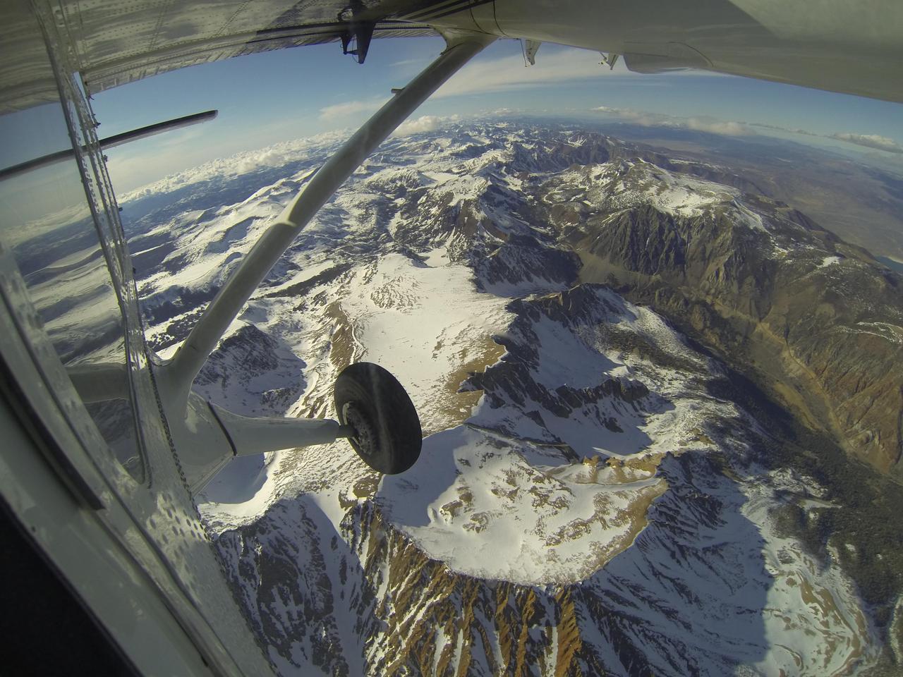
Mt. Dana and Dana Plateau in the Tuolumne River Basin within Yosemite National Park, Calif., as seen out the window of a Twin Otter aircraft carrying NASA Airborne Snow Observatory on April 3, 2013.
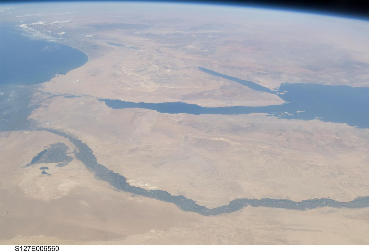
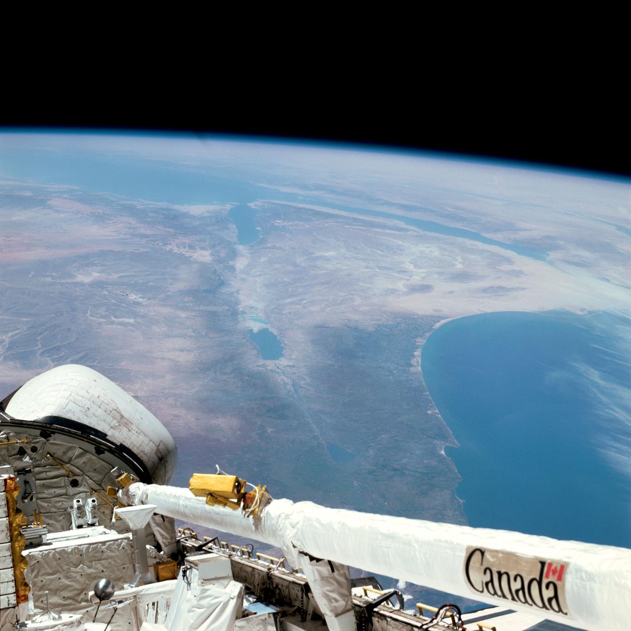
S127-E-006560 (17 July 2009) -- The Nile River and its delta in Egypt and the Sinai Peninsula and part of the Mediterranean Sea and Red Sea are just a few of the geographic features recognizable in this photograph, taken from an aft window on the Earth-orbiting Space Shuttle Endeavour.
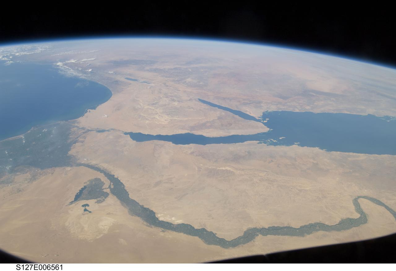
S127-E-006561 (17 July 2009) -- The Nile River and its delta in Egypt and the Sinai Peninsula and part of the Mediterranean Sea and Red Sea are just a few of the geographic features recognizable in this photograph, taken from an aft window on the Earth-orbiting Space Shuttle Endeavour.
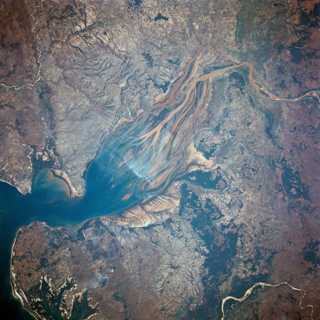
STS007-03-058 (18-24 June 1983) --- The Island of Madagascar in the Indian Ocean off the coast of Africa. The colorful area is the mouth of the Betsiboka River near the city of Majunga. The photograph was taken with a 70mm handheld camera aimed through the aft flight deck?s overhead windows on the Earth-orbiting Space Shuttle Challenger.
ISS042E237302 (02/09/2015) --- Aboard the International Space Station on Feb. 9, 2015 NASA astronaut Terry Virts while viewing through the Cupola window captured this image of the African continent. Virts tweeted the photo to his many fans with the comment: "Sun glint on one of a thousand rivers in the heart of #Africa, this one in #Angola" .
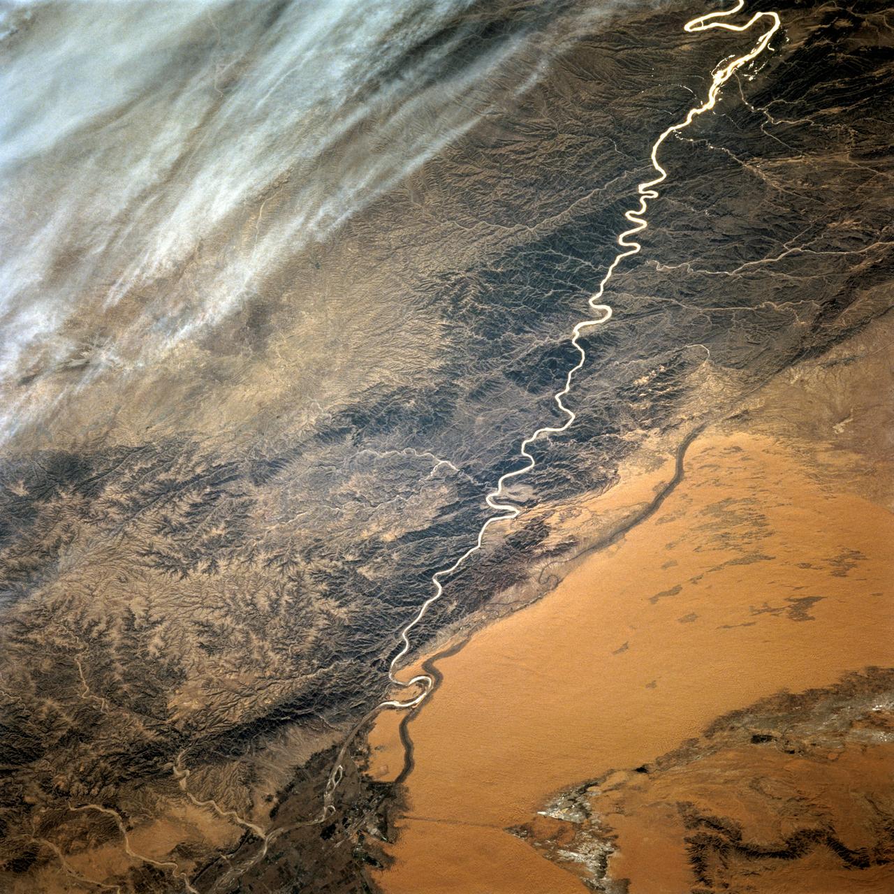
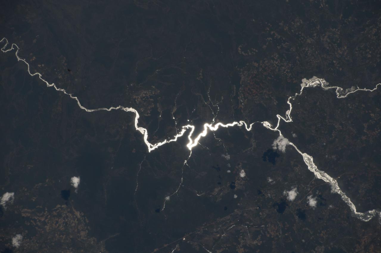
STS068-220-033 (30 September-11 October 1994) --- Photographed through the Space Shuttle Endeavour's flight deck windows, this 70mm frame shows a small section of China's Yellow River (Huang Ho) highlighted by sunglint reflection off the surface of the water. The river flows northeastward toward the village of Tung-lin-tzu. The low dissected mountains that cover more than half of this scene rise some 2,000 feet (on the average) above the valley floor. A major east-west transportation corridor (both railway and automobile) is observed traversing the landscape north of the river. This entire region is considered to be part of the Ordos Desert, actually part of the greater Gobi located just north of this area. Approximate center coordinates of this scene are 37.5 degrees north latitude and 105.0 degrees east longitude.
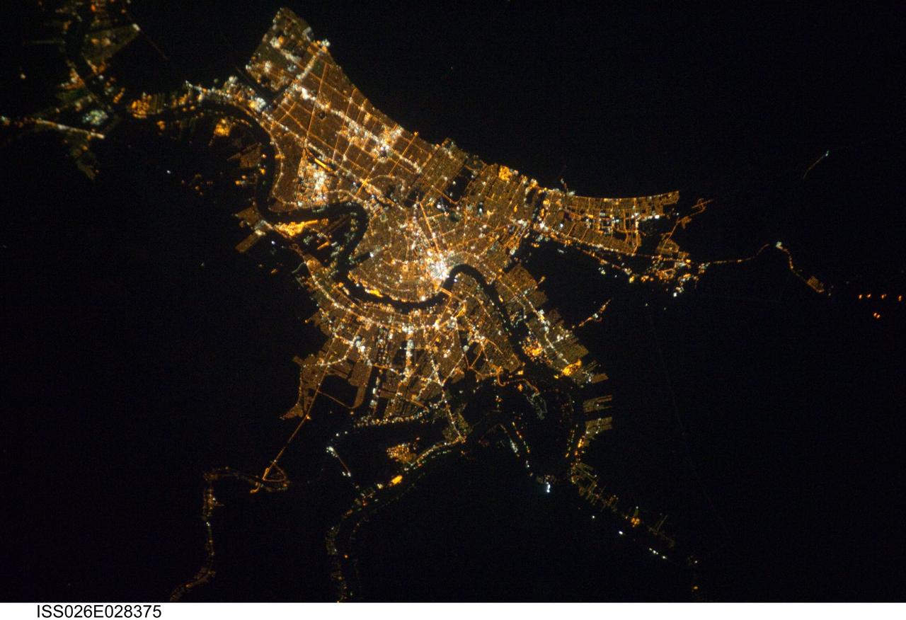
ISS026-E-028375 (22 Feb. 2011) --- Having enjoyed a clear sky nocturnal photo opportunity over New Orleans earlier (Jan. 26) in their mission, Expedition 26 crew members aboard the International Space Station had another window on Feb. 22 to capture images of the Crescent City or Big Easy from 220 miles above Earth. The Mississippi River is visible winding its way through the city. A 200-mm lens was used to take the picture.
STS003-17-806 (22-30 March 1982) --- A 70mm out-the-window view showing Israel, the Dead Sea, Sea of Galilee, Jordan River, Sinai, Jordan, the Red Sea and Egypt (in background). Rested Remote Manipulator System (RMS) arm and part of the aft section of space shuttle Columbia in foreground. Photo credit: NASA
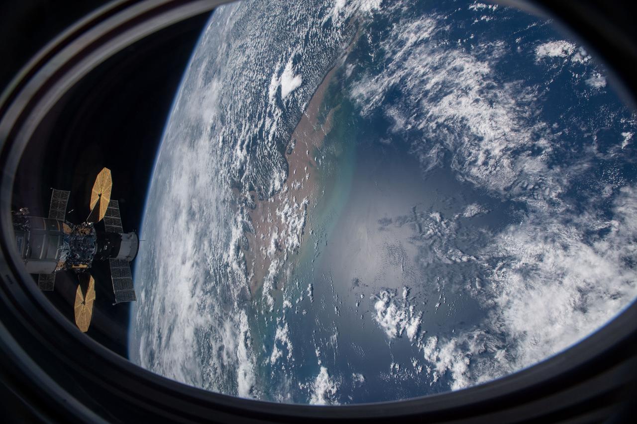
iss064e006446 (Nov. 27, 2020) --- This picture was taken from a window on the SpaceX Crew Dragon vehicle as the International Space Station orbited above the Atlantic Ocean just off the coast of Brazil near the mouth of the Amazon River. Two other spacecraft, including the Cygnus cargo craft with its two prominent cymbal-shaped solar arrays, and behind it, Russia's Soyuz MS-17 crew ship with its rectangular solar arrays, are also pictured docked to the orbiting lab.
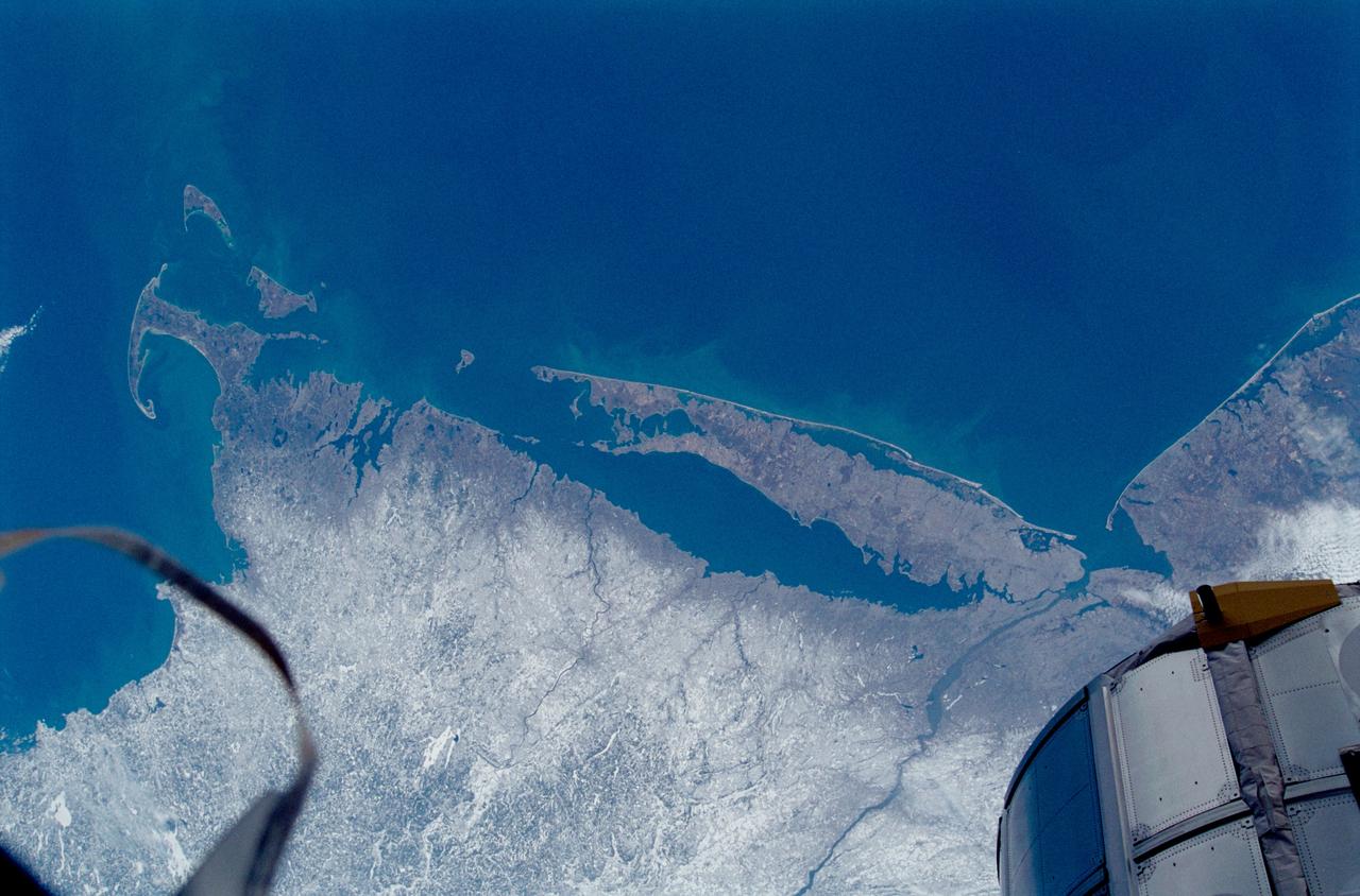
STS102-336-035 (8-21 March 2001) --- One of the STS-102 astronauts aimed a 35mm camera through windows on the aft flight deck of the Space Shuttle Discovery to capture this synoptic southeast view of several New England states. The moderating influence of the Atlantic Ocean is visible along the coastline. The southern limit of the snow-covered landscape can be traced from southeast Massachusetts (left center) westward along the northern shore of Long Island Sound and includes the northern end of New Jersey (right center). In addition to Long Island (center), other prominent features on this image include: Cape Cod, Martha's Vineyard, Nantucket, and Block Islands; as well as the Hudson River (bottom center). Several southerly-draining river systems are discernible in Connecticut and extensive wetlands are observed along New York and New Jersey coastal areas.
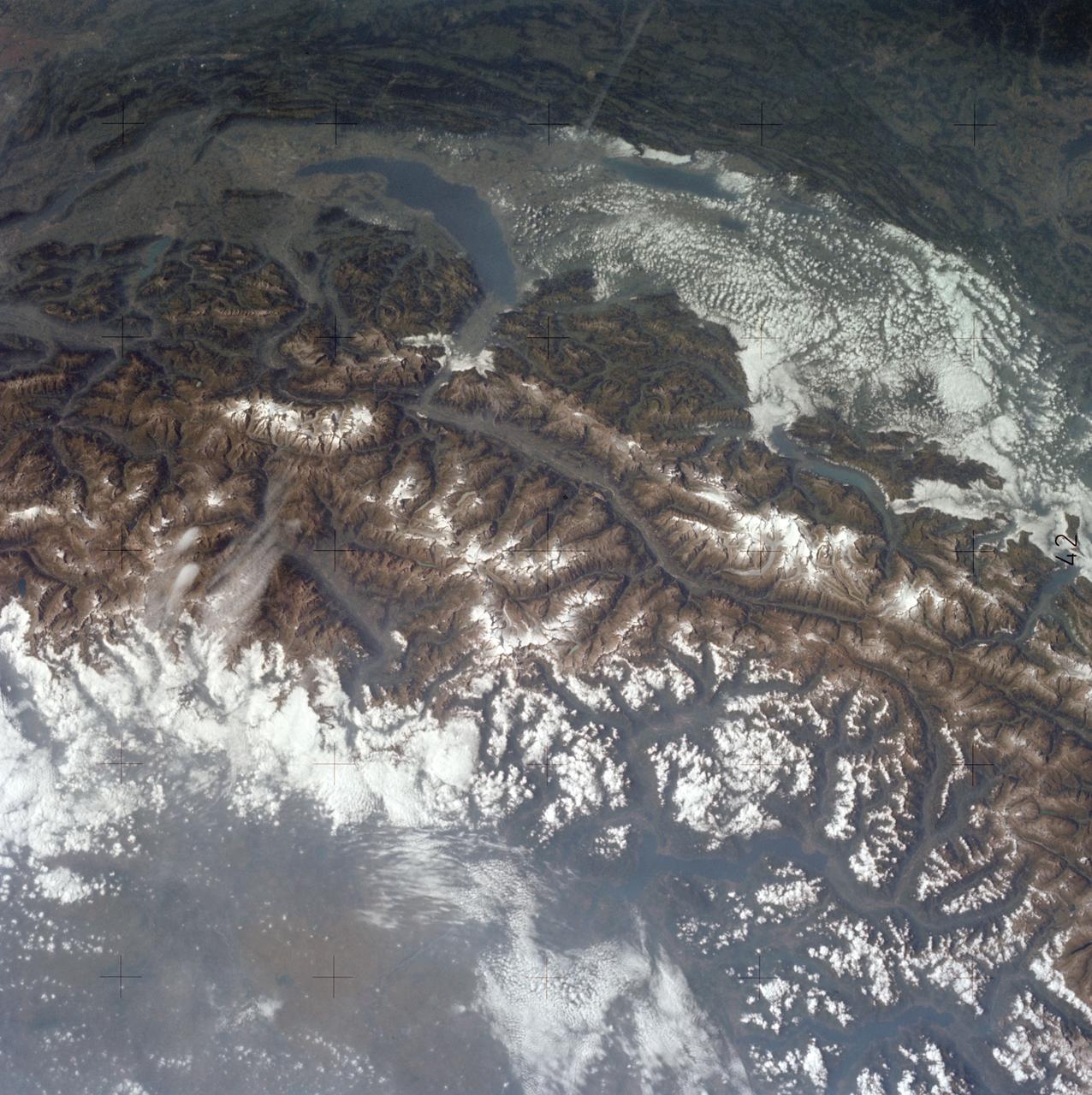
SL3-121-2438 (July-September 1973) --- The Alps of Switzerland, France and Italy are featured in this exceptional photograph taken by a hand-held camera from the Skylab space station during the second manned Skylab mission. Also visible in the out-the-window 70mm Hasselblad view are Lake Geneva, Lake of Lucerne, Rhone River and many other features. The Skylab 3 crewmen, astronauts Alan L. Bean, Owen K. Garriott and Jack R. Lousma completed a 59-day mission with a successful splashdown on Sept. 25, 1973. Photo credit: NASA

S99-E-5267 (13 February 2000) --- City of El Paso, Texas, and Ciudad Juarez, Chihuahua, Mexico and the Rio Grande River, which separates them. An electronic still camera (ESC), mounted in one of Endeavour's aft flight deck windows, is recording imagery of hundreds of Earth targets for the EarthKAM project. Students across the United States and in France, Germany and Japan are taking photos throughout the STS-99 mission. And they are using these new photos, plus all the images already available in the EarthKAM system, to enhance their classroom learning in Earth and space science, social studies, geography, mathematics and more. For general EarthKAM information and more images from this flight, go to http://www.earthkam.ucsd.edu/

S82-28907 (March 1982) --- Astronaut Jack R. Lousma turns toward astronaut C. Gordon Fullerton and smiles into the lens of the 35mm camera Fullerton used to expose this frame onboard the busy Earth-orbiting space shuttle Columbia. Lousma is at the commander's station of the forward flight deck on the Columbia. His front window view is of Earth below (note river upper right center). Lousma is wearing the trouser and shirt of a three-piece (jacket temporarily not worn) constant-wear garment. Except for entry and launch phases, shuttle crews wear the CWG throughout their awake hours. A data acquisition camera (DAC) is at upper left, along with a TV camera. Photo credit: NASA
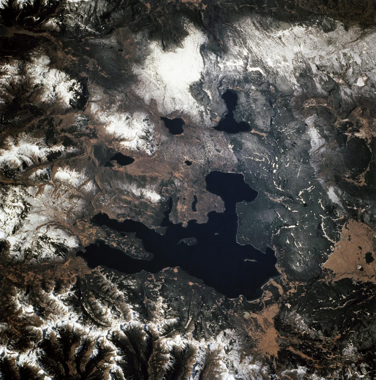
STS068-247-061 (30 September-11 October 1994) --- Photographed through the Space Shuttle Endeavour's flight windows, this 70mm frame centers on Yellowstone Lake in the Yellowstone National Park. North will be at the top if picture is oriented with series of sun glinted creeks and river branches at top center. The lake, at 2,320 meters (7,732 feet) above sea level, is the largest high altitude lake in North America. East of the park part of the Absaroka Range can be traced by following its north to south line of snow capped peaks. Jackson Lake is southeast of Yellowstone Park, and the connected Snake River can be seen in the lower left corner. Yellowstone, established in 1872 is the world's oldest national park. It covers an area of 9,000 kilometers (3,500 square miles), lying mainly on a broad plateau of the Rocky Mountains on the Continental Divide. It's average altitude is 2,440 meters (8,000 feet) above sea level. The plateau is surrounded by mountains exceeding 3,600 meters (12,000 feet) in height. Most of the plateau was formed from once-molten lava flows, the last of which is said to have occurred 100,000 years ago. Early volcanic activity is still evident in the region by nearly 10,000 hot springs, 200 geysers and numerous vents found throughout the park.

ISS028-E-045516 (9 Sept. 2011) --- Hurricane Katia off the northeastern USA coastline is featured in this image photographed by an Expedition 28 crew member on the International Space Station. Hurricane Katia had diminished to Category 1 strength on the Saffir-Simpson scale at the time this photograph was taken, but it still presented an impressive cloud circulation as its center passed by the northeastern USA coastline on Sept. 9, 2011. The storm had reached Category 4 strength earlier on Sept. 5, making it the second major hurricane of the 2011 Atlantic hurricane season. Katia remained over open waters of the Atlantic Ocean during its lifetime, unlike two preceding storms of the season ? Hurricane Irene and Tropical Storm Lee ? both of which made landfall on the continental USA. The approximate center of Hurricane Katia is visible at lower right, with its outer cloud bands extending across the center of the view. A small part of the State of New York ? including Long Island and the Hudson River ? is visible through a gap in the cloud cover at lower left. The Hudson River has a chocolate brown coloration due to heavy loading with sediment, a consequence of flooding and erosion of the upstream watershed from the heavy precipitation of Hurricane Irene and Tropical Storm Lee. A plume of sediment is just visible entering the Atlantic Ocean on the southern coastline of Long Island, directly to the south of the New York City metropolitan area (partially obscured by clouds). Crew members on the International Space Station have the opportunity to take images like this one by looking outwards at an angle through space station windows, much like taking photographs of the ground from a commercial airliner window ? albeit from an average altitude of approximately 400 kilometers.
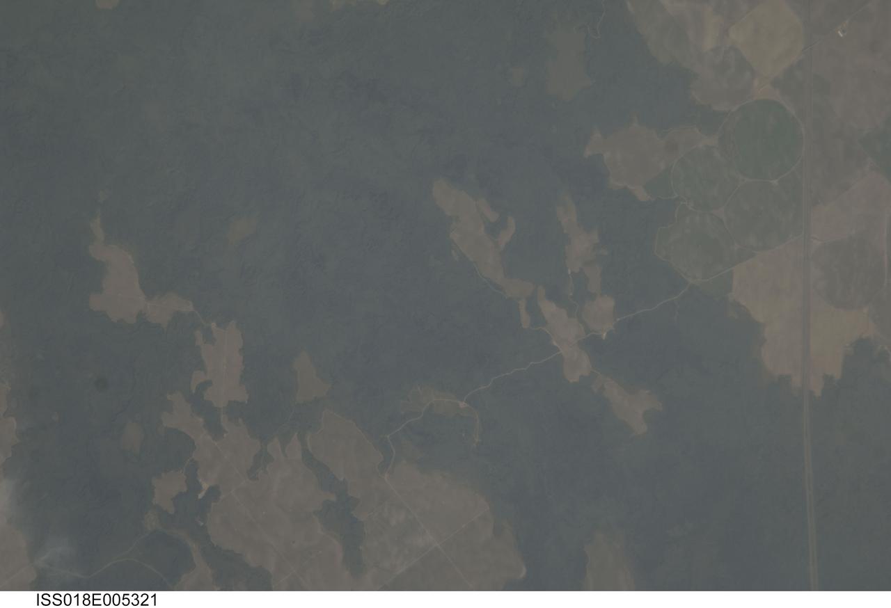
ISS018-E-005321 (24 Oct. 2008) --- The Hell's Half Acre Lava Field in Idaho is featured in this image photographed by an Expedition 18 crewmember on the International Space Station. Located in eastern Idaho, the Hell's Half Acre Lava Field is the easternmost large field associated with the Snake River Plain that arcs across the center of the state. The abundant lava flows and other volcanic rocks of the Snake River Plain are thought to be the result of southwest passage of the North American tectonic plate over a fixed mantle plume or "hotspot". According to scientists, Volcanism attributed to the hotspot began approximately 15 million years ago in the western portion of the Plain, with lava fields becoming younger to the east -- with lavas erupted approximately 4,100 years ago, Hell's Half Acre is one of the youngest lava fields. Today, the center of hotspot volcanism is located in Yellowstone National Park and feeds the extensive geyser system there. Portions of the Hell's Half Acre Lava Field are designated as a National Natural Landmark and Wilderness Study Area. This detailed photograph illustrates the forbidding landscape of the basaltic lava field -- the complex ridge patterns of the black to grey-green flow surfaces, comprised of ropy pahoehoe and blocky A a lava, are clearly visible. Regions of tan soil surrounded by lava are known as kipukas -- these "islands" are windows onto the older underlaying soil surface as they were never covered by lava. The kipukas are used for agriculture (both crops and grazing) -- several green fields are visible to the northwest of Interstate Highway 15 (right). Light to dark mottling visible in the kipukas is most likely due to variations in moisture and disturbance by agricultural activities.

ISS004-E-11807 (15 May 2002) --- This digital photograph, taken through the windows of the International Space Station on May 15, 2002, shows condensation trails over the Rhône Valley in the region west of Lyon, France. Condensation trails-or contrails-are straight lines of ice crystals that form in the wake of jet liners where air temperatures are lower than about -40 degrees Centigrade. Scientists have observed that newer contrails are thin whereas older trails have widened with time as a result of light winds. Because of this tendency for thin contrails to cover greater areas with time, it is estimated that these “artificial clouds” cover 0.1 per cent of the planet’s surface. Percentages are far higher in some places, say the scientists, such as southern California, the Ohio River Valley and parts of Europe, as illustrated here. The climatic impact of such clouds is poorly understood, which is why scientists continue to study them using images such as this.

ISS012-E-21250 (2 March 2006) --- Dust and smog in northeast China are featured in this image photographed by an Expedition 12 crewmember on the International Space Station. Much of the land surface is obscured in this oblique image of the North China Plain and parts of Inner Mongolia. In the center of the view a mass of gray smog—mainly industrial pollution and smoke from domestic burning—obscures Beijing and surrounding cities. Numerous plumes with their source points appear within the mass. Beijing suffers some of the worst air pollution in the world from these chronic sources, and the characteristic colors and textures of the smog can be easily seen through windows of the International Space Station. The coastline of Bo Hai Bay, 300 kilometers east of Beijing, is visible at left. The light brown material in Bo Hai Bay is sediment from the Yellow and other rivers. Separated from the smog mass by a band of puffy, white cumulus clouds is a light brown plume of dust. The line of white cloud has developed along the escarpment that separates the heavily populated North China Plain – location of the largest population agglomeration on Earth – and the sparsely populated semi-desert plains of Inner Mongolia. Observers saw a number of dust events in most Northern Hemisphere deserts in the spring of 2006, and the Gobi and the Takla Makan deserts of western China were no exception. Dust plumes originating in these deserts typically extend eastward hundreds of kilometers, regularly depositing dust on Beijing, the Korean peninsula and Japan. Some plumes even extend over the Pacific Ocean. In extreme cases, visible masses of Gobi-derived dust have reached North America.
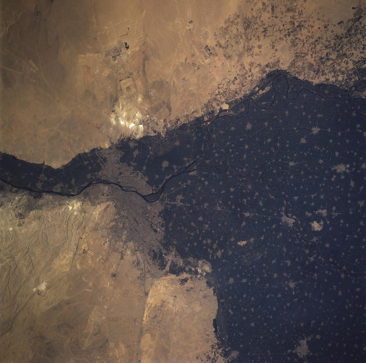
STS081-717-096 (12-22 Jan. 1997) --- The crewmembers, like astronauts 30 years ago, found the Nile River and its conspicuous delta an irresistible photo target from space, in this case from the Space Shuttle Atlantis' overhead windows. The majority of people living in Egypt reside in the city of Cairo. One of the most intensely cultivated lands in the world, the Nile delta can lay claim to some of the highest levels of soil salinity, as well as to being one of the highest users of fertilizer. The majority of Egypt's arable land is located in the delta. Cairo is "young" when compared to Egypt's long history, and has been a city since the Roman Empire. Although the city itself is relatively young, a site on the eastern bank of the Nile became the first capital of Egypt around 4225 BC. The city was called "Oun", but later was renamed Heliopolis by the Greeks. In 1991 the population of Cairo was estimated to be 54,600,000. The Pyramids of Gizai, one of the Seven Wonders of the Ancient World, can be seen on the western edge of the Nile delta and Cairo. The smallest and youngest of three Old Kingdom pyramids, Menkaure, is hard to distinguish because of its small size which casts a small shadow. Khafre is located between Menkaure and the Great Pyramid, and was originally 143 meters high. From the ground it appears that Khafre is taller than the other pyramids but this is an illusion caused by Khafre being built on higher ground. Khufu, or the Great Pyramid, was the first of the three to be built, and at an original height of 147 meters, is the tallest pyramid.
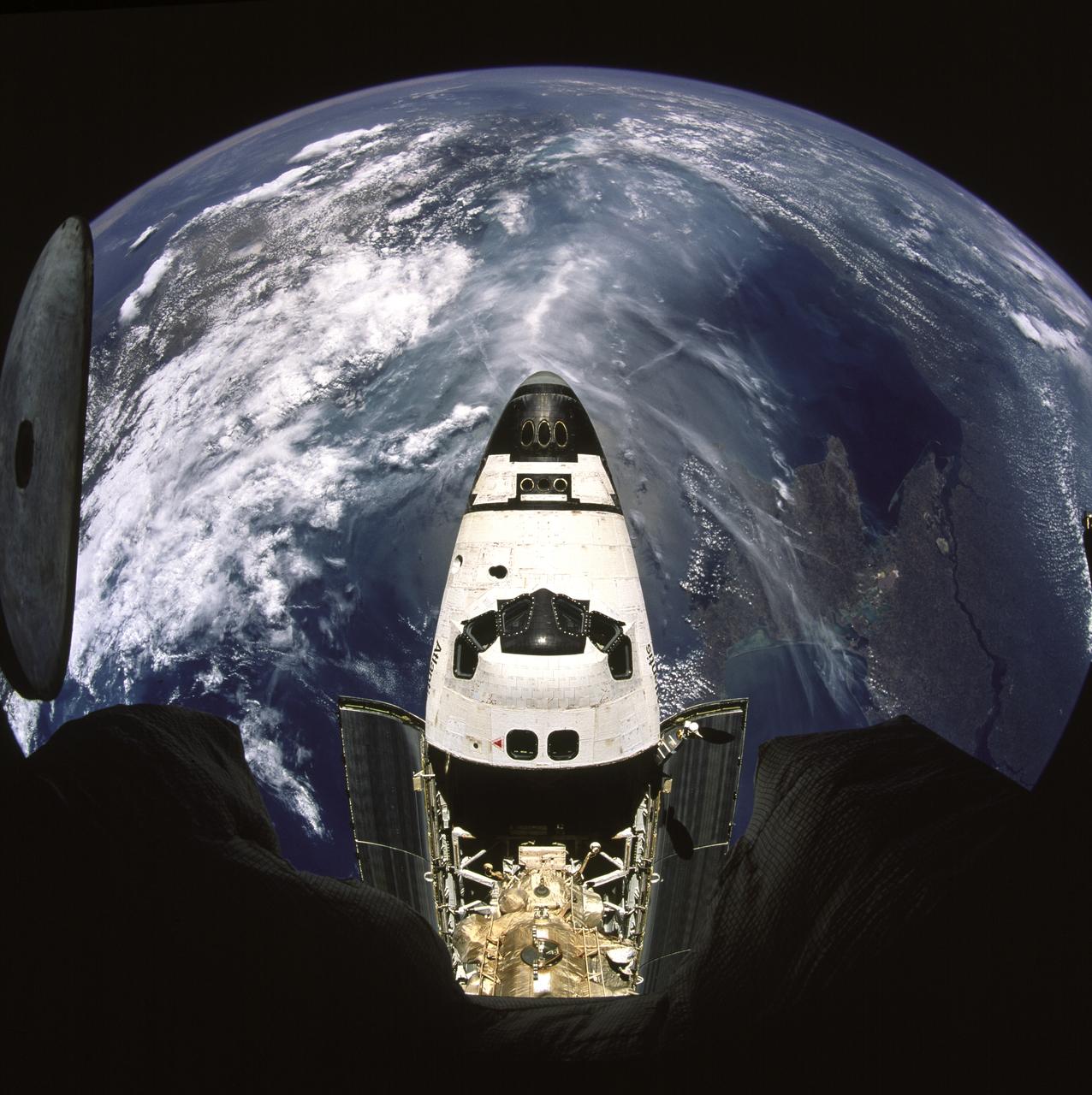
STS071-741-004 (27 June-7 July 1995) --- Docked already with Russia's Mir Space Station and backdropped against a half globe of Earth featuring the Crimean Peninsula, the space shuttle Atlantis is partially visible through a window on the Kvant 2 Module. A 70mm camera, carried into space by the STS-71 crew aboard the space shuttle Atlantis, was used to expose the image. The crew cabin and forward cargo bay of Atlantis are most prominent. Below center can be seen the Androgynous Peripheral Docking System (APDS) and the Kristall Module on Mir. The APDS is connected to a port in a tunnel leading to the Spacelab Science Module in Atlantis' cargo bay. The linkup enabled the seven STS-71 crew members to visit Mir and it allowed the three Mir-18 crew members, in space since March of this year, access to Spacelab. That module was quite busy with tests and data collection involving the three, Mir-18 crew, until Atlantis brought them home on July 7, 1995. The Black Sea lies directly beneath Atlantis, with Ukraine's diamond-shaped Crimean Peninsula immediately to the right of the cockpit. The wide lower course of the Dnepr River can be seen entering the Black Sea at far right. The coast of Romania and Bulgaria lies at a point where the cloud begins at top right. The peninsula of Asia Minor lies across the left of the view, mostly under cloud cover. The Mediterranean Sea is the cloud-free, blue mass beyond. Still further, at about 1,300 miles distance, the north edge of Africa is stretched out as a line across the horizon with its characteristic sandy color. The nose of Atlantis points southwest toward the only outlet of the Black Sea known as the Bosporus.