
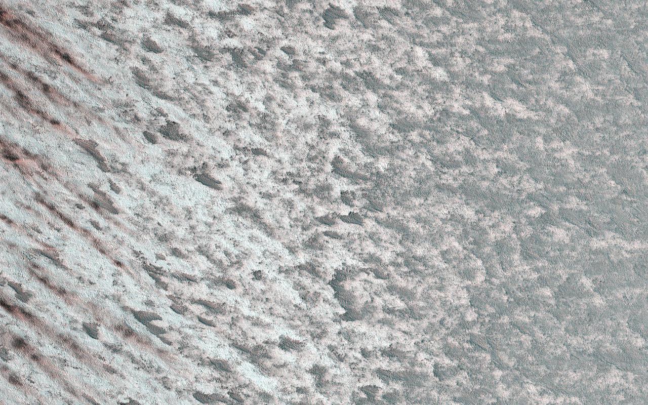
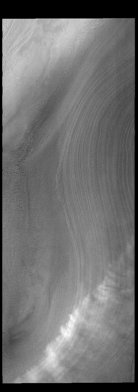
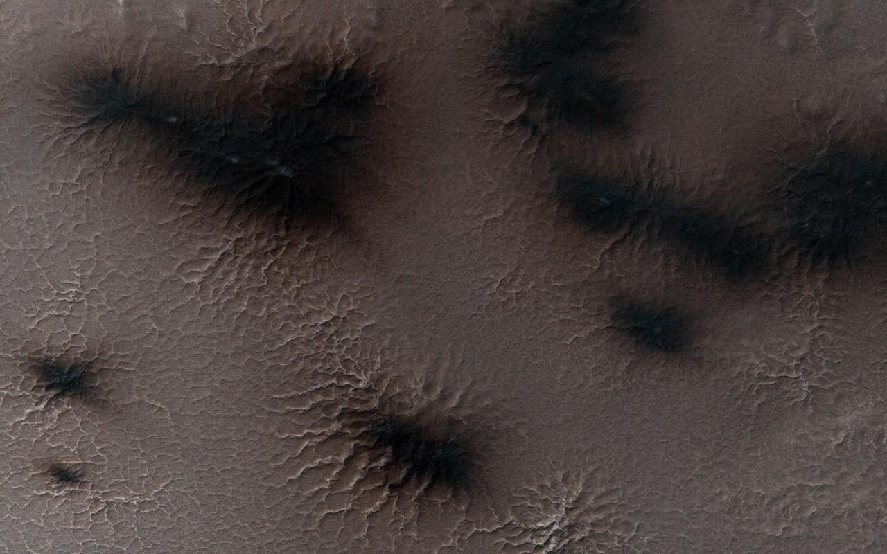
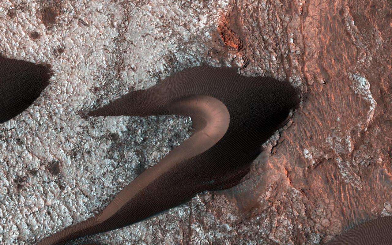
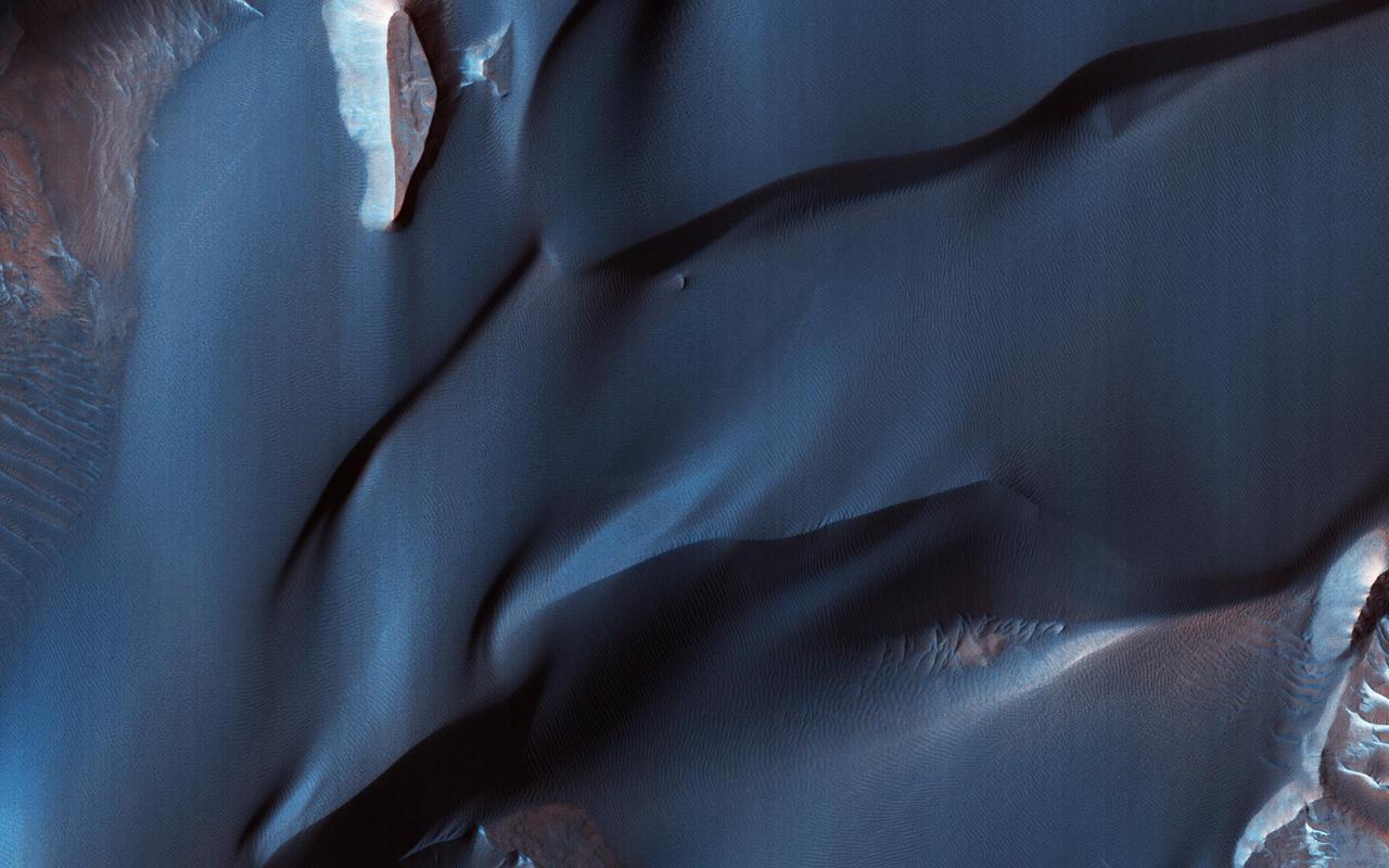
Changing Winds
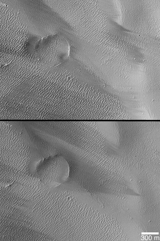
Wind Streak Changes
Wind Streak Changes
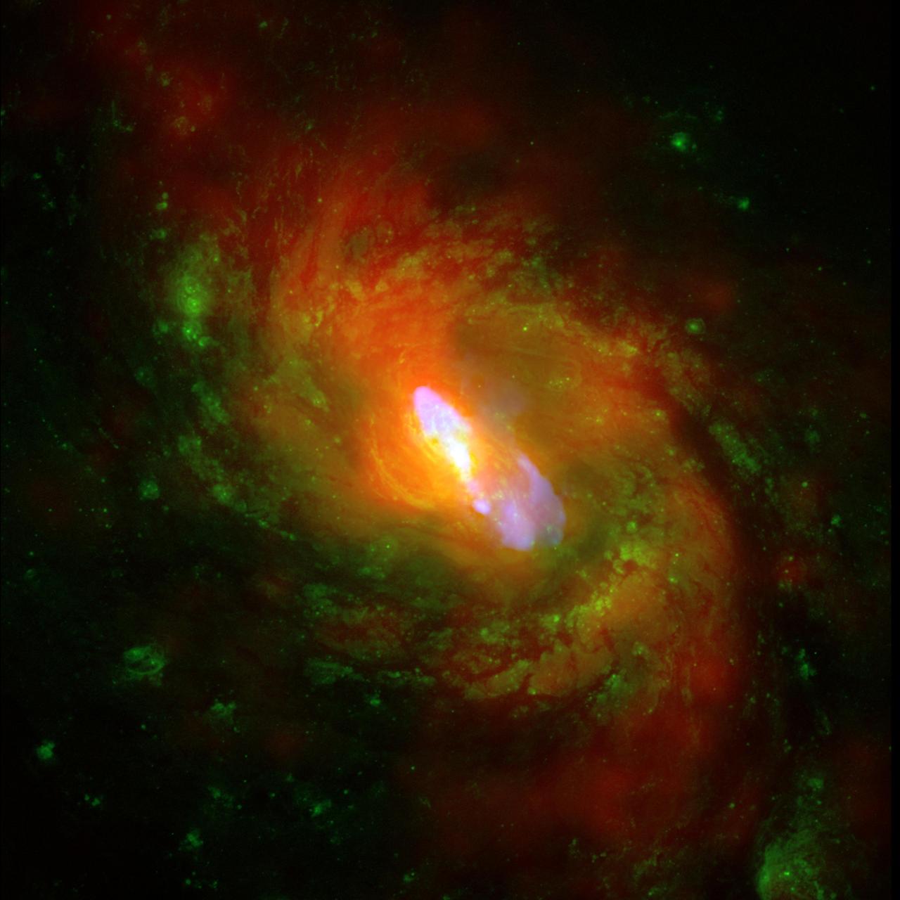
Observation Date: 1 pointing on Dec 4, 2000 and 9 pointings between Nov 18 and Dec 5, 2008. Distance Estimate: About 50 million light years away. This is a composite image of NGC 1068, one of the nearest and brightest galaxies containing a rapidly growing supermassive black hole. The X-ray images and spectra obtained using Chandra's High Energy Transmission Grating Spectrometer show that a strong wind is being driven away from the center of NGC 1068 at a rate of about a million miles per hour. This wind is likely generated as surrounding gas is accelerated and heated as it swirls toward the black hole. A portion of the gas is pulled into the black hole, but some of it is blown away. High energy X-rays produced by the gas near the black hole heat the ouflowing gas, causing it to glow at lower X-ray energies. X-ray data from the Chandra X-ray Observatory are shown in red, optical data from the Hubble Space Telescope in green and radio data from the Very Large Array in blue. The spiral structure of NGC 1068 is shown by the X-ray and optical data, and a jet powered by the central supermassive black hole is shown by the radio data. This Chandra study is much deeper than previous X-ray observations. Using this data, researchers believe that each year several times the mass of our sun is being deposited out to large distances, about 3,000 light years from the black hole. The wind likely carries enough energy to heat the surrounding gas and suppress extra star formation. These results help explain how a supermassive black hole can alter the evolution of its host galaxy. It has long been suspected that material blown away from a black hole can affect its environment, but a key question has been whether such "black hole blowback" typically delivers enough power to have a significant impact. NGC 1068 is located about 50 million light years from Earth and contains a supermassive black hole about twice as massive as the one in the middle of the Milky Way Galaxy. Image Credit: X-ray (NASA/CXC/ MIT/C.Canizares, D.Evans et al), Optical (NASA/STScI), Radio (NSF/ NRAO/VLA)
Bright windstreaks are located around several small craters at the top of this image captured by NASA 2001 Mars Odyssey spacecraft.
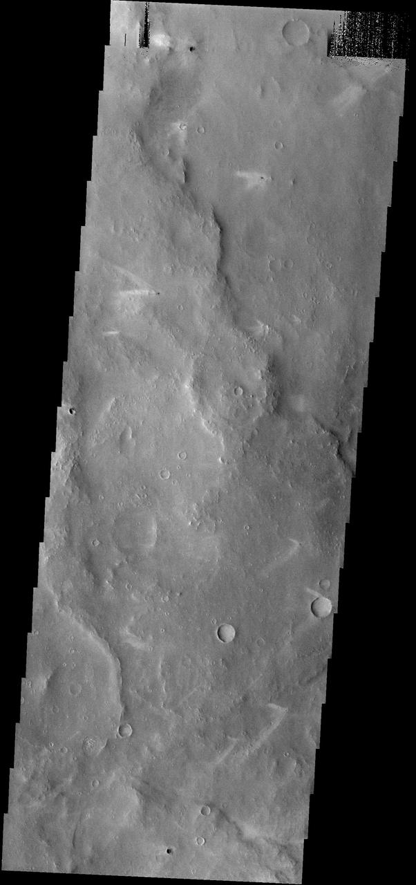
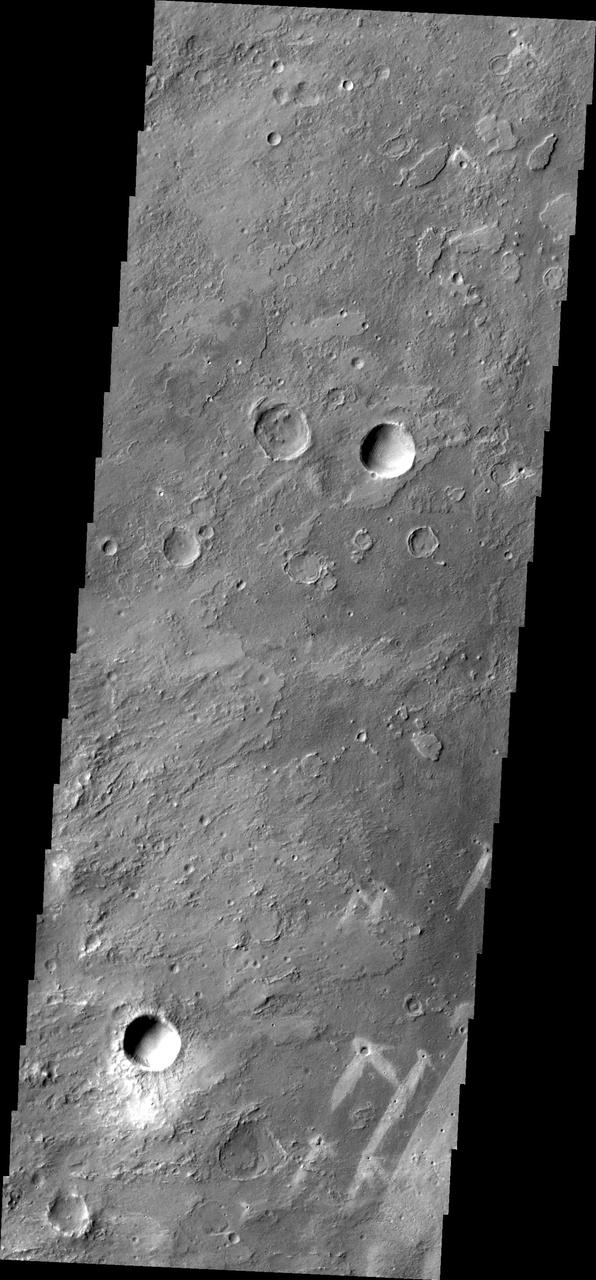
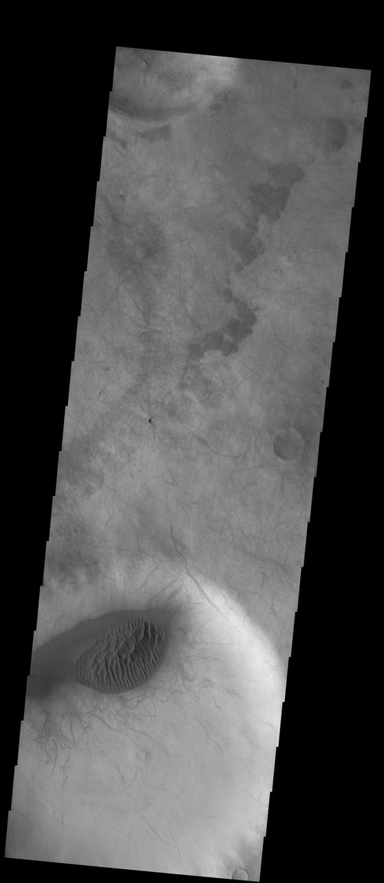
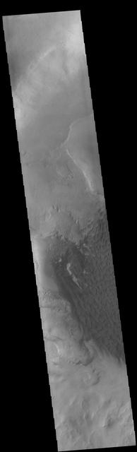
The windstreaks in this area northwest of Schiaparelli Crater point in three different directions. This indicates that the wind shifts/ed with time
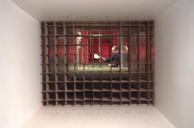
As part of the project FIRE study, technicians ready materials to be subjected to high temperatures that will simulate the effects of re-entry heating. Tests of various space capsule materials for Project FIRE were conducted. Photographed in the 9 X 6 Foot Thermal Structures Tunnel. Photograph published in Winds of Change, 75th Anniversary NASA publication, by James Schultz (page 78). Photograph also published in Engineer in Charge: A History of the Langley Aeronautical Laboratory, 1917-1958 by James R. Hansen (page 476). Also Published in the book " A Century at Langley" by Joseph Chambers. Pg. 92
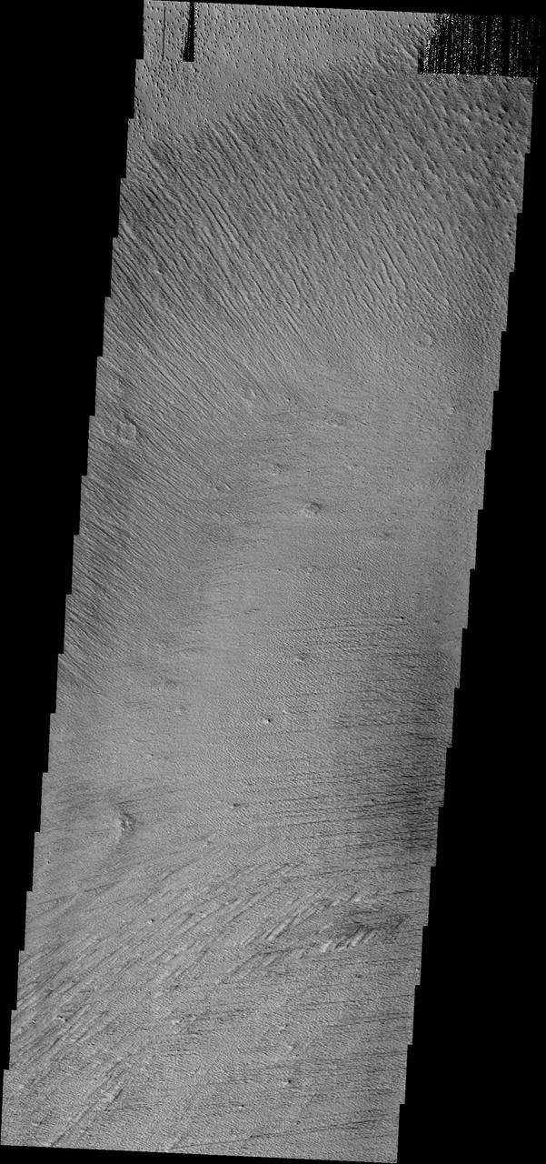
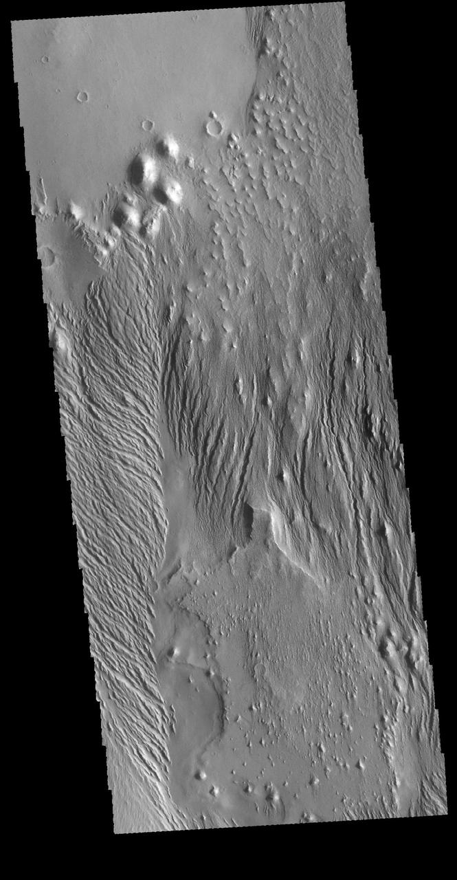
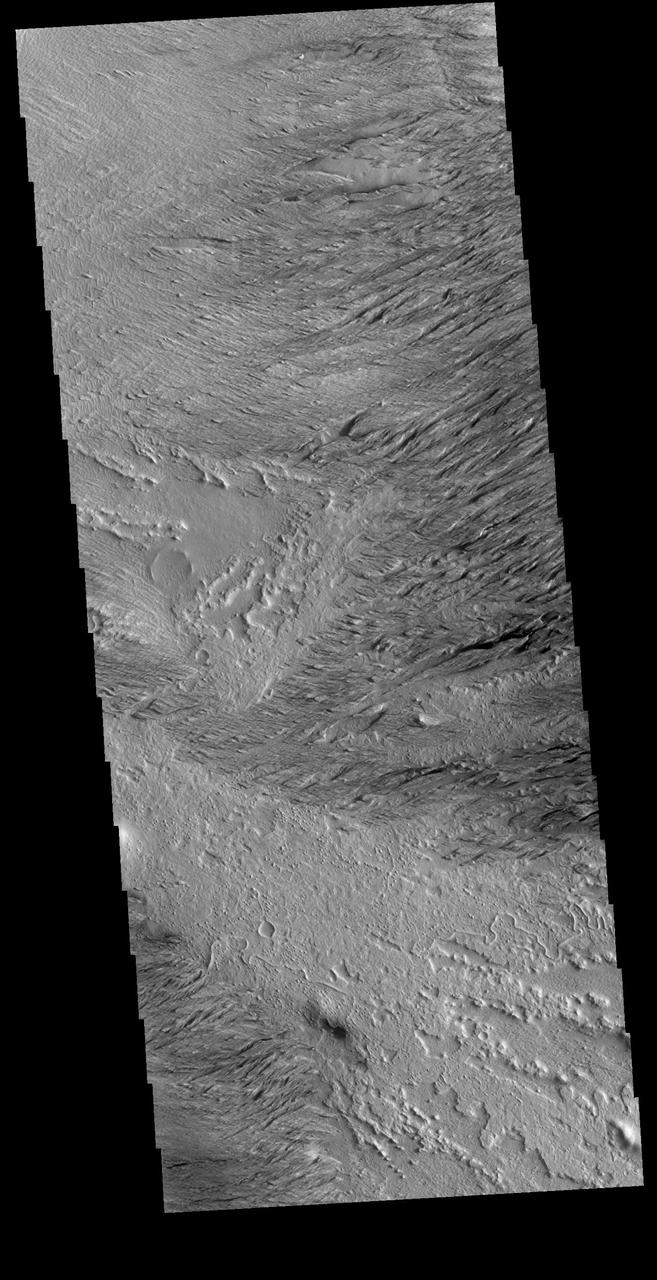
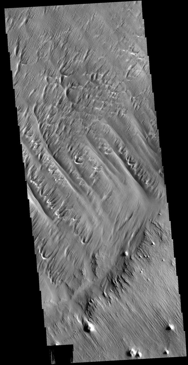
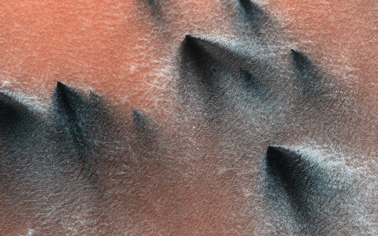
The multiple trends of yardangs in this image indicate that the winds in the Elysium region have changed direction several times
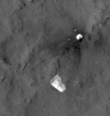
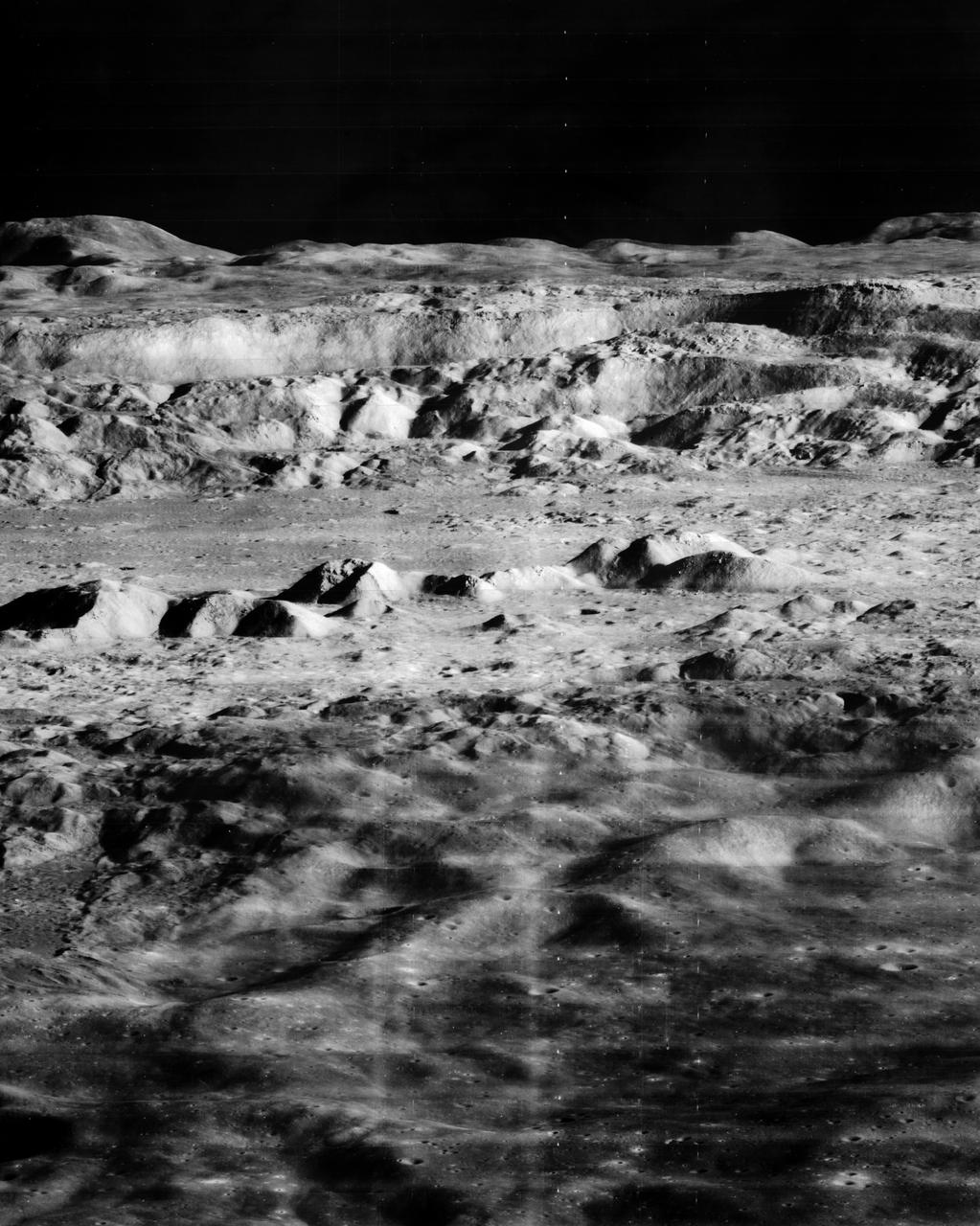
Small light colored area within the crater is Surveyor 1 on lunar surface photographed by Lunar Orbiter III. Published in the book "A Century at Langley" by Joseph Chambers. pg. 93 Moon Lunar Orbiter-Lunar Orbiter III: The hidden or dark side of the Moon was taken by Lunar Orbiter III During its mission to photograph potential lunar-landing sites for Apollo missions. -- Photograph published in Winds of Change, 75th Anniversary NASA publication (page 94), by James Schultz. Photo Number:67-H-328 is 1967-L-04026

The figure demonstrates of the capability of the SeaWinds instrument on NASA QuikScat satellite in monitoring both sea ice and ocean surface wind, thus helping to further our knowledge in wind-ice interaction and its effect on climate change.
This image from NASA Mars Odyssey of part of Meridiani Planum contains windstreaks that formed in several directions around a single crater. This indicates that wind directions changed, forming new tails for each prevailing wind direction.
Lunar Landing Module photographed at night at the Lunar Landing Research Facility. Gantry facility 1297. Upright cockpit design lander over moonscape pavement at LLRF. 69-4872 was published in Winds of Change, 75th Anniversary Publication of NASA, P.88, by James Schultz.
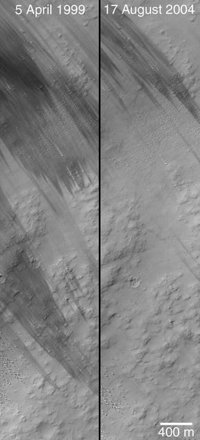
This image from NASA Mars Reconnaissance Orbiter shows wind-caused changes in the parachute of NASA Mars Science Laboratory spacecraft as the chute lay on the Martian ground during months after its use in safe landing of the Curiosity rover.
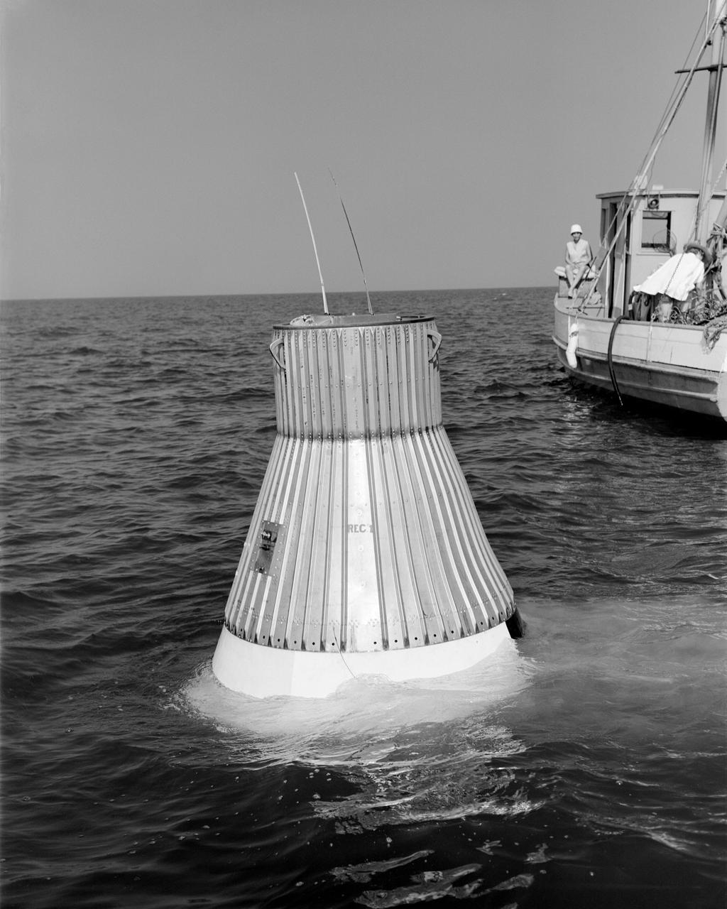
L59-4073 A model of the Mercury capsule undergoes flotation tests. -- Photograph published in Winds of Change, 75th Anniversary NASA publication (page 76), by James Schultz.
The Mercury space capsule undergoing tests in Full Scale Wind Tunnel, January 1959. Photograph published in Winds of Change, 75th Anniversary NASA publication, page 75, by James Schultz. Also Photograph published in Engineer in Charge: A History of the Langley Aeronautical Laboratory, 1917-1958, page 389, by James R. Hansen.
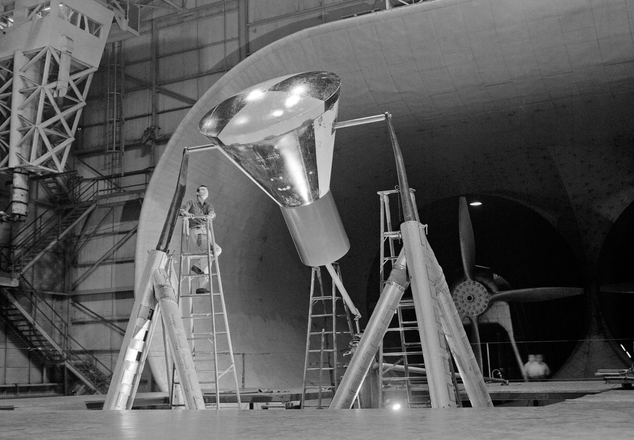
A 1/10th Scale Model of the X-15 research plane is prepared in Langley's 7 x 10 Foot Wind Tunnel for studies relating to spin characteristics. -- Photograph published in Winds of Change, 75th Anniversary NASA publication (page 66), by James Schultz.

Ames Mars Wind Tunnel Facility N-245: NASA is simulating small martian 'dust devils' and wind in a laboraotry to determine how they may affect the landscape and environment of the red planet. Dust Devils on Mars are often a great deal biggger than those on Earth and can at times cover the whole planet. Martian winds & dust devils, big and little, collectively are a great force that is constantly changing the planet's environment. shown here: Silica Sand (Oklahoma 90) particles used in vortex generatory and Mars Wind Tunnel

Ames Mars Wind Tunnel Facility N-245: NASA is simulating small martian 'dust devils' and wind in a laboraotry to determine how they may affect the landscape and environment of the red planet. Dust Devils on Mars are often a great deal biggger than those on Earth and can at times cover the whole planet. Martian winds & dust devils, big and little, collectively are a great force that is constantly changing the planet's environment. shown here: Carbondale Red Clay dust used in vortex generatory and Mars Wind Tunnel
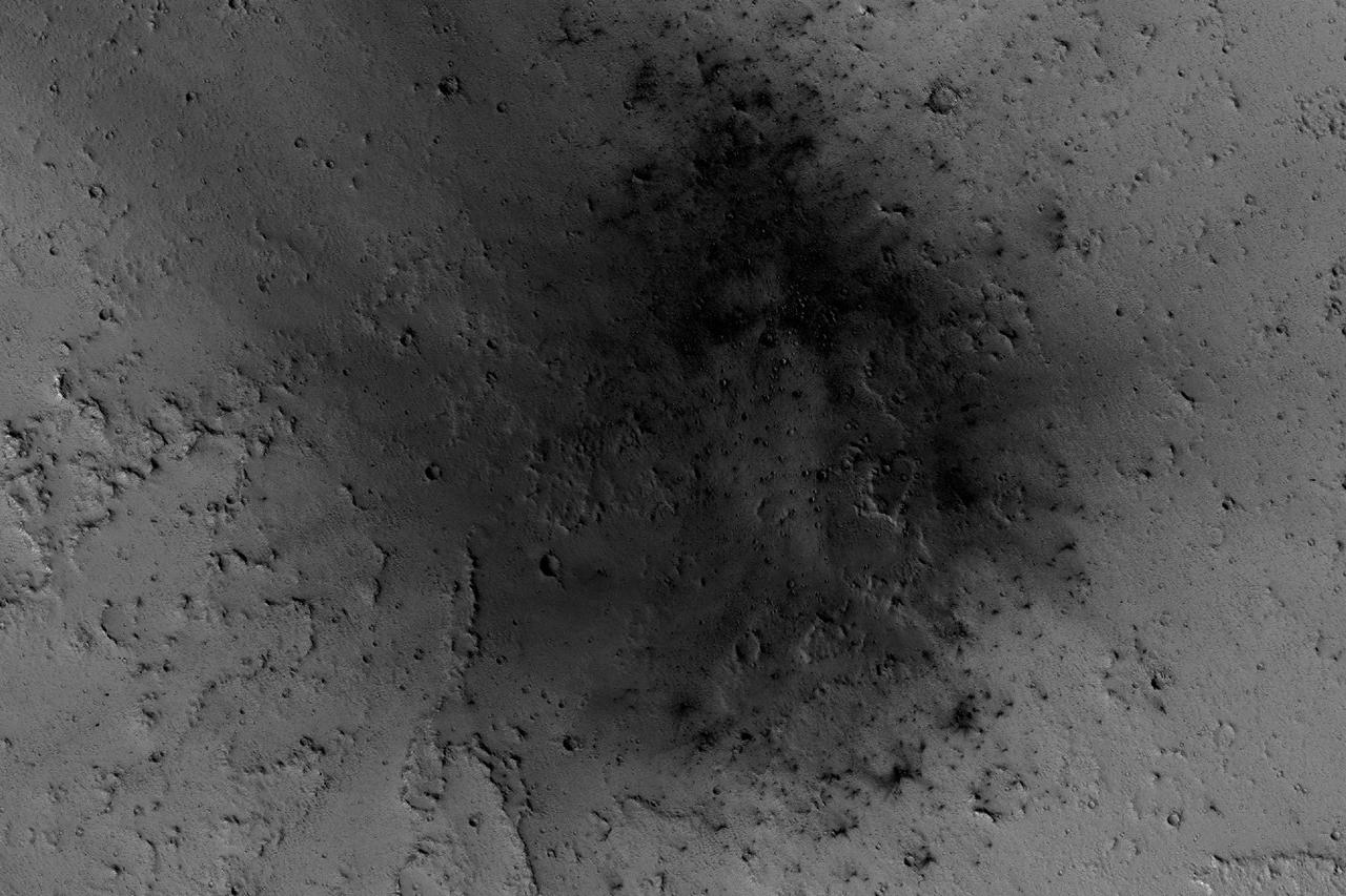
NASA's Mars Reconnaissance Orbiter has been observing Mars in sharp detail for more than a decade, enabling it to document many types of changes, such as the way winds alter the appearance of this recent impact site. The space-rock impact that created this blast zone occurred sometime between September 2005 and February 2006, as bracketed by observations made with the Mars Orbiter Camera on NASA's Mars Global Surveyor spacecraft. The location is between two large volcanos, named Ascraeus Mons and Pavonis Mons, in a dusty area of the Tharsis region of Mars. During the period from 2007 to 2012, winds blowing through the pass between the volcanoes darkened some regions and brightened others, probably by removing and depositing dust. The view covers an area about 1.0 mile (1.6 kilometers) across, at 7 degrees north latitude, 248 degrees east longitude. North is toward the top. An animation is availalble at http://photojournal.jpl.nasa.gov/catalog/PIA21267
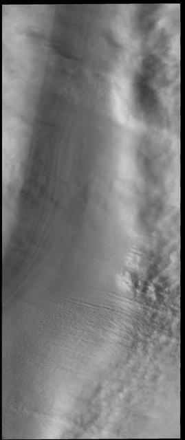
This VIS image shows 'streamers' of clouds created by katabatic winds at the north polar cap. Katabatic winds are created by cold air sinking at the pole and then speeding along the ice surface towards the edge of the polar cap. When the winds enter troughs the wind regime changes from laminar flow to choatic and clouds of ice particles and/or dust are visible. This wind activity peaks at the start of northern hemisphere summer. Orbit Number: 53942 Latitude: 86.8433 Longitude: 99.3149 Instrument: VIS Captured: 2014-02-10 10:50 https://photojournal.jpl.nasa.gov/catalog/PIA22362

The first Scout prepared for launch at Wallops Island July 1, 1960, and launched the evening of the same day. -- Photograph published in Winds of Change, 75th Anniversary NASA publication (page 73), by James Schultz.
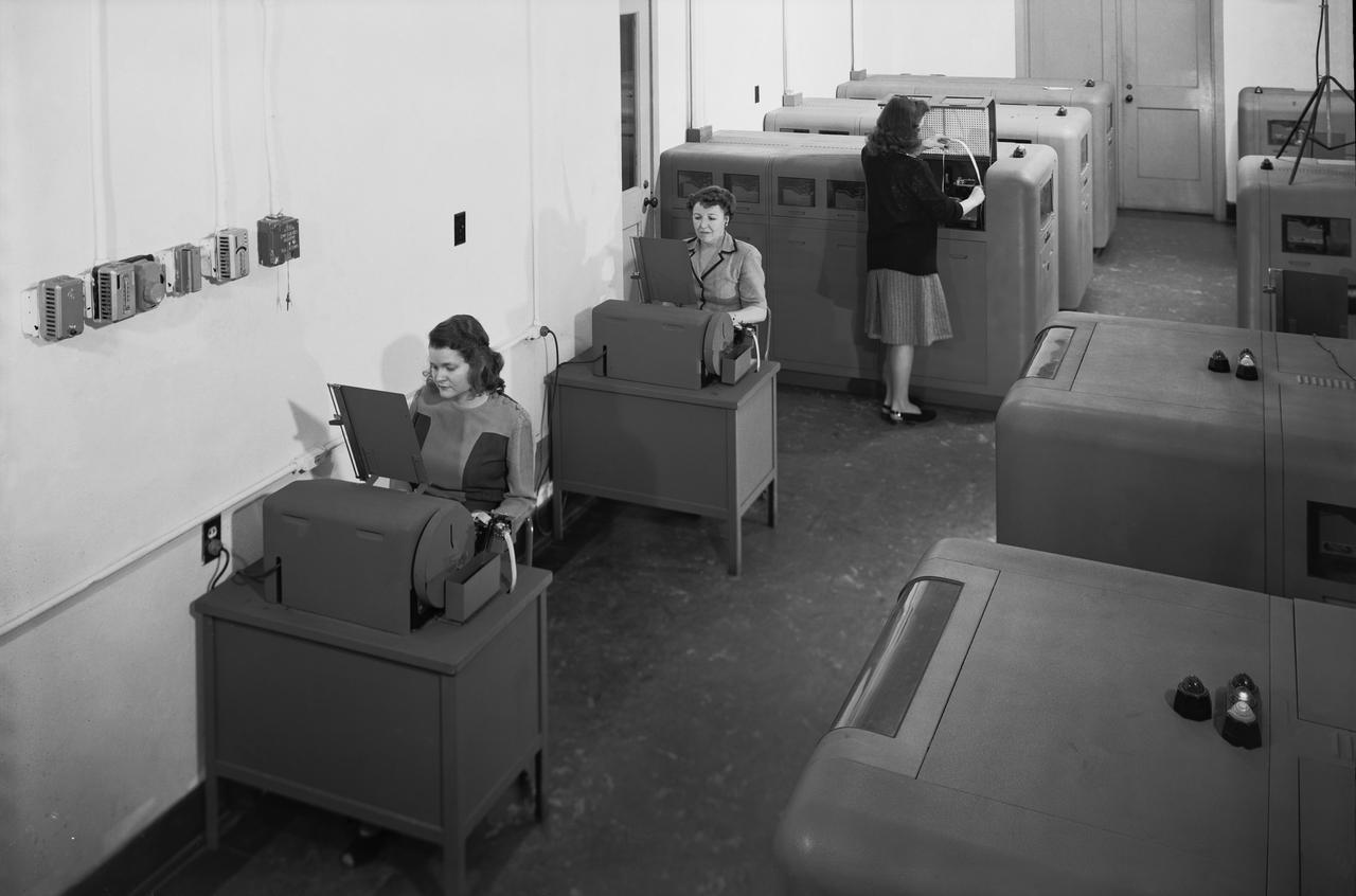
Langley's human computers at work in 1947. The female presence at Langley, who performed mathematical computations for male staff. -- Photograph published in Winds of Change, 75th Anniversary NASA publication (page 48), by James Schultz.
Practicing with a full-scale model of the Gemini Capsule in Langley's Rendezvous Docking Simulator. -- Caption and photograph published in Winds of Change, 75th Anniversary NASA publication, (page 89), by James Schultz.
Ames Mars Wind Tunnel Facility N-245: NASA is simulating small martian 'dust devils' and wind in a laboraotry to determine how they may affect the landscape and environment of the red planet. Dust Devils on Mars are often a great deal biggger than those on Earth and can at times cover the whole planet. Martian winds & dust devils, big and little, collectively are a great force that is constantly changing the planet's environment. shown here: is the control room for the Mars W.T. with Eric Eddlemon
Today's VIS image is located in a region that has been heavily modified by wind action. The narrow ridge/valley system seen in this image are a feature called yardangs. Yardangs form when unidirectional winds blow across poorly cemented materials. Multiple yardang directions can indicate changes in regional wind regimes. Orbit Number: 64188 Latitude: -0.629314 Longitude: 206.572 Instrument: VIS Captured: 2016-06-03 01:20 http://photojournal.jpl.nasa.gov/catalog/PIA20799

Ames Mars Wind Tunnel Facility N-245: NASA is simulating small martian 'dust devils' and wind in a laboraotry to determine how they may affect the landscape and environment of the red planet. Dust Devils on Mars are often a great deal biggger than those on Earth and can at times cover the whole planet. Martian winds & dust devils, big and little, collectively are a great force that is constantly changing the planet's environment. shown here walnut shell particles used in vortex generator to simulate quartz dust on Mars

Ames Mars Wind Tunnel Facility N-245: NASA is simulating small martian 'dust devils' and wind in a laboraotry to determine how they may affect the landscape and environment of the red planet. Dust Devils on Mars are often a great deal biggger than those on Earth and can at times cover the whole planet. Martian winds & dust devils, big and little, collectively are a great force that is constantly changing the planet's environment. shown here: vortex generator inside vacuum chamber using dry ice w/ Jaimie Chhu
The purpose of this sequence of images is to understand rapid albedo (brightness) changes seen at this time of year (late northern summer) on the Martian polar cap. Our cutout is an animation that is a comparison with an image acquired just 5 days earlier from this one. Changes in relative brightness are apparent between the observations. It is not immediately obvious what is causing the changes, but the linear patterns suggest that wind is playing a role. https://photojournal.jpl.nasa.gov/catalog/PIA25353
This artist's rendering shows a cutaway of the Seismic Experiment for Interior Structure instrument, or SEIS, which will fly as part of NASA's Mars InSight lander. SEIS is a highly sensitive seismometer that will be used to detect marsquakes from the Red Planet's surface for the first time. There are two layers in this cutaway. The outer layer is the Wind and Thermal Shield -- a covering that protects the seismometer from the Martian environment. The wind on Mars, as well as extreme temperature changes, could affect the highly sensitive instrument. The inside layer is SEIS itself, a brass-colored dome that houses the instrument's three pendulums. These insides are inside a titanium vacuum chamber to further isolate them from temperature changes on the Martian surface. https://photojournal.jpl.nasa.gov/catalog/PIA22320
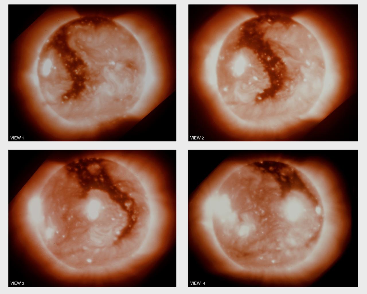
This montage is a sequence of soft x-ray photographs of the boot-shaped coronal hole rotating with the sun. The individual pictures were taken about 2 days apart by the Skylab telescope. Most of the apparent changes in this 6-day period resulted from a changing perspective. Skylab data helped demonstrate that coronal holes are sources of high-velocity streams in the solar wind. These high-velocity streams can be electrons, protons, and atomic nuclei that spray out from the Sun into interplanetary space. When the coronal hole is near the center of the Sun, as in view 2, the sprinkler is directed at Earth. These high-speed streams of solar wind distort Earth's magnetic field and disturb it's upper atmosphere.
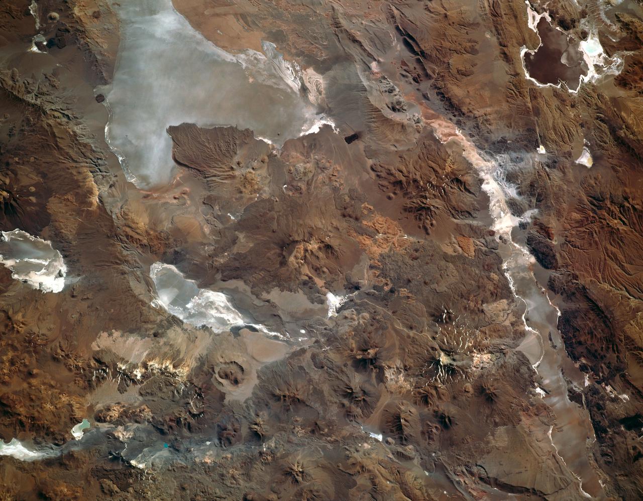
This photograph captures the exotic volcanic terrain of the Altiplano of the Central Andes. Some of the remarkable details include the west-pointing wind streaks, resulting from fine dust being transported across the Andes by high winds; paleto (old) shorelines along the margins of the salars (or dry lake beds), recording the changes in water levels on the high Altiplano; beautiful alluvial fans emptying onto some of the salars; and the hundreds of volcanic land forms which can be mapped and interpreted to help decipher the volcanic history of the region.
Today's VIS image shows a line of clouds over the south polar cap. These clouds are at an altitude above the surface where they are not directly interacting with the surface topography of the ice. During seasonal changes surface winds will sweep along the cap and create clouds where the winds dip into the troughs of the ice. Orbit Number: 91751 Latitude: -86.915 Longitude: 182.233 Instrument: VIS Captured: 2022-08-21 01:31 https://photojournal.jpl.nasa.gov/catalog/PIA25634
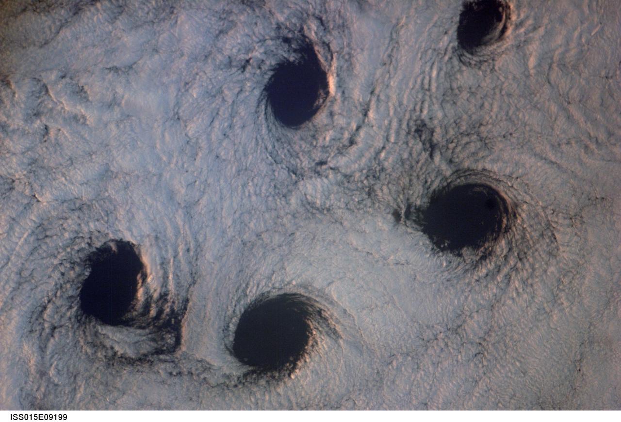
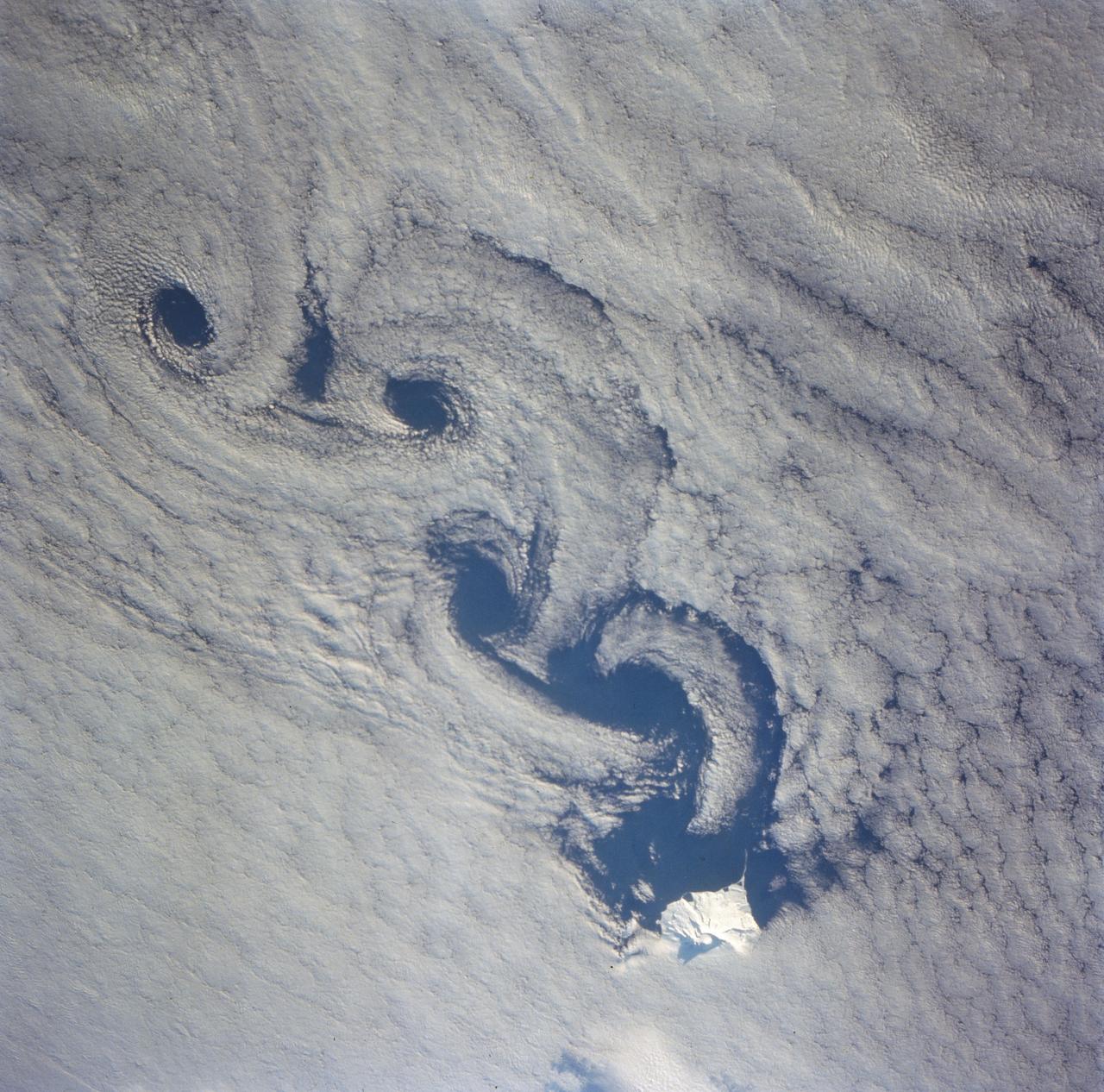
ISS015-E-09199 (23 May 2007) --- Von Karman cloud vortices near the Aleutian Islands are featured in this image photographed by an Expedition 15 crewmember on the International Space Station. The vortices are created by the wind encountering a barrier such as an island, changing direction and velocity and forming eddies in the wind and cloud pattern on the lee side of the island. The nadir point of the space station when the image was taken was 51.1 degrees north latitude and 178.8 degrees west longitude.
This VIS image is located near Zephyria Planum. Winds of two different directions have excavated a poorly cemented surface into linear ridge features called yardangs. Examining the structure of the ridges, it appears that winds first blew from the upper left of the image. Then perhaps after a change in climate, winds blew toward the upper right, carving a new pattern on top of the older one. The ridges are not perpendicular, but intersect at a wider angle. Orbit Number: 72496 Latitude: -4.75332 Longitude: 154.461 Instrument: VIS Captured: 2018-04-18 12:20 https://photojournal.jpl.nasa.gov/catalog/PIA22612
Ames Mars Wind Tunnel Facility N-245: NASA is simulating small martian 'dust devils' and wind in a laboraotry to determine how they may affect the landscape and environment of the red planet. Dust Devils on Mars are often a great deal biggger than those on Earth and can at times cover the whole planet. Martian winds & dust devils, big and little, collectively are a great force that is constantly changing the planet's environment. shown here: looking through Mars W. T. air intake towards test section w/ Eric Eddlemon
Ames Mars Wind Tunnel Facility N-245: NASA is simulating small martian 'dust devils' and wind in a laboraotry to determine how they may affect the landscape and environment of the red planet. Dust Devils on Mars are often a great deal biggger than those on Earth and can at times cover the whole planet. Martian winds & dust devils, big and little, collectively are a great force that is constantly changing the planet's environment. shown here: interior of vacuum chamber from above showing Mars W. T. and Vortex Generator w/ Dric Eddlemon and Jaimie Chhu
NASA's Curiosity Mars rover used one of its Hazard-Avoidance Cameras (Hazcams) to catch this dusty wind gust blowing overhead on March 18, 2022, the 3,418th Martian day, or sol, of the mission. Scientists believe it's a wind gust rather than a dust devil since it doesn't appear to have the trademark vorticity, or twisting, of a dust devil. The series of images captured by the Hazcam is viewable in the top image; the bottom image shows the frames after they've been processed by change-detection software, which helps the viewer see how the wind gust moves over time. Movie available at https://photojournal.jpl.nasa.gov/catalog/PIA25177
Eumenides Dorsum is a large linear rise located in southern Amazonis Planitia. Erosion by wind action is prevalent in this region. The horseshoe shaped depressions in this image are called blowouts and align with the wind direction that blew from upper right to lower left. The deep troughs and the finer scale linear erosion at the bottom of the image were created by winds that blew along the trend from upper left to lower right. This reflects two different predominant wind directions. It is difficult from just one image to determine if the wind changes were seasonal or over thousands of years in a single direction. Orbit Number: 79668 Latitude: 3.05139 Longitude: 202.032 Instrument: VIS Captured: 2019-11-30 04:22 https://photojournal.jpl.nasa.gov/catalog/PIA23746
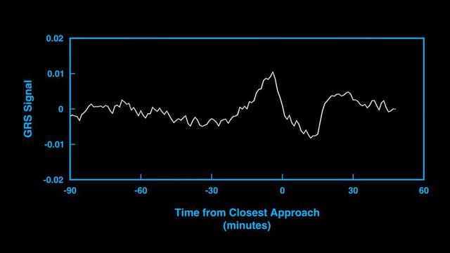
This animation and audio represent the subtle gravitational signal acquired by an antenna of NASA's Deep Space Network as the agency's Juno spacecraft performed a close flyby of Jupiter's Great Red Spot in July 2019. The changes in the signal frequency represent the changes in the local gravity as the spacecraft flew low overhead. Juno flew twice over the Great Red Spot in 2019, with the goal of picking up the subtle gravitational signal of the vortex. The concentration of mass caused by the powerful winds surrounding the Great Red Spot minutely change the spacecraft's velocity, inducing a Doppler shift on the radio signals relayed back to Earth. Movie available at https://photojournal.jpl.nasa.gov/catalog/PIA24963
Moon Lunar Orbiter-Lunar Orbiter II: Display Transparencies Lunar Orbiter II from Washington Press Conference. Lunar Orbiter II's telephoto lens took this picture of the floor of the crater Copernicus. -- Photograph published in Winds of Change, 75th Anniversary NASA publication (page 94), by James Schultz.
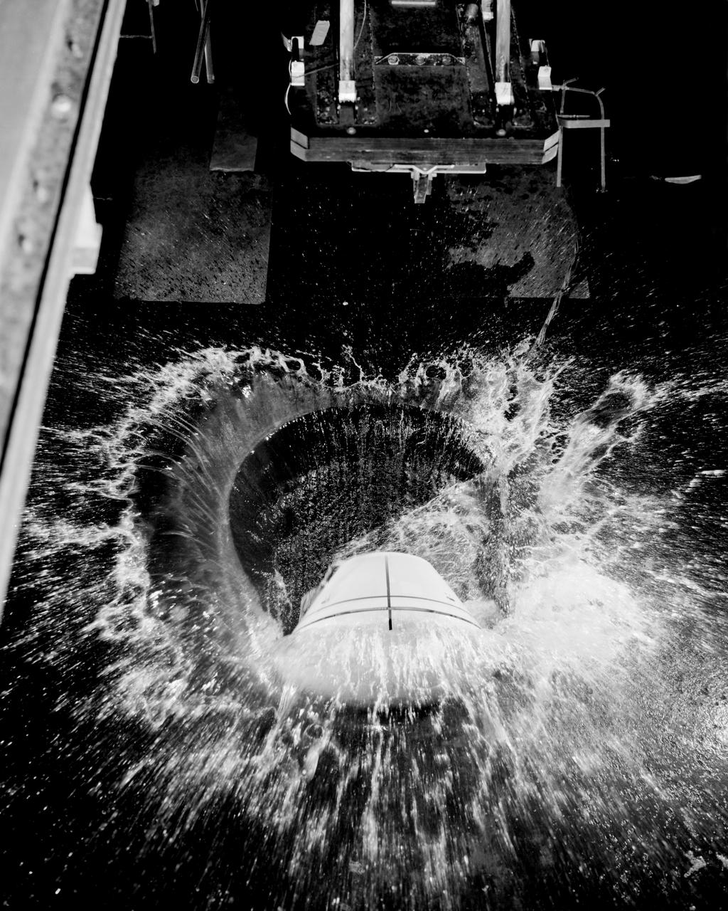
1/4th Scale Model of Apollo - Impact Structures Facility Launched from an overhead pendulum device, this Apollo spacecraft was tested in the Impact Structures Facility to determine water-landing characteristics. -- Photograph published in Winds of Change, 75th Anniversary NASA publication (page 91), by James Schultz.
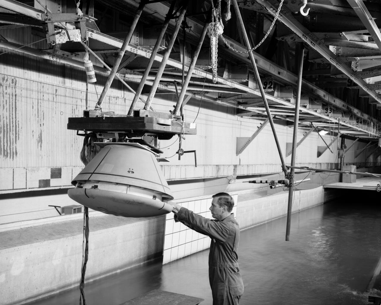
1/4th Scale Model of Apollo - Impact Structures Facility Launched from an overhead pendulum device, this Apollo spacecraft was tested in the Impact Structures Facility to determine water-landing characteristics. -- Photograph published in Winds of Change, 75th Anniversary NASA publication (page 91), by James Schultz.

Aside from native flora, fauna and the Langley rocket-research complex, there was not much on Wallops Island. Pictured is a 1960 photo of Launch area Number Three, used principally for Scout rocket firings. -- Photograph published in Winds of Change, 75th Anniversary NASA publication (page 73), by James Schultz.
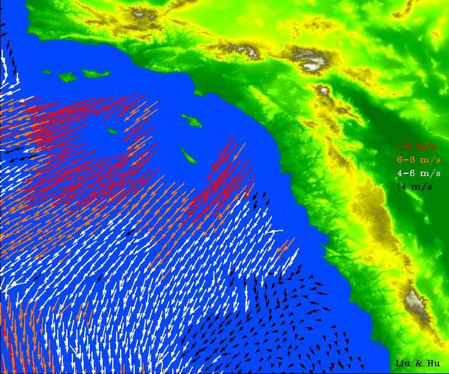
High-resolution ocean surface wind data from NASA's Quick Scatterometer (QuikScat) illustrate the strength of Santa Ana winds that pounded Southern California this week, causing damage and spreading brush fires. The colored arrows represent various ranges of wind speed, which were still well in excess of 30 knots (34 miles per hour), even after reaching the ocean and weakening. Santa Ana winds are offshore and down-slope winds unique to Southern California that are usually channeled through mountain gaps. These Santa Ana winds extend more than 500 kilometers (310 miles) offshore before changing direction to flow along the shore. The wind speeds and directions are retrieved from range-compressed backscatter data measured by QuikScat that has much higher spatial resolution than QuikScat's standard data products. Useful applications of high-resolution science-quality wind products derived from range-compressed backscatter have been demonstrated in two scientific papers: one on Hurricane Floyd and the other on Catalina Eddies. This is the first demonstration on near-real-time retrieval applications. http://photojournal.jpl.nasa.gov/catalog/PIA03892
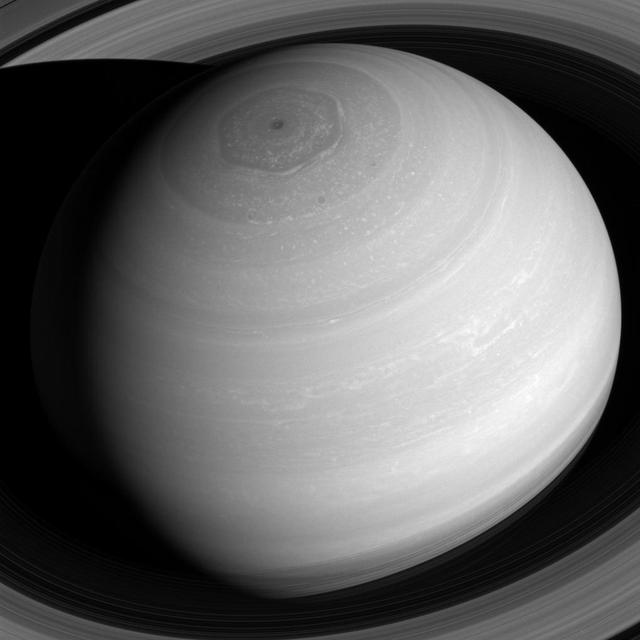
Saturn appears as a serene globe amid tranquil rings in this view from NASA's Cassini spacecraft. In reality, the planet's atmosphere is an ever-changing scene of high-speed winds and evolving weather patterns, punctuated by occasional large storms (see PIA14901). The rings, consist of countless icy particles, which are continually colliding. Such collisions play a key role in the rings' numerous waves and wakes, which are the manifestation of the subtle influence of Saturn's moons and, indeed, the planet itself. The long duration of the Cassini mission has allowed scientists to study how the atmosphere and rings of Saturn change over time, providing much-needed insights into this active planetary system. The view looks toward the sunlit side of the rings from about 41 degrees above the ring plane. The image was taken with the Cassini spacecraft wide-angle camera on July 16, 2016 using a spectral filter which preferentially admits wavelengths of near-infrared light centered at 752 nanometers. The view was acquired at a distance of approximately 1 million miles (2 million kilometers) from Saturn. Image scale is 68 miles (110 kilometers) per pixel. The view was obtained at a distance of approximately 752,000 miles (1.21 million kilometers) from Saturn and at a Sun-Saturn-spacecraft, or phase, angle of 6 degrees. Image scale is 45 miles (72 kilometers) per pixel. http://photojournal.jpl.nasa.gov/catalog/PIA20502
This unnamed crater in Terra Cimmeria has both a sand sheet with dune forms and a multitude of dust devil tracks. The linear and scalloped dark marks are created by dust devils removing surface dust and revealing the darker surface beneath the dust. It is common for sand to accumulate in the floor of crater. Changes in the wind occur due to the crater shape and possible internal peak or pit features. As the winds are deflected by this type of feature the sand and dust carried by the wind will settle out. The extensive number of dust devil tracks indicate that surface winds are pervasive in this region. Orbit Number: 75246 Latitude: -58.8609 Longitude: 172.829 Instrument: VIS Captured: 2018-12-01 00:11 https://photojournal.jpl.nasa.gov/catalog/PIA23024
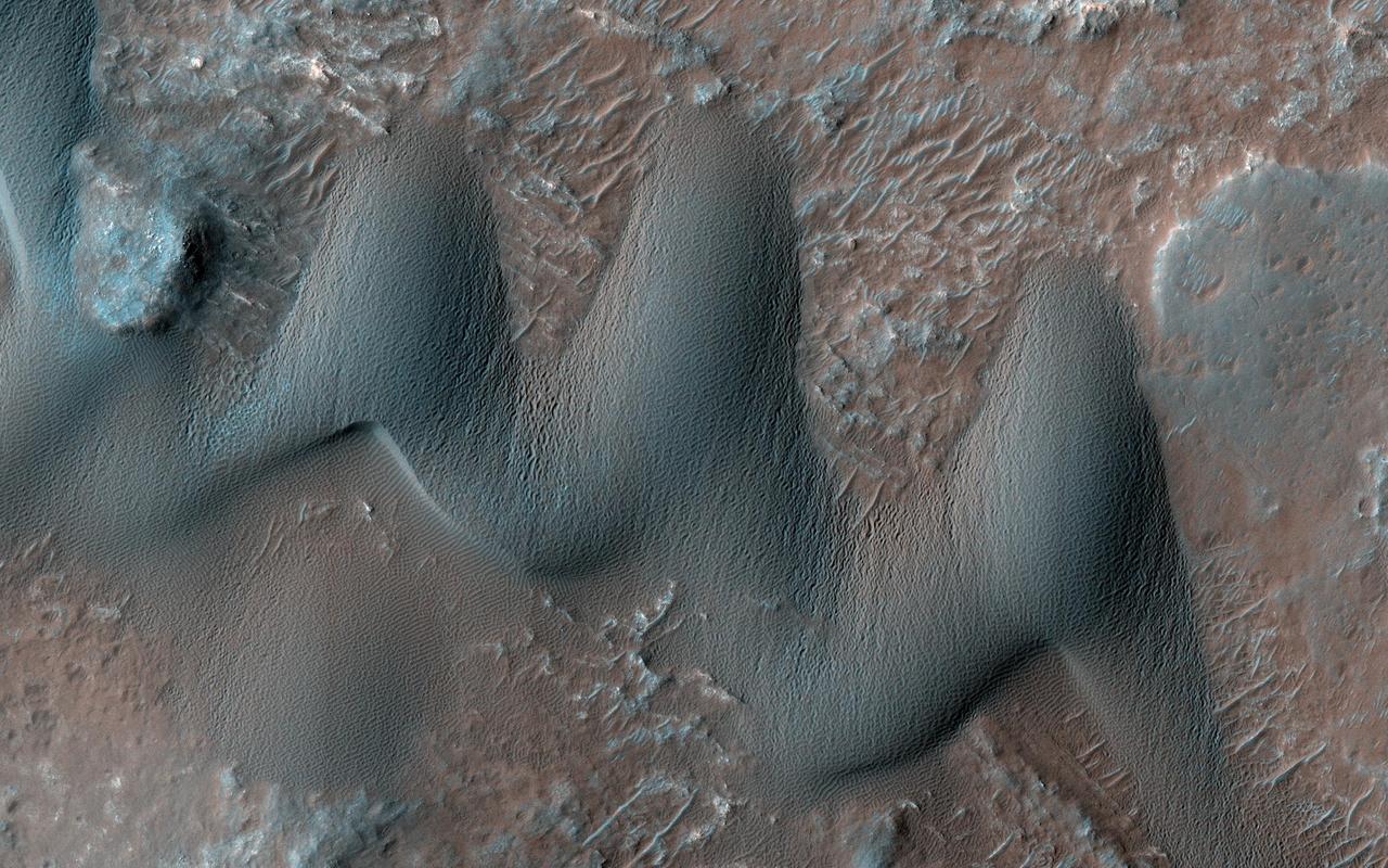
Sand dunes commonly form when particles that are being moved around by the wind find a natural barrier to accumulate and build a hill-like formation. Scientists study dunes because their shape and size can give us valuable information about the wind directions and speeds in current and past climates. For instance, barchan dunes are crescent-shaped, and they form when the wind blows mainly from one direction (perpendicular to the crescent long edge). On the other hand, "star" dunes have three or more "arms," and form in environments that that are affected by multiple wind directions. Our image shows an area on Mars with both star and barchan dunes next to each other. This implies that wind directions have changed with time, or that the surrounding landscape is creating complex wind patterns. Scientists can study HiRISE images collected over time of the same dunes to observe whether they are moving or not, and if so, how fast. By observing multiple dune systems over many seasons, we can get a better picture of wind regimes on Mars and possibly how they have evolved with time. https://photojournal.jpl.nasa.gov/catalog/PIA23849
Click on the image for larger version This image shows a circular impact crater and an oval volcanic caldera on the southern flank of a large volcano on Mars called Pavonis Mons. The caldera is also the source of numerous finger-like lava flows and at least one sinuous lava channel. Both the caldera and the crater are degraded by aeolian (wind) erosion. The strong prevailing winds have apparently carved deep grooves into the terrain. When looking at the scene for the first time, the image seems motion blurred. However, upon a closer look, the smaller, young craters are pristine, so the image must be sharp and the "blurriness" is due to the processes acting on the terrain. This suggests that the deflation-produced grooves, along with the crater and the caldera, are old features and deflation is not very active today. Alternatively, perhaps these craters are simply too young to show signs of degradation. This deeply wind-scoured terrain type is unique to Mars. Wind-carved stream-lined landforms on Earth are called "yardangs," but they don't form extensive terrains like this one. The basaltic lavas on the flanks of this volcano have been exposed to wind for such a long time that there are no parallels on Earth. Terrestrial landscapes and terrestrial wind patterns change much more rapidly than on Mars. http://photojournal.jpl.nasa.gov/catalog/PIA21064
It is about two weeks later in Inca City and the season is officially spring. Numerous changes have occurred. Large blotches of dust cover the araneiforms. Dark spots on the ridge show places where the seasonal polar ice cap has ruptured, releasing gas and fine material from the surface below. At the bottom of the image fans point in more than one direction from a single source, showing that the wind has changed direction while gas and dust were flowing out. Was the flow continuous or has the vent opened and closed? http://photojournal.jpl.nasa.gov/catalog/PIA18893
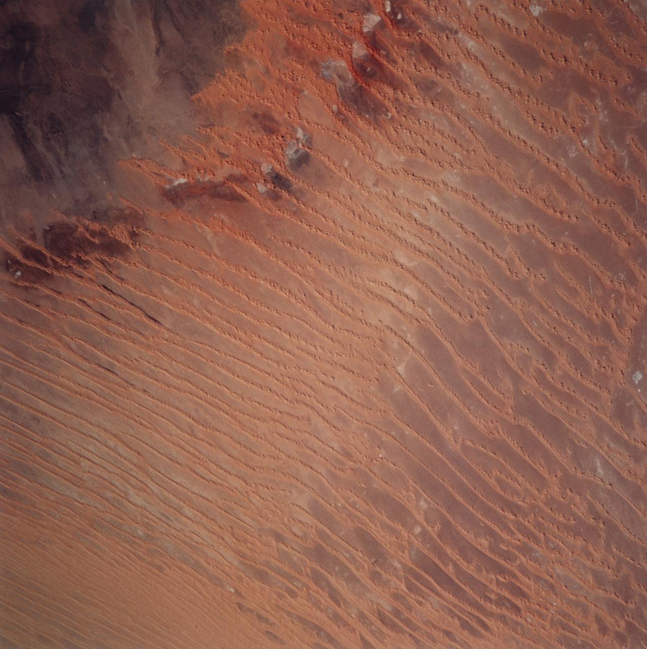
STS099-729-045 (11-22 February 2000) ---This Earth scene from the Space Shuttle Endeavour features linear dunes in the Algerian Saharan sand sea known as the Erg Chech. The dunes, according to NASA scientists, have been built up over thousands of years into masses elongated roughly parallel with the prevailing northeast winds. Dune chains in the northern (upper) half of the view are 5-8 kilometers apart. A slight change in orientation and an increase in the density of dunes appear across the middle of the view. Such changes usually relate to changes in sand supply, and also to topographic scarps over which the dunes pass. Obstacles like scarps and hills locally cause a leftward deflection (in the Northern Hemisphere) in wind direction, an effect that can be seen here in the dune orientation in the middle of the photo. Dunes in the lower part of the view are 2-5 kilometers apart. White patches are small dry lakes at low points in the underlying rock surface. The strong red color in some dunes near the edge of the dune field (left margin) is iron staining derived from sand particles blown into the dunes from the underlying iron-rich soils. A dune-free area appears in the lower left corner.
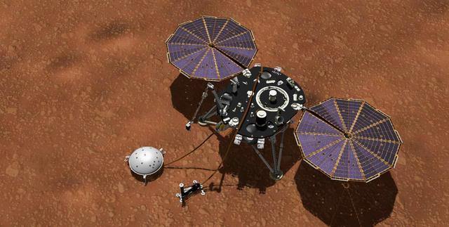
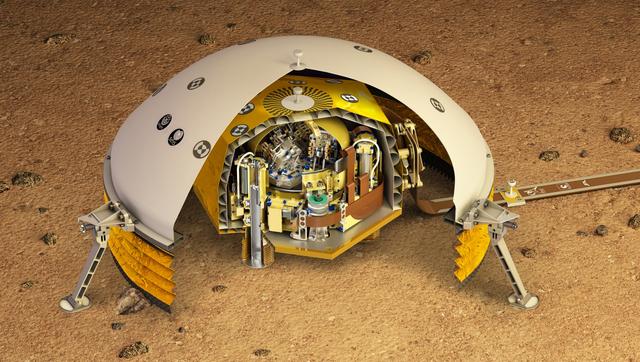
This artist's concept shows NASA's InSight lander with its instruments deployed on the Martian surface. InSight's package of weather sensors, called the Auxiliary Payload Subsystem (APSS), includes an air pressure sensor inside the lander -- its inlet is visible on InSight's deck -- and two air temperature and wind sensors on the deck. Under the deck's edge is a magnetometer, provided by UCLA, to measure changes in the local magnetic field that could also influence SEIS. InSight's air temperature and wind sensors are actually refurbished spares built for Curiosity's Rover Environmental Monitoring Station (REMS). Called Temperature and Wind for InSight, or TWINS, these two east- and west-facing booms sit on the lander's deck and were provided by Spain's Centro de Astrobiología (CAB). https://photojournal.jpl.nasa.gov/catalog/PIA22957
The Active Cavity Irradiance Monitor Satellite, or ACRIMSAT, mission is a climate change investigation that measures changes in how much of the sun's energy reaches Earth's atmosphere. This energy, called solar irradience, creates winds, heats the land and drives ocean currents, and therefore contains significant data that climatologists can use to improve predictions of climate change and global warming. The satellite's Active Cavity Irradiance Monitor III instrument, now in its third generation, has been used since the 1980s to study solar irradiance and its impacts on global warming. Scientists, using data from the instrument, now theorize that there is a significant correlation between solar radiation and global warming. ACRIMSAT completed its five-year primary mission in 2005 when it began operating under its extended mission. http://photojournal.jpl.nasa.gov/catalog/PIA18157
Springtime in the South Polar region of Mars is a season of exciting activity. The thick coating of carbon dioxide ice that accumulated over the winter begins to sublimate (turn to vapor) as the sun rises higher in the sky and warms the ice. Sunlight penetrates through the transparent ice, and is absorbed at the base of the ice layer. The gas that forms as a result of the warming escapes through weaknesses in the ice and erupts in the form of magnificent geysers of gas and dust. This image captures some of this activity in a region near 85 degrees south latitude that is being monitored by HiRISE. What makes this image interesting is the changing directions of the fans left behind by the geysers, indicating that the winds blew from different directions at the time that the geysers erupted. Winds from the southwest produced the dark fans at both ends of the image, whereas northwesterly winds dominated dust deposition in between. Local topography probably played a role in altering the wind direction; this shaded relief image shows that this image traverses a trough in the South Polar layered deposits, which may have funneled winds down slope along the length of the trough. https://photojournal.jpl.nasa.gov/catalog/PIA22881
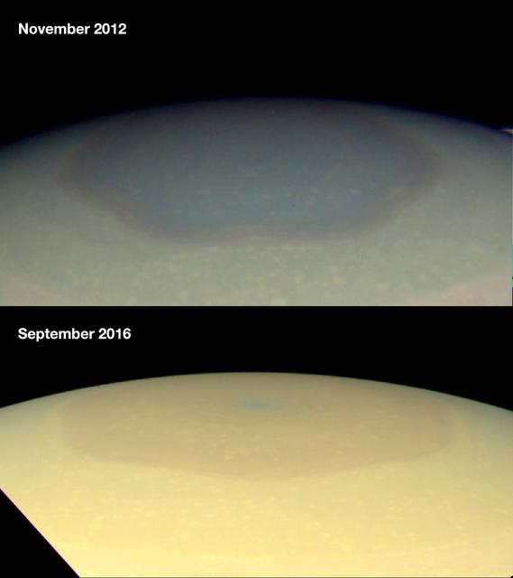
These two natural color images from NASA's Cassini spacecraft show the changing appearance of Saturn's north polar region between 2012 and 2016. Scientists are investigating potential causes for the change in color of the region inside the north-polar hexagon on Saturn. The color change is thought to be an effect of Saturn's seasons. In particular, the change from a bluish color to a more golden hue may be due to the increased production of photochemical hazes in the atmosphere as the north pole approaches summer solstice in May 2017. Researchers think the hexagon, which is a six-sided jetstream, might act as a barrier that prevents haze particles produced outside it from entering. During the polar winter night between November 1995 and August 2009, Saturn's north polar atmosphere became clear of aerosols produced by photochemical reactions -- reactions involving sunlight and the atmosphere. Since the planet experienced equinox in August 2009, the polar atmosphere has been basking in continuous sunshine, and aerosols are being produced inside of the hexagon, around the north pole, making the polar atmosphere appear hazy today. Other effects, including changes in atmospheric circulation, could also be playing a role. Scientists think seasonally shifting patterns of solar heating probably influence the winds in the polar regions. Both images were taken by the Cassini wide-angle camera. http://photojournal.jpl.nasa.gov/catalog/PIA21049
These gorgeous dunes are likely active, with ripples on their upwind slopes and dark streaks on their downwind slopes forming and changing due to wind-driven sand motion. Color has been enhanced to highlight the dunes. This motion will also keep the dune brink (the edge between the two slopes) and bottom edges sharply defined. The dark lines and squiggles on the dune slope are formed by passing dust devils. https://photojournal.jpl.nasa.gov/catalog/PIA22869
Technicians are pictured installing flaps and wiring on a flying-boat model, circa 1944 (page 47). Photograph published in Winds of Change, 75th Anniversary NASA publication, by James Schultz. Photograph also published in Engineer in Charge: A History of the Langley Aeronautical Laboratory, 1917-1958 by James R. Hansen (page 209). -- Photographed on: 04/24/1946.
This VIS image shows part of the floor of Rabe Crater. The floor of Rabe Crater has undergone several surface changing events. At some point after the crater was formed it was partially filled by a material laid down by wind or water action. This material has been eroded, creating a complex depression in the deposited material. The resultant sand has collected into the dunes seen in the image. Orbit Number: 75307 Latitude: -43.5769 Longitude: 34.3041 Instrument: VIS Captured: 2018-12-06 01:11 https://photojournal.jpl.nasa.gov/catalog/PIA23028
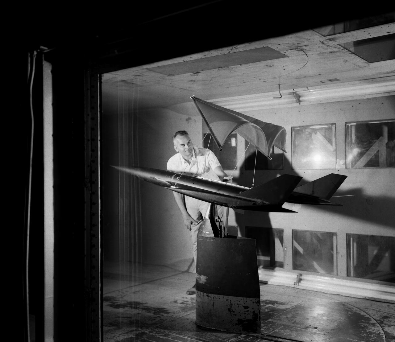
On June 26, 1959, then-Langley-research Francis Rogallo examined the Rogallo wing in the 7x10 FT Tunnel. Originally conceived as a means of bringing manned spacecraft to controlled, soft landings, Rogallo's concept was avidly embraced by later generations of hang-gliding enthusiasts. -- Photograph published in Winds of Change, 75th Anniversary NASA publication (page 18), by James Schultz.

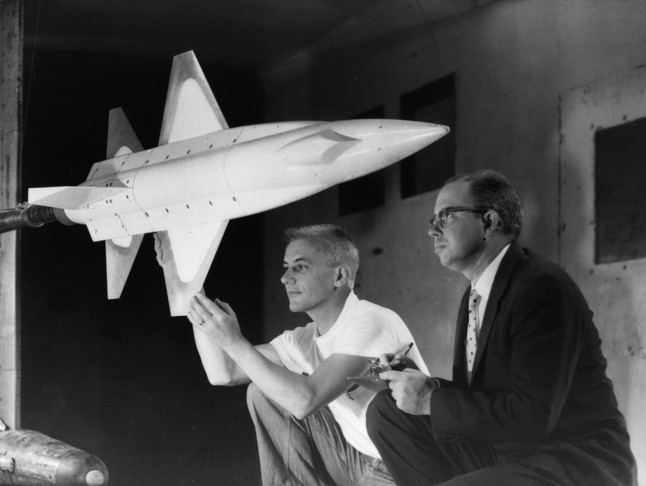
X-15 launch techniques were investigated using on-twentieth scale models mounted in the 7x10 FT Tunnel. -- Photograph published in Winds of Change, 75th Anniversary NASA publication (page 67), by James Schultz. -- Photograph also published in Sixty Years of Aeronautical Research 1917-1977 - a NASA publication (page 49), by David A. Anderton.
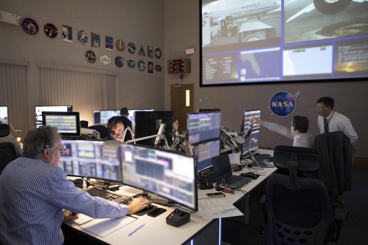
In the Mission Director's Center at Cape Canaveral Air Force Station, members of the launch team monitor the progress of preparations to launch eight Cyclone Global Navigation Satellite System, or CYGNSS, spacecraft. The CYGNSS satellites will make frequent and accurate measurements of ocean surface winds throughout the life cycle of tropical storms and hurricanes. The data that CYGNSS provides will enable scientists to probe key air-sea interaction processes that take place near the core of storms, which are rapidly changing and play a crucial role in the beginning and intensification of hurricanes.
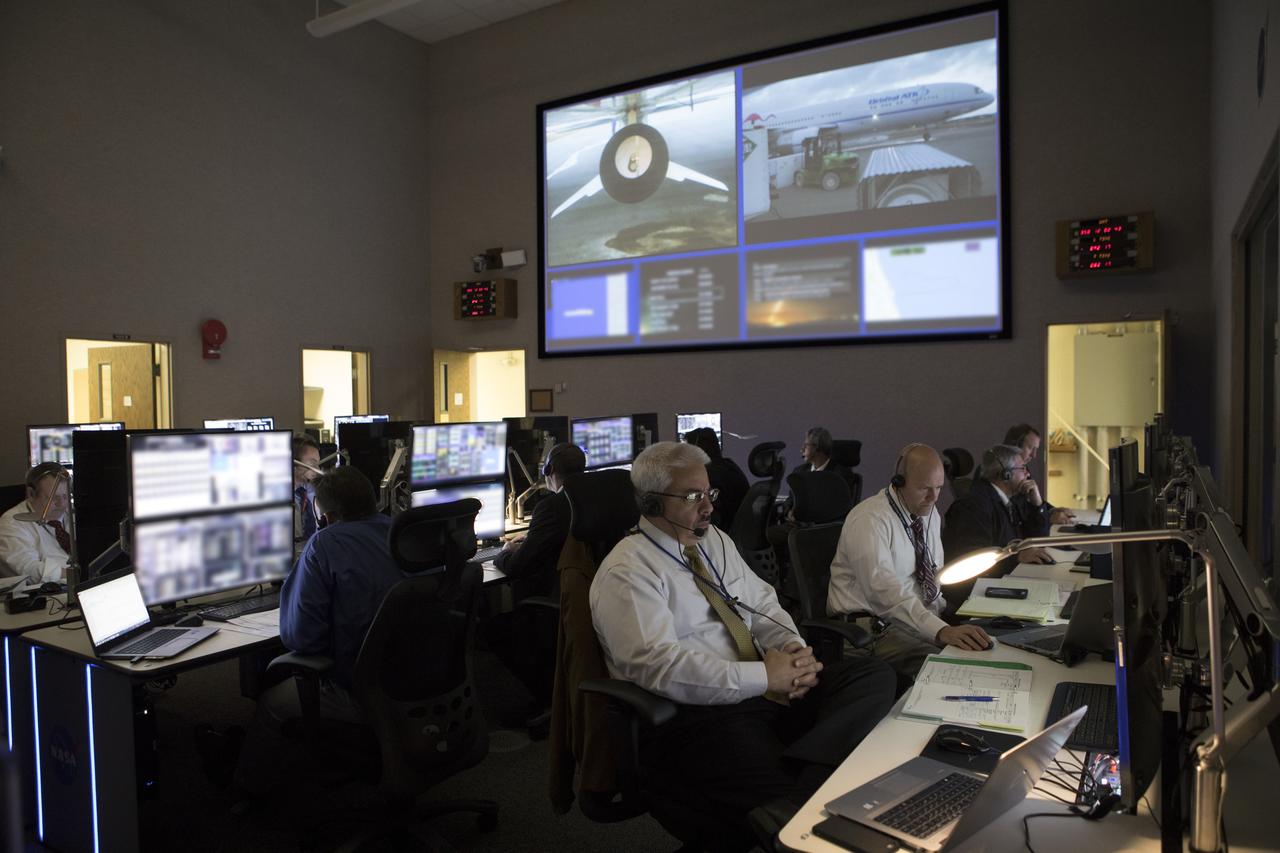
In the Mission Director's Center at Cape Canaveral Air Force Station, members of the launch team monitor the progress of preparations to launch eight Cyclone Global Navigation Satellite System, or CYGNSS, spacecraft. The CYGNSS satellites will make frequent and accurate measurements of ocean surface winds throughout the life cycle of tropical storms and hurricanes. The data that CYGNSS provides will enable scientists to probe key air-sea interaction processes that take place near the core of storms, which are rapidly changing and play a crucial role in the beginning and intensification of hurricanes.

Launching of the LJ6 Little Joe on Oct. 4, 1959 took place at Wallops Island, Va. This was the first attempt to launch an instrumented capsule with a Little Joe booster. Only the LJ1A and the LJ6 used the space metal chevron plates as heat reflector shields, as they kept shattering. Caption title ...and ascending skyward on a plume of exhaust. Photograph published in Winds of Change, 75th Anniversary NASA publication, page 77, by James Schultz
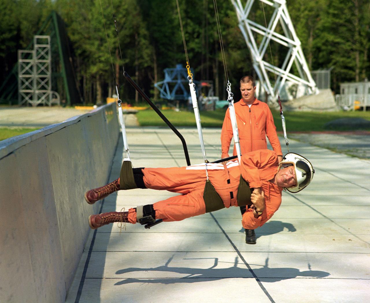
Walter Cronkite in the Reduced Gravity Simulator. Various views of Cronkite in the Lunar Landing Research Facility's Reduced Gravity Simulator which was used to train the astronauts for weightlessness. L68-8308 Caption: "During a 1968 visit to Langley, then CBS News Anchorman Walter Cronkite tries out the Reduced Gravity Simulator, a series of cable-supported slings designed to approximate the Moon's gravity, 1/6th that of Earth's." Photograph published in Winds of Change, 75th Anniversary NASA publication, p 91, by James Schultz.
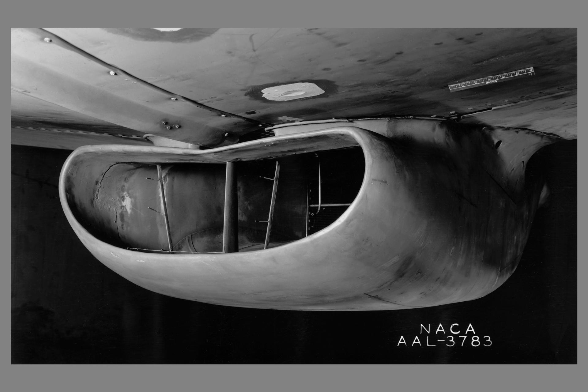
A portion of the North American P-51B airplane was tested in the 16-foot wind tunnel to devise a means of eliminating a rumble which occurred in the radiator duct system. The actual fuselage and center portion of the airplane was installed in the tunnel for this purpose as is shown. A change in the form of the duct was made and tested, which eliminated the rumble. The entrance to the original radiator duct is indicated in this photograph, and the revised form of the duct entrance in photographer AAL-3926.
As the air blows over the tops of the mountain peaks, seen here in the clear region, the direction of the air flow is disturbed. These disturbances in the flow pattern are generally small circular eddies with one circulating in a clockwise direction and the next in the reverse direction. The wind here has caused the shallow cloud cover to change accordingly. These eddies are commonly called von Karmen Vortices.
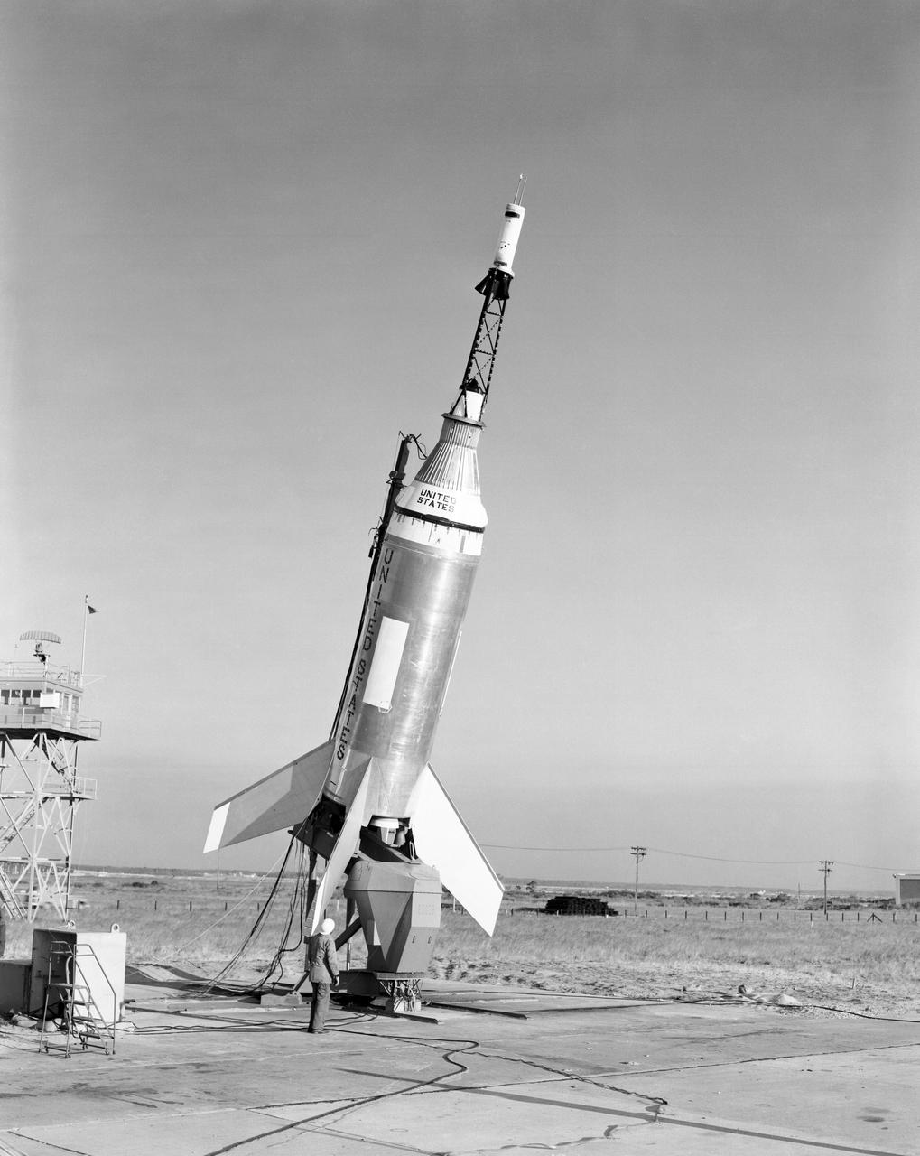
The Little Joe launch vehicle being readied for a test launch from Wallops in January 1960... Page 77. Photograph published in Winds of Change, 75th Anniversary NASA publication, by James Schultz. **note - see L59-5137 page 77 also. Photograph published in Engineer in Charge: A History of the Langley Aeronautical Laboratory, 1917-1958 by James R. Hansen. Page 389. ...was conceived by Langley engineers Max Faget and Paul Purser even before STG (Space Task Group) was organized.
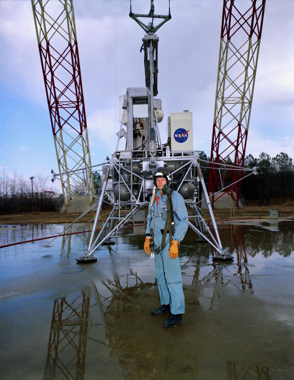
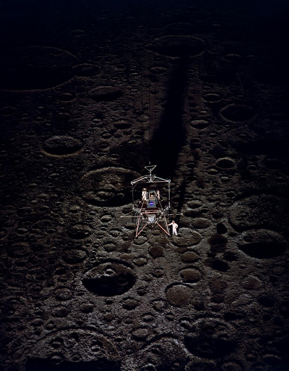
Neil Armstrong with the Lunar Excursion Module (LEM). Caption: "Not long after this photo was taken in front of the Lunar Landing Research Facility, astronaut Neil Armstrong became the first human to step upon the surface of the Moon." Photograph published in Winds of Change, 75th Anniversary NASA publication, by James Schultz, page 91. Also published in " A Century at Langley" by Joseph Chambers, pg. 95

In the Mission Director's Center at Cape Canaveral Air Force Station, members of the launch team monitor the progress of preparations to launch eight Cyclone Global Navigation Satellite System, or CYGNSS, spacecraft. The CYGNSS satellites will make frequent and accurate measurements of ocean surface winds throughout the life cycle of tropical storms and hurricanes. The data that CYGNSS provides will enable scientists to probe key air-sea interaction processes that take place near the core of storms, which are rapidly changing and play a crucial role in the beginning and intensification of hurricanes.
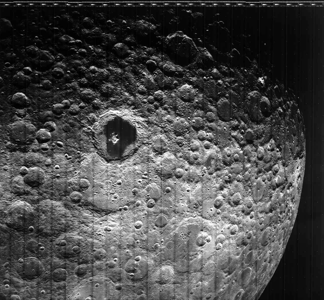
Moon Lunar Orbiter-Lunar Orbiter III: The hidden or dark side of the Moon was taken by Lunar Orbiter III During its mission to photograph potential lunar-landing sites for Apollo missions. -- Photograph published in Winds of Change, 75th Anniversary NASA publication (page 94), by James Schultz. Photo Number:67-H-328 is 1967-L-04026
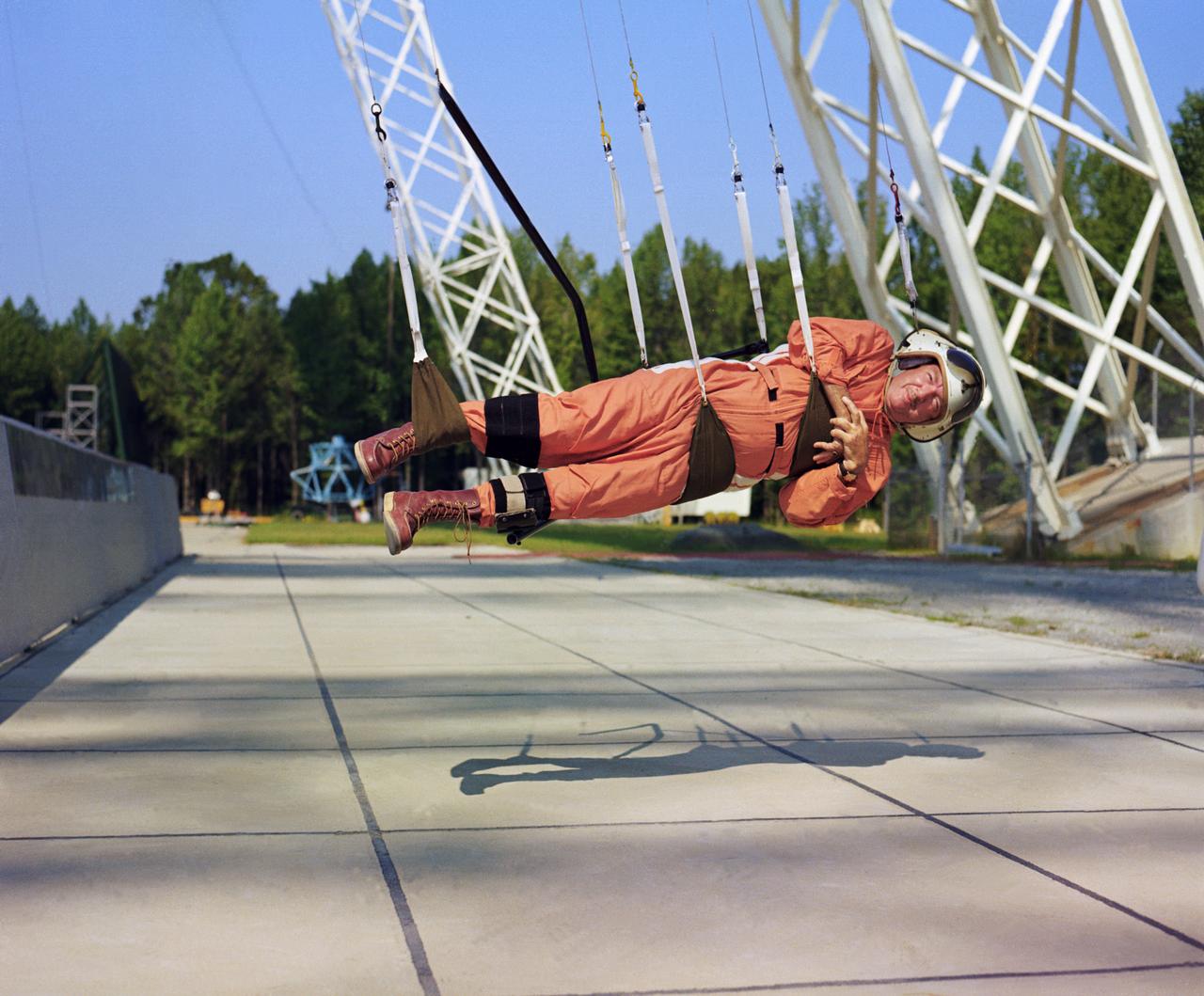
Walter Cronkite in the Reduced Gravity Simulator. Various views of Cronkite in the Lunar Landing Research Facility's Reduced Gravity Simulator which was used to train the astronauts for weightlessness. L68-8308 Caption: "During a 1968 visit to Langley, then CBS News Anchorman Walter Cronkite tries out the Reduced Gravity Simulator, a series of cable-supported slings designed to approximate the Moon's gravity, 1/6th that of Earth's." Photograph published in Winds of Change, 75th Anniversary NASA publication, p 91, by James Schultz.
This image is located in Meroe Patera (longitude: 292W/68E, latitude: 7.01), which is a small region within Syrtis Major Planitia. Syrtis Major is a low-relief shield volcano whose lava flows make up a plateau more than 1000 km across. These flows are of Hesperian age (Martian activity of intermediate age) and are believed to have originated from a series of volcanic depressions, called calderas. The caldera complex lies on extensions of the ring faults associated with the Isidis impact basin toward the northeast - thus Syrtis Major volcanism may be associated with post-impact adjustments of the Martian crust. The most striking feature in this image is the light streaks across the image that lead to dunes in the lower left region. Wind streaks are albedo markings interpreted to be formed by aeolian action on surface materials. Most are elongate and allow an interpretation of effective wind directions. Many streaks are time variable and thus provide information on seasonal or long-term changes in surface wind directions and strengths. The wind streaks in this image are lighter than their surroundings and are the most common type of wind streak found on Mars. These streaks are formed downwind from crater rims (as in this example), mesas, knobs, and other positive topographic features. The dune field in this image is a mixture of barchan dunes and transverse dunes. Dunes are among the most distinctive aeolian feature on Mars, and are similar in form to barchan and transverse dunes on Earth. This similarity is the best evidence to indicate that martian dunes are composed of sand-sized material, although the source and composition of the sand remain controversial. Both the observations of dunes and wind streaks indicate that this location has a windy environment - and these winds are persistent enough to product dunes, as sand-sized material accumulates in this region. These features also indicate that the winds in this region are originating from the right side of the image, and moving towards the left. http://photojournal.jpl.nasa.gov/catalog/PIA04012
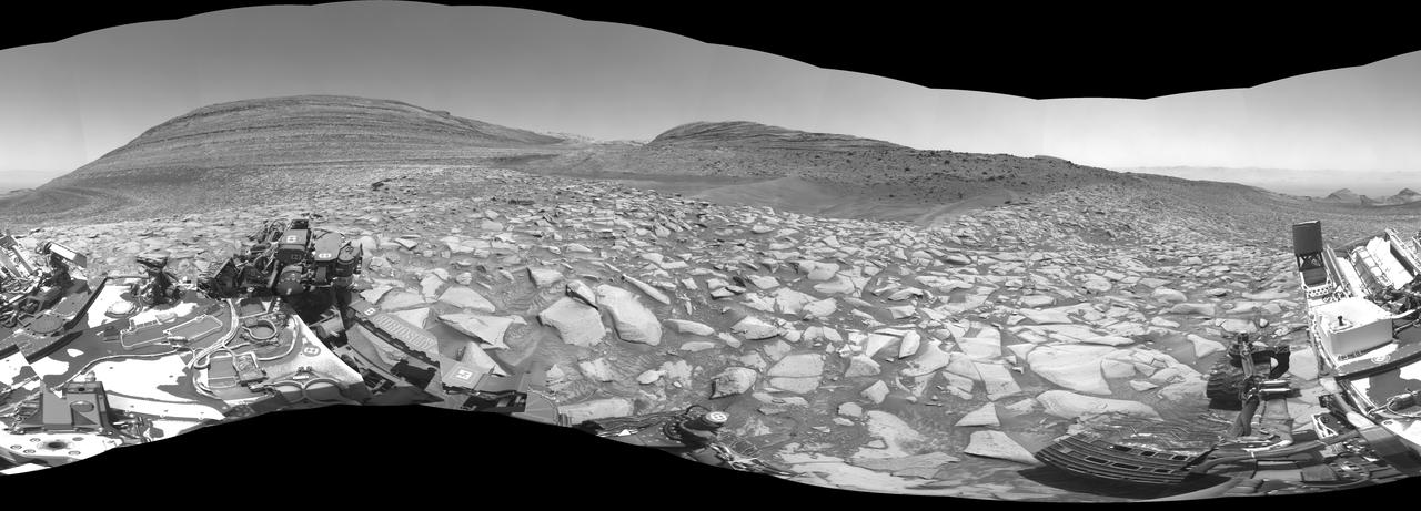
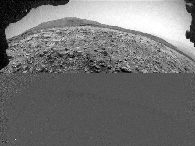
NASA's Curiosity Mars rover captured this 360-degree panorama using one of its black-and-white navigation cameras on Feb. 3, 2024, the 4,086th Martian day, or sol, of the mission. The panorama is made up of 36 images that were stitched together after being sent back to Earth. Since 2014, Curiosity has been ascending the foothills of Mount Sharp, which stands 3 miles (5 kilometers) above the floor of Gale Crater. The layers in this lower part of the mountain formed over millions of years under a changing Martian climate, providing scientists with a way to study how the presence of both water and the chemical ingredients required for life changed over time. This location is in an area Curiosity will be exploring for several months: Gediz Vallis channel. Seen from space, it resembles a winding, dry riverbed. Scientists are eager to study the area up close with Curiosity's instruments and confirm whether the channel was carved by debris flows (rapid, wet landslides) or an ancient river carrying rocks and sediment, as opposed to wind. https://photojournal.jpl.nasa.gov/catalog/PIA26246
This image from NASA's Mars Reconnaisance Orbiter (MRO) shows a dune field in Chasma Boreale, which is a large trough that cuts into the North Polar ice cap. Some of the dunes in this image are quite long and sinuous with a slight bulge at one end like a "head," giving it the appearance of a snake. However, most of the dunes visible here are of the type referred to as "barchan," which are characterized by their crescent shape. For these types of dunes, the "mouth" of the crescent points in the downwind direction, indicating that the winds are traveling east-west. The diverse dune morphologies here suggest that the wind-direction changes over a very small area. Because Mars has a similar axial tilt to Earth, it also experiences seasons. When we took this image, Mars was in late spring. At this time of year, the dunes in this image are almost completely covered by frost. But this will soon change! Small portions of the underlying dark basaltic sands of these dunes are becoming increasingly visible with the active removal of their seasonal coating of ice. A look at a series of images demonstrates the the transition from early to late spring, marked by defrosting and the gradual growth of dark spots. By summer, the dunes will be defrosted, and will appear completely black. https://photojournal.jpl.nasa.gov/catalog/PIA22053
This dune field formed near the base of the North Polar cap. Dunes require a source of loose particulate material to form. The source of the northern dune fields around the polar cap may be from the layers of dusty ice that are eroded by strong polar winds. This image was taken during the Martian northern summer, so there is no frost present on the dunes. The dunes closest to the base of the polar cap are long and parallel, indicating strong winds from the direction of the cap. As they get farther away from the polar cap, they start to form more crescent shaped dunes, called barchan dunes. Repeated observations by HiRISE of dunes like these show measurable changes in some locations. This discovery adds to the growing evidence that there are active processes happening all over the surface of Mars today. http://photojournal.jpl.nasa.gov/catalog/PIA11181
KENNEDY SPACE CENTER, FLA. -- At Cape Canaveral Air Force Station, the Delta II rocket with the THEMIS spacecraft atop awaits launch on Pad 17-B. Friday's launch attempt was scrubbed due to upper-level wind violation. The launch window is 6:01 p.m. to 6:19 p.m. EST on Saturday. THEMIS, an acronym for Time History of Events and Macroscale Interactions during Substorms, consists of five identical probes that will track violent, colorful eruptions near the North Pole. This will be the largest number of scientific satellites NASA has ever launched into orbit aboard a single rocket. The THEMIS mission aims to unravel the mystery behind auroral substorms, an avalanche of magnetic energy powered by the solar wind that intensifies the northern and southern lights. The mission will investigate what causes auroras in the Earth’s atmosphere to dramatically change from slowly shimmering waves of light to wildly shifting streaks of bright color. Photo credit: NASA/Kim Shiflett
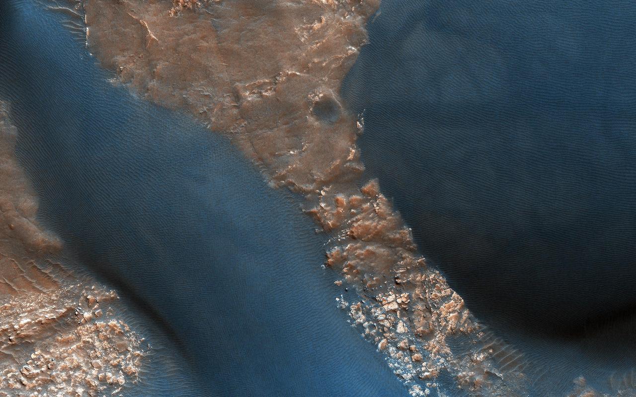
This image from NASA Mars Reconnaissance Orbiter spacecraft provides information about erosion and movement of surface material, about wind and weather patterns, even about the soil grains and grain sizes. However, looking past the dunes, these images also reveal the nature of the substrate beneath. Within the spaces between the dunes, a resistant and highly fractured surface is revealed. The fractured ground is resistant to erosion by the wind, and suggests the material is bedrock that is now shattered by a history of bending stresses or temperature changes, such as cooling, for example. Alternately, the surface may be a sedimentary layer that was once wet and shrunk and fractured as it dried, like gigantic mud cracks. In either case, the relative small and indistinct fractures have trapped the dark dune sand marching overhead. Now the fractures have become quite distinct, allowing us to examine the orientation and spacing of the fractures to learn more about the processes that formed them. http://photojournal.jpl.nasa.gov/catalog/PIA19958

While exploring Gediz Vallis channel, NASA's Curiosity Mars rover came across rocks that show a pale color near their edges. These rings of color changes, also called halos, resemble markings seen on Earth when groundwater leaks into rocks along fractures, causing chemical reactions that change the color. The markings were revealed over eons, after wind and sand eroded the debris pile. This panorama – captured by Curiosity's Mast Camera, or Mastcam, on May 7, 2024, the 4,178th Martian day, or sol, of the mission – is made up of 40 individual images that were stitched together after being sent back to Earth. The color has been adjusted to match lighting conditions as the human eye would see them on Earth. https://photojournal.jpl.nasa.gov/catalog/PIA26366
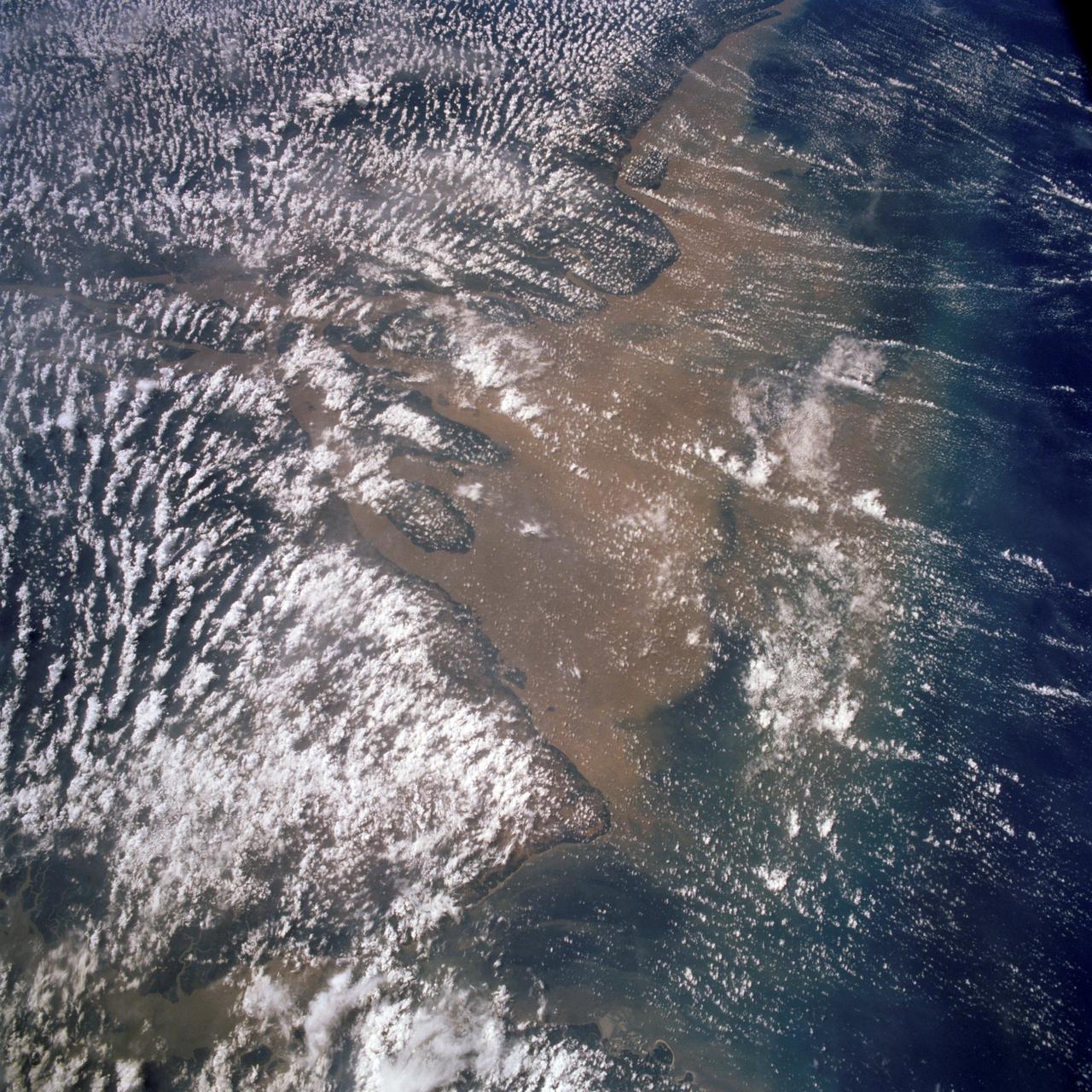
STS058-107-083 (18 Oct.-1 Nov. 1993) --- A near-nadir view of the mouth of the Amazon River, that shows all signs of being a relatively healthy system, breathing and exhaling. The well-developed cumulus field over the forested areas on both the north and south sides of the river (the view is slightly to the west) shows that good evapotranspiration is underway. The change in the cloud field from the moisture influx from the Atlantic (the cloud fields over the ocean are parallel to the wind direction) to perpendicular cloud fields over the land surface are normal. This change in direction is caused by the increased surface roughness over the land area. The plume of the river, although turbid, is no more or less turbid than it has been reported since the Portuguese first rounded Brasil's coast at the end of the 15th Century.
A mechanic checks the tubing on one of the many jacks which control the nozzle section of the 10- by 10-Foot Supersonic Wind Tunnel at the National Advisory Committee for Aeronautics (NACA) Lewis Flight Propulsion Laboratory. The 10- by 10-foot tunnel, which had its official opening in May 1956, was built under the Congressional Unitary Plan Act which coordinated wind tunnel construction at the NACA, Air Force, industry, and universities. The 10- by 10 was the largest of the three NACA tunnels built under the act. The 10- by 10 wind tunnel can be operated as a closed circuit for aerodynamic tests or as an open circuit for propulsion investigations. The 10-foot tall and 76-foot long stainless steel nozzle section just upstream from the test section can be adjusted to change the speed and composition of the air flow. Hydraulic jacks, seen in this photograph, flex the 1.37-inch thick walls of the tunnel nozzle. The size of the nozzle’s opening controls the velocity of the air through the test section. Seven General Electric motors capable of generating 25,000 horsepower produce the Mach 2.5 and 2.5 airflows. The facility was mostly operated at night due to its large power load requirements.
NASA's Ingenuity helicopter captured this view on Nov. 3, 2023, of its parking spot during Mars solar conjunction – a period when the Sun is between Earth and Mars, limiting communications. Ingenuity will use its color camera during this period to take time-lapse images of sand grains to learn more about how they move on the Red Planet. In the upper left of the image, one of the helicopter's legs is visible just out of frame. Just to the right of that is one of several "footprints" made before the helicopter lifted off on a previous flight to reposition itself. During conjunction, hot, ionized gas being expelled from the Sun's corona can potentially corrupt radio signals sent from Earth to NASA's fleet of Mars spacecraft, leading to unexpected behaviors. So, during this time, engineers don't send any commands, but the spacecraft do send their health data back to Earth. After conjunction, scientists will look through Ingenuity's imagery and see if any sand grains were blown by the wind. They plan to correlate this imagery with weather data collected by NASA's Perseverance rover, which is parked 3,471 feet (1,058 meters) away during conjunction. Wind and sand are major drivers of change on the Martian landscape, and scientists hope they will better understand these processes by studying the wind strength needed to lift sand particles. https://photojournal.jpl.nasa.gov/catalog/PIA26050

In the Mission Director's Center at Cape Canaveral Air Force Station, Kennedy Space Center Director Bob Cabana, right, congratulates, Omar Baez, a senior launch director in NASA's Launch Services Program, after the successful launch of eight Cyclone Global Navigation Satellite System, or CYGNSS, spacecraft. The satellites will make frequent and accurate measurements of ocean surface winds throughout the life cycle of tropical storms and hurricanes. The data that CYGNSS provides will enable scientists to probe key air-sea interaction processes that take place near the core of storms, which are rapidly changing and play a crucial role in the beginning and intensification of hurricanes.

In the Kennedy Space Center’s Press Site auditorium, NASA and industry leaders speak to members of the media during a prelaunch news conference for the agency’s Cyclone Global Navigation Satellite System, or CYGNSS, spacecraft. From left are: Tim Dunn, NASA launch director at Kennedy; and Bryan Baldwin, Pegasus launch vehicle program manager for Orbital ATK, Dulles, Virginia. The eight CYGNSS satellites will make frequent and accurate measurements of ocean surface winds throughout the life cycle of tropical storms and hurricanes. The data will help scientists probe key air-sea interaction processes that take place near the core of storms, which are rapidly changing and play a crucial role in the beginning and intensification of hurricanes.
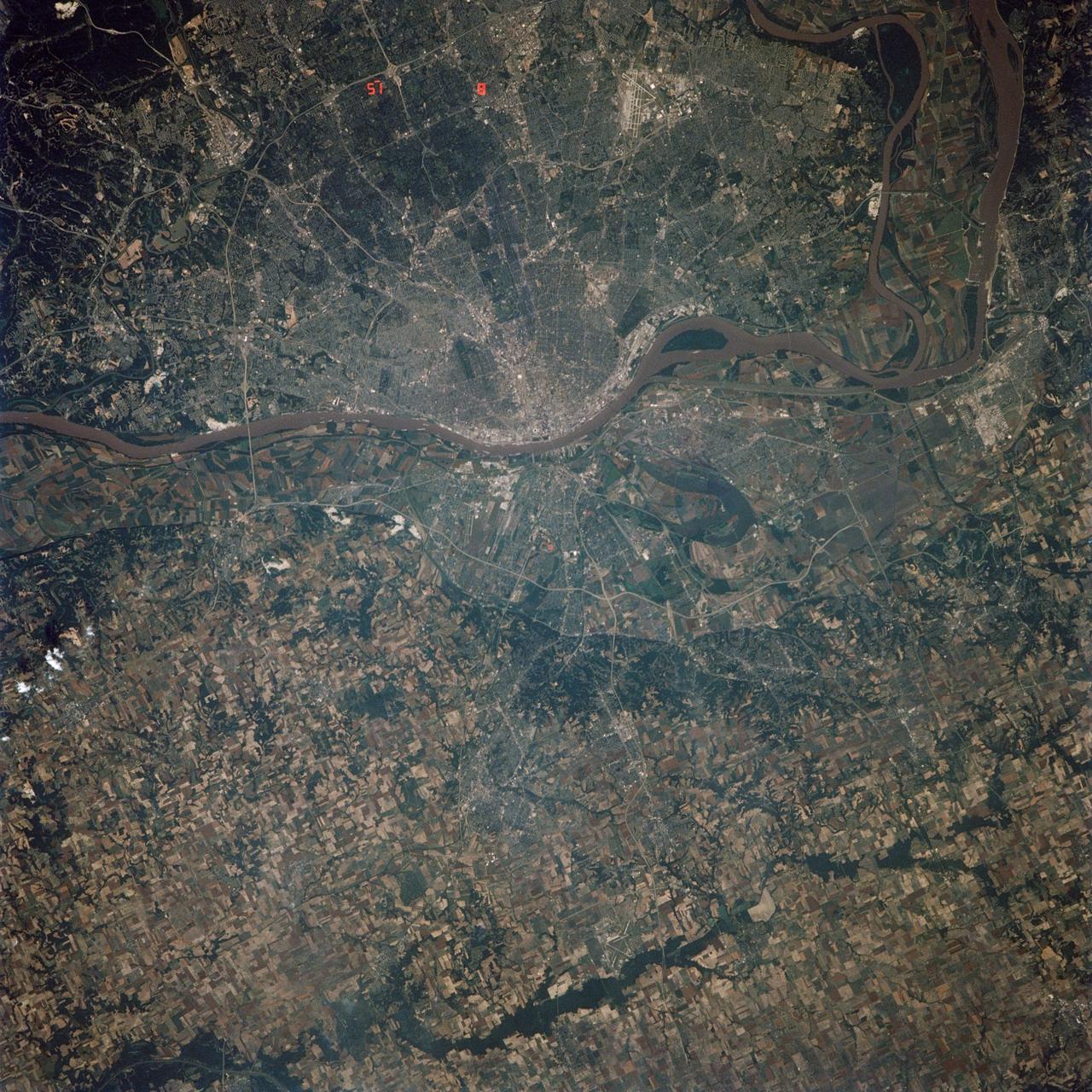
STS040-614-066 (5-14 June 1991) --- St. Louis, Missouri-East St. Louis, Illinois and surrounding area were photographed by the STS 40 crewmembers aboard the Space Shuttle Columbia. The winding Mississippi River serves as a reference point for finding features of the area. Busch Stadium is clearly seen. NASA photo experts studying the STS 40 imagery claim photographs of this type aid in following demographic changes and in planning for development. The ground track of STS-40 and the existence of exceptionally clear skies during much of the nine-day flight permitted photographic acquisition of several cities not generally seen from the space flights flying at 28-degree inclinations to the Equator.

In the Kennedy Space Center’s Press Site auditorium, NASA and industry leaders speak to members of the media during a prelaunch news conference for the agency’s Cyclone Global Navigation Satellite System, or CYGNSS, spacecraft. The model depicts the deployment module from which the eight micro-satellites will be deployed. In the background is Tim Dunn, NASA launch director at Kennedy. The CYGNSS satellites will make frequent and accurate measurements of ocean surface winds throughout the life cycle of tropical storms and hurricanes. The data will help scientists probe key air-sea interaction processes that take place near the core of storms, which are rapidly changing and play a crucial role in the beginning and intensification of hurricanes.
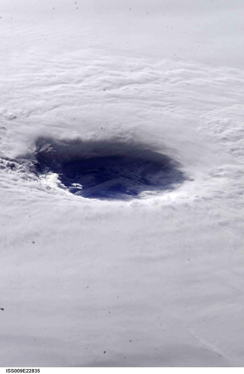
This image hosts a look into the eye of Hurricane Ivan, one of the strongest hurricanes on record, as the storm approached landfall on the central Gulf coast Wednesday afternoon on September 15, 2004. The hurricane was photographed by astronaut Edward M. (Mike) Fincke from aboard the International Space Station (ISS) at an altitude of approximately 230 miles. At the time, sustained winds in the eye of the wall were reported at about 135 mph as the downgraded category 4 storm approached the Alabama coast. Crew Earth Observations record Earth surface changes over time, as well as more fleeting events such as storms, floods, fires, and volcanic eruptions.
**Note also copied and numbered as L90-3749. -- L57-4827 caption: Take off of a five-stage missile research rocket from Wallops Island in 1957. The first two stages propelled the model to about 100,000 feet the last three stages were fired on a descending path to simulate the reentry conditions of ballistic missiles. -- Photograph published in Winds of Change, 75th Anniversary NASA publication (page 72), by James Schultz. -- Photograph also published in Engineer in Charge: A History of the Langley Aeronautical Laboratory, 1917-1958 by James R. Hansen (page 380).

In the Mission Director's Center at Cape Canaveral Air Force Station, Dana Allender, NASA Launch Operations manager, left, and Aly Mendoza-Hill, NASA Mission manager, monitor the progress of preparations to launch eight Cyclone Global Navigation Satellite System, or CYGNSS, spacecraft. The CYGNSS satellites will make frequent and accurate measurements of ocean surface winds throughout the life cycle of tropical storms and hurricanes. The data that CYGNSS provides will enable scientists to probe key air-sea interaction processes that take place near the core of storms, which are rapidly changing and play a crucial role in the beginning and intensification of hurricanes.
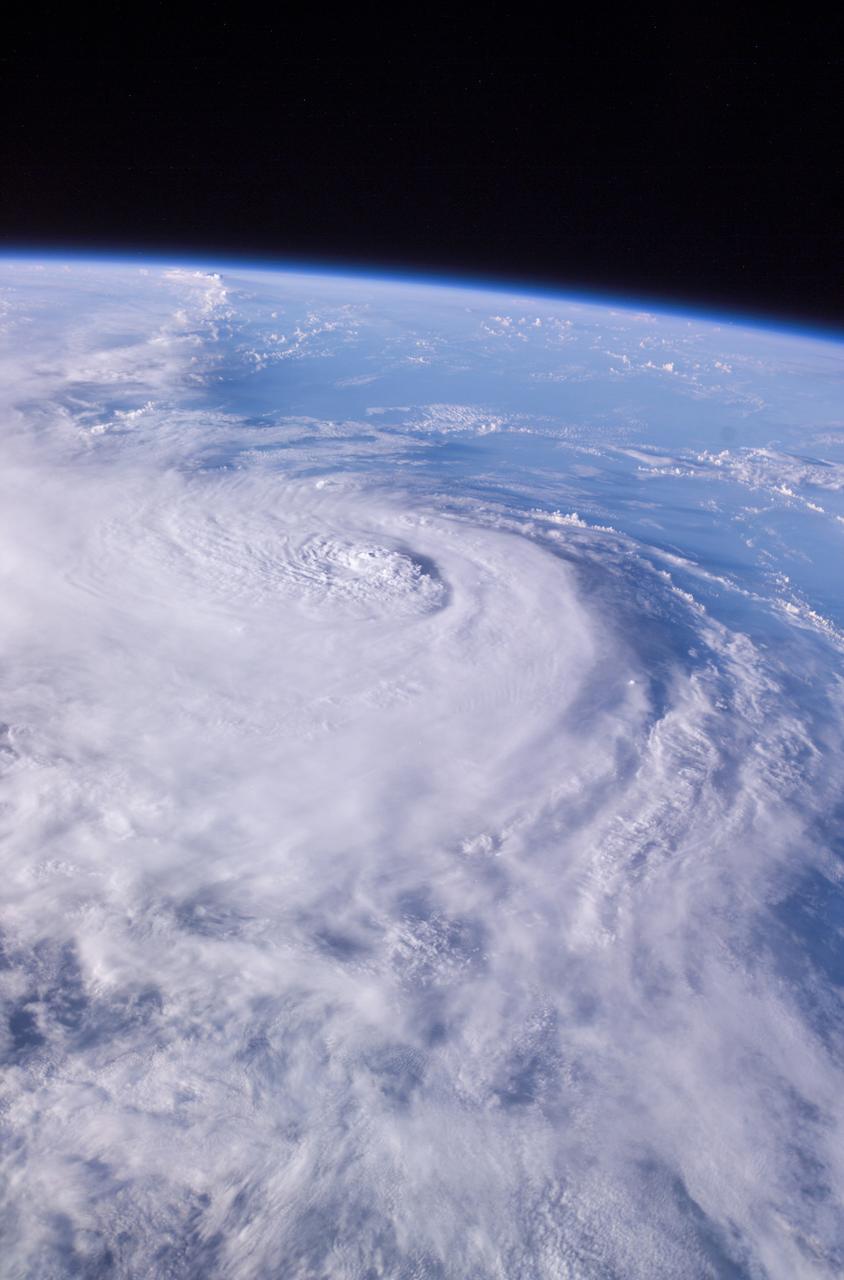
This panoramic view of Hurricane Charley was photographed by the Expedition 9 crew aboard the International Space Station (ISS) on August 13, 2004, at a vantage point just north of Tampa, Florida. The small eye was not visible in this view, but the raised cloud tops near the center coincide roughly with the time that the storm began to rapidly strengthen. The category 2 hurricane was moving north-northwest at 18 mph packing winds of 105 mph. Crew Earth Observations record Earth surface changes over time, as well as more fleeting events such as storms, floods, fires, and volcanic eruptions.
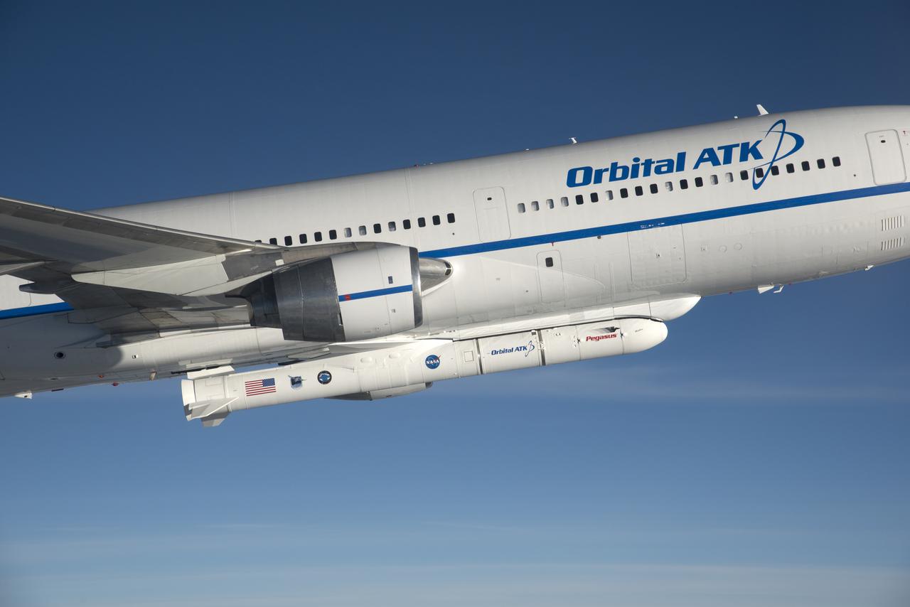
Photographed from the F-18 pathfinder aircraft, the Orbital ATK L-1011 Stargazer aircraft is seen flying over the Atlantic Ocean offshore from Daytona Beach, Florida. Attached beneath the aircraft is the Pegasus XL rocket with eight Cyclone Global Navigation Satellite System, or CYGNSS, spacecraft. The CYGNSS satellites will make frequent and accurate measurements of ocean surface winds throughout the life cycle of tropical storms and hurricanes. The data that CYGNSS provides will enable scientists to probe key air-sea interaction processes that take place near the core of storms, which are rapidly changing and play a crucial role in the beginning and intensification of hurricanes.

In the Kennedy Space Center’s Press Site auditorium, NASA and industry leaders speak to members of the media during a prelaunch news conference for the agency’s Cyclone Global Navigation Satellite System, or CYGNSS, spacecraft. From left are: Tim Dunn, NASA launch director at Kennedy; and Bryan Baldwin, Pegasus launch vehicle program manager for Orbital ATK, Dulles, Virginia. The eight CYGNSS satellites will make frequent and accurate measurements of ocean surface winds throughout the life cycle of tropical storms and hurricanes. The data will help scientists probe key air-sea interaction processes that take place near the core of storms, which are rapidly changing and play a crucial role in the beginning and intensification of hurricanes.
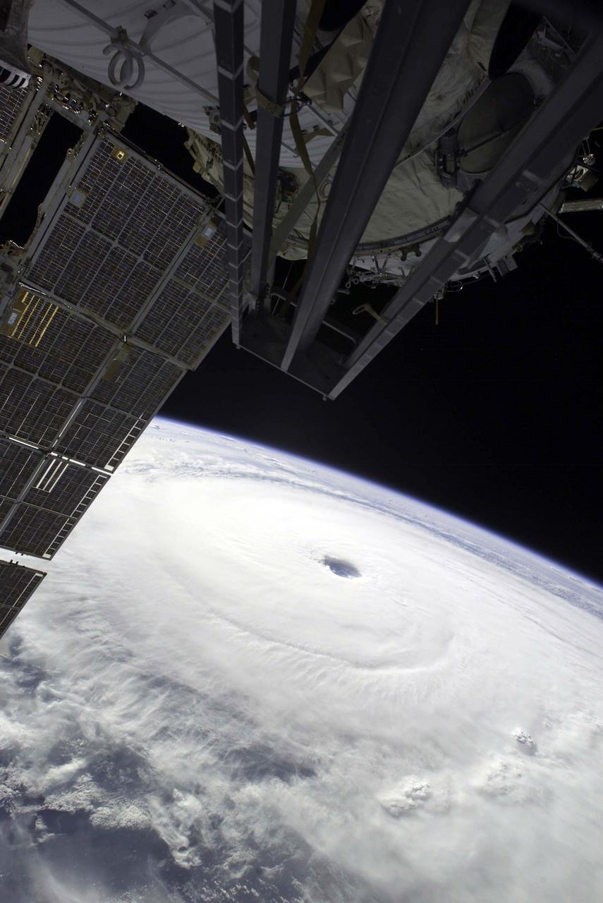
Except for a small portion of the International Space Station (ISS) in the foreground, Hurricane Ivan, one of the strongest hurricanes on record, fills this image over the northern Gulf of Mexico. As the downgraded category 4 storm approached landfall on the Alabama coast Wednesday afternoon on September 15, 2004, sustained winds in the eye of the wall were reported at about 135 mph. The hurricane was photographed by astronaut Edward M. (Mike) Fincke from aboard the ISS at an altitude of approximately 230 miles. Crew Earth Observations record Earth surface changes over time, as well as more fleeting events such as storms, floods, fires, and volcanic eruptions.

Photographed from the F-18 pathfinder aircraft, the Orbital ATK L-1011 Stargazer aircraft is seen flying over the Atlantic Ocean offshore from Daytona Beach, Florida. Attached beneath the aircraft is the Pegasus XL rocket with eight Cyclone Global Navigation Satellite System, or CYGNSS, spacecraft. The CYGNSS satellites will make frequent and accurate measurements of ocean surface winds throughout the life cycle of tropical storms and hurricanes. The data that CYGNSS provides will enable scientists to probe key air-sea interaction processes that take place near the core of storms, which are rapidly changing and play a crucial role in the beginning and intensification of hurricanes.

In the Mission Director's Center at Cape Canaveral Air Force Station, Greg Robinson, deputy associate administrator for Programs in the NASA Science Mission Directorate, right, congratulates, Tim Dunn, who was launch director for launch of eight Cyclone Global Navigation Satellite System, or CYGNSS, spacecraft. The satellites will make frequent and accurate measurements of ocean surface winds throughout the life cycle of tropical storms and hurricanes. The data that CYGNSS provides will enable scientists to probe key air-sea interaction processes that take place near the core of storms, which are rapidly changing and play a crucial role in the beginning and intensification of hurricanes.
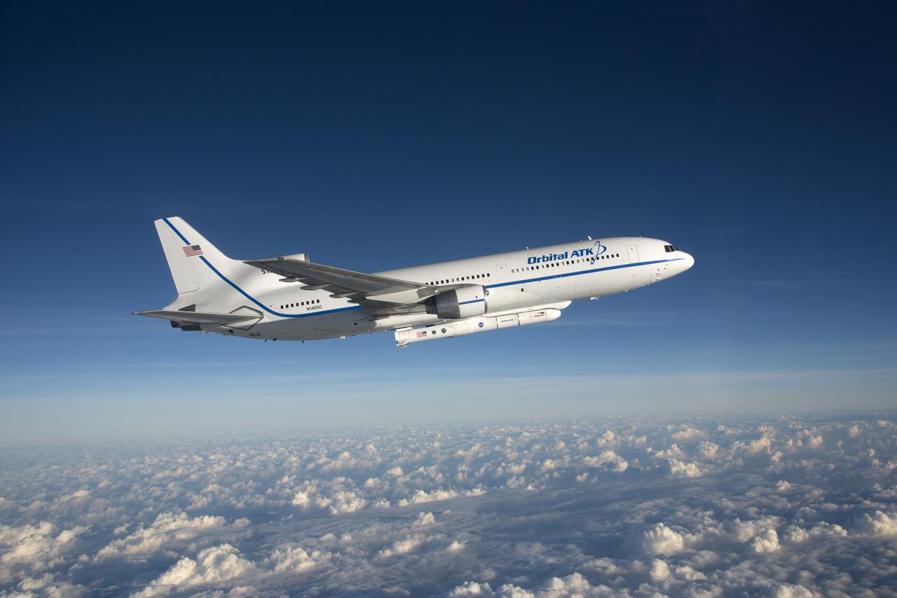
Photographed from the F-18 pathfinder aircraft, the Orbital ATK L-1011 Stargazer aircraft is seen flying over the Atlantic Ocean offshore from Daytona Beach, Florida. Attached beneath the aircraft is the Pegasus XL rocket with eight Cyclone Global Navigation Satellite System, or CYGNSS, spacecraft. The CYGNSS satellites will make frequent and accurate measurements of ocean surface winds throughout the life cycle of tropical storms and hurricanes. The data that CYGNSS provides will enable scientists to probe key air-sea interaction processes that take place near the core of storms, which are rapidly changing and play a crucial role in the beginning and intensification of hurricanes.
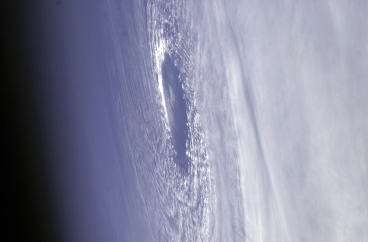
This image hosts a look at the eye of Hurricane Ivan, one of the strongest hurricanes on record, as the storm topped the western Caribbean Sea on Saturday, September 11, 2004. The hurricane was photographed by astronaut Edward M. (Mike) Fincke from aboard the International Space Station (ISS) at an altitude of approximately 230 miles. At the time, the category 5 storm sustained winds in the eye of the wall that were reported at about 160 mph. Crew Earth Observations record Earth surface changes over time, as well as more fleeting events such as storms, floods, fires, and volcanic eruptions.
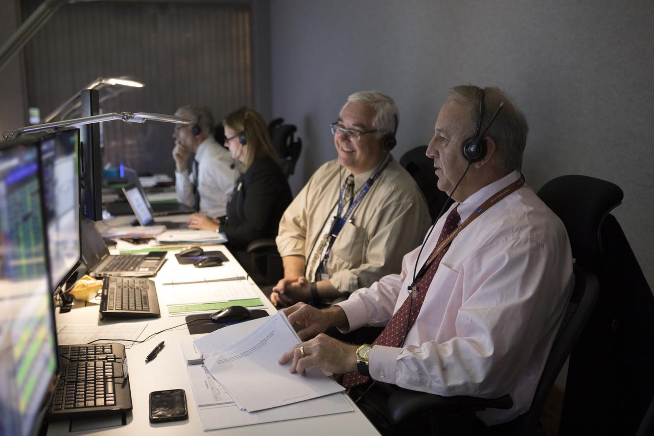
In the Mission Director's Center at Cape Canaveral Air Force Station, Andy Bundy, Avionics lead, left, and Pat Simpkins, director of Kennedy Space Center Engineering, monitor the progress of preparations to launch eight Cyclone Global Navigation Satellite System, or CYGNSS, spacecraft. The CYGNSS satellites will make frequent and accurate measurements of ocean surface winds throughout the life cycle of tropical storms and hurricanes. The data that CYGNSS provides will enable scientists to probe key air-sea interaction processes that take place near the core of storms, which are rapidly changing and play a crucial role in the beginning and intensification of hurricanes.
This color-infrared image shows sand dunes in Melas Chasma, located within the Valles Marineris canyon system. The dark-blue and purple colors indicate coarse-grained sands that are comprised of basalt, an iron and magnesium-rich volcanic rock that formed from cooled lava millions of years ago when volcanism was an active process on Mars. Migrating sand dunes often lead to the erosion and excavation of underlying material; regions where there are active dune fields are ideal places to search for exposed bedrock. Repeated imaging of dunes may also show changes that provide evidence for active surface processes related to wind patterns and climate. More information is available at https://photojournal.jpl.nasa.gov/catalog/PIA22783
Technicians at Astrotech Space Operations Facility near NASA’s Kennedy Space Center in Florida encapsulate NASA’s IMAP (Interstellar Mapping and Acceleration Probe), along with the agency’s Carruthers Geocorona Observatory and National Oceanic and Atmospheric Administration’s (NOAA) Space Weather Follow On–Lagrange 1 (SWFO-L1) spacecraft on Tuesday, Sept. 16, 2025, inside a SpaceX Falcon 9 payload fairing. The missions will each focus on different effects of the solar wind — the continuous stream of particles emitted by the Sun — and space weather — the changing conditions in space driven by the Sun — from their origins at the Sun to their farthest reaches billions of miles away at the edge of our solar system.
A SpaceX Falcon 9 rocket with NASA’s IMAP (Interstellar Mapping and Acceleration Probe), the agency’s Carruthers Geocorona Observatory, and National Oceanic and Atmospheric Administration’s (NOAA) Space Weather Follow On–Lagrange 1 (SWFO-L1) spacecraft atop stands vertical at Launch Complex 39A as the sun sets on Monday, Sept. 22, 2025, at the agency’s Kennedy Space Center in Florida. The missions will each focus on different effects of the solar wind — the continuous stream of particles emitted by the Sun — and space weather — the changing conditions in space driven by the Sun — from their origins at the Sun to their farthest reaches billions of miles away at the edge of our solar system.
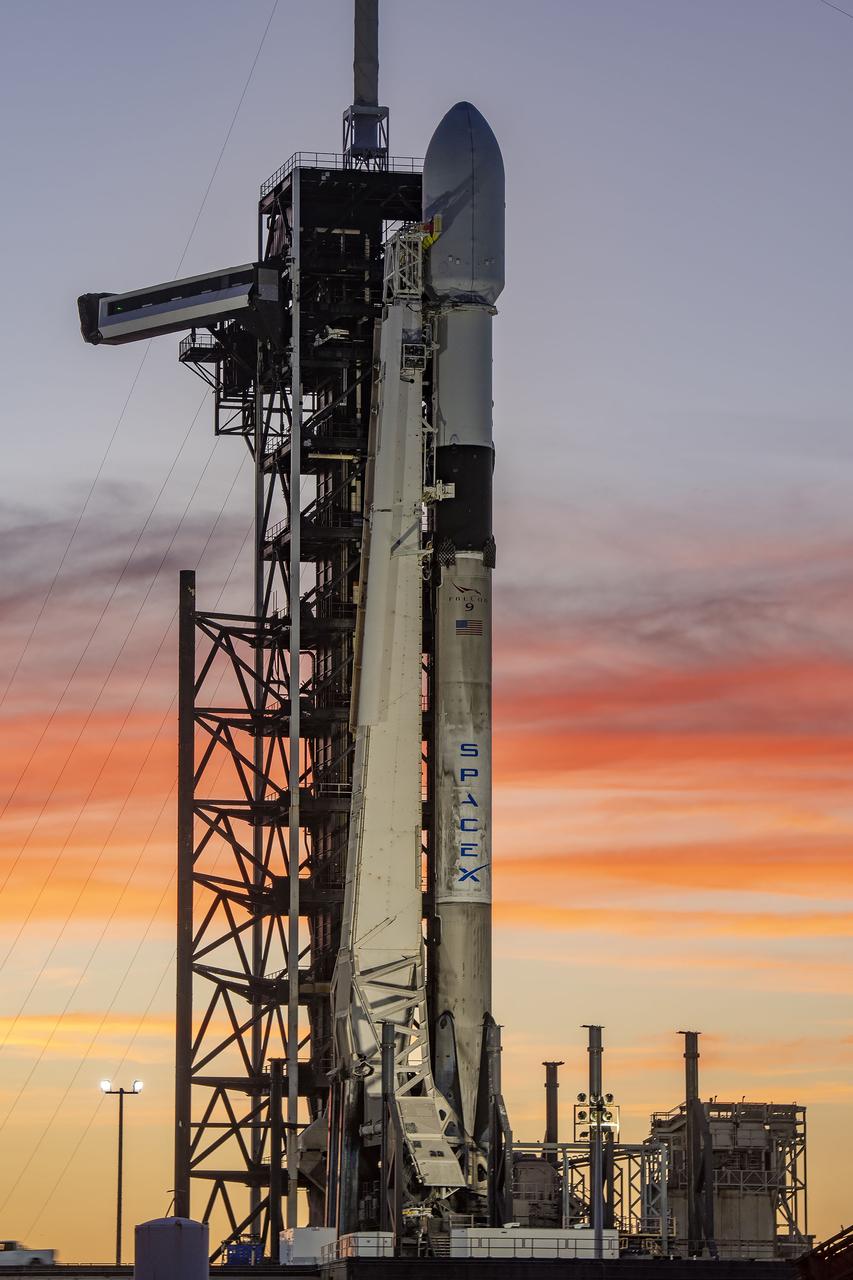
A SpaceX Falcon 9 rocket with NASA’s IMAP (Interstellar Mapping and Acceleration Probe), the agency’s Carruthers Geocorona Observatory, and National Oceanic and Atmospheric Administration’s (NOAA) Space Weather Follow On–Lagrange 1 (SWFO-L1) spacecraft atop stands vertical at Launch Complex 39A as the sun sets on Monday, Sept. 22, 2025, at the agency’s Kennedy Space Center in Florida. The missions will each focus on different effects of the solar wind — the continuous stream of particles emitted by the Sun — and space weather — the changing conditions in space driven by the Sun — from their origins at the Sun to their farthest reaches billions of miles away at the edge of our solar system.