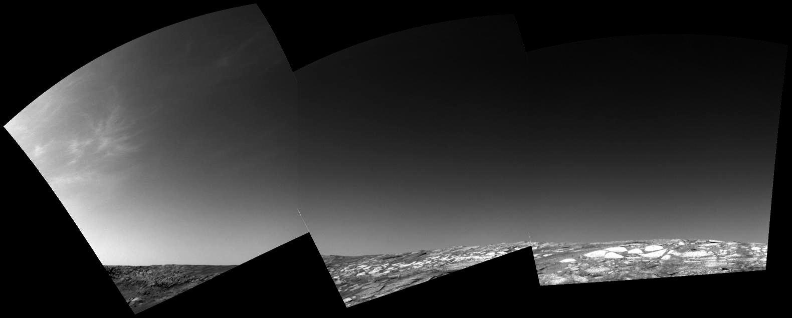
Clouds Roll in for Martian Winter
Winter Frost and Fog
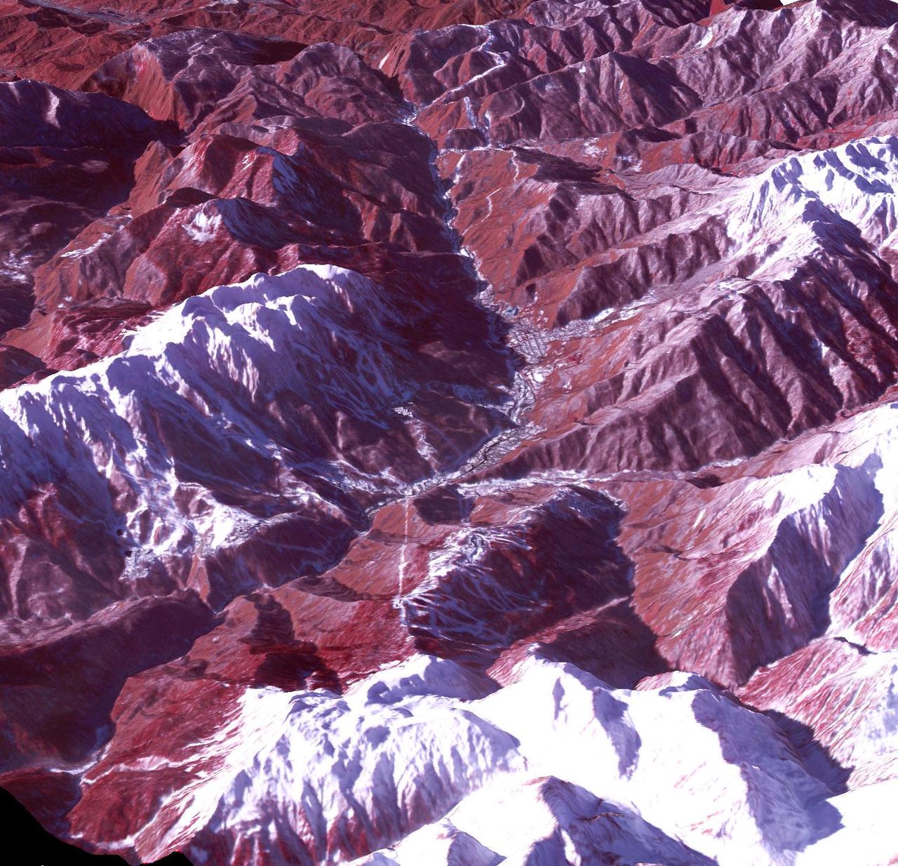
Winter Clouds Over Mie
Spirit Winter Home
Winter Morning in Northern Tharsis
Spirit Winter Work Site
Lyot Crater in Winter
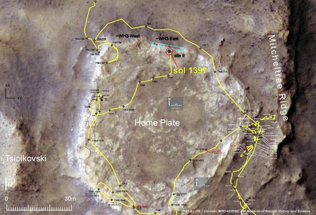
Heading for Next Winter Haven
Winter Frosted Dunes in Kaiser Crater
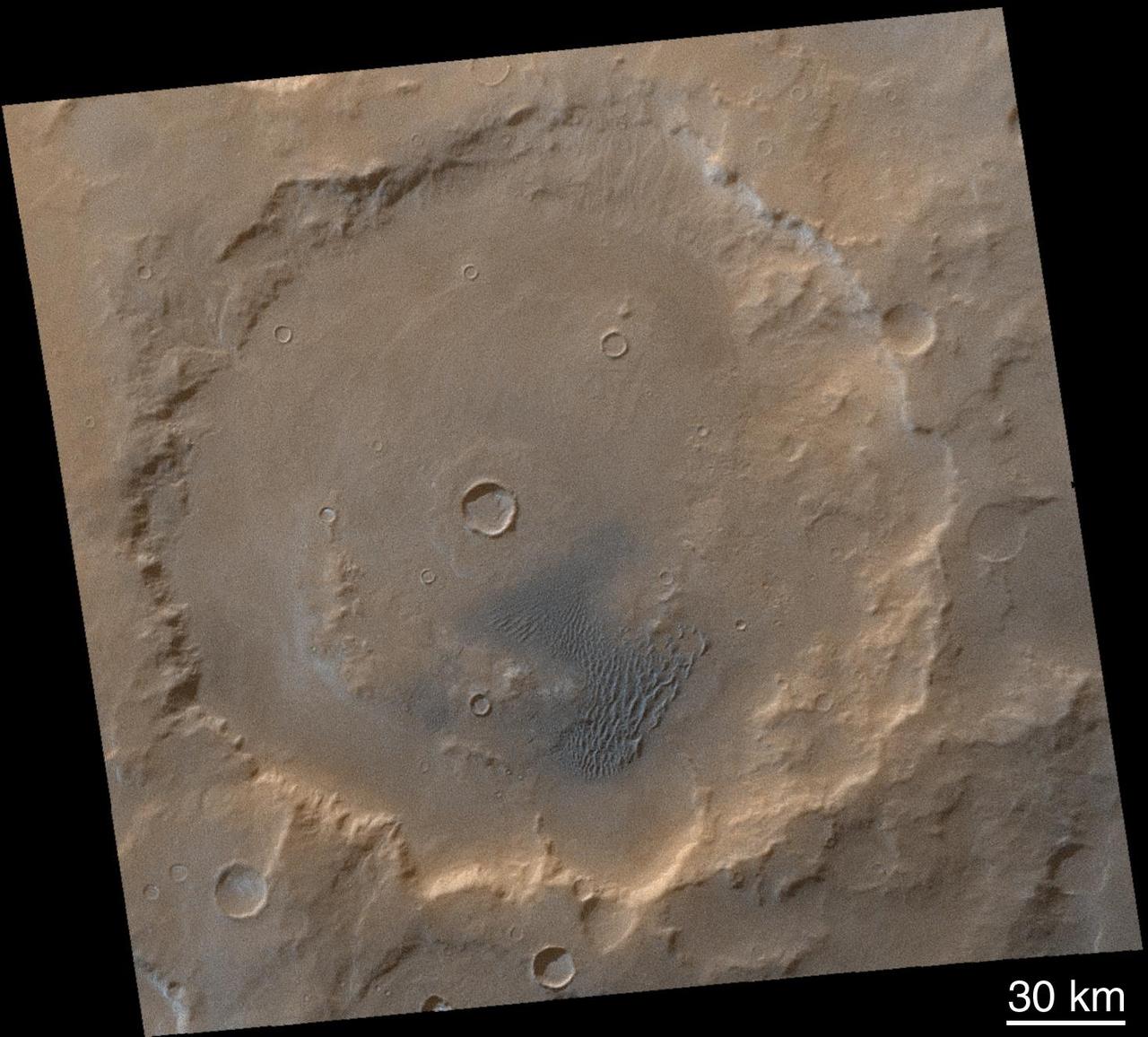
The Frosty Rims of Lomonosov Crater in Winter
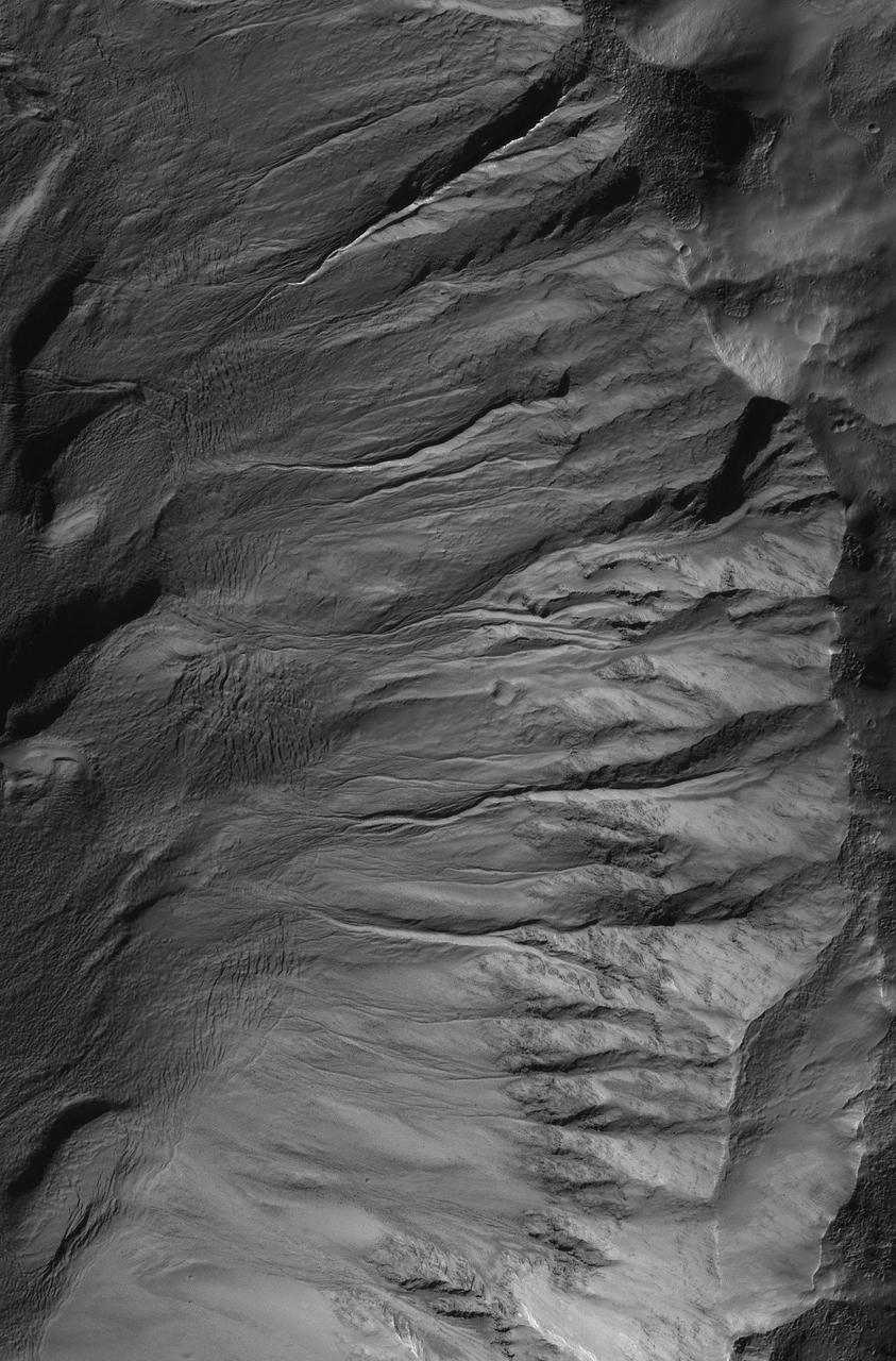
Sharp View of Gullies in Southern Winter
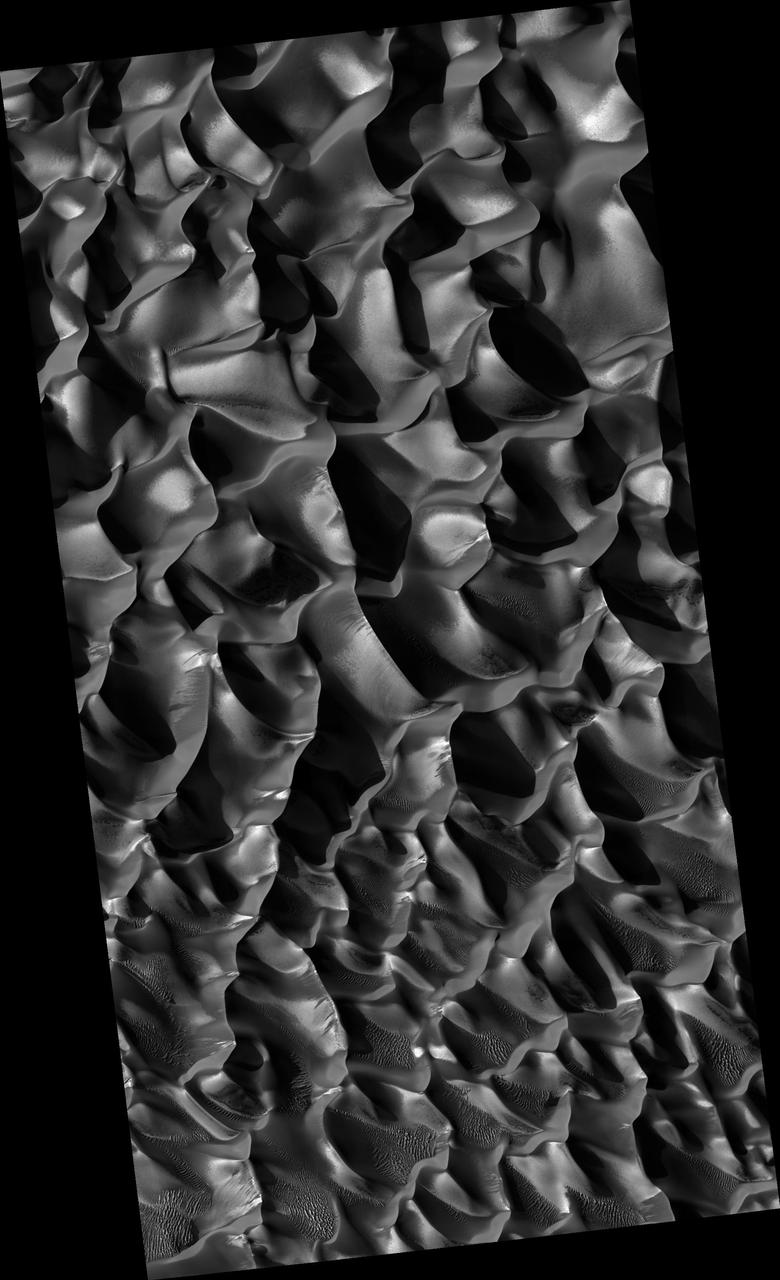
Winter View of Dunes in Proctor Crater
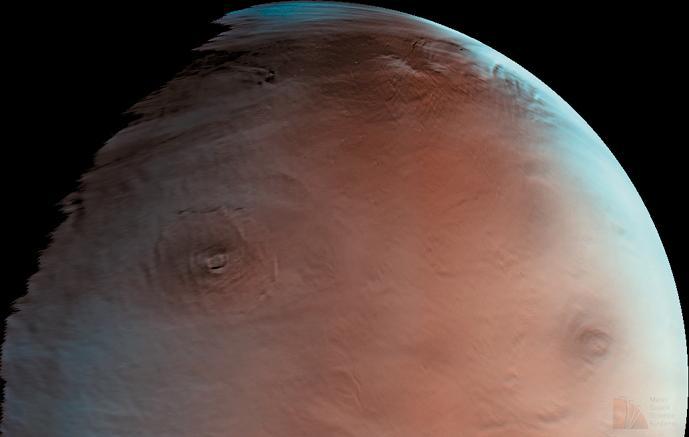
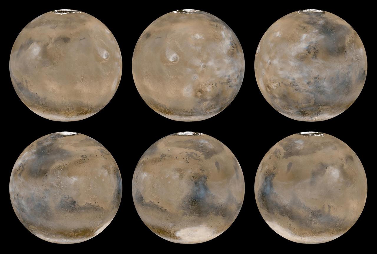
Winter in Mars North Polar Region
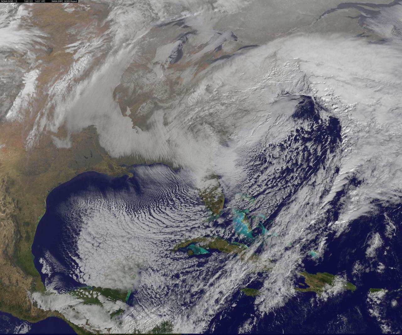
NASA satellite imagery captured the size of the massive winter storm that continued to pummel the U.S. East Coast early on January 23, 2016. This visible image of the major winter storm was taken from NOAA's GOES-East satellite on Saturday, January 23, 2016 at 1437 UTC (9:37 a.m. EST) as the Baltimore/Washington corridor was under a blizzard warning. Read more: <a href="http://go.nasa.gov/1RFv70u" rel="nofollow">go.nasa.gov/1RFv70u</a> Credits: NASA/NOAA GOES Project NASA Sees Winter Storm Slamming Eastern United States
On Nov. 12, NOAA's GOES satellite showed the storm system that brought wintry weather entire U.S. centered near Ontario, Canada. Snow is visible in the U.S. and Canadian Rockies. Read more: <a href="http://www.nasa.gov/content/goddard/new-satellite-movie-shows-us-pre-winter-wintry-outbreak/#.VGPP8t6FxgP" rel="nofollow">www.nasa.gov/content/goddard/new-satellite-movie-shows-us...</a> Image Credit: NASA/NOAA GOES Project
Winter Frosts of the Retreating South Polar Cap
Spirit Nears North-Tilting Site for Winter Haven
Defrosting Sand Dunes in Late Southern Winter
View Northward from Spirit Winter Roost
Mid-Winter Dust Storms Near Hellas Planitia
A Mid-Northern Summer/Southern Winter Mars
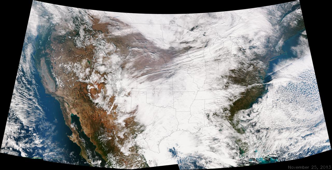
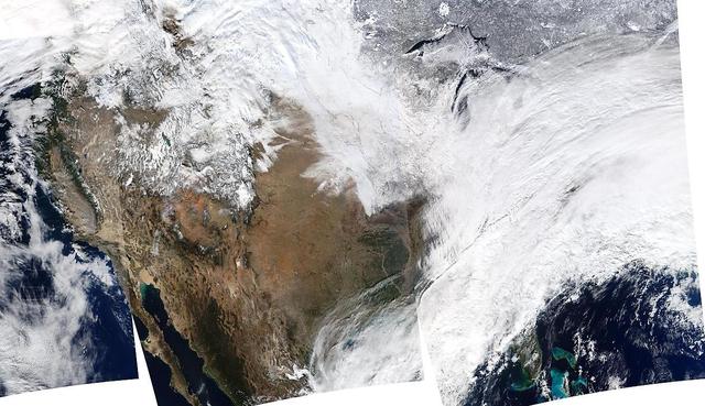
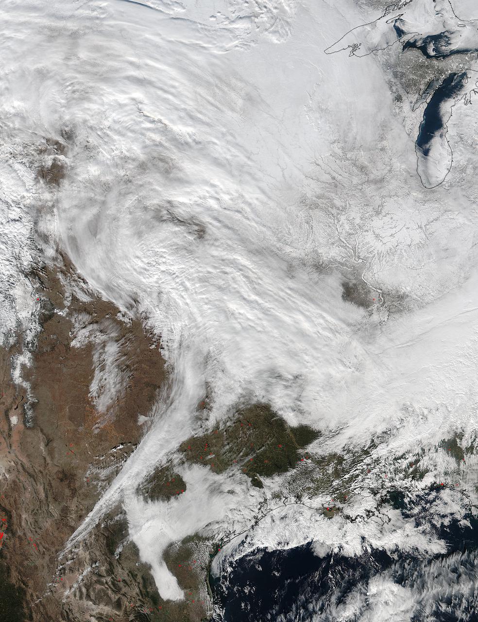
A large winter system is moving across the United States and is combining with cold air moving down from Canada, bringing snow to some areas. Major travel impacts are expected along the main highways throughout the eastern U.S. This true color image of the Continental U.S. was taken on November 25, 2013 by the Suomi NPP satellite and shows the system as it moves through the South and Midwest. <b><a href="http://www.nasa.gov/audience/formedia/features/MP_Photo_Guidelines.html" rel="nofollow">NASA image use policy.</a></b> <b><a href="http://www.nasa.gov/centers/goddard/home/index.html" rel="nofollow">NASA Goddard Space Flight Center</a></b> enables NASA’s mission through four scientific endeavors: Earth Science, Heliophysics, Solar System Exploration, and Astrophysics. Goddard plays a leading role in NASA’s accomplishments by contributing compelling scientific knowledge to advance the Agency’s mission. <b>Follow us on <a href="http://twitter.com/NASA_GoddardPix" rel="nofollow">Twitter</a></b> <b>Like us on <a href="http://www.facebook.com/pages/Greenbelt-MD/NASA-Goddard/395013845897?ref=tsd" rel="nofollow">Facebook</a></b> <b>Find us on <a href="http://instagrid.me/nasagoddard/?vm=grid" rel="nofollow">Instagram</a></b>
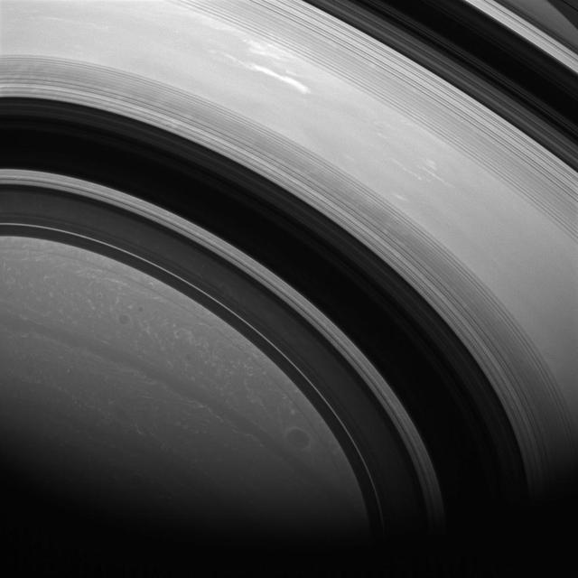
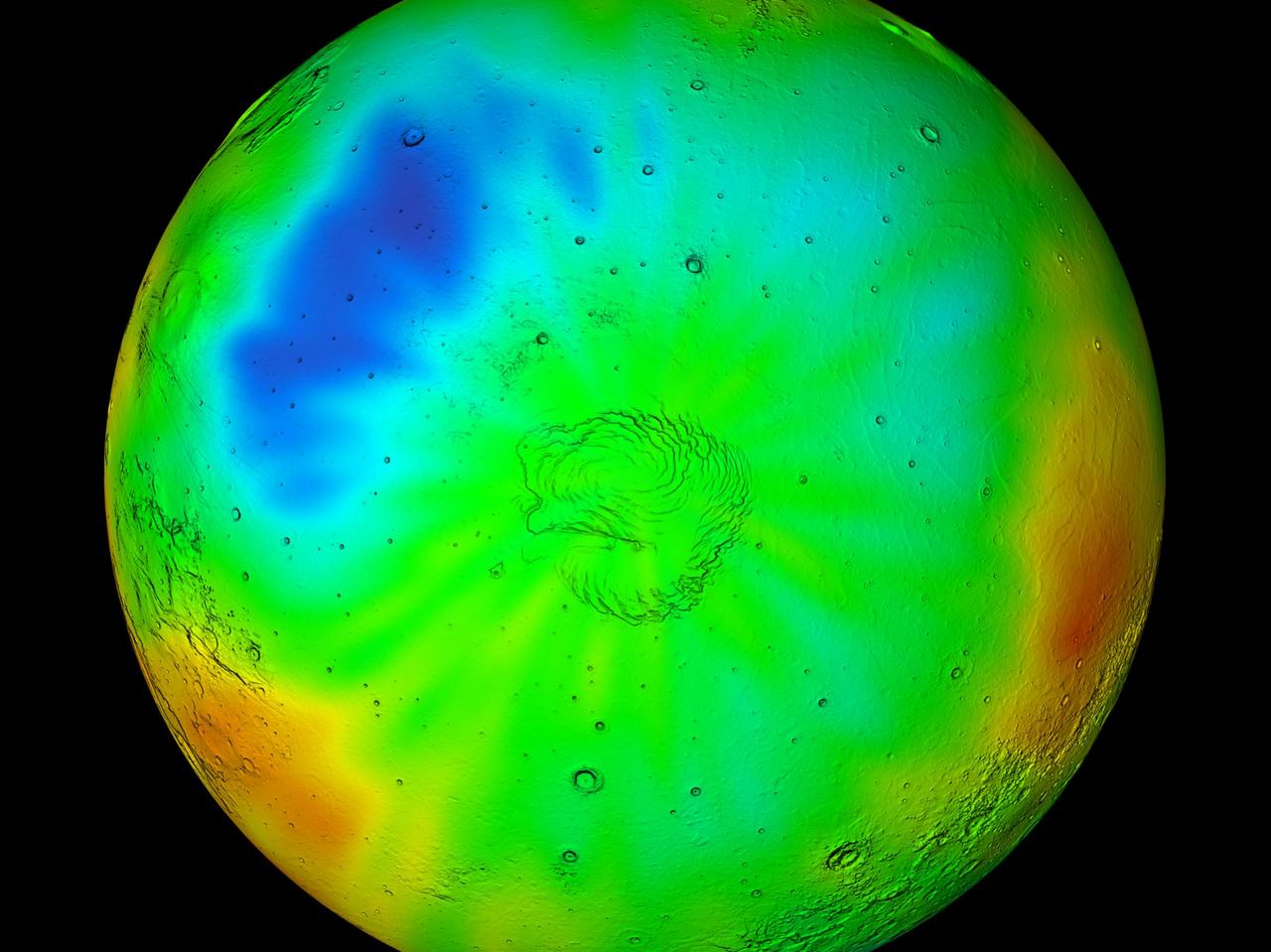
The shadows of Saturn rings edge ever farther southward as Saturn creeps towards southern winter or northern summer. Saturn is now almost exactly halfway between its equinox August 2009 and southern winter solstice in May 2017.
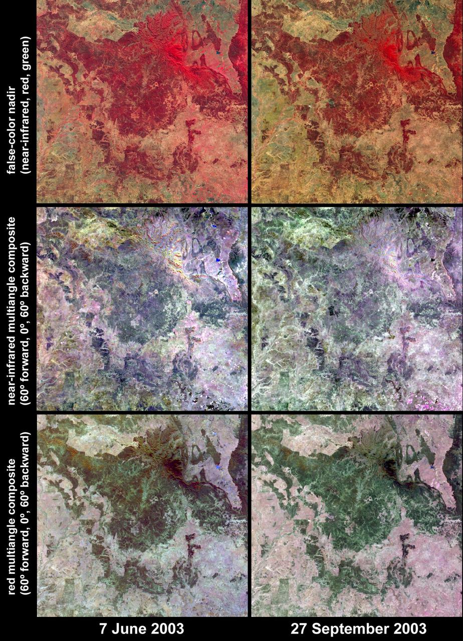
Austral winter and spring in Queensland Brigalow Belt as seen by NASA Terra spacecraft.
The 2014 Winter Olympic ski runs may be rated double black diamond, but theyre not quite as steep as they appear in this image acquired by NASA Terra spacecraft, of the skiing and snowboarding sites for the Sochi Winter Olympic Games.
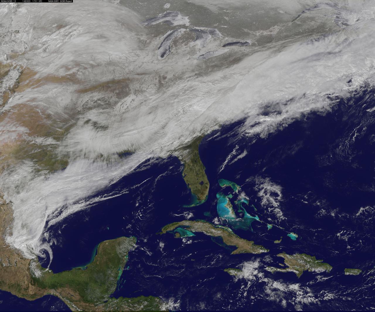
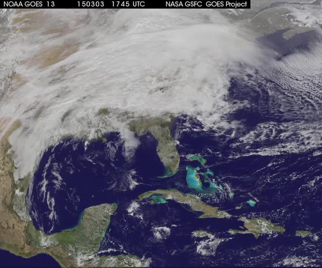
On March 3, a major winter storm brought snow to the mid-Atlantic, freezing rain to the Carolinas and rain and some freezing rain to the Gulf Coast states. NOAA's GOES-East satellite captured an image of the clouds associated with the winter storm on March 3 at 12:45 p.m. EST (1745 UTC)/ as it continued on its march over the mid-Atlantic. Bands of snow and sometimes heavy snow affected the Washington, D.C., region, Delaware and central Virginia, stretching west into West Virginia and eastern Kentucky. Snow also stretched back into the Ohio and Tennessee valleys while rain and freezing rain affected the Carolinas, and while the Gulf Coast states received rain. National Weather Service Winter Storm Warnings remained in effect until 6 p.m. EST on March 3 for Washington, D.C., and Baltimore, Md. In Richmond and Norfolk, Va., the Winter Storm warnings were in effect for six additional hours ending at midnight. On March 3, NOAA's National Weather Prediction Center in College Park, Md., noted the late-season winter storm will continue to shift eastward through the Tennessee Valley and the mid-Atlantic today, making for hazardous travel conditions. NOAA noted that unseasonably cold temperatures more typical of January will prevail east of the Rocky Mountains for the next few days keeping winter around for a while longer. The clouds are associated with a cold front that stretched from eastern Maine through Maryland and west into the Tennessee Valley. At NASA/NOAA's GOES Project at NASA's Goddard Space Flight Center in Greenbelt, Md., the cloud data from NOAA's GOES-East satellite were overlaid on a true-color image of land and ocean created by data from the Moderate Resolution Imaging Spectroradiometer, or MODIS, instrument that flies aboard NASA's Aqua and Terra satellites. Together, those data created the entire picture of the position of this major winter storm. GOES satellites provide the kind of continuous monitoring necessary for intensive data analysis. Geostationary describes an orbit in which a satellite is always in the same position with respect to the rotating Earth. This allows GOES to hover continuously over one position on Earth's surface, appearing stationary. As a result, GOES provide a constant vigil for the atmospheric "triggers" for severe weather conditions such as tornadoes, flash floods, hail storms and hurricanes. For updated information about the storm system, visit NOAA's NWS website: <a href="http://www.weather.gov" rel="nofollow">www.weather.gov</a> For more information about GOES satellites, visit: <a href="http://www.goes.noaa.gov/" rel="nofollow">www.goes.noaa.gov/</a> or goes.gsfc.nasa.gov/ Rob Gutro NASA's Goddard Space Flight Center, Greenbelt, Md. <b><a href="http://www.nasa.gov/audience/formedia/features/MP_Photo_Guidelines.html" rel="nofollow">NASA image use policy.</a></b> <b><a href="http://www.nasa.gov/centers/goddard/home/index.html" rel="nofollow">NASA Goddard Space Flight Center</a></b> enables NASA’s mission through four scientific endeavors: Earth Science, Heliophysics, Solar System Exploration, and Astrophysics. Goddard plays a leading role in NASA’s accomplishments by contributing compelling scientific knowledge to advance the Agency’s mission. <b>Follow us on <a href="http://twitter.com/NASAGoddardPix" rel="nofollow">Twitter</a></b> <b>Like us on <a href="http://www.facebook.com/pages/Greenbelt-MD/NASA-Goddard/395013845897?ref=tsd" rel="nofollow">Facebook</a></b> <b>Find us on <a href="http://instagram.com/nasagoddard?vm=grid" rel="nofollow">Instagram</a></b>
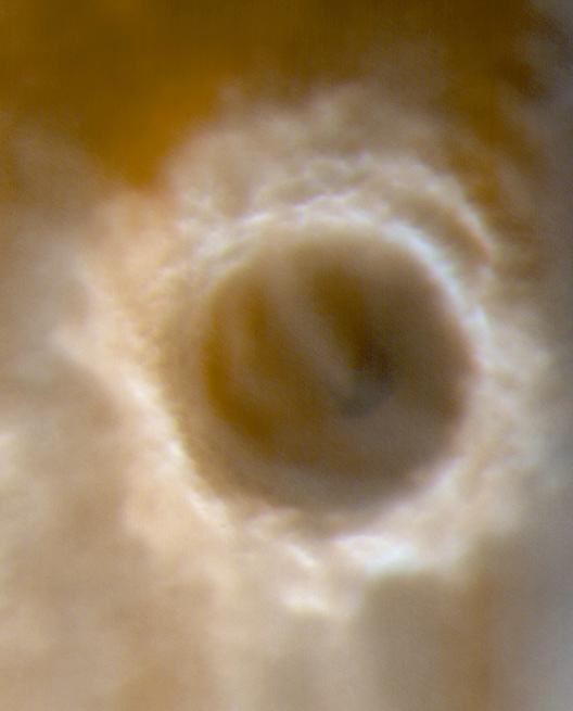
The High Resolution Imaging Science Experiment camera on NASA Mars Reconnaissance Orbiter captured winter images of NASA Phoenix Mars Lander surrounded by dry-ice frost on Mars.
This NASA Mars Odyssey image was taken during winter in the southern hemisphere, meaning that the usually cloudy Hellas Basin is relatively free from clouds.
On January 2, 2014, NASA’s Aqua satellite passed over the United States mutiple times showing winter weather, allowing the Moderate Resolution Imaging Spectroradiometer (MODIS) on board to capture this true-color image of a massive winter storm moving up the eastern seaboard. According to the National Weather Service the winter storm that impacted the Midwest and Northeast over the past couple of days is moving into the Atlantic Friday. Very cold temperatures and dangerous wind chills are moving in behind the system. The next storm is forming, and will bring blizzard conditions to the northern Plains Friday Night into Saturday. Extreme wind chills to -55 F are possible in the northern Plains this weekend. Credit: NASA/GSFC/Aqua/MODIS <b><a href="http://www.nasa.gov/audience/formedia/features/MP_Photo_Guidelines.html" rel="nofollow">NASA image use policy.</a></b> <b><a href="http://www.nasa.gov/centers/goddard/home/index.html" rel="nofollow">NASA Goddard Space Flight Center</a></b> enables NASA’s mission through four scientific endeavors: Earth Science, Heliophysics, Solar System Exploration, and Astrophysics. Goddard plays a leading role in NASA’s accomplishments by contributing compelling scientific knowledge to advance the Agency’s mission. <b>Follow us on <a href="http://twitter.com/NASA_GoddardPix" rel="nofollow">Twitter</a></b> <b>Like us on <a href="http://www.facebook.com/pages/Greenbelt-MD/NASA-Goddard/395013845897?ref=tsd" rel="nofollow">Facebook</a></b> <b>Find us on <a href="http://instagrid.me/nasagoddard/?vm=grid" rel="nofollow">Instagram</a></b>
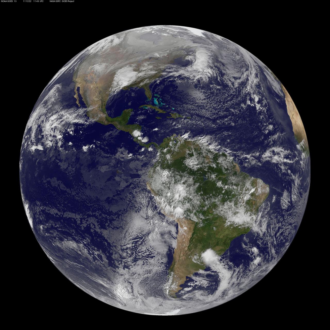
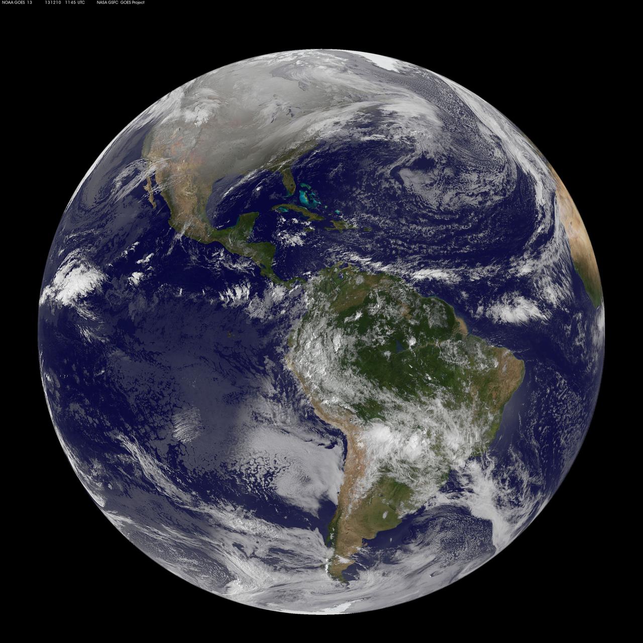
Image acquired December 22, 2011 NOAA's GOES-13 satellite captured this image of Earth on the first day of the winter solstice, December 22, 2011 at 11:45 UTC. The GOES-13 cloud images are overlaid on a true-color NASA/MODIS map by the NASA/NOAA GOES Project at NASA's Goddard Space Flight Center in Greenbelt, Md. <b><a href="http://goes.gsfc.nasa.gov/" rel="nofollow">Credit: NOAA/NASA GOES Project</a></b> <b><a href="http://www.nasa.gov/audience/formedia/features/MP_Photo_Guidelines.html" rel="nofollow">NASA image use policy.</a></b> <b><a href="http://www.nasa.gov/centers/goddard/home/index.html" rel="nofollow">NASA Goddard Space Flight Center</a></b> enables NASA’s mission through four scientific endeavors: Earth Science, Heliophysics, Solar System Exploration, and Astrophysics. Goddard plays a leading role in NASA’s accomplishments by contributing compelling scientific knowledge to advance the Agency’s mission. <b>Follow us on <a href="http://twitter.com/NASA_GoddardPix" rel="nofollow">Twitter</a></b> <b>Like us on <a href="http://www.facebook.com/pages/Greenbelt-MD/NASA-Goddard/395013845897?ref=tsd" rel="nofollow">Facebook</a></b> <b>Find us on <a href="http://instagrid.me/nasagoddard/?vm=grid" rel="nofollow">Instagram</a></b>
A winter storm that moved through the Mid-Atlantic on Feb. 16 and 17, 2015 extended the northeastern U.S. snowcover farther south. Until this storm hit, southern New Jersey and southeastern Pennsylvania appeared snow-free on satellite imagery from the previous week. The overnight storm blanketed the entire states of New Jersey and Pennsylvania, as seen on this Feb. 16 image. The image was taken from the MODIS or Moderate Resolution Imaging Spectroradiometer instrument that flies aboard NASA's Terra satellite. The snow cover from the storm actually extended even farther south than the image. Snowfall also blanketed West Virginia, Kentucky, Maryland, Delaware and Virginia, while freezing rain and icy conditions affected the Carolinas, Tennessee and Georgia. On Feb. 17, 2015, NOAA's National Weather Service noted "The winter storm that brought widespread snow, sleet and freezing rain to parts of the south-central U.S. and Mid-Atlantic will wind down as it moves offshore Tuesday. Lingering snow and freezing rain is possible early Tuesday for parts of the Northeast and mid-Atlantic, with rain across parts of the Southeast." Credit: NASA/GSFC/Jeff Schmaltz/MODIS Land Rapid Response Team <b><a href="http://www.nasa.gov/audience/formedia/features/MP_Photo_Guidelines.html" rel="nofollow">NASA image use policy.</a></b> <b><a href="http://www.nasa.gov/centers/goddard/home/index.html" rel="nofollow">NASA Goddard Space Flight Center</a></b> enables NASA’s mission through four scientific endeavors: Earth Science, Heliophysics, Solar System Exploration, and Astrophysics. Goddard plays a leading role in NASA’s accomplishments by contributing compelling scientific knowledge to advance the Agency’s mission. <b>Follow us on <a href="http://twitter.com/NASAGoddardPix" rel="nofollow">Twitter</a></b> <b>Like us on <a href="http://www.facebook.com/pages/Greenbelt-MD/NASA-Goddard/395013845897?ref=tsd" rel="nofollow">Facebook</a></b> <b>Find us on <a href="http://instagram.com/nasagoddard?vm=grid" rel="nofollow">Instagram</a></b>
Winter arrived officially on Dec. 22 at 12:35 a.m. EST, but the U.S. Plains states received an early and cool welcome on Dec. 19 from heavy snowfall that was seen by a NASA satellite. NASA's Aqua satellite passed overhead on Dec. 21 at 20:05 UTC (3:05 p.m. EST) and the Moderate Resolution Imaging Spectroradiometer (MODIS) instrument aboard NASA's Aqua satellite captured a visible image of snow blanketing the ground through west and central Kansas, eastern and central Colorado, much of New Mexico, northern Texas and the panhandle of Oklahoma. According to CBS News, blizzard conditions were reported in northern New Mexico, the Texas Panhandle, Oklahoma and northwestern Kansas. The Associated Press reported snow drifts as high as 10 feet in southeast Colorado. Six people lost their lives in traffic accidents from this storm. Heavy snow is expected again today, Dec. 22 in New Mexico and Colorado. Snow is also expected to stretch across the plains into the upper Midwest today, according to the National Weather Service. Portions of many states are expecting some snow today, including the four corners states, north Texas, Kansas, southern Nebraska, western Oklahoma, northern Missouri, Iowa, northern Illinois and southern Wisconsin stretching east into northern New England. The first day of the winter season occurs when the sun is farthest south, either Dec. 21 or 22. The day is also known as the winter solstice. By the second day of winter, NASA's Aqua satellite is going to have a lot more snowfall to observe. Image Credit: NASA Goddard MODIS Rapid Response Team Caption: NASA, Rob Gutro <b><a href="http://www.nasa.gov/audience/formedia/features/MP_Photo_Guidelines.html" rel="nofollow">NASA image use policy.</a></b> <b><a href="http://www.nasa.gov/centers/goddard/home/index.html" rel="nofollow">NASA Goddard Space Flight Center</a></b> enables NASA’s mission through four scientific endeavors: Earth Science, Heliophysics, Solar System Exploration, and Astrophysics. Goddard plays a leading role in NASA’s accomplishments by contributing compelling scientific knowledge to advance the Agency’s mission. <b>Follow us on <a href="http://twitter.com/NASA_GoddardPix" rel="nofollow">Twitter</a></b> <b>Like us on <a href="http://www.facebook.com/pages/Greenbelt-MD/NASA-Goddard/395013845897?ref=tsd" rel="nofollow">Facebook</a></b> <b>Find us on <a href="http://instagrid.me/nasagoddard/?vm=grid" rel="nofollow">Instagram</a></b>
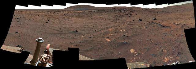
View Northward from Spirit Winter Roost False Color
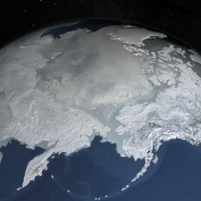
The sea ice cap of the Arctic appeared to reach its annual maximum winter extent on February 25, according to data from the NASA-supported National Snow and Ice Data Center (NSIDC) at the University of Colorado, Boulder. At 5.61 million square miles (14.54 million square kilometers), this year’s maximum extent was the smallest on the satellite record and also one of the earliest. Credit: NASA Goddard Space Flight Center <b><a href="http://www.nasa.gov/audience/formedia/features/MP_Photo_Guidelines.html" rel="nofollow">NASA image use policy.</a></b> <b><a href="http://www.nasa.gov/centers/goddard/home/index.html" rel="nofollow">NASA Goddard Space Flight Center</a></b> enables NASA’s mission through four scientific endeavors: Earth Science, Heliophysics, Solar System Exploration, and Astrophysics. Goddard plays a leading role in NASA’s accomplishments by contributing compelling scientific knowledge to advance the Agency’s mission. <b>Follow us on <a href="http://twitter.com/NASAGoddardPix" rel="nofollow">Twitter</a></b> <b>Like us on <a href="http://www.facebook.com/pages/Greenbelt-MD/NASA-Goddard/395013845897?ref=tsd" rel="nofollow">Facebook</a></b> <b>Find us on <a href="http://instagrid.me/nasagoddard/?vm=grid" rel="nofollow">Instagram</a></b>
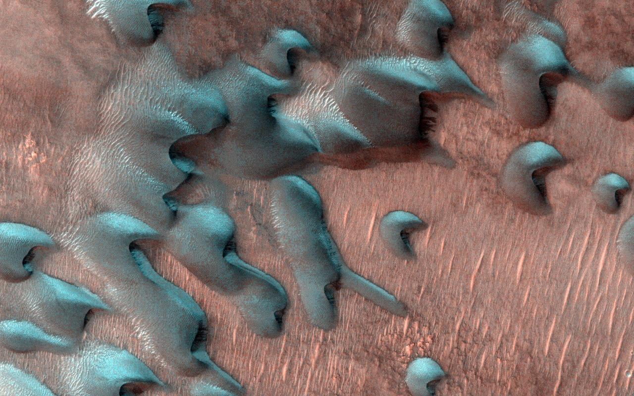
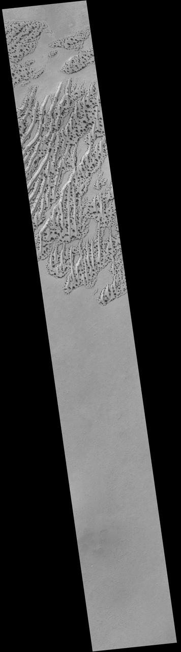
Usually, HiRISE takes pictures of well-illuminated terrain where there is plenty of light to produce clear images. Sometimes though, we would like to know what's going on in the dim wintertime areas. This picture was taken far north of the equator just two days after the winter solstice when the Sun was just a few degrees above the horizon. Sand dunes are moving across this landscape from top left to bottom right. Winter frost covers the colder, north-facing half of each dune (but not the warmer south-facing half). The frost here is a mixture of carbon dioxide ice and water ice and will disappear in a few months when spring arrives. https://photojournal.jpl.nasa.gov/catalog/PIA25552
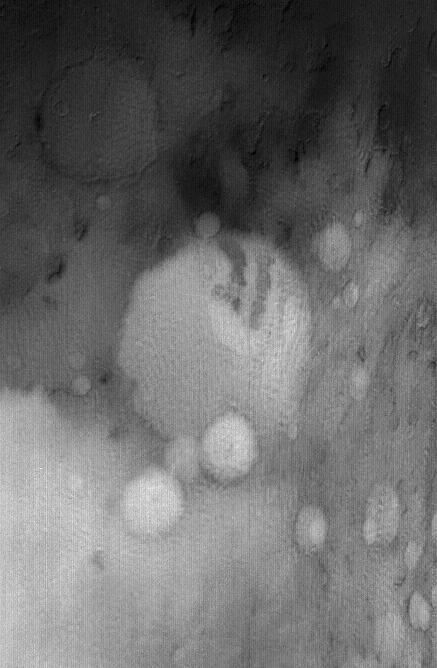
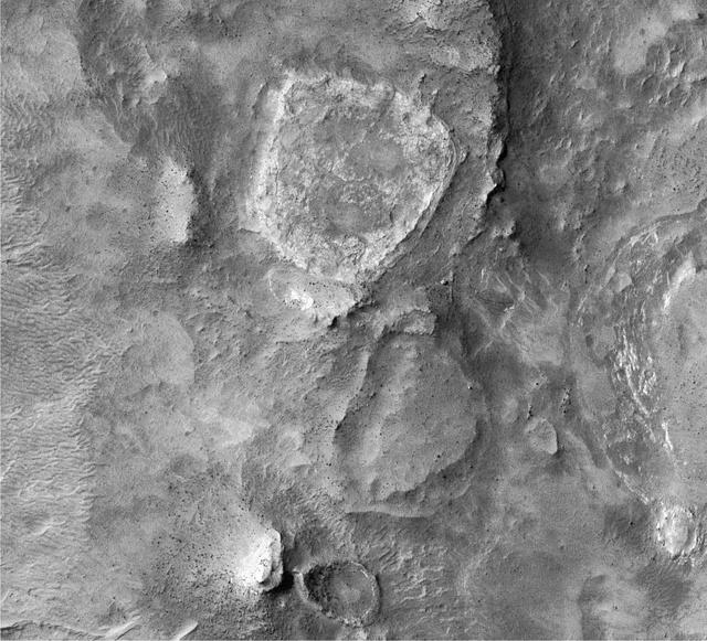
This image from NASA's Mars Reconnaissance Orbiter (MRO) shows the location with the most impressive known gully activity in Mars' northern hemisphere. Gullies are active in the winter due to carbon dioxide frost, but northern winters are shorter and warmer than southern winters, so there is less frost and less gully activity.. https://photojournal.jpl.nasa.gov/catalog/PIA21593
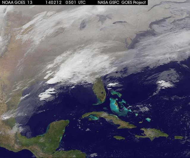
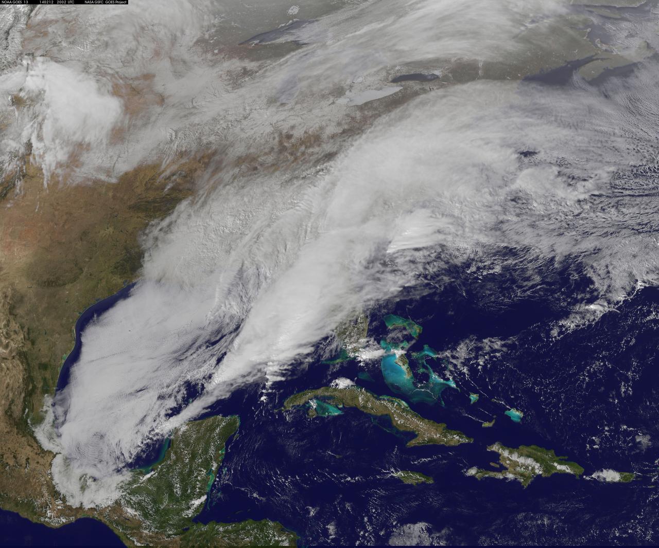
A new NASA video of NOAA's GOES satellite imagery shows three days of movement of the massive winter storm that stretches from the southern U.S. to the northeast. Visible and infrared imagery from NOAA's GOES-East or GOES-13 satellite from Feb. 10 at 1815 UTC/1:15 p.m. EST to Feb. 12 to 1845 UTC/1:45 p.m. EST were compiled into a video made by NASA/NOAA's GOES Project at NASA's Goddard Space Flight Center in Greenbelt, Md. In the video, viewers can see the development and movement of the clouds associated with the progression of the frontal system and related low pressure areas that make up the massive storm. The video also shows the snow covered ground over the Great Lakes region and Ohio Valley that stretches to northern New England. The clouds and fallen snow data from NOAA's GOES-East satellite were overlaid on a true-color image of land and ocean created by data from the Moderate Resolution Imaging Spectroradiometer or MODIS instrument that flies aboard NASA's Aqua and Terra satellites. On February 12 at 10 a.m. EST, NOAA's National Weather Service or NWS continued to issue watches and warnings from Texas to New England. Specifically, NWS cited Winter Storm Warnings and Winter Weather Advisories were in effect from eastern Texas eastward across the interior section of southeastern U.S. states and across much of the eastern seaboard including the Appalachians. Winter storm watches are in effect for portions of northern New England as well as along the western slopes of northern and central Appalachians. For updates on local forecasts, watches and warnings, visit NOAA's <a href="http://www.weather.gov" rel="nofollow">www.weather.gov</a> webpage. NOAA's Weather Prediction Center or WPC noted the storm is expected to bring "freezing rain spreading into the Carolinas, significant snow accumulations are expected in the interior Mid-Atlantic states tonight into Thursday and ice storm warnings and freezing rain advisories are in effect across much of central Georgia. GOES satellites provide the kind of continuous monitoring necessary for intensive data analysis. Geostationary describes an orbit in which a satellite is always in the same position with respect to the rotating Earth. This allows GOES to hover continuously over one position on Earth's surface, appearing stationary. As a result, GOES provide a constant vigil for the atmospheric "triggers" for severe weather conditions such as tornadoes, flash floods, hail storms and hurricanes. For updated information about the storm system, visit NOAA's WPC website; <a href="http://www.hpc.ncep.noaa.gov/" rel="nofollow">www.hpc.ncep.noaa.gov/</a> For more information about GOES satellites, visit: <a href="http://www.goes.noaa.gov/" rel="nofollow">www.goes.noaa.gov/</a> or <a href="http://goes.gsfc.nasa.gov/" rel="nofollow">goes.gsfc.nasa.gov/</a> Rob Gutro NASA's Goddard Space Flight Center <b><a href="http://goes.gsfc.nasa.gov/" rel="nofollow">Credit: NOAA/NASA GOES Project</a></b> <b><a href="http://www.nasa.gov/audience/formedia/features/MP_Photo_Guidelines.html" rel="nofollow">NASA image use policy.</a></b> <b><a href="http://www.nasa.gov/centers/goddard/home/index.html" rel="nofollow">NASA Goddard Space Flight Center</a></b> enables NASA’s mission through four scientific endeavors: Earth Science, Heliophysics, Solar System Exploration, and Astrophysics. Goddard plays a leading role in NASA’s accomplishments by contributing compelling scientific knowledge to advance the Agency’s mission. <b>Follow us on <a href="http://twitter.com/NASAGoddardPix" rel="nofollow">Twitter</a></b> <b>Like us on <a href="http://www.facebook.com/pages/Greenbelt-MD/NASA-Goddard/395013845897?ref=tsd" rel="nofollow">Facebook</a></b> <b>Find us on <a href="http://instagrid.me/nasagoddard/?vm=grid" rel="nofollow">Instagram</a></b>
![The monster winter storm that brought icing to the U.S. southeast moved northward along the Eastern Seaboard and brought snow, sleet and rain from the Mid-Atlantic to New England on February 13. A new image from NOAA's GOES satellite showed clouds associated with the massive winter storm stretch from the U.S. southeast to the northeast. Data from NOAA's GOES-East satellite taken on Feb. 13 at 1455 UTC/9:45 a.m. EST were made into an image by NASA/NOAA's GOES Project at NASA's Goddard Space Flight Center in Greenbelt, Md. The clouds and fallen snow data from NOAA's GOES-East satellite were overlaid on a true-color image of land and ocean created by data from the Moderate Resolution Imaging Spectroradiometer or MODIS instrument that flies aboard NASA's Aqua and Terra satellites.The image showed that the clouds associated with the storm were blanketing much of the U.S. East Coast. At 3:11 a.m. EST, a surface map issued by the National Weather Service or NWS showed the storm's low pressure area was centered over eastern North Carolina. Since then, the low has continued to track north along the eastern seaboard. By 11 a.m. EST, precipitation from the storm was falling from South Carolina to Maine, according to National Weather Service radar. By 11 a.m. EST, the Washington, D.C. region snow and sleet totals ranged from 3" in far eastern Maryland to over 18" in the northern and western suburbs in Maryland and Virginia. NWS reported that snow, sleet and rain were still falling and more snow is expected as the back side of the low moves into the region. The New York City region remained under an NWS Winter Storm Warning until 6 a.m. on Friday, February 14 and the National Weather Service expects minor coastal impacts Thursday into Friday afternoon. New England was also being battered by the storm. At 10:56 a.m. EST, Barnstable, Mass. on Cape Cod was experiencing rain and winds gusting to 28 mph. An NWS wind advisory is in effect for Cape Cod until 7 p.m. EST. Further north, Portland, Maine was experiencing heavy snow with winds from the northeast at 6 mph. The National Weather Service in Gray, Maine noted "Significant snowfall is likely for much of western Maine and New Hampshire as this storm passes by. There will be a mix or changeover to sleet and freezing rain over southern and coastal sections tonight...before all areas end as a period of snow Friday (Feb. 14) morning." On February 13 at 10 a.m. EST, NOAA's National Weather Service noted "An abundance of Atlantic moisture getting wrapped into the storm will continue to fuel widespread precipitation...which should lift through the Mid-Atlantic States and Northeast Thursday into Friday. A wide swath of heavy snow accumulations are expected with this storm...but air [moving] off the warmer ocean water should change snow over to rain along the coastal areas. Also...a narrow axis of sleet and freezing rain will be possible within the transition zone...which is expected to set up near the I-95 corridor." For updates on local forecasts, watches and warnings, visit NOAA's <a href="http://www.weather.gov" rel="nofollow">www.weather.gov</a> webpage. GOES satellites provide the kind of continuous monitoring necessary for intensive data analysis. Geostationary describes an orbit in which a satellite is always in the same position with respect to the rotating Earth. This allows GOES to hover continuously over one position on Earth's surface, appearing stationary. As a result, GOES provide a constant vigil for the atmospheric "triggers" for severe weather conditions such as tornadoes, flash floods, hail storms and hurricanes. For updated information about the storm system, visit NOAA's WPC website: <a href="http://www.hpc.ncep.noaa.gov/" rel="nofollow">www.hpc.ncep.noaa.gov/</a> For more information about GOES satellites, visit: <a href="http://www.goes.noaa.gov/" rel="nofollow">www.goes.noaa.gov/</a> or <a href="http://goes.gsfc.nasa.gov/" rel="nofollow">goes.gsfc.nasa.gov/</a> Credit: NASA/GSFC/Jeff Schmaltz/MODIS Land Rapid Response Team <b><a href="http://www.nasa.gov/audience/formedia/features/MP_Photo_Guidelines.html" rel="nofollow">NASA image use policy.</a></b> <b><a href="http://www.nasa.gov/centers/goddard/home/index.html" rel="nofollow">NASA Goddard Space Flight Center</a></b> enables NASA’s mission through four scientific endeavors: Earth Science, Heliophysics, Solar System Exploration, and Astrophysics. Goddard plays a leading role in NASA’s accomplishments by contributing compelling scientific knowledge to advance the Agency’s mission. <b>Follow us on <a href="http://twitter.com/NASAGoddardPix" rel="nofollow">Twitter</a></b> <b>Like us on <a href="http://www.facebook.com/pages/Greenbelt-MD/NASA-Goddard/395013845897?ref=tsd" rel="nofollow">Facebook</a></b> <b>Find us on <a href="http://instagram.com/nasagoddard?vm=grid" rel="nofollow">Instagram</a></b>](https://images-assets.nasa.gov/image/GSFC_20171208_Archive_e001229/GSFC_20171208_Archive_e001229~medium.jpg)
The monster winter storm that brought icing to the U.S. southeast moved northward along the Eastern Seaboard and brought snow, sleet and rain from the Mid-Atlantic to New England on February 13. A new image from NOAA's GOES satellite showed clouds associated with the massive winter storm stretch from the U.S. southeast to the northeast. Data from NOAA's GOES-East satellite taken on Feb. 13 at 1455 UTC/9:45 a.m. EST were made into an image by NASA/NOAA's GOES Project at NASA's Goddard Space Flight Center in Greenbelt, Md. The clouds and fallen snow data from NOAA's GOES-East satellite were overlaid on a true-color image of land and ocean created by data from the Moderate Resolution Imaging Spectroradiometer or MODIS instrument that flies aboard NASA's Aqua and Terra satellites.The image showed that the clouds associated with the storm were blanketing much of the U.S. East Coast. At 3:11 a.m. EST, a surface map issued by the National Weather Service or NWS showed the storm's low pressure area was centered over eastern North Carolina. Since then, the low has continued to track north along the eastern seaboard. By 11 a.m. EST, precipitation from the storm was falling from South Carolina to Maine, according to National Weather Service radar. By 11 a.m. EST, the Washington, D.C. region snow and sleet totals ranged from 3" in far eastern Maryland to over 18" in the northern and western suburbs in Maryland and Virginia. NWS reported that snow, sleet and rain were still falling and more snow is expected as the back side of the low moves into the region. The New York City region remained under an NWS Winter Storm Warning until 6 a.m. on Friday, February 14 and the National Weather Service expects minor coastal impacts Thursday into Friday afternoon. New England was also being battered by the storm. At 10:56 a.m. EST, Barnstable, Mass. on Cape Cod was experiencing rain and winds gusting to 28 mph. An NWS wind advisory is in effect for Cape Cod until 7 p.m. EST. Further north, Portland, Maine was experiencing heavy snow with winds from the northeast at 6 mph. The National Weather Service in Gray, Maine noted "Significant snowfall is likely for much of western Maine and New Hampshire as this storm passes by. There will be a mix or changeover to sleet and freezing rain over southern and coastal sections tonight...before all areas end as a period of snow Friday (Feb. 14) morning." On February 13 at 10 a.m. EST, NOAA's National Weather Service noted "An abundance of Atlantic moisture getting wrapped into the storm will continue to fuel widespread precipitation...which should lift through the Mid-Atlantic States and Northeast Thursday into Friday. A wide swath of heavy snow accumulations are expected with this storm...but air [moving] off the warmer ocean water should change snow over to rain along the coastal areas. Also...a narrow axis of sleet and freezing rain will be possible within the transition zone...which is expected to set up near the I-95 corridor." For updates on local forecasts, watches and warnings, visit NOAA's <a href="http://www.weather.gov" rel="nofollow">www.weather.gov</a> webpage. GOES satellites provide the kind of continuous monitoring necessary for intensive data analysis. Geostationary describes an orbit in which a satellite is always in the same position with respect to the rotating Earth. This allows GOES to hover continuously over one position on Earth's surface, appearing stationary. As a result, GOES provide a constant vigil for the atmospheric "triggers" for severe weather conditions such as tornadoes, flash floods, hail storms and hurricanes. For updated information about the storm system, visit NOAA's WPC website: <a href="http://www.hpc.ncep.noaa.gov/" rel="nofollow">www.hpc.ncep.noaa.gov/</a> For more information about GOES satellites, visit: <a href="http://www.goes.noaa.gov/" rel="nofollow">www.goes.noaa.gov/</a> or <a href="http://goes.gsfc.nasa.gov/" rel="nofollow">goes.gsfc.nasa.gov/</a> Credit: NASA/GSFC/Jeff Schmaltz/MODIS Land Rapid Response Team <b><a href="http://www.nasa.gov/audience/formedia/features/MP_Photo_Guidelines.html" rel="nofollow">NASA image use policy.</a></b> <b><a href="http://www.nasa.gov/centers/goddard/home/index.html" rel="nofollow">NASA Goddard Space Flight Center</a></b> enables NASA’s mission through four scientific endeavors: Earth Science, Heliophysics, Solar System Exploration, and Astrophysics. Goddard plays a leading role in NASA’s accomplishments by contributing compelling scientific knowledge to advance the Agency’s mission. <b>Follow us on <a href="http://twitter.com/NASAGoddardPix" rel="nofollow">Twitter</a></b> <b>Like us on <a href="http://www.facebook.com/pages/Greenbelt-MD/NASA-Goddard/395013845897?ref=tsd" rel="nofollow">Facebook</a></b> <b>Find us on <a href="http://instagram.com/nasagoddard?vm=grid" rel="nofollow">Instagram</a></b>
![The monster winter storm that brought icing to the U.S. southeast moved northward along the Eastern Seaboard and brought snow, sleet and rain from the Mid-Atlantic to New England on February 13. A new image from NOAA's GOES satellite showed clouds associated with the massive winter storm stretch from the U.S. southeast to the northeast. Data from NOAA's GOES-East satellite taken on Feb. 13 at 1455 UTC/9:45 a.m. EST were made into an image by NASA/NOAA's GOES Project at NASA's Goddard Space Flight Center in Greenbelt, Md. The clouds and fallen snow data from NOAA's GOES-East satellite were overlaid on a true-color image of land and ocean created by data from the Moderate Resolution Imaging Spectroradiometer or MODIS instrument that flies aboard NASA's Aqua and Terra satellites.The image showed that the clouds associated with the storm were blanketing much of the U.S. East Coast. At 3:11 a.m. EST, a surface map issued by the National Weather Service or NWS showed the storm's low pressure area was centered over eastern North Carolina. Since then, the low has continued to track north along the eastern seaboard. By 11 a.m. EST, precipitation from the storm was falling from South Carolina to Maine, according to National Weather Service radar. By 11 a.m. EST, the Washington, D.C. region snow and sleet totals ranged from 3" in far eastern Maryland to over 18" in the northern and western suburbs in Maryland and Virginia. NWS reported that snow, sleet and rain were still falling and more snow is expected as the back side of the low moves into the region. The New York City region remained under an NWS Winter Storm Warning until 6 a.m. on Friday, February 14 and the National Weather Service expects minor coastal impacts Thursday into Friday afternoon. New England was also being battered by the storm. At 10:56 a.m. EST, Barnstable, Mass. on Cape Cod was experiencing rain and winds gusting to 28 mph. An NWS wind advisory is in effect for Cape Cod until 7 p.m. EST. Further north, Portland, Maine was experiencing heavy snow with winds from the northeast at 6 mph. The National Weather Service in Gray, Maine noted "Significant snowfall is likely for much of western Maine and New Hampshire as this storm passes by. There will be a mix or changeover to sleet and freezing rain over southern and coastal sections tonight...before all areas end as a period of snow Friday (Feb. 14) morning." On February 13 at 10 a.m. EST, NOAA's National Weather Service noted "An abundance of Atlantic moisture getting wrapped into the storm will continue to fuel widespread precipitation...which should lift through the Mid-Atlantic States and Northeast Thursday into Friday. A wide swath of heavy snow accumulations are expected with this storm...but air [moving] off the warmer ocean water should change snow over to rain along the coastal areas. Also...a narrow axis of sleet and freezing rain will be possible within the transition zone...which is expected to set up near the I-95 corridor." For updates on local forecasts, watches and warnings, visit NOAA's <a href="http://www.weather.gov" rel="nofollow">www.weather.gov</a> webpage. GOES satellites provide the kind of continuous monitoring necessary for intensive data analysis. Geostationary describes an orbit in which a satellite is always in the same position with respect to the rotating Earth. This allows GOES to hover continuously over one position on Earth's surface, appearing stationary. As a result, GOES provide a constant vigil for the atmospheric "triggers" for severe weather conditions such as tornadoes, flash floods, hail storms and hurricanes. For updated information about the storm system, visit NOAA's WPC website: <a href="http://www.hpc.ncep.noaa.gov/" rel="nofollow">www.hpc.ncep.noaa.gov/</a> For more information about GOES satellites, visit: <a href="http://www.goes.noaa.gov/" rel="nofollow">www.goes.noaa.gov/</a> or <a href="http://goes.gsfc.nasa.gov/" rel="nofollow">goes.gsfc.nasa.gov/</a> Credit: NASA/GSFC/Jeff Schmaltz/MODIS Land Rapid Response Team <b><a href="http://www.nasa.gov/audience/formedia/features/MP_Photo_Guidelines.html" rel="nofollow">NASA image use policy.</a></b> <b><a href="http://www.nasa.gov/centers/goddard/home/index.html" rel="nofollow">NASA Goddard Space Flight Center</a></b> enables NASA’s mission through four scientific endeavors: Earth Science, Heliophysics, Solar System Exploration, and Astrophysics. Goddard plays a leading role in NASA’s accomplishments by contributing compelling scientific knowledge to advance the Agency’s mission. <b>Follow us on <a href="http://twitter.com/NASAGoddardPix" rel="nofollow">Twitter</a></b> <b>Like us on <a href="http://www.facebook.com/pages/Greenbelt-MD/NASA-Goddard/395013845897?ref=tsd" rel="nofollow">Facebook</a></b> <b>Find us on <a href="http://instagram.com/nasagoddard?vm=grid" rel="nofollow">Instagram</a></b>](https://images-assets.nasa.gov/image/GSFC_20171208_Archive_e001228/GSFC_20171208_Archive_e001228~medium.jpg)
The monster winter storm that brought icing to the U.S. southeast moved northward along the Eastern Seaboard and brought snow, sleet and rain from the Mid-Atlantic to New England on February 13. A new image from NOAA's GOES satellite showed clouds associated with the massive winter storm stretch from the U.S. southeast to the northeast. Data from NOAA's GOES-East satellite taken on Feb. 13 at 1455 UTC/9:45 a.m. EST were made into an image by NASA/NOAA's GOES Project at NASA's Goddard Space Flight Center in Greenbelt, Md. The clouds and fallen snow data from NOAA's GOES-East satellite were overlaid on a true-color image of land and ocean created by data from the Moderate Resolution Imaging Spectroradiometer or MODIS instrument that flies aboard NASA's Aqua and Terra satellites.The image showed that the clouds associated with the storm were blanketing much of the U.S. East Coast. At 3:11 a.m. EST, a surface map issued by the National Weather Service or NWS showed the storm's low pressure area was centered over eastern North Carolina. Since then, the low has continued to track north along the eastern seaboard. By 11 a.m. EST, precipitation from the storm was falling from South Carolina to Maine, according to National Weather Service radar. By 11 a.m. EST, the Washington, D.C. region snow and sleet totals ranged from 3" in far eastern Maryland to over 18" in the northern and western suburbs in Maryland and Virginia. NWS reported that snow, sleet and rain were still falling and more snow is expected as the back side of the low moves into the region. The New York City region remained under an NWS Winter Storm Warning until 6 a.m. on Friday, February 14 and the National Weather Service expects minor coastal impacts Thursday into Friday afternoon. New England was also being battered by the storm. At 10:56 a.m. EST, Barnstable, Mass. on Cape Cod was experiencing rain and winds gusting to 28 mph. An NWS wind advisory is in effect for Cape Cod until 7 p.m. EST. Further north, Portland, Maine was experiencing heavy snow with winds from the northeast at 6 mph. The National Weather Service in Gray, Maine noted "Significant snowfall is likely for much of western Maine and New Hampshire as this storm passes by. There will be a mix or changeover to sleet and freezing rain over southern and coastal sections tonight...before all areas end as a period of snow Friday (Feb. 14) morning." On February 13 at 10 a.m. EST, NOAA's National Weather Service noted "An abundance of Atlantic moisture getting wrapped into the storm will continue to fuel widespread precipitation...which should lift through the Mid-Atlantic States and Northeast Thursday into Friday. A wide swath of heavy snow accumulations are expected with this storm...but air [moving] off the warmer ocean water should change snow over to rain along the coastal areas. Also...a narrow axis of sleet and freezing rain will be possible within the transition zone...which is expected to set up near the I-95 corridor." For updates on local forecasts, watches and warnings, visit NOAA's <a href="http://www.weather.gov" rel="nofollow">www.weather.gov</a> webpage. GOES satellites provide the kind of continuous monitoring necessary for intensive data analysis. Geostationary describes an orbit in which a satellite is always in the same position with respect to the rotating Earth. This allows GOES to hover continuously over one position on Earth's surface, appearing stationary. As a result, GOES provide a constant vigil for the atmospheric "triggers" for severe weather conditions such as tornadoes, flash floods, hail storms and hurricanes. For updated information about the storm system, visit NOAA's WPC website: <a href="http://www.hpc.ncep.noaa.gov/" rel="nofollow">www.hpc.ncep.noaa.gov/</a> For more information about GOES satellites, visit: <a href="http://www.goes.noaa.gov/" rel="nofollow">www.goes.noaa.gov/</a> or <a href="http://goes.gsfc.nasa.gov/" rel="nofollow">goes.gsfc.nasa.gov/</a> Credit: NASA/GSFC/Jeff Schmaltz/MODIS Land Rapid Response Team <b><a href="http://www.nasa.gov/audience/formedia/features/MP_Photo_Guidelines.html" rel="nofollow">NASA image use policy.</a></b> <b><a href="http://www.nasa.gov/centers/goddard/home/index.html" rel="nofollow">NASA Goddard Space Flight Center</a></b> enables NASA’s mission through four scientific endeavors: Earth Science, Heliophysics, Solar System Exploration, and Astrophysics. Goddard plays a leading role in NASA’s accomplishments by contributing compelling scientific knowledge to advance the Agency’s mission. <b>Follow us on <a href="http://twitter.com/NASAGoddardPix" rel="nofollow">Twitter</a></b> <b>Like us on <a href="http://www.facebook.com/pages/Greenbelt-MD/NASA-Goddard/395013845897?ref=tsd" rel="nofollow">Facebook</a></b> <b>Find us on <a href="http://instagram.com/nasagoddard?vm=grid" rel="nofollow">Instagram</a></b>
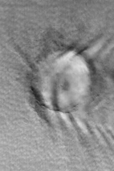
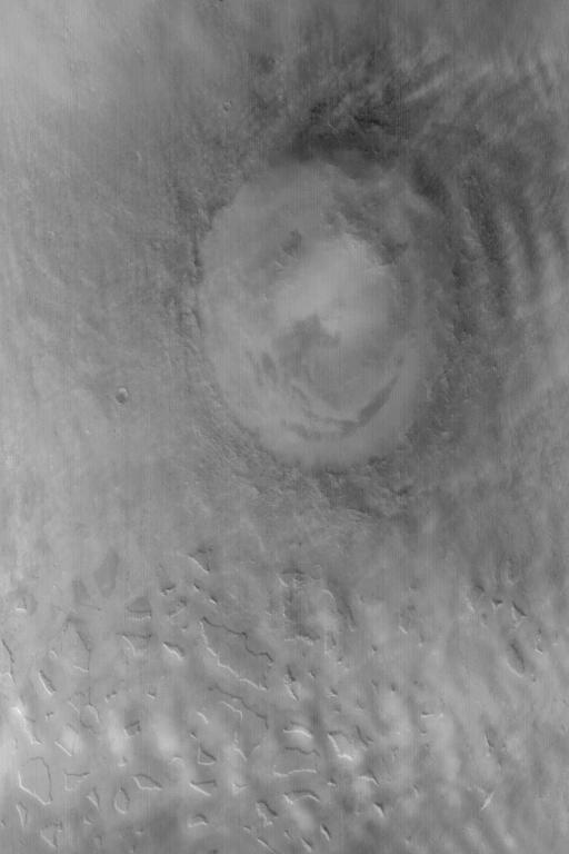
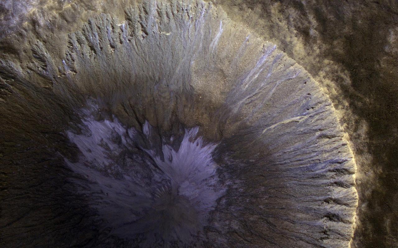
![This is an odd-looking image. It shows gullies during the winter while entirely in the shadow of the crater wall. Illumination comes only from the winter skylight. We acquire such images because gullies on Mars actively form in the winter when there is carbon dioxide frost on the ground, so we image them in the winter, even though not well illuminated, to look for signs of activity. The dark streaks might be signs of current activity, removing the frost, but further analysis is needed. NB: North is down in the cutout, and the terrain slopes towards the bottom of the image. The map is projected here at a scale of 50 centimeters (19.7 inches) per pixel. [The original image scale is 62.3 centimeters (24.5 inches) per pixel (with 2 x 2 binning); objects on the order of 187 centimeters (73.6 inches) across are resolved.] North is up. http://photojournal.jpl.nasa.gov/catalog/PIA21568](https://images-assets.nasa.gov/image/PIA21568/PIA21568~medium.jpg)
This is an odd-looking image. It shows gullies during the winter while entirely in the shadow of the crater wall. Illumination comes only from the winter skylight. We acquire such images because gullies on Mars actively form in the winter when there is carbon dioxide frost on the ground, so we image them in the winter, even though not well illuminated, to look for signs of activity. The dark streaks might be signs of current activity, removing the frost, but further analysis is needed. NB: North is down in the cutout, and the terrain slopes towards the bottom of the image. The map is projected here at a scale of 50 centimeters (19.7 inches) per pixel. [The original image scale is 62.3 centimeters (24.5 inches) per pixel (with 2 x 2 binning); objects on the order of 187 centimeters (73.6 inches) across are resolved.] North is up. http://photojournal.jpl.nasa.gov/catalog/PIA21568
NASA and NOAA satellites are providing various views of the major winter storm marching toward the U.S. East coast on March 13. The storm is forecast to merge with another system and is expected to bring large snowfall totals from the Mid-Atlantic to New England. NASA's Aqua satellite gathered infrared data from the storm system and the area ahead of the storm for cloud and ground temperatures. NOAA's GOES-East satellite provided visible and infrared imagery that showed the extent and the movement of the system. Forecasters at the National Weather Service's Weather Prediction Center (WPC) noted that the low pressure system crossing the Midwest states and Ohio Valley is expected to merge with another low off the southeast U.S. coast. WPC stated "This will allow for a strong nor'easter to develop near the coast and cause a late-season snowstorm from the central Appalachians to New England, including many of the big cities in the Northeast U.S." Credits: NASA/NOAA GOES Project
This image, taken Jan. 26, 2012, shows NASA no-longer-active Phoenix Mars Lander spacecraft after its second Martian arctic winter.
This image, taken Jan. 26, 2012, shows the back shell of NASA Phoenix Mars Lander spacecraft after its second Martian arctic winter.
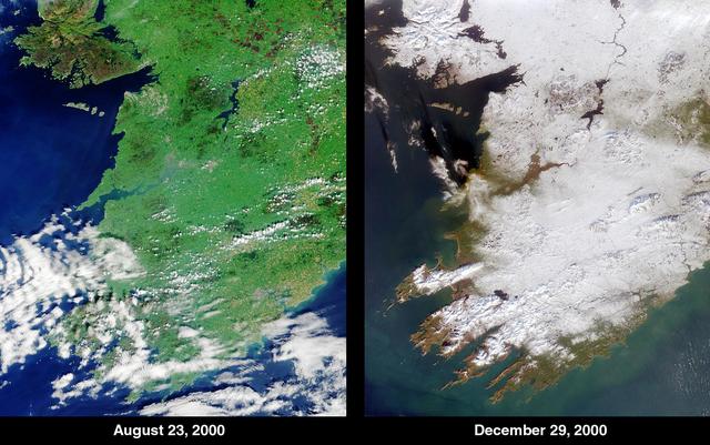
The contrast between summer and winter is apparent in this pair of images of southwestern Ireland acquired by NASA Terra satellite August 23, 2000 left and December 29, 2000 right.
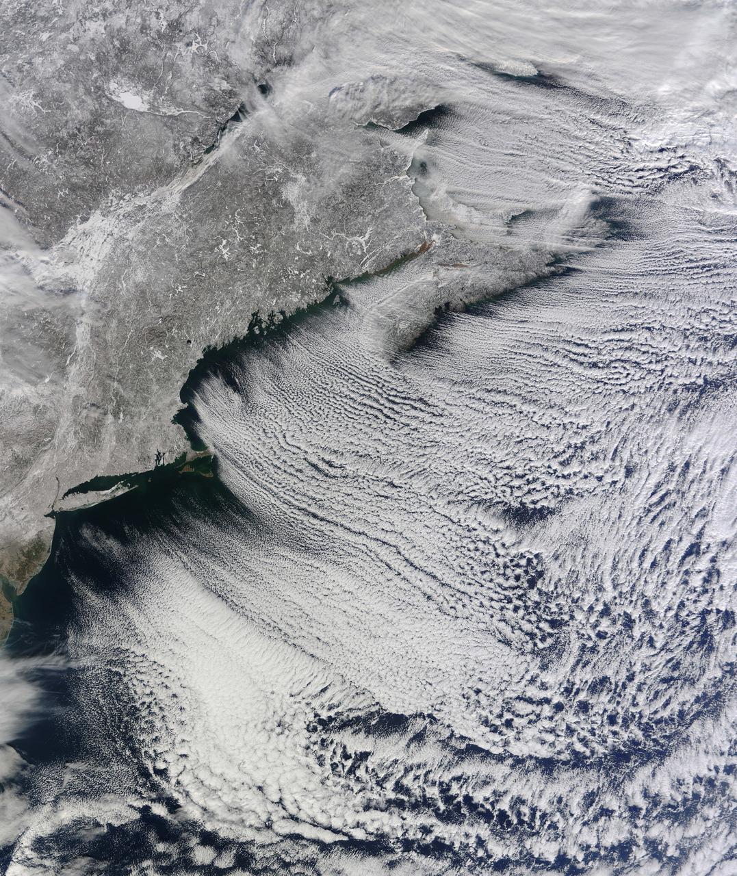
NASA image acquired January 24, 2011 What do you get when you mix below-freezing air temperatures, frigid northwest winds from Canada, and ocean temperatures hovering around 39 to 40 degrees Fahrenheit (4 to 5 degrees Celsius)? Paved highways of clouds across the skies of the North Atlantic. The Moderate Resolution Imaging Spectroradiometer (MODIS) on NASA’s Terra satellite collected this natural-color view of New England, the Canadian Maritimes, and coastal waters at 10:25 a.m. U.S. Eastern Standard Time on January 24, 2011. Lines of clouds stretch from northwest to southeast over the North Atlantic, while the relatively cloudless skies over land afford a peek at the snow that blanketed the Northeast just a few days earlier. Cloud streets form when cold air blows over warmer waters, while a warmer air layer—or temperature inversion—rests over top of both. The comparatively warm water of the ocean gives up heat and moisture to the cold air mass above, and columns of heated air—thermals—naturally rise through the atmosphere. As they hit the temperature inversion like a lid, the air rolls over like the circulation in a pot of boiling water. The water in the warm air cools and condenses into flat-bottomed, fluffy-topped cumulus clouds that line up parallel to the wind. Though they are easy to explain in a broad sense, cloud streets have a lot of mysteries on the micro scale. A NASA-funded researcher from the University of Wisconsin recently observed an unusual pattern in cloud streets over the Great Lakes. Cloud droplets that should have picked up moisture from the atmosphere and grown in size were instead shrinking as they moved over Lake Superior. Read more in an interview at What on Earth? NASA image by Jeff Schmaltz, MODIS Rapid Response Team, Goddard Space Flight Center. Caption by Michael Carlowicz. Instrument: Terra - MODIS Credit: <b><a href="http://www.earthobservatory.nasa.gov/" rel="nofollow"> NASA Earth Observatory</a></b> <b><a href="http://www.nasa.gov/centers/goddard/home/index.html" rel="nofollow">NASA Goddard Space Flight Center</a></b> enables NASA’s mission through four scientific endeavors: Earth Science, Heliophysics, Solar System Exploration, and Astrophysics. Goddard plays a leading role in NASA’s accomplishments by contributing compelling scientific knowledge to advance the Agency’s mission. <b>Follow us on <a href="http://twitter.com/NASA_GoddardPix" rel="nofollow">Twitter</a></b> <b>Join us on <a href="http://www.facebook.com/pages/Greenbelt-MD/NASA-Goddard/395013845897?ref=tsd" rel="nofollow">Facebook</a></b>
This satellite imagery from Jan. 21 at 10:00 a.m. EST shows the large winter storm over near the Gulf coast and another storm approaching the Pacific coast. Credits: NASA/NOAA GOES Project <b><a href="http://www.nasa.gov/audience/formedia/features/MP_Photo_Guidelines.html" rel="nofollow">NASA image use policy.</a></b> <b><a href="http://www.nasa.gov/centers/goddard/home/index.html" rel="nofollow">NASA Goddard Space Flight Center</a></b> enables NASA’s mission through four scientific endeavors: Earth Science, Heliophysics, Solar System Exploration, and Astrophysics. Goddard plays a leading role in NASA’s accomplishments by contributing compelling scientific knowledge to advance the Agency’s mission. <b>Follow us on <a href="http://twitter.com/NASAGoddardPix" rel="nofollow">Twitter</a></b> <b>Like us on <a href="http://www.facebook.com/pages/Greenbelt-MD/NASA-Goddard/395013845897?ref=tsd" rel="nofollow">Facebook</a></b> <b>Find us on <a href="http://instagrid.me/nasagoddard/?vm=grid" rel="nofollow">Instagram</a></b>
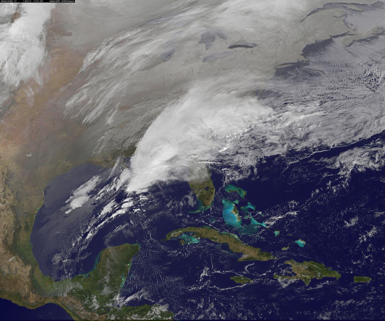
Clouds associated with the major winter storm that is bringing wintry precipitation and chilly temperatures to the U.S. south is the focus in an image from NOAA's GOES-East satellite today, February 12 at 1310 UTC/ 8:10 EST. Rain, freezing rain, sleet and snow are part of the large front that stretches from eastern Texas to the Carolinas in the Geostationary Operational Environmental satellite or GOES image. NOAA's weather maps show several areas of low pressure along the frontal boundary. One low pressure is in the northern Gulf of Mexico, while the other is in the Atlantic Ocean, just south of South Carolina. (Insert link: <a href="http://www.hpc.ncep.noaa.gov/noaa/noaad1.gif" rel="nofollow">www.hpc.ncep.noaa.gov/noaa/noaad1.gif</a>). NOAA's National Weather Service has been issuing watches and warnings throughout the south that extend along Mid-Atlantic east coast. The visible cloud and ground snow data in this image was taken from NOAA's GOES-East satellite. The image was created by the NASA GOES Project at NASA's Goddard Space Flight Center in Greenbelt, Md. The clouds and fallen snow were overlaid on a true-color image of land and ocean created by data from the Moderate Resolution Imaging Spectroradiometer or MODIS instrument that flies aboard NASA's Aqua and Terra satellites. NOAA's Weather Prediction Center, or WPC noted on Feb. 11 at 3:59 a.m. EST, "Once the intensifying surface low moves off the Southeast coast and begins its track up the Eastern Seaboard Wednesday night...winter weather will start lifting northward into the northern Mid-Atlantic states." GOES satellites provide the kind of continuous monitoring necessary for intensive data analysis. Geostationary describes an orbit in which a satellite is always in the same position with respect to the rotating Earth. This allows GOES to hover continuously over one position on Earth's surface, appearing stationary. As a result, GOES provide a constant vigil for the atmospheric "triggers" for severe weather conditions such as tornadoes, flash floods, hail storms and hurricanes. For updated information about the storm system, visit NOAA's WPC website; <a href="http://www.hpc.ncep.noaa.gov/" rel="nofollow">www.hpc.ncep.noaa.gov/</a> For more information about GOES satellites, visit: <a href="http://www.goes.noaa.gov/" rel="nofollow">www.goes.noaa.gov/</a> or <a href="http://goes.gsfc.nasa.gov/" rel="nofollow">goes.gsfc.nasa.gov/</a> Rob Gutro NASA's Goddard Space Flight Center <b><a href="http://www.nasa.gov/audience/formedia/features/MP_Photo_Guidelines.html" rel="nofollow">NASA image use policy.</a></b> <b><a href="http://www.nasa.gov/centers/goddard/home/index.html" rel="nofollow">NASA Goddard Space Flight Center</a></b> enables NASA’s mission through four scientific endeavors: Earth Science, Heliophysics, Solar System Exploration, and Astrophysics. Goddard plays a leading role in NASA’s accomplishments by contributing compelling scientific knowledge to advance the Agency’s mission. <b>Follow us on <a href="http://twitter.com/NASAGoddardPix" rel="nofollow">Twitter</a></b> <b>Like us on <a href="http://www.facebook.com/pages/Greenbelt-MD/NASA-Goddard/395013845897?ref=tsd" rel="nofollow">Facebook</a></b> <b>Find us on <a href="http://instagram.com/nasagoddard?vm=grid" rel="nofollow">Instagram</a></b>
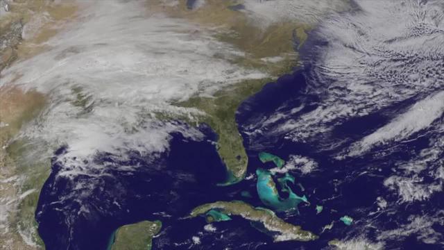
<b>View a video of the storm here: <a href="http://bit.ly/1m9aJFY" rel="nofollow">bit.ly/1m9aJFY</a></b> This visible image of the winter storm over the U.S. south and East Coast was taken by NOAA's GOES-13 satellite on Feb. 12 at 1855 UTC/1:55 p.m. EST. Snow covered ground can be seen over the Great Lakes region and Ohio Valley. On February 12 at 10 a.m. EST, NOAA's National Weather Service or NWS continued to issue watches and warnings from Texas to New England. Specifically, NWS cited Winter Storm Warnings and Winter Weather Advisories were in effect from eastern Texas eastward across the interior section of southeastern U.S. states and across much of the eastern seaboard including the Appalachians. Winter storm watches are in effect for portions of northern New England as well as along the western slopes of northern and central Appalachians. For updates on local forecasts, watches and warnings, visit NOAA's <a href="http://www.weather.gov" rel="nofollow">www.weather.gov</a> webpage. NOAA's Weather Prediction Center or WPC noted the storm is expected to bring "freezing rain spreading into the Carolinas, significant snow accumulations are expected in the interior Mid-Atlantic states tonight into Thursday and ice storm warnings and freezing rain advisories are in effect across much of central Georgia. GOES satellites provide the kind of continuous monitoring necessary for intensive data analysis. Geostationary describes an orbit in which a satellite is always in the same position with respect to the rotating Earth. This allows GOES to hover continuously over one position on Earth's surface, appearing stationary. As a result, GOES provide a constant vigil for the atmospheric "triggers" for severe weather conditions such as tornadoes, flash floods, hail storms and hurricanes. For updated information about the storm system, visit NOAA's WPC website; <a href="http://www.hpc.ncep.noaa.gov/" rel="nofollow">www.hpc.ncep.noaa.gov/</a> For more information about GOES satellites, visit: <a href="http://www.goes.noaa.gov/" rel="nofollow">www.goes.noaa.gov/</a> or <a href="http://goes.gsfc.nasa.gov/" rel="nofollow">goes.gsfc.nasa.gov/</a> Rob Gutro NASA's Goddard Space Flight Center <b><a href="http://goes.gsfc.nasa.gov/" rel="nofollow">Credit: NOAA/NASA GOES Project</a></b> <b><a href="http://www.nasa.gov/audience/formedia/features/MP_Photo_Guidelines.html" rel="nofollow">NASA image use policy.</a></b> <b><a href="http://www.nasa.gov/centers/goddard/home/index.html" rel="nofollow">NASA Goddard Space Flight Center</a></b> enables NASA’s mission through four scientific endeavors: Earth Science, Heliophysics, Solar System Exploration, and Astrophysics. Goddard plays a leading role in NASA’s accomplishments by contributing compelling scientific knowledge to advance the Agency’s mission. <b>Follow us on <a href="http://twitter.com/NASAGoddardPix" rel="nofollow">Twitter</a></b> <b>Like us on <a href="http://www.facebook.com/pages/Greenbelt-MD/NASA-Goddard/395013845897?ref=tsd" rel="nofollow">Facebook</a></b> <b>Find us on <a href="http://instagrid.me/nasagoddard/?vm=grid" rel="nofollow">Instagram</a></b>
Sunlight was just starting to reach the high Northern latitudes in late winter when NASA Mars Reconnaissance Orbiter HiRISE camera captured this image of part of the steep scarps around portions of the North Polar layered deposits.
Magnificent views of the region surrounding Salt Lake City, Utah are captured in these winter and summer images from NASA Terra satellite imaged on February 8, 2001 and June 16, 2001.
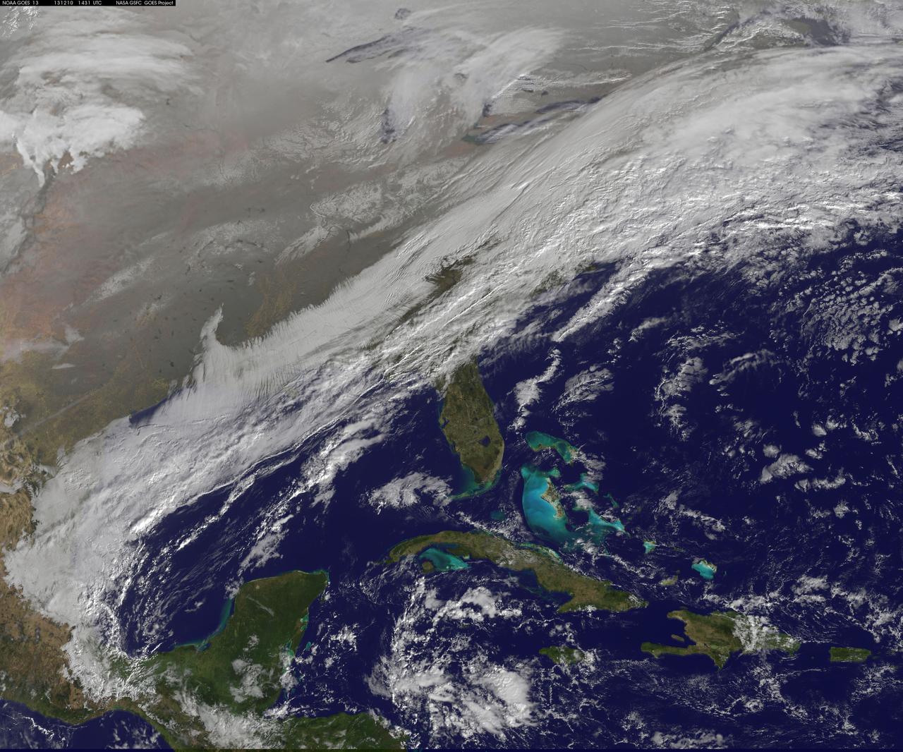
This image shows the strom system on Dec. 10, 2013 at 1445 UTC. According to the National Weather Service snow is falling from Tennessee Valley into the Mid-Atlantic and New England Tuesday . The fast moving system is creating swath of 2 to 7 inches of snow from southwest Virginia to the New England coast. Heavy Lake Effect snows will also impact the Lower Great Lakes into later this week, with up to two feet of accumulation. <b><a href="http://goes.gsfc.nasa.gov/" rel="nofollow">Credit: NOAA/NASA GOES Project</a></b> <b><a href="http://www.nasa.gov/audience/formedia/features/MP_Photo_Guidelines.html" rel="nofollow">NASA image use policy.</a></b> <b><a href="http://www.nasa.gov/centers/goddard/home/index.html" rel="nofollow">NASA Goddard Space Flight Center</a></b> enables NASA’s mission through four scientific endeavors: Earth Science, Heliophysics, Solar System Exploration, and Astrophysics. Goddard plays a leading role in NASA’s accomplishments by contributing compelling scientific knowledge to advance the Agency’s mission. <b>Follow us on <a href="http://twitter.com/NASA_GoddardPix" rel="nofollow">Twitter</a></b> <b>Like us on <a href="http://www.facebook.com/pages/Greenbelt-MD/NASA-Goddard/395013845897?ref=tsd" rel="nofollow">Facebook</a></b> <b>Find us on <a href="http://instagrid.me/nasagoddard/?vm=grid" rel="nofollow">Instagram</a></b>
This full disc image of earth shows the strom system on Dec. 10, 2013 at 1445 UTC. According to the National Weather Service snow is falling from Tennessee Valley into the Mid-Atlantic and New England Tuesday . The fast moving system is creating swath of 2 to 7 inches of snow from southwest Virginia to the New England coast. Heavy Lake Effect snows will also impact the Lower Great Lakes into later this week, with up to two feet of accumulation. <b><a href="http://goes.gsfc.nasa.gov/" rel="nofollow">Credit: NOAA/NASA GOES Project</a></b> <b><a href="http://www.nasa.gov/audience/formedia/features/MP_Photo_Guidelines.html" rel="nofollow">NASA image use policy.</a></b> <b><a href="http://www.nasa.gov/centers/goddard/home/index.html" rel="nofollow">NASA Goddard Space Flight Center</a></b> enables NASA’s mission through four scientific endeavors: Earth Science, Heliophysics, Solar System Exploration, and Astrophysics. Goddard plays a leading role in NASA’s accomplishments by contributing compelling scientific knowledge to advance the Agency’s mission. <b>Follow us on <a href="http://twitter.com/NASA_GoddardPix" rel="nofollow">Twitter</a></b> <b>Like us on <a href="http://www.facebook.com/pages/Greenbelt-MD/NASA-Goddard/395013845897?ref=tsd" rel="nofollow">Facebook</a></b> <b>Find us on <a href="http://instagrid.me/nasagoddard/?vm=grid" rel="nofollow">Instagram</a></b>
NASA-NOAA's Suomi NPP satellite passed over the large low pressure area on January 22 at 1855 UTC (1:55 p.m. EST) that stretched from New England south to Florida. Credit: Credits: NASA/NOAA/Goddard Rapid Response Team Credit: NASA/Goddard/Suomi NPP/VIIRS <b><a href="http://www.nasa.gov/audience/formedia/features/MP_Photo_Guidelines.html" rel="nofollow">NASA image use policy.</a></b> <b><a href="http://www.nasa.gov/centers/goddard/home/index.html" rel="nofollow">NASA Goddard Space Flight Center</a></b> enables NASA’s mission through four scientific endeavors: Earth Science, Heliophysics, Solar System Exploration, and Astrophysics. Goddard plays a leading role in NASA’s accomplishments by contributing compelling scientific knowledge to advance the Agency’s mission. <b>Follow us on <a href="http://twitter.com/NASAGoddardPix" rel="nofollow">Twitter</a></b> <b>Like us on <a href="http://www.facebook.com/pages/Greenbelt-MD/NASA-Goddard/395013845897?ref=tsd" rel="nofollow">Facebook</a></b> <b>Find us on <a href="http://instagrid.me/nasagoddard/?vm=grid" rel="nofollow">Instagram</a></b>

A major winter storm is poised to wallop the Mid-Atlantic and bring large amounts of snow to cities including Baltimore, Md., Washington, D.C. area on March 2 and 3, according to NOAA's National Weather Service. NOAA's GOES-East satellite captured this image of the clouds associated with the winter storm as it continued moving east toward those cities. On March 2, the National Weather Prediction Center in College Park, Md. noted that there is a slight risk for severe thunderstorms over parts of the western Gulf Coast and the Lower Mississippi Valley as a result of the southern portion of the system. The update at 7 a.m. EST noted that freezing rain/sleet is possible over parts of the lower Mississippi Valley and parts of the central Appalachians, while eastern Texas and the lower Mississippi Valley into the Ohio Valley are expected to experience heavy rain. The NWS Short Range Forecast Discussion stated "A strong storm over the Southern Plains/Lower Mississippi Valley will advance northeastward along a quasi-stationary front to off the Southern Mid-Atlantic Coast by Monday evening. Moisture from the Gulf of Mexico will overrun and pool along the associated front producing an area of snow extending from the Central Plains into the Northeast." The clouds are associated with a cold from that stretches from eastern Maine through Maryland and west into the Tennessee Valley. The low pressure center associated with the front was located over Arkansas. At NASA/NOAA's GOES Project at NASA's Goddard Space Flight Center in Greenbelt, Md. the cloud data from NOAA's GOES-East satellite were overlaid on a true-color image of land and ocean created by data from the Moderate Resolution Imaging Spectroradiometer or MODIS instrument that flies aboard NASA's Aqua and Terra satellites. Together, those data created the entire picture of the position of this major winter storm. GOES satellites provide the kind of continuous monitoring necessary for intensive data analysis. Geostationary describes an orbit in which a satellite is always in the same position with respect to the rotating Earth. This allows GOES to hover continuously over one position on Earth's surface, appearing stationary. As a result, GOES provide a constant vigil for the atmospheric "triggers" for severe weather conditions such as tornadoes, flash floods, hail storms and hurricanes. For updated information about the storm system, visit NOAA's NWS website: <a href="http://www.weather.gov" rel="nofollow">www.weather.gov</a> For more information about GOES satellites, visit: <a href="http://www.goes.noaa.gov/" rel="nofollow">www.goes.noaa.gov/</a> or <a href="http://goes.gsfc.nasa.gov/" rel="nofollow">goes.gsfc.nasa.gov/</a> Rob Gutro NASA Goddard Space Flight Center, Greenbelt, Md. <b><a href="http://www.nasa.gov/audience/formedia/features/MP_Photo_Guidelines.html" rel="nofollow">NASA image use policy.</a></b> <b><a href="http://www.nasa.gov/centers/goddard/home/index.html" rel="nofollow">NASA Goddard Space Flight Center</a></b> enables NASA’s mission through four scientific endeavors: Earth Science, Heliophysics, Solar System Exploration, and Astrophysics. Goddard plays a leading role in NASA’s accomplishments by contributing compelling scientific knowledge to advance the Agency’s mission. <b>Follow us on <a href="http://twitter.com/NASAGoddardPix" rel="nofollow">Twitter</a></b> <b>Like us on <a href="http://www.facebook.com/pages/Greenbelt-MD/NASA-Goddard/395013845897?ref=tsd" rel="nofollow">Facebook</a></b> <b>Find us on <a href="http://instagram.com/nasagoddard?vm=grid" rel="nofollow">Instagram</a></b>
The powerful winter storm that has been affecting much of the central and western U.S. continues to intensify as it moves into Canada. Snow is tapering off across the Upper Midwest, but heavy snow is possible on Thursday from the Ohio Valley to the mid-Mississippi Valley, with heavy rain possible from the central Appalachians to the lower Mississippi Valley. Freezing rain is possible from Texas to the Ohio Valley. This image was taken by GOES East at 1745Z on December 5, 2013. <b><a href="http://goes.gsfc.nasa.gov/" rel="nofollow">Credit: NOAA/NASA GOES Project</a></b> Caption: NOAA <b><a href="http://www.nasa.gov/audience/formedia/features/MP_Photo_Guidelines.html" rel="nofollow">NASA image use policy.</a></b> <b><a href="http://www.nasa.gov/centers/goddard/home/index.html" rel="nofollow">NASA Goddard Space Flight Center</a></b> enables NASA’s mission through four scientific endeavors: Earth Science, Heliophysics, Solar System Exploration, and Astrophysics. Goddard plays a leading role in NASA’s accomplishments by contributing compelling scientific knowledge to advance the Agency’s mission. <b>Follow us on <a href="http://twitter.com/NASA_GoddardPix" rel="nofollow">Twitter</a></b> <b>Like us on <a href="http://www.facebook.com/pages/Greenbelt-MD/NASA-Goddard/395013845897?ref=tsd" rel="nofollow">Facebook</a></b> <b>Find us on <a href="http://instagram.com/nasagoddard?vm=grid" rel="nofollow">Instagram</a></b>
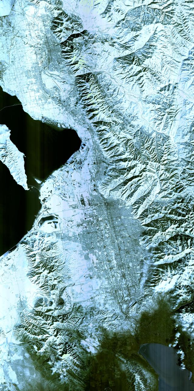
The 2002 Winter Olympics are hosted by Salt Lake City at several venues within the city, in nearby cities, and within the adjacent Wasatch Mountains. This simulated natural color image presents a snowy, winter view of north central Utah that includes all of the Olympic sites. The image extends from Ogden in the north, to Provo in the south; and includes the snow-capped Wasatch Mountains and the eastern part of the Great Salt Lake. This image was acquired on February 8, 2001 by the Advanced Spaceborne Thermal Emission and Reflection Radiometer (ASTER) on NASA's Terra satellite. With its 14 spectral bands from the visible to the thermal infrared wavelength region, and its high spatial resolution of 15 to 90 meters (about 50 to 300 feet), ASTER will image Earth for the next 6 years to map and monitor the changing surface of our planet. http://photojournal.jpl.nasa.gov/catalog/PIA03465
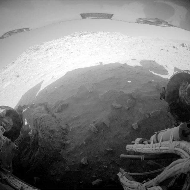
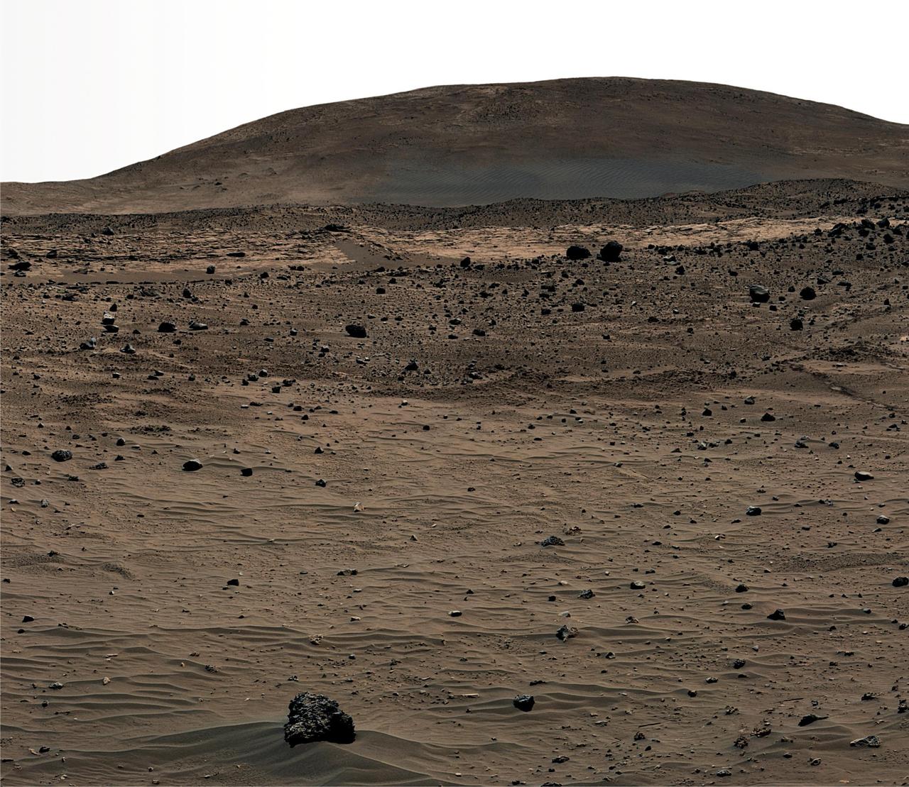
NASA Mars Exploration Rover Spirit recorded this fisheye view after completing a drive during on Mars on Feb. 8, 2010. The drive left Spirit in the position where the rover will stay parked during the upcoming Mars southern-hemisphere winter.
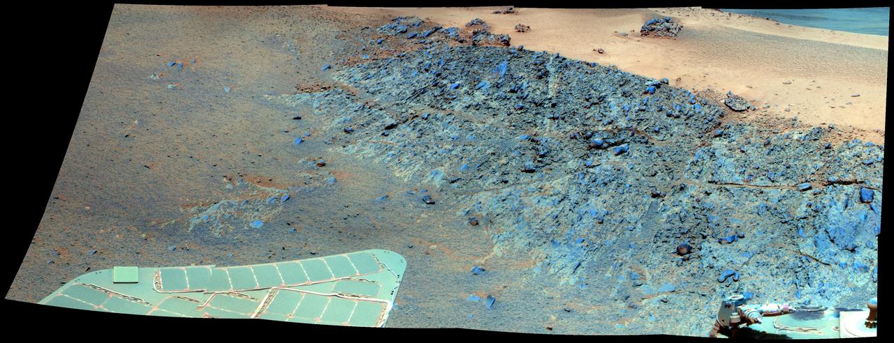
This false color mosaic from NASA rover Opportunity shows a north-facing outcrop, informally named Greeley Haven. This site optimizes Opportunity solar energy as winter approaches.
On Jan. 20 at 2:30 p.m. EST the VIIRS instrument aboard NASA-NOAA's Suomi NPP captured this image of the winter storm moving through the central U.S. Credits: NASA Goddard Rapid Response The low pressure area from the Eastern Pacific Ocean moved into the western U.S. and tracked across the four corners region into Texas where NASA-NOAA's Suomi NPP satellite observed the clouds associated with the storm. The Visible Infrared Imaging Radiometer Suite (VIIRS) instrument aboard Suomi NPP satellite captured the visible image on January 20, 2016 at 19:30 UTC (2:30 p.m. EST) when the storm was over the central U.S. In the image, snow cover is visible in the Rockies and southern Great Lakes states. VIIRS collects visible and infrared imagery and global observations of land, atmosphere, cryosphere and oceans. That low pressure system located over the south central United States on Jan. 21 is expected to track east across the Tennessee Valley and will give way to a deepening coastal low pressure area. The National Weather Service said "This latter feature takes over and becomes a dominant force in setting up heavy snow bands over the Mid-Atlantic and very gusty winds." The storm system is expected to bring an increased risk of severe weather from far southeastern Texas across southern Louisiana/Mississippi, and into the far western Florida Panhandle on Thursday, Jan. 21. That threat for severe weather will move east as the low pressure area continues heading in that direction. The National Weather Service Weather Prediction Center in College Park, Maryland said "A potentially crippling winter storm is anticipated for portions of the mid-Atlantic Friday into early Saturday. Snowfall may approach two feet for some locations, including the Baltimore and Washington, D.C. metro areas. Farther north, there is uncertainty in snowfall for the New York City-to-Boston corridor. Farther south, significant icing is likely for portions of Kentucky and North Carolina." <b><a href="http://www.nasa.gov/audience/formedia/features/MP_Photo_Guidelines.html" rel="nofollow">NASA image use policy.</a></b> <b><a href="http://www.nasa.gov/centers/goddard/home/index.html" rel="nofollow">NASA Goddard Space Flight Center</a></b> enables NASA’s mission through four scientific endeavors: Earth Science, Heliophysics, Solar System Exploration, and Astrophysics. Goddard plays a leading role in NASA’s accomplishments by contributing compelling scientific knowledge to advance the Agency’s mission. <b>Follow us on <a href="http://twitter.com/NASAGoddardPix" rel="nofollow">Twitter</a></b> <b>Like us on <a href="http://www.facebook.com/pages/Greenbelt-MD/NASA-Goddard/395013845897?ref=tsd" rel="nofollow">Facebook</a></b> <b>Find us on <a href="http://instagram.com/nasagoddard?vm=grid" rel="nofollow">Instagram</a></b>
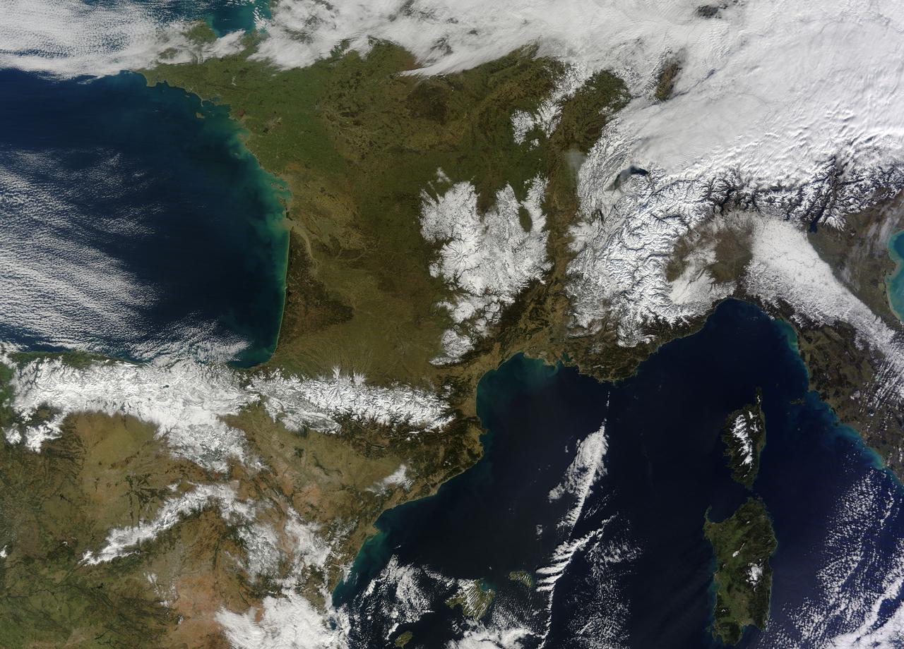
In February 2015, New England was not alone in dealing with the wrath of Old Man Winter. Thick snow blanketed mountain ranges in southwestern Europe after a winter storm pushed through the region in early February. The Moderate Resolution Imaging Spectroradiometer (MODIS) on NASA’s Terra satellite captured this true-color image of the snow-covered peaks of the Cantabrian Mountains, the Pyrenees, the Alps, and Massif Central on February 9, 2015. Credit: NASA/GSFC/Jeff Schmaltz/MODIS Land Rapid Response Team <b><a href="http://www.nasa.gov/audience/formedia/features/MP_Photo_Guidelines.html" rel="nofollow">NASA image use policy.</a></b> <b><a href="http://www.nasa.gov/centers/goddard/home/index.html" rel="nofollow">NASA Goddard Space Flight Center</a></b> enables NASA’s mission through four scientific endeavors: Earth Science, Heliophysics, Solar System Exploration, and Astrophysics. Goddard plays a leading role in NASA’s accomplishments by contributing compelling scientific knowledge to advance the Agency’s mission. <b>Follow us on <a href="http://twitter.com/NASAGoddardPix" rel="nofollow">Twitter</a></b> <b>Like us on <a href="http://www.facebook.com/pages/Greenbelt-MD/NASA-Goddard/395013845897?ref=tsd" rel="nofollow">Facebook</a></b> <b>Find us on <a href="http://instagram.com/nasagoddard?vm=grid" rel="nofollow">Instagram</a></b>
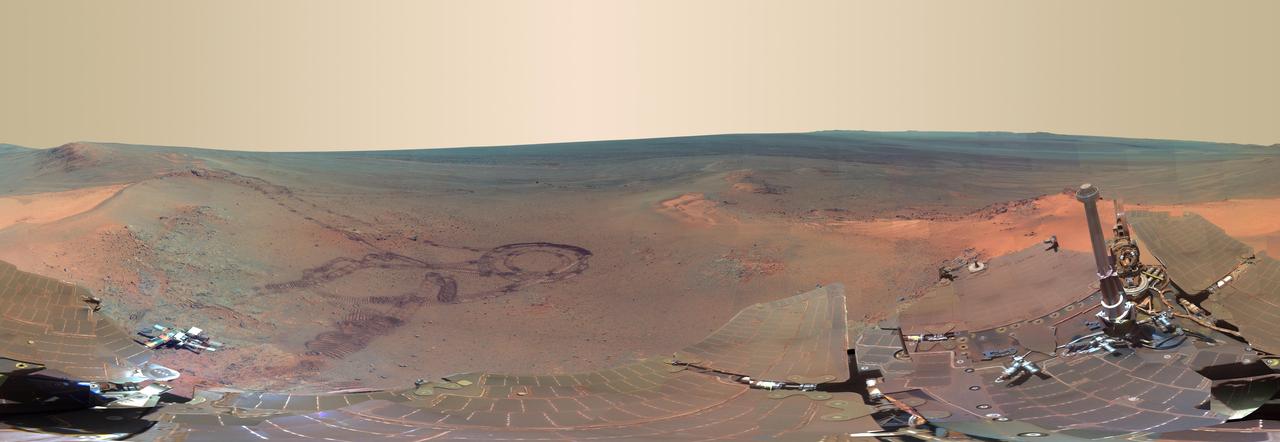
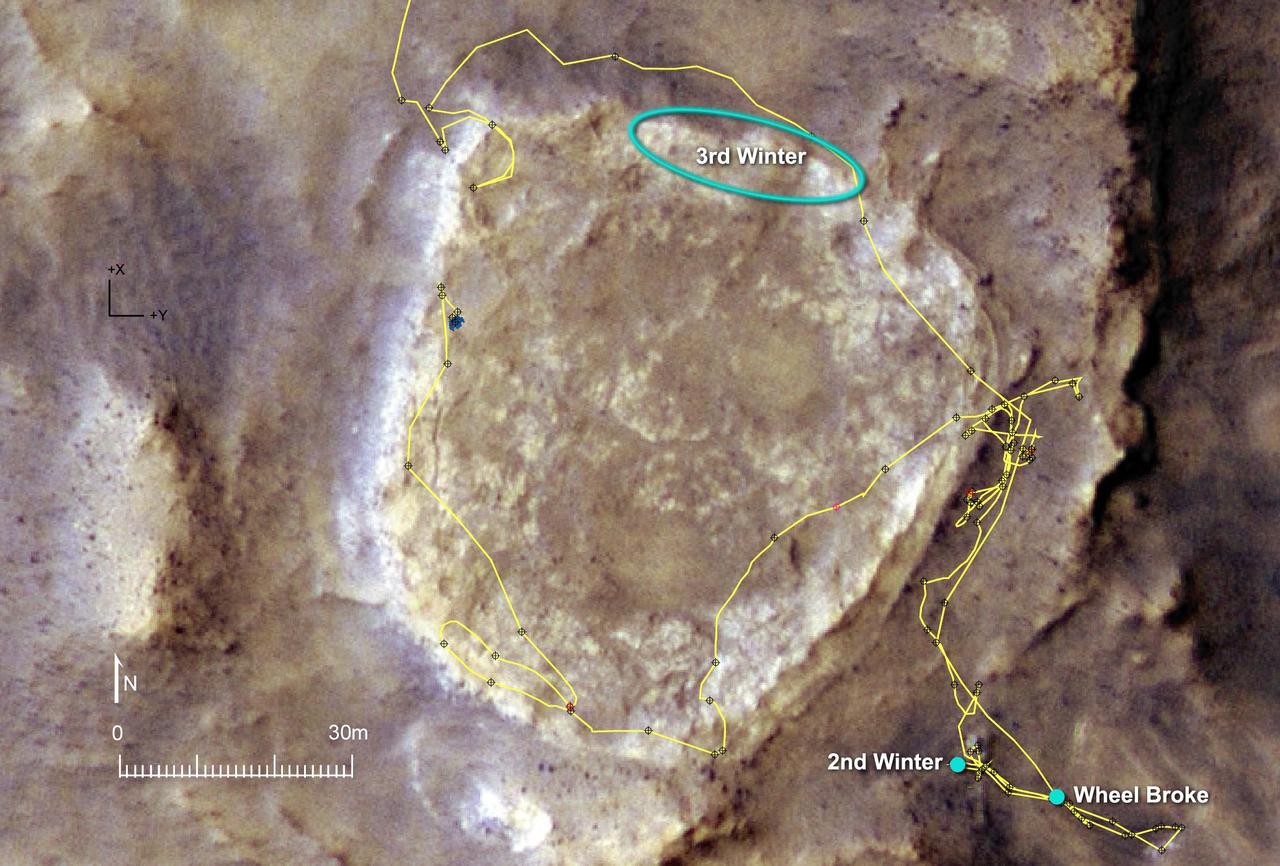
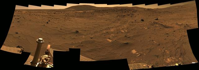
This full-circle scene combines 817 images, taken by the panoramic camera on NASA Mars Exploration Rover Opportunity, showing the terrain that surrounded the rover while it was stationary for four months of work during its most recent Martian winter.
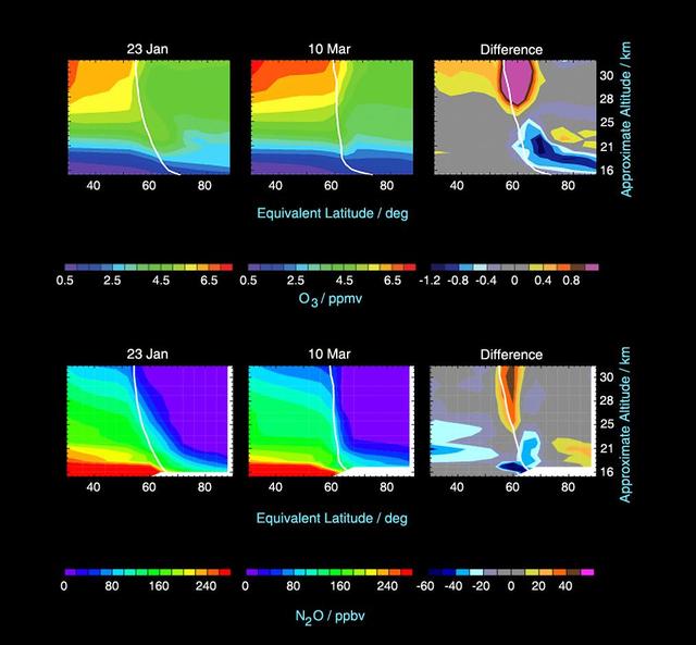
This image from the Microwave Limb Sounder instrument on NASA Aura spacecraft depicts the relationship between nitrous oxide levels and ozone loss, 2004-2005 Arctic winter.
A winter storm was bringing snow, sleet and freezing rain from lower Mississippi Valley to Northeastern U.S. on Thursday, March 5, 2015. A new NASA animation of NOAA's GOES-East satellite imagery showed the progression of the clouds associated with the storm system that triggered winter storm warnings and winter weather advisories from the southern Plains eastward through the Mid-Atlantic and southern New England coast. The system also triggered flood warnings along and to the west of the central Appalachians. An animation of GOES satellite visible and infrared imagery from March 3 through March 5 showed clouds associated with a cold front push over U.S. East coast. Behind the front, Arctic air is expected to drop low temperatures into the single numbers from Washington, D.C. to Minnesota overnight. Temperatures in the Carolinas and Tennessee are expected to drop to the low 20s. NOAA's National Weather Service Weather Prediction Center (NWS NPC) in College Park, Maryland noted "a strong cold front moving across the eastern U.S. will bring heavy snow from parts of the Ohio Valley to the Northeast today (March 5) with rain, freezing rain and sleet possible from parts of the lower Mississippi Valley across the Southeast to the southern Mid-Atlantic. Snowfall totals of 5 to 10 inches are possible for some areas. Winter Storm Warnings remain in effect from Texas to Nantucket." The animation ends at 17:45 UTC (12:45 p.m. EST). Before the end of the animation, the low pressure center along an arctic frontal boundary was nearly stationary over western North Carolina at 9 a.m. EST on March 5, according to the NWS NPC. NWS radar and surface observations indicated an extended swath of precipitation from near the Texas Gulf Coast through the interior eastern U.S. into southern New England. NPC's storm summary noted at that time "rain was changing to sleet/freezing rain and to all snow along a band within this swath as colder air continues to filter in from the north. Some areas in Tennessee, the northern mid-Atlantic and southern New England were reporting moderate to heavy snow." To create the video and imagery, NASA/NOAA's GOES Project takes the cloud data from NOAA's GOES-East satellite and overlays it on a true-color image of land and ocean created by data from the Moderate Resolution Imaging Spectroradiometer, or MODIS, instrument that flies aboard NASA's Aqua and Terra satellites. Together, those data created the entire picture of the storm and show its movement. After the storm system passes, the snow on the ground becomes visible. GOES satellites provide the kind of continuous monitoring necessary for intensive data analysis. Geostationary describes an orbit in which a satellite is always in the same position with respect to the rotating Earth. This allows GOES to hover continuously over one position on Earth's surface, appearing stationary. For updated information about the storm system, visit NOAA's NWS website: <a href="http://www.weather.gov" rel="nofollow">www.weather.gov</a> For more information about GOES satellites, visit: <a href="http://www.goes.noaa.gov/" rel="nofollow">www.goes.noaa.gov/</a> or goes.gsfc.nasa.gov/ Rob Gutro NASA's Goddard Space Flight Center <b><a href="http://www.nasa.gov/audience/formedia/features/MP_Photo_Guidelines.html" rel="nofollow">NASA image use policy.</a></b> <b><a href="http://www.nasa.gov/centers/goddard/home/index.html" rel="nofollow">NASA Goddard Space Flight Center</a></b> enables NASA’s mission through four scientific endeavors: Earth Science, Heliophysics, Solar System Exploration, and Astrophysics. Goddard plays a leading role in NASA’s accomplishments by contributing compelling scientific knowledge to advance the Agency’s mission. <b>Follow us on <a href="http://twitter.com/NASAGoddardPix" rel="nofollow">Twitter</a></b> <b>Like us on <a href="http://www.facebook.com/pages/Greenbelt-MD/NASA-Goddard/395013845897?ref=tsd" rel="nofollow">Facebook</a></b> <b>Find us on <a href="http://instagrid.me/nasagoddard/?vm=grid" rel="nofollow">Instagram</a></b>
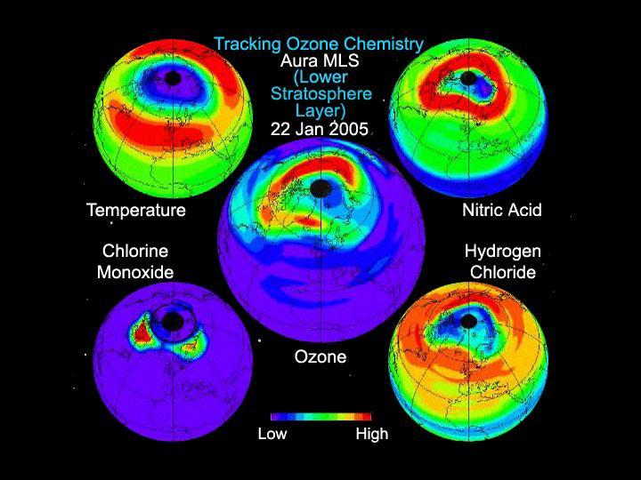
This still from an animation created from data from the Microwave Limb Sounder instrument on NASA Aura spacecraft depicts the complex interaction of chemicals involved in the destruction of ozone during the 2005 Arctic winter.
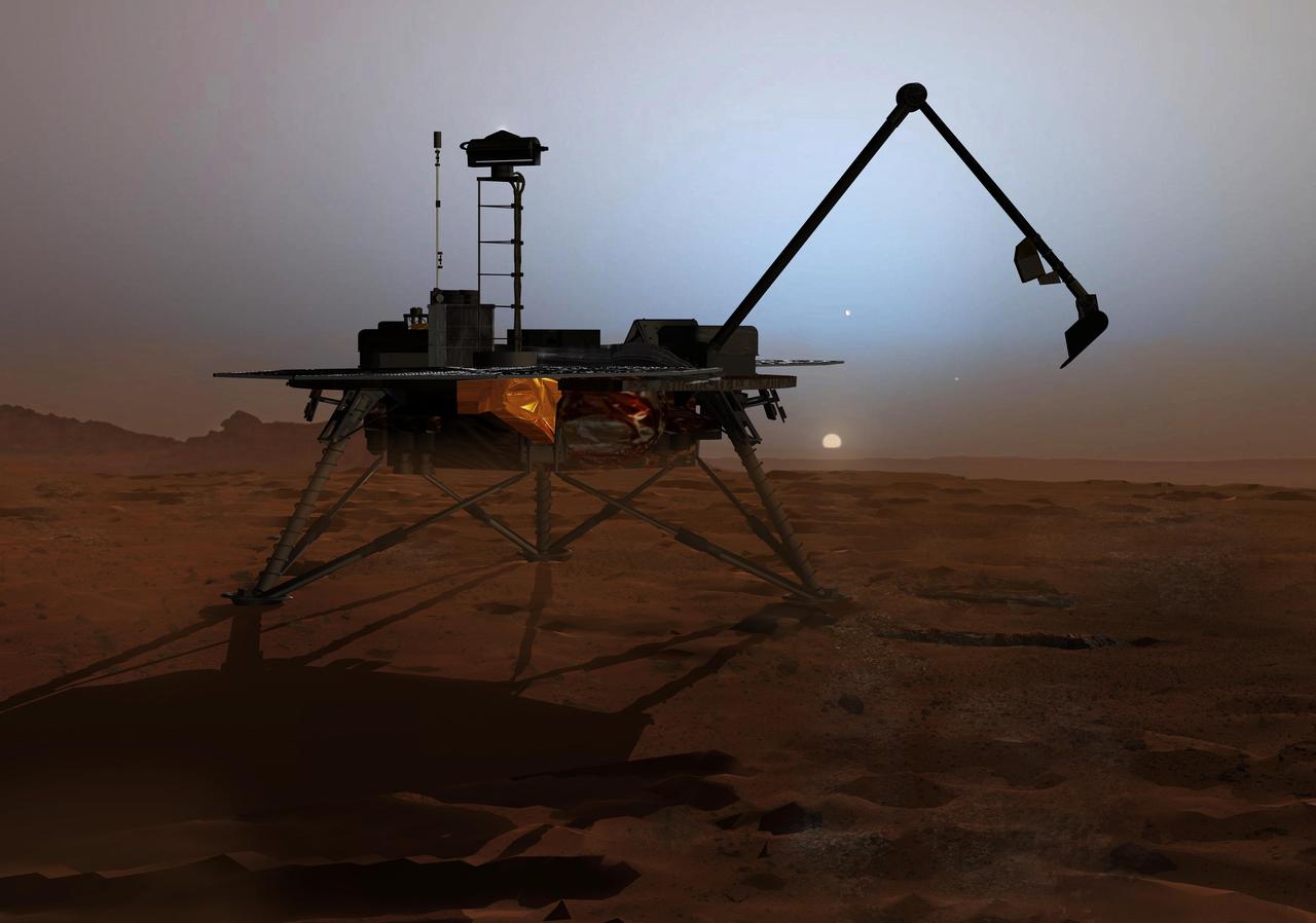
In this artist concept illustration, NASA Phoenix Mars Lander begins to shut down operations as winter sets in. The far-northern latitudes on Mars experience no sunlight during winter.
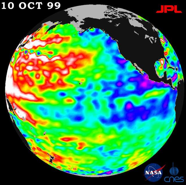
A repeat of last year mild La Niña conditions -- with a stormy winter in the Pacific Northwest and a dry winter in the southwestern United States -- will be the likely outcome of sea-surface heights observed by NASA TOPEX/Poseidon satellite.
This GOES-East image from March 5 at 17:30 UTC (12:30 p.m. EST) shows clouds associated with a cold front push east and south that brought winter weather to the U.S. East Coast. Credit: NASA/NOAA GOES Project <b><a href="http://www.nasa.gov/audience/formedia/features/MP_Photo_Guidelines.html" rel="nofollow">NASA image use policy.</a></b> <b><a href="http://www.nasa.gov/centers/goddard/home/index.html" rel="nofollow">NASA Goddard Space Flight Center</a></b> enables NASA’s mission through four scientific endeavors: Earth Science, Heliophysics, Solar System Exploration, and Astrophysics. Goddard plays a leading role in NASA’s accomplishments by contributing compelling scientific knowledge to advance the Agency’s mission. <b>Follow us on <a href="http://twitter.com/NASAGoddardPix" rel="nofollow">Twitter</a></b> <b>Like us on <a href="http://www.facebook.com/pages/Greenbelt-MD/NASA-Goddard/395013845897?ref=tsd" rel="nofollow">Facebook</a></b> <b>Find us on <a href="http://instagrid.me/nasagoddard/?vm=grid" rel="nofollow">Instagram</a></b>

New Horizons project manager Helene Winters of the Johns Hopkins University Applied Physics Laboratory speaks during an overview of the New Horizons Mission, Monday, Dec. 31, 2018 at Johns Hopkins University Applied Physics Laboratory (APL) in Laurel, Maryland. Photo Credit: (NASA/Joel Kowsky)
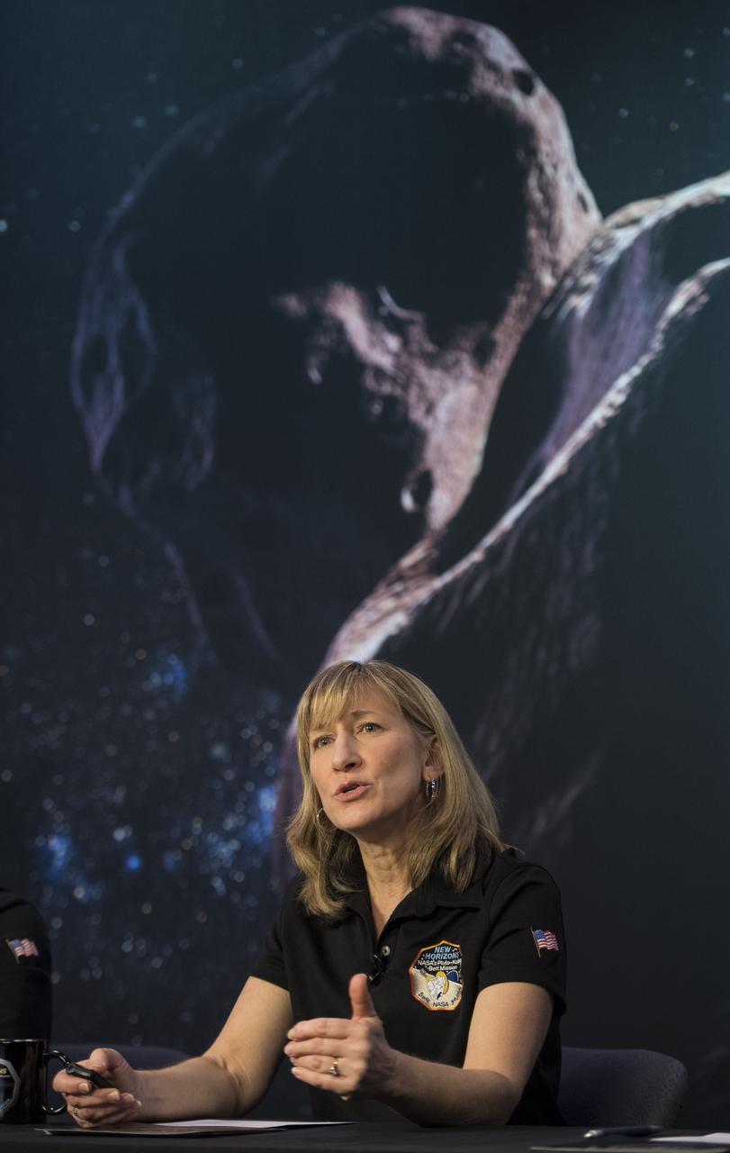
New Horizons project manager Helene Winters of the Johns Hopkins University Applied Physics Laboratory speaks at a press conference prior to the flyby of Ultima Thule by the New Horizons spacecraft, Monday, Dec. 31, 2018 at Johns Hopkins University Applied Physics Laboratory (APL) in Laurel, Maryland. Photo Credit: (NASA/Joel Kowsky)
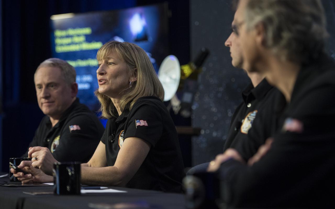
New Horizons project manager Helene Winters of the Johns Hopkins University Applied Physics Laboratory speaks at a press conference prior to the flyby of Ultima Thule by the New Horizons spacecraft, Monday, Dec. 31, 2018 at Johns Hopkins University Applied Physics Laboratory (APL) in Laurel, Maryland. Photo Credit: (NASA/Joel Kowsky)
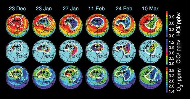
These data maps from the Microwave Limb Sounder on NASA Aura spacecraft depict levels of hydrogen chloride, chlorine monoxide, and ozone at an altitude of approximately 19 km 490,000 ft on selected days during the 2004-05 Arctic winter.
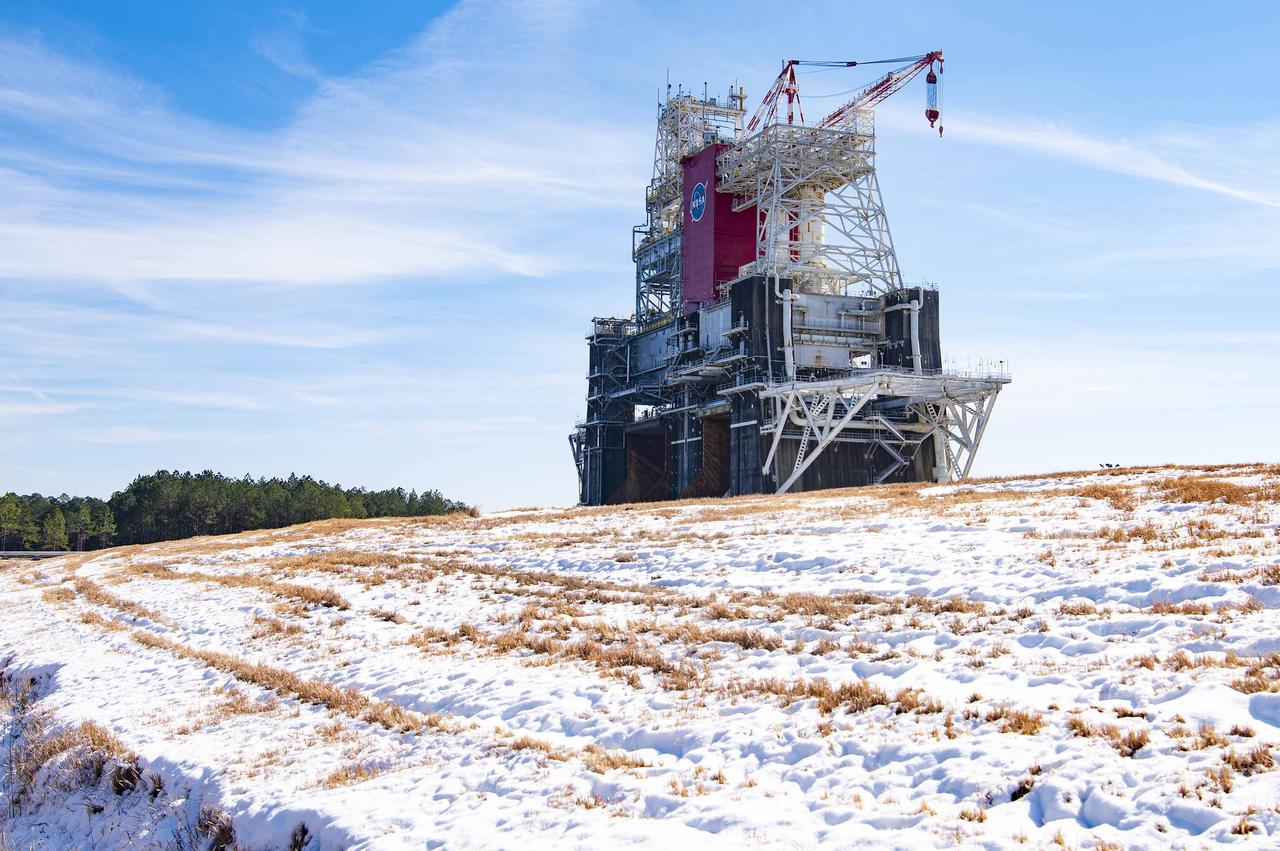
NASA’s Stennis Space Center near Bay St. Louis, Mississippi, is often associated with hot fires coming from the center’s long history of hot fire testing engines and stages that have helped power the nation’s space dreams since the first humans stepped foot on the Moon. However, NASA Stennis turned into a Winter Wonderland Jan. 21 when America’s largest rocket propulsion test site received a historic amount of snow across the unique federal city. Hancock County, where NASA Stennis is located, received five to seven inches of snow, according to the National Weather Service. It marked the most snow the county has received in 61 years. The December 31, 1963, snowfall holds the record at 10 inches of snow for Bay St. Louis, Mississippi.
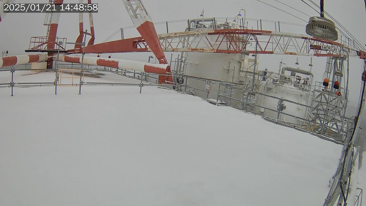
NASA’s Stennis Space Center near Bay St. Louis, Mississippi, is often associated with hot fires coming from the center’s long history of hot fire testing engines and stages that have helped power the nation’s space dreams since the first humans stepped foot on the Moon. However, NASA Stennis turned into a Winter Wonderland Jan. 21 when America’s largest rocket propulsion test site received a historic amount of snow across the unique federal city. Hancock County, where NASA Stennis is located, received five to seven inches of snow, according to the National Weather Service. It marked the most snow the county has received in 61 years. The December 31, 1963, snowfall holds the record at 10 inches of snow for Bay St. Louis, Mississippi.
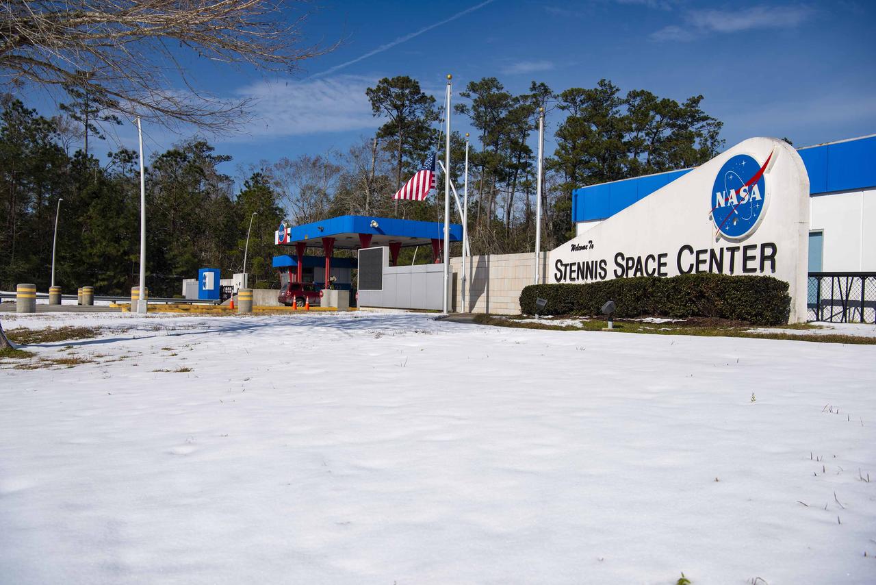
NASA’s Stennis Space Center near Bay St. Louis, Mississippi, is often associated with hot fires coming from the center’s long history of hot fire testing engines and stages that have helped power the nation’s space dreams since the first humans stepped foot on the Moon. However, NASA Stennis turned into a Winter Wonderland Jan. 21 when America’s largest rocket propulsion test site received a historic amount of snow across the unique federal city. Hancock County, where NASA Stennis is located, received five to seven inches of snow, according to the National Weather Service. It marked the most snow the county has received in 61 years. The December 31, 1963, snowfall holds the record at 10 inches of snow for Bay St. Louis, Mississippi.
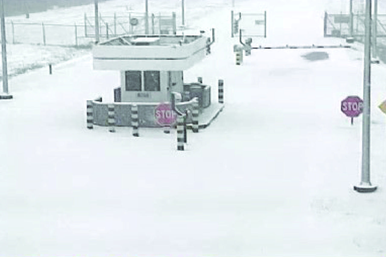
NASA’s Stennis Space Center near Bay St. Louis, Mississippi, is often associated with hot fires coming from the center’s long history of hot fire testing engines and stages that have helped power the nation’s space dreams since the first humans stepped foot on the Moon. However, NASA Stennis turned into a Winter Wonderland Jan. 21 when America’s largest rocket propulsion test site received a historic amount of snow across the unique federal city. Hancock County, where NASA Stennis is located, received five to seven inches of snow, according to the National Weather Service. It marked the most snow the county has received in 61 years. The December 31, 1963, snowfall holds the record at 10 inches of snow for Bay St. Louis, Mississippi.
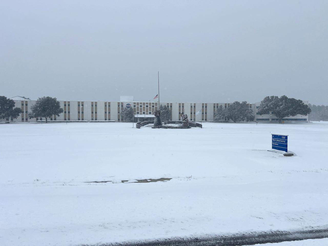
NASA’s Stennis Space Center near Bay St. Louis, Mississippi, is often associated with hot fires coming from the center’s long history of hot fire testing engines and stages that have helped power the nation’s space dreams since the first humans stepped foot on the Moon. However, NASA Stennis turned into a Winter Wonderland Jan. 21 when America’s largest rocket propulsion test site received a historic amount of snow across the unique federal city. Hancock County, where NASA Stennis is located, received five to seven inches of snow, according to the National Weather Service. It marked the most snow the county has received in 61 years. The December 31, 1963, snowfall holds the record at 10 inches of snow for Bay St. Louis, Mississippi.
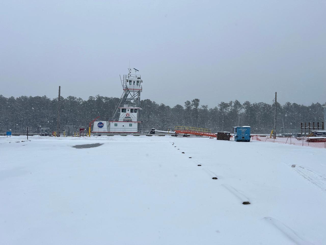
NASA’s Stennis Space Center near Bay St. Louis, Mississippi, is often associated with hot fires coming from the center’s long history of hot fire testing engines and stages that have helped power the nation’s space dreams since the first humans stepped foot on the Moon. However, NASA Stennis turned into a Winter Wonderland Jan. 21 when America’s largest rocket propulsion test site received a historic amount of snow across the unique federal city. Hancock County, where NASA Stennis is located, received five to seven inches of snow, according to the National Weather Service. It marked the most snow the county has received in 61 years. The December 31, 1963, snowfall holds the record at 10 inches of snow for Bay St. Louis, Mississippi.
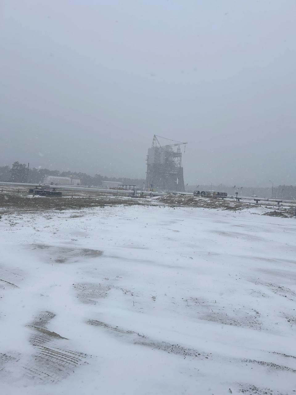
NASA’s Stennis Space Center near Bay St. Louis, Mississippi, is often associated with hot fires coming from the center’s long history of hot fire testing engines and stages that have helped power the nation’s space dreams since the first humans stepped foot on the Moon. However, NASA Stennis turned into a Winter Wonderland Jan. 21 when America’s largest rocket propulsion test site received a historic amount of snow across the unique federal city. Hancock County, where NASA Stennis is located, received five to seven inches of snow, according to the National Weather Service. It marked the most snow the county has received in 61 years. The December 31, 1963, snowfall holds the record at 10 inches of snow for Bay St. Louis, Mississippi.
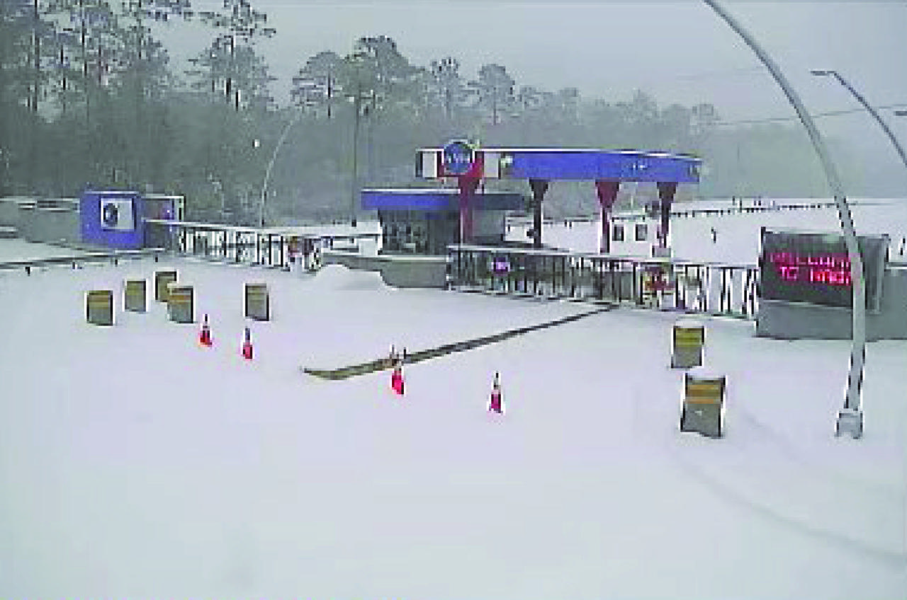
NASA’s Stennis Space Center near Bay St. Louis, Mississippi, is often associated with hot fires coming from the center’s long history of hot fire testing engines and stages that have helped power the nation’s space dreams since the first humans stepped foot on the Moon. However, NASA Stennis turned into a Winter Wonderland Jan. 21 when America’s largest rocket propulsion test site received a historic amount of snow across the unique federal city. Hancock County, where NASA Stennis is located, received five to seven inches of snow, according to the National Weather Service. It marked the most snow the county has received in 61 years. The December 31, 1963, snowfall holds the record at 10 inches of snow for Bay St. Louis, Mississippi.
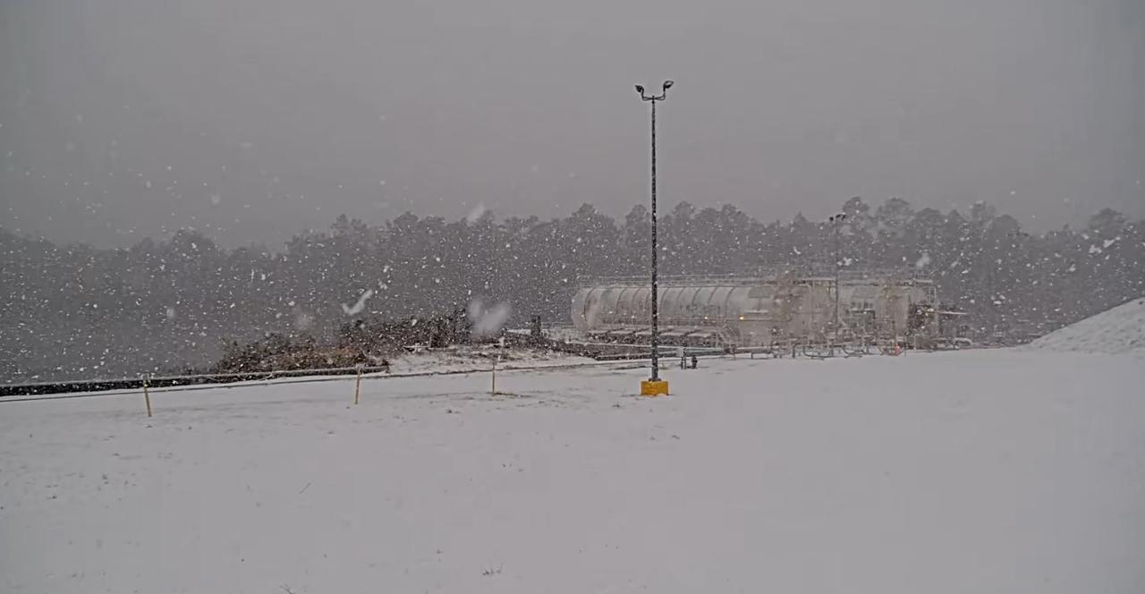
NASA’s Stennis Space Center near Bay St. Louis, Mississippi, is often associated with hot fires coming from the center’s long history of hot fire testing engines and stages that have helped power the nation’s space dreams since the first humans stepped foot on the Moon. However, NASA Stennis turned into a Winter Wonderland Jan. 21 when America’s largest rocket propulsion test site received a historic amount of snow across the unique federal city. Hancock County, where NASA Stennis is located, received five to seven inches of snow, according to the National Weather Service. It marked the most snow the county has received in 61 years. The December 31, 1963, snowfall holds the record at 10 inches of snow for Bay St. Louis, Mississippi.
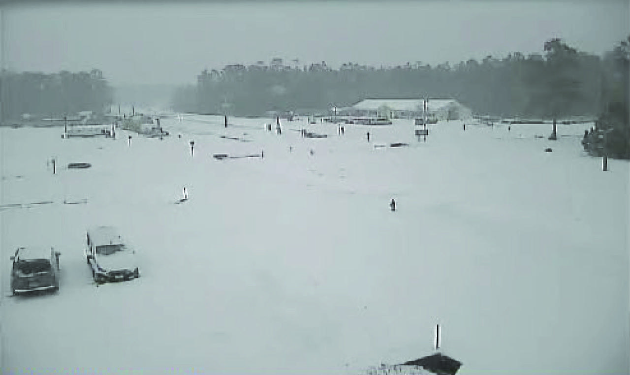
NASA’s Stennis Space Center near Bay St. Louis, Mississippi, is often associated with hot fires coming from the center’s long history of hot fire testing engines and stages that have helped power the nation’s space dreams since the first humans stepped foot on the Moon. However, NASA Stennis turned into a Winter Wonderland Jan. 21 when America’s largest rocket propulsion test site received a historic amount of snow across the unique federal city. Hancock County, where NASA Stennis is located, received five to seven inches of snow, according to the National Weather Service. It marked the most snow the county has received in 61 years. The December 31, 1963, snowfall holds the record at 10 inches of snow for Bay St. Louis, Mississippi.
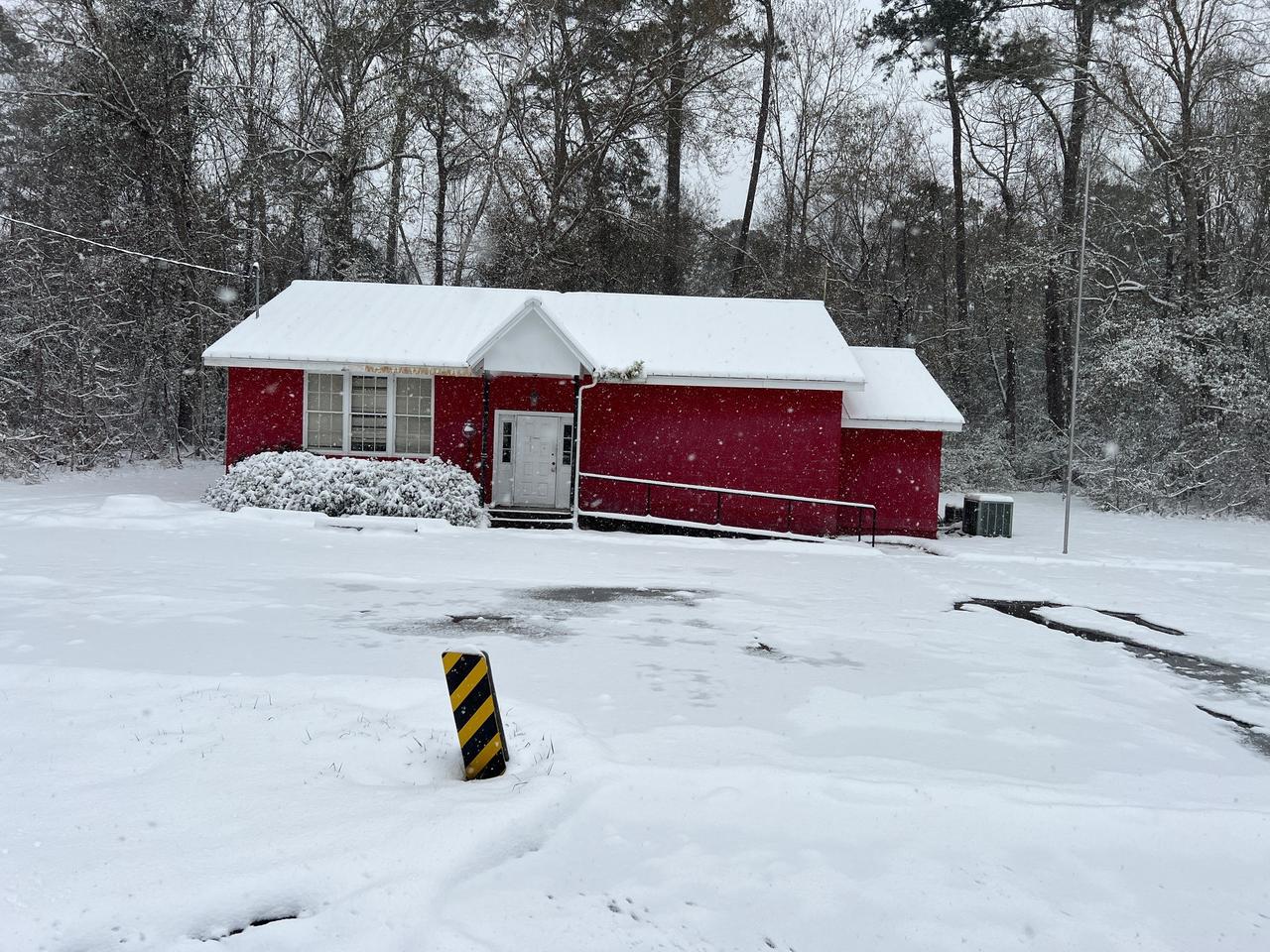
NASA’s Stennis Space Center near Bay St. Louis, Mississippi, is often associated with hot fires coming from the center’s long history of hot fire testing engines and stages that have helped power the nation’s space dreams since the first humans stepped foot on the Moon. However, NASA Stennis turned into a Winter Wonderland Jan. 21 when America’s largest rocket propulsion test site received a historic amount of snow across the unique federal city. Hancock County, where NASA Stennis is located, received five to seven inches of snow, according to the National Weather Service. It marked the most snow the county has received in 61 years. The December 31, 1963, snowfall holds the record at 10 inches of snow for Bay St. Louis, Mississippi.
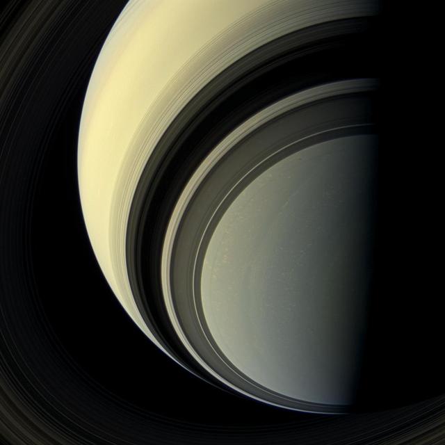
Winter is approaching in the southern hemisphere of Saturn and with this cold season has come the familiar blue hue that was present in the northern winter hemisphere at the start of NASA's Cassini mission. The changing blue hue that we have learned marks winter at Saturn is likely due to reduction of ultraviolet sunlight and the haze it produces, making the atmosphere clearer and increasing the opportunity for Rayleigh scattering (scattering by molecules and smaller particles) and methane absorption: both processes make the atmosphere blue. The small black dot seen to the right and up from image center, within the ring shadows of the A and F rings, is the shadow of the moon, Prometheus. For an image showing winter in the northern hemisphere see PIA08166. This view looks toward the unilluminated side of the rings from about 44 degrees below the ring plane. Images taken using red, green and blue spectral filters were combined to create this natural color view. The images were taken with the Cassini spacecraft wide-angle camera on July 29, 2013. This view was acquired at a distance of approximately 1.003 million miles (1.615 million kilometers) from Saturn. Image scale is 58 miles (93 kilometers) per pixel. http://photojournal.jpl.nasa.gov/catalog/PIA17176

New Horizons principal investigator Alan Stern of the Southwest Research Institute (SwRI), Boulder, CO and New Horizons project manager Helene Winters of the Johns Hopkins University Applied Physics Laboratory discuss the various teams have helped work on New Horizons, Monday, Dec. 31, 2018 at Johns Hopkins University Applied Physics Laboratory (APL) in Laurel, Maryland. Photo Credit: (NASA/Bill Ingalls)
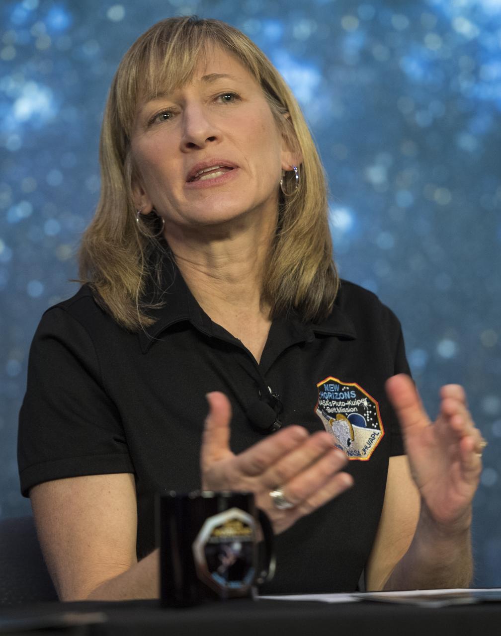
New Horizons project manager Helene Winters of the Johns Hopkins University Applied Physics Laboratory speaks during a press conference prior to the flyby of Ultima Thule by the New Horizons spacecraft, Monday, Dec. 31, 2018 at Johns Hopkins University Applied Physics Laboratory (APL) in Laurel, Maryland. Photo Credit: (NASA/Joel Kowsky)

NASA Shuttle Weather Officer Kathy Winters participates in the space shuttle Discovery launch status briefing on Friday, Oct. 29, 2010 at the NASA Kennedy Space Center in Cape Canaveral, Fla. Discovery and it's STS-133 mission crew of six are currently targeted to launch at 4:17p.m. EDT on Tuesday, Nov. 2, 2010. Photo Credit: (NASA/Bill Ingalls)
iss074e0044347 (Jan. 3, 2026) --- Harbin, China—nicknamed the “Ice City” for its long, harsh winters and home to about 10.6 million people—is pictured at approximately 3:28 a.m. local time from the International Space Station as it orbited 266 miles above the Asian continent. The city hosts the world-famous Harbin International Ice and Snow Festival and serves as an economic hub for manufacturing, energy, and education. Credit: JAXA/Kimiya Yui
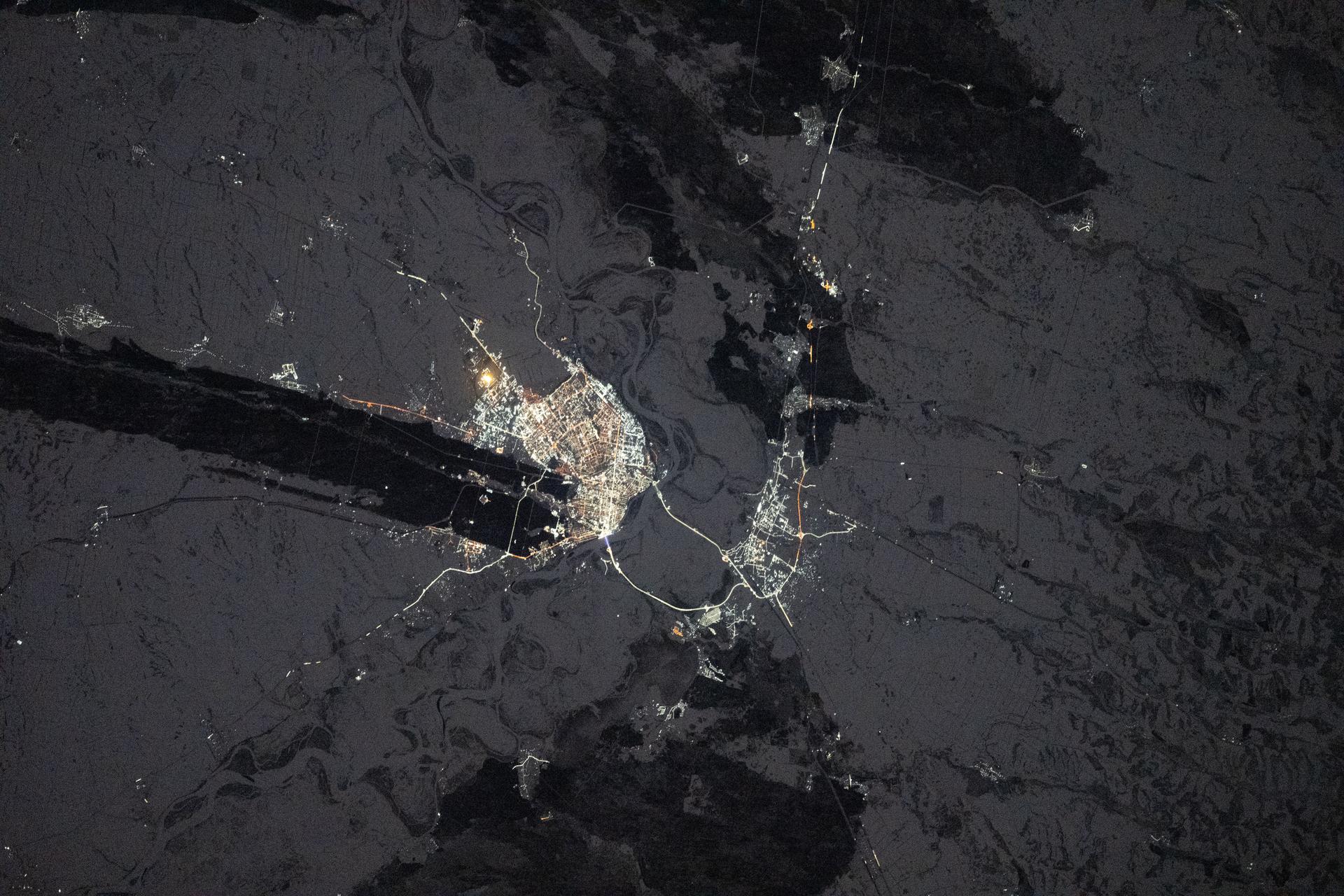
iss074e0044122 (Jan. 3, 2026) --- The city lights of Barnaul in Siberia, Russia, contrast with the extreme winter landscape. The darkened strip of land jutting out from the center of the city is part of the Ob River floodplain and terrace system, which is ideal for farming crops like wheat, barley, and sunflowers. The International Space Station was orbiting 265 miles above Earth at approximately 1:20 a.m. local time when this photograph was taken. Credit: JAXA/Kimiya Yui
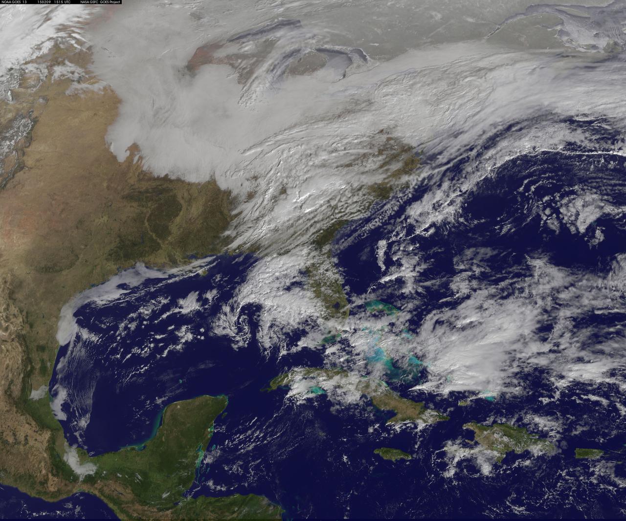
Another large snowstorm affecting New England was dropping more snow on the region and breaking records on February 9, as NOAA's GOES-East satellite captured an image of the clouds associated with the storm system. On Feb. 9, NOAA's National Weather Service in Boston, Massachusetts noted that "The 30-day snowfall total at Boston ending 7 a.m. this morning is 61.6 inches. This exceeds the previous maximum 30 day snowfall total on record at Boston, which was 58.8 inches ending Feb 7 1978." The GOES-East image was created by NASA/NOAA's GOES Project at NASA's Goddard Space Flight Center in Greenbelt, Maryland. It showed a blanket of clouds over the U.S. northeast that stretched down to the Mid-Atlantic where there was no snow on the ground in Washington, D.C. NOAA's National Weather Service Weather Prediction Center provided a look at the extent of the storm system and noted "Heavy snow will impact portions of New York State and New England as the new week begins. Freezing rain will spread from western Pennsylvania to Long Island, with rain for the mid-Atlantic states." The low pressure area bringing the snow to the northeast was located in central Pennsylvania. A cold front extended southward from the low across the Tennessee Valley while a stationary boundary extended eastward from the low across the central mid-Atlantic. To create the image, NASA/NOAA's GOES Project takes the cloud data from NOAA's GOES-East satellite and overlays it on a true-color image of land and ocean created by data from the Moderate Resolution Imaging Spectroradiometer, or MODIS, instrument that flies aboard NASA's Aqua and Terra satellites. Together, those data created the entire picture of the storm. NOAA's GOES satellites provide the kind of continuous monitoring necessary for intensive data analysis. Geostationary describes an orbit in which a satellite is always in the same position with respect to the rotating Earth. This allows GOES to hover continuously over one position on Earth's surface, appearing stationary. As a result, GOES provide a constant vigil for the atmospheric triggers for severe weather conditions such as tornadoes, flash floods, hail storms and hurricanes. For updated information about the storm system, visit NOAA's NWS website: <a href="http://www.weather.gov" rel="nofollow">www.weather.gov</a> For more information about GOES satellites, visit: <a href="http://www.goes.noaa.gov/" rel="nofollow">www.goes.noaa.gov/</a> or goes.gsfc.nasa.gov/ Rob Gutro NASA's Goddard Space Flight Center <b><a href="http://goes.gsfc.nasa.gov/" rel="nofollow">Credit: NOAA/NASA GOES Project</a></b> <b><a href="http://www.nasa.gov/audience/formedia/features/MP_Photo_Guidelines.html" rel="nofollow">NASA image use policy.</a></b> <b><a href="http://www.nasa.gov/centers/goddard/home/index.html" rel="nofollow">NASA Goddard Space Flight Center</a></b> enables NASA’s mission through four scientific endeavors: Earth Science, Heliophysics, Solar System Exploration, and Astrophysics. Goddard plays a leading role in NASA’s accomplishments by contributing compelling scientific knowledge to advance the Agency’s mission. <b>Follow us on <a href="http://twitter.com/NASAGoddardPix" rel="nofollow">Twitter</a></b> <b>Like us on <a href="http://www.facebook.com/pages/Greenbelt-MD/NASA-Goddard/395013845897?ref=tsd" rel="nofollow">Facebook</a></b> <b>Find us on <a href="http://instagram.com/nasagoddard?vm=grid" rel="nofollow">Instagram</a></b>

A hypothetical planet is depicted in this artist concept moving through the habitable zone and then further out into a long, cold winter.
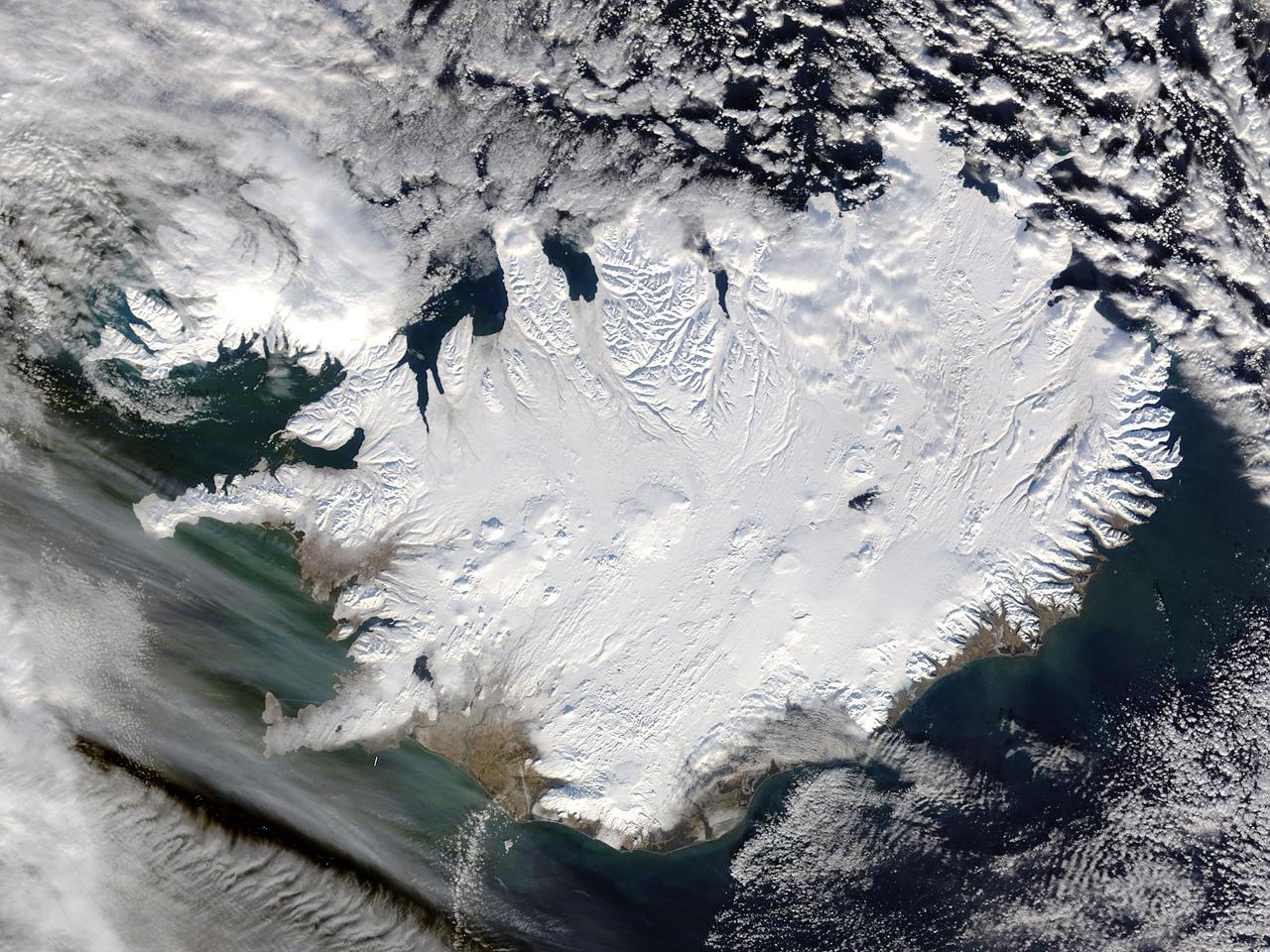
Iceland, dressed in winter white, peaked through a hole in a complex system of clouds in late February, 2015. The Moderate Resolution Imaging Spectroradiometer (MODIS) aboard NASA’s Terra satellite captured this true-color image on February 21 as it passed over the region. Ice and snow covers Iceland almost entirely, except for coastal regions in the southwest and southeast. The extensive, roughly H-shaped area in the southeast section of the island is Vatnajökull, Iceland’s largest glacier. Hidden underneath the ice lies Bardarbunga, a large subglacial stratovolcano. On August 31, 2014 the volcano began an eruption at two fissures to the north of the glacier and deposited a lava field that measured about 131 feet (40 meters) at its thickest points, and covered an area about 33 sq. mi (85 sq. km) by the time the eruption ended on February 27, 2015. The massive lava flow left its mark on Iceland – the cooled lava can be seen as the roughly oval black area to the north of the Vatnajökull glacier. Credit: NASA/GSFC/Jeff Schmaltz/MODIS Land Rapid Response Team <b><a href="http://www.nasa.gov/audience/formedia/features/MP_Photo_Guidelines.html" rel="nofollow">NASA image use policy.</a></b> <b><a href="http://www.nasa.gov/centers/goddard/home/index.html" rel="nofollow">NASA Goddard Space Flight Center</a></b> enables NASA’s mission through four scientific endeavors: Earth Science, Heliophysics, Solar System Exploration, and Astrophysics. Goddard plays a leading role in NASA’s accomplishments by contributing compelling scientific knowledge to advance the Agency’s mission. <b>Follow us on <a href="http://twitter.com/NASAGoddardPix" rel="nofollow">Twitter</a></b> <b>Like us on <a href="http://www.facebook.com/pages/Greenbelt-MD/NASA-Goddard/395013845897?ref=tsd" rel="nofollow">Facebook</a></b> <b>Find us on <a href="http://instagram.com/nasagoddard?vm=grid" rel="nofollow">Instagram</a></b>
NASA Spokesperson Allard Beutel, left, NASA Test Director Jeff Spaulding and Shuttle Weather Officer Kathy Winters, right, participate in the space shuttle Discovery launch status briefing on Friday, Oct. 29, 2010 at the NASA Kennedy Space Center in Cape Canaveral, Fla. Discovery and it's STS-133 mission crew of six are currently targeted to launch at 4:17p.m. EDT on Tuesday, Nov. 2, 2010. Photo Credit: (NASA/Bill Ingalls)
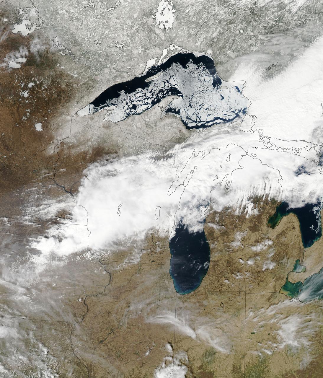
Though North America is a full month into astronomical spring, the Great Lakes have been slow to give up on winter. As of April 22, 2014, the Great Lakes were 33.9 percent ice covered. The lake they call Superior dominated the pack. In the early afternoon on April 20, 2014, the Moderate Resolution Imaging Spectroradiometer (MODIS) on NASA’s Aqua satellite captured this natural-color image of Lake Superior, which straddles the United States–Canada border. At the time Aqua passed over, the lake was 63.5 percent ice covered, according to the NOAA Great Lakes Environmental Research Lab (GLERL). Averaged across Lake Superior, ice was 22.6 centimeters (8.9 inches) thick; it was as much as twice that thickness in some locations. GLERL researcher George Leshkevich affirmed that ice cover this spring is significantly above normal. For comparison, Lake Superior had 3.6 percent ice cover on April 20, 2013; in 2012, ice was completely gone by April 12. In the last winter that ice cover grew so thick on Lake Superior (2009), it reached 93.7 percent on March 2 but was down to 6.7 percent by April 21. Average water temperatures on all of the Great Lakes have been rising over the past 30 to 40 years and ice cover has generally been shrinking. (Lake Superior ice was down about 79 percent since the 1970s.) But chilled by persistent polar air masses throughout the 2013-14 winter, ice cover reached 88.4 percent on February 13 and 92.2 percent on March 6, 2014, the second highest level in four decades of record-keeping. Air temperatures in the Great Lakes region were well below normal for March, and the cool pattern is being reinforced along the coasts because the water is absorbing less sunlight and warming less than in typical spring conditions. The graph below, based on data from Environment Canada, shows the 2014 conditions for all of the Great Lakes in mid-April compared to the past 33 years. Lake Superior ice cover got as high as 95.3 percent on March 19. By April 22, it was reported at 59.9 percent; Lake Huron was nearly 30.4 percent. News outlets noted that as many as 70 ships have been backed up in Lakes Michigan, Huron, and Erie, waiting for passage into ports on Lake Superior. The U.S. Coast Guard has been grouping ships together into small convoys after they pass through locks at Sault Ste. Marie, in order to maximize ice-breaking efficiency and to protect ships from damage. Superior is the world’s largest freshwater lake by area (82,100 square kilometers or 31,700 square miles) and the third largest by volume. The waters average 147 meters (483 feet) in depth, and the basin is believed to hold about 10 percent of the world’s liquid fresh water. NASA image courtesy Jeff Schmaltz LANCE/EOSDIS MODIS Rapid Response Team, GSFC. Caption by Mike Carlowicz. Read more: <a href="http://earthobservatory.nasa.gov/IOTD/view.php?id=83541&eocn=home&eoci=iotd_title" rel="nofollow">earthobservatory.nasa.gov/IOTD/view.php?id=83541&eocn...</a> Credit: <b><a href="http://www.earthobservatory.nasa.gov/" rel="nofollow"> NASA Earth Observatory</a></b> <b><a href="http://www.nasa.gov/audience/formedia/features/MP_Photo_Guidelines.html" rel="nofollow">NASA image use policy.</a></b> <b><a href="http://www.nasa.gov/centers/goddard/home/index.html" rel="nofollow">NASA Goddard Space Flight Center</a></b> enables NASA’s mission through four scientific endeavors: Earth Science, Heliophysics, Solar System Exploration, and Astrophysics. Goddard plays a leading role in NASA’s accomplishments by contributing compelling scientific knowledge to advance the Agency’s mission. <b>Follow us on <a href="http://twitter.com/NASAGoddardPix" rel="nofollow">Twitter</a></b> <b>Like us on <a href="http://www.facebook.com/pages/Greenbelt-MD/NASA-Goddard/395013845897?ref=tsd" rel="nofollow">Facebook</a></b> <b>Find us on <a href="http://instagram.com/nasagoddard?vm=grid" rel="nofollow">Instagram</a></b>
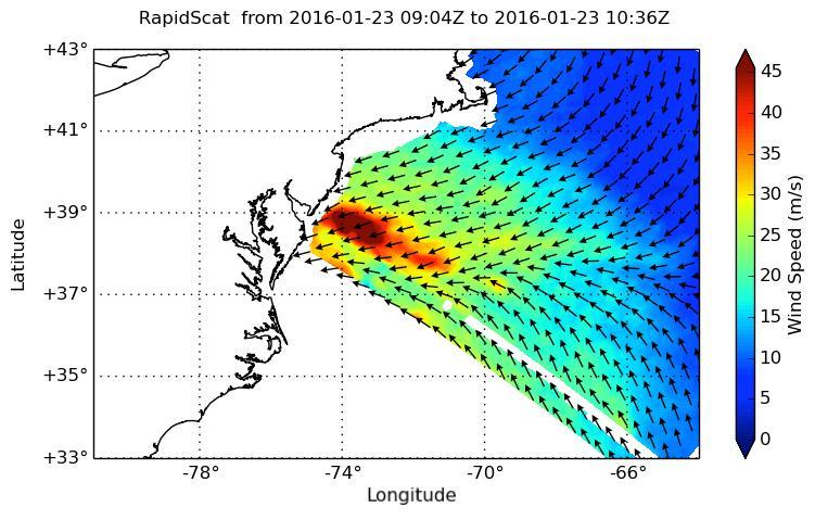
NASA's ISS-RapidScat instrument on the International Space Station provided a look at the strong winds that led to coastal flooding in southern New Jersey during the historic winter storm that blanketed much of the U.S. East Coast, starting Jan. 23, 2016. At 2 a.m. PST on Jan. 23, RapidScat showed sustained winds as strong as 45 meters per second (100 mph/162 kilometers per hour) along the coast of southern New Jersey. Many beachfront towns in this region were flooded as winds pushed ocean waters inland. The town of Cape May, New Jersey, reported a flood level of 8.98 feet (2.74 meters) -- the highest on record. This image shows ocean winds near the surface off the U.S. East Coast, from the hook of Cape Cod at top center to the South Carolina coastline at bottom left. Southern New Jersey and the northern edge of Delaware are directly in the path of the highest wind speeds. http://photojournal.jpl.nasa.gov/catalog/PIA20366
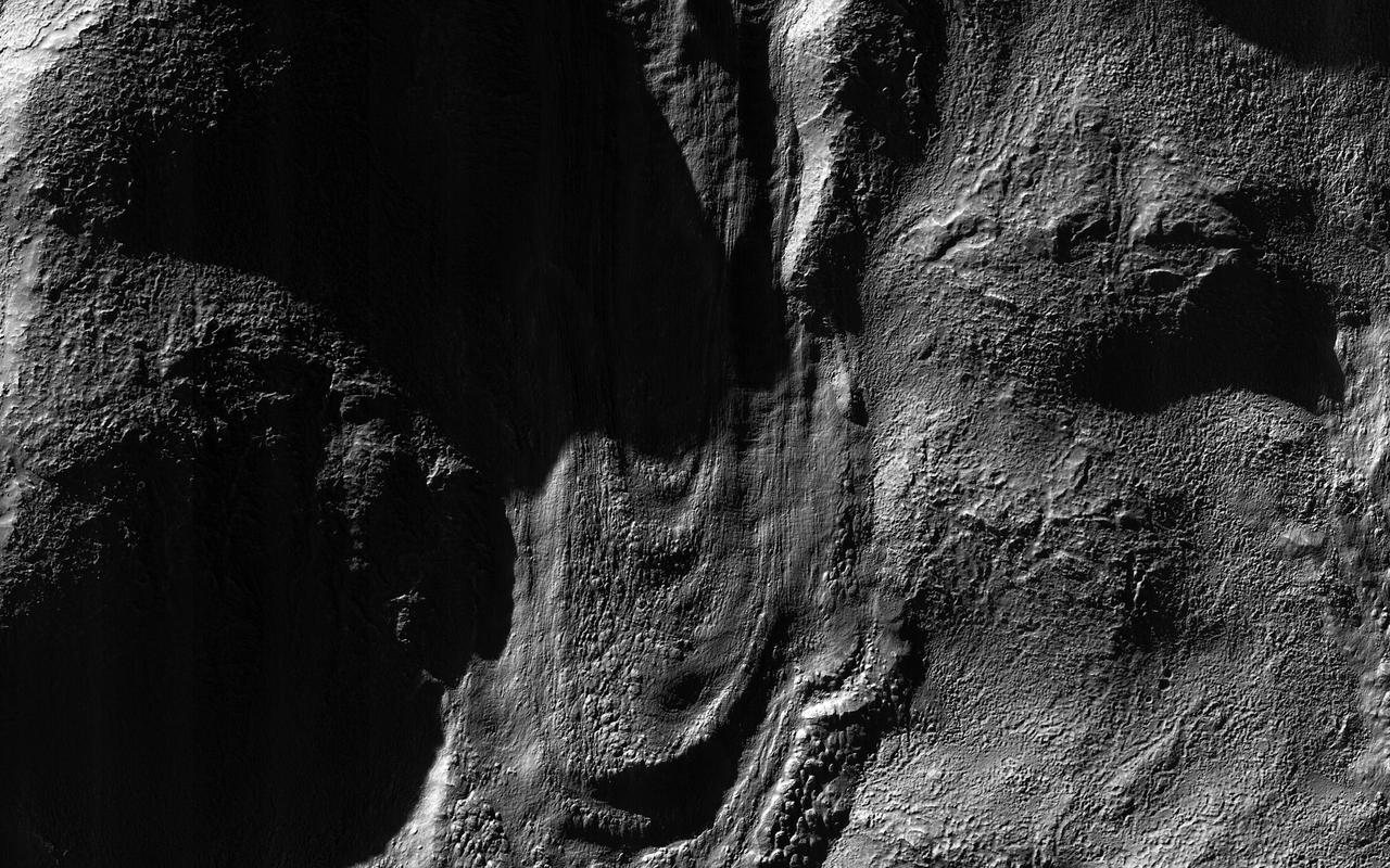
This image from NASA Mars Reconnaissance Orbiter spacecraft was acquired near the Martian winter solstice, when the sun was low over the horizon at this location.
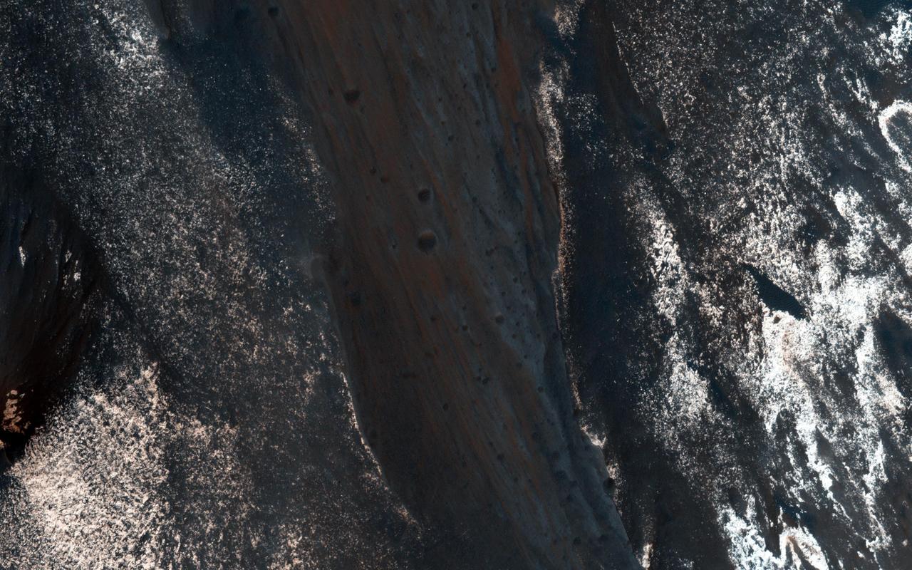
The formation of recurring slope lineae is a fascinating process on Mars. These RSLs show up in the spring and fade in the winter as seen by NASA Mars Reconnaissance Orbiter.
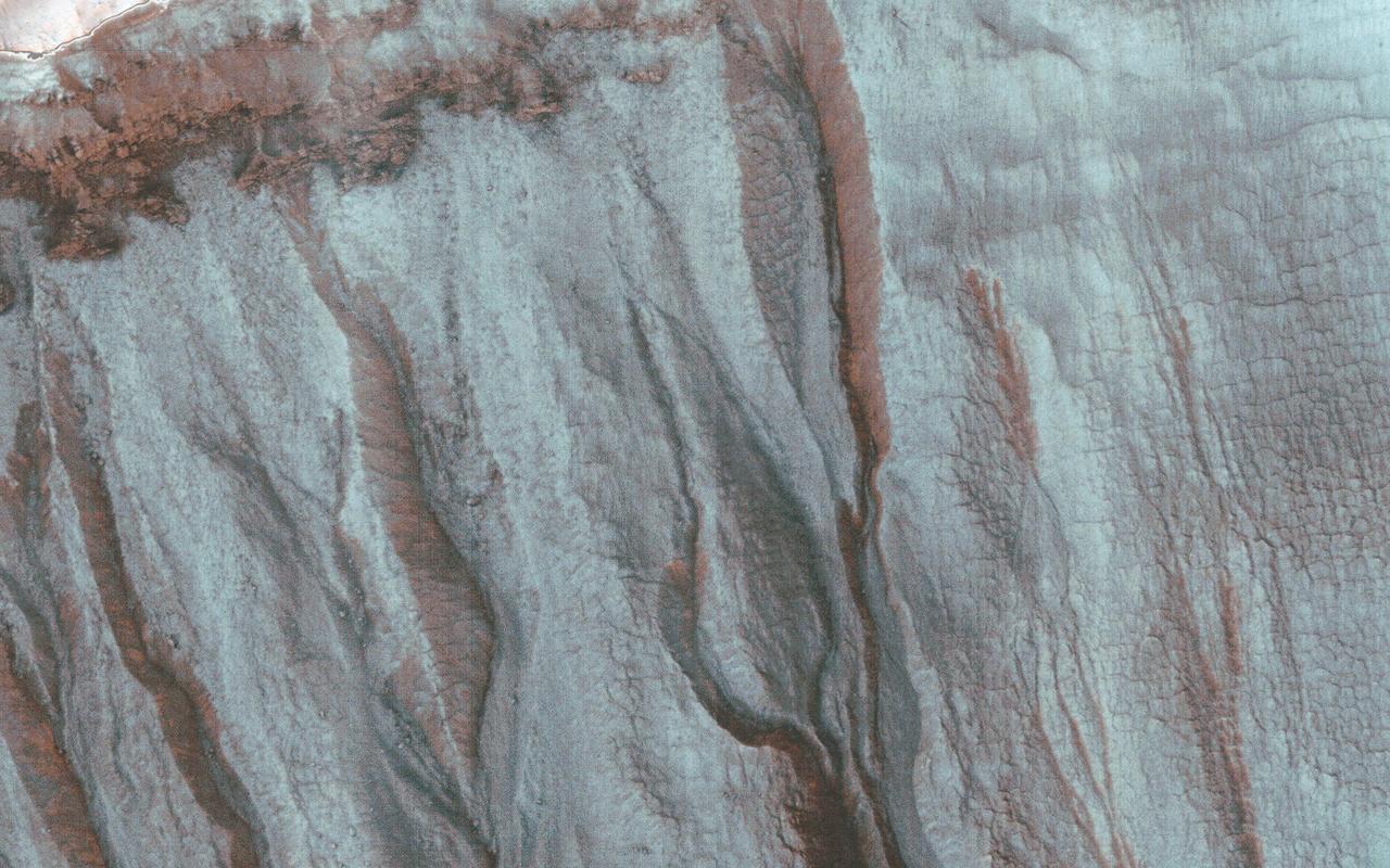
This image was acquired by NASA Mars Reconnaissance Orbiter spacecraft just after the northern winter solstice, when Southern hemisphere shadows are longest.
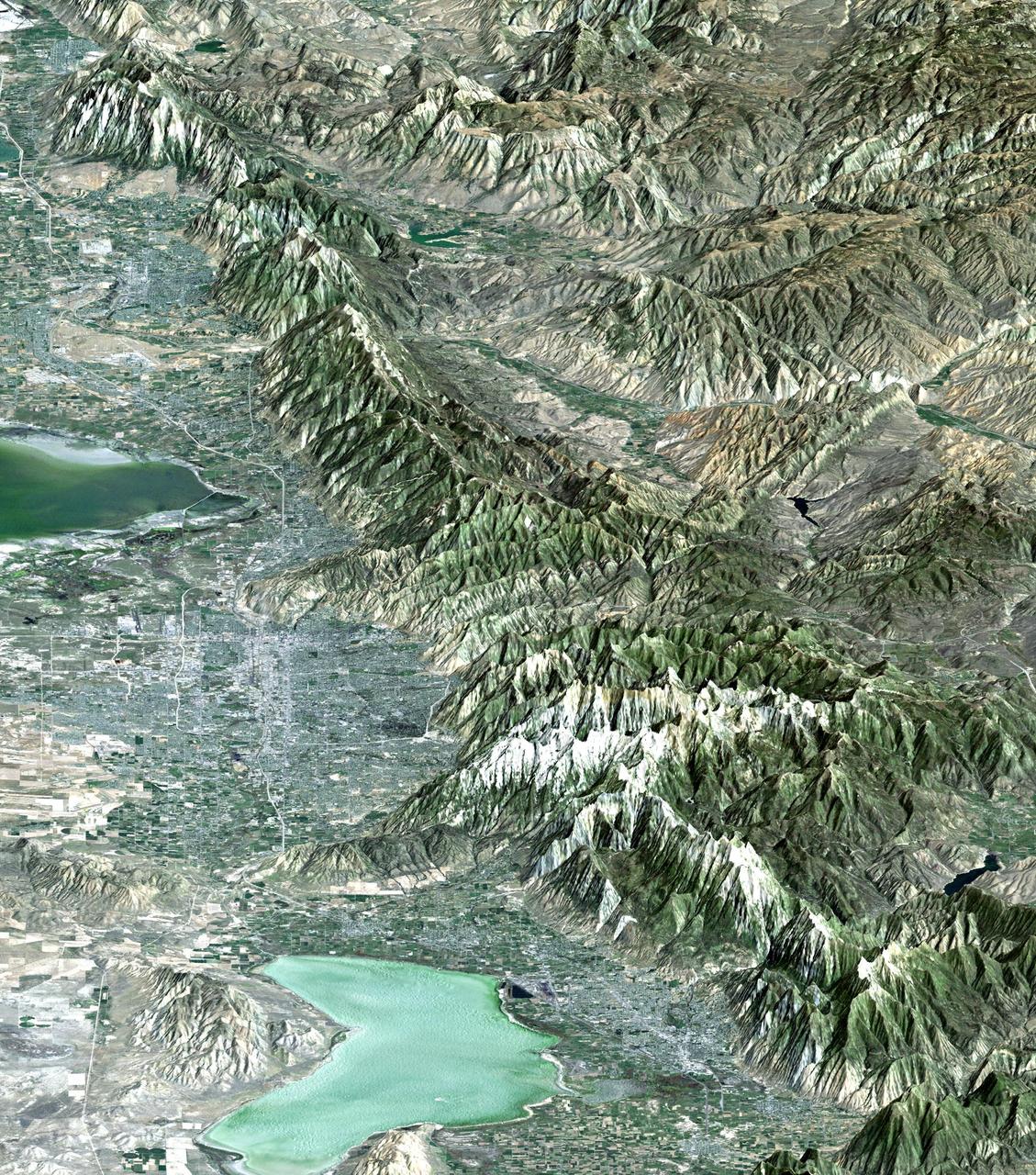
The 2002 Winter Olympics are hosted by Salt Lake City at several venues within the city, in nearby cities, and within the adjacent Wasatch Mountains.
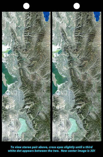
The 2002 Winter Olympics are hosted by Salt Lake City at several venues within the city, in nearby cities, and within the adjacent Wasatch Mountains.
As the long winter night deepens at Enceladus south pole, its jets are also progressively falling into darkness in this image observed by NASA Cassini spacecraft.