This picture is of a small scale flight demonstrator of the X-33 Reusable Launch Vehicle (RLV), Venture Star, developed and built by NASA and Lockheed Martin. The X-33 program was cancelled in 2001.
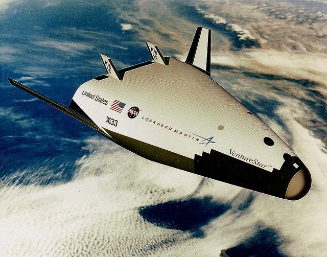
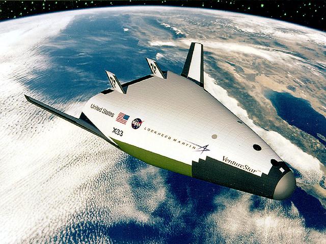
This is an artist's concept of an X-33 Advanced Technology Demonstrator, a subscale protoptye launch vehicle being developed by NASA Lockheed Martin Skunk Works. (Vehicle configuration current as of 10/97) The X-33 is a subscale prototype of a Reusable Launch Vehicle (RLV) Lockheed Martin has labeled "Venture Star TM." The X-33 program was cancelled in 2001.
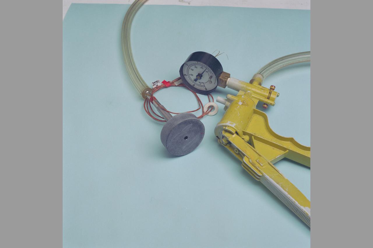
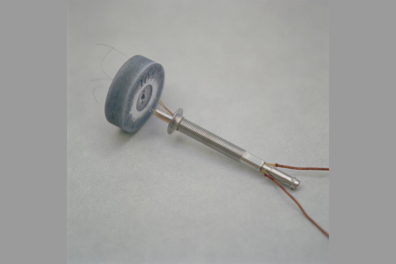
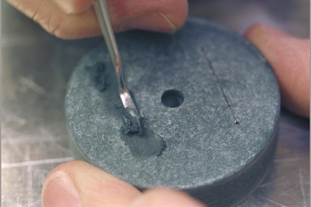
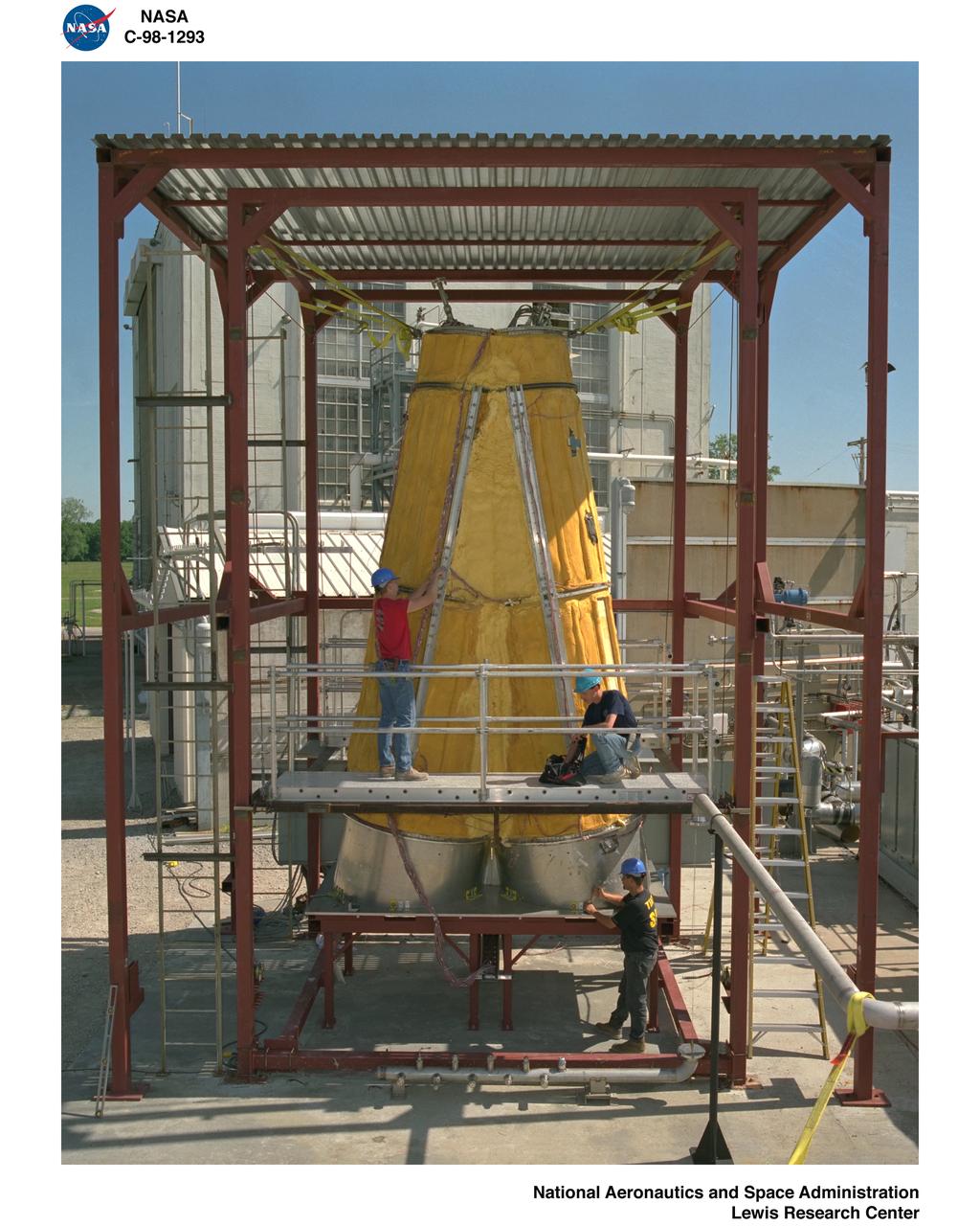
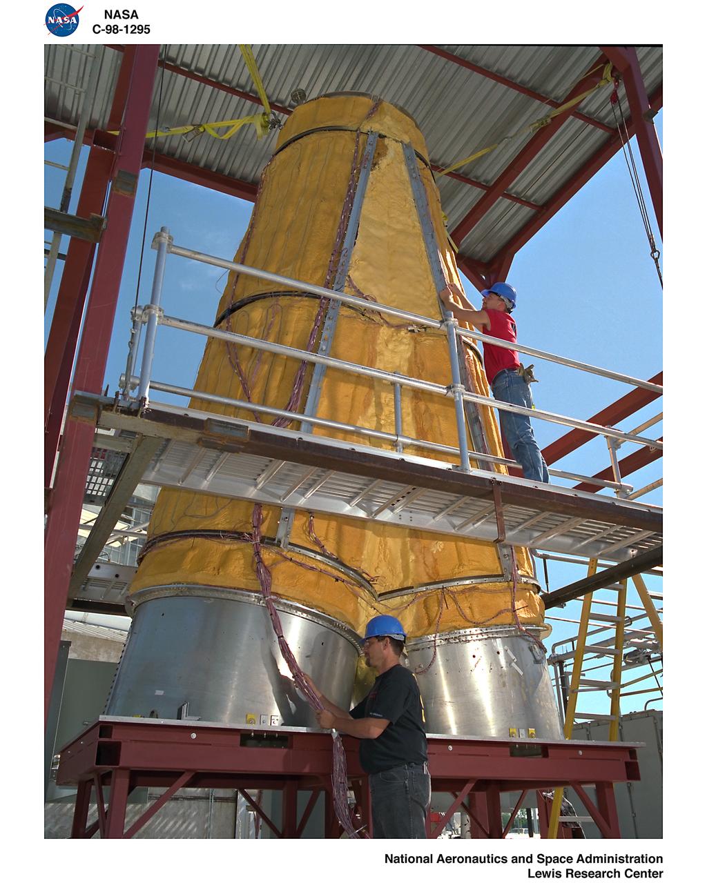
X-33 Aeroshell Flight Test Instrumentation. (leeward)

X-33 Aeroshell Flight Test Instrumentation. (leeward)

X-33 Aeroshell Flight Test Instrumentation. (leeward)
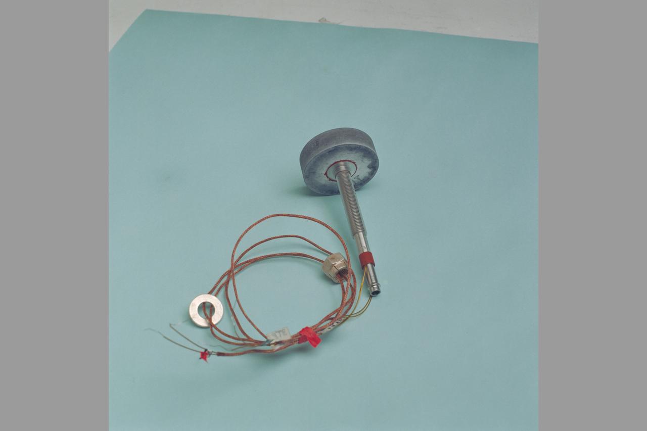
X-33 Aeroshell Flight Test Instrumentation. (leeward)
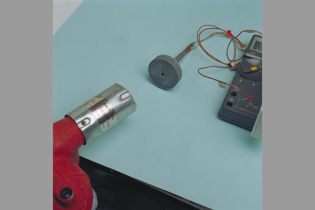
X-33 Aeroshell Flight Test Instrumentation. (leeward)A

X-33 Aeroshell Flight Test Instrumentation. (leeward)
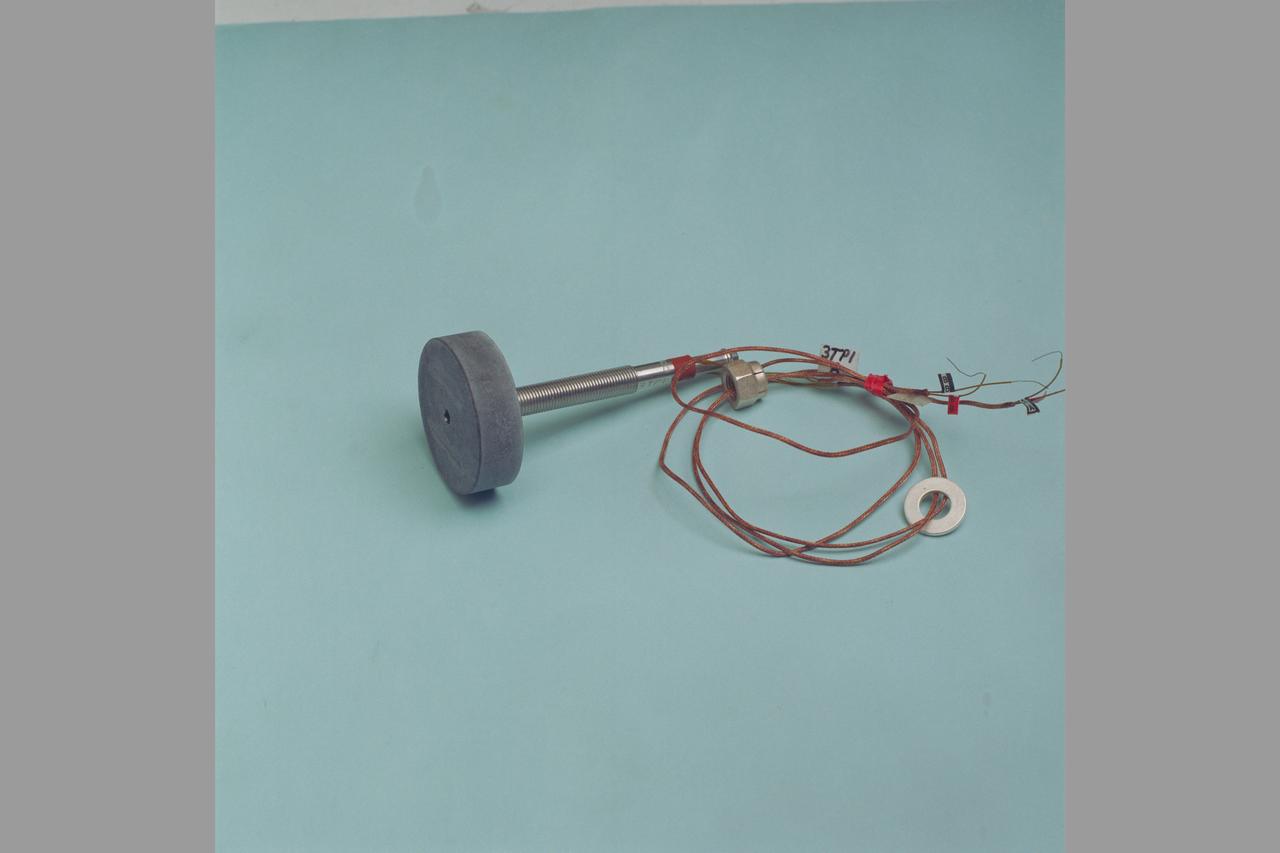
X-33 Aeroshell Flight Test Instrumentation. (leeward)
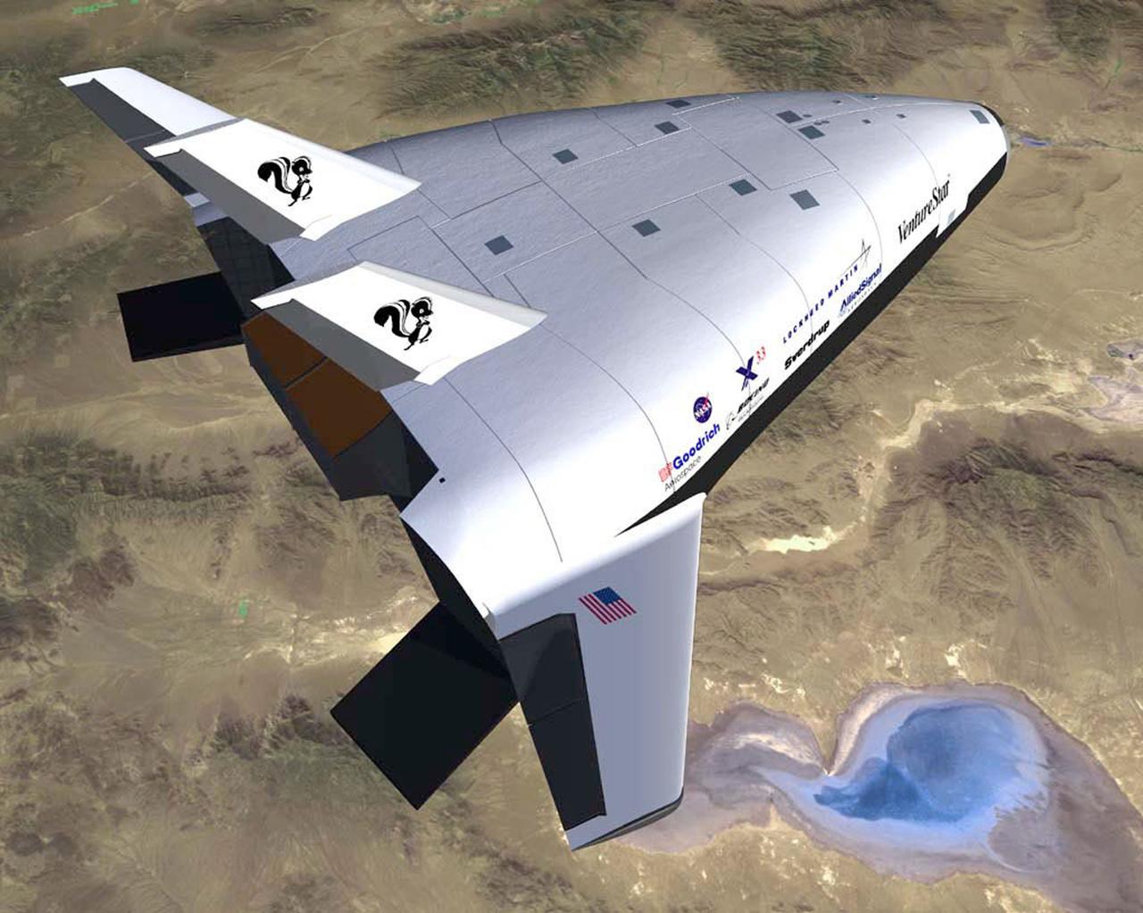
Pictured here is an artist's concept of the experimental X-33 in-flight. The X-33 program was designed to pave the way to a full-scale commercially developed, reusable launch vehicle (RLV). The program that will put the U.S. on a path toward safe, affordable, reliable access to space by providing the latest technology was ready for space flight. The X-33 is the flagship technology demonstrator for technologies that will dramatically lower the cost of access to space. The X-33 program was cancelled in 2001.
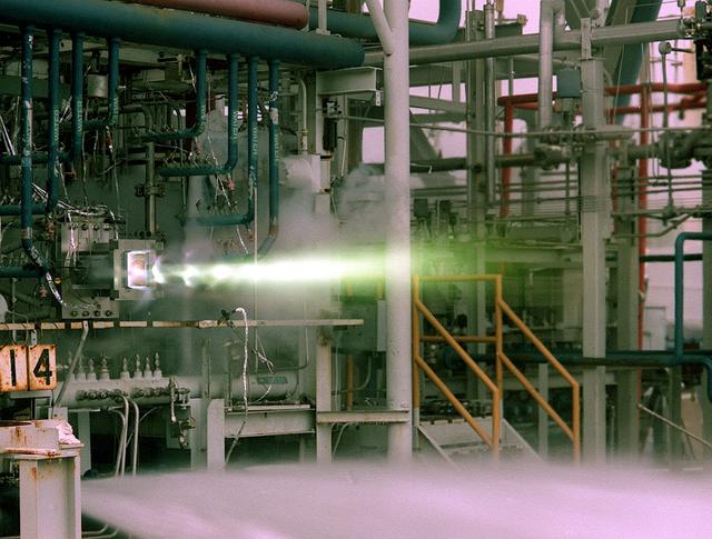
This is a photo of a 40 K Test of a single thrust cell of the Fastrac engine for the X-33, an alternate light-weight launch vehicle, at Marshall Test Stand-116. The X-33 program was cancelled in 2001.
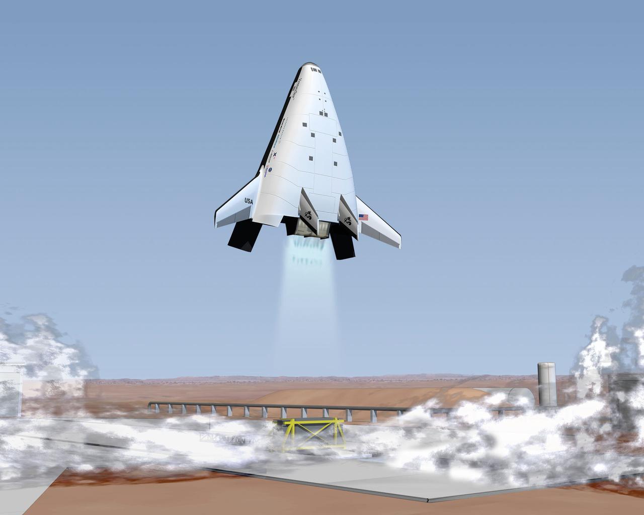
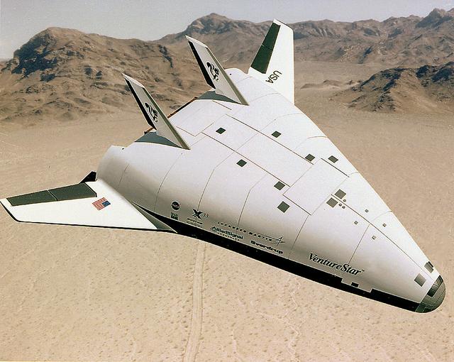
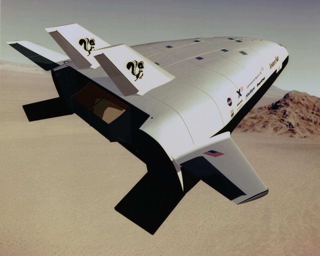
The wedge-shaped X-33 was a sub-scale technology demonstration prototype of a Reusable Launch Vehicle (RLV). Through demonstration flights and ground research, NASA's X-33 program was to provide the information needed for industry representatives such as Lockheed Martin (builder of the X-33 Venture Star) to decide by the year 2000 whether to proceed with the development of a full-scale, commercial RLV program. This program would dramatically increase reliability and lower the costs of putting a payload into space. This would in turn create new opportunities for space access and significantly improve U.S. economic competitiveness in the worldwide launch marketplace. NASA would be a customer, not the operator in the commercial RLV. The X-33 program was cancelled in 2001.

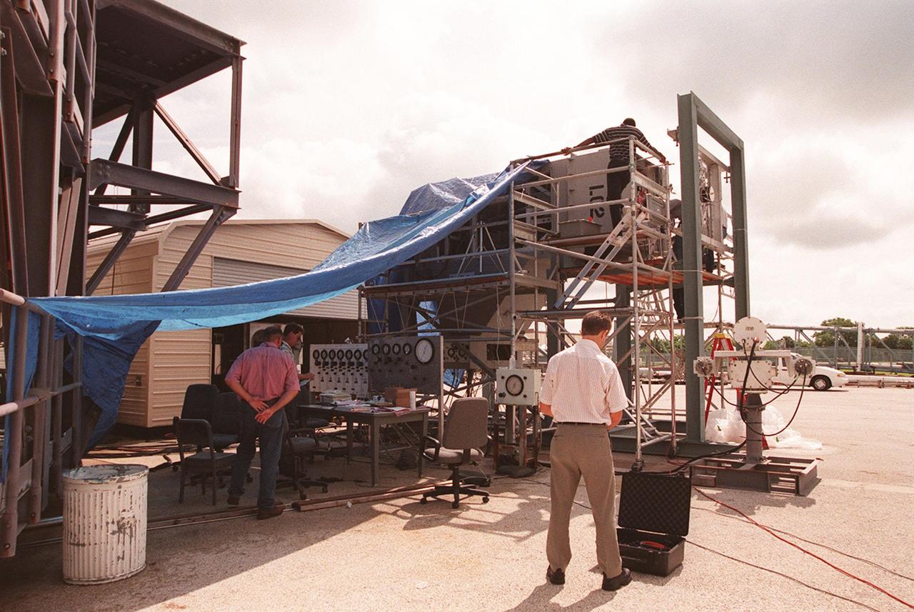
X-33 (Leeward) Aeroshell flight test instrumentation bond verification procedure (shop)
X-33 (Leeward) Aeroshell flight test instrumentation bond verification procedure (shop) with Richard Piquette
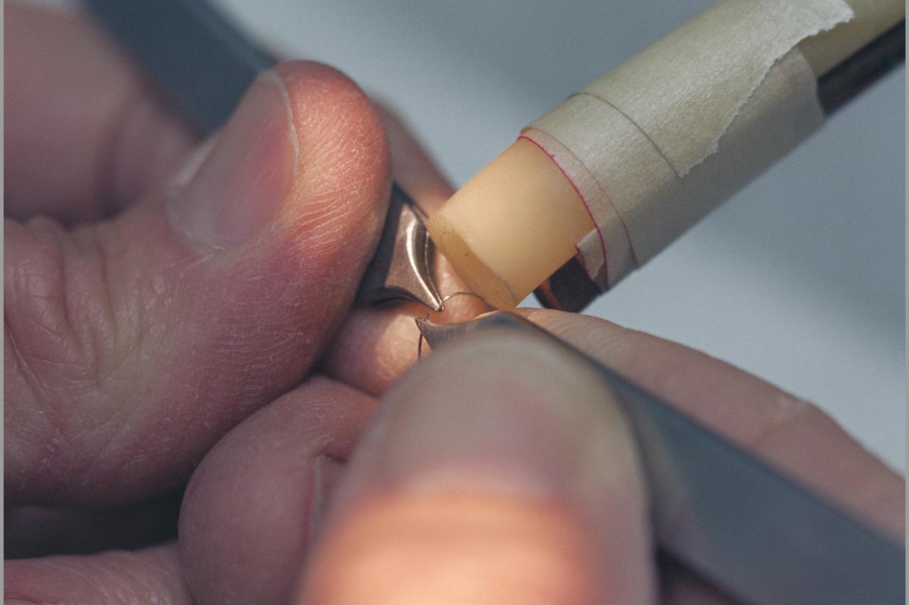
X-33 (Leeward) Aeroshell flight test instrumentation bond verification procedure (shop)
X-33 (Leeward) Aeroshell flight test instrumentation bond verification procedure (shop)
X-33 (Leeward) Aeroshell flight test instrumentation bond verification procedure (shop)

X-33 (Leeward) Aeroshell flight test instrumentation bond verification procedure (shop)
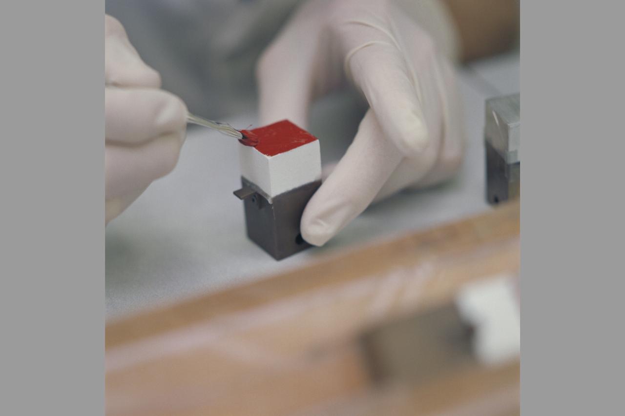
X-33 (Leeward) Aeroshell flight test instrumentation bond verification procedure (shop)
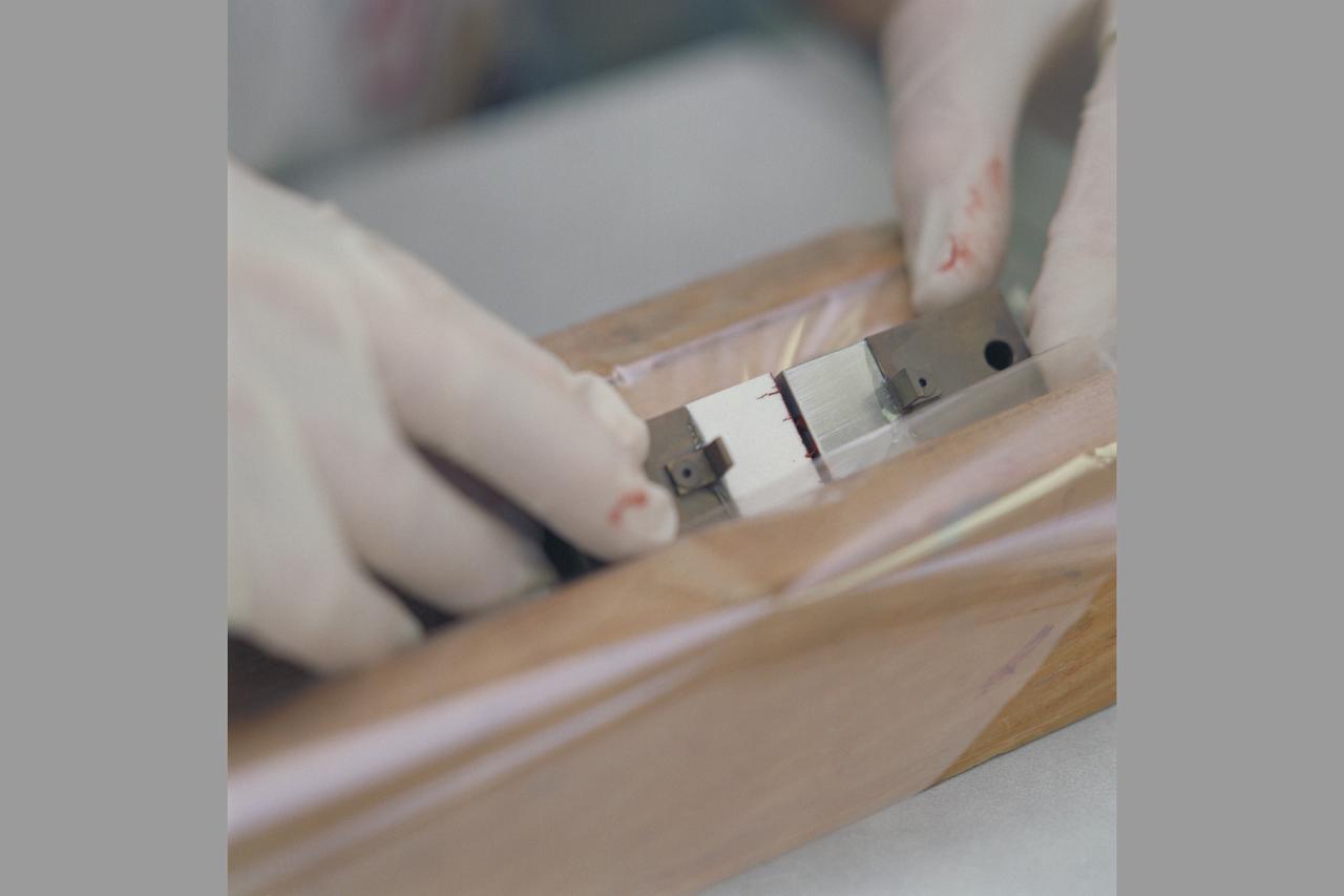
X-33 (Leeward) Aeroshell flight test instrumentation bond verification procedure (shop)
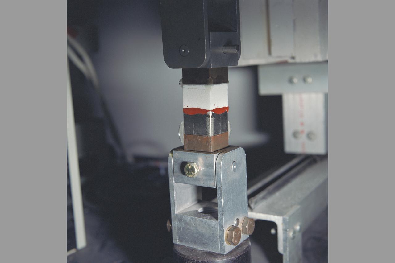
X-33 (Leeward) Aeroshell flight test instrumentation bond verification procedure (shop)
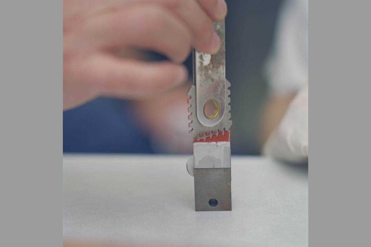
X-33 (Leeward) Aeroshell flight test instrumentation bond verification procedure (shop)

This is an artist's concept of the completely operational International Space Station being approached by an X-33 Reusable Launch Vehicle (RLV). The X-33 program was designed to pave the way to a full-scale, commercially developed RLV as the flagship technology demonstrator for technologies that would lower the cost of access to space. It is unpiloted, taking off vertically like a rocket, reaching an altitude of up to 60 miles and speeds between Mach 13 and 15, and landing horizontally like an airplane. The X-33 program was cancelled in 2001.

This is an artist's interpretation of a future launch complex for third generation propulsion reusable launch vehicles such as the X-33. The X-33 is a sub-scale technology demonstrator prototype of a Reusable Launch Vehicle (RLV), with a vertical take off / horizontal landing (lifting body) concept, which was manufactured and named as the Venture Star by Lockheed Martin. The X-33 program was cancelled in 2001.
In this artist's concept, the X-33 Venture Star, a Reusable Launch Vehicle (RLV), manufactured by Lockheed Martin Skunk Works, is shown in orbit with a deployed payload. The Venture Star was one of the earliest versions of the RLV's developed to replace the aging shuttle fleet. The X-33 program was cancelled in 2001.
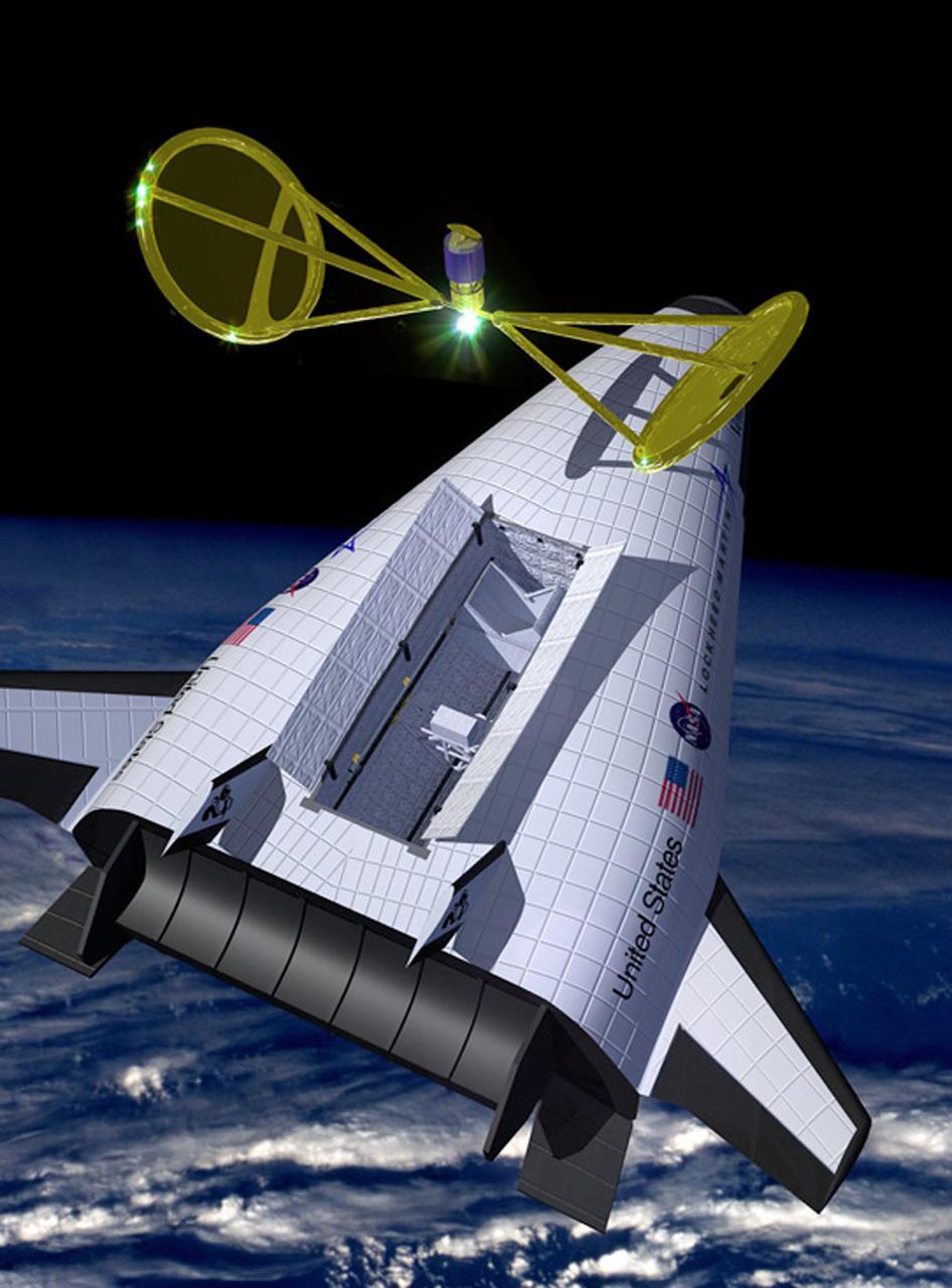
In this artist's concept, the X-33 Venture Star, a Reusable Launch Vehicle (RLV), manufactured by Lockheed Martin Skunk Works, is shown in orbit with a deployed payload. The Venture Star was one of the earliest versions of the RLV's developed to replace the aging shuttle fleet. The X-33 program was cancelled in 2001.
This artist’s concept is of the X-33 Advanced Technology Demonstrator, a subscale prototype Reusable Launch Vehicle (RLV), in its 1997 configuration. Named the Venture Star, this vehicle manufactured by Lockheed Martin Skunk Works, is shown in orbit with a deployed payload. The Venture Star was one of the earliest versions of the RLV’s developed in attempt to replace the aging shuttle fleet. The X-33 program has been discontinued.

In-flight photo of the NASA F-15B used in tests of the X-33 Thermal Protection System (TPS) materials. Flying at subsonic speeds, the F-15B tests measured the air loads on the proposed X-33 protective materials. In contrast, shock loads testing investigated the local impact of the supersonic shock wave itself on the TPS materials. Similar tests had been done in 1985 for the space shuttle tiles, using an F-104 aircraft.
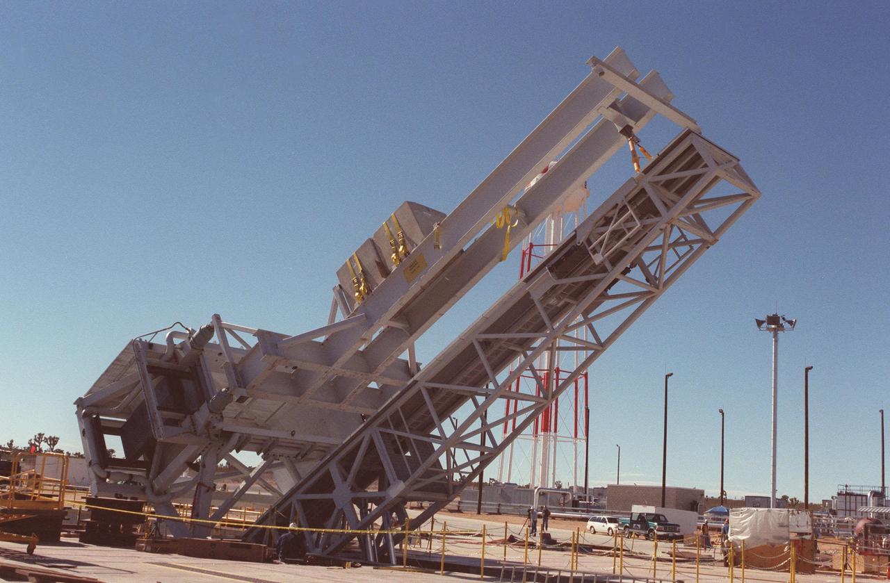
As part of X-33 launch equipment testing at Edwards Air Force Base, CA, the KSC-developed X-33 weight simulator (top), known as the "iron bird," is lifted to a vertical position at the X-33 launch site. The simulator matches the 75,000-pound weight and 63-foot height of the X-33 vehicle that will be using the launch equipment. KSC's Vehicle Positioning System (VPS) placed the simulator on the rotating launch platform prior to the rotation. The new VPS will dramatically reduce the amount of manual labor required to position a reusable launch vehicle for liftoff
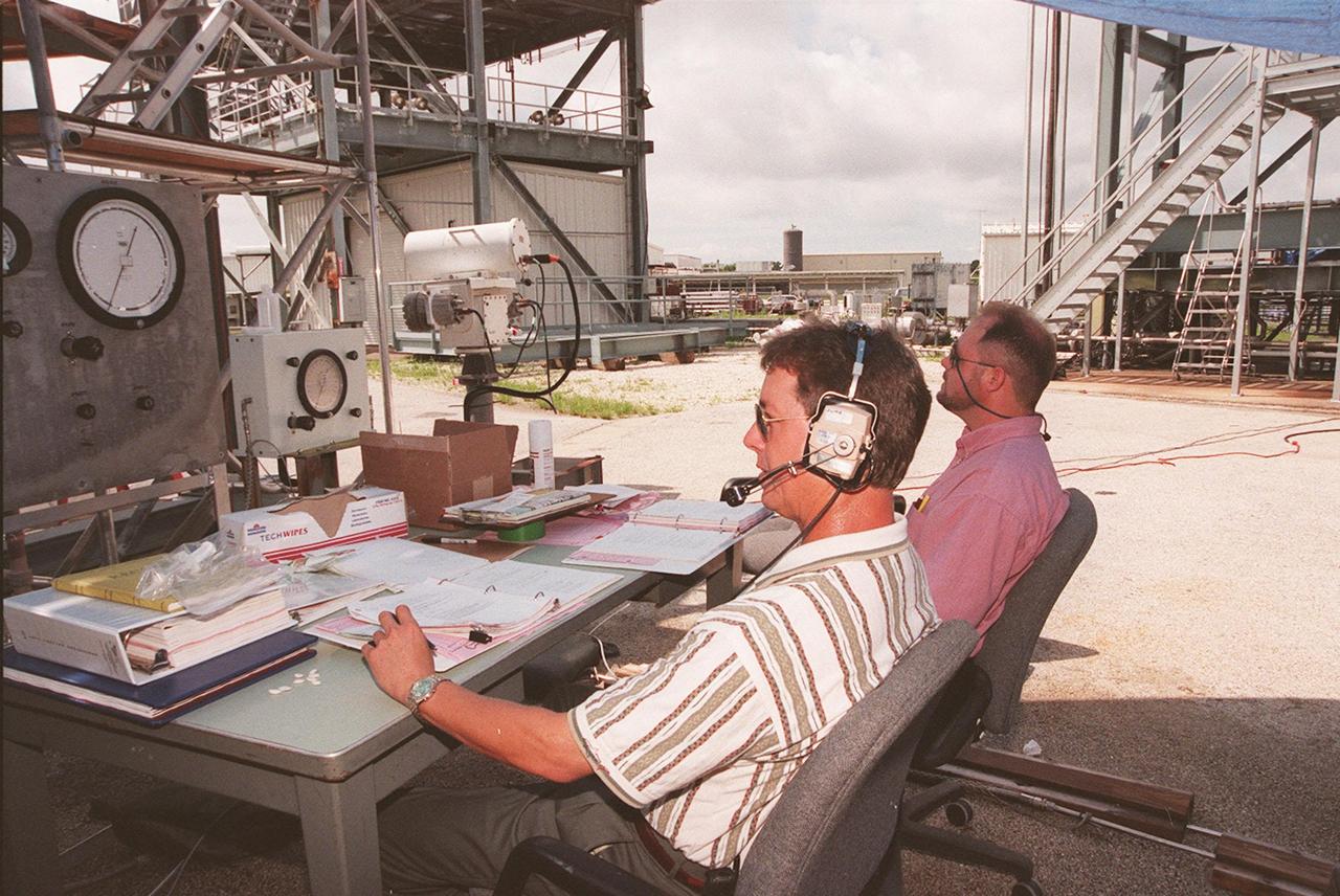
At the Launch Equipment Test Facility, Mike Ynclan, with Dynacs, and Greg Melton, a NASA engineer, look at measurements during testing of the X-33 umbilical system. A team of Kennedy Space Center experts developed the umbilical system, comprising panels, valves and hoses that provide the means to load the X-33 with super-cold propellant. The X-33, under construction at Lockheed Martin Skunk Works in Palmdale, Calif., is a half-scale prototype of the planned operational reusable launch vehicle dubbed VentureStar
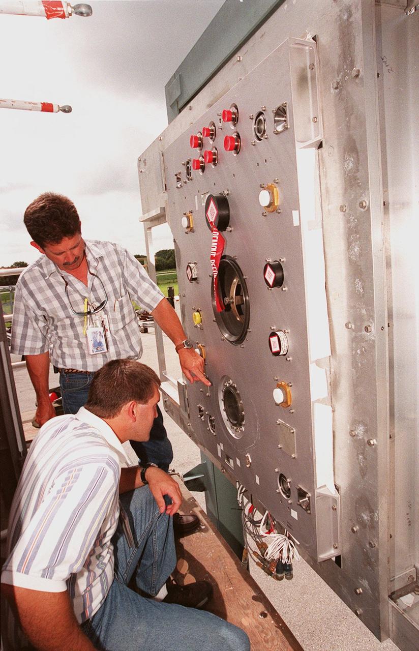
At the Launch Equipment Test Facility, , Will Reaves and Mike Solomon (kneeling), both with Lockheed Martin Technical Operations, observe parts of the X-33 umbilical system during testing. A team of Kennedy Space Center experts developed the umbilical system, comprising panels, valves and hoses that provide the means to load the X-33 with super-cold propellant. The X-33, under construction at Lockheed Martin Skunk Works in Palmdale, Calif., is a half-scale prototype of the planned operational reusable launch vehicle dubbed VentureStar
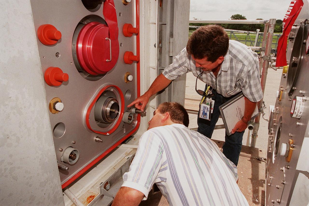
At the Launch Equipment Test Facility, Mike Solomon (left) and Will Reaves (right), both with Lockheed Martin Technical Operations, move in for a close look at part of the X-33 umbilical system. A team of Kennedy Space Center experts developed the umbilical system, comprising panels, valves and hoses that provide the means to load the X-33 with super-cold propellant. The X-33, under construction at Lockheed Martin Skunk Works in Palmdale, Calif., is a half-scale prototype of the planned operational reusable launch vehicle dubbed VentureStar

At the Launch Equipment Test Facility, Will Reaves (top of stand), with Lockheed Martin Technical Operations, looks over components of the X-33 umbilical system undergoing testing. A team of Kennedy Space Center experts developed the umbilical system, comprising panels, valves and hoses that provide the means to load the X-33 with super-cold propellant. The X-33, under construction at Lockheed Martin Skunk Works in Palmdale, Calif., is a half-scale prototype of the planned operational reusable launch vehicle dubbed VentureStar
At the Launch Equipment Test Facility, workers check results from testing the X-33 umbilical system. From left are Greg Melton (left), a NASA engineer; Will Reaves, with Lockheed Martin Technical Operations; and Scott Holcomb, also with Lockheed Martin Technical Operations. A team of Kennedy Space Center experts developed the umbilical system, comprising panels, valves and hoses that provide the means to load the X-33 with super-cold propellant. The X-33, under construction at Lockheed Martin Skunk Works in Palmdale, Calif., is a half-scale prototype of the planned operational reusable launch vehicle dubbed VentureStar
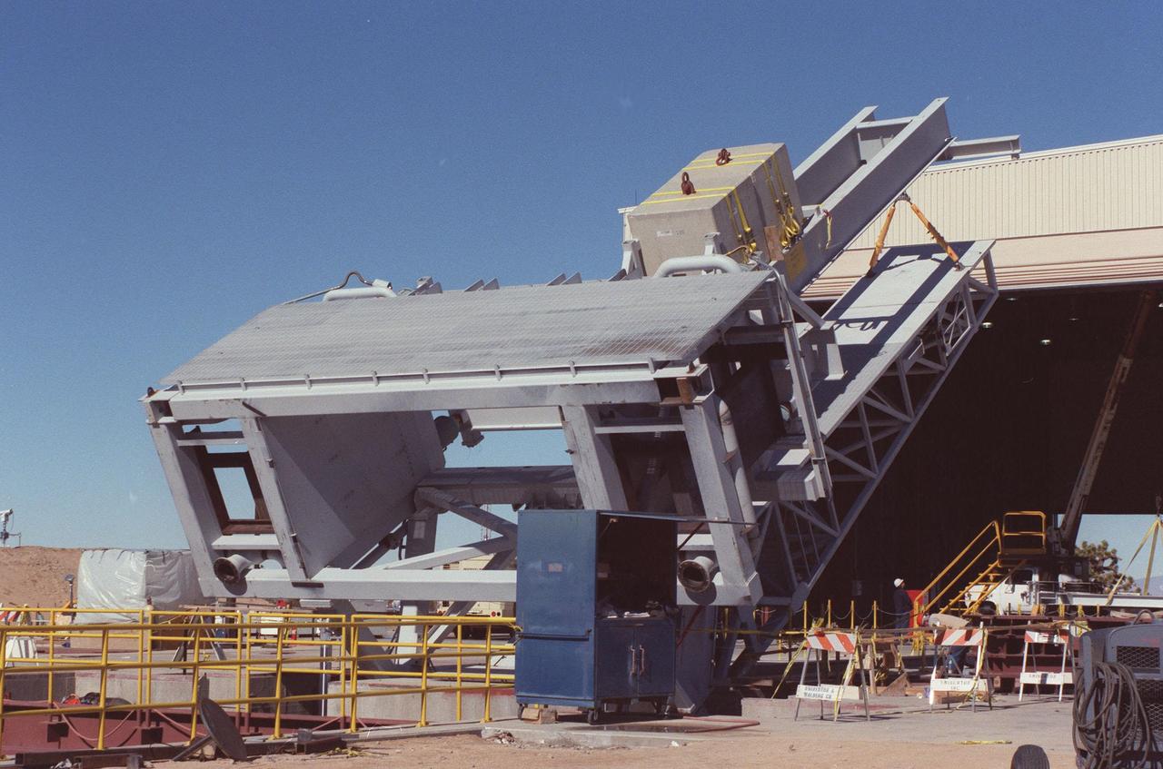
The KSC-developed X-33 weight simulator (top), known as the "iron bird," is lifted to a vertical position at the X-33 launch site as part of launch equipment testing on Edwards Air Force Base, CA. The simulator matches the 75,000-pound weight and 63-foot height of the X-33 vehicle that will be using the launch equipment. KSC's Vehicle Positioning System (VPS) placed the simulator on the rotating launch platform prior to the rotation. The new VPS will dramatically reduce the amount of manual labor required to position a reusable launch vehicle for liftoff
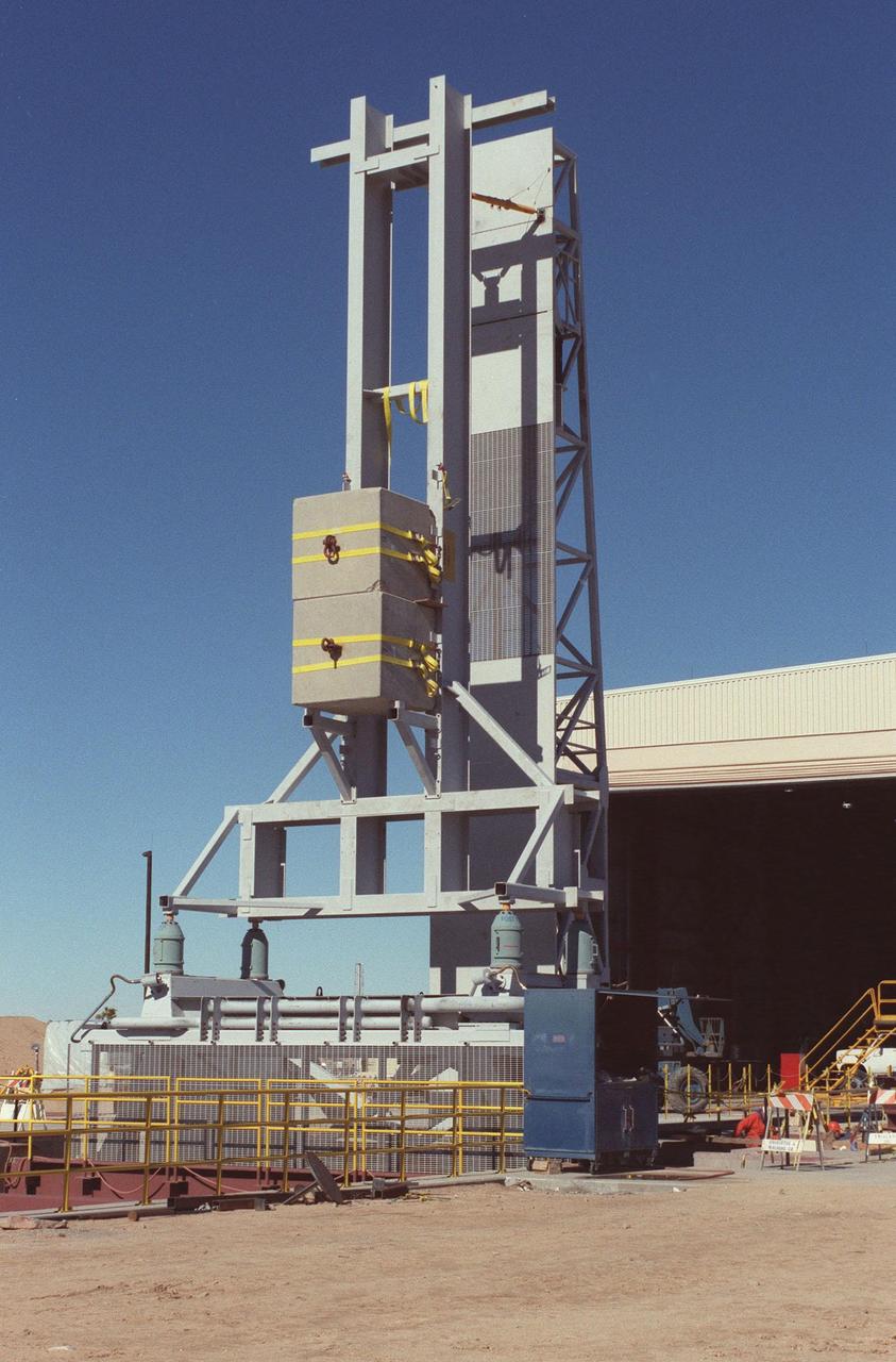
The KSC-developed X-33 weight simulator (left), known as the "iron bird," is fully raised to a vertical position at the X-33 launch site as part of launch equipment testing on Edwards Air Force Base, CA. The simulator matches the 75,000-pound weight and 63-foot height of the X-33 vehicle that will be using the launch equipment. KSC's Vehicle Positioning System (VPS) placed the simulator on the rotating launch platform prior to the rotation. The new VPS will dramatically reduce the amount of manual labor required to position a reusable launch vehicle for liftoff
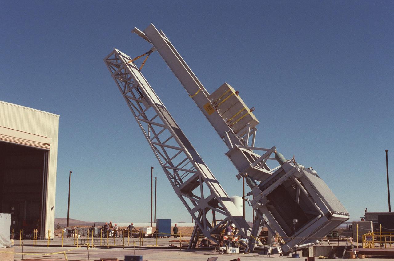
The KSC-developed X-33 weight simulator (top, right), known as the "iron bird," is lifted to a vertical position at the X-33 launch site as part of launch equipment testing on Edwards Air Force Base, CA. The simulator matches the 75,000-pound weight and 63-foot height of the X-33 vehicle that will be using the launch equipment. KSC's Vehicle Positioning System (VPS) placed the simulator on the rotating launch platform prior to the rotation. The new VPS will dramatically reduce the amount of manual labor required to position a reusable launch vehicle for liftoff

At the Launch Equipment Test Facility, Mike Solomon, with Lockheed Martin Technical Operations, studies a part of the X-33 umbilical system during testing. Pointing to the part is Will Reaves, also with Lockheed Martin Technical Operations. A team of Kennedy Space Center experts developed the umbilical system, comprising panels, valves and hoses that provide the means to load the X-33 with super-cold propellant. The X-33, under construction at Lockheed Martin Skunk Works in Palmdale, Calif., is a half-scale prototype of the planned operational reusable launch vehicle dubbed VentureStar

Cloud Aerosol Transport System (CATS) leaves Goddard building 33 for shipment to Space X for installation at the International Space Station
LOCKHEED MARTIN X-33 COMPOSITE TANK TESTING, HYDROGEN TANK MULTI-LOBED AT K SITE, NASA PLUM BROOK STATION
LOCKHEED MARTIN X-33 COMPOSITE TANK TESTING, HYDROGEN TANK MULTI-LOBED AT K SITE, NASA PLUM BROOK STATION

Construction is under way for the X-33/X-34 hangar complex near the Shuttle Landing Facility at KSC. The Reusable Launch Vehicle (RLV) complex will include facilities for related ground support equipment and administrative/ technical support. It will be available to accommodate the Space Shuttle; the X-34 RLV technology demonstrator; the L-1011 carrier aircraft for Pegasus and X-34; and other RLV and X-vehicle programs. The complex is jointly funded by the Spaceport Florida Authority, NASA's Space Shuttle Program and KSC. The facility will be operational in early 2000

Matt McGill, Andrew Kopchock and John Yorks with Cloud Aerosol Transport System (CATS) as it leaves Goddard building 33 for shipment to Space X for installation at the International Space Station
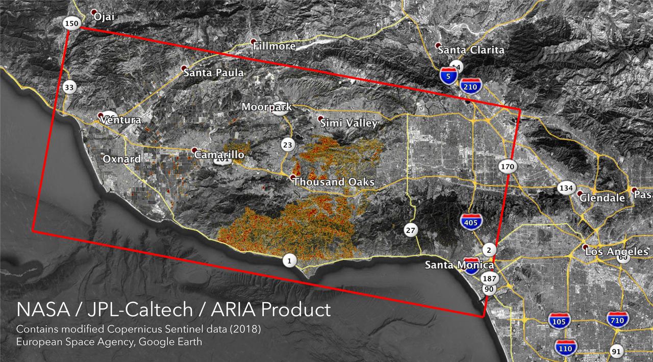
The Advanced Rapid Imaging and Analysis (ARIA) team at NASA's Jet Propulsion Laboratory in Pasadena, California, created these Damage Proxy Maps (DPMs) depicting areas in California likely damaged by the Woolsey and Camp Fires. They are derived from synthetic aperture radar (SAR) images from the Copernicus Sentinel-1 satellites, operated by the European Space Agency (ESA). The pre-event images for the Woolsey Fire in Southern California were taken before the fire on Oct. 30, 2018 and the post-event image was acquired during the fire on Nov. 11, 2018. The map covers an area of 50 miles x 25 miles (80 km x 40 km), indicated with the big red polygon. Each pixel measures about 33 yards x 33 yards (30 m x 30 m). The color variation from yellow to red indicates increasingly more significant ground surface change. The pre-event images for the Camp Fire in Northern California were taken on Nov. 4, 2018 and the post-event images were acquired during the fire on Nov. 10, 2018. The map covers an area of 55 miles x 48 miles (88 km x 77 km). As in the previous image, each pixel measures about 33 yards x 33 yards (30 m x 30 m). The color variation from yellow to red indicates increasingly more significant ground surface change. Preliminary validation for both maps was done by comparing approximate location data to Google's Crisismap. These damage proxy maps can be used as guidance to identify damaged areas with the understanding that they may be less reliable over vegetated areas including farmlands. For example, the scattered single colored pixels over vegetated areas may be false positives, and the lack of colored pixels over vegetated areas does not necessarily mean no damage. https://photojournal.jpl.nasa.gov/catalog/PIA22816
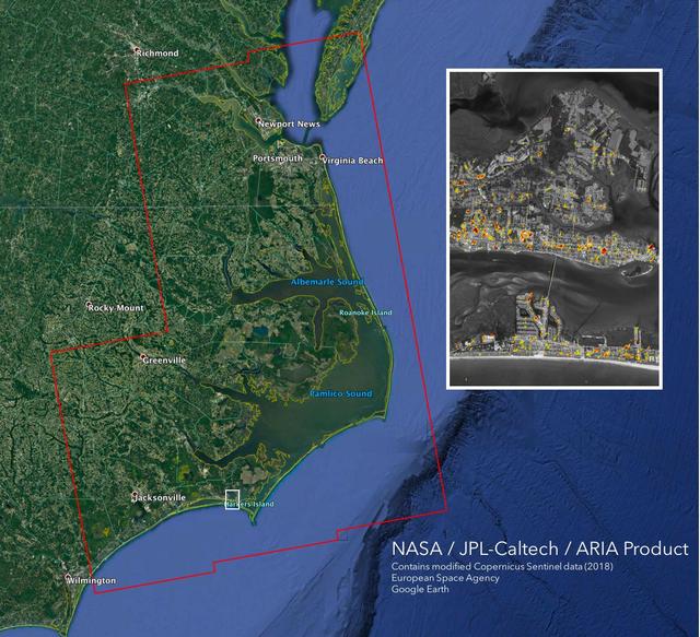
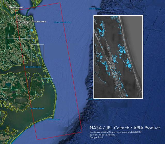
The Advanced Rapid Imaging and Analysis (ARIA) team at NASA's Jet Propulsion Laboratory in Pasadena, California, created this Damage Proxy Map (DPM) depicting areas of the Carolinas that are likely damaged (shown by red and yellow pixels) as a result of Hurricane Florence. The map is derived from synthetic aperture radar (SAR) images from the Copernicus Sentinel-1 satellites, operated by the European Space Agency (ESA). The images were taken before (September 02, 2016) and 12 hours after the hurricane's landfall (September 14, 2018 7:06 PM local time). The map covers an area of 155 miles x 210 miles (250 km x 340 km), indicated with the big red polygon. Each pixel measures about 33 yards x 33 yards (30 m x 30 m). The color variation from yellow to red indicates increasingly more significant ground surface change. Media reports provided anecdotal preliminary validation. This damage proxy map should be used as guidance to identify damaged areas, and may be less reliable over vegetated areas and flooded areas. For example, the scattered single colored pixels over vegetated areas may be false positives, and the lack of colored pixels over vegetated areas does not necessarily mean no damage. https://photojournal.jpl.nasa.gov/catalog/PIA22702
The Advanced Rapid Imaging and Analysis (ARIA) team at NASA's Jet Propulsion Laboratory in Pasadena, California, created this Flood Proxy Map depicting areas of the Carolinas that are likely flooded as a result of Hurricane Florence, shown by light blue pixels. The map is derived from synthetic aperture radar (SAR) images from the Copernicus Sentinel-1 satellites, operated by the European Space Agency (ESA). The images were taken before (September 09, 2018) and 36 hours after the hurricane's landfall (September 15, 2018 18:57 PM local time). The map covers an area of 53 miles x 152 miles (85 km x 245 km), indicated with the big red polygon. Each pixel measures about 33 yards x 33 yards (30 m x 30 m). Media reports provided anecdotal preliminary validation. This flood proxy map should be used as guidance to identify areas that are likely flooded and may be less reliable over urban and vegetated areas. https://photojournal.jpl.nasa.gov/catalog/PIA22704

The test of twin Linear Aerospike XRS-2200 engines, originally built for the X-33 program, was performed on August 6, 2001 at NASA's Sternis Space Center, Mississippi. The engines were fired for the planned 90 seconds and reached a planned maximum power of 85 percent. NASA's Second Generation Reusable Launch Vehicle Program , also known as the Space Launch Initiative (SLI), is making advances in propulsion technology with this third and final successful engine hot fire, designed to test electro-mechanical actuators. Information learned from this hot fire test series about new electro-mechanical actuator technology, which controls the flow of propellants in rocket engines, could provide key advancements for the propulsion systems for future spacecraft. The Second Generation Reusable Launch Vehicle Program, led by NASA's Marshall Space Flight Center in Huntsville, Alabama, is a technology development program designed to increase safety and reliability while reducing costs for space travel. The X-33 program was cancelled in March 2001.

In southern California, the combined ports of Los Angeles and Long Beach account for 33% of the nation containerized imports. This image from NASA Terra spacecraft shows the large backlog of waiting cargo ships being slowly unloaded. The left image was acquired July 4, 2014 during normal operations: 14 ships are being unloaded, while 7 wait their turns near the facilities. The right image was acquired on March 8, 2015: 19 ships are moored at unloading docks, while 47 ships wait their turns. The images cover an area of 16.7 x 18.6 km, and are located at 33.7 degrees north, 118.2 degrees west. http://photojournal.jpl.nasa.gov/catalog/PIA19249
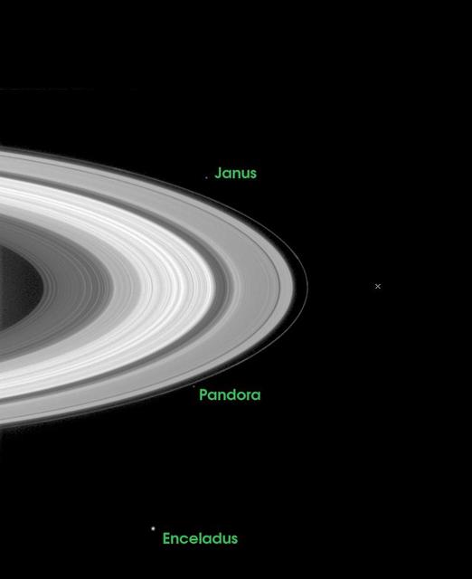
The path that lies ahead for the Cassini-Huygens mission is indicated in this image which illustrates where the spacecraft will be just 27 days from now, when it arrives at Saturn and crosses the ring plane 33 minutes before performing its critical orbital insertion maneuver. The X indicates the point where Cassini will pierce the ring plane on June 30, 2004, going from south to north of the ring plane, 33 minutes before the main engine fires to begin orbital insertion. The indicated point is between the narrow F-ring on the left and Saturn's tenuous G-ring which is too faint to be seen in this exposure. The image was taken on May 11, 2004 when the spacecraft was 26.3 million kilometers (16.3 million miles) from Saturn. Image scale is 158 kilometers (98 miles) per pixel. Moons visible in this image: Janus (181 kilometers or 113 miles across), one of the co-orbital moons; Pandora (84 kilometers or 52 miles across), one of the F ring shepherding moons; and Enceladus (499 kilometers or 310 miles across), a moon which may be heated from within and thus have a liquid sub-surface ocean. http://photojournal.jpl.nasa.gov/catalog/PIA06061

A close up of the Flight Test Fixture II, mounted on the underside of the F-15B Aerodynamic Flight Facility aircraft. The Thermal Protection System (TPS) samples, which included metallic Inconel tiles, soft Advanced Flexible Reusable Surface Insulation tiles, and sealing materials, were attached to the forward-left side position of the test fixture. In-flight video from the aircraft's on-board video system, as well as chase aircraft photos and video footage, documented the condition of the TPS during flights. Surface pressures over the TPS was measured by thermocouples contained in instrumentation "islands," to document shear and shock loads.

NASA successfully launched the RockSat-X education payload on a Terrier-Improved Malemute suborbital sounding rocket at 7:33:30 a.m. EDT Aug. 17 from the Wallops Flight Facility in Virginia. Students from eight community colleges and universities from across the United States participated in the RockSat-X project.The payload carrying the experiments flew to an altitude of 95 miles. Data was received from most of the student experiments. However, the payload was not recovered as planned. NASA will investigate the anomaly. Credit: NASA/Wallops/A. Stancil <b><a href="http://www.nasa.gov/audience/formedia/features/MP_Photo_Guidelines.html" rel="nofollow">NASA image use policy.</a></b> <b><a href="http://www.nasa.gov/centers/goddard/home/index.html" rel="nofollow">NASA Goddard Space Flight Center</a></b> enables NASA’s mission through four scientific endeavors: Earth Science, Heliophysics, Solar System Exploration, and Astrophysics. Goddard plays a leading role in NASA’s accomplishments by contributing compelling scientific knowledge to advance the Agency’s mission. <b>Follow us on <a href="http://twitter.com/NASAGoddardPix" rel="nofollow">Twitter</a></b> <b>Like us on <a href="http://www.facebook.com/pages/Greenbelt-MD/NASA-Goddard/395013845897?ref=tsd" rel="nofollow">Facebook</a></b> <b>Find us on <a href="http://instagrid.me/nasagoddard/?vm=grid" rel="nofollow">Instagram</a></b>

NASA's F/A-18 Hornet is seen here in a banked turn over Rogers Dry Lake in the Mojave desert on an early research flight. It was flown by NASA's Dryden Flight Research Center, Edwards, California, in a multi-year, joint NASA/DOD/industry program, the former Navy fighter was modified into a unique Systems Research Aircraft (SRA) to investigate a host of new technologies in the areas of flight controls, airdata sensing and advanced computing. One of the more than 20 experiments tested aboard the SRA F-18 was an advanced air data sensing system which used a group of pressure taps flush-mounted on the forward fuselage to measure both altitude and wind speed and direction--critical data for flight control and research investigations. The Real-Time Flush Air Data Sensing system concept was evaluated for possible use on the X-33 and X-34 resuable space-launch vehicles. The primary goal of the SRA program was to validate through flight research cutting-edge technologies which could benefit future aircraft and spacecraft by improving efficiency and performance, reducing weight and complexity, with a resultant reduction on development and operational costs.

These L-band images of the Manaus region of Brazil were acquired by the Spaceborne Imaging Radar-C and X-band Synthetic Aperture Radar (SIR-C/X-SAR) aboard the space shuttle Endeavour. The left image was acquired on April 12, 1994, and the middle image was acquired on October 3, 1994. The area shown is approximately 8 kilometers by 40 kilometers (5 miles by 25 miles). The two large rivers in this image, the Rio Negro (top) and the Rio Solimoes (bottom), combine at Manaus (west of the image) to form the Amazon River. The image is centered at about 3 degrees south latitude and 61 degrees west longitude. North is toward the top left of the images. The differences in brightness between the images reflect changes in the scattering of the radar channel. In this case, the changes are indicative of flooding. A flooded forest has a higher backscatter at L-band (horizontally transmitted and received) than an unflooded river. The extent of the flooding is much greater in the April image than in the October image, and corresponds to the annual, 10-meter (33-foot) rise and fall of the Amazon River. A third image at right shows the change in the April and October images and was created by determining which areas had significant decreases in the intensity of radar returns. These areas, which appear blue on the third image at right, show the dramatic decrease in the extent of flooded forest, as the level of the Amazon River falls. The flooded forest is a vital habitat for fish and floating meadows are an important source of atmospheric methane. This demonstrates the capability of SIR-C/X-SAR to study important environmental changes that are impossible to see with optical sensors over regions such as the Amazon, where frequent cloud cover and dense forest canopies obscure monitoring of floods. Field studies by boat, on foot and in low-flying aircraft by the University of California at Santa Barbara, in collaboration with Brazil's Instituto Nacional de Pesguisas Estaciais, during the first and second flights of the SIR-C/X-SAR system have validated the interpretation of the radar images. http://photojournal.jpl.nasa.gov/catalog/PIA01740
At the Skid Strip at the Cape Canaveral Air Station, Mission Specialist Catherine G. Coleman (Ph.D.) and her husband, Josh Simpson, prepare to board an aircraft for their return flight to Houston following the completion of the STS-93 Space Shuttle mission. Landing occurred on runway 33 at KSC's Shuttle Landing Facility on July 27 with main gear touchdown at 11:20:35 p.m. EDT. The mission's primary objective was to deploy the Chandra X-ray Observatory, which will allow scientists from around the world to study some of the most distant, powerful and dynamic objects in the universe. This was the 95th flight in the Space Shuttle program and the 26th for Columbia. The landing was the 19th consecutive Shuttle landing in Florida and the 12th night landing in Shuttle program history. On this mission, Eileen Collins became the first woman to serve as a Shuttle commander
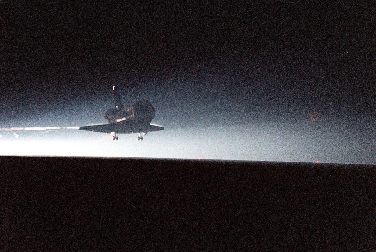
KENNEDY SPACE CENTER, Fla. -- The Space Shuttle orbiter Columbia touches down on runway 33 at the Shuttle Landing Facility after a successful mission of nearly five days and 1.8 million miles. Main gear touchdown was at 11:20:35 p.m. EDT on July 27. Aboard are the STS-93 crew members: Commander Eileen M. Collins, Pilot Jeffrey S. Ashby, and Mission Specialists Steven A. Hawley (Ph.D.), Catherine G. Coleman (Ph.D.) and Michel Tognini of France, with the Centre National d'Etudes Spatiales (CNES). The mission's primary objective was to deploy the Chandra X-ray Observatory, which will allow scientists from around the world to study some of the most distant, powerful and dynamic objects in the universe. This was the 95th flight in the Space Shuttle program and the 26th for Columbia. The landing was the 19th consecutive Shuttle landing in Florida and the 12th night landing in Shuttle program history
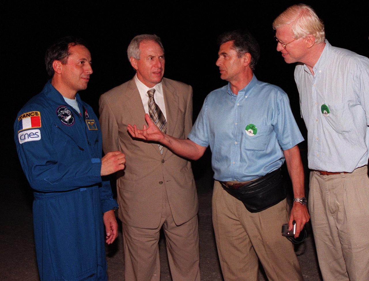
At the Shuttle Landing Facility (from left to right), STS-93 Mission Specialist Michel Tognini of France, representing the Centre National d'Etudes Spatiales (CNES), and NASA Administrator Daniel Goldin talk with Jacques Ratie, Astronaut Director, CNES, and Serge Plattard, International Relations, CNES. Landing occurred on runway 33 with main gear touchdown at 11:20:35 p.m. EDT on July 27. The mission's primary objective was to deploy the Chandra X-ray Observatory, which will allow scientists from around the world to study some of the most distant, powerful and dynamic objects in the universe. This was the 95th flight in the Space Shuttle program and the 26th for Columbia. The landing was the 19th consecutive Shuttle landing in Florida and the 12th night landing in Shuttle program history. On this mission, Eileen Collins became the first woman to serve as a Shuttle commander

At the Skid Strip at the Cape Canaveral Air Station, Mission Specialist Michel Tognini of France, representing the Centre National d'Etudes Spatiales (CNES), and his daughter Tatinana prepare to board an aircraft for their return flight to Houston following the completion of the STS-93 Space Shuttle mission. Landing occurred on runway 33 at KSC's Shuttle Landing Facility on July 27 with main gear touchdown at 11:20:35 p.m. EDT. The mission's primary objective was to deploy the Chandra X-ray Observatory, which will allow scientists from around the world to study some of the most distant, powerful and dynamic objects in the universe. This was the 95th flight in the Space Shuttle program and the 26th for Columbia. The landing was the 19th consecutive Shuttle landing in Florida and the 12th night landing in Shuttle program history. On this mission, Eileen Collins became the first woman to serve as a Shuttle commander

KENNEDY SPACE CENTER, FLA. -- At the Shuttle Landing Facility, NASA Administrator Daniel Goldin (foreground) talks with STS-93 Commander Eileen Collins beside the Space Shuttle orbiter Columbia following the successful completion of her mission. Marshall Space Flight Center Director Arthur G. Stephenson (far left) looks on. Landing occurred on runway 33 with main gear touchdown at 11:20:35 p.m. EDT on July 27. The mission's primary objective was to deploy the Chandra X-ray Observatory, which will allow scientists from around the world to study some of the most distant, powerful and dynamic objects in the universe. This was the 95th flight in the Space Shuttle program and the 26th for Columbia. The landing was the 19th consecutive Shuttle landing in Florida and the 12th night landing in Shuttle program history. On this mission, Collins became the first woman to serve as a Shuttle commander
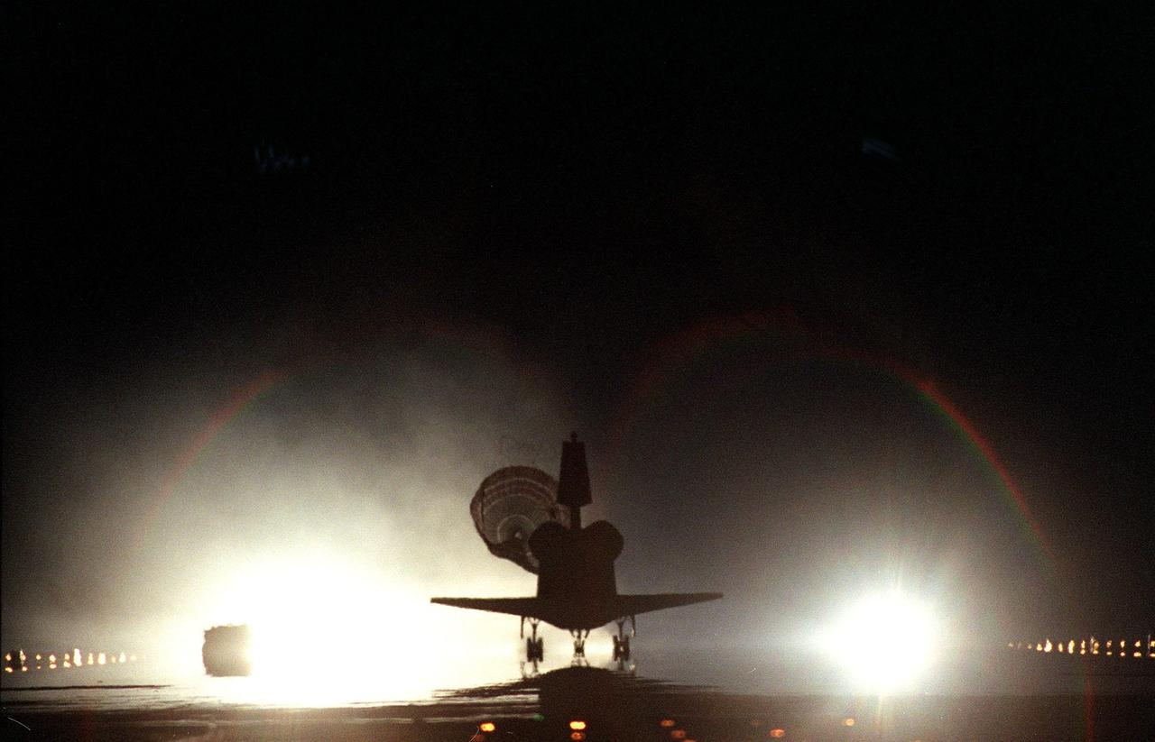
KENNEDY SPACE CENTER, Fla. -- The Space Shuttle orbiter Columbia, with its drag chute deployed, touches down on runway 33 at the Shuttle Landing Facility after a successful mission of nearly five days and 1.8 million miles. Main gear touchdown was at 11:20:35 p.m. EDT on July 27. Aboard are the STS-93 crew members: Commander Eileen M. Collins, Pilot Jeffrey S. Ashby, and Mission Specialists Steven A. Hawley (Ph.D.), Catherine G. Coleman (Ph.D.) and Michel Tognini of France, with the Centre National d'Etudes Spatiales (CNES). The mission's primary objective was to deploy the Chandra X-ray Observatory, which will allow scientists from around the world to study some of the most distant, powerful and dynamic objects in the universe. This was the 95th flight in the Space Shuttle program and the 26th for Columbia. The landing was the 19th consecutive Shuttle landing in Florida and the 12th night landing in Shuttle program history
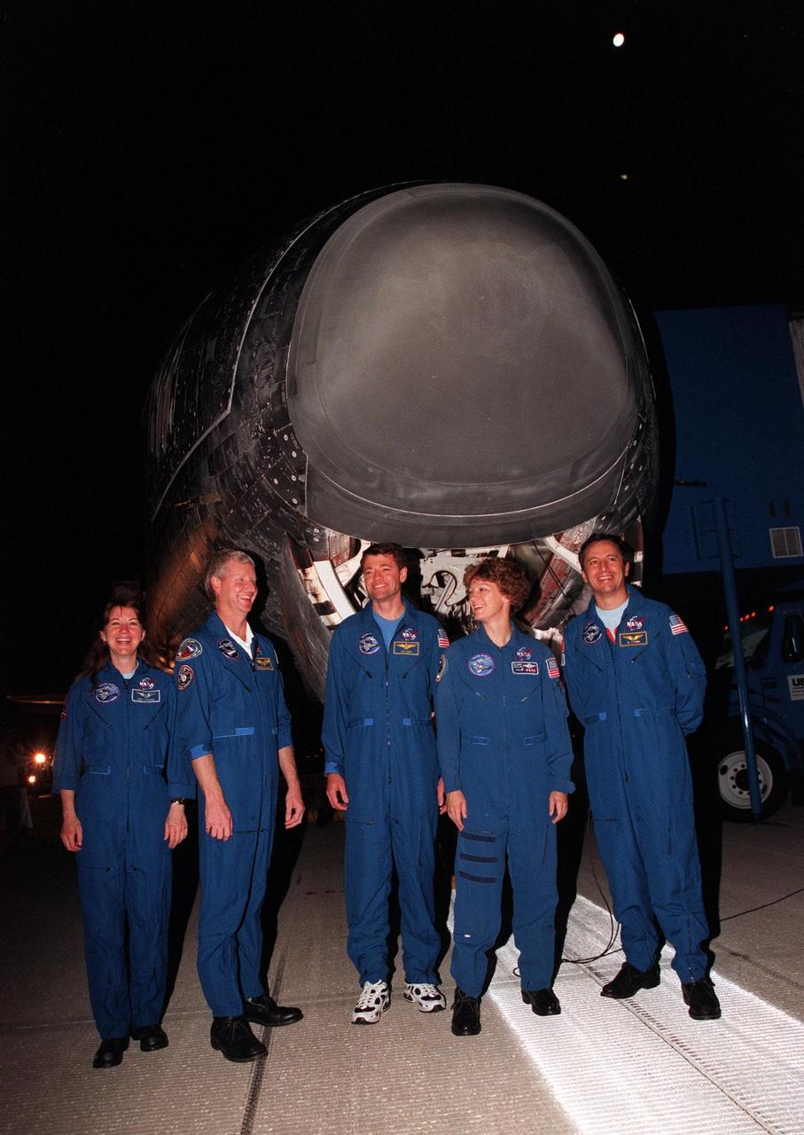
KENNEDY SPACE CENTER, FLA. -- The STS-93 crew pose in front of the Space Shuttle orbiter Columbia following their landing on runway 33 at the Shuttle Landing Facility. Main gear touchdown occurred at 11:20:35 p.m. EDT on July 27. From left to right, they are Mission Specialists Catherine G. Coleman (Ph.D.) and Steven A. Hawley (Ph.D.), Pilot Jeffrey S. Ashby, Commander Eileen Collins, and Mission Specialist Michel Tognini of France, with the Centre National d'Etudes Spatiales (CNES). The mission's primary objective was to deploy the Chandra X-ray Observatory, which will allow scientists from around the world to study some of the most distant, powerful and dynamic objects in the universe. This was the 95th flight in the Space Shuttle program and the 26th for Columbia. The landing was the 19th consecutive Shuttle landing in Florida and the 12th night landing in Shuttle program history. On this mission, Collins became the first woman to serve as a Shuttle commander

At the Skid Strip at the Cape Canaveral Air Station, Commander Eileen Collins and her daughter, Bridget Youngs, prepare to board an aircraft for their return flight to Houston following the completion of the STS-93 Space Shuttle mission. Landing occurred on runway 33 at KSC's Shuttle Landing Facility on July 27 with main gear touchdown at 11:20:35 p.m. EDT. The mission's primary objective was to deploy the Chandra X-ray Observatory, which will allow scientists from around the world to study some of the most distant, powerful and dynamic objects in the universe. This was the 95th flight in the Space Shuttle program and the 26th for Columbia. The landing was the 19th consecutive Shuttle landing in Florida and the 12th night landing in Shuttle program history. On this mission, Collins became the first woman to serve as a Shuttle commander

At the Skid Strip at the Cape Canaveral Air Station, Commander Eileen Collins and her daughter Bridget Youngs prepare to board an aircraft for their return flight to Houston following the completion of the STS-93 Space Shuttle mission. Landing occurred on runway 33 at KSC's Shuttle Landing Facility with main gear touchdown at 11:20:35 p.m. EDT on July 27. The mission's primary objective was to deploy the Chandra X-ray Observatory, which will allow scientists from around the world to study some of the most distant, powerful and dynamic objects in the universe. This was the 95th flight in the Space Shuttle program and the 26th for Columbia. The landing was the 19th consecutive Shuttle landing in Florida and the 12th night landing in Shuttle program history. On this mission, Collins became the first woman to serve as a Shuttle commander
KENNEDY SPACE CENTER, Fla. -- The Space Shuttle orbiter Columbia swoops out of the darkness onto runway 33 at the Shuttle Landing Facility after a successful mission of nearly five days and 1.8 million miles. Main gear touchdown was at 11:20:35 p.m. EDT on July 27. Aboard are the STS-93 crew members: Commander Eileen M. Collins, Pilot Jeffrey S. Ashby, and Mission Specialists Steven A. Hawley (Ph.D.), Catherine G. Coleman (Ph.D.) and Michel Tognini of France, with the Centre National d'Etudes Spatiales (CNES). The mission's primary objective was to deploy the Chandra X-ray Observatory, which will allow scientists from around the world to study some of the most distant, powerful and dynamic objects in the universe. This was the 95th flight in the Space Shuttle program and the 26th for Columbia. The landing was the 19th consecutive Shuttle landing in Florida and the 12th night landing in Shuttle program history

These two false-color images of the Manaus region of Brazil in South America were acquired by the Spaceborne Imaging Radar-C and X-band Synthetic Aperture Radar on board the space shuttle Endeavour. The image at left was acquired on April 12, 1994, and the image at right was acquired on October 3, 1994. The area shown is approximately 8 kilometers by 40 kilometers (5 miles by 25 miles). The two large rivers in this image, the Rio Negro (at top) and the Rio Solimoes (at bottom), combine at Manaus (west of the image) to form the Amazon River. The image is centered at about 3 degrees south latitude and 61 degrees west longitude. North is toward the top left of the images. The false colors were created by displaying three L-band polarization channels: red areas correspond to high backscatter, horizontally transmitted and received, while green areas correspond to high backscatter, horizontally transmitted and vertically received. Blue areas show low returns at vertical transmit/receive polarization; hence the bright blue colors of the smooth river surfaces can be seen. Using this color scheme, green areas in the image are heavily forested, while blue areas are either cleared forest or open water. The yellow and red areas are flooded forest or floating meadows. The extent of the flooding is much greater in the April image than in the October image and appears to follow the 10-meter (33-foot) annual rise and fall of the Amazon River. The flooded forest is a vital habitat for fish, and floating meadows are an important source of atmospheric methane. These images demonstrate the capability of SIR-C/X-SAR to study important environmental changes that are impossible to see with optical sensors over regions such as the Amazon, where frequent cloud cover and dense forest canopies block monitoring of flooding. Field studies by boat, on foot and in low-flying aircraft by the University of California at Santa Barbara, in collaboration with Brazil's Instituto Nacional de Pesguisas Estaciais, during the first and second flights of the SIR-C/X-SAR system have validated the interpretation of the radar images. http://photojournal.jpl.nasa.gov/catalog/PIA01735
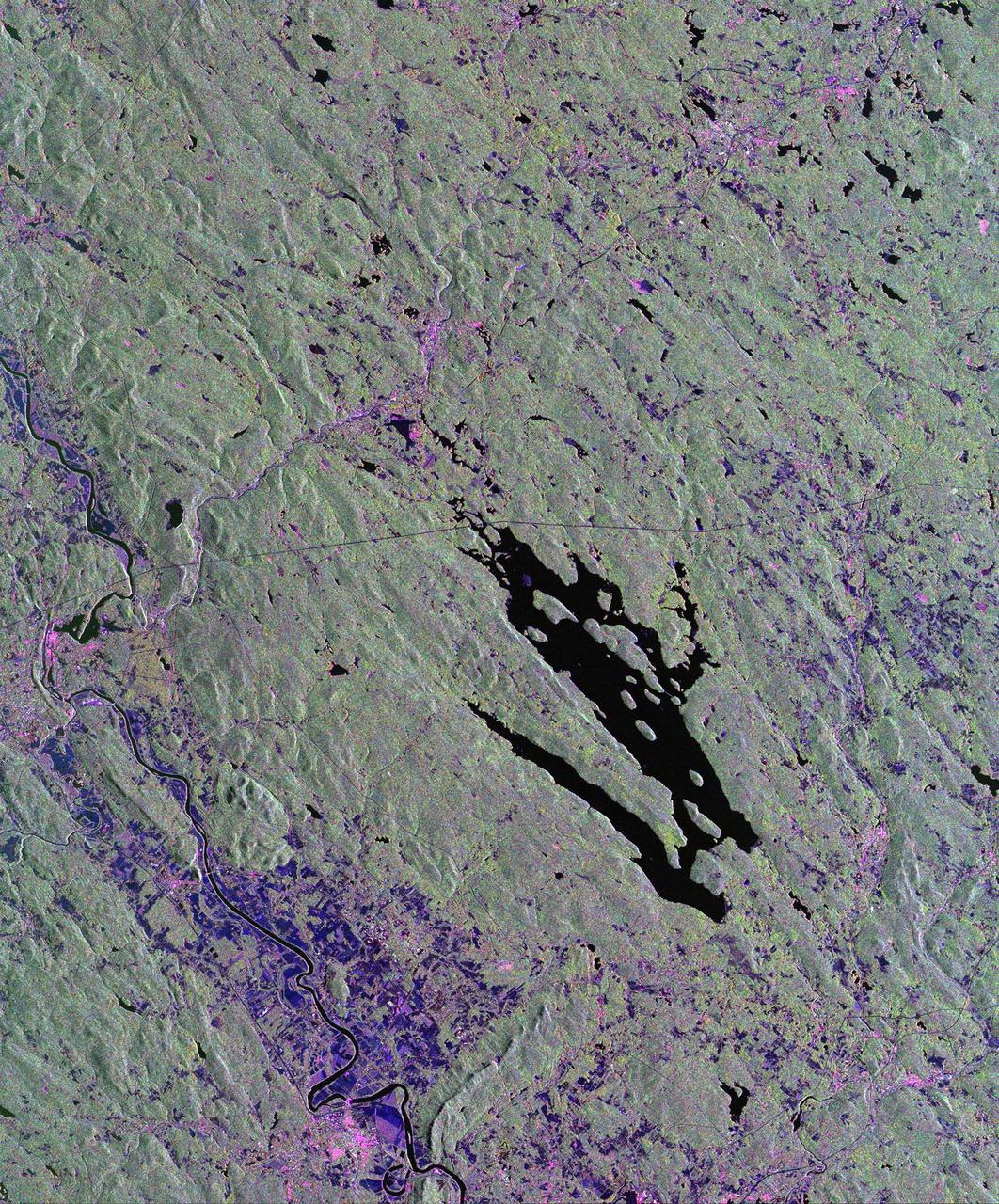
This is a radar image of the area surrounding the Harvard Forest in north-central Massachusetts that has been operated as a ecological research facility by Harvard University since 1907. At the center of the image is the Quabbin Reservoir, and the Connecticut River is at the lower left of the image. The Harvard Forest itself is just above the reservoir. Researchers are comparing the naturally occurring physical disturbances in the forest and the recent and projected chemical disturbances and their effects on the forest ecosystem. Agricultural land appears dark blue/purple, along with low shrub vegetation and some wetlands. Urban development is bright pink; the yellow to green tints are conifer-dominated vegetation with the pitch pine sand plain at the middle left edge of the image appearing very distinctive. The green tint may indicate pure pine plantation stands, and deciduous broadleaf trees appear gray/pink with perhaps wetter sites being pinker. This image was acquired by the Spaceborne Imaging Radar-C/X-Band Synthetic Aperture Radar (SIR-C/X-SAR) aboard the space shuttle Endeavour. SIR-C/X-SAR, a joint mission of the German, Italian and the United States space agencies, is part of NASA's Mission to Planet Earth. The image is centered at 42.50 degrees North latitude and 72.33 degrees West longitude and covers an area of 53 kilometers 63 by kilometers (33 miles by 39 miles). The colors in the image are assigned to different frequencies and polarizations of the radar as follows: red is L-band horizontally transmitted and horizontally received; green is L-band horizontally transmitted and vertically received; and blue is C-band horizontally transmitted and horizontally received. http://photojournal.jpl.nasa.gov/catalog/PIA01788
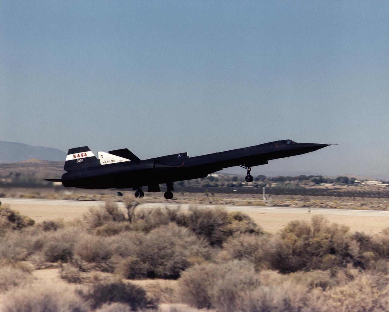
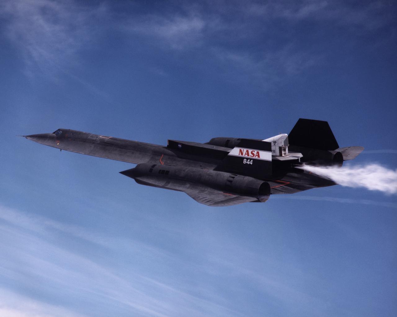
A NASA SR-71 takes off Oct. 31, making its first flight as part of the NASA/Rocketdyne/Lockheed Martin Linear Aerospike SR-71 Experiment (LASRE) at NASA's Dryden Flight Research Center, Edwards, California. The SR-71 took off at 8:31 a.m. PST. The aircraft flew for one hour and fifty minutes, reaching a maximum speed of Mach 1.2 before landing at Edwards at 10:21 a.m. PST, successfully validating the SR-71/linear aerospike experiment configuration. The goal of the first flight was to evaluate the aerodynamic characteristics and the handling of the SR-71/linear aerospike experiment configuration. The engine was not fired during the flight.
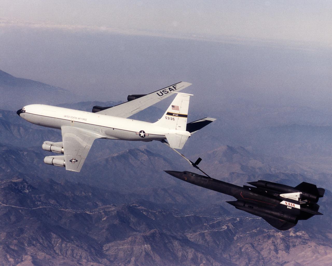
A NASA SR-71 refuels with an Edwards Air Force Base KC-135 during the first flight of the NASA/Rocketdyne/ Lockheed Martin Linear Aerospike SR-71 Experiment (LASRE). The flight took place Oct. 31 at NASA's Dryden Flight Research Center, Edwards, California. The SR-71 took off at 8:31 a.m. PST. The aircraft flew for one hour and fifty minutes, reaching a maximum speed of Mach 1.2 before landing at Edwards at 10:21 a.m. PST, successfully validating the SR-71/linear aerospike experiment configuration. The goal of the first flight was to evaluate the aerodynamic characteristics and the handling of the SR-71/linear aerospike experiment configuration. The engine was not fired during the flight.
A NASA SR-71 successfully completed its first flight 31 October 1997 as part of the NASA/Rocketdyne/Lockheed Martin Linear Aerospike SR-71 Experiment (LASRE) at NASA's Dryden Flight Research Center, Edwards, California. The SR-71 took off at 8:31 a.m. PST. The aircraft flew for one hour and fifty minutes, reaching a maximum speed of Mach 1.2 before landing at Edwards at 10:21 a.m. PST, successfully validating the SR-71/linear aerospike experiment configuration. The goal of the first flight was to evaluate the aerodynamic characteristics and the handling of the SR-71/linear aerospike experiment configuration. The engine was not fired during the flight.
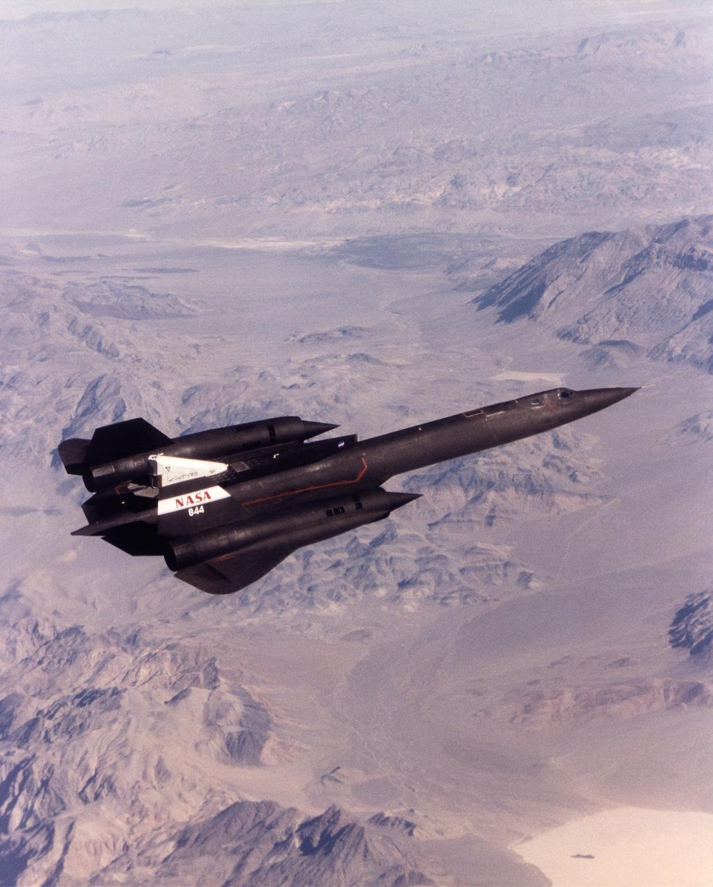
A NASA SR-71 made its successful first flight Oct. 31 as part of the NASA/Rocketdyne/ Lockheed Martin Linear Aerospike SR-71 Experiment (LASRE) at NASA's Dryden Flight Research Center, Edwards, California. The SR-71 took off at 8:31 a.m. PST. The aircraft flew for one hour and fifty minutes, reaching a maximum speed of Mach 1.2 before landing at Edwards at 10:21 a.m. PST, successfully validating the SR-71/linear aerospike experiment configuration. The goal of the first flight was to evaluate the aerodynamic characteristics and the handling of the SR-71/linear aerospike experiment configuration. The engine was not fired during the flight.
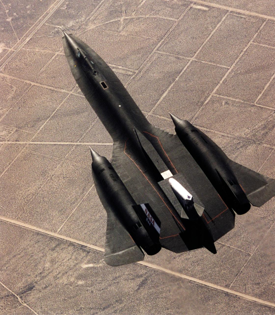
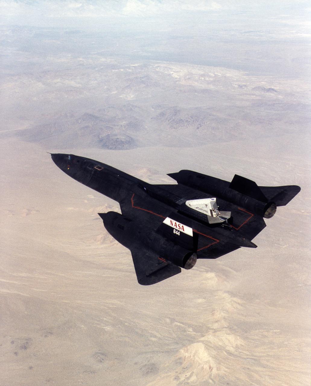
This photograph shows the SR-71 with the Linear Aerospike SR-71 Experiment on the rear fuselage as seen from above. The photo was taken on the first flight of the aircraft with the experiment aboard, which took place on 31 October 1997.
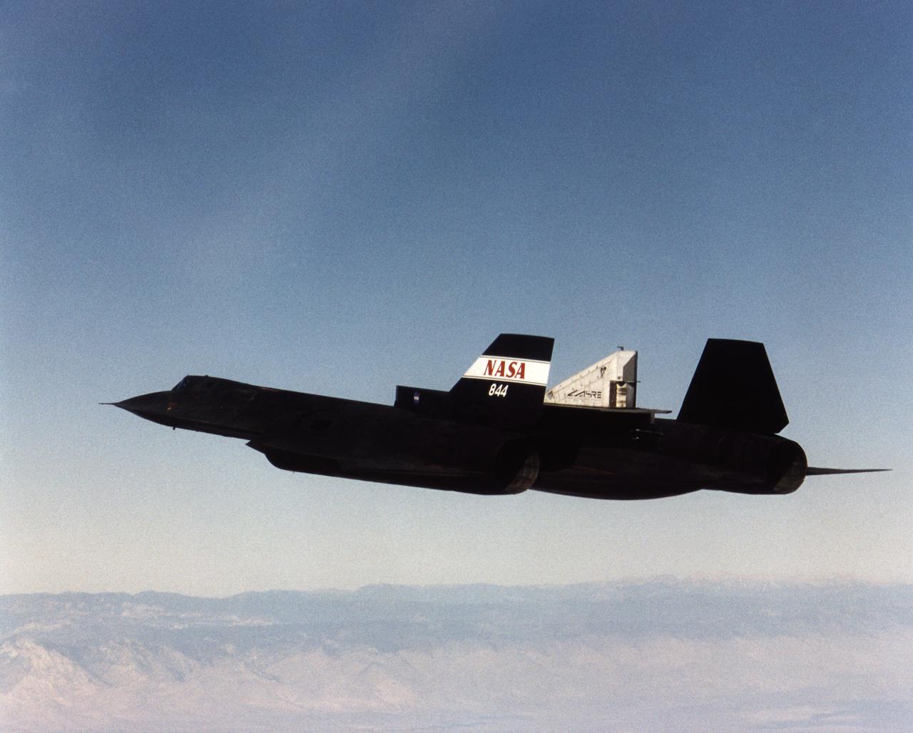
A NASA SR-71 successfully completed its first flight 31 October 1997 as part of the NASA/Rocketdyne/Lockheed Martin Linear Aerospike SR-71 Experiment (LASRE) at NASA's Dryden Flight Research Center, Edwards, California. The SR-71 took off at 8:31 a.m. PST. The aircraft flew for one hour and fifty minutes, reaching a maximum speed of Mach 1.2 before landing at Edwards at 10:21 a.m. PST, successfully validating the SR-71/linear aerospike experiment configuration. The goal of the first flight was to evaluate the aerodynamic characteristics and the handling of the SR-71/linear aerospike experiment configuration. The engine was not fired during the flight.
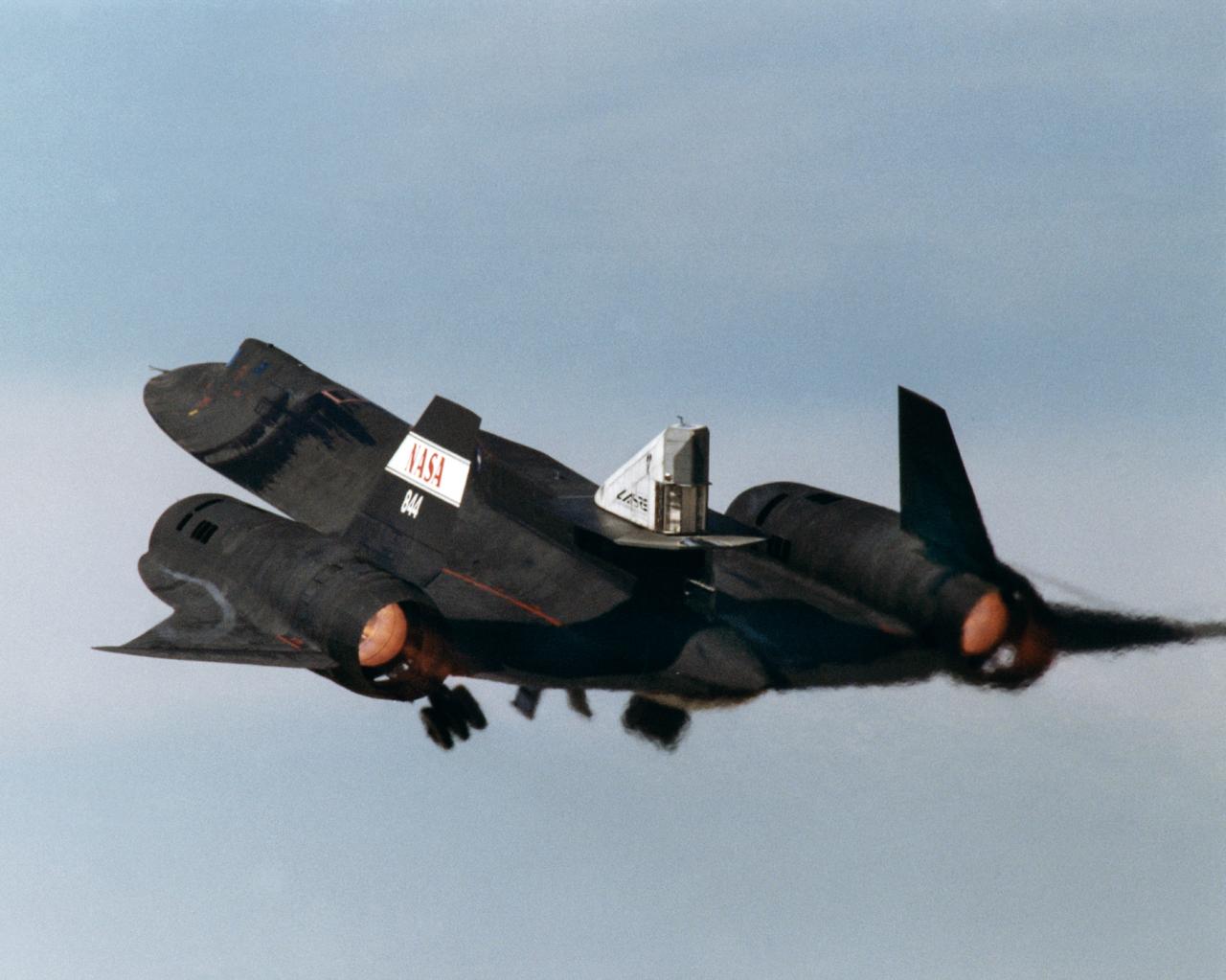
This photograph shows the LASRE pod on the upper rear fuselage of an SR-71 aircraft during take-off of the first flight to experience an in-flight cold flow test. The flight occurred on 4 March 1998.
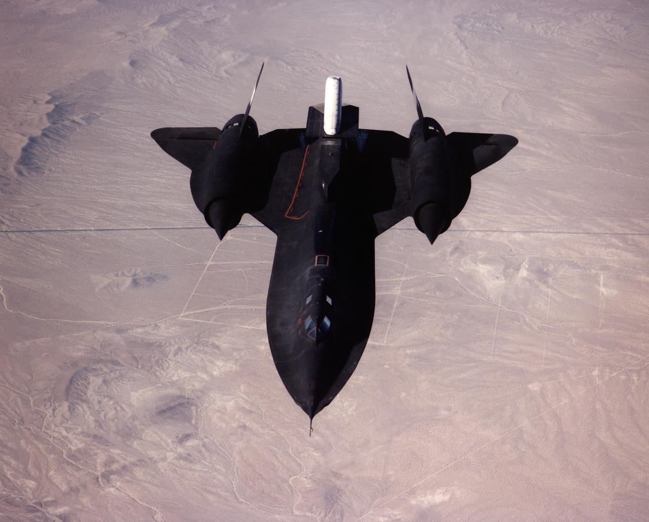
A NASA SR-71 made its successful first flight Oct. 31 as part of the NASA/Rocketdyne/Lockheed Martin Linear Aerospike SR-71 Experiment (LASRE) at NASA's Dryden Flight Research Center, Edwards, California. The SR-71 took off at 8:31 a.m. PST. The aircraft flew for one hour and fifty minutes, reaching a maximum speed of Mach 1.2 before landing at Edwards at 10:21 a.m. PST, successfully validating the SR-71/linear aerospike experiment configuration. The goal of the first flight was to evaluate the aerodynamic characteristics and the handling of the SR-71/linear aerospike experiment configuration. The engine was not fired during the flight.
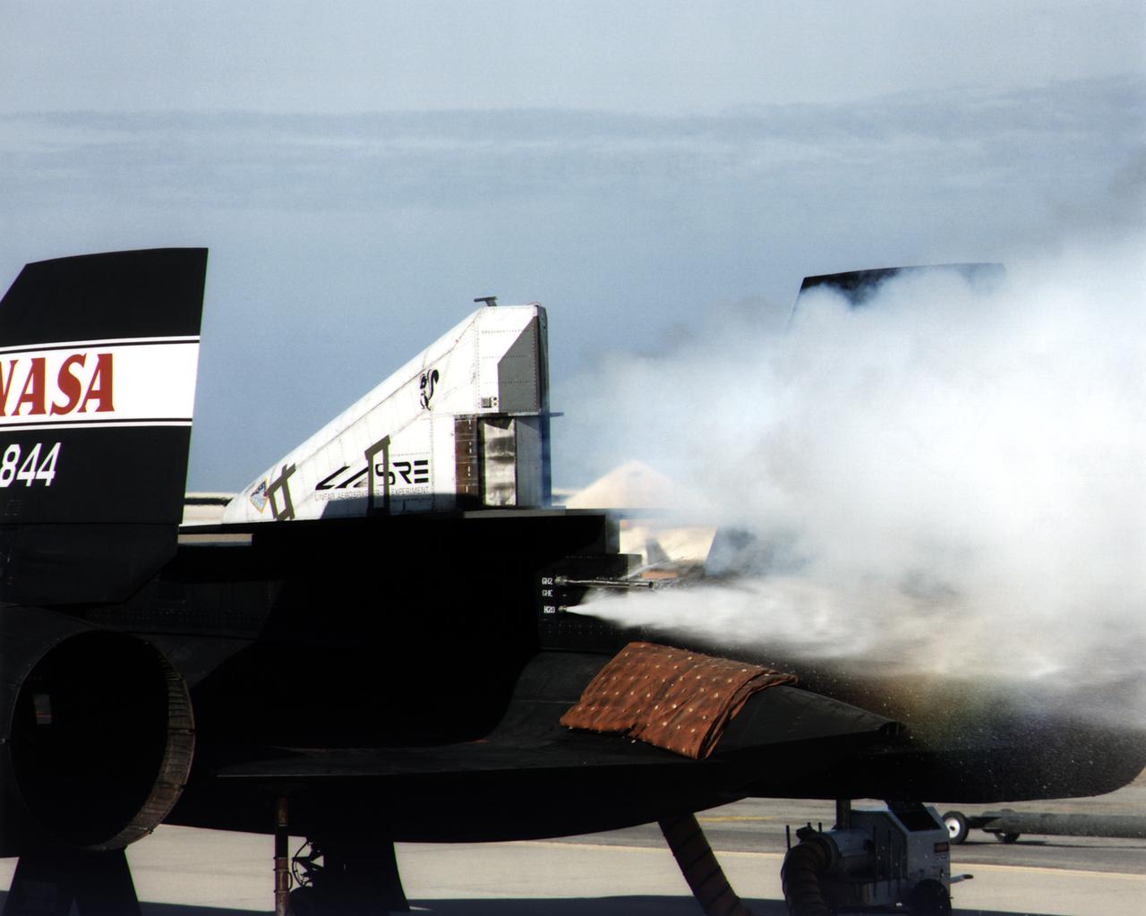
This photograph shows a ground cold flow test of the linear aerospike rocket engine mounted on the rear fuselage of an SR-71.
KENNEDY SPACE CENTER, FLA. -- STS-93 Commander Eileen Collins poses in front of the Space Shuttle orbiter Columbia following her textbook landing on runway 33 at the Shuttle Landing Facility. Main gear touchdown occurred at 11:20:35 p.m. EDT on July 27. On this mission, Collins became the first woman to serve as a Shuttle commander. Also on board were her fellow STS-93 crew members: Pilot Jeffrey S. Ashby and Mission Specialists Steven A. Hawley (Ph.D.), Catherine G. Coleman (Ph.D.) and Michel Tognini of France, with the Centre National d'Etudes Spatiales (CNES). The mission's primary objective was to deploy the Chandra X-ray Observatory, which will allow scientists from around the world to study some of the most distant, powerful and dynamic objects in the universe. This was the 95th flight in the Space Shuttle program and the 26th for Columbia. The landing was the 19th consecutive Shuttle landing in Florida and the 12th night landing in Shuttle program history

The city of Calcutta appears in this 24 by 34 km (15 by 21 mile) sub-scene, acquired March 29, 2000. In 1690 the British East India Company founded Calcutta as a trading post on the marshy east bank of the Hugli River. Chosen for its easily defensible location and its access to the Bay of Bengal, the site developed into an important trading port. In 1773 Calcutta was made the capital of British India. As merchants and workers from all over the Indian subcontinent flocked to the city, British interests prospered, and British colonizers built mansions and palaces on land reclaimed from the marshes and swampland. In 1912, however, Calcutta lost its position as the colonial capital to Delhi. The end of British rule in India in 1947 cut off many of Calcutta's sources of trade and brought a deluge of immigrants to the city. The Bangladesh war in 1971 exacerbated the influx of refugees. Today this vibrant city has a population of over 5 million, and continues to sprawl to the north and south from the central grid of its old European section. This image was acquired on June 23, 2002, covers an area of 33 x 27 km, and is located at 22.6 degrees north latitude and 88.3 degrees east longitude. http://photojournal.jpl.nasa.gov/catalog/PIA11157

This is an X-band image of seasonal changes at the ecological test site of Raco, Michigan, located south of Whitefish Bay on Lake Superior. The image is centered at about 46 degrees north latitude and 85 degrees west longitude. This image was acquired by the X-band Synthetic Aperture Radar onboard the space shuttle Endeavour on April 10th, 1994, and on October 1, 1994. The areas shown in red correspond to the April 10th data; the areas in blue correspond to data acquired on October 1, 1994; green indicates the ratio of data acquired on April 10 and October 1, 1994. The area shown is 22.7 kilometers by 53 kilometers (14 miles by 33 miles). Lake Superior in the upper right was frozen in April and had small waves (ripples) on its surface in October. The land area contains mostly forests and, to a lesser extent, agricultural regions. In April the area was covered in wet snow. By October, there agricultural areas were covered with grass. Vegetation and soils were moist due to rainfalls three days before the data was acquired on October 1, 1994. The bright light green/yellow tones in the lower half of the image show the stronger reflections of the snow-covered agricultural fields. The pinkish color corresponds to the coniferous and deciduous forests. The green area represents red pines. These trees are smaller than the surrounding forest cover and allow more radar penetration. The area is green because the radar is sensing the surface, which undergoes great change from snow to grass and fern undergrowth between April and October. The bright green triangle in the upper half of the image is an old airstrip, while the modern airport can be seen on the bottom right side of the image. The Raco site is an important location for monitoring seasonal changes and future global change because it is situated at the ecological transition zone between the boreal forests and the northern temperate forests. This transitional zone is expected to be ecologically sensitive to anticipated global changes resulting from climatic warming. Baseline studies of vegetation are essential in monitoring these expected changes. http://photojournal.jpl.nasa.gov/catalog/PIA01734
The NASA SR-71A successfully completed its first cold flow flight as part of the NASA/Rocketdyne/Lockheed Martin Linear Aerospike SR-71 Experiment (LASRE) at NASA's Dryden Flight Research Center, Edwards, California on March 4, 1998. During a cold flow flight, gaseous helium and liquid nitrogen are cycled through the linear aerospike engine to check the engine's plumbing system for leaks and to check the engine operating characterisitics. Cold-flow tests must be accomplished successfully before firing the rocket engine experiment in flight. The SR-71 took off at 10:16 a.m. PST. The aircraft flew for one hour and fifty-seven minutes, reaching a maximum speed of Mach 1.58 before landing at Edwards at 12:13 p.m. PST. "I think all in all we had a good mission today," Dryden LASRE Project Manager Dave Lux said. Flight crew member Bob Meyer agreed, saying the crew "thought it was a really good flight." Dryden Research Pilot Ed Schneider piloted the SR-71 during the mission. Lockheed Martin LASRE Project Manager Carl Meade added, "We are extremely pleased with today's results. This will help pave the way for the first in-flight engine data-collection flight of the LASRE."
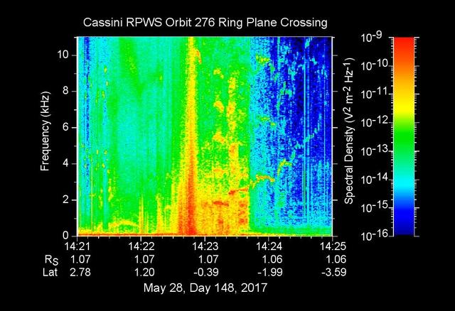
The sounds and colorful spectrogram in this still image and video represent data collected by the Radio and Plasma Wave Science, or RPWS, instrument on NASA's Cassini spacecraft, as it crossed through Saturn's D ring on May 28, 2017. This was the first of four passes through the inner edge of the D ring during the 22 orbits of Cassini's final mission phase, called the Grand Finale. During this ring plane crossing, the spacecraft was oriented so that its large high-gain antenna was used as a shield to protect more sensitive components from possible ring-particle impacts. The three 33-foot-long (10-meter-long) RPWS antennas were exposed to the particle environment during the pass. As tiny, dust-sized particles strike Cassini and the RPWS antennas, the particles are vaporized into tiny clouds of plasma, or electrically excited gas. These tiny explosions make a small electrical signal (a voltage impulse) that RPWS can detect. Researchers on the RPWS team convert the data into visible and audio formats, some like those seen here, for analysis. Ring particle hits sound like pops and cracks in the audio. Particle impacts are seen to increase in frequency in the spectrogram and in the audible pops around the time of ring crossing as indicated by the red/orange spike just before 14:23 on the x-axis. Labels on the x-axis indicate time (top line), distance from the planet's center in Saturn radii, or Rs (middle), and latitude on Saturn beneath the spacecraft (bottom). These data can be compared to those recorded during Cassini's first dive through the gap between Saturn and the D ring, on April 26. While it appeared from those earlier data that there were essentially no particles in the gap, scientists later determined the particles there are merely too small to create a voltage detectable by RPWS, but could be detected using Cassini's dust analyzer instrument. After ring plane crossing (about 14:23 onward) a series of high pitched whistles are heard. The RPWS instrument detects such tones during each of the Grand Finale orbits and the team is working to understand their source. The D ring proved to contain larger ring particles, as expected and recorded here, although the environment was determined to be relatively benign -- with less dust than other faint Saturnian rings Cassini has flown through. https://photojournal.jpl.nasa.gov/catalog/PIA21620
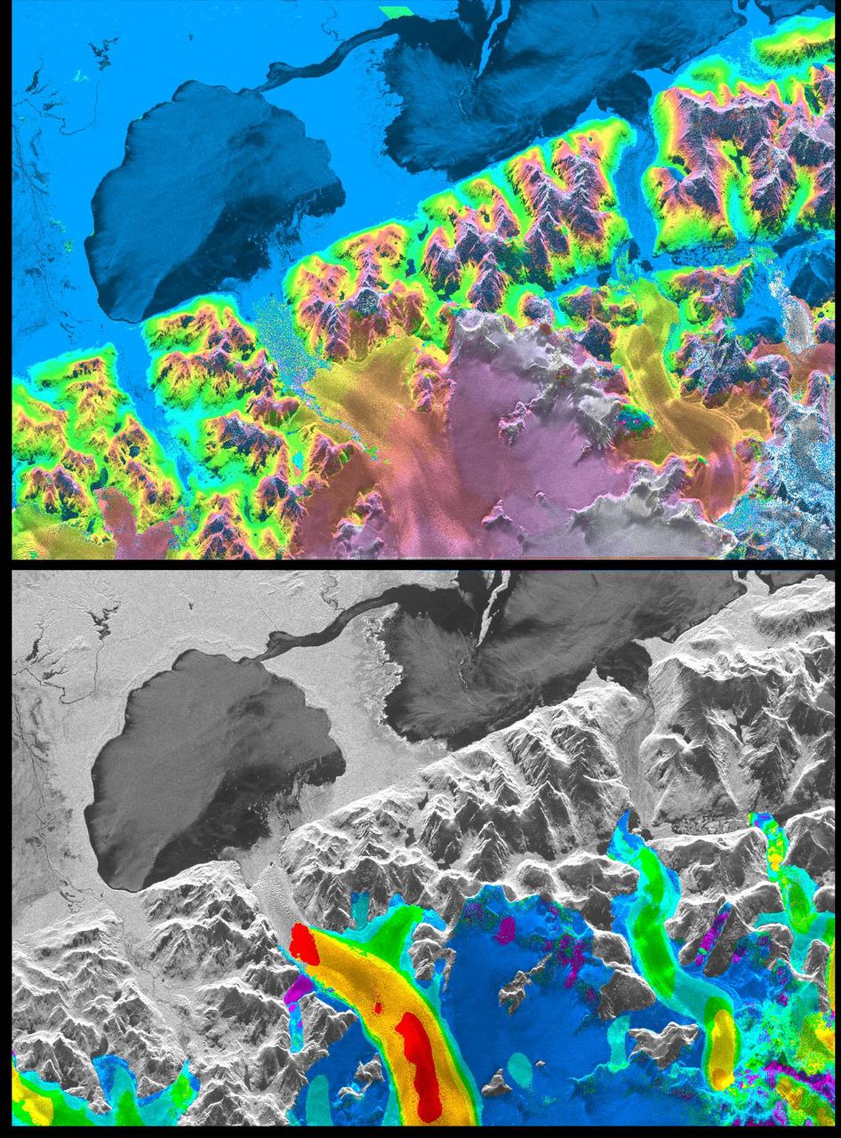
A NASA radar instrument has been successfully used to measure some of the fastest moving and most inaccessible glaciers in the world -- in Chile's huge, remote Patagonia ice fields -- demonstrating a technique that could produce more accurate predictions of glacial response to climate change and corresponding sea level changes. This image, produced with interferometric measurements made by the Spaceborne Imaging Radar-C and X-band Synthetic Aperture Radar (SIR-C/X-SAR) flown on the Space Shuttle last fall, has provided the first detailed measurements of the mass and motion of the San Rafael Glacier. Very few measurements have been made of the Patagonian ice fields, which are the world's largest mid-latitude ice masses and account for more than 60 percent of the Southern Hemisphere's glacial area outside of Antarctica. These features make the area essential for climatologists attempting to understand the response of glaciers on a global scale to changes in climate, but the region's inaccessibility and inhospitable climate have made it nearly impossible for scientists to study its glacial topography, meteorology and changes over time. Currently, topographic data exist for only a few glaciers while no data exist for the vast interior of the ice fields. Velocity has been measured on only five of the more than 100 glaciers, and the data consist of only a few single-point measurements. The interferometry performed by the SIR-C/X-SAR was used to generate both a digital elevation model of the glaciers and a map of their ice motion on a pixel-per-pixel basis at very high resolution for the first time. The data were acquired from nearly the same position in space on October 9, 10 and 11, 1994, at L-band frequency (24-cm wavelength), vertically transmitted and received polarization, as the Space Shuttle Endeavor flew over several Patagonian outlet glaciers of the San Rafael Laguna. The area shown in these two images is 50 kilometers by 30 kilometers (30 miles by 18 miles) in size and is centered at 46.6 degrees south latitude, 73.8 degrees west longitude. North is toward the upper right. The top image is a digital elevation model of the scene, where color and saturation represent terrain height (between 0 meters and 2,000 meters or up to 6,500 feet) and brightness represents radar backscatter. Low elevations are shown in blue and high elevations are shown in pink. The digital elevation map of the glacier surface has a horizontal resolution of 15 meters (50 feet) and a vertical resolution of 10 meters (30 feet). High-resolution maps like these acquired over several years would allow scientists to calculate directly long-term changes in the mass of the glacier. The bottom image is a map of ice motion parallel to the radar look direction only, which is from the top of the image. Purple indicates ice motion away from the radar at more than 6 centimeters per day; dark blue is ice motion toward or away at less than 6 cm per day; light blue is motion toward the radar of 6 cm to 20 cm (about 2 to 8 inches) per day; green is motion toward the radar of 20 cm to 45 cm (about 8 to 18 inches) per day; yellow is 45 cm to 85 cm (about 18 to 33 inches) per day; orange is 85 cm to 180 cm (about 33 to 71 inches) per day; red is greater than 180 cm (71 inches) per day. The velocity estimates are accurate to within 5 millimeters per day. The largest velocities are recorded on the San Rafael Glacier in agreement with previous work. Other outlet glaciers exhibit ice velocities of less than 1 meter per day. Several kilometers before its terminus, (left of center) the velocity of the San Rafael Glacier exceeds 10 meters (32 feet) per day, and ice motion cannot be estimated from the data. There, a revisit time interval of less than 12 hours would have been necessary to estimate ice motion from interferometry data. The results however demonstrate that the radar interferometry technique permits the monitoring of glacier characteristics unattainable by any other means. http://photojournal.jpl.nasa.gov/catalog/PIA01781
NASA Flight Research Pilot Milt Thompson, shown here on the lakebed with the M2-F1 lifting body, was an early backer of R. Dale Reed's lifting-body proposal. He urged Flight Research Center director Paul Bikle to approve the M2-F1's construction. Thompson also made the first glide flights in both the M2-F1 and its successor, the heavyweight M2-F2.
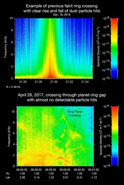
The sounds and spectrograms in these two videos represent data collected by the Radio and Plasma Wave Science, or RPWS, instrument on NASA's Cassini spacecraft, as it crossed the plane of Saturn's rings on two separate orbits. As tiny, dust-sized particles strike Cassini and the three 33-foot-long (10-meter-long), RPWS antennas, the particles are vaporized into tiny clouds of plasma, or electrically excited gas. These tiny explosions make a small electrical signal (a voltage impulse) that RPWS can detect. Researchers on the RPWS team convert the data into visible and audio formats, like those seen here, for analysis. Ring particle hits sound like pops and cracks in the audio. The first video (top image in the montage) was made using RPWS data from a ring plane crossing on Dec. 18, 2016, when the spacecraft passed through the faint, dusty Janus-Epimetheus ring (see PIA08328 for an image that features this ring). This was during Cassini's 253rd orbit of Saturn, known as Rev 253. As is typical for this sort of ring crossing, the number of audible pops and cracks rises to a maximum around the time of a ring crossing and trails off afterward. The peak of the ring density is obvious in the colored display at the red spike. The second video (bottom image in the montage) was made using data RPWS collected as Cassini made the first dive through the gap between Saturn and its rings as part of the mission's Grand Finale, on April 26, 2017. Very few pops and cracks are audible in this data at all. In comparing the two data sets, it is apparent that while Cassini detected many ring-particles striking Cassini when passing through the Janus-Epimetheus ring, the first Grand Finale crossing -- in stark contrast -- was nearly particle free. The unexpected finding that the gap is so empty is a new mystery that scientists are eager to understand. On April 26, 2017, Cassini dove through the previously unexplored ring-planet gap at speeds approaching 75,000 mph (121,000 kph), using its large, dish-shaped high-gain antenna (or HGA) as a shield to protect the rest of the spacecraft and its instruments from potential impacts by small, icy ring particles. Two of Cassini's instruments, the magnetometer and RPWS, extend beyond the protective antenna dish, and were exposed to the particle environment during the dive. The Cassini team used this data from RPWS, along with inputs from other components on the spacecraft, to make the decision of whether the HGA would be needed as a shield on most future Grand Finale dives through the planet-ring gap. Based on these inputs the team determined this protective measure would not be needed, allowing the team's preferred mode of science operations to proceed, with Cassini able to point its science instruments in any direction necessary to obtain scientists' desired observations. (Four of the 21 remaining dives pass through the inner D ring. The mission had already planned to use the HGA as a shield for those passes.) The colors on the spectrogram indicate the emitted power of the radio waves, with red as the most powerful. Time is on the x-axis, and frequency of the radio waves is on the y-axis. The audible whistle in the April 26 data, just before ring plane crossing, is due to a type of plasma wave that will be the subject of further study. In addition, there is an abrupt change beginning at the 09:00:00 mark on the spectrogram that represents a change in the RPWS antenna's operational configuration (from monopole mode to dipole mode). The videos can be viewed at https://photojournal.jpl.nasa.gov/catalog/PIA21446