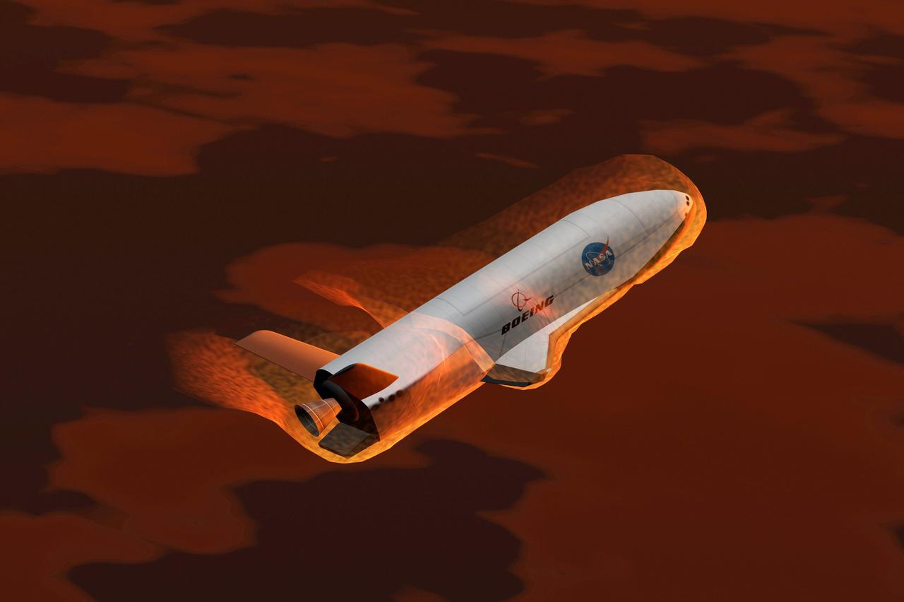
Pictured is an artist's concept of the experimental X-37 Reusable Launch Vehicle re-entering Earth‘s atmosphere. NASA and the Boeing Company entered a cooperative agreement to develop and fly a new experimental space plane called the X-37 that would be ferried into orbit to test new technologies. The reusable space plane incorporated technologies aimed at significantly cutting the cost of space flight. The X-37 would be carried into orbit by the Space Shuttle or be launched by an expendable rocket. After the X-37 was deployed, it would remain in orbit up to 21 days, performing a variety of experiments before re-entering the Earth's atmosphere and landing. The X-37 program was discontinued in 2003.
Pictured is an artist's concept of the experimental Reusable Launch Vehicle (RLV), the X-37 located in the cargo bay of a space shuttle with Earth in the background. The X-37 was designed to launch from the space shuttle's cargo bay as a secondary payload. Once deployed, the X-37 would remain on-orbit up to 21 days performing a variety of experiments before re-entering the Earth's atmosphere and landing. The X-37 program was discontinued in 2003.
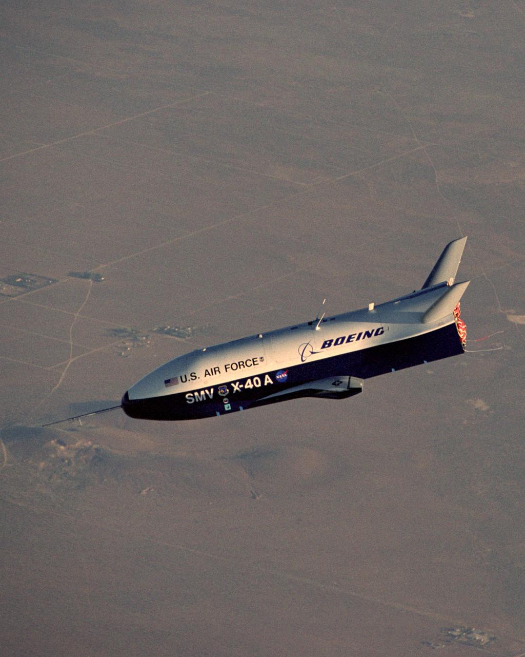
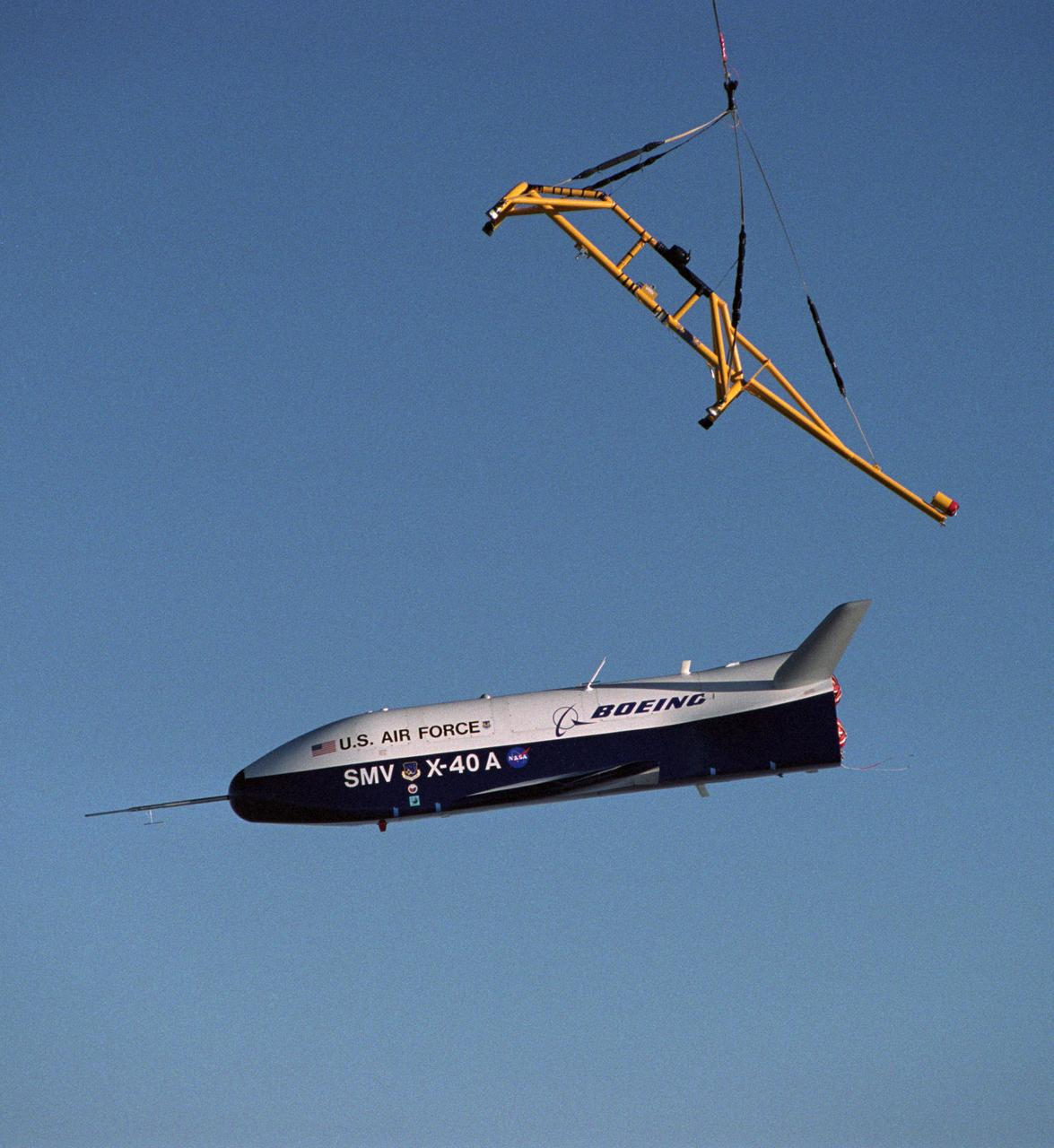
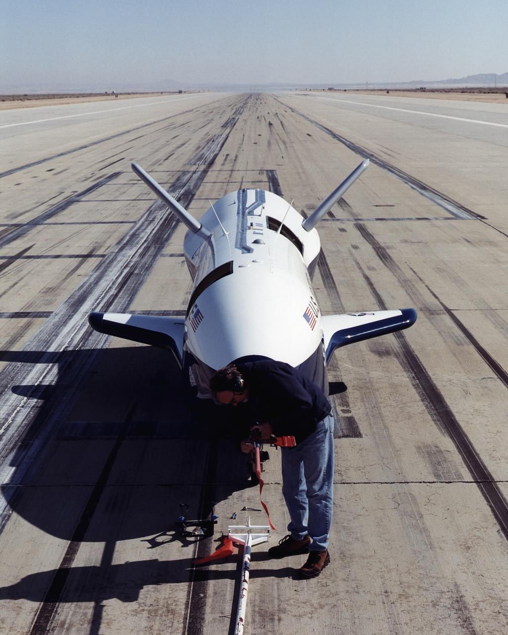
X-40A Free Flight #5. The unpowered X-40A, an 85 percent scale risk reduction version of the proposed X-37, proved the capability of an autonomous flight control and landing system in a series of glide flights at NASA's Dryden Flight Research Center in California. NASA's Marshall Space Flight Center in Huntsville, Alabama, manages the X-37 project. At Dryden, the X-40A underwent a series of ground and air tests to reduce possible risks to the larger X-37, including drop tests from a helicopter to check guidance and navigation systems planned for use in the X-37. The X-37 is designed to demonstrate technologies in the orbital and reentry environments for next-generation reusable launch vehicles that will increase both safety and reliability, while reducing launch costs from $10,000 per pound to $1,000 per pound.
X-40A Free Flight #5. The unpowered X-40A, an 85 percent scale risk reduction version of the proposed X-37, proved the capability of an autonomous flight control and landing system in a series of glide flights at NASA's Dryden Flight Research Center in California. NASA's Marshall Space Flight Center in Huntsville, Alabama, manages the X-37 project. At Dryden, the X-40A underwent a series of ground and air tests to reduce possible risks to the larger X-37, including drop tests from a helicopter to check guidance and navigation systems planned for use in the X-37. The X-37 is designed to demonstrate technologies in the orbital and reentry environments for next-generation reusable launch vehicles that will increase both safety and reliability, while reducing launch costs from $10,000 per pound to $1,000 per pound.
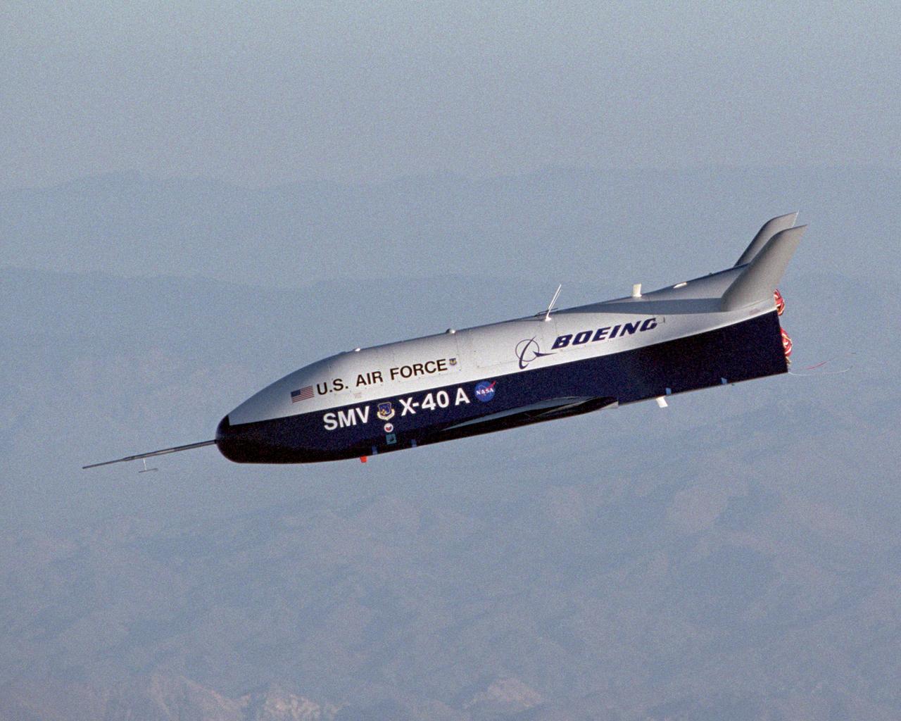
X-40A Free Flight #5. The unpowered X-40A, an 85 percent scale risk reduction version of the proposed X-37, proved the capability of an autonomous flight control and landing system in a series of glide flights at NASA's Dryden Flight Research Center in California. NASA's Marshall Space Flight Center in Huntsville, Alabama, manages the X-37 project. At Dryden, the X-40A underwent a series of ground and air tests to reduce possible risks to the larger X-37, including drop tests from a helicopter to check guidance and navigation systems planned for use in the X-37. The X-37 is designed to demonstrate technologies in the orbital and reentry environments for next-generation reusable launch vehicles that will increase both safety and reliability, while reducing launch costs from $10,000 per pound to $1,000 per pound.
Pictured is an artist's conception of the X-37 Demonstrator ascending left upright. As part of the Pathfinder Program, the X-37 flight experiment demonstrates advanced space transportation technologies through the use of flight experiments. These vehicles supported the Agency's goal of dramatically reducing the cost of access to space in attempt to define the future of space transportation. The X-37 program was discontinued in 2003.
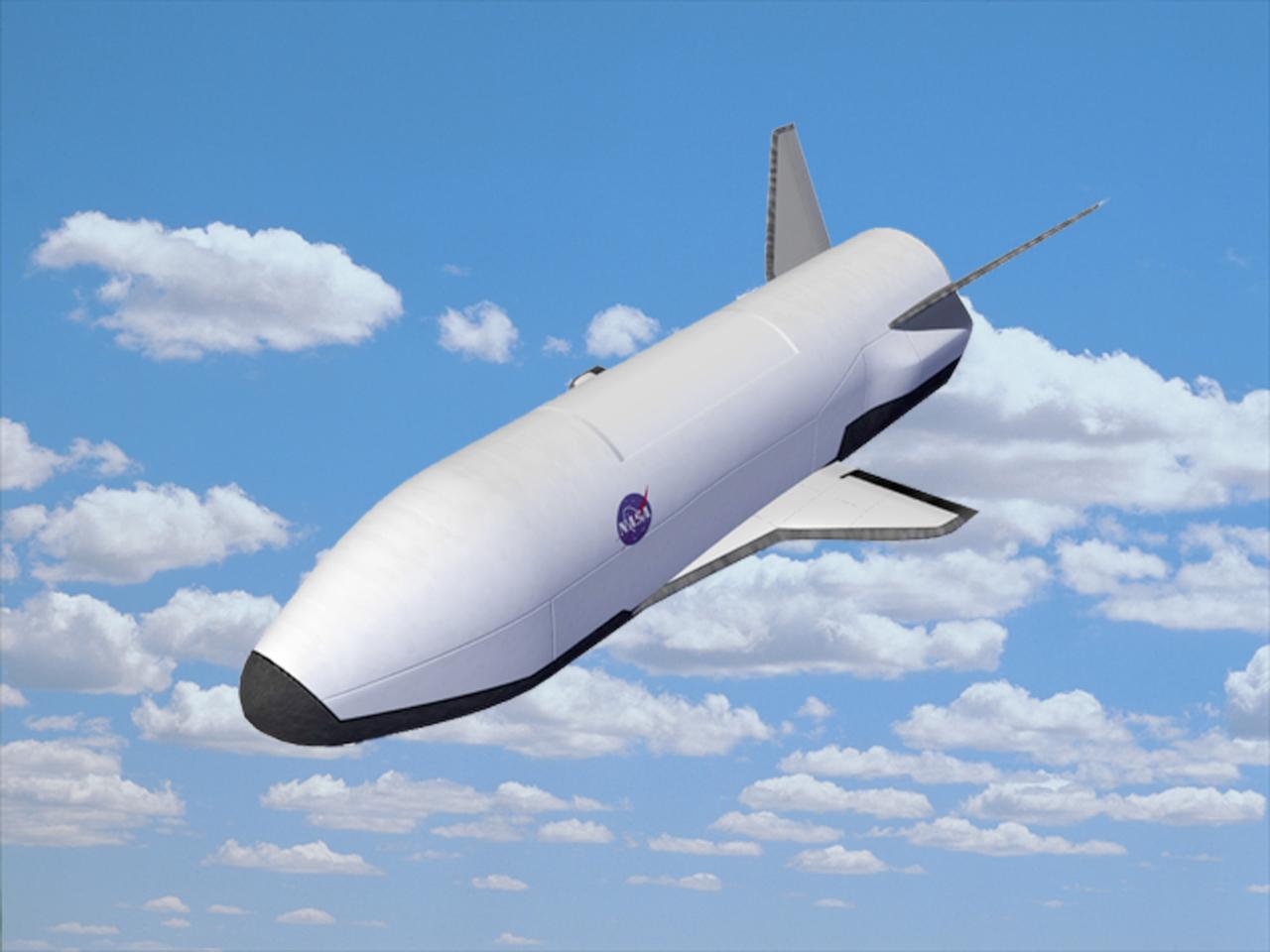
Pictured is an artist's concept of the X-37 Demonstrator re-entry. After being launched from the cargo bay of a Shuttle as a secondary payload, the X-37 remains on-orbit up to 21 days performing a variety of experiments before re-entering the Earth's atmosphere and landing. These vehicles supported the Agency's goal of dramatically reducing the cost of access to space in attempt to define the future of space transportation. The X-37 program was discontinued in 2003.
Pictured is an artist's conception of the X-37 Demonstrator descending down left. As part of the Pathfinder Program, the X-37 flight experiment demonstrates advanced space transportation technologies through the use of flight experiments. These vehicles supported the Agency's goal of dramatically reducing the cost of access to space in attempt to define the future of space transportation. The X-37 program was discontinued in 2003.
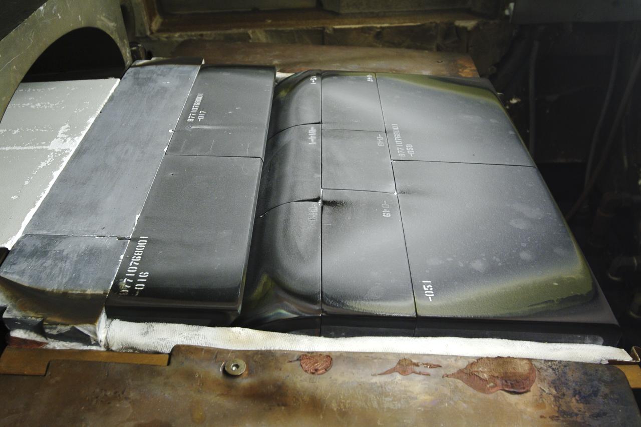
Thermal Evaluaion of X-37 Body flap Seal testing in the Panel Test Facility PFT-115
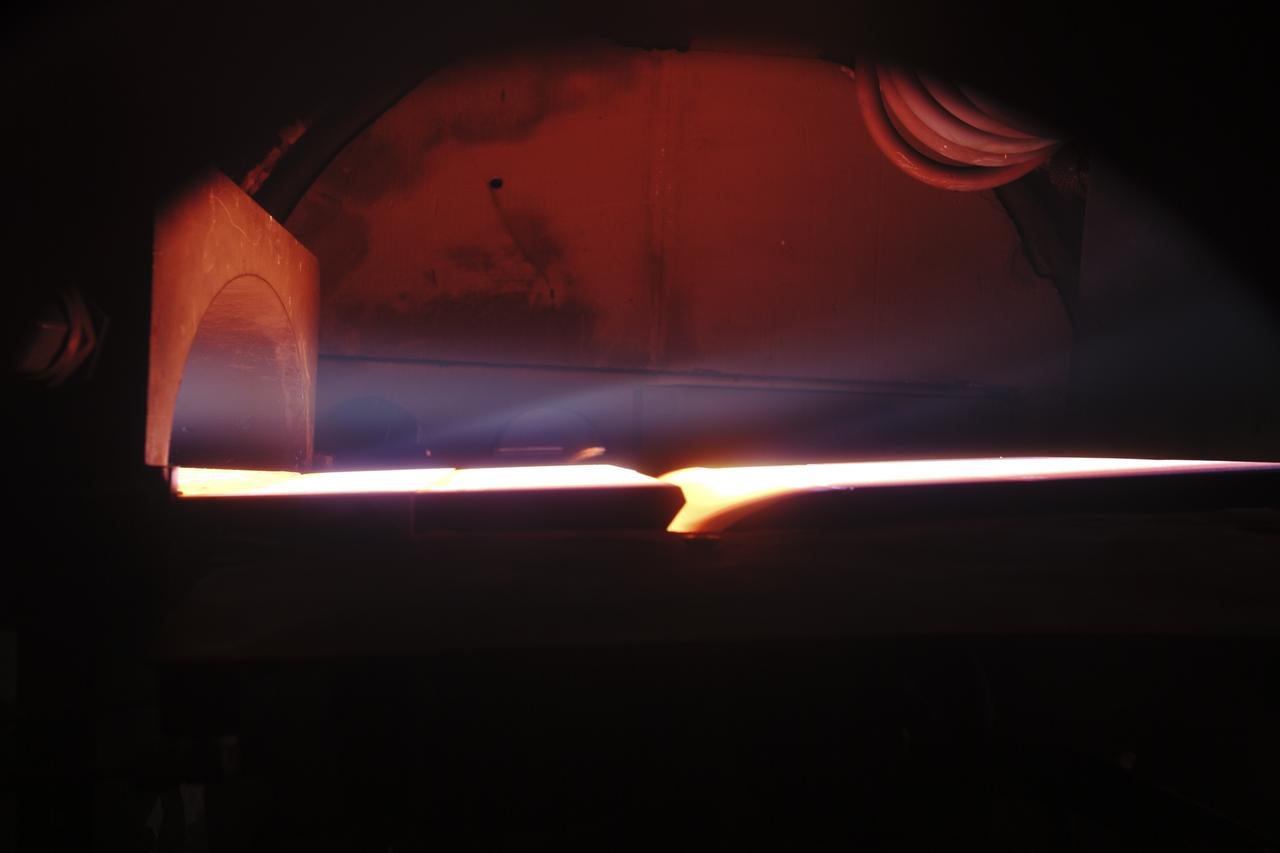
Thermal Evaluaion of X-37 Body Flap Sea test in Panel Test Facility PTF-115
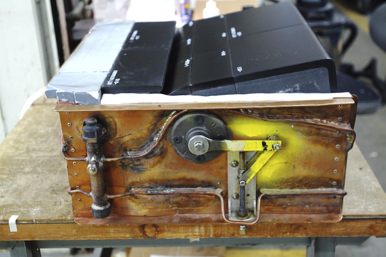
Thermal Evaluaion of X-37 Body Flap Sea test in Panel Test Facility PTF-115
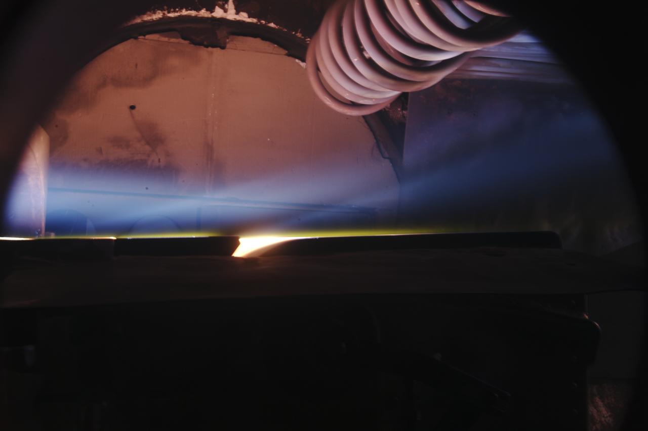
Thermal Evaluaion of X-37 Body Flap Sea test in Panel Test Facility PTF-115
A worker attaches covers for the nose pitot boom before removing the unpiloted X-40 from the runway at Edwards Air Force Base, California, following its successful free-flight on March 14, 2001. The unpiloted X-40 is a risk-reduction vehicle for the X-37, which is intended to be a reusable space vehicle. NASA's Marshall Space Flight Center in Huntsville, Ala, manages the X-37 project. At Dryden, the X-40A will undergo a series of ground and air tests to reduce possible risks to the larger X-37, including drop tests from a helicopter to check guidance and navigation systems planned for use in the X-37. The X-37 is designed to demonstrate technologies in the orbital and reentry environments for next-generation reusable launch vehicles that will increase both safety and reliability, while reducing launch costs from $10,000 per pound to $1,000 per pound.
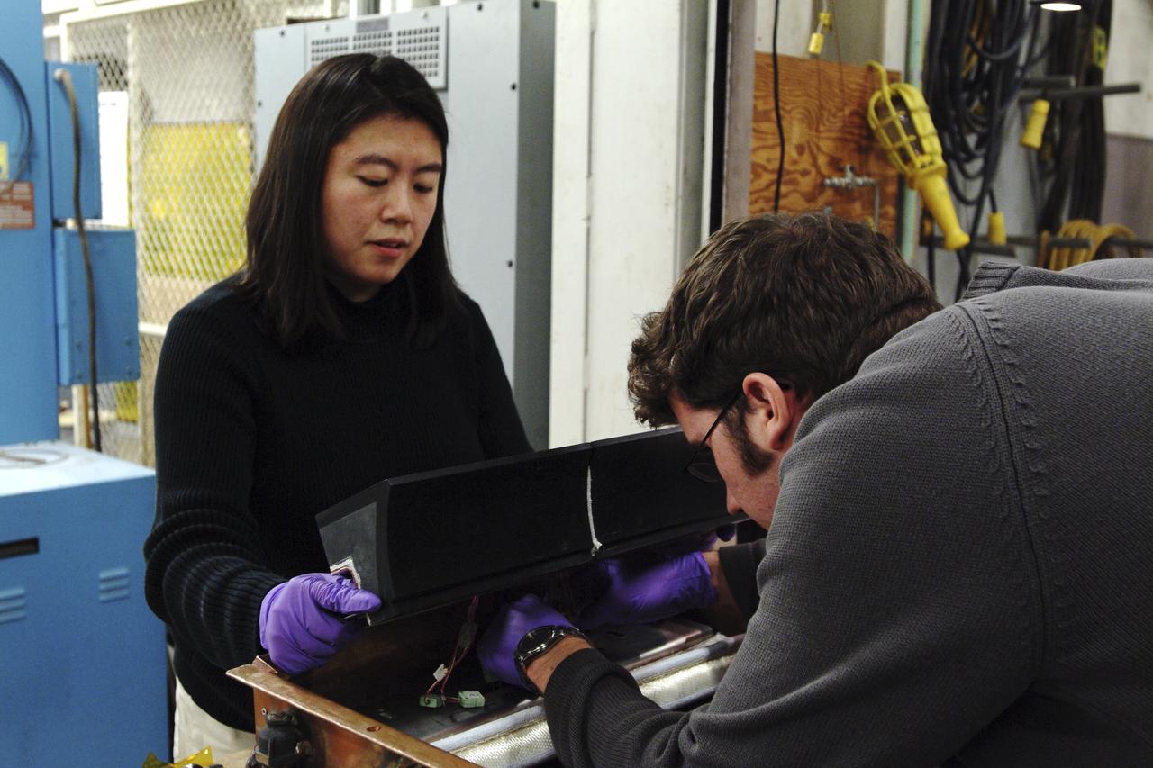
Thermal Evaluaion of X-37 Body Flap Sea test in Panel Test Facility PTF-115 With Winnie Chen, and Patric Briney, Boeing test engineers

Thermal Evaluaion of X-37 Body Flap Sea test in Panel Test Facility PTF-115 With Winnie Chen, Boeing test engineer
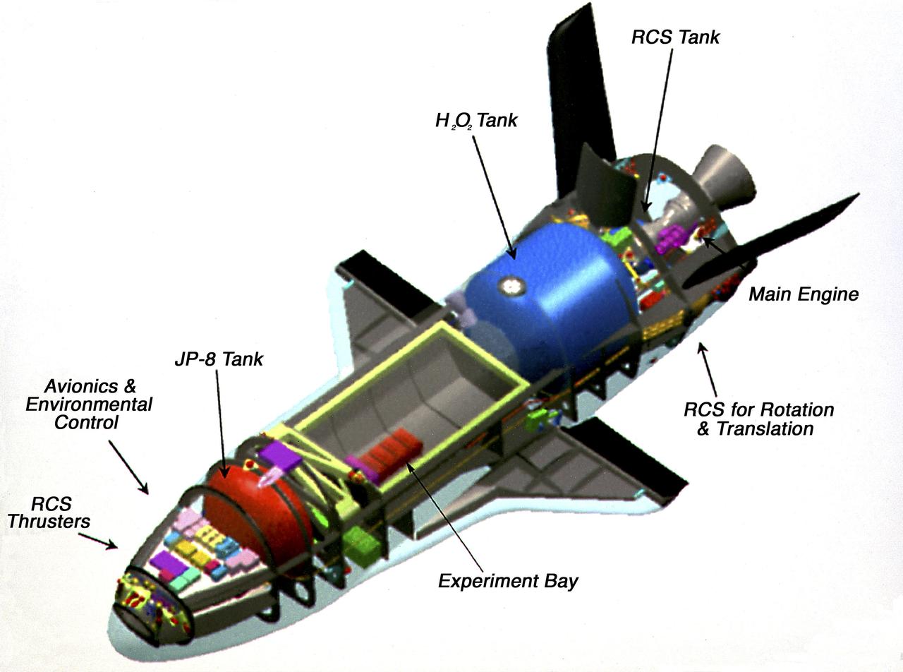
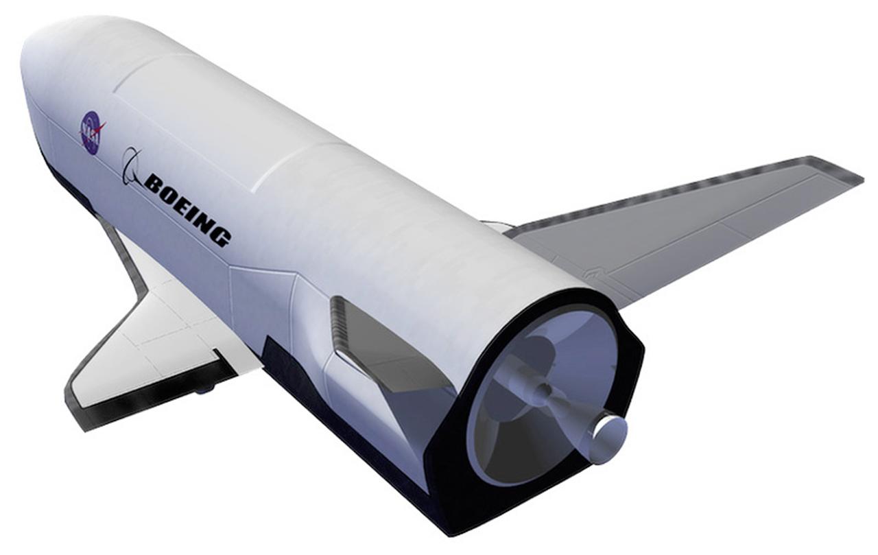
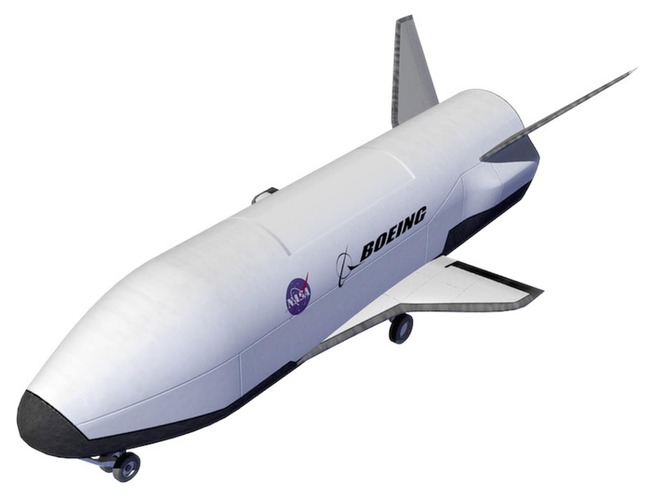
This photograph is an artist's cutaway view of the X-37 flight demonstrator showing its components. The X-37 experimental launch vehicle is roughly 27.5 feet (8.3 meters) long and 15 feet (4.5 meters) in wingspan. Its experiment bay is 7 feet (2.1 meters) long and 4 feet (1.2 meters) in diameter. Designed to operate in both the orbital and reentry phases of flight, the X-37 will increase both safety and reliability, while reducing launch costs from $10,000 per pound to $1000 per pound. The X-37 can be carried into orbit by the Space Shuttle or be launched by an expendable rocket. Managed by Marshall Space Flight Center and built by the Boeing Company, the X-37 is scheduled to fly two orbital missions in 2002/2003 to test the reusable launch vehicle technologies.

Wranglers steadied the X-40A at NASA's Dryden Flight Research Center, Edwards, California, March 14, 2001, as the experimental craft was carried to 15,000 feet for an unpiloted glide flight. The unpiloted X-40 is a risk-reduction vehicle for the X-37, which is intended to be a reusable space vehicle. NASA's Marshall Space Flight Center in Huntsville, Ala, manages the X-37 project. At Dryden, the X-40A will undergo a series of ground and air tests to reduce possible risks to the larger X-37, including drop tests from a helicopter to check guidance and navigation systems planned for use in the X-37. The X-37 is designed to demonstrate technologies in the orbital and reentry environments for next-generation reusable launch vehicles that will increase both safety and reliability, while reducing launch costs from $10,000 per pound to $1,000 per pound.
First flight at NASA's Dryden Flight Research Center for the X-40A was a 74 second glide from 15,000 feet on March 14, 2001. The unpiloted X-40 is a risk-reduction vehicle for the X-37, which is intended to be a reusable space vehicle. NASA's Marshall Space Flight Center in Huntsville, Ala, manages the X-37 project. At Dryden, the X-40A will undergo a series of ground and air tests to reduce possible risks to the larger X-37, including drop tests from a helicopter to check guidance and navigation systems planned for use in the X-37. The X-37 is designed to demonstrate technologies in the orbital and reentry environments for next-generation reusable launch vehicles that will increase both safety and reliability, while reducing launch costs from $10,000 per pound to $1,000 per pound.
Thermal Evaluaion of X-37 Body Flap Sea test in Panel Test Facility PTF-115 with (l) Duoc Tran, Boeing Test engineer and (r) Vincent Meglio, NASA lead Engineering Technician / Operator
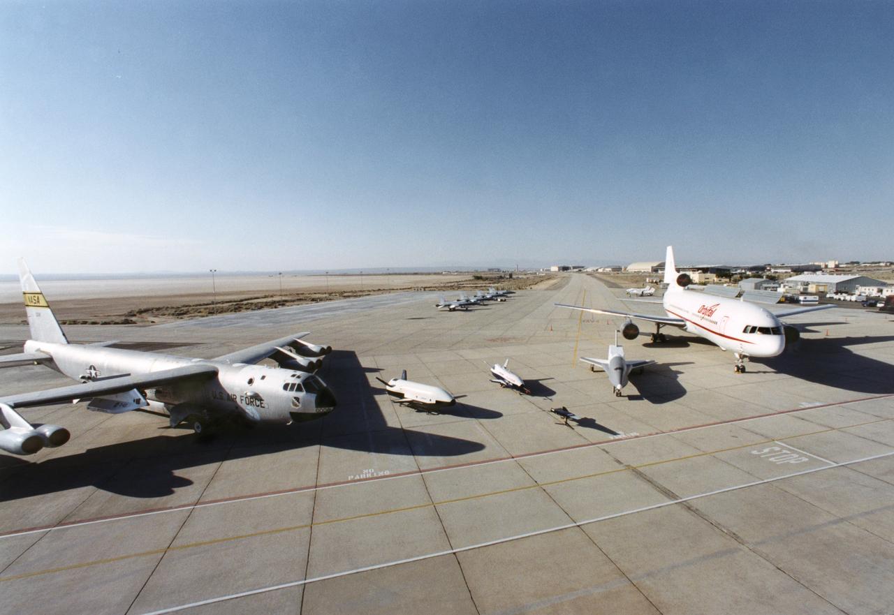
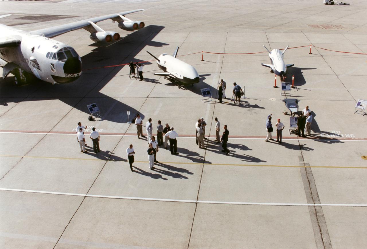
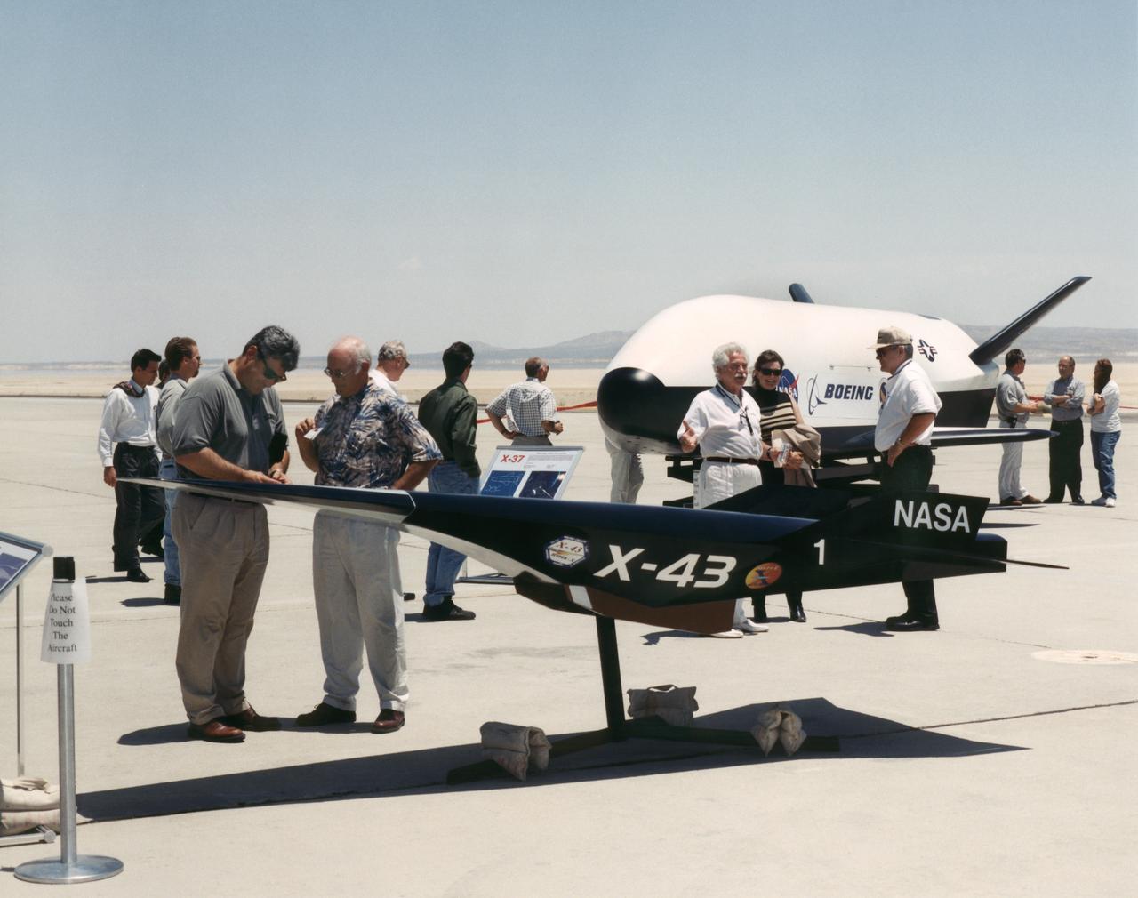
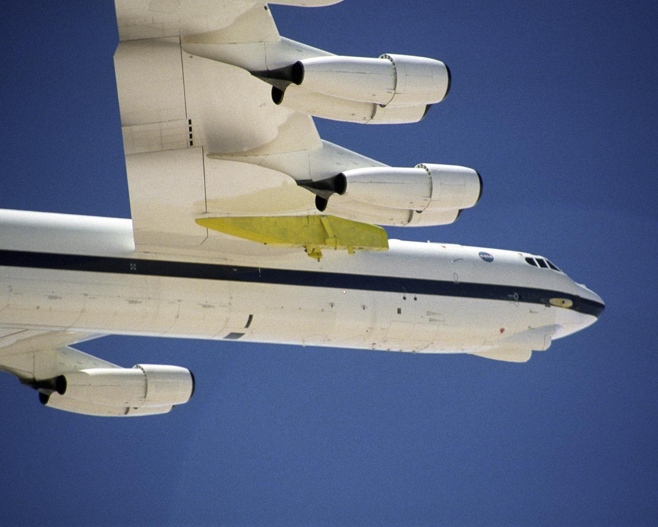
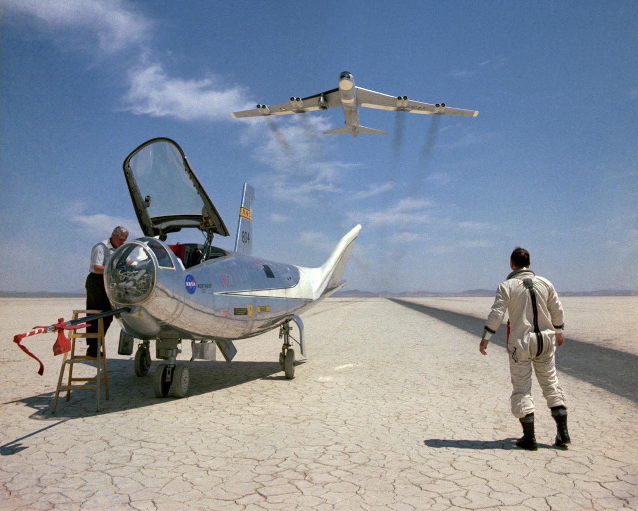
Aerospace industry representatives view actual and mock-up versions of 'X-Planes' intended to enhance access to space during a technical exposition on June 22, 2000 at Dryden Flight Research Center, Edwards, California. From left to right: NASA's B-52 launch aircraft, in service with NASA from 1959 to 2004; a neutral-buoyancy model of the Boeing's X-37; the Boeing X-40A behind the MicroCraft X-43 mock-up; Orbital Science's X-34 and the modified Lockheed L-1011 airliner that was intended to launch the X-34. These X-vehicles are part of NASA's Access to Space plan intended to bring new technologies to bear in an effort to dramatically lower the cost of putting payloads in space, and near-space environments. The June 22, 2000 NASA Reusable Launch Vehicle (RLV) Technology Exposition included presentations on the history, present, and future of NASA's RLV program. Special Sessions for industry representatives highlighted the X-37 project and its related technologies. The X-37 project is managed by NASA's Marshall Space Flight Center, Huntsville, Alabama.
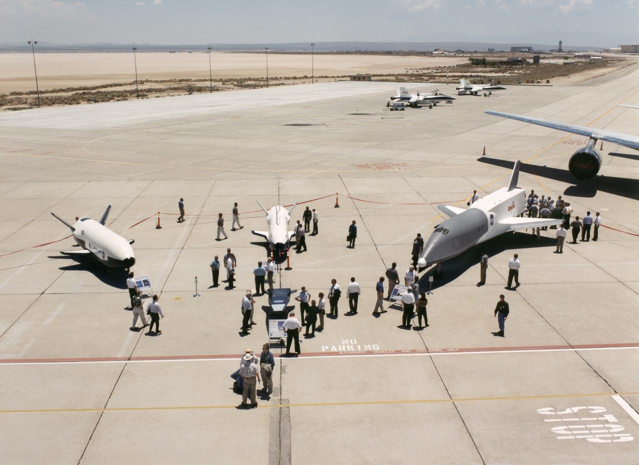
Aerospace industry representatives view actual and mock-up versions of 'X-Planes' intended to enhance access to space during a technical exposition on June 22, 2000 at Dryden Flight Research Center, Edwards, California. From left to right: NASA's B-52 launch aircraft, in service with NASA since 1959; a neutral-buoyancy model of the Boeing's X-37; the Boeing X-40A behind the MicroCraft X-43 mock-up; Orbital Science's X-34 and the modified Lockheed L-1011 airliner that was intended to launch the X-34. These X-vehicles are part of NASA's Access to Space plan intended to bring new technologies to bear in an effort to dramatically lower the cost of putting payloads in space, and near-space environments. The June 22, 2000 NASA Reusable Launch Vehicle (RLV) Technology Exposition included presentations on the history, present, and future of NASA's RLV program. Special Sessions for industry representatives highlighted the X-37 project and its related technologies. The X-37 project is managed by NASA's Marshall Space Flight Center, Huntsville, Alabama.
Aerospace industry representatives view actual and mock-up versions of 'X-Planes' intended to enhance access to space during a technical exposition on June 22, 2000 at Dryden Flight Research Center, Edwards, California. From left to right: NASA's B-52 launch aircraft, in service with NASA from 1959 to 2004; a neutral-buoyancy model of the Boeing's X-37; the Boeing X-40A behind the MicroCraft X-43 mock-up; Orbital Science's X-34 and the modified Lockheed L-1011 airliner that was intended to launch the X-34. These X-vehicles are part of NASA's Access to Space plan intended to bring new technologies to bear in an effort to dramatically lower the cost of putting payloads in space, and near-space environments. The June 22, 2000 NASA Reusable Launch Vehicle (RLV) Technology Exposition included presentations on the history, present, and future of NASA's RLV program. Special Sessions for industry representatives highlighted the X-37 project and its related technologies. The X-37 project is managed by NASA's Marshall Space Flight Center, Huntsville, Alabama.
Aerospace industry representatives view actual and mock-up versions of 'X-Planes' intended to enhance access to space during a technical exposition on June 22, 2000 at Dryden Flight Research Center, Edwards, California. From left to right: NASA's B-52 launch aircraft, in service with NASA since 1959; a neutral-buoyancy model of the Boeing's X-37; the Boeing X-40A behind the MicroCraft X-43 mock-up; Orbital Science's X-34 and the modified Lockheed L-1011 airliner that was intended to launch the X-34. These X-vehicles are part of NASA's Access to Space plan intended to bring new technologies to bear in an effort to dramatically lower the cost of putting payloads in space, and near-space environments. The June 22, 2000 NASA Reusable Launch Vehicle (RLV) Technology Exposition included presentations on the history, present, and future of NASA's RLV program. Special Sessions for industry representatives highlighted the X-37 project and its related technologies. The X-37 project is managed by NASA's Marshall Space Flight Center, Huntsville, Alabama.
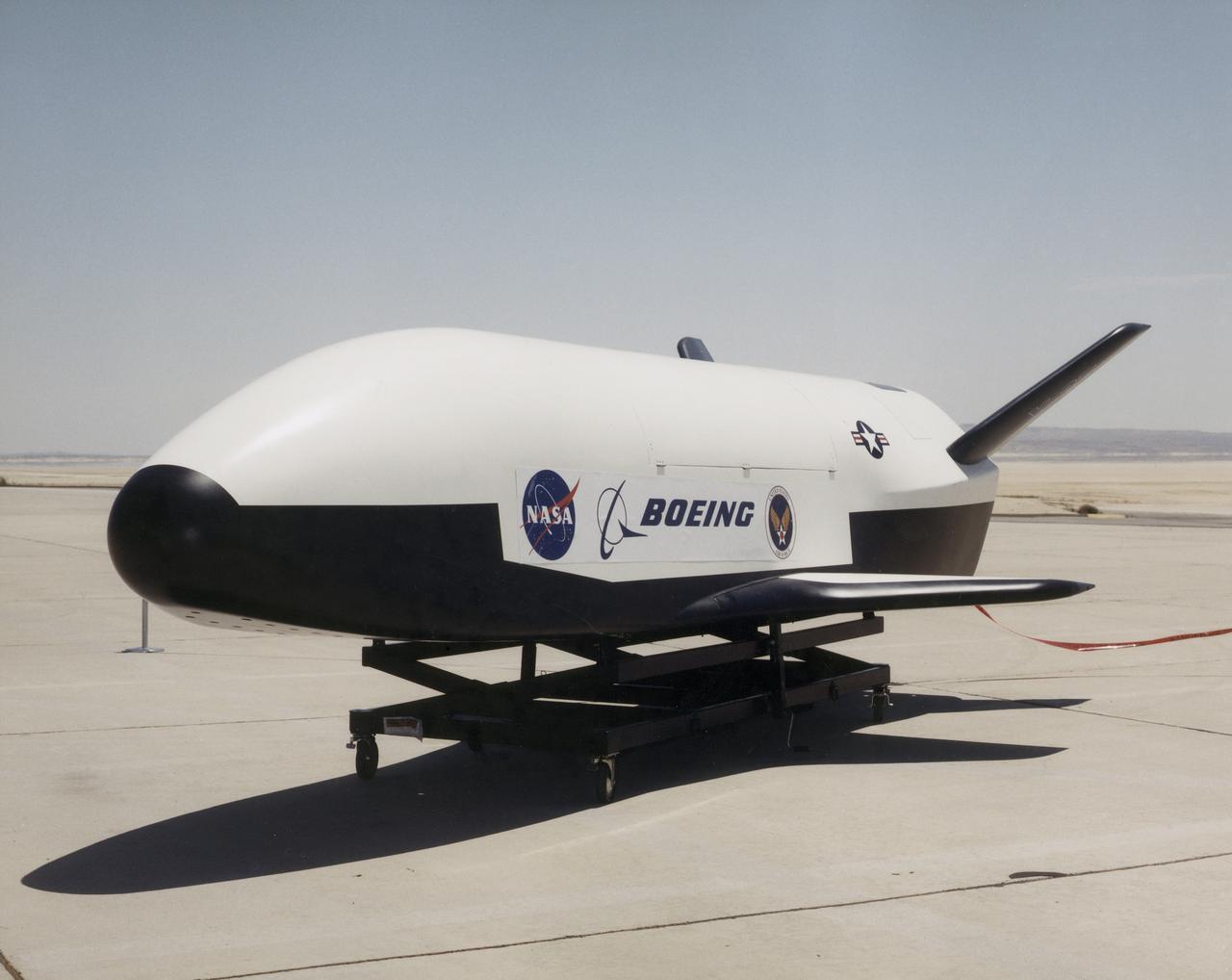
The photograph depicts the X-37 neutral buoyancy simulator mockup at Dryden Flight Research Center. The X-37 experimental launch vehicle is roughly 27.5 feet (8.3 meters) long and 15 feet (4.5 meters) in wingspan. Its experiment bay is 7 feet (2.1 meters) long and 4 feet (1.2 meters) in diameter. Designed to operate in both the orbital and reentry phases of flight, the X-37 will increase both safety and reliabiltiy, while reducing launch costs from $10,000 per pound to $1000 per pound. Managed by Marshall Space Flight Center and built by the boeing Company, the X-37 is scheduled to fly two orbital missions in 2002/2003 to test the reusable launch vehicle technologies.
NASA's X-37 Approach and Landing Test Vehicle is installed is a structural facility at Boeing's Huntington Beach, California plant. Tests, completed in July, were conducted to verify the structural integrity of the vehicle in preparation for atmospheric flight tests. Atmospheric flight tests of the Approach and Landing Test Vehicle are scheduled for 2004 and flight tests of the Orbital Vehicle are scheduled for 2006. The X-37 experimental launch vehicle is roughly 27.5 feet (8.3 meters) long and 15 feet (4.5 meters) in wingspan. It's experiment bay is 7 feet (2.1 meters) long and 4 feet (1.2 meters) in diameter. Designed to operate in both the orbital and reentry phases of flight, the X-37 will increase both safety and reliability, while reducing launch costs from $10,000 per pound to $1,000.00 per pound. The X-37 program is managed by the Marshall Space Flight Center and built by the Boeing Company.
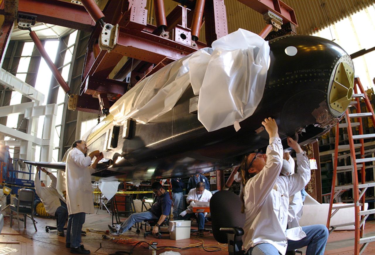
NASA's X-37 Approach and Landing Test Vehicle is installed is a structural facility at Boeing's Huntington Beach, California plant, where technicians make adjustments to composite panels. Tests, completed in July, were conducted to verify the structural integrity of the vehicle in preparation for atmospheric flight tests. Atmospheric flight tests of the Approach and Landing Test Vehicle are scheduled for 2004 and flight tests of the Orbital Vehicle are scheduled for 2006. The X-37 experimental launch vehicle is roughly 27.5 feet (8.3 meters) long and 15 feet (4.5 meters) in wingspan. It's experiment bay is 7 feet (2.1 meters) long and 4 feet (1.2 meters) in diameter. Designed to operate in both the orbital and reentry phases of flight, the X-37 will increase both safety and reliability, while reducing launch costs from $10,000 per pound to $1,000.00 per pound. The X-37 program is managed by the Marshall Space Flight Center and built by the Boeing Company.
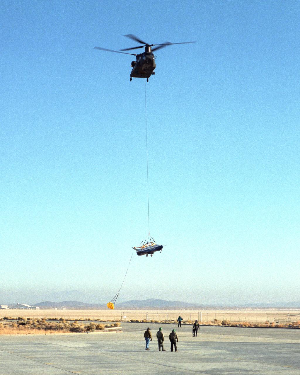
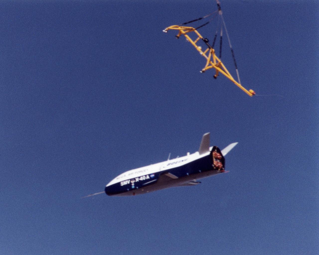
A U.S. Army CH-47 Chinook helicopter slowly lowers the X-40 sub-scale technology demonstrator to the ground under the watchful eyes of ground crew at the conclusion of a captive-carry test flight at NASA's Dryden Flight Research Center, Edwards, California. Several captive-carry flights were conducted to check out all operating systems and procedures before the X-40 made its first free flight at Edwards, gliding to a fully-autonomous approach and landing on the Edwards runway. The X-40 is an unpowered 82 percent scale version of the X-37, a Boeing-developed spaceplane designed to demonstrate various advanced technologies for development of future lower-cost access to space vehicles. Flight tests of the X-40 are designed to reduce the risks associated with research flights of the larger, more complex X-37.
Ground crewmen help guide the alignment of the X-40 technology demonstrator as the experimental craft is gently lowered to the ground by a U.S. Army CH-47 Chinook cargo helicopter following a captive-carry test flight at NASA's Dryden Flight Research Center, Edwards, California. The X-40 is an unpowered 82 percent scale version of the X-37, a Boeing-developed spaceplane designed to demonstrate various advanced technologies for development of future lower-cost access to space vehicles. The X-37 will be carried into space aboard a space shuttle and then released to perform various maneuvers and a controlled re-entry through the Earth's atmosphere to an airplane-style landing on a runway, controlled entirely by pre-programmed computer software. Following a series of captive-carry flights, the X-40 made several free flights from a launch altitude of about 15,000 feet above ground, gliding to a fully autonomous landing. The captive carry flights helped verify the X-40's navigation and control systems, rigging angles for its sling, and stability and control of the helicopter while carrying the X-40 on a tether.
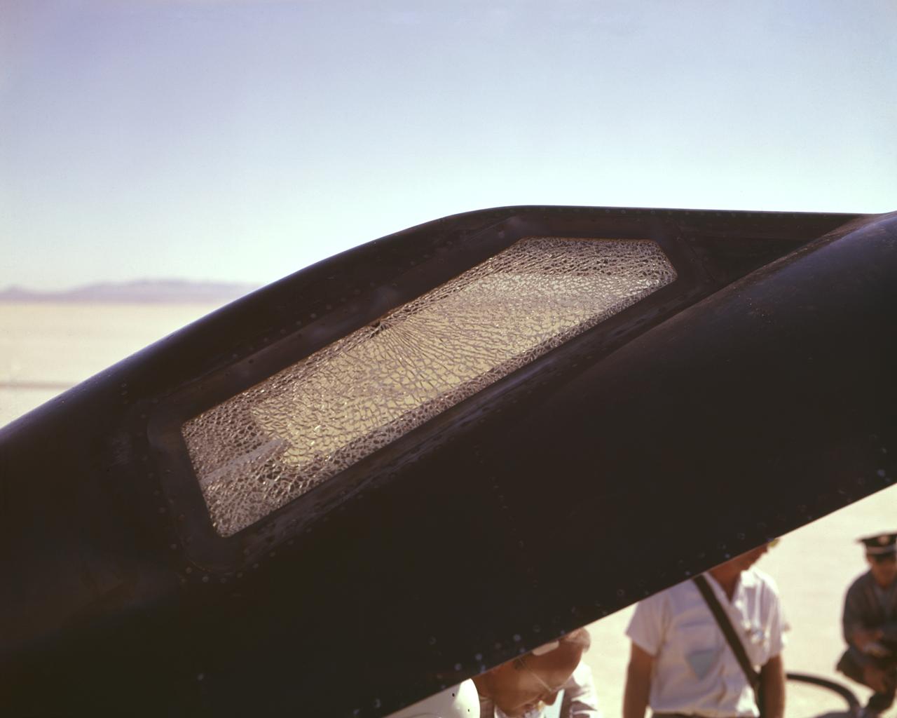
Cracked canopy glass on right side of X-15 #2 after flt. 2-21-37 on Nov. 9 1961. Robert White-pilot. First flight to mach 6.
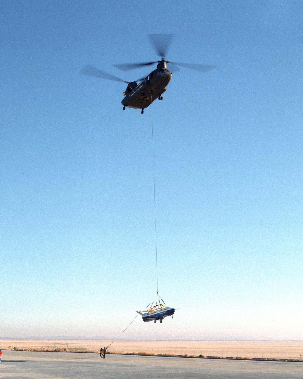
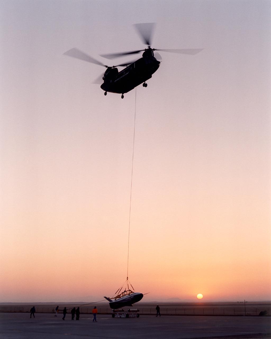
With a small stabilization parachute trailing behind, the X-40 sub-scale technology demonstrator is suspended under a U.S. Army CH-47 Chinook cargo helicopter during a captive-carry test flight at NASA's Dryden Flight Research Center, Edwards, California. The captive carry flights are designed to verify the X-40's navigation and control systems, rigging angles for its sling, and stability and control of the helicopter while carrying the X-40 on a tether. Following a series of captive-carry flights, the X-40 made free flights from a launch altitude of about 15,000 feet above ground, gliding to a fully autonomous landing. The X-40 is an unpowered 82 percent scale version of the X-37, a Boeing-developed spaceplane designed to demonstrate various advanced technologies for development of future lower-cost access to space vehicles.
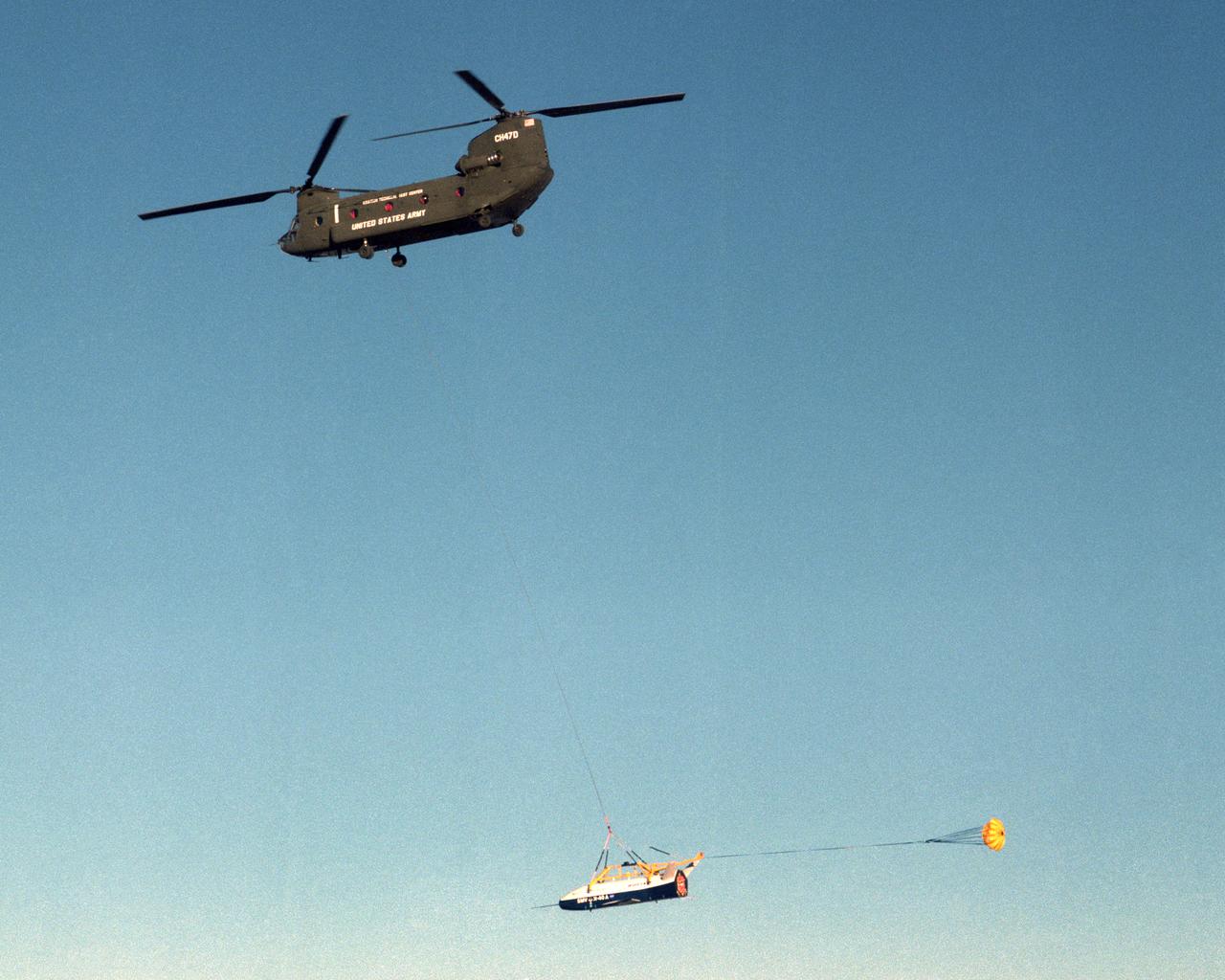
The X-40 sub-scale technology demonstrator is suspended under a U.S. Army CH-47 Chinook cargo helicopter during a captive-carry test flight at NASA's Dryden Flight Research Center, Edwards, California. The captive carry flights are designed to verify the X-40's navigation and control systems, rigging angles for its sling, and stability and control of the helicopter while carrying the X-40 on a tether. Following a series of captive-carry flights, the X-40 made free flights from a launch altitude of about 15,000 feet above ground, gliding to a fully autonomous landing. The X-40 is an unpowered 82 percent scale version of the X-37, a Boeing-developed spaceplane designed to demonstrate various advanced technologies for development of future lower-cost access to space vehicles.
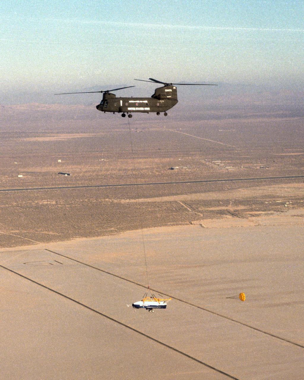
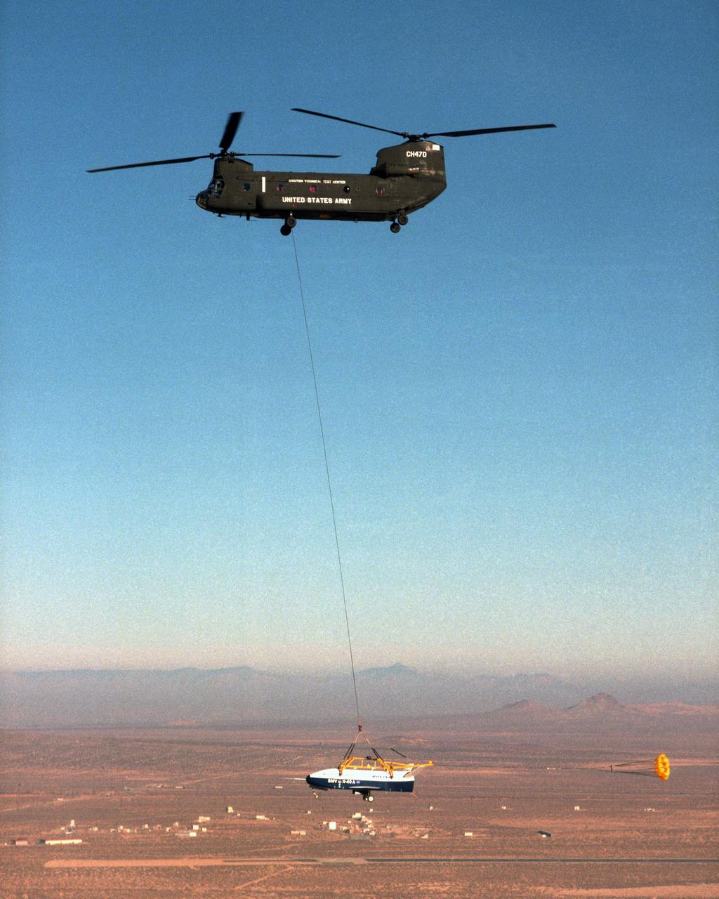
The X-40 sub-scale technology demonstrator and its U.S. Army CH-47 Chinook helicopter mothership fly over a dry lakebed runway during a captive-carry test flight from NASA's Dryden Flight Research Center, Edwards, California. The X-40 is attached to a sling which is suspended from the CH-47 by a 110-foot-long cable during the tests, while a small parachute trails behind to provide stability. The captive carry flights are designed to verify the X-40's navigation and control systems, rigging angles for its sling, and stability and control of the helicopter while carrying the X-40 on a tether. Following a series of captive-carry flights, the X-40 made free flights from a launch altitude of about 15,000 feet above ground, gliding to a fully autonomous landing. The X-40 is an unpowered 82 percent scale version of the X-37, a Boeing-developed spaceplane designed to demonstrate various advanced technologies for development of future lower-cost access to space vehicles.
The X-40A immediately after release from its harness suspended from a helicopter 15,000 feet above NASA's Dryden Flight Research Center at Edwards Air Force Base, California, on March 14, 2001. The unpiloted X-40 is a risk-reduction vehicle for the X-37, which is intended to be a reusable space vehicle. NASA's Marshall Space Flight Center in Huntsville, Ala, manages the X-37 project. At Dryden, the X-40A will undergo a series of ground and air tests to reduce possible risks to the larger X-37, including drop tests from a helicopter to check guidance and navigation systems planned for use in the X-37. The X-37 is designed to demonstrate technologies in the orbital and reentry environments for next-generation reusable launch vehicles that will increase both safety and reliability, while reducing launch costs from $10,000 per pound to $1,000 per pound.
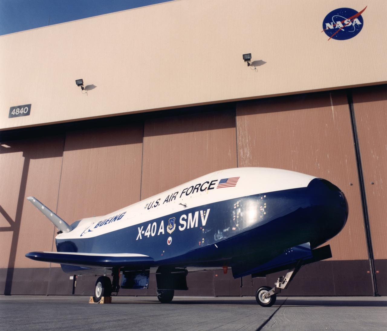
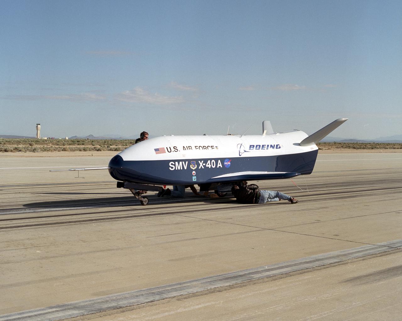
The X-40A SMV being delivered to NASA Dryden Flight Research Center at Edwards, California.
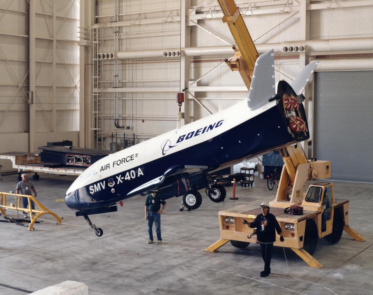
The X-40A SMV being delivered to NASA Dryden Flight Research Center at Edwards, California.
This image of the rock "Wedge" was taken from the Sojourner rover's rear color camera on Sol 37. The position of the rover relative to Wedge is seen in MRPS 83349. The segmented rod visible in the middle of the frame is the deployment arm for the Alpha Proton X-Ray Spectrometer (APXS). The APXS, the bright, cylindrical object at the end of the arm, is positioned against Wedge and is designed to measure the rock's chemical composition. This was done successfully on the night of Sol 37. http://photojournal.jpl.nasa.gov/catalog/PIA00906

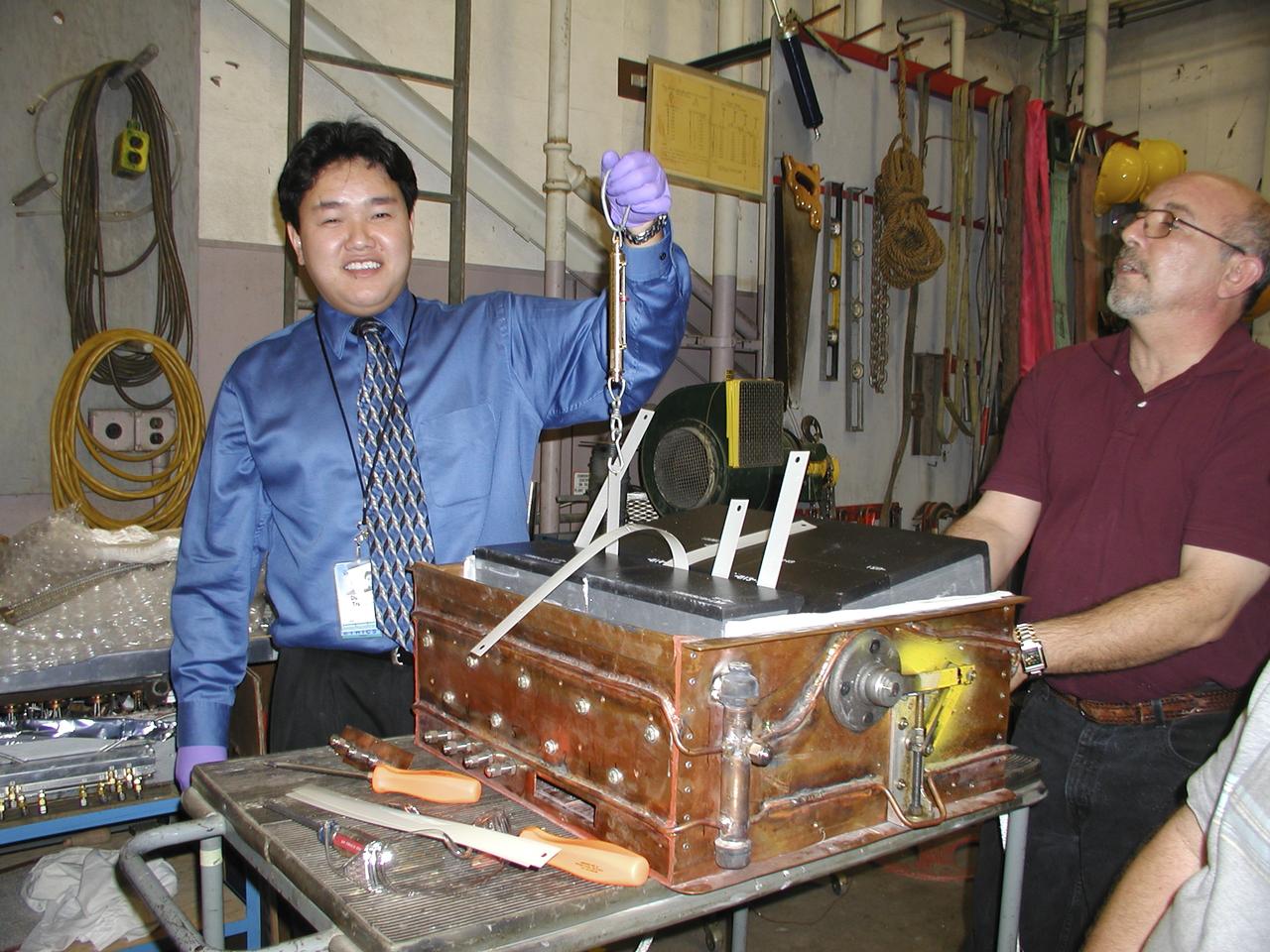
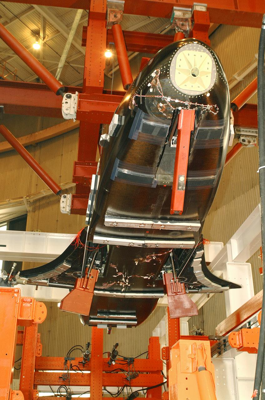
The X-37 advanced technology demonstrator flaperon unit was one of the first ever thermal and mechanical qualification tests of a carbon-carbon control surface designed for space flight. The test also featured extensive use of high-temperature fiber optic strain sensors. Peak temperatures reached 2,500 degrees Fahrenheit.
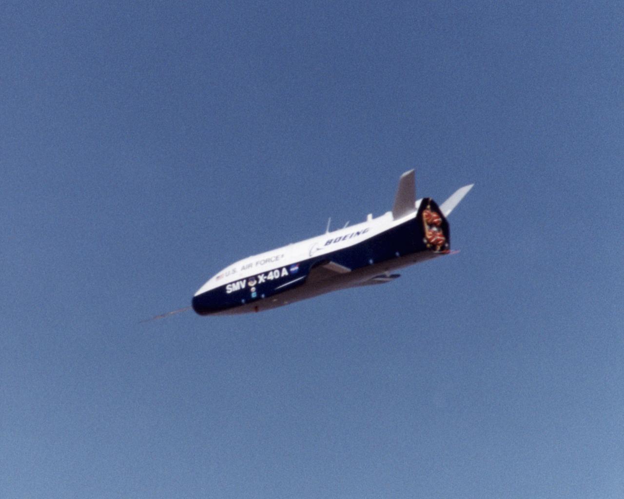
Second free-flight of the X-40A at the NASA Dryden Flight Research Center, on Edwards AFB, Calif., was made on Apr. 12, 2001. The unpowered X-40A, an 85 percent scale risk reduction version of the proposed X-37, is proving the capability of an autonomous flight control and landing system in a series of glide flights at Edwards. The April 12 flight introduced complex vehicle maneuvers during the landing sequence. The X-40A was released from an Army Chinook helicopter flying 15,050 feet overhead. Ultimately, the unpiloted X-37 is intended as an orbital testbed and technology demonstrator, capable of landing like an airplane and being quickly serviced for a follow-up mission.
X-40A departure with CH-47 - flight #7
A newly constructed pylon (green) for carrying aerospace vehicles aloft flies attached to the wing of NASA Dryden Flight Research Center's B-52H aircraft.
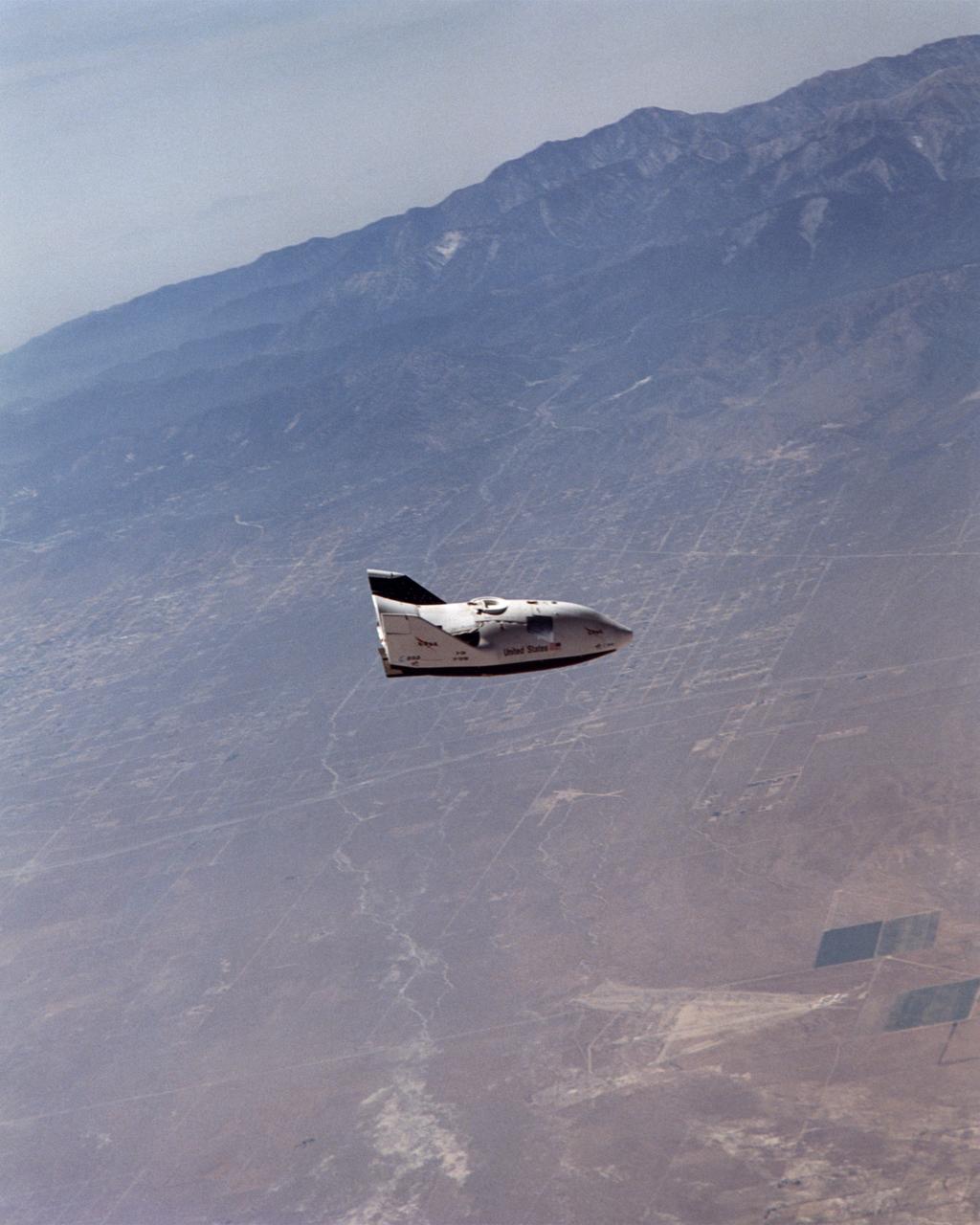
NASA's X-38 glided high over California desert test ranges as it descended from 37,500 feet to land on Rogers Dry Lake for the seventh free flight of the program July 10, 2001.

STS068-S-055 (7 October 1994) --- This is a false-color L-Band image of an area near Glasgow, Missouri, centered at about 39.2 degrees north latitude and 92.8 degrees west longitude. The image was acquired using the L-Band radar channel (horizontally transmitted and received and horizontally transmitted and vertically received) polarization's combined. The data were acquired by the Spaceborne Imaging Radar-C/X-Band Synthetic Aperture Radar (SIR-C/X-SAR) aboard the Space Shuttle Endeavour on orbit 50 on October 3, 1994. The area shown is approximately 37 by 25 kilometers (23 by 16 miles). The radar data, coupled with pre-flood aerial photography and satellite data and post-flood topographic and field data, are being used to evaluate changes associated with levee breaks in land forms, where deposits formed during the widespread flooding in 1993 along the Missouri and Mississippi Rivers. The distinct radar scattering properties of farmland, sand fields and scoured areas will be used to inventory flood plains along the Missouri River and determine the processes by which these areas return to preflood conditions. The image shows one such levee break near Glasgow, Missouri. In the upper center of the radar image, below the bend of the river, is a region covered by several meters of sand, shown as dark regions. West (left) of the dark areas, a gap in the levee tree canopy shows the area where the levee failed. Radar data such as these can help scientists more accurately assess the potential for future flooding in this region and how that might impact surrounding communities. Spaceborne Imaging Radar-C/X-Band Synthetic Aperture Radar (SIR-C/X-SAR) is part of NASA's Mission to Planet Earth. The radars illuminate Earth with microwaves, allowing detailed observations at any time, regardless of weather or sunlight conditions. SIR-C/X-SAR uses the three microwave wavelengths: the L-Band (24 centimeters), C-Band (6 centimeters) and X-Band (3 centimeters). The multi-frequency data will be used by the international scientific community to better understand the global environment and how it is changing. The SIR-C/X-SAR data, complemented by aircraft and ground studies, will give scientists clearer insights into those environmental changes which are caused by nature and those changes which are induced by human activity. SIR-C was developed by NASA's Jet Propulsion Laboratory (JPL). X-SAR was developed by the Dornier and Alenia Spazio companies for the German space agency, Deutsche Agentur fuer Raumfahrtangelegenheiten (DARA), and the Italian space agency, Agenzia Spaziale Italiana (ASI), with the Deutsche Forschungsanstalt fuer Luft und Raumfahrt e.v. (DLR), the major partner in science, operations and data processing of X-SAR. (P-44734)
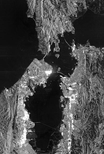
This is a radar image of San Francisco, California, taken on October 3,1994. The image is about 40 kilometers by 55 kilometers (25 miles by 34 miles) with north toward the upper right. Downtown San Francisco is visible in the center of the image with the city of Oakland east (to the right) across San Francisco Bay. Also visible in the image is the Golden Gate Bridge (left center) and the Bay Bridge connecting San Francisco and Oakland. North of the Bay Bridge is Treasure Island. Alcatraz Island appears as a small dot northwest of Treasure Island. This image was acquired by the Spaceborne Imaging Radar-C and X-band Synthetic Aperture Radar (SIR-C/X-SAR) aboard the space shuttle Endeavour on orbit 56. The image is centered at 37 degrees north latitude, 122degrees west longitude. This single-frequency SIR-C image was obtained by the L-band (24 cm) radar channel, horizontally transmitted and received. Portions of the Pacific Ocean visible in this image appear very dark as do other smooth surfaces such as airport runways. Suburban areas, with the low-density housing and tree-lined streets that are typical of San Francisco, appear as lighter gray. Areas with high-rise buildings, such as those seen in the downtown areas, appear in very bright white, showing a higher density of housing and streets which run parallel to the radar flight track. http://photojournal.jpl.nasa.gov/catalog/PIA01751

SL4-142-4577 (28 Jan. 1974) --- Two large ice islands in the vicinity of South Georgia Island in the South Atlantic Ocean, as photographed from the Skylab space station in Earth orbit by one of the Skylab 4 crewmen. The camera used was a hand-held 70mm Hasselblad, with SO-368 medium-speed Ektachrome. One of the ice islands is partially obscured by clouds. Ice islands were observed as large as 45 by 60 kilometers (27 x 37 miles) and as far north as 45 degrees south latitude. The size and distribution of the "small" icebergs (to a ship they would look very large) can be used to study the local winds and currents. Recent research has suggested the possibility of towing such Antarctic icebergs to selected areas and using them as water supplies. One such iceberg would contain many times the water as in Lake Powell. Photo credit: NASA
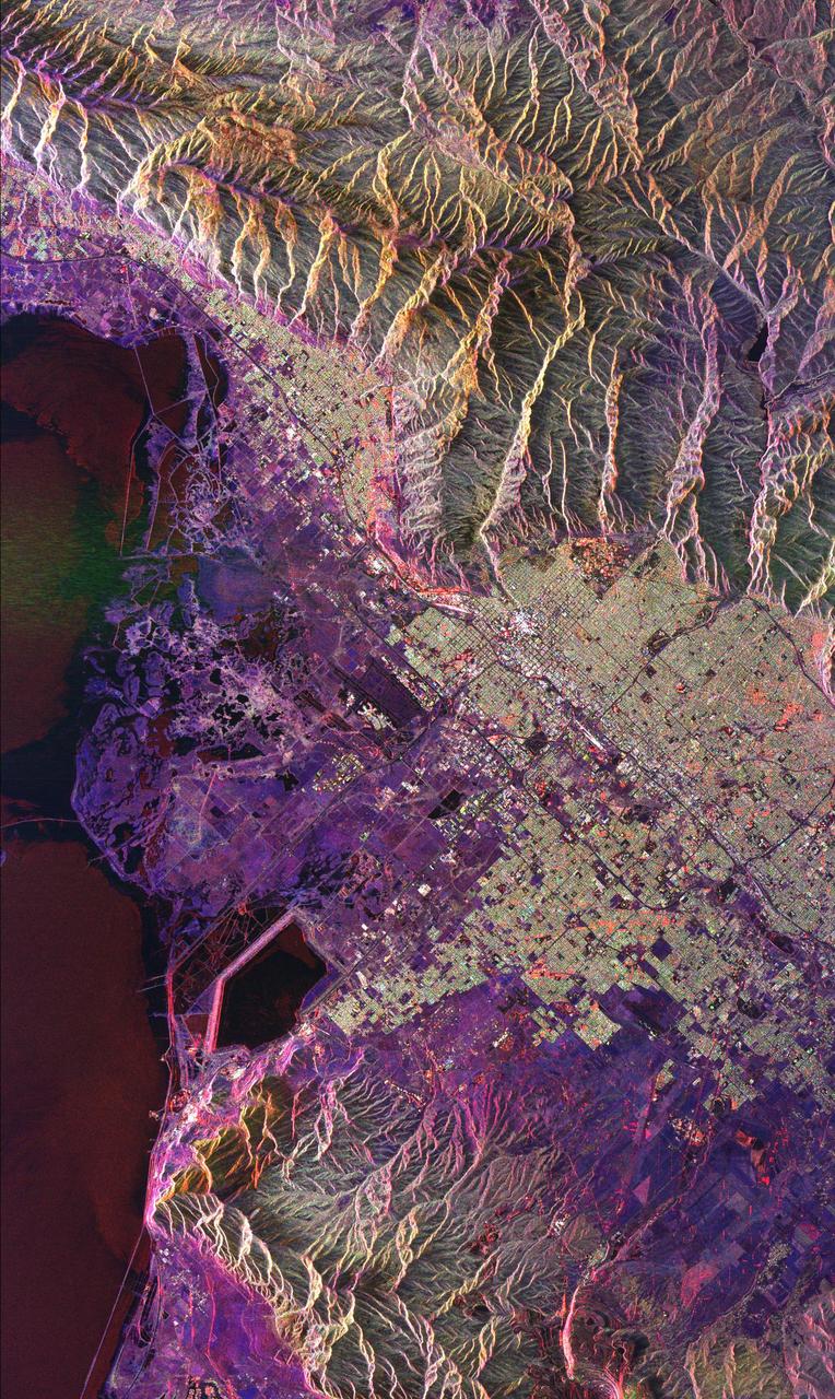
This radar image of Salt Lake City, Utah, illustrates the different land use patterns that are present in the Utah Valley. Salt Lake City lies between the shores of the Great Salt Lake (the dark area on the left side of the image) and the Wasatch Front Range (the mountains in the upper half of the image). The Salt Lake City area is of great interest to urban planners because of the combination of lake, valley and alpine environments that coexist in the region. Much of the southern shore of the Great Salt Lake is a waterfowl management area. The green grid pattern in the right center of the image is Salt Lake City and its surrounding communities. The Salt Lake City airport is visible as the brown rectangle near the center of the image. Interstate Highway 15 runs from the middle right edge to the upper left of the image. The bright white patch east of Interstate 15 is the downtown area, including Temple Square and the state capitol. The University of Utah campus is the yellowish area that lies at the base of the mountains, east of Temple Square. The large reservoir in the lower left center is a mine tailings pond. The semi-circular feature in the mountains at the bottom edge of the image is the Kennecott Copper Mine. The area shown is 60 kilometers by 40 kilometers (37 miles by 25 miles) and is centered at 40.6 degrees north latitude, 112.0 degrees west longitude. North is toward the upper left. This image was acquired by the Spaceborne Imaging Radar-C/X-Band Synthetic Aperture Radar (SIR-C/X-SAR) aboard the space shuttle Endeavour on April 10, 1994. The colors in this image represent the following radar channels and polarizations: red is L-band, horizontally transmitted and received; green is L-band, horizontally transmitted and vertically received; and blue is C-band, horizontally transmitted and vertically received. SIR-C/X-SAR, a joint mission of the German, Italian and United States space agencies, is part of NASA's Mission to Planet Earth program. http://photojournal.jpl.nasa.gov/catalog/PIA01798
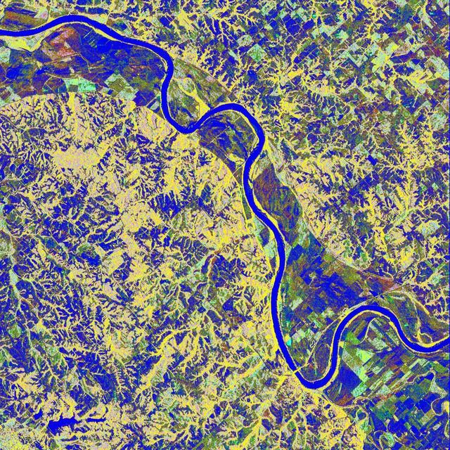
This is a false-color L-band image of an area near Glasgow, Missouri, centered at about 39.2 degrees north latitude and 92.8 degrees west longitude. The image was acquired by the Spaceborne Imaging Radar-C and X-band Synthetic Aperture Radar (SIR-C/X-SAR) aboard the space shuttle Endeavour on its 50th orbit on October 3, 1994. The false-color composite was made by displaying the L-band (horizontally transmitted and received) return in red; the L-band (horizontally transmitted and vertically received) return in green; and the sum of the two channels in blue. The area shown is approximately 37 kilometers by 25 kilometers (23 miles by 16 miles). The radar data, coupled with pre-flood aerial photography and satellite data and post-flood topographic and field data, are being used to evaluate changes associated with levee breaks in landforms, where deposits formed during the widespread flooding in 1993 along the Missouri and Mississippi Rivers. The distinct radar scattering properties of farmland, sand fields and scoured areas will be used to inventory floodplains along the Missouri River and determine the processes by which these areas return to preflood conditions. The image shows one such levee break near Glasgow, Missouri. In the upper center of the radar image is a region covered by several meters of sand, shown as blue regions below the bend in the river. West (left) of this dark area, a blue gap in the levee tree canopy can be seen, showing the area where the levee failed. Radar data such as these can help scientists more accurately assess the potential for future flooding in this region and how that might impact surrounding communities. http://photojournal.jpl.nasa.gov/catalog/PIA01744
STS068-S-052 (3 October 1994) --- This is a radar image of Mount Rainier in Washington state. The volcano last erupted about 150 years ago and numerous large floods and debris flows have originated on its slopes during the last century. Today the volcano is heavily mantled with glaciers and snow fields. More than 100,000 people live on young volcanic mud flows less than 10,000 years old and, are within the range of future, devastating mud slides. This image was acquired by the Spaceborne Imaging Radar-C/X-Band Synthetic Aperture Radar (SIR-C/X-SAR) aboard the Space Shuttle Endeavour on its 20th orbit on October 1, 1994. The area shown in the image is approximately 59 by 60 kilometers (36.5 by 37 miles). North is toward the top left of the image, which was composed by assigning red and green colors to the L-Band, horizontally transmitted and vertically, and the L-Band, horizontally transmitted and vertically received. Blue indicates the C-Band, horizontally transmitted and vertically received. In addition to highlighting topographic slopes facing the Space Shuttle, SIR-C records rugged areas as brighter and smooth areas as darker. The scene was illuminated by the Shuttle's radar from the northwest so that northwest-facing slopes are brighter and southeast-facing slopes are dark. Forested regions are pale green in color, clear cuts and bare ground are bluish or purple; ice is dark green and white. The round cone at the center of the image is the 14,435 feet (4,399 meters) active volcano, Mount Rainier. On the lower slopes is a zone of rock ridges and rubble (purple to reddish) above coniferous forests (in yellow/green). The western boundary of Mount Rainier National Park is seen as a transition from protected, old-growth forest to heavily logged private land, a mosaic of recent clear cuts (bright purple/blue) and partially re-grown timber plantations (pale blue). The prominent river seen curving away from the mountain at the top of the image (to the northwest) is the White River, and the river leaving the mountain at the bottom right of the image (south) is the Nisqually River, which flows out of the Nisqually glacier on the mountain. The river leaving to the left of the mountain is the Carbon River, leading west and north toward heavily populated regions near Tacoma. The dark patch at the top right of the image is Bumping Lake. Other dark areas seen to the right of ridges throughout the image are radar shadow zones. Radar images can be used to study the volcanic structure and the surrounding regions with linear rock boundaries and faults. In addition, the recovery of forested lands from natural disasters and the success of re-forestation programs can also be monitored. Ultimately this data may be used to study the advance and retreat of glaciers and other forces of global change. Spaceborne Imaging Radar-C/X-Band Synthetic Aperture Radar (SIR-C/X-SAR) is part of NASA's Mission to Planet Earth. (P-44703)
This is a radar image of Mount Rainier in Washington state. The volcano last erupted about 150 years ago and numerous large floods and debris flows have originated on its slopes during the last century. Today the volcano is heavily mantled with glaciers and snowfields. More than 100,000 people live on young volcanic mudflows less than 10,000 years old and, consequently, are within the range of future, devastating mudslides. This image was acquired by the Spaceborne Imaging Radar-C and X-band Synthetic Aperture Radar (SIR-C/X-SAR) aboard the space shuttle Endeavour on its 20th orbit on October 1, 1994. The area shown in the image is approximately 59 kilometers by 60 kilometers (36.5 miles by 37 miles). North is toward the top left of the image, which was composed by assigning red and green colors to the L-band, horizontally transmitted and vertically, and the L-band, horizontally transmitted and vertically received. Blue indicates the C-band, horizontally transmitted and vertically received. In addition to highlighting topographic slopes facing the space shuttle, SIR-C records rugged areas as brighter and smooth areas as darker. The scene was illuminated by the shuttle's radar from the northwest so that northwest-facing slopes are brighter and southeast-facing slopes are dark. Forested regions are pale green in color; clear cuts and bare ground are bluish or purple; ice is dark green and white. The round cone at the center of the image is the 14,435-foot (4,399-meter) active volcano, Mount Rainier. On the lower slopes is a zone of rock ridges and rubble (purple to reddish) above coniferous forests (in yellow/green). The western boundary of Mount Rainier National Park is seen as a transition from protected, old-growth forest to heavily logged private land, a mosaic of recent clear cuts (bright purple/blue) and partially regrown timber plantations (pale blue). The prominent river seen curving away from the mountain at the top of the image (to the northwest) is the White River, and the river leaving the mountain at the bottom right of the image (south) is the Nisqually River, which flows out of the Nisqually glacier on the mountain. The river leaving to the left of the mountain is the Carbon River, leading west and north toward heavily populated regions near Tacoma. The dark patch at the top right of the image is Bumping Lake. Other dark areas seen to the right of ridges throughout the image are radar shadow zones. Radar images can be used to study the volcanic structure and the surrounding regions with linear rock boundaries and faults. In addition, the recovery of forested lands from natural disasters and the success of reforestation programs can also be monitored. Ultimately this data may be used to study the advance and retreat of glaciers and other forces of global change. http://photojournal.jpl.nasa.gov/catalog/PIA01727
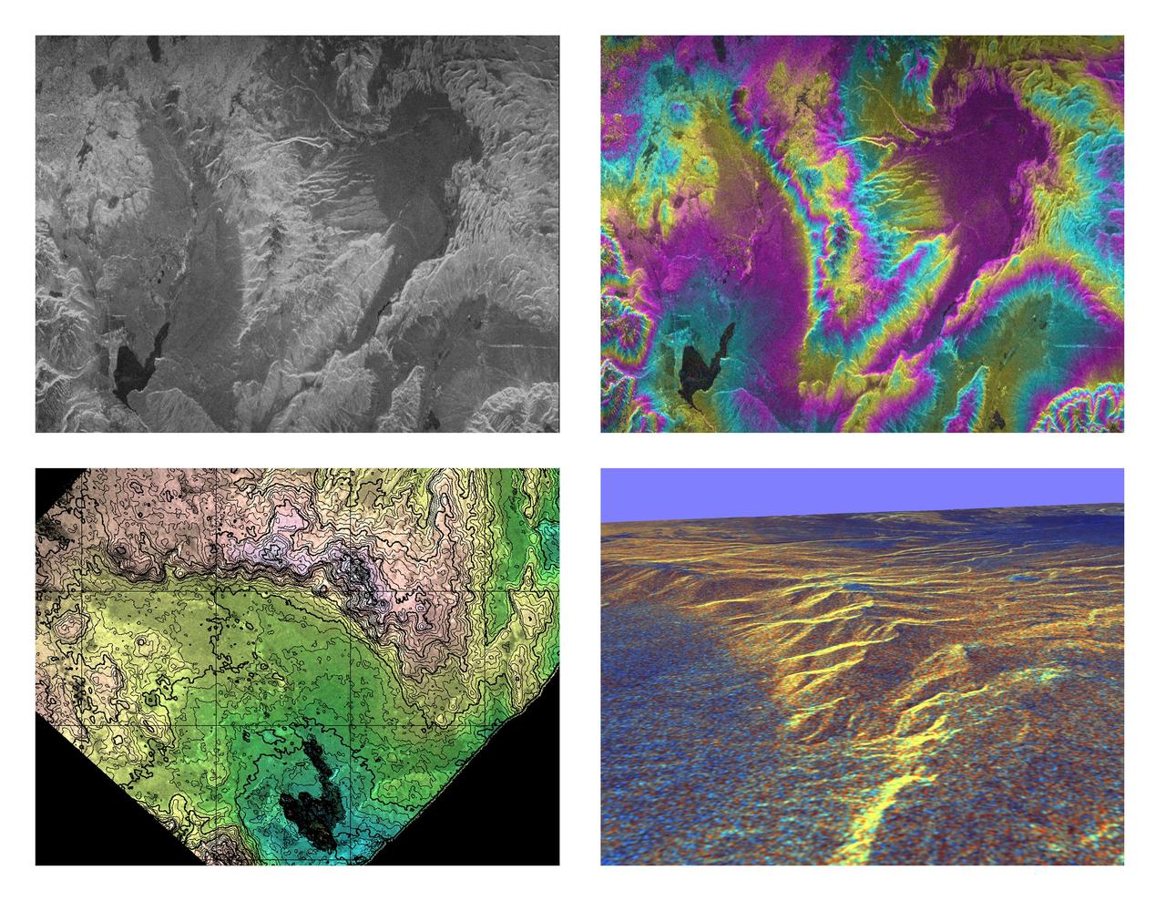
These four images of the Long Valley region of east-central California illustrate the steps required to produced three dimensional data and topographics maps from radar interferometry. All data displayed in these images were acquired by the Spaceborne Imaging Radar-C/X-band Synthetic Aperture Radar (SIR-C/X-SAR) aboard the space shuttle Endeavour during its two flights in April and October, 1994. The image in the upper left shows L-band (horizontally transmitted and received) SIR-C radar image data for an area 34 by 59 kilometers (21 by 37 miles). North is toward the upper right; the radar illumination is from the top of the image. The bright areas are hilly regions that contain exposed bedrock and pine forest. The darker gray areas are the relatively smooth, sparsely vegetated valley floors. The dark irregular patch near the lower left is Lake Crowley. The curving ridge that runs across the center of the image from top to bottom is the northeast rim of the Long Valley Caldera, a remnant crater from a massive volcanic eruption that occurred about 750,000 years ago. The image in the upper right is an interferogram of the same area, made by combining SIR-C L-band data from the April and October flights. The colors in this image represent the difference in the phase of the radar echoes obtained on the two flights. Variations in the phase difference are caused by elevation differences. Formation of continuous bands of phase differences, known as interferometric "fringes," is only possible if the two observations were acquired from nearly the same position in space. For these April and October data takes, the shuttle tracks were less than 100 meters (328 feet) apart. The image in the lower left shows a topographic map derived from the interferometric data. The colors represent increments of elevation, as do the thin black contour lines, which are spaced at 50-meter (164-foot) elevation intervals. Heavy contour lines show 250-meter intervals (820-foot). Total relief in this area is about 1,320 meters (4,330 feet). Brightness variations come from the radar image, which has been geometrically corrected to remove radar distortions and rotated to have north toward the top. The image in the lower right is a three-dimensional perspective view of the northeast rim of the Long Valley caldera, looking toward the northwest. SIR-C C-band radar image data are draped over topographic data derived from the interferometry processing. No vertical exaggeration has been applied. Combining topographic and radar image data allows scientists to examine relationships between geologic structures and landforms, and other properties of the land cover, such as soil type, vegetation distribution and hydrologic characteristics. http://photojournal.jpl.nasa.gov/catalog/PIA01770
The HL-10 was one of five heavyweight lifting-body designs flown at NASA's Flight Research Center (FRC--later Dryden Flight Research Center), Edwards, California, from July 1966 to November 1975 to study and validate the concept of safely maneuvering and landing a low lift-over-drag vehicle designed for reentry from space. Northrop Corporation built the HL-10 and M2-F2, the first two of the fleet of "heavy" lifting bodies flown by the NASA Flight Research Center. The contract for construction of the HL-10 and the M2-F2 was $1.8 million. "HL" stands for horizontal landing, and "10" refers to the tenth design studied by engineers at NASA's Langley Research Center, Hampton, Va. After delivery to NASA in January 1966, the HL-10 made its first flight on Dec. 22, 1966, with research pilot Bruce Peterson in the cockpit. Although an XLR-11 rocket engine was installed in the vehicle, the first 11 drop flights from the B-52 launch aircraft were powerless glide flights to assess handling qualities, stability, and control. In the end, the HL-10 was judged to be the best handling of the three original heavy-weight lifting bodies (M2-F2/F3, HL-10, X-24A). The HL-10 was flown 37 times during the lifting body research program and logged the highest altitude and fastest speed in the Lifting Body program. On Feb. 18, 1970, Air Force test pilot Peter Hoag piloted the HL-10 to Mach 1.86 (1,228 mph). Nine days later, NASA pilot Bill Dana flew the vehicle to 90,030 feet, which became the highest altitude reached in the program. Some new and different lessons were learned through the successful flight testing of the HL-10. These lessons, when combined with information from it's sister ship, the M2-F2/F3, provided an excellent starting point for designers of future entry vehicles, including the Space Shuttle.

This photograph shows the Compton Gamma-Ray Observatory (GRO) being deployed by the Remote Manipulator System (RMS) arm aboard the Space Shuttle Atlantis during the STS-37 mission in April 1991. The GRO reentered Earth atmosphere and ended its successful mission in June 2000. For nearly 9 years, the GRO Burst and Transient Source Experiment (BATSE), designed and built by the Marshall Space Flight Center (MSFC), kept an unblinking watch on the universe to alert scientists to the invisible, mysterious gamma-ray bursts that had puzzled them for decades. By studying gamma-rays from objects like black holes, pulsars, quasars, neutron stars, and other exotic objects, scientists could discover clues to the birth, evolution, and death of stars, galaxies, and the universe. The gamma-ray instrument was one of four major science instruments aboard the Compton. It consisted of eight detectors, or modules, located at each corner of the rectangular satellite to simultaneously scan the entire universe for bursts of gamma-rays ranging in duration from fractions of a second to minutes. In January 1999, the instrument, via the Internet, cued a computer-controlled telescope at Las Alamos National Laboratory in Los Alamos, New Mexico, within 20 seconds of registering a burst. With this capability, the gamma-ray experiment came to serve as a gamma-ray burst alert for the Hubble Space Telescope, the Chandra X-Ray Observatory, and major gound-based observatories around the world. Thirty-seven universities, observatories, and NASA centers in 19 states, and 11 more institutions in Europe and Russia, participated in the BATSE science program.
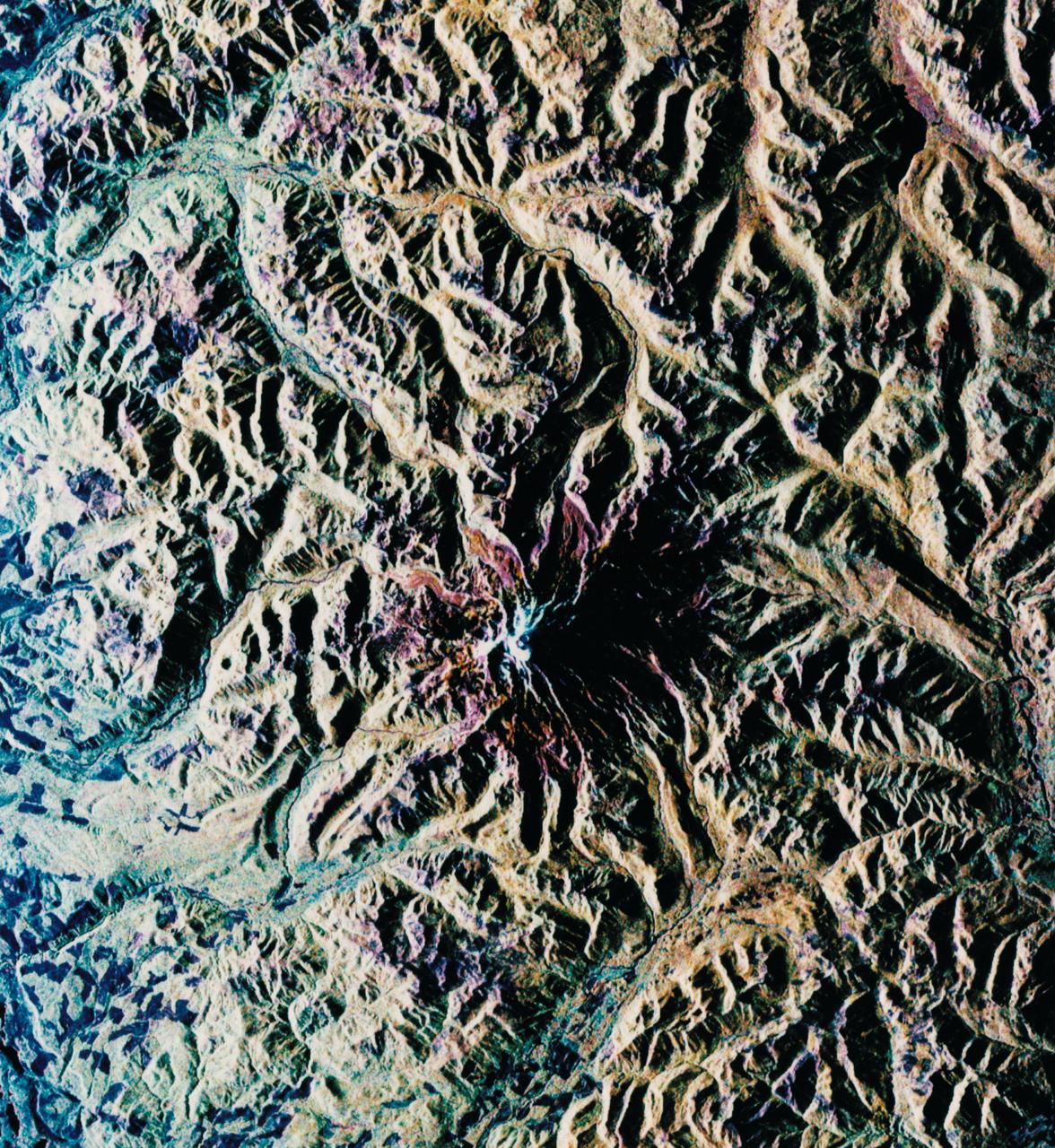
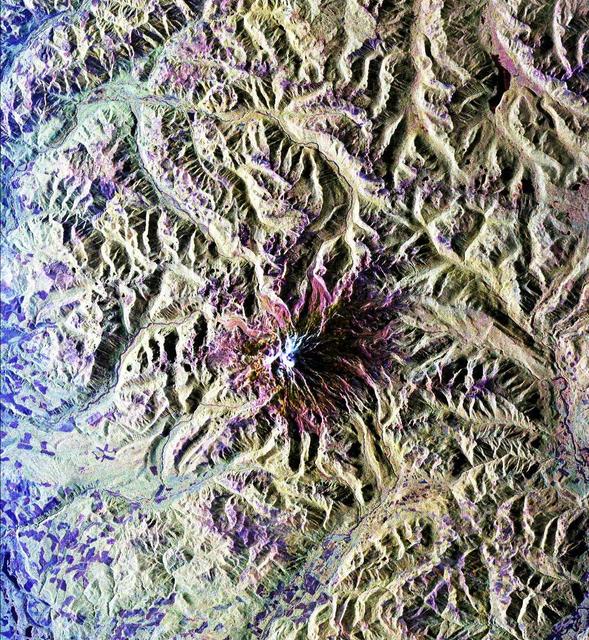
This is an image of the Kliuchevskoi volcano, Kamchatka, Russia, which began to erupt on September 30, 1994. Kliuchevskoi is the bright white peak surrounded by red slopes in the lower left portion of the image. The image was acquired by the Spaceborne Imaging Radar-C and X-band Synthetic Aperture Radar aboard the space shuttle Endeavour on its 25th orbit on October 1, 1994. The image shows an area approximately 30 kilometers by 60 kilometers (18.5 miles by 37 miles) that is centered at 56.18 degrees north latitude and 160.78 degrees east longitude. North is toward the top of the image. The Kamchatka volcanoes are among the most active volcanoes in the world. The volcanic zone sits above a tectonic plate boundary, where the Pacific plate is sinking beneath the northeast edge of the Eurasian plate. The Endeavour crew obtained dramatic video and photographic images of this region during the eruption, which will assist scientists in analyzing the dynamics of the current activity. The colors in this image were obtained using the following radar channels: red represents the L-band (horizontally transmitted and received); green represents the L-band (horizontally transmitted and vertically received); blue represents the C-band (horizontally transmitted and vertically received). The Kamchatka River runs from left to right across the image. An older, dormant volcanic region appears in green on the north side of the river. The current eruption included massive ejections of gas, vapor and ash, which reached altitudes of 20,000 meters (65,000 feet). New lava flows are visible on the flanks of Kliuchevskoi, appearing yellow/green in the image, superimposed on the red surfaces in the lower center. Melting snow triggered mudflows on the north flank of the volcano, which may threaten agricultural zones and other settlements in the valley to the north. http://photojournal.jpl.nasa.gov/catalog/PIA01731
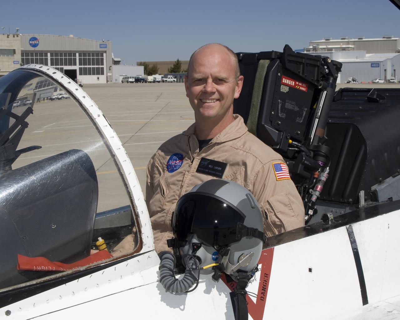
Nils Larson is a research pilot in the Flight Crew Branch of NASA's Dryden Flight Research Center, Edwards, Calif. Larson joined NASA in February 2007 and will fly the F-15, F-18, T-38 and ER-2. Prior to joining NASA, Larson was on active duty with the U.S. Air Force. He has accumulated more that 4,900 hours of military and civilian flight experience in more than 70 fixed and rotary winged aircraft. Larson completed undergraduate pilot training at Williams Air Force Base, Chandler, Ariz., in 1987. He remained at Williams as a T-37 instructor pilot. In 1991, Larson was assigned to Beale Air Force Base, Calif., as a U-2 pilot. He flew 88 operational missions from Korea, Saudi Arabia, the United Kingdom, Panama and other locations. Larson graduated from the U.S. Air Force Test Pilot School at Edwards Air Force Base, Calif., in Class 95A. He became a flight commander and assistant operations officer for the 445th squadron at Edwards. He flew the radar, avionics integration and engine tests in F-15 A-D, the early flights of the glass cockpit T-38C and airworthiness flights of the Coast Guard RU-38. He was selected to serve as an Air Force exchange instructor at the U.S. Naval Test Pilot School, Patuxent River, Md. He taught systems and fixed-wing flight test and flew as an instructor pilot in the F-18, T-2, U-6A Beaver and X-26 Schweizer sailplane. Larson commanded U-2 operations for Warner Robins Air Logistics Center's Detachment 2 located in Palmdale, Calif. In addition to flying the U-2, Larson supervised the aircraft's depot maintenance and flight test. He was the deputy group commander for the 412th Operations Group at Edwards before retiring from active duty in 2007 with the rank of lieutenant colonel. His first experience with NASA was at the Glenn Research Center, Cleveland, where he served a college summer internship working on arcjet engines. Larson is a native of Bethany, W.Va,, and received his commission from the U.S. Air Force Academy in 1986 with a
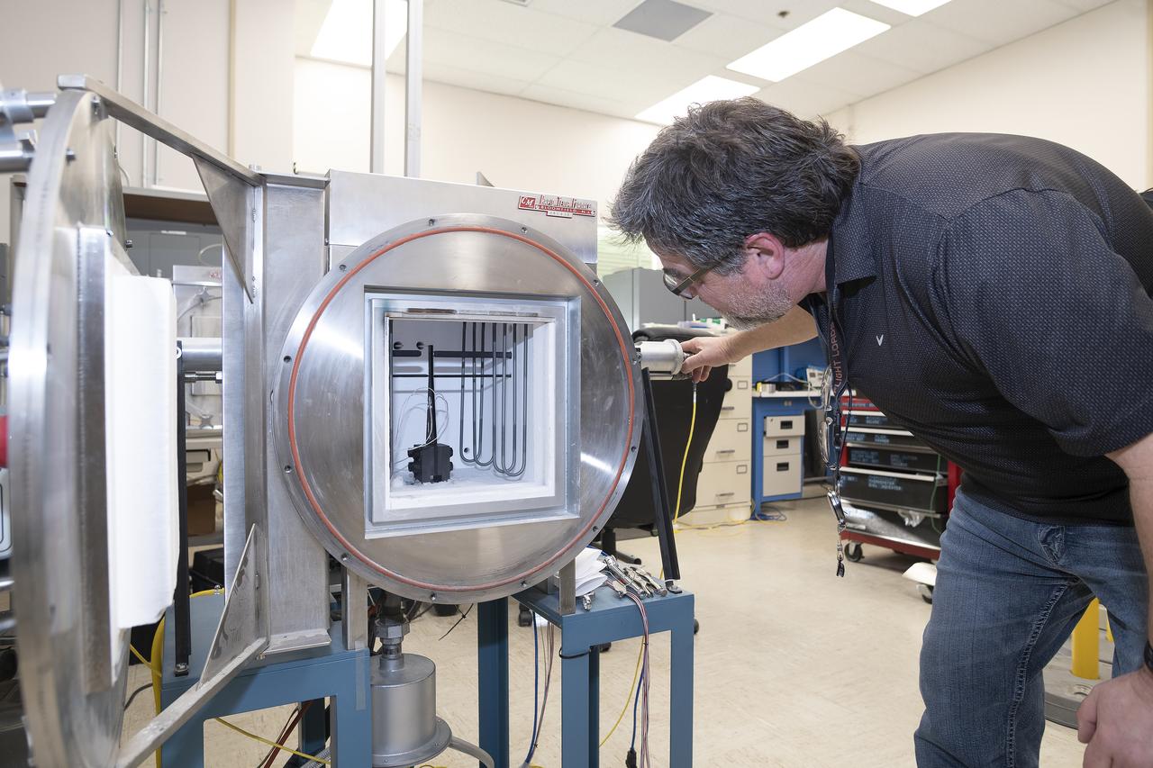
Anthony piazza, a researcher at NASA’s Armstrong Flight Research center in Edwards, California, works with high-temperature strain sensors. This test article is a bending load bar, which enables high-temperature optical strain sensor research up to 1,800 degrees Fahrenheit.
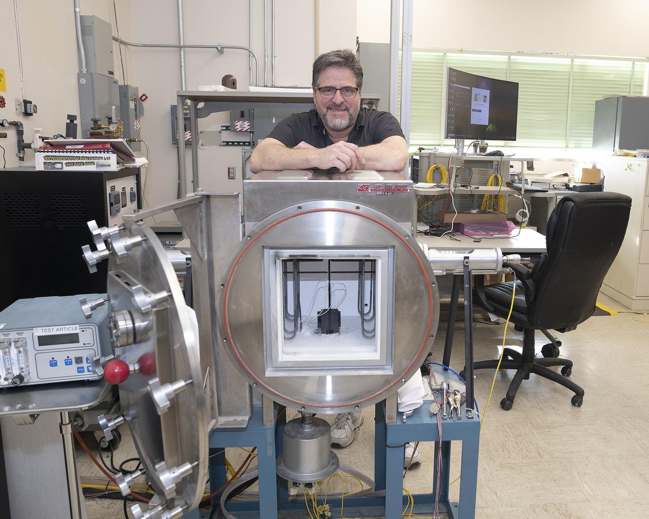
Anthony piazza, a researcher at NASA’s Armstrong Flight Research center in Edwards, California, works with high-temperature strain sensors. This test article is a bending load bar, which enables high-temperature optical strain sensor research up to 1,800 degrees Fahrenheit.