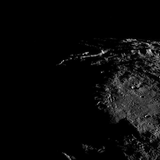
Sunlit cliffs tower above Yalode Crater on Ceres in this shadowy perspective view. At 152 miles (260 kilometers) in diameter, Yalode is one of Ceres' largest craters. A fissure called Nar Sulcus is seen just right of center. Dawn took this image on Oct. 19, 2016, from its second extended-mission science orbit (XMO2), at a distance of about 920 miles (1,480 kilometers) above the surface. The image resolution is about 460 feet (140 meters) per pixel. http://photojournal.jpl.nasa.gov/catalog/PIA21236
This view from NASA's Dawn spacecraft shows the rim of Yalode Crater on Ceres at upper left. Yalode is one of the largest impact basins on Ceres, with a diameter of 160 miles (260 kilometers). For a view of Yalode from higher altitude, along with other prominent Ceres features, see PIA20019. Dawn took this image on Oct. 22, 2016, from its second extended-mission science orbit (XMO2), at a distance of about 920 miles (1,480 kilometers) above the surface. The image resolution is about 460 feet (140 meters) per pixel. http://photojournal.jpl.nasa.gov/catalog/PIA21247
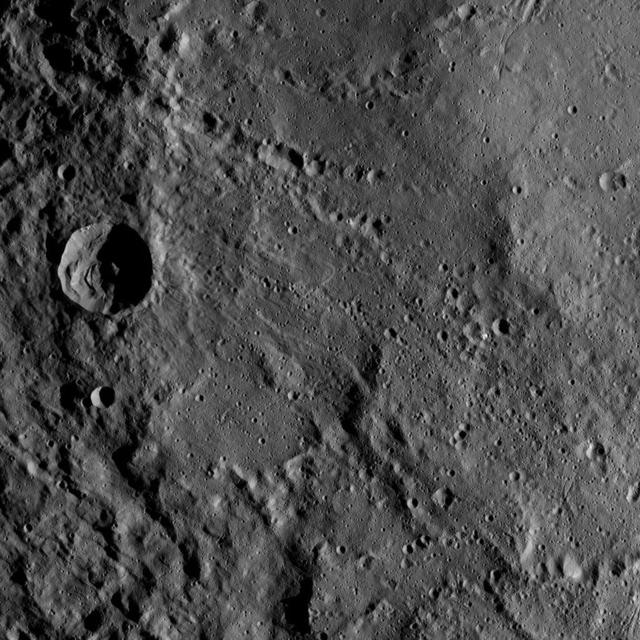
This view from NASA's Dawn spacecraft shows an area in the interior of Yalode Crater on Ceres. Yalode is one of the largest impact basins on Ceres, with a diameter of 160 miles (260 kilometers). Dawn took this image on June 3, 2016, from its low-altitude mapping orbit, at a distance of about 240 miles (385 kilometers) above the surface. The image resolution is 120 feet (35 meters) per pixel. http://photojournal.jpl.nasa.gov/catalog/PIA20945
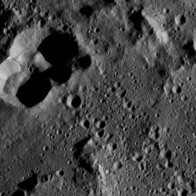
This image from NASA's Dawn spacecraft shows part of Lono Crater (at bottom) within the giant Yalode impact basin on Ceres. Lono is 12 miles (20 kilometers) wide, and Yalode is 160 miles (260 kilometers) in diameter. A video featuring Yalode can be seen in PIA20019. The image is centered at 34 degrees south latitude, 303 degrees east longitude. Dawn took this image on June 7, 2016, from its low-altitude mapping orbit, at a distance of about 240 miles (385 kilometers) above the surface. The image resolution is 120 feet (35 meters) per pixel. http://photojournal.jpl.nasa.gov/catalog/PIA20957
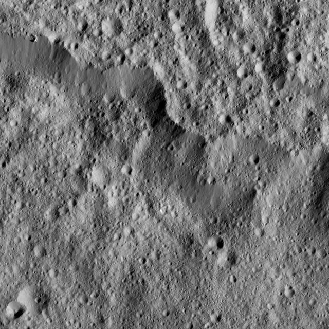
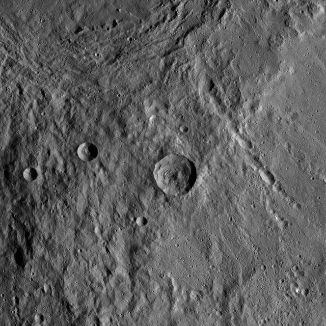
This view from NASA's Dawn spacecraft shows part of the southwestern rim of Yalode Crater on Ceres. Yalode is one of the largest impact basins on Ceres, with a diameter of 160 miles (260 kilometers). The scene shows hummocky terrain where an impact formed a 14-mile (22-kilometer) wide crater with a central peak, seen at left. A great deal of material has slumped down the walls of the crater -- a phenomenon called mass wasting. The crater's impact ejecta forms a smooth blanket around its rim, which takes on a streaky texture leading away from the crater toward lower right. Dawn took this image on Oct. 22, 2016, from its second extended-mission science orbit (XMO2), at a distance of about 920 miles (1,480 kilometers) above the surface. The image resolution is about 460 feet (140 meters) per pixel. http://photojournal.jpl.nasa.gov/catalog/PIA21244
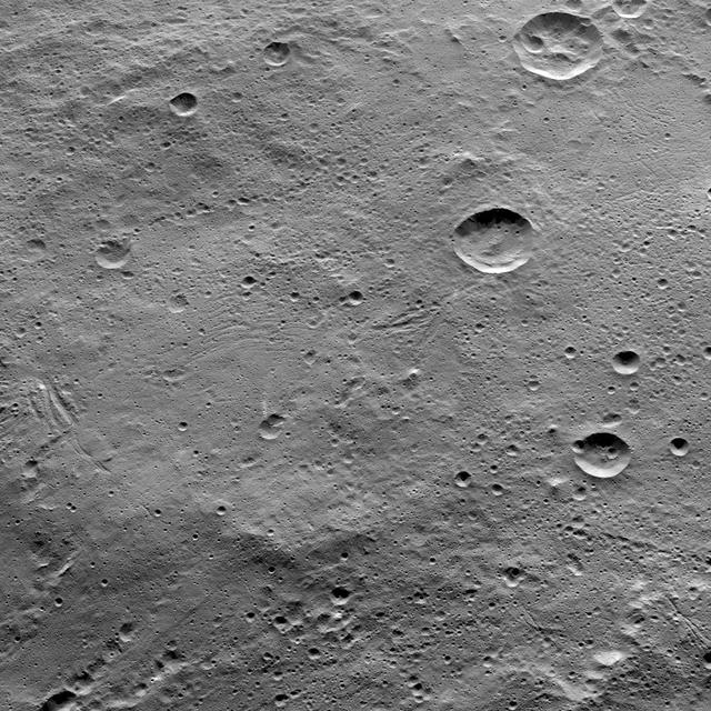
This view from NASA's Dawn spacecraft shows cratered terrain on the edge of the giant crater Yalode. The image is centered at 44 degrees south latitude, 316 degrees east longitude. Dawn took this image on June 1, 2016, from its low-altitude mapping orbit, at a distance of about 240 miles (385 kilometers) above the surface. The image resolution is 120 feet (35 meters) per pixel. http://photojournal.jpl.nasa.gov/catalog/PIA20936
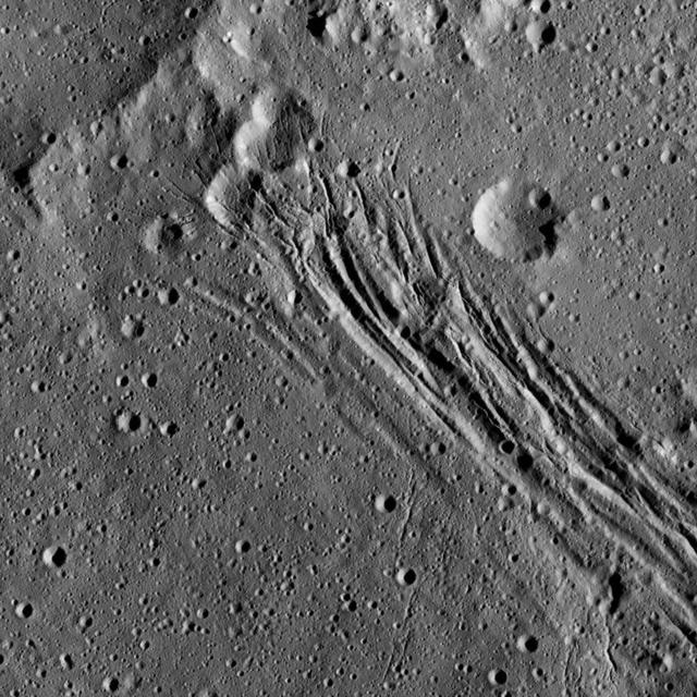
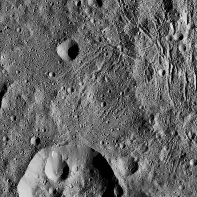
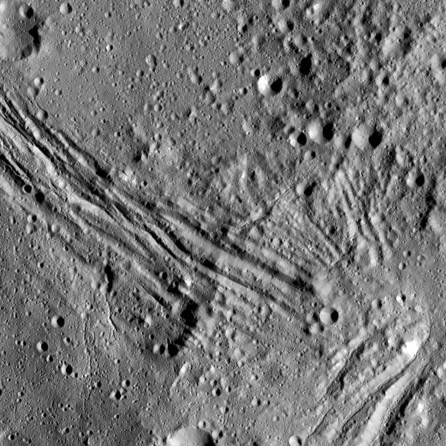
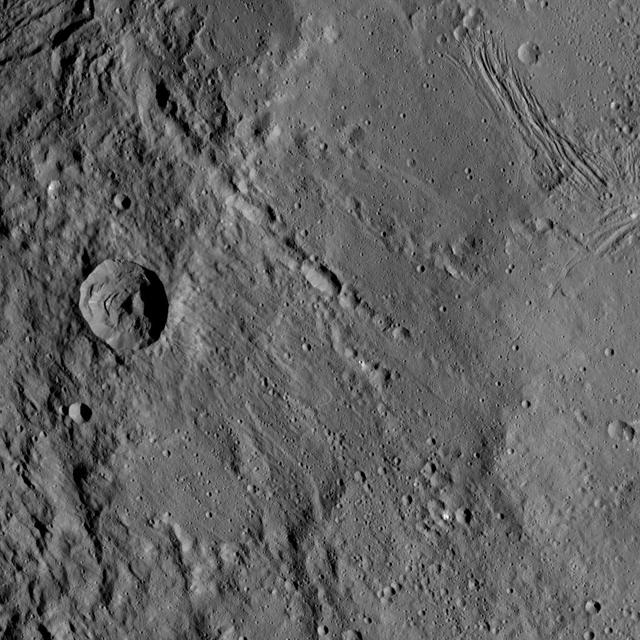
This image, taken by NASA's Dawn spacecraft, shows a series of linear features, which are depressions that located within the large Yalode Crater on Ceres. The widest of the linear features is approximately 0.9 miles (1.5 kilometers) in width. Scientists think these features formed when extensional stresses pulled the surface of Ceres apart. In the upper part of the image, the linear features cut through several impact craters, indicating that the fractures are younger than those particular craters. The linear features are not the youngest things visible in this view, however. There are also small impact craters imprinted upon them, meaning those craters must have appeared more recently. Yalode is 160 miles (260 kilometers) in diameter. Dawn took this image on June 15, 2016, from its low-altitude mapping orbit, at a distance of about 240 miles (385 kilometers) above the surface. The image resolution is 120 feet (35 meters) per pixel. http://photojournal.jpl.nasa.gov/catalog/PIA20959
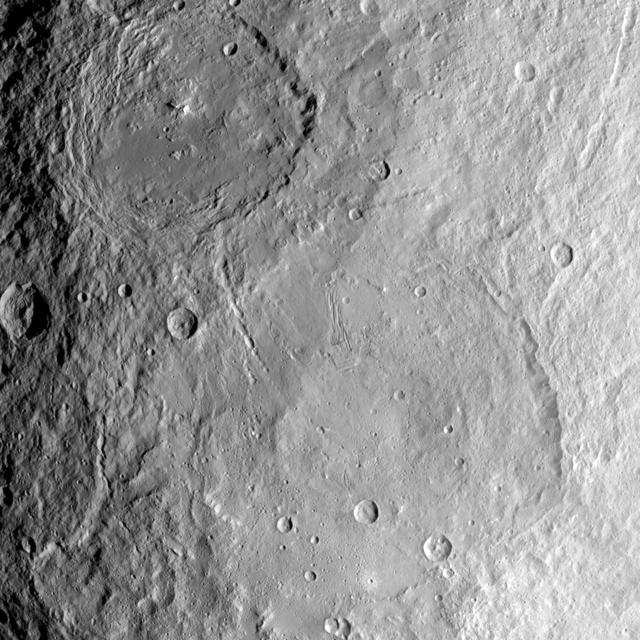
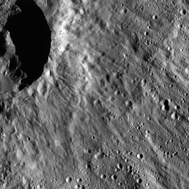
Yalode crater is so large -- at 162 miles, 260 kilometers in diameter -- that a variety of vantage points is necessary to understand its geological context. This view of the northern portion of Yalode is one of many images NASA's Dawn spacecraft has taken of this crater. The large impact that formed the crater likely involved a lot of heat, which explains the relatively smooth crater floor punctuated by smaller craters. A couple of larger craters in Yalode have polygonal shapes. This type of crater shape is frequently found on Ceres and may be indicative of extensive underground fractures. The larger crater to the right of center in this image is called Lono (12 miles, 20 kilometers in diameter) and the one below it is called Besua (11 miles, 17 kilometers). Some of the small craters are accompanied by ejecta blankets that are more reflective than their surroundings. The strange Nar Sulcus fractures can be seen in the bottom left corner of the picture. Linear features seen throughout the image may have formed when material collapsed above empty spaces underground. These linear features include linear chains of craters called catenae. Dawn took this image on September 27, 2015, from 915 miles (1,470 kilometers) altitude. The center coordinates of this image are 32 degrees south latitude and 300 degrees east longitude. Yalode gets its name from a goddess worshipped by women at the harvest rites in the Dahomey culture of western Africa. Besua takes its name from the Egyptian grain god, and Lono from the Hawaiian god of agriculture. https://photojournal.jpl.nasa.gov/catalog/PIA21410
This image from NASA's Dawn spacecraft shows the large craters Urvara (top) and Yalode (bottom) on dwarf planet Ceres. These features are so big that they must be observed from high altitudes in order to fit in the frame of a single image. Urvara is (101 miles (163 kilometers) in diameter, while Yalode is 162 miles (260 kilometers) in diameter. The two giant craters were formed at different times. Yalode is almost 1 billion years older than Urvara, which is about 120 million to 140 million years old. Yalode's relatively smooth floor indicates Ceres' crust material became close to -- or even reached -- the melting temperature of ice as a consequence of the heat generated by the impact. On the other hand, the smaller Urvara has rougher terrain. This suggests Urvara had either a lower temperature increase from the impact, or a colder crust temperature at the time of the crater's formation, or a combination of the two. Indeed, Ceres' interior was warmer in the past, and has been slowly cooling as its supply of radioactive isotopes, whose decay represents Ceres' main heat source, has been decreasing over time. This picture also reveals geological details such, as the feature Nar Sulcus inside Yalode and a central peak in Urvara. Urvara is named after the Indian and Iranian deity of plants and fields. Yalode is named for the Dahomey goddess, worshipped by women at the harvest rites. This image was obtained by NASA's Dawn spacecraft on June 9, 2015. The spacecraft was then in its survey orbit (2,700 miles, 4,400 kilometers above the surface), when the footprint of Dawn's framing camera on Ceres' surface was about 260 miles (420 kilometers) across on Ceres' surface. The resolution is 1,400 feet (410 meters) per pixel. The central coordinates of the picture are 43 degrees south latitude, 278 degrees east in longitude. https://photojournal.jpl.nasa.gov/catalog/PIA21917
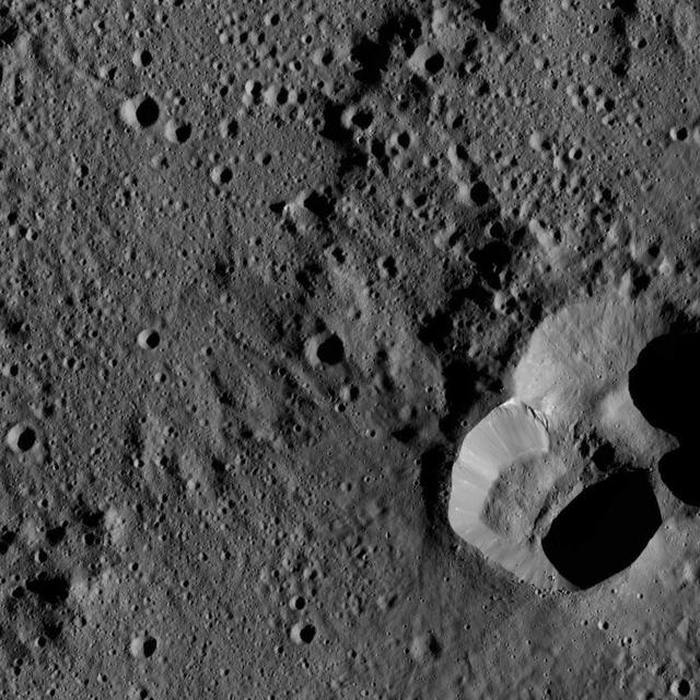
This image shows the eastern part of a feature called Nar Sulcus in Yalode Crater on dwarf planet Ceres, as seen by NASA's Dawn spacecraft. The term "sulcus" (plural: sulci) describes terrain with long, parallel fractures. Sulci are very common on icy moons -- for example, at the south pole of Enceladus, as seen in PIA11686. Nar Sulcus, 31 miles (50 kilometer) long, is the only feature of its kind identified on Ceres. It may point to an episode of tectonic deformation resulting from the evolution of the crater, which is the second largest on Ceres. The impact that formed Yalode heated Ceres' mixture of ice, rock and salt, perhaps causing a large volume to melt. When this material subsequently refroze, it would expand (just as water does when it turns to ice in your freezer). That may have created stresses that fractured the ground, forming Nar Sulcus. The name "Nar Sulcus" refers to the Azerbaijani festival of the pomegranate harvest. That festival is held in October and November in the city of Goychay, center of pomegranate cultivation in Azerbaijan. Dawn took this image on August 15, 2016, from its low-altitude mapping orbit, at a distance of about 240 miles (385 kilometers) above the surface. The image resolution is 120 feet (35 meters) per pixel. https://photojournal.jpl.nasa.gov/catalog/PIA21400
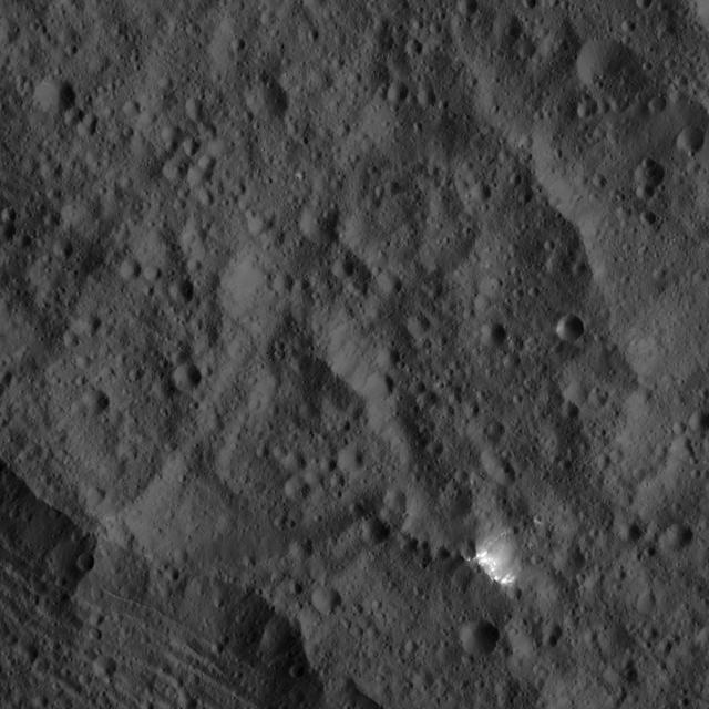
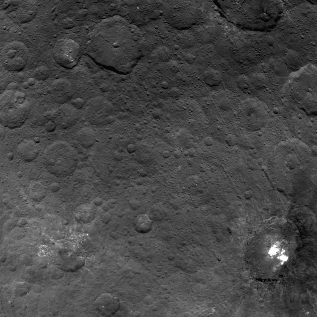
This image, taken by NASA Dawn spacecraft, shows a small patch of bright material close to the northern rim of the giant crater Yalode, seen at lower left. Yalode is one of the largest impact basins on Ceres.
This view from NASA Dawn spacecraft shows a sinuous canyon in the southern hemisphere of Ceres, south of Yalode Crater.
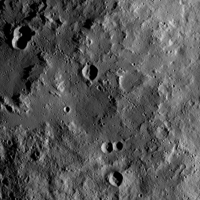
A portion of the rim of giant Yalode Crater is seen in this image of Ceres. Yalode is approximately 162 miles 260 kilometers in diameter. NASA Dawn spacecraft took this image on June 15, 2016. Dawn took this image from its low-altitude mapping orbit, at a distance of about 240 miles (385 kilometers) above the surface. The image resolution is 120 feet (35 meters) per pixel. This view is centered at approximately 28 degrees south latitude, 287 degrees east longitude. http://photojournal.jpl.nasa.gov/catalog/PIA20827
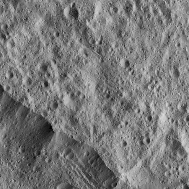
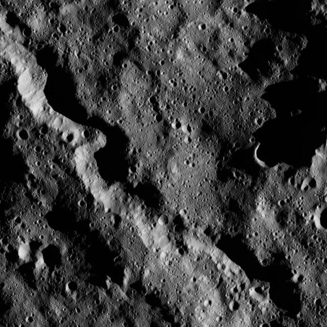
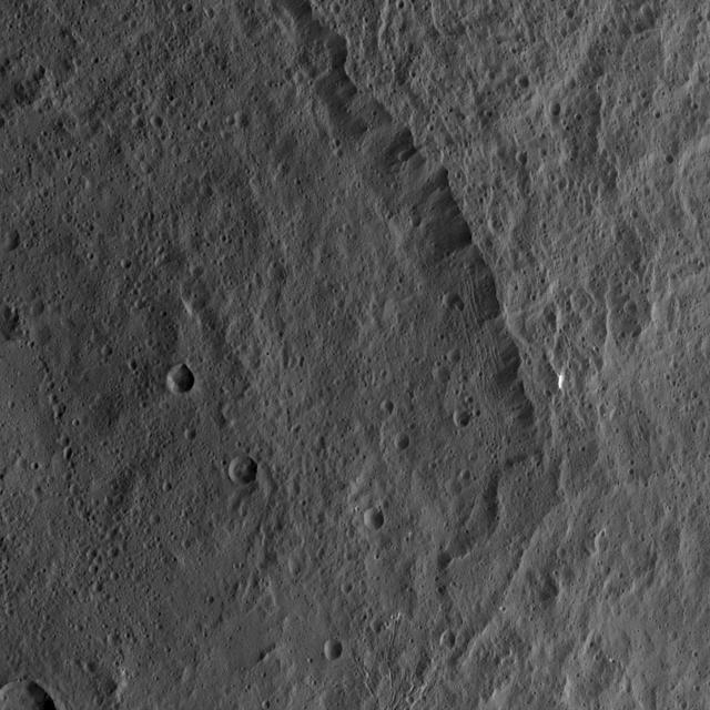
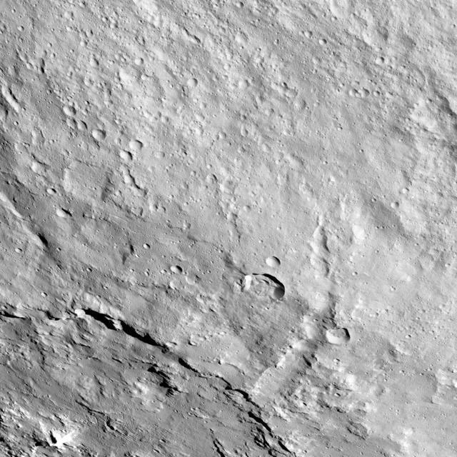
This picture from NASA Dawn spacecraft shows a portion of the northeastern rim of Yalode Crater, one of the largest impact features on Ceres. A set of narrow, roughly parallel fractures can be seen at top center.
This image from NASA Dawn spacecraft shows a scene located at mid-latitudes in the southern hemisphere of Ceres. The view features a portion of a crater between the large impact features Urvara and Yalode.
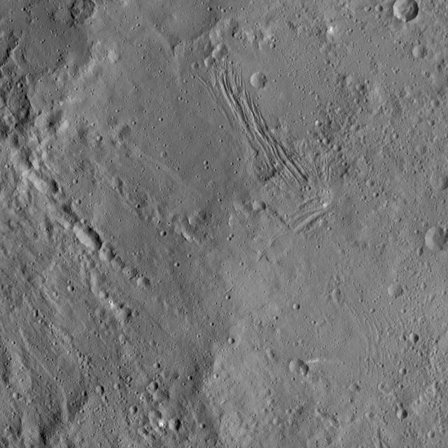
This image of Nar Sulcus in Yalode Crater was obtained by NASA's Dawn spacecraft on May 19, 2018 from an altitude of about 875 miles (1410 kilometers). Nar Sulcus is located at about 42 degrees south in latitude and 280 degrees east in longitude. https://photojournal.jpl.nasa.gov/catalog/PIA22469
This image of the region between Urvara Crater's eastern rim and Yalode Crater's western rim was obtained by NASA's Dawn spacecraft on May 20, 2018 from an altitude of about 1070 miles (1720 kilometers). The center of this picture is located at about 54 degrees south in latitude and 272 degrees east in longitude. https://photojournal.jpl.nasa.gov/catalog/PIA22516
This image of Ceres, taken by NASA's Dawn spacecraft, shows terrain in the southern hemisphere within the large crater called Yalode (160 miles, or 260 kilometers across). Many small-scale, linear troughs, in a variety of orientations, are apparent across this landscape. The prominent crater at top-right is called Lono (12 miles, 20 kilometers wide). The crater directly below it is called Besua (11 miles, 17 kilometers wide). The image is centered at approximately 44 degrees south latitude, 300 degrees east latitude. Dawn took this image from an altitude of 915 miles (1,470 kilometers) during the mission's High Altitude Mapping Orbit (HAMO) phase on Oct. 14, 2015. Image resolution is 450 feet (140 meters) per pixel. http://photojournal.jpl.nasa.gov/catalog/PIA20150
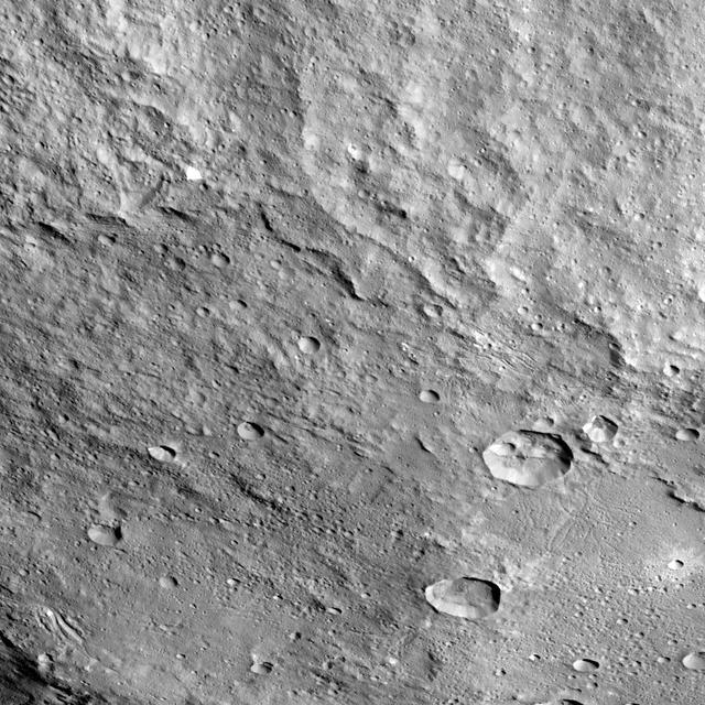
This view from NASA's Dawn spacecraft shows the rim of the large impact feature named Yalode in the southern mid-latitudes on dwarf planet Ceres. Linear, roughly parallel features are visible in the crater wall. Dawn took this image on Oct. 14, 2015, from an altitude of 915 miles (1,470 kilometers). It has a resolution of 450 feet (140 meters) per pixel. http://photojournal.jpl.nasa.gov/catalog/PIA20131
NASA's Dawn spacecraft took this picture on its way to a new orbit, at an altitude of about 30,000 miles (48,300 kilometers), as part of a series of images intended to help the navigation of the spacecraft relative to Ceres. The image was taken on March 28, 2017. Several familiar features can be identified: At the top, we see Occator Crater and its faculae (bright deposits identified as a mixture of sodium carbonate and other salts). Below center is the crater Urvara, and to the right of it, the larger crater Yalode (the third and second largest craters on Ceres, respectively). Large-scale faults called Samhain Catenae stretch from the Occator region toward the Yalode-Urvara region. The spacecraft will settle into a new orbit that will allow it to observe Ceres in opposition at the end of April 2017, when Dawn is directly between the sun and the Occator bright spots, at an altitude of about 12,400 miles (20,000 kilometers). The Dawn Journal has more details about the science expected from these observations. https://photojournal.jpl.nasa.gov/catalog/PIA21401
This view from NASA's Dawn spacecraft shows different types of terrain located side by side on Ceres: a smooth terrain at right with numerous small impact craters, and a less-cratered, hummocky terrain at left. A huge crater chain crosses the scene diagonally from upper left to lower right. The smooth terrain, which is in the western part of Yalode impact basin, is interrupted by a set of roughly parallel furrows and ridges at upper right. These linear features are perpendicular to another set of smaller, fainter linear markings, which appear just below them. An impact into the hummocky terrain formed a crater, seen at left, 14 miles (22 kilometers) in diameter with a central peak. A great deal of material has slumped down the walls of the crater -- a phenomenon called mass wasting. The crater's impact ejecta forms a smooth blanket around its rim, which takes on a streaky texture leading away from the crater toward lower right. The image was taken during in Dawn's High Altitude Mapping Orbit (HAMO) phase from an altitude of 911 miles (1,466 kilometers) on Oct. 6, 2015. Image resolution is 394 feet (120 meters) per pixel. The image is centered at 37 degrees south latitude, 279 degrees east longitude. http://photojournal.jpl.nasa.gov/catalog/PIA20133
This image from NASA's Dawn spacecraft showing the northern part of Hanami Planum on Ceres honors the Japanese cherry blossom festival, or "Hanami," which is a long-standing Japanese tradition of welcoming spring. Hanami Planum is the third largest geological feature on Ceres, after Vendimia Planitia and the Samhain Catenae. It extends over 345 miles (555 kilometers). This image shows familiar features, such as Occator Crater, characterized both by bright material inside the crater and dark ejecta material outside. Several parallel linear features, called Junina Catenae, can be seen departing from Occator and extending toward the top of the image. These catenae are chains of small craters formed by the impact and scouring of material ejected when large craters are formed. Scientists were able to relate these crater chains to Urvara and Yalode. Even though these are located in the southern hemisphere, some of their ejecta could reach the northern hemisphere, thanks to Ceres' fast rotation and small size. This image was obtained by Dawn on June 15, 2015. The spacecraft was then in its survey orbit (2,700 miles, or 4,400 kilometers high), when the footprint of Dawns framing camera on Ceres surface was about 260 miles (420 kilometers). The resolution is 1,400 feet (410 meters) per pixel. The central coordinates of the picture are 14 degrees north latitude, 213 degrees east in longitude. https://photojournal.jpl.nasa.gov/catalog/PIA21921
This image from NASA's Dawn spacecraft shows the northeastern rim of Urvara Crater on Ceres at lower left. To the right of the crater, the long, narrow feature that appears to jut out toward the north is called Pongal Catena, which is about 60 miles (96 km) long. Catenae are large grooves or troughs that can have various origins. They refer to chains of closely connected craters formed by a series of impacts, as found on Jupiter's moon Ganymede. They can also represent large faults created by internal forces, for example in this example found on Mars. The mechanism that formed Pongal Catena is not understood yet, but it likely formed as a consequence of the stresses generated by the large impacts that resulted in the formation of the Urvara and Yalode craters. Pongal catena is one of several types of fractures found in this region that reflect a complex history. A feature called Nar Sulcus is another example. Studying the geometry of these features and their relationships can help shed light on the nature of Ceres' subsurface. This image was obtained on September 28, 2015, from an altitude of about 915 miles (1,470 kilometers). Pongal Catena is centered at 37.4 degrees south latitude, 267.7 degrees east longitude. This feature gets its name from the Tamil (Sri Lanka and southern India) harvest festival observed in mid-January. It is a time for giving thanks to nature, and we thank Ceres for all the wonders it has offered us so far. https://photojournal.jpl.nasa.gov/catalog/PIA21408