
iss071e439834 (Aug. 8, 2024) --- The Yangtze River beams in the Sun's glint as wildfires burn in the surrounding forestland near the city of Wuhan in China's province of Hubei. The International Space Station was orbiting 262 miles above the Asian nation at the time of this photograph.

iss073e0515603 (Aug. 24, 2025) --- Shanghai, China, situated on the Yangtze River where it meets the East China Sea, is pictured at approximately 1:32 a.m. local time from the International Space Station as it orbited 261 miles above the nation's eastern coastline. Visible landmarks include Shanghai Hongqiao International Airport near the top of the frame and Shanghai Pudong International Airport at the bottom. The city's lights appear dimmer from orbit due to the widespread use of modern, downward-facing, energy-efficient lighting that reduces light pollution. Credit: JAXA (Japan Aerospace Exploration Agency)
Acquired by NASA Terra spacecraft, this image shows the Three Gorges Dam which spans the Yangtze River in east-central China, and is the world largest power station in terms of installed capacity.

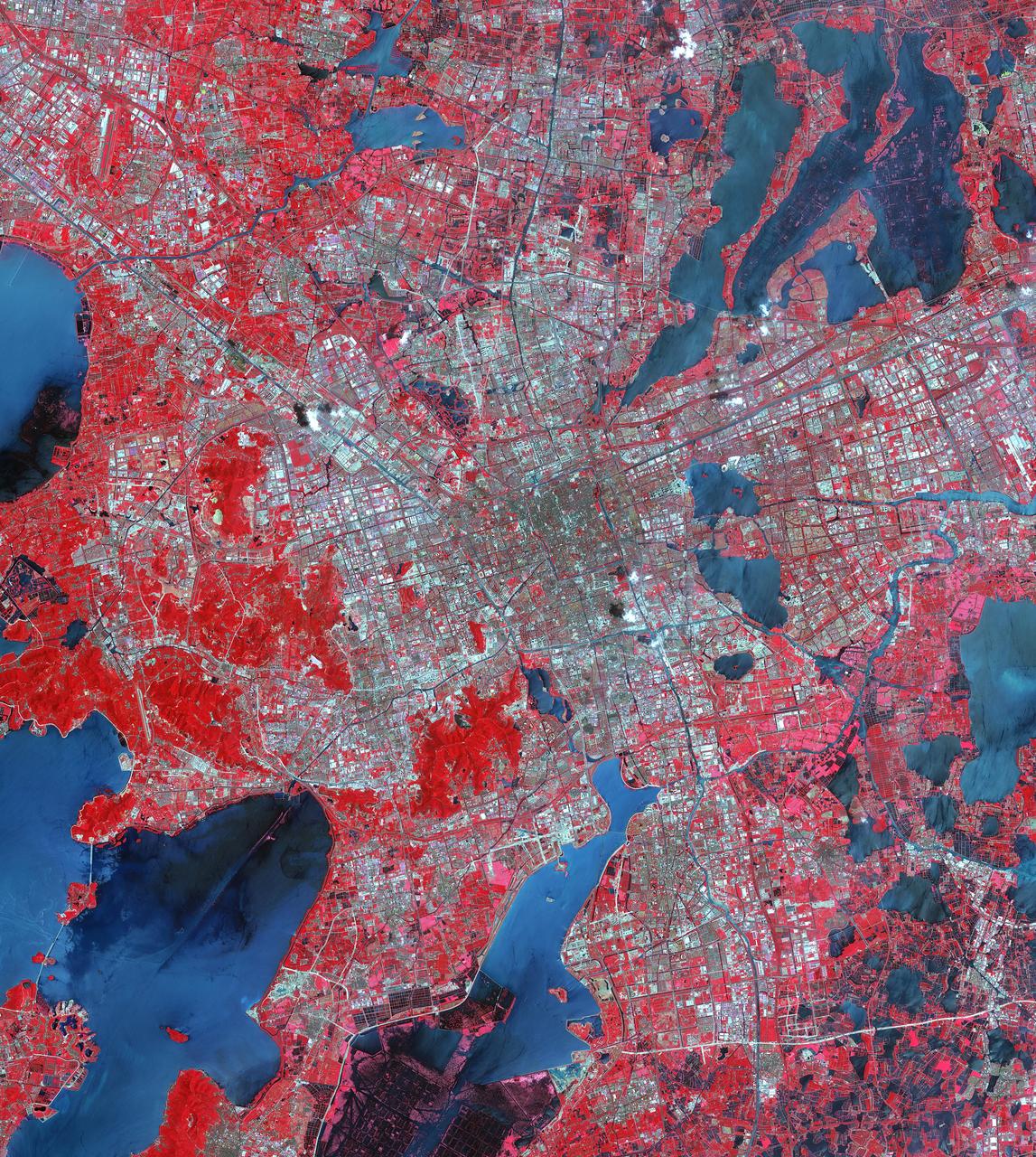
ISS030-E-188071 (27 March 2012) --- A nighttime view of Shanghai is featured in this image photographed by an Expedition 30 crew member on the International Space Station. The city of Shanghai sits along the delta banks of the Yangtze River along the eastern coast of China. The city proper is the world’s most populous city (the 2010 census counts 23 million people, including “unregistered” residents). With that many humans, the city is a tremendous sight at night. Shanghai is a key financial capital for China and the Asian Pacific region. The bright lights of the city center and the distinctive new skyscrapers that form the skyline along the Pudong district (the eastern shore of the Huangpu River, a tributary of the Yangtze that cuts through the center of Shanghai) make for spectacular night viewing both on the ground and from space. The official census count in 2000 was 16.4 million; the city population has increased more than 35 per cent since that time. Much of the growth has occurred in new satellite developments like areas to the west of the city (for example, Suzhou). The city’s rapid growth and development during the 20th and 21st centuries have come at a cost. Water availability is a key concern, and groundwater withdrawal has resulted in substantial subsidence in and around the city. Because it is built only a few meters above sea level – on the banks of the deltaic estuary of the Yangtze River – curbing subsidence rates is a critical concern.
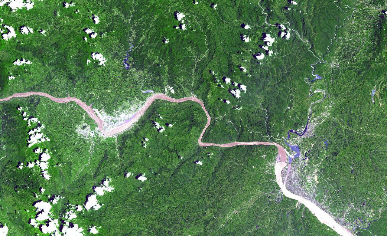
This ASTER image shows a 60 km stretch of the Yangtze River in China, including the Xiling Gorge, the eastern of the three gorges. In the left part of the image is the construction site of the Three Gorges Dam, the world's largest. This image was acquired on July 20, 2000 by the Advanced Spaceborne Thermal Emission and Reflection Radiometer (ASTER) on NASA's Terra satellite. With its 14 spectral bands from the visible to the thermal infrared wavelength region, and its high spatial resolution of 15 to 90 meters (about 50 to 300 feet), ASTER will image Earth for the next 6 years to map and monitor the changing surface of our planet. http://photojournal.jpl.nasa.gov/catalog/PIA03852

iss073e0420094 (July 3, 2025) --- Shanghai, China—the nation's largest city with a metropolitan population of approximately 24.9 million—is seen from the International Space Station at around 9:55 p.m. local time. Located where the Yangtze River meets the Yellow Sea, the city glows with urban energy. Notable landmarks include Shanghai Hongqiao International Airport near the top center and Shanghai Pudong International Airport at the bottom. The Huangpu River winds through the heart of downtown, dividing the historic Bund from the futuristic skyline of Lujiazui.

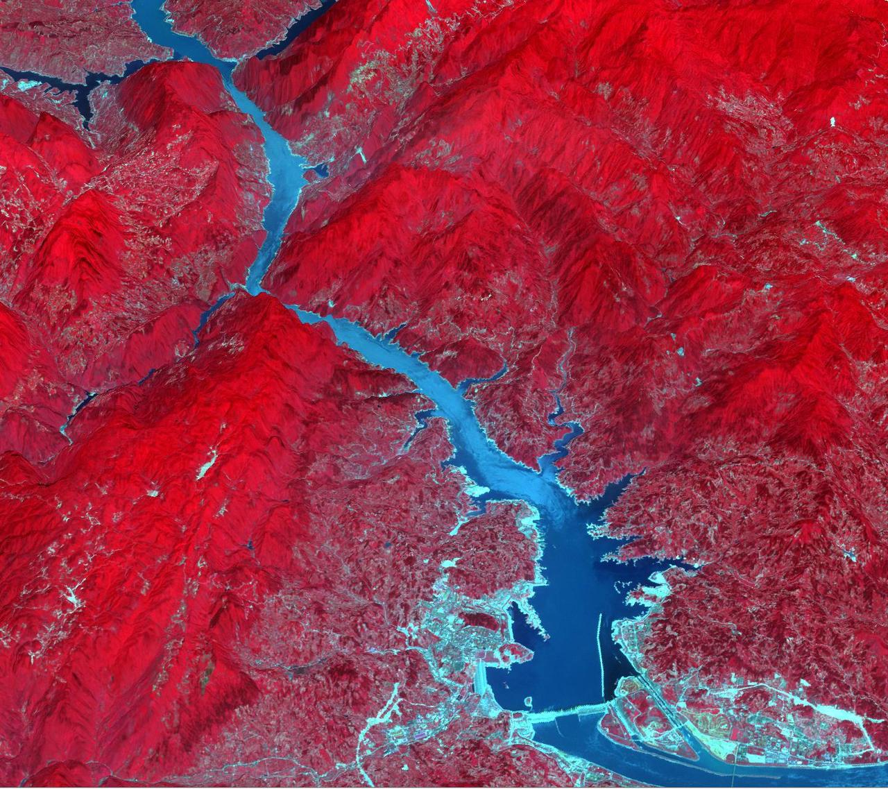
ISS019-E-007720 (15 April 2009) --- Three Gorges Dam in China is featured in this image photographed by an Expedition 19 crew member on the International Space Station. A new reservoir is filling in central China. The Three Gorges Dam on the Yangtze River - the world?s largest dam ? was completed in 2006, and the river is filling up its valley behind the dam to form a narrow reservoir extending more than 600 kilometers. This image is one of the first images documenting the flooding behind the dam. The main objective for the dam is to supply water for the largest hydroelectric plant in the world and help control the devastating floods that plague the lowlands downstream from the dam.
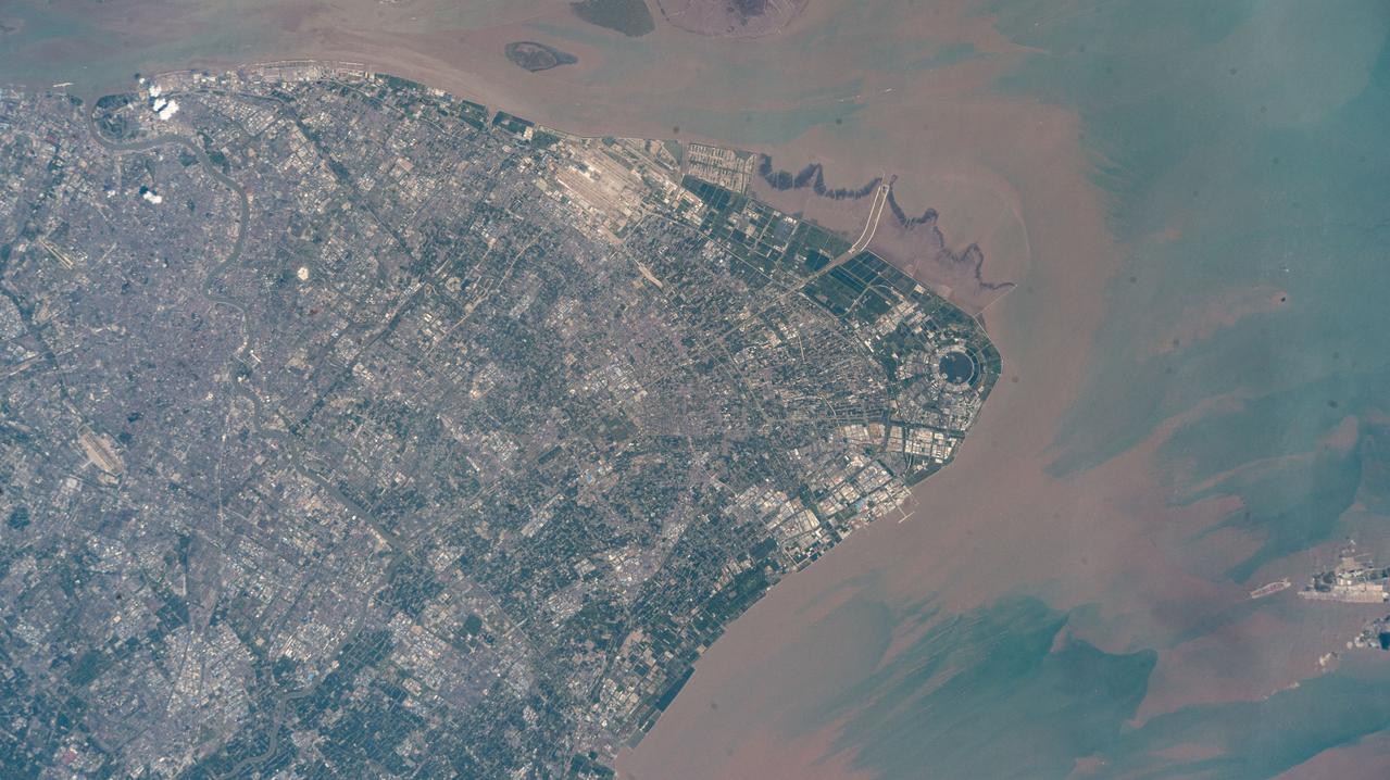
iss073e0513927 (Aug. 22, 2025) --- Shanghai, China's most populous city with over 24 million citizens and sitting on the East China Sea at the mouth of the Yangtze River, is pictured from the International Space Station as it orbited 260 miles above. Highlights include Shanghai Pudong International Airport (at top), the second busiest airport in the world by cargo traffic, and the circular Dishui Lake (center right), the largest artificial freshwater lake in China, hosting business and recreational activities.
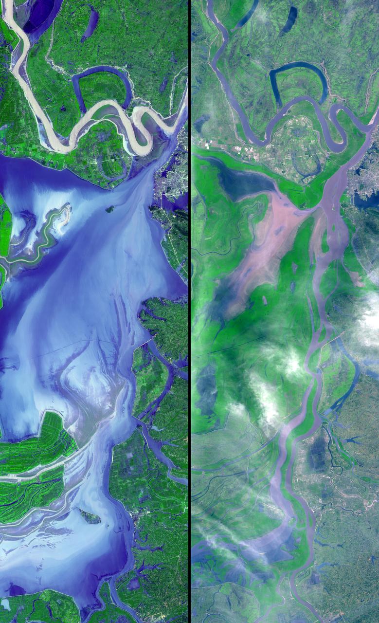
These images show dramatic change in the water at Dongting Lake in Hunan province, China. A flood crest surged down the Yangtze River in late August of this year, but the embankments made by residents there held. The left image was acquired on September 2, 2002 and shows the extent of the lake. The right image was obtained March 19, 2002 before the flooding began. These images were acquired on September 2, 2002 and March 19, 2002 by the Advanced Spaceborne Thermal Emission and Reflection Radiometer (ASTER) on NASA's Terra satellite. With its 14 spectral bands from the visible to the thermal infrared wavelength region, and its high spatial resolution of 15 to 90 meters (about 50 to 300 feet), ASTER will image Earth for the next 6 years to map and monitor the changing surface of our planet. http://photojournal.jpl.nasa.gov/catalog/PIA03858
Suzhou is a major city located in southeastern Jiangsu Province of East China, about 100 km northwest of Shanghai. It is a major economic center and focal point of trade and commerce. The city is situated on the lower reaches of the Yangtze River and the shores of Lake Tai. Founded in 514 BCE, Suzhou has over 2,500 years of history, with an abundant display of relics and sites of historical interest. Since major economic reforms began in 1978, Suzhou has become one of the fastest growing major cities in the world. The population has grown from 0.9 million in 1990, 2.2 million in 2000, 4.1 million in 2010, to 5.3 million in 2017. The Landsat TM image was acquired August 4, 1984, and the Aster image was acquired August 2, 2015. The images cover an area of 48 by 53 km, and are located at 31.2 degrees north, 120.4 degrees east. https://photojournal.jpl.nasa.gov/catalog/PIA22266
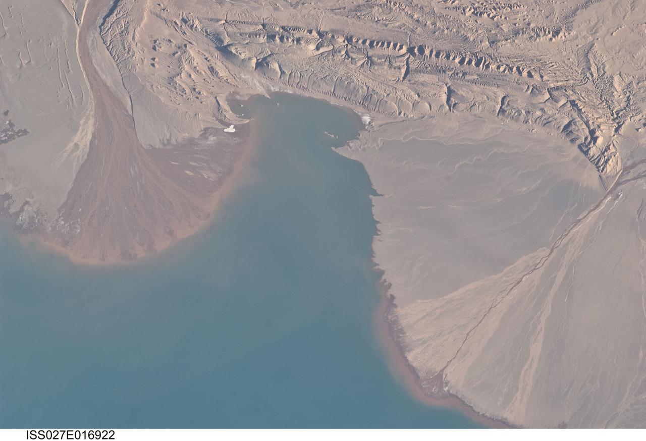
ISS027-E-016922 (25 April 2011) --- River deltas and Lake Ayakum in China (Tibet) are featured in this image photographed by an Expedition 27 crew member on the International Space Station. The Tibetan Plateau contains numerous lakes that dot an otherwise arid landscape. Lake Ayakum is located near the northern boundary of the Plateau to the southeast of the Kunlun Mountains. While many of the small glacier- and snowmelt-fed streams that cross the Tibetan Plateau eventually give rise to major Southeast Asian rivers including the Mekong and Yangtze, some empty into saline lakes such as Lake Ayakum. This detailed photograph highlights two river deltas (upper left and lower right) formed along the southwestern shoreline of the lake. When sediments build up to the point that a river can no longer flow over them, it will jump to a new channel position and begin the process anew. Scientists have noted that, over geologic time, the channels tend to sweep back and forth ? similar to the motion of an automobile windshield wiper ? to form the typical semi-circular or fan shape of the delta. Gray to tan surfaces of both deltas indicate prior positions of their respective river channels; the uniform coloration and smooth texture suggest that they are relatively old and are now inactive. In contrast, the younger and currently active delta surfaces can be recognized by reddish-brown sediment and clearly visible river channels. Lateral channel migration is particularly evident in the approximately eight-kilometer-wide active delta area at upper left. The reddish coloration of the actively depositing sediment may indicate a change from the sources that formed the older parts of the deltas (or indicate weathering and soil formation on the older deposits), or an episodic input of dust or other material to the river catchments.