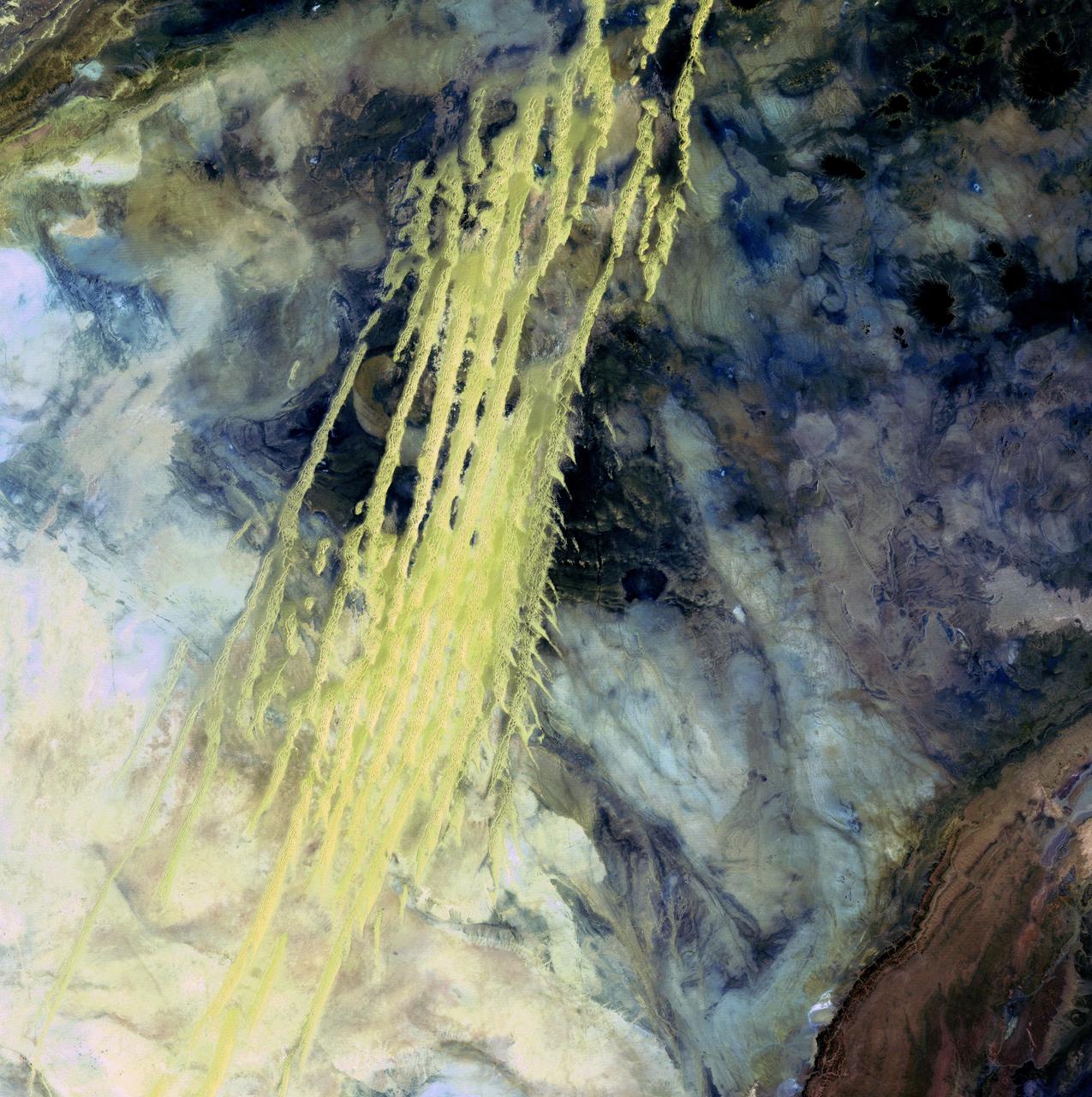
Algerian Abstract - April 8th, 1985 Description: What look like pale yellow paint streaks slashing through a mosaic of mottled colors are ridges of wind-blown sand that make up Erg Iguidi, an area of ever-shifting sand dunes extending from Algeria into Mauritania in northwestern Africa. Erg Iguidi is one of several Saharan ergs, or sand seas, where individual dunes often surpass 500 meters-nearly a third of a mile-in both width and height. Credit: USGS/NASA/Landsat 5 To learn more about the Landsat satellite go to: <a href="http://landsat.gsfc.nasa.gov/" rel="nofollow">landsat.gsfc.nasa.gov/</a> <b><a href="http://www.nasa.gov/centers/goddard/home/index.html" rel="nofollow">NASA Goddard Space Flight Center</a></b> enables NASA’s mission through four scientific endeavors: Earth Science, Heliophysics, Solar System Exploration, and Astrophysics. Goddard plays a leading role in NASA’s accomplishments by contributing compelling scientific knowledge to advance the Agency’s mission. <b>Follow us on <a href="http://twitter.com/NASA_GoddardPix" rel="nofollow">Twitter</a></b> <b>Join us on <a href="http://www.facebook.com/pages/Greenbelt-MD/NASA-Goddard/395013845897?ref=tsd" rel="nofollow">Facebook</a></b>
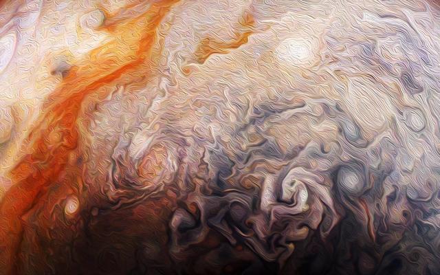
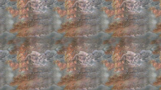
Citizen scientist Rick Lundh created this abstract Jovian artwork using data from the JunoCam imager onboard NASA's Juno spacecraft. The original image captures a close-up view of numerous storms in the northern hemisphere of Jupiter. To produce this artwork, Lundh selected a more contrasting part of one of Jupiter's storms, then cropped the image and applied an oil-painting filter. https://photojournal.jpl.nasa.gov/catalog/PIA21983 . - Enhanced image by Rick Lundh based on images provided courtesy of NASA/JPL-Caltech/SwRI/MSSS
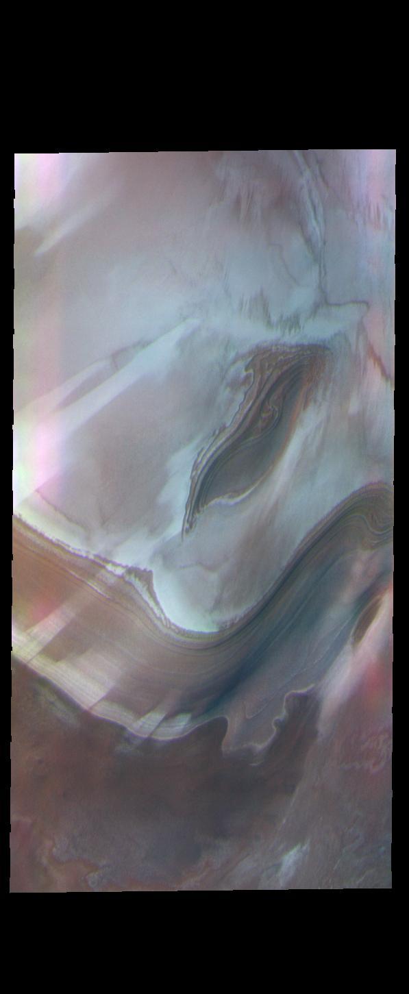
This image captured by NASA's 2001 Mars Odyssey spacecraft looks like a piece of abstract art. Orbit Number: 63689 Latitude: 79.922 Longitude: 35.9293 Instrument: VIS Captured: 2016-04-22 23:28 https://photojournal.jpl.nasa.gov/catalog/PIA21695

Director's Colloquium: Ruslan Belikov, Ames Astrophysicist presents 'Imaging other Earths and High Contrast Coronagraphy at Ames abstract: Exoplanet detection over the past decade - Audio available through Ames Library
Seeing small areas of the Moon at 50 cm per pixel often presents unexpected views, and sometimes it is hard to interpret the geology at first glance, much less what is up and what is down, as evidenced by NASA Lunar Reconnaissance Orbiter.
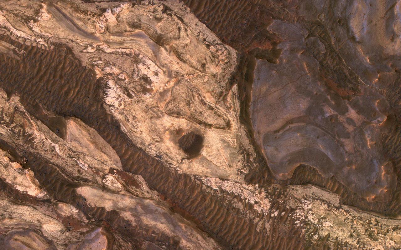
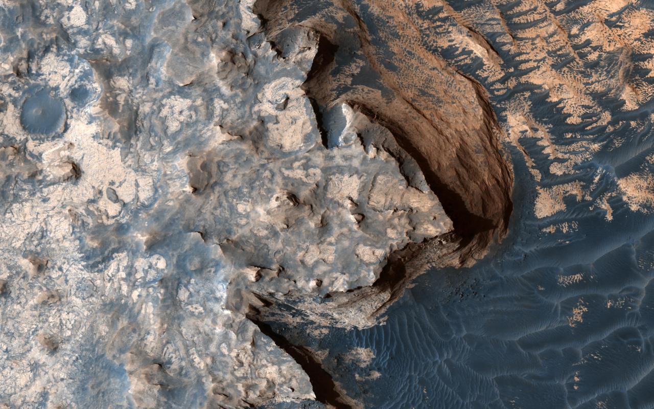
Sometimes Mars' surface is just beautiful as seen through the eyes of HiRISE. This is one example on the floor of Ius Chasma, part of Valles Marineris. The region has had a complex history of sediment deposition, deformation, erosion, and alteration. https://photojournal.jpl.nasa.gov/catalog/PIA23183

This artist's concept appeared on the Feb. 23, 2017 cover of the journal Nature announcing that the TRAPPIST-1 star, an ultra-cool dwarf, has seven Earth-size planets orbiting it. Any of these planets could have liquid water on them. Planets that are farther from the star are more likely to have significant amounts of ice, especially on the side that faces away from the star. The system has been revealed through observations from NASA's Spitzer Space Telescope and the ground-based TRAPPIST (TRAnsiting Planets and PlanetesImals Small Telescope) telescope, as well as other ground-based observatories. The system was named for the TRAPPIST telescope. http://photojournal.jpl.nasa.gov/catalog/PIA21421

Closeup photo of an optical cube mounted to OSAM-1 hardware inside cleanroom at Goddard Space Flight Center, Greenbelt Md., Jun 4, 2024. This photo has been reviewed by OSAM1 project management and the Export Control Office and is released for public view. NASA/Mike Guinto
Sunlight washes over the exterior of the integration and testing facility at Goddard Space Flight Center, Greenbelt, Md., Feb 20, 2023. This photo is approved for public release. NASA/Mike Guinto
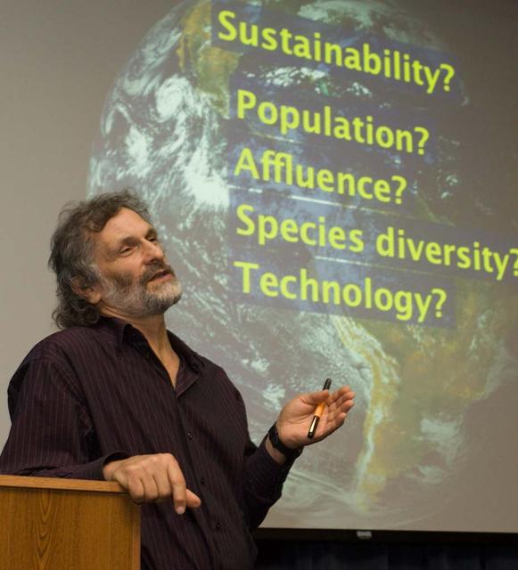
Director's Colloquium; Dr Jonathan Trent, Physical Scientist with NASA Ames Bioengineering Branch presents 'OMEGA and the Future of Aviation Fuels) Abstract: Offshore Membrane Enclosures for Growing Algae (OMEGA) is an innovative approach to growing oil-producing, freshwater algea in off shore enclosures, using municipal wastewater that is currently dumped into the ocean at a rate of >35 billion gals/day.
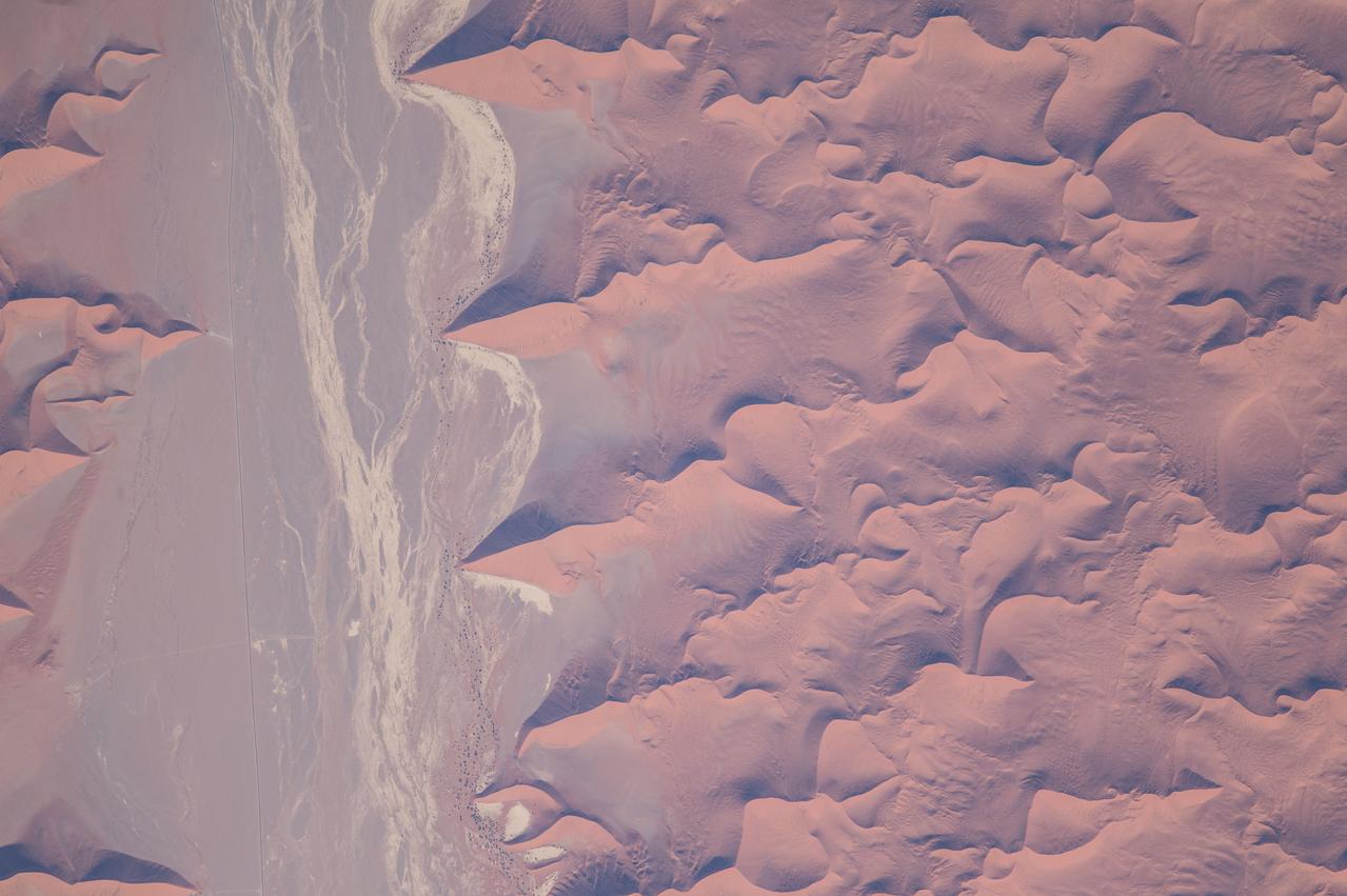
ISS047e022280 (03/26/2016) --- This interesting Earth observation image from the International Space Station seems an abstract painting but is really the outskirts of the Namib Desert in southwest Africa. One of the oldest and largest deserts in the world, the Namib stretches inland from the Atlantic Ocean, covering large swathes of Namibia and parts of Angola and South Africa. This arid hotspot surprisingly supports a diverse number of plants and animals, some of which are found nowhere else in the world.

Director's Colloquium; Dr Jonathan Trent, Physical Scientist with NASA Ames Bioengineering Branch presents 'OMEGA and the Future of Aviation Fuels) Abstract: Offshore Membrane Enclosures for Growing Algae (OMEGA) is an innovative approach to growing oil-producing, freshwater algea in off shore enclosures, using municipal wastewater that is currently dumped into the ocean at a rate of >35 billion gals/day.
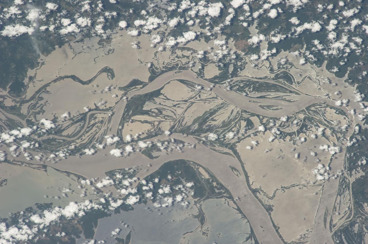
ISS037-E-001606 (18 Sept. 2013) --- What at first glance might appear to be a piece of abstract art is actually a photo made using a 180mm lens from approximately 226 nautical miles above Earth featuring the very wide Amazon River floodplain at Santarem, Brazil. One of the Expedition 37 crew members aboard the International Space Station took the photograph on Sept. 18, 2013. Center coordinates of the area pictured are located at approximately 2.1 degrees south latitude and 54.9 degrees west longitude.

This image of abstract shapes is comprised numerous subparallel, very long, orange colored linear dunes and patchy grey dry lakes (playas). The dunes are aligned north to south in the great central basin of Astralia (27.0S, 138.0E). The regularity of the dunes is created by the winds blowing from the south. As the dunes advance, jaged edges on the south side of each dry lake are formed while the north side is eroded smooth by the wind and water.
When team members from NASA's Juno mission invited the public to process JunoCam images, they did not anticipate that they would receive back such beautiful, creative expressions of art. The oranges and grayed-out regions of blue-green in this tiled and color-enhanced image resemble a color scheme much like Romantic era paintings, but more abstract. The lack of discreet objects to focus on allows the mind to seek familiar Earthly shapes, and the brightest spots seem to draw the eye. Citizen scientist Eric Jorgensen created this Jovian artwork with a JunoCam image taken when the spacecraft was at an altitude of 11,100 miles (17,800 kilometers) above Jupiter's cloudtops on Dec. 11, 2016 at 9:22 a.m. PT (12:22 p.m. ET). http://photojournal.jpl.nasa.gov/catalog/PIA21385 . - Enhanced image by Eric Jorgensen based on images provided courtesy of NASA/JPL-Caltech/SwRI/MSSS
Caption: This is a conceptual animation showing ozone-depleting chemicals moving from the equator to the poles. The chemicals become trapped by the winds of the polar vortex, a ring of fast moving air that circles the South Pole. Watch full video: <a href="https://youtu.be/7n2km69jZu8" rel="nofollow">youtu.be/7n2km69jZu8</a> -- The next three decades will see an end of the era of big ozone holes. In a new study, scientists from NASA Goddard Space Flight Center say that the ozone hole will be consistently smaller than 12 million square miles by the year 2040. Ozone-depleting chemicals in the atmosphere cause an ozone hole to form over Antarctica during the winter months in the Southern Hemisphere. Since the Montreal Protocol agreement in 1987, emissions have been regulated and chemical levels have been declining. However, the ozone hole has still remained bigger than 12 million square miles since the early 1990s, with exact sizes varying from year to year. The size of the ozone hole varies due to both temperature and levels of ozone-depleting chemicals in the atmosphere. In order to get a more accurate picture of the future size of the ozone hole, scientists used NASA’s AURA satellite to determine how much the levels of these chemicals in the atmosphere varied each year. With this new knowledge, scientists can confidently say that the ozone hole will be consistently smaller than 12 million square miles by the year 2040. Scientists will continue to use satellites to monitor the recovery of the ozone hole and they hope to see its full recovery by the end of the century. Research: Inorganic chlorine variability in the Antarctic vortex and implications for ozone recovery. Journal: Geophysical Research: Atmospheres, December 18, 2014. Link to paper: <a href="http://onlinelibrary.wiley.com/doi/10.1002/2014JD022295/abstract" rel="nofollow">onlinelibrary.wiley.com/doi/10.1002/2014JD022295/abstract</a>.
This image from NASA's Mars Reconnaissance Orbiter is reminiscent of the rugged and open terrain of a stark shore-line, perhaps of an island nation, such as the British Isles. A close-up in enhanced color produces a striking effect, giving the impression of a cloud-covered cliff edge with foamy waves crashing against it. The reality is that the surface of Mars is much dryer than our imaginations might want to suggest. This is only a tiny part of a much larger structure; an inverted crater -- a crater that has been infilled by material that is more resistant to erosion than the rocks around it -- surrounded by bluish basaltic dunes. The edge of these elevated light-toned deposits are degraded, irregular and cliff-forming. Dunes visible below the cliff, give the impression of an ocean surface, complete with foam capped waves crashing against the "shore line," demonstrating the abstract similarity between the nature of a turbulent ocean and a Martian dune field. Meridiani Planum has an overall smooth terrain, which starkly contrasts with the more common boulder- and crater-laden landscapes observed over much of the rest of Mars. This makes it relatively younger in character than many other areas of the planet. Meridiani is one of the Mars Exploration Rover landing sites, and, is known for its layers and sediments. The orbital detection of hematite was one of the main reasons for sending Opportunity to this area. Salt-bearing rocks -- also called sulphates -- were observed in the very first image from Opportunity, so perhaps it's apt that this HiRISE image reminds us of the turmoil and rugged beauty of a cliff-face, a coastline, being worn down by a relentless sea. https://photojournal.jpl.nasa.gov/catalog/PIA21760

This Hubble image shows NGC 4789A, a dwarf irregular galaxy in the constellation of Coma Berenices. It certainly lives up to its name — the stars that call this galaxy home are smeared out across the sky in an apparently disorderly and irregular jumble, giving NGC 4789A a far more subtle and abstract appearance than its glitzy spiral and elliptical cousins. These stars may look as if they have been randomly sprinkled on the sky, but they are all held together by gravity. The colors in this image have been deliberately exaggerated to emphasize the mix of blue and red stars. The blue stars are bright, hot and massive stars that have formed relatively recently, whereas the red stars are much older. The presence of both tells us that stars have been forming in this galaxy throughout its history. At a distance of just over 14 million light-years away NGC 4789A is relatively close to us, allowing us to see many of the individual stars within its bounds. This image also reveals numerous other galaxies, far more distant, that appear as fuzzy shapes spread across the image. Image Credit: ESA/Hubble & NASA, Acknowledgements: Judy Schmidt (Geckzilla) <b><a href="http://www.nasa.gov/audience/formedia/features/MP_Photo_Guidelines.html" rel="nofollow">NASA image use policy.</a></b> <b><a href="http://www.nasa.gov/centers/goddard/home/index.html" rel="nofollow">NASA Goddard Space Flight Center</a></b> enables NASA’s mission through four scientific endeavors: Earth Science, Heliophysics, Solar System Exploration, and Astrophysics. Goddard plays a leading role in NASA’s accomplishments by contributing compelling scientific knowledge to advance the Agency’s mission. <b>Follow us on <a href="http://twitter.com/NASAGoddardPix" rel="nofollow">Twitter</a></b> <b>Like us on <a href="http://www.facebook.com/pages/Greenbelt-MD/NASA-Goddard/395013845897?ref=tsd" rel="nofollow">Facebook</a></b> <b>Find us on <a href="http://instagrid.me/nasagoddard/?vm=grid" rel="nofollow">Instagram</a></b>
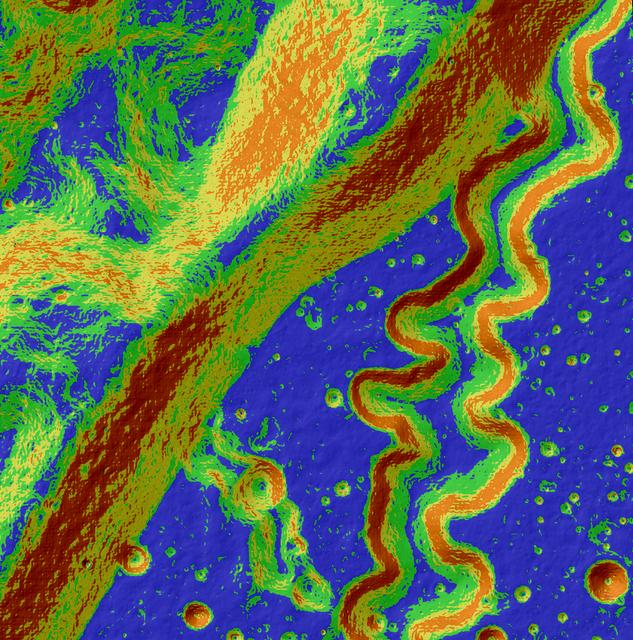
This may look like a work of abstract art, but in reality, it's our Moon and is for science. The Lunar Reconnaissance Orbiter Camera, or LROC, is a system of three cameras mounted on the Lunar Reconnaissance Orbiter (LRO) that capture high resolution photos of the lunar surface. This colorful image is an LROC slope map of the northwestern portion of the floor of Posidonius crater. Warmer colors indicate steeper slopes, whereas cooler colors are shallower slopes. A rille winds its way across the floor and flows along a southerly course, diverging from its path along the crater rim. A tributary rille (or narrow channel) can be seen joining the main rille at the bottom center. Image width is approximately 3.4 miles. North is up. Read more: <a href="http://lroc.sese.asu.edu/posts/796" rel="nofollow">lroc.sese.asu.edu/posts/796</a> Credit: NASA/GSFC/Arizona State University <b><a href="http://www.nasa.gov/audience/formedia/features/MP_Photo_Guidelines.html" rel="nofollow">NASA image use policy.</a></b> <b><a href="http://www.nasa.gov/centers/goddard/home/index.html" rel="nofollow">NASA Goddard Space Flight Center</a></b> enables NASA’s mission through four scientific endeavors: Earth Science, Heliophysics, Solar System Exploration, and Astrophysics. Goddard plays a leading role in NASA’s accomplishments by contributing compelling scientific knowledge to advance the Agency’s mission. <b>Follow us on <a href="http://twitter.com/NASAGoddardPix" rel="nofollow">Twitter</a></b> <b>Like us on <a href="http://www.facebook.com/pages/Greenbelt-MD/NASA-Goddard/395013845897?ref=tsd" rel="nofollow">Facebook</a></b> <b>Find us on <a href="http://instagram.com/nasagoddard?vm=grid" rel="nofollow">Instagram</a></b>
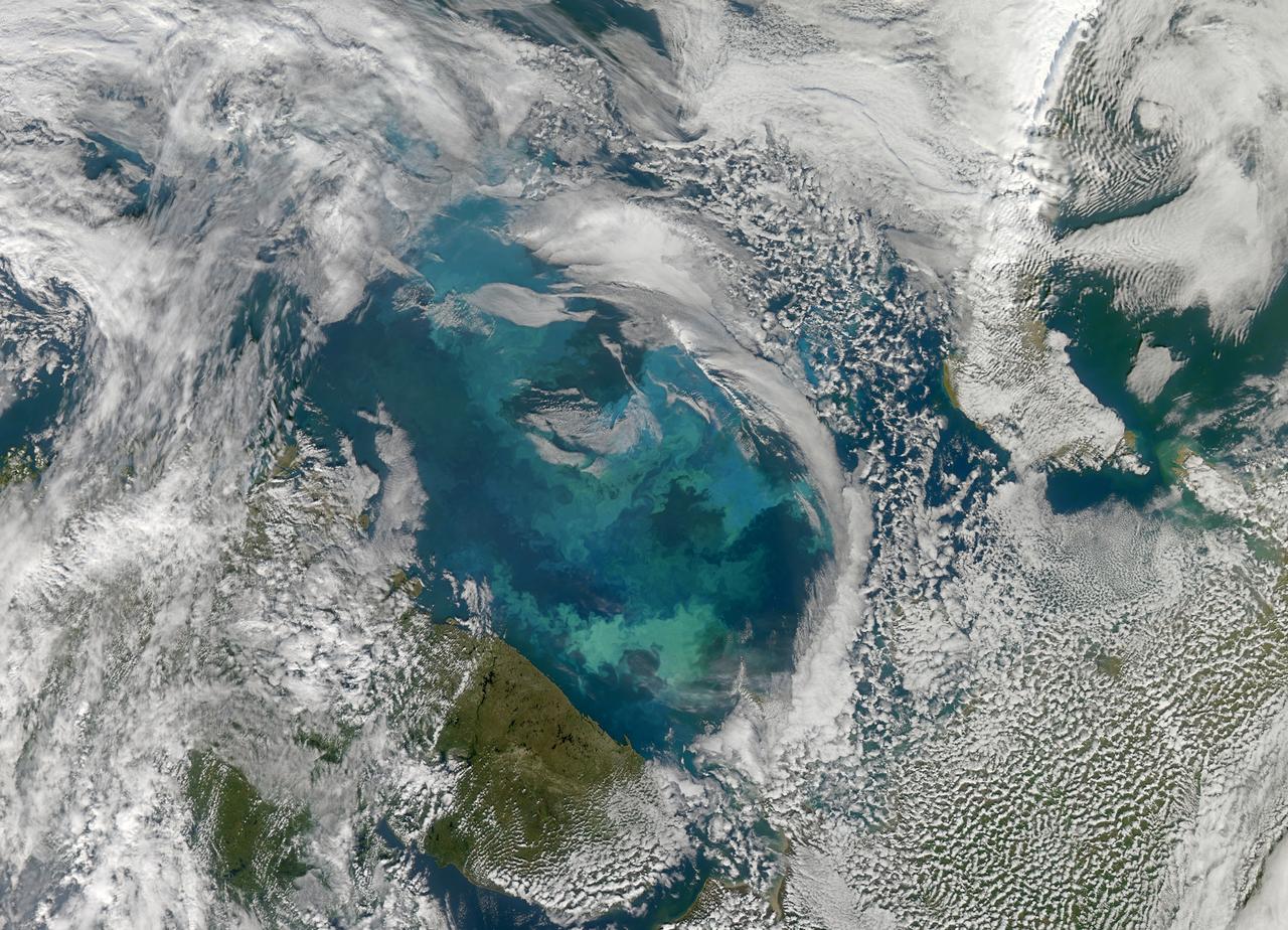
NASA image acquired August 31, 2010 To see a detail of this image go to: <a href="http://www.flickr.com/photos/gsfc/4971318856/">www.flickr.com/photos/gsfc/4971318856/</a> In this natural-color image from August 31, 2010, the ocean’s canvas swirls with turquoise, teal, navy, and green, the abstract art of the natural world. The colors were painted by a massive phytoplankton bloom made up of millions of tiny, light-reflecting organisms growing in the sunlit surface waters of the Barents Sea. Such blooms peak every August in the Barents Sea. The variations in color are caused by different species and concentrations of phytoplankton. The bright blue colors are probably from coccolithophores, a type of phytoplankton that is coated in a chalky shell that reflects light, turning the ocean a milky turquoise. Coccolithophores dominate the Barents Sea in August. Shades of green are likely from diatoms, another type of phytoplankton. Diatoms usually dominate the Barents Sea earlier in the year, giving way to coccolithophores in the late summer. However, field measurements of previous August blooms have also turned up high concentrations of diatoms. The Barents Sea is a shallow sea sandwiched between the coastline of northern Russia and Scandinavia and the islands of Svalbard, Franz Josef Land, and Novaya Zemlya. Within the shallow basin, currents carrying warm, salty water from the Atlantic collide with currents carrying cold, fresher water from the Arctic. During the winter, strong winds drive the currents and mix the waters. When winter’s sea ice retreats and light returns in the spring, diatoms thrive, typically peaking in a large bloom in late May. The shift between diatoms and coccolithophores occurs as the Barents Sea changes during the summer months. Throughout summer, perpetual light falls on the waters, gradually warming the surface. Eventually, the ocean stratifies into layers, with warm water sitting on top of cooler water. The diatoms deplete most of the nutrients in the surface waters and stop growing. Coccolithophores, on the other hand, do well in warm, nutrient-depleted water with a lot of light. In the Barents Sea, these conditions are strongest in August. The shifting conditions and corresponding change in species lead to strikingly beautiful multicolored blooms such as this one. The Moderate Resolution Imaging Spectroradiometer (MODIS) on NASA’s Aqua satellite acquired this image. NASA image courtesy Norman Kuring, NASA Ocean Color Group. Caption by Holli Riebeek. Instrument: Aqua - MODIS Click here to see more images from <b><a href="#//earthobservatory.nasa.gov/" rel="nofollow"> NASA Goddard’s Earth Observatory</a></b> <b><a href="http://www.nasa.gov/centers/goddard/home/index.html" rel="nofollow">NASA Goddard Space Flight Center</a></b> is home to the nation's largest organization of combined scientists, engineers and technologists that build spacecraft, instruments and new technology to study the Earth, the sun, our solar system, and the universe. <b>Follow us on <a href="http://twitter.com/NASA_GoddardPix" rel="nofollow">Twitter</a></b> <b>Join us on <a href="http://www.facebook.com/pages/Greenbelt-MD/NASA-Goddard/395013845897?ref=tsd" rel="nofollow">Facebook</a></b>
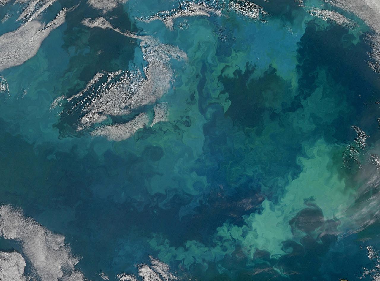
NASA image acquired August 31, 2010 To see the full view of this image go to: <a href="http://www.flickr.com/photos/gsfc/4970549945">www.flickr.com/photos/gsfc/4970549945</a> In this natural-color image from August 31, 2010, the ocean’s canvas swirls with turquoise, teal, navy, and green, the abstract art of the natural world. The colors were painted by a massive phytoplankton bloom made up of millions of tiny, light-reflecting organisms growing in the sunlit surface waters of the Barents Sea. Such blooms peak every August in the Barents Sea. The variations in color are caused by different species and concentrations of phytoplankton. The bright blue colors are probably from coccolithophores, a type of phytoplankton that is coated in a chalky shell that reflects light, turning the ocean a milky turquoise. Coccolithophores dominate the Barents Sea in August. Shades of green are likely from diatoms, another type of phytoplankton. Diatoms usually dominate the Barents Sea earlier in the year, giving way to coccolithophores in the late summer. However, field measurements of previous August blooms have also turned up high concentrations of diatoms. The Barents Sea is a shallow sea sandwiched between the coastline of northern Russia and Scandinavia and the islands of Svalbard, Franz Josef Land, and Novaya Zemlya. Within the shallow basin, currents carrying warm, salty water from the Atlantic collide with currents carrying cold, fresher water from the Arctic. During the winter, strong winds drive the currents and mix the waters. When winter’s sea ice retreats and light returns in the spring, diatoms thrive, typically peaking in a large bloom in late May. The shift between diatoms and coccolithophores occurs as the Barents Sea changes during the summer months. Throughout summer, perpetual light falls on the waters, gradually warming the surface. Eventually, the ocean stratifies into layers, with warm water sitting on top of cooler water. The diatoms deplete most of the nutrients in the surface waters and stop growing. Coccolithophores, on the other hand, do well in warm, nutrient-depleted water with a lot of light. In the Barents Sea, these conditions are strongest in August. The shifting conditions and corresponding change in species lead to strikingly beautiful multicolored blooms such as this one. The Moderate Resolution Imaging Spectroradiometer (MODIS) on NASA’s Aqua satellite acquired this image. NASA image courtesy Norman Kuring, NASA Ocean Color Group. Caption by Holli Riebeek. Instrument: Aqua - MODIS Click here to see more images from <b><a href="#//earthobservatory.nasa.gov/" rel="nofollow"> NASA Goddard’s Earth Observatory</a></b> <b><a href="http://www.nasa.gov/centers/goddard/home/index.html" rel="nofollow">NASA Goddard Space Flight Center</a></b> is home to the nation's largest organization of combined scientists, engineers and technologists that build spacecraft, instruments and new technology to study the Earth, the sun, our solar system, and the universe. <b>Follow us on <a href="http://twitter.com/NASA_GoddardPix" rel="nofollow">Twitter</a></b> <b>Join us on <a href="http://www.facebook.com/pages/Greenbelt-MD/NASA-Goddard/395013845897?ref=tsd" rel="nofollow">Facebook</a></b>

jsc2022e062020 (6/30/2022) --- Space Health will create a digital twin of the astronaut from the data collected by the Bio-Monitor and demonstrate how this could be used for autonomous health monitoring on future space missions. (Image courtesy of CSA)