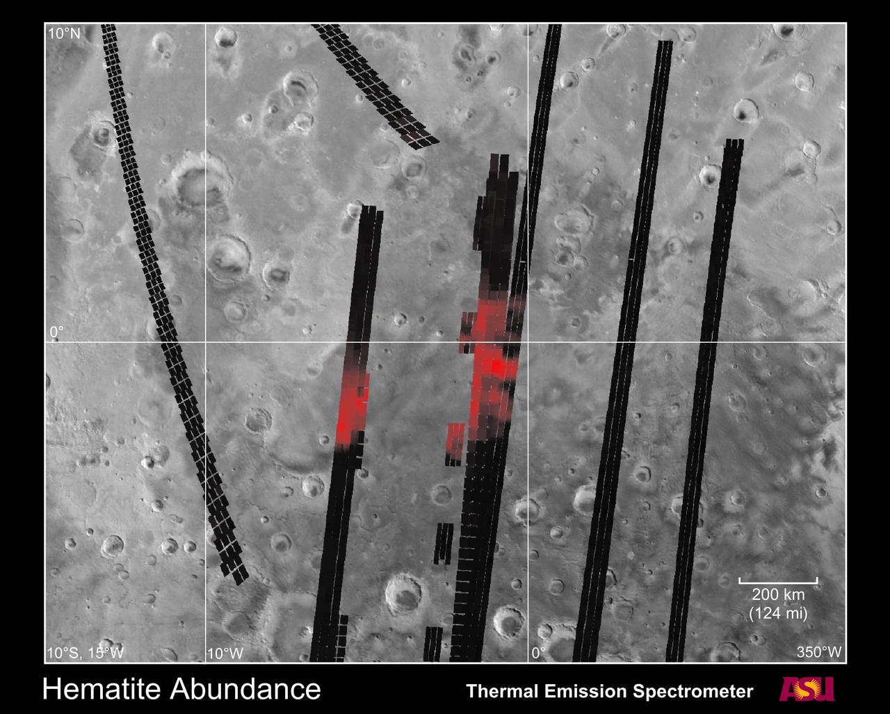
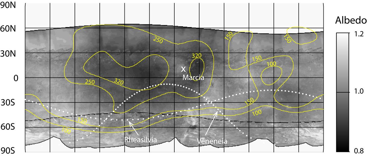
Hematite Abundance on Martian Surface

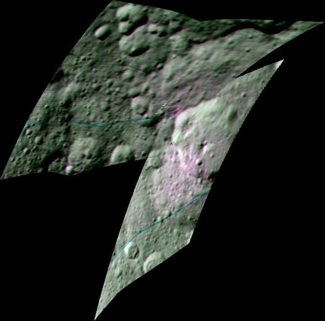
Hematite Abundance Map at Echo
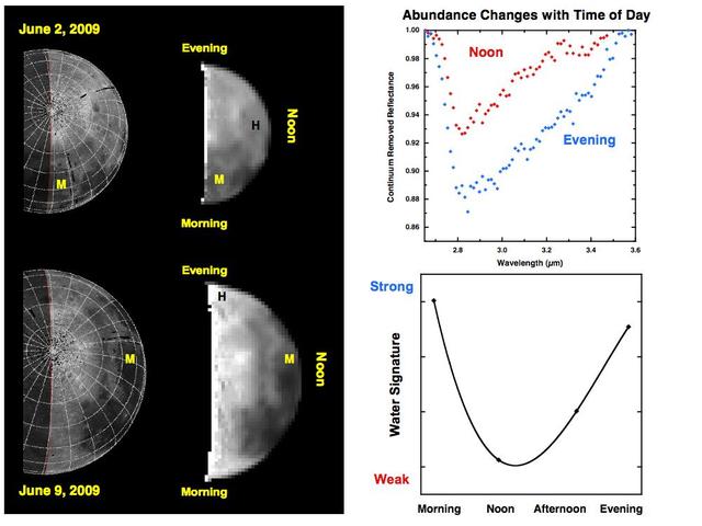
Water Abundances Change with Time of Day
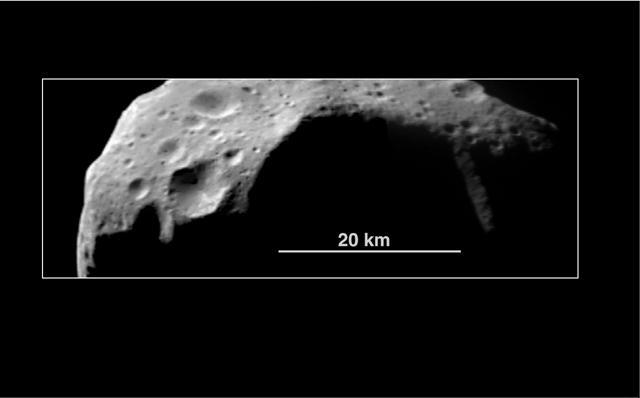
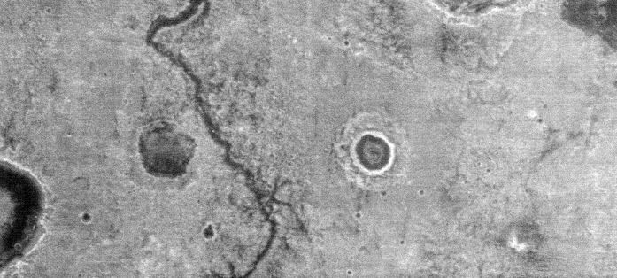
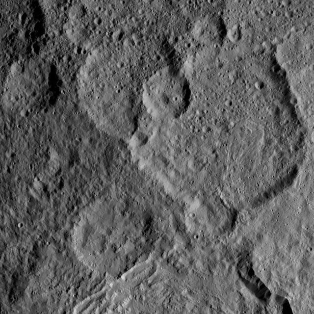
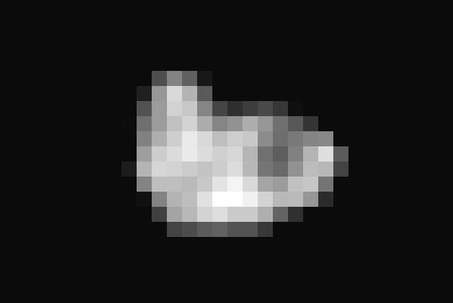
Abundance of Very Large Impact Craters on Mathilde
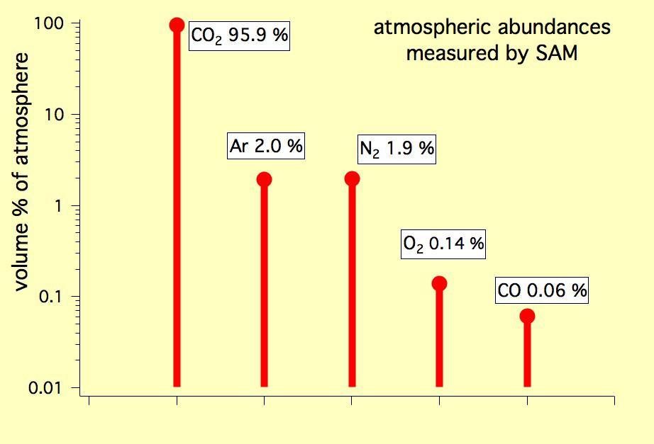
This graph shows the percentage abundance of five gases in the atmosphere of Mars, as measured by the Quadrupole Mass Spectrometer instrument of the SAM instrument suite onboard Curiosity.
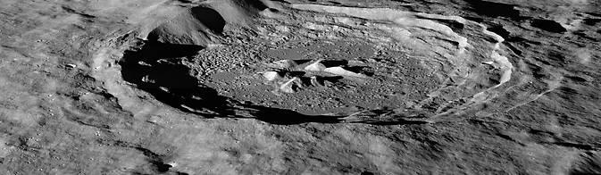
Space travel is difficult and expensive – it would cost thousands of dollars to launch a bottle of water to the moon. The recent discovery of hydrogen-bearing molecules, possibly including water, on the moon has explorers excited because these deposits could be mined if they are sufficiently abundant, sparing the considerable expense of bringing water from Earth. Lunar water could be used for drinking or its components – hydrogen and oxygen – could be used to manufacture important products on the surface that future visitors to the moon will need, like rocket fuel and breathable air. Recent observations by NASA's Lunar Reconnaissance Orbiter (LRO) spacecraft indicate these deposits may be slightly more abundant on crater slopes in the southern hemisphere that face the lunar South Pole. "There’s an average of about 23 parts-per-million-by-weight (ppmw) more hydrogen on Pole-Facing Slopes (PFS) than on Equator-Facing Slopes (EFS)," said Timothy McClanahan of NASA's Goddard Space Flight Center in Greenbelt, Maryland. This is the first time a widespread geochemical difference in hydrogen abundance between PFS and EFS on the moon has been detected. It is equal to a one-percent difference in the neutron signal detected by LRO's Lunar Exploration Neutron Detector (LEND) instrument. McClanahan is lead author of a paper about this research published online October 19 in the journal Icarus. Read more: <a href="http://1.usa.gov/1uaa8s2" rel="nofollow">1.usa.gov/1uaa8s2</a> Photo caption: LRO image of the moon's Hayn Crater, located just northeast of Mare Humboldtianum, dramatically illuminated by the low Sun casting long shadows across the crater floor. Image Credit: NASA/GSFC/Arizona State University <b><a href="http://www.nasa.gov/audience/formedia/features/MP_Photo_Guidelines.html" rel="nofollow">NASA image use policy.</a></b> <b><a href="http://www.nasa.gov/centers/goddard/home/index.html" rel="nofollow">NASA Goddard Space Flight Center</a></b> enables NASA’s mission through four scientific endeavors: Earth Science, Heliophysics, Solar System Exploration, and Astrophysics. Goddard plays a leading role in NASA’s accomplishments by contributing compelling scientific knowledge to advance the Agency’s mission. <b>Follow us on <a href="http://twitter.com/NASAGoddardPix" rel="nofollow">Twitter</a></b> <b>Like us on <a href="http://www.facebook.com/pages/Greenbelt-MD/NASA-Goddard/395013845897?ref=tsd" rel="nofollow">Facebook</a></b> <b>Find us on <a href="http://instagram.com/nasagoddard?vm=grid" rel="nofollow">Instagram</a></b>

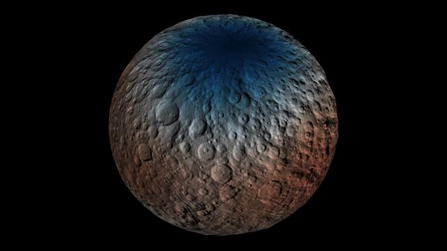
The inset perspective view from NASA Dawn space of Ceres bright spot Occator Crator is overlaid with data concerning the composition. Red signifies a high abundance of carbonates, while gray indicates a low carbonate abundance. http://photojournal.jpl.nasa.gov/catalog/PIA20694
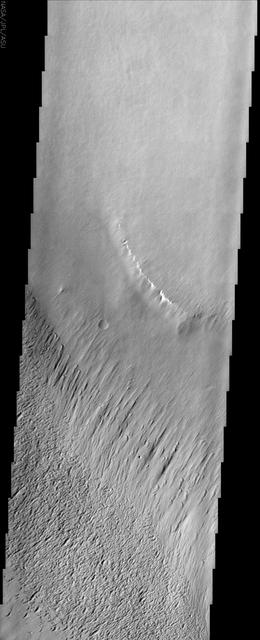
Sand is abundant of this portion of the floor of Ganges Chasma as captured by NASA 2001 Mars Odyssey.
This frame from an animation shows dwarf planet Ceres overlaid with the concentration of hydrogen determined from data acquired by the gamma ray and neutron detector GRaND instrument aboard NASA Dawn spacecraft. The hydrogen is in the upper yard (or meter) of regolith, the loose surface material on Ceres. The color scale gives hydrogen content in water-equivalent units, which assumes all of the hydrogen is in the form of H2O. Blue indicates where hydrogen content is higher, near the poles, while red indicates lower content at lower latitudes. In reality, some of the hydrogen is in the form of water ice, while a portion of the hydrogen is in the form of hydrated minerals (such as OH, in serpentine group minerals). The color information is superimposed on shaded relief map for context. A second animation (Figure 2) compares the hydrogen content of Ceres' regolith with that of the giant asteroid Vesta, which Dawn orbited from 2011 to 2012. These data show Vesta is a much drier world, with a much lower percent of hydrogen in its regolith. Both maps were produced from data acquired by GRaND. Videos are available at http://photojournal.jpl.nasa.gov/catalog/PIA21081
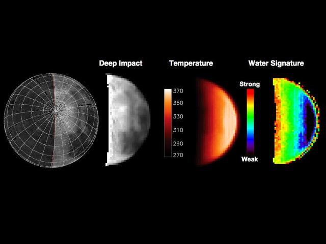
This image shows the initial ejecta that resulted when NASA Deep Impact probe collided with comet Tempel 1 at 10:52 p.m. Pacific time, July 3 1:52 a.m. Eastern time, July 4, 2005.
Hydrogen is most abundant in areas with low reflectivity, or albedo, on the giant asteroid Vesta, as shown in this contour map from NASA Dawn mission.
This nighttime thermal infrared image, taken by NASA Mars Odyssey spacecraft, shows differences in temperature that are due to differences in the abundance of rocks, sand and dust on the surface.
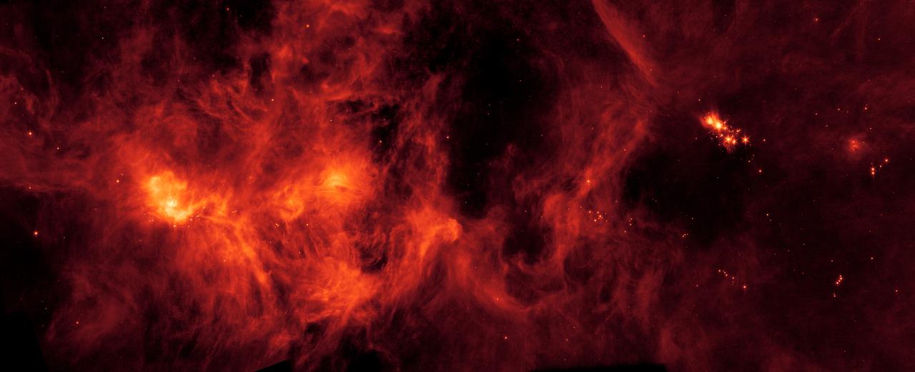
A collection of gas and dust over 500 light-years across, the Perseus Molecular Cloud hosts an abundance of young stars. It was imaged here by the NASA's Spitzer Space Telescope. https://photojournal.jpl.nasa.gov/catalog/PIA23405
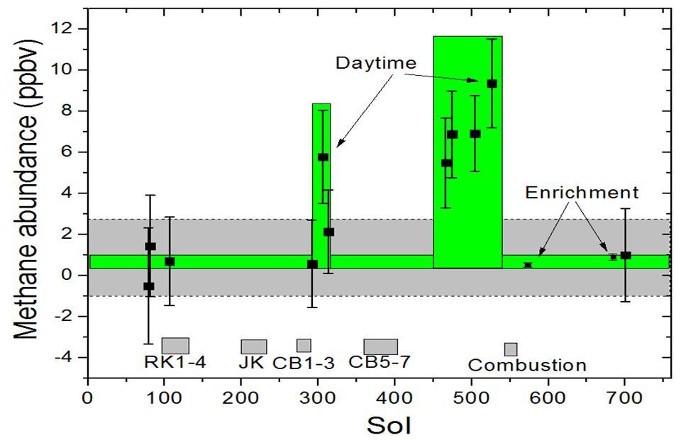
This graphic shows tenfold spiking in the abundance of methane in the Martian atmosphere surrounding NASA Curiosity Mars rover, as detected by a series of measurements made with the Tunable Laser Spectrometer instrument in the rover laboratory suite.
This image from NASA Mars Odyssey covers a portion of the Medusa Fossae formation, near the equator of Mars. The most characteristic feature of the Medusa Fossae formation is the abundance of yardangs, which are erosional landforms carved by wind.
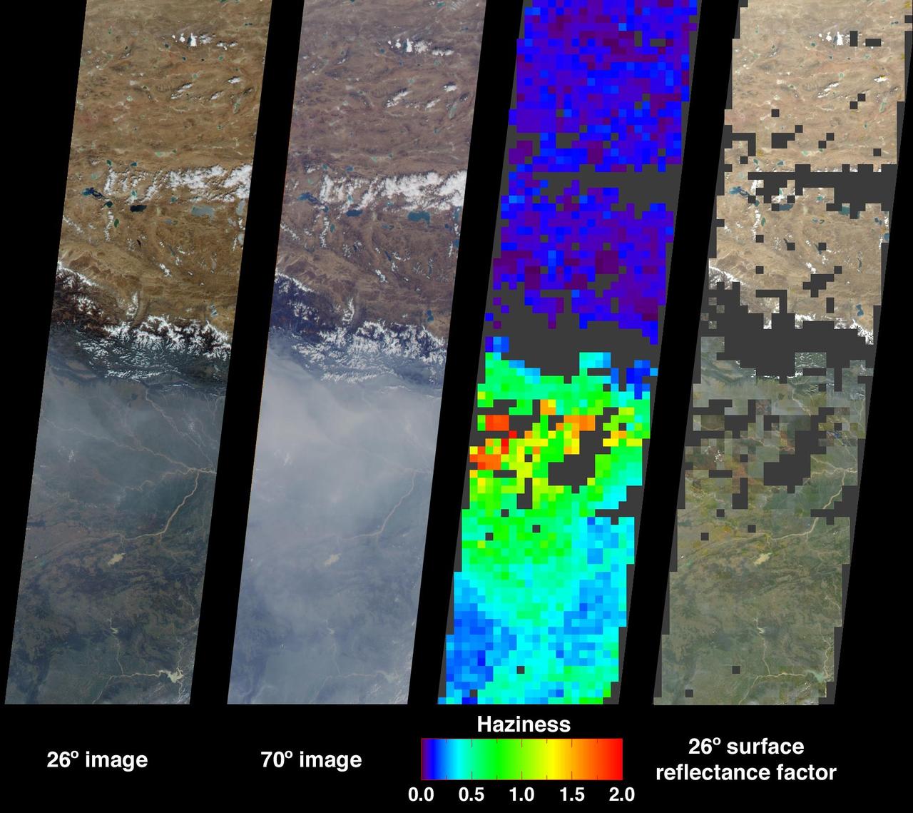
Large abundances of aerosols, or airborne particulates, over the low-lying plains of northeastern India appear in dramatic contrast with the relatively pristine air of the high-altitude Tibetan Plateau in this image from NASA Terra satellite acquired on
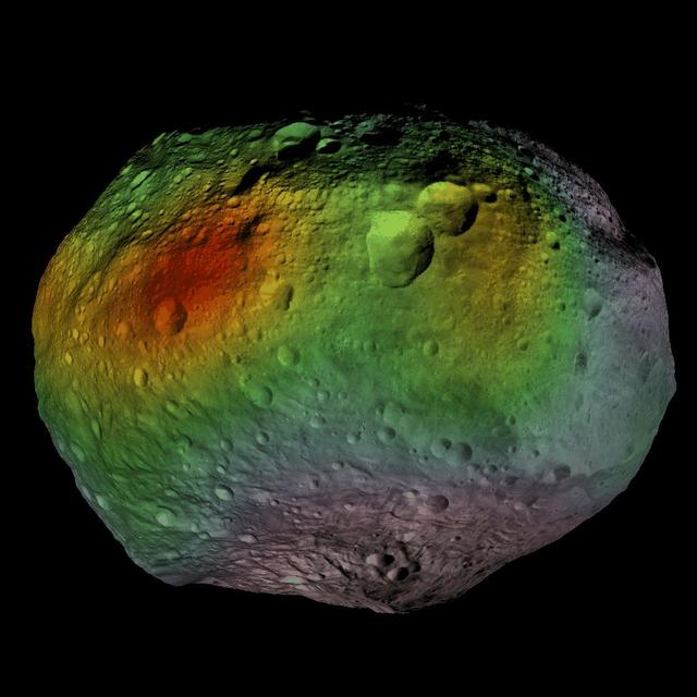
This image shows that NASA Dawn mission detected abundances of hydrogen in a wide swath around the equator of the giant asteroid Vesta. The hydrogen probably exists in the form of hydroxyl or water bound to minerals in Vesta surface.
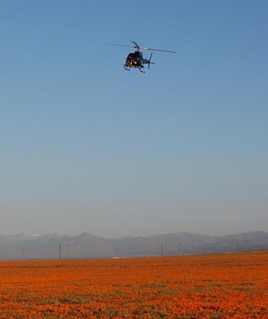
This image, taken April 9, 2010, shows a helicopter carrying an engineering test model of the landing radar for NASA Mars Science Laboratory over a patch of desert with abundant California poppies.
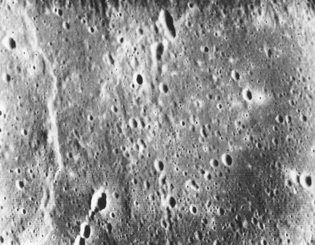
This picture, taken only minutes after NASA Mariner 10 made its closest approach to Mercury, is one of the highest resolution pictures obtained. Abundant craters in various stages of degradation dot the surface.
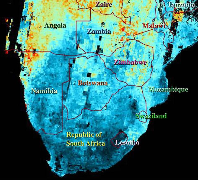
This map shows the abundance of airborne particulates, or aerosols, over Southern Africa during the period August 14-September 29, 2000, when NASA Terra satellite flew over the area.
Recurring slope lineae RSL may be due to active seeps of water. These dark flows are abundant along the steep slopes of ancient bedrock in Coprates Chasma as seen in this image from NASA Mars Reconnaissance Orbiter.
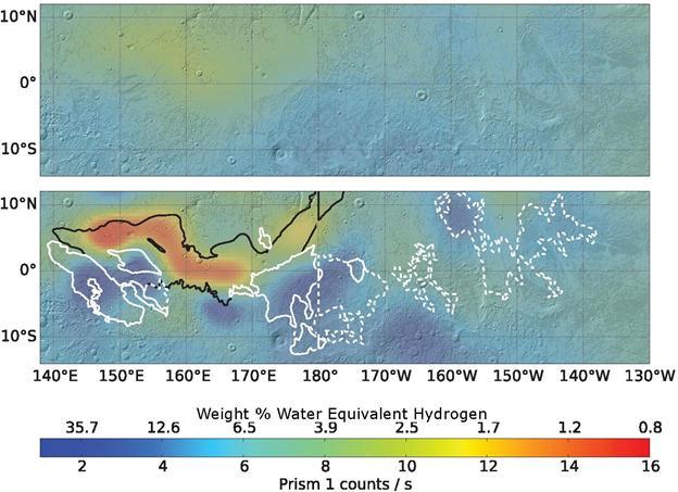
Re-analysis of 2002-2009 data from a hydrogen-finding instrument on NASA's Mars Odyssey orbiter increased the resolution of maps of hydrogen abundance. The reprocessed data (lower map) shows more "water-equivalent hydrogen" (darker blue) in some parts of this equatorial region of Mars. Puzzingly, this suggests the possible presence of water ice just beneath the surface near the equator, though it would not be thermodynamically stable there. The upper map uses raw data from Odyssey's neutron spectrometer instrument, which senses the energy state of neutrons coming from Mars, providing an indication of how much hydrogen is present in the top 3 feet (1 meter) of the surface. Hydrogen detected by Odyssey at high latitudes of Mars in 2002 was confirmed to be in the form of water ice by the follow-up NASA Phoenix Mars Lander mission in 2008. A 2017 reprocessing of the older data applied image-reconstruction techniques often used to reduce blurring from medical imaging data. The results are shown here for an area straddling the equator for about one-fourth the circumference of the planet, centered at 175 degrees west longitude. The white contours outline lobes of a formation called Medusae Fossae, coinciding with some areas of higher hydrogen abundance in the enhanced-resolution analysis. The black line indicates the limit of a relatively young lava plain, coinciding with areas of lower hydrogen abundance in the enhanced-resolution analysis. The color-coding key for hydrogen abundance in both maps is indicated by the horizontal bar, in units expressed as how much water would be present in the ground if the hydrogen is all in the form of water. Units of the equivalent water weight, as a percentage of the material in the ground, are correlated with counts recorded by the spectrometer, ranging from less than 1 weight-percent water equivalent (red) to more than 30 percent (dark blue). https://photojournal.jpl.nasa.gov/catalog/PIA21848
Ceres Haulani Crater is shown in these views from NASA Dawn spacecraft. These views reveal variations in the region brightness, mineralogy and temperature at infrared wavelengths.
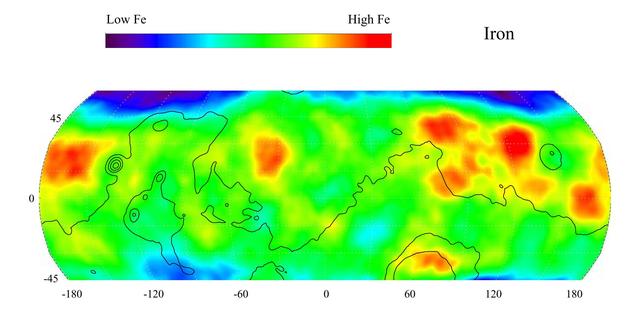
This gamma ray spectrometer map from NASA Mars Odyssey of the mid-latitude region of Mars is based on gamma-rays from the element iron, one of the most abundant elements on Mars and Earth. It is responsible for the red color on the surface of Mars.
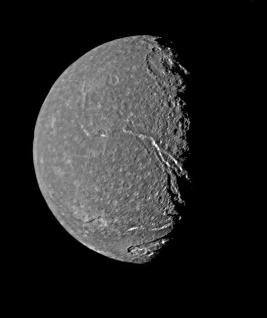
On Jan. 24, 1986, NASA Voyager 2 returned the highest-resolution picture of Titania, Uranus largest satellite. Abundant impact craters of many sizes pockmark the ancient surface; most prominent features are fault valleys that stretch across Titania. http://photojournal.jpl.nasa.gov/catalog/PIA00039

African American Advisory Group'a history month celebration; 'An Abundance of Excellence' Chronicling the Journey of the Black Astronauts. Rhonda Baker, Ernest Jennings, Nonnie Braxton
This VIS image shows part of Olympia Undae, a vast sand sea near the north pole. In regions with limited sand abundance, individual dunes form and the surface below the dunes are visible. This is the case at the top of the image. When sand abundances grow, the individual dunes coalesce into a sheet of sand hiding the underlaying surface. This is the case at the bottom of the image. Orbit Number: 80393 Latitude: 80.0028 Longitude: 143.285 Instrument: VIS Captured: 2020-01-28 21:30 https://photojournal.jpl.nasa.gov/catalog/PIA23835
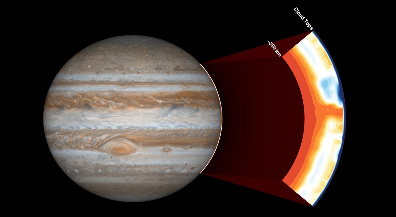
NASA's Juno spacecraft carries an instrument called the Microwave Radiometer, which examines Jupiter's atmosphere beneath the planet's cloud tops. This image shows the instrument's view of the outer part of Jupiter's atmosphere. Before Juno began using this instrument, scientists expected the atmosphere to be uniform at depths greater than 60 miles (100 kilometers). But with the Microwave Radiometer, scientists have discovered that the atmosphere has variations down to at least 220 miles (350 kilometers), as deep as the instrument can see. In the cut-out image to the right, orange signifies high ammonia abundance and blue signifies low ammonia abundance. Jupiter appears to have a band around its equator high in ammonia abundance, with a column shown in orange. This is contrary to scientists' expectations that ammonia would be uniformly mixed. https://photojournal.jpl.nasa.gov/catalog/PIA21642
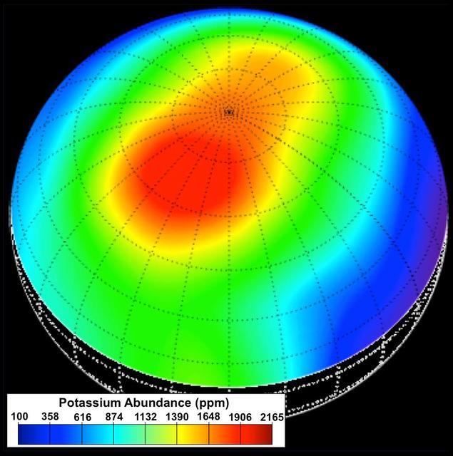
During the first year of NASA MESSENGER orbital mission, the spacecraft GRS instrument measured the elemental composition of Mercury surface materials. mong the most important discoveries from the GRS was the observation of higher abundances of the moderately volatile elements potassium, sodium, and chlorine than expected from previous scientific models and theories. Particularly high concentrations of these elements were observed at high northern latitudes, as illustrated in this potassium abundance map, which provides a view of the surface centered at 60° N latitude and 120° E longitude. This map was the first elemental map ever made of Mercury's surface and is to-date the only map to report absolute elemental concentrations, in comparison to element ratios. Prior to MESSENGER's arrival at Mercury, scientists expected that the planet would be depleted in moderately volatile elements, as is the case for our Moon. The unexpectedly high abundances observed with the GRS have forced a reevaluation of our understanding of the formation and evolution of Mercury. In addition, the K map provided the first evidence for distinct geochemical terranes on Mercury, as the high-potassium region was later found to also be distinct in its low Mg/Si, Ca/Si, S/Si, and high Na/Si and Cl/Si abundances. Instrument: Gamma-Ray Spectrometer (GRS) http://photojournal.jpl.nasa.gov/catalog/PIA19414
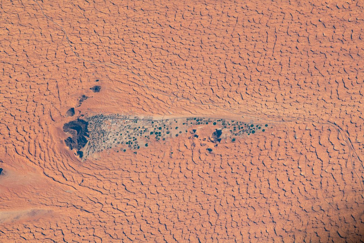
iss064e006308 (Nov. 26, 2020) --- Surrounded by the Nefud Desert, the city of Jubba, Saudi Arabia, with its abundant agriculture and plentiful water, is pictured from the International Space Station as it orbited 261 miles above.
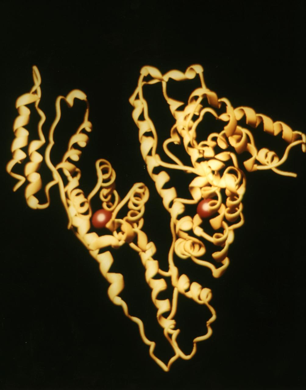
As the most abundant protein in the circulatory system albumin contributes 80% to colloid osmotic blood pressure. Albumin is also chiefly responsible for the maintenance of blood pH. It is located in every tissue and bodily secretion, with extracellular protein comprising 60% of total albumin. Perhaps the most outstanding property of albumin is its ability to bind reversibly to an incredible variety of ligands. It is widely accepted in the pharmaceutical industry that the overall distribution, metabolism, and efficiency of many drugs are rendered ineffective because of their unusually high affinity for this abundant protein. An understanding of the chemistry of the various classes of pharmaceutical interactions with albumin can suggest new approaches to drug therapy and design. Principal Investigator: Dan Carter/New Century Pharmaceuticals
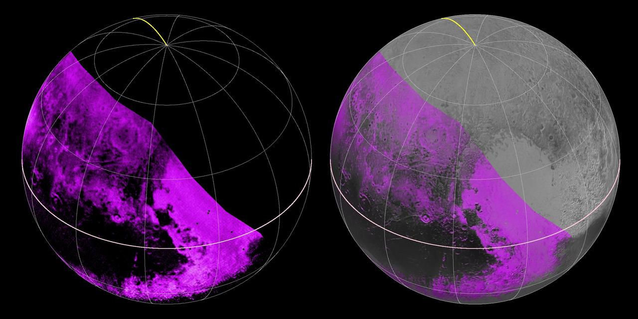
The Ralph/LEISA infrared spectrometer on NASA's New Horizons spacecraft mapped compositions across Pluto's surface as it flew past the planet on July 14, 2015. On the left, a map of methane ice abundance shows striking regional differences, with stronger methane absorption indicated by the brighter purple colors, and lower abundances shown in black. Data have only been received so far for the left half of Pluto's disk. At right, the methane map is merged with higher-resolution images from the spacecraft's Long Range Reconnaissance Imager (LORRI). http://photojournal.jpl.nasa.gov/catalog/PIA19953
It is no secret that Mercury's surface is scarred by abundant tectonic deformation, the vast majority of which is due to the planet's history of cooling and contraction through time. Yet Mercury is also heavily cratered, and hosts widespread volcanic plains. So it's perhaps unsurprising that these three types of landform often intersect-literally-as shown in this scene. Here, an unnamed crater, about 7.5 km (4.7 mi.) in diameter was covered, and almost fully buried, by lava. At some point after, compression of the surface formed scarps and ridges in the area that, when they reached the buried crater, came to describe its curved outline. Many arcuate ridges on Mercury formed this way. In this high-resolution view, we can also see the younger, later population of smaller craters that pock-mark the surface. http://photojournal.jpl.nasa.gov/catalog/PIA19263

ISS048e002079 (06/19/2016) --- A new day dawns for the crew of Expedition 48 on board the International Space Station on June 19, 2016. This inspiring image shows the golden rays of the the Sun streaming through the multiple layers of clouds to touch the Earth giving it abundant life.
jsc2020e012431 (2/27/2020) --- A preflight view of Neutron-1 internal components and harnessing. The NanoRacks-NEUTRON-1 investigation maps neutron abundance in low-Earth orbit. Data gathered on global neutron counts could contribute to better understanding of the complex relationship between Earth and the Sun. Image courtesy of HSFL

KENNEDY SPACE CENTER, FLA. -- A raccoon keeps an eye on the photographer who spotted him among the tall grasses near KSC. The nocturnal creatures are abundant in the area but usually not seen in the daytime except when breeding or caring for their young. They are most common along wooded streams.
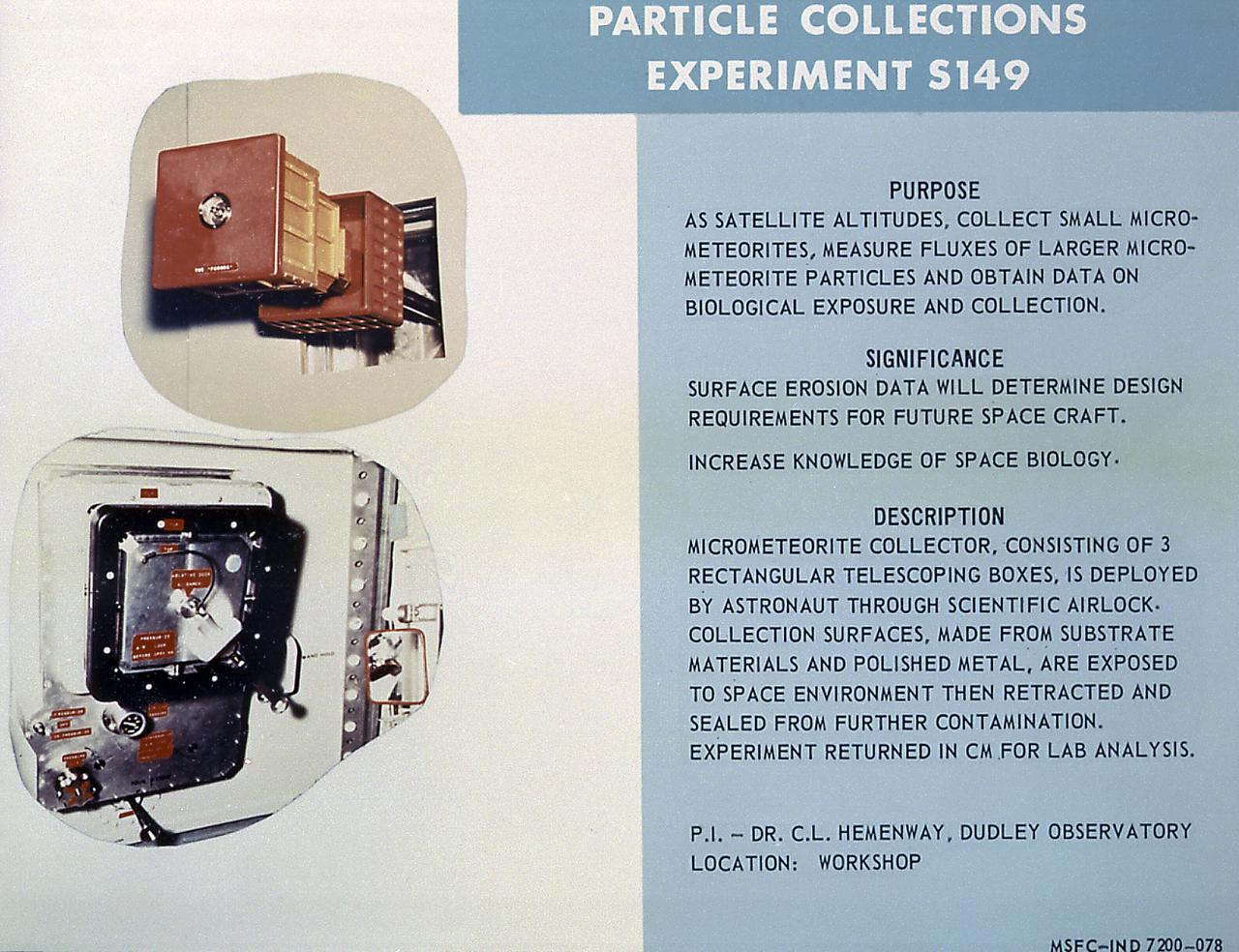
This chart describes Skylab's Particle Collection device, a scientific experiment designed to study micro-meteoroid particles in near-Earth space and determine their abundance, mass distribution, composition, and erosive effects. The Marshall Space Flight Center had program management responsibility for the development of Skylab hardware and experiments.
Contributes to many transport and regulatory processes and has multifunctional binding properties which range form various metals, to fatty acids, hormones, and a wide spectrum of therapeutic drugs. The most abundant protein of the circulatory system. It binds and transports an incredible variety of biological and pharmaceutical ligands throughout the blood stream. Principal Investigator was Larry DeLucas.
This photograph shows Skylab's Particle Collection device, a scientific experiment designed to study micro-meteoroid particles in near-Earth space and determine their abundance, mass distribution, composition, and erosive effects. The Marshall Space Flight Center had program management responsibility for the development of Skylab hardware and experiments.
This photograph shows Skylab's Nuclear Emulsion experiment, a Skylab science facility that was mounted inside the Multiple Docking Adapter used to record the relative abundance of primary, high-energy heavy nuclei outside the Earth's atmosphere. The Marshall Space Flight Center had program management responsibility for the development of Skylab hardware and experiments.

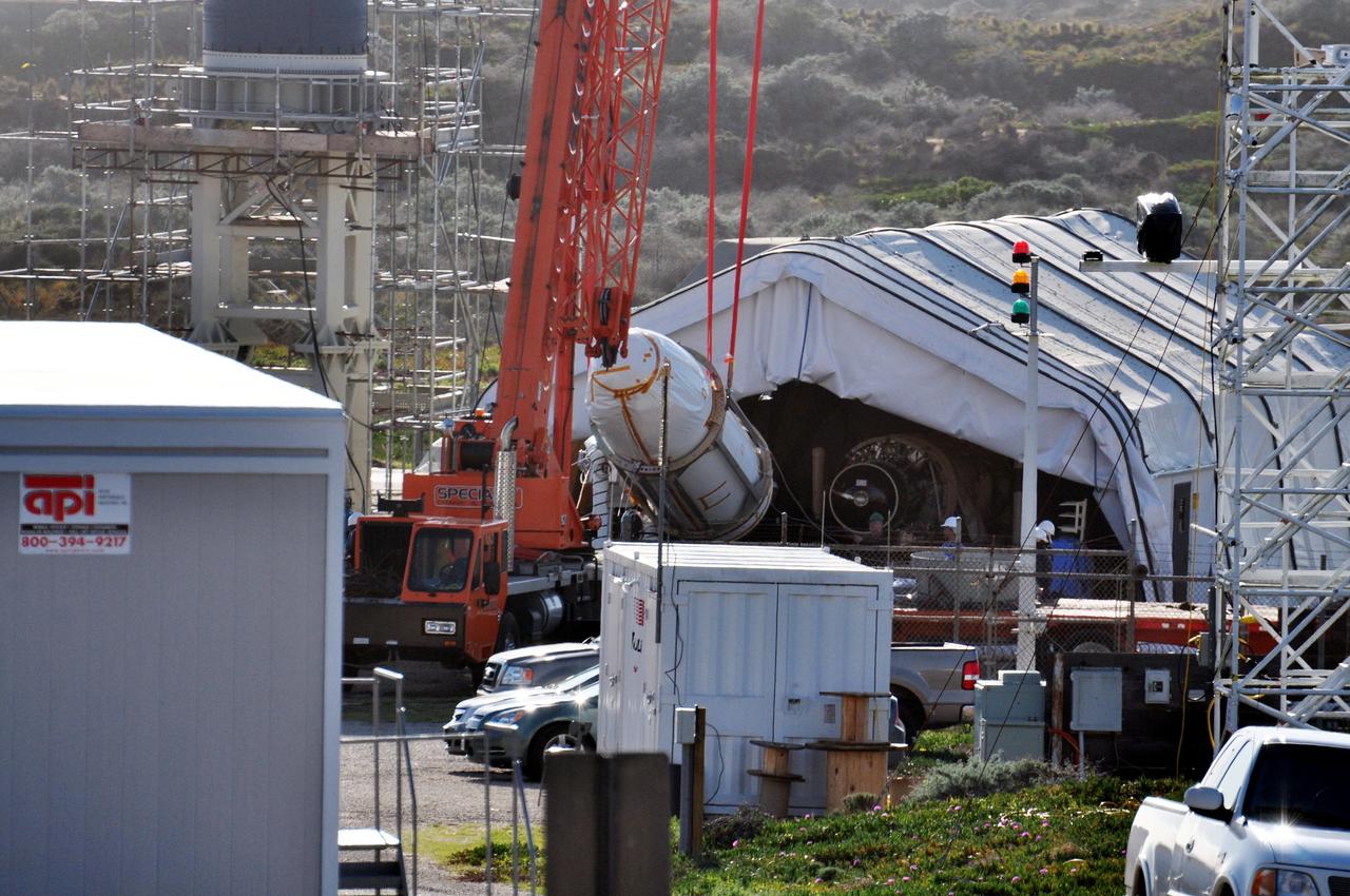
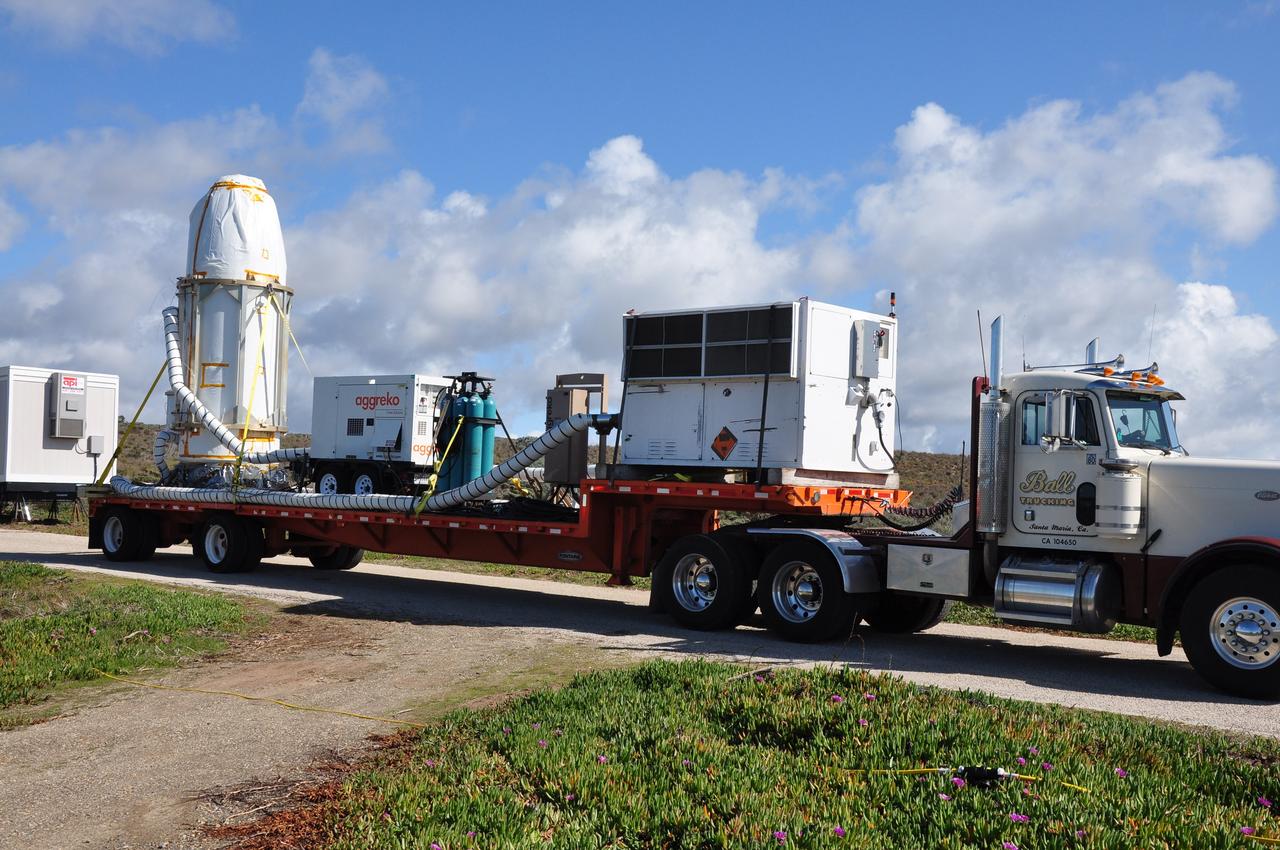
VANDENBERG AIR FORCE BASE, Calif. -- The Stage 1, 2 and 3 motors of the Taurus XL rocket are being prepared for transfer to Space Launch Complex 576-E at Vandenberg Air Force Base in California. The Taurus is the launch vehicle for NASA's Orbiting Carbon Observatory, or OCO, which is a new Earth-orbiting mission sponsored by NASA's Earth System Science Pathfinder Program. The observatory is scheduled to launch Feb. 23 from Vandenberg. The spacecraft will collect precise global measurements of carbon dioxide (CO2) in the Earth's atmosphere. Scientists will analyze OCO data to improve our understanding of the natural processes and human activities that regulate the abundance and distribution of this important greenhouse gas. This improved understanding will enable more reliable forecasts of future changes in the abundance and distribution of CO2 in the atmosphere and the effect that these changes may have on the Earth's climate. Photo credit: NASA/Randy Beaudoin, VAFB
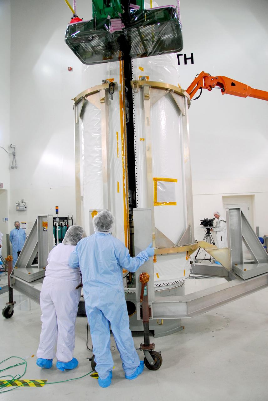
VANDENBERG AIR FORCE BASE, Calif. -- The Encapsulated Cargo Element (ECE) containing NASA's Orbiting Carbon Observatory, or OCO, is lowered to a horizontal position after arrival at Space Launch Complex 576-E at Vandenberg Air Force Base in California. The spacecraft is scheduled for launch aboard Orbital Sciences' Taurus XL rocket on Feb. 23 from Vandenberg. The spacecraft will collect precise global measurements of carbon dioxide (CO2) in the Earth's atmosphere. Scientists will analyze OCO data to improve our understanding of the natural processes and human activities that regulate the abundance and distribution of this important greenhouse gas. This improved understanding will enable more reliable forecasts of future changes in the abundance and distribution of CO2 in the atmosphere and the effect that these changes may have on the Earth's climate. Photo credit: NASA/Randy Beaudoin, VAFB

VANDENBERG AIR FORCE BASE, Calif. -- The first half of the fairing is placed around NASA's Orbiting Carbon Observatory, or OCO, at Vandenberg Air Force Base in California. The fairing is a molded structure that fits flush with the outside surface of the rocket and forms an aerodynamically smooth nose cone, protecting the spacecraft during launch and ascent. The spacecraft is scheduled for launch aboard Orbital Sciences' Taurus XL rocket on Feb. 23 from Vandenberg. The spacecraft will collect precise global measurements of carbon dioxide (CO2) in the Earth's atmosphere. Scientists will analyze OCO data to improve our understanding of the natural processes and human activities that regulate the abundance and distribution of this important greenhouse gas. This improved understanding will enable more reliable forecasts of future changes in the abundance and distribution of CO2 in the atmosphere and the effect that these changes may have on the Earth's climate. Photo credit: NASA/Robert Hargreaves Jr., VAFB
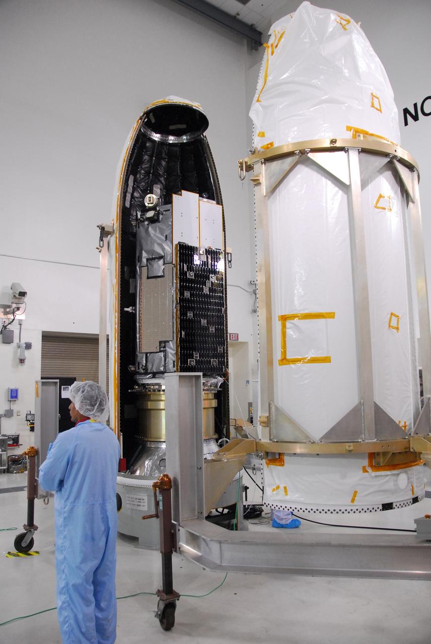
VANDENBERG AIR FORCE BASE, Calif. -- The second half of the fairing, at right, is moved closer to NASA's Orbiting Carbon Observatory, or OCO, at left, to complete installation. The work is being done in Building 1032 of Vandenberg Air Force Base in California. The fairing is a molded structure that fits flush with the outside surface of the rocket and forms an aerodynamically smooth nose cone, protecting the spacecraft during launch and ascent. The spacecraft is scheduled for launch aboard Orbital Sciences' Taurus XL rocket on Feb. 23 from Vandenberg. The spacecraft will collect precise global measurements of carbon dioxide (CO2) in the Earth's atmosphere. Scientists will analyze OCO data to improve our understanding of the natural processes and human activities that regulate the abundance and distribution of this important greenhouse gas. This improved understanding will enable more reliable forecasts of future changes in the abundance and distribution of CO2 in the atmosphere and the effect that these changes may have on the Earth's climate. Photo credit: NASA/Robert Hargreaves Jr., VAFB
VANDENBERG AIR FORCE BASE, Calif. --The Encapsulated Cargo Element (ECE) containing NASA's Orbiting Carbon Observatory, or OCO, is lowered to a horizontal position after arrival at Space Launch Complex 576-E at Vandenberg Air Force Base in California. The spacecraft is scheduled for launch aboard Orbital Sciences' Taurus XL rocket on Feb. 23 from Vandenberg. The spacecraft will collect precise global measurements of carbon dioxide (CO2) in the Earth's atmosphere. Scientists will analyze OCO data to improve our understanding of the natural processes and human activities that regulate the abundance and distribution of this important greenhouse gas. This improved understanding will enable more reliable forecasts of future changes in the abundance and distribution of CO2 in the atmosphere and the effect that these changes may have on the Earth's climate. Photo credit: NASA/Randy Beaudoin, VAFB
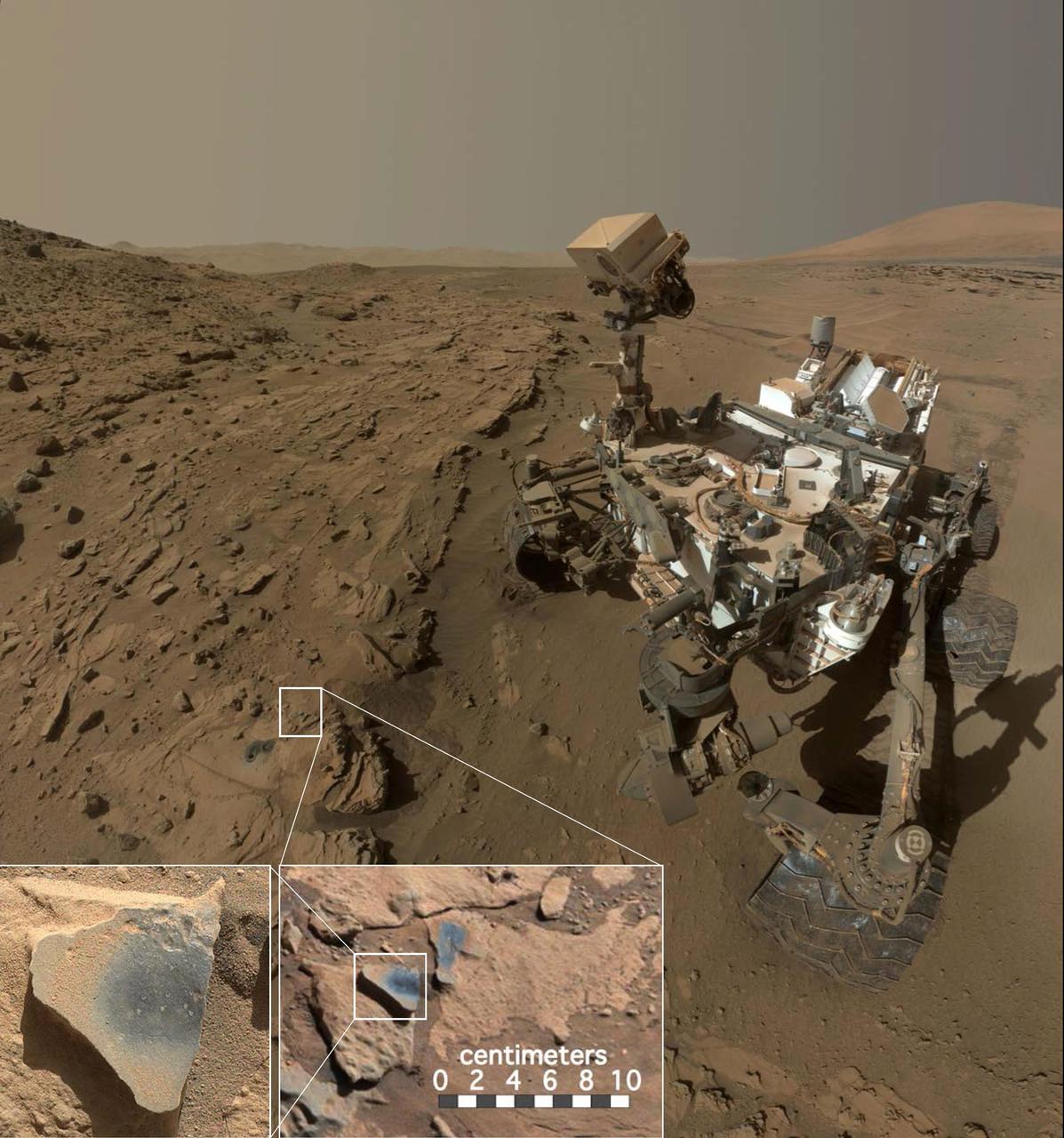
This scene shows NASA's Curiosity Mars rover at a location called "Windjana," where the rover found rocks containing manganese-oxide minerals, which require abundant water and strongly oxidizing conditions to form. In front of the rover are two holes from the rover's sample-collection drill and several dark-toned features that have been cleared of dust (see inset images). These flat features are erosion-resistant fracture fills containing manganese oxides. The discovery of these materials suggests the Martian atmosphere might once have contained higher abundances of free oxygen than it does now. The rover used the Mars Hand Lens Imager (MAHLI) camera in April and May 2014 to take dozens of images that were combined into this self-portrait. http://photojournal.jpl.nasa.gov/catalog/PIA20752

VANDENBERG AIR FORCE BASE, Calif. -- NASA's Orbiting Carbon Observatory, or OCO, arrives at Space Launch Complex 576-E at Vandenberg Air Force Base in California. The spacecraft is scheduled for launch aboard Orbital Sciences' Taurus XL rocket on Feb. 23 from Vandenberg. The spacecraft will collect precise global measurements of carbon dioxide (CO2) in the Earth's atmosphere. Scientists will analyze OCO data to improve our understanding of the natural processes and human activities that regulate the abundance and distribution of this important greenhouse gas. This improved understanding will enable more reliable forecasts of future changes in the abundance and distribution of CO2 in the atmosphere and the effect that these changes may have on the Earth's climate. Photo credit: NASA/Randy Beaudoin, VAFB
Vandenberg Air Force Base, Calif. – In the Astrotech Payload Processing Facility at Vandenberg Air Force Base in California, preparations are under way to fuel NASA's Orbiting Carbon Observatory, or OCO, with hydrazine thruster control propellant. The OCO is a new Earth-orbiting mission sponsored by NASA's Earth System Science Pathfinder Program. The OCO mission will collect precise global measurements of carbon dioxide (CO2) in the Earth's atmosphere. Scientists will analyze OCO data to improve our understanding of the natural processes and human activities that regulate the abundance and distribution of this important greenhouse gas. This improved understanding will enable more reliable forecasts of future changes in the abundance and distribution of CO2 in the atmosphere and the effect that these changes may have on the Earth's climate. The launch of OCO is scheduled for Feb. 23 from Vandenberg. Photo credit: Robert Hargreaves Jr., VAFB

VANDENBERG AIR FORCE BASE, Calif. -- Workers secure the installation of the fairing around NASA's Orbiting Carbon Observatory, or OCO. The work is being done in Building 1032 of Vandenberg Air Force Base in California. The fairing is a molded structure that fits flush with the outside surface of the rocket and forms an aerodynamically smooth nose cone, protecting the spacecraft during launch and ascent. The spacecraft is scheduled for launch aboard Orbital Sciences' Taurus XL rocket on Feb. 23 from Vandenberg. The spacecraft will collect precise global measurements of carbon dioxide (CO2) in the Earth's atmosphere. Scientists will analyze OCO data to improve our understanding of the natural processes and human activities that regulate the abundance and distribution of this important greenhouse gas. This improved understanding will enable more reliable forecasts of future changes in the abundance and distribution of CO2 in the atmosphere and the effect that these changes may have on the Earth's climate. Photo credit: NASA/Robert Hargreaves Jr., VAFB

VANDENBERG AIR FORCE BASE, Calif. -- The Encapsulated Cargo Element containing NASA's Orbiting Carbon Observatory, or OCO, is lifted from its transporter on Space Launch Complex 576-E at Vandenberg Air Force Base in California. The spacecraft is scheduled for launch aboard Orbital Sciences' Taurus XL rocket on Feb. 23 from Vandenberg. The spacecraft will collect precise global measurements of carbon dioxide (CO2) in the Earth's atmosphere. Scientists will analyze OCO data to improve our understanding of the natural processes and human activities that regulate the abundance and distribution of this important greenhouse gas. This improved understanding will enable more reliable forecasts of future changes in the abundance and distribution of CO2 in the atmosphere and the effect that these changes may have on the Earth's climate. Photo credit: NASA/Randy Beaudoin, VAFB

VANDENBERG AIR FORCE BASE, Calif. --The Encapsulated Cargo Element containing NASA's Orbiting Carbon Observatory, or OCO, lowered to a horizontal position on a transporter, is moved under a protective tent after arrival at Space Launch Complex 576-E at Vandenberg Air Force Base in California. The spacecraft is scheduled for launch aboard Orbital Sciences' Taurus XL rocket on Feb. 23 from Vandenberg. The spacecraft will collect precise global measurements of carbon dioxide (CO2) in the Earth's atmosphere. Scientists will analyze OCO data to improve our understanding of the natural processes and human activities that regulate the abundance and distribution of this important greenhouse gas. This improved understanding will enable more reliable forecasts of future changes in the abundance and distribution of CO2 in the atmosphere and the effect that these changes may have on the Earth's climate. Photo credit: NASA/Randy Beaudoin, VAFB
VANDENBERG AIR FORCE BASE, Calif. -- NASA's Orbiting Carbon Observatory, or OCO, is transported to Space Launch Complex 576-E at Vandenberg Air Force Base in California. The spacecraft is scheduled for launch aboard Orbital Sciences' Taurus XL rocket on Feb. 23 from Vandenberg. The spacecraft will collect precise global measurements of carbon dioxide (CO2) in the Earth's atmosphere. Scientists will analyze OCO data to improve our understanding of the natural processes and human activities that regulate the abundance and distribution of this important greenhouse gas. This improved understanding will enable more reliable forecasts of future changes in the abundance and distribution of CO2 in the atmosphere and the effect that these changes may have on the Earth's climate. Photo credit: NASA/Randy Beaudoin, VAFB

Vandenberg Air Force Base, Calif. – In the Astrotech Payload Processing Facility at Vandenberg Air Force Base in California, a technician monitors data during fueling of NASA's Orbiting Carbon Observatory, or OCO, with hydrazine thruster control propellant. The OCO is a new Earth-orbiting mission sponsored by NASA's Earth System Science Pathfinder Program. The OCO mission will collect precise global measurements of carbon dioxide (CO2) in the Earth's atmosphere. Scientists will analyze OCO data to improve our understanding of the natural processes and human activities that regulate the abundance and distribution of this important greenhouse gas. This improved understanding will enable more reliable forecasts of future changes in the abundance and distribution of CO2 in the atmosphere and the effect that these changes may have on the Earth's climate. The launch of OCO is scheduled for Feb. 23 from Vandenberg. Photo credit: Robert Hargreaves Jr., VAFB

VANDENBERG AIR FORCE BASE, Calif. -- The Stage 1, 2 and 3 motors of the Taurus XL rocket are being prepared for transfer to Space Launch Complex 576-E at Vandenberg Air Force Base in California. The Taurus is the launch vehicle for NASA's Orbiting Carbon Observatory, or OCO, which is a new Earth-orbiting mission sponsored by NASA's Earth System Science Pathfinder Program. The observatory is scheduled to launch Feb. 23 from Vandenberg. The spacecraft will collect precise global measurements of carbon dioxide (CO2) in the Earth's atmosphere. Scientists will analyze OCO data to improve our understanding of the natural processes and human activities that regulate the abundance and distribution of this important greenhouse gas. This improved understanding will enable more reliable forecasts of future changes in the abundance and distribution of CO2 in the atmosphere and the effect that these changes may have on the Earth's climate. Photo credit: NASA/Randy Beaudoin, VAFB

VANDENBERG AIR FORCE BASE, Calif. -- NASA's Orbiting Carbon Observatory, or OCO, arrives at Space Launch Complex 576-E at Vandenberg Air Force Base in California. The spacecraft is scheduled for launch aboard Orbital Sciences' Taurus XL rocket, being erected at left, on Feb. 23 from Vandenberg. The spacecraft will collect precise global measurements of carbon dioxide (CO2) in the Earth's atmosphere. Scientists will analyze OCO data to improve our understanding of the natural processes and human activities that regulate the abundance and distribution of this important greenhouse gas. This improved understanding will enable more reliable forecasts of future changes in the abundance and distribution of CO2 in the atmosphere and the effect that these changes may have on the Earth's climate. Photo credit: NASA/Randy Beaudoin, VAFB
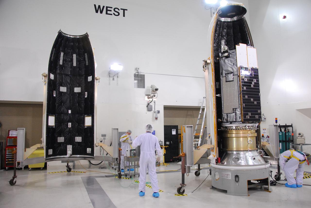
VANDENBERG AIR FORCE BASE, Calif. -- At left, the second half of the fairing is moved toward NASA's Orbiting Carbon Observatory, or OCO, at right, for installation. The work is being done in Building 1032 of Vandenberg Air Force Base in California. The fairing is a molded structure that fits flush with the outside surface of the rocket and forms an aerodynamically smooth nose cone, protecting the spacecraft during launch and ascent. The spacecraft is scheduled for launch aboard Orbital Sciences' Taurus XL rocket on Feb. 23 from Vandenberg. The spacecraft will collect precise global measurements of carbon dioxide (CO2) in the Earth's atmosphere. Scientists will analyze OCO data to improve our understanding of the natural processes and human activities that regulate the abundance and distribution of this important greenhouse gas. This improved understanding will enable more reliable forecasts of future changes in the abundance and distribution of CO2 in the atmosphere and the effect that these changes may have on the Earth's climate. Photo credit: NASA/Robert Hargreaves Jr., VAFB
VANDENBERG AIR FORCE BASE, Calif. -- Workers check the movement of the fairing at right toward NASA's Orbiting Carbon Observatory, or OCO, at left, to complete installation. The work is being done in Building 1032 of Vandenberg Air Force Base in California. The fairing is a molded structure that fits flush with the outside surface of the rocket and forms an aerodynamically smooth nose cone, protecting the spacecraft during launch and ascent. The spacecraft is scheduled for launch aboard Orbital Sciences' Taurus XL rocket on Feb. 23 from Vandenberg. The spacecraft will collect precise global measurements of carbon dioxide (CO2) in the Earth's atmosphere. Scientists will analyze OCO data to improve our understanding of the natural processes and human activities that regulate the abundance and distribution of this important greenhouse gas. This improved understanding will enable more reliable forecasts of future changes in the abundance and distribution of CO2 in the atmosphere and the effect that these changes may have on the Earth's climate. Photo credit: NASA/Robert Hargreaves Jr., VAFB

VANDENBERG AIR FORCE BASE, Calif. -- The Stage 1, 2 and 3 motors of the Taurus XL rocket are being prepared for transfer to Space Launch Complex 576-E at Vandenberg Air Force Base in California. The Taurus is the launch vehicle for NASA's Orbiting Carbon Observatory, or OCO, which is a new Earth-orbiting mission sponsored by NASA's Earth System Science Pathfinder Program. The observatory is scheduled to launch Feb. 23 from Vandenberg. The spacecraft will collect precise global measurements of carbon dioxide (CO2) in the Earth's atmosphere. Scientists will analyze OCO data to improve our understanding of the natural processes and human activities that regulate the abundance and distribution of this important greenhouse gas. This improved understanding will enable more reliable forecasts of future changes in the abundance and distribution of CO2 in the atmosphere and the effect that these changes may have on the Earth's climate. Photo credit: NASA/Randy Beaudoin, VAFB

VANDENBERG AIR FORCE BASE, Calif. -- The second half of the fairing is prepared for installation around NASA's Orbiting Carbon Observatory, or OCO, at Vandenberg Air Force Base in California. The fairing is a molded structure that fits flush with the outside surface of the rocket and forms an aerodynamically smooth nose cone, protecting the spacecraft during launch and ascent. The spacecraft is scheduled for launch aboard Orbital Sciences' Taurus XL rocket on Feb. 23 from Vandenberg. The spacecraft will collect precise global measurements of carbon dioxide (CO2) in the Earth's atmosphere. Scientists will analyze OCO data to improve our understanding of the natural processes and human activities that regulate the abundance and distribution of this important greenhouse gas. This improved understanding will enable more reliable forecasts of future changes in the abundance and distribution of CO2 in the atmosphere and the effect that these changes may have on the Earth's climate. Photo credit: NASA/Robert Hargreaves Jr., VAFB

Vandenberg Air Force Base, Calif. – In the Astrotech Payload Processing Facility at Vandenberg Air Force Base in California, a technician monitors data during fueling of NASA's Orbiting Carbon Observatory, or OCO, with hydrazine thruster control propellant. The OCO is a new Earth-orbiting mission sponsored by NASA's Earth System Science Pathfinder Program. The OCO mission will collect precise global measurements of carbon dioxide (CO2) in the Earth's atmosphere. Scientists will analyze OCO data to improve our understanding of the natural processes and human activities that regulate the abundance and distribution of this important greenhouse gas. This improved understanding will enable more reliable forecasts of future changes in the abundance and distribution of CO2 in the atmosphere and the effect that these changes may have on the Earth's climate. The launch of OCO is scheduled for Feb. 23 from Vandenberg. Photo credit: Robert Hargreaves Jr., VAFB

Vandenberg Air Force Base, Calif. – In the Astrotech Payload Processing Facility at Vandenberg Air Force Base in California, preparations are under way to fuel NASA's Orbiting Carbon Observatory, or OCO, with hydrazine thruster control propellant. The OCO is a new Earth-orbiting mission sponsored by NASA's Earth System Science Pathfinder Program. The OCO mission will collect precise global measurements of carbon dioxide (CO2) in the Earth's atmosphere. Scientists will analyze OCO data to improve our understanding of the natural processes and human activities that regulate the abundance and distribution of this important greenhouse gas. This improved understanding will enable more reliable forecasts of future changes in the abundance and distribution of CO2 in the atmosphere and the effect that these changes may have on the Earth's climate. The launch of OCO is scheduled for Feb. 23 from Vandenberg. Photo credit: Robert Hargreaves Jr., VAFB
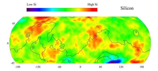
This gamma ray spectrometer map of the mid-latitude region of Mars is based on gamma-rays from the element silicon. Silicon is one of the most abundant elements on the surface of both Mars and Earth (second only to oxygen). The most extensive region of highest silicon content, shown in red, is located in the high latitudes north of Tharsis (centered near 45 degrees latitude, -120 degrees longitude). The area of lowest silicon content, shown in blue, lies just to the east of the Hellas Basin (-45 degrees latitude, 90 degrees longitude). Contours of constant surface elevation are also shown. The long continuous contour line running from east to west marks the approximate separation of the younger lowlands in the north from the older highlands in the south. http://photojournal.jpl.nasa.gov/catalog/PIA04256

NASA’s T-34 aircraft flown from the agency’s Armstrong Flight Research Center aims the plane toward Southern California’s Antelope Valley Poppy Reserve flying over yellow wildflowers. The aircraft was flown from the agency’s Armstrong Flight Research Center.

CAPE CANAVERAL, Fla. -- Sunrise is reflected in the water abundant on NASA's Kennedy Space Center in Florida. In the background are Launch Pad 39A and the Rotation/Processing Facility, which supported solid rocket booster preparations during the Space Shuttle Program. On this particular morning, preparations are underway for a launch from Space Launch Complex-41 on Cape Canaveral Air Force Station, a part of the spaceport which neighbors Kennedy Space Center. For more information, visit http://www.nasa.gov/centers/kennedy. Photo credit: NASA/Ben Smegelsky
![SCI2016_0001: SOFIA/GREAT [O I] spectrum at 4.7 THz (63 μm) superimposed on a picture of Mars. Absorption line depth is approximately 10% of the continuum. The abundance of atomic oxygen computed from the data is less than expected from the Forget et al. 1999 global circulation & photochemical model. Credit: SOFIA/GREAT spectrum: NASA/DLR/USRA/DSI/MPIfR/GREAT Consortium/MPIfS/Rezac et al. 2015; Mars image: NASA](https://images-assets.nasa.gov/image/ACD17-0168-003/ACD17-0168-003~medium.jpg)
SCI2016_0001: SOFIA/GREAT [O I] spectrum at 4.7 THz (63 μm) superimposed on a picture of Mars. Absorption line depth is approximately 10% of the continuum. The abundance of atomic oxygen computed from the data is less than expected from the Forget et al. 1999 global circulation & photochemical model. Credit: SOFIA/GREAT spectrum: NASA/DLR/USRA/DSI/MPIfR/GREAT Consortium/MPIfS/Rezac et al. 2015; Mars image: NASA

KENNEDY SPACE CENTER, FLA. -- A moth with unusual markings is captured on the ground at NASA's Kennedy Space Center. Insects are abundant throughout the center as it shares a boundary with the Merritt Island National Wildlife Refuge. Approximately one half of the Refuge's 140,000 acres consists of brackish estuaries and marshes. The remaining lands consist of coastal dunes, scrub oaks, pine forests and flatwoods, and palm and oak hammocks. Photo credit: NASA/Amanda Diller
This view, taken on Oct. 21, 2016, from NASA Dawn spacecraft shows Megwomets Crater on Ceres. Megwomets is the largest crater in this image, at right of center. The crater is named for a Yurok god of acorns and distributor of vegetal abundance. Dawn took this image on Oct. 21, 2016, from its second extended-mission science orbit (XMO2), at a distance of about 920 miles (1,480 kilometers) above the surface. The image resolution is about 460 feet (140 meters) per pixel. http://photojournal.jpl.nasa.gov/catalog/PIA21245
STS085-502-104 (7 - 19 August 1997) --- The abundant plankton, microscopic organisms, are taking the shape of the currents in the Baltic Sea offshore from Gdansk, Poland. Plankton blooms occur when there is enough nutrient in the water to support rapid growth and reproduction of the microorganisms. Gdansk is situated at the mouth of the Vistula River on the north coast of Poland. It is a major industrial center for shipyards, metallurgical and chemical plants, timber mills, food-processing facilities and more recently (since 1975) for coal exports and petroleum imports.
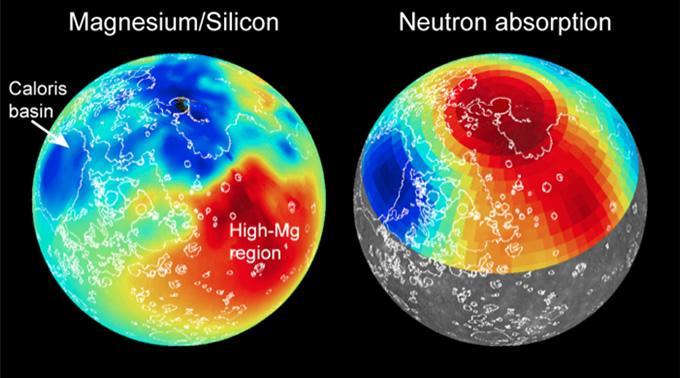
Maps of magnesium/silicon (left) and thermal neutron absorption (right) across Mercury's surface (red indicates high values, blue low) are shown. These maps, together with maps of other elemental abundances, reveal the presence of distinct geochemical terranes. Volcanic smooth plains deposits are outlined in white. Read the mission news story to learn more! http://photojournal.jpl.nasa.gov/catalog/PIA19242
VANDENBERG AIR FORCE BASE, Calif. -- On Launch Complex 576-E at Vandenberg Air Force Base in California, NASA's Orbiting Carbon Observatory, or OCO, spacecraft waits atop Orbital Sciences' Taurus XL rocket to launch Feb. 24. The spacecraft will collect precise global measurements of carbon dioxide (CO2) in the Earth's atmosphere. Scientists will analyze OCO data to improve our understanding of the natural processes and human activities that regulate the abundance and distribution of this important greenhouse gas. Photo courtesy of Glenn Weigle, Orbital Sciences
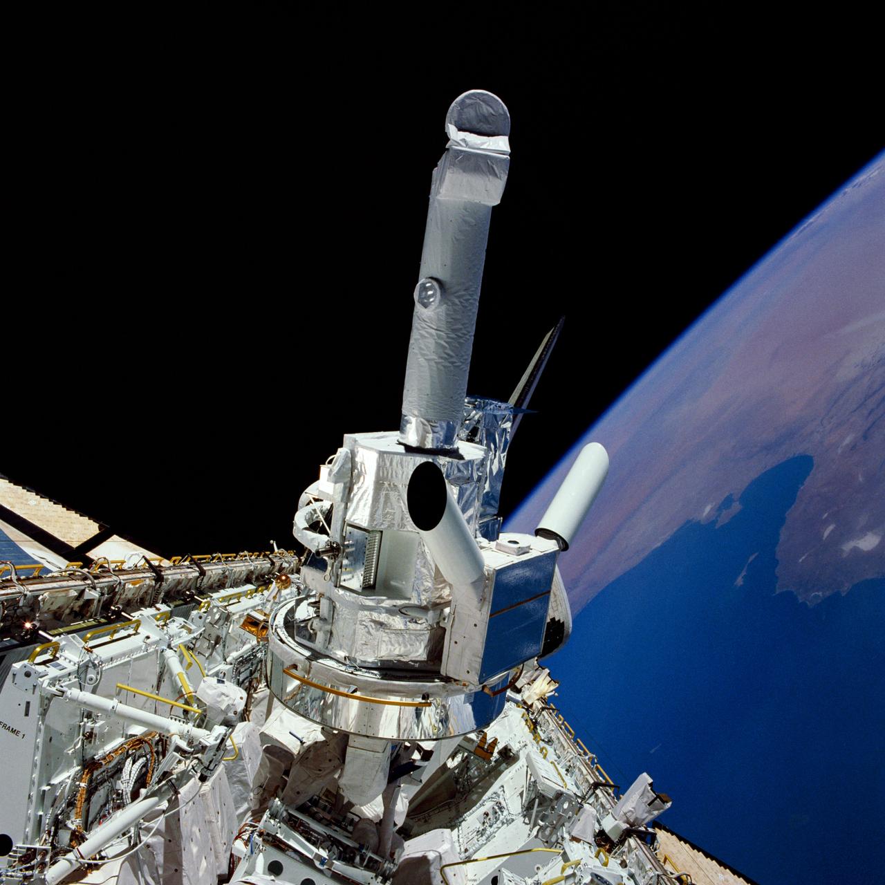
51F-33-005 (29 July - 6 August 1985) --- Experiments and the instrument pointing system (IPS) for Spacelab 2 are backdropped against the Libya/Tunisia Mediterranean coast and black space in this 70mm view photographed through the aft flight deck windows of the Space Shuttle Challenger. Also partially visible among the cluster of Spacelab 2 hardware are the solar optical universal polarimeter (SOUP) experiment and the coronal helium abundance experiment (CHASE).

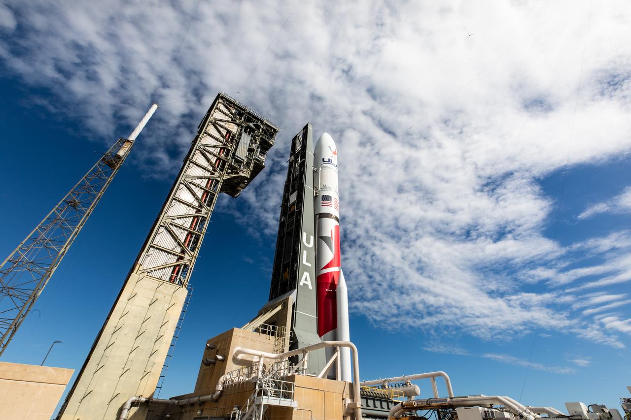
Ahead of launch as part of NASA’s Commercial Lunar Payload Services (CLPS) initiative, Astrobotic’s Peregrine lunar lander is encapsulated in the payload fairing, or nose cone, of United Launch Alliance’s Vulcan rocket on Nov. 21, 2023, at Astrotech Space Operations Facility near the agency’s Kennedy Space Center in Florida. Launch of Astrobotic’s Peregrine Mission One will carry NASA and commercial payloads to the Moon in early 2024 to study the lunar exosphere, thermal properties, and hydrogen abundance of the lunar regolith, magnetic fields, and the radiation environment of the lunar surface.
P-21744 C Range: 4.2 million kilometers (2.6 million miles) In this image of Europa acquired by Voyager 2, global scale dark streaks are becoming visible. Europa, the size of the earth's moon, is apparently covered by water ice as indicated by ground based spectrometers and its brightness. The central longitude of this view is 235° west. Bright rayed impact craters which are abundant on ancient Ganymede and Callisto would easily be visible at this range. The suggestion is that Europa's surface is young and that the streaks are reflections of currently active internal dynamic processes.
VANDENBERG AIR FORCE BASE, Calif. -- At Vandenberg Air Force Base in California, the transporter holding NASA's Orbiting Carbon Observatory, or OCO, heads for Launch Complex 576-E. OCO will collect precise global measurements of carbon dioxide (CO2) in the Earth's atmosphere. Scientists will analyze OCO data to improve our understanding of the natural processes and human activities that regulate the abundance and distribution of this important greenhouse gas. OCO is scheduled to launch Feb. 24 aboard an Orbital Sciences' Taurus XL rocket. Photo credit: NASA/VAFB
VANDENBERG AIR FORCE BASE, Calif. -- On Launch Complex 576-E at Vandenberg Air Force Base in California, NASA's Orbiting Carbon Observatory, or OCO, has been erected atop Orbital Sciences' Taurus XL rocket for a Feb. 24 launch. OCO will collect precise global measurements of carbon dioxide (CO2) in the Earth's atmosphere. Scientists will analyze OCO data to improve our understanding of the natural processes and human activities that regulate the abundance and distribution of this important greenhouse gas. Photo credit: NASA/Randy Beaudoin, VAFB
This enhanced color composite image from Dawn's visible and infrared mapping spectrometer shows the area around Ernutet Crater on Ceres. The instrument detected the evidence of organic materials in this area, as reported in a 2017 study in the journal Science. In this view, areas that appear pink with respect to the background appear to be rich in organics, and green areas are where organic material appears to be less abundant. Light with a wavelength of 2000 nanometers is shown in blue, 3400 nanometers is shown in green and 1700 nanometers is shown in red. http://photojournal.jpl.nasa.gov/catalog/PIA21420

STS066-124-059 (3-14 Nov. 1994) --- Mount Everest region, Nepal and China. Low morning Sun highlights Mount Everest (the highest mountain in the world at 8,848 meters), Cho Oyu (8,153 meters) to the northwest, and other peaks of "The Roof of the World". New snow seems to be confined to the highest peaks. Abundant details of glacier surfaces, including moraines, crevasse fields, and ice falls are displayed for study.

Ahead of launch as part of NASA’s Commercial Lunar Payload Services (CLPS) initiative, Astrobotic’s Peregrine lunar lander is encapsulated in the payload fairing, or nose cone, of United Launch Alliance’s Vulcan rocket on Nov. 21, 2023, at Astrotech Space Operations Facility near the agency’s Kennedy Space Center in Florida. Launch of Astrobotic’s Peregrine Mission One will carry NASA and commercial payloads to the Moon in early 2024 to study the lunar exosphere, thermal properties, and hydrogen abundance of the lunar regolith, magnetic fields, and the radiation environment of the lunar surface.
Range : 4.2 million km. ( 2.6 million miles ) Jupiter's moon Europa, the size of earth's moon, is apparently covered by water ice, as indicated by ground spectrometers and its brightness. In this view, global scale dark sreaks discovered by Voyager 1 that criss-cross the the satelite are becoming visible. Bright rayed impact craters, which are abundant on Ganymede and Callisto, would be easily visible at this range, suggesting that Europa's surface is young and that the streaks are reflections of currently active internal dynamic processes.
VANDENBERG AIR FORCE BASE, Calif. -- On Launch Complex 576-E at Vandenberg Air Force Base in California, NASA's Orbiting Carbon Observatory, or OCO, has been erected atop Orbital Sciences' Taurus XL rocket for a Feb. 24 launch. OCO will collect precise global measurements of carbon dioxide (CO2) in the Earth's atmosphere. Scientists will analyze OCO data to improve our understanding of the natural processes and human activities that regulate the abundance and distribution of this important greenhouse gas. Photo credit: NASA/Randy Beaudoin, VAFB
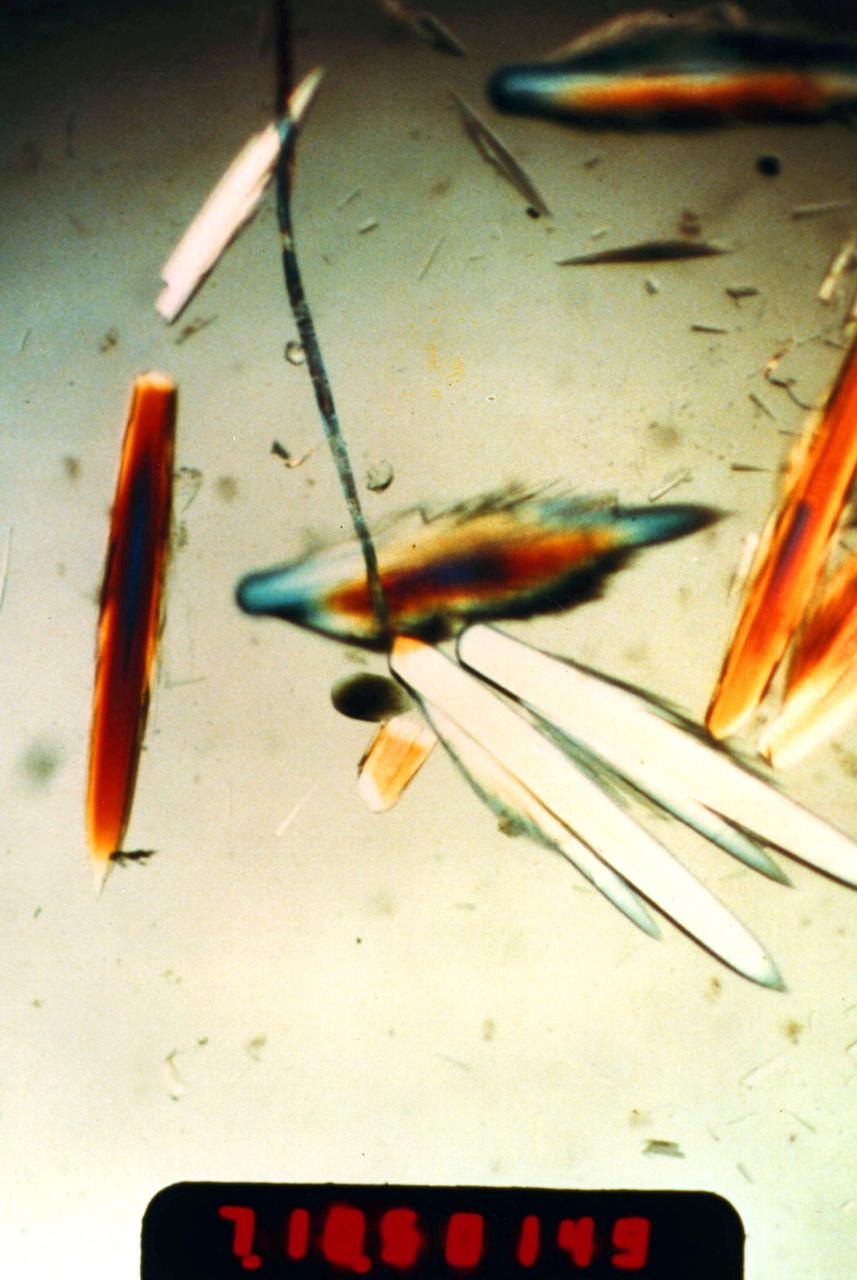
Horse Serum Albumin crystals grown during the USML-1 (STS-50) mission's Protein Crystal Growth Glovebox Experiment. These crystals were grown using a vapor diffusion technique at 22 degrees C. The crystals were allowed to grow for nine days while in orbit. Crystals of 1.0 mm in length were produced. The most abundant blood serum protein, regulates blood pressure and transports ions, metabolites, and therapeutic drugs. Principal Investigator was Edward Meehan.
Dinosaur Provincial Park is a UNESCO World Heritage Site east of Calgary, Alberta, Canada. Located in the Red River Valley, it is noted for its badland topography and rich abundance of dinosaur fossils. Found in Late Cretaceous rocks, over 60 dinosaur species have been discovered. The image was acquired June 6, 2018, covers an area of 10.9 by 13.2 km, and is located at 50.6 degrees north, 111.5 degrees west. https://photojournal.jpl.nasa.gov/catalog/PIA26290
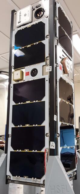
jsc2020e012430 (2/27/2020) --- A preflight view of Neutron-1 3U CubeSat fully assembled prior to vibration testing. The NanoRacks-NEUTRON-1 investigation maps neutron abundance in low-Earth orbit. Data gathered on global neutron counts could contribute to better understanding of the complex relationship between Earth and the Sun. Image courtesy of HSFL
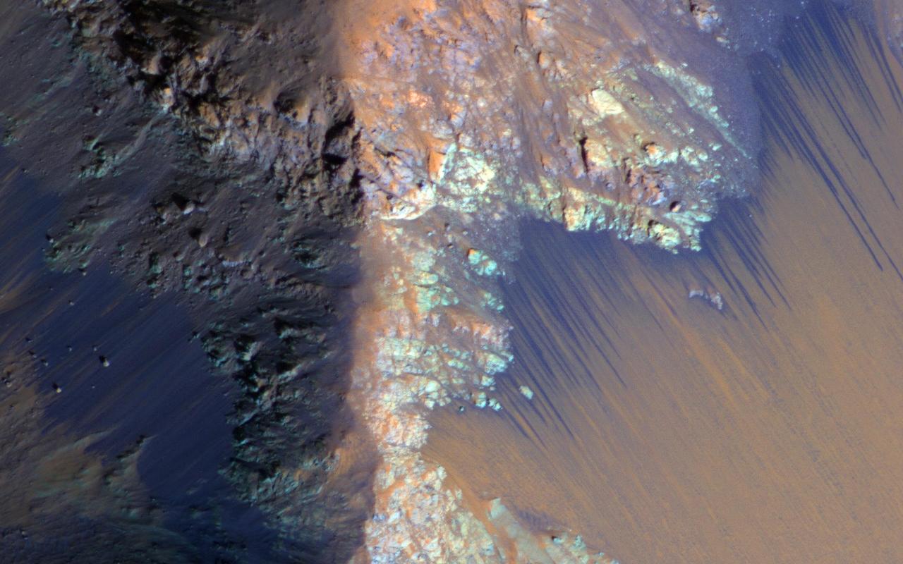
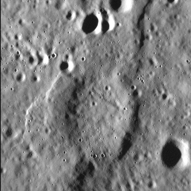
This high-resolution view shows hollows on the southwestern peak ring of the Scarlatti basin. The hollows are the irregularly shaped, flat-floored depressions. The image is striking because it shows that there are abundant small impact craters on the surface surrounding the hollows. But there are few if any within the hollows themselves. Since impacts occur randomly over Mercury's surface and accumulate with time, the lack of craters on the hollows indicates that they must be very young relative to the rest of Mercury's surface. http://photojournal.jpl.nasa.gov/catalog/PIA19246
VANDENBERG AIR FORCE BASE, Calif. -- At Vandenberg Air Force Base in California, the transporter holding NASA's Orbiting Carbon Observatory, or OCO, arrives on Launch Complex 576-E. OCO will collect precise global measurements of carbon dioxide (CO2) in the Earth's atmosphere. Scientists will analyze OCO data to improve our understanding of the natural processes and human activities that regulate the abundance and distribution of this important greenhouse gas. OCO is scheduled to launch Feb. 24 aboard an Orbital Sciences' Taurus XL rocket. Photo credit: NASA/VAFB
VANDENBERG AIR FORCE BASE, Calif. -- At Vandenberg Air Force Base in California, the transporter holding NASA's Orbiting Carbon Observatory, or OCO, heads for Launch Complex 576-E. OCO will collect precise global measurements of carbon dioxide (CO2) in the Earth's atmosphere. Scientists will analyze OCO data to improve our understanding of the natural processes and human activities that regulate the abundance and distribution of this important greenhouse gas. OCO is scheduled to launch Feb. 24 aboard an Orbital Sciences' Taurus XL rocket. Photo credit: NASA/VAFB
(PCG) Protein Crystal Growth Human Serum Albumin. Contributes to many transport and regulatory processes and has multifunctional binding properties which range from various metals, to fatty acids, hormones, and a wide spectrum of therapeutic drugs. The most abundant protein of the circulatory system. It binds and transports an incredible variety of biological and pharmaceutical ligands throughout the blood stream. Principal Investigator on STS-26 was Larry DeLucas.

This image from NASA Mars Reconnaissance Orbiter spacecraft shows numerous branching ridges with various degrees of sinuosity. These branching forms resemble tributaries funneling and draining into larger channel trunks towards the upper portion of the scene. The raised relief of these branching ridges suggests that these are ancient channels are inverted due to lithification and cementation of the riverbed sediment, which made it more resistant to erosion than the surrounding material. Wind-blown bedforms are abundant and resemble small ridges that are aligned in an approximately north-south direction. http://photojournal.jpl.nasa.gov/catalog/PIA20006

jsc2020e012432 (2/27/2020) --- A preflight view of the total mass measurement of Neutron-1 after complete integration. The NanoRacks-NEUTRON-1 investigation maps neutron abundance in low-Earth orbit. Data gathered on global neutron counts could contribute to better understanding of the complex relationship between Earth and the Sun. Image courtesy of HSFL
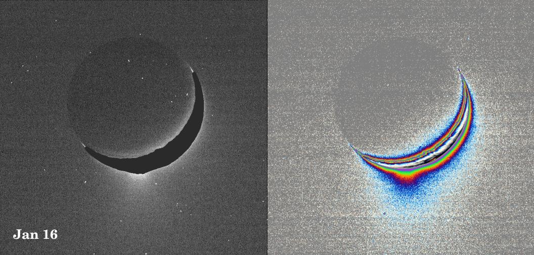
A fine spray of small, icy particles emanating from the warm, geologically unique province surrounding the south pole of Saturn’s moon Enceladus was observed in a Cassini narrow-angle camera image of the crescent moon taken on Jan. 16, 2005. Taken from a high-phase angle of 148 degrees -- a viewing geometry in which small particles become much easier to see -- the plume of material becomes more apparent in images processed to enhance faint signals. Imaging scientists have measured the light scattered by the plume's particles to determine their abundance and fall-off with height. Though the measurements of particle abundance are more certain within 100 kilometers (60 miles) of the surface, the values measured there are roughly consistent with the abundance of water ice particles measured by other Cassini instruments (reported in September, 2005) at altitudes as high as 400 kilometers (250 miles) above the surface. Imaging scientists, as reported in the journal Science on March 10, 2006, believe that the jets are geysers erupting from pressurized subsurface reservoirs of liquid water above 273 degrees Kelvin (0 degrees Celsius). The image at the left was taken in visible green light. A dark mask was applied to the moon's bright limb in order to make the plume feature easier to see. The image at the right has been color-coded to make faint signals in the plume more apparent. Images of other satellites (such as Tethys and Mimas) taken in the last 10 months from similar lighting and viewing geometries, and with identical camera parameters as this one, were closely examined to demonstrate that the plume towering above Enceladus' south pole is real and not a camera artifact. The images were acquired at a distance of about 209,400 kilometers (130,100 miles) from Enceladus. Image scale is about 1 kilometer (0.6 mile) per pixel. http://photojournal.jpl.nasa.gov/catalog/PIA07760
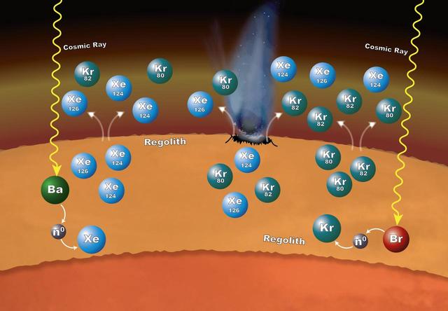
Chemistry that takes place in the surface material on Mars can explain why particular xenon (Xe) and krypton (Kr) isotopes are more abundant in the Martian atmosphere than expected. The isotopes -- variants that have different numbers of neutrons -- are formed in the loose rocks and material that make up the regolith -- the surface layer down to solid rock. The chemistry begins when cosmic rays penetrate into the surface material. If the cosmic rays strike an atom of barium (Ba), the barium can lose one or more of its neutrons (n0). Atoms of xenon can pick up some of those neutrons – a process called neutron capture – to form the isotopes xenon-124 and xenon-126. In the same way, atoms of bromine (Br) can lose some of their neutrons to krypton, leading to the formation of krypton-80 and krypton-82 isotopes. These isotopes can enter the atmosphere when the regolith is disturbed by impacts and abrasion, allowing gas to escape. http://photojournal.jpl.nasa.gov/catalog/PIA20847
Since its discovery in 2005, Pluto's moon Hydra has been known only as a fuzzy dot of uncertain shape, size, and reflectivity. Imaging obtained during NASA's New Horizons' historic transit of the Pluto-Charon system and transmitted to Earth early this morning has definitively resolved these fundamental properties of Pluto's outermost moon. Long Range Reconnaissance Imager (LORRI) observations revealed an irregularly shaped body characterized by significant brightness variations over the surface. With a resolution of 2 miles (3 kilometers) per pixel, the LORRI image shows the tiny potato-shaped moon measures 27 miles (43 kilometers) by 20 miles (33 kilometers). Like that of Charon, Hydra's surface is probably covered with water ice, the most abundant ice in the universe. Observed within Hydra's bright regions is a darker circular structure with a diameter of approximately 6 miles (10 kilometers). Hydra's reflectivity (the percentage of incident light reflected from the surface) is intermediate between that of Pluto and Charon. Hydra was approximately 400,000 miles away from New Horizons when this image was acquired. http://photojournal.jpl.nasa.gov/catalog/PIA19711

This map shows the route driven by NASA's Curiosity Mars rover (blue line) and locations where the rover's Chemistry and Camera (ChemCam) instrument detected the element boron (dots, colored by abundance of boron according to the key at right). The main map shows the traverse from landing day (Sol 0) in August 2012 to the rover's location in September 2016, with boron detections through September 2015. The inset at upper left shows a magnified version of the most recent portion of that traverse, with boron detections during that portion. Overlapping dots represent cases when boron was detected in multiple ChemCam observation points in the same target and non-overlapping dots represent cases where two different targets in the same location have boron. Most of the mission's detections of boron have been made in the most recent seven months (about 200 sols) of the rover's uphill traverse. The base image for the map is from the High Resolution Imaging Science Experiment (HiRISE) camera on NASA's Mars Reconnaissance Orbiter. North is up. The scale bar at lower right represents one kilometer (0.62 mile). http://photojournal.jpl.nasa.gov/catalog/PIA21150

This diagram illustrates how hypothetical helium atmospheres might form. These would be on planets about the mass of Neptune, or smaller, which orbit tightly to their stars, whipping around in just days. They are thought to have cores of water or rock, surrounded by thick atmospheres of gas. Radiation from their nearby stars would boil off hydrogen and helium, but because hydrogen is lighter, more hydrogen would escape. It's also possible that planetary bodies, such as asteroids, could impact the planet, sending hydrogen out into space. Over time, the atmospheres would become enriched in helium. With less hydrogen in the planets' atmospheres, the concentration of methane and water would go down. Both water and methane consist in part of hydrogen. Eventually, billions of years later (a "Gyr" equals one billion years), the abundances of the water and methane would be greatly reduced. Since hydrogen would not be abundant, the carbon would be forced to pair with oxygen, forming carbon monoxide. NASA's Spitzer Space Telescope observed a proposed helium planet, GJ 436b, with these traits: it lacks methane, and appears to contain carbon monoxide. Future observations are needed to detect helium itself in the atmospheres of these planets, and confirm this theory. http://photojournal.jpl.nasa.gov/catalog/PIA19345
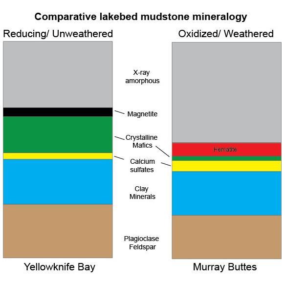
This graphic shows proportions of minerals identified in mudstone exposures at the "Yellowknife Bay" location where NASA's Curiosity Mars rover first analyzed bedrock, in 2013, and at the "Murray Buttes" area investigated in 2016. Minerals were identified by X-ray diffraction analysis of sample powder from the rocks. The samples were acquired by drilling and delivered to the Chemistry and Mineralogy (CheMin) instrument inside the rover. Two key differences in the Murray Buttes mudstone include hematite rather than magnetite, and far less abundance of crystalline mafic minerals, compared to the Yellowknife Bay mudstone composition. Hematite and magnetite are both iron oxide minerals, with hematite as a more oxidized one. That difference could result from the Murray Buttes mudstone layer experiencing more weathering than the Yellowknife Bay mudstone. More weathering could also account for the lower abundance of crystalline mafics, which are volcanic-origin minerals such as pyroxene and olivine. The Yellowknife Bay site is on the floor of Gale Crater. The Murray Buttes site is on lower Mount Sharp, the layered mound in the center of the crater. http://photojournal.jpl.nasa.gov/catalog/PIA21149
Workers in the Space Assembly and Encapsulation Building 2 prepare the 2001 Mars Odyssey Orbiter for its move to the spin table for testing. The orbiter carries three science instruments THEMIS, the Gamma Ray Spectrometer (GRS), and the Mars Radiation Environment Experiment (MARIE) that will map the mineralogy and morphology of the Martian surface, the elemental composition of the surface and determine the abundance of hydrogen in the shallow subsurface, and characterize aspects of the near-space radiation environment with regards to the radiation-related risk to human explorers. The Mars Odyssey Orbiter is scheduled for launch on April 7, 2001, aboard a Delta II rocket from Launch Pad 17-A, Cape Canaveral Air Force Station

Workers in the Space Assembly and Encapsulation Building 2 prepare the 2001 Mars Odyssey Orbiter for its move to the spin table for testing. The orbiter carries three science instruments THEMIS, the Gamma Ray Spectrometer (GRS), and the Mars Radiation Environment Experiment (MARIE) that will map the mineralogy and morphology of the Martian surface, the elemental composition of the surface and determine the abundance of hydrogen in the shallow subsurface, and characterize aspects of the near-space radiation environment with regards to the radiation-related risk to human explorers. The Mars Odyssey Orbiter is scheduled for launch on April 7, 2001, aboard a Delta II rocket from Launch Pad 17-A, Cape Canaveral Air Force Station
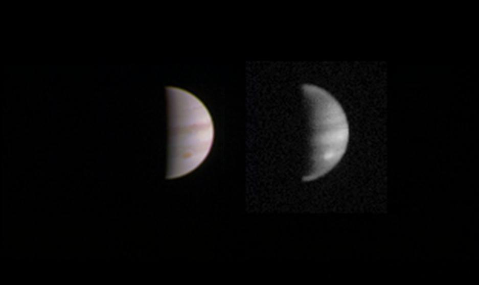
This dual view of Jupiter was taken on August 23, when NASA's Juno spacecraft was 2.8 million miles (4.4 million kilometers) from the gas giant planet on the inbound leg of its initial 53.5-day capture orbit. The image on the left is a color composite taken with Junocam's visible red, green, and blue filters. The image on the right was also taken by JunoCam, but uses the camera's infrared filter, which is sensitive to the abundance of methane in the atmosphere. Bright features like the planet's Great Red Spot are higher in the atmosphere, and so have less of their light absorbed by the methane. http://photojournal.jpl.nasa.gov/catalog/PIA20884
VANDENBERG AIR FORCE BASE, Calif. – The fairing for NASA's Orbiting Carbon Observatory-2, or OCO-2, mission arrives at Vandenberg Air Force Base in California. The fairing will protect OCO-2 during launch aboard a United Launch Alliance Delta II rocket from Space Launch Complex 2 in July. OCO-2 will collect precise global measurements of carbon dioxide in the Earth's atmosphere and provide scientists with a better idea of the chemical compound's impacts on climate change. Scientists will analyze this data to improve our understanding of the natural processes and human activities that regulate the abundance and distribution of this important atmospheric gas. Photo credit: NASA_Randy Beaudoin
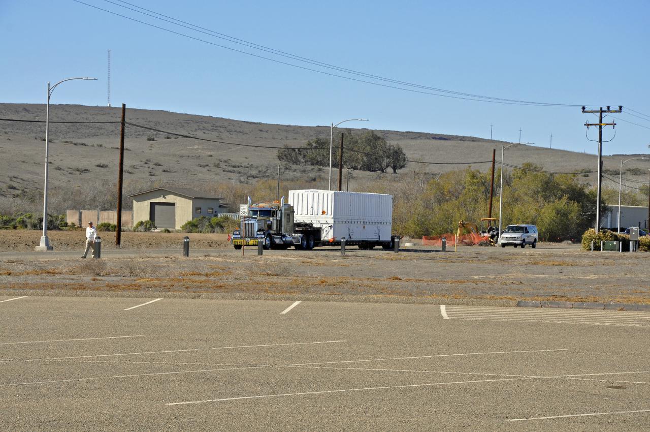
On Friday, Jan. 5, 2024, United Launch Alliance’s Vulcan rocket carrying Astrobotic’s Peregrine lunar lander is rolled out of the Vertical Integration Facility to the launch pad at Space Launch Complex 41 on Cape Canaveral Space Force Station in Florida in advance of a planned lift off at 2:18 a.m. EST Monday, Jan. 8, 2024. Astrobotic’s Peregrine Mission One will carry NASA and commercial payloads to the Moon to study the lunar exosphere, thermal properties, and hydrogen abundance of the lunar regolith, magnetic fields, and the radiation environment of the lunar surface.(Multiple values)