After Fire
After Fire
NEA Scout spacecraft after de-integration from hot box
Diamond Jenness: After the Grind
Opportunity Site: Before and After
After a U-Turn
After a U-Turn
On Nov. 9 at 05:55 UTC/12:55 a.m. EDT, Typhoon Haiyan was in the middle of the South China Sea, headed toward Vietnam.   Credit: NASA Goddard MODIS Rapid Response Team   <b><a href="http://www.nasa.gov/audience/formedia/features/MP_Photo_Guidelines.html" rel="nofollow">NASA image use policy.</a></b>  <b><a href="http://www.nasa.gov/centers/goddard/home/index.html" rel="nofollow">NASA Goddard Space Flight Center</a></b> enables NASA’s mission through four scientific endeavors: Earth Science, Heliophysics, Solar System Exploration, and Astrophysics. Goddard plays a leading role in NASA’s accomplishments by contributing compelling scientific knowledge to advance the Agency’s mission.  <b>Follow us on <a href="http://twitter.com/NASA_GoddardPix" rel="nofollow">Twitter</a></b>  <b>Like us on <a href="http://www.facebook.com/pages/Greenbelt-MD/NASA-Goddard/395013845897?ref=tsd" rel="nofollow">Facebook</a></b>  <b>Find us on <a href="http://instagrid.me/nasagoddard/?vm=grid" rel="nofollow">Instagram</a></b>
Haiyan After Moving Through the Philippines
Damaging heavy rains fell on South Carolina in the southeastern United States at the beginning of October 2015. Much of that water had, by mid October, flowed into the Atlantic Ocean bringing with it heavy loads of sediment, nutrients, and dissolved organic material. The above VIIRS image shows the runoff as it interacts with ocean currents on October 15, 2015.  Credit: NASA/Goddard/SuomiNPP/VIIRS via NASA's OceanColor
Colors after the Storms
The First Image After Closest Approach
Before-and-After Look at Impact Craters
Dust on Mars: Before and After Spirit
Dust on Mars: Before and After Opportunity
Nighttime interior shot of the DC-8 during the transit flight to Santiago.   Credit: NASA/Michael Studinger  NASA's Operation IceBridge is an airborne science mission to study Earth's polar ice. For more information about IceBridge, visit: <a href="http://www.nasa.gov/icebridge" rel="nofollow">www.nasa.gov/icebridge</a>  <b><a href="http://www.nasa.gov/audience/formedia/features/MP_Photo_Guidelines.html" rel="nofollow">NASA image use policy.</a></b>  <b><a href="http://www.nasa.gov/centers/goddard/home/index.html" rel="nofollow">NASA Goddard Space Flight Center</a></b> enables NASA’s mission through four scientific endeavors: Earth Science, Heliophysics, Solar System Exploration, and Astrophysics. Goddard plays a leading role in NASA’s accomplishments by contributing compelling scientific knowledge to advance the Agency’s mission.  <b>Follow us on <a href="http://twitter.com/NASA_GoddardPix" rel="nofollow">Twitter</a></b>  <b>Like us on <a href="http://www.facebook.com/pages/Greenbelt-MD/NASA-Goddard/395013845897?ref=tsd" rel="nofollow">Facebook</a></b>  <b>Find us on <a href="http://instagrid.me/nasagoddard/?vm=grid" rel="nofollow">Instagram</a></b>
DC-8 after dark
This is an artist's impression of supernova 1993J, an exploding star in the galaxy M81 whose light reached us 21 years ago. The supernova originated in a double-star system where one member was a massive star that exploded after siphoning most of its hydrogen envelope to its companion star. After two decades, astronomers have at last identified the blue helium-burning companion star, seen at the center of the expanding nebula of debris from the supernova. The Hubble Space Telescope identified the ultraviolet glow of the surviving companion embedded in the fading glow of the supernova.  More info:  Using NASA’s Hubble Space Telescope, astronomers have discovered a companion star to a rare type of supernova. The discovery confirms a long-held theory that the supernova, dubbed SN 1993J, occurred inside what is called a binary system, where two interacting stars caused a cosmic explosion.  &quot;This is like a crime scene, and we finally identified the robber,&quot; said Alex Filippenko, professor of astronomy at University of California (UC) at Berkeley. &quot;The companion star stole a bunch of hydrogen before the primary star exploded.&quot; SN 1993J is an example of a Type IIb supernova, unusual stellar explosions that contains much less hydrogen than found in a typical supernova.  Astronomers believe the companion star took most of the hydrogen surrounding the exploding main star and continued to burn as a super-hot helium star.  “A binary system is likely required to lose the majority of the primary star’s hydrogen envelope prior to the explosion. The problem is that, to date, direct observations of the predicted binary companion star have been difficult to obtain since it is so faint relative to the supernova itself,” said lead researcher Ori Fox of UC Berkeley.  Read more: <a href="http://1.usa.gov/1Az5Qb9" rel="nofollow">1.usa.gov/1Az5Qb9</a>  Credit: NASA, ESA, G. Bacon (STScI)  <b><a href="http://www.nasa.gov/audience/formedia/features/MP_Photo_Guidelines.html" rel="nofollow">NASA image use policy.</a></b>  <b><a href="http://www.nasa.gov/centers/goddard/home/index.html" rel="nofollow">NASA Goddard Space Flight Center</a></b> enables NASA’s mission through four scientific endeavors: Earth Science, Heliophysics, Solar System Exploration, and Astrophysics. Goddard plays a leading role in NASA’s accomplishments by contributing compelling scientific knowledge to advance the Agency’s mission. <b>Follow us on <a href="http://twitter.com/NASAGoddardPix" rel="nofollow">Twitter</a></b> <b>Like us on <a href="http://www.facebook.com/pages/Greenbelt-MD/NASA-Goddard/395013845897?ref=tsd" rel="nofollow">Facebook</a></b> <b>Find us on <a href="http://instagram.com/nasagoddard?vm=grid" rel="nofollow">Instagram</a></b>
Hubble Finds Supernova Companion Star after Two Decades of Searching
Opportunity Surroundings After Sol 2393 Drive Polar
Opportunity View After Sol 321 Drive
18 Minutes After Beagle 2 Landing
Opportunity Surroundings After Sol 2363 Drive Vertical
After Conquering Husband Hill, Spirit Moves On Stereo
Opportunity View After Long Drive on Sol 1770
Opportunity Surroundings After Sol 1820 Drive Vertical
Opportunity Surroundings After Sol 1820 Drive Polar
Opportunity Surroundings After Sol 2393 Drive Vertical
Opportunity Surroundings After Sol 2363 Drive Polar
After Sample-Delivery Attempt, Sol 62
Phoenix Robotic Arm Workspace After 90 Sols
After Conquering Husband Hill, Spirit Moves On Vertical
Opportunity View After Sol 321 Drive Vertical
After Opportunity First Drive in Six Weeks
Still Shining After All This Time Polar
Opportunity Surroundings After Sol 2220 Drive Polar
Conductivity Probe after Trench-Bottom Placement
Soil Still in Scoop After Sample-Delivery Attempt
Martian Surface after Phoenix Conductivity Measurements
Opportunity View After Drive on Sol 1806
Opportunity Surroundings After Sol 2220 Drive Vertical
Still Shining After All This Time Vertical
Opportunity View After Drive on Sol 1806 Vertical
View Ahead After Spirit Sol 1861 Drive
Front Windshield after Sol 61 Drive
Underneath Phoenix Lander 97 Sols After Touchdown
Opportunity View After Sol 321 Drive Polar
Io Pele Hemisphere After Pillan Changes
After Conquering Husband Hill, Spirit Moves On Polar
After Conquering Husband Hill, Spirit Moves On
Opportunity Surroundings After Sol 1820 Drive
Opportunity View After Drive on Sol 1806 Polar
NASA Dawn spacecraft after installation of high gain antenna.
Dawn Spacecraft After Installation of High Gain Antenna
NASA Dawn spacecraft after installation of high gain antenna.
Dawn Spacecraft After Installation of High Gain Antenna
This set of images from NASA Curiosity rover shows a patch of rock before and after it was cleaned by Curiosity Dust Removal Tool DRT.
Before and After a Little Dusting
A pair of Saturn moons, Dione and Tethys, accompany the planet and its rings in this image taken shortly after the planet August 2009 equinox by NASA Cassini spacecraft.
Saturnscape After Equinox
NASA's SPHEREx space observatory was photographed at BAE Systems in Boulder, Colorado, in November 2024 after completing environmental testing. The spacecraft's three concentric cones help direct heat and light away from the telescope and other components, keeping them cool.  Short for Spectro-Photometer for the History of the Universe, Epoch of Reionization and Ices Explorer, SPHEREx will create a map of the cosmos like no other. Using a technique called spectroscopy to image the entire sky in 102 wavelengths of infrared light, SPHEREx will gather information about the composition of and distance to millions of galaxies and stars. With this map, scientists will study what happened in the first fraction of a second after the big bang, how galaxies formed and evolved, and the origins of water in planetary systems in our galaxy.  https://photojournal.jpl.nasa.gov/catalog/PIA26536
SPHEREx After Environmental Testing
Opportunity View After Long Drive on Sol 1770 Polar
After Attempted Sample Delivery on Sol 60, False Color
Wind-Sculpted Vicinity After Opportunity Sol 1797 Drive
After Rasping by Phoenix in Snow White Trench, Sol 60
Changes in Jupiter Great Red Spot After Four Months
Wind-Sculpted Vicinity After Opportunity Sol 1797 Drive Polar
Opportunity View After Long Drive on Sol 1770 Vertical
Wind-Sculpted Vicinity After Opportunity Sol 1797 Drive Vertical
NASA Mars Exploration Rover team members prepare a testing setup for a subsequent experiment after an experiment driving the rover in a crablike motion, with all four corner wheels angled to the right.
After a Crabwalk Test
PHOTO DATE: January 10, 2022. LOCATION: Bldg. 30, Apollo MOCR Viewing Room. SUBJECT: ASCAN Class of 2021 official swearing in ceremony. PHOTOGRAPHER: Josh Valcarcel
astronaut-candidates-cheer-after-swearing-in-ceremony_51817953647_o
These six images from NASA Mars rover Curiosity show the two moons of Mars moments before left three and after right three the larger moon, Phobos, occulted Deimos on Aug. 1, 2013.
Before and After Occultation of Deimos by Phobos
This May 12, 2014, view from NASA Curiosity Mars Rover shows the rock target Windjana and its immediate surroundings after inspection of the site by the rover by drilling and other activities.
Mars Rock Windjana After Examination
This mosaic of images from the Surface Stereo Imager camera on NASA Phoenix Mars Lander shows a portion of the spacecraft deck after deliveries of several Martian soil samples to instruments on the deck.
Phoenix Deck after Sample Deliveries
This view from the Surface Stereo Imager on NASA Phoenix Mars Lander shows the trench informally named Snow White after a series of scrapings were done in preparation for collecting a sample for analysis from a hard subsurface layer.
Snow White Trench After Scraping
This image, taken Jan. 26, 2012, shows the back shell of NASA Phoenix Mars Lander spacecraft after its second Martian arctic winter.
Phoenix Back Shell After Second Martian Winter
This image, taken Jan. 26, 2012, shows NASA no-longer-active Phoenix Mars Lander spacecraft after its second Martian arctic winter.
Phoenix Lander After Second Martian Winter
An aerial view of the Wallops Island launch facilities taken by the Wallops Incident Response Team Oct. 29 following the failed launch attempt of Orbital Science Corp.'s Antares rocket Oct. 28.  Credit: NASA/Terry Zaperach  ---  The Wallops Incident Response Team completed today an initial assessment of Wallops Island, Virginia, following the catastrophic failure of Orbital Science Corp.’s Antares rocket shortly after liftoff at 6:22 p.m. EDT Tuesday, Oct. 28, from Pad 0A of the Mid-Atlantic Regional Spaceport at NASA’s Wallops Flight Facility in Virginia.  “I want to praise the launch team, range safety, all of our emergency responders and those who provided mutual aid and support on a highly-professional response that ensured the safety of our most important resource -- our people,” said Bill Wrobel, Wallops director. “In the coming days and weeks ahead, we'll continue to assess the damage on the island and begin the process of moving forward to restore our space launch capabilities. There's no doubt in my mind that we will rebound stronger than ever.”  The initial assessment is a cursory look; it will take many more weeks to further understand and analyze the full extent of the effects of the event. A number of support buildings in the immediate area have broken windows and imploded doors. A sounding rocket launcher adjacent to the pad, and buildings nearest the pad, suffered the most severe damage.  At Pad 0A the initial assessment showed damage to the transporter erector launcher and lightning suppression rods, as well as debris around the pad.  The Wallops team also met with a group of state and local officials, including the Virginia Department of Environmental Quality, the Virginia Department of Emergency Management, the Virginia Marine Police, and the U.S. Coast Guard. The Wallops environmental team also is conducting assessments at the site. Preliminary observations are that the environmental effects of the launch failure were largely contained within the southern third of Wallops Island, in the area immediately adjacent to the pad.   Immediately after the incident, the Wallops’ industrial hygienist collected air samples at the Wallops mainland area, the Highway 175 causeway, and on Chincoteague Island. No hazardous substances were detected at the sampled locations.  Additional air, soil and water samples will be collected from the incident area as well as at control sites for comparative analysis.  The Coast Guard and Virginia Marine Resources Commission reported today they have not observed any obvious signs of water pollution, such as oil sheens. Furthermore, initial assessments have not revealed any obvious impacts to fish or wildlife resources. The Incident Response Team continues to monitor and assess.  Following the initial assessment, the response team will open the area of Wallops Island, north of the island flagpole opposite of the launch pad location, to allow the U.S. Navy to return back to work.  Anyone who finds debris or damage to their property in the vicinity of the launch mishap is cautioned to stay away from it and call the Incident Response Team at 757-824-1295.  Further updates on the situation and the progress of the ongoing investigation will be available at:  <a href="http://www.orbital.com" rel="nofollow">www.orbital.com</a>  and  <a href="http://www.nasa.gov/orbital" rel="nofollow">www.nasa.gov/orbital</a>  <b><a href="http://www.nasa.gov/audience/formedia/features/MP_Photo_Guidelines.html" rel="nofollow">NASA image use policy.</a></b>  <b><a href="http://www.nasa.gov/centers/goddard/home/index.html" rel="nofollow">NASA Goddard Space Flight Center</a></b> enables NASA’s mission through four scientific endeavors: Earth Science, Heliophysics, Solar System Exploration, and Astrophysics. Goddard plays a leading role in NASA’s accomplishments by contributing compelling scientific knowledge to advance the Agency’s mission. <b>Follow us on <a href="http://twitter.com/NASAGoddardPix" rel="nofollow">Twitter</a></b> <b>Like us on <a href="http://www.facebook.com/pages/Greenbelt-MD/NASA-Goddard/395013845897?ref=tsd" rel="nofollow">Facebook</a></b> <b>Find us on <a href="http://instagram.com/nasagoddard?vm=grid" rel="nofollow">Instagram</a></b>
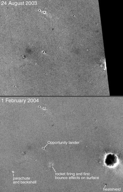
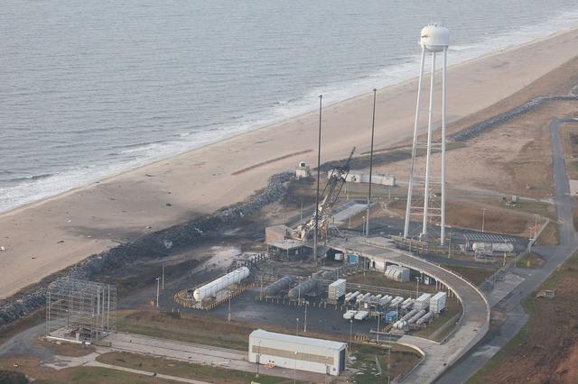
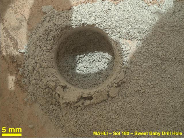
NASA’s Wallops Flight Facility Completes Initial Assessment after Orbital Launch Mishap
S86-38989 (28 Jan. 1986) --- Main engine exhaust, solid rocket booster plume and an expanding ball of gas from the external tank is visible seconds after the space shuttle Challenger accident on Jan. 28, 1986.     (NOTE: The 51-L crew members lost their lives in the space shuttle Challenger accident moments after launch on Jan. 28, 1986 from the Kennedy Space Center.) Photo credit: NASA
Challenger accident after launch
NASA rover Opportunity used its navigation camera to take the images combined into this full 360-degree view of the rover surroundings after a drive on the 2,220th Martian day, or sol, of Opportunity mission on Mars April 22, 2010.
Opportunity Surroundings After Sol 2220 Drive
This artist concept depicts the moment immediately after NASA Curiosity rover touches down onto the Martian surface. The spacecraft has detected touchdown, and pyrotechnic cutters have severed connections between rover and spacecraft descent stage.
A Moment After Curiosity Touchdown, Artist Concept
After an activity called the mini drill test by NASA Mars rover Curiosity, the rover MAHLI camera recorded this view of the results. The test generated a ring of powdered rock for inspection in advance of the rover first full drilling.
Close-Up After Preparatory Test of Drilling on Mars
This image from an animation shows a patch of sandstone scrubbed with the Dust Removal Tool, a wire-bristle brush, on NASA Curiosity Mars rover. This rock target is called Windjana, after a gorge in Western Australia.
Martian Sandstone Target Windjana Before and After Brushing
This July 29, 2014, panorama combines several images from the navigation camera on NASA Mars Exploration Rover Opportunity to show the rover surroundings after surpassing 25 miles 40.23 kilometers of total driving on Mars.
Opportunity Surroundings After 25 Miles on Mars
This image from the navigation camera on the mast of NASA Mars Exploration Rover Opportunity shows streaks of dust or sand on the vehicle rear solar panel after a series of drives during which the rover was pointed steeply uphill.
Streaks on Opportunity Solar Panel After Uphill Drive
These images from the Context Camera on NASA Mars Reconnaissance Orbiter were taken before and after an apparent impact scar appeared in the area in March 2012. Comparing the images confirms that fresh craters appeared during the interval.
Before-and-After Views Confirm Fresh Craters
This mosaic shot by the microscopic imager on the robotic arm of NASA Mars Exploration Rover Opportunity shows a rock target called Esperance after some of the rock surface had been removed by Opportunity rock abrasion tool.
Close-Up of Esperance After Abrasion by Opportunity
This Mastcam-Z image shows Perseverance's drill with no cored-rock sample evident in the sample tube. The image was taken on Sept. 1, 2021 (the 190th sol, or Martian day, of the mission), after coring – and after a cleaning operation was performed to clear the sample tube's lip of any residual material.  The bronze-colored ring is the coring bit. The half-moon inside the bit is the open end of the sample tube. A portion of the tube's serial number – 266 – can be seen on the left side of tube's rim.  Arizona State University in Tempe leads the operations of the Mastcam-Z instrument, working in collaboration with Malin Space Science Systems in San Diego.  A key objective for Perseverance's mission on Mars is astrobiology, including the search for signs of ancient microbial life. The rover will characterize the planet's geology and past climate, pave the way for human exploration of the Red Planet, and be the first mission to collect and cache Martian rock and regolith (broken rock and dust).  Subsequent NASA missions, in cooperation with ESA (European Space Agency), would send spacecraft to Mars to collect these sealed samples from the surface and return them to Earth for in-depth analysis.  The Mars 2020 Perseverance mission is part of NASA's Moon to Mars exploration approach, which includes Artemis missions to the Moon that will help prepare for human exploration of the Red Planet.  https://photojournal.jpl.nasa.gov/catalog/PIA24803
Perseverance's Drill After Cleaning Operation
Flyaround view of the International Space Station (ISS) taken from STS-132 Space Shuttle Atlantis after separation.
Flyaround view of ISS after undocking
This graphic depicts what Mars atmosphere would have looked like to a viewer with ultraviolet-seeing eyes after a meteor shower on Oct. 19, 2014.
Emission from Ionized Magnesium in Mars Atmosphere After Comet Flyby
A blink pair of images taken before and after NASA Curiosity performed a mini drill test on a Martian rock shows changes resulting from that activity.
Before-and-After Blink of Curiosity Mini Drill into Mars Rock
A green star marks the location of NASA's Curiosity Mars rover after a drive on the mission's 957th Martian day, or sol, (April 16, 2015). The map covers an area about 1.25 miles (2 kilometers) wide.  Curiosity landed on Mars in August 2012. The drive on Sol 957 brought the mission's total driving distance past the 10-kilometer mark (6.214 miles). The rover is passing through a series of shallow valleys on a path from the "Pahrump Hills" outcrop, which it investigated for six months, toward its next science destination, called "Logan Pass."  The rover's traverse line enters this map at the location Curiosity reached in mid-July 2014.  The base map uses imagery from the High Resolution Imaging Science Experiment (HiRISE) camera on NASA's Mars Reconnaissance Orbiter.  http://photojournal.jpl.nasa.gov/catalog/PIA19390
Curiosity Position After 10 Kilometers
F5D Skylancer taxis in after a mission.
F5D Skylancer #213 taxis in after a mission.
This view from the Mast Camera (Mastcam) on NASA's Curiosity Mars rover shows the rover's drill just after finishing a drilling operation at a target rock called "Telegraph Peak" on Feb. 24, 2015, the 908th Martian day, or sol, of the rover's work on Mars. Three sols later, a fault-protection action by the rover halted a process of transferring sample powder that was collected during this drilling.  The image is in raw color, as recorded directly by the camera, and has not been white-balanced.  The fault-protection event, triggered by an irregularity in electrical current, led to engineering tests in subsequent days to diagnose the underlying cause.  http://photojournal.jpl.nasa.gov/catalog/PIA19145
Curiosity Drill After Drilling at Telegraph Peak
Expedition 35 commander and Canadian Space Agency astronaut Chris Hadfield (facing away from camera) poses for a photo in the Unity Node 1 after getting a haircut.
Hadfield after a Haircut in Node 1
ISS016-E-006834 (27 Oct. 2007) --- The interior of the Harmony node was photographed after it was attached to its temporary location on the International Space Station during STS-120 flight day five activities.
Node 2 Interior after Installation
StenniSphere reopened Jan. 18, 2006, almost five months after Hurricane Katrina damaged the basement of the building that houses the visitor center. Thanks to the staff's careful preparations before the storm, no artifacts or exhibits were harmed.
StenniSphere reopens after Hurricane Katrina
ISS016-E-006833 (27 Oct. 2007) --- The interior of the Harmony node was photographed after it was attached to its temporary location on the International Space Station during STS-120 flight day five activities.
Node 2 Interior after Installation
This image from the Mars Hand Lens Imager MAHLI on NASA Mars rover Curiosity shows the rock target Cumberland before and after Curiosity drilled into it to collect a sample for analysis.
Before-and-After Blink of Cumberland Drilling
NASA's Atmospheric Infrared Sounder (AIRS) captured views of Hurricane Nicholas before and after it made landfall about 10 miles west-southwest of Sargent Beach, Texas, on Tuesday, Sept. 14, 2021.  One image showed Nicholas approaching the Texas coast as a tropical storm in the early afternoon on Monday, Sept. 13, 2021. The storm strengthened to a Category 1 hurricane on Monday night and made landfall Tuesday morning around 12:30 a.m. CDT. The second AIRS image (Figure 1) captured Hurricane Nicholas shortly after landfall around 2:53 a.m. CDT.  In the infrared AIRS images, the large purple areas indicate very cold clouds carried high into the atmosphere by lofty thunderstorms that are also associated with heavy rainfall. Warmer areas with shallower rain clouds are shown in blue and green. The orange and red areas represent mostly cloud-free air.  AIRS, in conjunction with the Advanced Microwave Sounding Unit (AMSU), senses emitted infrared and microwave radiation from Earth to provide a three-dimensional look at the planet's weather and climate. Working in tandem, the two instruments make simultaneous observations down to Earth's surface. With more than 2,000 channels sensing different regions of the atmosphere, the system creates a global, three-dimensional map of atmospheric temperature and humidity, cloud amounts and heights, greenhouse gas concentrations, and many other atmospheric phenomena. Launched into Earth orbit in 2002 aboard NASA's Aqua spacecraft, the AIRS and AMSU instruments are managed by NASA's Jet Propulsion Laboratory in Southern California, under contract to NASA. JPL is a division of Caltech.  https://photojournal.jpl.nasa.gov/catalog/PIA24532
Hurricane Nicholas Before and After Landfall
X-40A landing after Free Flight 4A
John McKay after flight in F-104B
NASA Mars rover Opportunity captured this view southward just after completing a 338-foot 103-meter southward drive, in reverse, on Aug. 10, 2014. The foreground of this view from the rover Navcam includes the rear portion of the rover deck.
Opportunity Rear-Facing View Ahead After a Drive
NASA Mars Exploration Rover Spirit recorded this fisheye view after completing a drive during on Mars on Feb. 8, 2010. The drive left Spirit in the position where the rover will stay parked during the upcoming Mars southern-hemisphere winter.
Spirit Rear View After Parking for Fourth Winter
On Feb. 19, 2014, NASA Curiosity Mars rover looked back after finishing a long drive. The rows of rocks just to the right of the fresh wheel tracks in this view are an outcrop called Junda. This view is looking toward the east-northeast.
Curiosity View Back After Passing Junda Striations