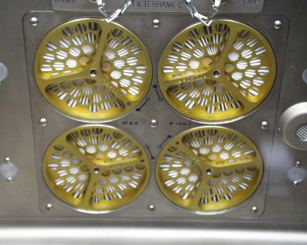
This photo shows one of three arrays of air filters inside the Microgravity Science Glovebox (MSG) being developed by the European Space Agency (ESA) and NASA for use aboard the International Space Station (ISS). Scientists will use the MSG to carry out multidisciplinary studies in combustion science, fluid physics and materials science. The MSG is managed by NASA's Marshall Space Flight Center (MSFC). Photo Credit: NASA/MSFC
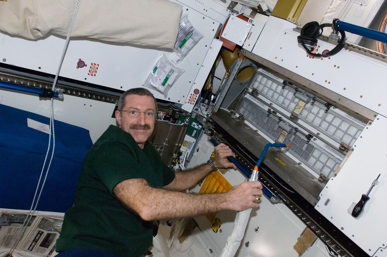
ISS030-E-060469 (4 Feb. 2012) --- NASA astronaut Dan Burbank, Expedition 30 commander, cleans cabin air bacteria filters in the Tranquility node of the International Space Station.
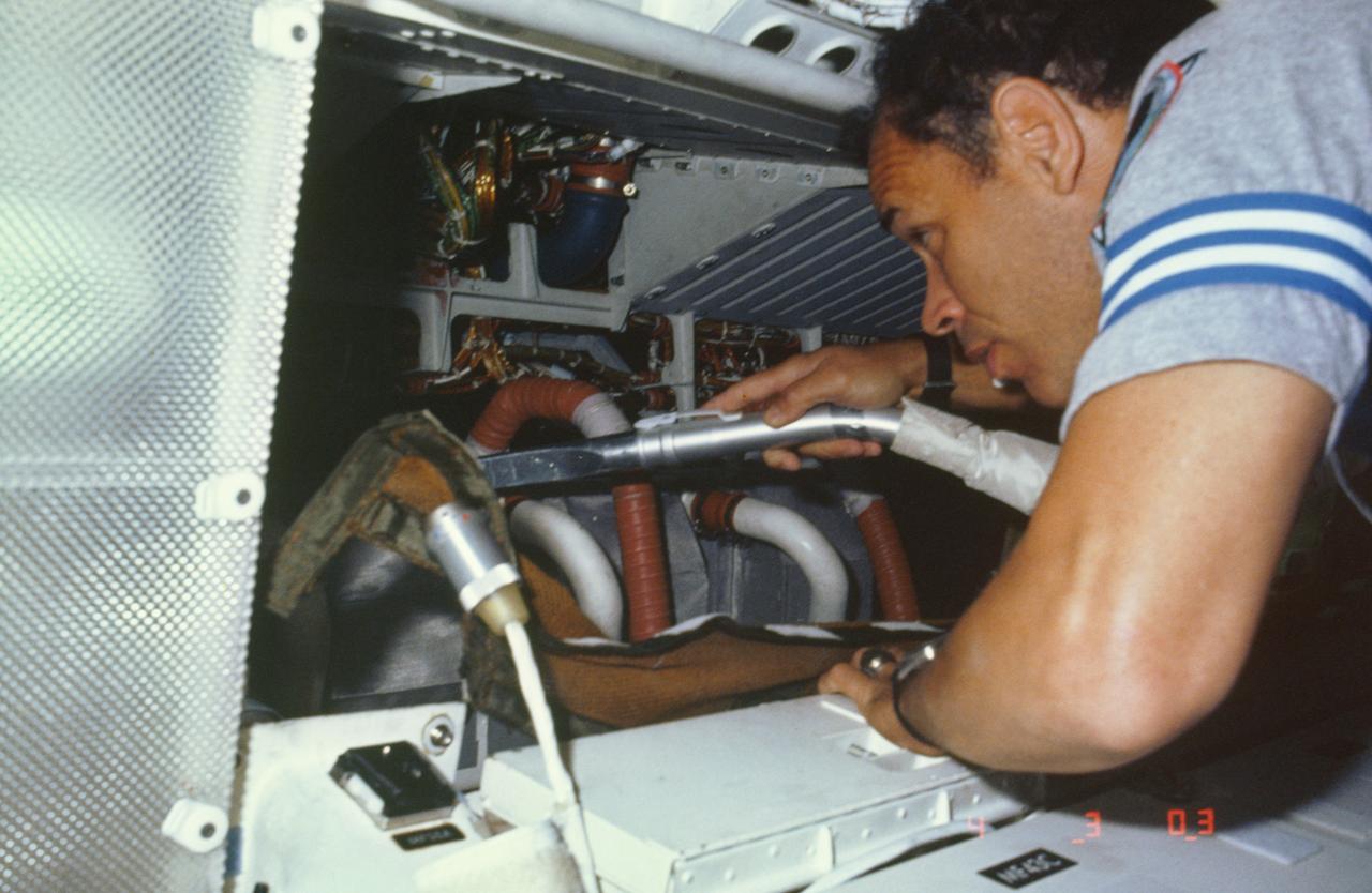
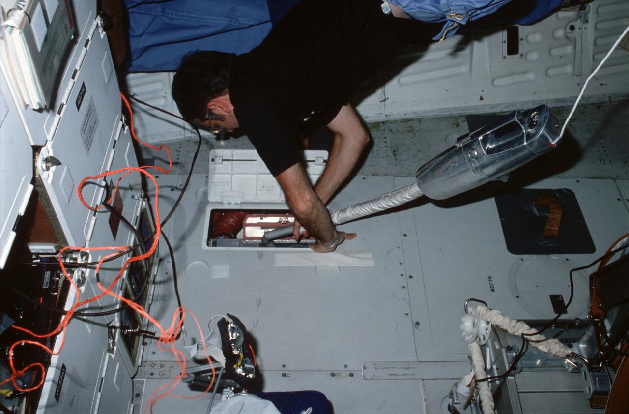
51B-13-008 (29 April-6 May 1985) --- Astronaut Frederick D. Gregory vacuums air filters in avionics bay. The 51-B pilot is physically located in the overhead area of the middeck on Challenger, but his activity is only a few meters away from the flight deck.
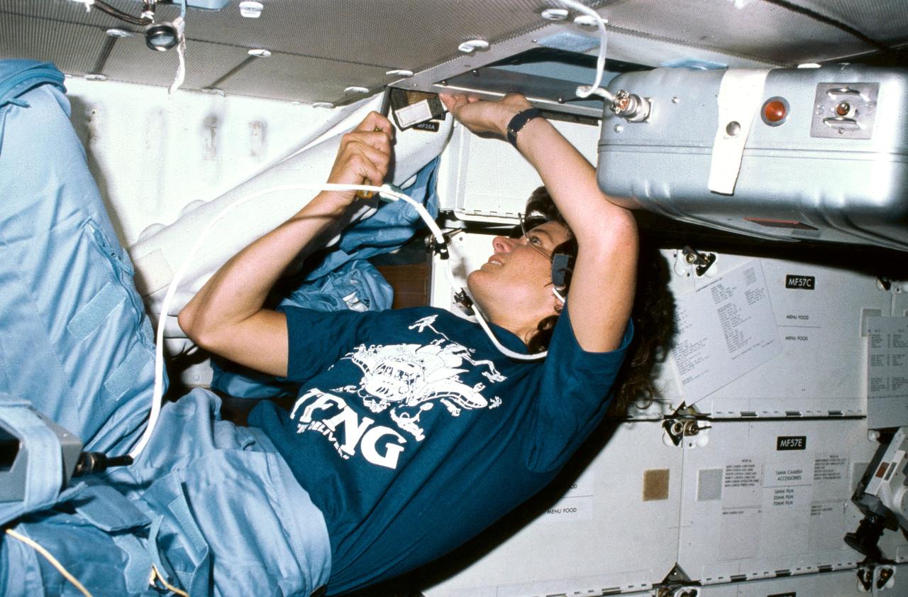
S83-35768 (18-24 June 1983) --- Astronaut Sally K. Ride, mission specialist for STS-7, uses a screw driver in order to clean out an air filtering system in the mid-deck of the Earth-orbiting Space Shuttle Challenger. Dr. Ride's constant wear garment bears some extras -- a cartoon of 35 busy astronauts around a Space Shuttle and the acronym TFNG, below which is written, "We deliver!" TFNG stands for thirty-five new guys, referring to the 1978 class of astronaut candidates (ASCAN) from which Dr. Ride and three of her crew members hail. The tiny two-word declarative in white lettering refers to the successful deployment of two communications satellites. This photograph was made with a 35mm camera.
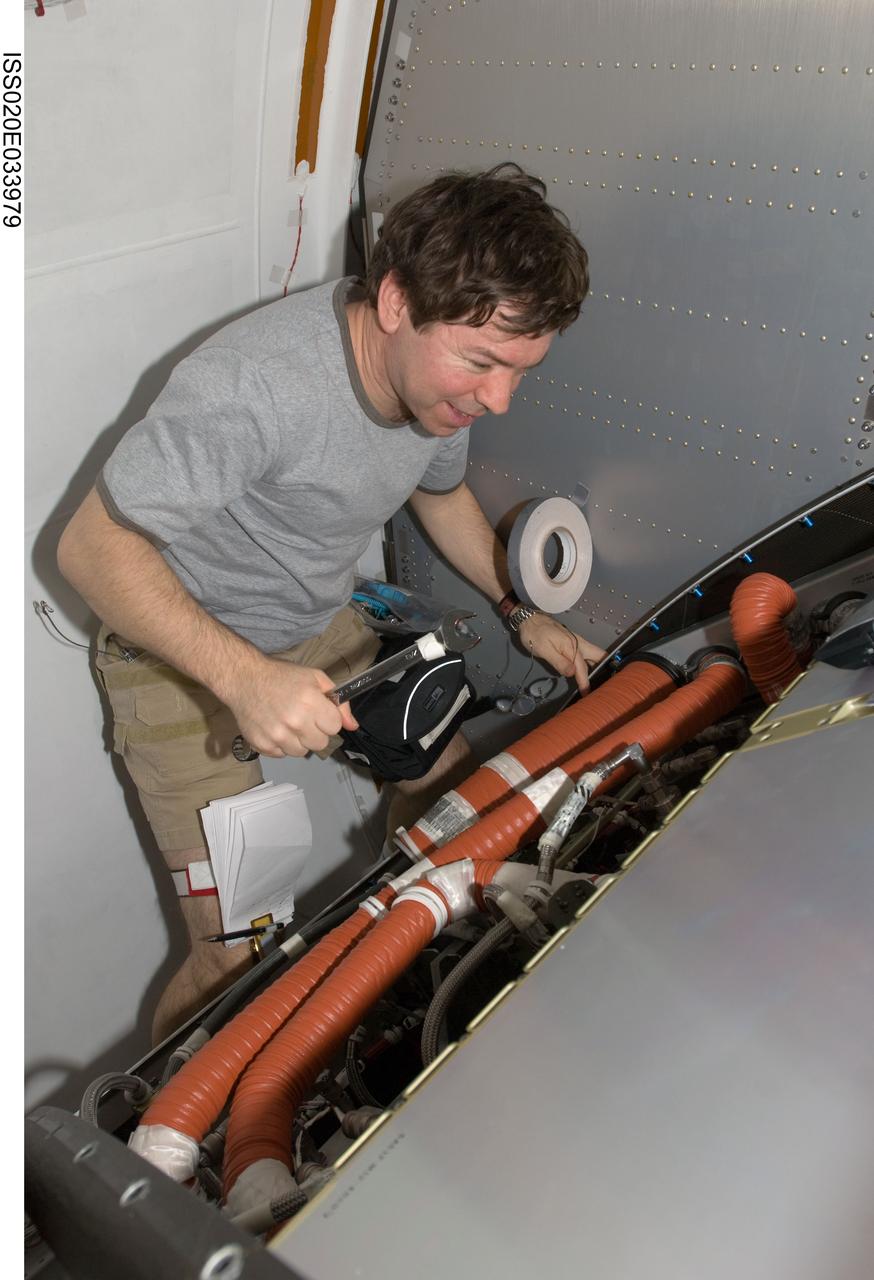
ISS020-E-033979 (25 Aug. 2009) --- NASA astronaut Michael Barratt, Expedition 20 flight engineer, works with the Crew Health Care System (CHeCS) rack in the Kibo laboratory of the International Space Station.
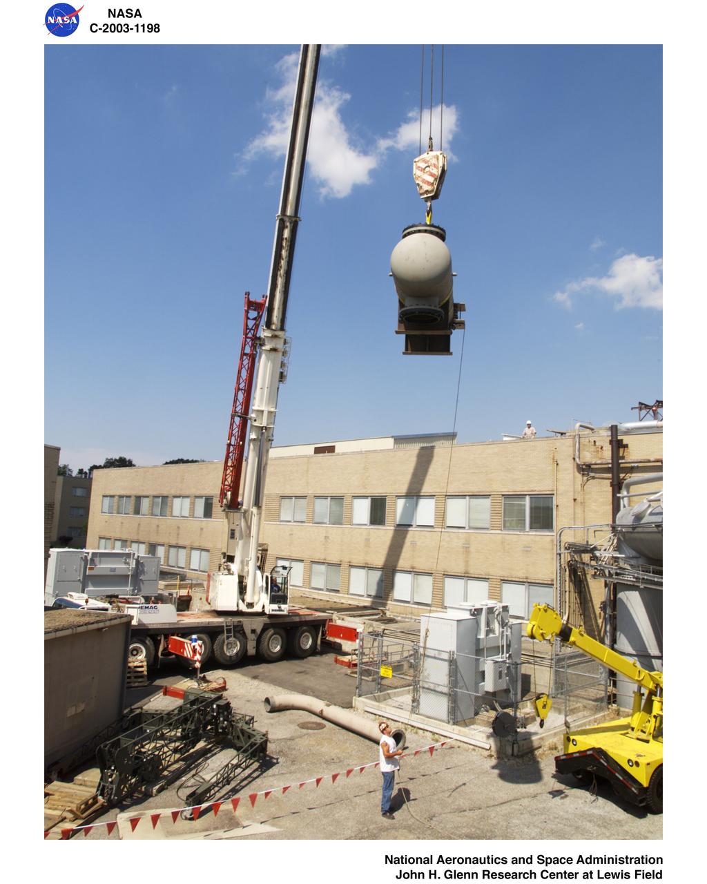
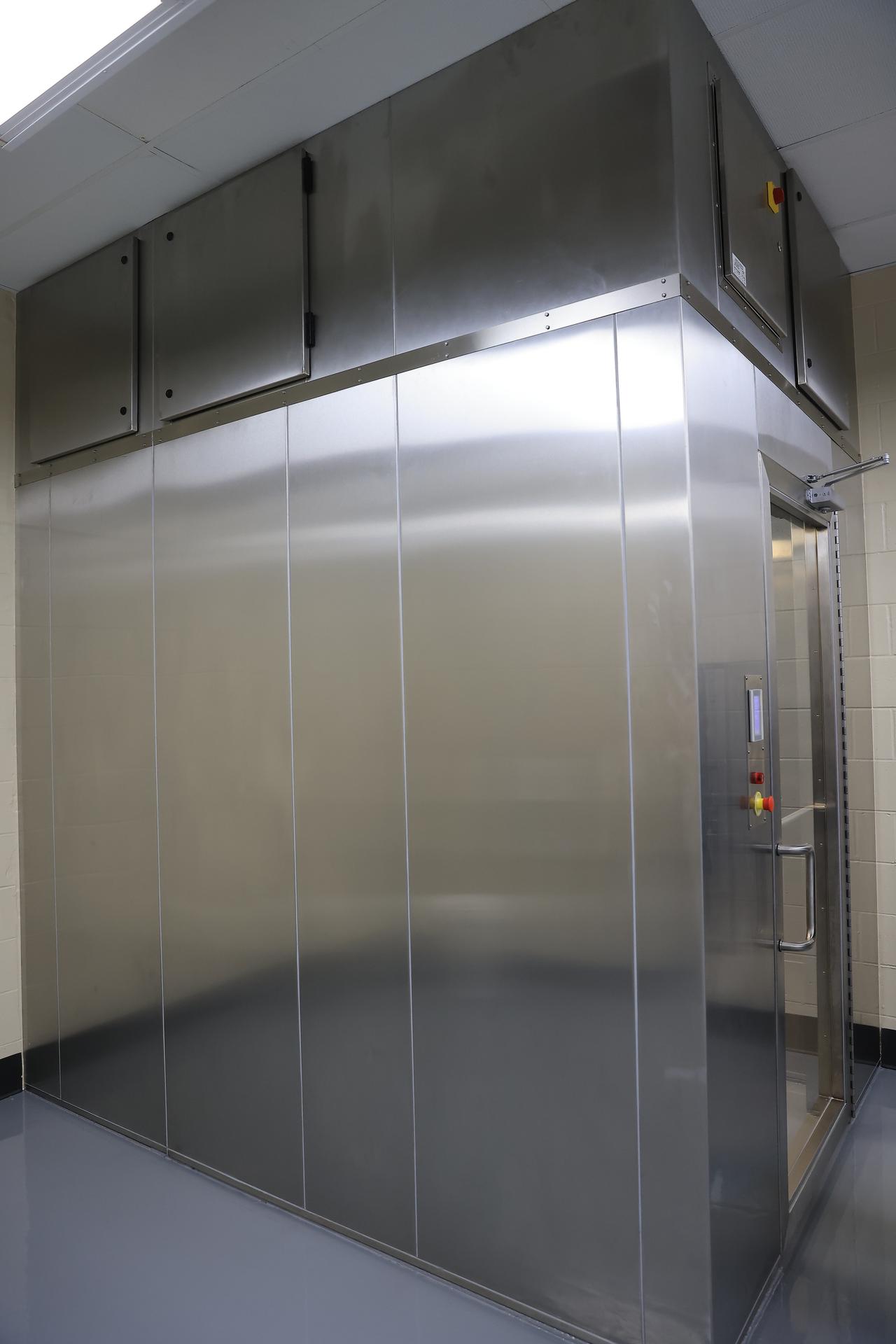
165 Ton Crane lifting air filter into position for Building 23 Cell W-8
S125-E-013369 (21 May 2009) --- Astronaut Gregory C. Johnson, STS-125 pilot, uses a vacuum cleaner to remove dust particles from the air filter system on the flight deck of Space Shuttle Atlantis.
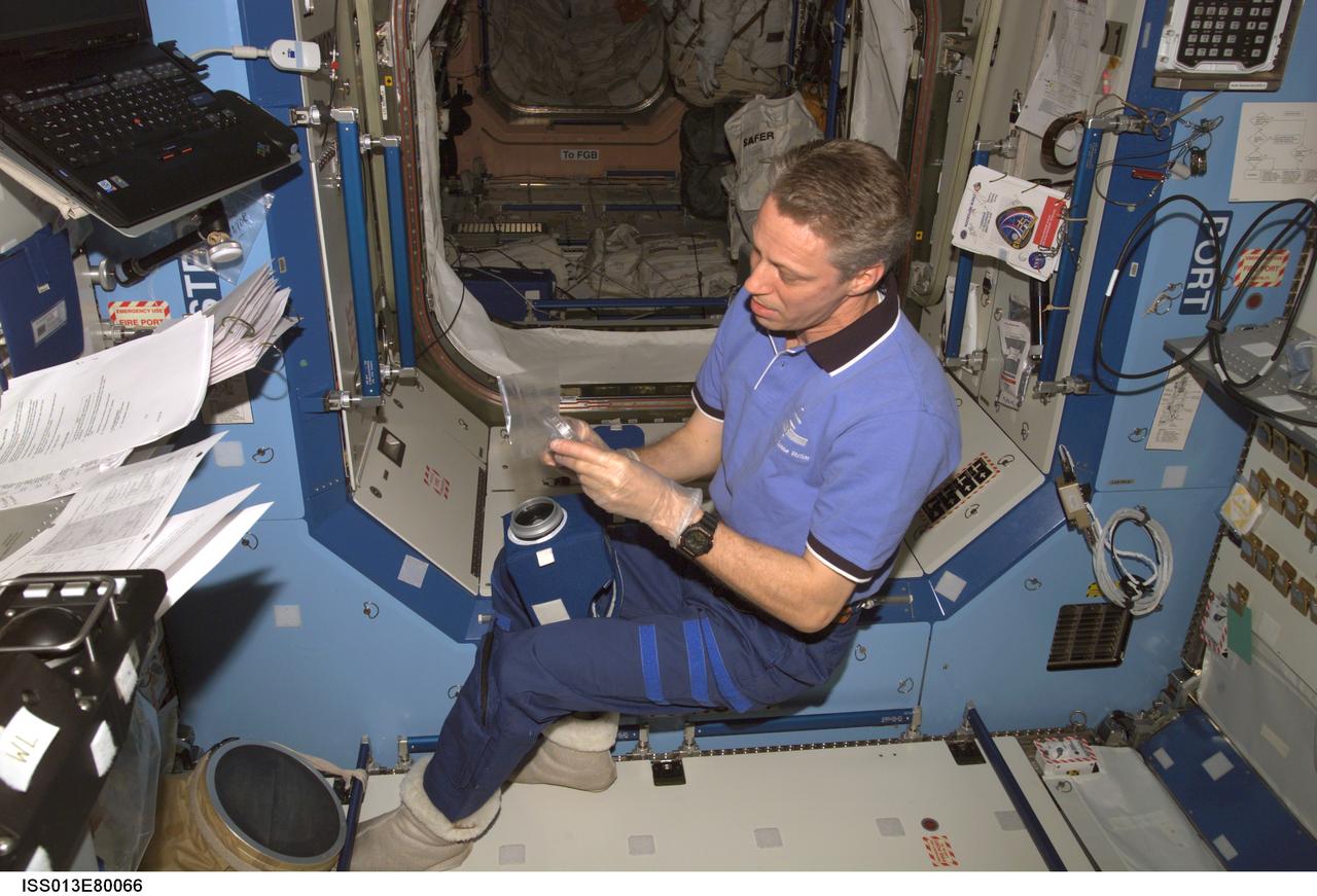
ISS013-E-80066 (10 Sept. 2006) --- European Space Agency (ESA) astronaut Thomas Reiter, Expedition 13 flight engineer, works with the surface, water and air biocharacterization (SWAB) air sampling device (ASD) filter kit in the Destiny laboratory of the International Space Station.
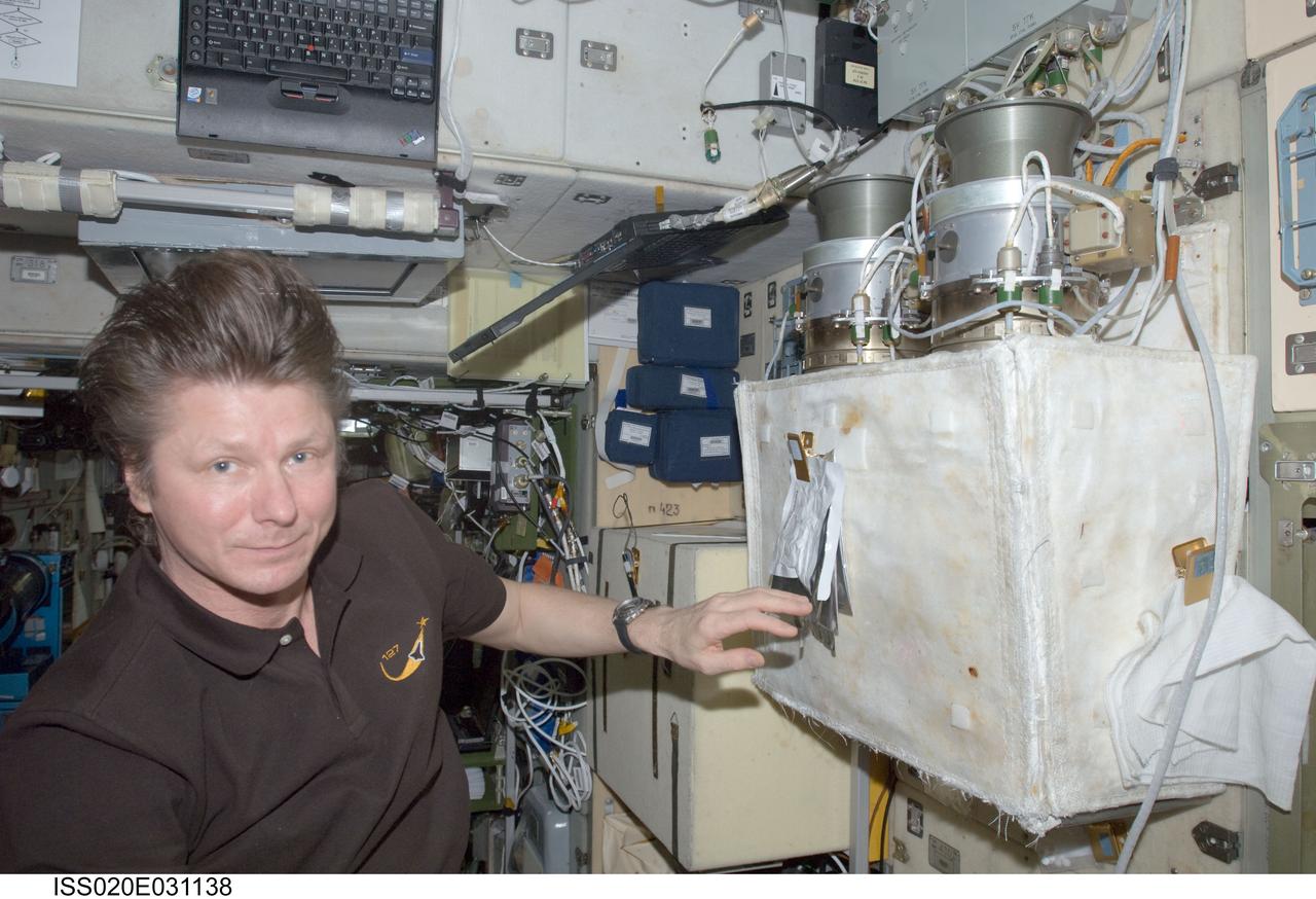
ISS020-E-031138 (16 Aug. 2009) --- Cosmonaut Gennady Padalka, Expedition 20 commander, performs a check on the Russian POTOK-150MK (150 micron) air filter unit of the Zvezda Service Module’s SOGS air revitalization subsystem on the International Space Station.
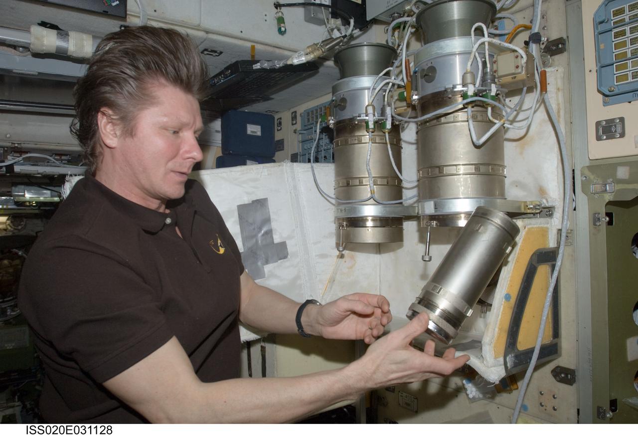
ISS020-E-031128 (16 Aug. 2009) --- Cosmonaut Gennady Padalka, Expedition 20 commander, performs a check on the Russian POTOK-150MK (150 micron) air filter unit of the Zvezda Service Module’s SOGS air revitalization subsystem on the International Space Station.
STS040-34-001 (5-14 June 1991) --- This 35mm scene shows a close-up of a prototype filter designed to remove contamination from air and water, before it flows into the Orbiter's humidity separators. This experiment is part of Development Test Objective (DTO) 647, Water Separator Filter Performance Evaluation. Astronauts Bryan D. O'Connor, mission commander, and Sidney M. Gutierrez, pilot, carried out the test and down linked television to the ground for engineering analysis.
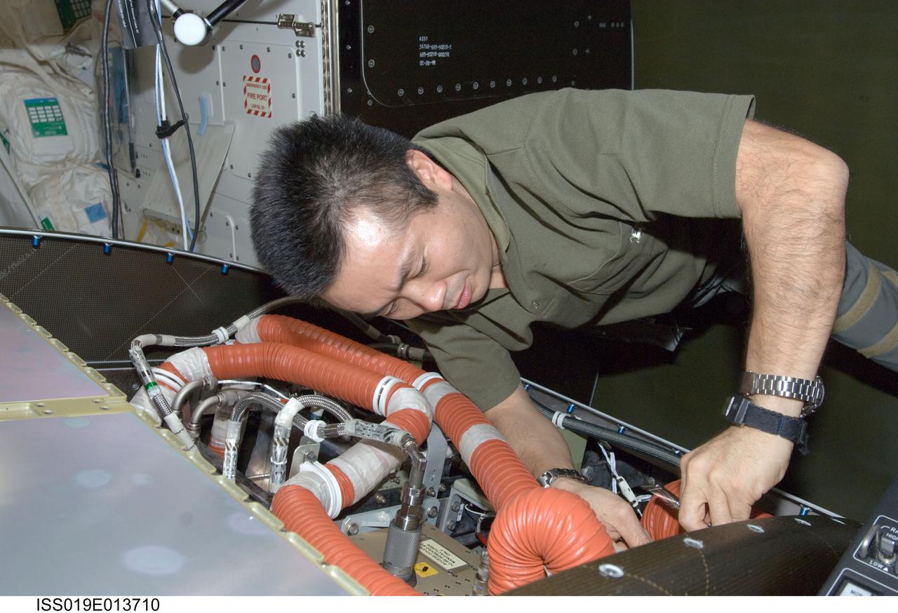
ISS019-E-013710 (5 May 2009) --- Japan Aerospace Exploration Agency (JAXA) astronaut Koichi Wakata, Expedition 19/20 flight engineer, cleans a fan filter on the Crew Health Care System Avionics Air Assembly (CHeCS AAA) in the Destiny laboratory of the International Space Station.
STS008-13-336 (5 Sept 1983) --- On middeck, Richard M. Truly, STS-8 commander, uses vacuum cleaner to remove debris from air revitalization system (ARS) filter assembly. Open panel on middeck floor is the ARS access panel.
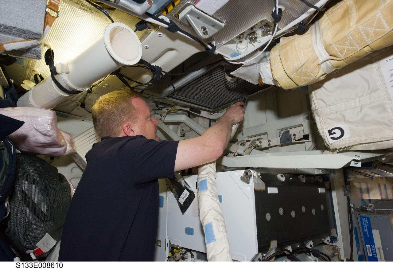
S133-E-008610 (3 March 2011) --- NASA astronaut Eric Boe, STS-133 pilot, uses a vacuum cleaner to remove dust particles from the air filter system on the middeck of space shuttle Discovery while docked with the International Space Station. Photo credit: NASA or National Aeronautics and Space Administration
This image is a wide-angle view of the Orbital Workshop waste management compartment. The waste management facilities presented a unique challenge to spacecraft designers. In addition to collection of liquid and solid human wastes, there was a medical requirement to dry all solid human waste products and to return the residue to Earth for examination. Liquid human waste (urine) was frozen for return to Earth. Total quantities of each astronaut's liquid and solid wastes were precisely measured. Cabin air was drawn into the toilet, shown on the wall at right in this photograph, and over the waste products to generate a flow of the waste in the desired direction. The air was then filtered for odor control and antiseptic purposes prior to being discharged back into the cabin.
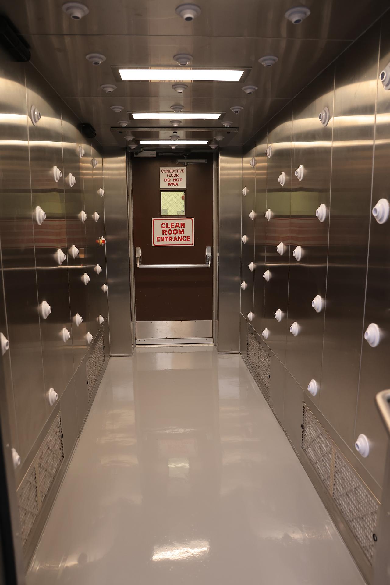
This image shows the recently upgraded air showers which blast high-velocity HEPA-filtered air onto people before they enter a clean room at NASA’s Payload Hazardous Servicing Facility at the agency’s Kennedy Space Center in Florida on Friday, Feb. 27, 2026. The PHSF went through several upgrades ahead of the arrival of Nancy Grace Roman Space Telescope. Roman will provide deep, panoramic views of the cosmos, generating never-before-seen pictures that will revolutionize our understanding of the universe. Roman will undergo several prelaunch operations, including thermal protection closeout, cleaning, solar array work, and loading hydrazine propellant.

This image shows the recently upgraded air showers which blast high-velocity HEPA-filtered air onto people before they enter a clean room at NASA’s Payload Hazardous Servicing Facility at the agency’s Kennedy Space Center in Florida on Friday, Feb. 27, 2026. The PHSF went through several upgrades ahead of the arrival of Nancy Grace Roman Space Telescope. Roman will provide deep, panoramic views of the cosmos, generating never-before-seen pictures that will revolutionize our understanding of the universe. Roman will undergo several prelaunch operations, including thermal protection closeout, cleaning, solar array work, and loading hydrazine propellant.
This image shows the recently upgraded air showers which blast high-velocity HEPA-filtered air onto people before they enter a clean room at NASA’s Payload Hazardous Servicing Facility at the agency’s Kennedy Space Center in Florida on Friday, Feb. 27, 2026. The PHSF went through several upgrades ahead of the arrival of Nancy Grace Roman Space Telescope. Roman will provide deep, panoramic views of the cosmos, generating never-before-seen pictures that will revolutionize our understanding of the universe. Roman will undergo several prelaunch operations, including thermal protection closeout, cleaning, solar array work, and loading hydrazine propellant.
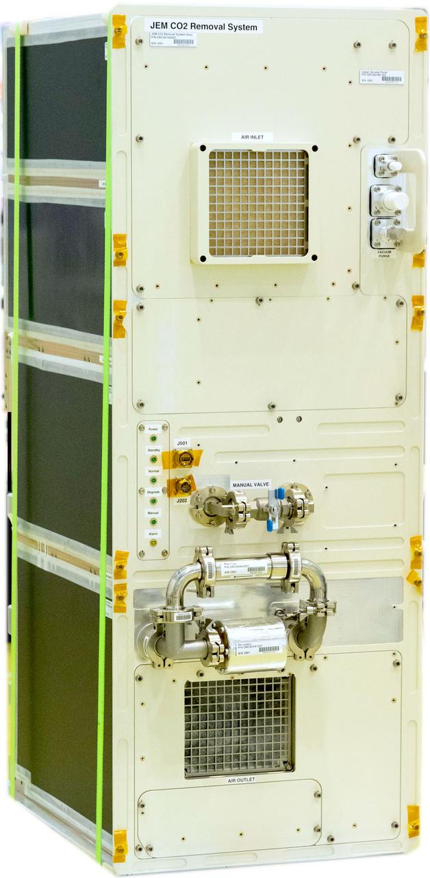
jsc2025e076916 (September 25, 2025) -- A close-up view of the JEM Demonstration of CO? Removal System (JEM DRCS) hardware. JEM DRCS will operate on the space station by filtering carbon dioxide out of the cabin air. The experiment will help guide future spacecraft life support systems and could also support technologies that reduce carbon dioxide emissions on Earth. Image courtesy of JAXA.
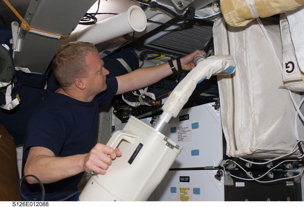
S126-E-012088 (27 Nov. 2008) --- Having completed the current home improvement project with other members of the joint space shuttle-International Space Station aggregation aboard the orbital outpost, astronaut Eric Boe turns to housekeeping chores aboard Endeavour. The pilot uses a vacuum cleaner to remove dust particles from the air filter system on the shuttle's middeck.
The Microgravity Science Glovebox is a facility for performing microgravity research in the areas of materials, combustion, fluids and biotechnology science. The facility occupies a full ISPR, consisting of: the ISPR rack and infrastructure for the rack, the glovebox core facility, data handling, rack stowage, outfitting equipment, and a video subsystem. MSG core facility provides the experiment developers a chamber with air filtering and recycling, up to two levels of containment, an airlock for transfer of payload equipment to/from the main volume, interface resources for the payload inside the core facility, resources inside the airlock, and storage drawers for MSG support equipment and consumables.
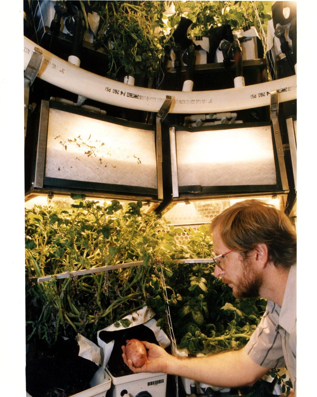
Original photo and caption dated August 14, 1995: <i>"KSC plant physiologist Dr. Gary Stutte harvests a potato grown in the Biomass Production Chamber of the Controlled environment Life Support system (CELSS) in Hangar L at Cape Canaveral Air Station. During a 418-day "human rated" experiment, potato crops grown in the chamber provided the equivalent of a continuous supply of the oxygen for one astronaut, along with 55 percent of that long-duration space flight crew member's caloric food requirements and enough purified water for four astronauts while absorbing their expelled carbon dioxide. The experiment provided data that will help demonstarte the feasibility of the CELSS operating as a bioregenerative life support system for lunar and deep-space missions that can operate independently without the need to carry consumables such as air, water and food, while not requiring the expendable air and water system filters necessary on today's human-piloted spacecraft."</i
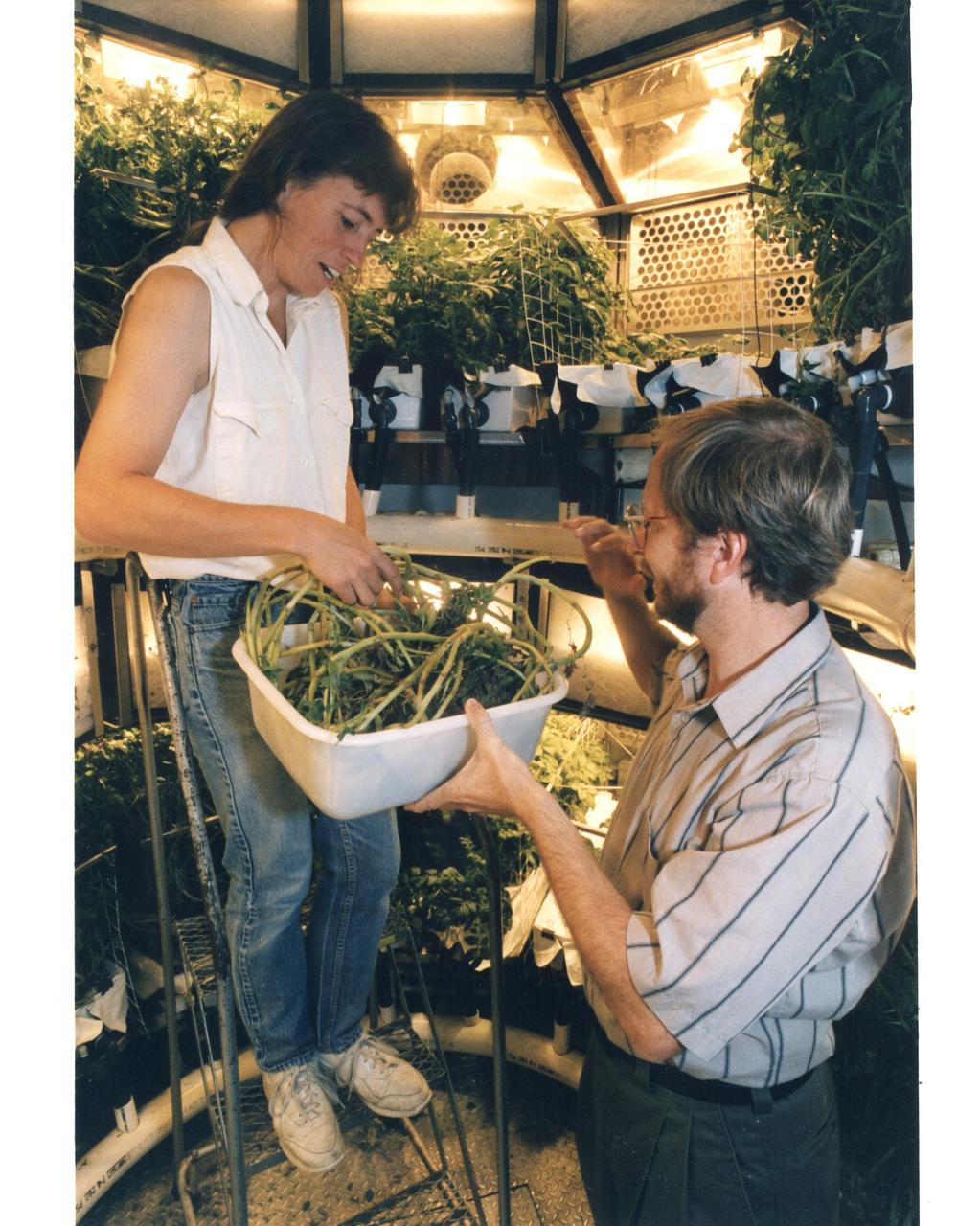
Original photo and caption dated August 14, 1995: <i>"KSC plant physiologist Dr. Gary Stutte (right) and Cheryl Mackowiak harvest potatoes grown in the Biomass Production Chamber of the Controlled Enviornment Life Support System (CELSS in Hangar L at Cape Canaveral Air Station. During a 418-day "human rated" experiment, potato crops grown in the chamber provided the equivalent of a continuous supply of the oxygen for one astronaut, along with 55 percent of that long-duration space flight crew member's caloric food requirements and enough purified water for four astronauts while absorbing their expelled carbon dioxide. The experiment provided data that will help demonstarte the feasibility of the CELSS operating as a bioregenerative life support system for lunar and deep-space missions that can operate independently without the need to carry consumables such as air, water and food, while not requiring the expendable air and water system filters necessary on today's human-piloted spacecraft."</i

This picture of Neptune was produced from images taken through the ultraviolet, violet and green filters of the Voyager 2 wide-angle camera. This 'false' color image has been made to show clearly details of the cloud structure and to paint clouds located at different altitudes with different colors. Dark, deeplying clouds tend to be masked in the ultraviolet wavelength since overlying air molecules are particularly effective in scattering sunlight there which brightens the sky above them. Such areas appear dark blue in this photo. The Great Dark Spot (GDS) and the high southern latitudes have a deep bluish cast in this image, indication they are regions where visible light (but not ultraviolet light) may penetrate to a deeper layer of dark cloud or haze in Neptune's atmosphere. Conversely, the pinkish clouds may be positioned at high altitudes.
STS053-04-018 (2-9 Dec 1992) --- Astronauts Guion S. Bluford (left) and Michael R. U. (Rich) Clifford monitor the Fluid Acquisition and Resupply Equipment (FARE) onboard the Space Shuttle Discovery. Clearly visible in the mid-deck FARE setup is one of two 12.5-inch spherical tanks made of transparent acrylic, one to supply and one to receive fluids. The purpose of FARE is to investigate the dynamics of fluid transfer in microgravity and develop methods for transferring vapor-free propellants and other liquids that must be replenished in long-term space systems like satellites, Extended-Duration Orbiters (EDO), and Space Station Freedom. Eight times over an eight-hour test period, the mission specialists conducted the FARE experiment. A sequence of manual valve operations caused pressurized air from the bottles to force fluids from the supply tank to the receiver tank and back again to the supply tank. Baffles in the receiver tank controlled fluid motion during transfer, a fine-mesh screen filtered vapor from the fluid, and the overboard vent removed vapor from the receiver tank as the liquid rose. FARE is managed by NASA's Marshall Space Flight Center (MSFC) in Alabama. The basic equipment was developed by Martin Marietta for the Storable Fluid Management Demonstration. Susan L. Driscoll is the principal investigator.
STS053-09-019 (2 - 9 Dec 1992) --- A medium close-up view of part of the Fluid Acquisition and Resupply Equipment (FARE) onboard the Space Shuttle Discovery. Featured in the mid-deck FARE setup is fluid activity in one of two 12.5-inch spherical tanks made of transparent acrylic. Pictured is the receiver tank. The other tank, out of frame below, is for supplying fluids. The purpose of FARE is to investigate the dynamics of fluid transfer in microgravity and develop methods for transferring vapor-free propellants and other liquids that must be replenished in long-term space systems like satellites, Extended-Duration Orbiters (EDO), and Space Station Freedom. Eight times over an eight-hour test period, the mission specialists conducted the FARE experiment. A sequence of manual valve operations caused pressurized air from the bottles to force fluids from the supply tank to the receiver tank and back again to the supply tank. Baffles in the receiver tank controlled fluid motion during transfer, a fine-mesh screen filtered vapor from the fluid, and the overboard vent removed vapor from the receiver tank as the liquid rose. FARE is managed by NASA's Marshall Space Flight Center (MSFC) in Alabama. The basic equipment was developed by Martin Marietta for the Storable Fluid Management Demonstration. Susan L. Driscoll is the principal investigator.
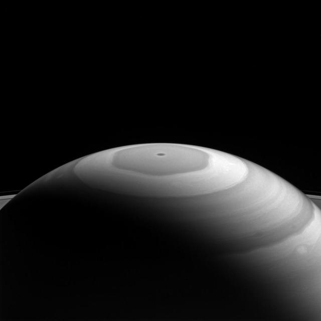
Saturn's north polar region displays its beautiful bands and swirls, which somewhat resemble the brushwork in a watercolor painting. Each latitudinal band represents air flowing at different speeds, and clouds at different heights, compared to neighboring bands. Where they meet and flow past each other, the bands' interactions produce many eddies and swirls. The northern polar region of Saturn is dominated by the famous hexagon shape (see PIA11682) which itself circumscribes the northern polar vortex -- seen as a dark spot at the planet's pole in the above image-- which is understood to the be eye of a hurricane-like storm (PIA14946). This view looks toward the sunlit side of the rings from about 20 degrees above the ring plane. The image was taken with the Cassini spacecraft wide-angle camera on Sept. 5, 2016 using a spectral filter which preferentially admits wavelengths of near-infrared light centered at 728 nanometers. The view was obtained at a distance of approximately 890,000 miles (1.4 million kilometers) from Saturn. Image scale is 53 miles (86 kilometers) per pixel. http://photojournal.jpl.nasa.gov/catalog/PIA20507
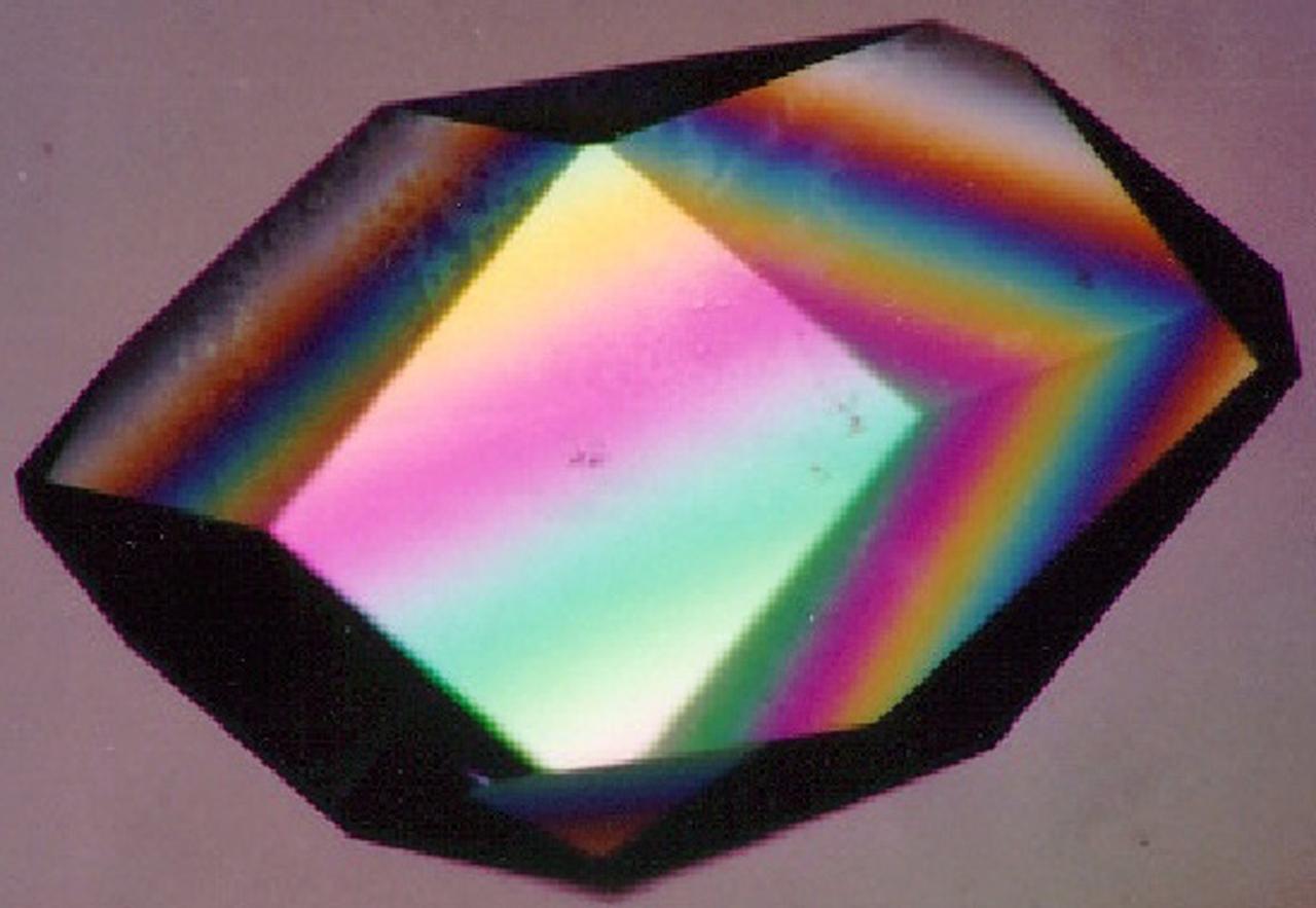
To the crystallographer, this may not be a diamond but it is just as priceless. A Lysozyme crystal grown in orbit looks great under a microscope, but the real test is X-ray crystallography. The colors are caused by polarizing filters. Proteins can form crystals generated by rows and columns of molecules that form up like soldiers on a parade ground. Shining X-rays through a crystal will produce a pattern of dots that can be decoded to reveal the arrangement of the atoms in the molecules making up the crystal. Like the troops in formation, uniformity and order are everything in X-ray crystallography. X-rays have much shorter wavelengths than visible light, so the best looking crystals under the microscope won't necessarily pass muster under the X-rays. In order to have crystals to use for X-ray diffraction studies, crystals need to be fairly large and well ordered. Scientists also need lots of crystals since exposure to air, the process of X-raying them, and other factors destroy them. Growing protein crystals in space has yielded striking results. Lysozyme's structure is well known and it has become a standard in many crystallization studies on Earth and in space.
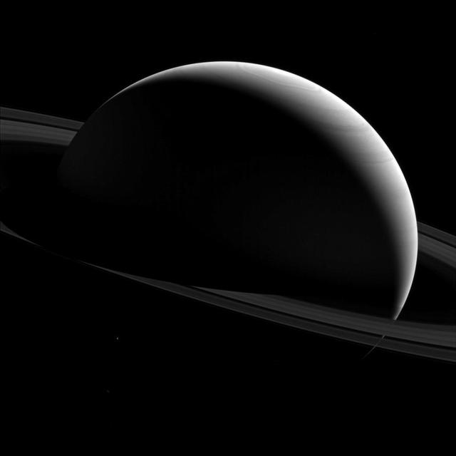
The night sides of Saturn and Tethys are dark places indeed. We know that shadows are darker areas than sunlit areas, and in space, with no air to scatter the light, shadows can appear almost totally black. Tethys (660 miles or 1,062 kilometers across) is just barely seen in the lower left quadrant of this image below the ring plane and has been brightened by a factor of three to increase its visibility. The wavy outline of Saturn's polar hexagon is visible at top center. This view looks toward the sunlit side of the rings from about 10 degrees above the ring plane. The image was taken with the Cassini spacecraft wide-angle camera on Jan. 15, 2015 using a spectral filter which preferentially admits wavelengths of near-infrared light centered at 752 nanometers. The view was obtained at a distance of approximately 1.5 million miles (2.4 million kilometers) from Saturn. Image scale is 88 miles (141 kilometers) per pixel. http://photojournal.jpl.nasa.gov/catalog/PIA18333

A NASA camera on the Deep Space Climate Observatory satellite has returned its first view of the entire sunlit side of Earth from one million miles away. This color image of Earth was taken by NASA’s Earth Polychromatic Imaging Camera (EPIC), a four megapixel CCD camera and telescope. The image was generated by combining three separate images to create a photographic-quality image. The camera takes a series of 10 images using different narrowband filters -- from ultraviolet to near infrared -- to produce a variety of science products. The red, green and blue channel images are used in these color images. The image was taken July 6, 2015, showing North and Central America. The central turquoise areas are shallow seas around the Caribbean islands. This Earth image shows the effects of sunlight scattered by air molecules, giving the image a characteristic bluish tint. The EPIC team is working to remove this atmospheric effect from subsequent images. Once the instrument begins regular data acquisition, EPIC will provide a daily series of Earth images allowing for the first time study of daily variations over the entire globe. These images, available 12 to 36 hours after they are acquired, will be posted to a dedicated web page by September 2015. The primary objective of DSCOVR, a partnership between NASA, the National Oceanic and Atmospheric Administration (NOAA) and the U.S. Air Force, is to maintain the nation’s real-time solar wind monitoring capabilities, which are critical to the accuracy and lead time of space weather alerts and forecasts from NOAA. For more information about DSCOVR, visit: <a href="http://www.nesdis.noaa.gov/DSCOVR/" rel="nofollow">www.nesdis.noaa.gov/DSCOVR/</a>
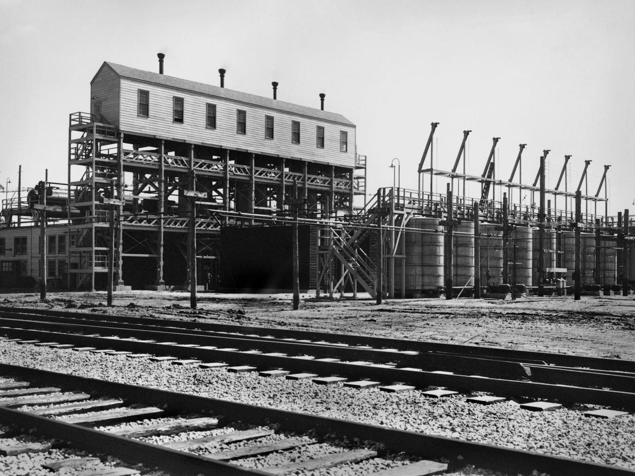
An ammonia oxidation plant at the Plum Brook Ordnance Works near Sandusky, Ohio, which later became the National Aeronautics and Space Administration’s (NASA) Plum Brook Station. During World War II the ordnance works produced trinitroluene (TNT), dinitrotoluene (DNT), and pentolite which were crated and shipped to an arsenal in Ravenna, Ohio. There, the explosives were packed into shells and sent to Allied forces overseas. Plum Brook was the third largest producer of TNT during World War II. Toluene, sulfuric acid, and nitric acid were used to manufacture the TNT. Nitric Acid is made by oxidizing ammonia, adding water, and concentrating it. The facility in this photograph was used for this oxidation. The structure included air compressors, filters, aftercoolers, power recovery systems, air receivers, heaters, ammonia gasifiers, gas mixers, cooler condensers, absorption columns, and bleaching columns. The Plum Brook Ordnance Works was shut down immediately after the war and remained vacant for the next ten years. NASA’s predecessor, the National Advisory Committee for Aeronautics (NACA), acquired the 500 acres of the site in 1955 to build a nuclear test reactor. By 1963, the agency had acquired the entire 9000 acres from the Army. Almost all of the military facilities were removed in the early 1960s. Plum Brook Station contained over 30 test facilities at its peak in the late 1960s. Today there are four major facilities in operation.

Africa is front and center in this image of Earth taken by a NASA camera on the Deep Space Climate Observatory (DSCOVR) satellite. The image, taken July 6 from a vantage point one million miles from Earth, was one of the first taken by NASA’s Earth Polychromatic Imaging Camera (EPIC). Central Europe is toward the top of the image with the Sahara Desert to the south, showing the Nile River flowing to the Mediterranean Sea through Egypt. The photographic-quality color image was generated by combining three separate images of the entire Earth taken a few minutes apart. The camera takes a series of 10 images using different narrowband filters -- from ultraviolet to near infrared -- to produce a variety of science products. The red, green and blue channel images are used in these Earth images. The DSCOVR mission is a partnership between NASA, the National Oceanic and Atmospheric Administration (NOAA) and the U.S. Air Force, with the primary objective to maintain the nation’s real-time solar wind monitoring capabilities, which are critical to the accuracy and lead time of space weather alerts and forecasts from NOAA. DSCOVR was launched in February to its planned orbit at the first Lagrange point or L1, about one million miles from Earth toward the sun. It’s from that unique vantage point that the EPIC instrument is acquiring images of the entire sunlit face of Earth. Data from EPIC will be used to measure ozone and aerosol levels in Earth’s atmosphere, cloud height, vegetation properties and a variety of other features. Image Credit: NASA
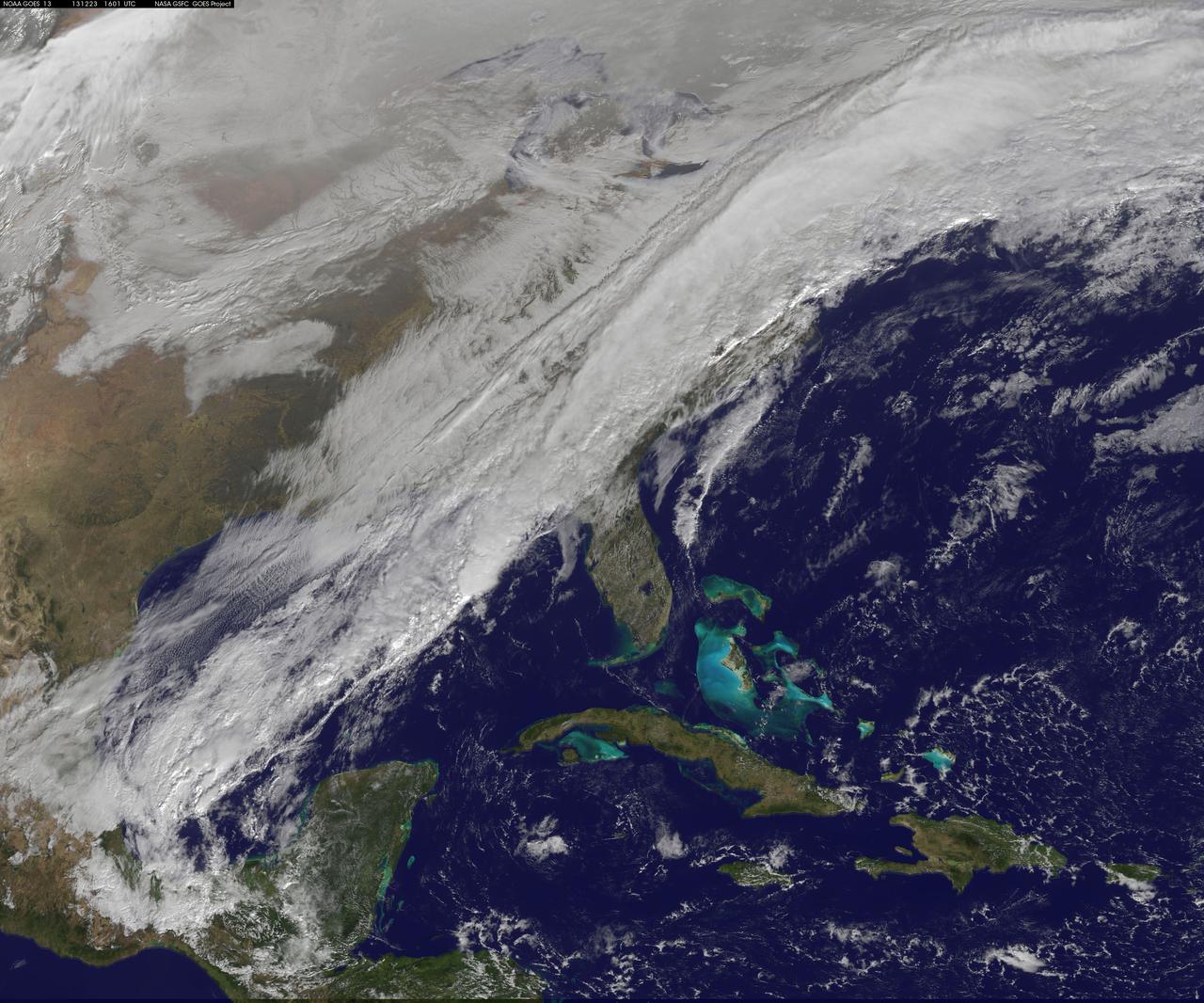
A long, strong, cold front draped over the eastern U.S. is marking a stark change from record-warmth to very cold temperatures. This NOAA GOES-East satellite image from December 23 at 1515 UTC/10:15 a.m. EST shows a powerful cold front covering the U.S. East Coast and stretching into the central and southwestern Gulf of Mexico. According to the National Weather Service, that front is bringing rain and embedded thunderstorms over the Mid-Atlantic and Southeastern U.S. The same system is bringing lingering wintry precipitation to northern New England and upstate New York. Behind the cold front, much colder and dry Canadian air will filter in under high pressure and bring sunshine over the eastern U.S. in time for Christmas. The image was created by the NASA GOES Project at NASA's Goddard Space Flight Center, Greenbelt, Md. Rob Gutro NASA Goddard Space Flight Center <b><a href="http://www.nasa.gov/audience/formedia/features/MP_Photo_Guidelines.html" rel="nofollow">NASA image use policy.</a></b> <b><a href="http://www.nasa.gov/centers/goddard/home/index.html" rel="nofollow">NASA Goddard Space Flight Center</a></b> enables NASA’s mission through four scientific endeavors: Earth Science, Heliophysics, Solar System Exploration, and Astrophysics. Goddard plays a leading role in NASA’s accomplishments by contributing compelling scientific knowledge to advance the Agency’s mission. <b>Follow us on <a href="http://twitter.com/NASA_GoddardPix" rel="nofollow">Twitter</a></b> <b>Like us on <a href="http://www.facebook.com/pages/Greenbelt-MD/NASA-Goddard/395013845897?ref=tsd" rel="nofollow">Facebook</a></b> <b>Find us on <a href="http://instagram.com/nasagoddard?vm=grid" rel="nofollow">Instagram</a></b>
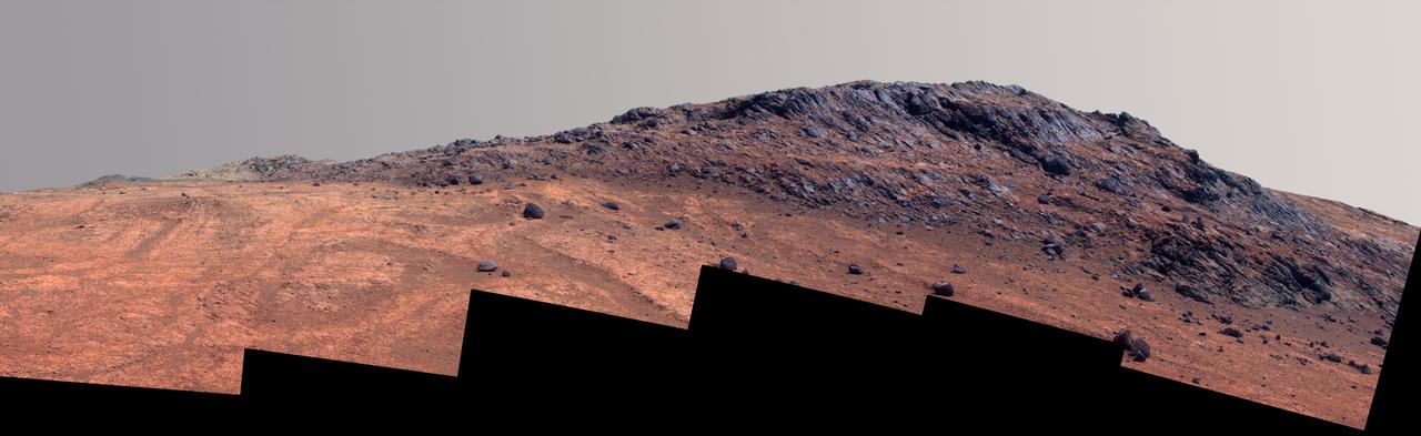
This Martian scene shows contrasting textures and colors of "Hinners Point," at the northern edge of "Marathon Valley," and swirling reddish zones on the valley floor to the left. In this version of the image, the landscape is presented in enhanced color to make differences in surface materials more easily visible. The summit takes its informal name as a tribute to Noel Hinners (1935-2014). For NASA's Apollo program, Hinners played important roles in selection of landing sites on the moon and scientific training of astronauts. He then served as NASA associate administrator for space science, director of the Smithsonian National Air and Space Museum, director of NASA's Goddard Space Flight Center, NASA chief scientist and associate deputy administrator of NASA. Subsequent to responsibility for the Viking Mars missions while at NASA, he spent the latter part of his career as vice president for flight systems at Lockheed Martin, where he had responsibility for the company's roles in development and operation of NASA's Mars Global Surveyor, Mars Reconnaissance Orbiter, Mars Odyssey, Phoenix Mars Lander, Stardust and Genesis missions. Marathon Valley cuts generally east-west through the western rim of Endeavour Crater. The valley's name refers to the distance Opportunity drove from its 2004 landing site to arrival at this location in 2014. The valley was a high-priority destination for the rover mission because observations from orbit detected clay minerals there. Dark rocks on Hinners Point show a pattern dipping downward toward the interior of Endeavour, to the right from this viewing angle. The strong dip may have resulted from the violence of the impact event that excavated the crater. Brighter rocks make up the valley floor. The reddish zones there may be areas where water has altered composition. Inspections by Opportunity have found compositions there are higher in silica and lower in iron than the typical composition of rocks on Endeavour's rim. The scene spans from west-southwest at left to northwest at right. The larger of two stones close to each other in the foreground left of center is about 5 inches (12 centimeters) wide. On bright bedrock to the right of those stones, Opportunity inspected a target informally named "Pvt. George Gibson." Another inspected target, "Pvt. Silas Goodrich," is on the valley floor near the left edge of this scene. The informal names for these targets refer to members of the Lewis and Clark expedition's Corps of Discovery. The image combines exposures taken through three of the Pancam's color filters, centered on wavelengths of 753 nanometers (near-infrared), 535 nanometers (green) and 432 nanometers (violet). http://photojournal.jpl.nasa.gov/catalog/PIA19820
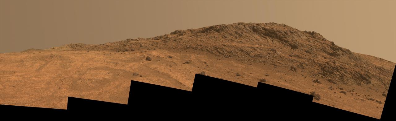
This Martian scene shows contrasting textures and colors of "Hinners Point," at the northern edge of "Marathon Valley," and swirling reddish zones on the valley floor to the left. The view combines six frames taken by the panoramic camera (Pancam) on NASA's Mars Exploration Rover Opportunity on Aug. 14, 2015, during the 4,108th Martian day, or sol, of the rover's work on Mars. The summit takes its informal name as a tribute to Noel Hinners (1935-2014). For NASA's Apollo program, Hinners played important roles in selection of landing sites on the moon and scientific training of astronauts. He then served as NASA associate administrator for space science, director of the Smithsonian National Air and Space Museum, director of NASA's Goddard Space Flight Center, NASA chief scientist and associate deputy administrator of NASA. Subsequent to responsibility for the Viking Mars missions while at NASA, he spent the latter part of his career as vice president for flight systems at Lockheed Martin, where he had responsibility for the company's roles in development and operation of NASA's Mars Global Surveyor, Mars Reconnaissance Orbiter, Mars Odyssey, Phoenix Mars Lander, Stardust and Genesis missions. Marathon Valley cuts generally east-west through the western rim of Endeavour Crater. The valley's name refers to the distance Opportunity drove from its 2004 landing site to arrival at this location in 2014. The valley was a high-priority destination for the rover mission because observations from orbit detected clay minerals there. Dark rocks on Hinners Point show a pattern dipping downward toward the interior of Endeavour, to the right from this viewing angle. The strong dip may have resulted from the violence of the impact event that excavated the crater. Brighter rocks make up the valley floor. The reddish zones there may be areas where water has altered composition. Inspections by Opportunity have found compositions there are higher in silica and lower in iron than the typical composition of rocks on Endeavour's rim. The scene spans from west-southwest at left to northwest at right. The larger of two stones close to each other in the foreground left of center is about 5 inches (12 centimeters) wide. On bright bedrock to the right of those stones, Opportunity inspected a target informally named "Pvt. George Gibson." Another inspected target, "Pvt. Silas Goodrich," is on the valley floor near the left edge of this scene. The informal names for these targets refer to members of the Lewis and Clark expedition's Corps of Discovery. This version of the image is presented in approximate true color by combing exposures taken through three of the Pancam's color filters, centered on wavelengths of 753 nanometers (near-infrared), 535 nanometers (green) and 432 nanometers (violet). http://photojournal.jpl.nasa.gov/catalog/PIA19819

Africa is front and center in this image of Earth taken by a NASA camera on the Deep Space Climate Observatory (DSCOVR) satellite. The image, taken July 6 from a vantage point one million miles from Earth, was one of the first taken by NASA’s Earth Polychromatic Imaging Camera (EPIC). Central Europe is toward the top of the image with the Sahara Desert to the south, showing the Nile River flowing to the Mediterranean Sea through Egypt. The photographic-quality color image was generated by combining three separate images of the entire Earth taken a few minutes apart. The camera takes a series of 10 images using different narrowband filters -- from ultraviolet to near infrared -- to produce a variety of science products. The red, green and blue channel images are used in these Earth images. The DSCOVR mission is a partnership between NASA, the National Oceanic and Atmospheric Administration (NOAA) and the U.S. Air Force, with the primary objective to maintain the nation’s real-time solar wind monitoring capabilities, which are critical to the accuracy and lead time of space weather alerts and forecasts from NOAA. DSCOVR was launched in February to its planned orbit at the first Lagrange point or L1, about one million miles from Earth toward the sun. It’s from that unique vantage point that the EPIC instrument is acquiring images of the entire sunlit face of Earth. Data from EPIC will be used to measure ozone and aerosol levels in Earth’s atmosphere, cloud height, vegetation properties and a variety of other features. Image Credit: NASA <b><a href="http://www.nasa.gov/audience/formedia/features/MP_Photo_Guidelines.html" rel="nofollow">NASA image use policy.</a></b> <b><a href="http://www.nasa.gov/centers/goddard/home/index.html" rel="nofollow">NASA Goddard Space Flight Center</a></b> enables NASA’s mission through four scientific endeavors: Earth Science, Heliophysics, Solar System Exploration, and Astrophysics. Goddard plays a leading role in NASA’s accomplishments by contributing compelling scientific knowledge to advance the Agency’s mission. <b>Follow us on <a href="http://twitter.com/NASAGoddardPix" rel="nofollow">Twitter</a></b> <b>Like us on <a href="http://www.facebook.com/pages/Greenbelt-MD/NASA-Goddard/395013845897?ref=tsd" rel="nofollow">Facebook</a></b> <b>Find us on <a href="http://instagrid.me/nasagoddard/?vm=grid" rel="nofollow">Instagram</a></b>
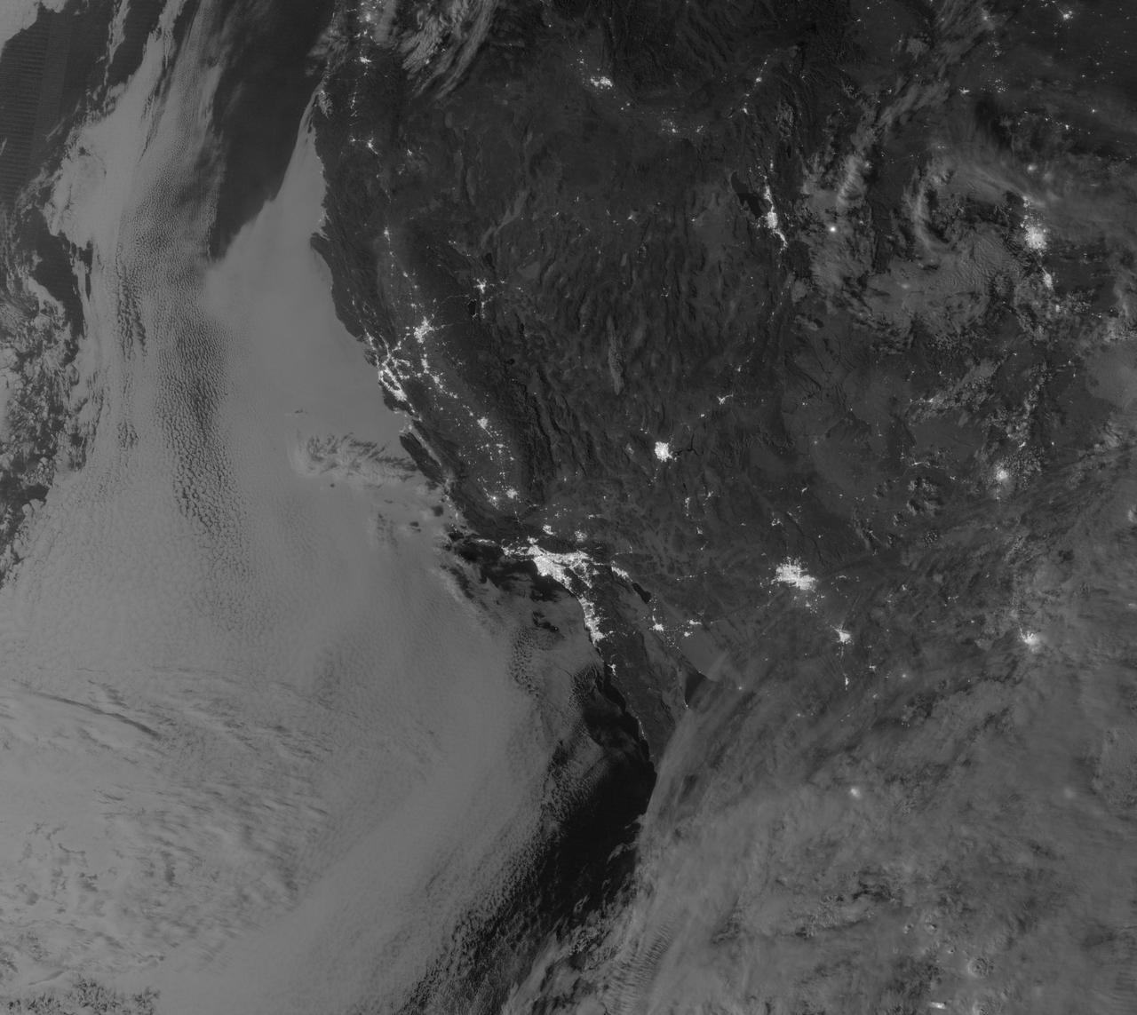
NASA image acquired September 27, 2012 On September 27, 2012, the Visible Infrared Imaging Radiometer Suite (VIIRS) on the Suomi NPP satellite captured this nighttime view of low-lying marine layer clouds along the coast of California. The image was captured by the VIIRS “day-night band,” which detects light in a range of wavelengths from green to near-infrared and uses filtering techniques to observe signals such as gas flares, auroras, wildfires, city lights, and reflected moonlight. An irregularly-shaped patch of high clouds hovers off the coast of California, and moonlight caused the high clouds to cast distinct shadows on the marine layer clouds below. VIIRS acquired the image when the Moon was in its waxing gibbous phase, meaning it was more than half-lit, but less than full. Low clouds pose serious hazards for air and ship traffic, but satellites have had difficulty detecting them in the past. To illustrate this, the second image shows the same scene in thermal infrared, the band that meteorologists generally use to monitor clouds at night. Only high clouds are visible; the low clouds do not show up at all because they are roughly the same temperature as the ground. NASA Earth Observatory image by Jesse Allen and Robert Simmon, using VIIRS Day-Night Band data from the Suomi National Polar-orbiting Partnership. Suomi NPP is the result of a partnership between NASA, the National Oceanic and Atmospheric Administration, and the Department of Defense. Caption by Adam Voiland. Instrument: Suomi NPP - VIIRS Credit: <b><a href="http://www.earthobservatory.nasa.gov/" rel="nofollow"> NASA Earth Observatory</a></b> <b>Click here to view all of the <a href="http://earthobservatory.nasa.gov/Features/NightLights/" rel="nofollow"> Earth at Night 2012 images </a></b> <b>Click here to <a href="http://earthobservatory.nasa.gov/NaturalHazards/view.php?id=79758" rel="nofollow"> read more </a> about this image </b> <b><a href="http://www.nasa.gov/audience/formedia/features/MP_Photo_Guidelines.html" rel="nofollow">NASA image use policy.</a></b> <b><a href="http://www.nasa.gov/centers/goddard/home/index.html" rel="nofollow">NASA Goddard Space Flight Center</a></b> enables NASA’s mission through four scientific endeavors: Earth Science, Heliophysics, Solar System Exploration, and Astrophysics. Goddard plays a leading role in NASA’s accomplishments by contributing compelling scientific knowledge to advance the Agency’s mission. <b>Follow us on <a href="http://twitter.com/NASA_GoddardPix" rel="nofollow">Twitter</a></b> <b>Like us on <a href="http://www.facebook.com/pages/Greenbelt-MD/NASA-Goddard/395013845897?ref=tsd" rel="nofollow">Facebook</a></b> <b>Find us on <a href="http://instagram.com/nasagoddard?vm=grid" rel="nofollow">Instagram</a></b>
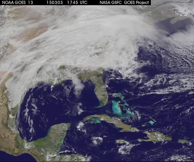
A winter storm was bringing snow, sleet and freezing rain from lower Mississippi Valley to Northeastern U.S. on Thursday, March 5, 2015. A new NASA animation of NOAA's GOES-East satellite imagery showed the progression of the clouds associated with the storm system that triggered winter storm warnings and winter weather advisories from the southern Plains eastward through the Mid-Atlantic and southern New England coast. The system also triggered flood warnings along and to the west of the central Appalachians. An animation of GOES satellite visible and infrared imagery from March 3 through March 5 showed clouds associated with a cold front push over U.S. East coast. Behind the front, Arctic air is expected to drop low temperatures into the single numbers from Washington, D.C. to Minnesota overnight. Temperatures in the Carolinas and Tennessee are expected to drop to the low 20s. NOAA's National Weather Service Weather Prediction Center (NWS NPC) in College Park, Maryland noted "a strong cold front moving across the eastern U.S. will bring heavy snow from parts of the Ohio Valley to the Northeast today (March 5) with rain, freezing rain and sleet possible from parts of the lower Mississippi Valley across the Southeast to the southern Mid-Atlantic. Snowfall totals of 5 to 10 inches are possible for some areas. Winter Storm Warnings remain in effect from Texas to Nantucket." The animation ends at 17:45 UTC (12:45 p.m. EST). Before the end of the animation, the low pressure center along an arctic frontal boundary was nearly stationary over western North Carolina at 9 a.m. EST on March 5, according to the NWS NPC. NWS radar and surface observations indicated an extended swath of precipitation from near the Texas Gulf Coast through the interior eastern U.S. into southern New England. NPC's storm summary noted at that time "rain was changing to sleet/freezing rain and to all snow along a band within this swath as colder air continues to filter in from the north. Some areas in Tennessee, the northern mid-Atlantic and southern New England were reporting moderate to heavy snow." To create the video and imagery, NASA/NOAA's GOES Project takes the cloud data from NOAA's GOES-East satellite and overlays it on a true-color image of land and ocean created by data from the Moderate Resolution Imaging Spectroradiometer, or MODIS, instrument that flies aboard NASA's Aqua and Terra satellites. Together, those data created the entire picture of the storm and show its movement. After the storm system passes, the snow on the ground becomes visible. GOES satellites provide the kind of continuous monitoring necessary for intensive data analysis. Geostationary describes an orbit in which a satellite is always in the same position with respect to the rotating Earth. This allows GOES to hover continuously over one position on Earth's surface, appearing stationary. For updated information about the storm system, visit NOAA's NWS website: <a href="http://www.weather.gov" rel="nofollow">www.weather.gov</a> For more information about GOES satellites, visit: <a href="http://www.goes.noaa.gov/" rel="nofollow">www.goes.noaa.gov/</a> or goes.gsfc.nasa.gov/ Rob Gutro NASA's Goddard Space Flight Center <b><a href="http://www.nasa.gov/audience/formedia/features/MP_Photo_Guidelines.html" rel="nofollow">NASA image use policy.</a></b> <b><a href="http://www.nasa.gov/centers/goddard/home/index.html" rel="nofollow">NASA Goddard Space Flight Center</a></b> enables NASA’s mission through four scientific endeavors: Earth Science, Heliophysics, Solar System Exploration, and Astrophysics. Goddard plays a leading role in NASA’s accomplishments by contributing compelling scientific knowledge to advance the Agency’s mission. <b>Follow us on <a href="http://twitter.com/NASAGoddardPix" rel="nofollow">Twitter</a></b> <b>Like us on <a href="http://www.facebook.com/pages/Greenbelt-MD/NASA-Goddard/395013845897?ref=tsd" rel="nofollow">Facebook</a></b> <b>Find us on <a href="http://instagrid.me/nasagoddard/?vm=grid" rel="nofollow">Instagram</a></b>