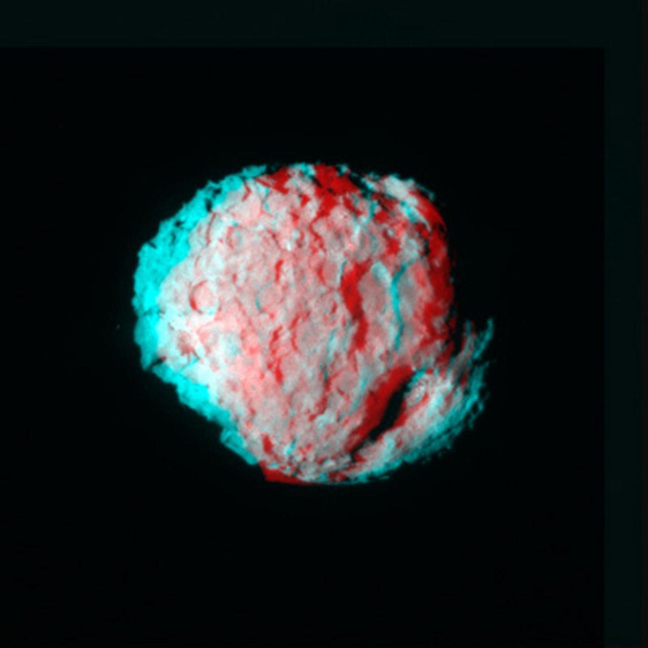
NASA Stardust Navigation Camera captured this anaglyph of the comet Wild 2. 3D glasses are necessary to view this image.
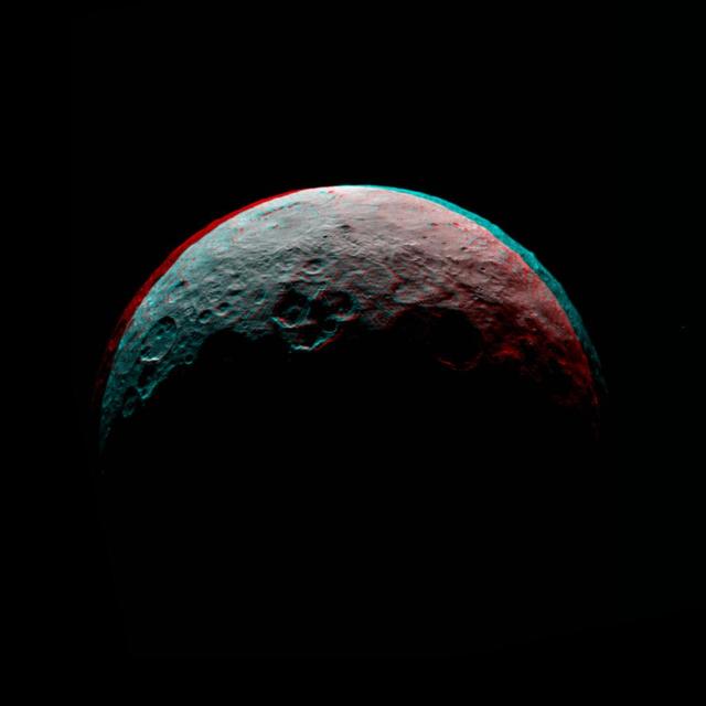
This anaglyph of Ceres is part of a sequence of images taken by NASA Dawn spacecraft April 24 to 26, 2015, from a distance of 8,500 miles 13,500 kilometers. http://photojournal.jpl.nasa.gov/catalog/PIA19540
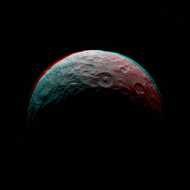
This anaglyph of Ceres is part of a sequence taken by NASA Dawn spacecraft April 24 to 26, 2015, from a distance of 8,500 miles 13,500 kilometers. http://photojournal.jpl.nasa.gov/catalog/PIA19539
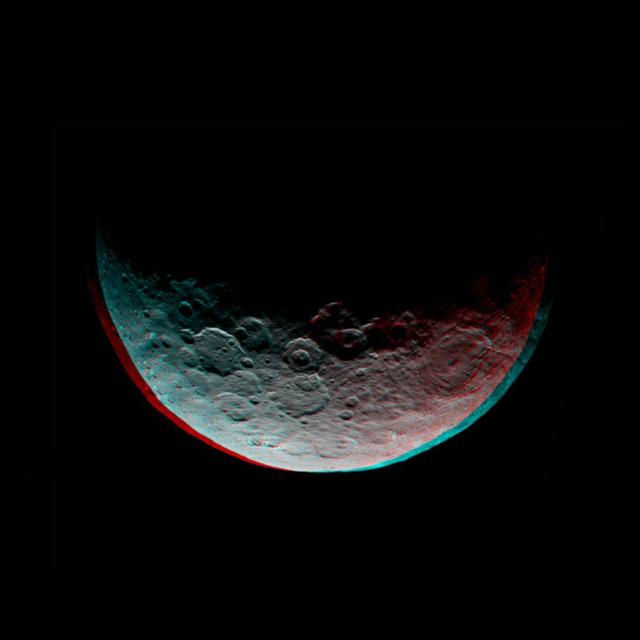
This anaglyph of Ceres is part of a sequence of images taken by NASA Dawn spacecraft April 24 to 26, 2015, from a distance of 8,500 miles 13,500 kilometers. 3-D glasses are needed to view this image. http://photojournal.jpl.nasa.gov/catalog/PIA19320
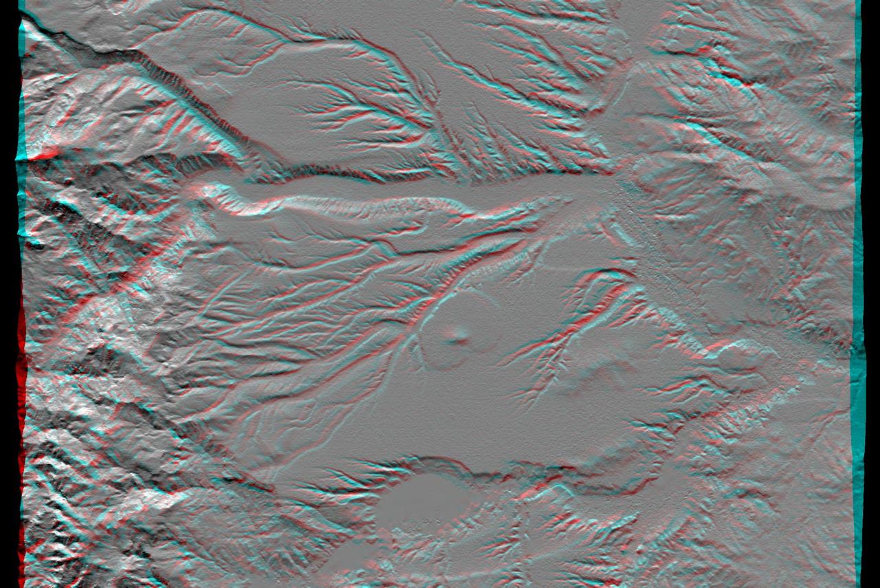
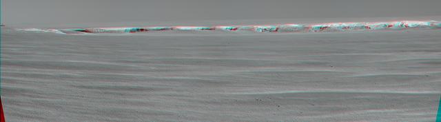
Seeing to New Depths Anaglyph
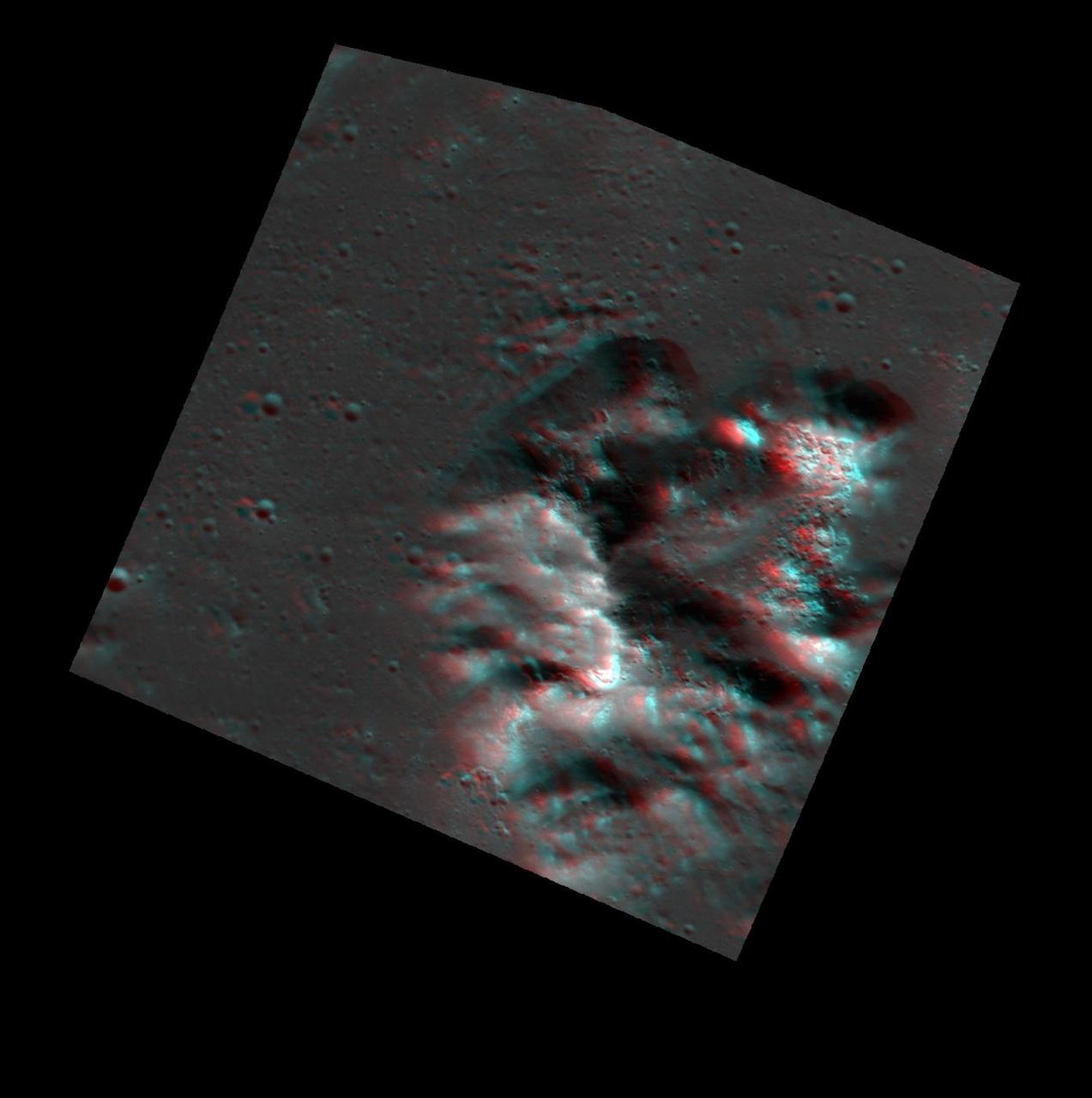
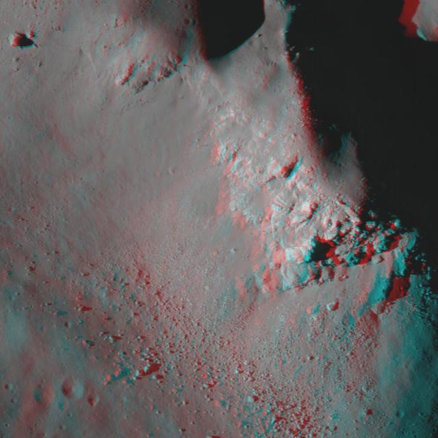
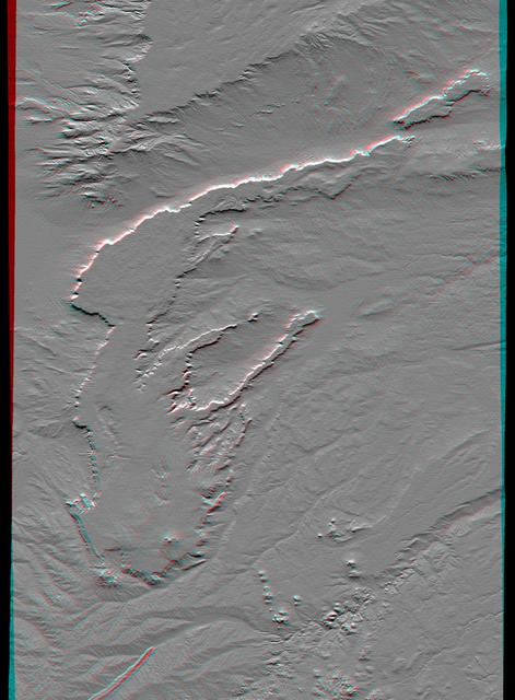
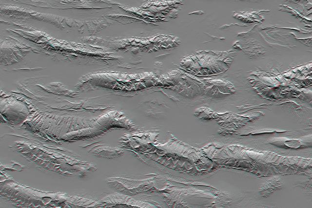
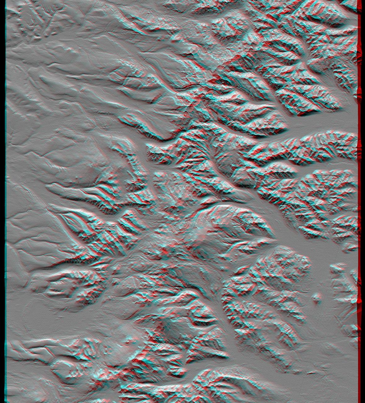
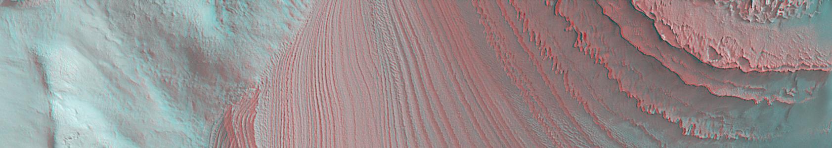
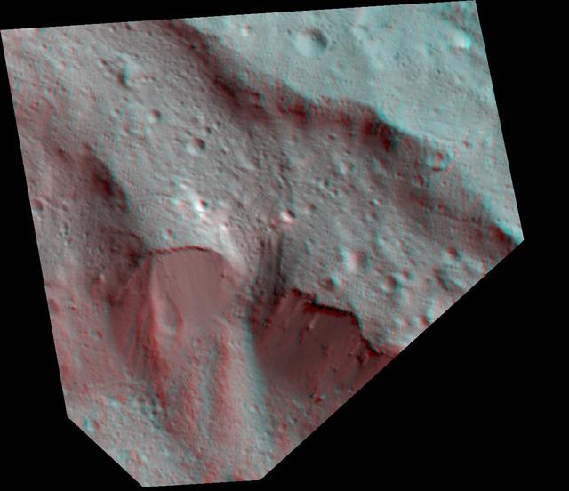
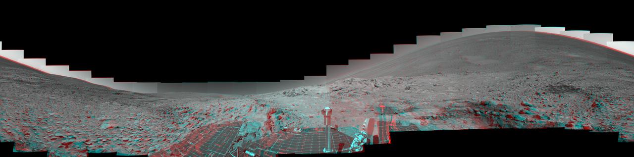
A Mountain of Hollows Anaglyph
Just in time for the U.S. National Park Service's Centennial celebration on Aug. 25, NASA's Multiangle Imaging SpectroRadiometer (MISR) instrument aboard NASA's Terra satellite is releasing four new anaglyphs that showcase 33 of our nation's national parks, monuments, historical sites and recreation areas in glorious 3D. Shown in the annotated image are Sequoia National Park, Kings Canyon National Park, Manzanar National Historic Site, Devils Postpile National Monument, Yosemite National Park, and parts of Death Valley National Park. MISR views Earth with nine cameras pointed at different angles, giving it the unique capability to produce anaglyphs, stereoscopic images that allow the viewer to experience the landscape in three dimensions. The anaglyphs were made by combining data from MISR's vertical-viewing and 46-degree forward-pointing camera. You will need red-blue glasses in order to experience the 3D effect; ensure you place the red lens over your left eye. The images have been rotated so that north is to the left in order to enable 3D viewing because the Terra satellite flies from north to south. All of the images are 235 miles (378 kilometers) from west to east. These data were acquired July 7, 2016, Orbit 88051. http://photojournal.jpl.nasa.gov/catalog/PIA20892
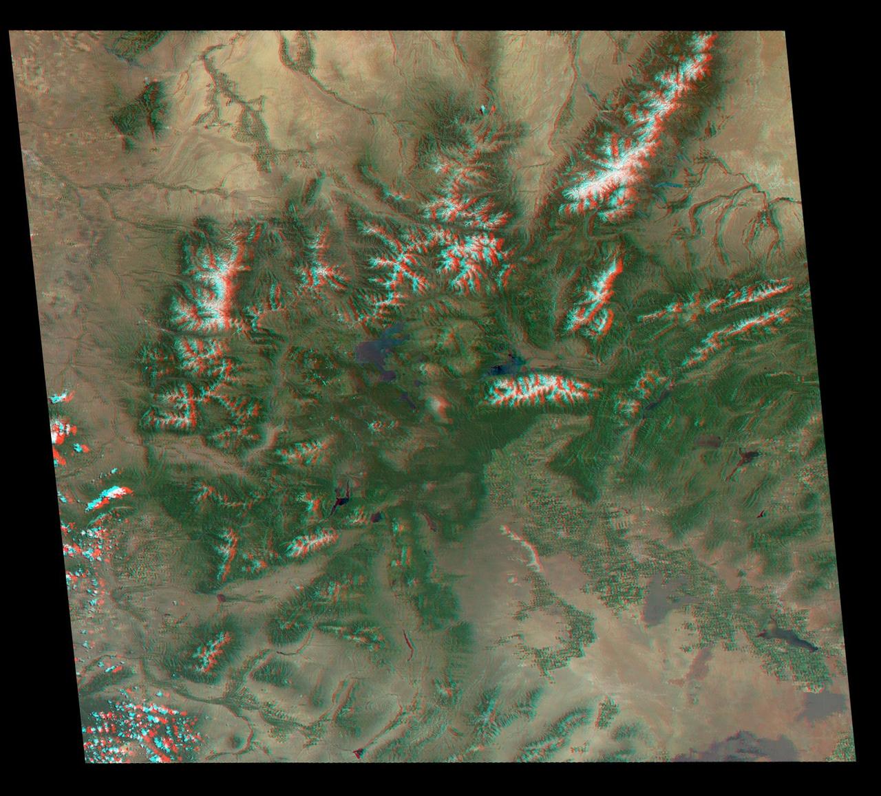
Just in time for the U.S. National Park Service's Centennial celebration on Aug. 25, NASA's Multiangle Imaging SpectroRadiometer (MISR) instrument aboard NASA's Terra satellite is releasing four new anaglyphs that showcase 33 of our nation's national parks, monuments, historical sites and recreation areas in glorious 3D. Shown in the annotated image are Grand Teton National Park, John D. Rockefeller Memorial Parkway, Yellowstone National Park, and parts of Craters of the Moon National Monument. MISR views Earth with nine cameras pointed at different angles, giving it the unique capability to produce anaglyphs, stereoscopic images that allow the viewer to experience the landscape in three dimensions. The anaglyphs were made by combining data from MISR's vertical-viewing and 46-degree forward-pointing camera. You will need red-blue glasses in order to experience the 3D effect; ensure you place the red lens over your left eye. The images have been rotated so that north is to the left in order to enable 3D viewing because the Terra satellite flies from north to south. All of the images are 235 miles (378 kilometers) from west to east. These data were acquired June 25, 2016, Orbit 87876. http://photojournal.jpl.nasa.gov/catalog/PIA20890
Just in time for the U.S. National Park Service's Centennial celebration on Aug. 25, NASA's Multiangle Imaging SpectroRadiometer (MISR) instrument aboard NASA's Terra satellite is releasing four new anaglyphs that showcase 33 of our nation's national parks, monuments, historical sites and recreation areas in glorious 3D. Shown in the annotated image are Lewis and Clark National Historic Park, Mt. Rainier National Park, Olympic National Park, Ebey's Landing National Historical Reserve, San Juan Island National Historic Park, North Cascades National Park, Lake Chelan National Recreation Area, and Ross Lake National Recreation Area (also Mt. St. Helens National Volcanic Monument, administered by the U.S. Forest Service) MISR views Earth with nine cameras pointed at different angles, giving it the unique capability to produce anaglyphs, stereoscopic images that allow the viewer to experience the landscape in three dimensions. The anaglyphs were made by combining data from MISR's vertical-viewing and 46-degree forward-pointing camera. You will need red-blue glasses in order to experience the 3D effect; ensure you place the red lens over your left eye. The images have been rotated so that north is to the left in order to enable 3D viewing because the Terra satellite flies from north to south. All of the images are 235 miles (378 kilometers) from west to east. These data were acquired May 12, 2012, Orbit 65960. http://photojournal.jpl.nasa.gov/catalog/PIA20891
Just in time for the U.S. National Park Service's Centennial celebration on Aug. 25, NASA's Multiangle Imaging SpectroRadiometer (MISR) instrument aboard NASA's Terra satellite is releasing four new anaglyphs that showcase 33 of our nation's national parks, monuments, historical sites and recreation areas in glorious 3D. Shown in the annotated image are Walnut Canyon National Monument, Sunset Crater Volcano National Monument, Wupatki National Monument, Grand Canyon National Park, Pipe Spring National Monument, Zion National Park, Cedar Breaks National Monument, Bryce Canyon National Park, Capitol Reef National Park, Navajo National Monument, Glen Canyon National Recreation Area, Natural Bridges National Monument, Canyonlands National Park, and Arches National Park. MISR views Earth with nine cameras pointed at different angles, giving it the unique capability to produce anaglyphs, stereoscopic images that allow the viewer to experience the landscape in three dimensions. The anaglyphs were made by combining data from MISR's vertical-viewing and 46-degree forward-pointing camera. You will need red-blue glasses in order to experience the 3D effect; ensure you place the red lens over your left eye. The images have been rotated so that north is to the left in order to enable 3D viewing because the Terra satellite flies from north to south. All of the images are 235 miles (378 kilometers) from west to east. These data were acquired June 18, 2016, Orbit 87774. http://photojournal.jpl.nasa.gov/catalog/PIA20889
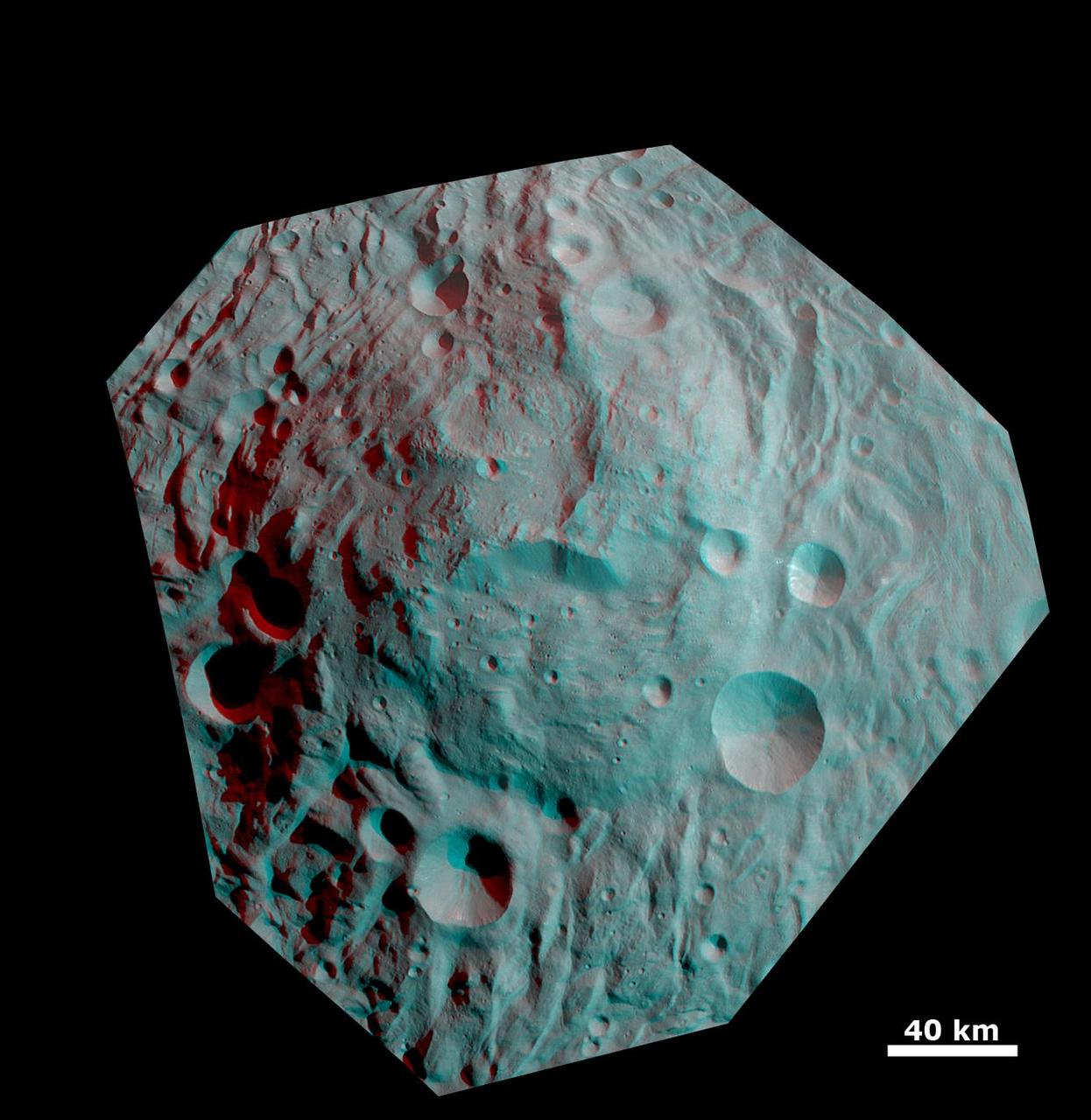
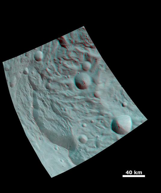
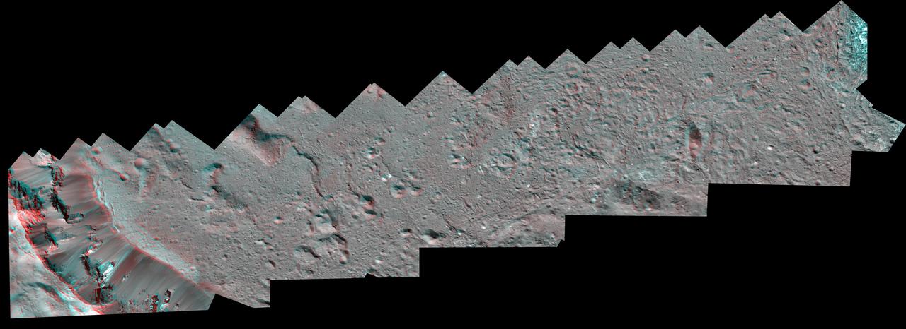
This anaglyph image shows the topography of asteroid Vesta southwestern region. The large, heavily degraded subdued rimmed crater in the top right becomes clearer in this anaglyph image. You need 3D glasses to view this image.

Craters on Saturn moon Pandora exhibit clarity and depth in this anaglyph from NASA Cassini spacecraft. 3D glasses are necessary to view this image.

This anaglyph, from NASA Shuttle Radar Topography Mission, is of Honolulu, on the island of Oahu .3D glasses are necessary to view this image.
This anaglyph NASA Shuttle Radar Topography Mission, shows the city of Bhuj, India. 3D glasses are necessary to view this image.
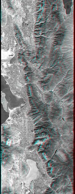
This anaglyph, from NASA Shuttle Radar Topography Mission, is of Salt Lake City, Utah. 3D glasses are necessary to view this image.
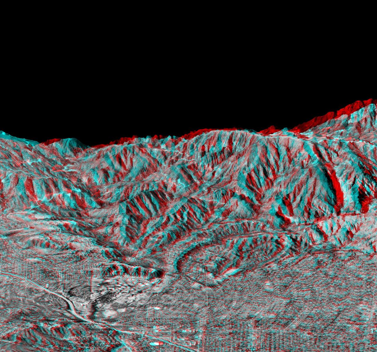
This elevation anaglyph of Los Angeles and adjacent mountainous terrain was created by NASA Shuttle Radar Topography Mission. 3D glasses are necessary to view this image.
This anaglyph, from NASA Shuttle Radar Topography Mission, is of the Iturralde Structure, Bolivia, a possible impact crater. 3D glasses are necessary to view this image.
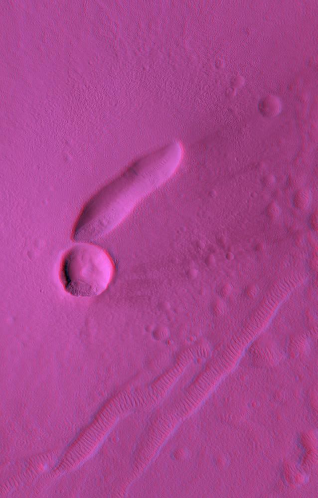
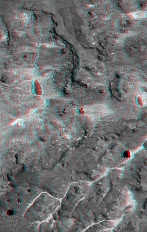
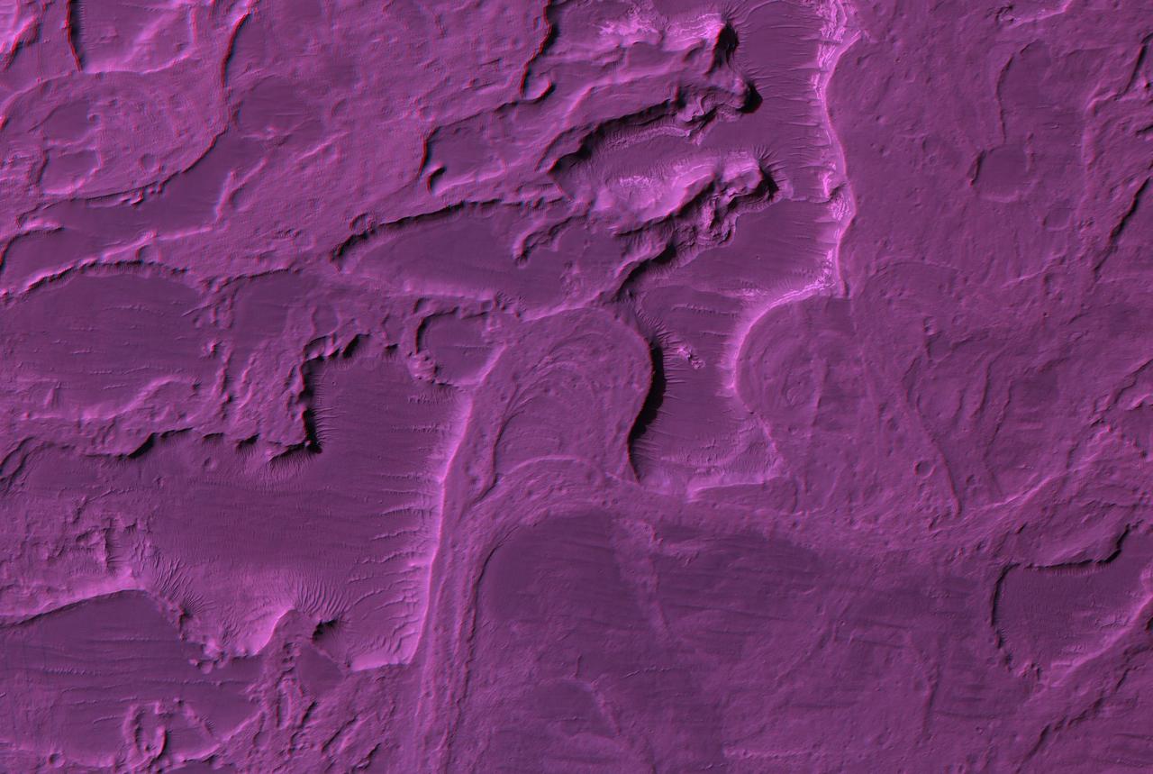
This anaglyph from NASA Mars Reconnaissance Orbiter spacecraft, is of East Mareotis Tholus, a small volcano in Tempe Terra, Mars. 3D glasses are necessary to view this image.
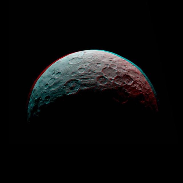
This image of Ceres is part of a sequence taken by NASA Dawn spacecraft April 24 to 26, 2015, from a distance of 8,500 miles 13,500 kilometers. You need 3-D glasses to view this image. http://photojournal.jpl.nasa.gov/catalog/PIA19537
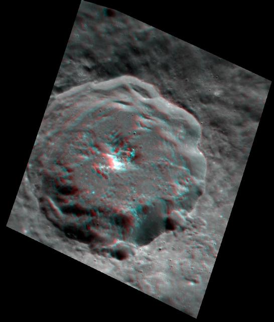
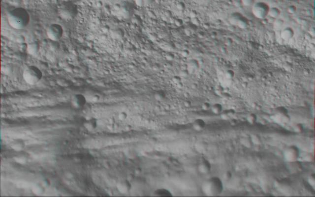
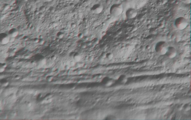
NASA Lunar Reconnaissance Orbiter captured this anaglyph image is a close up view of Copernicus crater. 3D glasses are necessary to view this image.
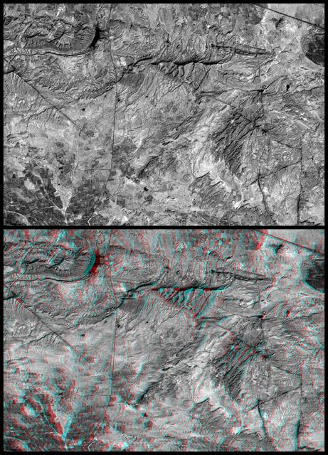
This anaglyph NASA Shuttle Radar Topography Mission, shows the Haro and Kas Hills of the Kachchh region in western India. 3D glasses are necessary to view this image.
This anaglyph, from NASA Shuttle Radar Topography Mission, is of the Andes Mountains, southeast of San Carlos de Bariloche, Argentina. 3D glasses are necessary to view this image.
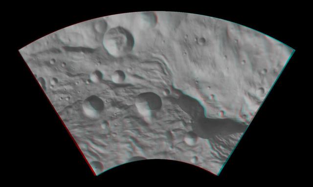
This anaglyph from NASA Dawn spacecraft image shows the topography of asteroid Vesta southeastern region. You need 3D glasses to view this image.
This anaglyph, from NASA Shuttle Radar Topography Mission, is of Patagonia, near La Esperanza, Argentina. 3D glasses are necessary to view this image.
This anaglyph, from NASA Shuttle Radar Topography Mission, is of Massanutten Mountain in the Shenandoah Valley of northern Virginia. 3D glasses are necessary to view this image.
This anaglyph, from NASA Shuttle Radar Topography Mission, shows the city of Bhuj, India. 3D glasses are necessary to view this image.
This anaglyph, from NASA Shuttle Radar Topography Mission, is of Lake Palanskoye in northern Kamchatka. 3D glasses are necessary to view this image.
This anaglyph, from NASA Shuttle Radar Topography Mission, is of Mount St Helens, Washington. 3D glasses are necessary to view this image.
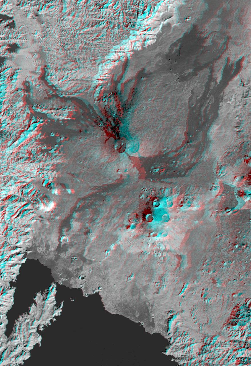
This anaglyph, from NASA Shuttle Radar Topography Mission, is of the Nyiragongo volcano in the Congo. 3D glasses are necessary to view this image.
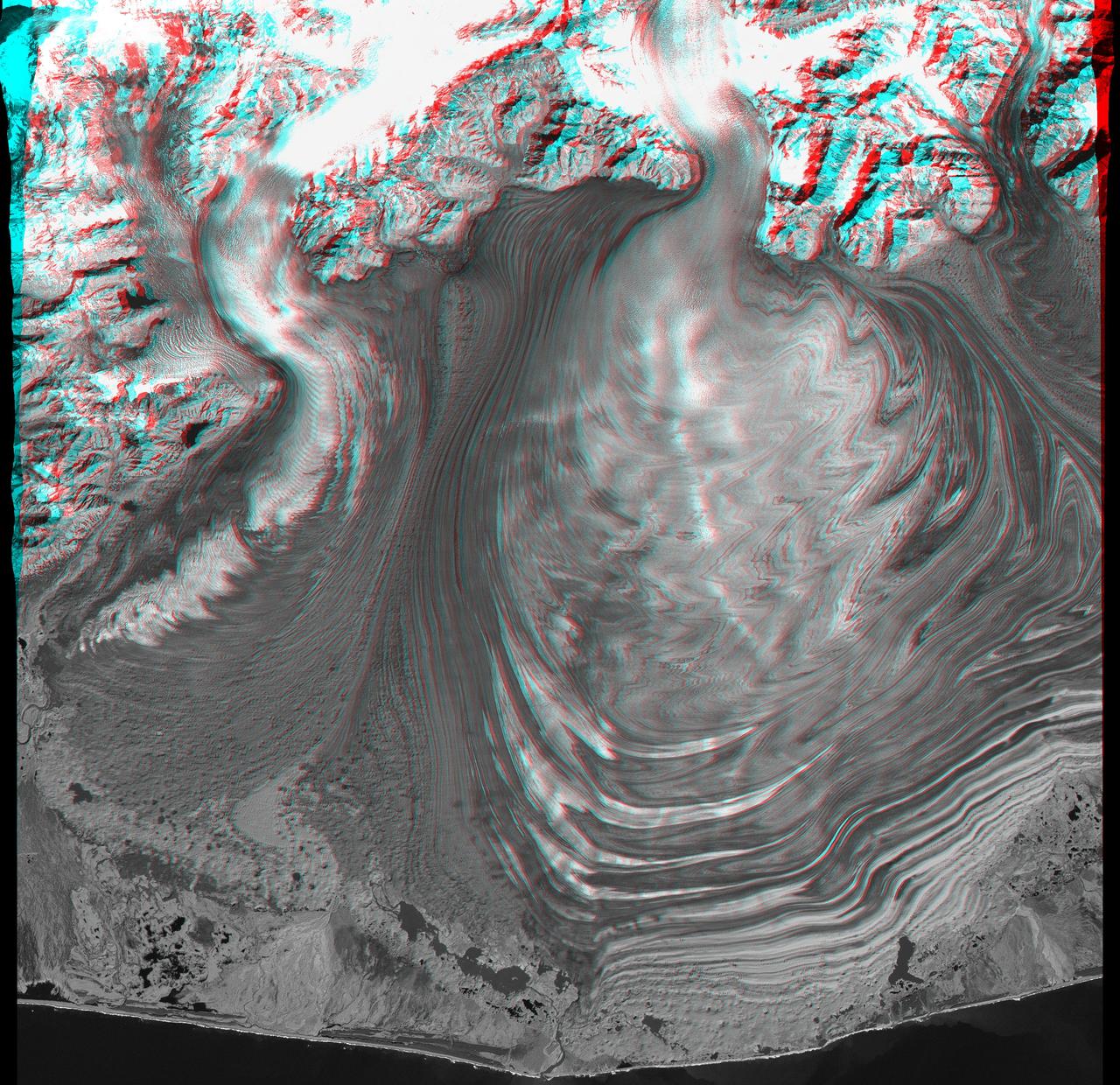
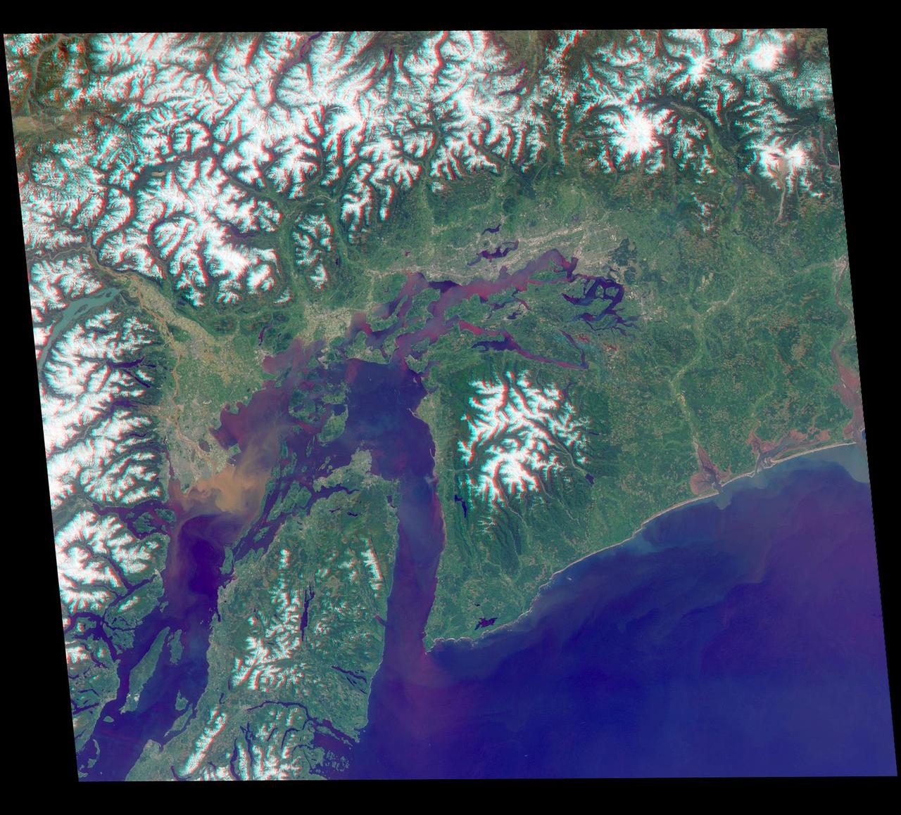
This anaglyph, from NASA Shuttle Radar Topography Mission, is of Malaspina Glacier in southeastern Alaska. 3D glasses are necessary to view this image.
This anaglyph, from NASA Shuttle Radar Topography Mission, shows complexly eroded volcanic terrain in northern Patagonia, near El Cain, Argentina. 3D glasses are necessary to view this image.
This anaglyph, from NASA Shuttle Radar Topography Mission, in South America is dominated by the Andes Mountains, which extend all along the Pacific Coast. 3D glasses are necessary to view this image.
This anaglyph, from NASA Shuttle Radar Topography Mission, shows Viti Levu, the largest island in the group some 332 islands commonly known as Fiji. 3D glasses are necessary to view this image.
This anaglyph shows a 3-D model of the protoplanet Vesta, using scientists best guess to date of what the surface of the protoplanet might look like. It was created as part of an exercise for NASA Dawn mission. 3D glasses are necessary.
This anaglyph, from NASA Shuttle Radar Topography Mission, shows elatively young volcanoes in northern Patagonia, at Los Menucos, Argentina. 3D glasses are necessary to view this image.
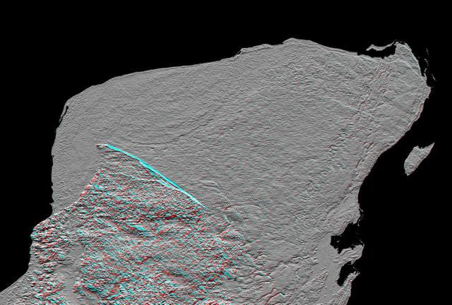
This anaglyph of Mexico Yucatan Peninsula was generated from NASA Shuttle Radar Topography Mission data, and shows a subtle but distinctive indication of the Chicxulub impact crater. 3D glasses are necessary to view this image.
This anaglyph, from NASA Shuttle Radar Topography Mission, is of the coastal area in southernmost Oman; the Arabian Sea is on the right. 3D glasses are necessary to view this image.
This anaglyph, from NASA Shuttle Radar Topography Mission, shows basalt cliffs along the northwest edge of the Meseta de Somuncura plateau near Sierra Colorada, Argentina. 3D glasses are necessary to view this image.

This anaglyph, from NASA Shuttle Radar Topography Mission, shows Wheeler Ridge and vicinity, California, a site of major tectonic activity. 3D glasses are necessary to view this image.
This anaglyph, from NASA Shuttle Radar Topography Mission, is of an area southwest of Zapala, Argentina, showing a wide diversity of geologic features. 3D glasses are necessary to view this image.
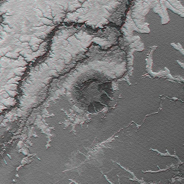
Manicouagan Crater is one of the world largest and oldest known impact craters and perhaps the one most readily apparent to astronauts in orbit. This anaglyph is from the instrument onboard NASA Shuttle Radar Topography Mission. 3D glasses needed.
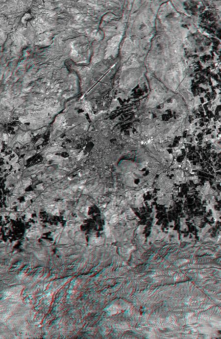
This anaglyph, from NASA Shuttle Radar Topography Mission, shows the city of Bhuj, India. 3D glasses are necessary to view this image.
This anaglyph NASA Shuttle Radar Topography Mission, shows the city of Bhuj, India. 3D glasses are necessary to view this image.
This stereo anaglyph combines two views from the Multi-angle Imaging SpectroRadiometer (MISR) instrument aboard the Terra satellite. The images were taken minutes after a fireball - the term used for exceptionally bright meteors that are visible over a wide area - exploded over the Bering Sea on Dec. 18, 2018. The anaglyph has been rotated 93.8 degrees counterclockwise to enable 3D viewing. The 3D effect can be seen with red-blue glasses. https://photojournal.jpl.nasa.gov/catalog/PIA23050
This anaglyph from NASA Mars Reconnaissance Orbiter spacecraft, shows Olympus Mons, the largest volcano in the Solar System. Constructed of lava flows, many aspects of this titanic volcano remain puzzling. 3D glasses are necessary to view this image.
This 3-D anaglyph shows an area on the western side of the volcanically active Kamchatka Peninsula, Russia as seen by the instrument onboard NASA Shuttle Radar Topography Mission. 3D glasses are necessary to view this image.
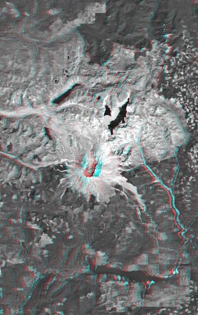
This anaglyph, from NASA Shuttle Radar Topography Mission, is of Mount Meru, an active volcano located just 70 kilometers 44 miles west of Mount Kilimanjaro. 3D glasses are necessary to view this image.
This anaglyph image shows the topography of part of Vesta equatorial region; this uneven topography is mostly due to large, ancient, rather degraded ruin eroded craters. You need 3D glasses to view this image.
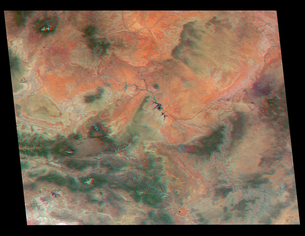
The Zagros Mountains in Iran offer a visually stunning topographic display of geologic structure in layered sedimentary rocks in this anaglyph from NASA Shuttle Radar Topography Mission. 3D glasses are necessary to view this image.
This anaglyph, from NASA Shuttle Radar Topography Mission, shows the eastern flank of the Andes Mountains, southeast of San Martin de Los Andes, Argentina. 3D glasses are necessary to view this image.
This anaglyph image shows the topography of part of Vesta equatorial region. These craters are classed as ruin eroded craters and are most clear in the center of the image, above the troughs. You need 3D glasses to view this image.
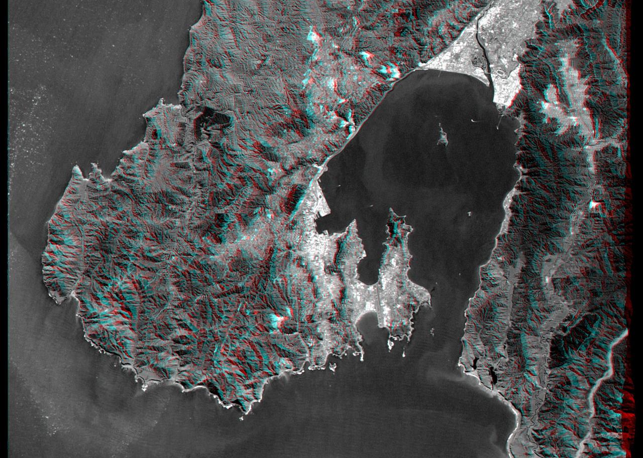
This anaglyph, from NASA Shuttle Radar Topography Mission, is of Wellington, the capital city of New Zealand, located on the shores of Port Nicholson, a natural harbor. 3D glasses are necessary to view this image.
This anaglyph, from the instrument onboard NASA Shuttle Radar Topography Mission, shows an area south of San Martin de Los Andes, Argentina. 3D glasses are necessary to view this image.
This anaglyph from NASA Mars Reconnaissance Orbiter shows erosional features formed by seasonal frost near the south pole of Mars. 3D glasses are necessary to view this image.
This anaglyph shows NASA Jet Propulsion Laboratory JPL in Pasadena, California as seen by the instrument onboard NASA Shuttle Radar Topography Mission. 3D glasses are necessary to view this image.

This anaglyph, from NASA Shuttle Radar Topography Mission, shows Meseta de Somuncura, a broad plateau capped by basalt. Near its western edge is evidence of multiple volcanic events. 3D glasses are necessary to view this image.
This anaglyph from NASA Mars Reconnaissance Orbiter spacecraft, shows that Eberswalde Delta contains river meanders, which indicate that flowing water was present for an extended period of time. 3D glasses are necessary to view this image.
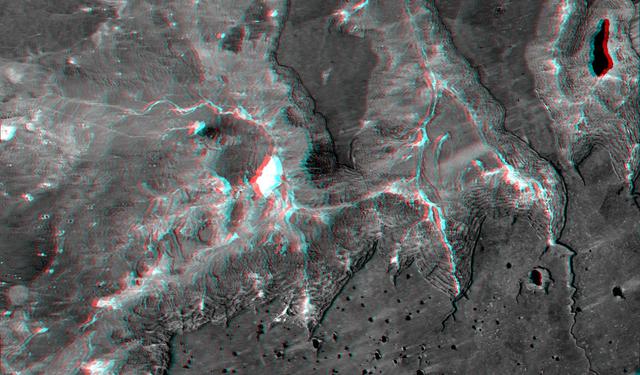
This anaglyph, from NASA Shuttle Radar Topography Mission, shows the Kamchatka Peninsula in eastern Russia. Sredinnyy Khrebet, the mountain range that makes up the spine of the peninsula. 3D glasses are necessary to view this image.
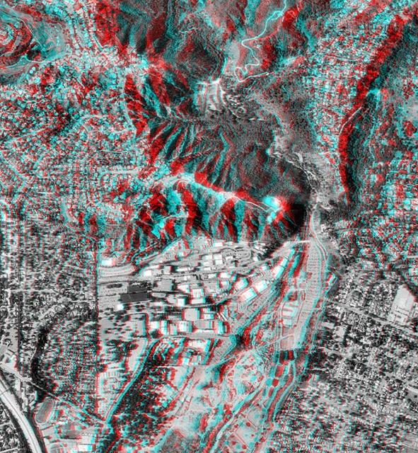
This anaglyph, from NASA Shuttle Radar Topography Mission, is of Pasadena, California, looking north toward the San Gabriel Mountains. 3D glasses are necessary to view this image.
This anaglyph, from NASA Shuttle Radar Topography Mission, is of the Iturralde Structure, Bolivia, a possible impact crater. 3D glasses are necessary to view this image.
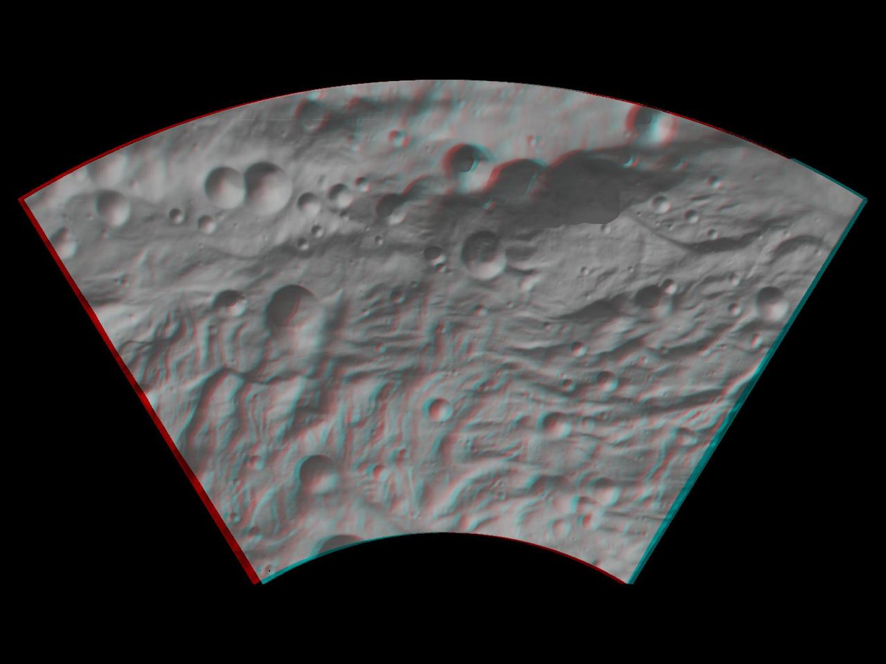
This anaglyph image shows the topography of the mountain-central complex in asteroid Vesta south polar region. You need 3D glasses to view this image.
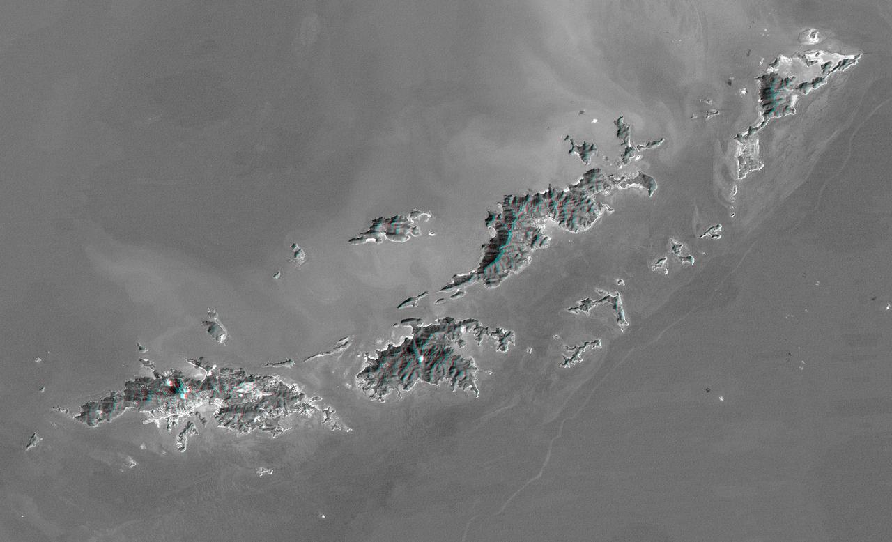
St. Thomas, St. John, Tortola, and Virgin Gorda are the four main islands lower left to upper right of this map-view anaglyph of the U.S. Virgin Islands and British Virgin Islands from NASA Shuttle Radar Topography Mission. 3D glasses are necessary.
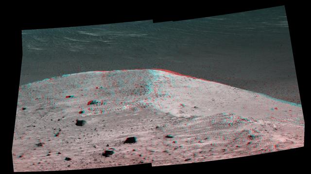
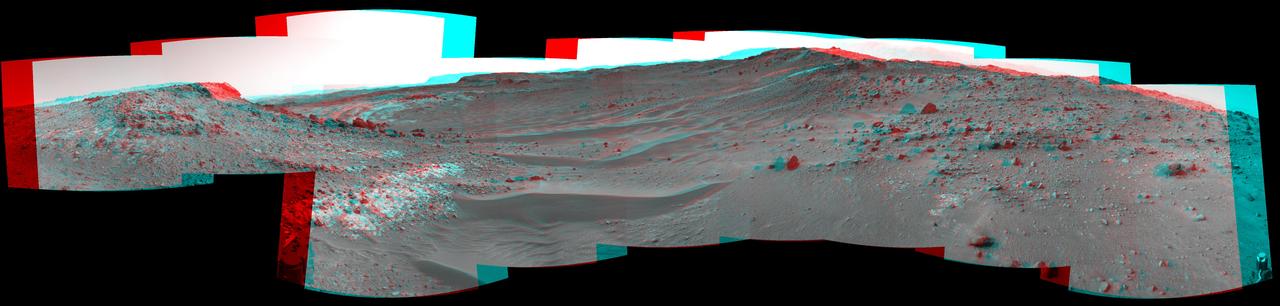
This stereo scene from NASA's Mars Exploration Rover Opportunity shows "Spirit Mound" overlooking the floor of Endeavour Crater. The mound stands near the eastern end of "Bitterroot Valley" on the western rim of the crater, and this view faces eastward. The image combines views from the left eye and right eye of the rover's panoramic camera (Pancam) to appear three-dimensional when seen through blue-red glasses with the red lens on the left. The component images were taken on Sept. 21, 2016, during the 4,501st Martian day, or sol, of Opportunity's work on Mars For scale, the two rocks at lower center are each about 8 inches (about 20 centimeters) across. At the mound's crest line, the image covers an area about 28 feet (about 8.5 meters) wide. The informal name the rover's science team chose for this feature refers to Spirit Mound in South Dakota. The team is using names of sites visited by the Lewis and Clark Expedition as informal names for features in Mars' Bitterroot Valley (named for a valley that the expedition visited in Montana). http://photojournal.jpl.nasa.gov/catalog/PIA20853
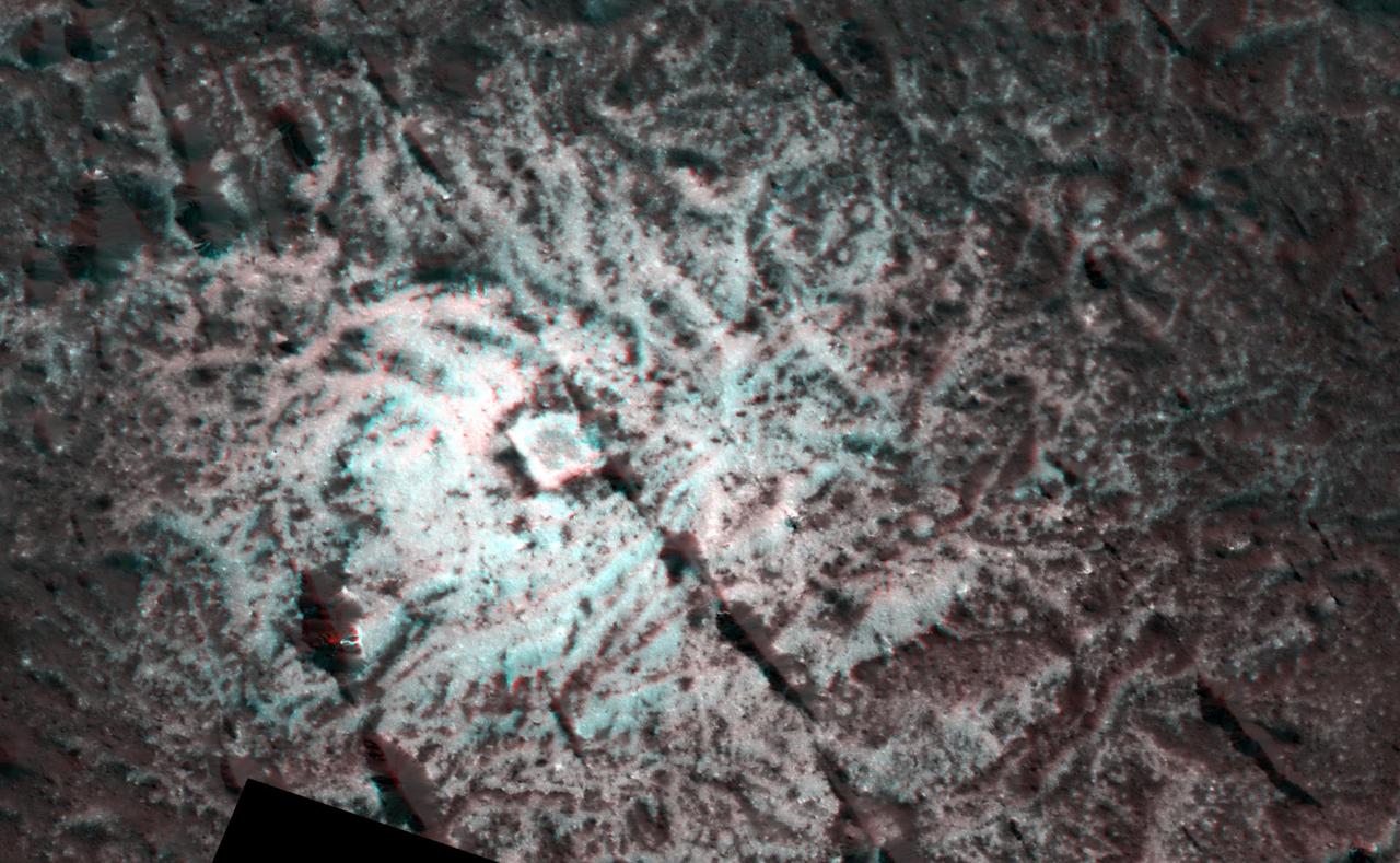
This 3-D image, or anaglyph, shows the center of Occator Crater, the brightest area on dwarf planet Ceres, using data from NASA's Dawn mission. The bright central area, including a dome that is 0.25 miles (400 meters) high, is called Cerealia Facula. The secondary, scattered bright areas are called Vinalia Faculae. A 2017 study suggests that the central bright area is significantly younger than Occator Crater. Estimates put Cerealia Facula at 4 million years old, while Occator Crater is approximately 34 million years old. The reflective material that appears so bright in this image is made of carbonate salts, according to Dawn researchers. The Vinalia Faculae seem to be composed of carbonates mixed with dark material. http://photojournal.jpl.nasa.gov/catalog/PIA21398
Mount San Antonio more commonly known as Mount Baldy crowns the San Gabriel Mountains northeast of Los Angeles, Calif., in this anaglyph from NASA Shuttle Radar Topography Mission. 3D glasses are necessary to view this image.
This anaglyph image from NASA Dawn spacecraft shows the topography of asteroid Vesta south polar region. The material at the base of the scarp right side is probably due to landsliding.
This anaglyph image from NASA Dawn spacecraft shows the topography of the mountain-central complex in asteroid Vesta south polar region. You need 3D glasses to view this image.
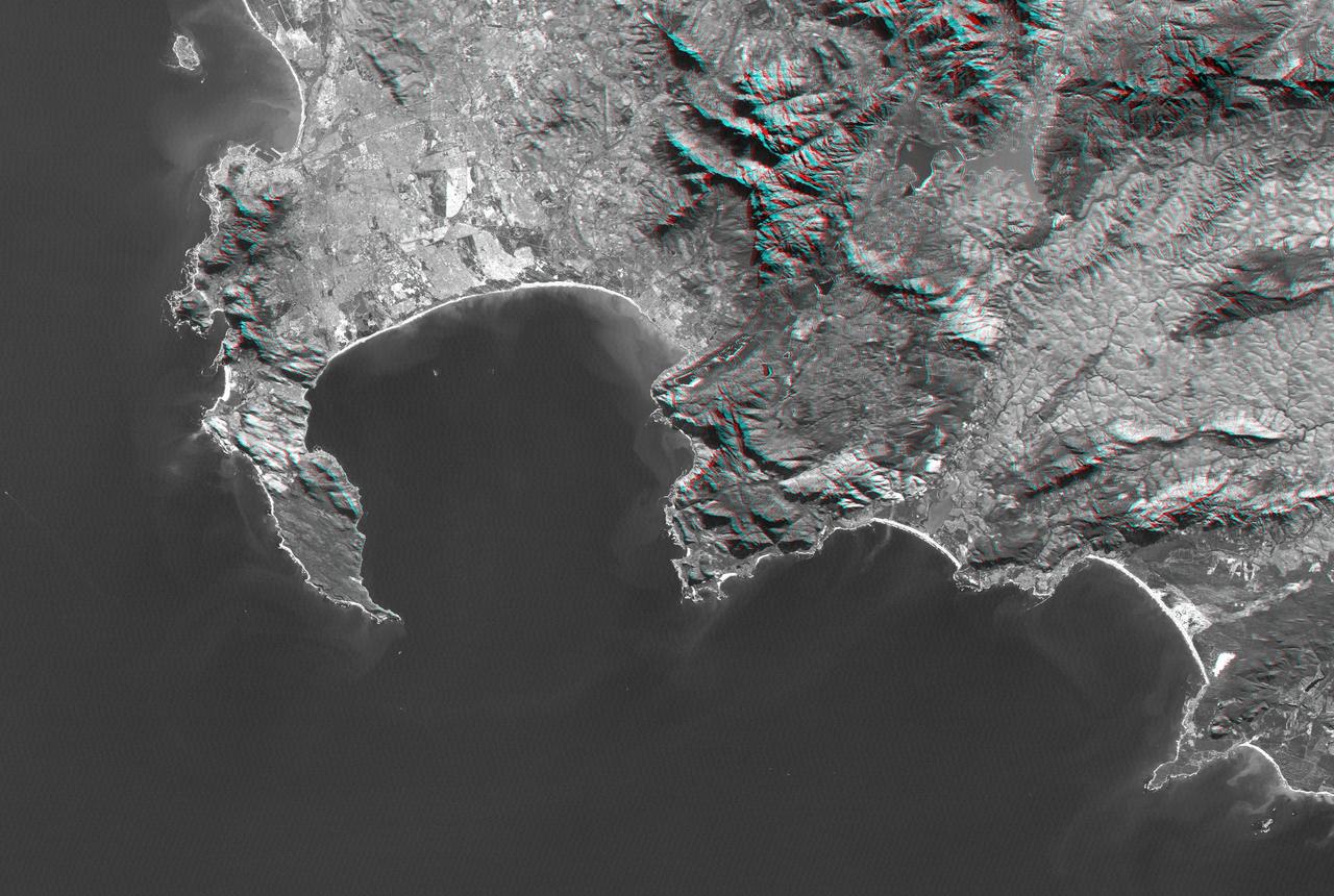
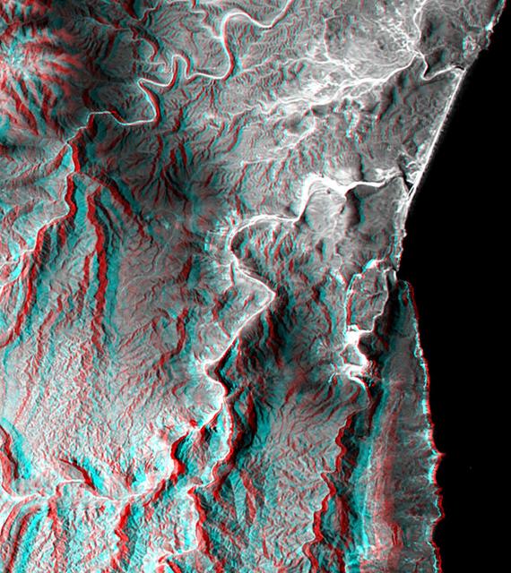
Cape Town and the Cape of Good Hope, South Africa, appear on the left west of this anaglyph from NASA Shuttle Radar Topography Mission. 3D glasses are necessary to view this image.
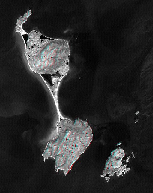
This anaglyph, from NASA Shuttle Radar Topography Mission, shows Miquelon and Saint Pierre Islands, located south of Newfoundland, Canada. 3D glasses are necessary to view this image.

This anaglyph, from NASA Shuttle Radar Topography Mission, shows Meseta de Somuncura, a semi-arid basalt plateau in northern Patagonia. 3D glasses are necessary to view this image.
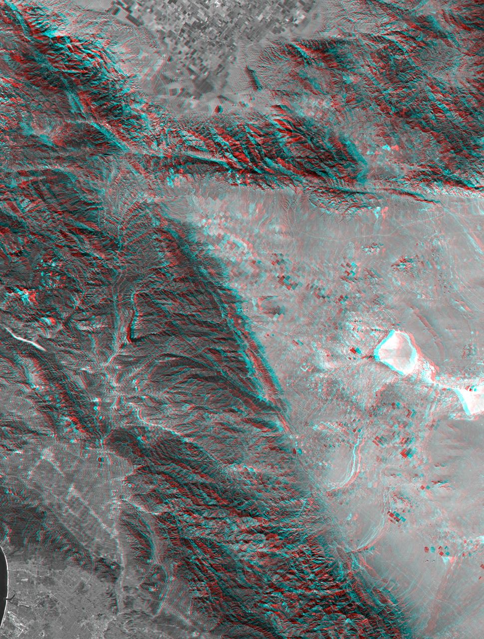
This anaglyph, from NASA Shuttle Radar Topography Mission, shows rugged terrain between Los Angeles and California central valley. 3D glasses are necessary to view this image.
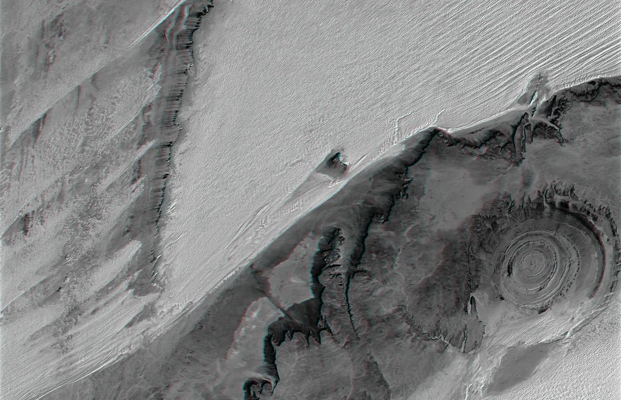
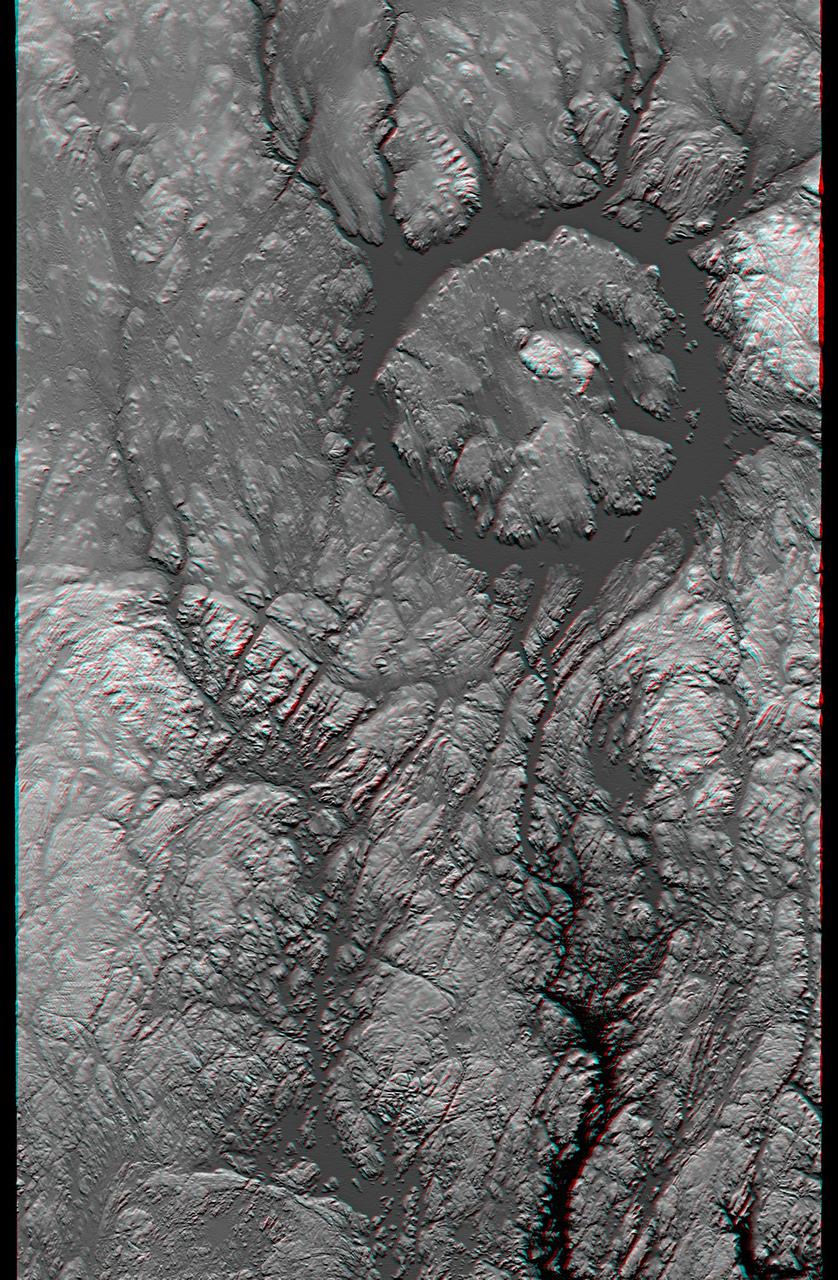
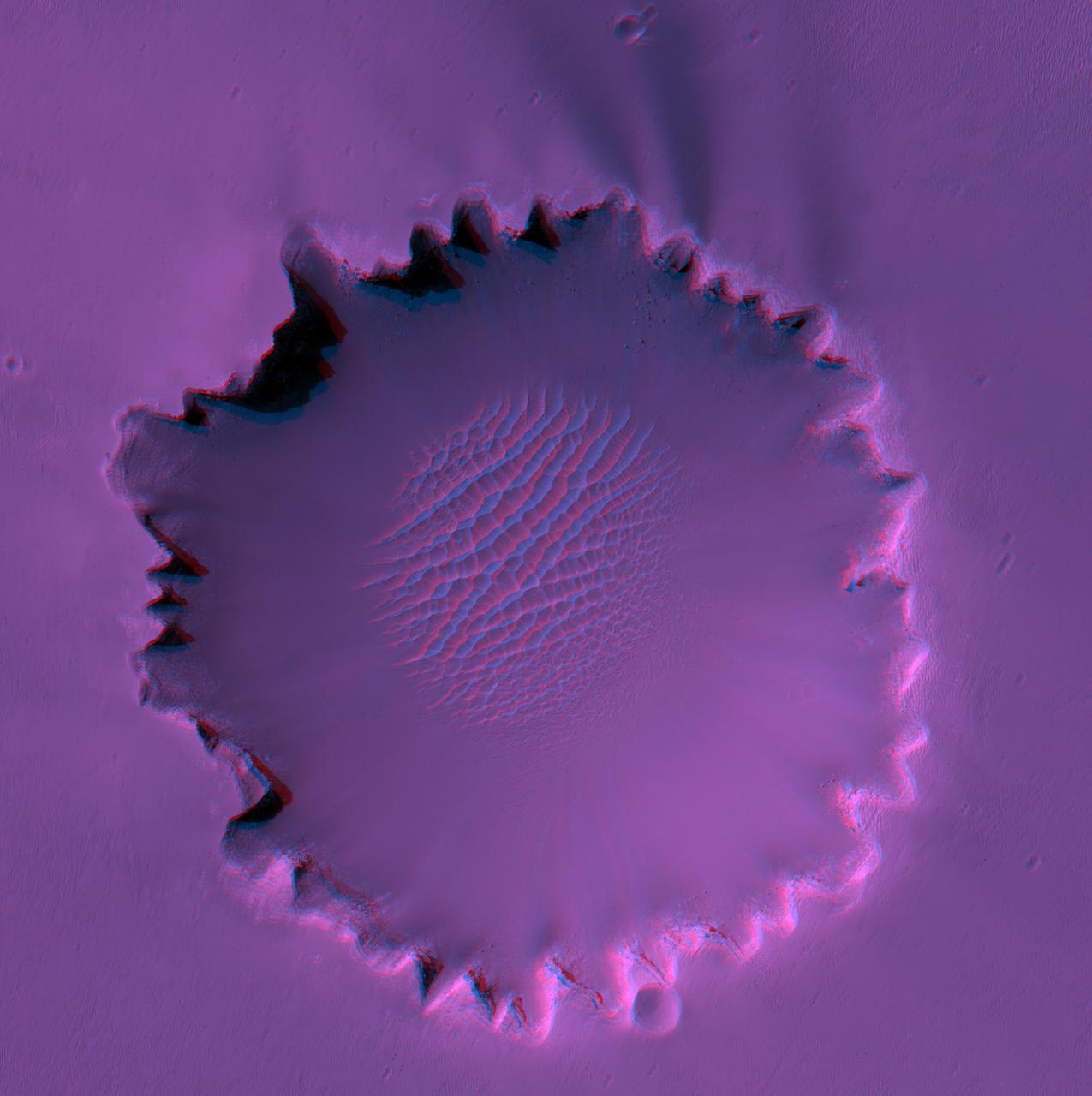
The prominent circular feature seen here is known as the Richat Structure, in the Sahara desert of Mauritania. This anaglyph is from NASA Shuttle Radar Topography Mission. 3D glasses are necessary to view this image.
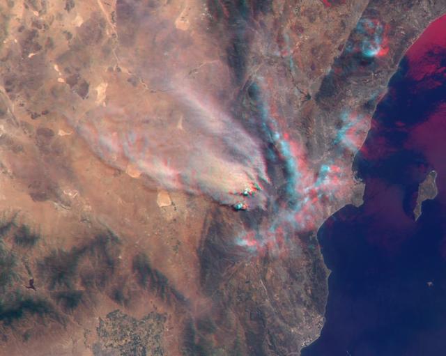
NASA Terra satellite took this anaglyph of several pyrocumulus clouds, created by the Station Fire, visible above the smoke plumes rising from the San Gabriel Mountains north of Los Angeles. 3D glasses are necessary to view this image.
This anaglyph, from NASA Shuttle Radar Topography Mission, shows the varied topography of eastern New York State and parts of Massachusetts, Connecticut, Pennsylvania and New Jersey. 3D glasses are necessary.
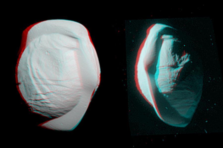
These stereo views, or anaglyphs, highlight the unusual, quirky shape of Saturn's moon Pan. They appear three-dimensional when viewed through red-blue glasses with the red lens on the left. The views show the northern and southern hemispheres of Pan, at left and right, respectively. They have been rotated to maximize the stereo effect. Pan has an average diameter of 17 miles (28 kilometers). The moon orbits within the Encke Gap in Saturn's A ring. Both of these views look toward Pan's trailing side, which is the side opposite the moon's direction of motion as it orbits Saturn. These views were acquired by the Cassini narrow-angle camera on March 7, 2017, at distances of approximately 16,000 miles or 25,000 kilometers (left view) and 21,000 miles or 34,000 kilometers (right view). Image scale in the original images is about 500 feet (150 meters) per pixel (left view) and about 650 feet (200 meters) per pixel (right view). The images have been magnified by a factor of two from their original size. http://photojournal.jpl.nasa.gov/catalog/PIA21435
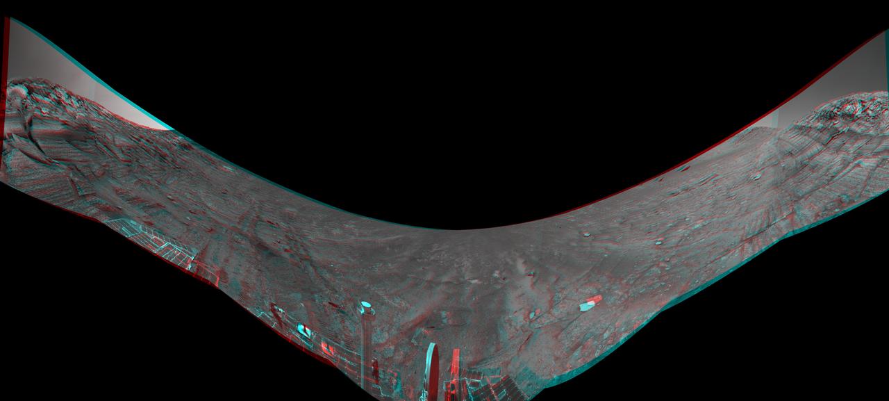
This stereo view from the Navigation Camera (Navcam) on NASA's Curiosity Mars rover shows the terrain ahead of the rover as it makes its way westward through a valley called "Artist's Drive." The image appears three-dimensional when viewed through red-blue glasses with the red lens on the left. The Navcam recorded the component images of this mosaic on April 10, 2015, during the 951st Martian Day, or sol, of Curiosity's work on Mars. The valley is on the rover's route toward a higher site on Mount Sharp than the "Pahrump Hills" area the mission investigated at the base of the layered mountain. http://photojournal.jpl.nasa.gov/catalog/PIA19165
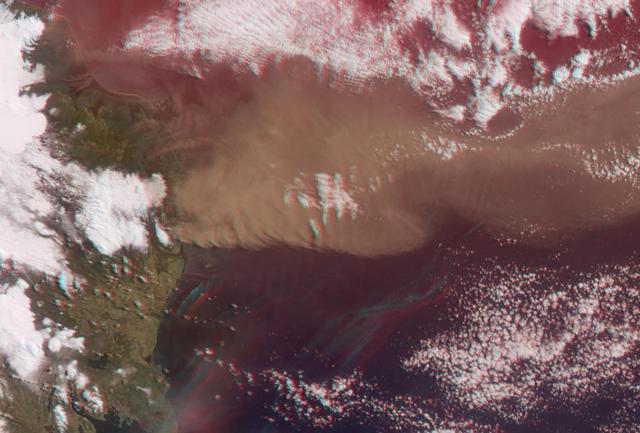
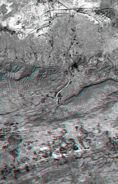
NASA Terra satellite flew directly over Iceland on April 19, 2010, to capture this stereo anaglyph generated from the nadir and 46-degree forward-viewing cameras of the Eyjafjallajökull volcano and its erupting ash plume. 3D glasses are necessary to vie
This anaglyph from the base of Burns Cliff in the inner wall of Endurance Crater combines several frames taken by Opportunity navigation camera during the NASA rover 280th martian day Nov. 6, 2004. 3D glasses are necessary to view this image.
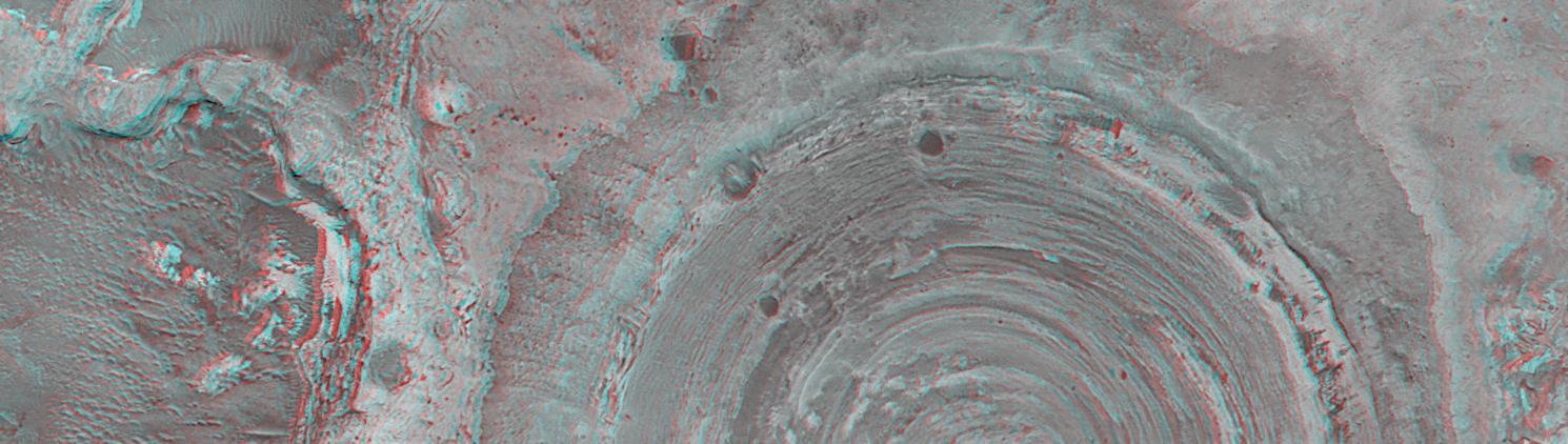
This anaglyph from NASA Mars Global Surveyor shows a circular feature in northern Terra Meridiani. The circular feature was once an impact crater. 3D glasses are necessary to view this image.
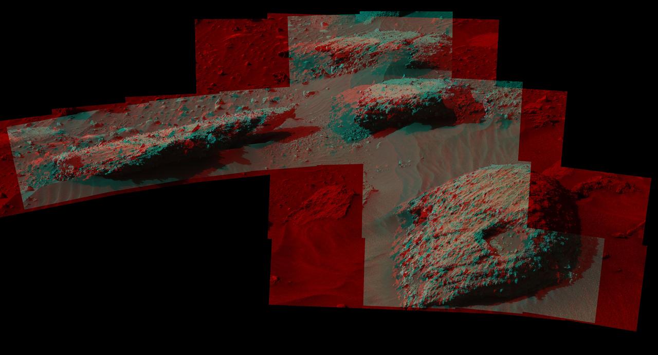
This stereo scene from the Mast Camera (Mastcam) on NASA's Curiosity Mars Rover shows boulders composed, in part, of pebble-size (0.2 to 2.6 inches, or 0.5 to 6.5 centimeters across) and larger rock fragments. The size and shape of the fragments provide clues to the origins of these boulders. This image is an anaglyph that appears three dimensional when viewed through red-blue glasses with the red lens on the left. The separate right-eye and left-eye views combined into the stereo version are Figure 1 and Figure 2. Mastcam's right-eye camera has a telephoto lens, with focal length of 100 millimeters. The left-eye camera provides a wider view, with a 34-millimeter lens. These images were taken on July 22, 2016, during the 1,408th Martian day, or sol, of Curiosity's work on Mars. For scale, the relatively flat rock at left is about 5 feet (1.5 meters) across. The rock in the foreground at right is informally named "Balombo." The group of boulders is at a site called "Bimbe." The Curiosity team chose to drive the rover to Bimbe to further understand patches of boulders first identified from orbit and seen occasionally on the rover's traverse. The boulders at Bimbe consist of multiple rock types. Some include pieces, or "clasts," of smaller, older rock cemented together, called breccias or conglomerates. The shapes of the inclusion clasts -- whether they are rounded or sharp-edged -- may indicate how far the clasts were transported, and by what processes. Breccias have more angular clasts, while conglomerates have more rounded clasts. As is clear by looking at these boulders, they contain both angular and rounded clasts, leading to some uncertainty about how they formed. Conglomerate rocks such as "Hottah" were inspected near Curiosity's landing site and interpreted as part of an ancient streambed. Breccias are generally formed by consolidation of fragments under pressure. On Mars such pressure might come from crater-forming impact, or by deep burial and exhumation. http://photojournal.jpl.nasa.gov/catalog/PIA20836
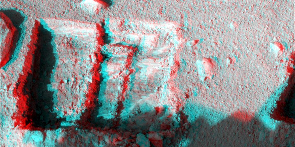
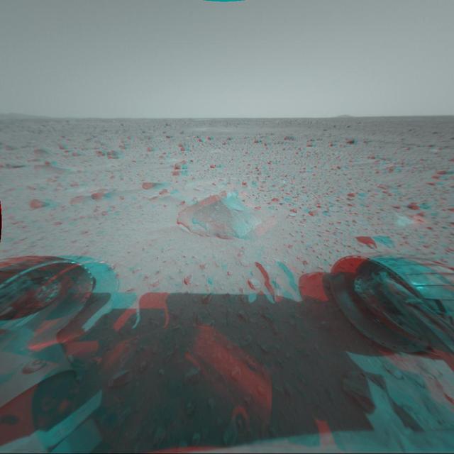
This anaglyph was taken by NASA Phoenix Mars Lander Surface Stereo Imager Oct. 7, 2008. The anaglyph highlights the depth of the trench, informally named La Mancha, and reveals the ice layer beneath the soil surface. 3D glasses are necessary.
The Dawn spacecraft captured these stereo views of Occator Crater on the dwarf planet Ceres in 2018. More than 70 framing camera images were used to construct this anaglyph view (which requires red-blue stereo glasses for viewing) of the southeastern floor of the crater, including the rim at far left in this view. This area is largely covered with impact melt and features a variety of pits and low mounds, some of which are related to impact debris but others to subsurface brine seepage and deposition. The spatial resolution of the stereo images is about 11 feet (3.5 meters) per pixel. Occator Crater, named after the Roman god of the agricultural practice of harrowing, is about 57 miles (92 kilometers) in diameter. The conclusion of Dawn's mission operations was Oct. 31, 2018, when the spacecraft depleted its hydrazine used for attitude control. This image was produced by Dr. Paul Schenk at the Lunar and Planetary Institute in Houston. https://photojournal.jpl.nasa.gov/catalog/PIA24061
This anaglyph from Mars Global Surveyor MGS shows layers in Galle Crater. 3D glasses are necessary to view this image.
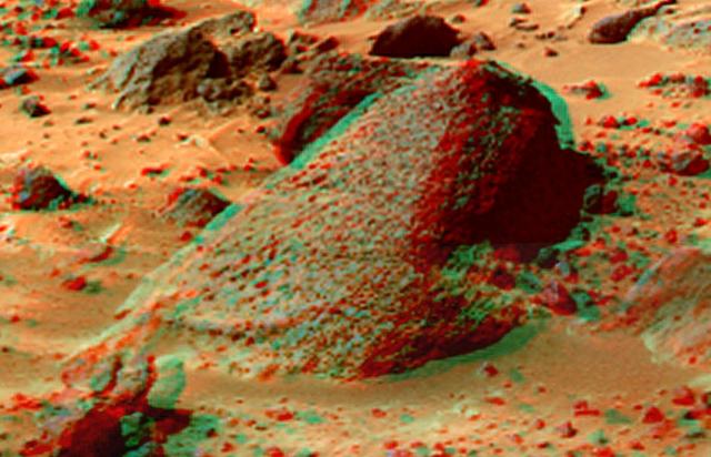
This anaglyph from NASA Mars Exploration Rover Opportunity at the rim of Victoria Crater. 3D glasses are necessary to view this image.
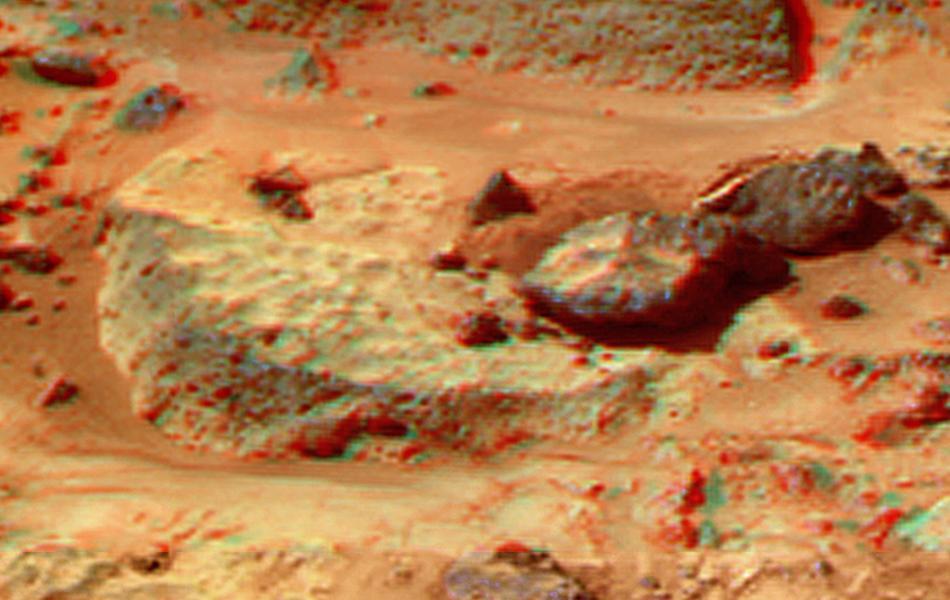
This 3-D stereo anaglyph image was taken by NASA Mars Exploration Rover Spirit. 3D glasses are necessary to view this image.

This anaglyph view of Grommit was produced by NASA Mars Pathfinder Imager camera. 3D glasses are necessary to identify surface detail.
This anaglyph view of Flute Top was produced by NASA Mars Pathfinder Imager camera. 3D glasses are necessary to identify surface detail.
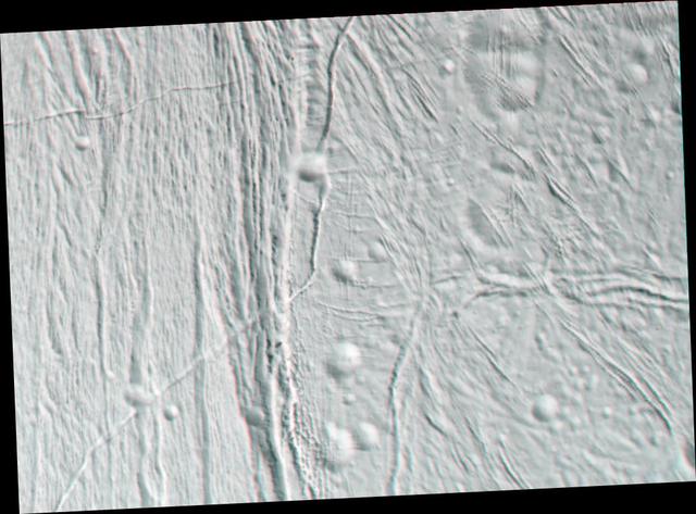
This stereo anaglyph from NASA Cassini spacecraft is of Saturn moon Enceladus. 3D glasses are necessary to view this image.
This anaglyph from NASA Mars Reconnaissance Orbiter is of Victoria Crater. 3D glasses are necessary to identify surface detail.

This anaglyph view of Half Dome was produced by NASA Mars Pathfinder Imager camera. 3D glasses are necessary to identify surface detail.
This anaglyph view of Wedge was produced by NASA Mars Pathfinder Imager camera. 3D glasses are necessary to identify surface detail.
This anaglyph view of Shark was produced by NASA Mars Pathfinder Imager camera. 3D glasses are necessary to identify surface detail.
The Dawn spacecraft captured these stereo images of Occator crater on the dwarf planet Ceres in 2018. Framing camera images were used to construct this anaglyph view (which requires red-blue stereo glasses for viewing) of part of the northeastern rim of the crater. This area is approximately 4 miles (7 kilometers) wide and features a thin mantling layer of impact melt draped over faulted terrace blocks. Impact melt flowed through a gap in the blocks in the center of the frame. The spatial resolution of the stereo images is about 11 feet (3.5 meters) per pixel. Occator Crater, named after the Roman god of the agricultural practice of harrowing, is about 57 miles (92 kilometers) in diameter. The conclusion of Dawn's mission operations was Oct. 31, 2018, when the spacecraft depleted its hydrazine used for attitude control. This image was produced by Dr. Paul Schenk at the Lunar and Planetary Institute in Houston. https://photojournal.jpl.nasa.gov/catalog/PIA24064
The Dawn spacecraft captured these stereo images of Occator Crater on the dwarf planet Ceres in 2018. Framing camera images were used to construct this anaglyph view (which requires red-blue stereo glasses for viewing) of part of the southeastern floor of the crater. This area is approximately 3 miles (5 kilometers) wide and is entirely within the large impact melt deposit formed there during the impact process. The low bright mounds and pits were probably formed by brine that moved to the surface to form surface vents and surface domes during freezing. The spatial resolution of the stereo images is about 11 feet (3.5 meters) per pixel. Occator crater, named after the Roman god of the agricultural practice of harrowing, is about 57 miles (92 kilometers) in diameter. The conclusion of Dawn's mission operations was Oct. 31, 2018, when the spacecraft depleted its hydrazine used for attitude control. This image was produced by Dr. Paul Schenk at the Lunar and Planetary Institute in Houston. https://photojournal.jpl.nasa.gov/catalog/PIA24062
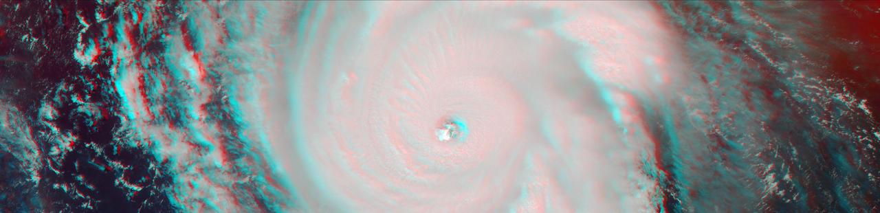
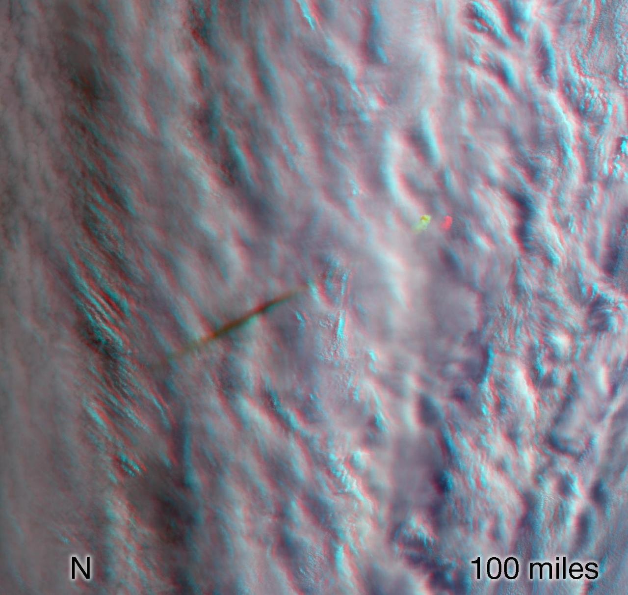
On Sept. 7, the Multi-angle Imaging SpectroRadiometer (MISR) instrument on NASA's Terra satellite passed over Hurricane Irma at approximately 11:20 am local time. The MISR instrument comprises nine cameras that view the Earth at different angles, and since it takes roughly seven minutes for all nine cameras to capture the same location, the motion of the clouds between images allows scientists to calculate the wind speed at the cloud tops. This stereo anaglyph combines two of the MISR angles to show a three-dimensional view of Irma. You will need red-blue glasses to view the anaglyph; place the red lens over your left eye. At this time, Irma's eye was located approximately 60 miles (100 kilometers) north of the Dominican Republic and 140 miles (230 kilometers) north of its capital, Santo Domingo. Irma was a powerful Category 5 hurricane, with wind speeds at the ocean surface up to 185 miles (300 kilometers) per hour. The MISR data show that at cloud top, winds near the eye wall (the most destructive part of the storm) were approximately 90 miles per hour (145 kilometers per hour), and the maximum cloud-top wind speed throughout the storm calculated by MISR was 135 miles per hour (220 kilometers per hour). While the hurricane's dominant rotation direction is counter-clockwise, winds near the eye wall are consistently pointing outward from it. This is an indication of outflow, the process by which a hurricane draws in warm, moist air at the surface and ejects cool, dry air at its cloud tops. https://photojournal.jpl.nasa.gov/catalog/PIA21945
This anaglyph view of Ender, due south of the lander, was produced by NASA Mars Pathfinder Imager camera. 3D glasses are necessary to identify surface detail.
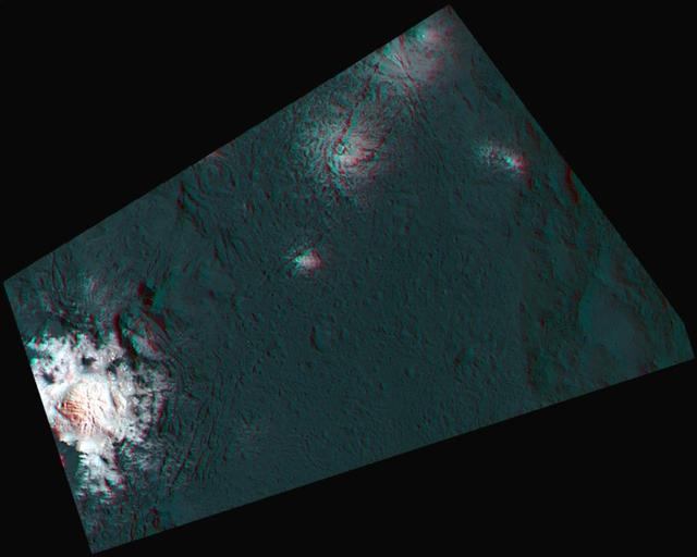
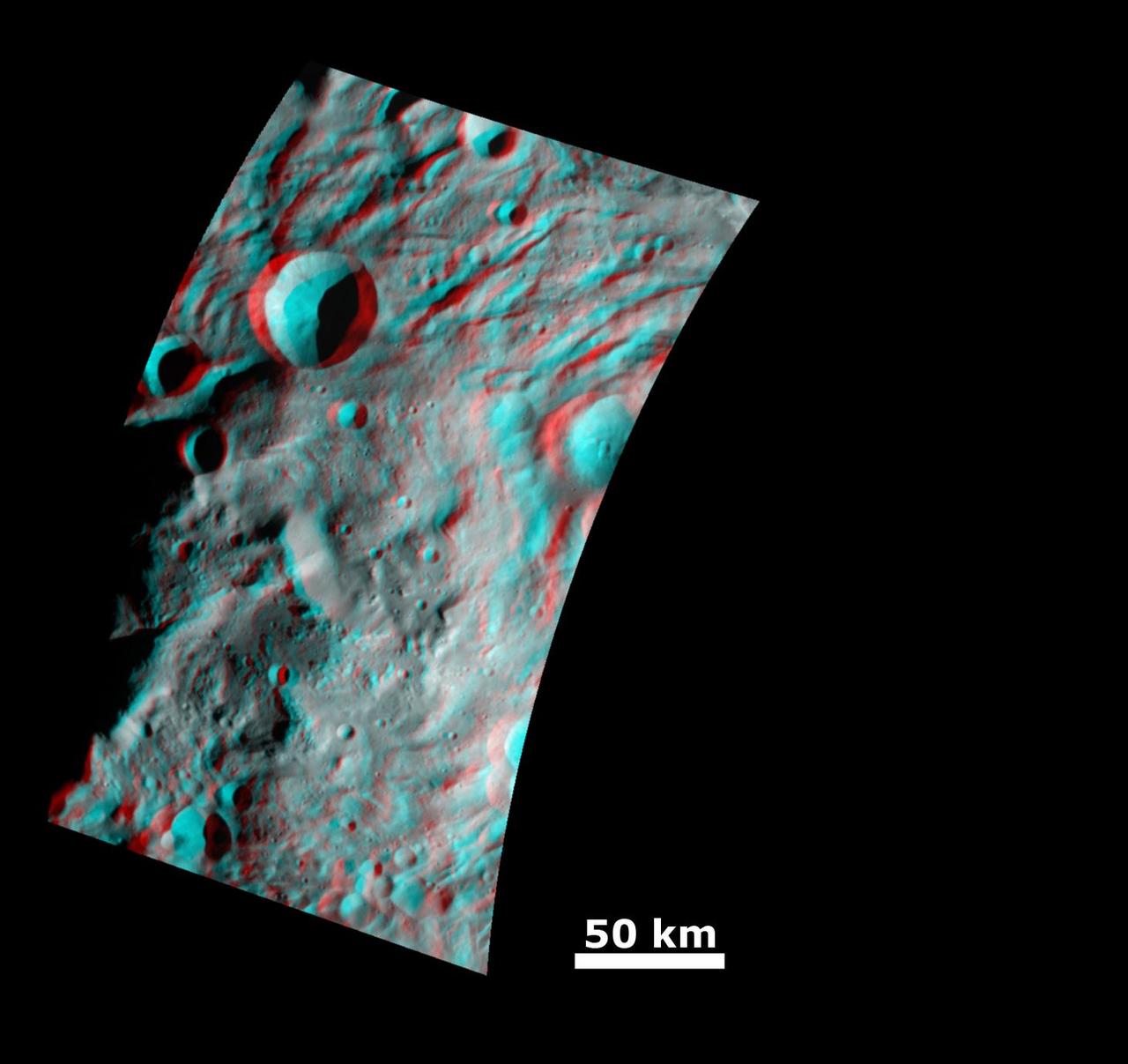
This anaglyph from NASA Dawn spacecraft shows degraded craters in asteroid Vesta northern hemisphere. You need 3D glasses to view this image.
This anaglyph view of Souffle, to the left of Yogi, was produced by NASA Mars Pathfinder Imager camera. 3D glasses are necessary to identify surface detail.
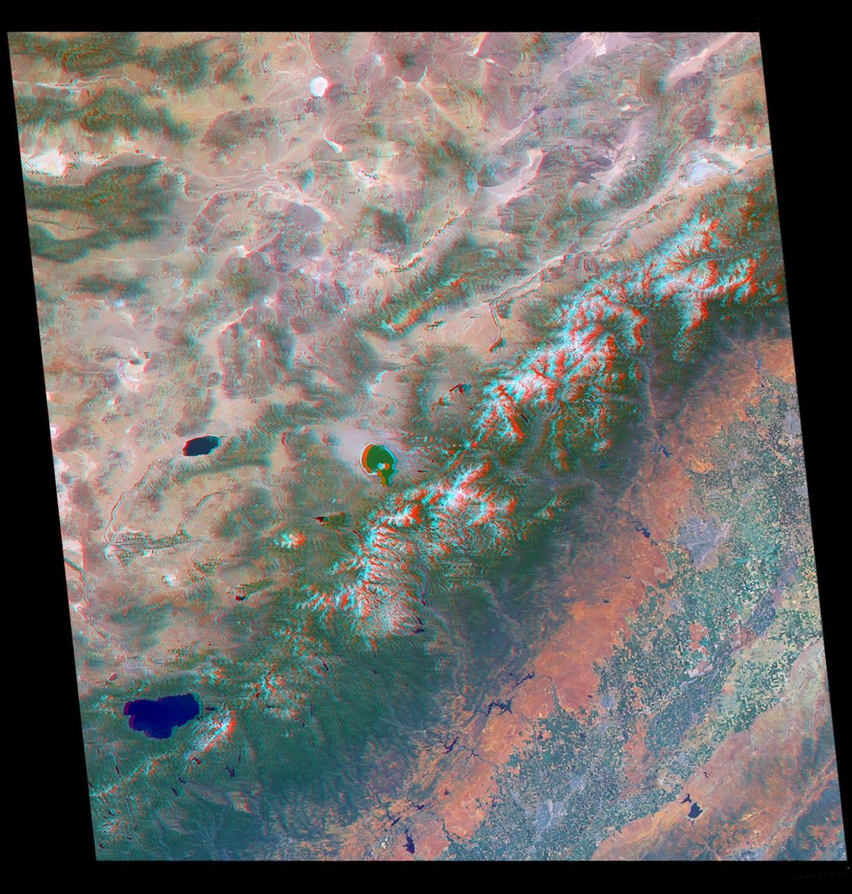
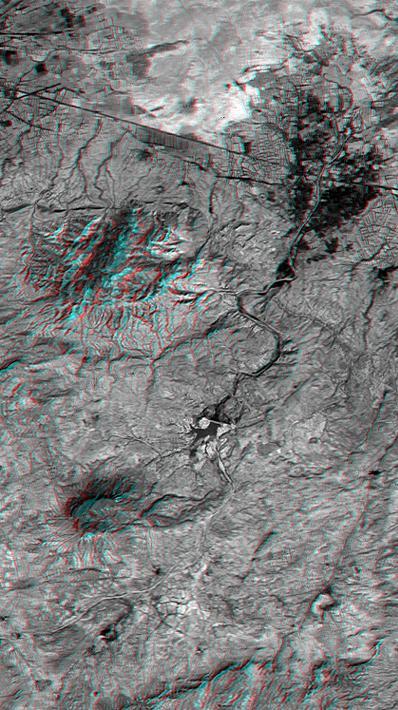
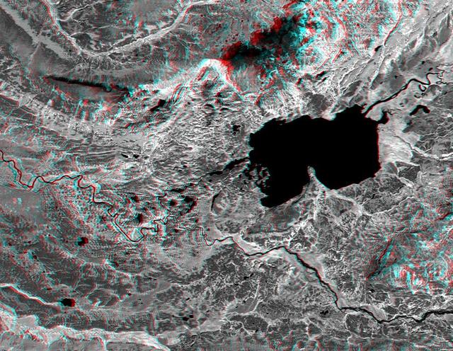
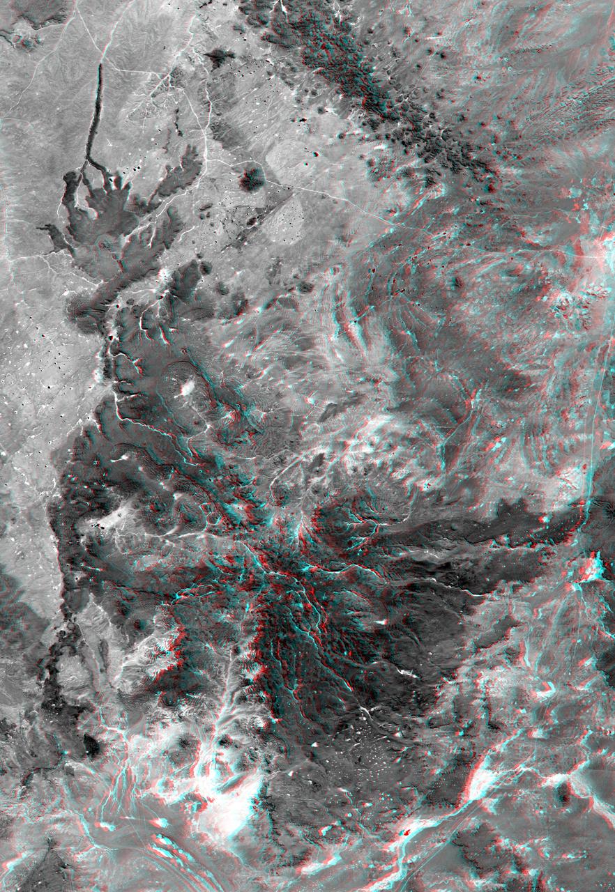
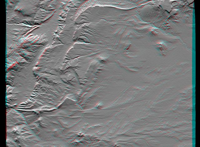
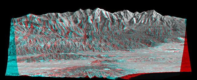
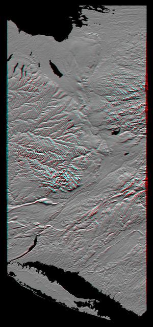
The mountains and desert plateaus of northwest Colorado are shown in this anaglyph from the MISR instrument aboard NASA Terra spacecraft. 3D glasses are necessary to view this image.
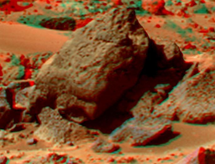
This mosaic of images from NASA Mars Exploration Rover Spirit shows a panoramic anaglyph of the Columbia Hills. 3D glasses are necessary to view this image.