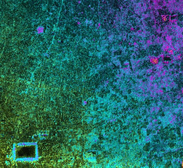
This image, taken by NASA Airborne Synthetic Aperture Radar AIRSAR in 2002, is of Cambodia Angkor region revealing a temple upper-right not depicted on early 19th Century French archeological survey maps and American topographic maps.
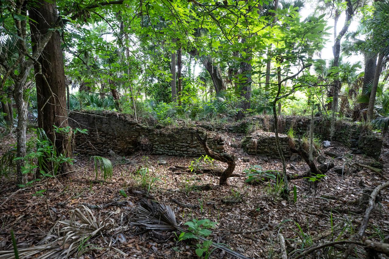
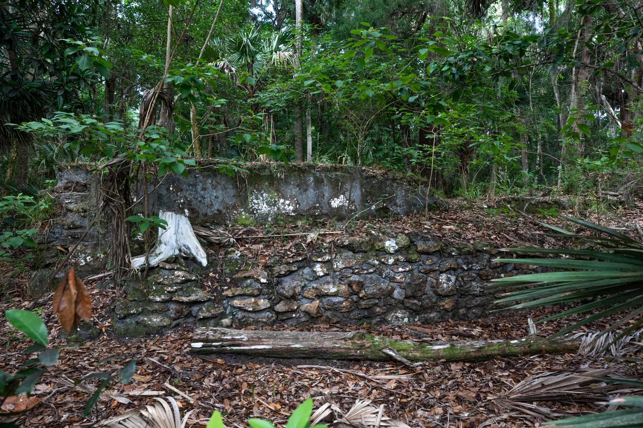
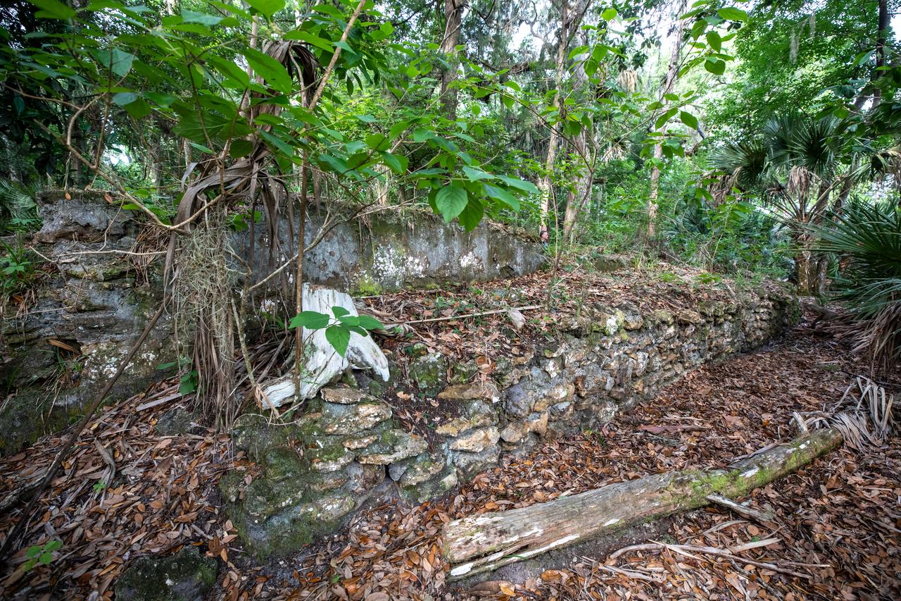
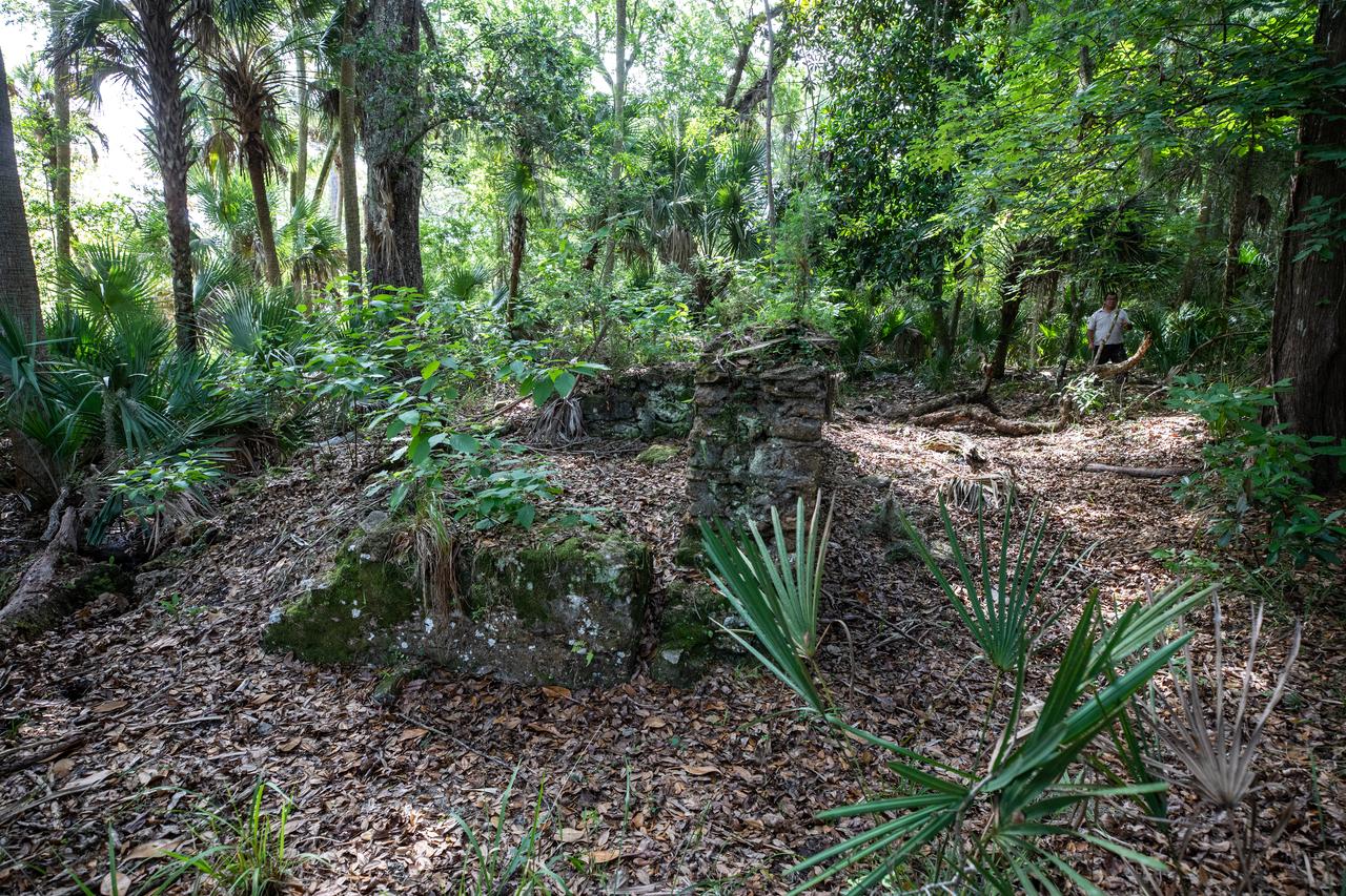
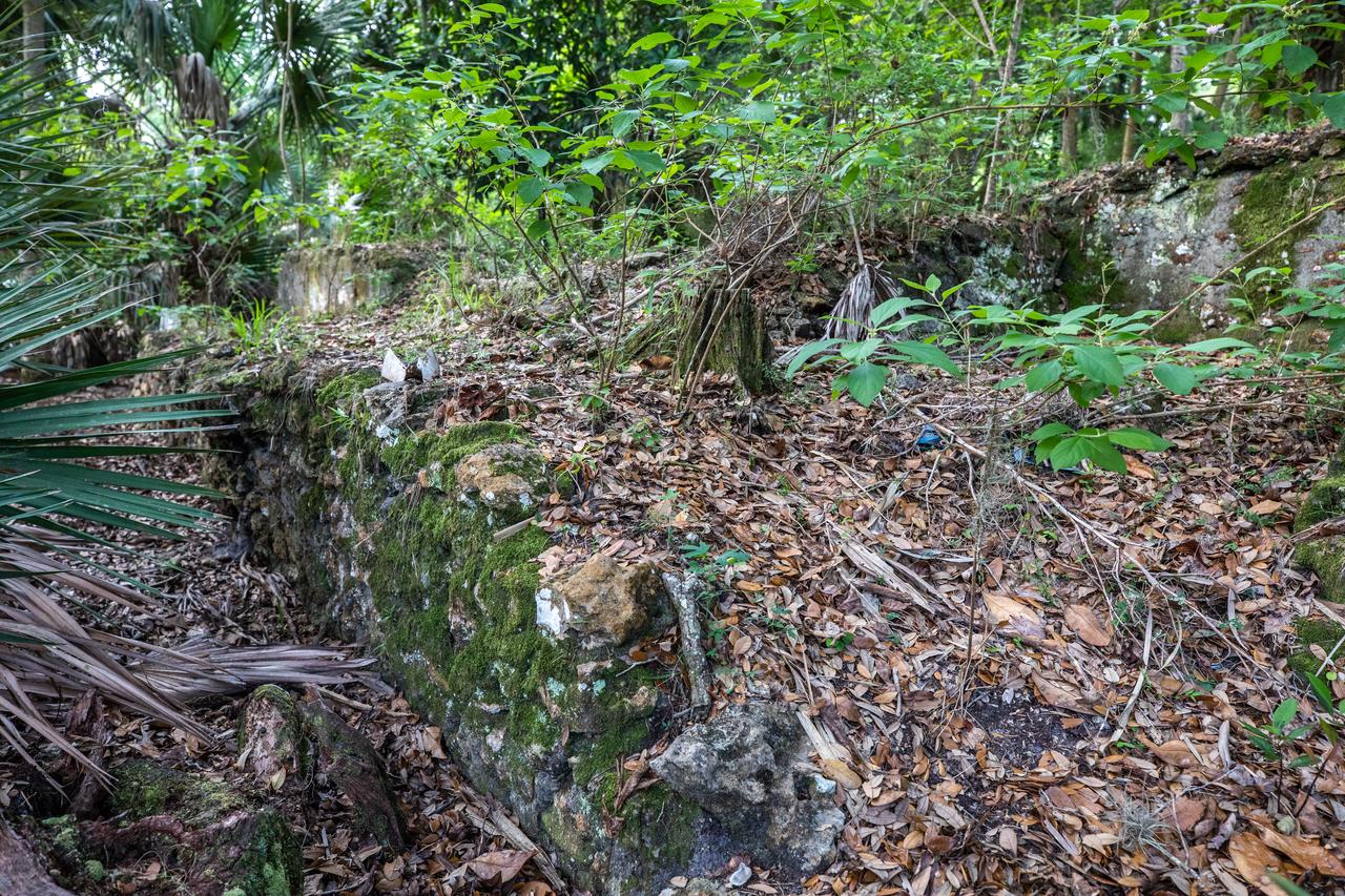
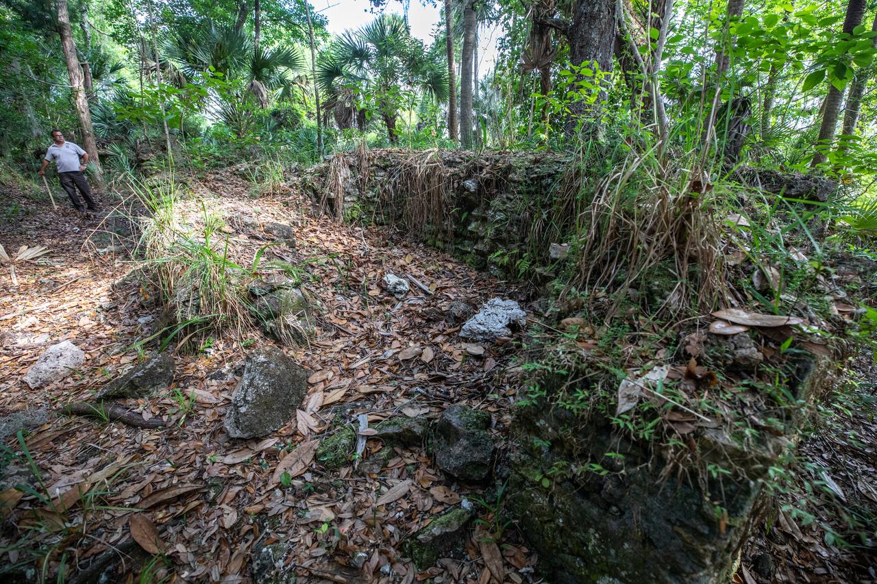
Archeological ruins of the Elliot Plantation sugar mill are revealed through the oak hammock at NASA’s Kennedy Space Center in Florida on May 26, 2022. The plantation’s enslaved community built the sugar mill structure, or sugar train, where sugar cane juice would be boiled during processing in graduated copper kettles until the liquid reduced into a thick syrup. The ruins of Elliot Plantation date from the 1760s and represent the largest, earliest, and southernmost British period sugar plantation in the U.S., as well as one of the most intact and best examples of a completely preserved enslaved landscape. The archeological site is managed through interagency cooperation between the National Park Service, the U.S. Fish and Wildlife Service, and NASA.
Archeological ruins of the Elliot Plantation sugar mill are revealed through the oak hammock at NASA’s Kennedy Space Center in Florida on May 26, 2022. The plantation’s enslaved community built the sugar mill structure, or sugar train, where sugar cane juice would be boiled during processing in graduated copper kettles until the liquid reduced into a thick syrup. The ruins of Elliot Plantation date from the 1760s and represent the largest, earliest, and southernmost British period sugar plantation in the U.S., as well as one of the most intact and best examples of a completely preserved enslaved landscape. The archeological site is managed through interagency cooperation between the National Park Service, the U.S. Fish and Wildlife Service, and NASA.
Archeological ruins of the Elliot Plantation sugar mill are revealed through the oak hammock at NASA’s Kennedy Space Center in Florida on May 26, 2022. The plantation’s enslaved community built the sugar mill structure, or sugar train, where sugar cane juice would be boiled during processing in graduated copper kettles until the liquid reduced into a thick syrup. The ruins of Elliot Plantation date from the 1760s and represent the largest, earliest, and southernmost British period sugar plantation in the U.S., as well as one of the most intact and best examples of a completely preserved enslaved landscape. The archeological site is managed through interagency cooperation between the National Park Service, the U.S. Fish and Wildlife Service, and NASA.
Archeological ruins of the Elliot Plantation sugar mill are revealed through the oak hammock at NASA’s Kennedy Space Center in Florida on May 26, 2022. The plantation’s enslaved community built the sugar mill structure, or sugar train, where sugar cane juice would be boiled during processing in graduated copper kettles until the liquid reduced into a thick syrup. The ruins of Elliot Plantation date from the 1760s and represent the largest, earliest, and southernmost British period sugar plantation in the U.S., as well as one of the most intact and best examples of a completely preserved enslaved landscape. The archeological site is managed through interagency cooperation between the National Park Service, the U.S. Fish and Wildlife Service, and NASA.
Archeological ruins of the Elliot Plantation sugar mill are revealed through the oak hammock at NASA’s Kennedy Space Center in Florida on May 26, 2022. The plantation’s enslaved community built the sugar mill structure, or sugar train, where sugar cane juice would be boiled during processing in graduated copper kettles until the liquid reduced into a thick syrup. The ruins of Elliot Plantation date from the 1760s and represent the largest, earliest, and southernmost British period sugar plantation in the U.S., as well as one of the most intact and best examples of a completely preserved enslaved landscape. The archeological site is managed through interagency cooperation between the National Park Service, the U.S. Fish and Wildlife Service, and NASA.
Archeological ruins of the Elliot Plantation sugar mill are revealed through the oak hammock at NASA’s Kennedy Space Center in Florida on May 26, 2022. The plantation’s enslaved community built the sugar mill structure, or sugar train, where sugar cane juice would be boiled during processing in graduated copper kettles until the liquid reduced into a thick syrup. The ruins of Elliot Plantation date from the 1760s and represent the largest, earliest, and southernmost British period sugar plantation in the U.S., as well as one of the most intact and best examples of a completely preserved enslaved landscape. The archeological site is managed through interagency cooperation between the National Park Service, the U.S. Fish and Wildlife Service, and NASA.
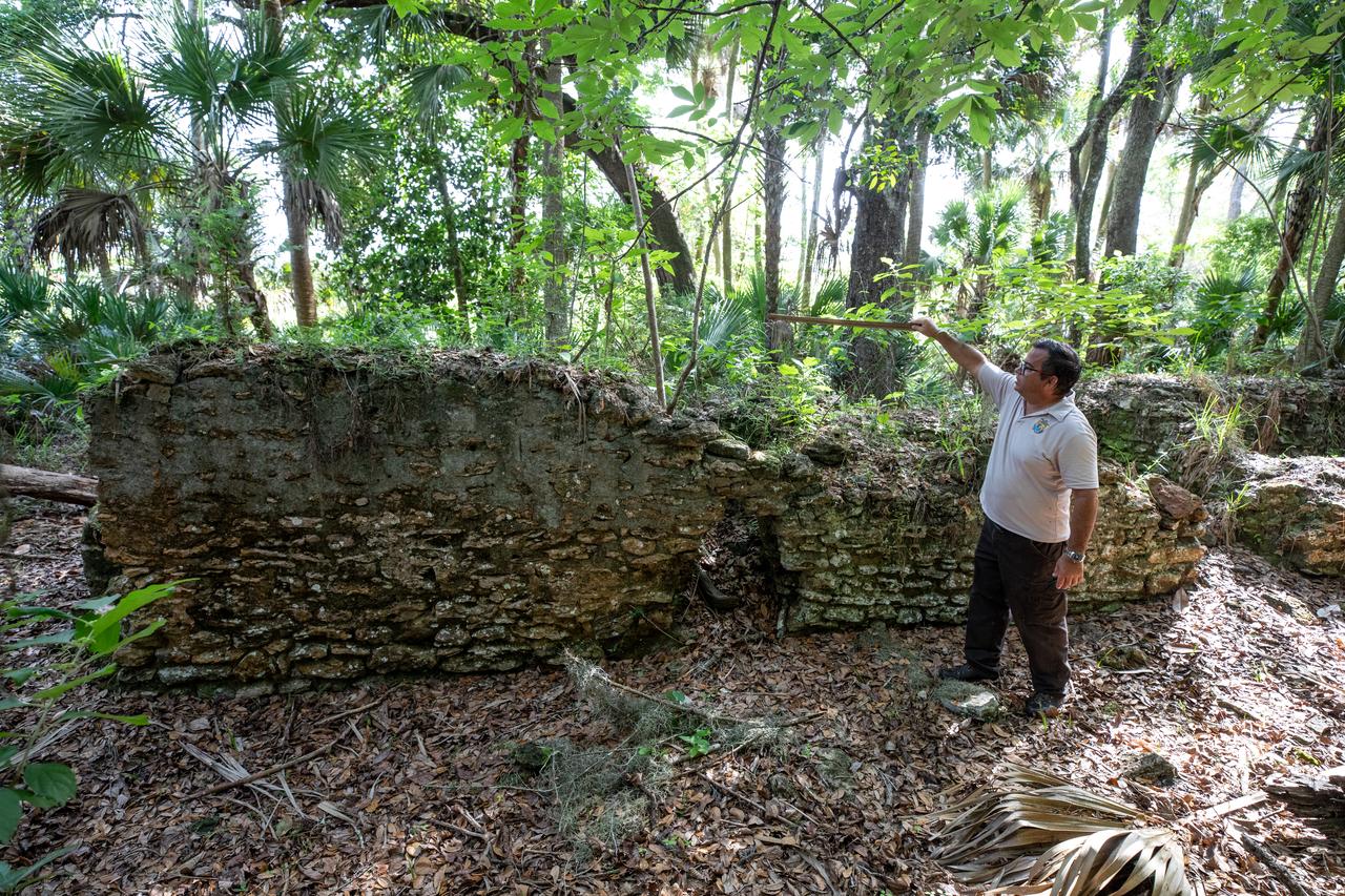
Near the archeological ruins of the Elliot Plantation sugar mill at NASA’s Kennedy Space Center in Florida, Michael Legare, of the U.S. Fish and Wildlife Service, recreates the original wall height of the structure on May 26, 2022. The plantation’s enslaved community built the sugar mill structure, or sugar train, where sugar cane juice would be boiled during processing in graduated copper kettles until the liquid reduced into a thick syrup. The ruins of Elliot Plantation date from the 1760s and represent the largest, earliest, and southernmost British period sugar plantation in the U.S., as well as one of the most intact and best examples of a completely preserved enslaved landscape. The archeological site is managed through interagency cooperation between the National Park Service, the U.S. Fish and Wildlife Service, and NASA.
Michael Legare, of the U.S. Fish and Wildlife Service, stands near the archeological ruins of the Elliot Plantation sugar mill at NASA’s Kennedy Space Center in Florida on May 26, 2022. The plantation’s enslaved community built the sugar mill structure, or sugar train, where sugar cane juice would be boiled during processing in graduated copper kettles until the liquid reduced into a thick syrup. The ruins of Elliot Plantation date from the 1760s and represent the largest, earliest, and southernmost British period sugar plantation in the U.S., as well as one of the most intact and best examples of a completely preserved enslaved landscape. The archeological site is managed through interagency cooperation between the National Park Service, the U.S. Fish and Wildlife Service, and NASA.
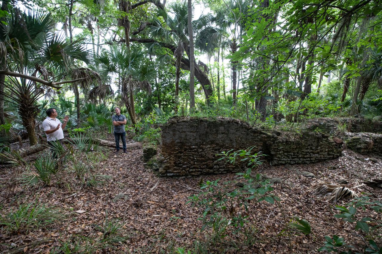
Members of U.S. Fish and Wildlife Service and NASA Communications visit the archeological ruins of the Elliot Plantation sugar mill at NASA’s Kennedy Space Center in Florida on May 26, 2022. The plantation’s enslaved community built the sugar mill structure, or sugar train, where sugar cane juice would be boiled during processing in graduated copper kettles until the liquid reduced into a thick syrup. The ruins of Elliot Plantation date from the 1760s and represent the largest, earliest, and southernmost British period sugar plantation in the U.S., as well as one of the most intact and best examples of a completely preserved enslaved landscape. The archeological site is managed through interagency cooperation between the National Park Service, the U.S. Fish and Wildlife Service, and NASA.
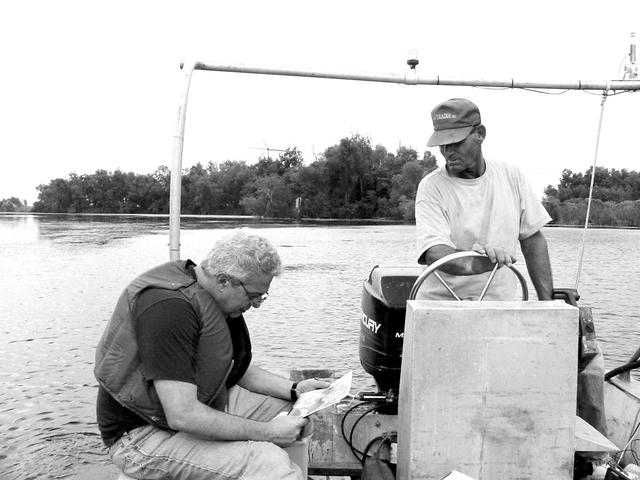
Dr. Marco Giardino, chief of the Applications Integration Division for NASA Stennis Space Center's Earth Science Applications Directorate, has been chosen by the JASON Project to be one of six host researchers for Disappearing Wetlands, which will run through the 2004-05 school year. In the photo, Giardino (left) interprets satellite imagery on the way to an archeological site near Lake Salvador, La., in November 2002. With him is his local guide, Michael Comardelle.

iss066e113865 (Jan. 15, 2022) --- A sample site is denoted for the SQuARE archaeological investigation with pieces of Kapton tape. This investigation studies how astronauts use objects in space over an extended period of time in space. The experiment adapts the standard archaeological technique on Earth called the “shovel test pit” by having crew members mark out square sample sites throughout the orbiting laboratory. Astronauts took picture of these sites at the same time every day, and then at randomly selected times. What we learn could inform design of future space habitats. Credits: International Space Station Archeological Project.

NASA DC-8 airborne laboratory flying over Mint Canyon near the snow-covered San Gabriel Mountains of California. The mostly white aircraft is silhouetted against the darker mountains in the background.

The DC-8 Airborne Laboratory in a left banking turn above the airport at Palmdale, California. The right wing is silhouetted against the blue sky, while the left wing contrasts with the desert terrain. The former airliner is a "dash-72" model and has a range of 5,400 miles. The craft can stay airborne for 12 hours and has an operational speed range between 300 and 500 knots. The research flights are made at between 500 and 41,000 feet. The aircraft can carry up to 30,000 lbs of research/science payload equipment installed in 15 mission-definable spaces.
NASA's DC-8 Airborne Science platform shown against a background of a dark blue sky on February 20, 1998. The aircraft is shown from the right rear, slightly above its plane, with the right wing in the foreground and the left wing and horizontal tail in the background. The former airliner is a "dash-72" model and has a range of 5,400 miles. The craft can stay airborne for 12 hours and has an operational speed range between 300 and 500 knots. The research flights are made at between 500 and 41,000 feet. The aircraft can carry up to 30,000 lbs of research/science payload equipment installed in 15 mission-definable spaces.

NASA's DC-8 Airborne Laboratory during a flight over the snow-covered Sierra Nevada Mountains. Over the past several years the DC-8 has conducted research missions in such diverse places as the Pacific in spring and Sweden in winter.
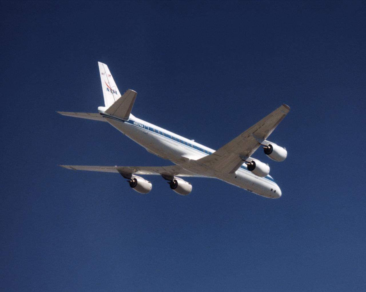
The NASA DC-8 in a right bank over the rugged Sierra Nevada Mountains. The former airliner is a "dash-72" model and has a range of 5,500 miles. The craft can stay airborne for 12 hours and has an operational speed range between 300 and 500 knots. The research flights are made at between 500 and 41,000 feet. The aircraft can carry up to 30,000 lbs of research/science payload equipment installed in 15 mission-definable spaces. In this photo, the aircraft is shown in flight from below, with the DC-8 silhouetted against a blue sky.

The DC-8 in flight near Lone Pine, Calif. In the foreground are the Sierra Nevada Mountains, covered with winter snow. In the distance are the White Mountains. The DC-8's fuselage is painted white with a dark blue stripe down the side. The wings are silver, while the engine pods are white. In this view of the airplane's right-hand side, only a few of its antennas are visible. The experimental payload can be as great as 30,000 pounds of equipment for gathering data of various sorts.
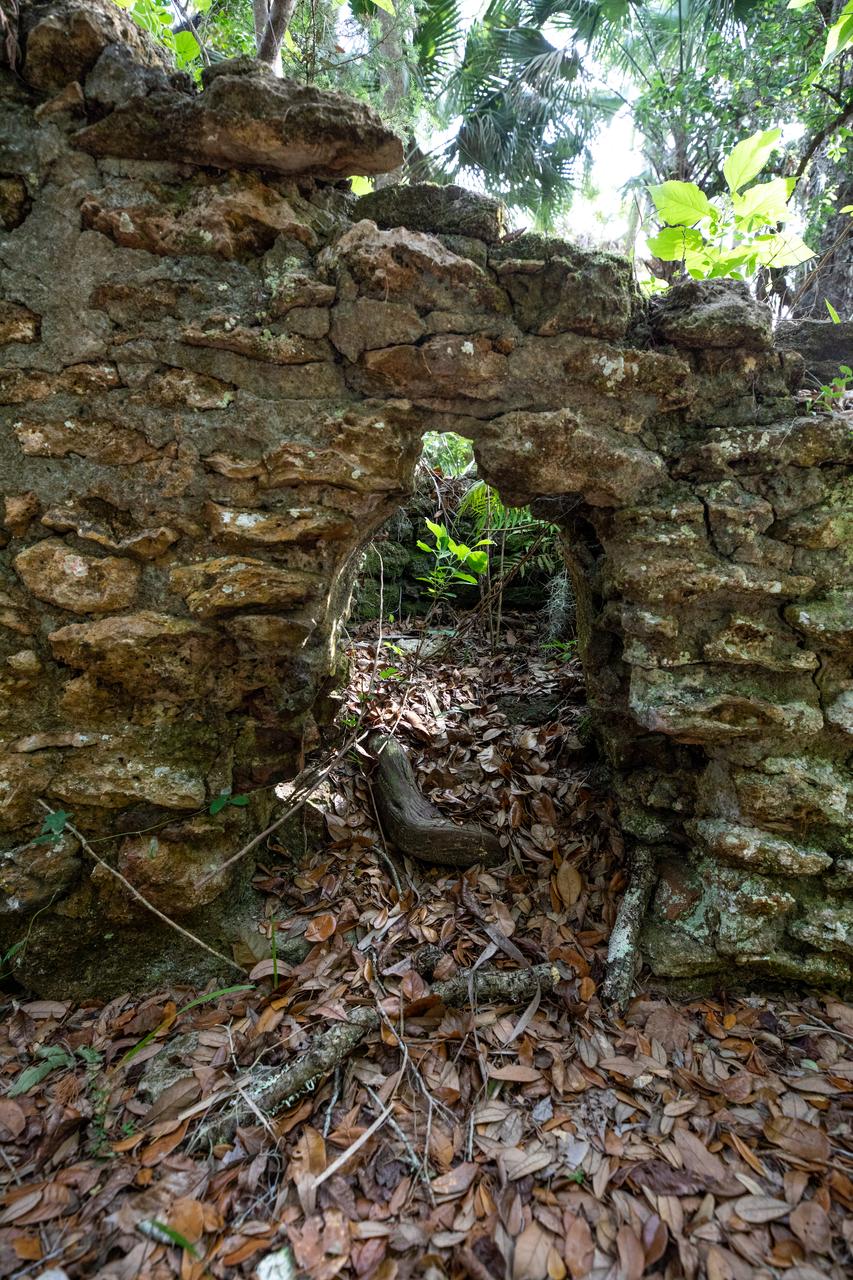
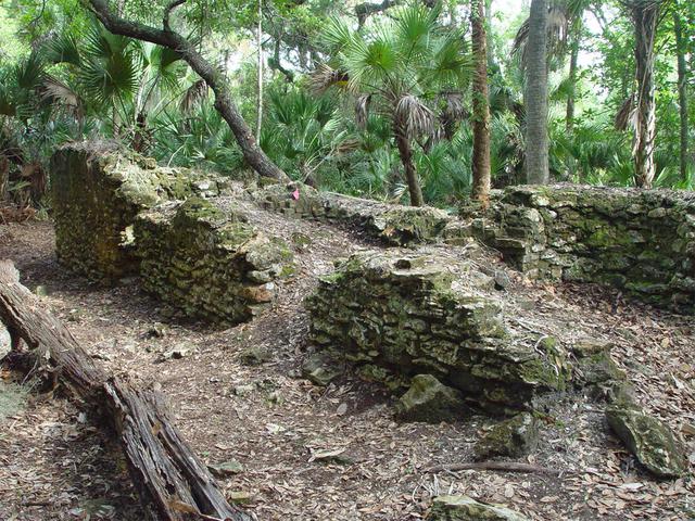
Archeological ruins of Elliot Plantation are revealed through the oak hammock on NASA’s Kennedy Space Center in Florida in 2008. Pictured is a structure composed of coquina blocks from a hearth of a large dwelling, determined to be that of the plantation overseer. The use of coquina is consistent with high-status building materials of the period. The ruins of Elliot Plantation date from the 1760s and represent the largest, earliest, and southernmost British period sugar plantation in the U.S., as well as one of the most intact and best examples of a completely preserved enslaved landscape. In interagency cooperation between the National Park Service, the U.S. Fish and Wildlife Service, and NASA, and with the assistance of volunteers from the Indian River Anthropological Society, and historic preservation offices of Brevard and Volusia counties, approximately 200 shovel tests and 20 excavation units were completed in three areas of the plantation complex from 2008 to 2009.
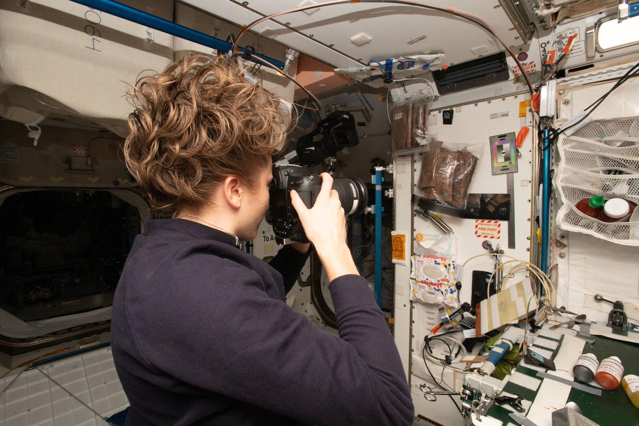
iss066e114158 (Jan. 15, 2022) --- NASA astronaut and expedition 66 Flight Engineer Kayla Barron snaps pictures of a sample “pit” aboard the International Space Station as part of the SQuARE experiment. This study is adapted from the standard archaeological technique on Earth called the “shovel test pit” and tracks the use and movement of objects in several sample sites throughout the orbiting laboratory. Crew members marked off the sample sites and took pictures at approximately the same every day, and then at randomly selected times. Scientists on the ground will analyze the images to understand how astronauts use objects and spaces over an extended period of time. What we learn could inform design of future space habitats. Credits: International Space Station Archeological Project/NASA
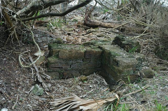
Archeological ruins of the Elliot Plantation sugar factory are revealed through the oak hammock on NASA’s Kennedy Space Center in Florida in 2008. The sugar factory structure, or sugar train, was built from fieldstone and is where sugar cane juice would be boiled during processing in graduated copper kettles until the liquid reduced into a thick syrup. The ruins of Elliot Plantation date from the 1760s and represent the largest, earliest, and southernmost British period sugar plantation in the U.S., as well as one of the most intact and best examples of a completely preserved enslaved landscape. In interagency cooperation between the National Park Service, the U.S. Fish and Wildlife Service, and NASA, and with the assistance of volunteers from the Indian River Anthropological Society, and historic preservation offices of Brevard and Volusia counties, approximately 200 shovel tests and 20 excavation units were completed in three areas of the plantation complex from 2008 to 2009.
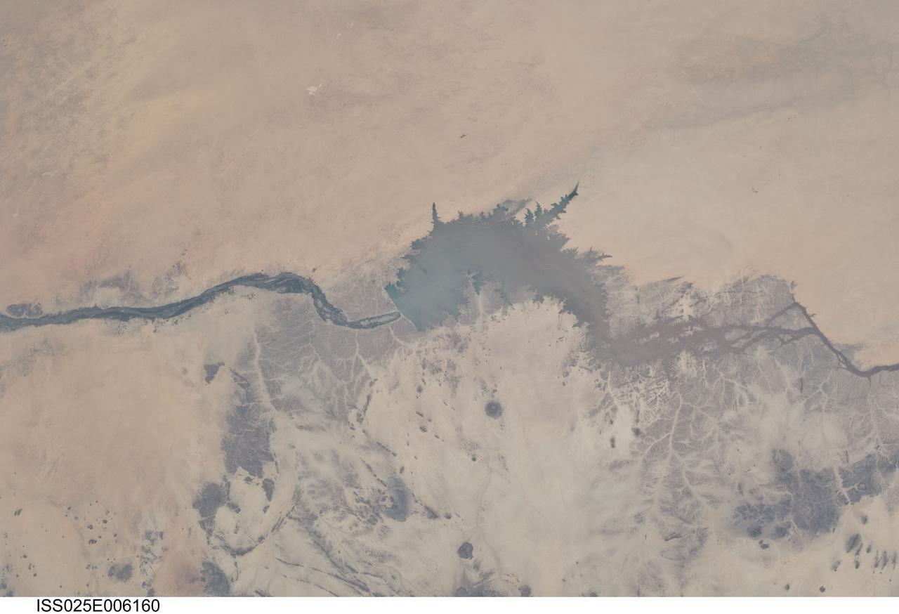
ISS025-E-006160 (5 Oct. 2010) --- Merowe Dam, Nile River and the Republic of the Sudan are featured in this image photographed by an Expedition 25 crew member on the International Space Station. The Merowe Dam is located near the 4th cataract of the Nile River, in the Nubian Desert of the northeastern Republic of the Sudan (also known as Sudan). The dam was built to generate hydroelectric power—electricity intended to further industrial and agricultural development of the country. This photograph illustrates the current extent of the reservoir filling behind the dam; the final spill gate was closed in 2008. The Merowe Dam is located approximately 350 kilometers (215 miles) to the northwest of Sudan’s capital, Khartoum. The nearest settlement downstream of the dam is Karima. Following Sudan’s independence from Egypt and the United Kingdom in 1956, allocation and control of Nile River water was divided between Egypt and Sudan by the Nile Waters Treaty signed in 1959. Today, other countries within the Nile basin—including Ethiopia, Kenya, Rwanda, Tanzania, and Uganda—are seeking more equitable allocation and utilization of the water and recently (2010) signed a new water use pact challenging the 1959 treaty. Beyond the issues of water rights, several local tribes will be displaced by the planned 170 kilometer-long reservoir, and the flooded region contains significant but little-studied archeological sites. The Sudanese government has a resettlement program in place for the tribes. A variety of international institutions have been conducting “salvage” or “rescue” archeological surveys since 1999. Such rescue surveys seek to preserve as much information as possible from sites that will be destroyed or otherwise made inaccessible (in this case by flooding).
STS060-90-028 (3-11 Feb 1994) --- This view is centered over Rome and covers approximately 3,600 square miles. Anzio, the site of the January 22, 1944, Allied landing in Central Italy, is on the coast at the lower left. The coastal protuberance near the center is Ostia. This Roman Empire port on the Tiber River silted in and was covered over. It is now an archeological site and a tourist attraction. Southeast of the mouth of the Tiber is the Pontine Marsh. These marshlands were drained in the 1930's and have been converted to farmland. Volcanism formed the land in the region. It is evidenced in the circular caldera lakes visible. Castel Gandolfo, part of the Papal State, is on Lake Albano toward the bottom of the frame. Rome was founded during the Bronze Age on a river crossing. The road from the coast along the river was the main route for the early salt trade. The city became the capital of modern Italy in 1861. It has undergone explosive growth since World War II and now has a population of over three million people. Leonardo da Vinci (Fiumicino) Airport, the main international airport, is visible near the coast north of the Tiber River.

ISS009-E-05953 (7 May 2004) --- The Pinacates Biosphere Reserve is featured in this image photographed by an Expedition 9 crewmember on the International Space Station (ISS). The Pinacates—a moon-like volcanic landscape that lies in the Sonoran Desert in Mexico just a few miles from the border with Arizona—is one of the most unique and striking landscapes in North America. The volcanic range is surrounded by one of North America’s largest dune fields, Gran Desierto. The natural history of the region includes thousands of years of human occupation; it is the aboriginal homeland of the O’Odham tribe, also known as the Papago. The region also served as an early training site for Apollo astronauts in the mid-late 1960s. The name Pinacate is derived from “pinacatl,” the Aztec name for the desert stink beetle which is common in the region. The natural and cultural resource management of the region, including the archeological sites and the high biodiversity, is now guaranteed: the site was declared a UNESCO Biosphere Reserve in 1993. The high-resolution image provides a view of a large volcanic crater called Crater Elegante, which is one of the most prominent and interesting features of the Pinacates.
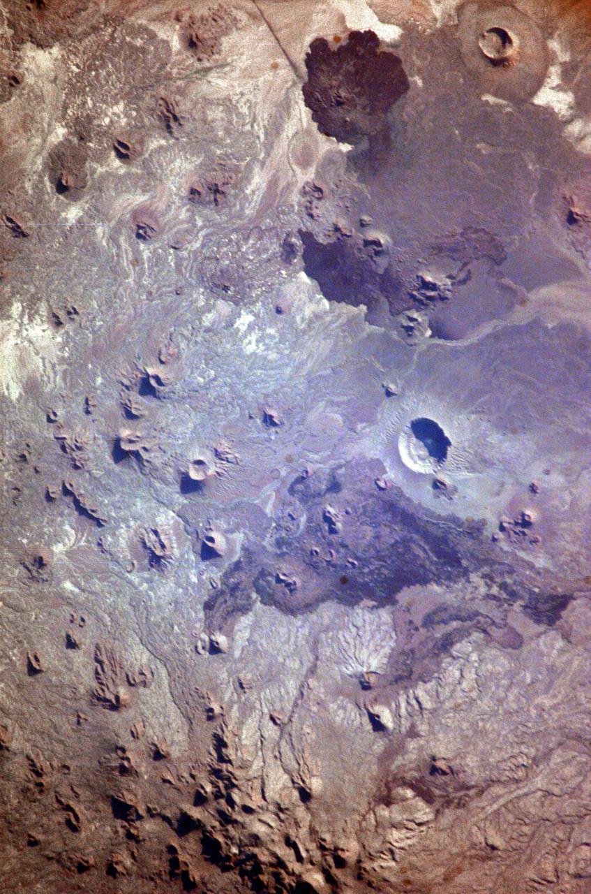
ISS009-E-05944 (7 May 2004) --- The Pinacates Biosphere Reserve is featured in this image photographed by an Expedition 9 crewmember on the International Space Station (ISS). The Pinacates—a moon-like volcanic landscape that lies in the Sonoran Desert in Mexico just a few miles from the border with Arizona—is one of the most unique and striking landscapes in North America. The volcanic range is surrounded by one of North America’s largest dune fields, Gran Desierto. The natural history of the region includes thousands of years of human occupation; it is the aboriginal homeland of the O’Odham tribe, also known as the Papago. The region also served as an early training site for Apollo astronauts in the mid-late 1960s. The name Pinacate is derived from “pinacatl,” the Aztec name for the desert stink beetle which is common in the region. The natural and cultural resource management of the region, including the archeological sites and the high biodiversity, is now guaranteed: the site was declared a UNESCO Biosphere Reserve in 1993. The high-resolution image provides a view of a large volcanic crater called Crater Elegante, which is one of the most prominent and interesting features of the Pinacates.
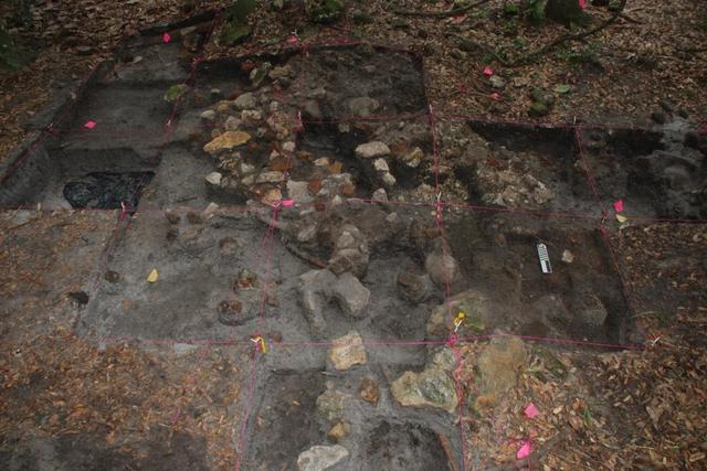
Archeological ruins of Elliot Plantation are revealed through the oak hammock on NASA’s Kennedy Space Center in Florida in 2009. Pictured is a structure composed of coquina blocks from a hearth of a large dwelling, determined to be that of the plantation overseer. The use of coquina is consistent with high-status building materials of the period. Mapped in this photo are the remnants of a chimney collapse from a detached kitchen in the overseer’s house. An enormous scatter of architectural debris, including coquina, fieldstone, brick and mortar, as well as substantial food remains, broken dishes, bottle glass, and other kitchen wares, were recovered and documented during investigations of the ruins. The ruins of Elliot Plantation date from the 1760s and represent the largest, earliest, and southernmost British period sugar plantation in the U.S., as well as one of the most intact and best examples of a completely preserved enslaved landscape. In interagency cooperation between the National Park Service, the U.S. Fish and Wildlife Service, and NASA, and with the assistance of volunteers from the Indian River Anthropological Society, and historic preservation offices of Brevard and Volusia counties, approximately 200 shovel tests and 20 excavation units were completed in three areas of the plantation complex from 2008 to 2009.
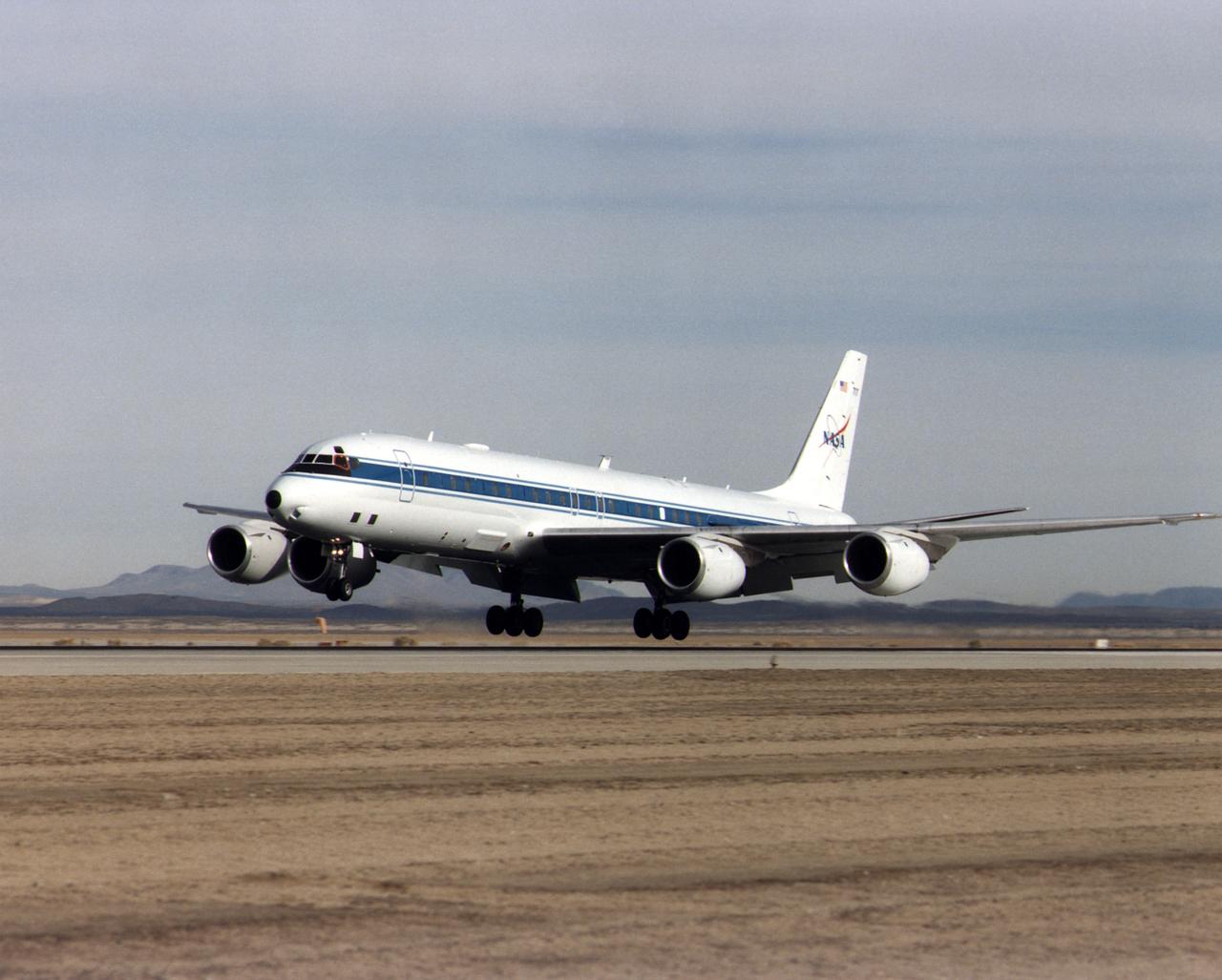
NASA's DC-8 Airborne Science platform landed at Edwards Air Force Base, California, to join the fleet of aircraft at NASA's Dryden Flight Research Center. The white aircraft with a blue stripe running horizontally from the nose to the tail is shown with its main landing gear just above the runway. The former airliner is a "dash-72" model and has a range of 5,400 miles. The craft can stay airborne for 12 hours and has an operational speed range between 300 and 500 knots. The research flights are made at between 500 and 41,000 feet. The aircraft can carry up to 30,000 lbs of research/science payload equipment installed in 15 mission-definable spaces.
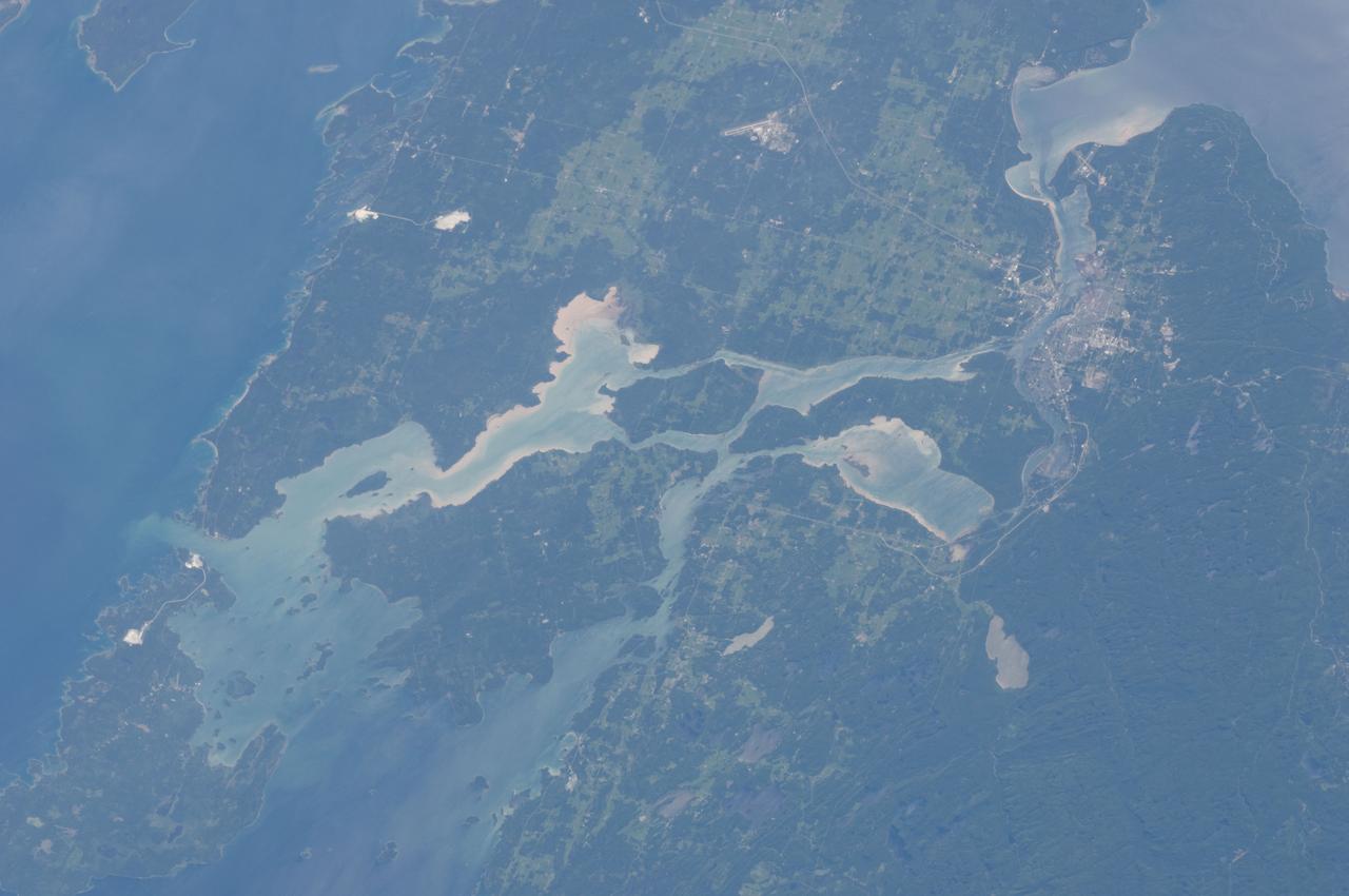
ISS028-E-010162 (29 June 2011) --- Sault Ste Marie, Ontario and Michigan are featured in this image photographed by an Expedition 28 crew member on the International Space Station. The twin cities of Sault Ste Marie are located across the St. Mary?s River that forms part of the international boundary between Canada (Province of Ontario) and the United States (State of Michigan). This photograph highlights the two cities, together with the region of lakes and islands that separates Lakes Huron and Superior, two of the Great Lakes of North America. Smaller lakes include Lake George to the west; the large forested islands of St. Joseph and Drummond are visible at lower left. The Sault Ste Marie urban areas (upper right) have a distinctive gray to white coloration in the image, contrasting with the deep green of forested areas in Ontario and the lighter green of agricultural fields in Michigan. The coloration of water surfaces in the lakes and rivers varies from blue to blue-green to silver, and is likely caused by varying degrees of sediment and sunglint ? light reflecting back to the observer on the space station from the water surface, much as light reflects from a mirror. Prior to formalization of the US/Canada border in 1817, Sault Ste Marie was a single community. Archeological evidence suggests that the region had been occupied by Native Americans at least five hundred years ago. A mission ? the first European settlement in Michigan ? was established there in 1668 by the French Jesuit Father Jacques Marquette. Today, shipping locks and canals in both urban areas are an important part of the Great Lakes shipping traffic system.

ISS028-E-018562 (22 July 2011) --- Island of Crete, Greece is featured in this image photographed by an Expedition 28 crew member on the International Space Station. In classical Greek mythology the island of Crete was home to King Minos and the terrible Minotaur, a beast that was half man and half bull. The known historical record of Crete is no less impressive. The island was the center of the Bronze Age Minoan civilization that flourished from approximately 2700 – 1420 BC. There is archeological, geological, and cultural evidence to suggest that a cataclysmic volcanic eruption in approximately 1620 BC of Santorini volcano was a major cause of the decline – if not complete destruction – of the Minoan civilization. Today, Crete is the largest and most heavily populated island of Greece (or the Hellenic Republic). The island extends for approximately 260 kilometers and is approximately 60 kilometers across at its widest point. The terrain of Crete is rugged and includes mountains, plateaus, and several deep gorges. The largest city on the island, Heraklion, is located along the northern coastline (center). Several smaller islands ring Crete; two of the largest of these, Dia and Gavdos are sparsely populated year-round, although Gavdos hosts numerous summer visitors. The western and central parts of Crete appear surrounded by quicksilver in this photograph. This phenomenon is known as sunglint, caused by light reflecting off of the sea surface directly toward the observer. The point of maximum reflectance is visible as a bright white region to the northwest of the island (lower right). Surface currents causing variations in the degree of reflectance are visible near the southwestern shoreline of Crete and the smaller island of Gavdos (upper right).
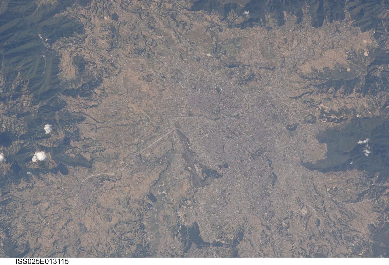
ISS025-E-013115 (9 Nov. 2010) --- Kathmandu, Nepal is featured in this image photographed by an Expedition 25 crew member on the International Space Station. The capital and largest city of Nepal, Kathmandu occupies much of the Kathmandu Valley located near the center of the country. Nepal itself contains much of the Himalaya mountain range between China (Tibet) to the north and India to the south. Geological and fossil evidence indicates that the Kathmandu Valley was filled by a large lake (Paleo-Kathmandu Lake) between approximately 2.8 million and 10,000 years ago, according to scientists. Geologists believe the lake drained in phases over time due both to a drier regional climate, continuing tectonic uplift and faulting in the region, and formation of an integrated valley drainage system as river channels cut through previous natural rock ridge dams. The green vegetated slopes that ring the Kathmandu metro area (light gray, center) include both forest reserves and national parks. The metropolitan area is relatively flat compared to the surrounding high mountains. Tribhuvan International Airport, located near the current eastern margin of the metro area, is the only international airport in Nepal. Archeological evidence suggests that the development of Kathmandu, together with the nearby “sister cities” of Lalitpur and Bhaktapur, began almost 2,000 years ago. Today, Kathmandu and its sister cities form the governmental, cultural, and—as a main access point to the Himalayas for tourism—economic center of the country.
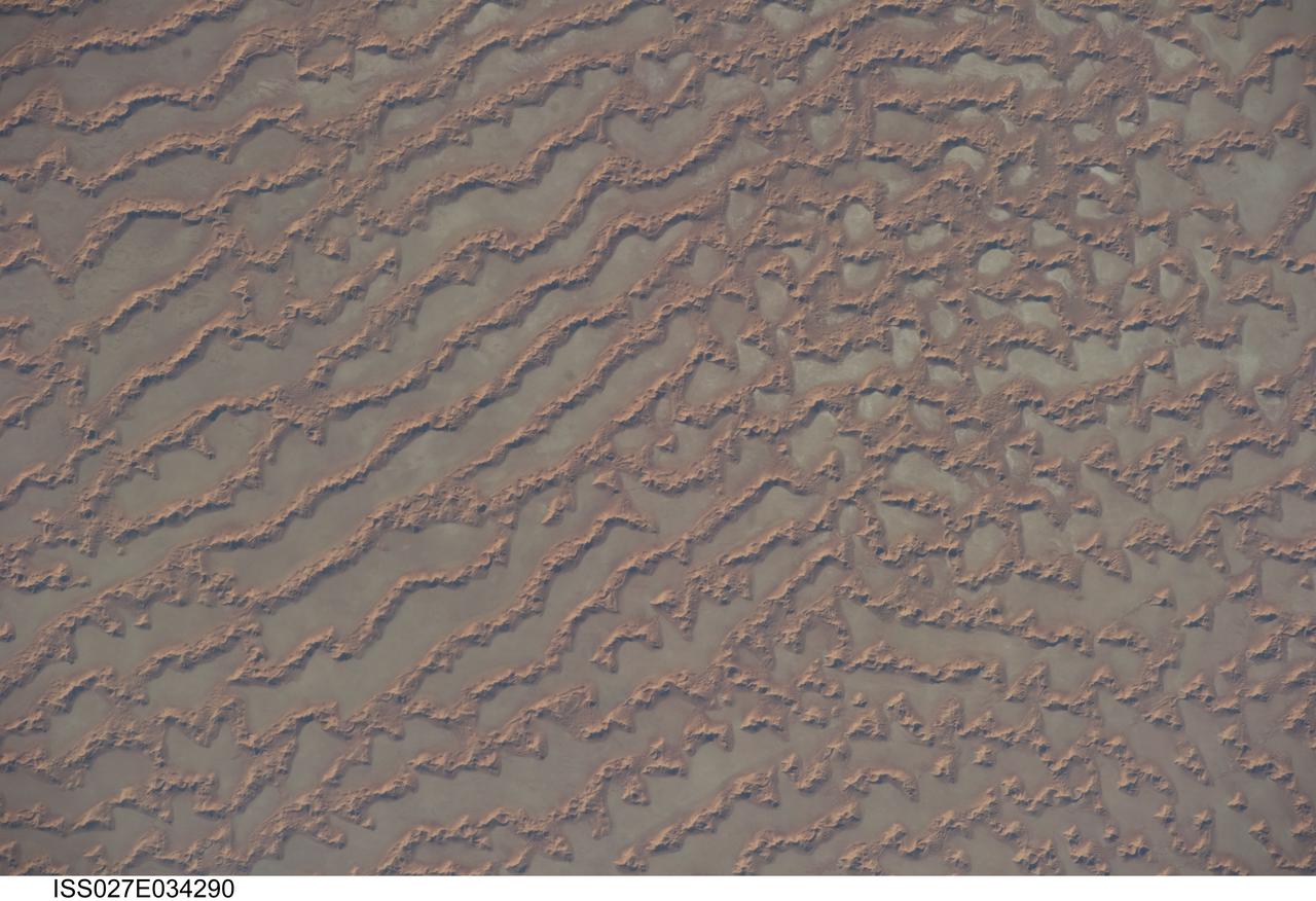
ISS027-E-034290 (16 May 2011) --- Ar Rub al Khali Sand Sea, Arabian Peninsula is featured in this image photographed by an Expedition 27 crew member on the International Space Station. The Ar Rub al Khali, also known as the “Empty Quarter”, is a large region of sand dunes and interdune flats known as a sand sea (or erg). This photograph highlights a part of the Ar Rub al Khali located close to its southeastern margin in the Sultanate of Oman. Reddish-brown, large linear sand dunes alternate with blue-gray interdune salt flats known as sabkhas at left. The major trend of the linear dunes is transverse to northwesterly trade winds that originate in Iraq (known as the Shamal winds). Formation of secondary barchan (crescent-shaped) and star dunes (dune crests in several directions originating from a single point, looking somewhat like a starfish from above) on the linear dunes is supported by southwesterly winds that occur during the monsoon season (Kharif winds). The long linear dunes begin to break up into isolated large star dunes to the northeast and east (right). This is likely a result of both wind pattern interactions and changes in the sand supply to the dunes. The Empty Quarter covers much of the south-central portion of the Arabian Peninsula, and with an area of approximately 660,000 square kilometers it is the largest continuous sand desert on Earth. The Empty Quarter is so called as the dominantly hyperarid climate and difficulty of travel through the dunes has not encouraged permanent settlement within the region. There is geological and archeological evidence to support cooler and wetter past climates in the region together with human settlement. This evidence includes exposed lakebed sediments, scattered stone tools, and the fossils of hippopotamus, water buffalo, and long-horned cattle.