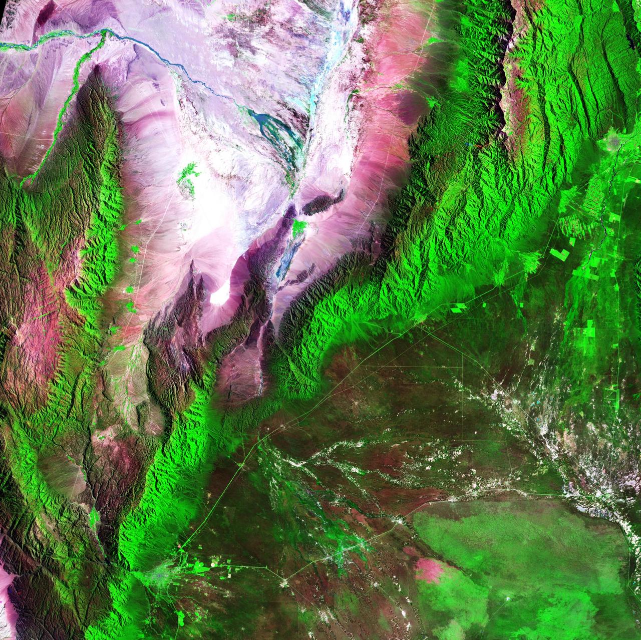
Acquisition Date: February 28, 1985 The Sierra de Velasco Mountains dominate this image in northern Argentina. The Catamarca province is in the northern part of the image, and the La Rioja province is to the south. The streams are fed by runoff from the snow in the Andes Mountains to the north. These intermittent streams can dry up rapidly. The larger urban area near the bottom of the image is La Rioja, the capital of the province of La Rioja. Credit: NASA/GSFC/Landsat/USGS To learn more about Landsat and to see the orginal high res file go to: <a href="http://landsat.usgs.gov/gallery_view.php?category=greenflag&thesort=mainTitle" rel="nofollow">landsat.usgs.gov/gallery_view.php?category=greenflag&...</a>
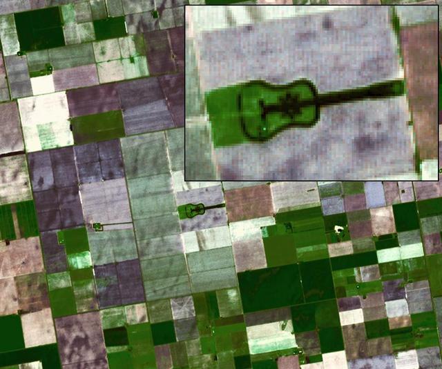
Located in the fertile agricultural region of Argentina Pampas is a guitar-shaped forest made up of cypress and eucalyptus trees as seen by NASA Terra spacecraft.
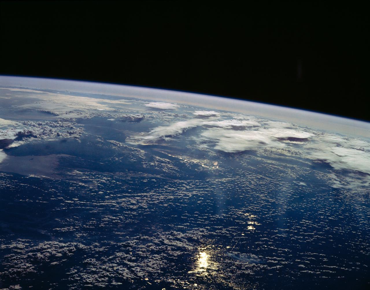
STS054-151-150 (13-19 Jan 1993) --- View west into sun glint off the Rio Salado, Saladillo, and Parana Rivers in Argentina. The Space Shuttle nadir is about 28 degrees north latitude and 57 degrees west longitude. The Andes Mountains are barely visible on Earth's limb. Thunderstorms along the eastern edge of the Andes are typical of this time of year (Southern Hemisphere summer), with anvils moving to the east from the core of the storm.
SL3-33-167 (July-September 1973) --- A vertical view of the Argentina-Paraguay border area of South America as photographed from Earth orbit by one of the six lenses of the Itek-furnished S190-A Multispectral Photographic Facility Experiment aboard the Skylab space station. This picture was taken with type 2443 infrared color film. The Parana River flows from east to west across the picture. This part of the Rio Parana is located between the towns of Posadas, Argentina, and Resistencia, Argentina. The major body of water in the large swamp area is Laguna Ibera. Note the several fires burning in this area. The largest land mass (Argentina) is south of the river. Paraguay is north of the river. Isla Apipe Grande is near the center of the photograph. The S190-A experiment is part of the Skylab Earth Resources Experiments Package. Federal agencies participating with NASA on the EREP project are the Departments of Agriculture, Commerce, Interior, the Environmental Protection Agency and the Corps of Engineers. All EREP photography is available to the public through the Department of Interior?s Earth Resources Observations Systems Data Center, Sioux Falls, South Dakota, 57198. Photo credit: NASA
AS07-04-1593 (21 Oct. 1968) --- This Earth observation photograph shows Argentina, Chile, Bolivia, Salar de Atacama, the Andes Mountains, and Gran Chaco. The coordinates for the center of this photograph are 23.00 degrees south and 67.30 degrees west, taken at an altitude of 175 miles during the 154th revolution around Earth. The crew consisted of astronauts Walter M. Schirra, Donn F. Eisele and Walter Cunningham.
This anaglyph, from NASA Shuttle Radar Topography Mission, is of the Andes Mountains, southeast of San Carlos de Bariloche, Argentina. 3D glasses are necessary to view this image.
This anaglyph, from NASA Shuttle Radar Topography Mission, is of Patagonia, near La Esperanza, Argentina. 3D glasses are necessary to view this image.

NASA Terra spacecraft captured this image of the Laguna del Maule volcanic field which straddles the Andean range crest between Chile and Argentina.
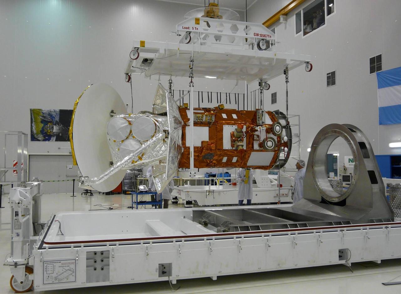
Engineers inspect NASA Aquarius/SAC-D observatory at INVAP facility in Bariloche, Argentina.
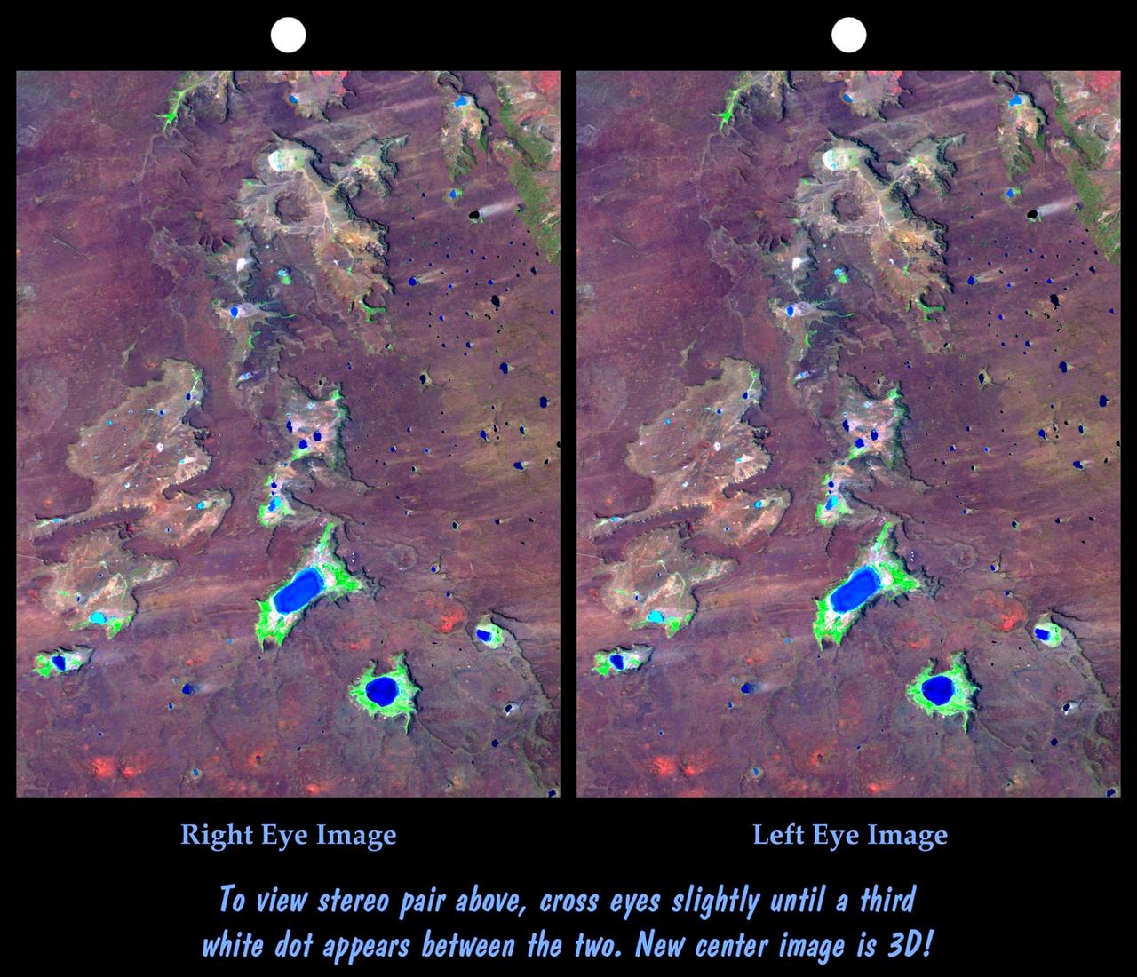
This anaglyph, from NASA Shuttle Radar Topography Mission, shows elatively young volcanoes in northern Patagonia, at Los Menucos, Argentina. 3D glasses are necessary to view this image.
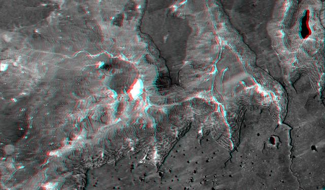
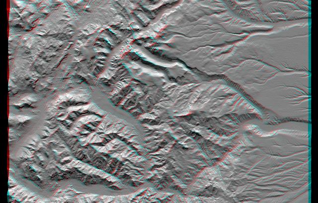
This view of northern Patagonia, near El Cain, Argentina shows complexly eroded volcanic terrain, with basalt mesas, sinkholes, landslide debris, playas, and relatively few integrated drainage channels.
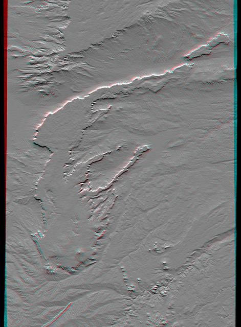
This anaglyph, from NASA Shuttle Radar Topography Mission, shows complexly eroded volcanic terrain in northern Patagonia, near El Cain, Argentina. 3D glasses are necessary to view this image.
This view of northern Patagonia, at Los Menucos, Argentina shows remnants of relatively young volcanoes built upon an eroded plain of much older and contorted volcanic, granitic, and sedimentary rocks.

Ushuaia is the capital of Tierra Del Fuego, Argentina, and is regarded as the southernmost city in the world. First inhabited more than 10,000 years ago, the city received its first major economic growth when a prison was established in the 1890s. Ushuaia's current population of about 57,000 has developed the city into a tourist hub for those visiting the Tierra del Fuego National Park. The image was acquired March 25, 2018, covers an area of 18.6 by 21.1 kilometers, and is located at 54.8 degrees south, 68.3 degrees west. https://photojournal.jpl.nasa.gov/catalog/PIA22685
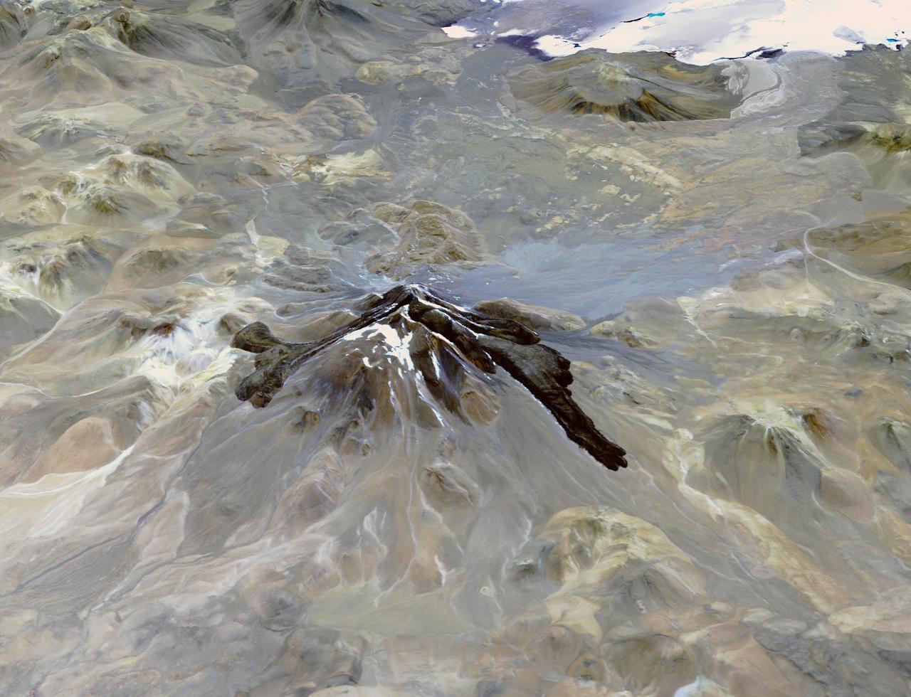
Llullaillaco is a stratovolcano at the border of Argentina and Chile. It lies on a high plateau close to the Atacama Desert. At an elevation of 6723 m ASL, it is the second highest active volcano in the world. About 150,000 years ago the volcano's southeastern flank collapsed, producing a debris avalanche that traveled 25 kilometers. The youngest dated rocks are about 5600 years old; but there are local reports of activity from the 1800s. The perspective image looking east was acquired December 19, 2014 and is located at 24.7 degrees south, 68.5 degrees west. https://photojournal.jpl.nasa.gov/catalog/PIA22721
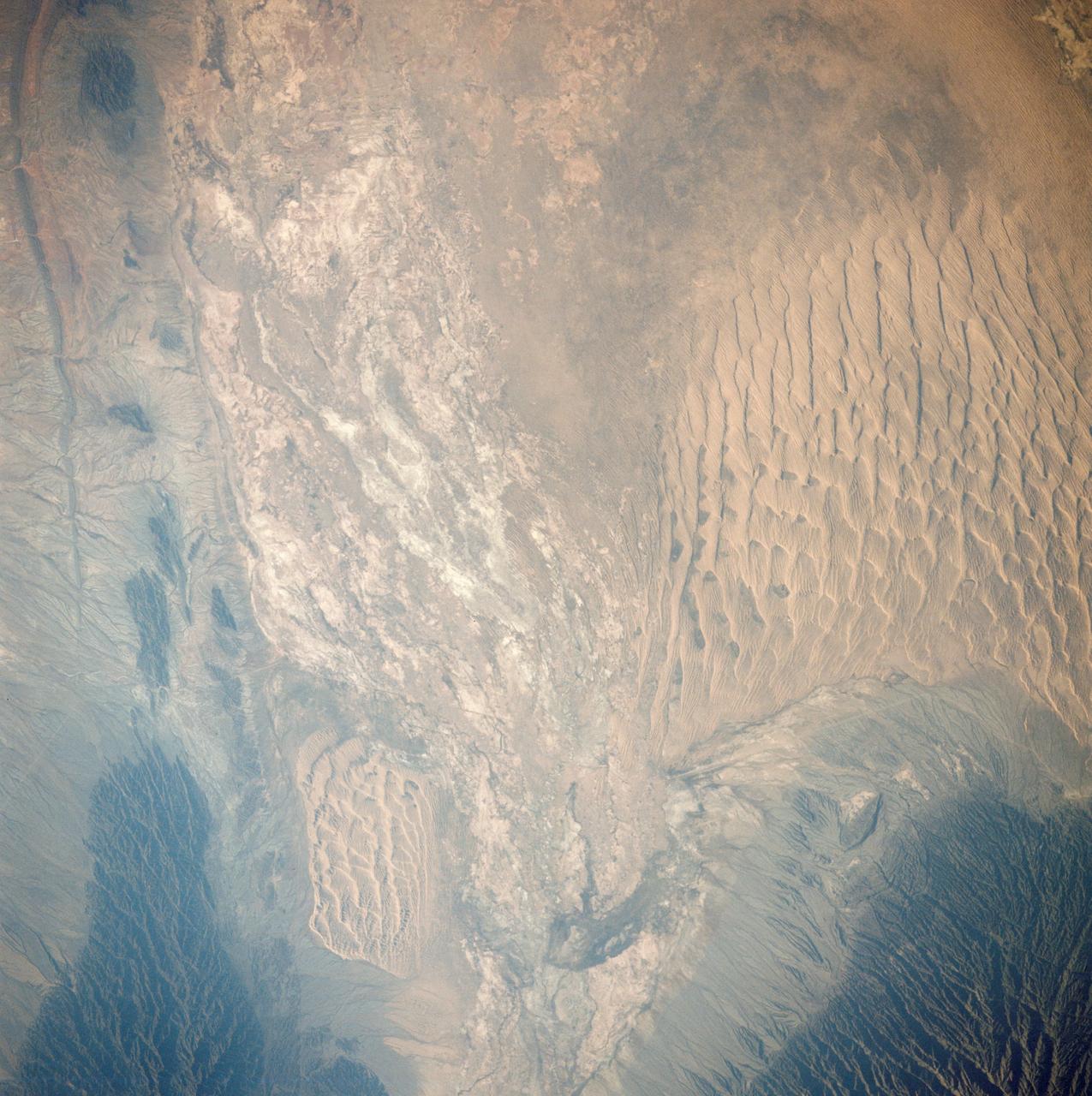
AST-27-2341 (20 July 1975) --- A near vertical view of sand dunes in the San Juan Province of Western Argentina, as photographed from the Apollo spacecraft in Earth orbit during the joint U.S.-USSR Apollo-Soyuz Test Project mission. The picture was taken at an altitude of 220 kilometers (136 statute miles) with a 70mm Hasselblad camera using medium-speed Ektachrome QX-807 type film.
Payun Matru is a large shield volcano capped by a caldera (right half of image), located in the Andean Volcanic Belt in Argentina. Nearby to the south is the high compound volcano Payun; to the west is a field of cinder cones and lava flows. The most recent volcanic activity occurred about 500 years ago. The image was acquired March 1, 2009, covers an area of 46.7 by 53.1 km, and is located at 36.4 degrees south, 69.3 degrees west. https://photojournal.jpl.nasa.gov/catalog/PIA23670
Basalt cliffs along the northwest edge of the Meseta de Somuncura plateau near Sierra Colorada, Argentina show an unusual and striking pattern of erosion.
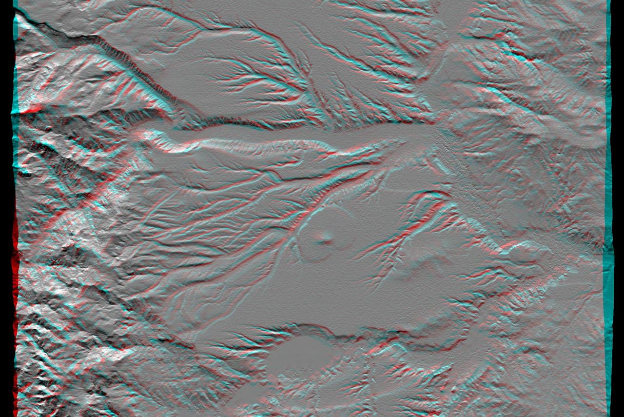
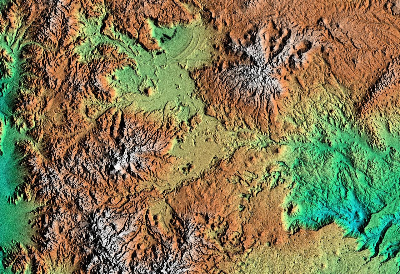
This anaglyph, from NASA Shuttle Radar Topography Mission, is of an area southwest of Zapala, Argentina, showing a wide diversity of geologic features. 3D glasses are necessary to view this image.
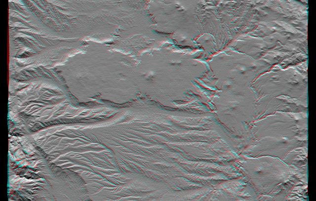
This anaglyph, from NASA Shuttle Radar Topography Mission, shows basalt cliffs along the northwest edge of the Meseta de Somuncura plateau near Sierra Colorada, Argentina. 3D glasses are necessary to view this image.
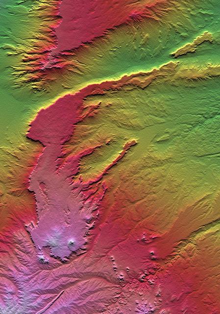
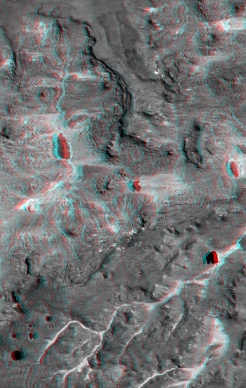
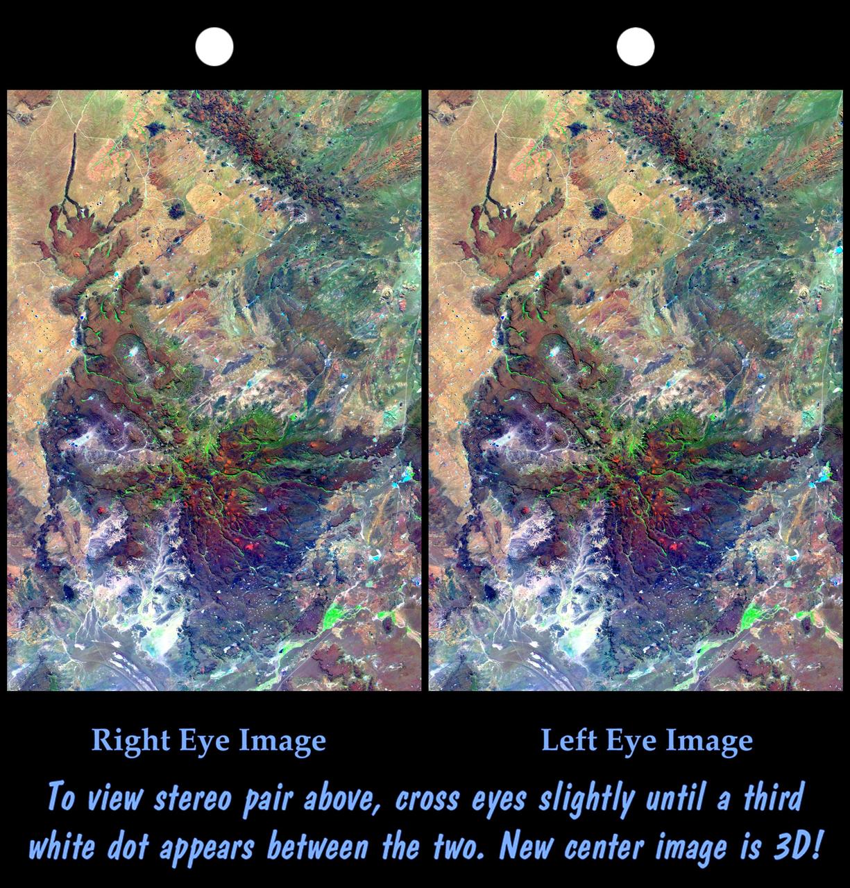
All of the major landforms relate to volcanism and/or erosion in this Shuttle Radar Topography Mission scene of Patagonia, near La Esperanza, Argentina.
The Pampas of Argentina is shown in this MISR Mystery Quiz #17 captured by NASA Terra spacecraft.
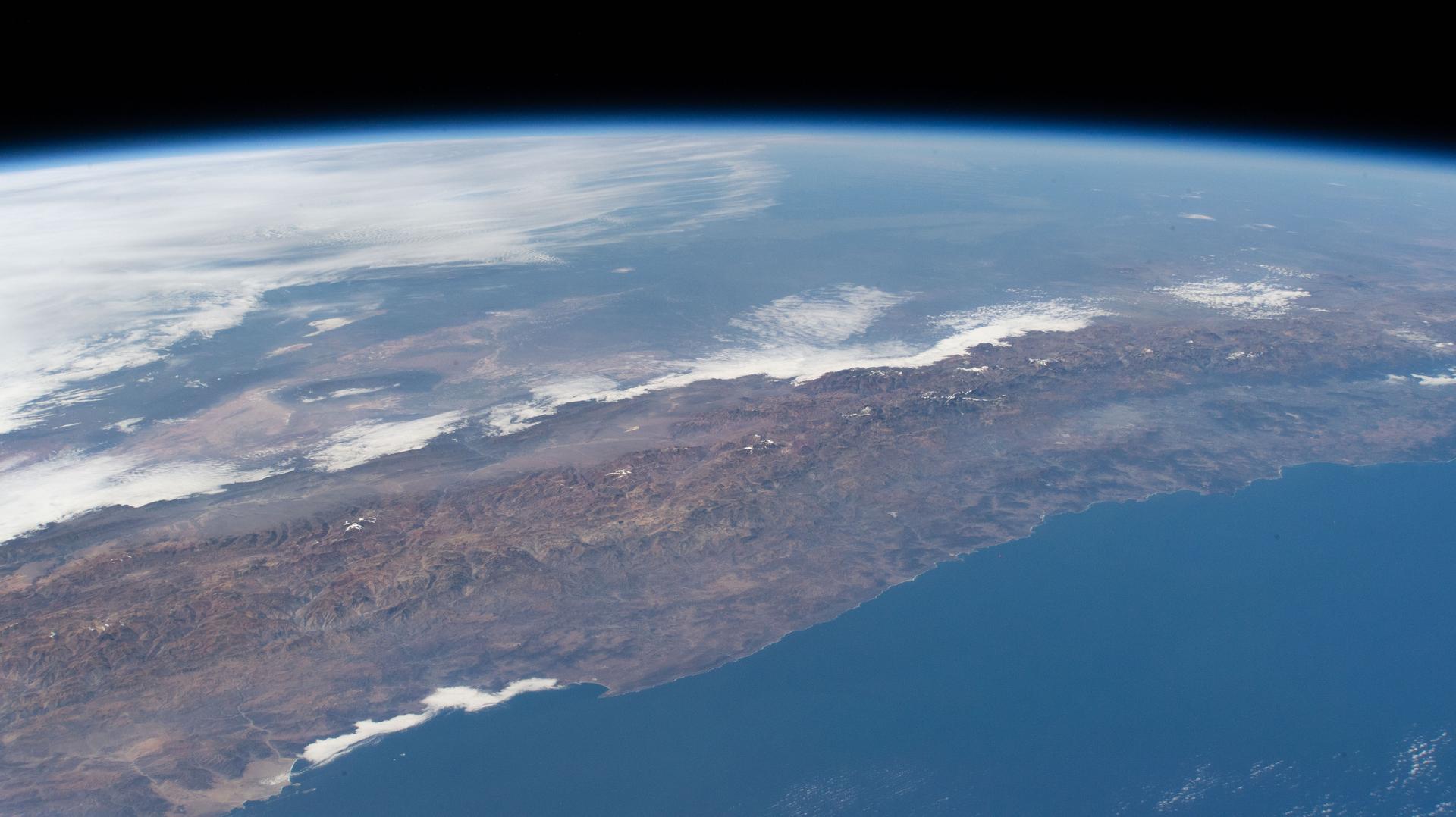
iss058e006004 (Jan. 26, 2019) --- This photograph of South America from bottom to top looks from the northeast coast of Argentina to southwest across Chile, the Andes mountains and the Pacific Ocean. The International Space Station was orbiting 259 miles above the Atlantic coast of the South American continent.
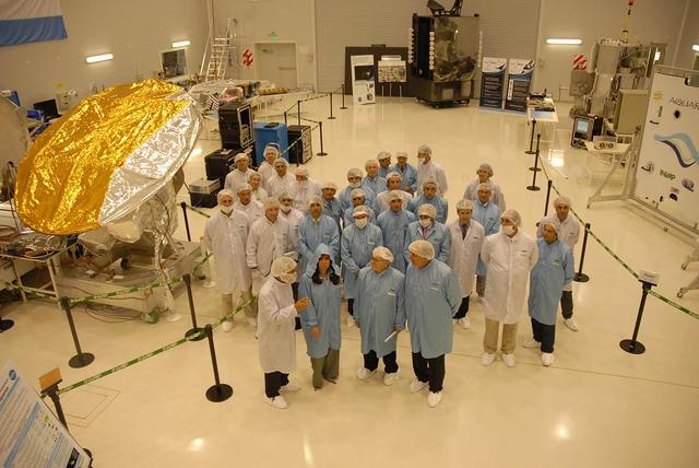
Dr. Cristina Fernández Kirchner, the President of Argentina, visits INVAP for the inauguration of the new facilities including a tour of the high bay where NASA Aquarius/SAC-D satellite is being tested and integrated.
This anaglyph, from NASA Shuttle Radar Topography Mission, shows the eastern flank of the Andes Mountains, southeast of San Martin de Los Andes, Argentina. 3D glasses are necessary to view this image.
This anaglyph, from the instrument onboard NASA Shuttle Radar Topography Mission, shows an area south of San Martin de Los Andes, Argentina. 3D glasses are necessary to view this image.
This topographic image acquired by NASA Shuttle Radar Topography Mission SRTM from data collected on February 15, 2000, of Patagonia, Argentina shows a spectacular landscape formed by volcanoes, rivers, and wind.
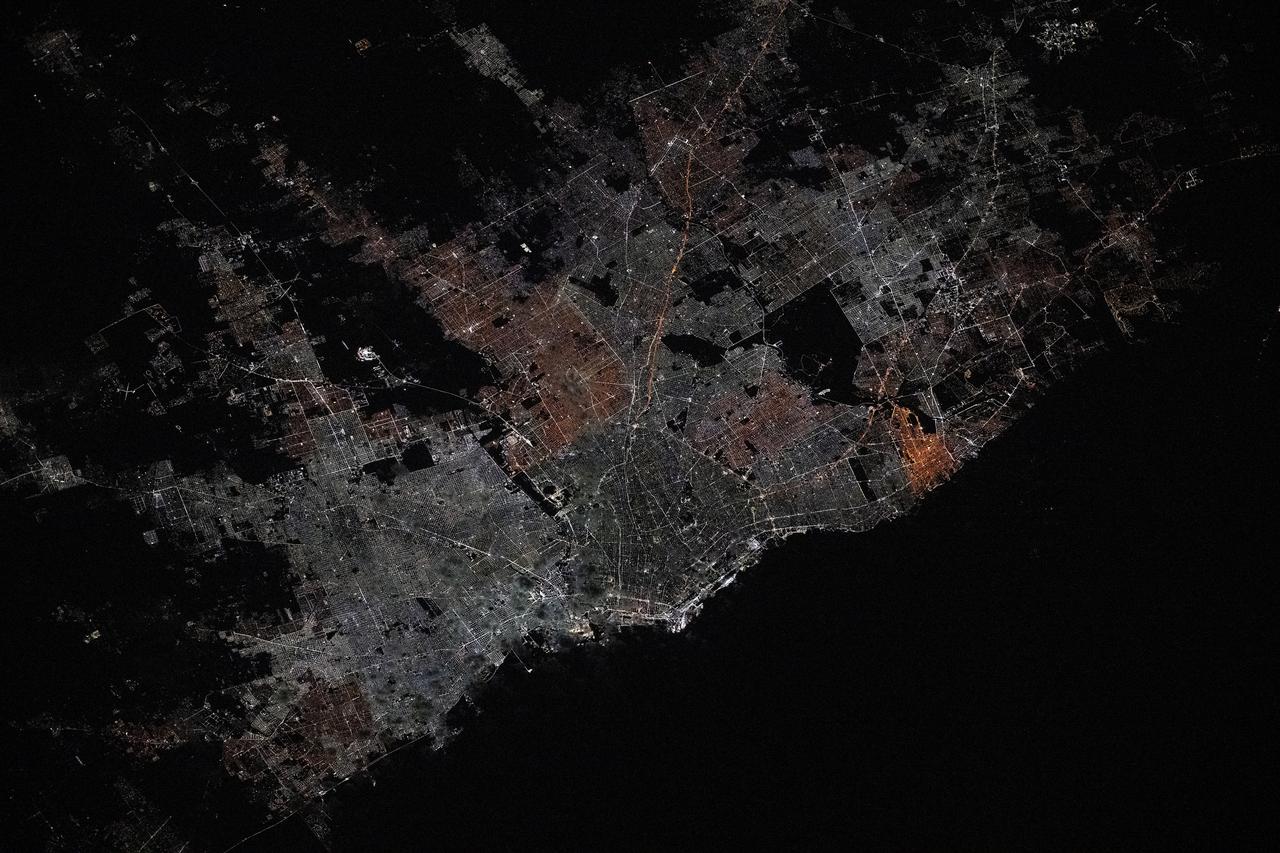
iss072e519264 (Jan. 21, 2025) --- The city lights of Buenos Aires, Argentina, the South American nation's capital with a population of about 3.1 million residents, is pictured at approximately 3:51 a.m. local time from the International Space Station as it orbited 266 miles above.
In northern Argentina's Salta province, the chaco forests, made up of shrubs and hardwood trees, once thrived in the region. In the past 30 years, large-scale farming and ranch operators have cleared broad areas of the chaco, and replaced with industrial-scale raising of crops and livestock. The December 1, 1989 Landsat TM image is dominiated by traditional puestos, settlements consisting of a few dwellings and small-scale crops located near a well. The November 19, 2019 ASTER image shows large fields arranged in a grid pattern. The chaco forest has almost disappeared. The images cover an area of 22.2 by 27.8 km, and are located at 24.9 degrees south, 63.5 degrees west. https://photojournal.jpl.nasa.gov/catalog/PIA23756
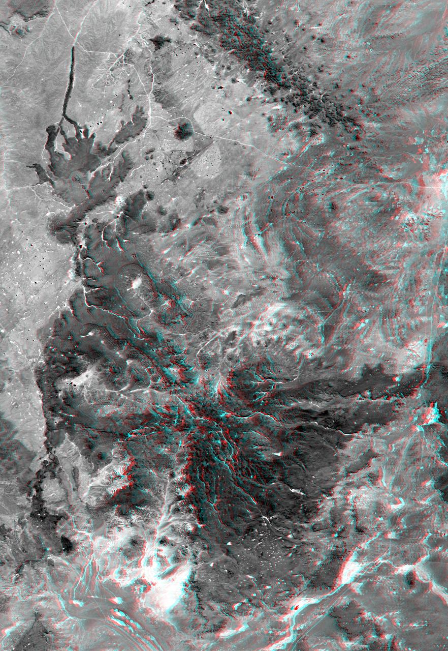
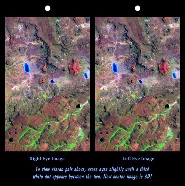
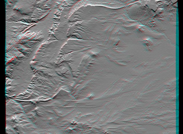
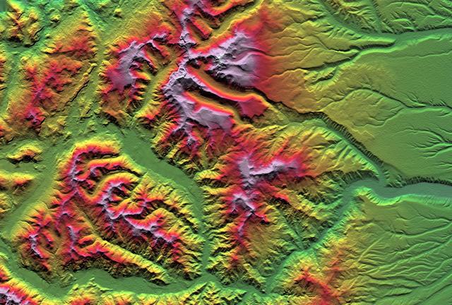
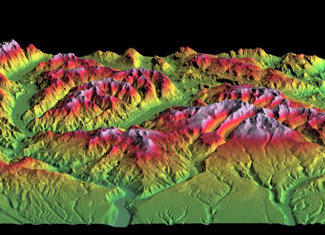
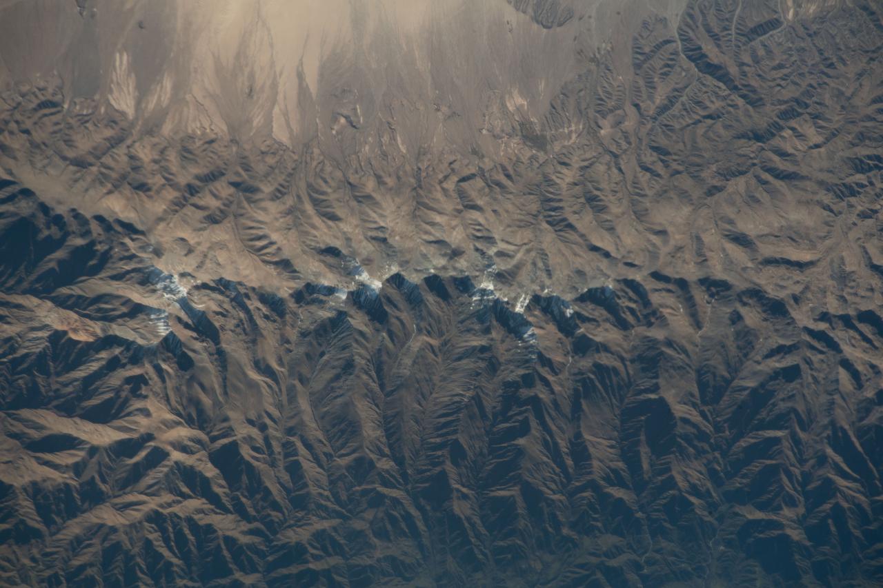
The interplay of volcanism, stream erosion and landslides is evident in this Shuttle Radar Topography Mission view of the eastern flank of the Andes Mountains, southeast of San Carlos de Bariloche, Argentina.
This perspective view acquired by NASA Shuttle Radar Topography Mission SRTM from data collected in the year 2000 shows Patagonia, Argentina, a spectacular landscape formed by volcanoes, rivers, and wind.
This depiction of an area south of San Martin de Los Andes, Argentina, is the first Shuttle Radar Topography Mission SRTM view of the Andes Mountains, the tallest mountain chain in the western hemisphere.
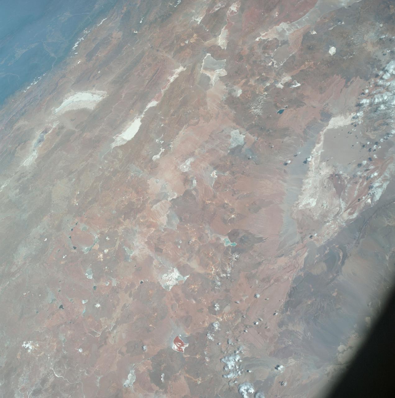
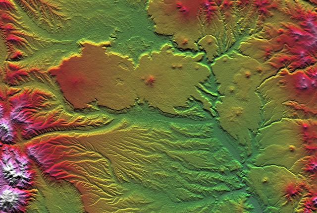
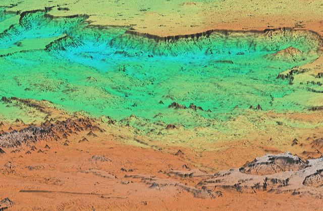
The Meseta de Somuncura is a semi-arid basalt plateau in northern Patagonia. This view of the northwestern part of the plateau, near Los Menucos, Argentina, shows numerous depressions where the upper basalt layers are missing or collapsed.
NASA Terra spacecraft captured this view of severe flooding in La Plata, Argentina, on April 4, 2013. Torrential rains and record flash flooding has killed more than 50 and left thousands homeless, according to news reports.
iss072e474246 (Jan. 13, 2025) --- Mar Chiquita Lake, a slowly evaporating salt lake in central Argentina's province of Córdoba that is home to a variety of aquatic birds and other wildlife, is pictured from the International Space Station as it orbited 265 miles above the South American nation.
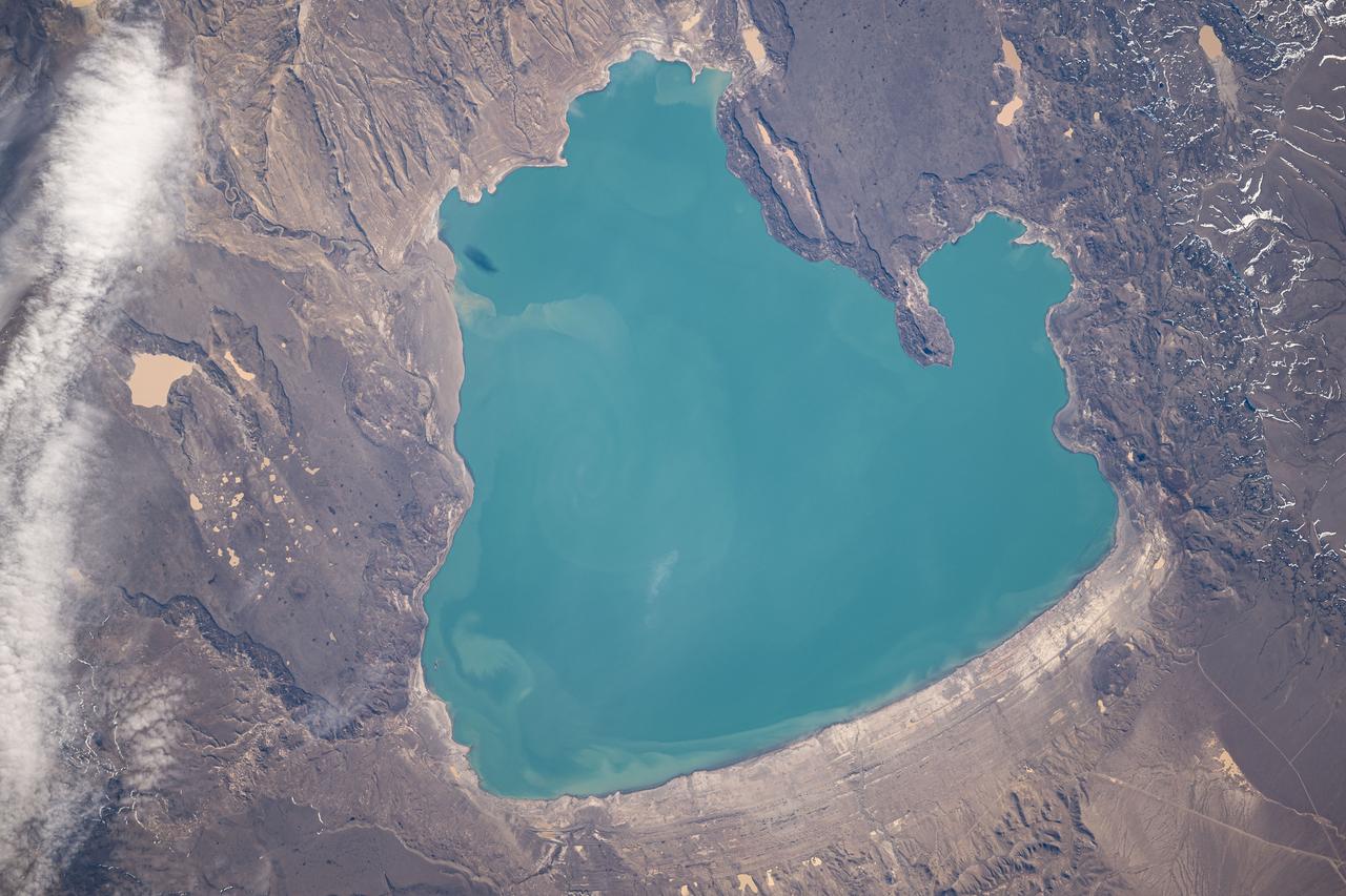
iss071e582300 (Sept. 2, 2024) -- Lake Cardiel is pictured from the International Space Station as it orbited 268 miles above Argentina. The lake is highly favored by fisherman as its alkaline water creates a rich habitat for salmon and other species to live. Its color results from nearby glaciers grinding rock into "glacial flour." The sediment is picked up by meltwater streams that feed into the lake and are slow to sink to the bottom, making the water appear a bright turquoise.
iss074e0349412 (March 3, 2026) --- The Andes mountain range running between Chile and Argentina creates distinct differences in climate and geography between the two South American nations. Chile’s Pacific coastline contributes to its moderate temperatures, with the Atacama Desert in the north being one of the driest places on Earth, while its central and southern regions are cooler and wetter. Argentina’s western side is more arid because the Andes block moisture from the Pacific Ocean, while the country’s Atlantic coastline receives more precipitation than its interior and western regions. Credit: NASA

iss069e027342 (July 2, 2023) -- An almost-full moon glows in the back as the space station orbits 268 miles above the coast of Argentina.
This depiction of an area south of San Martin de Los Andes, Argentina, is the first Shuttle Radar Topography Mission SRTMview of the Andes Mountains, the tallest mountain chain in the western hemisphere.
iss074e0046040 (Jan. 5, 2025) --- From left, the cities of Resistencia and Corrientes—both cultural and economic hubs with a combined population of over 888,000—are separated by the Paraná River in northeastern Argentina near the Paraguay border. The International Space Station was orbiting 268 miles above South America when this photograph was taken. Credit: NASA/Chris Williams
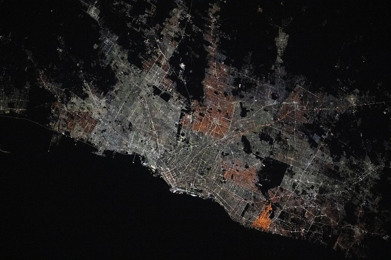
iss073e0176306 (May 20, 2025) --- Buenos Aires, Argentina, the South American nation's largest city with a population of about 3.12 million, surrounded by numerous suburbs on the bank of the Rio de la Plata is pictured at approximately 4:43 a.m. local time from the International Space Station as it orbited 267 miles above.

iss072e572361 (Jan. 28, 2025) --- The Andes mountain range separates the South American nations of Chile and Argentina significantly impacting the climate of both countries. The elevation of the Andes creates a dry climate to the west and a rainy climate to the east. The International Space Station was orbiting 266 miles above Los Ángeles, Chile, at the time of this photograph.
SL4-137-3721 (February 1974) --- Plankton blooms and color variations in the Falkland Current east of the Argentina coast in the South Atlantic Ocean as seen from the Skylab space station in Earth orbit. This picture was taken by one of the Skylab 4 crewmen using a hand-held 70mm Hasselblad camera. The Skylab 4 crew made many observations of the Falkland Current and related phenomena. This current flows north and northeastward along the Argentine coast near 40 degree south latitude where it meets the Brazil Current and the two swing eastward. The study of such photographs as this one can add significantly to our knowledge and understanding of the oceans. Photo credit: NASA
June 13, 2011 The MODIS instrument on NASA's Terra satellite captured this visible image of the ash plume from the eruption of the Puyehue-Cordón Caulle volcano, Chile on June 13 at 14:35 UTC (10:35 a.m. EDT). The wind shifted from the day before and was now blowing from the west and southwest, pushing the plume east and northeast. Note the snow on the Andes Mountain rage. Image Credit: NASA Goddard/MODIS Rapid Response, Jeff Schmaltz/Text: NASA/Rob Gutro <b><a href="http://www.nasa.gov/centers/goddard/home/index.html" rel="nofollow">NASA Goddard Space Flight Center</a></b> enables NASA’s mission through four scientific endeavors: Earth Science, Heliophysics, Solar System Exploration, and Astrophysics. Goddard plays a leading role in NASA’s accomplishments by contributing compelling scientific knowledge to advance the Agency’s mission. <b>Follow us on <a href="http://twitter.com/NASA_GoddardPix" rel="nofollow">Twitter</a></b> <b>Join us on <a href="http://www.facebook.com/pages/Greenbelt-MD/NASA-Goddard/395013845897?ref=tsd" rel="nofollow">Facebook</a></b> <b>Find us on <a href="http://web.stagram.com/n/nasagoddard/?vm=grid" rel="nofollow">Instagram</a></b>
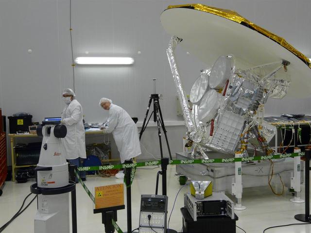
NASA Aquarius instrument power interfaces are tested prior to connection with the SAC-D service platform at the INVAP facility in Bariloche, Argentina.
NASA Aquarius instrument is lifted upright onto the SAC-D service platform at the INVAP high bay facility in Bariloche, Argentina.
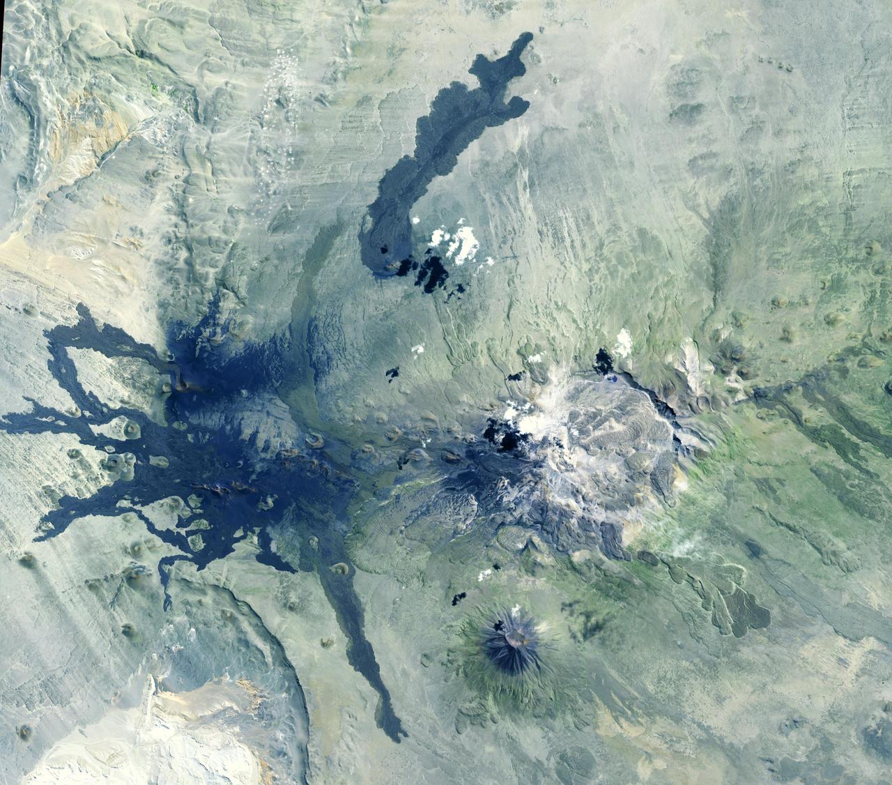
Situated in the southern Andes Mountains, the Payún volcanic field of Argentina is a complex landscape that formed over hundreds of thousands of years. Sprawling over 5,200 square kilometers (2,000 square miles), Payún is a massive shield volcano—a broad formation resembling an ancient warrior shield. This false-color image is a composite of observations acquired on February 7 and March 20, 2001 by the Enhanced Thematic Mapper Plus on the Landsat 7 satellite. It was made from a combination of visible and infrared light, where green indicates vegetation, black indicates lava flows, and orange is bare rock rich in iron oxides. Part of the back-arc volcanism of the Andes, Payún lies about 530 kilometers (330 miles) east from where the Nazca plate subducts below the South America plate. Not surprisingly, a volcanic zone extends over some 1,000 kilometers (600 miles) north-to-south in this region. According to a study published in 2010, the regional geology and chemical composition of the rocks indicate that the volcanic field likely formed within the past 300,000 years. The dominant feature of the volcanic field is Payún Matru, an elliptical caldera measuring roughly 9 by 7 kilometers (6 by 4 miles). Geologists surmise that the caldera formed after the old magma chamber emptied and the summit collapsed. Southwest of the caldera is a stratovolcano composed of alternating layers of compacted ash, hardened lava, and rocks ejected during previous eruptions. This stratovolcano, Payún, rises to 3,680 meters (12,073 feet) above sea level. (The entire volcanic field sits at 2,000 meters, or 6,600 feet.) The stratovolcano may be the most prominent feature in the volcanic field but it is by no means the only one. More than 300 eruptive features litter the shield volcano, most of them occupying an east-west line. West of Payún Matru is an area known as Los Volcanes, a mass of strombolian cones and basaltic lava flows. Image courtesy Michael P. Taylor, Landsat Data Continuity Mission Project Office, NASA Goddard Space Flight Center. Caption by Michon Scott with information from Michael Abrams, NASA Jet Propulsion Laboratory. Instrument: Landsat 7 - ETM+ To read more go to: <a href="http://1.usa.gov/UO8CbF" rel="nofollow">1.usa.gov/UO8CbF</a> Credit: <b><a href="http://www.earthobservatory.nasa.gov/" rel="nofollow"> NASA Earth Observatory</a></b> <b><a href="http://www.nasa.gov/audience/formedia/features/MP_Photo_Guidelines.html" rel="nofollow">NASA image use policy.</a></b> <b><a href="http://www.nasa.gov/centers/goddard/home/index.html" rel="nofollow">NASA Goddard Space Flight Center</a></b> enables NASA’s mission through four scientific endeavors: Earth Science, Heliophysics, Solar System Exploration, and Astrophysics. Goddard plays a leading role in NASA’s accomplishments by contributing compelling scientific knowledge to advance the Agency’s mission. <b>Follow us on <a href="http://twitter.com/NASA_GoddardPix" rel="nofollow">Twitter</a></b> <b>Like us on <a href="http://www.facebook.com/pages/Greenbelt-MD/NASA-Goddard/395013845897?ref=tsd" rel="nofollow">Facebook</a></b> <b>Find us on <a href="http://instagram.com/nasagoddard?vm=grid" rel="nofollow">Instagram</a></b>
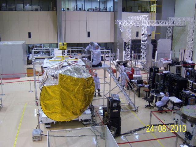
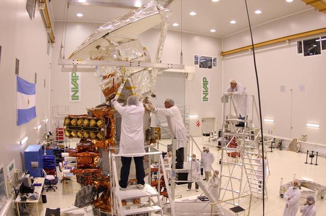
After months of integration and testing at the INVAP facility Bariloche, Argentina, NASA Aquarius/SAC-D is removed from the service platform in preparation for shipping to Brazil.

This image, acquired by NASA Terra spacecraft, shows the Cordoba province of northern Argentina, struck by wildfires caused by high temperatures and strong winds.

iss058e000188 (Dec. 24, 2018) --- The cloud-covered Pacific coast of the South American nation of Chile contrasts with the Andes Mountain range and the cloud formations extending over Argentina.
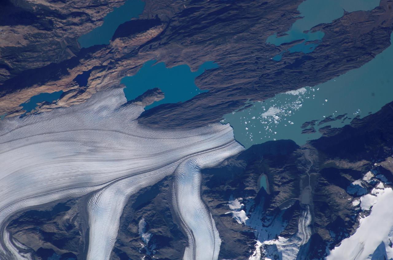
iss070e021220 (Oct. 31, 2023) --- Upsala Glacier, in between Chile and Argentina, flows into Lago Argentina in this photograph from the International Space Station as it orbited 270 miles above.
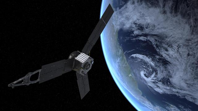
This artist rendering shows NASA Juno spacecraft during its Earth flyby gravity assist on Oct. 9, 2013. On Earth below, the southern Atlantic Ocean is visible, along with the coast of Argentina.
This image, acquired by NASA Terra satellite on July 6, 2013, shows heavy rains, which began in mid-June, resulting in major flooding along the Parana River in Argentina.

Since August 2015, heavy rains have caused rivers to overflow and forced tens of thousands from their homes in Paraguay, Argentina and Brazil. Rosario, Argentina is located 186 miles (300 kilometers) northwest of Buenos Aires, on the western shore of the Parana River. The entire Parana River floodplain for hundreds of kilometers is still under water or wet, as seen in this image from the Advanced Spaceborne Thermal Emission and Reflection Radiometer (ASTER) instrument on NASA's Terra spacecraft, acquired Jan. 6, 2016. The image covers an area of 30.8 by 33.9 miles (49.5 by 54.6 kilometers), and is located at 33 degrees south, 61 degrees west. http://photojournal.jpl.nasa.gov/catalog/PIA20295
iss058e002245 (Jan. 7, 2019) --- The U.S. Cygnus space freighter from Northrop Grumman and its prominent cymbal-shaped UltraFlex solar arrays are pictured as the International Space Station orbited 262 miles above the Atlantic Ocean off the coast of Argentina. Towards the top center of the photograph is the seven-windowed cupola with its shutters open.
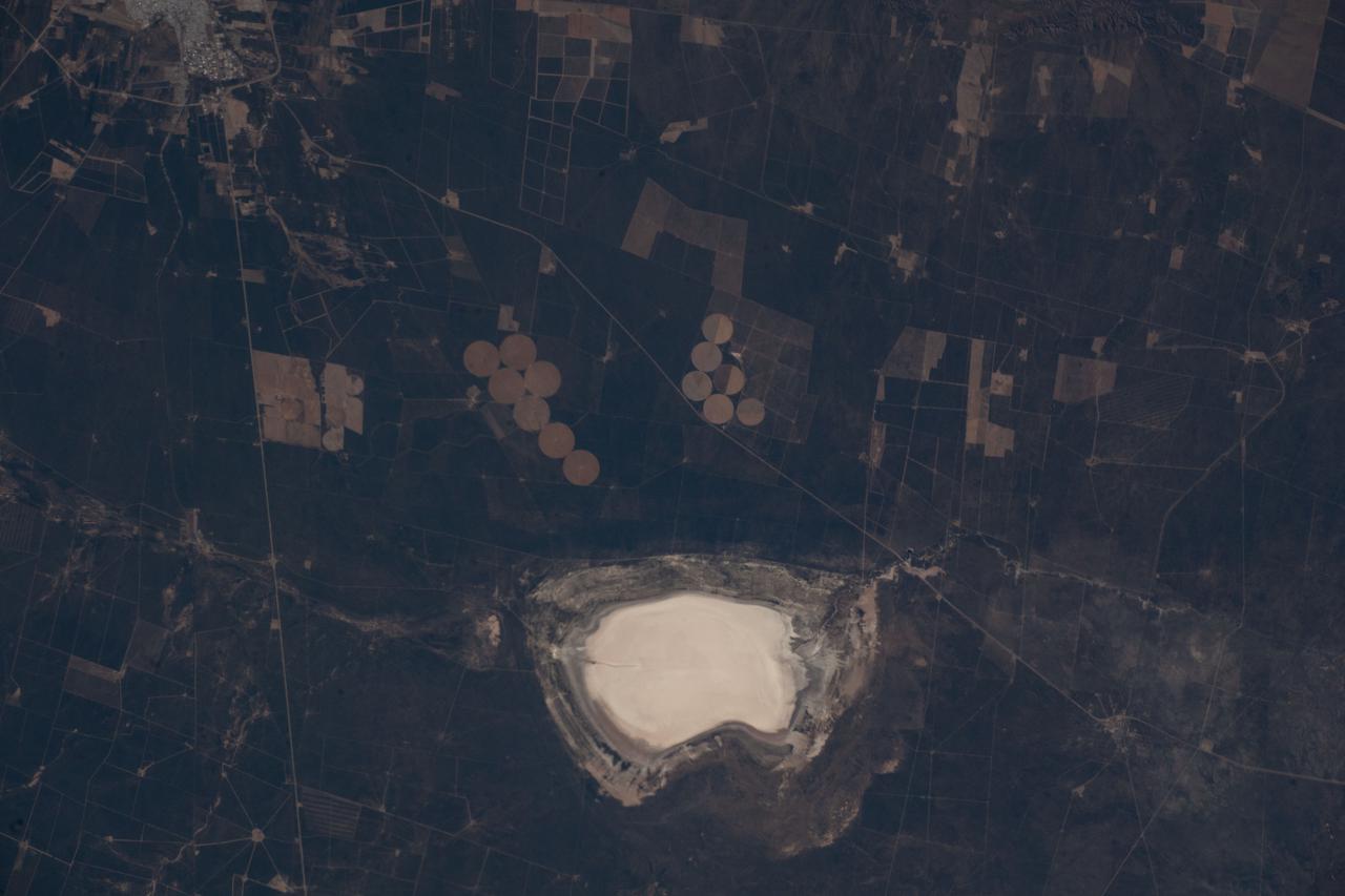
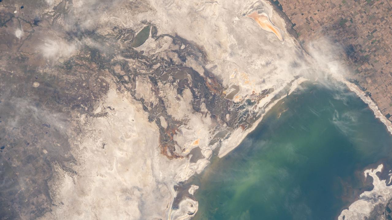
iss067e031910 (April 27, 2022) --- Lake Salinas del Bebedero rests southwest of San Luis, Argentina (upper left), in this photograph from the International Space Station as it orbited 269 miles above. The area pictured lies at the foot of the Sierra Grande Mountains in the temperate grassland region of central Argentina.
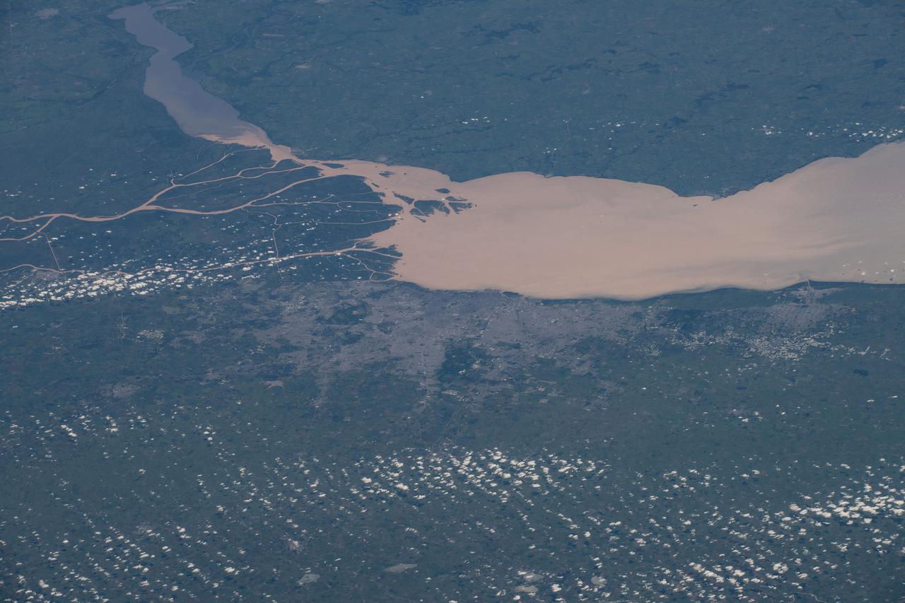
iss067e031912 (April 27, 2022) --- The Rio de la Plata separates the nations of Argentina (bottom) and Uruguay (top) in this photograph from the International Space Station as it orbited 269 miles above. Barely visible in the fertile lowlands of South America, are the populous cities of Buenos Aires, Argentina (center), and Montevideo, Uruguay (upper right).
Earth Observation taken during a day pass by the Expedition 40 crew aboard the International Space Station (ISS). Folder lists this as: Uruguay Argentina sun glint coastlines. Also sent down via Twitter message: This was the Argentina coastline a few hours ago.

iss063e040142 (June 28, 2020) --- Victoria, Argentina (lower right), pictured from the International Space Station, is located on the eastern edge of the Parana River floodplain. Smoke like this is typical of Argentina and comes from either natural or man-made fires.
SL4-137-3608 (14 Dec. 1973) --- A view of cold water eddies in the Falkland Current off the South Atlantic coast of southern Argentina as seen from the Skylab space station in Earth orbit. This picture was taken by one of the Skylab 4 crewmen using a hand-held 70mm Hasselblad camera. This land area (left corner) extends south along the coast from Puerto Deseado (center left border) for about 50 miles. Within the ocean, several light blue areas are visible and represent the occurrence of plankton with the Falkland Current. Over the ocean, the cold water eddies are identified by the circular cloud-free areas within the cloud street pattern and bordered by cumulus cloud buildup (white). The cloud streets indicate the wind is from the southwest and do not form over eddies because energy form the atmosphere is absorbed by the cold ocean water. On the downwind side of the eddies, cumulus clouds tend to form as the cold moist air flows over the warmer water. Similar cloud and eddy features have been observed by the Skylab 4 crewmen in the Yucatan Current off Yucatan Peninsula and in some parts of the South Pacific. Studies are underway by Dr. George Maul, NOAA, and Dr. Robert Stevenson, ONR, to determine the significance of the cold water eddies to ocean dynamics. Photo credit: NASA
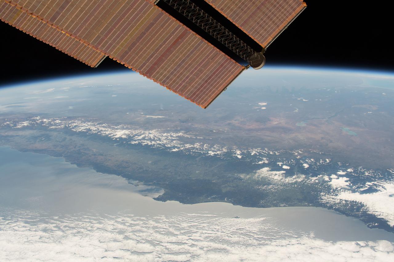
iss055e086530 (May 26, 2018) --- The snow-capped tips of the Andes Mountains range separates the South American countries of Chile and Argentina.
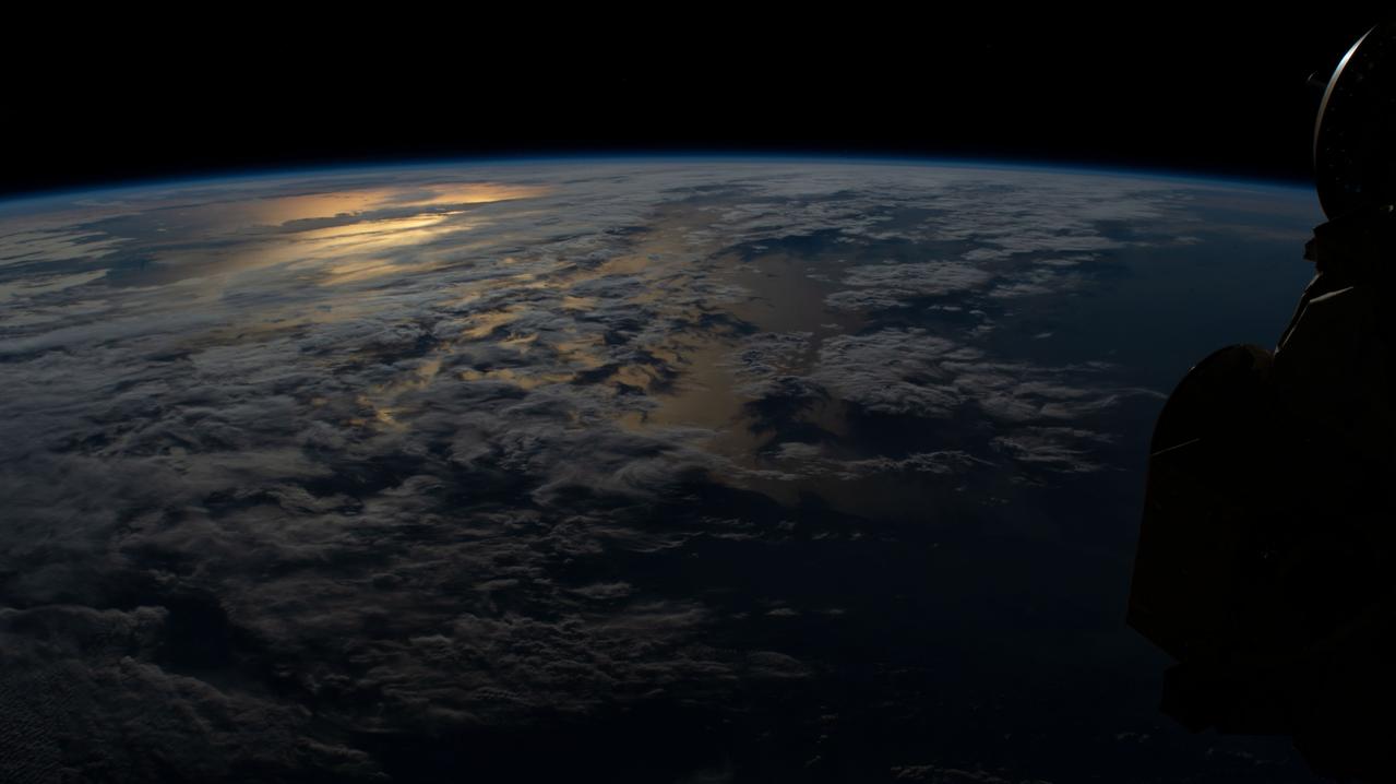
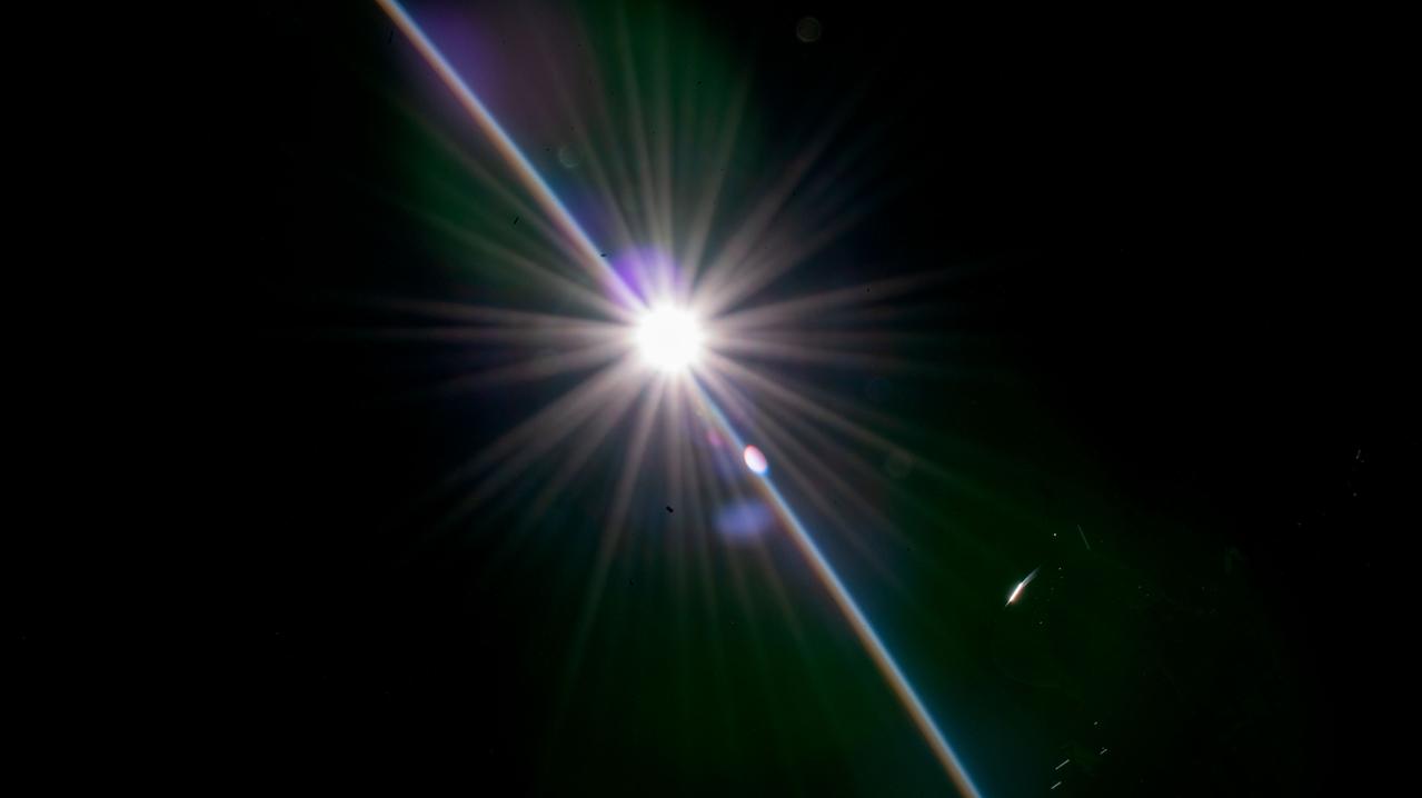
iss070e024002 (Nov. 13, 2023) --- The sun's glint beams in between a cloudy stretch of the south Atlantic Ocean off the coast of Argentina.
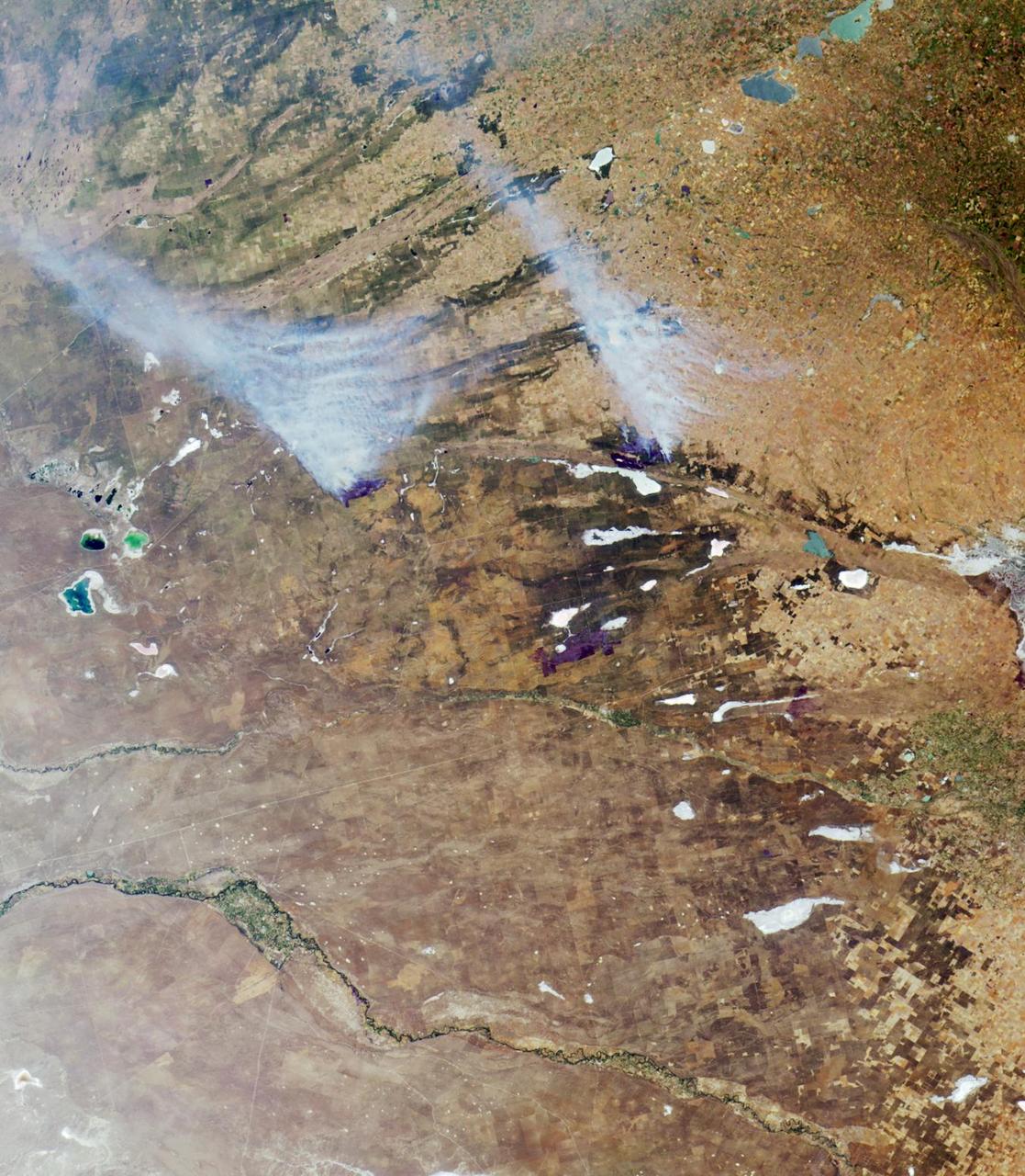
iss063e093344 (Sept. 22, 2020) --- A wildfire is pictured in northern Argentina as the International Space Station was orbiting across the South American continent.
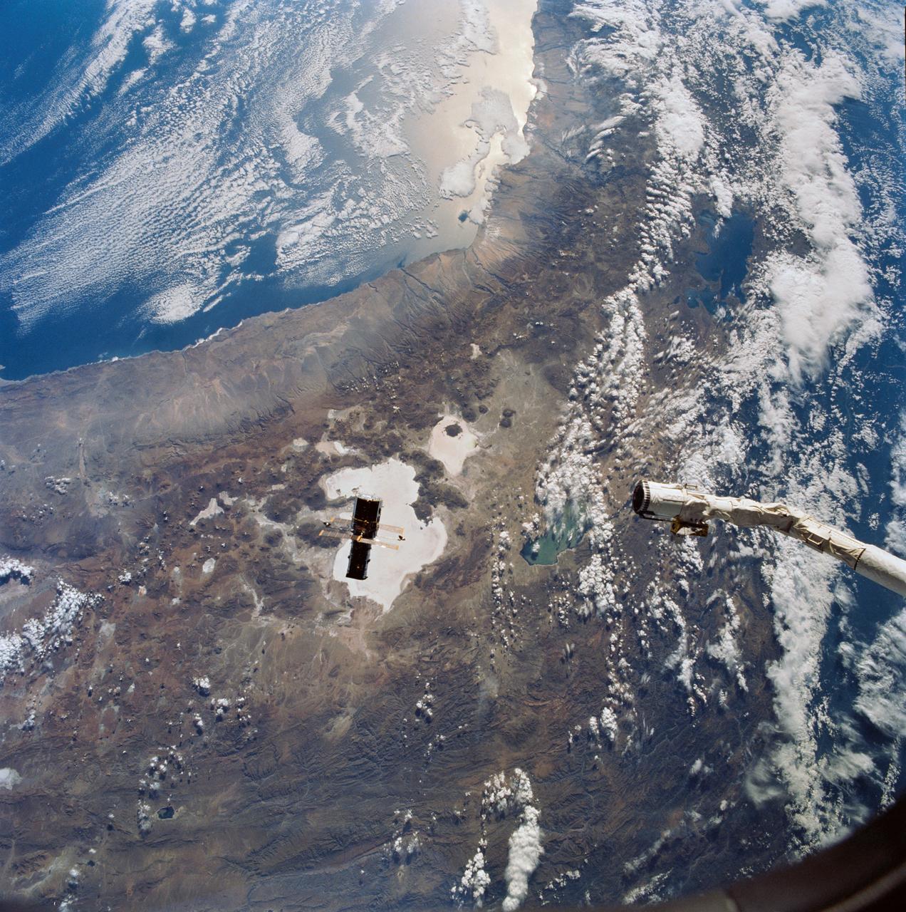
Hubble Space Telescope (HST), with its solar array (SA) wings and high gain antennae (HGA) fully extended,is released from Discovery's, Orbiter Vehicle (OV) 103's, remote manipulator system (RMS) end effector and is set free into Earth orbit by the STS-31 crew. HST drifts away from the end effector over the Andes Mountains.Parts of Bolivia, Peru, Chile, and Argentina are visible. The view covers a huge area of the western half of South America stretching from 14 degrees south latitude to 23 degrees, about 1,000 kilometers.
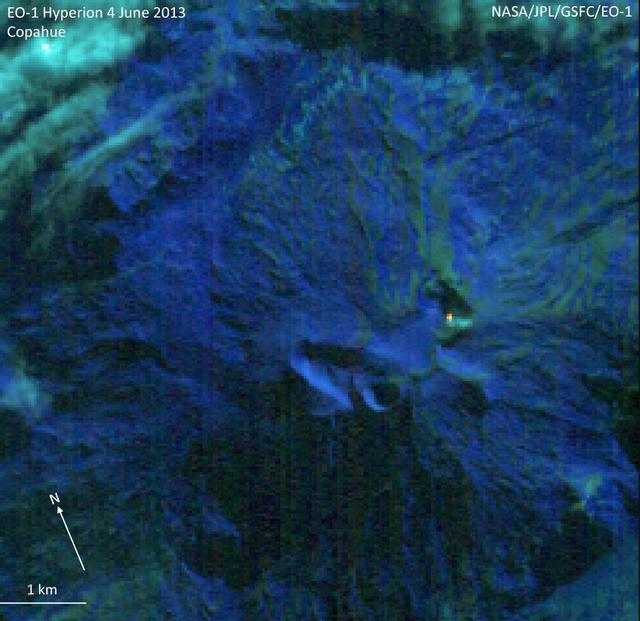
NASA Earth Observing-1 EO-1 spacecraft observed Copahue volcano, a 2965 meter high volcano on the Chile-Argentina border, on Jun. 4, 2013. Having recently displayed signs of unrest, the volcano is under close scrutiny by local volcanologists.
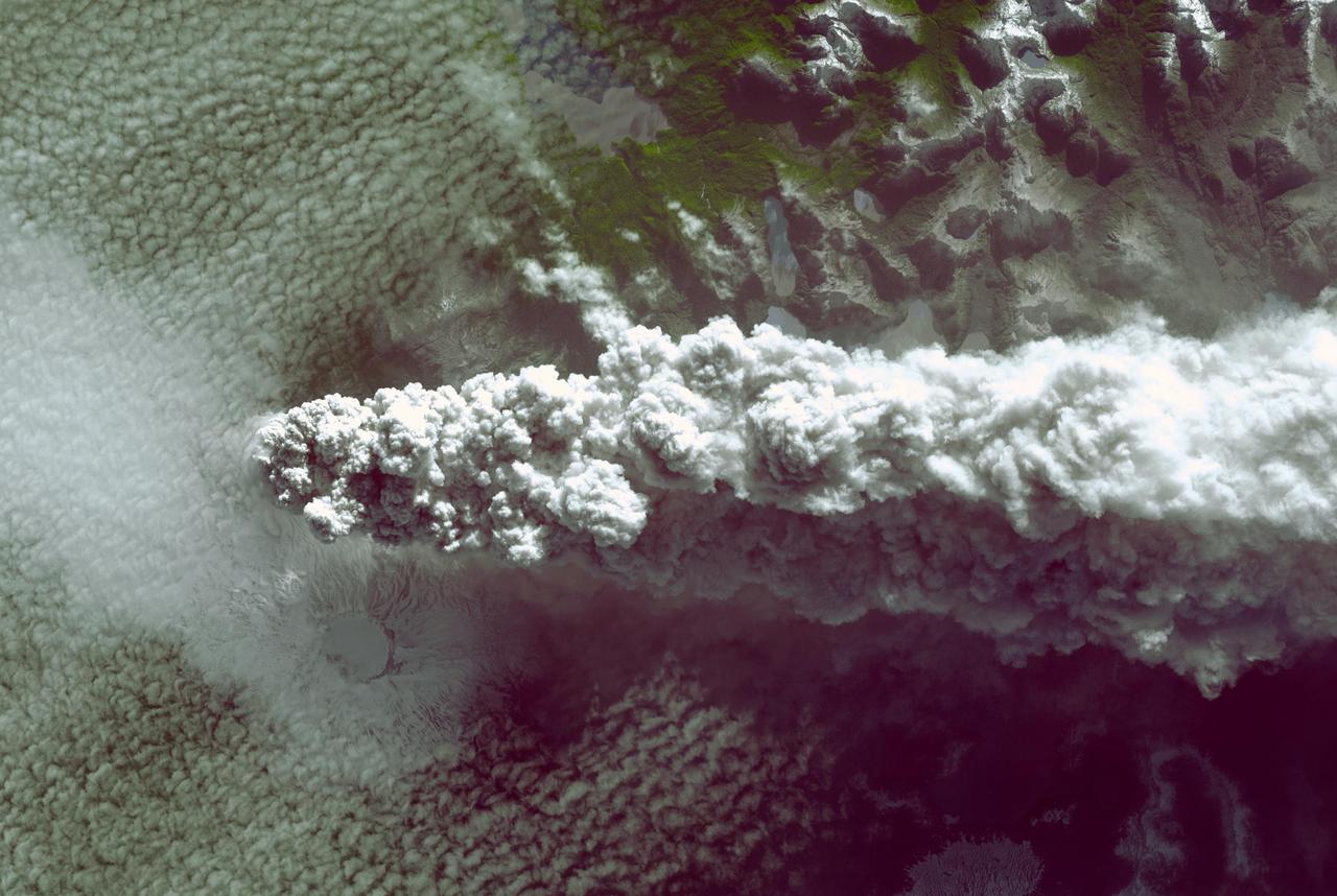
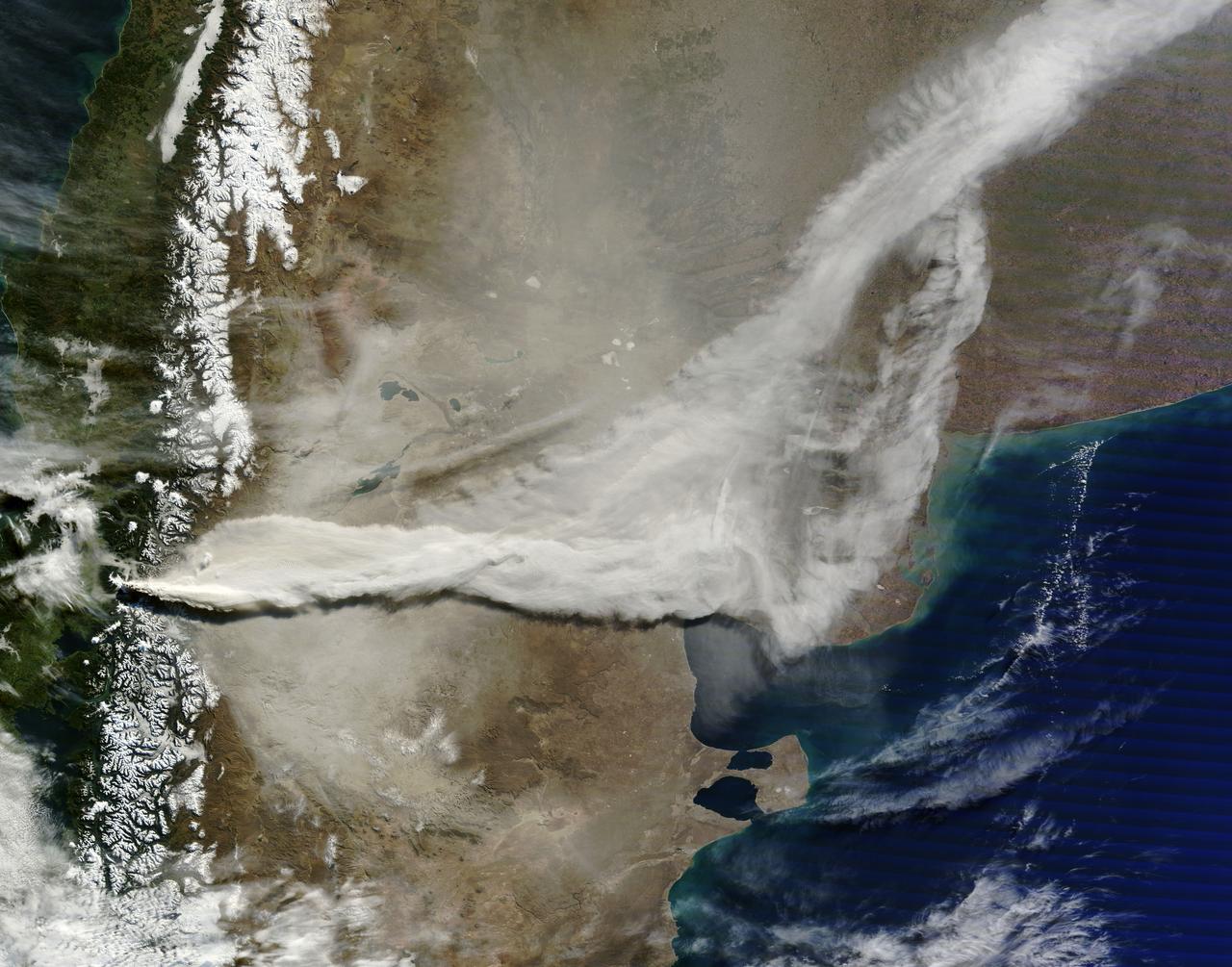
Southern Chile Puyehue volcano came to life on June 4, 2011, after decades of dormancy. Winds spread the ash column eastward over neighboring Argentina, leading to the evacuation of thousands of residents. This image is from NASA Terra spacecraft.
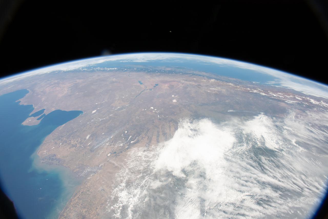
iss067e029174 (April 22, 2022) --- Several cities in the mountainous northwestern region of Argentina are pictured from the International Space Station as it orbited 264 miles above.
iss063e066312 (Aug. 5, 2020) --- Flying over southern Argentina, this photograph from the International Space Station looks northward with the Sun's glint beaming on the Atlantic Ocean.

Earth Observation taken during a day pass by the Expedition 40 crew aboard the International Space Station (ISS). Folder lists this as: Argentina.
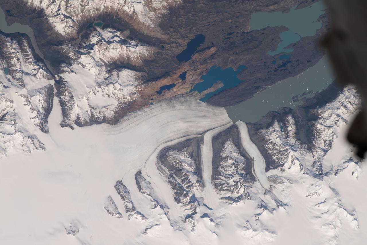
ISS010-E-18306 (19 February 2005) --- Patagonia Glacier in Argentina is featured in this image photographed by an Expedition 10 crewmember on the International Space Station.
Earth Observation taken during a day pass by the Expedition 40 crew aboard the International Space Station (ISS). Folder lists this as: sun glint near Argentina.
iss055e070222 (May 12, 2018) --- The Rio de la Plata and the Atlantic coasts of Argentina, Uruguay and Brazil are pictured from the International Space Station.

From left to right, NASA Deputy Administrator, Pam Melroy, Advisor to the Minister for Science and Technology in Argentina, Guillermo Salvatierra, NASA Administrator Bill Nelson, Minister of Science, Technology and Innovation in Argentina and Chairman of the Board of CONAE, Daniel Filmus, and Executive and Technical Director of the Comisión Nacional de Actividades Espaciales (CONAE), Raúl Kulichevsky, pose for a photo Tuesday, March 22, 2022, at NASA Headquarters in Washington DC. Photo Credit: (NASA/Aubrey Gemignani)

NASA Administrator Bill Nelson, right, meets with Executive and Technical Director of the Comisión Nacional de Actividades Espaciales (CONAE), Raúl Kulichevsky, left, Advisor to the Minister for Science and Technology in Argentina, Guillermo Salvatierra, second from left, and Minister of Science, Technology and Innovation in Argentina and Chairman of the Board of CONAE, Daniel Filmus, Tuesday, March 22, 2022, at NASA Headquarters in Washington DC. Photo Credit: (NASA/Aubrey Gemignani)
iss067e034832 (May 5, 2022) --- The Rio de la Plata separates the nations of Argentina (bottom) and Uruguay (top) in this photograph from the International Space Station as it orbited 270 miles above. Barely visible (at lower center), is the populous city of Buenos Aires, Argentina, at the mouth of the Paraná Delta which empties in to the Rio de la Plata.

NASA Deputy Administrator Pam Melroy, center, speaks with the Minister of Science, Technology and Innovation in Argentina and Chairman of the Board of the Comisión Nacional de Actividades Espaciales (CONAE), Daniel Filmus, left, and Advisor to the Minister for Science and Technology in Argentina, Guillermo Salvatierra, during a meeting, Tuesday, March 22, 2022, at NASA Headquarters in Washington DC. Photo Credit: (NASA/Aubrey Gemignani)
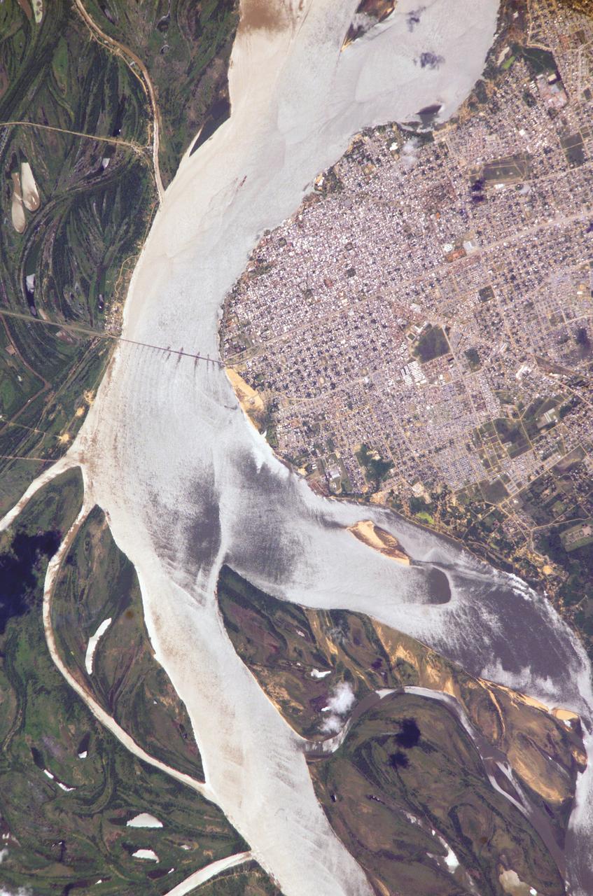
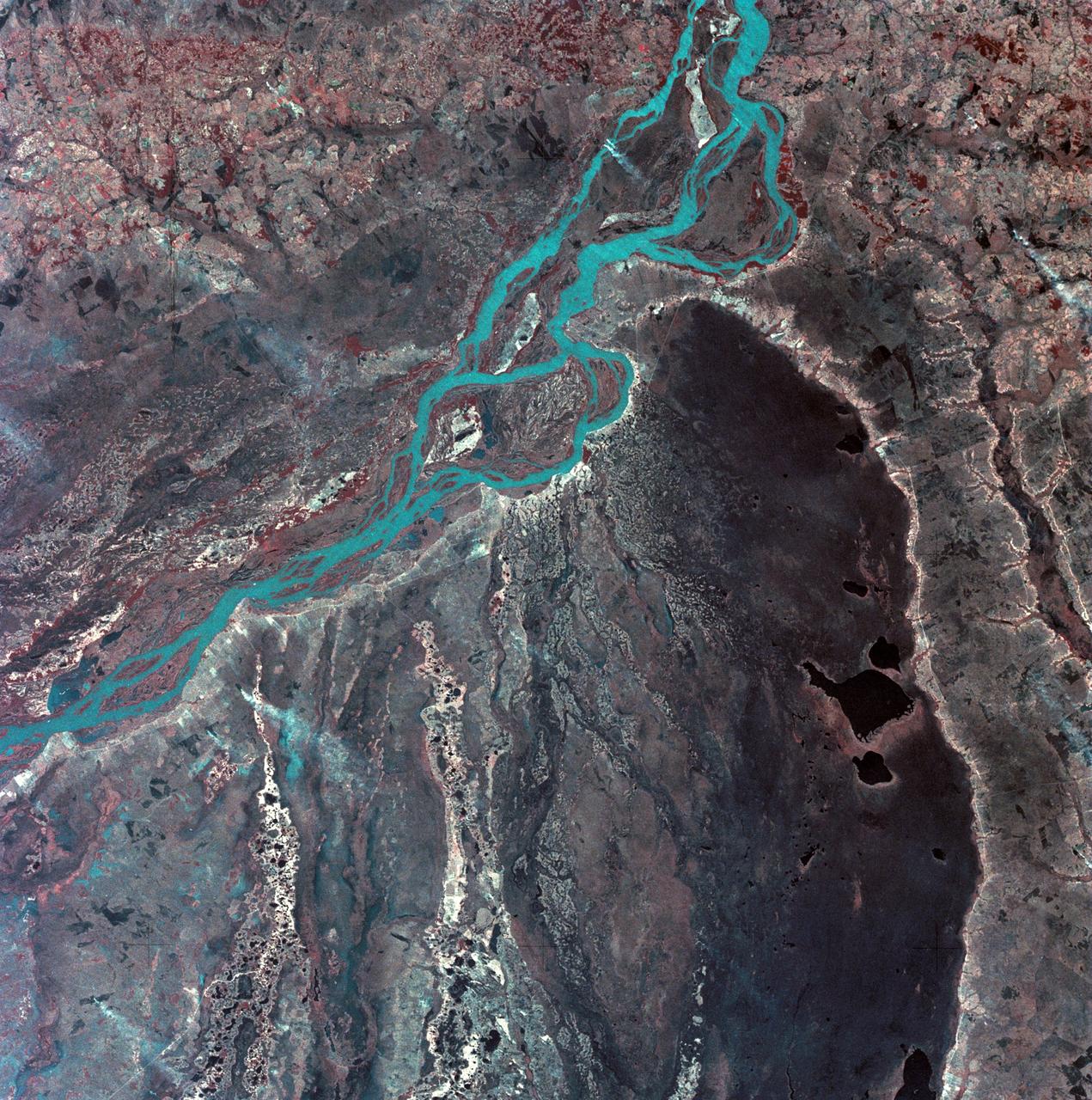
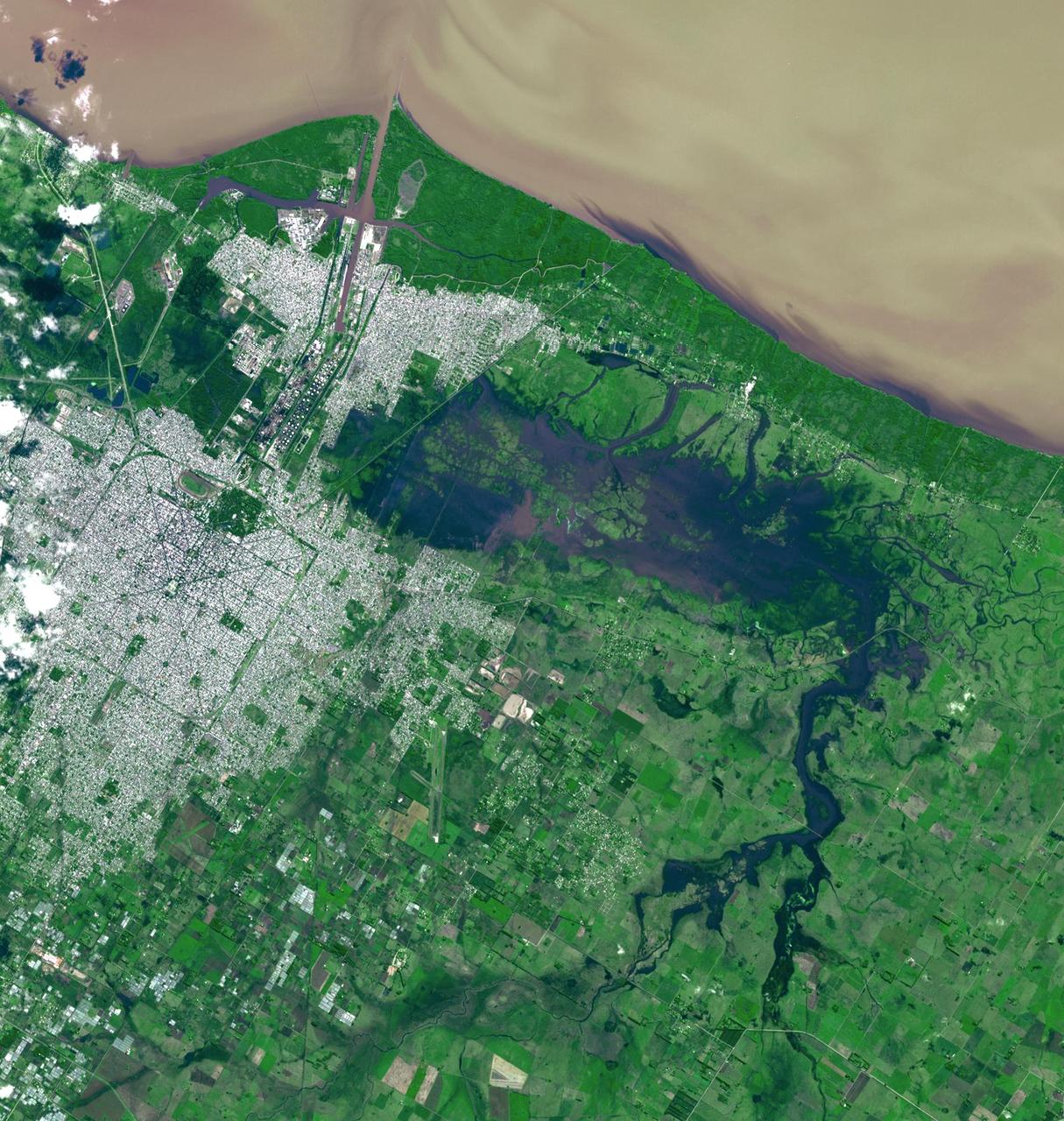
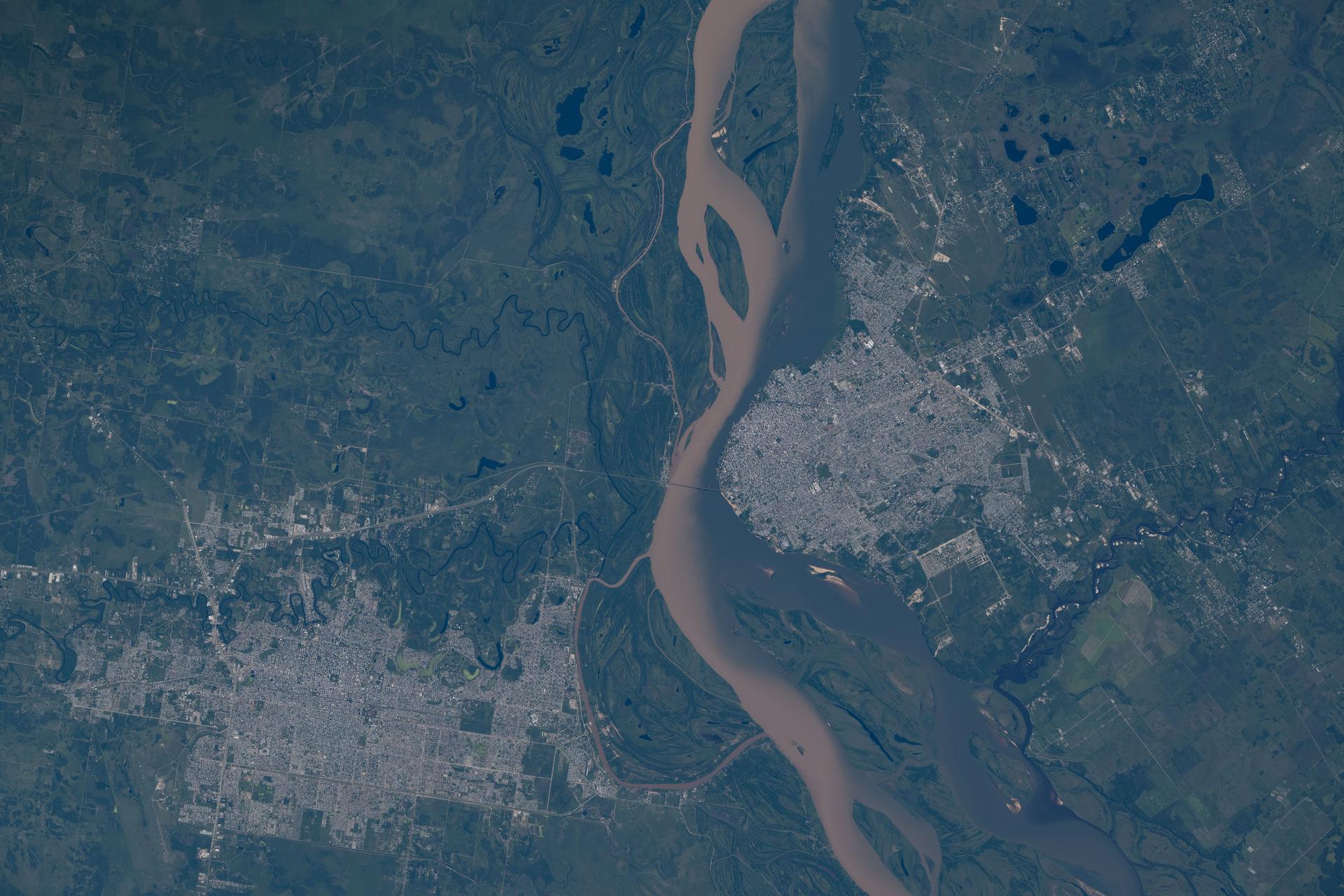
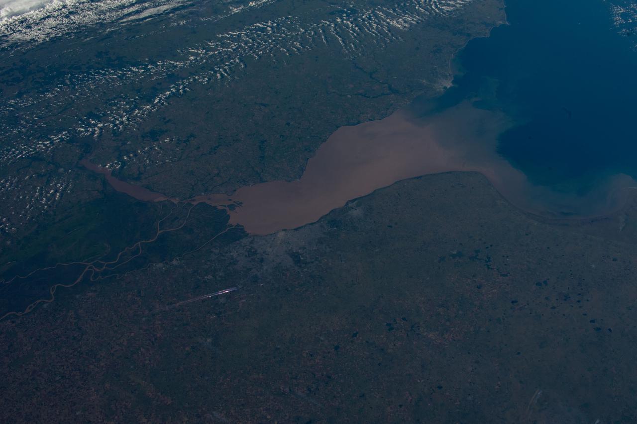
ISS010-E-05070 (25 October 2004) --- Corrientes, Argentina, and the Parana River are featured in this image photographed by an Expedition 10 crewmember on the International Space Station (ISS). Corrientes, Argentina sits on the east bank of the Parana River, South America’s third largest river (after the Negro and Amazon Rivers). From its headwaters in southeastern Brazil, the river flows southwestward around southern Paraguay, and then into Argentina. Corrientes is located just inside Argentina, across the river from the southwestern tip of Paraguay. The bridge over the Parana, built in the 1970s, connects Corrientes to its sister city, Resistencia, (beyond the left edge of image) on the western bank of the river. Sun glint on the river gives it a silvery glow and emphasizes channel islands in the river, side channels, and meander scars on the floodplain opposite the city, and even reveals the pattern of disturbed flow downstream of the bridge pylons. The old part of the city appears as a zone of smaller, more densely clustered city blocks along the river to the north of a major highway, which runs through Corrientes from the General Belgrano Bridge to the northeast (upper right of image). Larger blocks of the younger cityscape, with more green space, surround these core neighborhoods.

STS089-709-049 (22-31 Jan. 1998) --- This oblique photograph of Argentina and Chile was among several of South America photographed with a 70mm handheld camera from the Earth-orbiting space shuttle Endeavour. This part of Patagonia in Argentina and the lake district of Chile and Argentina are in southern South America between latitudes 40 degrees and 43 degrees. It is a beautiful alpine region noted for skiing and for the recent immigration of rich Americans and Europeans. On the west side of the Andes are a series of snow-capped volcanoes that are formed due to melting of sediments and portions of the Pacific Plate, which are being subducted beneath South America. East of the mountains the plains are barren and windswept, noted as having "the curse of sterility" by Charles Darwin. In the mountain regions some alpine valleys are filled by lovely lakes, such as Nahuel Huapi (in sunglint). The university town and ski resort of Bariloche, Argentina is the light area on the southeastern shore. In 1901 Robert Leroy Parker and Harry Longabaugh (aka Butch Cassidy and Sundance Kid) bought a ranch near the town of Cholila (lower left in the photo) with the proceeds of a robbery of the First National Bank of Winnemucca, Nevada. They lived there as successful ranchers until 1907, when they were reportedly forced to sell out and flee to Bolivia where their career ended at the hands of the Bolivian army. Photo credit: NASA
iss071e062798 (May 7, 2024) --- The Talampaya National Park in Argentina, a UNESCO World Heritage Site, is pictured from the International Space Station as it orbited 263 miles above the South American nation.
iss067e301734 (Aug. 30, 2022) --- The Bahia Blanca, including the three islands of Bermejo, Trinidad, and Anadna, on the coast of Argentina, are pictured from the International Space Station as it orbited 267 miles above the Atlantic Ocean.
iss071e582470 (Sept. 2, 2024) --- The Falkland Islands, also known as Islas Malvinas, are pictured from the International Space Station as it orbited 267 miles above the Argentine Sea in between the archipelago and the southern tip of Argentina.
iss066e169328 (March 11, 2022) --- Buenos Aires, Argentina, on the coast of Rio de La Plata, is pictured from the International Space Station as it orbited 266 miles above the Argentine Sea.
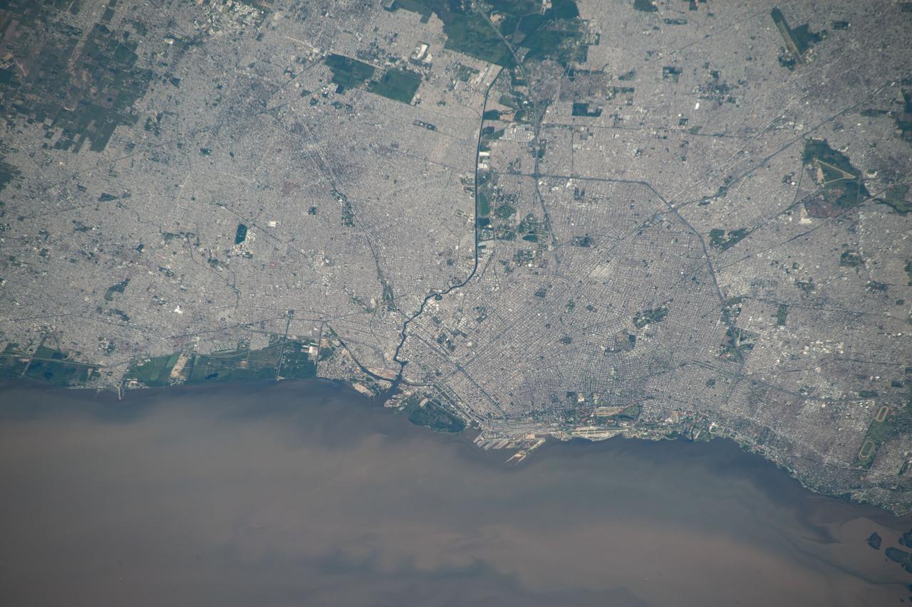
iss070e025974 (Nov. 16, 2023) --- Buenos Aires, Argentina, and its surrounding suburbs on the Rio de la Plata, are pictured from the International Space Station as it orbited 266 miles above the South American nation.
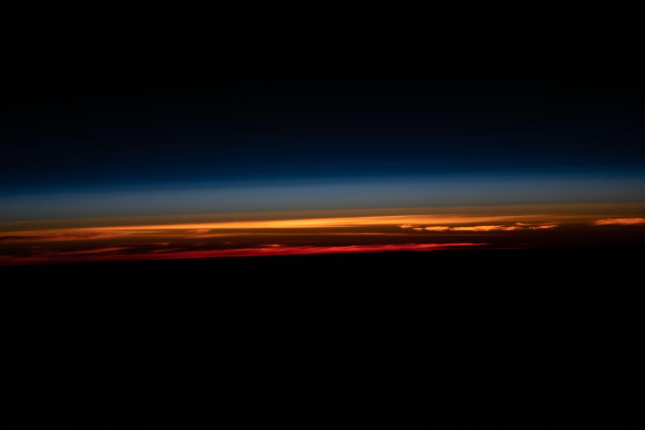
iss065e018758 (May 3, 2021) --- A sunset is pictured above the Earth's horizon as the International Space Station orbited 269 miles above the Atlantic Ocean near the southern coast of Argentina.
STS98-E-5312 (16 February 2001) --- The International Space Station (ISS) backdropped against Rio Negro, Argentina, following undocking. The photo was taken with a digital still camera.

iss068e054895 (Feb. 17, 2023) --- The last rays of an orbital sunset illuminate the Earth's atmosphere in this photograph from the International Space Station as it orbited 269 miles above the Atlantic Ocean off the coast Argentina.
iss064e005537 (Nov. 23, 2020) --- A bright blue, South Atlantic Ocean is pictured as the International Space Station soared nearly 270 miles above, just off the coast of Argentina.

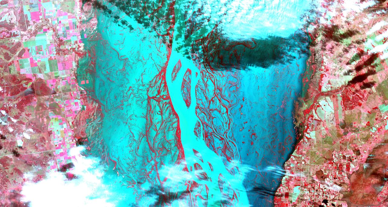
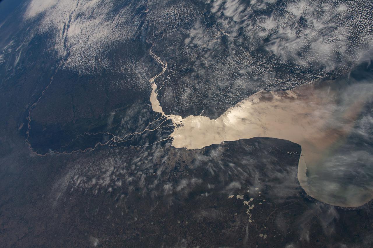
iss070e099697 (Feb., 23, 2024) --- The Paraguay River, separating the nations of Argentina and Paraguay in this photograph, and its tributaries were pictured by Expedition 70 Flight Engineer Jasmin Moghbeli as the International Space Station orbited 263 miles above.

iss064e048655 (March 30, 2021) --- A waning gibbous Moon is pictured above the Earth's horizon as the International Space Station orbited 269 miles above the Atlantic Ocean off the coast of Argentina.

iss068e054894 (Feb. 17, 2023) --- The last rays of an orbital sunset fade below Earth's horizon in this photograph from the International Space Station as it orbited 269 miles above the Atlantic Ocean just off the coast of southern Argentina.
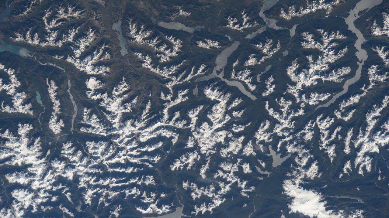
iss072e398041 (Dec. 21, 2024) --- The snow-tipped Andes mountain range and its many lakes on the southern border between Chile and Argentina are pictured from the International Space Station as it orbited 268 miles above South America.
iss053e239454 (Nov. 22, 2017) --- The Pacific coast of Chile, the snow-capped Andes mountains and the arid Patagonian plateaus of Argentina are pictured as the International Space Station orbited near the bottom-most portion of the South American continent.
iss061e036737 (Nov. 9, 2019) --- The International Space Station orbits 264 miles above Argentina on its northeast track across South America as this photograph looks across the Atlantic Ocean during an orbital sunset.
iss068e054893 (Feb. 17, 2023) --- The last rays of an orbital sunset penetrate Earth's horizon in this photograph from the International Space Station as it orbited 269 miles above the Atlantic Ocean just off the coast of southern Argentina.
iss066e091560 (Nov. 30, 2021) --- The remote archipelago of the Falkland Islands, also known as the Islas Malvinas, off the coast of southern Argentina is pictured from the International Space Station as it orbited 270 miles above the south Atlantic.

iss070e026585 (Nov. 19, 2023) --- The sun's glint beams off the Paraguay River which separates a portion of the South American nations of Argentina and Paraguay in this photograph from the International Space Station as it orbited 265 miles above.
iss071e582449 (Sept. 2, 2024) --- The Santa Cruz River, in Argentina's southernmost province, empties into the Argentine Sea in this photograph from the International Space Station as it orbited 267 miles above the South American nation's coast.
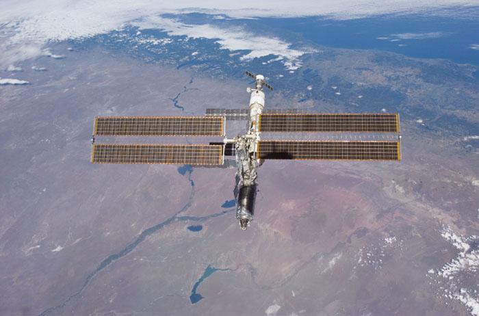
STS98-E-5314 (16 February 2001) --- The International Space Station (ISS) backdropped against the Rio Negro, Argentina, following undocking. The photo was taken with a digital still camera.
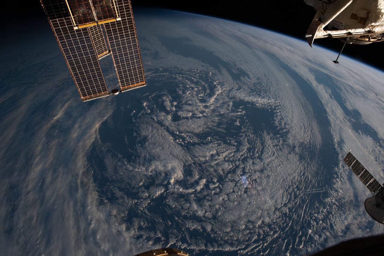
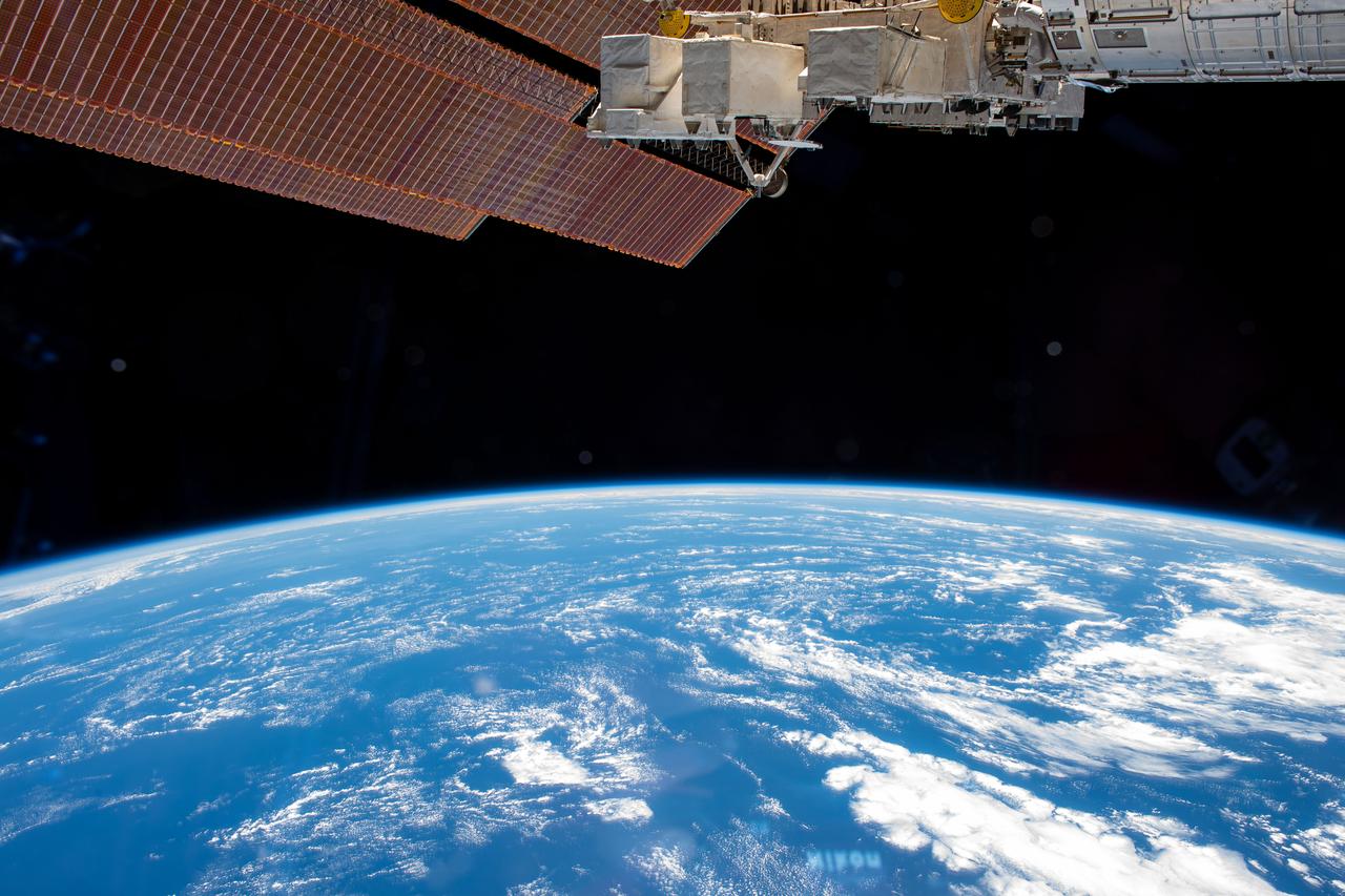
iss069e027354 (July 2, 2023) -- Clouds cover Earth and the orbital lab's solar arrays are shown in the top left corner as the space station orbits 270 miles above the Atlantic Ocean off the coast of Argentina.
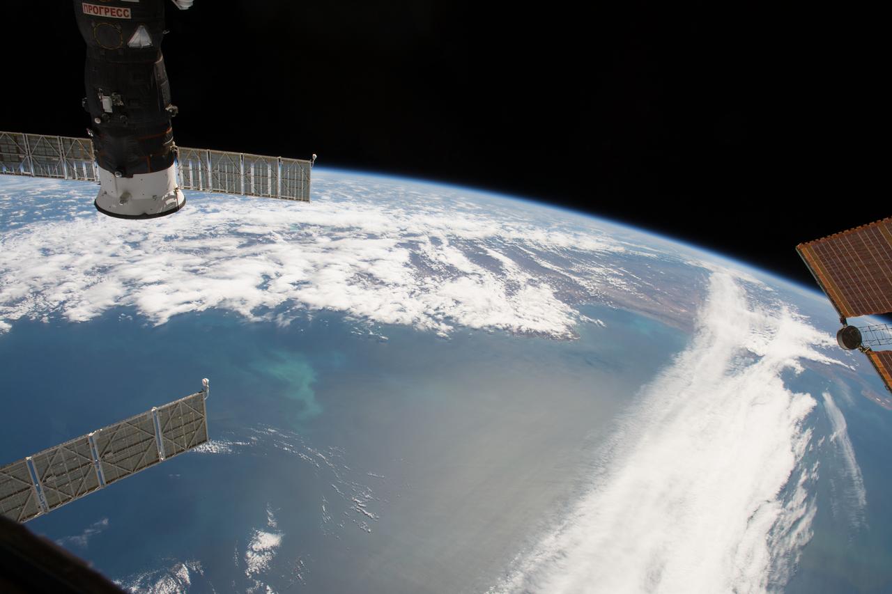
iss054e022072 (Jan. 12, 2018) --- The International Space Station orbits above the Falkland Islands off the coast of the southern-most portion of Argentina on the continent of South America. In the upper-right of the photograph is the docked Progress 68 cargo craft.