
NASA Chief Technologist Douglas Terrier presents to grade school students about NASA’s Artemis Program -- which will send the first woman and the next man to surface of the Moon by 2024 -- at “NASA Day in Arkansas” at Harding University in Searcy, Arkansas, on Jan. 27, 2020.

NASA Chief Technologist Douglas Terrier meets with members of the media at “NASA Day in Arkansas” at Harding University in Searcy, Arkansas, on Jan. 27, 2020.

NASA Chief Technologist Douglas Terrier meets with researchers conducting plant research relevant to space exploration during “NASA Day in Arkansas” at Harding University in Searcy, Arkansas, on Jan. 27, 2020.

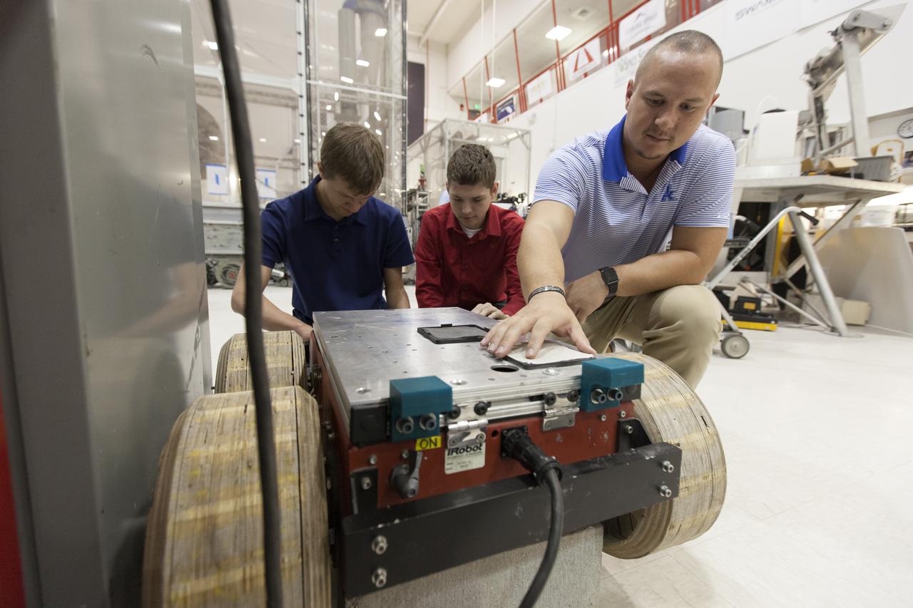
NASA Chief Technologist Douglas Terrier, right, and NASA Deputy Chief Technologist David Steitz, left, investigate a rover developed at Harding University in Searcy, Arkansas, in partnership with NASA’s Jet Propulsion Laboratory in Silicon Valley, California, and the University of Arkansas-Little Rock while attending “NASA Day in Arkansas” hosted at the university on Jan. 27, 2020.

NASA Chief Technologist Douglas Terrier, center, and NASA Deputy Chief Technologist David Steitz, left, talk with a Harding University student researcher about LED technology being used to track atmospheric composition, while attending “NASA Day in Arkansas” hosted at the university in Searcy, Arkansas on Jan. 27, 2020.

NASA Chief Technologist Douglas Terrier, right, being briefed on student-developed precision atmospheric laser technology mounted on a remotely-operated rover at Harding University in Searcy, Arkansas, while attending “NASA Day in Arkansas” hosted at the university on Jan. 27, 2020.

NASA Chief Technologist Douglas Terrier, center, talk with a Harding University student about a miniaturized laser sample analysis device that may be used for planetary science research. Terrier attended “NASA Day in Arkansas,” hosted at the university in Searcy, Arkansas on Jan. 27, 2020.

NASA Chief Technologist Douglas Terrier, left of center, meets with Dr. Ed Wilson, engineering professor emeritus and tours Wilson's atmospheric sciences laser lab during “NASA Day in Arkansas” at Harding University in Searcy, Arkansas, on Jan. 27, 2020.

Dr. Ruth Jones, Branch Chief for Industrial Safety Branch (QD12) at MSFC, poses with model of Space Launch System, in Building 4220. Photo for publication in University of Arkansas, Pine Bluff, Alumni magazine.
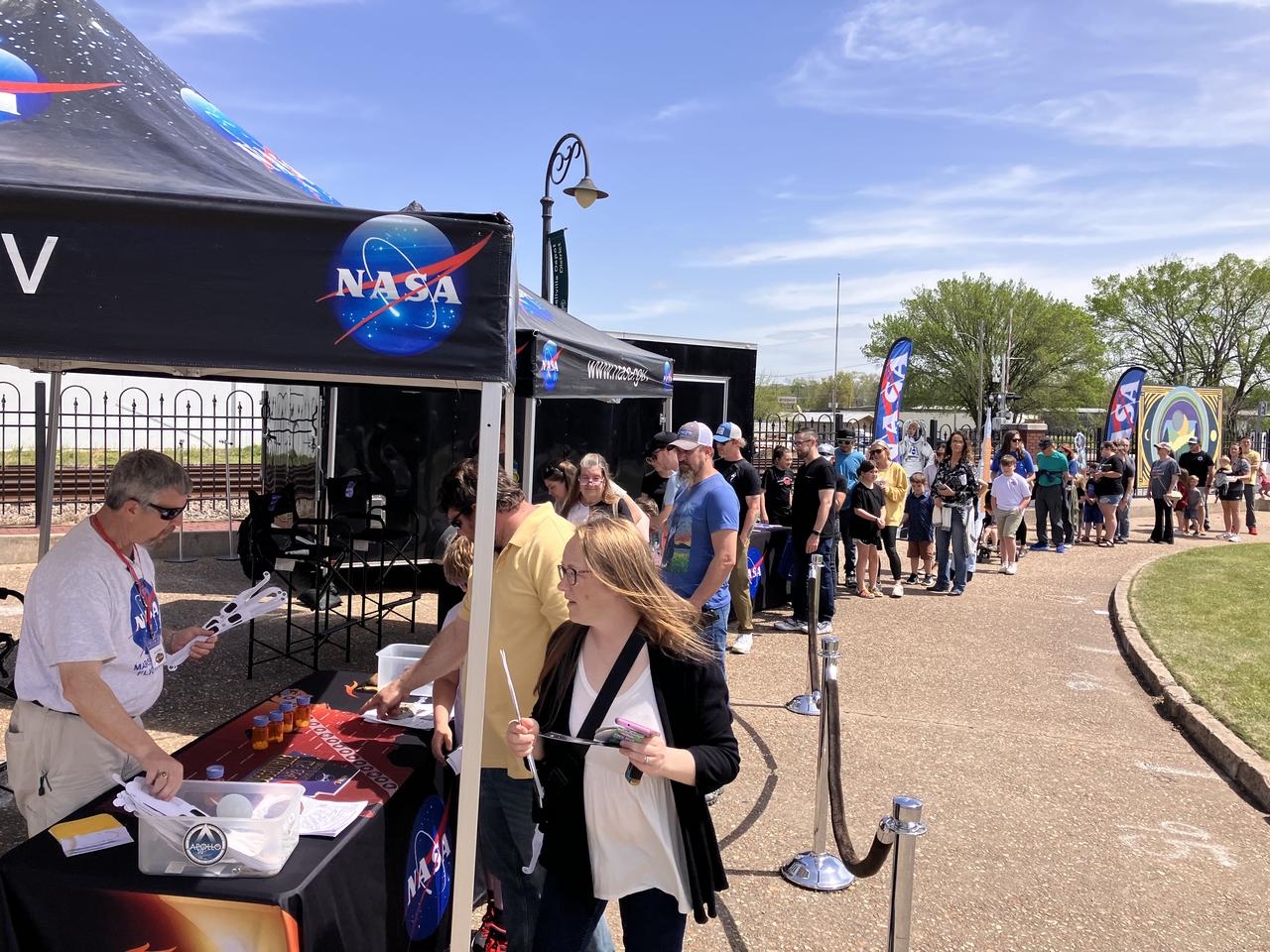
NASA gives out solar eclipse glasses for people to safely view the eclipse on April 8 in Russellville, Arkansas.
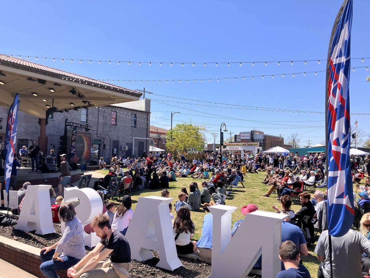
A crowd of people in Russellville, Arkansas, prepare to watch the total solar eclipse on April 8 as Forbes ranked the city as a top spot for viewing.
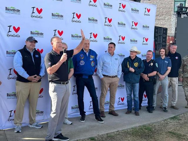
NASA Stennis Acting Center Director John Bailey, front left, speaks to people gathered to view the total solar eclipse in Russellville, Arkansas, on April 8.
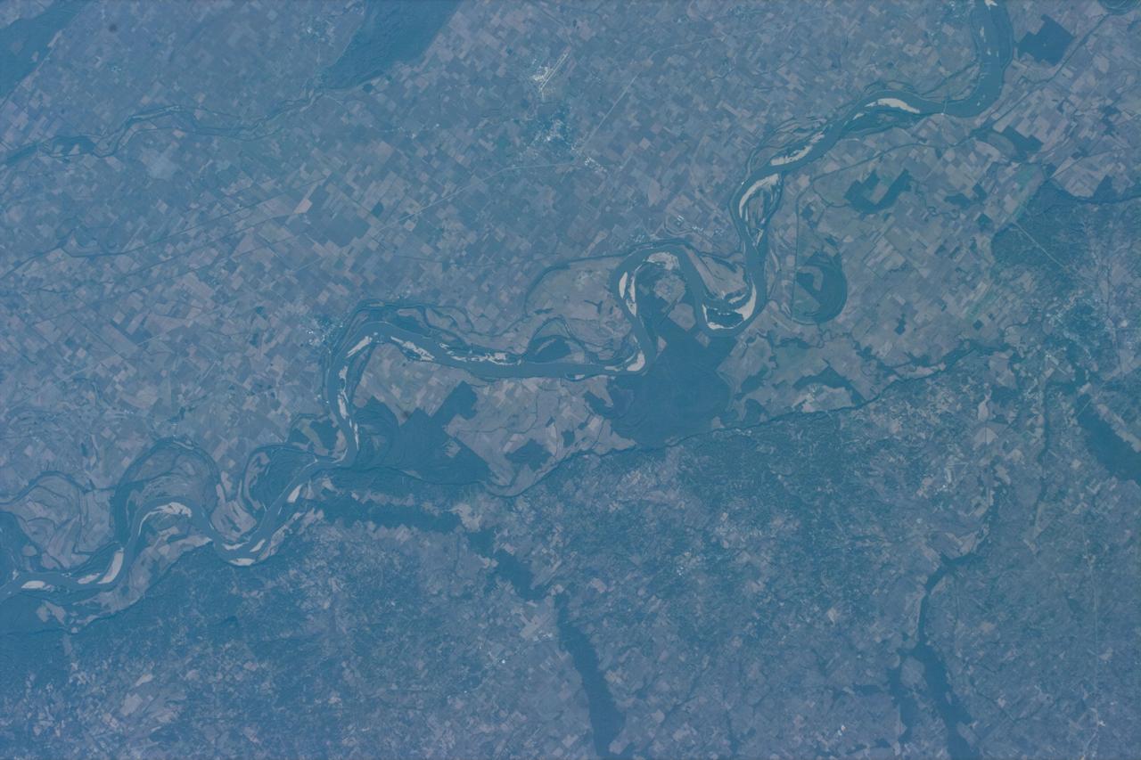
iss073e0880658 (Oct. 15, 2025) --- The Mississippi River separates Arkansas (left) from Mississippi in this view, with the St. Francis National Forest visible on the Arkansas side. Although not a true delta, the Mississippi Delta is a broad floodplain stretching from southern Illinois to Louisiana, with deep cultural roots in northern Mississippi. The International Space Station was orbiting 261 miles above Earth when this photograph was taken.

Dr. Ruth Jones, Branch Chief for Industrial Safety Branch (QD12) at MSFC, talks safety issues in the Payload Operation Integration Center. Photo for publication in University of Arkansas, Pine Bluff, Alumni magazine.
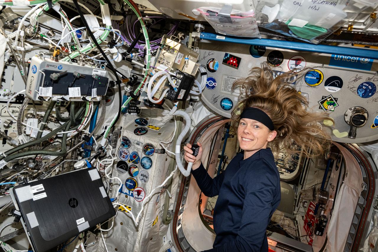
iss072e882080 (March 31, 2025) --- NASA astronaut and Expedition 72 Flight Engineer Nichole Ayers talks on a ham radio with students from Lakeside Junior High School in Springdale, Arkansas. Ayers answered questions from the students about her experience living and working aboard the International Space Station.

Dr. Ruth Jones, Branch Chief for Industrial Safety Branch (QD12) at MSFC, at Test Stand 4693 which holds the Space Launch System Liquid Hydrogen Tank. Photo for publication in University of Arkansas, Pine Bluff, Alumni magazine.
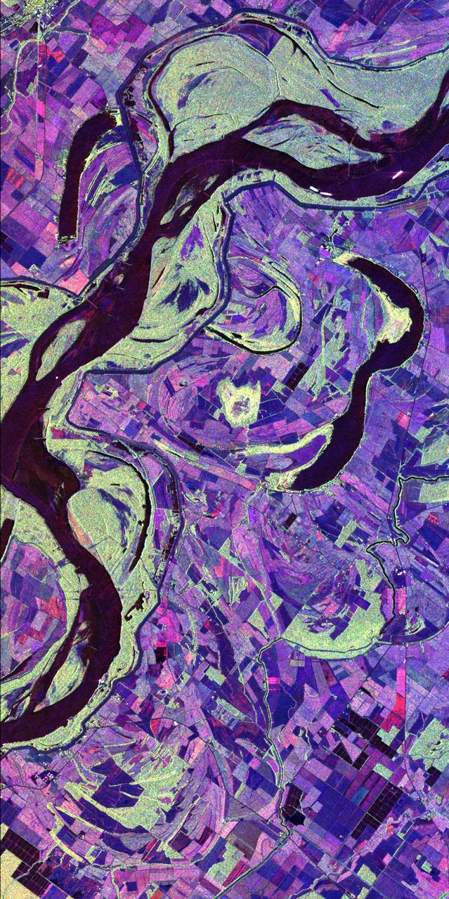
This image of the Mississippi River in Mississippi, Arkansas, and Louisiana shows regions of the southern United States that are prone to flooding.
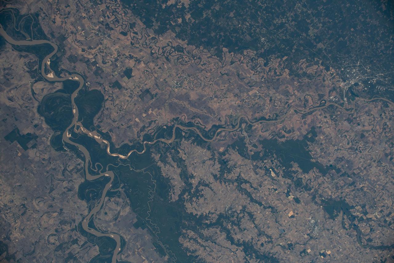
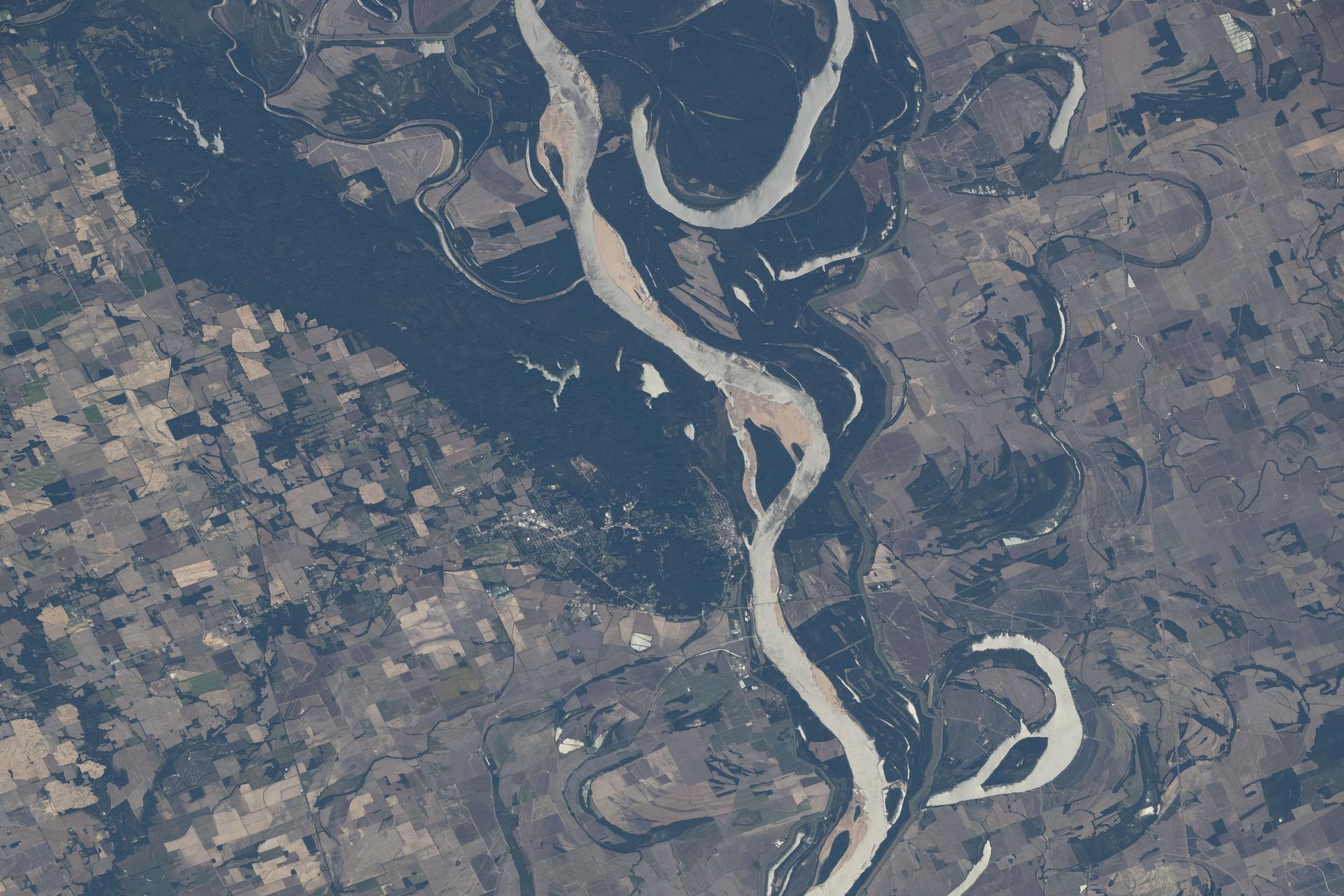
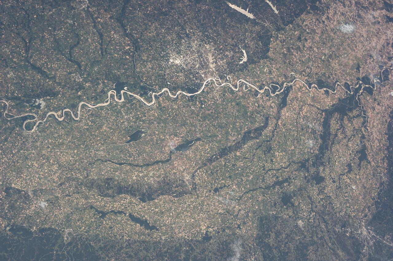
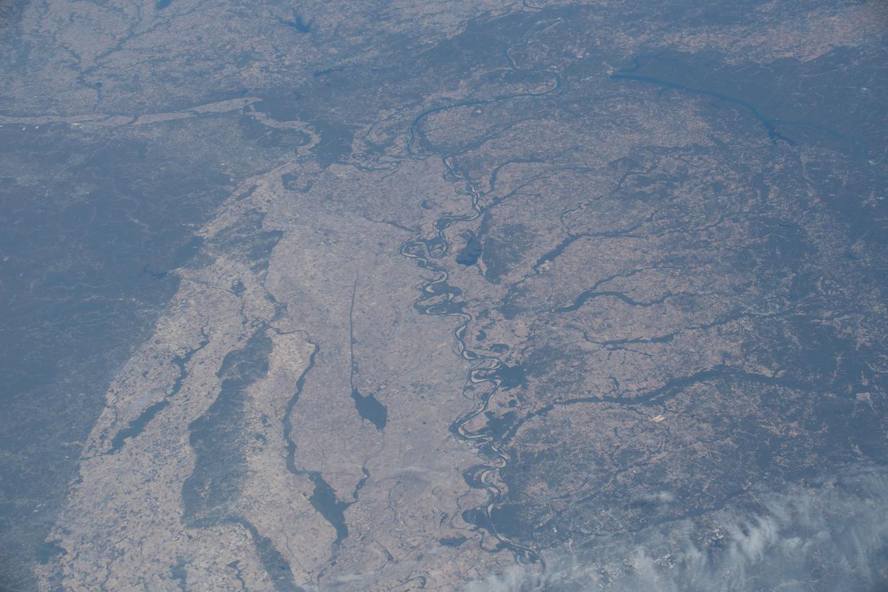
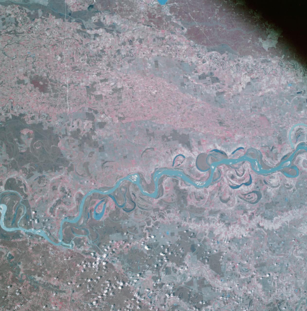
iss061e026278 (Nov. 1, 2019) --- The Mississippi River separates the states of Mississippi and Arkansas and splits into the Arkansas River. The International Space Station was orbiting 255 miles in altitude and 164 miles west of Memphis, Tennessee, when this photograph was taken.
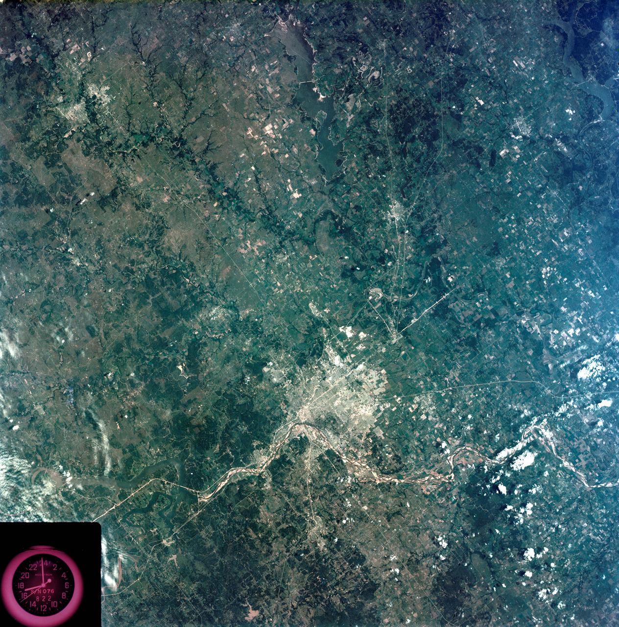
STS073-E-5091 (30 Oct. 1995) --- The Mississippi River meanders through its floodplain between the northeastern corner of Arkansas and the northwestern corner of Tennessee. Blytheville, Arkansas and the former Eaker Air Force Base can be seen near the top of the image. The frame was exposed with the Electronic Still Camera (ESC).
Earth observation taken during a day pass by the Expedition 37 crew. Per Twitter message: The Mississippi River through Missouri, Tennessee, Arkansas, Mississippi.

ISS011-E-13623 (24 September 2005) --- Hurricane Rita is featured in this image photographed by an Expedition 11 crewmember on the international space station, as it moves over Arkansas.
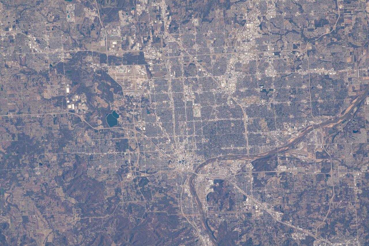
iss064e009722 (Dec. 4, 2020) --- Tulsa, Oklahoma, split by the Arkansas River, was pictured from the International Space Station as it orbited 262 miles above.
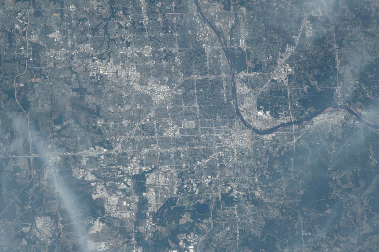
iss069e054666 (Aug. 4, 2023) --- Tulsa, Oklahoma, on the Arkansas River is pictured from the International Space Station as it orbited 261 miles above the Sooner State.
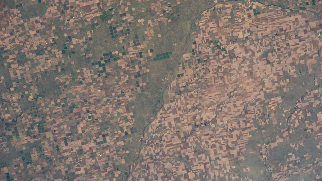
iss067e123189 (June 10, 2022) --- Agricultural activities along the Arkansas River in the state of Kansas, a leader in wheat, grain sorghum and beef production, are pictured from the International Space Station as it orbited 263 miles above the state of Oklahoma.
iss070e008440 (Oct. 22, 2023) --- The Mississippi River Valley and portions of the states of Arkansas, Missouri, Tennessee, Kentucky, and Illinois are pictured from the International Space Station as it orbited 261 miles above
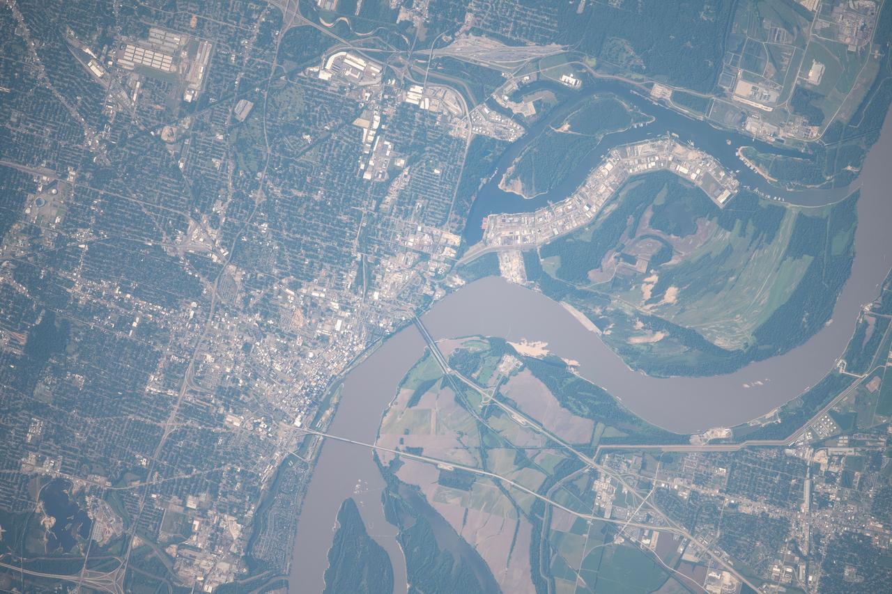
iss060e055395 (Sept. 6, 2019) --- Downtown Memphis on the Mississippi River, which separates the states of Tennessee and Arkansas, is pictured from the International Space Station as it orbited 261 miles above the United States.

S78-35306 (31 Jan. 1978) --- Astronaut S. David Griggs. (NOTE: He died on June 17, 1989, near Earle, Arkansas, in the crash of a vintage World War II airplane.)

iss046e005351 (1/5/2016) --- The Expedition 46 crew photographed an Earth observation night pass over the Gulf of Mexico. The view looks toward the northeast and includes Texas and Louisiana gulf coasts, as well as major cities in Texas, Louisiana, Mississippi, Alabama, Oklahoma, Arkansas, Tennessee and more.
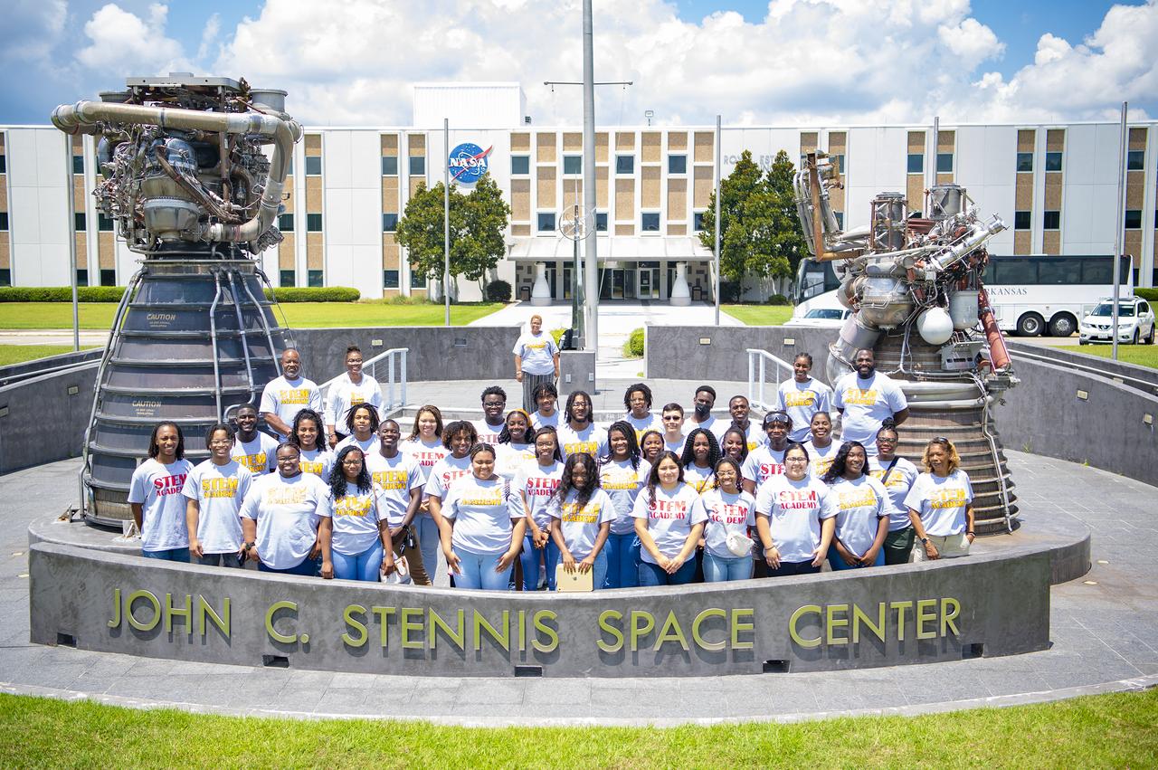
Participants in the University of Arkansas at Pine Bluff STEM (science, technology, engineering and mathematics) Summer Institute stand in front of the Roy Estess Building at NASA’s Stennis Space Center during a site tour on June 25. The students viewed multiple areas of the federal city, including a visit to the Thad Cochran Test Stand, where students learned about NASA Stennis’ role in the Artemis campaign. NASA is going back to the Moon for scientific discovery, economic benefits, and inspiration for a new generation of explorers: the Artemis Generation. The agency will use what is learned on and around the Moon to take the next giant leap – sending astronauts to Mars. The Arkansas at Pine Bluff STEM program started in 2003 and is designed to help increase the number and diversity of well-prepared STEM graduates.

This image acquired on Jan. 17, 2016 by NASA Terra spacecraft shows major flooding along the Mississippi River, affecting Missouri, Illinois, Arkansas and Tennessee. As of January 17, flood warnings were issued for the area around Baton Rouge, Louisiana, as the river crested at 43.3 feet (13.1 meters), 8 feet (2.4 meters) above flood stage. Shipping and industrial activities were significantly affected; low-lying areas were flooded, and agricultural operations were impacted on the west side of the river. This image from the Advanced Spaceborne Thermal Emission and Reflection Radiometer (ASTER) on NASA's Terra spacecraft was acquired Jan. 17, 2016, covers an area of 23.6 by 23.6 miles (38 by 38 kilometers), and is located at 30.6 degrees north, 91.3 degrees west. http://photojournal.jpl.nasa.gov/catalog/PIA20364

iss073e0509720 (Aug. 18, 2025) --- Great Bend, Kansas, primarily an agricultural town and located at the point where the Arkansas River course shifts, is pictured from the International Space Station as it orbited 261 miles above the Sunflower State. The triangular Great Bend Municipal Airport, once used as a base for the B-29 Superfortress during WWII and now used for general aviation, can also be seen.
STS058-89-013 (18 Oct-1 Nov 1993) --- An oblique westward view, across the wheat fields and cattle pastures, of eastern Colorado to the Front Range of the Rocky Mountains. Denver is bisected at the center of the right edge of the frame. Pikes Peak and Colorado Springs are left of center, and the Arkansas River Valley with Canyon City and the Royal Gorge are along the left edge of the frame. This view shows the startling contrast between the nearly-flat High Plains and the ancient geological uplift of the Rockies.
AS09-26A-3741A (9 March 1969) --- Color infrared photograph of the Mississippi River between Vicksburg and Greenville as photographed from the Apollo 9 spacecraft during its 92nd revolution of Earth. This picture was a part of the SO65 Multispectral Terrain Photography Experiment. The City of Vicksburg is located in the southeast corner of the picture. Note Interstate 20 under construction running east and west. Greenville is just out of picture at top center. All east of river is Mississippi; Louisiana is at lower left; and Arkansas is at upper left.
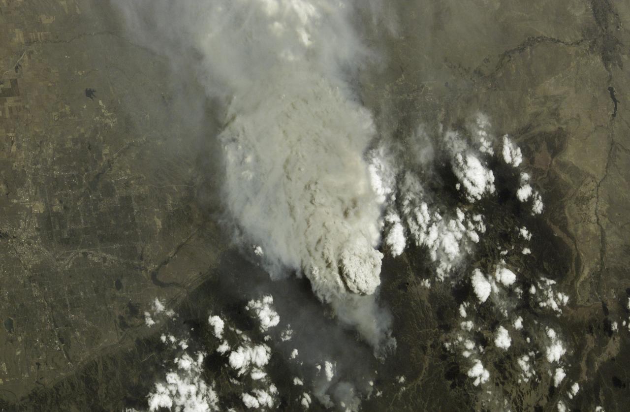
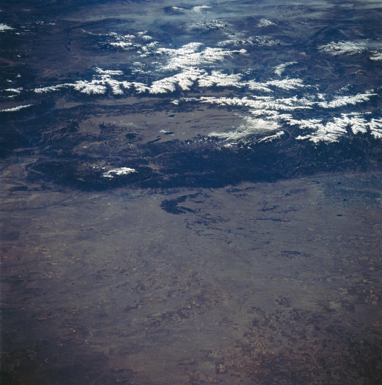
This is a photo of the Hayman Fire burning in the foothills southwest of Denver, Colorado, as viewed by an Expedition Five crewmember aboard the International Space Station (ISS). Astronauts use a variety of lenses and look angles as their orbits pass over the wildfires to document the long-distance movements of smoke from the fires as well as details of the burning areas. In this view, Littleton, Chatfield Lake, and the Arkansas River are all visible.
In the Swamp Works laboratory at NASA's Kennedy Space Center in Florida, student interns, from the left, Jeremiah House, Thomas Muller and Austin Langdon are joining agency scientists, contributing in the area of Exploration Research and Technology. House is studying computer/electrical engineering at John Brown University in Siloam Springs, Arkansas. Muller is pursuing a degree in computer engineering and control systems and Florida Tech. Langdon is an electrical engineering major at the University of Kentucky. The agency attracts its future workforce through the NASA Internship, Fellowships and Scholarships, or NIFS, Program.
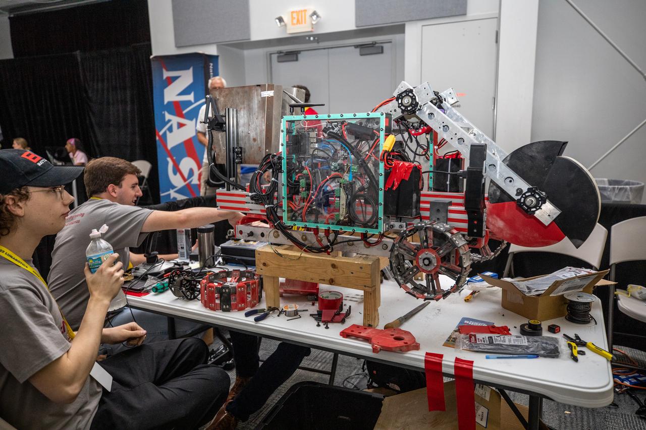
Students from the University of Arkansas prepare their robot for its turn to dig in the mining arena during NASA’s LUNABOTICS competition on May 24, 2022, at the Center for Space Education near the Kennedy Space Center Visitor Complex in Florida. More than 35 teams from around the U.S. have designed and built remote-controlled robots for the mining competition. Teams use their autonomous or remote-controlled robots to maneuver and dig in a supersized sandbox filled with rocks and simulated lunar soil, or regolith. The objective of the challenge is to see which team’s robot can collect and deposit the most rocky regolith within a specified amount of time.
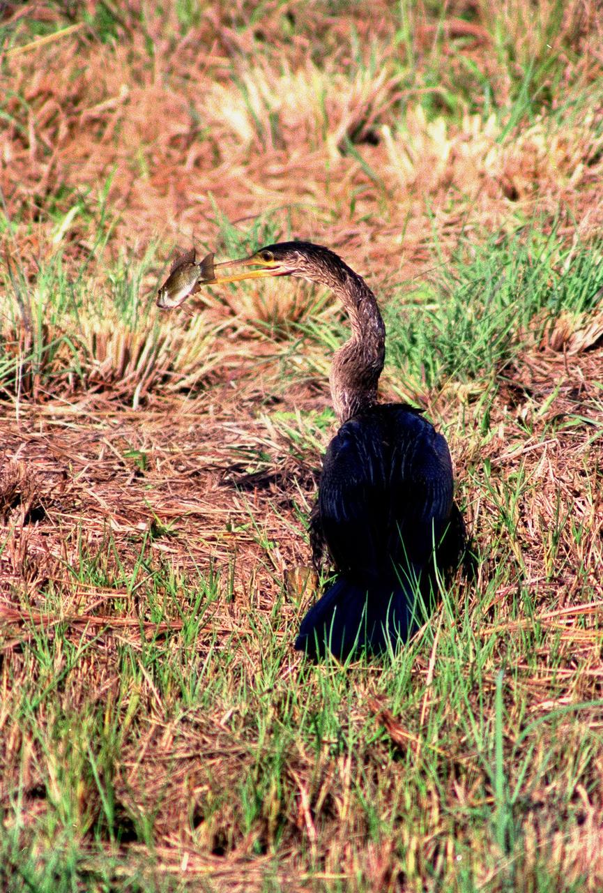
KENNEDY SPACE CENTER, FLA. -- Spotted in the Merritt Island National Wildlife Refuge, which shares a boundary with the space center, an anhinga captures a fish in its long, dagger-shaped bill. It is also known as the "snakebird" because in the water its body is submerged so that only its head and long, slender neck are visible. Ranging the Atlantic and Gulf Coasts from North Carolina to Texas, north in the Mississippi Valley to Arkansas and Tennessee, and in the South to South America, it inhabits freshwater ponds and swamps with thick vegetation. They are often seen with wings half-open, drying them in the sun since they lack oil glands with which to preen
Dr. Ruth Jones, conducts safety walkthrough of structures and scaffolds in Building 4619.
![ISS005-E-5419 (18 June 2002) --- This photograph, taken by the International Space Station’s Expedition Five crew on June 18, 2002, shows the Hayman Fire burning in the foothills southwest of Denver. Astronauts use a variety of lenses and look angles as their orbits pass over wildfires to document the long-distance movements of smoke from the fires as well as details of the burning areas. In this perspective view, Littleton, Chatfield Lake and the Arkansas River are all visible. The link [<http://eol.jsc.nasa.gov/scripts/sseop/photo.pl?mission=ISS005&roll=E&frame=5416> ] was provided by the Earth Sciences and Image Analysis Laboratory at Johnson Space Center. Additional images taken by astronauts and cosmonauts can be viewed at the NASA-JSC Gateway to Astronaut Photography of Earth [link to <http://eol.jsc.nasa.gov/> ].](https://images-assets.nasa.gov/image/iss005e05419/iss005e05419~medium.jpg)
ISS005-E-5419 (18 June 2002) --- This photograph, taken by the International Space Station’s Expedition Five crew on June 18, 2002, shows the Hayman Fire burning in the foothills southwest of Denver. Astronauts use a variety of lenses and look angles as their orbits pass over wildfires to document the long-distance movements of smoke from the fires as well as details of the burning areas. In this perspective view, Littleton, Chatfield Lake and the Arkansas River are all visible. The link [<http://eol.jsc.nasa.gov/scripts/sseop/photo.pl?mission=ISS005&roll=E&frame=5416> ] was provided by the Earth Sciences and Image Analysis Laboratory at Johnson Space Center. Additional images taken by astronauts and cosmonauts can be viewed at the NASA-JSC Gateway to Astronaut Photography of Earth [link to <http://eol.jsc.nasa.gov/> ].
STS103-501-104 (19-27 December 1999) --- One of the astronauts aboard the Earth-orbiting Space Shuttle Discovery used a handheld large format camera to photograph this scene which stretches from the Gulf of Mexico into Oklahoma. Parts of Louisiana and Arkansas are also visible in the frame. The Red River snakes its way through the East Texas Piney Woods (center). The river meets with the southern edge of the Ouachita folded mountains of southern Oklahoma. The white, linear feature north of the Red River is most likely a jet stream cloud, according to Earth scientists who studied the STS-103 collection at the Johnson Space Center (JSC). Jet contrails can be seen flying over the clouds. Along the Texas Gulf Coast are Galveston Bay and the greater Houston metropolitan area.
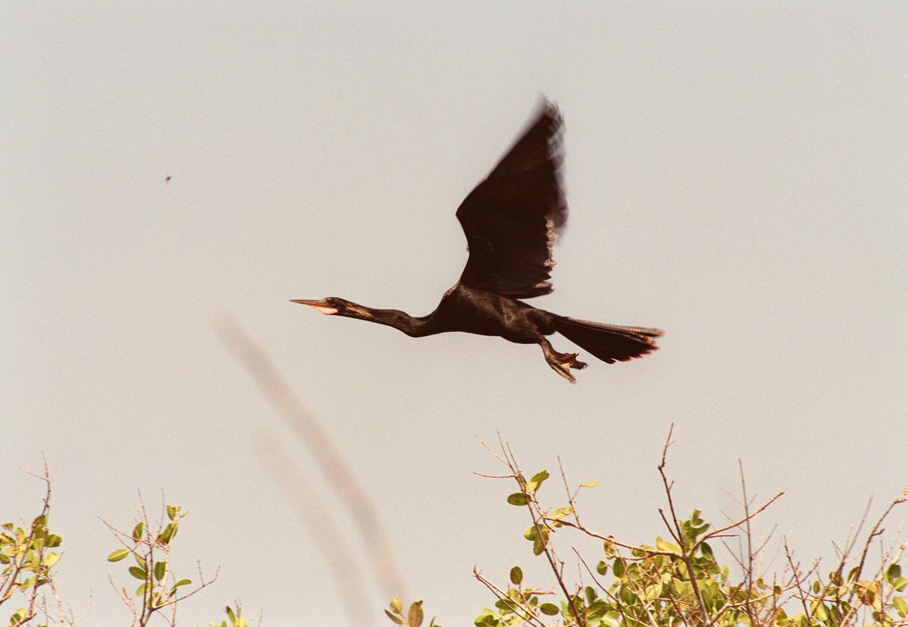
KENNEDY SPACE CENTER, FLA. -- In the Merritt Island National Wildlife Refuge, which shares a boundary with Kennedy Space Center, an anhinga takes flight. Anhingas inhabit frewshwater ponds and swamps with thick vegetation. They ranage from the Atlantic and gulf coasts from North Carolina to Texas, the Mississippi Valley north to Arkansas and Tennessee, and south to southern South America. They are also referred to as snakebirds because its body is submerged when swimming, showing only its head and long, slender neck above water. The 92,000-acre wildlife refuge is a habitat for more than 310 species of birds, 25 mammals, 117 fishes and 65 amphibians and reptiles. The marshes and open water of the refuge also provide wintering areas for 23 species of migratory waterfowl, as well as a year-round home for great blue herons, great egrets, wood storks, cormorants, brown pelicans and other species of marsh and shore birds
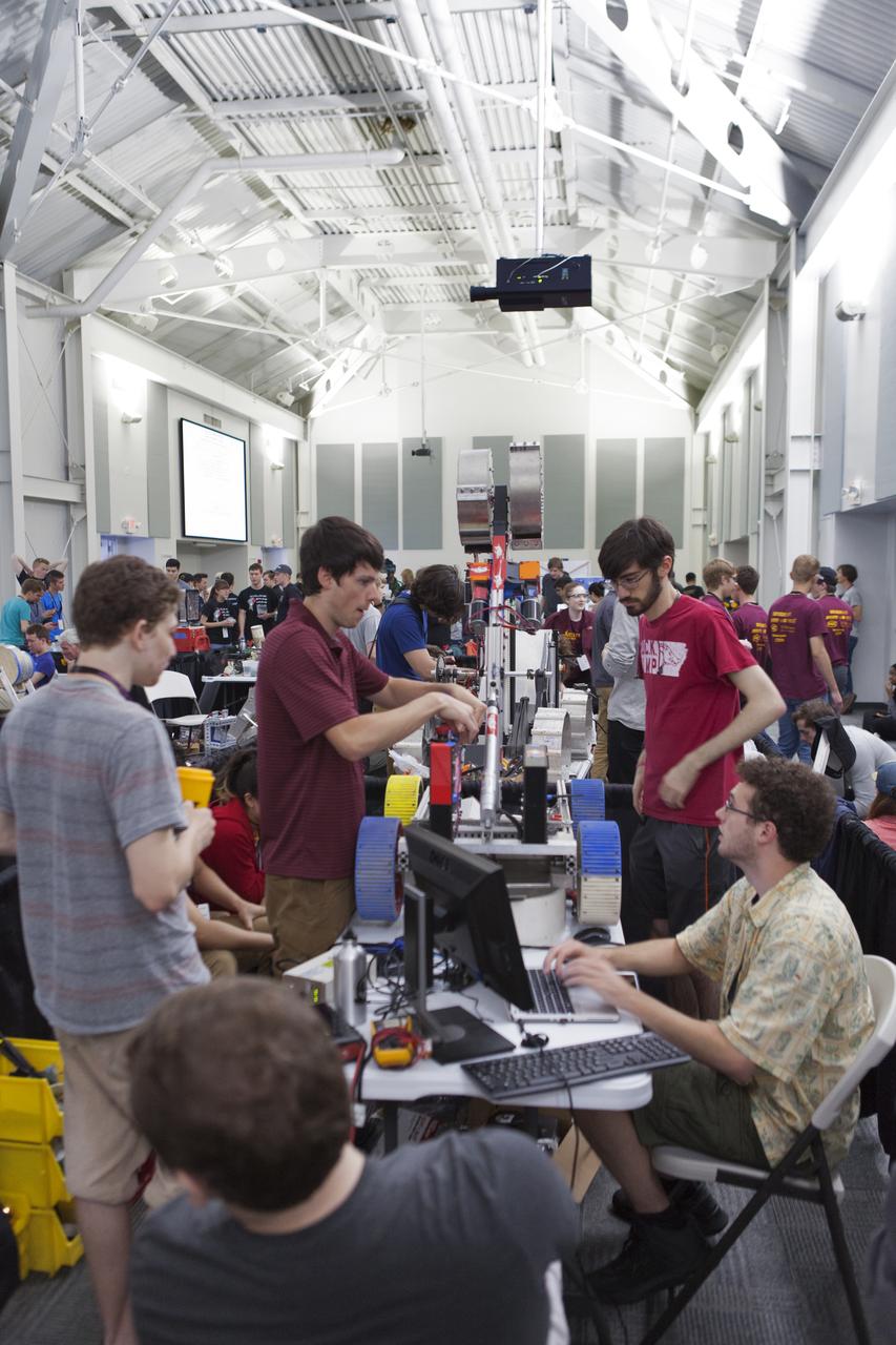
Team members from the University of Arkansas make adjustments to their robot miner for its turn in the mining arena on the fourth day of NASA's 9th Robotic Mining Competition, May 17, at NASA's Kennedy Space Center Visitor Complex in Florida. They are in the RobotPits inside the Educator Resource Center. More than 40 student teams from colleges and universities around the U.S. are using their mining robots to dig in a supersized sandbox filled with BP-1, or simulated Lunar soil, gravel and rocks, and participate in other competition requirements. The Robotic Mining Competition is a NASA Human Exploration and Operations Mission Directorate project designed to encourage students in science, technology, engineering and math, or STEM fields. The project provides a competitive environment to foster innovative ideas and solutions that could be used on NASA's deep space missions.
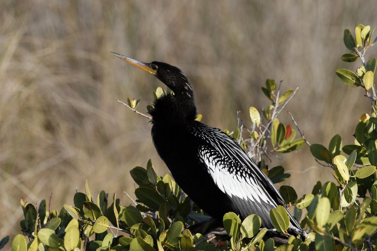
CAPE CANAVERAL, Fla. – A male Anhinga perches in a shrub in the Merritt island National Wildlife Refuge, which borders NASA's Kennedy Space Center in Florida. Anhingas inhabit freshwater ponds and swamps with thick vegetation. They range from the Atlantic and Gulf coasts from North Carolina to Texas, the Mississippi Valley north to Arkansas and Tennessee, and south to southern South America. They are also referred to as snakebirds because their body is submerged when swimming, showing only the head and long, slender neck above water. The center shares a boundary with the refuge that includes salt-water estuaries, brackish marshes, hardwood hammocks and pine flatwoods. The diverse landscape provides habitat for more than 310 species of birds, 25 mammals, 117 fishes and 65 amphibians and reptiles. Photo credit: NASA/Jim Grossmann

S85-28647 (28 Feb 1985) --- The seven members of the STS-51D mission are pictured in the midst of a busy training schedule in preparation for NASA's 16th Space Shuttle flight, currently planned for April of this year. The crewmembers are (front row, left to right), Karol J. Bobko, commander; Donald E. Williams, pilot; Rhea Seddon and Jeffrey A. Hoffman, mission specialists; and (back row) S. David Griggs, mission specialist; and Charles D. Walker and United States Senator Jake Garn (Republican - Utah) both payload specialists. Walker represents McDonnell-Douglas Corporation. EDITOR'S NOTE: Mission specialist S. David Griggs died June 17, 1989, near Earle, Arkansas, in the crash of a World-War-II-era training plane.
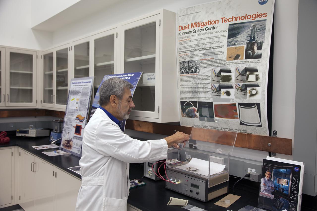
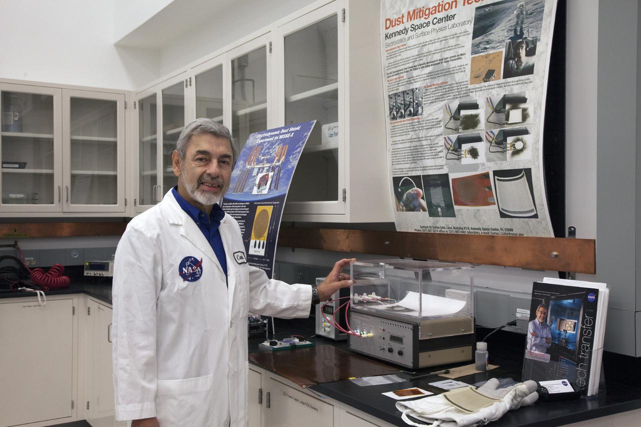
CAPE CANAVERAL, Fla. -- Dr. Carlos Calle, senior research scientist on the Electrodynamic Dust Shield for Dust Mitigation project, demonstrates equipment used in his experiments in the Electrostatics and Surface Physics Laboratory in the SwampWorks at NASA's Kennedy Space Center in Florida. Electrodynamic dust shield, or EDS, technology is based on concepts originally developed by NASA as early as 1967 and later by the University of Tokyo. In 2003, NASA, in collaboration with the University of Arkansas at Little Rock, started development of the EDS for dust particle removal from solar panels to be used on future missions to the moon, an asteroid or Mars. A flight experiment to expose the dust shields to the space environment currently is under development. For more information, visit: http://www.nasa.gov/content/scientists-developing-ways-to-mitigate-dust-problem-for-explorers/ Photo credit: NASA/Dan Casper
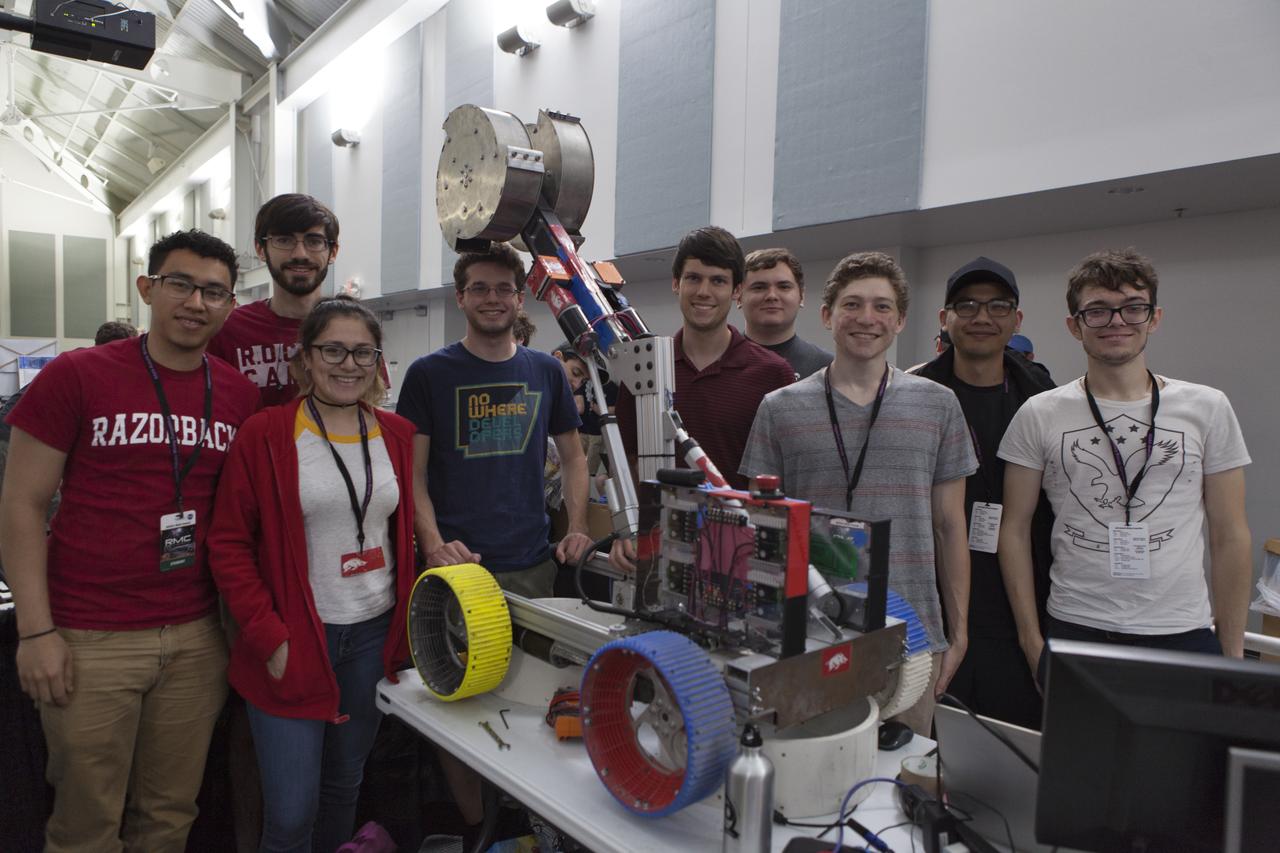
Team members from the University of Arkansas pause with their robot miner in the RobotPits on the fourth day of NASA's 9th Robotic Mining Competition, May 17, at NASA's Kennedy Space Center Visitor Complex in Florida. More than 40 student teams from colleges and universities around the U.S. are using their mining robots to dig in a supersized sandbox filled with BP-1, or simulated Lunar soil, gravel and rocks, and participate in other competition requirements. The Robotic Mining Competition is a NASA Human Exploration and Operations Mission Directorate project designed to encourage students in science, technology, engineering and math, or STEM fields. The project provides a competitive environment to foster innovative ideas and solutions that could be used on NASA's deep space missions.
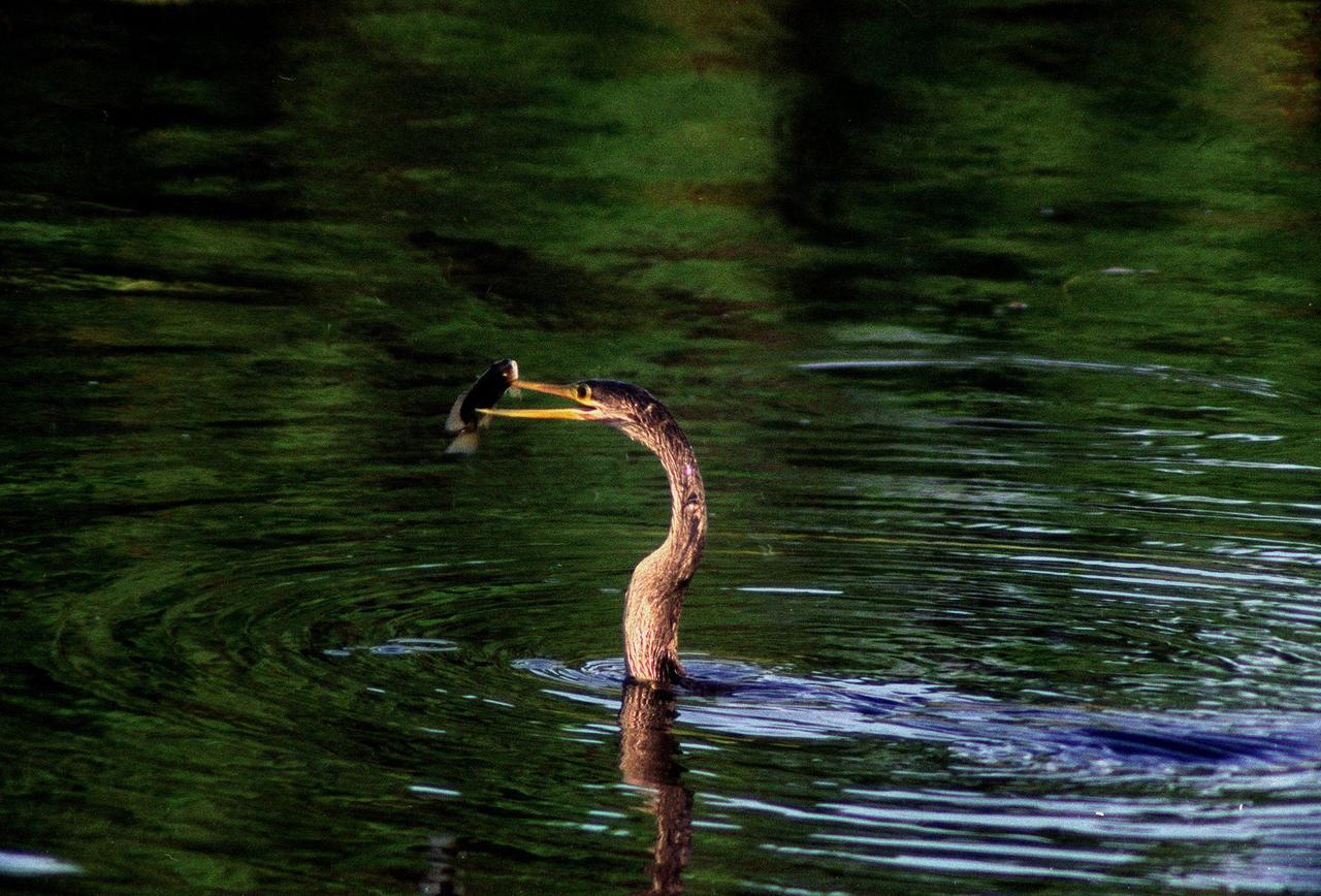
KENNEDY SPACE CENTER, FLA. -- In the Merritt Island National Wildlife Refuge, which shares a boundary with the space center, an anhinga gets ready to eat the fish it captured in the nearby Indian River with its long, dagger-shaped bill. The bird will flip its catch into the air and gulp it down headfirst. The anhinga is also known as the "snakebird" because in the water its body is submerged so that only its head and long, slender neck are visible. Ranging the Atlantic and Gulf Coasts from North Carolina to Texas, north in the Mississippi Valley to Arkansas and Tennessee, and in the South to South America, it inhabits freshwater ponds and swamps with thick vegetation. They are often seen with wings half-open, drying them in the sun since they lack oil glands with which to preen
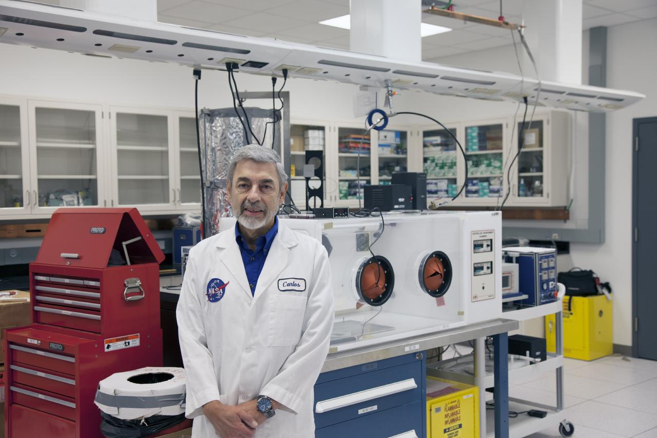
CAPE CANAVERAL, Fla. -- Dr. Carlos Calle, senior research scientist on the Electrodynamic Dust Shield for Dust Mitigation project, manages the Electrostatics and Surface Physics Laboratory in the SwampWorks at NASA's Kennedy Space Center in Florida. Electrodynamic dust shield, or EDS, technology is based on concepts originally developed by NASA as early as 1967 and later by the University of Tokyo. In 2003, NASA, in collaboration with the University of Arkansas at Little Rock, started development of the EDS for dust particle removal from solar panels to be used on future missions to the moon, an asteroid or Mars. A flight experiment to expose the dust shields to the space environment currently is under development. For more information, visit: http://www.nasa.gov/content/scientists-developing-ways-to-mitigate-dust-problem-for-explorers/ Photo credit: NASA/Dan Casper
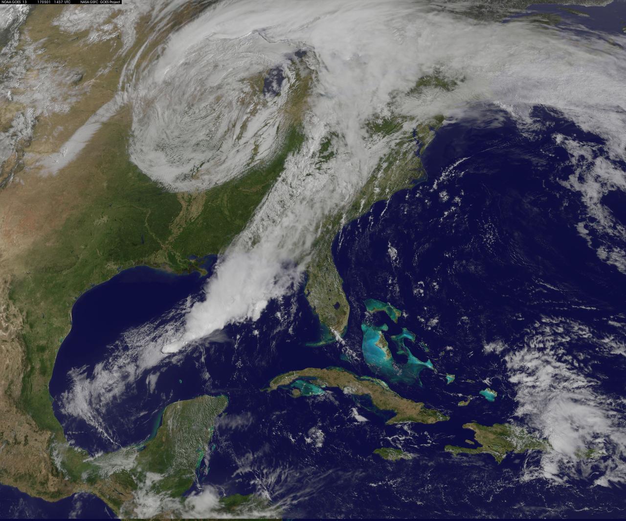
NASA Sees Severe Weather from Central to Eastern US A vigorous weather system has generated severe weather over the mid-section of the U.S. and satellites are providing a look at it as it is moving toward the East Coast. NASA and NOAA satellites have been tracking a storm system that has generated flooding and tornadic thunderstorms in the central U.S. and is expected bring severe weather to the U.S. Mid-Atlantic region. At NASA's Goddard Space Flight Center in Greenbelt, Maryland, data from NOAA's GOES-East satellite were used to create images and an animation of the movement of the powerful storm. On April 30, the Moderate Resolution Imaging Spectroradiometer, or MODIS, instrument aboard NASA's Aqua satellite captured a visible image of the storms moving over eastern Texas and Louisiana. Tornadoes in eastern Texas killed four people. The system generated heavy rainfall and caused additional fatalities and damages in Arkansas, Missouri, Mississippi, Alabama and Tennessee. On Monday, May 1, NOAA's National Weather Service noted, "Major to record flooding continues over portions of the central U.S. Severe thunderstorms are possible from the Mid-Atlantic to the northeastern U.S. "Major to record flooding will continue over portions of eastern Oklahoma, northern Arkansas, Missouri, Illinois and Indiana. Rivers will gradually recede over the next several days. Additional strong to severe thunderstorms will be possible Monday afternoon and evening over portions of the Mid-Atlantic and Northeast U.S. Damaging winds, large hail, and isolated tornadoes will be possible." Image caption: On May 1, 2017, at 10:37 a.m. EDT (1437 UTC) NOAA's GOES-East satellite captured this visible image of the storm system centered over Iowa with an associated cold front that stretches into the Gulf of Mexico. Credits: NASA/NOAA GOES Project <b><a href="http://www.nasa.gov/audience/formedia/features/MP_Photo_Guidelines.html" rel="nofollow">NASA image use policy.</a></b> <b><a href="http://www.nasa.gov/centers/goddard/home/index.html" rel="nofollow">NASA Goddard Space Flight Center</a></b> enables NASA’s mission through four scientific endeavors: Earth Science, Heliophysics, Solar System Exploration, and Astrophysics. Goddard plays a leading role in NASA’s accomplishments by contributing compelling scientific knowledge to advance the Agency’s mission. <b>Follow us on <a href="http://twitter.com/NASAGoddardPix" rel="nofollow">Twitter</a></b> <b>Like us on <a href="http://www.facebook.com/pages/Greenbelt-MD/NASA-Goddard/395013845897?ref=tsd" rel="nofollow">Facebook</a></b> <b>Find us on <a href="http://instagrid.me/nasagoddard/?vm=grid" rel="nofollow">Instagram</a></b>
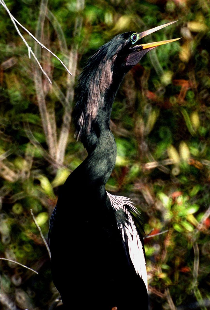
KENNEDY SPACE CENTER, FLA. -- The greenish iridescence of a male Anhinga nearly blends into the green vegetation behind it on the grounds of the Kennedy Space Center. The mostly black-bodied bird is also known as a "snakebird" because, when swimming, only its head and long, slender neck are visible above water. The anhinga inhabits freshwater ponds and swamps with thick vegetation and ranges the Atlantic and Gulf coasts from North Carolina to Texas, the Mississippi Valley north to Arkansas and Tennessee, and south to southern South America. The Center shares a boundary with the Merritt Island National Wildlife Refuge, which encompasses 92,000 acres that are a habitat for more than 331 species of birds, 31 mammals, 117 fishes, and 65 amphibians and reptiles. The marshes and open water of the refuge provide wintering areas for 23 species of migratory waterfowl, as well as a year-round home for great blue herons, great egrets, wood storks, cormorants, brown pelicans and other species of marsh and shore birds, as well as a variety of insects
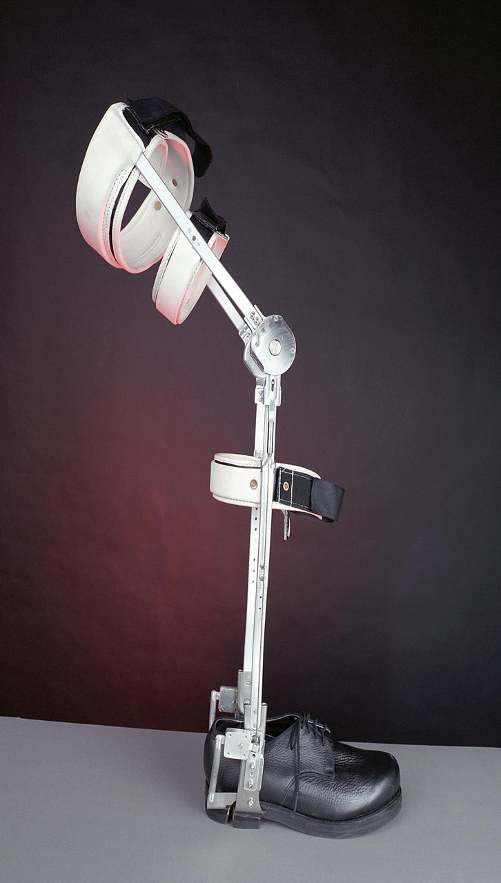
A knee brace that uses Space Shuttle propulsion technology has moved a step closer to being available to help knee injury and stroke patients and may possibly benefit patients with birth defects, spinal cord injuries, and post-polio conditions. After years of hard work, inventors at NASA's Marshall Space Flight Center (MSFC) in Huntsville, Alabama, have turned over the final design and prototype to industry partners at Horton's Orthotic Lab in Little Rock, Arkansas for further clinical testing. The device, called the Selectively Lockable Knee Brace, may mean faster, less painful rehabilitation for patients by allowing the knee to move when weight is not on the heel. Devices currently on the market lock the knee in a rigid, straight-leg position, or allow continuous free motion. The knee brace is just one example of how space technology is being used to improve the lives of people on Earth. NASA's MSFC inventors Michael Shadoan and Neill Myers are space propulsion engineers who use the same mechanisms and materials to build systems for rockets that they used to design and develop the knee brace.
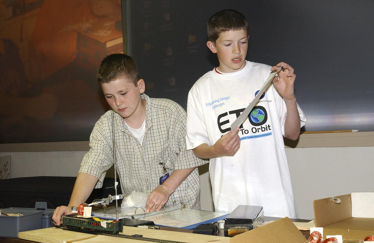
In this photograph, Jeff Alden (left) and Justin O'Cornor, two middle school students at Lane Middle School in Portland, Oregon are demonstrating their Earth-to-Orbit (ETO) Design Challenge project at NASA Marshall Space Flight Center (MSFC) in Huntsville, Alabama. Jeff and Justin, who are just a couple of "typical teens," have been spending their time tackling some of the same challenges NASA engineers face when designing propulsion systems at MSFC. The ETO Design Challenge is a hands-on educational program, targeted to middle school students, in which students are assigned a project engaging in related design challenges in their classrooms under the supervision of their teachers. The project is valuable because it can be used by any student and any teacher, even those without technical backgrounds. Students in 12 states: Alabama, Arkansas, California, Colorado, Illinois, Missouri, Montana, New York, Ohio, Tennessee, Virginia, and Washington, are taking part in the MSFC's Earth-to-Orbit program. NASA uses such programs to support educational excellence while participating in educational outreach programs through centers around the country. The Oregon students' teacher, Joanne Fluvog, commented, "the biggest change I've seen is in the students' motivation and their belief in their ability to think." Both Justin and Jeff said being involved in a real engineering project has made them realize that "science is cool."
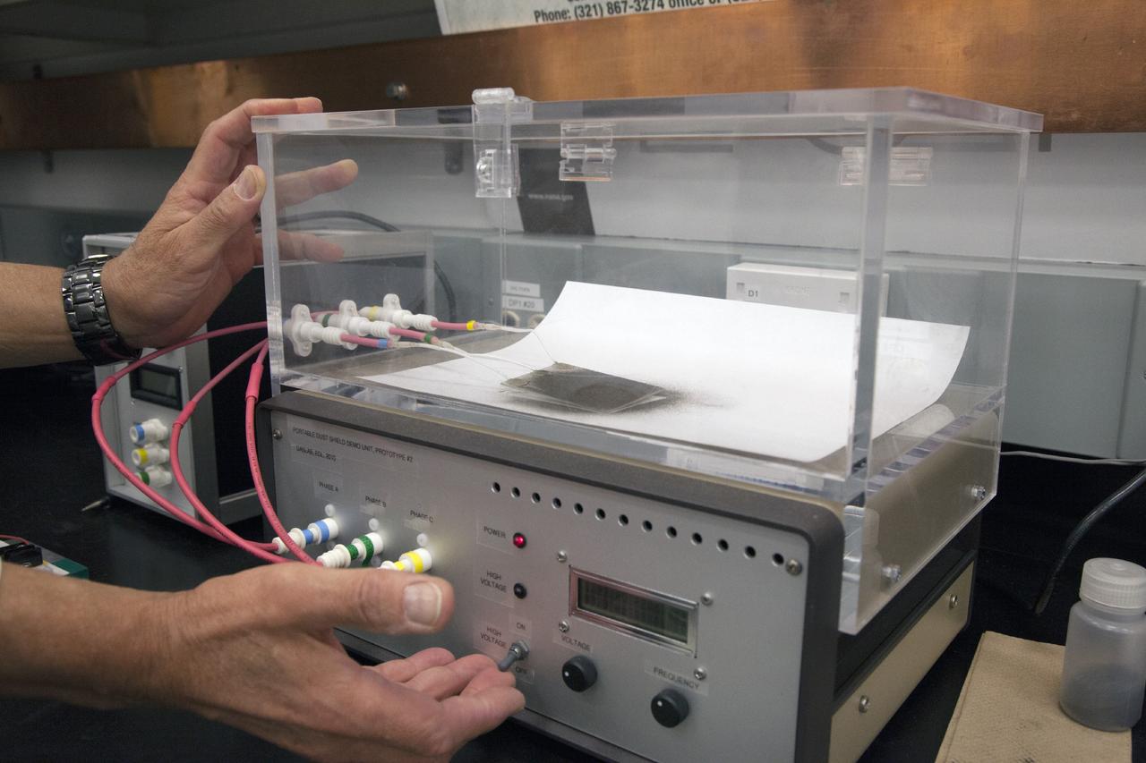
CAPE CANAVERAL, Fla. -- Dr. Carlos Calle, senior research scientist on the Electrodynamic Dust Shield for Dust Mitigation project, demonstrates a dust particle experiment in the Electrostatics and Surface Physics Laboratory in the SwampWorks at NASA's Kennedy Space Center in Florida. The technology works by creating an electric field that propagates out like the ripples on a pond. This could prevent dust accumulation on spacesuits, thermal radiators, solar panels, optical instruments and view ports for future lunar and Mars exploration activities. Electrodynamic dust shield, or EDS, technology is based on concepts originally developed by NASA as early as 1967 and later by the University of Tokyo. In 2003, NASA, in collaboration with the University of Arkansas at Little Rock, started development of the EDS for dust particle removal from solar panels to be used on future missions to the moon, an asteroid or Mars. A flight experiment to expose the dust shields to the space environment currently is under development. For more information, visit: http://www.nasa.gov/content/scientists-developing-ways-to-mitigate-dust-problem-for-explorers/ Photo credit: NASA/Dan Casper
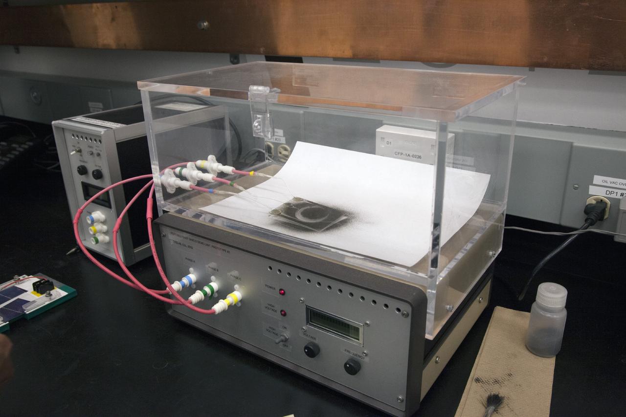
CAPE CANAVERAL, Fla. -- Dust particle experiments are conducted for Electrodynamic Dust Shield for Dust Mitigation project in the Electrostatics and Surface Physics Laboratory in the SwampWorks at NASA's Kennedy Space Center in Florida. The technology works by creating an electric field that propagates out like the ripples on a pond. This could prevent dust accumulation on spacesuits, thermal radiators, solar panels, optical instruments and view ports for future lunar and Mars exploration activities. Electrodynamic dust shield, or EDS, technology is based on concepts originally developed by NASA as early as 1967 and later by the University of Tokyo. In 2003, NASA, in collaboration with the University of Arkansas at Little Rock, started development of the EDS for dust particle removal from solar panels to be used on future missions to the moon, an asteroid or Mars. A flight experiment to expose the dust shields to the space environment currently is under development. For more information, visit: http://www.nasa.gov/content/scientists-developing-ways-to-mitigate-dust-problem-for-explorers/ Photo credit: NASA/Dan Casper
CAPE CANAVERAL, Fla. -- Dr. Carlos Calle, senior research scientist on the Electrodynamic Dust Shield for Dust Mitigation project, demonstrates a dust particle experiment in the Electrostatics and Surface Physics Laboratory in the SwampWorks at NASA's Kennedy Space Center in Florida. The technology works by creating an electric field that propagates out like the ripples on a pond. This could prevent dust accumulation on spacesuits, thermal radiators, solar panels, optical instruments and view ports for future lunar and Mars exploration activities. Electrodynamic dust shield, or EDS, technology is based on concepts originally developed by NASA as early as 1967 and later by the University of Tokyo. In 2003, NASA, in collaboration with the University of Arkansas at Little Rock, started development of the EDS for dust particle removal from solar panels to be used on future missions to the moon, an asteroid or Mars. A flight experiment to expose the dust shields to the space environment currently is under development. For more information, visit: http://www.nasa.gov/content/scientists-developing-ways-to-mitigate-dust-problem-for-explorers/ Photo credit: NASA/Dan Casper

KENNEDY SPACE CENTER, FLA. -- The greenish iridescence of a male Anhinga nearly blends into the green vegetation behind it on the grounds of the Kennedy Space Center. The mostly black-bodied bird is also known as a "snakebird" because, when swimming, only its head and long, slender neck are visible above water. The anhinga inhabits freshwater ponds and swamps with thick vegetation and ranges the Atlantic and Gulf coasts from North Carolina to Texas, the Mississippi Valley north to Arkansas and Tennessee, and south to southern South America. The Center shares a boundary with the Merritt Island National Wildlife Refuge, which encompasses 92,000 acres that are a habitat for more than 331 species of birds, 31 mammals, 117 fishes, and 65 amphibians and reptiles. The marshes and open water of the refuge provide wintering areas for 23 species of migratory waterfowl, as well as a year-round home for great blue herons, great egrets, wood storks, cormorants, brown pelicans and other species of marsh and shore birds, as well as a variety of insects
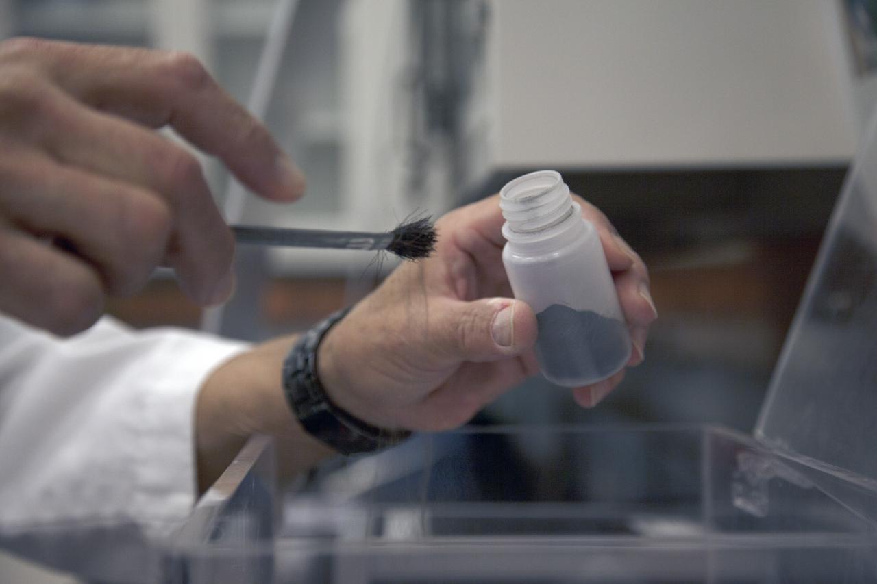
CAPE CANAVERAL, Fla. -- Dr. Carlos Calle, senior research scientist on the Electrodynamic Dust Shield for Dust Mitigation project, works with dust fabricated for use in his experiments in the Electrostatics and Surface Physics Laboratory in the SwampWorks at NASA's Kennedy Space Center in Florida. The fabricated material is designed to mimic the dust on the lunar surface. The technology works by creating an electric field that propagates out like the ripples on a pond. This could prevent dust accumulation on spacesuits, thermal radiators, solar panels, optical instruments and view ports for future lunar and Mars exploration activities. Electrodynamic dust shield, or EDS, technology is based on concepts originally developed by NASA as early as 1967 and later by the University of Tokyo. In 2003, NASA, in collaboration with the University of Arkansas at Little Rock, started development of the EDS for dust particle removal from solar panels to be used on future missions to the moon, an asteroid or Mars. A flight experiment to expose the dust shields to the space environment currently is under development. For more information, visit: http://www.nasa.gov/content/scientists-developing-ways-to-mitigate-dust-problem-for-explorers/ Photo credit: NASA/Dan Casper
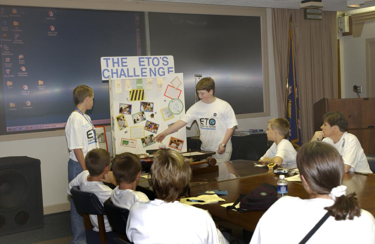
In this photograph, students from all over the country gathered and discussed their Earth-to-Orbit (ETO) Design Challenge project at NASA Marshall Space Flight Center in Huntsville, Alabama. These students who are just "typical teens," have been spending their time tackling some of the same challenges NASA engineers face when designing propulsion systems at MSFC. The ETO Design Challenge is a hands-on educational program, targeted to middle school students, in which students are assigned a project engaging in related design challenges in their classrooms under the supervision of their teachers. The project is valuable because it can be used by any student, and any teacher, even those without technical backgrounds. Student in 12 states: Alabama, Arkansas, California, Colorado, Illinois, Missouri, Montana, New York, Ohio, Ternessee, Virginia, and Washington, are taking part in MSFC's Earth-to-Orbit program. NASA uses such programs to support educational excellence while participating in educational outreach programs through centers around the country. One of the students' teachers, Joanne Fluvog, commented, "the biggest change I've seen is in the students' motivation and their belief in their ability to think." Justin O'Connor and Jeff Alden, students of Lane Middle School in Portland, Oregon, participated in the ETO program and said being involved in a real engineering project has made them realize that "science is cool."
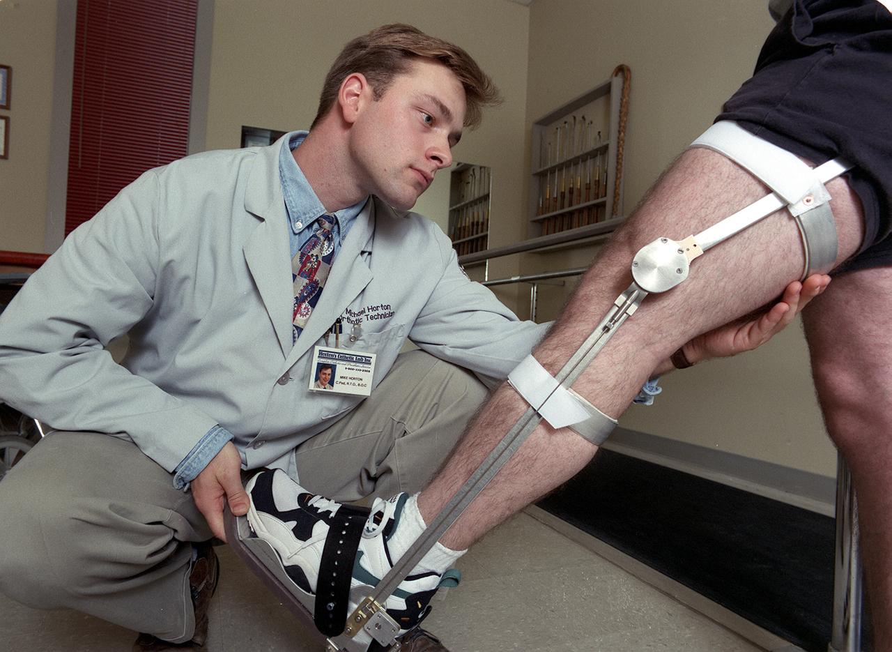
A knee brace that uses Space Shuttle propulsion technology has moved a step closer to being available to help knee injury and stroke patients and may possibly benefit patients with birth defects, spinal cord injuries, and post-polio conditions. After years of hard work, inventors at NASA's Marshall Space Flight Center (MSFC) in Huntsville, Alabama, have turned over the final design and prototype to industry partners at Horton's Orthotic Lab in Little Rock, Arkansas for further clinical testing. The device, called the Selectively Lockable Knee Brace, may mean faster, less painful rehabilitation for patients by allowing the knee to move when weight is not on the heel. Devices currently on the market lock the knee in a rigid, straight-leg position, or allow continuous free motion. Pictured here is a knee brace prototype being tested and fitted at Horton's Orthotic Lab. The knee brace is just one example of how space technology is being used to improve the lives of people on Earth. NASA's MSFC inventors Michael Shadoan and Neill Myers are space propulsion engineers who use the same mechanisms and materials to build systems for rockets that they used to design and develop the knee brace.

Meandering Mississippi - May 28th, 2003 Description: Small, blocky shapes of towns, fields, and pastures surround the graceful swirls and whorls of the Mississippi River. Countless oxbow lakes and cutoffs accompany the meandering river south of Memphis, Tennessee, on the border between Arkansas and Mississippi, USA. The "mighty Mississippi" is the largest river system in North America. Credit: USGS/NASA/Landsat 7 To learn more about the Landsat satellite go to: <a href="http://landsat.gsfc.nasa.gov/" rel="nofollow">landsat.gsfc.nasa.gov/</a> <b><a href="http://www.nasa.gov/centers/goddard/home/index.html" rel="nofollow">NASA Goddard Space Flight Center</a></b> enables NASA’s mission through four scientific endeavors: Earth Science, Heliophysics, Solar System Exploration, and Astrophysics. Goddard plays a leading role in NASA’s accomplishments by contributing compelling scientific knowledge to advance the Agency’s mission. <b>Follow us on <a href="http://twitter.com/NASA_GoddardPix" rel="nofollow">Twitter</a></b> <b>Join us on <a href="http://www.facebook.com/pages/Greenbelt-MD/NASA-Goddard/395013845897?ref=tsd" rel="nofollow">Facebook</a></b>
S73-35080 (July-September 1973) --- A vertical view of northeast Oklahoma and the metropolitan Tulsa area is seen in this Skylab 3 Earth Resources Experiments Package S190-B (five-inch Earth terrain camera) photograph taken from the Skylab space station in Earth orbit. THE PICTURE SHOULD BE HELD WITH THE CLOCK ON THE LEFT AND THE LAKE IN THE CORNER ON THE RIGHT. THE LONG STRETCH OF HIGHWAY (U.S. 75) RUNS STRAIGHT NORTH FROM TULSA. Tulsa, a rapidly expanding city in the heart of the mid-continent oil field, has a population of approximately 330,000. The Arkansas River meanders across the southern (lower) portion of the photograph passing through Tulsa as it flows southeastward. Oologah Reservoir, the long body of water, is located northeast of Tulsa. Lake Hudson is the body of water in the right corner of the picture. Keystone Reservoir is to the west and upstream from Tulsa. Westward from Tulsa U.S. 64 makes a 45 degree bend as it turns northwest to cross the Keystone Reservoir. The thin white line over the Oologah Reservoir is a highway bridge. Bartlesville is on U.S. 75 near the north (top) corner of the picture. The Tulsa International Airport is immediately northeast of downtown Tulsa. Several smaller airfields are visible in the surrounding area. The toll roads and other major highways are clearly visible in the picture. Claremore is northeast of Tulsa on U.S. 66 with the Will Rogers Turnpike passing nearby. Sapulpa is southwest of Tulsa on the Turner Turnpike which leads toward Oklahoma City. The detailed information contained in this photograph can be extracted by direct observation and applied to updating land use and cultural maps of Tulsa and to numerous surrounding satellite cities. All EREP photography is available to the public through the Department of Interior?s Earth Resources Observations Systems Data Center, Sioux Falls, South Dakota, 57198. (Alternate number SL3-83-206) Photo credit: NASA
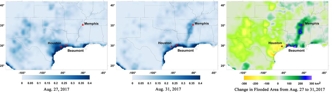
Data from NASA's Soil Moisture Active Passive (SMAP) satellite have been used to create new surface flooding maps of Southeast Texas and the Tennessee Valley following Hurricane Harvey. The SMAP observations detect the proportional cover of surface water within the satellite sensor's field of view. This sequence of images shows changes in the extent of surface flooding from successive five-day SMAP observation composite images. Widespread flooding can be seen in the Houston metropolitan area on Aug. 27 following record rainfall from the Category 4 hurricane, which made landfall on Aug. 25th, 2017 (left image). Flood waters around Houston had substantially receded by Aug. 31 (middle image), while flooding had increased across Louisiana, eastern Arkansas, and western Tennessee as then Tropical Storm Harvey passed over the area. The far right image shows the change in flooded area between Aug. 27 and Aug. 31, with regions showing the most flooding recession depicted in yellow and orange shades and those where flooding had increased depicted in blue shades. The SMAP satellite has a low-frequency (L-band) microwave radiometer with enhanced capabilities for detecting surface water changes in nearly all weather conditions and under low-to-moderate vegetation cover. SMAP provides global coverage with one-to-three-day repeat sampling that is well suited for global monitoring of inland surface water cover dynamics. https://photojournal.jpl.nasa.gov/catalog/PIA21951
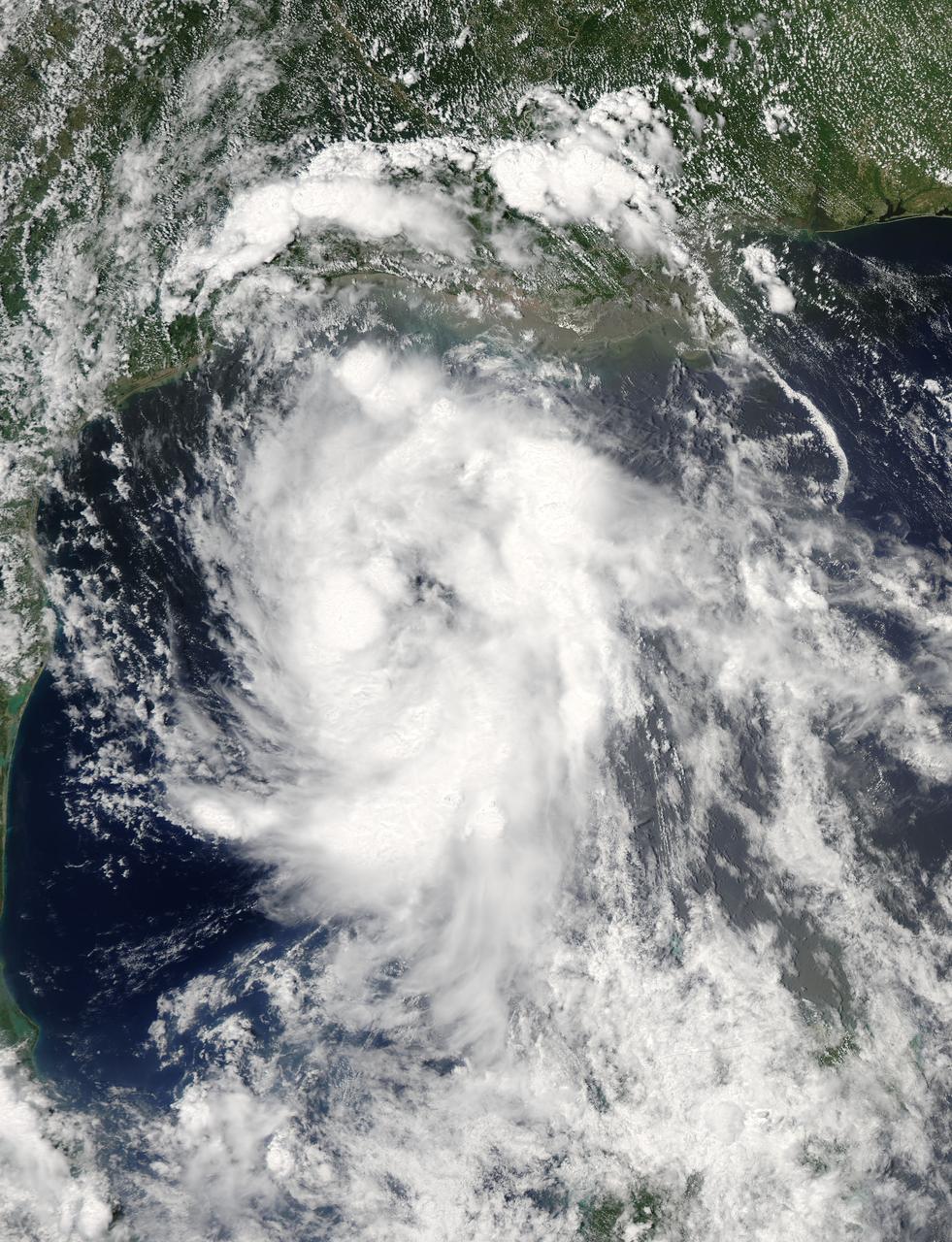
On June 15 at 19:15 UTC (3:15 p.m. EDT) the MODIS instrument aboard NASA's Aqua satellite captured a visible image of Tropical Storm Bill approaching Texas and Louisiana. Powerful thunderstorms circled the center in fragmented bands. At 11 a.m. CDT on June 16, a Tropical Storm Warning was in effect from Baffin Bay to High Island Texas as Bill was making landfall. The National Hurricane Center noted that Bill is expected to produce total rain accumulations of 4 to 8 inches over eastern Texas and eastern Oklahoma and 2 to 4 inches over western Arkansas and southern Missouri, with possible isolated maximum amounts of 12 inches in eastern Texas. In eastern Texas and far western Louisiana today and tonight, isolated tornadoes are also possible, as with any landfalling tropical storm. Tropical storm conditions are expected to continue into the evening in the warning area. Along the coasts, the combination of a storm surge and the tide will cause normally dry areas near the coast to be flooded by rising waters. The water could reach the following heights above ground if the peak surge occurs at the time of high tide. The NHC noted that the Upper Texas coast could experience 2 to 4 feet, and the western Louisiana coast between 1 to 2 feet. At 10 a.m. CDT (1500 UTC), the center of Tropical Storm Bill was located near latitude 28.2 North, longitude 96.4 West. Bill was moving toward the northwest near 10 mph (17 kph) and that general motion is expected to continue today. The latest minimum central pressure reported by an Air Force Reserve Hurricane Hunter aircraft was 997 millibars. Reports from an Air Force Reserve reconnaissance aircraft indicate that maximum sustained winds remain near 60 mph (95 kph) with higher gusts. Unlike Carlos, Bill is not a compact storm. Tropical-storm-force winds extend outward up to 150 miles (240 km) from the center. Between 9 and 10 a.m. CDT, an automated observing station at Port O'Connor also reported a sustained wind of 44 mph (70 kph) and a gust to 53 mph (85 kph). For updated forecasts, watches and warnings, visit the National Hurricane Center webpage at <a href="http://www.nhc.noaa.gov" rel="nofollow">www.nhc.noaa.gov</a>. For local forecasts and advisories, visit: <a href="http://www.weather.gov" rel="nofollow">www.weather.gov</a>. Bill is forecast to continue moving inland and is expected to be a tropical depression by Wednesday, June 17, west of Dallas. The remnants of Bill are forecast to move into the Midwest later in the week. Credit: NASA/GSFC/Jeff Schmaltz/MODIS Land Rapid Response Team <b><a href="http://www.nasa.gov/audience/formedia/features/MP_Photo_Guidelines.html" rel="nofollow">NASA image use policy.</a></b> <b><a href="http://www.nasa.gov/centers/goddard/home/index.html" rel="nofollow">NASA Goddard Space Flight Center</a></b> enables NASA’s mission through four scientific endeavors: Earth Science, Heliophysics, Solar System Exploration, and Astrophysics. Goddard plays a leading role in NASA’s accomplishments by contributing compelling scientific knowledge to advance the Agency’s mission. <b>Follow us on <a href="http://twitter.com/NASAGoddardPix" rel="nofollow">Twitter</a></b> <b>Like us on <a href="http://www.facebook.com/pages/Greenbelt-MD/NASA-Goddard/395013845897?ref=tsd" rel="nofollow">Facebook</a></b> <b>Find us on <a href="http://instagrid.me/nasagoddard/?vm=grid" rel="nofollow">Instagram</a></b>

A major winter storm is poised to wallop the Mid-Atlantic and bring large amounts of snow to cities including Baltimore, Md., Washington, D.C. area on March 2 and 3, according to NOAA's National Weather Service. NOAA's GOES-East satellite captured this image of the clouds associated with the winter storm as it continued moving east toward those cities. On March 2, the National Weather Prediction Center in College Park, Md. noted that there is a slight risk for severe thunderstorms over parts of the western Gulf Coast and the Lower Mississippi Valley as a result of the southern portion of the system. The update at 7 a.m. EST noted that freezing rain/sleet is possible over parts of the lower Mississippi Valley and parts of the central Appalachians, while eastern Texas and the lower Mississippi Valley into the Ohio Valley are expected to experience heavy rain. The NWS Short Range Forecast Discussion stated "A strong storm over the Southern Plains/Lower Mississippi Valley will advance northeastward along a quasi-stationary front to off the Southern Mid-Atlantic Coast by Monday evening. Moisture from the Gulf of Mexico will overrun and pool along the associated front producing an area of snow extending from the Central Plains into the Northeast." The clouds are associated with a cold from that stretches from eastern Maine through Maryland and west into the Tennessee Valley. The low pressure center associated with the front was located over Arkansas. At NASA/NOAA's GOES Project at NASA's Goddard Space Flight Center in Greenbelt, Md. the cloud data from NOAA's GOES-East satellite were overlaid on a true-color image of land and ocean created by data from the Moderate Resolution Imaging Spectroradiometer or MODIS instrument that flies aboard NASA's Aqua and Terra satellites. Together, those data created the entire picture of the position of this major winter storm. GOES satellites provide the kind of continuous monitoring necessary for intensive data analysis. Geostationary describes an orbit in which a satellite is always in the same position with respect to the rotating Earth. This allows GOES to hover continuously over one position on Earth's surface, appearing stationary. As a result, GOES provide a constant vigil for the atmospheric "triggers" for severe weather conditions such as tornadoes, flash floods, hail storms and hurricanes. For updated information about the storm system, visit NOAA's NWS website: <a href="http://www.weather.gov" rel="nofollow">www.weather.gov</a> For more information about GOES satellites, visit: <a href="http://www.goes.noaa.gov/" rel="nofollow">www.goes.noaa.gov/</a> or <a href="http://goes.gsfc.nasa.gov/" rel="nofollow">goes.gsfc.nasa.gov/</a> Rob Gutro NASA Goddard Space Flight Center, Greenbelt, Md. <b><a href="http://www.nasa.gov/audience/formedia/features/MP_Photo_Guidelines.html" rel="nofollow">NASA image use policy.</a></b> <b><a href="http://www.nasa.gov/centers/goddard/home/index.html" rel="nofollow">NASA Goddard Space Flight Center</a></b> enables NASA’s mission through four scientific endeavors: Earth Science, Heliophysics, Solar System Exploration, and Astrophysics. Goddard plays a leading role in NASA’s accomplishments by contributing compelling scientific knowledge to advance the Agency’s mission. <b>Follow us on <a href="http://twitter.com/NASAGoddardPix" rel="nofollow">Twitter</a></b> <b>Like us on <a href="http://www.facebook.com/pages/Greenbelt-MD/NASA-Goddard/395013845897?ref=tsd" rel="nofollow">Facebook</a></b> <b>Find us on <a href="http://instagram.com/nasagoddard?vm=grid" rel="nofollow">Instagram</a></b>