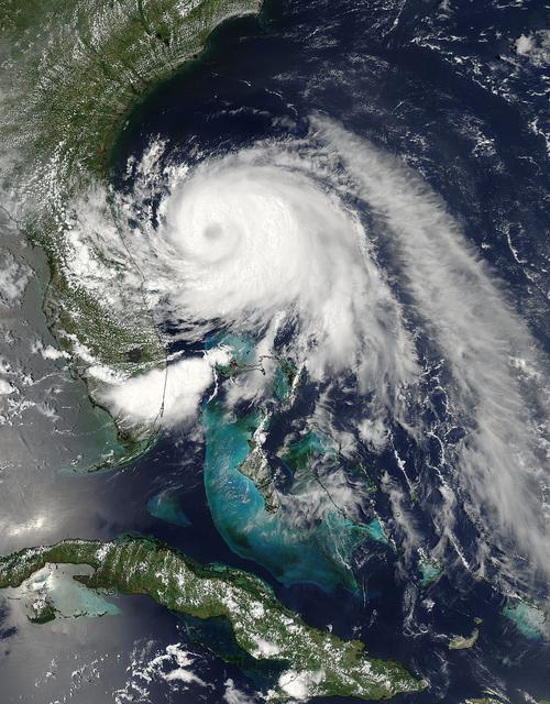
This visible image of Tropical Storm Arthur was taken by the MODIS instrument aboard NASA's Aqua satellite on July 2 at 18:50 UTC (2:50 p.m. EDT). A cloud-covered eye is clearly visible. Credit: NASA Goddard MODIS Rapid Response Team Read more: <a href="http://www.nasa.gov/content/goddard/arthur-atlantic/" rel="nofollow">www.nasa.gov/content/goddard/arthur-atlantic/</a> <b><a href="http://www.nasa.gov/audience/formedia/features/MP_Photo_Guidelines.html" rel="nofollow">NASA image use policy.</a></b> <b><a href="http://www.nasa.gov/centers/goddard/home/index.html" rel="nofollow">NASA Goddard Space Flight Center</a></b> enables NASA’s mission through four scientific endeavors: Earth Science, Heliophysics, Solar System Exploration, and Astrophysics. Goddard plays a leading role in NASA’s accomplishments by contributing compelling scientific knowledge to advance the Agency’s mission. <b>Follow us on <a href="http://twitter.com/NASAGoddardPix" rel="nofollow">Twitter</a></b> <b>Like us on <a href="http://www.facebook.com/pages/Greenbelt-MD/NASA-Goddard/395013845897?ref=tsd" rel="nofollow">Facebook</a></b> <b>Find us on <a href="http://instagram.com/nasagoddard?vm=grid" rel="nofollow">Instagram</a></b>

Captured on Friday, July 3, 2014 at 12:20 PM EDT. The National Hurricane Center in Miami says Arthur is centered about 260 miles southwest of Cape Hatteras, North Carolina, and about 110 miles south-southwest of Cape Fear. It's moving north at 14 mph. Satellite: Terra Credit: NASA/GSFC/Jeff Schmaltz/MODIS Land Rapid Response Team <b><a href="http://www.nasa.gov/audience/formedia/features/MP_Photo_Guidelines.html" rel="nofollow">NASA image use policy.</a></b> <b><a href="http://www.nasa.gov/centers/goddard/home/index.html" rel="nofollow">NASA Goddard Space Flight Center</a></b> enables NASA’s mission through four scientific endeavors: Earth Science, Heliophysics, Solar System Exploration, and Astrophysics. Goddard plays a leading role in NASA’s accomplishments by contributing compelling scientific knowledge to advance the Agency’s mission. <b>Follow us on <a href="http://twitter.com/NASAGoddardPix" rel="nofollow">Twitter</a></b> <b>Like us on <a href="http://www.facebook.com/pages/Greenbelt-MD/NASA-Goddard/395013845897?ref=tsd" rel="nofollow">Facebook</a></b> <b>Find us on <a href="http://instagram.com/nasagoddard?vm=grid" rel="nofollow">Instagram</a></b>

Despite a somewhat ragged appearance on satellite imagery, Arthur has strengthened overnight. NOAA and Air Force Reserve Hurricane Hunter aircraft have found surface winds in the 45-50 kt range to the south and northeast of the center, while also finding the central pressure has fallen to about 996 mb. Arthur has begun moving steadily northward at around 5 kt. The overall track forecast reasoning remains unchanged, as the tropical cyclone should continue northward for the next 12 to 24 hours. This image was taken by GOES West at the far eastern periphery of its scan, at 1200Z on July 2, 2014. <b><a href="http://goes.gsfc.nasa.gov/" rel="nofollow">Image credit: NOAA/NASA GOES Project</a></b> Caption credit: NASA/NOAA via <b><a href="www.nnvl.noaa.gov/" rel="nofollow"> NOAA Environmental Visualization Laboratory</a></b> <b><a href="http://www.nasa.gov/audience/formedia/features/MP_Photo_Guidelines.html" rel="nofollow">NASA image use policy.</a></b> <b><a href="http://www.nasa.gov/centers/goddard/home/index.html" rel="nofollow">NASA Goddard Space Flight Center</a></b> enables NASA’s mission through four scientific endeavors: Earth Science, Heliophysics, Solar System Exploration, and Astrophysics. Goddard plays a leading role in NASA’s accomplishments by contributing compelling scientific knowledge to advance the Agency’s mission. <b>Follow us on <a href="http://twitter.com/NASAGoddardPix" rel="nofollow">Twitter</a></b> <b>Like us on <a href="http://www.facebook.com/pages/Greenbelt-MD/NASA-Goddard/395013845897?ref=tsd" rel="nofollow">Facebook</a></b> <b>Find us on <a href="http://instagram.com/nasagoddard?vm=grid" rel="nofollow">Instagram</a></b>
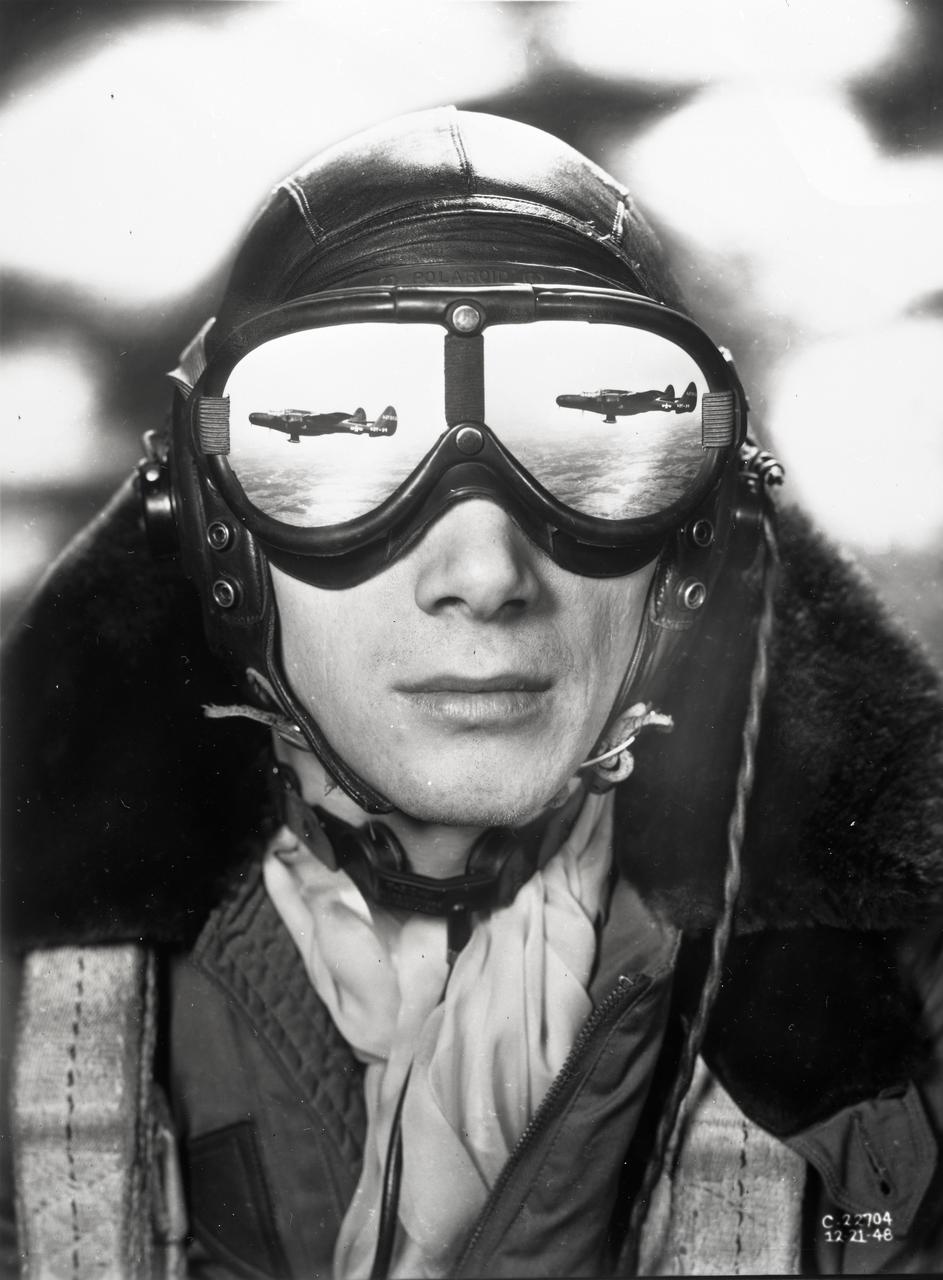
Flight engineer and photographer William Wynne (pictured) worked with photographer Arthur Laufman to execute a photo concept devised by Laufman. Wynne printed two copies of the F-61 aircraft in flight. The prints were made to the correct size that allowed them to be cut out and taped to the lenses of his goggles to simulate a reflection. The photo of Wynne was then taken with an out of focus background to simulate clouds.
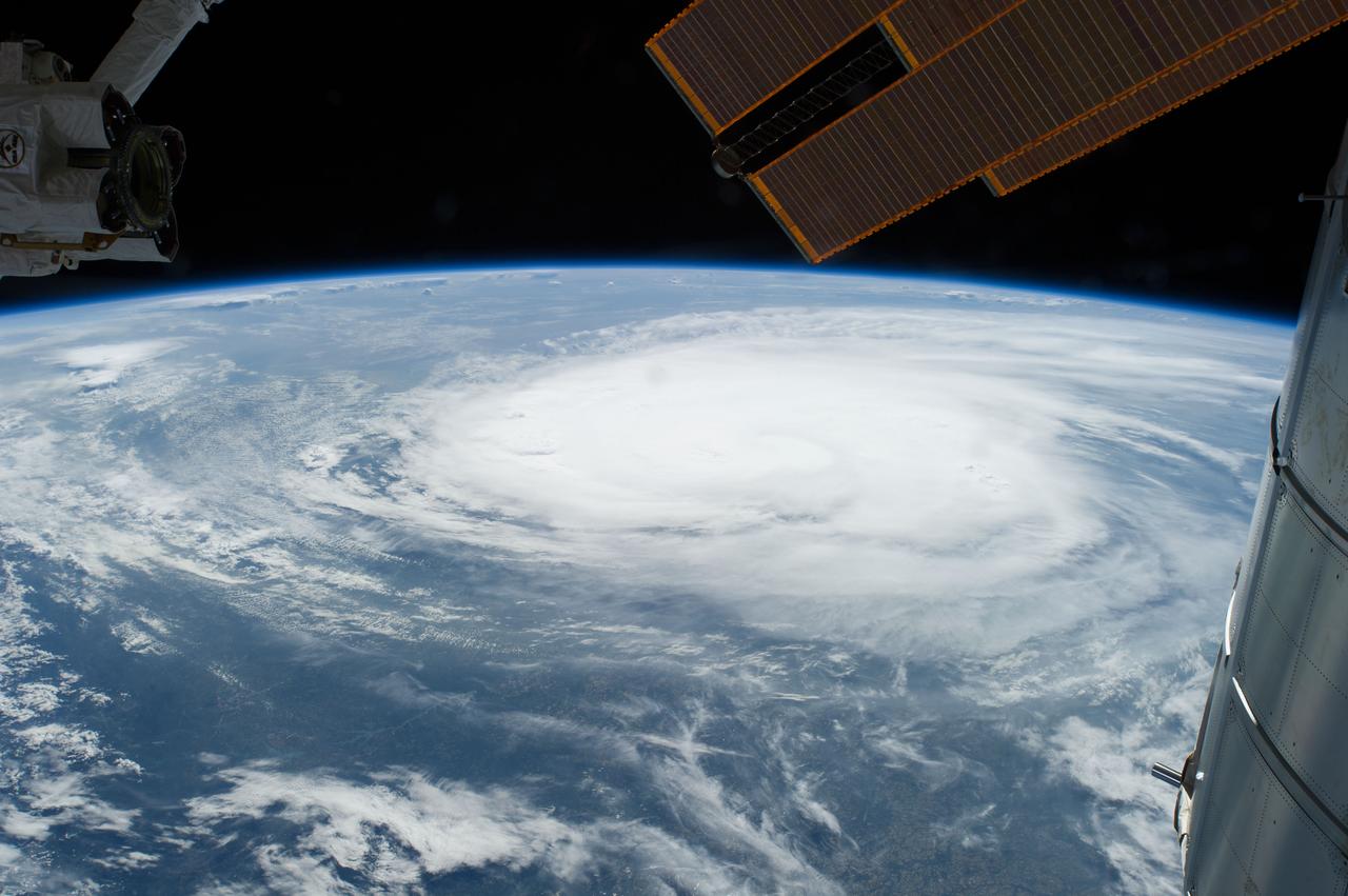
View of Hurricane Arthur taken during a day pass by the Expedition 40 crew aboard the International Space Station (ISS).
ISS040-E-031651 (2 July 2014) --- One of the Expedition 40 crew members aboard the Earth-orbiting International Space Station, some 227 nautical miles above Earth, photographed this image of Tropical Storm Arthur moving northerly near the east coast of the USA late on July 2, 2014. The crew had photographed imagery which showed Arthur churning in Atlantic waters off of Florida some eight hours prior to this picture.
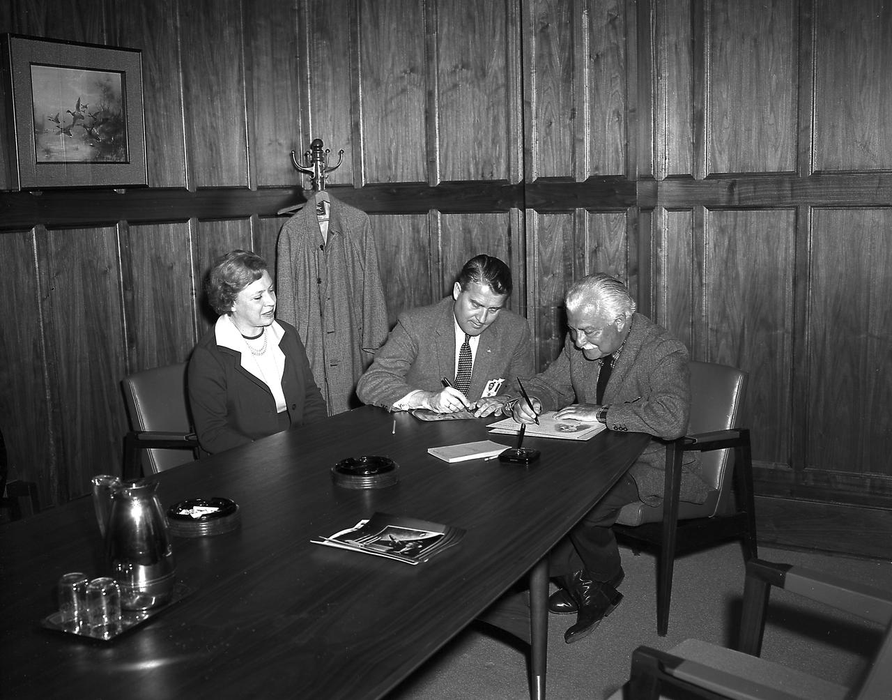
Mr. Mrs. Arthur Fiedler of the Boston Pops Orchestra and Dr. von Braun in his office during the Fiedlers' visit to the Marshall Space Flight Center (MSFC) on March, 23, 1962.
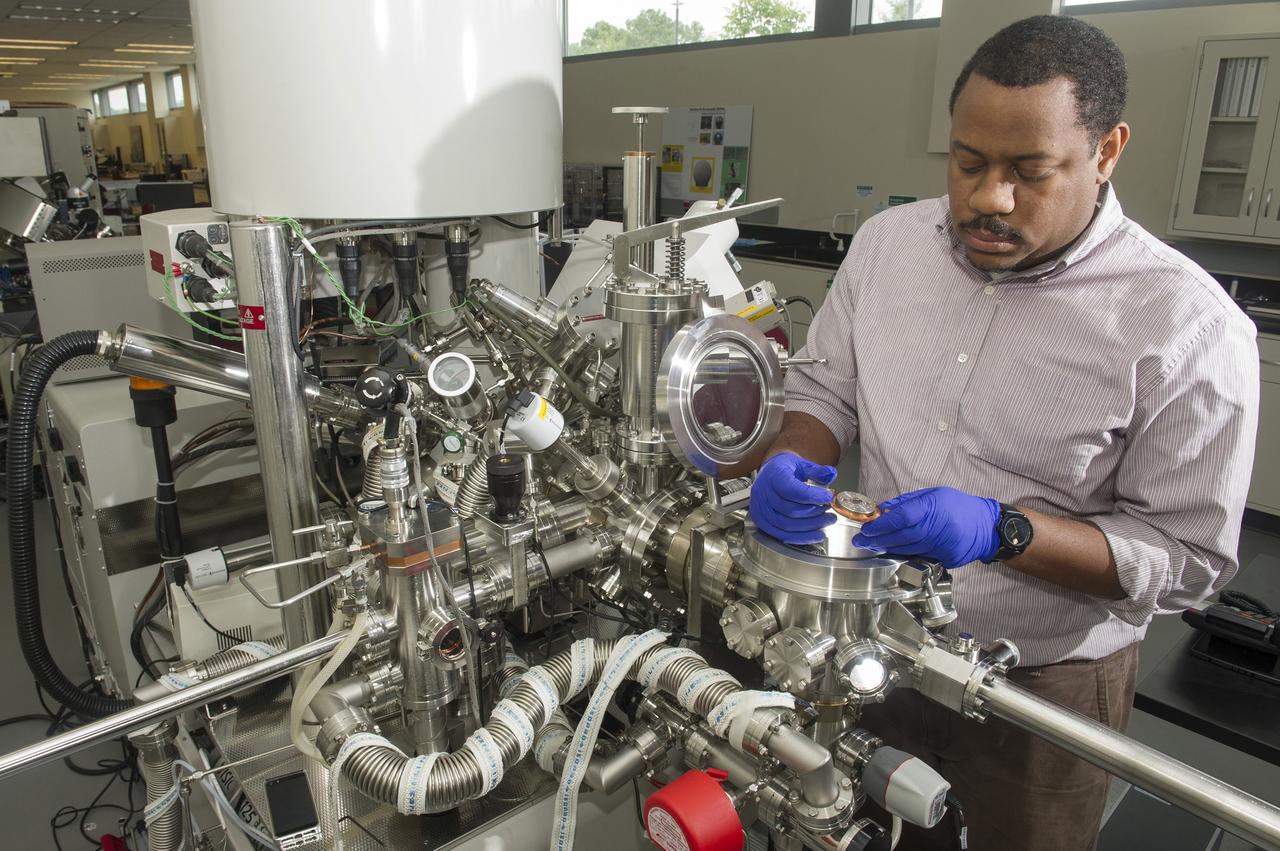
ARTHUR BROWN (AST, AEROSPACE METALLIC MATERIALS) LOADS A CERAMIC COATED SILICON WAFER INTO A KRATOS (ELECTRON SPECTROSCOPY FOR CHEMICAL ANALYSIS) TO PERFORM X-RAY PHOTOELECTRON SPECTROSCOPY (XPS). XPS IS A TECHNIQUE THAT ANALYZES THE SURFACE CHEMISTRY OF A SAMPLE BY IRRADIATING IT WITH X-RAYS AND MEASURING THE NUMBER AND KINETIC ENERGY OF ELECTRON THAT ESCAPE.

Radar and satellite imagery indicate that the convective organization of the cyclone has improved, and the cyclone is being upgraded based on a sustained wind report of 33 kt from Settlement Point, Grand Bahama Island earlier this morning. Low shear conditions and warm sea-surface temperatures should allow for at least steady strengthening, and the cyclone is expected to become a hurricane by 72 hours. This image was taken by GOES East at 1445Z on July 1, 2014. <b><a href="http://goes.gsfc.nasa.gov/" rel="nofollow">Credit: NOAA/NASA GOES Project</a></b> Caption: NOAA <b><a href="http://www.nasa.gov/audience/formedia/features/MP_Photo_Guidelines.html" rel="nofollow">NASA image use policy.</a></b> <b><a href="http://www.nasa.gov/centers/goddard/home/index.html" rel="nofollow">NASA Goddard Space Flight Center</a></b> enables NASA’s mission through four scientific endeavors: Earth Science, Heliophysics, Solar System Exploration, and Astrophysics. Goddard plays a leading role in NASA’s accomplishments by contributing compelling scientific knowledge to advance the Agency’s mission. <b>Follow us on <a href="http://twitter.com/NASAGoddardPix" rel="nofollow">Twitter</a></b> <b>Like us on <a href="http://www.facebook.com/pages/Greenbelt-MD/NASA-Goddard/395013845897?ref=tsd" rel="nofollow">Facebook</a></b> <b>Find us on <a href="http://instagram.com/nasagoddard?vm=grid" rel="nofollow">Instagram</a></b>
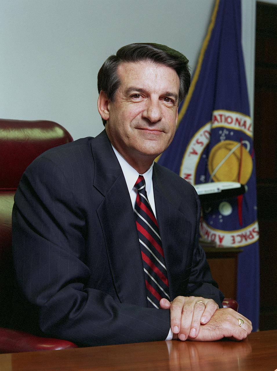
Mr. Arthur G. Stephenson has been serving as the ninth Director of NASA's Marshall Space Flight Center since his appointment on September 11, 1998. Prior to his appointment, Mr. Stephenson worked for TRW, Redondo Beach, California, for 28 years and was president of Oceaneering Advanced Technologies in Houston, Texas, at the time of his appointment. Mr. Stephenson has over 30 years of experience as a manager in spacecraft and high-technology systems.
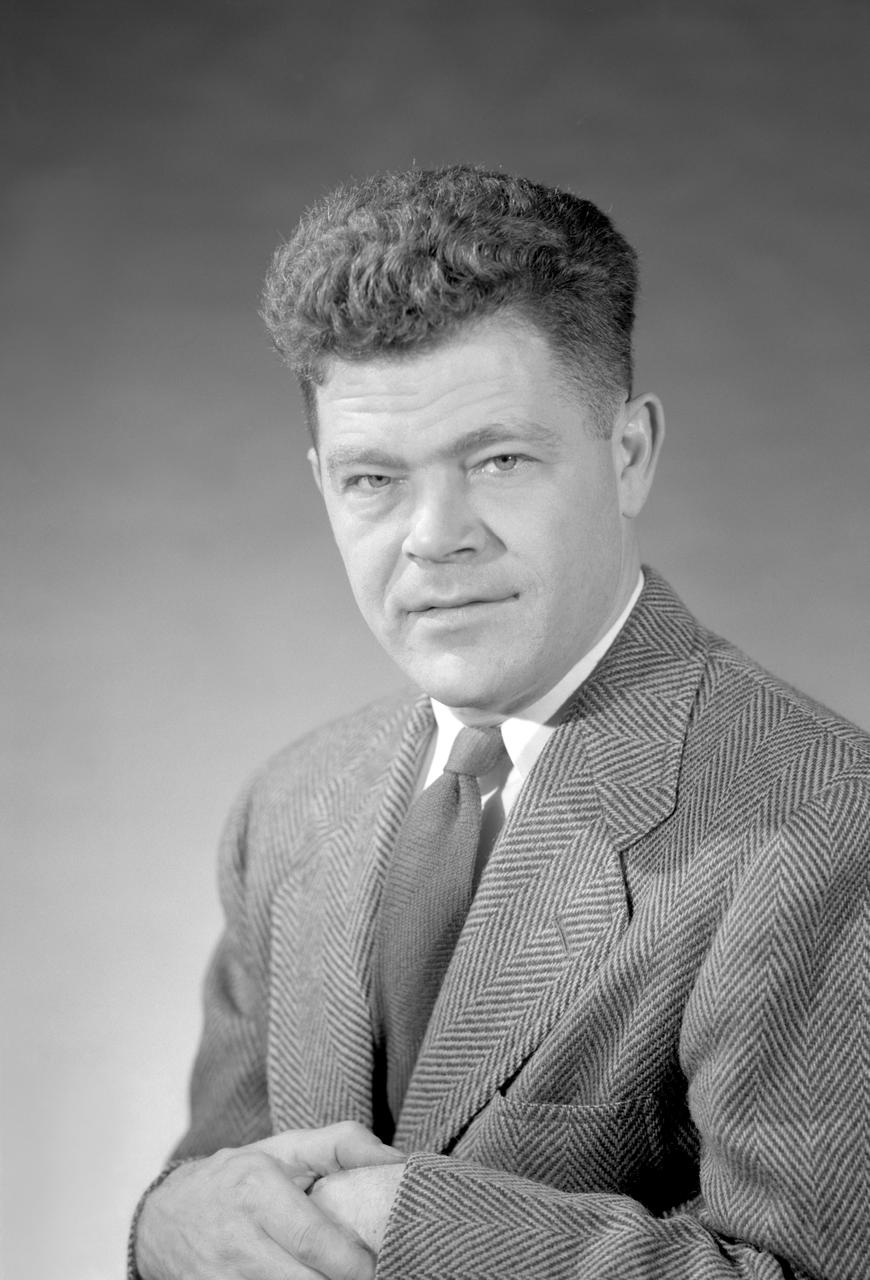
Portrait of Author W. Vogeley
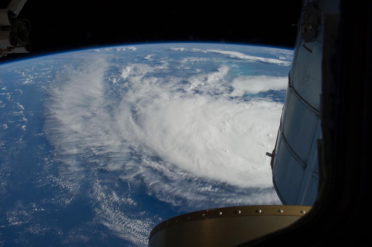
Earth Observation taken during a day pass by the Expedition 40 crew aboard the International Space Station (ISS). Folder lists this as: Tropical Storm Arthur.

Two Phase Flow Facility, Toffy Modular Light Emitting Diode (LED) Light System Camera file: 45548822 PSD on backup Pictured: Arthur Stackowicz
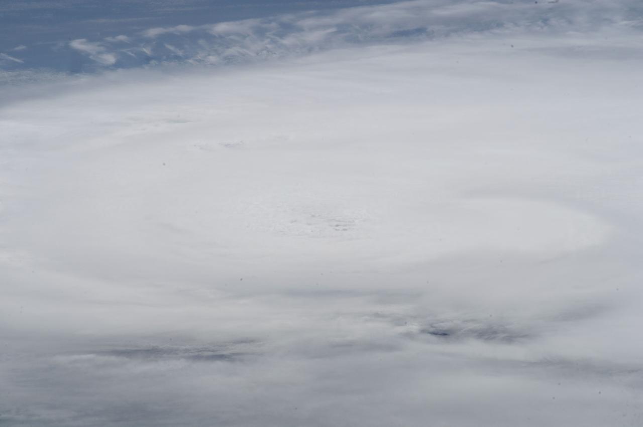
Earth Observation taken during a day pass by the Expedition 40 crew aboard the International Space Station (ISS). Folder lists this as: Tropical Storm Arthur.
Earth Observation taken during a day pass by the Expedition 40 crew aboard the International Space Station (ISS). Folder lists this as: Tropical Storm Arthur.
Earth Observation taken during a day pass by the Expedition 40 crew aboard the International Space Station (ISS). Folder lists this as: Tropical Storm Arthur.
Earth Observation taken during a day pass by the Expedition 40 crew aboard the International Space Station (ISS). Folder lists this as: Hurricane Arthur.
Earth observation taken during a day pass by the Expedition 40 crew aboard the International Space Station (ISS). Folder lists this as: Hurricane Arthur.
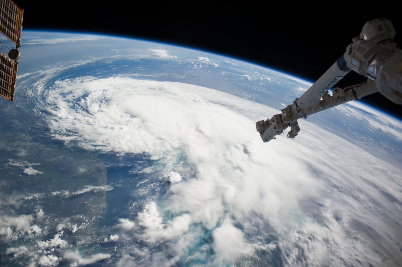
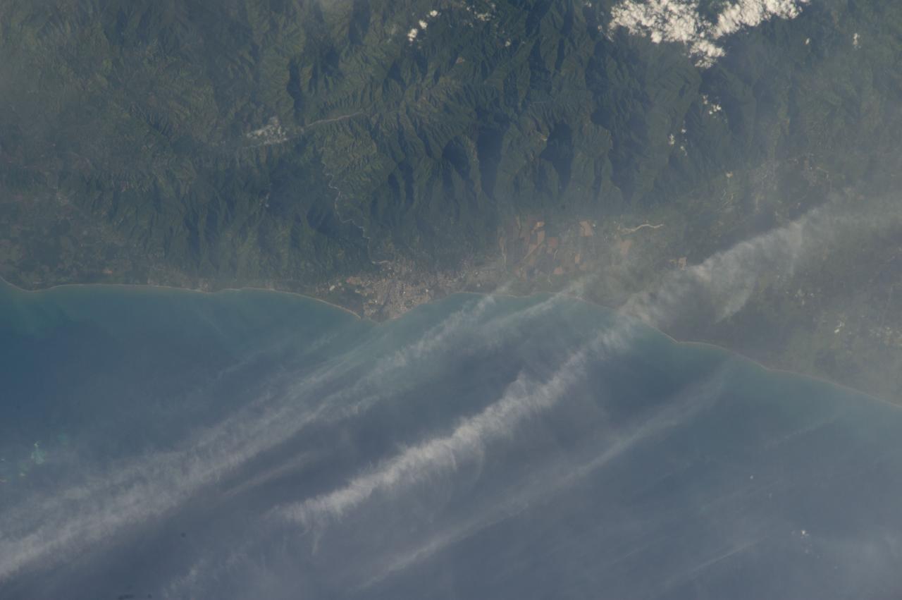
ISS040-E-030615 (2 July 2014) --- One of the Expedition 40 crew members aboard the Earth-orbiting International Space Station, some 227 nautical miles above Earth, photographed this image of Tropical Storm Arthur in the afternoon of July 2, 2014. Arthur was churning in Atlantic waters off the coast of Florida and slowly moving northward at the time the photo was taken. The robotic arm of the Space Station Remote Manipulator System or Canadarm2 is seen at upper right.
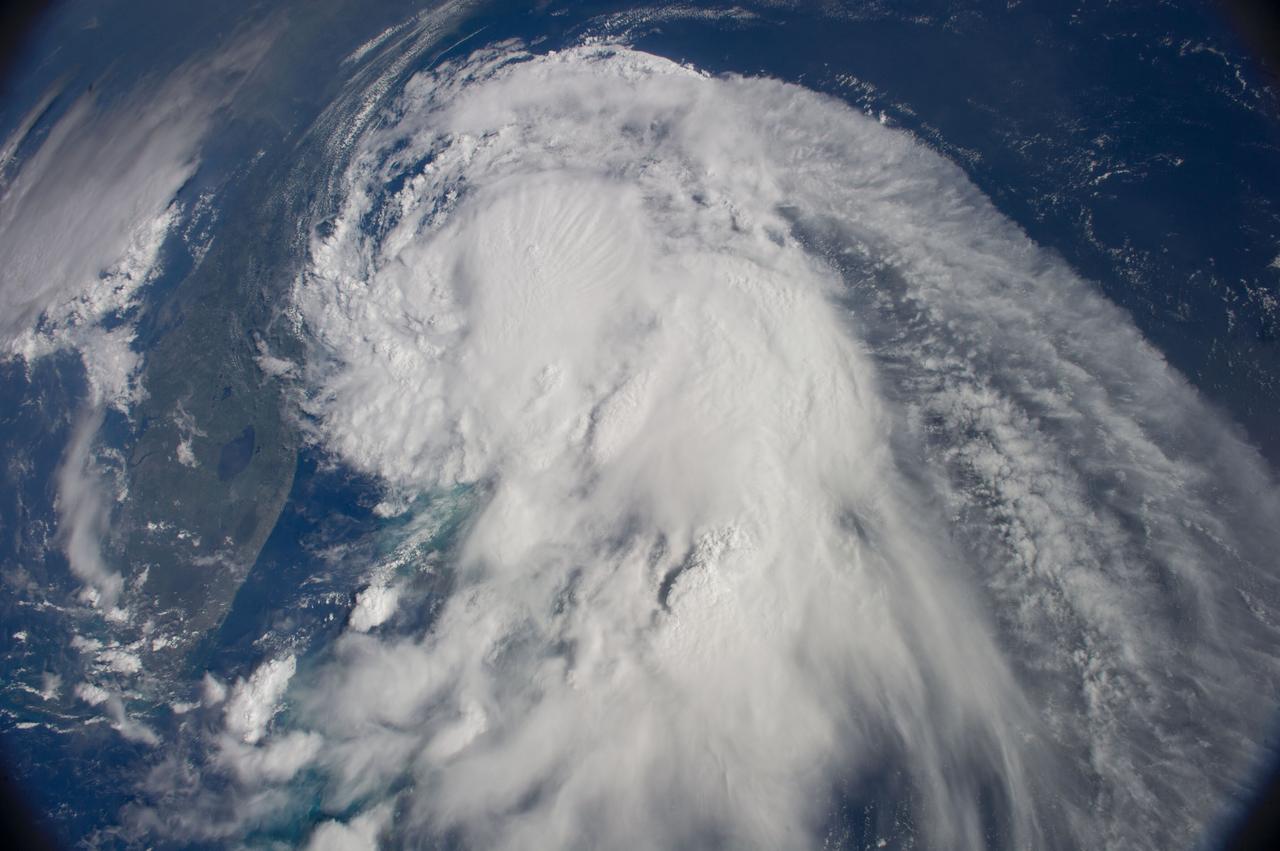
ISS040-E-030568 (2 July 2014) --- One of the Expedition 40 crew members aboard the Earth-orbiting International Space Station, some 227 nautical miles above Earth, photographed this image of Tropical Storm Arthur in the afternoon of July 2, 2014. Arthur was churning in Atlantic waters off the coast of Florida and slowly moving northward at the time the photo was taken. Much of the Florida peninsula can be seen at left.

Earth Observation taken during a day pass by the Expedition 40 crew aboard the International Space Station (ISS). Folder lists this only as: Hurricane Arthur wide angle.

NACA/Ames Photographer Radio personality Arthur Godfrey shown here with Ames Pilot George Cooper and Center Director Smith J DeFrance during tour of facility
Earth Observation taken during a day pass by the Expedition 40 crew aboard the International Space Station (ISS). Folder lists this only as: Hurricane Arthur wide angle.
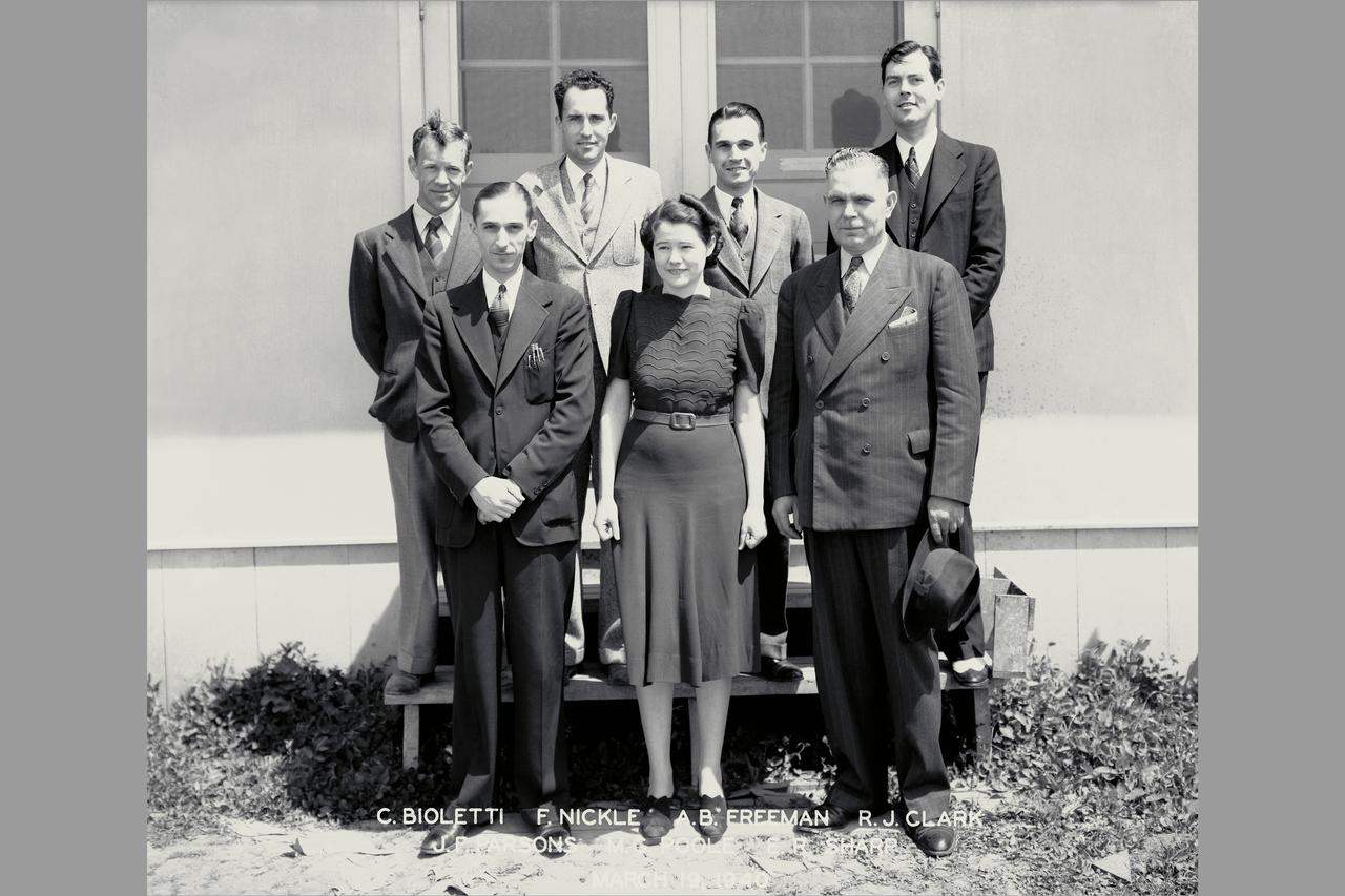
AMES PERSONNEL: Front Row; John Parsons, Manie Poole, Edward Sharp, Back Row; Carlson Bioletti, Ferril Nickle, Arthur Freeman, R J Clark

Earth observation taken during a day pass by the Expedition 40 crew aboard the International Space Station (ISS). Folder lists this as: Hurricane Arthur just before landfall.
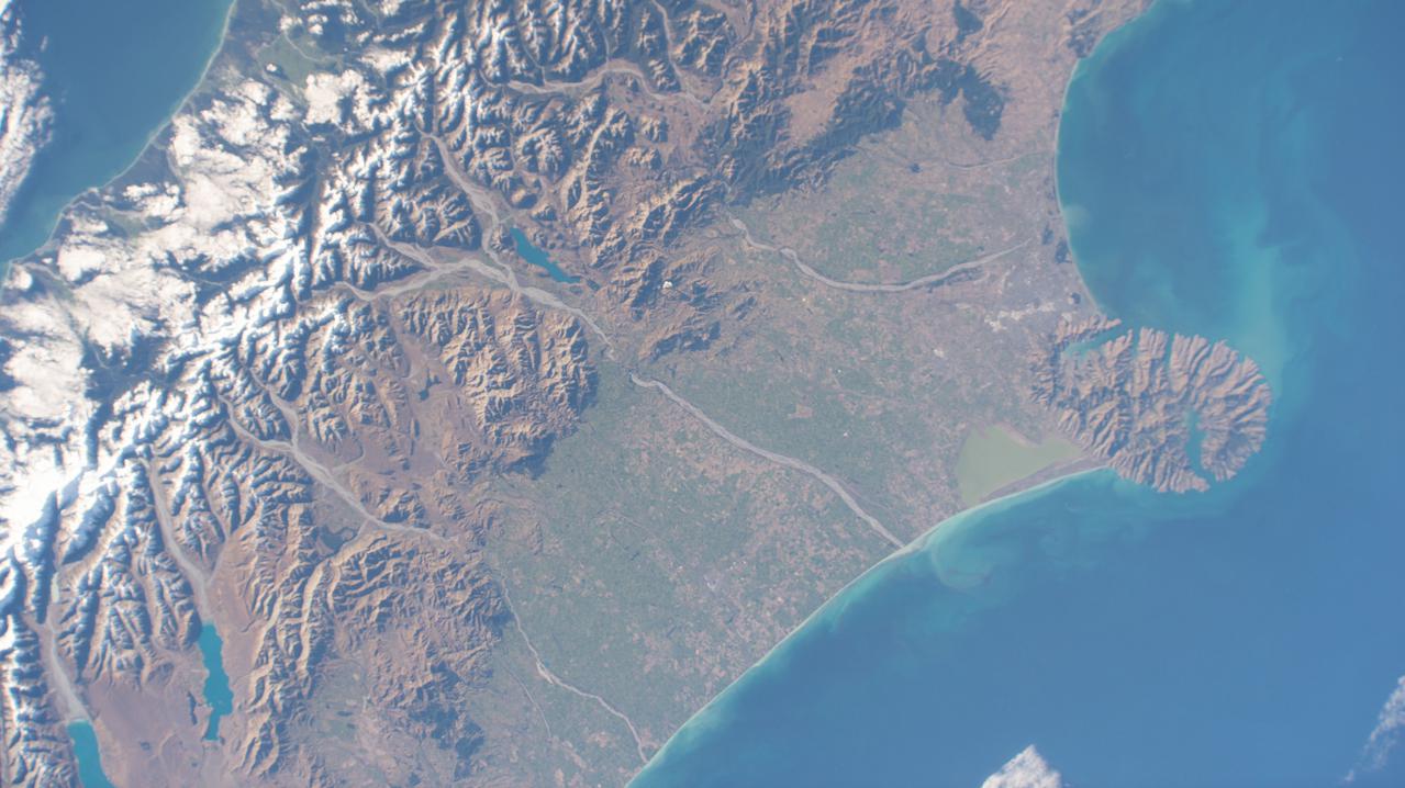
iss065e011342 (May 2, 2021) --- Christchurch, New Zealand, is pictured in between Pigeon Bay and Arthur's Pass National Park as the International Space Station orbited 269 miles above the island nation.

Earth Observation taken during a day pass by the Expedition 40 crew aboard the International Space Station (ISS). Folder lists this only as: Hurricane Arthur wide angle.
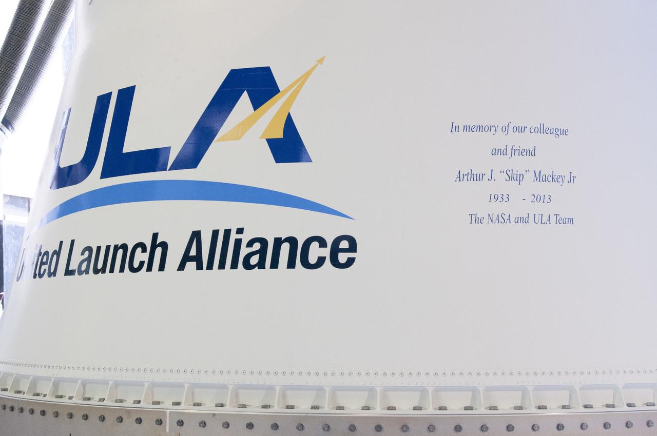
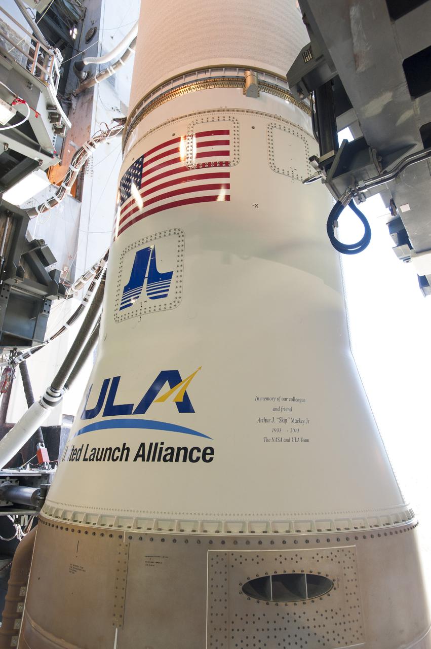
CAPE CANAVERAL, Fla. – This memorial message was added to the Atlas V rocket for NASA's Tracking and Data Relay Satellite, or TDRS-L, spacecraft being prepared for launch from Cape Canaveral Air Force Station's Launch Complex 41. Arthur J. "Skip" Mackey Jr. was the “Voice of NASA” during the 1960s, 1970s and early 1980s for flight commentary after liftoff for expendable vehicles launched from Cape Canaveral. Mackey served as branch chief for Telemetry and Communications at Hangar AE in the agency’s Expendable Launch Vehicle Program and then the Launch Services Program for 39 years. He died in Fort Lauderdale, Fla., on Nov. 19, 2013. The TDRS-L spacecraft is the second of three new satellites designed to ensure vital operational continuity for NASA by expanding the lifespan of the Tracking and Data Relay Satellite System TDRSS fleet, which consists of eight satellites in geosynchronous orbit. The spacecraft provide tracking, telemetry, command and high bandwidth data return services for numerous science and human exploration missions orbiting Earth. These include NASA's Hubble Space Telescope and the International Space Station. TDRS-L has a high-performance solar panel designed for more spacecraft power to meet the growing S-band communications requirements. TDRSS is one of NASA Space Communication and Navigation’s SCaN three networks providing space communications to NASA’s missions. For more information more about TDRS-L, visit: http://www.nasa.gov/tdrs To learn more about SCaN, visit: www.nasa.gov/scan For more on "Skip" Mackey go to: http://www.nasa.gov/content/skip-mackey-remembered-by-colleagues-as-voice-of-nasa/ Image credit: United Launch Alliance
CAPE CANAVERAL, Fla. – This memorial message was added to the Atlas V rocket for NASA's Tracking and Data Relay Satellite, or TDRS-L, spacecraft being prepared for launch from Cape Canaveral Air Force Station's Launch Complex 41. Arthur J. "Skip" Mackey Jr. was the “Voice of NASA” during the 1960s, 1970s and early 1980s for flight commentary after liftoff for expendable vehicles launched from Cape Canaveral. Mackey served as branch chief for Telemetry and Communications at Hangar AE in the agency’s Expendable Launch Vehicle Program and then the Launch Services Program for 39 years. He died in Fort Lauderdale, Fla., on Nov. 19, 2013. The TDRS-L spacecraft is the second of three new satellites designed to ensure vital operational continuity for NASA by expanding the lifespan of the Tracking and Data Relay Satellite System TDRSS fleet, which consists of eight satellites in geosynchronous orbit. The spacecraft provide tracking, telemetry, command and high bandwidth data return services for numerous science and human exploration missions orbiting Earth. These include NASA's Hubble Space Telescope and the International Space Station. TDRS-L has a high-performance solar panel designed for more spacecraft power to meet the growing S-band communications requirements. TDRSS is one of NASA Space Communication and Navigation’s SCaN three networks providing space communications to NASA’s missions. For more information more about TDRS-L, visit: http://www.nasa.gov/tdrs To learn more about SCaN, visit: www.nasa.gov/scan For more on "Skip" Mackey go to: http://www.nasa.gov/content/skip-mackey-remembered-by-colleagues-as-voice-of-nasa/ Image credit: United Launch Alliance
CAPE CANAVERAL, Fla. – This memorial message was added to the Atlas V rocket for NASA's Tracking and Data Relay Satellite, or TDRS-L, spacecraft being prepared for launch from Cape Canaveral Air Force Station's Launch Complex 41. Arthur J. "Skip" Mackey Jr. was the “Voice of NASA” during the 1960s, 1970s and early 1980s for flight commentary after liftoff for expendable vehicles launched from Cape Canaveral. Mackey served as branch chief for Telemetry and Communications at Hangar AE in the agency’s Expendable Launch Vehicle Program and then the Launch Services Program for 39 years. He died in Fort Lauderdale, Fla., on Nov. 19, 2013. The TDRS-L spacecraft is the second of three new satellites designed to ensure vital operational continuity for NASA by expanding the lifespan of the Tracking and Data Relay Satellite System TDRSS fleet, which consists of eight satellites in geosynchronous orbit. The spacecraft provide tracking, telemetry, command and high bandwidth data return services for numerous science and human exploration missions orbiting Earth. These include NASA's Hubble Space Telescope and the International Space Station. TDRS-L has a high-performance solar panel designed for more spacecraft power to meet the growing S-band communications requirements. TDRSS is one of NASA Space Communication and Navigation’s SCaN three networks providing space communications to NASA’s missions. For more information more about TDRS-L, visit: http://www.nasa.gov/tdrs To learn more about SCaN, visit: www.nasa.gov/scan For more on "Skip" Mackey go to: http://www.nasa.gov/content/skip-mackey-remembered-by-colleagues-as-voice-of-nasa/ Image credit: United Launch Alliance

ISS040-E-030559 (2 July 2014) --- One of the Expedition 40 crew members aboard the Earth-orbiting International Space Station, some 227 nautical miles above Earth, photographed this image of Tropical Storm Arthur in the afternoon of July 2, 2014. Arthur was churning in Atlantic waters off the coast of Florida and slowly moving northward at the time the photo was taken. The robotic arm of the Space Station Remote Manipulator System or Canadarm2 is seen at upper center, and the tip of one of the orbital outpost's solar array panels is in upper right.
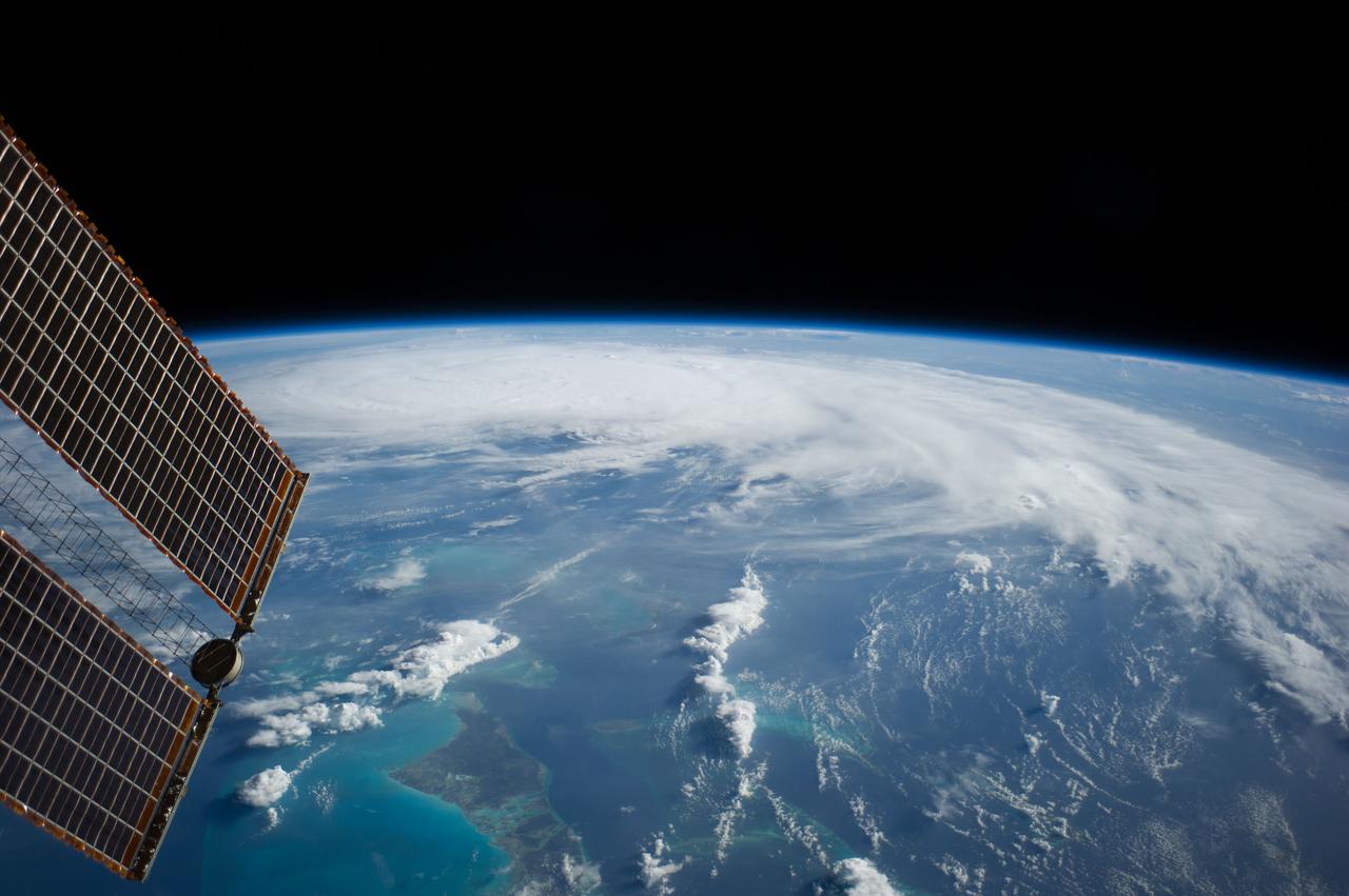
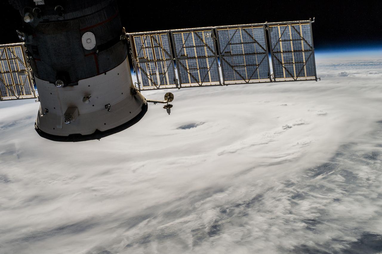
ISS040-E-031901 (3 July 2014) --- As the International Space Station was flying 227 nautical miles above the Bahama Islands, one of the Expedition 40 crew members photographed this image of Hurricane Arthur, moving northerly along the Atlantic coast line. Arthur's forecast at 11 a.m. (EDT) on July 3, 2014 projected it hitting the coast of North Carolina as a Category 2 hurricane, with winds over 100 mph, on the night of July 3 or the morning of July 4. A tip of one of the solar panels on the orbital outpost is in upper left.
20th Anniversary of the First Lunar Landing Colloquium held at Langley. William H. Michael Jr. (center) reviews the evolution of his parking orbit concept with Clinton E. Brown (right) head of the Lunar Exploration Working Group and Arthur Vogeley (left) mastermind of Langley's rendezvous and docking simulators of the 1960's.
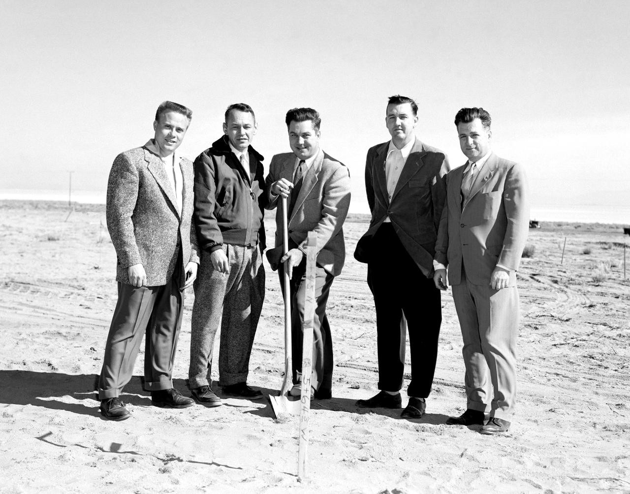
The NACA High-Speed Flight Research Station, had initially been subordinate to the Langley Memorial Aeronautical Laboratory near Hampton, Virginia, but as the flight research in the Mojave Desert increasingly proved its worth after 1946, it made sense to make the Flight Research Station a separate entity reporting directly to the headquarters of the National Advisory Committee for Aeronautics. But an autonomous center required all the trappings of a major research facility, including good quarters. With the adoption of the Edwards “Master Plan,” the Air Force had committed itself to moving from its old South Base to a new location midway between the South and North Bases. The NACA would have to move also--so why not take advantage of the situation and move into a full-blown research facility. The Air Force issued a lease to NACA for a location on the northwestern shore of the Roger Dry Lake. Construction started on the NACA station in early February 1953. On a windy day, January 27, 1953, at a groundbreaking ceremony stood left to right: Gerald Truszynski, Head of Instrumentation Division; Joseph Vensel, Head of the Operations Branch; Walter Williams, Head of the Station, scooping the first shovel full of dirt; Marion Kent, Head of Personnel; and California state official Arthur Samet.
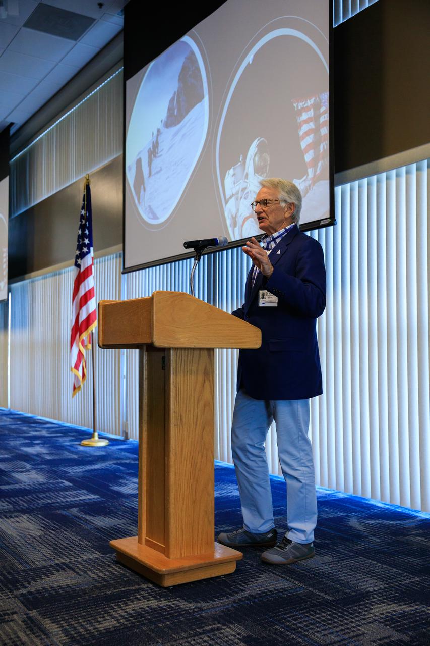
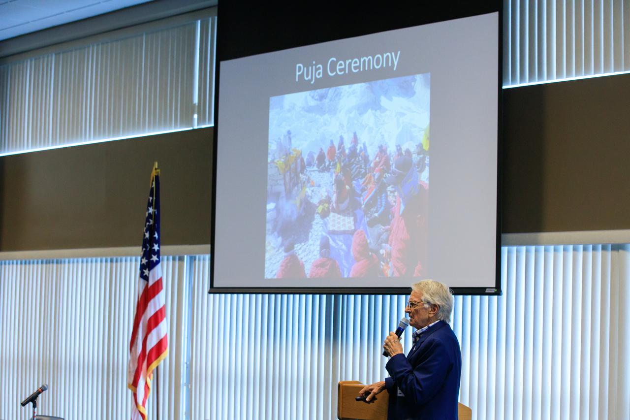
Arthur Muir, a retired Chicago attorney and America’s oldest Mt. Everest summiteer, addresses the audience during the inaugural Cross-Program Connection event at NASA Kennedy Space Center’s Space Station Processing Facility on March 8, 2023. Muir, 75, was the speaker at the Florida spaceport function titled “Explorers Doing the Impossible.” He toured Kennedy before sharing his experiences in overcoming incredible challenges during his journey to the top of Earth’s highest mountain.
Arthur Muir, a retired Chicago attorney and America’s oldest Mt. Everest summiteer, addresses the audience during the inaugural Cross-Program Connection event at NASA Kennedy Space Center’s Space Station Processing Facility on March 8, 2023. Muir, 75, was the speaker at the Florida spaceport function titled “Explorers Doing the Impossible.” He toured Kennedy before sharing his experiences in overcoming incredible challenges during his journey to the top of Earth’s highest mountain.
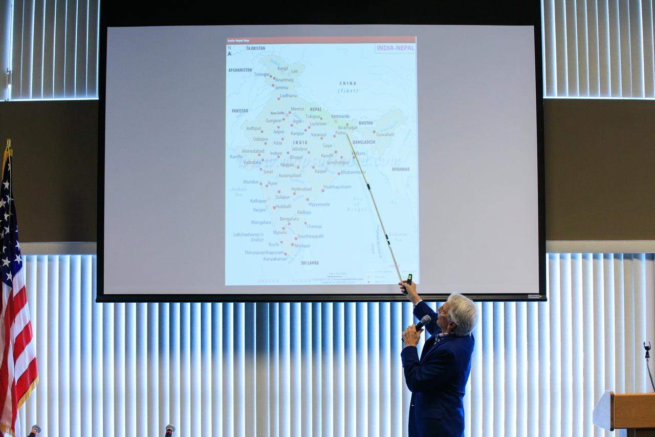
Arthur Muir, a retired Chicago attorney and America’s oldest Mt. Everest summiteer, delivers his presentation during the inaugural Cross-Program Connection event at NASA Kennedy Space Center’s Space Station Processing Facility on March 8, 2023. Muir, 75, was the speaker at the Florida spaceport function titled “Explorers Doing the Impossible.” He toured Kennedy before sharing his experiences in overcoming incredible challenges during his journey to the top of Earth’s highest mountain.
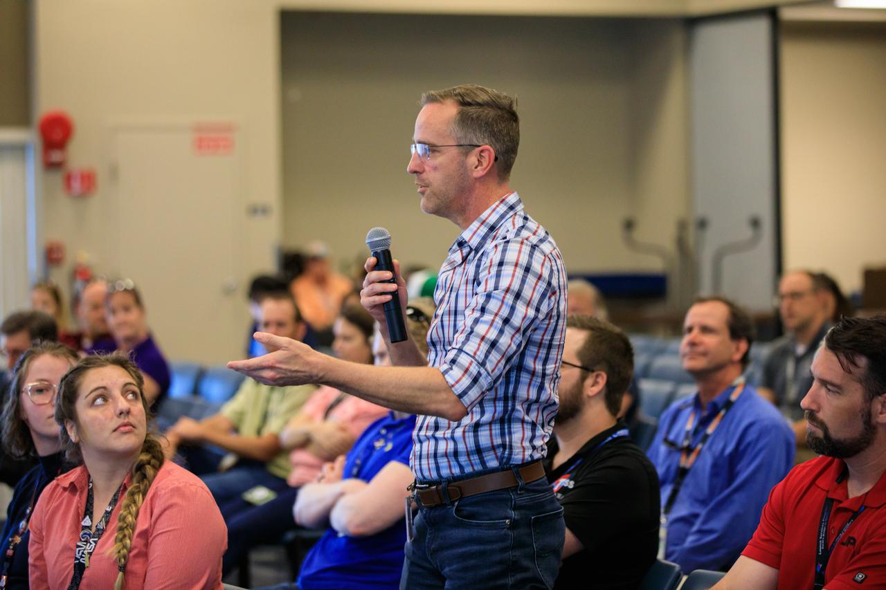
An audience member asks a question during the inaugural Cross-Program Connection event at NASA Kennedy Space Center’s Space Station Processing Facility on March 8, 2023. Arthur Muir, a retired Chicago attorney and America’s oldest Mt. Everest summiteer, was the speaker at the Florida spaceport function titled “Explorers Doing the Impossible.” He toured Kennedy before sharing his experiences in overcoming incredible challenges during his journey to the top of Earth’s highest mountain.
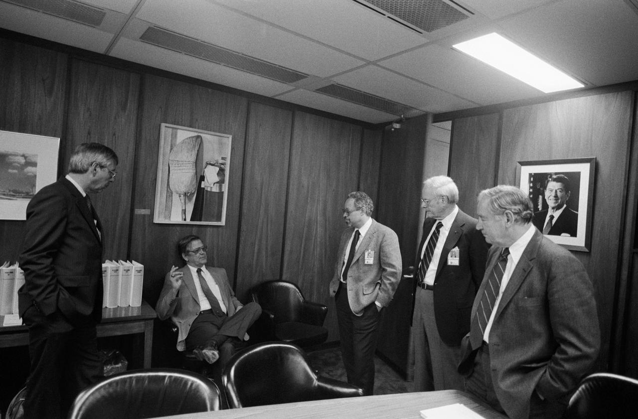
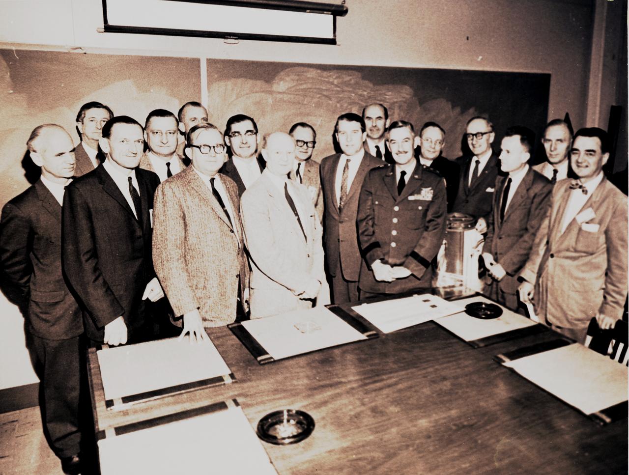
S86-28751 (5 March 1986) --- Two NASA officials talk with members of the Presidential Commission on the Space Shuttle Challenger Accident in the Executive Conference Room of JSC’s Project Management Building. Left to right are JSC Deputy Director Robert C. Goetz; Richard H. Kohrs, Deputy Manager, National Space Transportation Systems Office; and commission members Dr. Arthur B.C. Walker Jr., Robert W. Rummel and Joseph F. Sutter. Photo credit: NASA
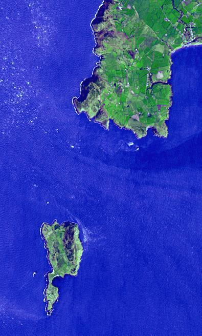
Lying 3 km off the Llyn peninsula of Wales, the Bardsey Island is known as the Island of 20,000 saints. While today's permanent population numbers only four, the island was once an important religious site, with a 6th century monastery. It is the legendary burial site of King Arthur. Another legend holds that anyone who died on the island would not go to hell. The image was acquired April 4, 2006, covers an area of 6 by 10 km, and is located at 52.7 degrees north, 4.8 degrees west. http://photojournal.jpl.nasa.gov/catalog/PIA21182

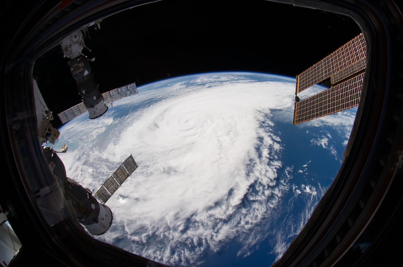
ISS040-E-033548 (4 July 2014) --- One of the Expedition 40 crew members aboard the Earth-orbiting International Space Station made use of a 10.5mm focal length to photograph this fish-eye view of Hurricane Arthur, which altered the holiday plans of millions of residents on the Atlantic Coast on U.S. Independence Day, 2014. This image was taken on July 4 at 13:32:41 GMT. One of the modules of the orbital outpost (top right) and a docked Russian spacecraft (right center) are visible in the photo.

Arthur Muir, a retired Chicago attorney and America’s oldest Mt. Everest summiteer, attends the inaugural Cross-Program Connection event at NASA Kennedy Space Center’s Space Station Processing Facility on March 8, 2023. Muir, 75, was the speaker at the Florida spaceport function titled “Explorers Doing the Impossible.” He toured Kennedy before sharing his experiences in overcoming incredible challenges during his journey to the top of Earth’s highest mountain.

S86-28750 (5 March 1986) --- Two JSC officials and two members of the Presidential Commission on the Space Shuttle Challenger Accident meet in the Executive Conference Room of JSC’s Project Management Building. Left to right are JSC Deputy Director Robert C. Goetz; Richard H. Kohrs, Deputy Manager for National Space Transportation Systems Program Office; and commission members Joseph F. Sutter and Dr. Arthur B.C. Walker Jr. Photo credit: NASA
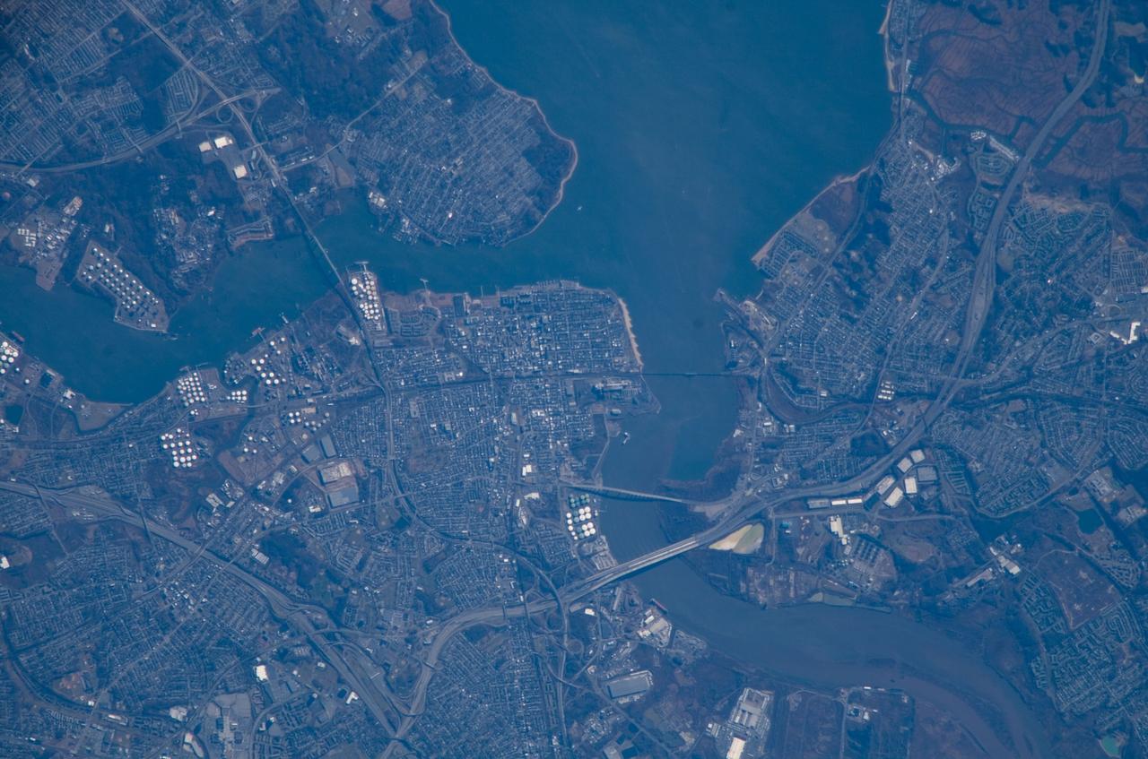
ISS016-E-018493 (24 Dec. 2007) --- Perth Amboy, New Jersey is featured in this image photographed by an Expedition 16 crewmember on the International Space Station. The port city of Perth Amboy is located between the outlets of the Raritan River and Arthur Kill ("river" in Dutch) into Raritan Bay in upper New Jersey. According to scientists, rich clay beds in the region, formed during the Cretaceous Era (approximately 65-144 million years ago), provided the raw materials for numerous pottery and terra cotta manufacturers during the 19th century. The city became an industrial and shipping center, and resort destination, through the early to mid-20th century. While the majority of the industrial factory facilities have left Perth Amboy, petroleum processing and storage remains part of the economic base -- several refining facilities are visible along the banks of Arthur Kill in this image (upper left). Originally known simply as "Amboy", "Perth" was added to the name in honor of the Earl of Perth when the city became the capital of East Jersey in 1686. Together with South Amboy across the Raritan River, both cities are collectively known today as "the Amboys". Perth Amboy is currently undergoing urban renewal and redevelopment to resume its former status of a resort destination. Raritan Bay also provides a source of local income through clam fishing.
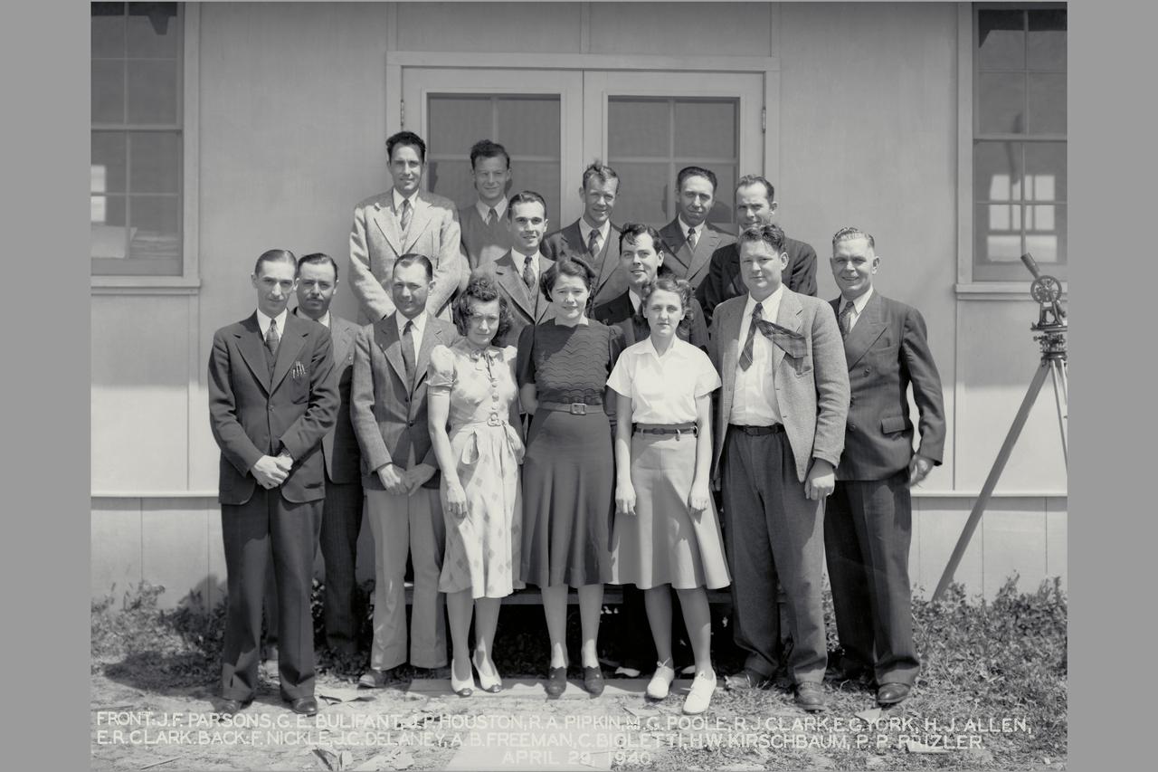
Arriving Engineers were John Parsons and Ferril Nickle (January 29, 1940) They were the first permanent members of the laboratory's staff on site. Other early arrivals from Langley were: Carlton Bioletti, March 1; Arthur B. Freeman, March 2; Edward R. Sharp, March 11; Manie G Poole, March 11; H. Julian Allen, April 13; Geroge E. Bulifant, April 17; Howard W. Krischbaum, April 29; and John P. Houston, April 29. Russ Robinson on-site representative of the construction group and their support staff E York, R Pippen.
This photograph of Dr. von Braun, shown here to the left of General Bruce Medaris, was taken in the fall of 1959, immediately prior to Medaris' retirement from the Army. At the time, von Braun and his associates worked for the Army Ballistics Missile Agency in Huntsville, Alabama. Those in the photograph have been identified as Ernst Stuhlinger, Frederick von Saurma, Fritz Mueller, Hermarn Weidner, E.W. Neubert (partially hidden), W.A. Mrazek, Karl Heimburg, Arthur Rudolph, Otto Hoberg, von Braun, Oswald Lange, Medaris, Helmut Hoelzer, Hans Maus, E.D. Geissler, Hans Heuter, and George Constan.

NASA’s Exploration Ground Systems Manager Shawn Quinn, right, moderates the inaugural Cross-Program Connection event at NASA Kennedy Space Center’s Space Station Processing Facility in Florida on March 8, 2023. Other participants, from left, are: Stacie Turner, Kennedy’s Deep Space Logistics; Dana Hutcherson, NASA’s Commercial Crew Program deputy program manager; and Arthur Muir, a retired Chicago attorney and America’s oldest Mt. Everest summiteer. Muir, 75, was the speaker at the event titled “Explorers Doing the Impossible.” He toured Kennedy before sharing his experiences in overcoming incredible challenges during his journey to the top of Earth’s highest mountain.
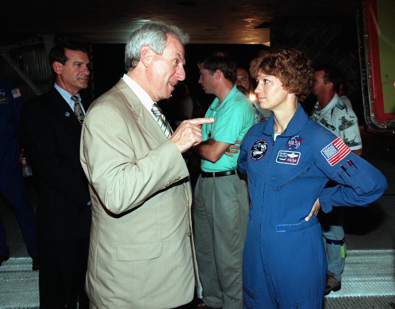
KENNEDY SPACE CENTER, FLA. -- At the Shuttle Landing Facility, NASA Administrator Daniel Goldin (foreground) talks with STS-93 Commander Eileen Collins beside the Space Shuttle orbiter Columbia following the successful completion of her mission. Marshall Space Flight Center Director Arthur G. Stephenson (far left) looks on. Landing occurred on runway 33 with main gear touchdown at 11:20:35 p.m. EDT on July 27. The mission's primary objective was to deploy the Chandra X-ray Observatory, which will allow scientists from around the world to study some of the most distant, powerful and dynamic objects in the universe. This was the 95th flight in the Space Shuttle program and the 26th for Columbia. The landing was the 19th consecutive Shuttle landing in Florida and the 12th night landing in Shuttle program history. On this mission, Collins became the first woman to serve as a Shuttle commander
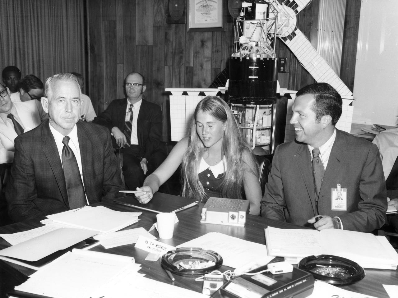
Kathy Jackson, high school student from Houston, Texas, discusses her experiment with Dr. Robert Allen (left) and her scintific advisor Arthur White, both of the Marshall Space Flight Center (MSFC). Miss Jackson’s experiment tested the motor sensory performance of an astronaut at various times during the Skylab flight to detect any degredation in his eye-hand coordination. She was one of the 25 winners of a contest in which some 3,500 high school students proposed experiments for the following year’s Skylab mission. Of the 25 students, 6 did not see their experiments conducted on Skylab because the experiments were not compatible with Skylab hardware and timelines. Of the 19 remaining, 11 experiments required the manufacture of equipment.
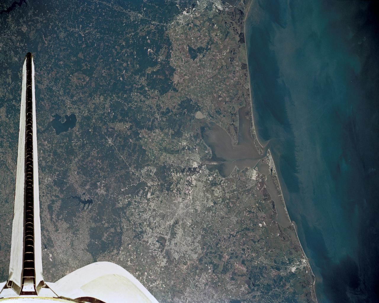
51J-143-126 (5 Oct. 1985) --- The vertical stabilizer of the Earth-orbiting Space Shuttle Atlantis serves to partially frame this scene of Metropolitan Houston. Hold photo with vertical tail at top so that north will be at top. America's fourth largest city, with its radiating highway network, lies at the junction between the East Texas piney woods, containing lakes Conroe and Livingston (near top center and top right, respectively), and the coastal prairie, now largely farmland (left side of frame). The coast stretches from the left at Freeport and the mouth of the Brazos River, past Galveston and Texas City, and the circle of the High Island Salt Dome (clearly seen at lower right near the Bolivar Peninsula), to Port Arthur on the Neches River (far right). Patterns of muddy and clear water are particularly well-displayed in Galveston and Trinity Bays, as well as in the Gulf of Mexico. With a close look, the Harris County Domed Stadium (Astrodome) can be recognized on Houston's south side. The NASA Johnson Space Center (JSC) and the Clear Lake City area are easily delineated some 25 miles southeast of downtown Houston. The scene was recorded on film by one of the STS-51J crewmembers using a handheld Hasselblad camera and 70mm film.
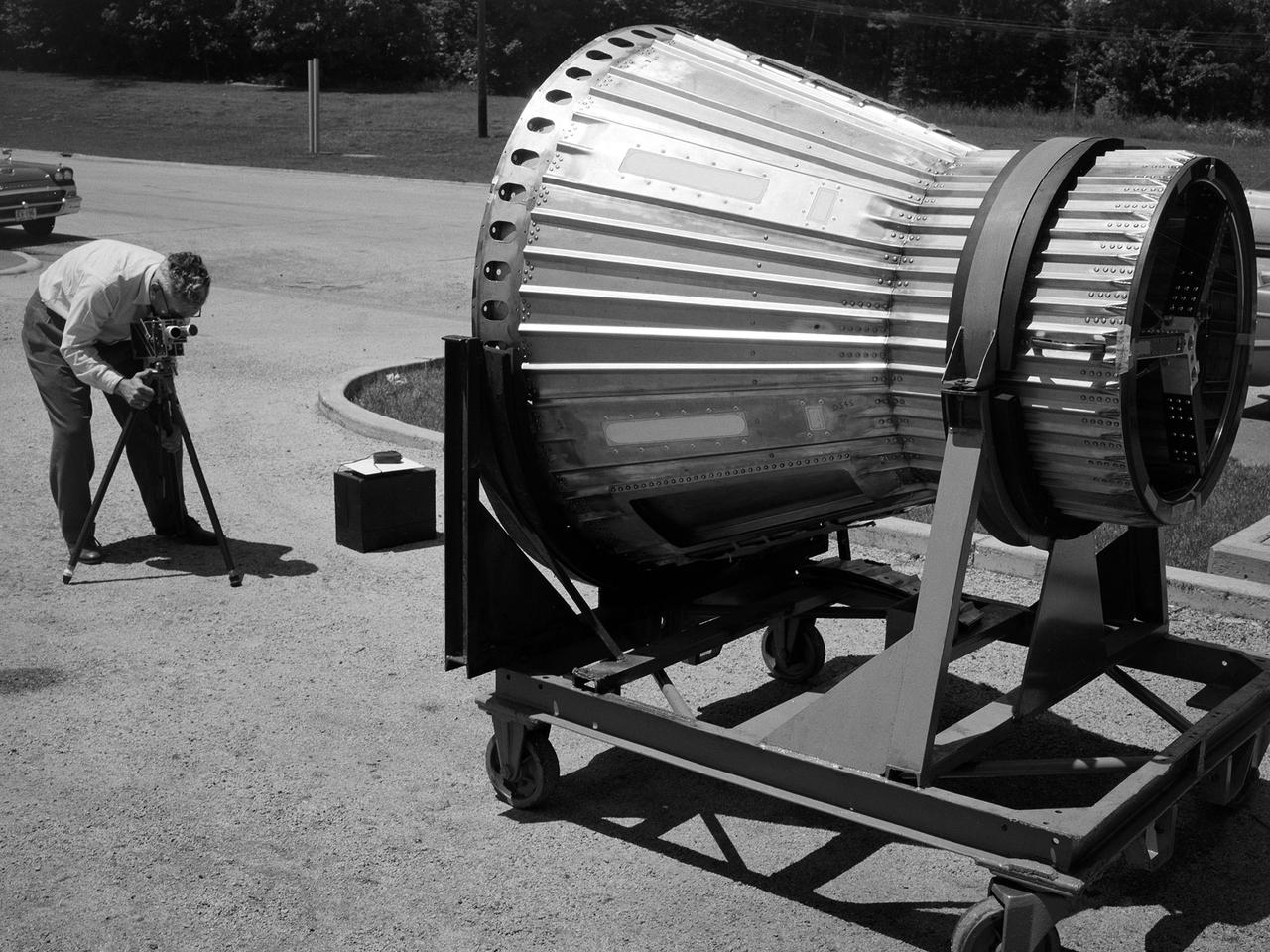
National Aeronautics and Space Administration (NASA) photographer Arthur Laufman sets up a camera to film a Mercury capsule that was constructed by the Lewis Research Center staff. Lewis engineers and mechanics built two of the capsules for the upcoming Big Joe launches in September 1959. Big Joe was an attempt early in Project Mercury to use a full-scale Atlas booster to simulate the reentry of a mock-up Mercury capsule without actually placing it in orbit. The Photographic Branch, referred to as the Photo Lab, was part of the center’s Technical Reports Division. Originally the group performed normal and high-speed still image and motion picture photography. The photographers documented construction, performed publicity work, created images for reports, photographed data on manometer boards, and recorded test footage. Laufman joined the Photo Lab staff in 1948 and began producing full-length technical films as a tool to educate those outside of the agency on the research being conducted at Lewis. He worked with engineers to determine proper subjects for these films and develop a script. Laufman not only filmed tests, but also supporting footage of facilities, models, and staff members. He then edited the footage and added audio, visuals, and narration. The film masters were assigned standard identification numbers and add to the Photo Lab’s catalogue.

ISS036-E-009405 (17 June 2013) --- One of the Expedition 36 crew members aboard the International Space Station, some 240 miles above Earth, used a 50mm lens to record this oblique nighttime image of a large part of the nation’s second largest state in area, including the four largest metropolitan areas in population. The extent of the metropolitan areas is easily visible at night due to city and highway lights. The largest metro area, Dallas-Fort Worth, often referred to informally as the Metroplex, is the heavily cloud-covered area at the top center of the photo. Neighboring Oklahoma, on the north side of the Red River, less than 100 miles to the north of the Metroplex, appears to be experiencing thunderstorms. The Houston metropolitan area, including the coastal city of Galveston, is at lower right. To the east near the Texas border with Louisiana, the metropolitan area of Beaumont-Port Arthur appears as a smaller blotch of light, also hugging the coast of the Texas Gulf. Moving inland to the left side of the picture one can delineate the San Antonio metro area. The capital city of Austin can be seen to the northeast of San Antonio. This and hundreds of thousands of other Earth photos taken by astronauts and cosmonauts over the past 50 years are available on http://eol.jsc.nasa.gov
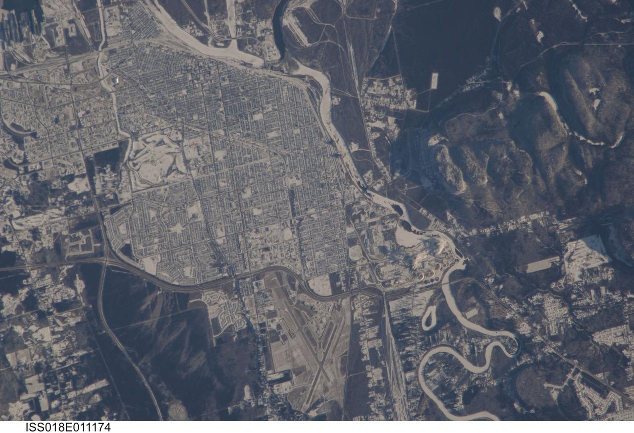
ISS018-E-011174 (6 Dec. 2008) --- The City of Thunder Bay, Ontario, Canada is featured in this image photographed by an Expedition 18 crewmember on the International Space Station. Located on the shores of Lake Superior, the metropolitan area of Thunder Bay is one of the largest in the Province of Ontario. It is also the major port providing access to the Great Lakes for central Canada?s grain products. The City of Thunder Bay is relatively new ? it was incorporated in 1970 by combining the cities of Fort William (depicted in this astronaut photograph) and Port Arthur with the townships of Neebing and McIntyre. While the growth and merging of separate municipalities into a larger contiguous metropolitan area is common (a process called agglomeration by urban geographers), it is less common for distinct cities to also merge into a new political entity. This detailed view is centered on the southern portion of Thunder Bay, comprised of the older city of Fort William. Winter snows outline the street grid of the city, while park areas interspersed throughout the street grid appear as roughly rectangular areas of unbroken white snow. Built materials appear light gray, while vegetated areas and rock outcrop near Mount McKay are dark green to dark gray. The Kam River to the south of Fort William is ice-covered, and has a homogeneous covering of snow that traces the river channel.
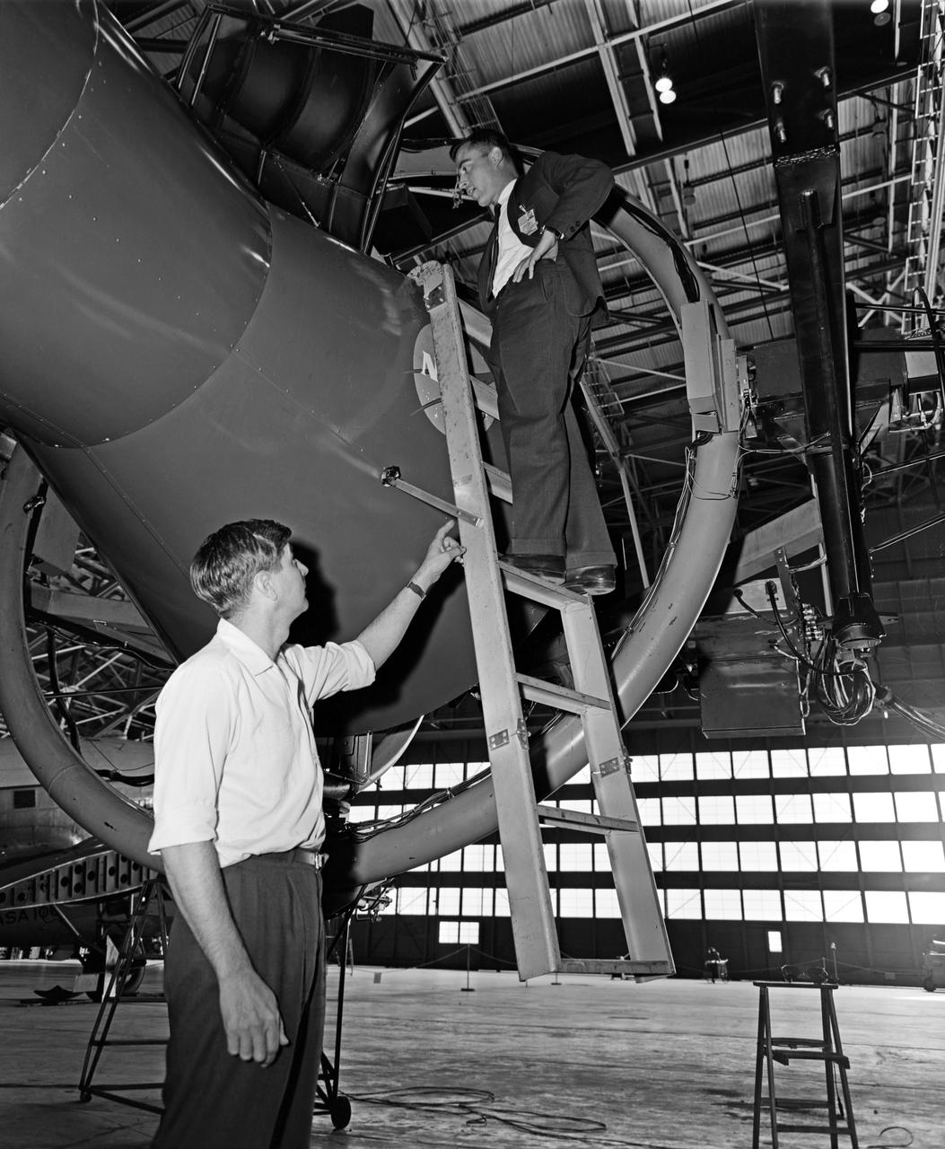
Astronaut John Young (above) was one of 14 astronauts, 8 NASA test pilots, and 2 McDonnell test pilots who took part in simulator studies. Young piloted the simulator on November 12, 1963 Arthur Vogeley wrote: "Many of the astronauts have flown this simulator in support of the Gemini studies and they, without exception, appreciated the realism of the visual scene. The simulator has also been used in the development of pilot techniques to handle certain jet malfunctions in order that aborts could be avoided. In these situations large attitude changes are sometimes necessary and the false motion cues that were generated due to earth gravity were somewhat objectionable; however, the pilots were readily able to overlook these false motion cues in favor of the visual realism." Roy F. Brissenden wrote: "The basic Gemini control studies developed the necessary techniques and demonstrated the ability of human pilots to perform final space docking with the specified Gemini-Agena systems using only visual references. ... Results... showed that trained astronauts can effect the docking with direct acceleration control and even with jet malfunctions as long as good visual conditions exist.... Probably more important than data results was the early confidence that the astronauts themselves gained in their ability to perform the maneuver in the ultimate flight mission." -- Published in Barton C. Hacker and James M. Grimwood, On the Shoulders of Titans: A History of Project Gemini, NASA SP-4203; A.W. Vogeley, "Discussion of Existing and Planned Simulators For Space Research," Paper presented at the Conference on the Role of Simulation in Space Technology, August 17-21, 1964; Roy F. Brissenden, "Initial Operations with Langley's Rendezvous Docking Facility," Langley Working Paper, LWP-21, 1964.
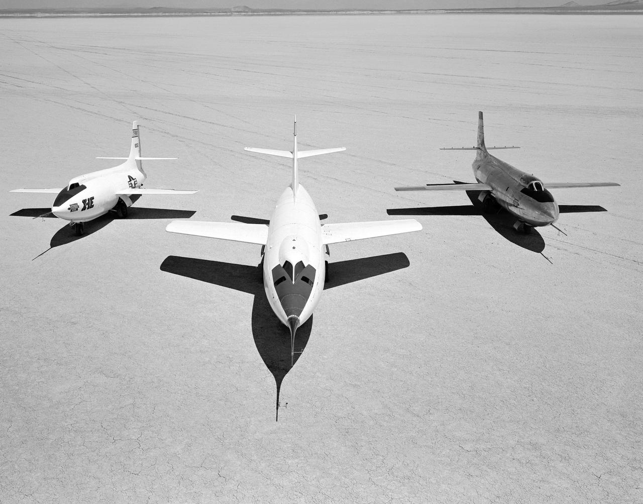
Early NACA research aircraft on the lakebed at the High Speed Research Station in 1955: Left to right: X-1E, D-558-II, X-1B