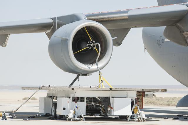
The volcanic ash distribution spider, shown here in the inlet of the engine while running, was used to send the ultra-fine particles of ash through the engine.
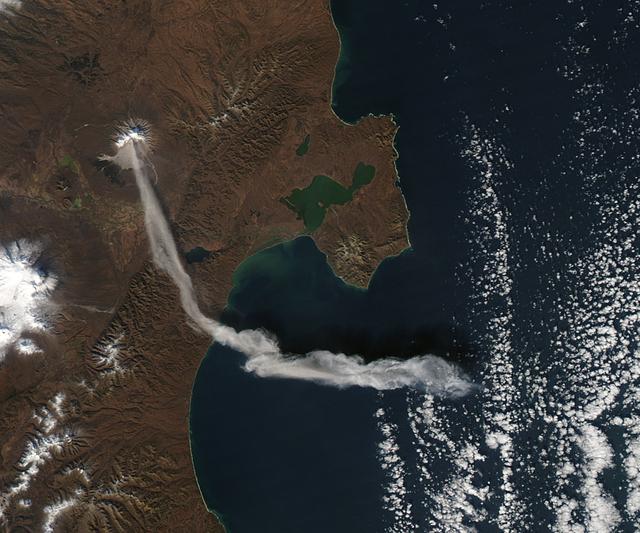
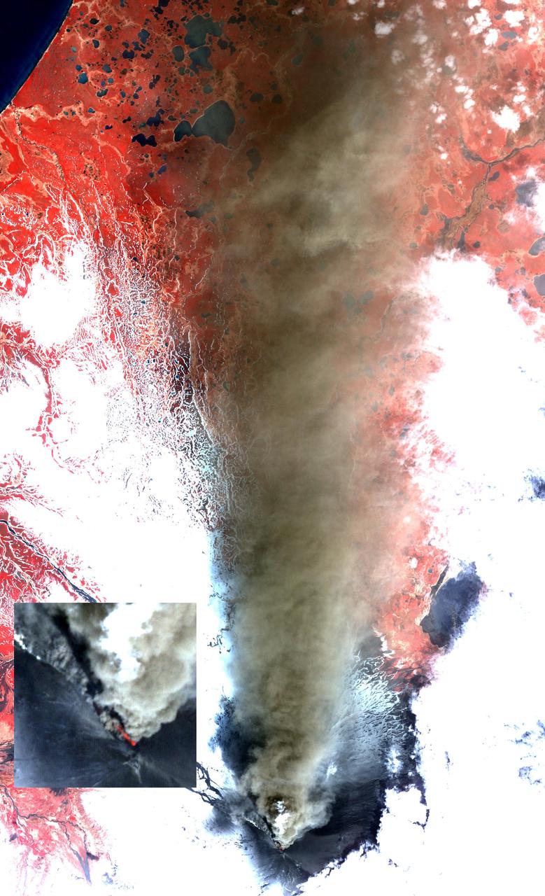
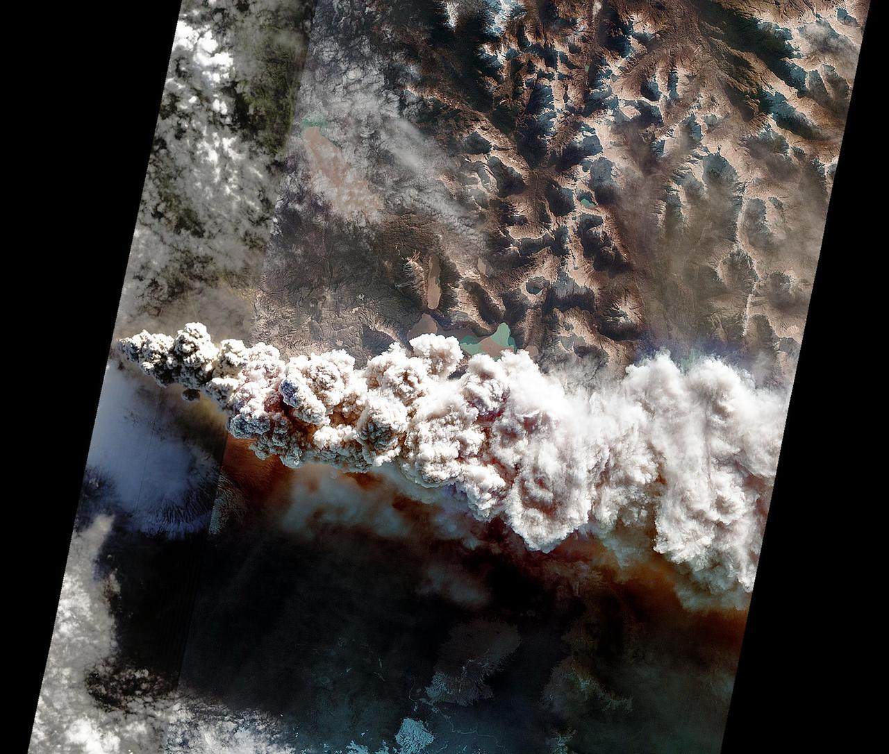
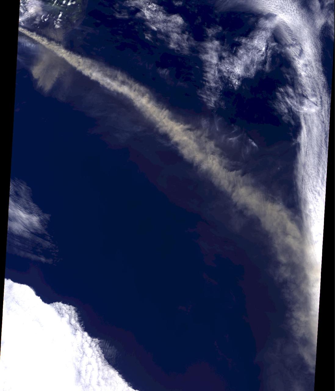
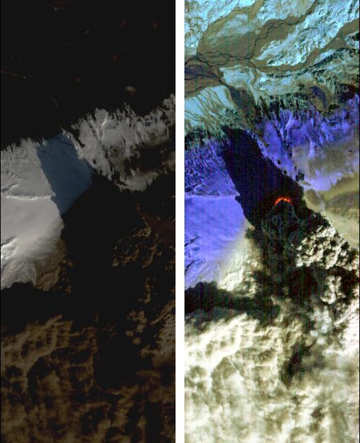
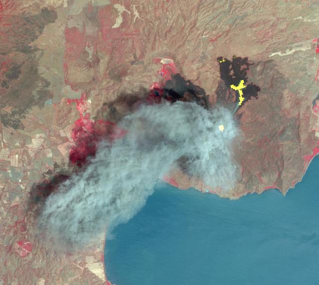
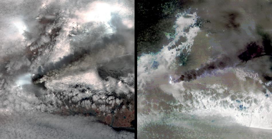
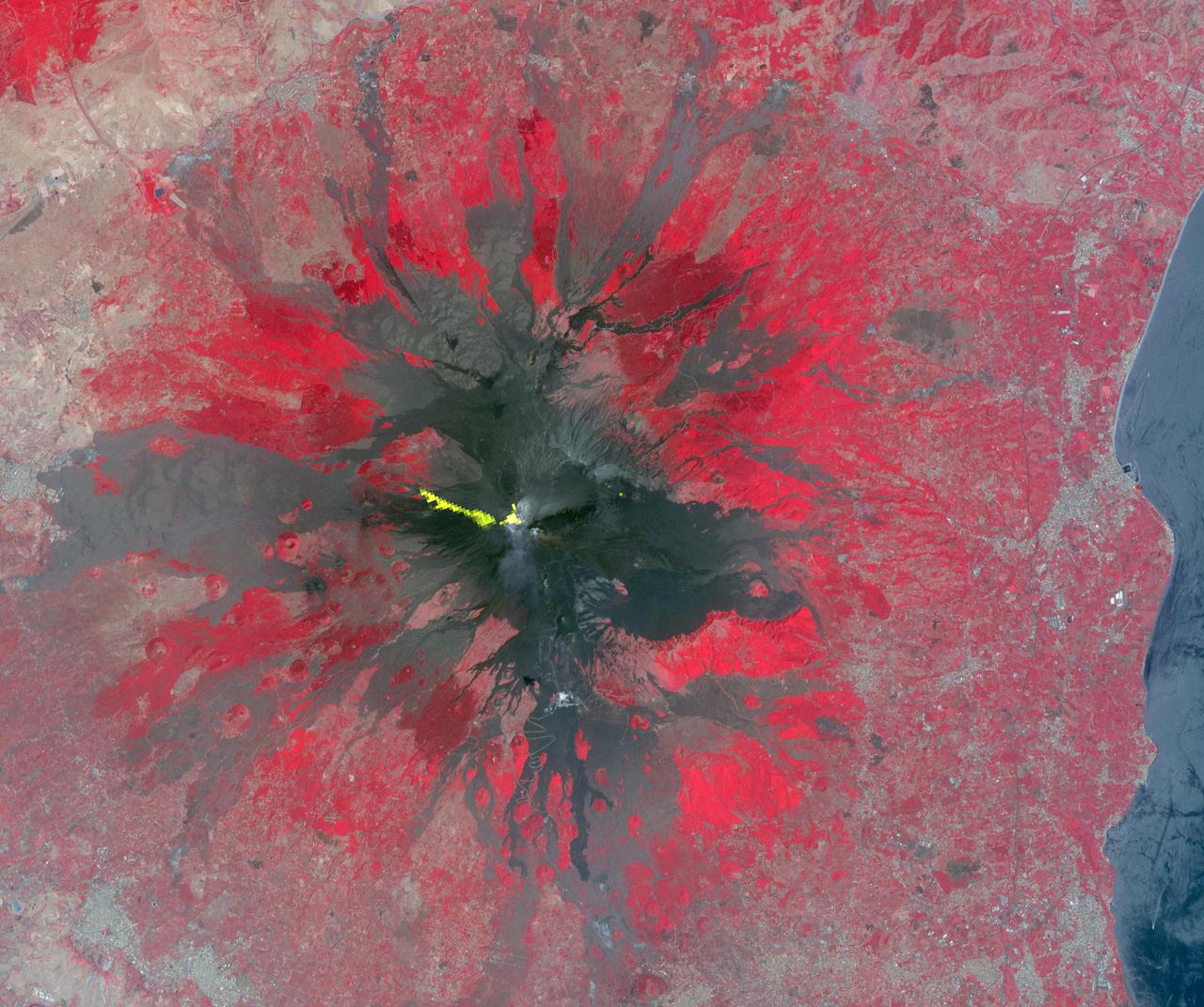
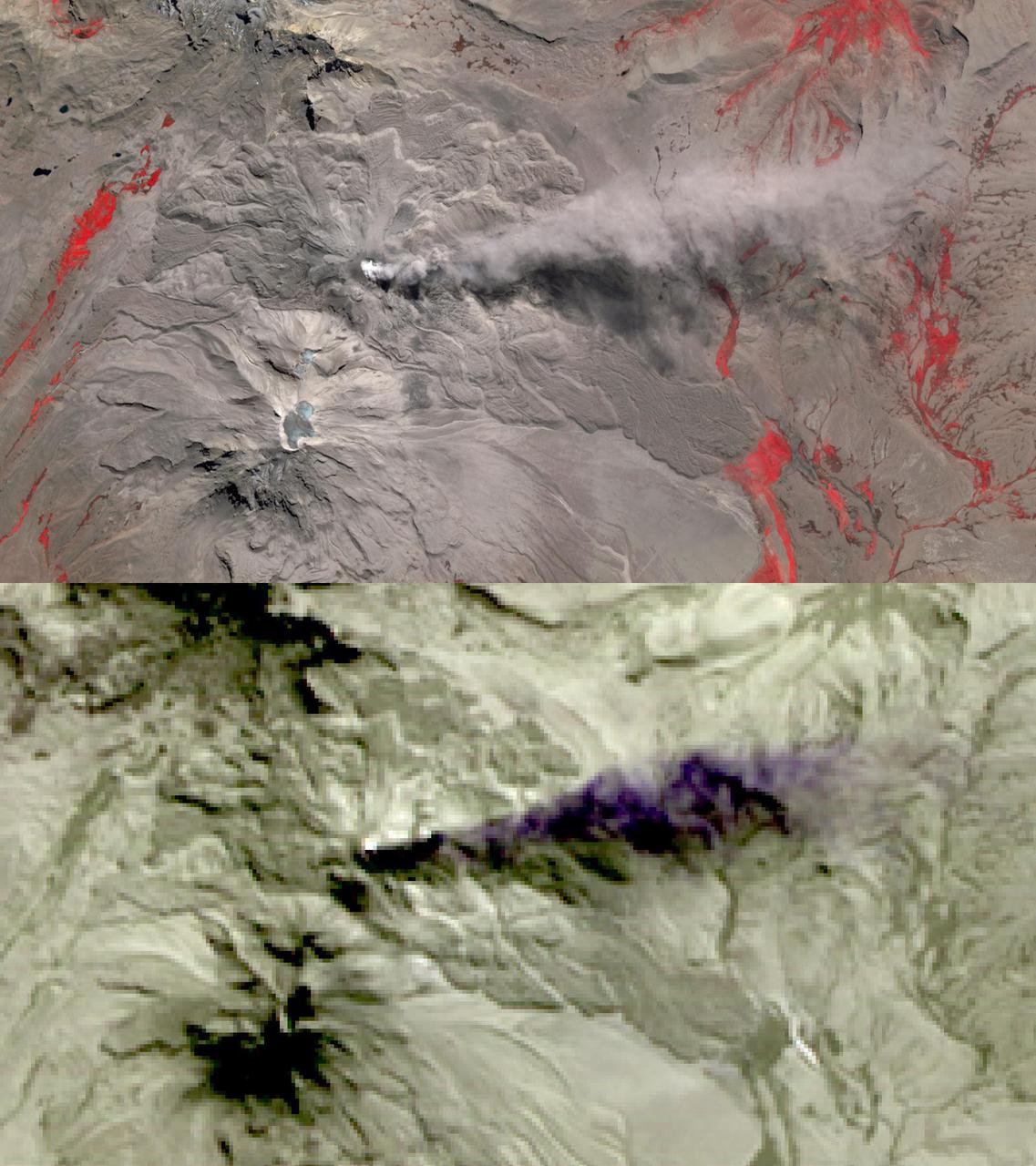
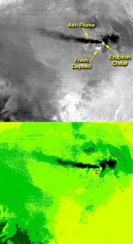
When NASA’s Terra satellite passed over Russia’s Kamchatka Peninsula at noon local time (00:00 Universal Time) on October 6, 2012, Shilveluch Volcano was quiet. By the time NASA’s Aqua satellite passed over the area two hours later (bottom image), the volcano had erupted and sent a plume of ash over the Kamchatskiy Zaliv. The plume traveled about 90 kilometers (55 miles) toward the south-southeast, where a change in wind direction began pushing the plume toward the east. On October 6, 2012, the Kamchatka Volcanic Emergency Response Team (KVERT) reported that the ash plume from Shiveluch reached an altitude of 3 kilometers (9,800 feet) above sea level, and had traveled some 220 kilometers (140 miles) from the volcano summit. Shiveluch (also spelled Sheveluch) ranks among the biggest and most active volcanoes on the Kamchatka Peninsula. Rising to 3,283 meters (10,771 feet) above sea level, Shiveluch is a stratovolcano composed of alternating layers of hardened lava, compacted ash, and rocks ejected by previous eruptions. The beige-colored expanse of rock on the volcano’s southern slopes (visible in both images) is due to an explosive eruption that occurred in 1964. Part of Shiveluch’s southern flank collapsed, and the light-colored rock is avalanche debris left by that event. High-resolution imagery of Shiveluch shows very little vegetation within that avalanche zone. On October 6, 2012, KVERT cited observations from the Moderate Resolution Imaging Spectroradiometer (MODIS) instruments on Terra and Aqua in detecting the Shiveluch eruption. This was not the first time that MODIS observed a Shiveluch eruption shortly after it started. In 2007, MODIS captured an image within minutes of the eruption’s start, before winds could blow the ash away from the summit. When NASA’s Terra satellite passed over Russia’s Kamchatka Peninsula at noon local time (00:00 Universal Time) on October 6, 2012, Shilveluch Volcano was quiet (top image). By the time NASA’s Aqua satellite passed over the area two hours later (bottom image), the volcano had erupted and sent a plume of ash over the Kamchatskiy Zaliv. The plume traveled about 90 kilometers (55 miles) toward the south-southeast, where a change in wind direction began pushing the plume toward the east. On October 6, 2012, the Kamchatka Volcanic Emergency Response Team (KVERT) reported that the ash plume from Shiveluch reached an altitude of 3 kilometers (9,800 feet) above sea level, and had traveled some 220 kilometers (140 miles) from the volcano summit. Shiveluch (also spelled Sheveluch) ranks among the biggest and most active volcanoes on the Kamchatka Peninsula. Rising to 3,283 meters (10,771 feet) above sea level, Shiveluch is a stratovolcano composed of alternating layers of hardened lava, compacted ash, and rocks ejected by previous eruptions. The beige-colored expanse of rock on the volcano’s southern slopes (visible in both images) is due to an explosive eruption that occurred in 1964. Part of Shiveluch’s southern flank collapsed, and the light-colored rock is avalanche debris left by that event. High-resolution imagery of Shiveluch shows very little vegetation within that avalanche zone. On October 6, 2012, KVERT cited observations from the Moderate Resolution Imaging Spectroradiometer (MODIS) instruments on Terra and Aqua in detecting the Shiveluch eruption. This was not the first time that MODIS observed a Shiveluch eruption shortly after it started. In 2007, MODIS captured an image within minutes of the eruption’s start, before winds could blow the ash away from the summit. Credit: <b><a href="http://www.earthobservatory.nasa.gov/" rel="nofollow"> NASA Earth Observatory</a></b> <b><a href="http://www.nasa.gov/audience/formedia/features/MP_Photo_Guidelines.html" rel="nofollow">NASA image use policy.</a></b> <b><a href="http://www.nasa.gov/centers/goddard/home/index.html" rel="nofollow">NASA Goddard Space Flight Center</a></b> enables NASA’s mission through four scientific endeavors: Earth Science, Heliophysics, Solar System Exploration, and Astrophysics. Goddard plays a leading role in NASA’s accomplishments by contributing compelling scientific knowledge to advance the Agency’s mission. <b>Follow us on <a href="http://twitter.com/NASA_GoddardPix" rel="nofollow">Twitter</a></b> <b>Like us on <a href="http://www.facebook.com/pages/Greenbelt-MD/NASA-Goddard/395013845897?ref=tsd" rel="nofollow">Facebook</a></b> <b>Find us on <a href="http://instagrid.me/nasagoddard/?vm=grid" rel="nofollow">Instagram</a></b>
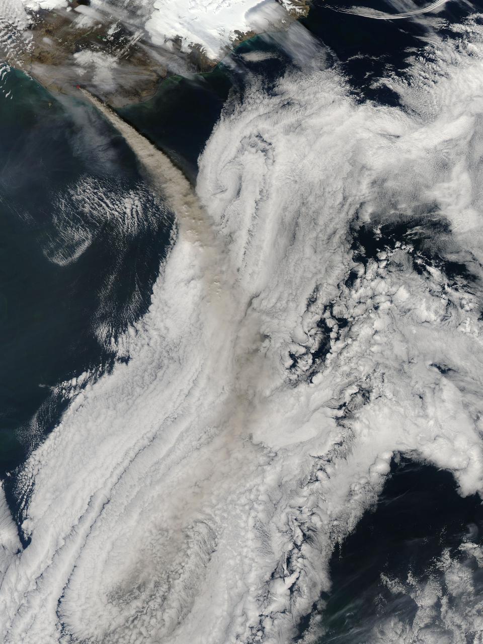
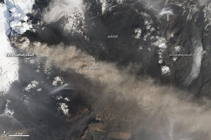
NASA image acquired May 8, 2010 at 13 :35 UTC Ash plume from Eyjafjallajokull Volcano, Iceland Satellite: Aqua NASA/GSFC/Jeff Schmaltz/MODIS Land Rapid Response Team <b><a href="http://www.nasa.gov/centers/goddard/home/index.html" rel="nofollow">NASA Goddard Space Flight Center</a></b> is home to the nation's largest organization of combined scientists, engineers and technologists that build spacecraft, instruments and new technology to study the Earth, the sun, our solar system, and the universe.

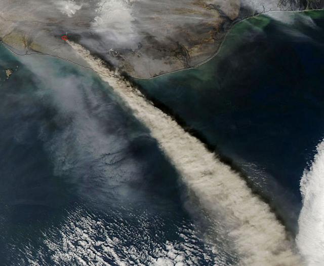
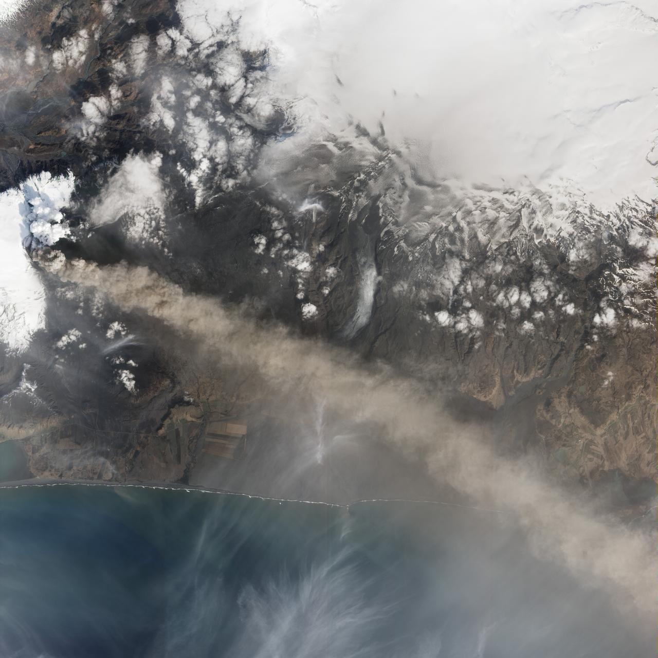
NASA satellite image acquired May 6, 2010 at 11 :55 UTC To view a detail of this image go to: <a href="http://www.flickr.com/photos/gsfc/4583711511/">www.flickr.com/photos/gsfc/4583711511/</a> NASA Satellite Sees a Darker Ash Plume From Iceland Volcano NASA's Terra satellite flew over the Eyjafjallajokull Volcano, Iceland, on May 6 at 11:55 UTC (7:55 a.m. EDT). The Moderate Resolution Imaging Spectroradiometer instrument known as MODIS that flies onboard Terra, captured a visible image of the ash plume. The plume was blowing east then southeast over the Northern Atlantic. The satellite image shows that the plume is at a lower level in the atmosphere than the clouds that lie to its east, as the brown plume appears to slide underneath the white clouds. Satellite: Terra NASA/GSFC/Jeff Schmaltz/MODIS Land Rapid Response Team To learn more about MODIS go to: <a href="http://www.nasa.gov/topics/earth/features/iceland-volcano-plume.html" rel="nofollow">www.nasa.gov/topics/earth/features/iceland-volcano-plume....</a> <b><a href="http://www.nasa.gov/centers/goddard/home/index.html" rel="nofollow">NASA Goddard Space Flight Center</a></b> is home to the nation's largest organization of combined scientists, engineers and technologists that build spacecraft, instruments and new technology to study the Earth, the sun, our solar system, and the universe.

This plot shows that a pulsar, the remnant of a stellar explosion, is surrounded by a disk of its own ashes. The disk, revealed by the two data points at the far right from NASA Spitzer Space Telescope, is the first ever found around a pulsar.
NASA image acquired May 8, 2010 at 13 :35 UTC Ash plume from Eyjafjallajokull Volcano, Iceland Satellite: Aqua NASA/GSFC/Jeff Schmaltz/MODIS Land Rapid Response Team <b><a href="http://www.nasa.gov/centers/goddard/home/index.html" rel="nofollow">NASA Goddard Space Flight Center</a></b> is home to the nation's largest organization of combined scientists, engineers and technologists that build spacecraft, instruments and new technology to study the Earth, the sun, our solar system, and the universe.
The Valley of Ten Thousand Smokes, located in Katmai National Park, forms a unique and ashen landscape. Encircled by volcanoes – both active and inactive – it has served as a perfect collection area for huge amounts of volcanic ash. According to the Alaska Historical Society (AHS), 2012 marked the centennial anniversary of the volcanic eruption that formed the valley, and led to the establishment, in 1918, of Katmai National Park. A massive eruption rocked the region on June 6, 1912 as the then-unknown volcano, Novarupta, became suddenly and violently active. According to the AHS, it erupted with “such force that mountains collapsed, ash darkened summer skies, earthquakes rocked population centers and were recorded as far away as Washington, D.C.” Glowing hot ash was reported to have smothered an area covering 40 square miles, and up to 700 feet deep. While the active volcanoes surrounding the valley - Novarupta, Mt. Mageik, Trident Volcano, Mt. Griggs, Mt. Martin and Mt. Katmai - have remained relatively quiescent, their ashen legacy continues to affect the landscape – and air traffic - even a century after it was laid down. The Moderate Resolution Imaging Spectroradiometer (MODIS) aboard NASA’s Terra satellite captured this true-color image on September 29, 2014. Volcanic ash from the Katmai region has been lifted aloft by strong winds, and is blowing to the southeast, over Shelikof Strait, Kodiak Island, and the Gulf of Alaska. Although such clouds are not from active volcanoes, the remobilized volcanic ash still provides a potential hazard to aircraft flying through the region. Credit: NASA/GSFC/Jeff Schmaltz/MODIS Land Rapid Response Team <b><a href="http://www.nasa.gov/audience/formedia/features/MP_Photo_Guidelines.html" rel="nofollow">NASA image use policy.</a></b> <b><a href="http://www.nasa.gov/centers/goddard/home/index.html" rel="nofollow">NASA Goddard Space Flight Center</a></b> enables NASA’s mission through four scientific endeavors: Earth Science, Heliophysics, Solar System Exploration, and Astrophysics. Goddard plays a leading role in NASA’s accomplishments by contributing compelling scientific knowledge to advance the Agency’s mission. <b>Follow us on <a href="http://twitter.com/NASAGoddardPix" rel="nofollow">Twitter</a></b> <b>Like us on <a href="http://www.facebook.com/pages/Greenbelt-MD/NASA-Goddard/395013845897?ref=tsd" rel="nofollow">Facebook</a></b> <b>Find us on <a href="http://instagram.com/nasagoddard?vm=grid" rel="nofollow">Instagram</a></b>

NASA satellite image acquired May 6, 2010 at 11 :55 UTC To view the full view go to: <a href="http://www.nasa.gov/topics/earth/features/iceland-volcano-plume.html" rel="nofollow">www.nasa.gov/topics/earth/features/iceland-volcano-plume....</a> NASA Satellite Sees a Darker Ash Plume From Iceland Volcano NASA's Terra satellite flew over the Eyjafjallajokull Volcano, Iceland, on May 6 at 11:55 UTC (7:55 a.m. EDT). The Moderate Resolution Imaging Spectroradiometer instrument known as MODIS that flies onboard Terra, captured a visible image of the ash plume. The plume was blowing east then southeast over the Northern Atlantic. The satellite image shows that the plume is at a lower level in the atmosphere than the clouds that lie to its east, as the brown plume appears to slide underneath the white clouds. Satellite: Terra NASA/GSFC/Jeff Schmaltz/MODIS Land Rapid Response Team To learn more about MODIS go to: <a href="http://rapidfire.sci.gsfc.nasa.gov/gallery/?latest" rel="nofollow">rapidfire.sci.gsfc.nasa.gov/gallery/?latest</a> <b><a href="http://www.nasa.gov/centers/goddard/home/index.html" rel="nofollow">NASA Goddard Space Flight Center</a></b> is home to the nation's largest organization of combined scientists, engineers and technologists that build spacecraft, instruments and new technology to study the Earth, the sun, our solar system, and the universe.
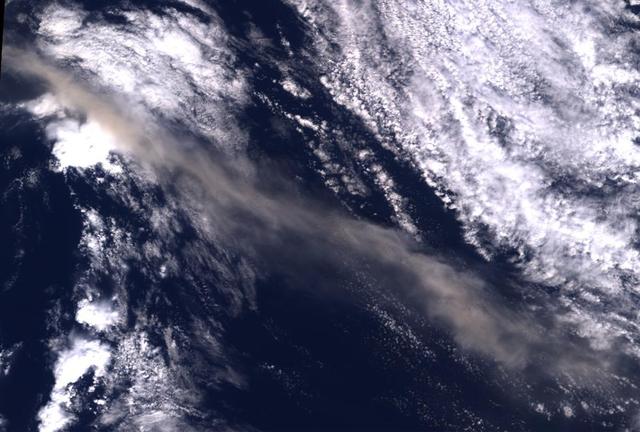
NASA Aqua satellite flew over the volcano on April 15, capturing this image of the ash plume. The image shows the ash cloud being carried over the Shetland Islands and onward to Europe.
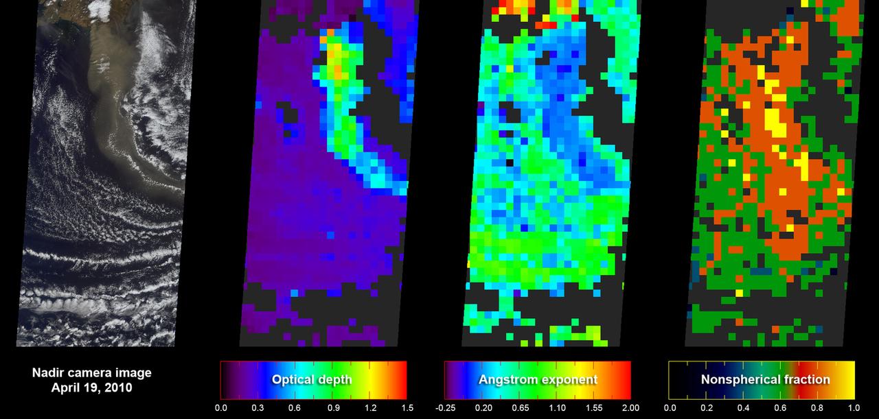
This image from NASA Terra spacecraft shows the ash plume of Iceland Eyjafyallajökull Volcano on April 19, 2010. The eruption plume and drifting veil of ash appear to be homogeneous.
Ash from Iceland Eyjafjallajökull volcano, viewed here in imagery from NASA Terra spacecraft on May 16, 2010, once again disrupted air traffic over Europe with the closure of major airports in the United Kingdom and the Netherlands.
As NASA Terra satellite flew over Iceland erupting Eyjafjallajökull volcano, its Multi-angle Imaging SpectroRadiometer instrument acquired 36 near-simultaneous images of the ash plume, covering nine view angles in each of four wavelengths.
When NASA's Terra satellite flew over the Puyehue-Cordon Caulle volcano on July 8, 2011 at 14:25 UTC (10:25 a.m. EDT) it captured this visible image of a steady stream of ash (light brown) blowing southeast into Argentina. The Puyehue-Cordón Caulle Volcano is located in the Andes Mountains of central Chile, near the Argentina border. Image: NASA Goddard/MODIS Rapid Response Team, Jeff Schmaltz Text: NASA Goddard/Rob Gutro <b><a href="http://www.nasa.gov/centers/goddard/home/index.html" rel="nofollow">NASA Goddard Space Flight Center</a></b> enables NASA’s mission through four scientific endeavors: Earth Science, Heliophysics, Solar System Exploration, and Astrophysics. Goddard plays a leading role in NASA’s accomplishments by contributing compelling scientific knowledge to advance the Agency’s mission. <b>Follow us on <a href="http://twitter.com/NASA_GoddardPix" rel="nofollow">Twitter</a></b> <b>Like us on <a href="http://www.facebook.com/pages/Greenbelt-MD/NASA-Goddard/395013845897?ref=tsd" rel="nofollow">Facebook</a></b> <b>Find us on <a href="http://web.stagram.com/n/nasagoddard/?vm=grid" rel="nofollow">Instagram</a></b>
Alaska Pavlof volcano, located along Alaska Aleutian Peninsula, sent a low-level ash plume north-northeast about 37.3 miles 60 kilometers on May 19, 2013, when this image was acquired NASA Terra spacecraft.
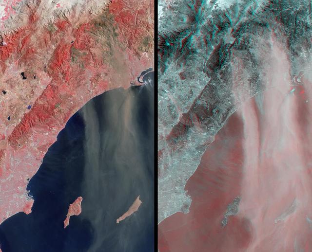
This anaglyph from the MISR instrument aboard NASA Terra spacecraft shows Santa Ana winds swept large amounts of dust and ash across the skies of San Diego and over the Pacific Ocean. 3D glasses are necessary to view this image.
This image from NASA Terra spacecraft shows ash plumes from Eyjafjallajökull Volcano, Iceland stretching over the North Atlantic; the volcano erupted on April 14, 2010 bringing closure to major airports in Europe.

NASA's ASTER (Advanced Spaceborne Thermal Emission and Reflection Radiometer)captured these images of Guatemala's Fuego volcano on Nov. 24, following a recent eruption. The main image shows the lava flows on the flanks of Fuego (upper left corner) in light gray. Vegetation is shown in red, clouds in white, and city and fields in dark gray. A thick ash plume rising from the peak of the volcano and more diffuse ash clouds over the southern part of the scene are also visible. The thermal infrared composite highlights the ash clouds in orange, with a dark orange cloud over the summit where the ash is thickest. White areas are relatively warmer; Fuego's summit is bright white at the active crater. https://photojournal.jpl.nasa.gov/catalog/PIA22820
NASA satellite image acquired May 2, 2010 To see the full view of this image go to: <a href="http://www.flickr.com/photos/gsfc/4584266582/">www.flickr.com/photos/gsfc/4584266582/</a> Ash and steam continued billowing from Eyjafjallajökull Volcano in early May 2010. The Advanced Land Imager (ALI) on NASA’s Earth Observing-1 (EO-1) satellite captured this natural-color image on May 2, 2010. The volcano’s summit is near the left edge of this image, capped by a dark plume. The plume is dull gray-brown, indicating that its principal visible component is volcanic ash. Ash from the plume blows toward the east-southeast, passing over a charcoal-colored ash field on the land surface. Just to the north of Eyjafjallajökull’s summit are white puffs of steam, likely from surface lava flows vaporizing snow and glacial ice. On May 4, 2010, the Icelandic Meteorological Office warned that Eyjafjallajökull showed no signs of ending its eruptive activity in the near future. The Met Office reported that ash from the volcano had reached a height of 5.8 to 6.0 kilometers (19,000 to 20,000 feet) above sea level, and had spread 65 to 80 kilometers (40 to 50 miles) east-southeast of the volcano, where it impeded visibility for local residents. The Met Office also reported that lava continued flowing down a steep hill north of the crater. NASA image by Robert Simmon, using ALI data from the EO-1 team. Caption by Michon Scott. Instrument: EO-1 – ALI To view other images from the Earth Observatory go to: <a href="http://earthobservatory.nasa.gov/" rel="nofollow">earthobservatory.nasa.gov/</a> <b><a href="http://www.nasa.gov/centers/goddard/home/index.html" rel="nofollow">NASA Goddard Space Flight Center</a></b> is home to the nation's largest organization of combined scientists, engineers and technologists that build spacecraft, instruments and new technology to study the Earth, the sun, our solar system, and the universe.
NASA satellite image acquired May 2, 2010 To view a detail of this image go to: <a href="http://www.flickr.com/photos/gsfc/4584266734/">www.flickr.com/photos/gsfc/4584266734/</a> Ash and steam continued billowing from Eyjafjallajökull Volcano in early May 2010. The Advanced Land Imager (ALI) on NASA’s Earth Observing-1 (EO-1) satellite captured this natural-color image on May 2, 2010. The volcano’s summit is near the left edge of this image, capped by a dark plume. The plume is dull gray-brown, indicating that its principal visible component is volcanic ash. Ash from the plume blows toward the east-southeast, passing over a charcoal-colored ash field on the land surface. Just to the north of Eyjafjallajökull’s summit are white puffs of steam, likely from surface lava flows vaporizing snow and glacial ice. On May 4, 2010, the Icelandic Meteorological Office warned that Eyjafjallajökull showed no signs of ending its eruptive activity in the near future. The Met Office reported that ash from the volcano had reached a height of 5.8 to 6.0 kilometers (19,000 to 20,000 feet) above sea level, and had spread 65 to 80 kilometers (40 to 50 miles) east-southeast of the volcano, where it impeded visibility for local residents. The Met Office also reported that lava continued flowing down a steep hill north of the crater. NASA image by Robert Simmon, using ALI data from the EO-1 team. Caption by Michon Scott. Instrument: EO-1 – ALI To view other images from the Earth Observatory go to: <a href="http://earthobservatory.nasa.gov/" rel="nofollow">earthobservatory.nasa.gov/</a> <b><a href="http://www.nasa.gov/centers/goddard/home/index.html" rel="nofollow">NASA Goddard Space Flight Center</a></b> is home to the nation's largest organization of combined scientists, engineers and technologists that build spacecraft, instruments and new technology to study the Earth, the sun, our solar system, and the universe.
Sheveluch Volcano in Kamchatka, Siberia, is one of the frequently active volcanoes located in eastern Siberia. In this image from NASA Terra spacecraft, brownish ash covers the southern part of the mountain, under an ash-laden vertical eruption plume.
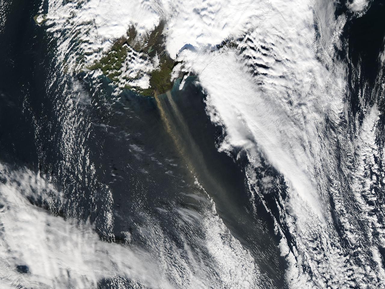
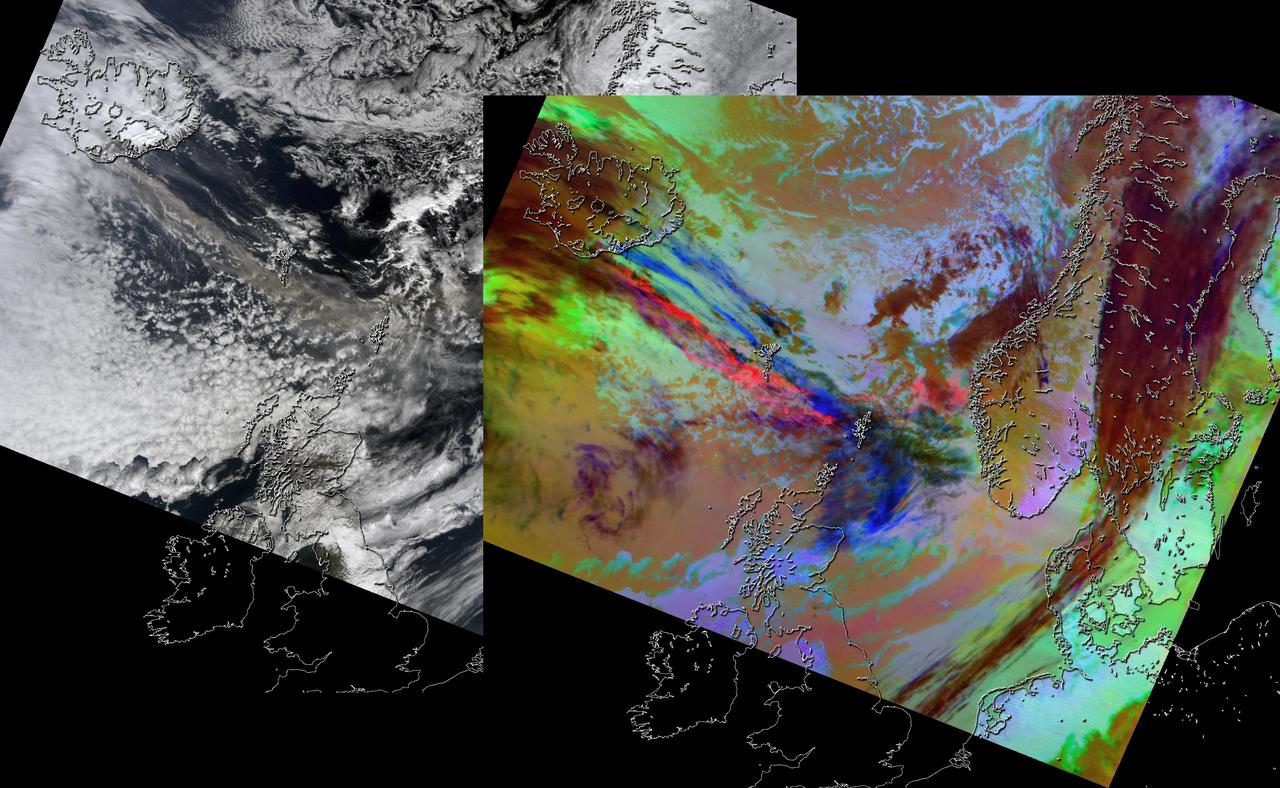
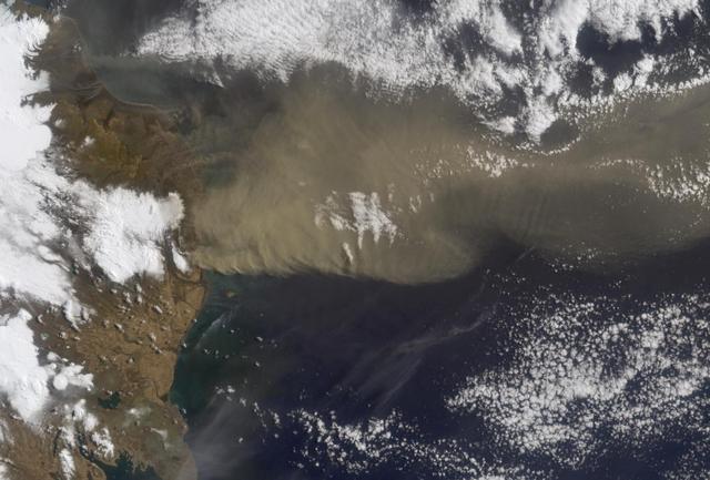
On September 16, 2013 the Moderate Resolution Imaging Spectroradiometer (MODIS) aboard NASA’s Aqua satellite passed over the southern tip of Iceland and captured a remarkable image dust plumes blowing hundreds of kilometers over the Atlantic Ocean. The westernmost plume is dark tan in color and so thick that the blue ocean waters are obscured from view near Iceland's coast. The eastern plume appears broader, thinner and light gray in color. According to the Icelandic Met Office, near the Mýrdalsjökull and Vatnajökull ice-caps there are vast glacial outwash plains which stretch from the glacial margins to the sea. These plains, formed by melt water from glaciers, are known as sandur. Strong northerly winds frequently blow dust from the sandur plains far from the shore. This particular dust plume originates to the east of the Mýrdalsjökull ice cap. The Katla volcano, one of the largest in Iceland, lies under the Mýrdalsjökull glacier and in the general region of the westernmost plume. Katla has a history of large, violent eruptions occurring on an average of every 50-100 years. The volcano has been increasingly restless since 1999, with increased seismicity in recent years. In 2011 a very small eruption was reported, with minimal damage. Because of the increasing restlessness and the dangerous nature of historic eruptions, the volcano is currently carefully monitored. None of the monitoring agencies reported eruption at Katla in mid-September of this year. Credit: NASA/GSFC/Jeff Schmaltz/MODIS Land Rapid Response Team <b><a href="http://www.nasa.gov/audience/formedia/features/MP_Photo_Guidelines.html" rel="nofollow">NASA image use policy.</a></b> <b><a href="http://www.nasa.gov/centers/goddard/home/index.html" rel="nofollow">NASA Goddard Space Flight Center</a></b> enables NASA’s mission through four scientific endeavors: Earth Science, Heliophysics, Solar System Exploration, and Astrophysics. Goddard plays a leading role in NASA’s accomplishments by contributing compelling scientific knowledge to advance the Agency’s mission. <b>Follow us on <a href="http://twitter.com/NASA_GoddardPix" rel="nofollow">Twitter</a></b> <b>Like us on <a href="http://www.facebook.com/pages/Greenbelt-MD/NASA-Goddard/395013845897?ref=tsd" rel="nofollow">Facebook</a></b> <b>Find us on <a href="http://instagram.com/nasagoddard?vm=grid" rel="nofollow">Instagram</a></b>
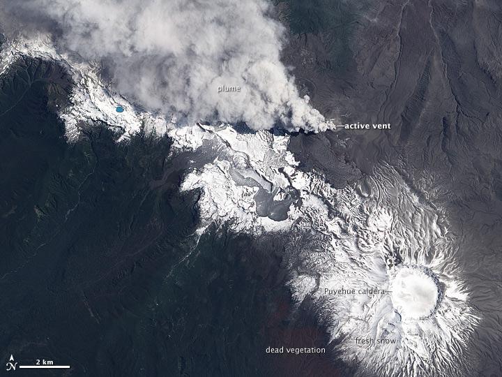
NASA image acquired December 23, 2011 In early June 2011, Chile’s Puyehue-Cordón Caulle Volcano erupted explosively, sending volcanic ash around the Southern Hemisphere. In late December 2011, activity at the volcano had calmed, but volcanic ash and steam continued to pour through the fissure that opened several months earlier. The Advanced Land Imager (ALI) on NASA’s Earth Observing-1 (EO-1) satellite captured this natural-color image on December 23, 2011. The active fissure lies northwest of the Puyehue caldera, and a plume blows from the fissure toward the west and north. This image shows not just ash but also snow on the volcano surface, including the caldera. Because volcanic ash regularly coats the land surface, the pristine snow probably fell recently. In a bulletin issued December 26, 2011, Chile’s Servicio Nacional de Geología y Minería (SERNAGEOMIN) characterized the activity over the previous 24 hours as a minor eruption of low intensity. Reaching an altitude of 2,236 meters (7,336 feet), Puyehue-Cordón Caulle is a stratovolcano, a steep-sloped, conical volcano composed of layers of ash, lava, and rocks released by previous eruptions. This volcano comprises part of the largest active geothermal area in the southern Andes. NASA Earth Observatory image created by Jesse Allen, using EO-1 ALI data provided courtesy of the NASA EO-1 team. Caption by Michon Scott. Instrument: EO-1 - ALI To view more images from this event go here: <a href="http://earthobservatory.nasa.gov/NaturalHazards/event.php?id=50859" rel="nofollow">earthobservatory.nasa.gov/NaturalHazards/event.php?id=50859</a> Credit: <b><a href="http://www.earthobservatory.nasa.gov/" rel="nofollow"> NASA Earth Observatory</a></b> <b><a href="http://www.nasa.gov/audience/formedia/features/MP_Photo_Guidelines.html" rel="nofollow">NASA image use policy.</a></b> <b><a href="http://www.nasa.gov/centers/goddard/home/index.html" rel="nofollow">NASA Goddard Space Flight Center</a></b> enables NASA’s mission through four scientific endeavors: Earth Science, Heliophysics, Solar System Exploration, and Astrophysics. Goddard plays a leading role in NASA’s accomplishments by contributing compelling scientific knowledge to advance the Agency’s mission. <b>Follow us on <a href="http://twitter.com/NASA_GoddardPix" rel="nofollow">Twitter</a></b> <b>Like us on <a href="http://www.facebook.com/pages/Greenbelt-MD/NASA-Goddard/395013845897?ref=tsd" rel="nofollow">Facebook</a></b> <b>Find us on <a href="http://instagrid.me/nasagoddard/?vm=grid" rel="nofollow">Instagram</a></b>
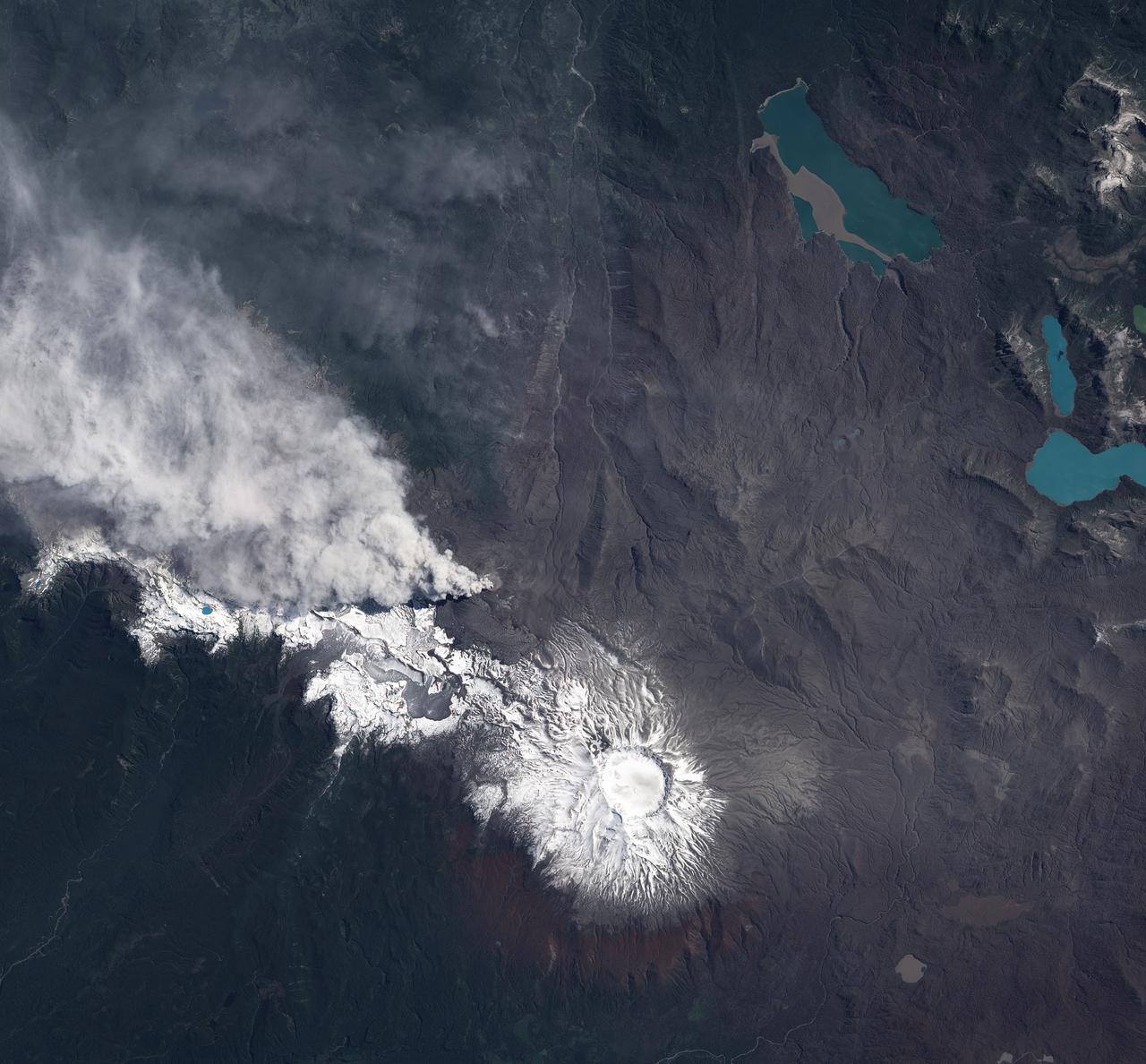
NASA image acquired December 23, 2011 In early June 2011, Chile’s Puyehue-Cordón Caulle Volcano erupted explosively, sending volcanic ash around the Southern Hemisphere. In late December 2011, activity at the volcano had calmed, but volcanic ash and steam continued to pour through the fissure that opened several months earlier. The Advanced Land Imager (ALI) on NASA’s Earth Observing-1 (EO-1) satellite captured this natural-color image on December 23, 2011. The active fissure lies northwest of the Puyehue caldera, and a plume blows from the fissure toward the west and north. This image shows not just ash but also snow on the volcano surface, including the caldera. Because volcanic ash regularly coats the land surface, the pristine snow probably fell recently. In a bulletin issued December 26, 2011, Chile’s Servicio Nacional de Geología y Minería (SERNAGEOMIN) characterized the activity over the previous 24 hours as a minor eruption of low intensity. Reaching an altitude of 2,236 meters (7,336 feet), Puyehue-Cordón Caulle is a stratovolcano, a steep-sloped, conical volcano composed of layers of ash, lava, and rocks released by previous eruptions. This volcano comprises part of the largest active geothermal area in the southern Andes. NASA Earth Observatory image created by Jesse Allen, using EO-1 ALI data provided courtesy of the NASA EO-1 team. Caption by Michon Scott. Instrument: EO-1 - ALI To view more images from this event go here: <a href="http://earthobservatory.nasa.gov/NaturalHazards/event.php?id=50859" rel="nofollow">earthobservatory.nasa.gov/NaturalHazards/event.php?id=50859</a> Credit: <b><a href="http://www.earthobservatory.nasa.gov/" rel="nofollow"> NASA Earth Observatory</a></b> <b><a href="http://www.nasa.gov/audience/formedia/features/MP_Photo_Guidelines.html" rel="nofollow">NASA image use policy.</a></b> <b><a href="http://www.nasa.gov/centers/goddard/home/index.html" rel="nofollow">NASA Goddard Space Flight Center</a></b> enables NASA’s mission through four scientific endeavors: Earth Science, Heliophysics, Solar System Exploration, and Astrophysics. Goddard plays a leading role in NASA’s accomplishments by contributing compelling scientific knowledge to advance the Agency’s mission. <b>Follow us on <a href="http://twitter.com/NASA_GoddardPix" rel="nofollow">Twitter</a></b> <b>Like us on <a href="http://www.facebook.com/pages/Greenbelt-MD/NASA-Goddard/395013845897?ref=tsd" rel="nofollow">Facebook</a></b> <b>Find us on <a href="http://instagrid.me/nasagoddard/?vm=grid" rel="nofollow">Instagram</a></b>
NASA image acquired December 4, 2010 After a respite of less than a month, Klyuchevskaya Volcano resumed erupting in late November 2010. The Global Volcanism Program reported several ash plumes that rose up to 7.9 kilometers (26,000 feet) above sea level from November 25–29. According to the Kamchatka Volcanic Eruption Response Team (KVERT) seismicity was “slightly above background levels” on November 26th and 27th, and they reported observations of strombolian activity on December 1st and 2nd. A plume of ash, steam, and other volcanic gases streamed from Klyuchevskaya on December 4, 2010, visible in this natural-color image acquired by the Advanced Land Imager (ALI) aboard the Earth Observing-1 (EO-1) satellite. In the large image, a much smaller plume is visible above neighboring Bezymianny Volcano. NASA Earth Observatory image by Jesse Allen & Robert Simmon, using ALI data from the NASA EO-1 team. Caption by Robert Simmon. Instrument: EO-1 - ALI Credit: <b><a href="http://www.earthobservatory.nasa.gov/" rel="nofollow"> NASA Earth Observatory</a></b> <b><a href="http://www.nasa.gov/centers/goddard/home/index.html" rel="nofollow">NASA Goddard Space Flight Center</a></b> enables NASA’s mission through four scientific endeavors: Earth Science, Heliophysics, Solar System Exploration, and Astrophysics. Goddard plays a leading role in NASA’s accomplishments by contributing compelling scientific knowledge to advance the Agency’s mission. <b>Follow us on <a href="http://twitter.com/NASA_GoddardPix" rel="nofollow">Twitter</a></b> <b>Join us on <a href="http://www.facebook.com/pages/Greenbelt-MD/NASA-Goddard/395013845897?ref=tsd" rel="nofollow">Facebook</a></b>
On June 14, 2011, NASA Earth Observing-1 EO-1 spacecraft obtained this image showing ash-rich volcanic plume billowing out of the vent, punching through a low cloud layer. The plume grey color is a reflection of its ash content.
Popocatepetl, Mexico's most active volcano, erupted on February 23, sending blocks and bombs down the volcano's flanks, and emitting an ash column 1 km above the summit. Two days later, an ash cloud was still seen coming from the volcano. The thermal infrared color composite reveals a hot spot (red) at the summit crater. The dark red color near the vent of the east-blowing ash cloud suggests that its composition is dominantly ash material; further downwind, the color changes to purple, suggesting that some of the ash particles may be ice-covered. The images were acquired February 25, 2020, cover an area of 18 by 22.5 km, and are located at 19 degrees north, 98.6 degrees west. https://photojournal.jpl.nasa.gov/catalog/PIA23680
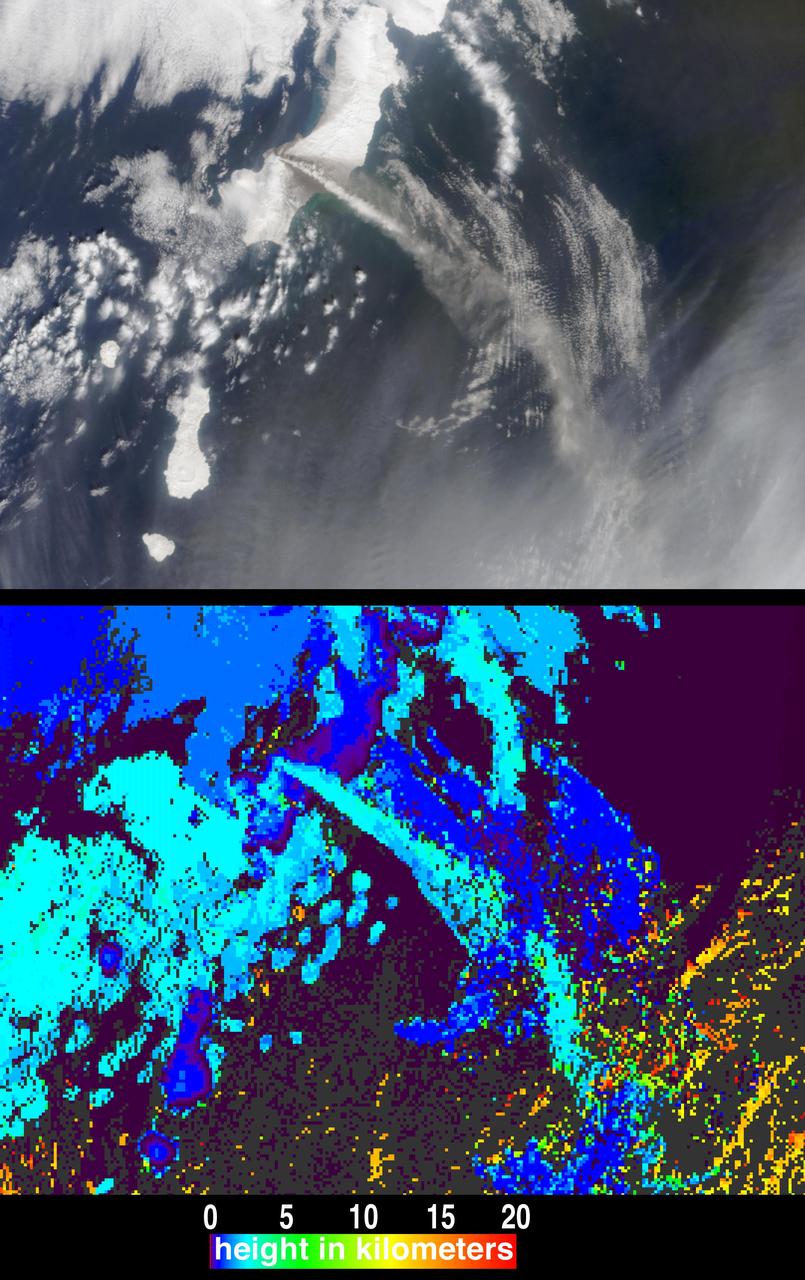
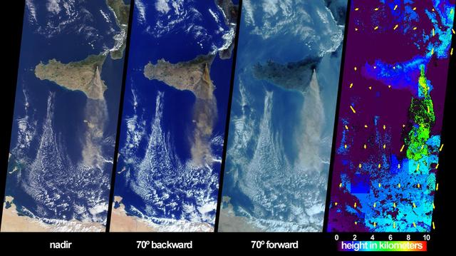
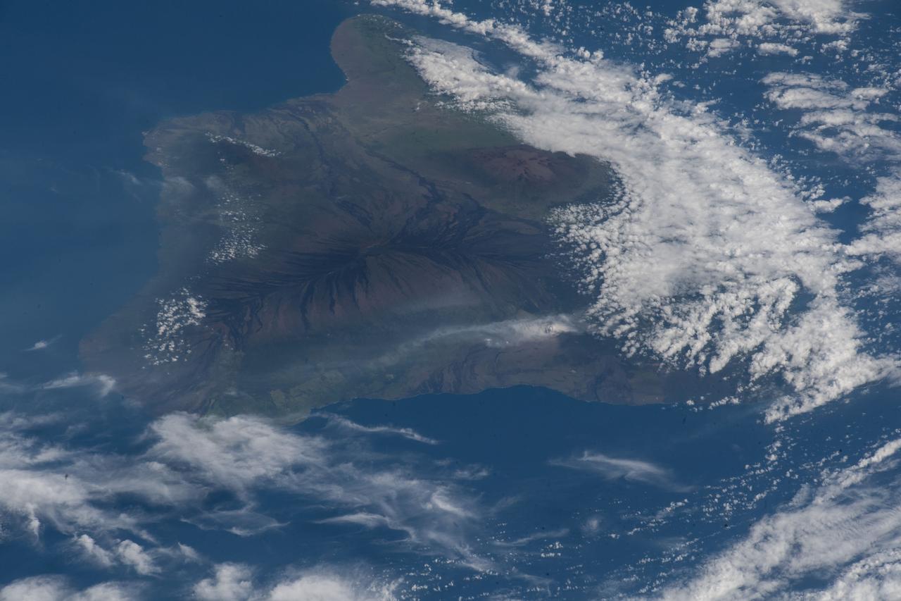
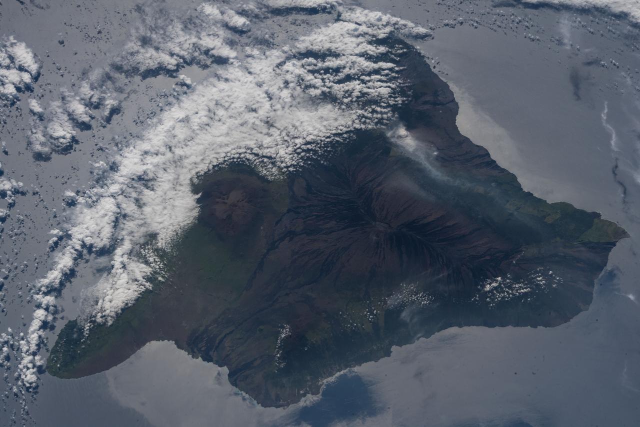
On May 3, 2018, a new eruption began at a fissure of the Kilauea volcano on the Island of Hawaii. Kilauea is the most active volcano in the world, having erupted almost continuously since 1983. Advancing lava and dangerous sulfur dioxide gas have forced thousands of residents in the neighborhood of Leilani Estates to evacuate. A number of homes have been destroyed, and no one can say how soon the eruption will abate and evacuees can return home. On May 6, 2018, at approximately 11 a.m. local time, the Multi-angle Imaging SpectroRadiometer (MISR) instrument on NASA's Terra satellite captured this view of the island as it passed overhead. Much of the island was shrouded by clouds, including the fissure on its eastern point. However, an eruption plume is visible streaming southwest over the ocean. The MISR instrument is unique in that it has nine cameras that view Earth at different angles: one pointing downward, four at various angles in the forward direction, and four in the backward direction. This image shows the view from one of MISR's forward-pointing cameras (60 degrees), which shows the plume more distinctly than the near-vertical views. The information from the images acquired at different view angles is used to calculate the height of the plume, results of which are superimposed on the right-hand image. The top of the plume near the fissure is at approximately 6,500 feet (2,000 meters) altitude, and the height of the plume decreases as it travels south and west. These relatively low altitudes mean that the ash and sulfur dioxide remained near the ground, which can cause health issues for people on the island downwind of the eruption. The "Ocean View" air quality monitor operated by the Clean Air Branch of the State of Hawaii Department of Health recorded a concentration of 18 μg/m3 of airborne particles less than 2.5 micrometers in diameter at 11 a.m. local time. This amount corresponds to an air quality rating of "moderate" and supports the MISR results indicating that ash was most likely present at ground level on this side of the island. These data were acquired during Terra orbit 97780. An annotated version is available at https://photojournal.jpl.nasa.gov/catalog/PIA22451
The height and motion of the ash and gas plume from the April 22, 2003, eruption of the Chikurachki volcano is portrayed in these views NASA Terra spacecraft.
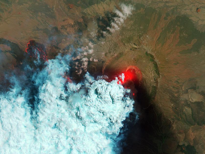
NASA image acquired June 24, 2011 Since it began erupting on June 12, 2011, emissions from Eritrea’s Nabro Volcano have drifted over much of East Africa and the Middle East. Ash has displaced residents living near the volcano and disrupted flights in the region. Despite the volcano’s widespread effects, little is known about the eruption. Nabro is located in an isolated region along the border between Eritrea and Ethiopia, and few English-language reports have been published. Satellite remote sensing is currently the only reliable way to monitor the ongoing eruption. This satellite image is among the first detailed pictures of the erupting vent and lava flows. They were acquired by the Advanced Land Imager (ALI) aboard the Earth Observing-1 (EO-1) satellite on June 24, 2011. The bright red portions of the false-color image (top) indicate hot surfaces. Hot volcanic ash glows above the vent, located in the center of Nabro’s caldera. To the west of the vent, portions of an active lava flow (particularly the front of the flow) are also hot. The speckled pattern on upstream portions of the flow are likely due to the cool, hardened crust splitting and exposing fluid lava as the flow advances. The bulbous blue-white cloud near the vent is likely composed largely of escaping water vapor that condensed as the plume rose and cooled. The whispy, cyan clouds above the lava flow are evidence of degassing from the lava. NASA Earth Observatory image by Robert Simmon, using EO-1 ALI data. Caption by Robert Simmon. Instrument: EO-1 - ALI To download the high res go here: <a href="http://earthobservatory.nasa.gov/IOTD/view.php?id=51216" rel="nofollow">earthobservatory.nasa.gov/IOTD/view.php?id=51216</a> <b><a href="http://www.nasa.gov/centers/goddard/home/index.html" rel="nofollow">NASA Goddard Space Flight Center</a></b> enables NASA’s mission through four scientific endeavors: Earth Science, Heliophysics, Solar System Exploration, and Astrophysics. Goddard plays a leading role in NASA’s accomplishments by contributing compelling scientific knowledge to advance the Agency’s mission. <b>Follow us on <a href="http://twitter.com/NASA_GoddardPix" rel="nofollow">Twitter</a></b> <b>Like us on <a href="http://www.facebook.com/pages/Greenbelt-MD/NASA-Goddard/395013845897?ref=tsd" rel="nofollow">Facebook</a></b> <b>Find us on <a href="http://web.stagram.com/n/nasagoddard/?vm=grid" rel="nofollow">Instagram</a></b>
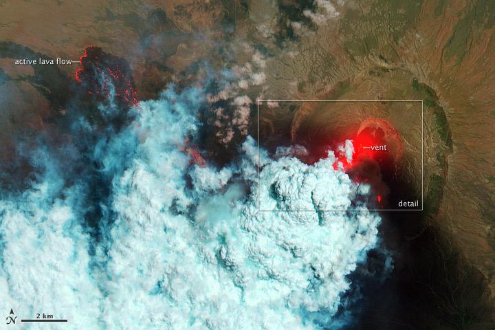
NASA image acquired June 24, 2011 Since it began erupting on June 12, 2011, emissions from Eritrea’s Nabro Volcano have drifted over much of East Africa and the Middle East. Ash has displaced residents living near the volcano and disrupted flights in the region. Despite the volcano’s widespread effects, little is known about the eruption. Nabro is located in an isolated region along the border between Eritrea and Ethiopia, and few English-language reports have been published. Satellite remote sensing is currently the only reliable way to monitor the ongoing eruption. This satellite image is among the first detailed pictures of the erupting vent and lava flows. They were acquired by the Advanced Land Imager (ALI) aboard the Earth Observing-1 (EO-1) satellite on June 24, 2011. The bright red portions of the false-color image (top) indicate hot surfaces. Hot volcanic ash glows above the vent, located in the center of Nabro’s caldera. To the west of the vent, portions of an active lava flow (particularly the front of the flow) are also hot. The speckled pattern on upstream portions of the flow are likely due to the cool, hardened crust splitting and exposing fluid lava as the flow advances. The bulbous blue-white cloud near the vent is likely composed largely of escaping water vapor that condensed as the plume rose and cooled. The whispy, cyan clouds above the lava flow are evidence of degassing from the lava. NASA Earth Observatory image by Robert Simmon, using EO-1 ALI data. Caption by Robert Simmon. Instrument: EO-1 - ALI To download the high res go here: <a href="http://earthobservatory.nasa.gov/IOTD/view.php?id=51216" rel="nofollow">earthobservatory.nasa.gov/IOTD/view.php?id=51216</a> <b><a href="http://www.nasa.gov/centers/goddard/home/index.html" rel="nofollow">NASA Goddard Space Flight Center</a></b> enables NASA’s mission through four scientific endeavors: Earth Science, Heliophysics, Solar System Exploration, and Astrophysics. Goddard plays a leading role in NASA’s accomplishments by contributing compelling scientific knowledge to advance the Agency’s mission. <b>Follow us on <a href="http://twitter.com/NASA_GoddardPix" rel="nofollow">Twitter</a></b> <b>Like us on <a href="http://www.facebook.com/pages/Greenbelt-MD/NASA-Goddard/395013845897?ref=tsd" rel="nofollow">Facebook</a></b> <b>Find us on <a href="http://web.stagram.com/n/nasagoddard/?vm=grid" rel="nofollow">Instagram</a></b>
The height and southward extent of the ash plume emanating from Sicily Mount Etna volcano on October 27, 2002 are captured in these four image panels from NASA Terra spacecraft.
This image of Africa Nabro volcano in Eritrea was acquired by NASA Terra spacecraft on July 6, 2011. Ash plumes sent into the stratosphere disrupted air traffic in Sudan, Djibouti, Ethiopia and Sudan.
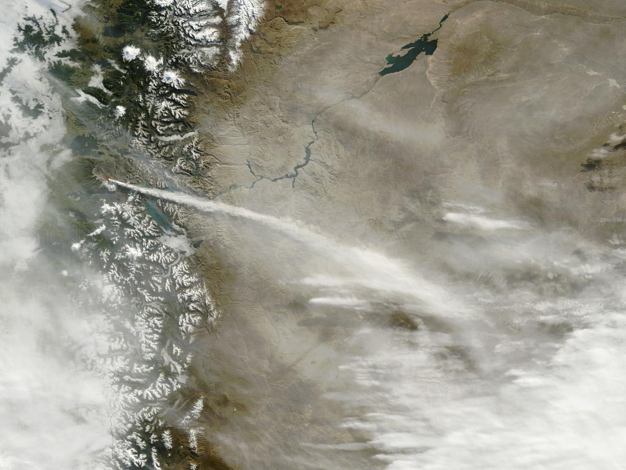
Iceland Eyjafjallajökull volcano produced its second major ash plume beginning on May 7, 2010. NASA Terra satellite passed just east of the volcano mid-morning and captured this image the same day.
On Feb. 13, 2014, violent eruption of Kelud stratovolcano in Java, Indonesia sent volcanic ash covering an area of 70,000 square miles, prompting the evacuation of tens of thousands of people. This image is from NASA Terra spacecraft.
This NASA Terra satellite image of Mount St. Helens was captured one week after the March 8, 2005 ash and steam eruption, the latest activity since the volcano reawakening in September 2004.
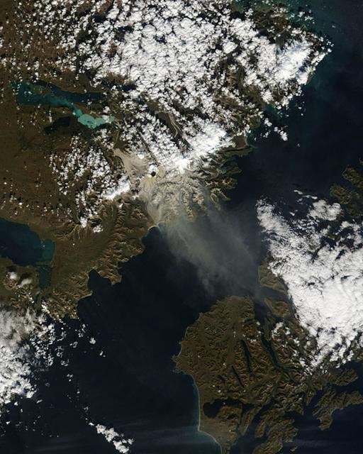
On April 15, 2010, NASA Terra spacecraft captured these images of the ongoing eruption of Iceland Eyjafjallajökull Volcano, which continues to spew ash into the atmosphere and impact air travel worldwide.
On Saturday, April 17, 2010, NASA Earth Observing-1 EO-1 spacecraft obtained this pair of images of the continuing eruption of Iceland Eyjafjallajökull volcano. On the left, new black ash deposits are visible on the ground.
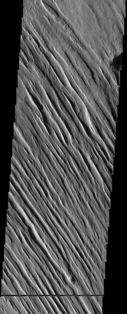
The wind-sculpted yardangs in this scene from NASA Mars Odyssey spacecraft are part of the Medusae Fossae Formation, a regionally extensive geologic unit that probably was produced from the accumulation of volcanic ash.
On Nov. 8, 2010, the ASTER instrument onboard NASA Terra spacecraft captured an image of the hot volcanic flows from Merapi volcano that resulted from continued collapse of the summit lava dome, and the ensuing release of ash plumes.
On Feb. 25, 2011, NASA Terra spacecraft captured this image of a large ash-laden eruption plume drifting towards the northeast from Kizimen volcano, an isolated stratovolcano, in Kamchatka, Russia.
In Dec. 2015, one of Nicaragua largest volcanoes, Momotombo, erupted for the first time since 1905. NASA Terra spacecraft acquired this image showing large ash columns and pyroclasitc flows.
After lying dormant for 70 years, Cotopaxi volcano in Ecuador started erupting the week of Aug. 17, 2015. NASA Terra spacecraft acquired this image on August 22, showing huge columns of ash that affected towns in the region.
Plosky Tolbachik volcano, in Russia far eastern Kamchatka peninsula, erupted on Nov. 27, 2012 for the first time in 35 years, sending clouds of ash almost 10,000 feet into the sky. This image was acquired by NASA Terra spacecraft.
Winter still grips the volcanoes on Russia Kamchatka peninsula. NASA Terra spacecraft acquired this image showing the mantle of white, disturbed by dark ash entirely covering Sheveluch volcano from recent eruptions.
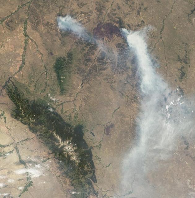
On July 2, 2012, NASA MISR instrument on NASA Terra spacecraft passed over the Horse Creek Fire and much larger Ash Creek Fire Complex in southeastern Montana, to the east of Billings, Mont.
On April 28, 2014, NASA Terra spacecraft spotted signs of activity at Ubinas volcano in the Peruvian Andes. The appearance of a new lava dome in March 2014 and frequent ash emissions are signs of increasing activity at this volcano.
This image acquired by NASA Terra spacecraft is of the Valley of Ten Thousand Smokes. Located in Katmai National Park, Alaska, the park is filled with ash flows from the 1912 eruption of Novarupta.
NASA Terra satellite flew directly over Iceland on April 19, 2010 and captured this image of the Eyjafjallajökull volcano and its erupting ash plume. 3D glasses are necessary to view this image.
NASA Terra spacecraft captured this pair of images of Iceland Eyjafyallajökull volcano on May 3, 2010. On this day, Ireland closed its airspace for several hours due to presence of ash over the country.
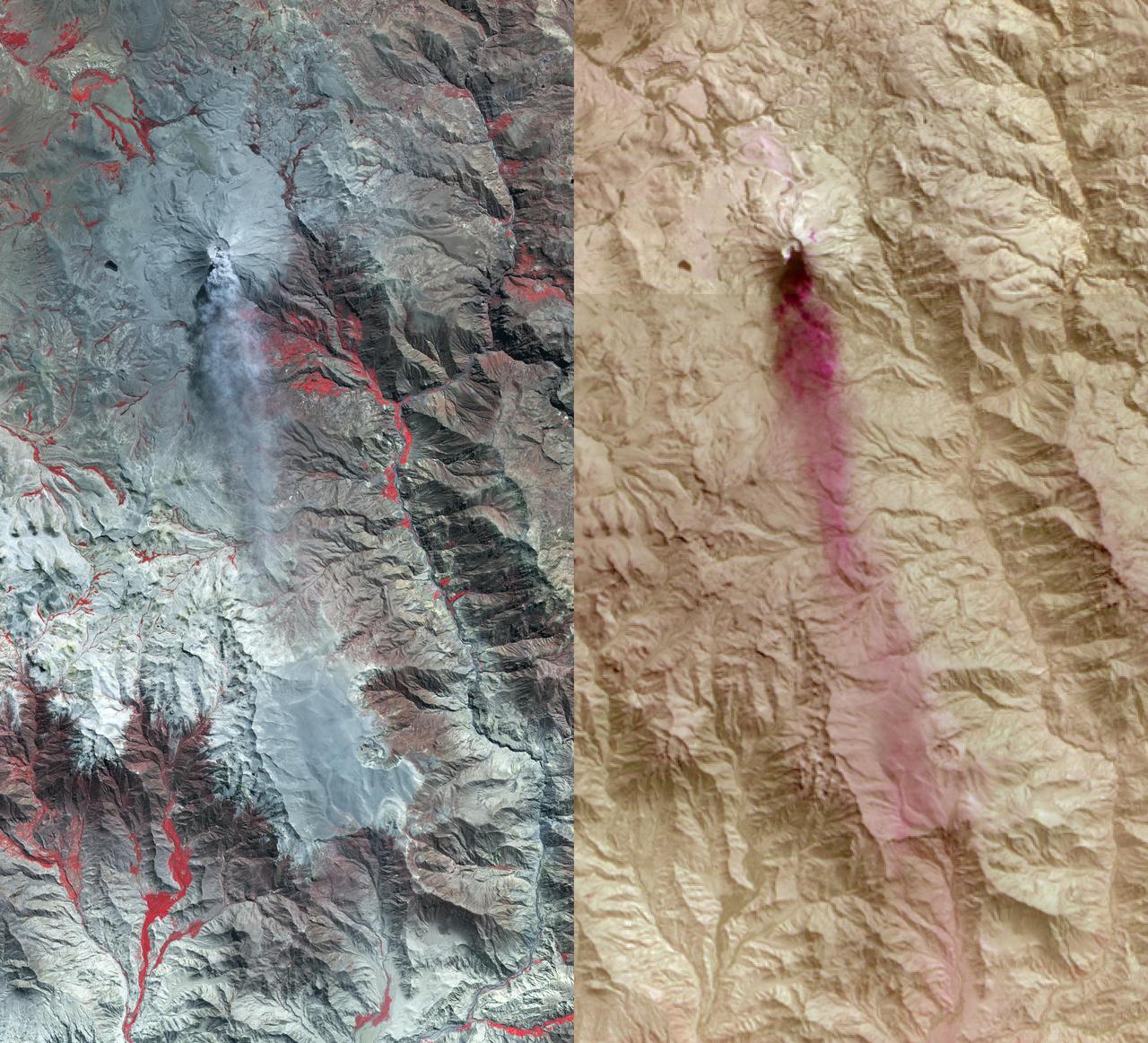
Dramatic changes have been observed at the Eyjafjallajökull volcano in Iceland by NASA's Earth Observing 1 (EO-1) spacecraft. On May 2, 2010, the Hyperion hyperspectral imager on EO-1 imaged Eyjafjallajökull and identified the extent of a lava flow extending northwards from the main eruption vent. This lava flow had been previously reported by volcanologists in Iceland, and is slowly carving its way north through the ice cap. The image on the left (Figure 1) is at visible wavelengths, and shows the persistent dark volcanic plume emanating from the main vent. This plume is still rich in ash, hence its brown coloration. This ash is still causing problems, threatening new airspace closures over parts of Europe. Large cracks at the edge of the crater are an indication of the extent of ice removal from the icecap during the eruption. To the north of this vent is another plume that is very white. This second plume is the result of ice being boiled off, generally non-explosively, by the heat from the silicate lava flow. As a result this plume is probably comprised mostly of water vapour. The black lava shows up clearly against the ice in the left-hand image. The image in the center (Figure 2) is a false-color image in the short-wavelength infrared. In this image, ice appears as blue and hot pixels appear as red. Very hot pixels appear as yellow and white. Red pixels, visible though the plume chart the extent of the lava flow, which has extended some 1.8 kilometers (1.1 miles) northwards from the area of the vent that is emitting the most energy. Total heat loss on May 2 was estimated to be at least 300 megawatts. The image on the right (Figure 3) shows the lava flow on May 4, 2010. The entire lava channel is now exposed, most of the overlying ice having been removed and the white plume has mostly disappeared. Without the plume obscuring heat loss from the lava flow, a better estimate of heat loss can be made. On May 4, the volcano was emitting at least 1,600 megawatts of energy. Each image covers an area measuring 7.7 kilometers (4.8 miles) wide, and has a resolution of 30 meters (98 feet) per pixel. The vertical direction is north-northeast. http://photojournal.jpl.nasa.gov/catalog/PIA13098
Mt. Etna, Italy erupted Tuesday, February 16, 2021, sending rivers of lava down the southeast flank of the volcano, and spewing ashes and volcanic stones over nearby villages. Sicily's Catania Airport was temporarily closed due to an ash plume that rose to 3700 m altitude. The ASTER nighttime thermal infrared data shows the extent of the active lava flows, draped over an older Google Earth image. The image was acquired February 17, 2021, covers an area of 38 by 39 km, and is located at 37.8 degrees north, 15 degrees east. https://photojournal.jpl.nasa.gov/catalog/PIA24417
The April 18, 2015 eruption of Calbuco Volcano in Chile, as seen by NASA Terra spacecraft, led to the evacuation of thousands of citizens near the summit, blanketed nearby towns with a layer of ash, and disrupted air traffic. One week later, on April 26, the Advanced Spaceborne Thermal Emission and Reflection Radiometer (ASTER) instrument on NASA's Terra spacecraft acquired this nighttime thermal infrared image of Calbuco. Hot eruptive material at the summit appears in white (hot), with a purple plume streaming to the right, indicating that it is ash-laden. The image covers an area of 3.1 by 4.1 miles (5 by 6.6 kilometers), and is located at 41.3 degrees south, 72.5 degrees west. http://photojournal.jpl.nasa.gov/catalog/PIA19382
Sangay Volcano, Ecuador, erupted in early June, sending lava flows and pyroclastic flows down its southeastern flank. A large ash plume rose above 7 km, and was blown westward by the prevailing winds. Ashfall was reported in several cities downwind. The nighttime thermal infrared image acquired by ASTER on June 11 shows the flows in white, and the large ash plume in dark red-brown, indicating its composition is dominated by ash particles. The image covers an area of 24.5 by 46.8 km, and is located at 2 degrees south, 78.4 degrees west. https://photojournal.jpl.nasa.gov/catalog/PIA23914
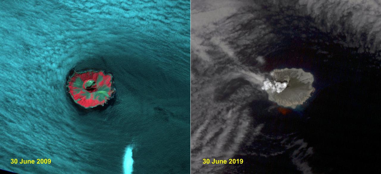
Raikoke volcanic island is near the center of the Kuril Islands in the Sea of Okhotsk in the northwest Pacific Ocean. The island is roughly circular with dimensions of 2.0 by 2.5 kilometers. On June 22, the volcano erupted with a gas and ash plume reaching 17 kilometers. The two ASTER images, acquired exactly 10 years apart on June 30, dramatically depict the changes to the island. In 2009, vegetation (red) covered most of the island. The 2019 image shows an ash and steam plume rising from the caldera. There is no trace of any vegetation, ash deposits having buried everything. The images are located at 48.3 degrees north, 153.2 degrees east. https://photojournal.jpl.nasa.gov/catalog/PIA23326
iss055e070338 (May 12, 2018) --- The ash plume from the Kilauea volcano on the big island of Hawaii was pictured May 12, 2018, from the International Space Station.
iss055e070297 (May 12, 2018) --- The volcanic ash plume from Mount Kilauea is seen just inland off the eastern coast of Hawaii's Big Island.
iss055e070305 (May 12, 2018) --- The volcanic ash plume from Mount Kilauea is seen just inland off the eastern coast of Hawaii's Big Island.
This thermal infrared image from NASA Terra spacecraft of Merapi continuing eruption has been processed to reveal the dominant presence of volcanic ash in the eruption plume and clouds, displayed in dark red. The warm volcanic flow appears bright.
NASA Terra spacecraft shows Mexico active Popocatepetl volcano, located about 40 miles southeast of Mexico City, spewing water vapor, gas, ashes and glowing rocks since its most recent eruption period began in April 2012.
NASA Terra spacecraft shows Popocatepetl, the nearly 18.000-foot-high volcano about 40 miles southeast of Mexico City, continuing to spew water vapor, gas, ashes and glowing rocks from its latest eruption, which started in mid-April 2012.
Mt. Etna, Sicily, Italy, is Europe most active volcano. In mid-May 2016, Mt. Etna put on a display of lava fountaining, ash clouds and lava flows. Three of the four summit craters were active. NASA Terra spacecraft acquired this image on May 26, 2016.
NASA Terra satellite flew directly over Iceland on April 19, 2010, to capture this stereo anaglyph generated from the nadir and 46-degree forward-viewing cameras of the Eyjafjallajökull volcano and its erupting ash plume. 3D glasses are necessary to vie
Southern Chile Puyehue volcano came to life on June 4, 2011, after decades of dormancy. Winds spread the ash column eastward over neighboring Argentina, leading to the evacuation of thousands of residents. This image is from NASA Terra spacecraft.
Plosky Tolbachik volcano in Russia far eastern Kamchatka peninsula erupted on Nov. 27, 2012, for the first time in 35 years, sending clouds of ash to the height of more than 9,800 feet 3,000 meters in this image from NASA Terra spacecraft.
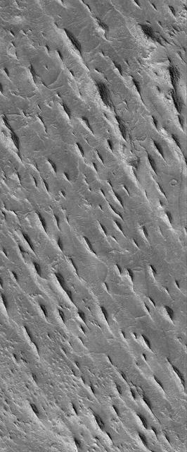
This MGS MOC image shows a group of tapered ridges, known as yardangs, which formed by wind erosion of a relatively easily-eroded material, most likely sedimentary rock or volcanic ash deposits containing some fraction of sand-sized grains
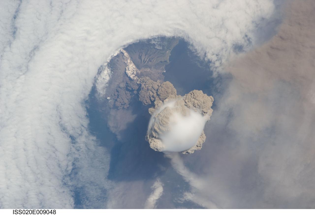
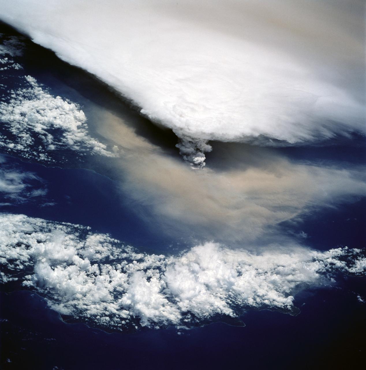
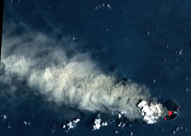
ISS020-E-009048 (12 June 2009) --- Sarychev Peak Volcano eruption, Kuril Islands, is featured in this image photographed by an Expedition 20 crew member on the International Space Station. A fortuitous orbit of the International Space Station allowed the astronauts this striking view of Sarychev volcano (Russia?s Kuril Islands, northeast of Japan) in an early stage of eruption on June 12, 2009. Sarychev Peak is one of the most active volcanoes in the Kuril Island chain and is located on the northwestern end of Matua Island. Prior to June 12, the last explosive eruption had occurred in 1989 with eruptions in 1986, 1976, 1954, and 1946 also producing lava flows. Ash from the June 2009 eruption has been detected 2407 kilometers ESE and 926 kilometers WNW of the volcano, and commercial airline flights are being diverted away from the region to minimize the danger of engine failures from ash intake. This detailed photograph is exciting to volcanologists because it captures several phenomena that occur during the earliest stages of an explosive volcanic eruption. The main column is one of a series of plumes that rose above Matua Island (48.1 degrees north latitude and 153.2 degrees east longitude) on June 12. The plume appears to be a combination of brown ash and white steam. The vigorously rising plume gives the steam a bubble-like appearance; the surrounding atmosphere has been shoved up by the shock wave of the eruption. The smooth white cloud on top may be water condensation that resulted from rapid rising and cooling of the air mass above the ash column, and is probably a transient feature (the eruption plume is starting to punch through). The structure also indicates that little to no shearing winds were present at the time to disrupt the plume. Another series of images, acquired 2-3 days after the start of eruptive activity, illustrate the effect of shearing winds on extent of the ash plumes across the Pacific Ocean. By contrast, a cloud of denser, gray ash ? most probably a pyroclastic flow -- appears to be hugging the ground, descending from the volcano summit. The rising eruption plume casts a shadow to the northwest of the island (bottom center). Brown ash at a lower altitude of the atmosphere spreads out above the ground at upper right. Low-level stratus clouds approach Matua Island from the east, wrapping around the lower slopes of the volcano. Only about 1.5 kilometers of the coastline of Matua Island (upper center) can be seen beneath the clouds and ash.
ISS011-E--8489 (10 June 2005) --- This digital still photograph, taken on June 10 from the Earth-orbiting International Space Station, shows an active Colima, the most prominent volcanic center of the western Mexican Belt. Around 11 p.m. local time, June 6, an explosion from this volcano, for which the summit elevation is approximately 3,850 meters, produced an ash plume to a height of approximately 8.5 kilometers (27,900 feet). The ash plume traveled southwest at a speed of approximately 79 kilometers per hour, and ash fell in and around the cities of Colima, about 30 kilometers away, and Villa de Alvarez. Brief evacuation of some 50 residents in the area was considered a minor undertaking and it was reported some three days after this picture was taken that all were able to return to their homes.
ISS011-E--8490 (10 June 2005) --- This digital still photograph, taken on June 10 from the Earth-orbiting International Space Station, shows an active Colima, the most prominent volcanic center of the western Mexican Belt. Around 11 p.m. local time, June 6, an explosion from this volcano, for which the summit elevation is approximately 3,850 meters, produced an ash plume to a height of approximately 8.5 kilometers (27,900 feet). The ash plume traveled southwest at a speed of approximately 79 kilometers per hour, and ash fell in and around the cities of Colima, about 30 kilometers away, and Villa de Alvarez. Brief evacuation of some 50 residents in the area was considered a minor undertaking and it was reported some three days after this picture was taken that all were able to return to their homes.
On March 3, 2015, Chile's Villarrica volcano erupted, forcing the evacuation of thousands of people. The eruption deposited a layer of ash over the volcano's eastern slope, blanketing and darkening the normal winter snow cover. The eruption and its effects were captured by the Advanced Spaceborne Thermal Emission and Reflection Radiometer (ASTER) instrument on NASA's Terra spacecraft on March 9. Black flows on the other flanks are mud and ash flows. Vegetation is displayed in red colors. The thermal infrared image shows hot spots (white colored) at the summit crater, indicating continuing volcanic activity. The ash blanket is warmer (brighter) than the cold snow (black). The image covers an area of 13.5 by 16.5 kilometers, and is located at 39.4 degrees south, 71.9 degrees west. http://photojournal.jpl.nasa.gov/catalog/PIA19241
On April 3, the Advanced Spaceborne Thermal Emission and Reflection Radiometer (ASTER) on NASA's Terra Satellite captured this image of the erupting Mt. Usu volcano in Hokkaido, Japan. With its 14 spectral bands from the visible to the thermal infrared wavelength region, and its high spatial resolution of 15 to 90 meters (about 50 to 300 feet), ASTER will image the Earth for the next 6 years to map and monitor the changing surface of our planet. This false color infrared image of Mt Usu volcano is dominated by Lake Toya, an ancient volcanic caldera. On the south shore is the active Usu volcano. On Friday, March 31, more than 11,000 people were evacuated by helicopter, truck and boat from the foot of Usu, that began erupting from the northwest flank, shooting debris and plumes of smoke streaked with blue lightning thousands of feet in the air. Although no lava gushed from the mountain, rocks and ash continued to fall after the eruption. The region was shaken by thousands of tremors before the eruption. People said they could taste grit from the ash that was spewed as high as 2,700 meters (8,850 ft) into the sky and fell to coat surrounding towns with ash. "Mount Usu has had seven significant eruptions that we know of, and at no time has it ended quickly with only a small scale eruption," said Yoshio Katsui, a professor at Hokkaido University. This was the seventh major eruption of Mount Usu in the past 300 years. Fifty people died when the volcano erupted in 1822, its worst known eruption. In the image, most of the land is covered by snow. Vegetation, appearing red in the false color composite, can be seen in the agricultural fields, and forests in the mountains. Mt. Usu is crossed by three dark streaks. These are the paths of ash deposits that rained out from eruption plumes two days earlier. The prevailing wind was from the northwest, carrying the ash away from the main city of Date. Ash deposited can be traced on the image as far away as 10 kilometers (16 miles) from the volcano. http://photojournal.jpl.nasa.gov/catalog/PIA02608
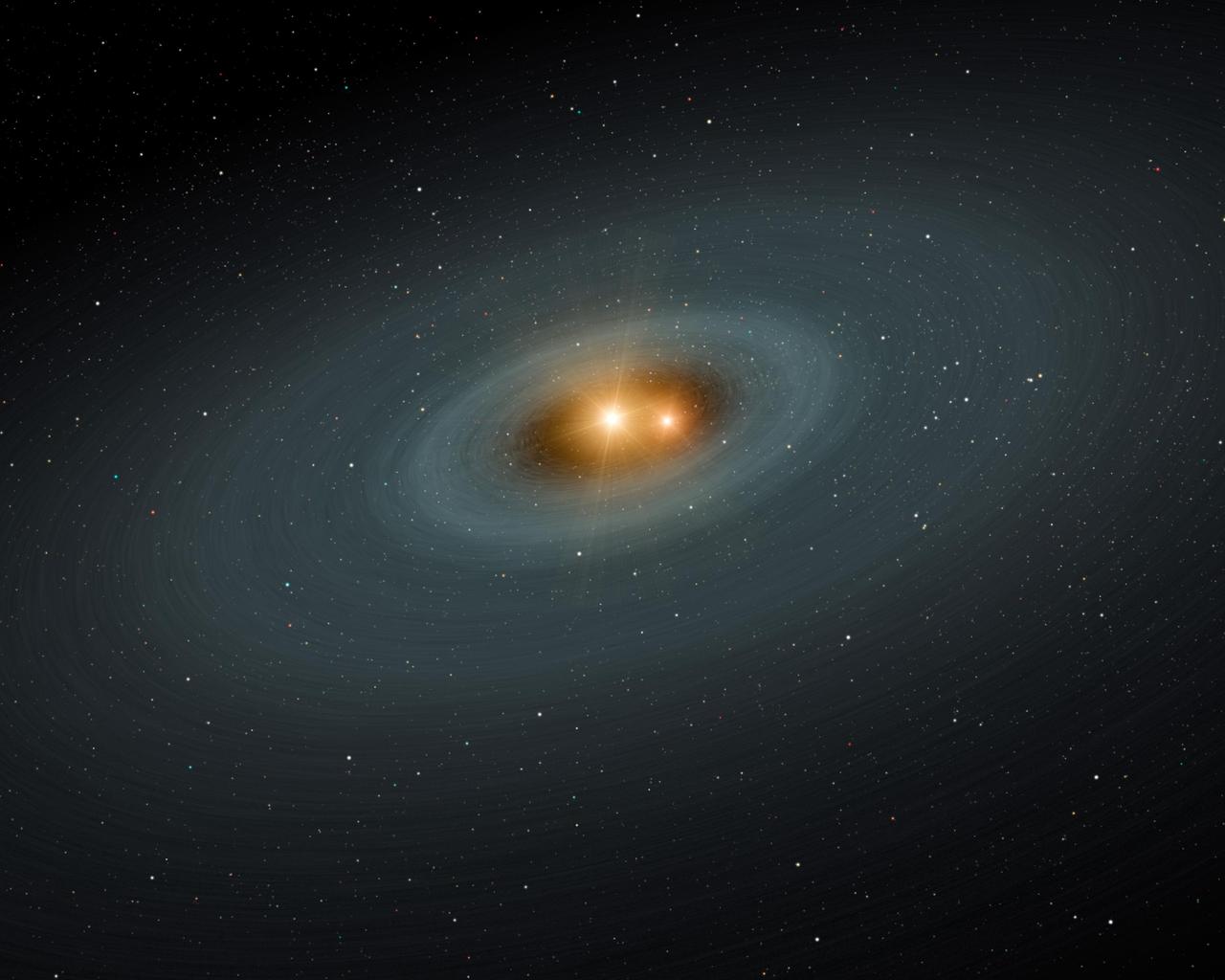
This artist concept illustrates a tight pair of stars and a surrounding disk of dust, most likely the shattered remains of planetary smashups. Using NASA Spitzer Space Telescope, the scientists found dusty evidence for such collisions.
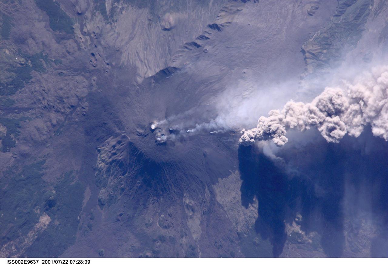
ISS002-E-9637 (22 July 2001) --- An overhead look at the smoke and ash being expelled from the erupting volcano Mt. Etna on the island of Sicily. This image was recorded by an Expedition Two crew member with a digital still camera.
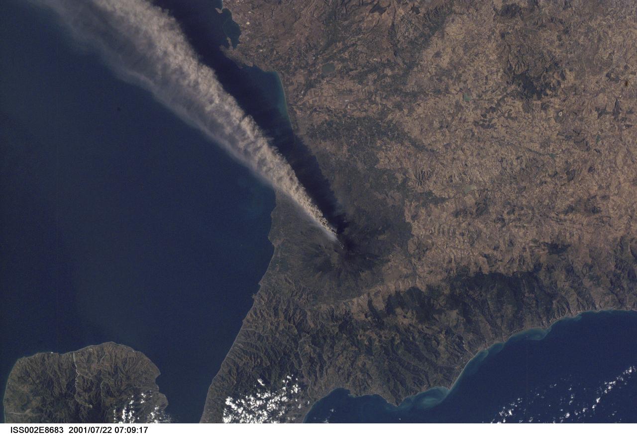
ISS002-E-8683 (22 July 2001) --- Smoke and ash combine to create a plume extending from the erupting volcano on Mt. Etna in Sicily. The digital still image was recorded by one of the Expedition Two crew members.
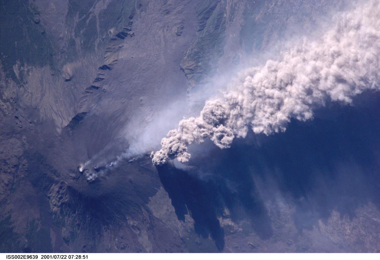
ISS002-E-9639 (22 July 2001) --- An overhead look at the smoke and ash being expelled from the erupting volcano Mt. Etna on the island of Sicily. This image was recorded by an Expedition Two crew member with a digital still camera.
At the top of this VIS image is an area eroded by the wind. This region of the Martian surface is highly dissected by wind action. The surface materials are poorly cemented and easily eroded. It has been suggested that the surface is comprised of volcanic ash deposits, sourced from the Tharsis and Apollinaris volcanoes. Orbit Number: 93116 Latitude: -8.25265 Longitude: 151.629 Instrument: VIS Captured: 2022-12-11 10:31 https://photojournal.jpl.nasa.gov/catalog/PIA25818
Two of Guatemala's active volcanoes, Fuego (upper left) and Pacaya (lower right) were erupting when the ASTER nighttime thermal infrared image was acquired on March 5, 2021. Pacaya's most recent eruption began Wednesday, with several lava flows and ash eruptions; surrounding villages were ordered evacuated. Since mid-February, Fuego continued to produce sporadic emissions of ash from its active central crater. In the ASTER image, the hottest areas are white, and coldest are black. The image covers an area of 29.8 by 40.3 km, and is centered at 14.4 degrees north, 90.8 degrees west. https://photojournal.jpl.nasa.gov/catalog/PIA24419

jsc2020e040946 (9/10/2020) --- A picture of roving fiber (right), which is made from fly ash (upper left) in a Japanese thermal power station. A mass production project for this fiber is in progress. Detailed properties are being investigated on the ISS. One of the tests was conducted at the Electrostatic Levitation Furnace (ELF) aboard the ISS from April to May 2020 (lower left). The Exposure test of of BASHFIBER® (ExHAM-Nippon Fiber-2) tests the resistance of a thread-like fiber to cosmic rays on the exterior of the International Space Station (ISS). BASHFIBER is a mixture of basalt rock and fly ash, with high resistance to acid and salt. The fiber has the potential for a variety of applications making use of an abundant byproduct.
In this image of Peru's Sabancaya stratovolcano, acquired May 13, 2020, the years-long eruption continues. In the top image, Sabancaya has a bright white cloud in its caldera. The greyish cloud to the east is an ash plume. The Ampato volcano, with its prominent summit caldera, is to the south. The red areas are vegetation. The lower thermal infrared composite image shows the plume in purple, indicating that it is dominantly composed of ash and water vapor. A bright hotspot can be seen in the summit caldera of Sabancaya. The images cover an area of 13.5 by 24 kilometers, and are located at 15.8 degrees south, 71.9 degrees west. https://photojournal.jpl.nasa.gov/catalog/PIA24866
STS039-151-179 (28 April-6 May 1991) --- A large format frame of one of the USSR's volcanic complex (Kamchatka area) with the active volcano Klyuchevskaya (Kloo-chevs'-ska-ya), 15,584 feet in elevation. The last reported eruption of the volcano was on April 8, but an ash and steam plume extending to the south was observed by the STS-39 crew almost three weeks later. The south side of the volcano is dirty from the ash fall and landslide activity. The summit is clearly visible, as is the debris flow from an earlier eruption. Just north of the Kamchatka River is Shiveluch, a volcano which was active in early April. There are more than 100 volcanic edifices recognized on Kamchatka, with 15 classified as active.
Mt. Etna, Italy erupted February 17, 2021, sending rivers of lave down the southeast flank of the volcano, and spewing ashes and volcanic stones over nearby villages. Sicily's Catania Airport was temporarily closed due to an ash plume that rose to 3700 m altitude. By the following week, the eruption had waned. The ASTER visible image shows the extent of the active lava flows (derived from the thermal infrared data). The image was acquired February 26, 2021, covers an area of 25.5 by 27.0 km, and is located at 37.8 degrees north, 15 degrees east. https://photojournal.jpl.nasa.gov/catalog/PIA24418
STS064-116-064 (20 Sept. 1994) --- Near the end of the mission, the crew aboard space shuttle Discovery was able to document the beginning of the second day of activity of the Rabaul volcano, on the east end of New Britain. On the morning of Sept. 19, 1994, two volcanic cones on the opposite sides of the 6-kilometer sea crater had begun to erupt with very little warning. Discovery flew just east of the eruption roughly 24 hours after it started and near the peak of its activity. New Ireland, the cloud-covered area in the foreground, lies just east of Rabaul harbor. The eruption, which sent a plume up to over 60,000 feet into the atmosphere, caused over 50,000 people to evacuate the area. Because winds were light at the time of the eruption, most of the ash was deposited in a region within 20 kilometers of the eruption zone. This photo shows the large white billowing eruption plume is carried in a westerly direction by the weak prevailing winds. At the base of the eruption column is a layer of yellow-brown ash being distributed by lower level winds. A sharp boundary moving outward from the center of the eruption in the lower cloud is a pulse of laterally-moving ash which results from a volcanic explosion. Geologists theorize that the large white column and the lower gray cloud are likely from the two main vents on each side of the harbor. The bay and harbor of Rabaul are covered with a layer of ash, possibly partly infilled with volcanic material. Matupit Island and the airport runway have disappeared into the bay. More than a meter of ash has fallen upon the city of Rabaul. Up to five vents were reported to have erupted at once, including the two cones Vulcan and Tavurvur, which are opposites of the harbor as well as new vents below the bay. Half of the Vulcan cone has collapsed into the sea. The extra day in space due to bad weather at the landing site afforded the crew the opportunity for both still and video coverage of the event. Photo credit: NASA or National Aeronautics and Space Administration
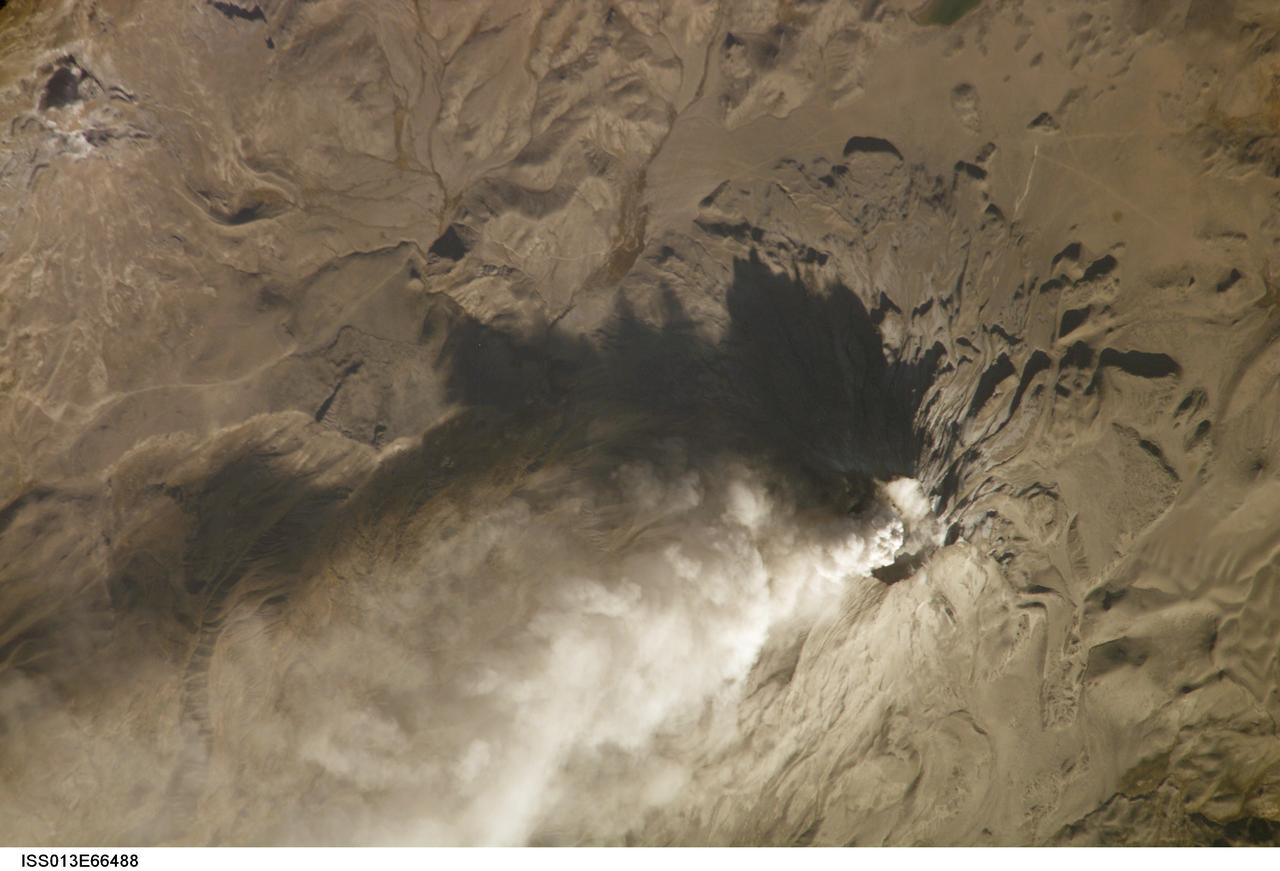
ISS013-E-66488 (14 Aug. 2006) --- Ash cloud from Ubinas Volcano, Peru is featured in this image photographed by an Expedition 13 crewmember on the International Space Station (ISS). Subduction of the Nazca tectonic plate along the western coast of South America forms the high Peruvian Andes, and also produces magma feeding a chain of historically active volcanoes along the western front of the mountains. The most active of these volcanoes in Peru is Ubinas. A typical steep-sided stratovolcano comprised primarily of layers of silica-rich lava flows, it has a summit elevation of 5,672 meters. The volcanic cone appears distinctively truncated or flat-topped in profile -- the result of a relatively small eruption that evacuated a magma reservoir near the summit. Following removal of the magma, the summit material collapsed downwards to form the current 1.4 kilometer-wide summit caldera. This oblique image (looking at an angle from the ISS) captures an ash cloud first observed on satellite imagery at 11:00 GMT on Aug. 14, 2006; this image was acquired one hour and 45 minutes later. The ash cloud resulted in the issuing of an aviation hazard warning by the Buenos Aires Volcanic Ash Advisory Center. Modern activity at Ubinas is characterized by these minor to moderate explosive eruptions of ash and larger pumice - a volcanic rock characterized by low density and high proportion of gas bubbles formed as the explosively-erupted parent lava cools during its transit through the air. These materials blanket the volcanic cone and surrounding area, giving this image an overall gray appearance. Shadowing of the western flank of Ubinas throws several lava flows into sharp relief, and highlights the steep slopes at the flow fronts -- a common characteristic of silica-rich, thick, and slow-moving lavas. NASA researchers note that the most recent major eruption of Ubinas occurred in 1969, however the historical record of activity extends back to the 16th century.
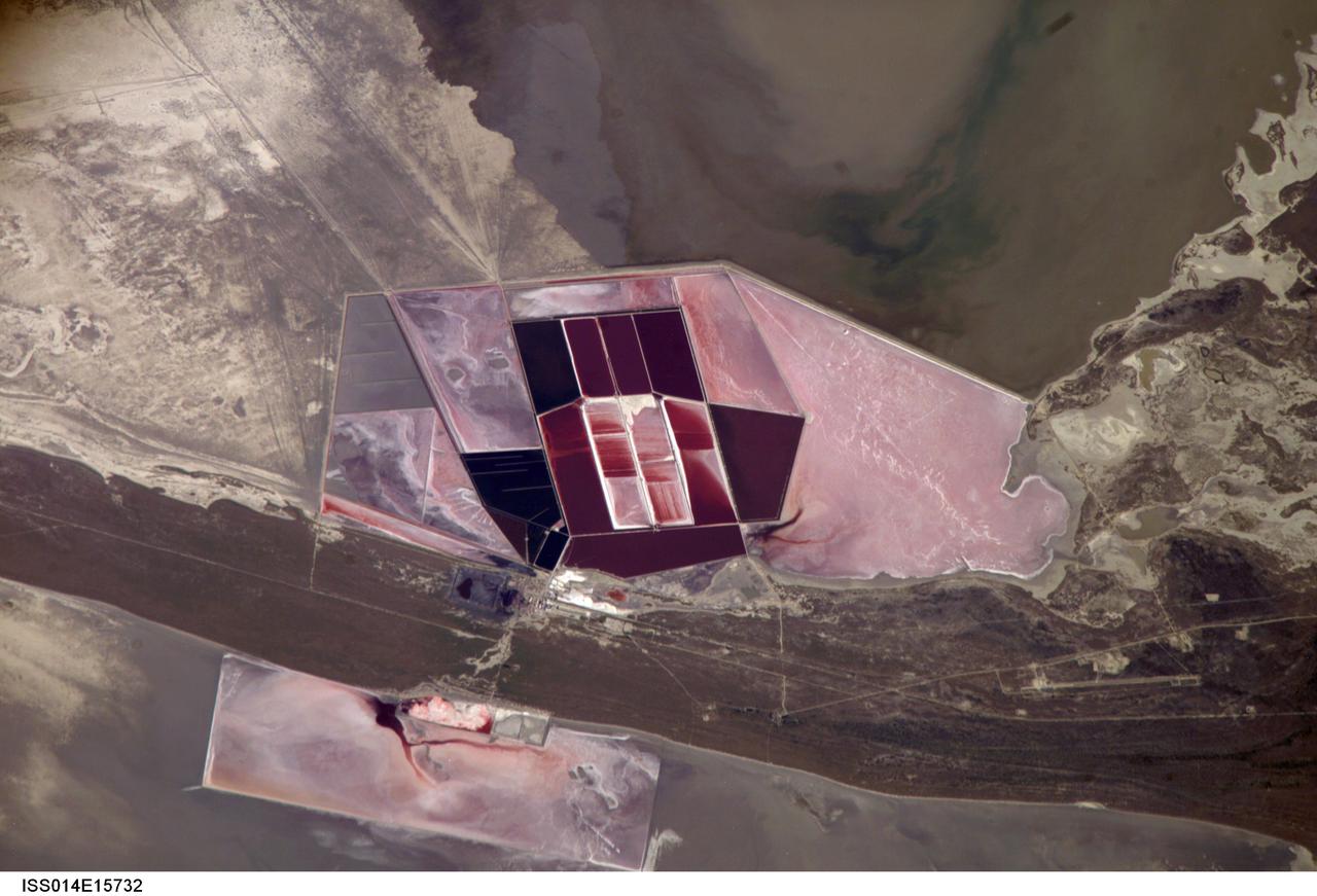
ISS014-E-15732 (1 March 2007) --- Salt ponds of Botswana are featured in this image photographed by an Expedition 14 crewmember on the International Space Station. This recent, detailed view shows the salt ponds of one of Africa's major producers of soda ash (sodium carbonate) and salt. Soda ash is used for glass making, in metallurgy, in the detergent industry, and in chemical manufacture. The image shows a small part of the great salt flats of central Botswana known as the Makgadikgadi Salt Pans. The soda ash and salt are both mainly exported (since 1989) to most countries in southern and central Africa. Brines from just beneath the pan floor are evaporated to produce the soda ash and salt -- a process for which the semiarid climate of Botswana is ideal. Red salt-loving algae in the ponds indicate that the salinity of the evaporating brines is medium to high. The salt pans of Botswana--a prominent visual photo target of interest for astronauts aboard the station--lie at the low point of a vast shallow continental basin. Rivers draining from as far away as central Angola - more than 1,000 kilometers away - supply water to the pans. According to scientists, during several wet climatic phases in the recent geological past the pans were permanently filled with water, for thousands of years, only to dry out when climates fluctuated to drier conditions. During dry phases water only reaches the pans underground. These are the brines that support the ash and salt industry. During wet phases when open water exists, beach ridges are constructed by wave action. One of these crosses the lower part of the view.

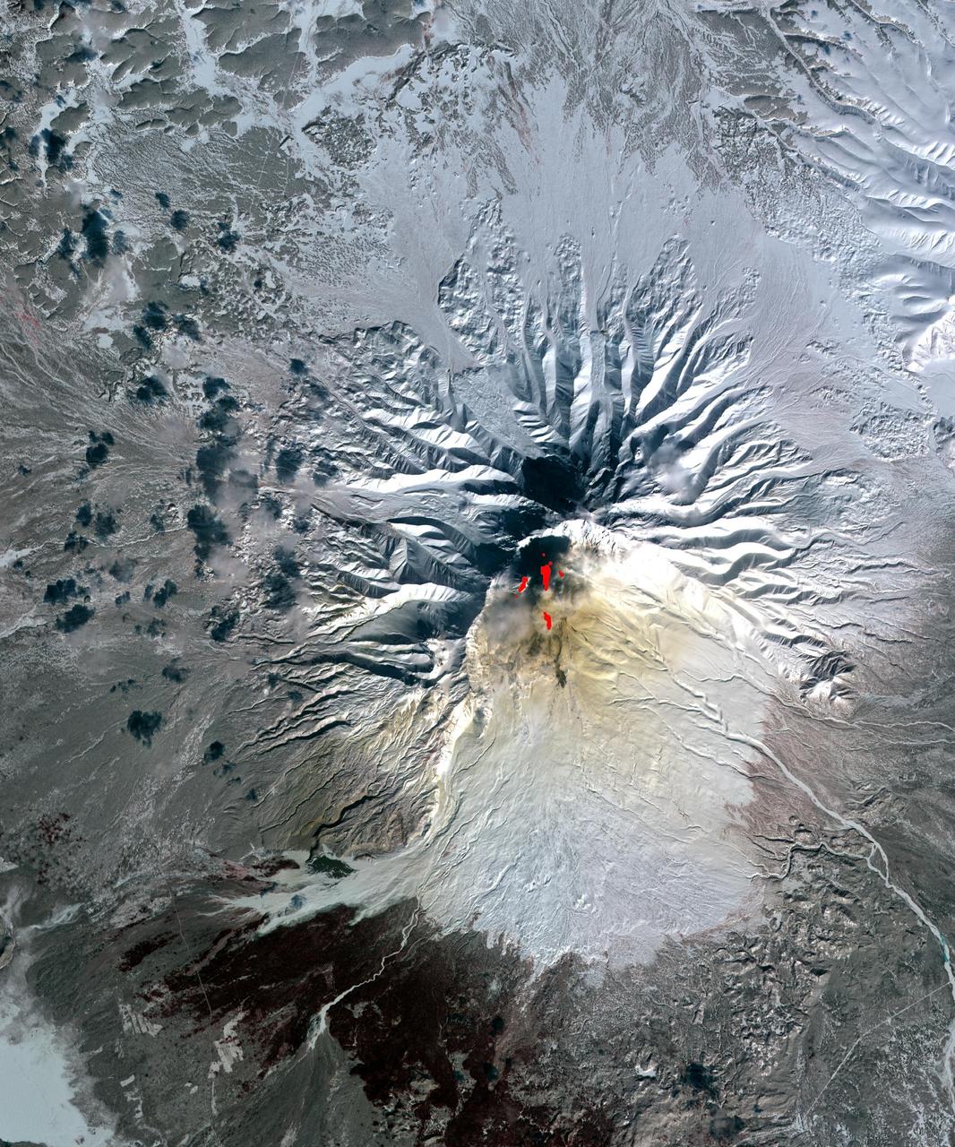
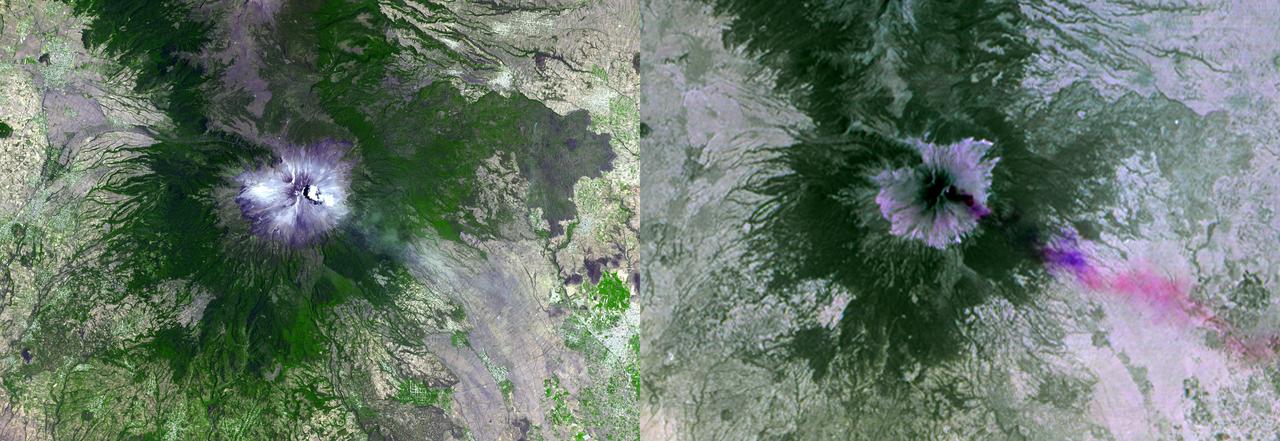
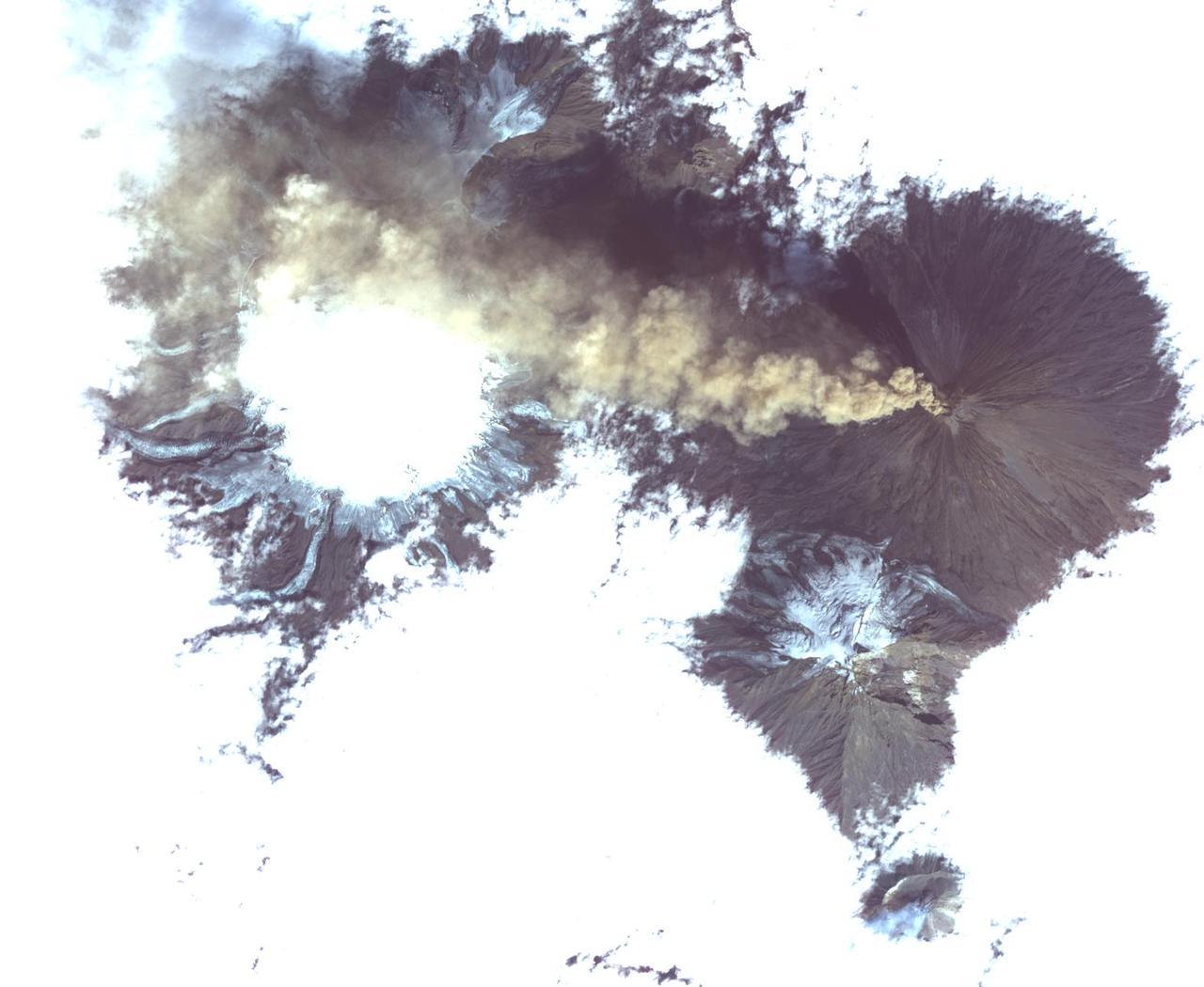
NASA image acquired Sept 7, 2010 Shiveluch (also spelled Sheveluch) is one of the largest and most active volcanoes on Russia’s Kamchatka Peninsula. It has been spewing ash and steam intermittently—with occasional dome collapses, pyroclastic flows, and lava flows, as well—for the past decade. Shiveluch is a stratovolcano, a steep-sloped formation of alternating layers of hardened lava, ash, and rocks thrown out by earlier eruptions. A lava dome has been growing southwest of the 3,283-meter (10,771-foot) summit. The Advanced Land Imager (ALI) on NASA’s Earth Observing-1 (EO-1) satellite acquired this image on September 7, 2010. Brown and tan debris—perhaps ash falls, perhaps mud from lahars—covers the southern landscape of the volcano, while the hills on the northern side remain covered in snow and ice. The Kamchatkan Volcanic Eruption Response Team (KVERT) reported that seismic activity at Shiveluch was "above background levels" from September 3-10. Ash plumes rose to an altitude of 6.5 kilometers (21,300 feet) on September 3-4, and gas-and-ash plumes were reported on September 7, when this image was acquired. According to the Smithsonian Institution's volcano program, at least 60 large eruptions of Shiveluch have occurred during the current Holocene Epoch of geological history. Intermittent explosive eruptions began in the 1990s, and the largest historical eruptions from Shiveluch occurred in 1854 and 1964. NASA Earth Observatory image created by Jesse Allen and Robert Simmon, using EO-1 ALI data provided courtesy of the NASA EO-1 team. Caption by Mike Carlowicz. Instrument: EO-1 - ALI Credit: NASA Earth Observatory NASA Goddard Space Flight Center contributes to NASA’s mission through four scientific endeavors: Earth Science, Heliophysics, Solar System Exploration, and Astrophysics. Goddard plays a leading role in NASA’s endeavors by providing compelling scientific knowledge to advance the Agency’s mission. Follow us on Twitter Join us on Facebook
STS064-116-055 (20 Sept. 1994) --- Near the end of its mission, the crew aboard space shuttle Discovery was able to document the beginning of the second day of activity of the Rabaul volcano, on the east end of New Britain. On the morning of Sept. 19, 1994, two volcanic cones on the opposite sides of the 6-kilometer sea crater had begun to erupt with very little warning. Discovery flew just east of the eruption roughly 24 hours after it started and near the peak of its activity. The eruption, which sent a plume up to over 60,000 feet into the atmosphere, caused over 50,000 people to evacuate the area. Because winds were light at the time of the eruption, most of the ash was deposited in a region within 20 kilometers of the eruption zone. This photo shows the large white billowing eruption plume is carried in a westerly direction by the weak prevailing winds. At the base of the eruption column is a layer of yellow-brown ash being distributed by lower level winds. A sharp boundary moving outward from the center of the eruption in the lower cloud is a pulse of laterally-moving ash which results from a volcanic explosion. Geologists theorize that the large white column and the lower gray cloud are likely from the two main vents on each side of the harbor. The cloud-covered island in the foreground is New Ireland. The bay and harbor of Rabaul are covered with a layer of ash, possibly partly infilled with volcanic material. Matupit Island and the airport runway have disappeared into the bay. More than a meter of ash has fallen upon the city of Rabaul. Up to five vents were reported to have erupted at once, including the cones Vulcan and Tavurvur, which are opposites of the harbor as well as new vents below the bay. Half of the Vulcan cone has collapsed into the sea. The extra day in space due to bad weather at the landing site afforded the crew the opportunity for both still and video coverage of the event. Photo credit: NASA or National Aeronautics and Space Administration

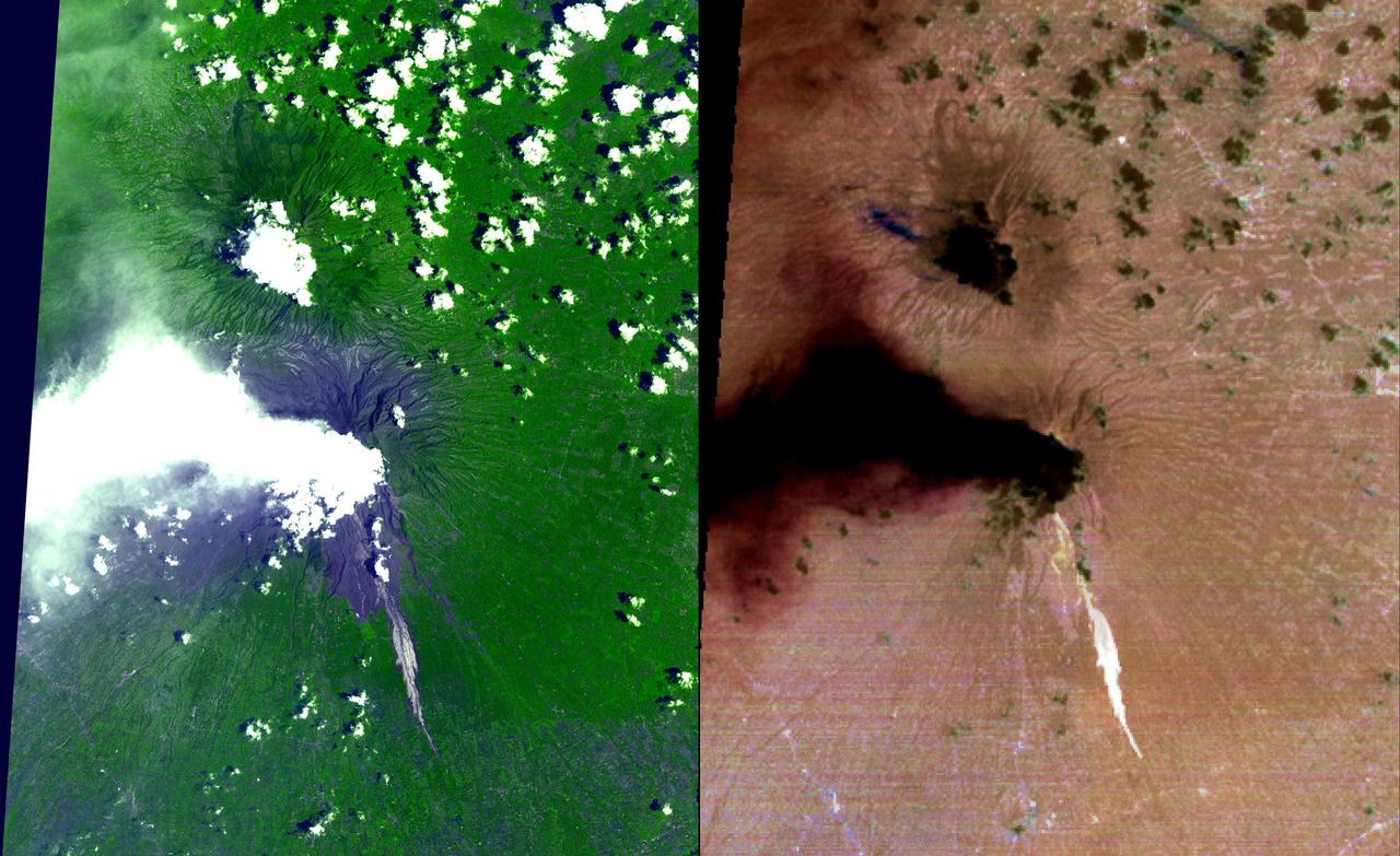
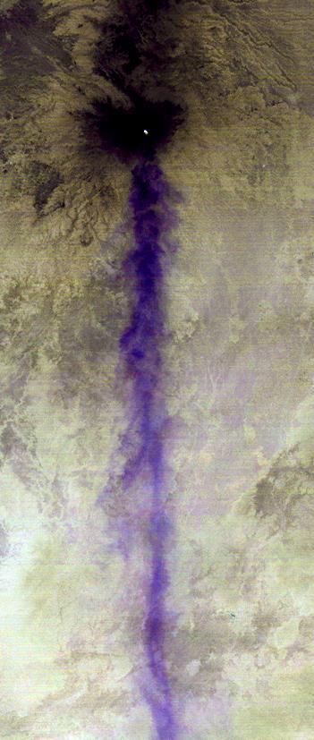
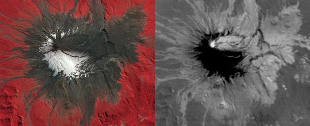
On the night of June 4, 2001, the Advanced Spaceborne Thermal Emission and Reflection Radiometer (ASTER) captured this thermal image of the erupting Shiveluch volcano. Located on Russia's Kamchatka Peninsula, Shiveluch rises to an altitude of 2,447 meters (8,028 feet). The active lava dome complex is seen as a bright (hot) area on the summit of the volcano. To the southwest, a second hot area is either a debris avalanche or hot ash deposit. Trailing to the west is a 25-kilometer (15-mile) ash plume, seen as a cold "cloud" streaming from the summit. At least 60 large eruptions have occurred here during the last 10,000 years; the largest historical eruptions were in 1854 and 1964. Because Kamchatka is located along the major aircraft routes between North America/Europe and Asia, this area is constantly monitored for potential ash hazards to aircraft. The area is part of the "Ring of Fire," a string of volcanoes that encircles the Pacific Ocean. The lower image is the same as the upper, except it has been color-coded: red is hot, light greens to dark green are progressively colder, and gray/black are the coldest areas. The image is located at 56.7 degrees north latitude, 161.3 degrees east longitude. http://photojournal.jpl.nasa.gov/catalog/PIA03514
ISS018-E-028898 (7 Feb. 2009) --- The summit of Popocatepetl Volcano in Mexico is featured in this image photographed by an Expedition 18 crewmember on the International Space Station. Volcano Popocatepetl, a large stratovolcano located approximately 70 kilometers to the southeast of Mexico City, is considered by many volcanologists to be ?the planet?s riskiest volcano?. The volcano warrants this distinction because of its proximity to one of the most densely populated megacities on Earth (population near 23 million in 2009). The variety of potential volcanic hazards at Popocatepetl is also considerable, including explosive eruptions of ash, pyroclastic flows (hot, fluidized masses of rock and gas that flow rapidly downhill), and debris avalanches. This detailed photograph of the summit crater of Popocatepetl (center) also highlights Ventorillo and Noroccidental Glaciers ? together with ice on nearby Iztaccihuatl Volcano and Pico de Orizaba (Mexico?s highest peak and the highest volcano in North America), these are the only mountain glaciers in tropical North America. The presence of glaciers on Popocatepetl is also connected with another volcanic hazard ? the creation of dangerous mudflows, or lahars, should the ice melt during eruptive activity. At the time this image was taken, steam and ash plumes were observed at the volcano ? a faint white steam plume is visible against gray ash deposits on the eastern and southern flanks of the volcano.

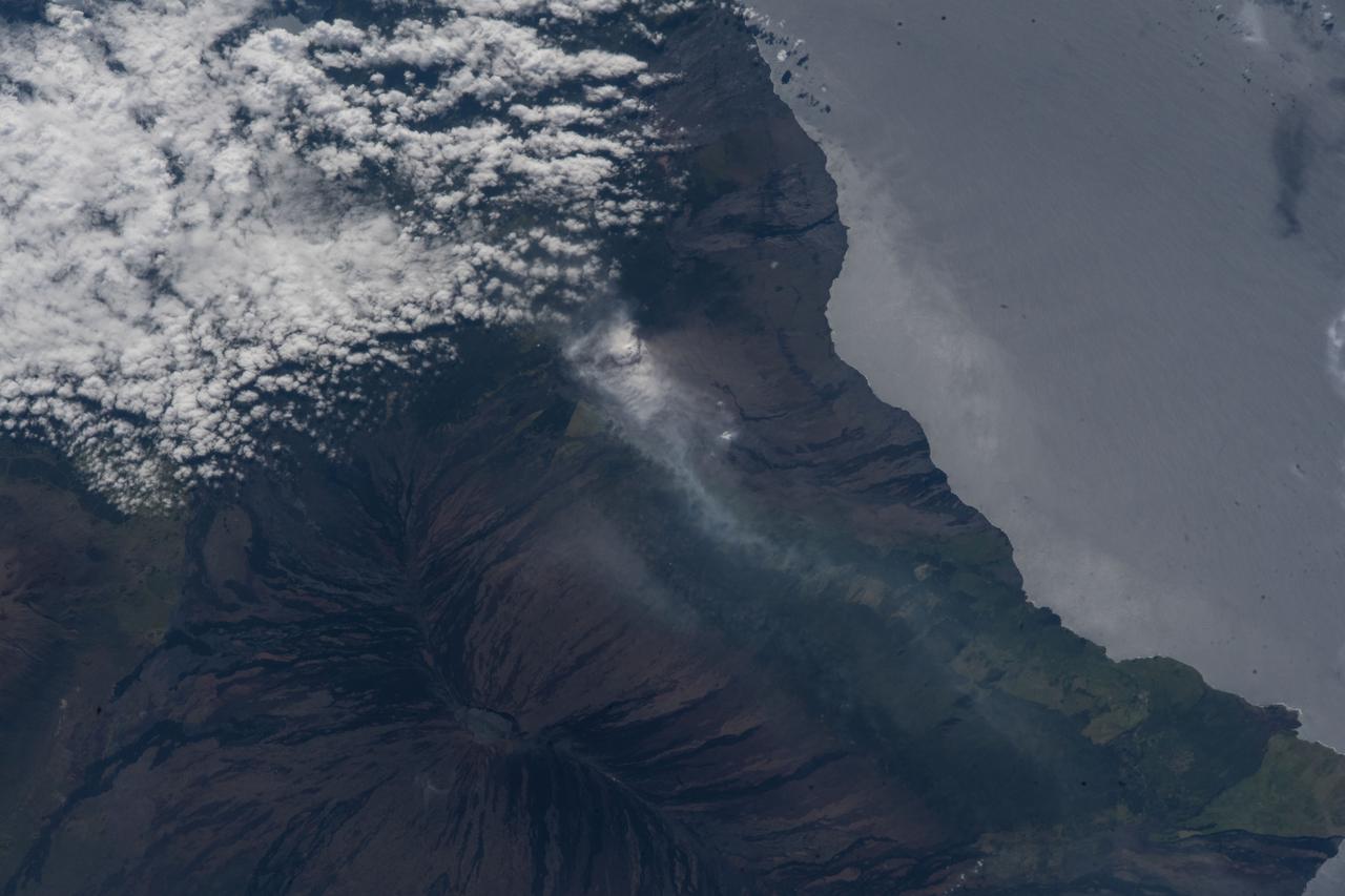
ISS014-E-17165 (21 March 2007) --- A plume at Shiveluch Volcano, Kamchatka Peninsula, Russia is featured in this image photographed by an Expedition 14 crewmember on the International Space Station. Shiveluch, one of Kamchatka's most active volcanoes, began its latest activity with gas and steam emissions in mid-late March 2007. This image was captured around mid-morning on or around March 21 2007, and shows a steam plume, probably containing minor amounts of ash, blowing westward from the summit of the volcano. The crewmembers were transiting the southern tip of Russia's Kamchatka Peninsula; with a clear view of the volcano about 5 degrees north of the ground track of the station. Subsequent eruptions on March 29 and 30 have been recorded by the Kamchatka Volcano Observatory and NASA. The volcano's southern flank, clearly visible in this northeast-looking oblique view, comprises a horseshoe-shaped caldera from a late Pleistocene eruption, subsequently blanketed by additional ash deposits, and highlighted by the snow cover. The peak of Shiveluch is a distinctive brown color due to the removal of snow, exposure of rock forming the summit, and deposits of new ash. The relatively smooth landscape of the south contrasts with the large, steep valleys on the northern slope of the volcano. Low clouds wrap around the eastern part of the mountain, obscuring the lower elevations.
On the night of June 4, 2001 ASTER captured this thermal image of the erupting Shiveluch volcano. Located on Russia's Kamchatka Peninsula, Shiveluch rises to an altitude of 8028'. The active lava dome complex is seen as a bright (hot) area on the summit of the volcano. To the southwest, a second hot area is either a debris avalanche or hot ash deposit. Trailing to the west is a 25 km ash plume, seen as a cold "cloud" streaming from the summit. At least 60 large eruptions have occurred during the last 10,000 years; the largest historical eruptions were in 1854 and 1964. Because Kamchatka is located along the major aircraft routes between North America/Europe and the Far East, this area is constantly monitored for potential ash hazards to aircraft. The lower image is the same as the upper, except it has been color coded: red is hot, light greens to dark green are progressively colder, and gray/black are the coldest areas. The image is located at 56.7 degrees north latitude, 161.3 degrees east longitude. http://photojournal.jpl.nasa.gov/catalog/PIA02674
This 3-D anaglyph image of Mt. St. Helens volcano combines the nadir-looking and back-looking band 3 images of ASTER. To view the image in stereo, you will need blue-red glasses. Make sure to look through the red lens with your left eye. This ASTER image of Mt. St. Helens volcano in Washington was acquired on August 8, 2000 and covers an area of 37 by 51 km. Mount Saint Helens, a volcano in the Cascade Range of southwestern Washington that had been dormant since 1857, began to show signs of renewed activity in early 1980. On 18 May 1980, it erupted with such violence that the top of the mountain was blown off, spewing a cloud of ash and gases that rose to an altitude of 19 kilometers. The blast killed about 60 people and destroyed all life in an area of some 180 square kilometers (some 70 square miles), while a much larger area was covered with ash and debris. It continues to spit forth ash and steam intermittently. As a result of the eruption, the mountain's elevation decreased from 2,950 meters to 2,549 meters. The image is centered at 46.2 degrees north latitude, 122.2 degrees west longitude. http://photojournal.jpl.nasa.gov/catalog/PIA11160
STS113-332-030 (14 December 2002) --- The STS-113 crewmembers used a 35mm still camera to record this image of Mt. Etna Volcano erupting on the island of Sicily. The south-looking oblique sunset view shows snowy, winter-time Mt. Etna with a brown smutty ash plume.
iss059e119235 (June 20, 2019) --- The International Space Station was orbiting 256 miles above the north African country of Libya when an Expedition 59 crewmember photographed the isolated volcanic crater of Waw an Namus, which is composed of dark ash and features three small saltwater lakes.

CAPE CANAVERAL, Fla. - Gary Ash, is the flight engineer on the Shuttle Carrier Aircraft, or SCA, that will take space shuttle Endeavour from NASA's Kennedy Space Center in Florida to Los Angeles for public display. Photo credit: NASA/Kim Shiflett
Klyuchevskoi, one of the world's most active volcanoes, is seen poking through above a solid cloud deck, with an ash plume streaming to the west. Located on the Kamchatka Peninsula in far eastern Russia, it is one of many active volcanoes on the Peninsula. Nearby, to the south, the smaller Bezymianny volcano can be seem with a small steam plume coming from its summit. The image was acquired Aug. 20, 2017, covers an area of 12 by 14 miles (19.5 by 22.7 kilometers), and is located at 56.1 degrees north, 160.6 degrees east. https://photojournal.jpl.nasa.gov/catalog/PIA21878
Nishinoshima is a small volcanic island located about 1000 km south of Tokyo, Japan. Eruptive activity began in December 2019, and has continued uninterrupted. ASTER captured this image of an ash and steam plume emanating from the central crater. Thermal infrared data is superposed in red on a visible-infrared color image to highlight the lava in the central crater and lava flows that have flowed down the volcano's flanks. The image was acquired July 28, 2020, covers an area of 15 by 21 km, and is located at 27.3 degrees north, 140.8 degrees east. https://photojournal.jpl.nasa.gov/catalog/PIA24017

In this ASTER image of Soufriere Hills Volcano on Montserrat in the Caribbean, continued eruptive activity is evident by the extensive smoke and ash plume streaming towards the west-southwest. Significant eruptive activity began in 1995, forcing the authorities to evacuate more than 7,000 of the island's original population of 11,000. The primary risk now is to the northern part of the island and to the airport. Small rockfalls and pyroclastic flows (ash, rock and hot gases) are common at this time due to continued growth of the dome at the volcano's summit. This image was acquired on October 29, 2002 by the Advanced Spaceborne Thermal Emission and Reflection Radiometer (ASTER) on NASA's Terra satellite. With its 14 spectral bands from the visible to the thermal infrared wavelength region, and its high spatial resolution of 15 to 90 meters (about 50 to 300 feet), ASTER images Earth to map and monitor the changing surface of our planet. http://photojournal.jpl.nasa.gov/catalog/PIA03880
Tyrrhenus Mons is one of the oldest Martian volcanoes. Tyrrhena Fossae is the largest of the channels dissecting the volcano. As well as being one of the oldest volcanoes, it is made of layers that include volcanic ash rather than just basaltic flows. This difference is evident in how the volcano is being eroded, creating broad intersecting sinuous channels. On Earth basaltic flows form broad shield volcanoes like Hawaii. Shield volcanoes can erupt from the central crater, as well as along the flanks. Volcanoes with ash layers, called composite volcanoes, form steeper sides like Mt Rainier and Mt Fuji. The major amount of material erupts only from the central caldera. Orbit Number: 73059 Latitude: -20.5291 Longitude: 107.331 Instrument: VIS Captured: 2018-06-03 21:19 https://photojournal.jpl.nasa.gov/catalog/PIA22664
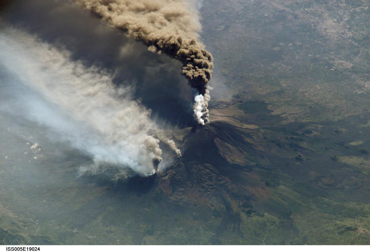
Expedition Five crew members aboard the International Space Station (ISS) captured this overhead look at the smoke and ash regurgitated from the erupting volcano Mt. Etna on the island of Sicily, Italy in October 2002. Triggered by a series of earthquakes on October 27, 2002, this eruption was one of Etna's most vigorous in years. This image shows the ash plume curving out toward the horizon. The lighter-colored plumes down slope and north of the summit seen in this frame are produced by forest fires set by flowing lava. At an elevation of 10,990 feet (3,350 m), the summit of the Mt. Etna volcano, one of the most active and most studied volcanoes in the world, has been active for a half-million years and has erupted hundreds of times in recorded history.
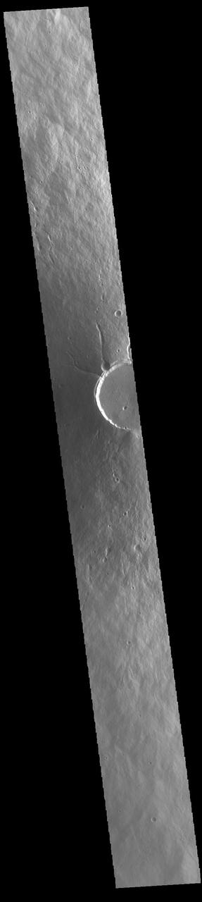
Today's VIS image shows a cross section of Elysium Mons, including part of the summit caldera. Unlike the Tharsis volcanoes to the east, there are very few identifiable lava flows on the flanks of the Elysium Mons. In profile the volcano looks like Mt. Fuji in Japan. Mt. Fuji is a stratovolcano. A stratovolcano, also known as a composite volcano, is a conical volcano built up by multiple layers of lava and ash erupting solely from the summit caldera. The Tharsis volcanoes are shield volcanoes, which will host flank eruptions, but rarely ash eruptions. Elysium Mons is 12.6km (7.8 miles) tall. For comparison, Mt. Fuji is 3.7 km (2.3 miles) tall. Orbit Number: 93908 Latitude: 24.4791 Longitude: 146.667 Instrument: VIS Captured: 2023-02-14 16:41 https://photojournal.jpl.nasa.gov/catalog/PIA25925
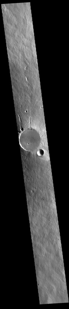
Today's VIS image shows a cross section of Elysium Mons, including the entire summit caldera. Unlike the Tharsis volcanoes to east, there are very few identifiable lava flows on the flanks of the Elysium Mons. In profile the volcano looks like Mt. Fuji in Japan. Mt. Fuji is a stratovolcano. A stratovolcano, also known as a composite volcano, is a conical volcano built up by multiple layers of lava and ash erupting solely from the summit caldera. The Tharsis volcanoes are shield volcanoes, which will host flank eruptions, but rarely ash eruptions. Elysium Mons is 12.6km (7.8 miles) tall. For comparison, Mt. Fuji is 3.7 km (2.3 miles) tall. Orbit Number: 86633 Latitude: 24.5225 Longitude: 146.837 Instrument: VIS Captured: 2021-06-25 16:09 https://photojournal.jpl.nasa.gov/catalog/PIA24959