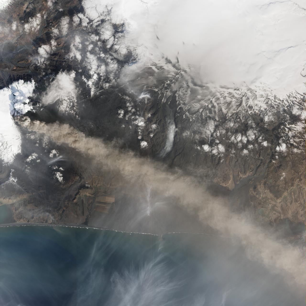
NASA satellite image acquired May 2, 2010 To see the full view of this image go to: <a href="http://www.flickr.com/photos/gsfc/4584266582/">www.flickr.com/photos/gsfc/4584266582/</a> Ash and steam continued billowing from Eyjafjallajökull Volcano in early May 2010. The Advanced Land Imager (ALI) on NASA’s Earth Observing-1 (EO-1) satellite captured this natural-color image on May 2, 2010. The volcano’s summit is near the left edge of this image, capped by a dark plume. The plume is dull gray-brown, indicating that its principal visible component is volcanic ash. Ash from the plume blows toward the east-southeast, passing over a charcoal-colored ash field on the land surface. Just to the north of Eyjafjallajökull’s summit are white puffs of steam, likely from surface lava flows vaporizing snow and glacial ice. On May 4, 2010, the Icelandic Meteorological Office warned that Eyjafjallajökull showed no signs of ending its eruptive activity in the near future. The Met Office reported that ash from the volcano had reached a height of 5.8 to 6.0 kilometers (19,000 to 20,000 feet) above sea level, and had spread 65 to 80 kilometers (40 to 50 miles) east-southeast of the volcano, where it impeded visibility for local residents. The Met Office also reported that lava continued flowing down a steep hill north of the crater. NASA image by Robert Simmon, using ALI data from the EO-1 team. Caption by Michon Scott. Instrument: EO-1 – ALI To view other images from the Earth Observatory go to: <a href="http://earthobservatory.nasa.gov/" rel="nofollow">earthobservatory.nasa.gov/</a> <b><a href="http://www.nasa.gov/centers/goddard/home/index.html" rel="nofollow">NASA Goddard Space Flight Center</a></b> is home to the nation's largest organization of combined scientists, engineers and technologists that build spacecraft, instruments and new technology to study the Earth, the sun, our solar system, and the universe.
NASA image acquired May 8, 2010 at 13 :35 UTC Ash plume from Eyjafjallajokull Volcano, Iceland Satellite: Aqua NASA/GSFC/Jeff Schmaltz/MODIS Land Rapid Response Team <b><a href="http://www.nasa.gov/centers/goddard/home/index.html" rel="nofollow">NASA Goddard Space Flight Center</a></b> is home to the nation's largest organization of combined scientists, engineers and technologists that build spacecraft, instruments and new technology to study the Earth, the sun, our solar system, and the universe.
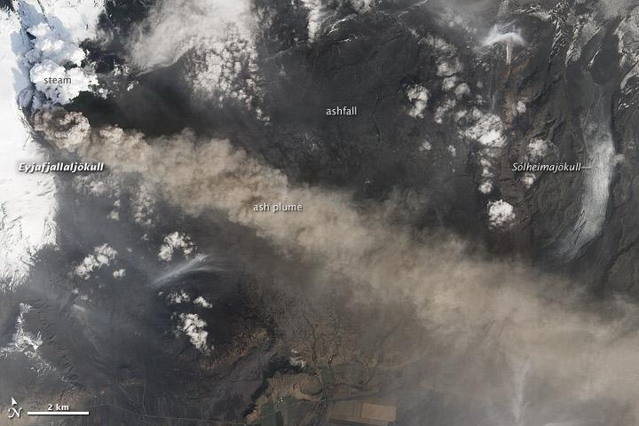
NASA satellite image acquired May 2, 2010 To view a detail of this image go to: <a href="http://www.flickr.com/photos/gsfc/4584266734/">www.flickr.com/photos/gsfc/4584266734/</a> Ash and steam continued billowing from Eyjafjallajökull Volcano in early May 2010. The Advanced Land Imager (ALI) on NASA’s Earth Observing-1 (EO-1) satellite captured this natural-color image on May 2, 2010. The volcano’s summit is near the left edge of this image, capped by a dark plume. The plume is dull gray-brown, indicating that its principal visible component is volcanic ash. Ash from the plume blows toward the east-southeast, passing over a charcoal-colored ash field on the land surface. Just to the north of Eyjafjallajökull’s summit are white puffs of steam, likely from surface lava flows vaporizing snow and glacial ice. On May 4, 2010, the Icelandic Meteorological Office warned that Eyjafjallajökull showed no signs of ending its eruptive activity in the near future. The Met Office reported that ash from the volcano had reached a height of 5.8 to 6.0 kilometers (19,000 to 20,000 feet) above sea level, and had spread 65 to 80 kilometers (40 to 50 miles) east-southeast of the volcano, where it impeded visibility for local residents. The Met Office also reported that lava continued flowing down a steep hill north of the crater. NASA image by Robert Simmon, using ALI data from the EO-1 team. Caption by Michon Scott. Instrument: EO-1 – ALI To view other images from the Earth Observatory go to: <a href="http://earthobservatory.nasa.gov/" rel="nofollow">earthobservatory.nasa.gov/</a> <b><a href="http://www.nasa.gov/centers/goddard/home/index.html" rel="nofollow">NASA Goddard Space Flight Center</a></b> is home to the nation's largest organization of combined scientists, engineers and technologists that build spacecraft, instruments and new technology to study the Earth, the sun, our solar system, and the universe.

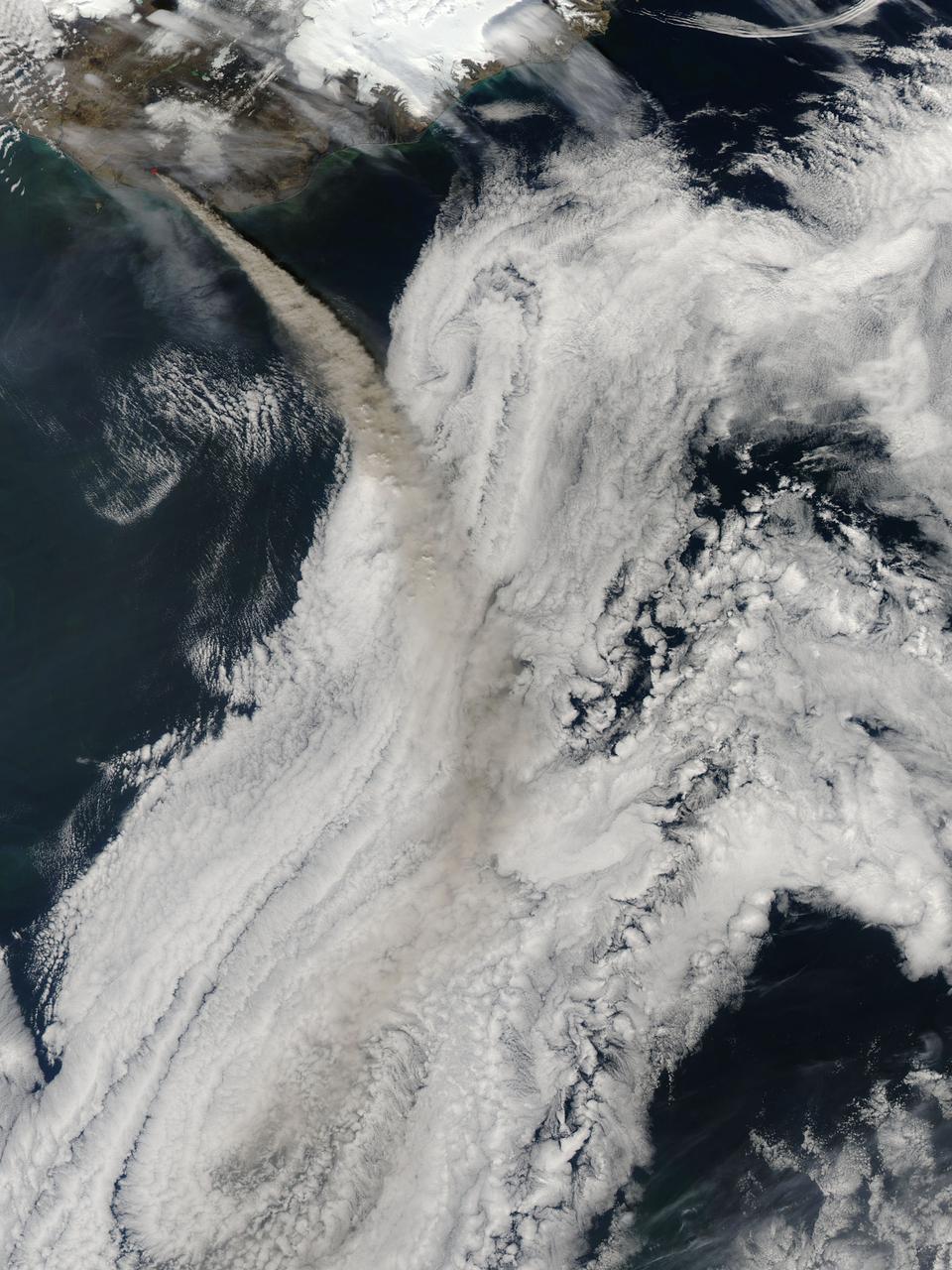
NASA satellite image acquired May 6, 2010 at 11 :55 UTC To view a detail of this image go to: <a href="http://www.flickr.com/photos/gsfc/4583711511/">www.flickr.com/photos/gsfc/4583711511/</a> NASA Satellite Sees a Darker Ash Plume From Iceland Volcano NASA's Terra satellite flew over the Eyjafjallajokull Volcano, Iceland, on May 6 at 11:55 UTC (7:55 a.m. EDT). The Moderate Resolution Imaging Spectroradiometer instrument known as MODIS that flies onboard Terra, captured a visible image of the ash plume. The plume was blowing east then southeast over the Northern Atlantic. The satellite image shows that the plume is at a lower level in the atmosphere than the clouds that lie to its east, as the brown plume appears to slide underneath the white clouds. Satellite: Terra NASA/GSFC/Jeff Schmaltz/MODIS Land Rapid Response Team To learn more about MODIS go to: <a href="http://www.nasa.gov/topics/earth/features/iceland-volcano-plume.html" rel="nofollow">www.nasa.gov/topics/earth/features/iceland-volcano-plume....</a> <b><a href="http://www.nasa.gov/centers/goddard/home/index.html" rel="nofollow">NASA Goddard Space Flight Center</a></b> is home to the nation's largest organization of combined scientists, engineers and technologists that build spacecraft, instruments and new technology to study the Earth, the sun, our solar system, and the universe.
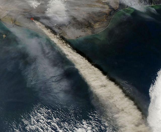
NASA image acquired May 8, 2010 at 13 :35 UTC Ash plume from Eyjafjallajokull Volcano, Iceland Satellite: Aqua NASA/GSFC/Jeff Schmaltz/MODIS Land Rapid Response Team <b><a href="http://www.nasa.gov/centers/goddard/home/index.html" rel="nofollow">NASA Goddard Space Flight Center</a></b> is home to the nation's largest organization of combined scientists, engineers and technologists that build spacecraft, instruments and new technology to study the Earth, the sun, our solar system, and the universe.

NASA satellite image acquired May 6, 2010 at 11 :55 UTC To view the full view go to: <a href="http://www.nasa.gov/topics/earth/features/iceland-volcano-plume.html" rel="nofollow">www.nasa.gov/topics/earth/features/iceland-volcano-plume....</a> NASA Satellite Sees a Darker Ash Plume From Iceland Volcano NASA's Terra satellite flew over the Eyjafjallajokull Volcano, Iceland, on May 6 at 11:55 UTC (7:55 a.m. EDT). The Moderate Resolution Imaging Spectroradiometer instrument known as MODIS that flies onboard Terra, captured a visible image of the ash plume. The plume was blowing east then southeast over the Northern Atlantic. The satellite image shows that the plume is at a lower level in the atmosphere than the clouds that lie to its east, as the brown plume appears to slide underneath the white clouds. Satellite: Terra NASA/GSFC/Jeff Schmaltz/MODIS Land Rapid Response Team To learn more about MODIS go to: <a href="http://rapidfire.sci.gsfc.nasa.gov/gallery/?latest" rel="nofollow">rapidfire.sci.gsfc.nasa.gov/gallery/?latest</a> <b><a href="http://www.nasa.gov/centers/goddard/home/index.html" rel="nofollow">NASA Goddard Space Flight Center</a></b> is home to the nation's largest organization of combined scientists, engineers and technologists that build spacecraft, instruments and new technology to study the Earth, the sun, our solar system, and the universe.