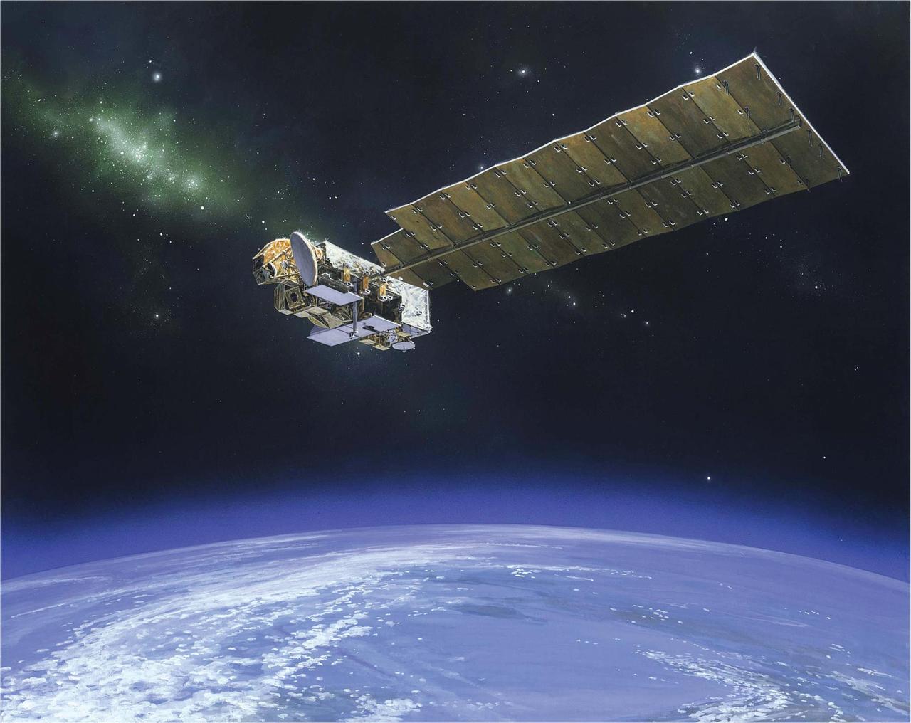
The Aura spacecraft is NASA atmospheric chemistry mission that is monitoring the Earth protective atmosphere.

This STS-48 onboard photo is of the Upper Atmosphere Research Satellite (UARS) in the grasp of the RMS (Remote Manipulator System) during deployment, September 1991. UARS gathers data related to the chemistry, dynamics, and energy of the ozone layer. UARS data is used to study energy input, stratospheric photo chemistry, and upper atmospheric circulation. UARS helps us understand and predict how the nitrogen and chlorine cycles, and the nitrous oxides and halo carbons which maintain them, relate to the ozone balance. It also observes diurnal variations in short-lived stratospheric chemical species important to ozone destruction. Data from UARS enables scientists to study ozone depletion in the upper atmosphere.

This STS-48 onboard photo is of the Upper Atmosphere Research Satellite (UARS) in the grasp of the RMS (Remote Manipulator System) during deployment, September 1991. UARS gathers data related to the chemistry, dynamics, and energy of the ozone layer. UARS data is used to study energy input, stratospheric photo chemistry, and upper atmospheric circulation. UARS helps us understand and predict how the nitrogen and chlorine cycles, and the nitrous oxides and halo carbons which maintain them, relate to the ozone balance. It also observes diurnal variations in short-lived stratospheric chemical species important to ozone destruction. Data from UARS enables scientists to study ozone depletion in the upper atmosphere.
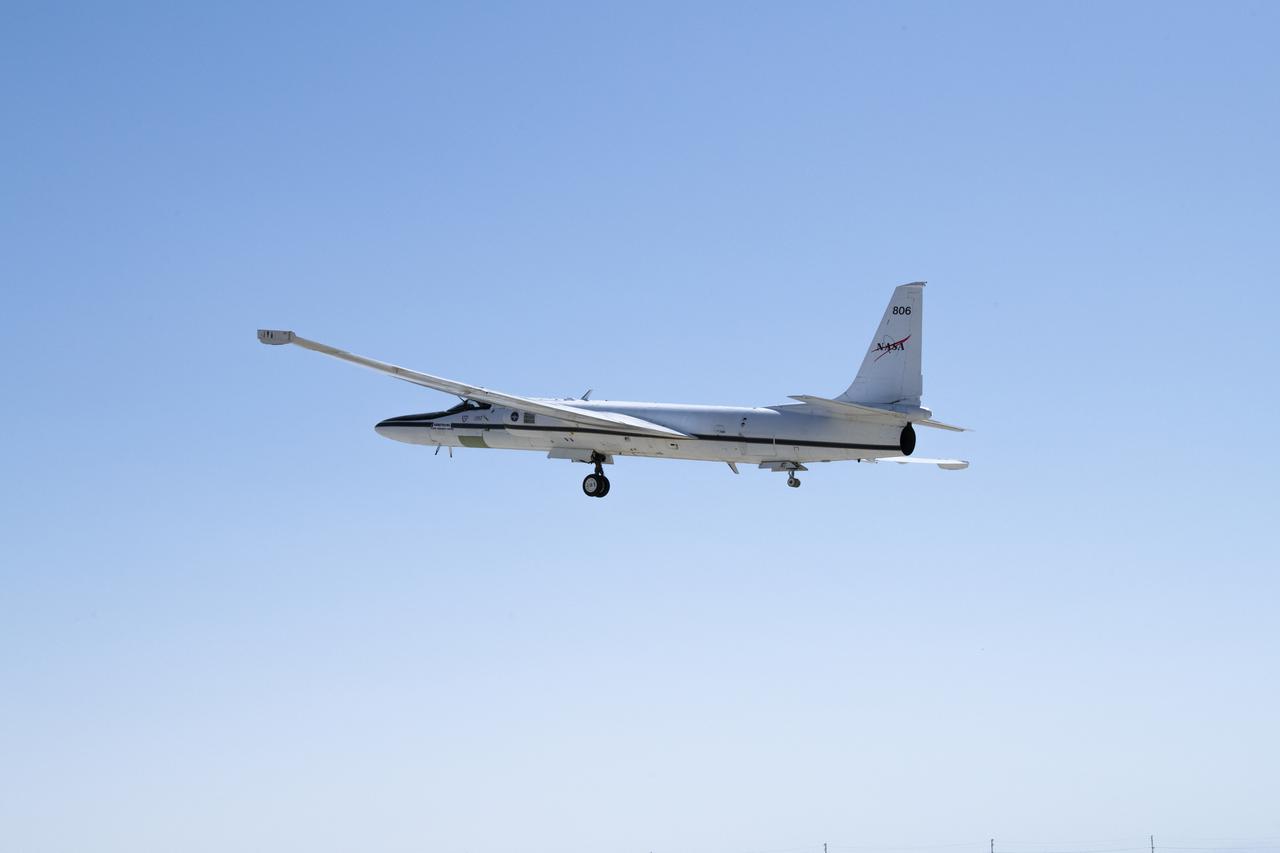
NASA’s ER-2 No. 806 returns to flying high-altitude on April 7, 2022, after three years of heavy maintenance. NASA Armstrong operates two ER-2 aircraft to collect information about Earth resources, celestial observations, atmospheric chemistry and dynamics, and oceanic processes.
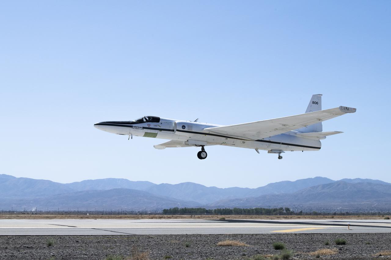
NASA's ER-2 No. 806 returns to flying high-altitude on April 7, 2022, after three years of heavy maintenance. NASA Armstrong operates two ER-2 aircraft to collect information about Earth resources, celestial observations, atmospheric chemistry and dynamics, and oceanic processes.
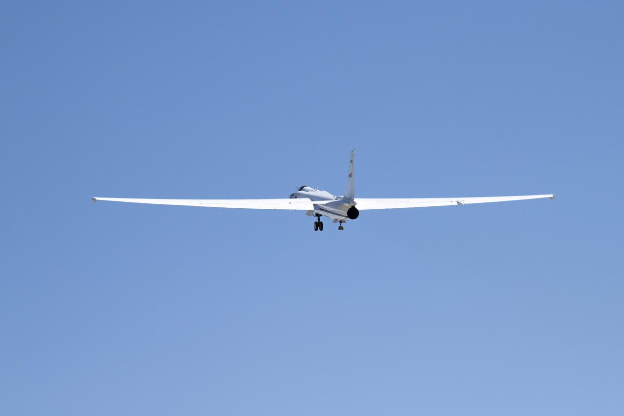
NASA’s ER-2 No. 806 returns to flying high-altitude on April 7, 2022, after three years of heavy maintenance. NASA Armstrong operates two ER-2 aircraft to collect information about Earth resources, celestial observations, atmospheric chemistry and dynamics, and oceanic processes.
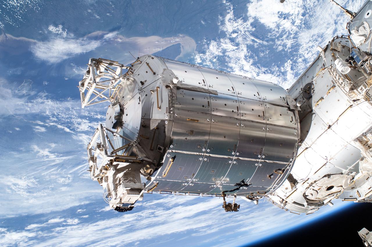
iss036e016840 (7/9/2013) --- Close-up view of the COLUMBUS External Platform Facility (CEPF) and the Solar facility taken during extravehicular activity (EVA) 22 on the International Space Station. The Sun Monitoring on the External Payload Facility of Columbus (Solar) is a monitoring observatory that will measure the solar spectral irradiance, which is of great importance for atmospheric modeling, atmospheric chemistry and climatology.
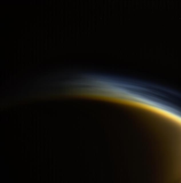
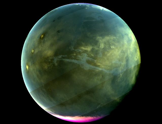
In this view, individual layers of haze can be distinguished in the upper atmosphere of Titan, Saturn's largest moon. Titan's atmosphere features a rich and complex chemistry originating from methane and nitrogen and evolving into complex molecules, eventually forming the smog that surrounds the moon. This natural color image was taken in visible light with the Cassini spacecraft wide-angle camera on March 31, 2005, at a distance of approximately 20,556 miles (33,083 kilometers) from Titan. The view looks toward the north polar region on the moon's night side. Part of Titan's sunlit crescent is visible at right. The Cassini spacecraft ended its mission on Sept. 15, 2017. https://photojournal.jpl.nasa.gov/catalog/PIA21902
KENNEDY SPACE CENTER, FLA. - At Space Launch Complex 2 on North Vandenberg Air Force Base, Calif., the Aura spacecraft arrives at the top of the mobile service tower, or gantry. It will be moved and then mated with the second stage of the Boeing Delta II rocket. The latest in the Earth Observing System (EOS) series, Aura is scheduled to launch July 10. Aura’s four state-of-the-art instruments will study the dynamics of chemistry occurring in the atmosphere. The spacecraft will provide data to help scientists better understand the Earth’s ozone, air quality and climate change.
KENNEDY SPACE CENTER, FLA. - At Space Launch Complex 2 on North Vandenberg Air Force Base, Calif., the Aura spacecraft arrives at the base of the mobile service tower, or gantry. The latest in the Earth Observing System (EOS) series, Aura is scheduled to launch July 10 aboard the Boeing Delta II rocket. Aura’s four state-of-the-art instruments will study the dynamics of chemistry occurring in the atmosphere. The spacecraft will provide data to help scientists better understand the Earth’s ozone, air quality and climate change.
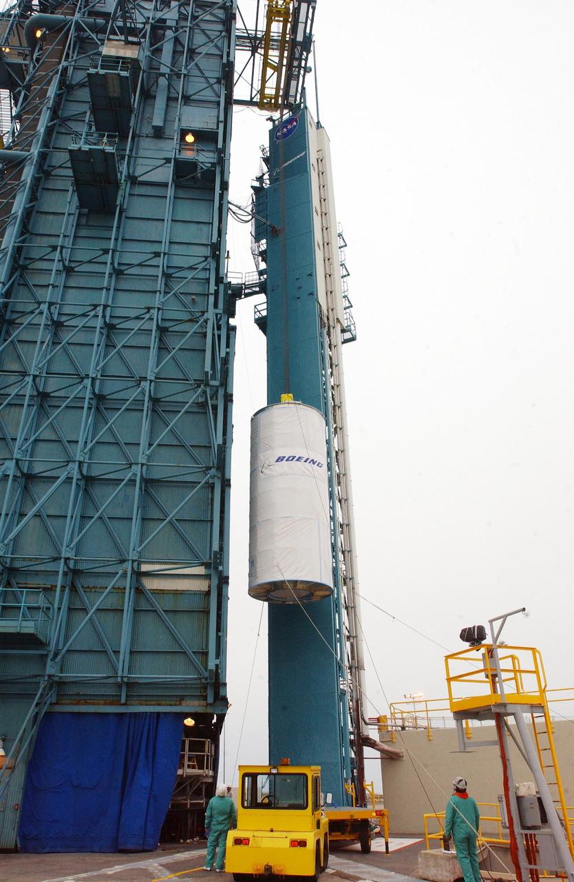
KENNEDY SPACE CENTER, FLA. - At Space Launch Complex 2 on North Vandenberg Air Force Base, Calif., the Aura spacecraft is lifted up the mobile service tower, or gantry. The latest in the Earth Observing System (EOS) series, Aura is scheduled to launch July 10 aboard the Boeing Delta II rocket. Aura’s four state-of-the-art instruments will study the dynamics of chemistry occurring in the atmosphere. The spacecraft will provide data to help scientists better understand the Earth’s ozone, air quality and climate change.
![VANDENBERG AFB, CALIF. - The Aura spacecraft atop its Boeing Delta II launch vehicle sits on NASA’s Space Complex 2 at Vandenberg Air Force Base in California waiting to launch. Liftoff is now scheduled for no earlier than July 14. The latest in the Earth Observing System (EOS) series, Aura’s four state-of-the-art instruments will study the dynamics of chemistry occurring in the atmosphere. The spacecraft will provide data to help scientists better understand the Earth’s ozone, air quality and climate change. [Photo by Bill Ingalls/NASA]](https://images-assets.nasa.gov/image/KSC-04pd1469/KSC-04pd1469~medium.jpg)
VANDENBERG AFB, CALIF. - The Aura spacecraft atop its Boeing Delta II launch vehicle sits on NASA’s Space Complex 2 at Vandenberg Air Force Base in California waiting to launch. Liftoff is now scheduled for no earlier than July 14. The latest in the Earth Observing System (EOS) series, Aura’s four state-of-the-art instruments will study the dynamics of chemistry occurring in the atmosphere. The spacecraft will provide data to help scientists better understand the Earth’s ozone, air quality and climate change. [Photo by Bill Ingalls/NASA]
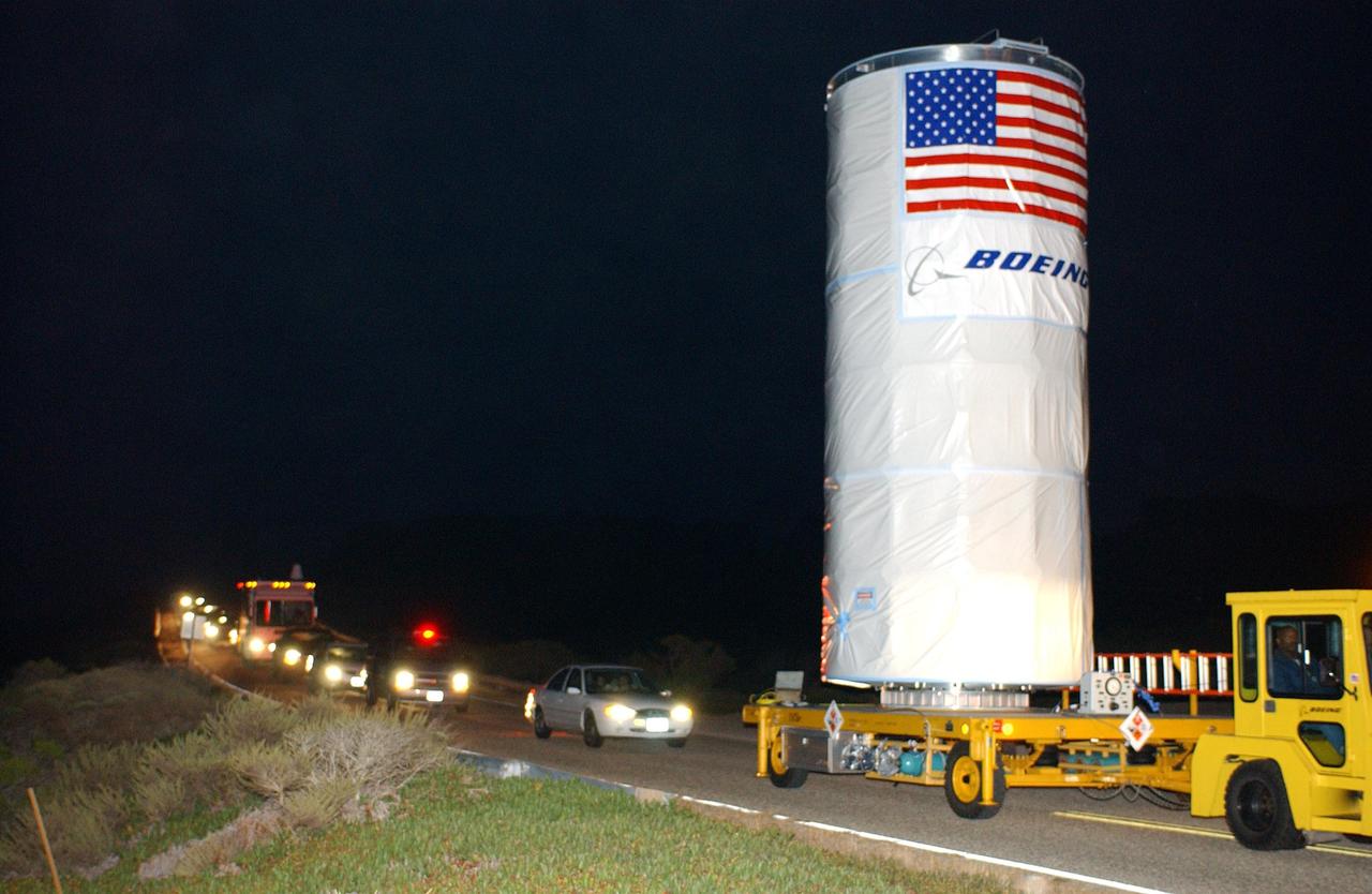
KENNEDY SPACE CENTER, FLA. - The Aura spacecraft on a transporter heads a convoy of vehicles in the predawn hours as it moves to Space Launch Complex 2 on North Vandenberg Air Force Base, Calif. The latest in the Earth Observing System (EOS) series, Aura is scheduled to launch July 10 aboard a Boeing Delta II rocket. Aura’s four state-of-the-art instruments will study the dynamics of chemistry occurring in the atmosphere. The spacecraft will provide data to help scientists better understand the Earth’s ozone, air quality and climate change.
KENNEDY SPACE CENTER, FLA. - At Space Launch Complex 2 on North Vandenberg Air Force Base, Calif., the Aura spacecraft is prepared for its lift up the mobile service tower, or gantry. The latest in the Earth Observing System (EOS) series, Aura is scheduled to launch July 10 aboard the Boeing Delta II rocket. Aura’s four state-of-the-art instruments will study the dynamics of chemistry occurring in the atmosphere. The spacecraft will provide data to help scientists better understand the Earth’s ozone, air quality and climate change.

iss050e052652 (2/26/2017) --- A view of the Space Test Program - Houston5 (STP-H5). The Space Test Program-H5-Lightning Imaging Sensor (STP-H5 LIS) on the International Space Station (ISS) measures the amount, rate, and energy of lightning around the world. Improved understanding of lightning and its connections to weather provides crucial insight for weather forecasting, climate change, atmospheric chemistry and physics, and aircraft and spacecraft safety.

Madhulika Guhathakurta, SDO Program Scientist at NASA Headquarters in Washington, speaks during a briefing to discuss recent images from NASA's Solar Dynamics Observatory, or SDO, Wednesday, April 21, 2010, at the Newseum in Washington. Launched on Feb. 11, 2010, SDO is the most advanced spacecraft ever designed to study the sun. During its five-year mission, it will examine the sun's magnetic field and also provide a better understanding of the role the sun plays in Earth's atmospheric chemistry and climate. Photo Credit: (NASA/Carla Cioffi)

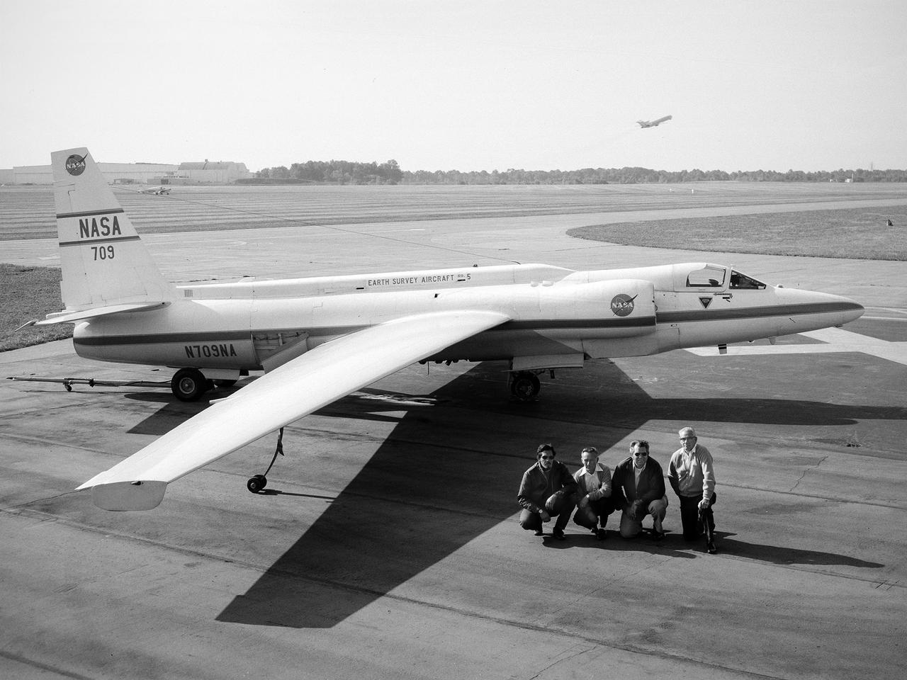
NASA DC-8 airborne laboratory flying over Mint Canyon near the snow-covered San Gabriel Mountains of California. The mostly white aircraft is silhouetted against the darker mountains in the background.
The DC-8 Airborne Laboratory in a left banking turn above the airport at Palmdale, California. The right wing is silhouetted against the blue sky, while the left wing contrasts with the desert terrain. The former airliner is a "dash-72" model and has a range of 5,400 miles. The craft can stay airborne for 12 hours and has an operational speed range between 300 and 500 knots. The research flights are made at between 500 and 41,000 feet. The aircraft can carry up to 30,000 lbs of research/science payload equipment installed in 15 mission-definable spaces.
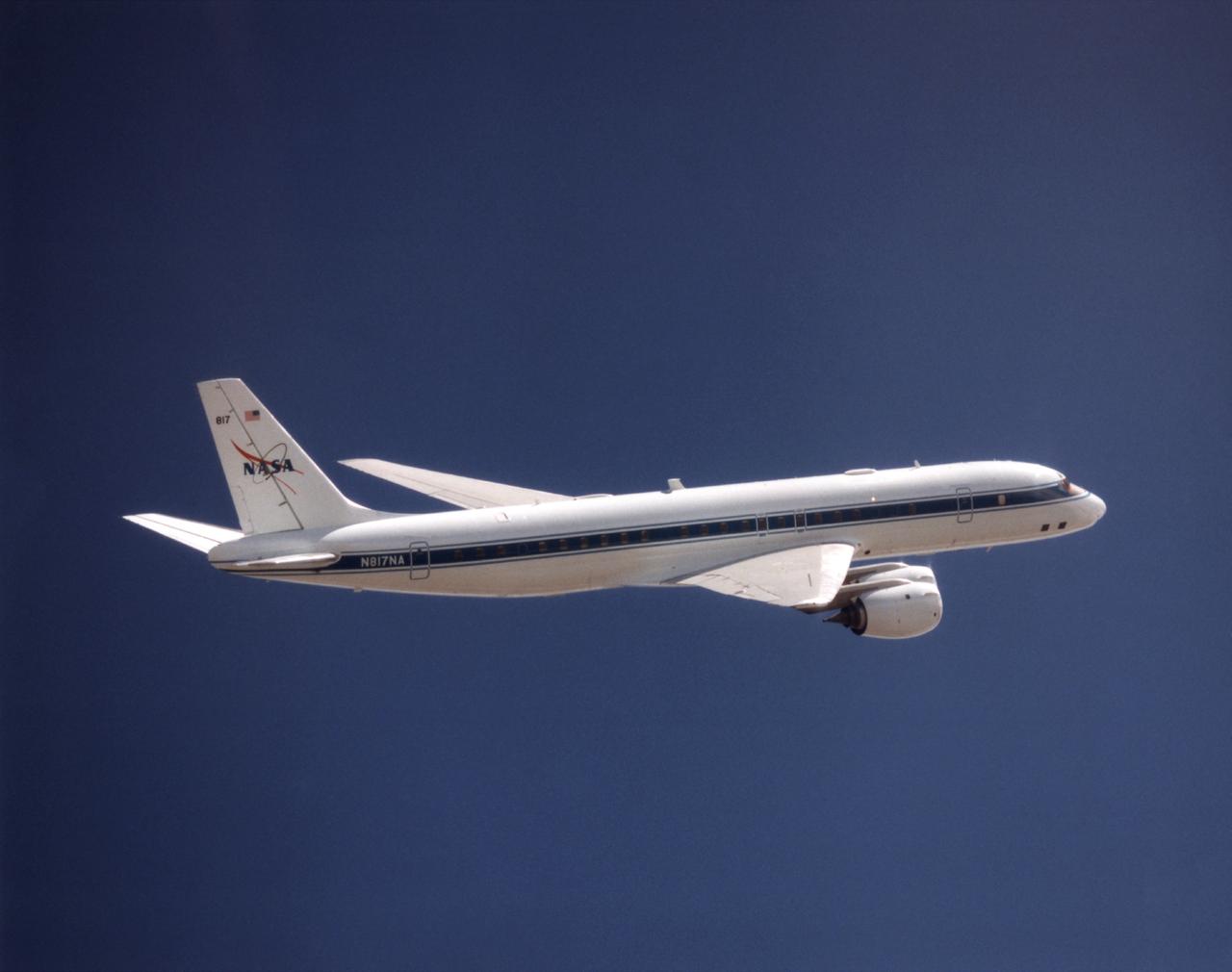
NASA's DC-8 Airborne Science platform shown against a background of a dark blue sky on February 20, 1998. The aircraft is shown from the right rear, slightly above its plane, with the right wing in the foreground and the left wing and horizontal tail in the background. The former airliner is a "dash-72" model and has a range of 5,400 miles. The craft can stay airborne for 12 hours and has an operational speed range between 300 and 500 knots. The research flights are made at between 500 and 41,000 feet. The aircraft can carry up to 30,000 lbs of research/science payload equipment installed in 15 mission-definable spaces.
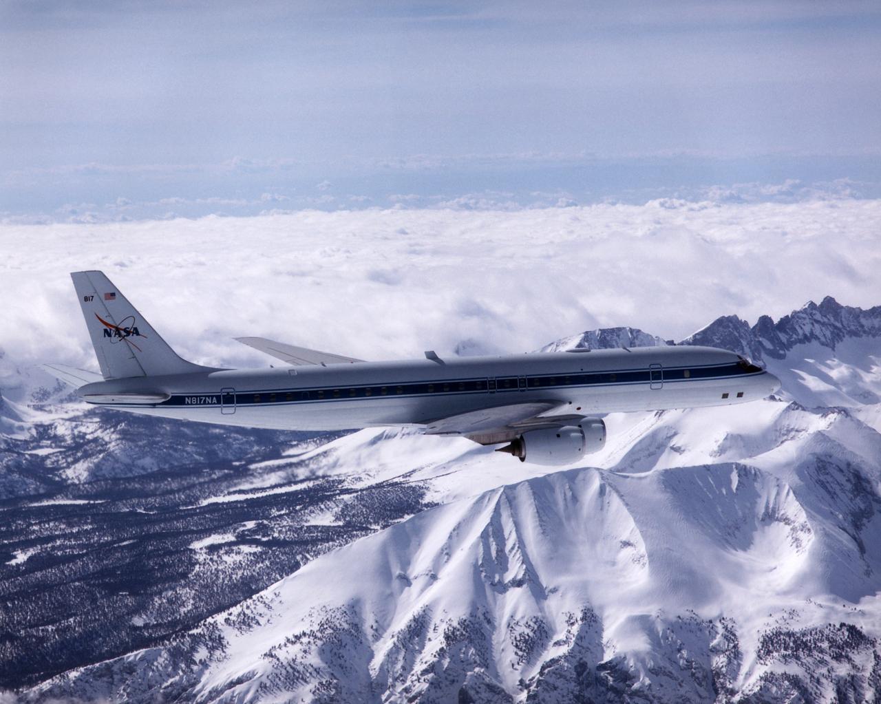
NASA's DC-8 Airborne Laboratory during a flight over the snow-covered Sierra Nevada Mountains. Over the past several years the DC-8 has conducted research missions in such diverse places as the Pacific in spring and Sweden in winter.
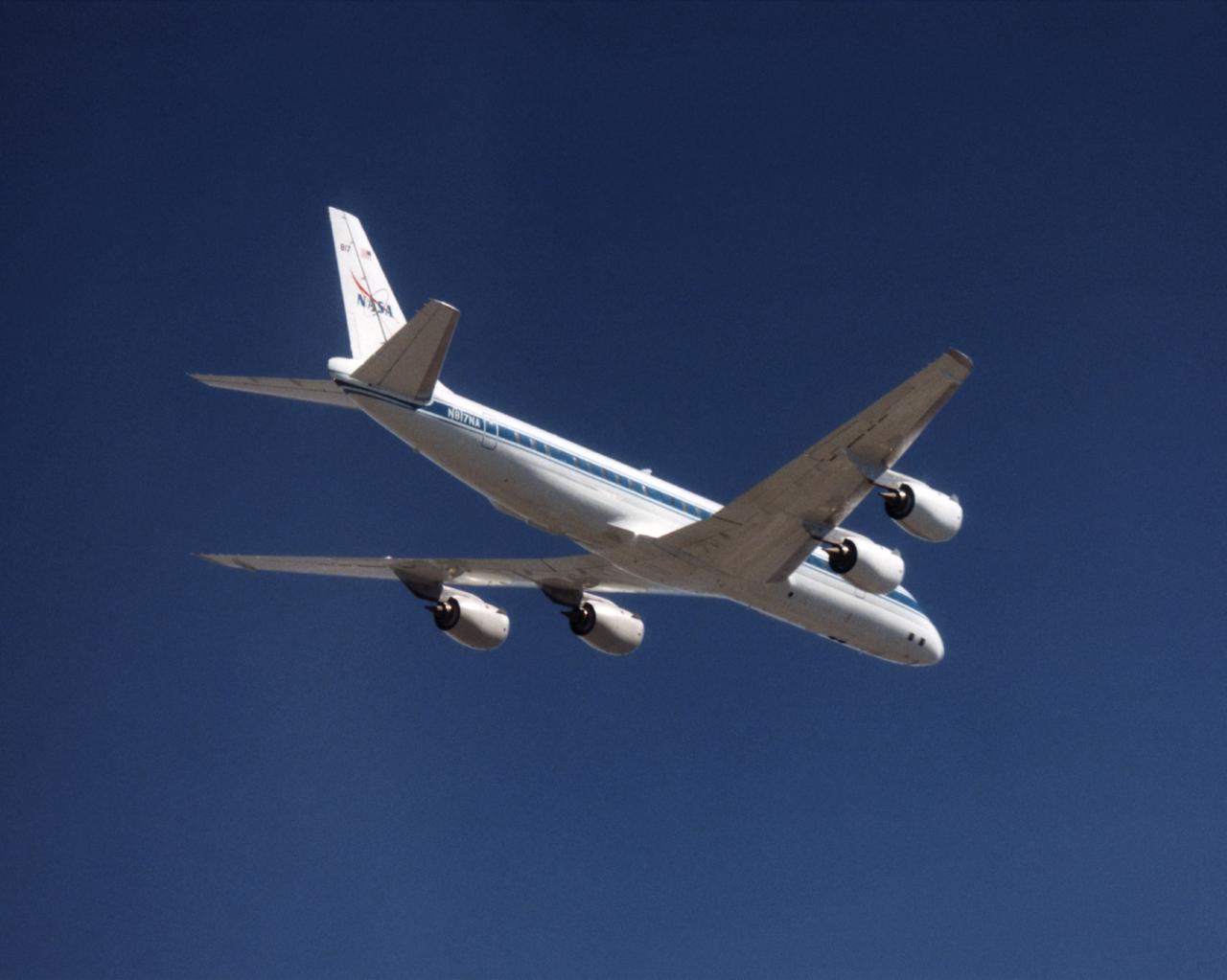
The NASA DC-8 in a right bank over the rugged Sierra Nevada Mountains. The former airliner is a "dash-72" model and has a range of 5,500 miles. The craft can stay airborne for 12 hours and has an operational speed range between 300 and 500 knots. The research flights are made at between 500 and 41,000 feet. The aircraft can carry up to 30,000 lbs of research/science payload equipment installed in 15 mission-definable spaces. In this photo, the aircraft is shown in flight from below, with the DC-8 silhouetted against a blue sky.
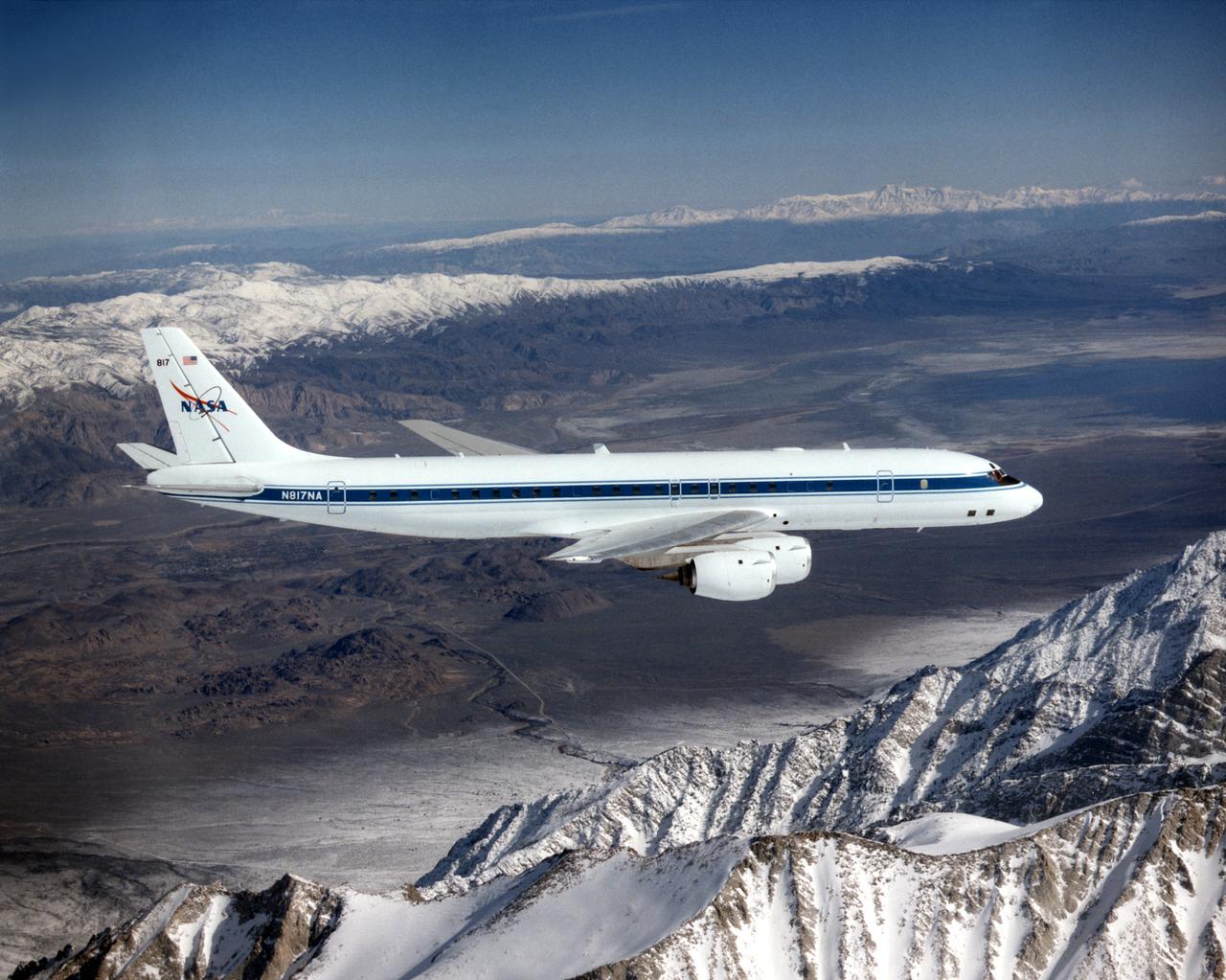
The DC-8 in flight near Lone Pine, Calif. In the foreground are the Sierra Nevada Mountains, covered with winter snow. In the distance are the White Mountains. The DC-8's fuselage is painted white with a dark blue stripe down the side. The wings are silver, while the engine pods are white. In this view of the airplane's right-hand side, only a few of its antennas are visible. The experimental payload can be as great as 30,000 pounds of equipment for gathering data of various sorts.
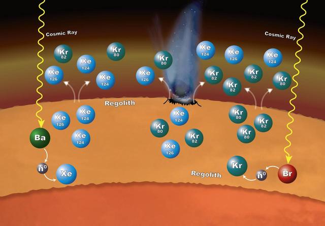
Chemistry that takes place in the surface material on Mars can explain why particular xenon (Xe) and krypton (Kr) isotopes are more abundant in the Martian atmosphere than expected. The isotopes -- variants that have different numbers of neutrons -- are formed in the loose rocks and material that make up the regolith -- the surface layer down to solid rock. The chemistry begins when cosmic rays penetrate into the surface material. If the cosmic rays strike an atom of barium (Ba), the barium can lose one or more of its neutrons (n0). Atoms of xenon can pick up some of those neutrons – a process called neutron capture – to form the isotopes xenon-124 and xenon-126. In the same way, atoms of bromine (Br) can lose some of their neutrons to krypton, leading to the formation of krypton-80 and krypton-82 isotopes. These isotopes can enter the atmosphere when the regolith is disturbed by impacts and abrasion, allowing gas to escape. http://photojournal.jpl.nasa.gov/catalog/PIA20847
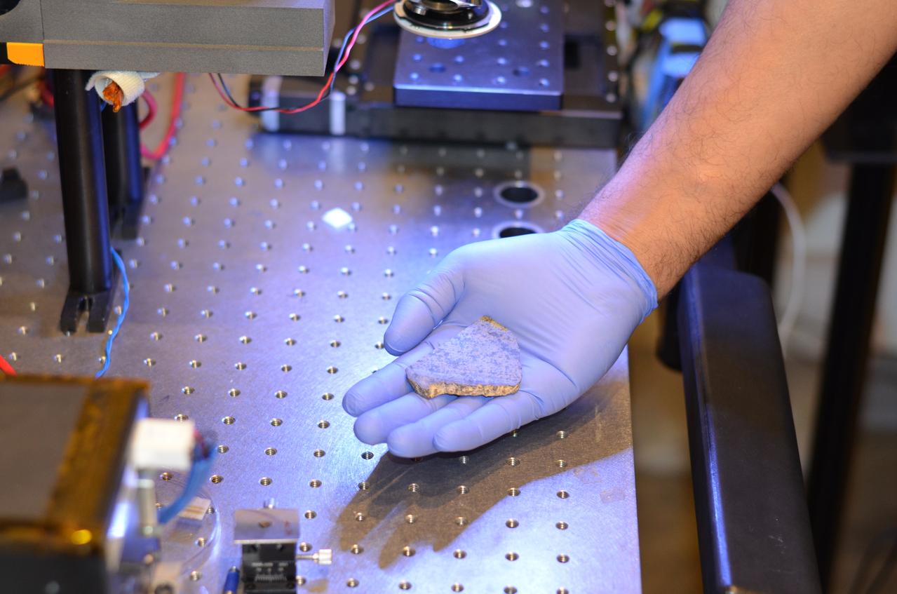
Rohit Bhartia of NASA's Mars 2020 mission holds a slice of a meteorite scientists have determined came from Mars. This slice will likely be used here on Earth for testing a laser instrument for NASA's Mars 2020 rover; a separate slice will go to Mars on the rover. Martian meteorites are believed to be the result of impacts to the Red Planet's surface, resulting in rock being blasted into the atmosphere. After traveling through space for eons, some of these rocks entered Earth's atmosphere. Scientists determine whether they are true Martian meteorites based on their rock and noble gas chemistry and mineralogy. The gases trapped in these meteorites bear the unique fingerprint of the Martian atmosphere, as recorded by NASA's Viking mission in 1976. The rock types also show clear signs of igneous processing not possible on smaller bodies, such as asteroids. https://photojournal.jpl.nasa.gov/catalog/PIA22245

A slice of a meteorite scientists have determined came from Mars placed inside an oxygen plasma cleaner, which removes organics from the outside of surfaces. This slice will likely be used here on Earth for testing a laser instrument for NASA's Mars 2020 rover; a separate slice will go to Mars on the rover. Martian meteorites are believed to be the result of impacts to the Red Planet's surface, resulting in rock being blasted into the atmosphere. After traveling through space for eons, some of these rocks entered Earth's atmosphere. Scientists determine whether they are true Martian meteorites based on their rock and noble gas chemistry and mineralogy. The gases trapped in these meteorites bear the unique fingerprint of the Martian atmosphere, as recorded by NASA's Viking mission in 1976. The rock types also show clear signs of igneous processing not possible on smaller bodies, such as asteroids. https://photojournal.jpl.nasa.gov/catalog/PIA22247
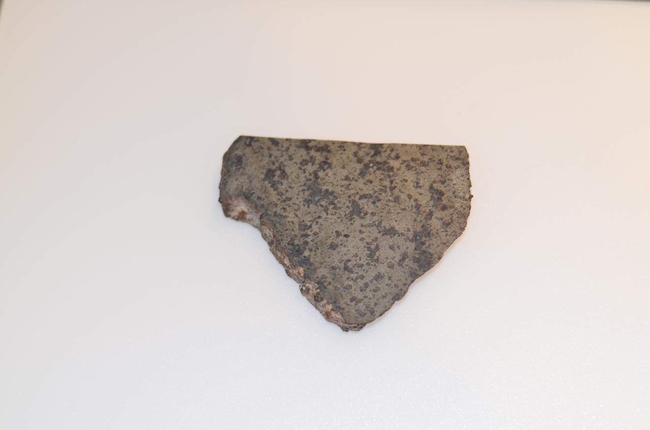
Close-up of a slice of a meteorite scientists have determined came from Mars. This slice will likely be used here on Earth for testing a laser instrument for NASA's Mars 2020 rover; a separate slice will go to Mars on the rover. Martian meteorites are believed to be the result of impacts to the Red Planet's surface, resulting in rock being heaved into the atmosphere. After traveling through space for eons, some of these rocks entered Earth's atmosphere. Scientists determine whether they are true Martian meteorites based on their rock and noble gas chemistry and mineralogy. The gases trapped in these meteorites bear the unique fingerprint of the Martian atmosphere, as recorded by NASA's Viking mission in 1976. The rock types also show clear signs of igneous processing not possible on smaller bodies, such as asteroids. https://photojournal.jpl.nasa.gov/catalog/PIA22246
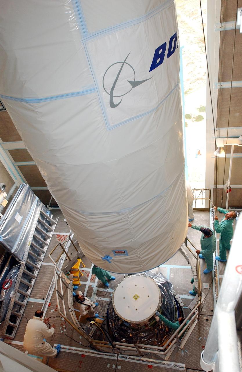
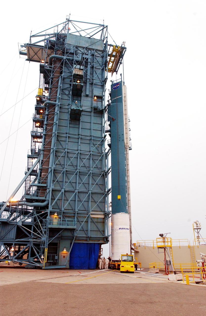
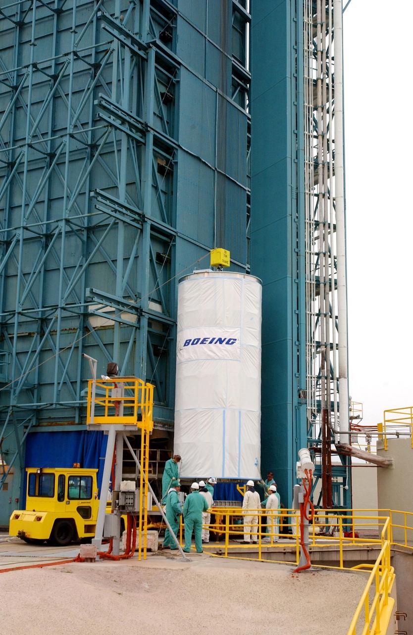
KENNEDY SPACE CENTER, FLA. - Inside the mobile service tower, or gantry, at Space Launch Complex 2 on North Vandenberg Air Force Base, Calif., the Aura spacecraft is maneuvered into position over the second stage of the Boeing Delta II rocket. After it is mated with the second stage, the fairing will be installed. The latest in the Earth Observing System (EOS) series, Aura is scheduled to launch July 10. Aura’s four state-of-the-art instruments will study the dynamics of chemistry occurring in the atmosphere. The spacecraft will provide data to help scientists better understand the Earth’s ozone, air quality and climate change.
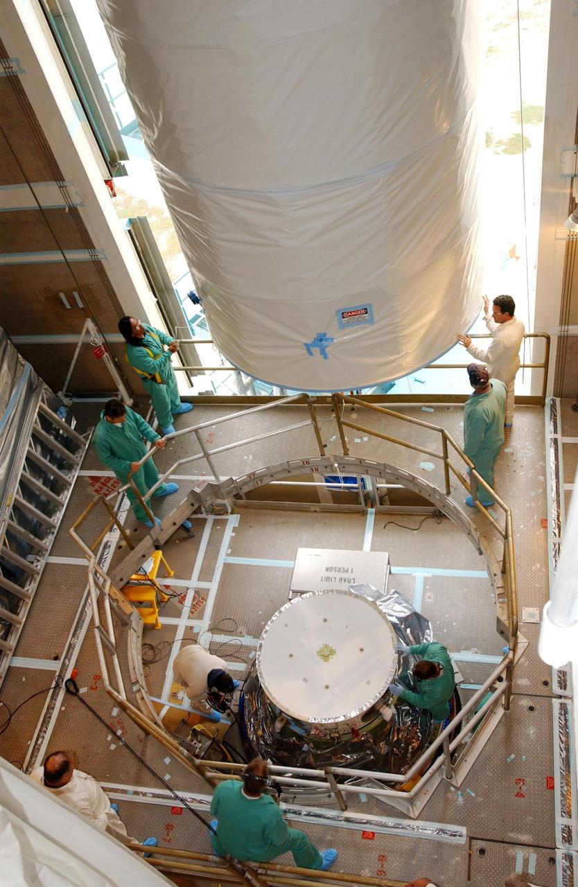
KENNEDY SPACE CENTER, FLA. - Inside the mobile service tower, or gantry, at Space Launch Complex 2 on North Vandenberg Air Force Base, Calif., workers help guide the Aura spacecraft toward the second stage of the Boeing Delta II rocket. After mating with the second stage, the fairing will be installed. The latest in the Earth Observing System (EOS) series, Aura is scheduled to launch July 10. Aura’s four state-of-the-art instruments will study the dynamics of chemistry occurring in the atmosphere. The spacecraft will provide data to help scientists better understand the Earth’s ozone, air quality and climate change.
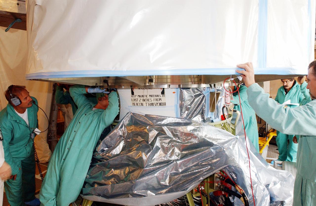
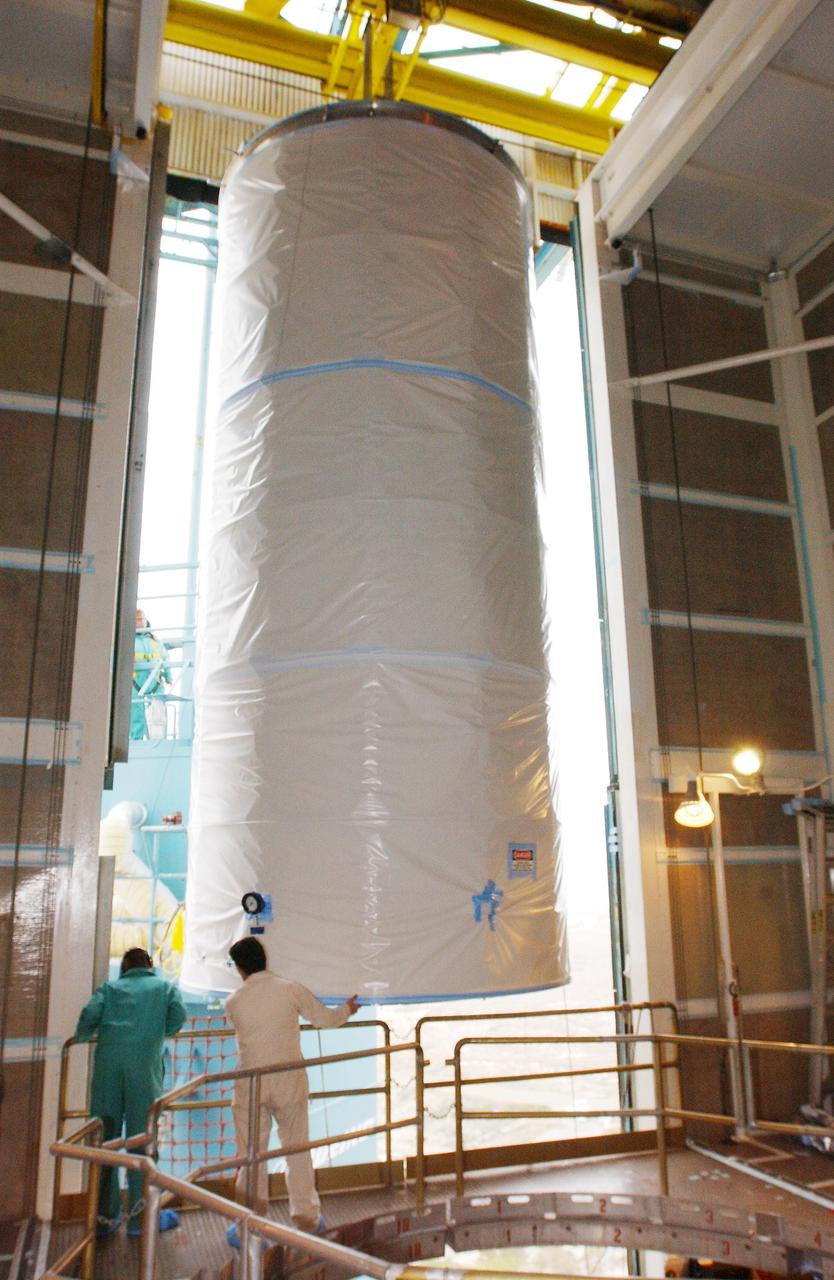
KENNEDY SPACE CENTER, FLA. - Workers on the mobile service tower, or gantry, at Space Launch Complex 2 on North Vandenberg Air Force Base, Calif., check connections as the protective cover is lifted off the Aura spacecraft. Aura will be mated to the second stage of the Boeing Delta II rocket before the fairing is installed. The latest in the Earth Observing System (EOS) series, Aura is scheduled to launch July 10. Aura’s four state-of-the-art instruments will study the dynamics of chemistry occurring in the atmosphere. The spacecraft will provide data to help scientists better understand the Earth’s ozone, air quality and climate change.
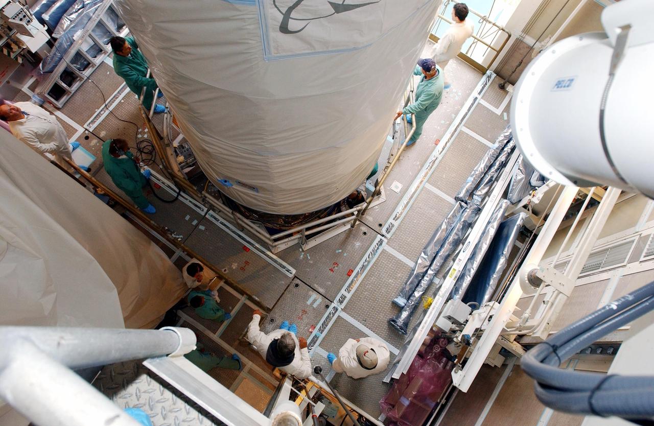
KENNEDY SPACE CENTER, FLA. - Inside the mobile service tower, or gantry, at Space Launch Complex 2 on North Vandenberg Air Force Base, Calif., the Aura spacecraft is lowered toward the second stage of the Boeing Delta II rocket. After it is mated with the second stage, the fairing will be installed. The latest in the Earth Observing System (EOS) series, Aura is scheduled to launch July 10. Aura’s four state-of-the-art instruments will study the dynamics of chemistry occurring in the atmosphere. The spacecraft will provide data to help scientists better understand the Earth’s ozone, air quality and climate change.
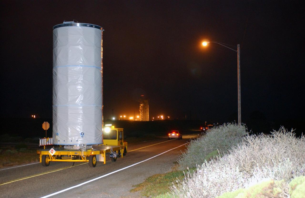
KENNEDY SPACE CENTER, FLA. - In the predawn hours, the Aura spacecraft is transported the short distance from the Astrotech payload processing facility to Space Launch Complex 2 on North Vandenberg Air Force Base, Calif. The latest in the Earth Observing System (EOS) series, Aura is scheduled to launch July 10 aboard a Boeing Delta II rocket. Aura’s four state-of-the-art instruments will study the dynamics of chemistry occurring in the atmosphere. The spacecraft will provide data to help scientists better understand the Earth’s ozone, air quality and climate change.
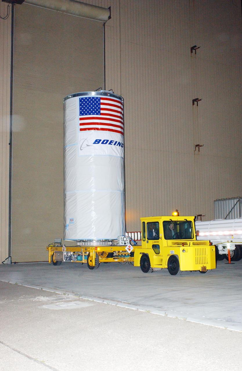
KENNEDY SPACE CENTER, FLA. - In the predawn hours, the Aura spacecraft is being transported from the Astrotech payload processing facility located a few miles south of Space Launch Complex 2 on North Vandenberg Air Force Base, Calif. The latest in the Earth Observing System (EOS) series, Aura is scheduled to launch July 10 aboard a Boeing Delta II rocket. Aura’s four state-of-the-art instruments will study the dynamics of chemistry occurring in the atmosphere. The spacecraft will provide data to help scientists better understand the Earth’s ozone, air quality and climate change.
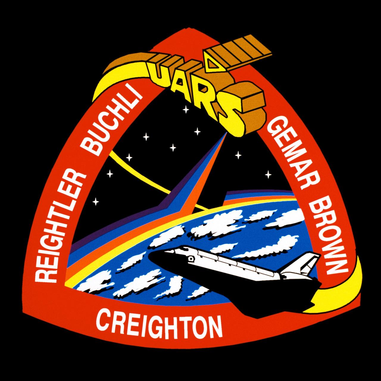
STS048-S-001 (July 1991) --- Designed by the astronaut crew members, the patch represents the space shuttle orbiter Discovery in orbit about Earth after deploying the Upper Atmospheric Research Satellite (UARS) depicted in block letter style. The stars are those in the northern hemisphere as seen in the fall and winter when UARS will begin its study of Earth's atmosphere. The color bands on Earth's horizon, extending up to the UARS spacecraft, depict the study of Earth's atmosphere. The triangular shape represents the relationship among the three atmospheric processes that determine upper atmospheric structure and behavior: chemistry, dynamics and energy. In the words of the crew members, "This continuous process brings life to our planet and makes our planet unique in the solar system." The NASA insignia design for space shuttle flights is reserved for use by the astronauts and for other official use as the NASA Administrator may authorize. Public availability has been approved only in the form of illustrations by the various news media. When and if there is any change in this policy, which is not anticipated, it will be publicly announced. Photo credit: NASA
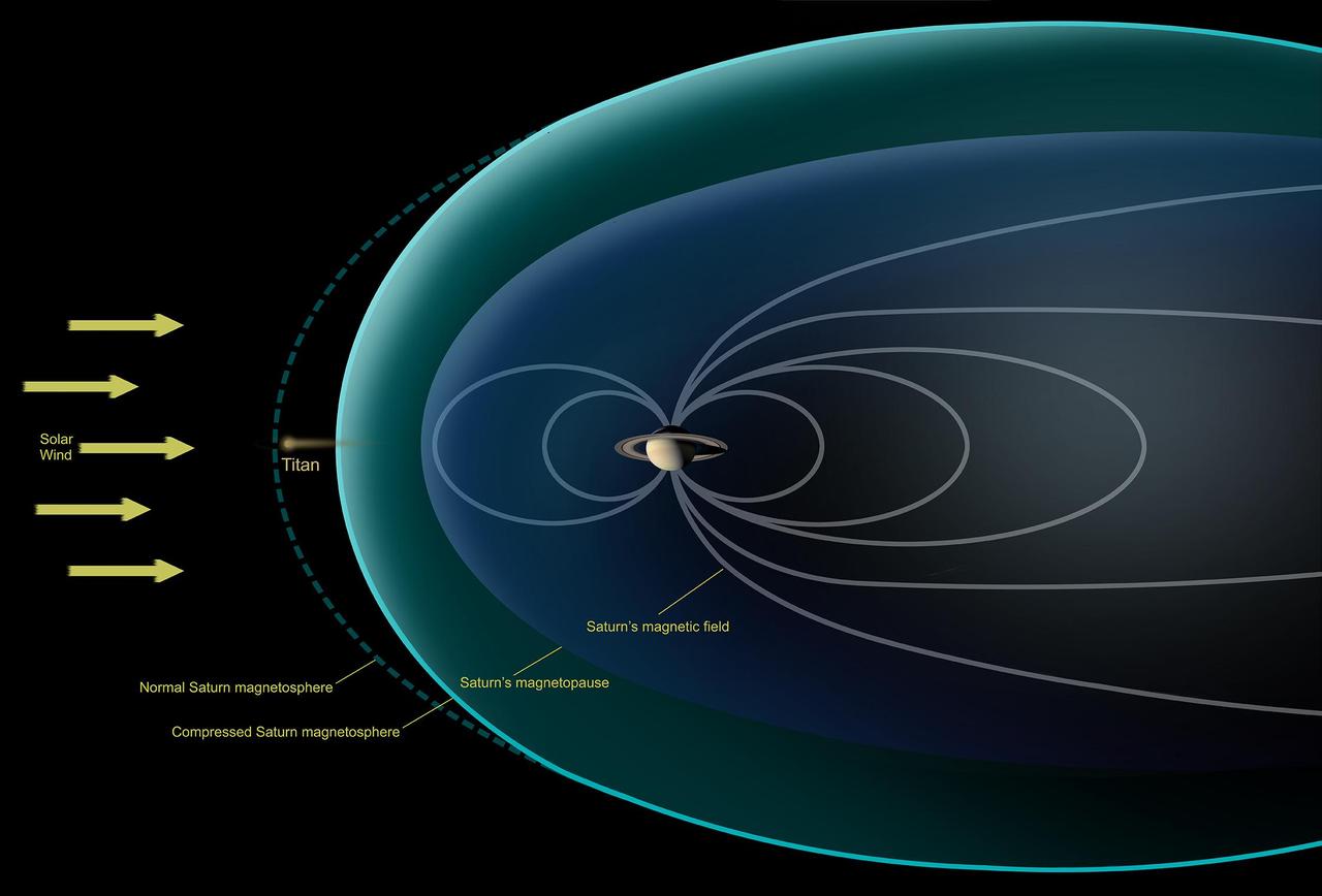
This diagram depicts conditions observed by NASA's Cassini spacecraft during a flyby in Dec. 2013, when Saturn's magnetosphere was highly compressed, exposing Titan to the full force of the solar wind. In analyzing data from the encounter, scientists with Cassini's magnetometer team observed that the giant moon interacted with the solar wind much like the planets Mars and Venus, or a comet -- none of which possess their own internal magnetic field. Specifically, they saw that the solar wind draped itself around Titan, creating a shockwave that formed around Titan where the full-force solar wind rammed into the moon's atmosphere. Previously, researchers had thought Titan would have a different sort of interaction with the solar wind because of the moon's complex atmospheric chemistry. http://photojournal.jpl.nasa.gov/catalog/PIA19055
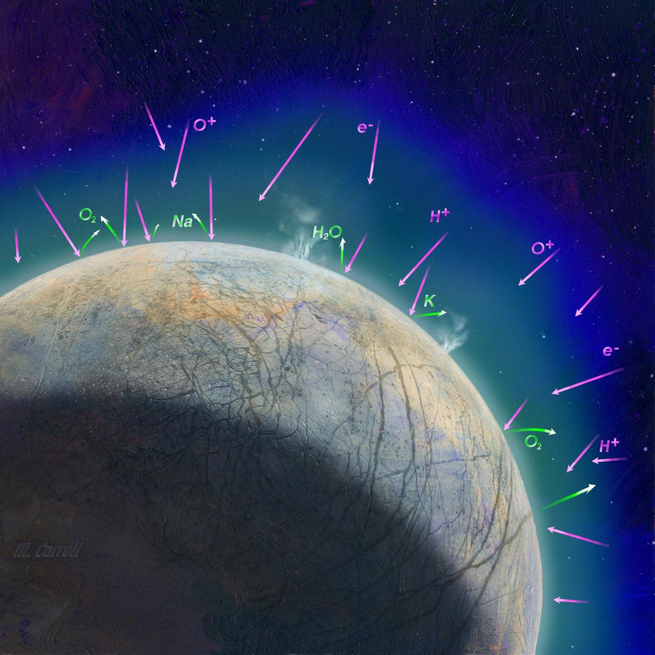
This artist's concept shows how scientists think the thin atmosphere on Jupiter's moon Europa is formed. It illustrates how the impact of high-energy, charged particles can kick up material from the surface and how possible plumes might also contribute to the atmosphere. NASA's Europa Clipper mission aims to better understand the moon's atmosphere by measuring its chemical composition with the MAss Spectrometer for Planetary EXploration/Europa (MASPEX) and "sniffing" the dust grains blasted off the surface with the SUrface Dust Analyzer (SUDA). These two instruments will help scientists understand whether Europa harbors the composition and chemistry required to host life. Europa Clipper's three main science objectives are to determine the thickness of the moon's icy shell and its interactions with the ocean below, to investigate its composition, and to characterize its geology. The mission's detailed exploration of Europa will help scientists better understand the astrobiological potential for habitable worlds beyond our planet. https://photojournal.jpl.nasa.gov/catalog/PIA26107

ISS006-E-33736 (25 February 2003) --- The boot of Italy crosses the image in this southwest-looking view taken by an Expedition Six crewmember onboard the International Space Station (ISS). The spine of Italy is highlighted with snow and the largely cloud-covered Mediterranean Sea is at the top. The Adriatic Sea transverses most of the bottom of the image and Sicily appears top left beyond the toe of the boot. The heel lies out of the left side of the image. Corsica and Sardinia appear right of center partly under cloud. The floor of the Po River valley, lower right, is obscured by haze. Experience gained from similar haze events, in which atmospheric pressure, humidity and visibility and atmospheric chemistry were known, suggests that the haze as industrial smog. Industrial haze from the urban region of the central and upper Po valley accumulates to visible concentrations under conditions of high atmospheric pressure and the surrounding mountains prevent easy dispersal. This view illustrates the markedly different color and texture of cloud versus industrial aerosol haze.
The 7-year journey to Saturn began with the liftoff of a Titan IVB/Centaur carrying the Cassini orbiter and its attached Huygens probe. After a 2.2-billion mile journey that included two swingbys of Venus and one of Earth to gain additional velocity, the two-story tall spacecraft will arrive at Saturn in July 2004. The orbiter will circle the planet for 4 years, its compliment of 12 scientific instruments gathering data about Saturn's atmosphere, rings and magnetosphere, and conducting close-up observations of the Saturnian moons. Huygens, with a separate suite of 6 science instruments, will separate from Cassini to fly on a ballistic trajectory toward Titan, the only celestial body besides Earth to have an atmosphere rich in nitrogen. Scientists are eager to study further this chemical similarity in hopes of learning more about the origins of our own planet Earth. Huygens will provide the first direct sampling of Titan's atmospheric chemistry and the first detailed photographs of its surface. The Cassini mission is an international effort involving NASA, the European Space Agency (ESA), and the Italian Space Agency, Agenzia Spaziale Italiana (ASI).
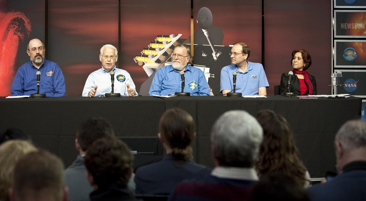
Alan Title, second from left, principal investigator, Atmospheric Imaging Assembly instrument, Lockheed Martin Solar and Astrophysics Laboratory in Palo Alto, speaks during a briefing to discuss recent images from NASA's Solar Dynamics Observatory, or SDO, Wednesday, April 21, 2010, at the Newseum in Washington. Launched on Feb. 11, 2010, SDO is the most advanced spacecraft ever designed to study the sun. During its five-year mission, it will examine the sun's magnetic field and also provide a better understanding of the role the sun plays in Earth's atmospheric chemistry and climate. Pictured from left to right: Dean Pesnell, SDO project scientist, Goddard Space Flight Center in Greenbelt, Md., Alan Title, Philip H. Scherrer, principal investigator, Helioseismic and Magnetic Imager instrument, Stanford University in Palo Alto, Tom Woods, principal investigator, Extreme Ultraviolet Variability Experiment instrument, Laboratory for Atmospheric and Space Physics, University of Colorado in Boulder and Madhulika Guhathakurta, SDO program scientist, NASA Headquarters in Washington. Photo Credit: (NASA/Carla Cioffi)
The 7-year journey to Saturn began with the liftoff of a Titan IVB/ Centaur carrying the Cassini orbiter and its attached Huygens probe. After a 2.2-billion mile journey that included two swingbys of Venus and one of the Earth to gain additional velocity, the two-story tall spacecraft will arrive at Saturn in July 2004. The orbiter will circle the planet for 4 years, its compliment of 12 scientific instruments gathering data about Saturn's atmosphere, rings and magnetosphere and conducting close-up observations of Saturnian moons. Huygens, with a separate suite of 6 science instruments, will separate from Cassini to fly on a ballistic trajectory toward Titan, the only celestial body besides Earth to have an atmosphere rich in nitrogen. Scientists are eager to study further this chemical similarity in hopes of learning more about the origins of our own planet Earth. Huygens will provide the first direct sampling of Titan's atmospheric chemistry and the first detailed photographs of its surface. The Cassini mission is an International effort involving NASA, the European Space Agency (ESA), and the Italian Space Agency, Agenzia Spaziale Italiana (ASI).
NASA's DC-8 Airborne Science platform landed at Edwards Air Force Base, California, to join the fleet of aircraft at NASA's Dryden Flight Research Center. The white aircraft with a blue stripe running horizontally from the nose to the tail is shown with its main landing gear just above the runway. The former airliner is a "dash-72" model and has a range of 5,400 miles. The craft can stay airborne for 12 hours and has an operational speed range between 300 and 500 knots. The research flights are made at between 500 and 41,000 feet. The aircraft can carry up to 30,000 lbs of research/science payload equipment installed in 15 mission-definable spaces.
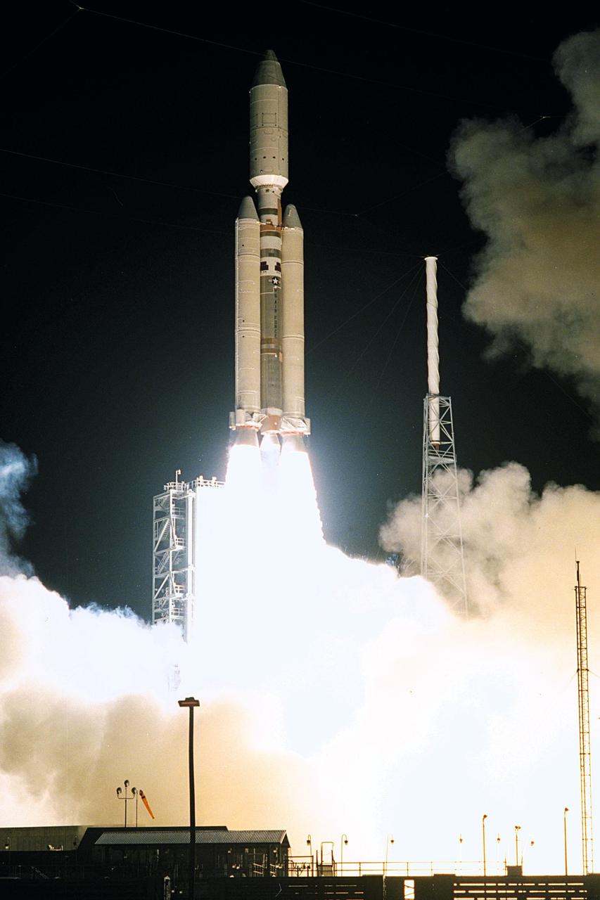
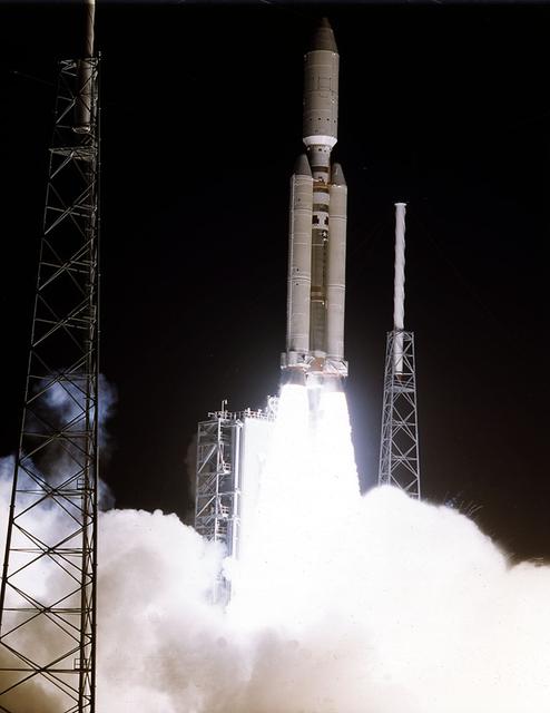
A seven-year journey to the ringed planet Saturn begins with the liftoff of a Titan IVB/Centaur carrying the Cassini orbiter and its attached Huygens probe. Launch occurred at 4:43 a.m. EDT, Oct. 15, from Launch Complex 40 on Cape Canaveral Air Station. After a 2.2-billion mile journey that will include two swingbys of Venus and one of Earth to gain additional velocity, the two-story tall spacecraft will arrive at Saturn in July 2004. The orbiter will circle the planet for four years, its complement of 12 scientific instruments gathering data about Saturn's atmosphere, rings and magnetosphere and conducting closeup observations of the Saturnian moons. Huygens, with a separate suite of six science instruments, will separate from Cassini to fly on a ballistic trajectory toward Titan, the only celestial body besides Earth to have an atmosphere rich in nitrogen. Scientists are eager to study further this chemical similarity in hopes of learning more about the origins of our own planet Earth. Huygens will provide the first direct sampling of Titan's atmospheric chemistry and the first detailed photographs of its surface. The Cassini mission is an international effort involving NASA, the European Space Agency (ESA) and the Italian Space Agency, Agenzia Spaziale Italiana (ASI). The Jet Propulsion Laboratory manages the U.S. contribution to the mission for NASA's Office of Space Science. The major U.S. contractor is Lockheed Martin, which provided the launch vehicle and upper stage, spacecraft propulsion module and radioisotope thermoelectric generators that will provide power for the spacecraft. The Titan IV/Centaur is a U.S. Air Force launch vehicle, and launch operations were managed by the 45th Space Wing
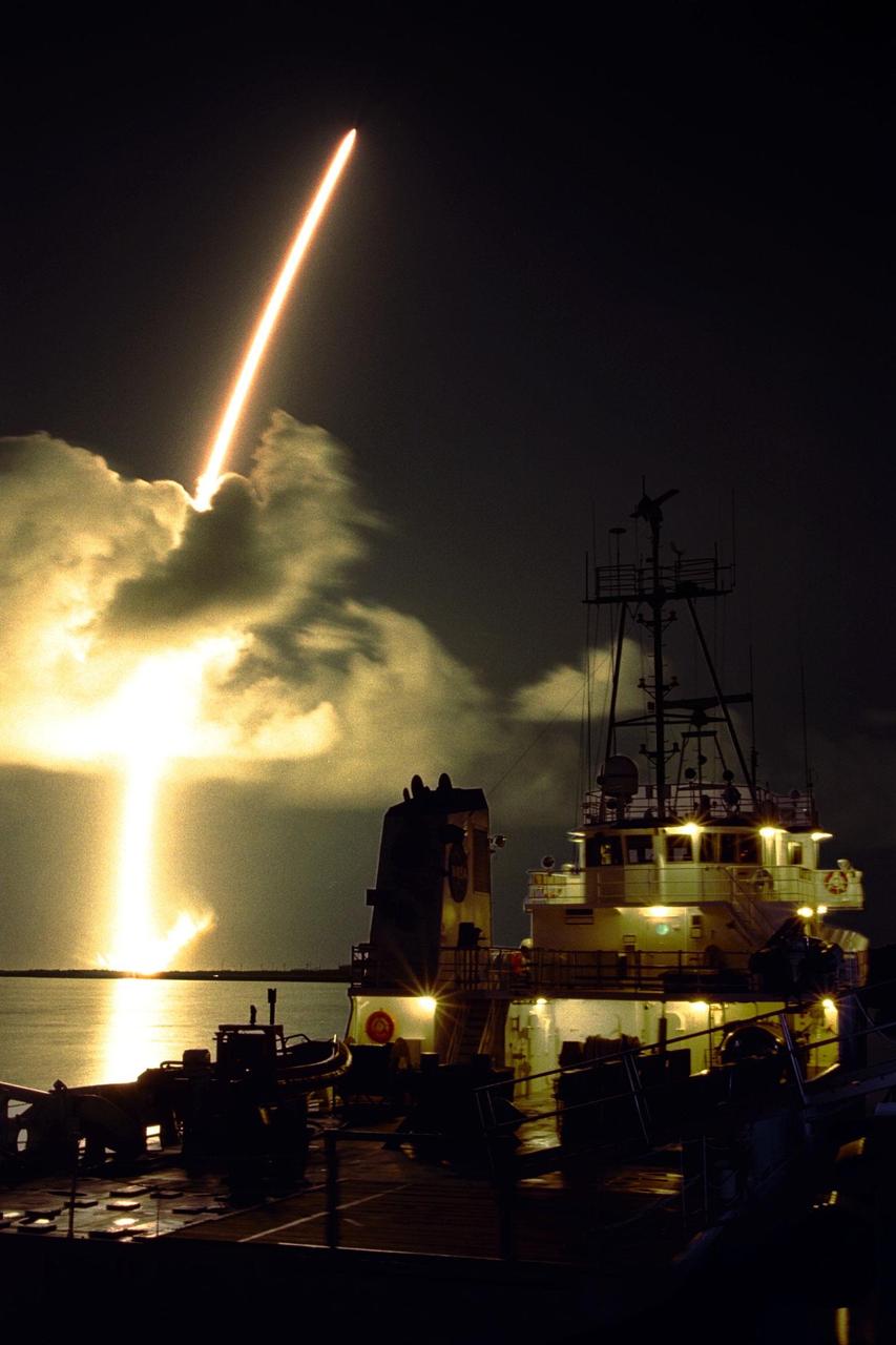
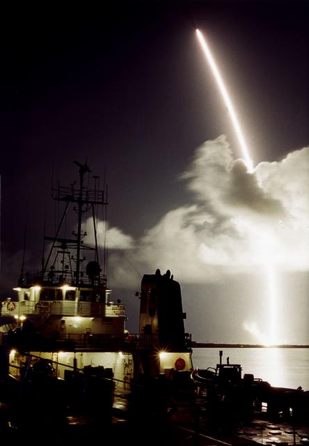
A seven-year journey to the ringed planet Saturn begins with the liftoff of a Titan IVB/Centaur carrying the Cassini orbiter and its attached Huygens probe. This spectacular streak shot was taken from Hangar AF on Cape Canaveral Air Station, with a solid rocket booster retrieval ship in the foreground. Launch occurred at 4:43 a.m. EDT, Oct. 15, from Launch Complex 40 on Cape Canaveral Air Station. After a 2.2-billion mile journey that will include two swingbys of Venus and one of Earth to gain additional velocity, the two-story tall spacecraft will arrive at Saturn in July 2004. The orbiter will circle the planet for four years, its complement of 12 scientific instruments gathering data about Saturn's atmosphere, rings and magnetosphere and conducting closeup observations of the Saturnian moons. Huygens, with a separate suite of six science instruments, will separate from Cassini to fly on a ballistic trajectory toward Titan, the only celestial body besides Earth to have an atmosphere rich in nitrogen. Scientists are eager to study further this chemical similarity in hopes of learning more about the origins of our own planet Earth. Huygens will provide the first direct sampling of Titan's atmospheric chemistry and the first detailed photographs of its surface. The Cassini mission is an international effort involving NASA, the European Space Agency (ESA) and the Italian Space Agency, Agenzia Spaziale Italiana (ASI). The Jet Propulsion Laboratory manages the U.S. contribution to the mission for NASA's Office of Space Science. The major U.S. contractor is Lockheed Martin, which provided the launch vehicle and upper stage, spacecraft propulsion module and radioisotope thermoelectric generators that will provide power for the spacecraft. The Titan IV/Centaur is a U.S. Air Force launch vehicle, and launch operations were managed by the 45th Space Wing
A seven-year journey to the ringed planet Saturn begins with the liftoff of a Titan IVB/Centaur carrying the Cassini orbiter and its attached Huygens probe. Launch occurred at 4:43 a.m. EDT, Oct. 15, from Launch Complex 40 on Cape Canaveral Air Station. After a 2.2-billion mile journey that will include two swingbys of Venus and one of Earth to gain additional velocity, the two-story tall spacecraft will arrive at Saturn in July 2004. The orbiter will circle the planet for four years, its complement of 12 scientific instruments gathering data about Saturn's atmosphere, rings and magnetosphere and conducting closeup observations of the Saturnian moons. Huygens, with a separate suite of six science instruments, will separate from Cassini to fly on a ballistic trajectory toward Titan, the only celestial body besides Earth to have an atmosphere rich in nitrogen. Scientists are eager to study further this chemical similarity in hopes of learning more about the origins of our own planet Earth. Huygens will provide the first direct sampling of Titan's atmospheric chemistry and the first detailed photographs of its surface. The Cassini mission is an international effort involving NASA, the European Space Agency (ESA) and the Italian Space Agency, Agenzia Spaziale Italiana (ASI). The Jet Propulsion Laboratory manages the U.S. contribution to the mission for NASA's Office of Space Science. The major U.S. contractor is Lockheed Martin, which provided the launch vehicle and upper stage, spacecraft propulsion module and radioisotope thermoelectric generators that will provide power for the spacecraft. The Titan IV/Centaur is a U.S. Air Force launch vehicle, and launch operations were managed by the 45th Space Wing
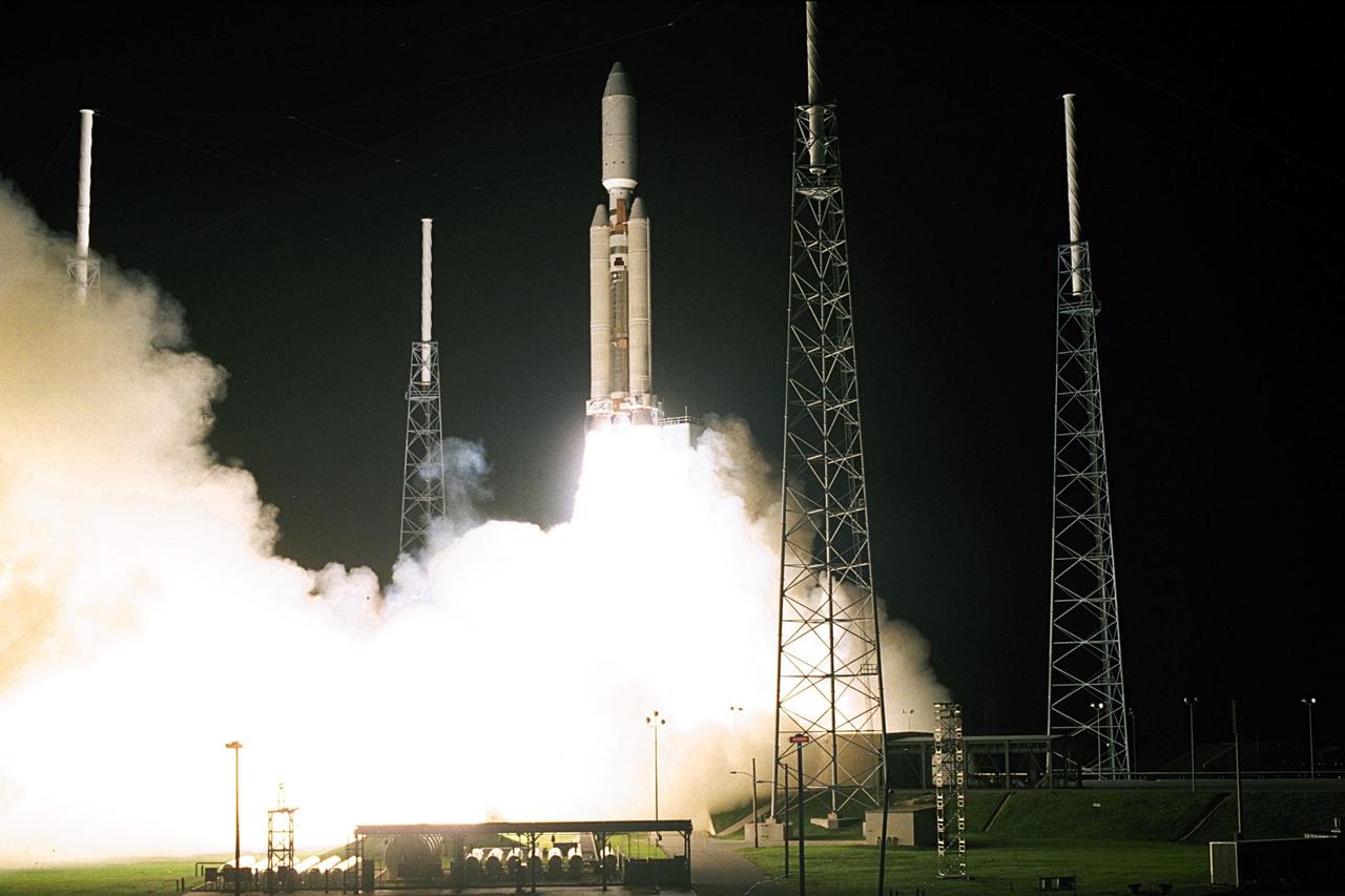
A seven-year journey to the ringed planet Saturn begins with the liftoff of a Titan IVB/Centaur carrying the Cassini orbiter and its attached Huygens probe. Launch occurred at 4:43 a.m. EDT, Oct. 15, from Launch Complex 40 on Cape Canaveral Air Station. After a 2.2-billion mile journey that will include two swingbys of Venus and one of Earth to gain additional velocity, the two-story tall spacecraft will arrive at Saturn in July 2004. The orbiter will circle the planet for four years, its complement of 12 scientific instruments gathering data about Saturn's atmosphere, rings and magnetosphere and conducting closeup observations of the Saturnian moons. Huygens, with a separate suite of six science instruments, will separate from Cassini to fly on a ballistic trajectory toward Titan, the only celestial body besides Earth to have an atmosphere rich in nitrogen. Scientists are eager to study further this chemical similarity in hopes of learning more about the origins of our own planet Earth. Huygens will provide the first direct sampling of Titan's atmospheric chemistry and the first detailed photographs of its surface. The Cassini mission is an international effort involving NASA, the European Space Agency (ESA) and the Italian Space Agency, Agenzia Spaziale Italiana (ASI). The Jet Propulsion Laboratory manages the U.S. contribution to the mission for NASA's Office of Space Science. The major U.S. contractor is Lockheed Martin, which provided the launch vehicle and upper stage, spacecraft propulsion module and radioisotope thermoelectric generators that will provide power for the spacecraft. The Titan IV/Centaur is a U.S. Air Force launch vehicle, and launch operations were managed by the 45th Space Wing
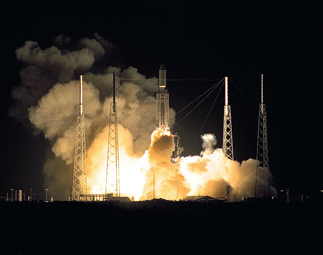
A seven-year journey to the ringed planet Saturn begins with the liftoff of a Titan IVB/Centaur carrying the Cassini orbiter and its attached Huygens probe. Launch occurred at 4:43 a.m. EDT, Oct. 15, from Launch Complex 40 on Cape Canaveral Air Station. After a 2.2-billion mile journey that will include two swingbys of Venus and one of Earth to gain additional velocity, the two-story tall spacecraft will arrive at Saturn in July 2004. The orbiter will circle the planet for four years, its complement of 12 scientific instruments gathering data about Saturn's atmosphere, rings and magnetosphere and conducting closeup observations of the Saturnian moons. Huygens, with a separate suite of six science instruments, will separate from Cassini to fly on a ballistic trajectory toward Titan, the only celestial body besides Earth to have an atmosphere rich in nitrogen. Scientists are eager to study further this chemical similarity in hopes of learning more about the origins of our own planet Earth. Huygens will provide the first direct sampling of Titan's atmospheric chemistry and the first detailed photographs of its surface. The Cassini mission is an international effort involving NASA, the European Space Agency (ESA) and the Italian Space Agency, Agenzia Spaziale Italiana (ASI). The Jet Propulsion Laboratory manages the U.S. contribution to the mission for NASA's Office of Space Science. The major U.S. contractor is Lockheed Martin, which provided the launch vehicle and upper stage, spacecraft propulsion module and radioisotope thermoelectric generators that will provide power for the spacecraft. The Titan IV/Centaur is a U.S. Air Force launch vehicle, and launch operations were managed by the 45th Space Wing
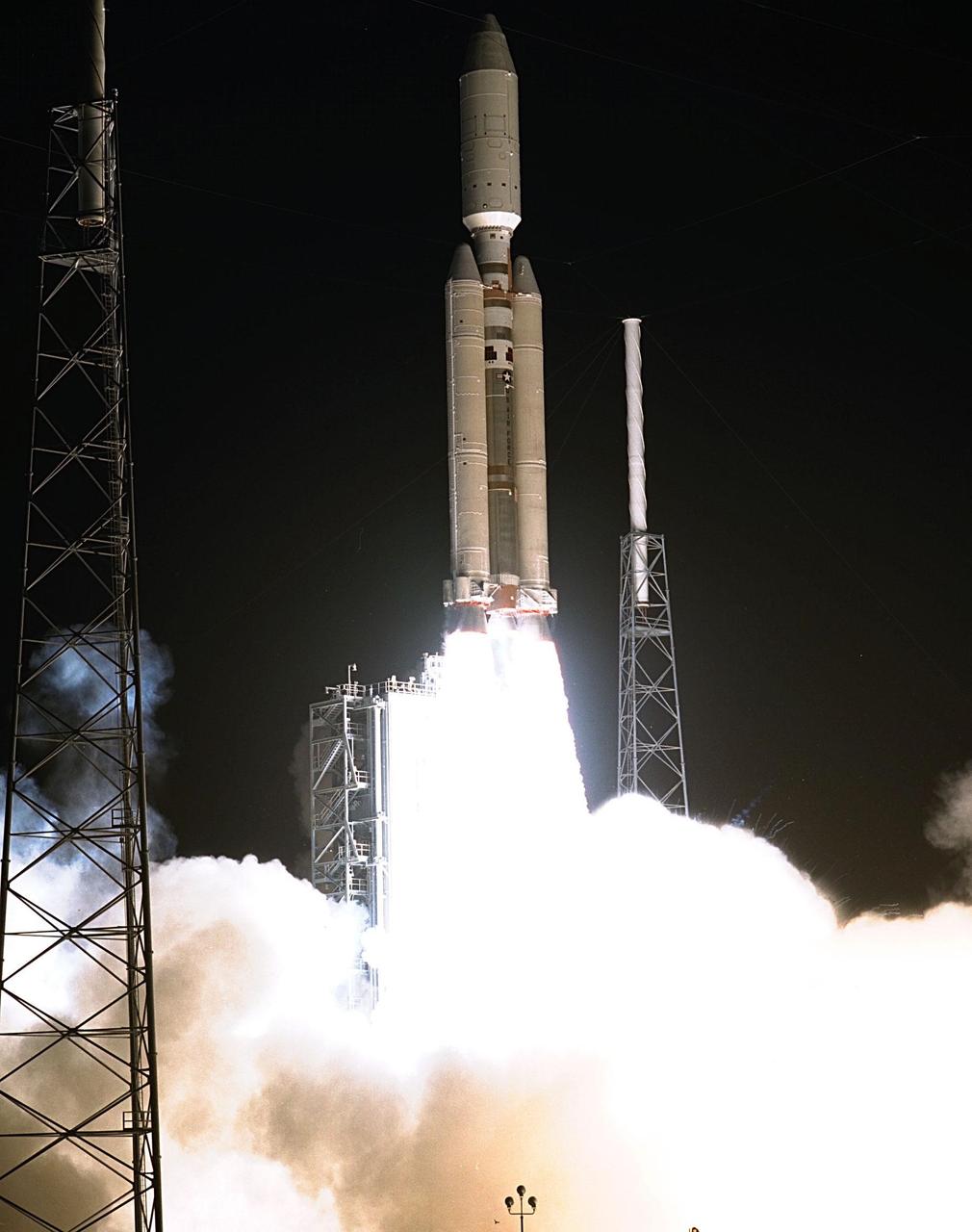
KENNEDY SPACE CENTER, FLA. -- A seven-year journey to the ringed planet Saturn begins with the liftoff of a Titan IVB/Centaur carrying the Cassini orbiter and its attached Huygens probe. Launch occurred at 4:43 a.m. EDT, Oct. 15, from Launch Complex 40 on Cape Canaveral Air Station. After a 2.2-billion mile journey that will include two swingbys of Venus and one of Earth to gain additional velocity, the two-story tall spacecraft will arrive at Saturn in July 2004. The orbiter will circle the planet for four years, its complement of 12 scientific instruments gathering data about Saturn's atmosphere, rings and magnetosphere and conducting closeup observations of the Saturnian moons. Huygens, with a separate suite of six science instruments, will separate from Cassini to fly on a ballistic trajectory toward Titan, the only celestial body besides Earth to have an atmosphere rich in nitrogen. Scientists are eager to study further this chemical similarity in hopes of learning more about the origins of our own planet Earth. Huygens will provide the first direct sampling of Titan's atmospheric chemistry and the first detailed photographs of its surface. The Cassini mission is an international effort involving NASA, the European Space Agency (ESA) and the Italian Space Agency, Agenzia Spaziale Italiana (ASI). The Jet Propulsion Laboratory manages the U.S. contribution to the mission for NASA's Office of Space Science. The major U.S. contractor is Lockheed Martin, which provided the launch vehicle and upper stage, spacecraft propulsion module and radioisotope thermoelectric generators that will provide power for the spacecraft. The Titan IV/Centaur is a U.S. Air Force launch vehicle, and launch operations were managed by the 45th Space Wing
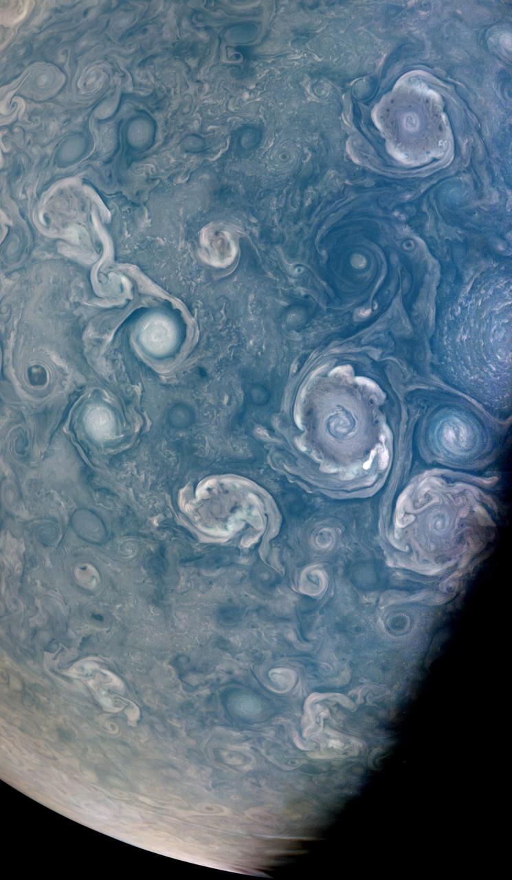
As NASA's Juno mission completed its 43rd close flyby of Jupiter on July 5, 2022, its JunoCam instrument captured this striking view of vortices – hurricane-like spiral wind patterns – near the planet's north pole. These powerful storms can be over 30 miles (50 kilometers) in height and hundreds of miles across. Figuring out how they form is key to understanding Jupiter's atmosphere, as well as the fluid dynamics and cloud chemistry that create the planet's other atmospheric features. Scientists are particularly interested in the vortices' varying shapes, sizes, and colors. For example, cyclones, which spin counter-clockwise in the northern hemisphere and clockwise in the southern, and anti-cyclones, which rotate clockwise in the northern hemisphere and counter-clockwise in the southern hemisphere, exhibit very different colors and shapes. A NASA citizen science project, Jovian Vortex Hunter, seeks help from volunteer members of the public to spot and help categorize vortices and other atmospheric phenomena visible in JunoCam photos of Jupiter. This process does not require specialized training or software, and can be done by anyone, anywhere, with a cellphone or laptop. As of July 2022, 2,404 volunteers had made 376,725 classifications using the Jovian Vortex Hunter project web site at https://www.zooniverse.org/projects/ramanakumars/jovian-vortex-hunter. Another citizen scientist, Brian Swift, created this enhanced color and contrast view of vortices using raw JunoCam image data. At the time the raw image was taken, the Juno spacecraft was about 15,600 miles (25,100 kilometers) above Jupiter's cloud tops, at a latitude of about 84 degrees. https://photojournal.jpl.nasa.gov/catalog/PIA25017
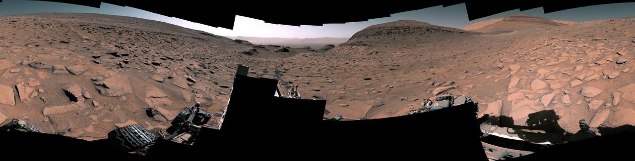
NASA's Curiosity Mars rover captured this 360-degree panorama at a site nicknamed "Ubajara" on April 30, 2023, the 3,815th Martian day, or sol, of the mission. Taken by the rover's Mastcam, this panorama was stitched together from 141 images after they were sent to Earth. Dark rover tracks recede into the distance in the center of the scene. Curiosity used the drill on the end of its robotic arm to take a sample from Ubajara, then dropped the pulverized rock into instruments within the rover's body. One of those instruments, called CheMin (Chemistry & Mineralogy), used X-ray diffraction to discover the presence of an iron carbonate mineral called siderite in samples from this site and two others: one above and one below Ubajara in a region enriched with salty minerals called sulfates. The discovery of siderite may help solve one of Mars' mysteries: There is strong evidence that liquid water coursed over the planet's surface billions of years ago, suggesting Mars had a thick, carbon-rich atmosphere rather than the wispy one it has today (a thicker carbon dioxide atmosphere is required to provide enough pressure and warmth for water to remain liquid on a planet's surface; otherwise, it rapidly vaporizes or freezes – which is the case on Mars today). That carbon dioxide and water should have reacted with Martian rocks to create carbonate minerals. However, when scientists study the planet with satellites that ample carbonate hasn't been apparent – even at Curiosity's site. It's possible that other minerals may be masking carbonate from satellite near-infrared analysis, particularly in sulfate-rich areas. If other such layers across Mars also contain hidden carbonates, the amount of stored carbon dioxide would be part of that needed in the ancient atmosphere to create conditions warm enough to support liquid water. The rest could be hidden in other deposits or have been lost to space over time. https://photojournal.jpl.nasa.gov/catalog/PIA26554
A National Aeronautics and Space Administration (NASA) Lockheed U-2 aircraft on display at the 1973 Inspection of the Lewis Research Center in Cleveland, Ohio. Lockheed developed the U-2 as a high-altitude reconnaissance aircraft in the early 1950s before satellites were available. The U-2 could cruise over enemy territory at 70,000 feet and remain impervious to ground fire, interceptor aircraft, and even radar. An advanced camera system was designed specifically for the aircraft. The pilot is required to use a pressure suit similar to those worn by astronauts. NASA’s Ames Research Center received two U-2 aircraft in April 1971 to conduct high-altitude research. They were used to study and monitor various Earth resources, celestial bodies, atmospheric chemistry, and oceanic processes. NASA replaced its U-2s with ER-2 aircraft in 1981 and 1989. The ER-2s were designed to carry up to 2600 pounds of scientific equipment. The ER-2 program was transferred to Dryden Flight Research Center in 1997. Since the inaugural flight for this program on August 31, 1971, NASA’s U-2 and ER-2 aircraft have flown more than 4500 data missions and test flights for NASA, other federal agencies, states, universities, and the private sector.
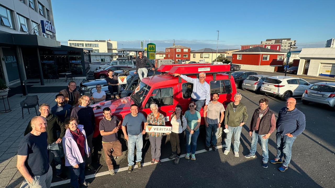
Members of the VERITAS science team pause for a photograph on July 31, 2023, after arriving in Iceland to begin a two-week campaign to study the volcanic island's geology to help the team prepare for NASA's VERITAS (short for Venus Emissivity, Radio science, InSAR, Topography, And Spectroscopy) mission to Venus. From July 30 to Aug. 14, 2023, the international science team, including local participation from the University of Iceland, worked to lay the groundwork for the science that will ultimately be done from Venus orbit. At center, holding the VERITAS mission identifier is the mission's principal investigator and the science team lead, Sue Smrekar, of NASA's Jet Propulsion Laboratory in Southern California. Flanking her are science team members from multiple U.S., Italian, and German institutions, including members of the German Aerospace Center (DLR) Flugzeug Synthetic Aperture Radar (F-SAR) airplane team. The DLR F-SAR team was tasked with collecting synthetic-aperture radar data of the regions studied by the field team. A key objective of the campaign is to refine change detection algorithms that will be used to look for global surface change (such as volcanic activity) between NASA's Magellan radar mission from the 1990s and VERITAS, as well as between VERITAS and the ESA (European Space Agency) EnVision mission to Venus, both of which are targeting the early 2030s for launch. NASA's VERITAS is an orbiter designed to peer through Venus' thick atmosphere with a suite of powerful instruments to create global maps of the planet's surface, including topography, radar images, rock type, and gravity, as well as detect surface changes. VERITAS is designed to understand what processes are currently active, search for evidence of past and current interior water, and understand the geologic evolution of the planet, illuminating how rocky planets throughout the galaxy evolve. VERITAS and NASA's Deep Atmosphere Venus Investigation of Noble gases, Chemistry, and Imaging (DAVINCI) mission were selected in 2021 under NASA's Discovery Program as the agency's next missions to Venus. The Discovery Program is managed by the Planetary Missions Program Office at NASA's Marshall Space Flight Center in Huntsville, Alabama, for the Planetary Science Division of NASA's Science Mission Directorate in Washington. https://photojournal.jpl.nasa.gov/catalog/PIA25835
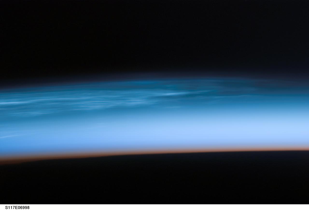
S117-E-06998 (10 June 2007) --- Polar Mesospheric Clouds are featured in this image photographed by a STS-117 crewmember onboard Space Shuttle Atlantis. Sometimes in the summertime in the far northern (or southern) latitudes, high in the Earth's atmosphere at the edge of space, thin silvery clouds form and are observed just after sunset. These high clouds, occurring at altitudes of about 80 kilometers (50 miles), are called Polar Mesospheric Clouds (PMC) or noctilucent clouds, and are the subject of new studies to determine whether their occurrence is related to global climate change. Observations over the past few years suggest that PMC are now observed more frequently and at lower latitudes than historical observations. Several studies related to the International Polar Year (IPY), and the AIM (Aeronomy of Ice in the Mesosphere) spacecraft are underway to collect relevant data on the chemistry and physics of the mesosphere that might explain the occurrence of PMC. Astronauts in orbiting spacecraft frequently observe PMC over Canada, northern Europe and Asia during June, July and August. While PMC also occur over the high latitudes in the southern hemisphere in December, January and February, astronaut observations of southern PMC are less frequent. Earlier in June 2007, the shuttle crew visiting the International Space Station observed spectacular PMC over north-central Asia. This image was taken looking north while the shuttle and station were docking and flying over the border between western China, Mongolia and Kazakhstan. The red-to-dark region at the bottom of the image is the dense part of the Earth's atmosphere. Because this image was taken with a long lens (180mm), the entire profile of the Earth's limb is not captured. To support IPY research over the next 2 years, station crewmembers will be looking for and documenting PMC in both hemispheres.
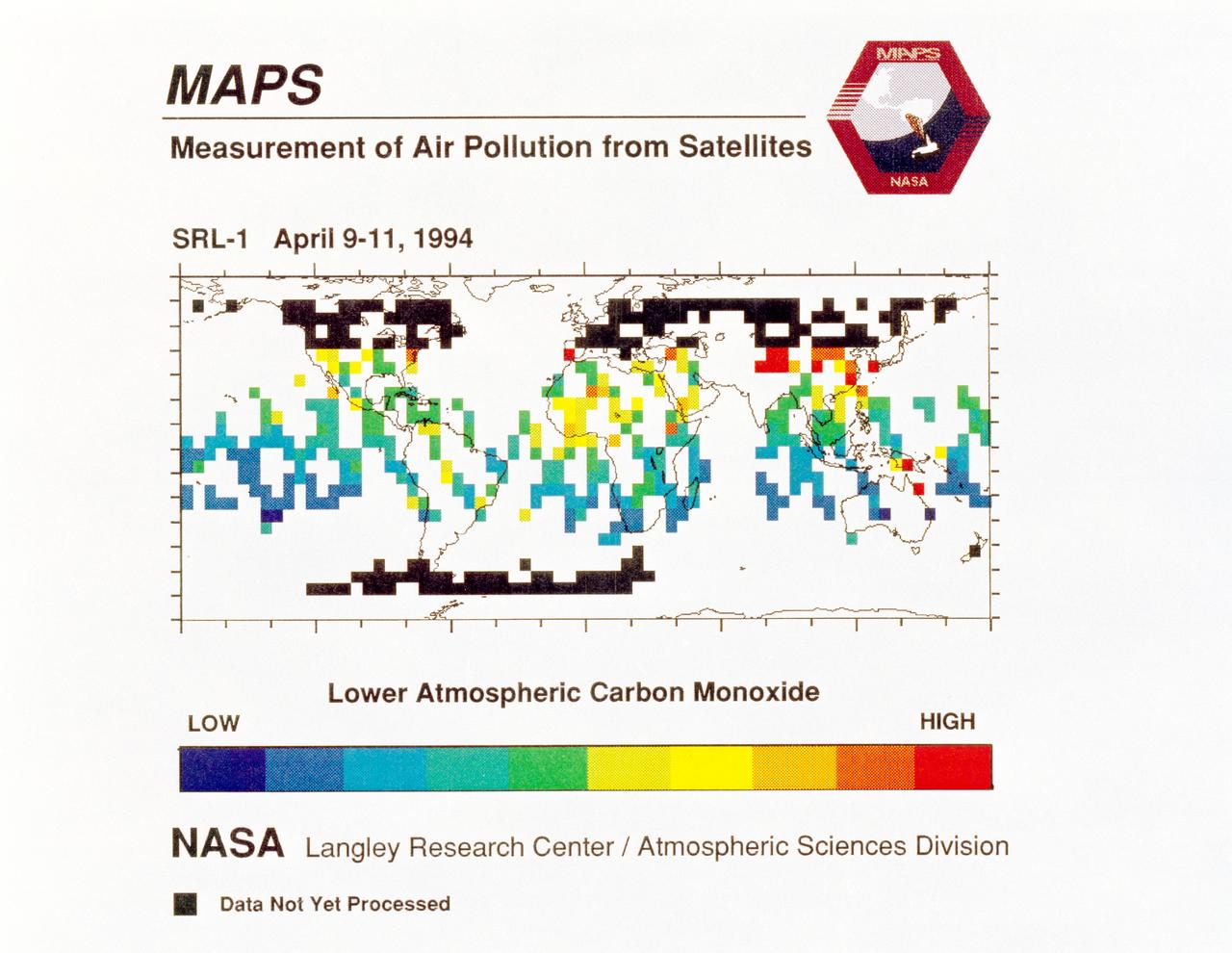
STS059-S-040 (12 April 1994) --- STS-59's MAPS (Measurement of Air Pollution from Satellites) experiment is sending real-time data that provides the most comprehensive view of carbon monoxide concentrations on Earth ever recorded. This computer image shows a summary of "quick look" data obtained by the MAPS instrument during its first days of operations as part of the Space Shuttle Endeavour's SRL-1 payload. This data will be processed using more sophisticated techniques following the flight. The color red indicates areas with the highest levels of carbon monoxide. These Northern Hemisphere springtime carbon monoxide values are generally significantly higher than the values found in the Southern Hemisphere. This is in direct contrast to the data obtained by the MAPS experiment during November 1981 and October 1984, i.e. during Northern Hemisphere fall. The astronauts aboard Endeavour have seen fires in most of the areas showing higher carbon monoxide values (China, Eastern Australia, and equatorial Africa). The relationship between the observed fires and the higher carbon monoxide values will be investigated following SRL-1 by combining the MAPS data with meteorological data, surface imagery, and Space Shuttle hand-held photographs. By the end of SRL-1, MAPS will have acquired data over most of the globe between 57 degrees north and 57 degrees south latitudes. The entire data set will be carefully analyzed using sophisticated post-flight data processing techniques. The data will then be applied in a variety of scientific studies concerning chemistry and transport processes in the atmosphere. The MAPS experiment measures the carbon monoxide in the lower atmosphere. This gas is produced both as a result of natural processes and as a result of human activities. The primary human resources of carbon monoxide are automobiles and industry and the burning of plant materials. The primary natural source is the interaction of sunlight with naturally occurring ozone and water vapor. The strength of all of these sources changes seasonally.
Caption: MAVEN's Imaging UltraViolet Spectrograph obtained this image of Mars on July 13, 2016, when the planet appeared nearly full when viewed from the highest altitudes in the MAVEN orbit. The ultraviolet colors of the planet have been rendered in false color, to show what we would see with ultraviolet-sensitive eyes. The ultraviolet (UV) view gives several new perspectives on Mars. Valles Marineris, a two-thousand-mile canyon system, appears prominently across the middle of the image as a blue gash. The deep canyon appears blue due to the scattering of ultraviolet light by the atmosphere, so strong that we cannot make out the bottom of the canyon. The greenish cast of the planet as a whole is a combination of the reflection of the surface plus the atmospheric scattering. The three tall Tharsis volcanoes appear near the left edge, dotted by white clouds forming as the winds flow over them. Bright white polar caps appear at both poles, typical for this season, in which there is a transition from southern-hemisphere winter to summer. The magenta-colored region visible at the south pole shows where ozone is absorbing ultraviolet light — the same property of ozone that protects life on Earth from harmful UV radiation. While ozone tends to be destroyed by chemical processes in the winter on Earth, different atmospheric chemistry at Mars caused it to build up in the winter there. A hint of ozone is also visible near the north pole; more will accumulate there as winter is coming. IUVS obtains images of Mars every orbit when the sunlit portion of the planet is visible from high altitude. Credits: NASA/Goddard/University of Colorado/LASP Read more: <a href="http://go.nasa.gov/2d9aU1N" rel="nofollow">go.nasa.gov/2d9aU1N</a> Today, NASA’s Mars Atmosphere and Volatile EvolutioN (MAVEN) mission completed one Mars year of science observations. One Mars year is just under two Earth years. MAVEN launched on Nov. 18, 2013, and went into orbit around Mars on Sept. 21, 2014. During its time at Mars, MAVEN has answered many questions about the Red Planet. “Taken together, the MAVEN results tell us that loss of gas from the atmosphere to space has been the major force behind the climate having changed from a warm, wet environment to the cold, dry one that we see today,” said Bruce Jakosky, MAVEN principal investigator, from the University of Colorado in Boulder. NASA recently declared that MAVEN had achieved mission success during its primary mission. Mission success means that the spacecraft operated as intended, made the expected science measurements, and achieved its proposed science objectives. <b><a href="http://www.nasa.gov/audience/formedia/features/MP_Photo_Guidelines.html" rel="nofollow">NASA image use policy.</a></b> <b><a href="http://www.nasa.gov/centers/goddard/home/index.html" rel="nofollow">NASA Goddard Space Flight Center</a></b> enables NASA’s mission through four scientific endeavors: Earth Science, Heliophysics, Solar System Exploration, and Astrophysics. Goddard plays a leading role in NASA’s accomplishments by contributing compelling scientific knowledge to advance the Agency’s mission. <b>Follow us on <a href="http://twitter.com/NASAGoddardPix" rel="nofollow">Twitter</a></b> <b>Like us on <a href="http://www.facebook.com/pages/Greenbelt-MD/NASA-Goddard/395013845897?ref=tsd" rel="nofollow">Facebook</a></b> <b>Find us on <a href="http://instagrid.me/nasagoddard/?vm=grid" rel="nofollow">Instagram</a></b>
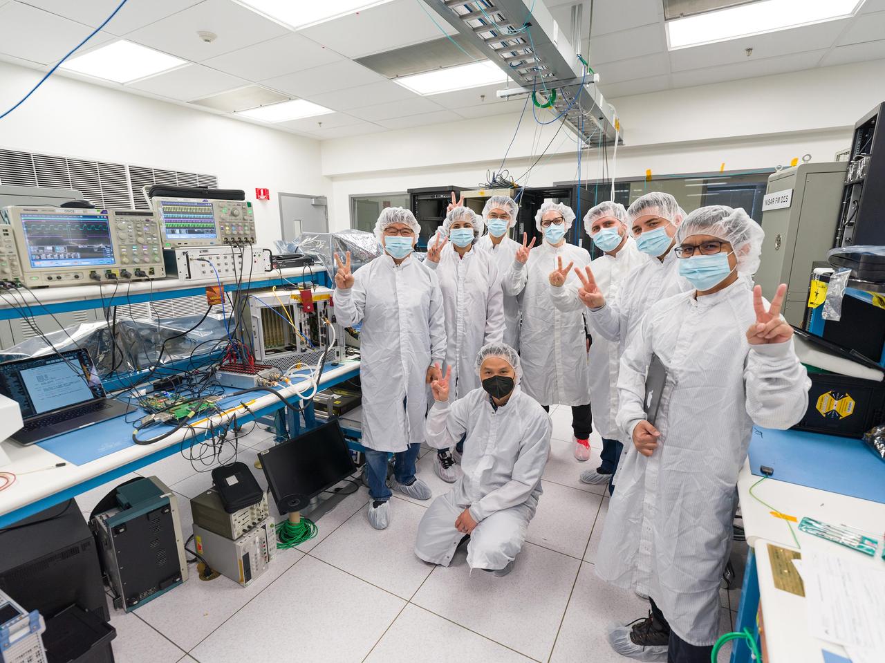
Seen here are members of the international team that participated in recent tests on prototype hardware for the Venus Interferometric Synthetic Aperture Radar (VISAR) at NASA's Jet Propulsion Laboratory in Southern California. VISAR is being developed at JPL for NASA's Venus Emissivity Radio Science, InSAR, Topography & Spectroscopy (VERITAS) mission that will launch within a decade to explore Earth's twin. In March 2023, the hardware underwent early interface tests in a JPL clean room, representing the first in a series to be run by JPL and Thales Alenia Space Italy (TASI), an international partner of the VERITAS mission that is contributing hardware to the instrument. Dressed in gowns to minimize the risk of contamination with sensitive electronics, the JPL VISAR digital team and TASI engineers pose for a photograph next to the laboratory benches where the tests took place. Figure A shows the same personnel without gowns for a team photo. From left to right: Marvin Cruz (JPL), Chester Lim (JPL), Tim Noh (JPL), Hana Haideri (JPL), Luca Di Marco Napini (TASI), Ernie Chuang (JPL), Dragana Perkovic-Martin (JPL), and Gabriel Mihu (TASI). JPL's Michael Burke, Anusha Yarlagadda, Duane Clark, and TASI's Antonio Delfino also participated in the tests but are not pictured. When VERITAS arrives in orbit, it will use VISAR to create detailed 3D global maps of Venus. The spacecraft will also carry a near-infrared spectrometer to figure out what the surface is made of. Together, the instruments will offer clues about the planet's past and present geologic processes, help reveal how the paths of Venus and Earth diverged, and how Venus lost its potential as a habitable world. VERITAS is managed by JPL. VERITAS and NASA's Deep Atmosphere Venus Investigation of Noble gases, Chemistry, and Imaging (DAVINCI) mission were selected in 2021 under NASA's Discovery Program as the agency's next missions to Venus. The Discovery Program is managed by the Planetary Missions Program Office at NASA's Marshall Space Flight Center in Huntsville, Alabama, for the Planetary Science Division of NASA's Science Mission Directorate in Washington. https://photojournal.jpl.nasa.gov/catalog/PIA25833

Mark Pestana is a research pilot and project manager at the NASA Dryden Flight Research Center, Edwards, Calif. He is a pilot for the Beech B200 King Air, the T-34C and the Predator B. He flies the F-18 Hornet as a co-pilot and flight test engineer. Pestana has accumulated more than 4,000 hours of military and civilian flight experience. He was also a flight engineer on the NASA DC-8 flying laboratory. Pestana was the project manager and pilot for the Hi–rate Wireless Airborne Network Demonstration flown on the NASA B200 research aircraft. He flew B200 research missions for the X-38 Space Integrated Inertial Navigation Global Positioning System experiment. Pestana also participated in several deployments of the DC-8, including Earth science expeditions ranging from hurricane research over the Caribbean Sea to ozone studies over the North Pole, atmospheric chemistry over the South Pacific, rain forest health in Central America, Rocky Mountain ice pack assessment, and volcanic and tectonic activity around the Pacific Rim. He came to Dryden as a DC-8 mission manager in June 1998 from NASA Johnson Space Center, Houston, where he served as the Earth and Space Science discipline manager for the International Space Station Program at Johnson. Pestana also served as a flight crew operations engineer in the Astronaut Office, developing the controls, displays, tools, crew accommodations and procedures for on-orbit assembly, test, and checkout of the International Space Station. He led the analysis and technical negotiations for modification of the Russian Soyuz spacecraft as an emergency crew return vehicle for space station crews. He joined the U.S. Air Force Reserve in 1991 and held various positions as a research and development engineer, intelligence analyst, and Delta II launch vehicle systems engineer. He retired from the U.S. Air Force Reserve with the rank of colonel in 2005. Prior to 1990, Pestana was on active duty with the U.S. Air Force as the director of mi
Pilot Earle Boyer and researcher Henry Brandhorst prepare for a solar cell calibration flight in a Martin B-57B Canberra at the National Aeronautics and Space Administration (NASA) Lewis Research Center. Lewis was in the early stages of decades-long energy conversion and space power research effort. Brandhorst, a member of the Chemistry and Energy Conversion Division, led a team of Lewis researchers in a quest to develop new power sources to sustain spacecraft in orbit. Solar cells proved to be an important source of energy, but researchers discovered that their behavior varied at different atmospheric levels. Their standardization and calibration were critical. Brandhorst initiated a standardized way to calibrate solar cells in the early 1960s using the B-57B aircraft. The pilots would take the aircraft up into the troposphere and open the solar cell to the sunlight. The aircraft would steadily descend while instruments recorded how much energy was being captured by the solar cell. From this data, Brandhorst could determine the estimated power for a particular solar cell at any altitude. Pilot Earle Boyer joined NASA Lewis in October 1962. He had flown Convair F-102 Delta Dagger fighters in the Air Force and served briefly in the National Guard before joining the Langley Research Center. Boyer was only at Langley a few months before he transferred to Cleveland. He flew the B-57B, a Convair F-106 Delta Dart, Gulfstream G-1 with an experimental turboprop, Learjet and many other aircraft over the next 32 years at Lewis.
Seen here in March 2023, prototype hardware for the Venus Interferometric Synthetic Aperture Radar (VISAR) underwent interface testing at NASA's Jet Propulsion Laboratory in Southern California. VISAR is being developed at JPL for NASA's Venus Emissivity Radio Science, InSAR, Topography & Spectroscopy (VERITAS) mission that will launch within a decade to explore Earth's twin. These early interface tests are the first in a series to be run by JPL and Thales Alenia Space Italy (TASI), an international partner of the VERITAS mission that is contributing hardware to the instrument. Figure A shows TASI engineers Luca Di Marco Napini and Gabriel Mihu working in a JPL cleanroom on the VISAR prototype hardware. When VERITAS arrives in orbit, it will use VISAR to create detailed 3D global maps of Venus. The spacecraft will also carry a near-infrared spectrometer to figure out what the surface is made of. Together, the instruments will offer clues about the planet's past and present geologic processes, help reveal how the paths of Venus and Earth diverged, and how Venus lost its potential as a habitable world. VERITAS is managed by JPL. VERITAS and NASA's Deep Atmosphere Venus Investigation of Noble gases, Chemistry, and Imaging (DAVINCI) mission were selected in 2021 under NASA's Discovery Program as the agency's next missions to Venus. The Discovery Program is managed by the Planetary Missions Program Office at NASA's Marshall Space Flight Center in Huntsville, Alabama, for the Planetary Science Division of NASA's Science Mission Directorate in Washington. https://photojournal.jpl.nasa.gov/catalog/PIA25832

James Barrilleaux is the assistant chief pilot for ER-2s in the Flight Crew Branch of NASA's Dryden Flight Research Center, Edwards, California. The ER-2s--civilian variants of the military U-2S reconnaissance aircraft--are part of NASA's Airborne Science program. The ER-2s can carry airborne scientific payloads of up to 2,600 pounds to altitudes of about 70,000 feet to investigate such matters as earth resources, celestial phenomena, atmospheric chemistry and dynamics, and oceanic processes. Barrilleaux has held his current position since February 1998. Barrilleaux joined NASA in 1986 as a U-2/ER-2 pilot with NASA's Airborne Science program at Ames Research Center, Moffett Field, California. He flew both the U-2C (until 1989) and the ER-2 on a wide variety of missions both domestic and international. Barrilleaux flew high-altitude operations over Antarctica in which scientific instruments aboard the ER-2 defined the cause of ozone depletion over the continent, known as the ozone hole. He has also flown the ER-2 over the North Pole. Barrilleaux served for 20 years in the U.S. Air Force before he joined NASA. He completed pilot training at Reese Air Force Base, Lubbock, Texas, in 1966. He flew 120 combat missions as a F-4 fighter pilot over Laos and North Vietnam in 1970 and 1971. He joined the U-2 program in 1974, becoming the commander of an overseas U-2 operation in 1982. In 1983, he became commander of the squadron responsible for training all U-2 pilots and SR-71 crews located at Beale Air Force Base, Marysville, California. He retired from the Air Force as a lieutenant colonel in 1986. On active duty, he flew the U-2, F-4 Phantom, the T-38, T-37, and the T-33. His decorations included two Distinguished Flying Crosses, 12 Air Medals, two Meritorious Service Medals, and other Air Force and South Vietnamese awards. Barrilleaux earned a bachelor of science degree in chemical engineering from Texas A&M University, College Station, in 1964 and a master of science

New imagery from the Hubble Space Telescope is revealing details never before seen on Jupiter. Hubble’s new Jupiter maps were used to create this Ultra HD animation. These new maps and spinning globes of Jupiter were made from observations performed with NASA’s Hubble Space Telescope. They are the first products to come from a program to study the solar system’s outer planets – Jupiter, Uranus, Neptune and, later, Saturn – each year using Hubble. The observations are designed to capture a broad range of features, including winds, clouds, storms and atmospheric chemistry. These annual studies will help current and future scientists see how these giant worlds change over time. Scientists at NASA’s Goddard Space Flight Center, the Jet Propulsion Laboratory, and the University of California at Berkeley produced two global maps of Jupiter from the observations, which were made using Hubble’s high-performance Wide Field Camera 3. The two maps represent nearly back-to-back rotations of the planet, making it possible to determine the speeds of Jupiter’s winds. Already, the images have revealed a rare wave just north of the planet’s equator and a unique filament-like feature in the core of the Great Red Spot that had not been seen previously. In addition, the new images confirm that the Great Red Spot continues to shrink and become more circular, as it has been doing for years. The long axis of this characteristic storm is about 150 miles (240 kilometers) shorter now than it was in 2014. Recently, the storm had been shrinking at a faster-than-usual rate, but the latest change is consistent with the long-term trend. Read more:http://www.nasa.gov/press-release/goddard/hubble-s-planetary-portrait-captures-new-changes-in-jupiter-s-great-red-spot Credits: NASA/ESA/Goddard/UCBerkeley/JPL-Caltech/STScI <b><a href="http://www.nasa.gov/audience/formedia/features/MP_Photo_Guidelines.html" rel="nofollow">NASA image use policy.</a></b> <b><a href="http://www.nasa.gov/centers/goddard/home/index.html" rel="nofollow">NASA Goddard Space Flight Center</a></b> enables NASA’s mission through four scientific endeavors: Earth Science, Heliophysics, Solar System Exploration, and Astrophysics. Goddard plays a leading role in NASA’s accomplishments by contributing compelling scientific knowledge to advance the Agency’s mission. <b>Follow us on <a href="http://twitter.com/NASAGoddardPix" rel="nofollow">Twitter</a></b> <b>Like us on <a href="http://www.facebook.com/pages/Greenbelt-MD/NASA-Goddard/395013845897?ref=tsd" rel="nofollow">Facebook</a></b> <b>Find us on <a href="http://instagrid.me/nasagoddard/?vm=grid" rel="nofollow">Instagram</a></b>
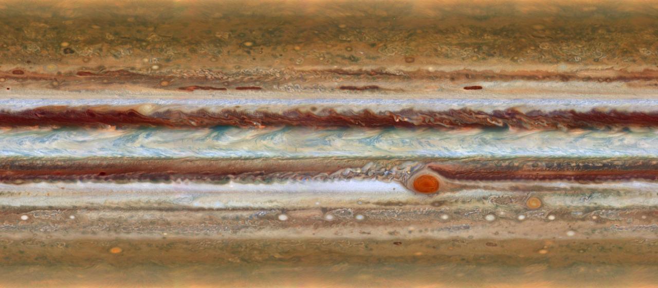
New imagery from the Hubble Space Telescope is revealing details never before seen on Jupiter. Hubble’s new Jupiter maps were used to create this Ultra HD animation. These new maps and spinning globes of Jupiter were made from observations performed with NASA’s Hubble Space Telescope. They are the first products to come from a program to study the solar system’s outer planets – Jupiter, Uranus, Neptune and, later, Saturn – each year using Hubble. The observations are designed to capture a broad range of features, including winds, clouds, storms and atmospheric chemistry. These annual studies will help current and future scientists see how these giant worlds change over time. Scientists at NASA’s Goddard Space Flight Center, the Jet Propulsion Laboratory, and the University of California at Berkeley produced two global maps of Jupiter from the observations, which were made using Hubble’s high-performance Wide Field Camera 3. The two maps represent nearly back-to-back rotations of the planet, making it possible to determine the speeds of Jupiter’s winds. Already, the images have revealed a rare wave just north of the planet’s equator and a unique filament-like feature in the core of the Great Red Spot that had not been seen previously. In addition, the new images confirm that the Great Red Spot continues to shrink and become more circular, as it has been doing for years. The long axis of this characteristic storm is about 150 miles (240 kilometers) shorter now than it was in 2014. Recently, the storm had been shrinking at a faster-than-usual rate, but the latest change is consistent with the long-term trend. Read more: <a href="http://www.nasa.gov/press-release/goddard/hubble-s-planetary-portrait-captures-new-changes-in-jupiter-s-great-red-spot" rel="nofollow">www.nasa.gov/press-release/goddard/hubble-s-planetary-por...</a> Credits: NASA/ESA/Goddard/UCBerkeley/JPL-Caltech/STScI <b><a href="http://www.nasa.gov/audience/formedia/features/MP_Photo_Guidelines.html" rel="nofollow">NASA image use policy.</a></b> <b><a href="http://www.nasa.gov/centers/goddard/home/index.html" rel="nofollow">NASA Goddard Space Flight Center</a></b> enables NASA’s mission through four scientific endeavors: Earth Science, Heliophysics, Solar System Exploration, and Astrophysics. Goddard plays a leading role in NASA’s accomplishments by contributing compelling scientific knowledge to advance the Agency’s mission. <b>Follow us on <a href="http://twitter.com/NASAGoddardPix" rel="nofollow">Twitter</a></b> <b>Like us on <a href="http://www.facebook.com/pages/Greenbelt-MD/NASA-Goddard/395013845897?ref=tsd" rel="nofollow">Facebook</a></b> <b>Find us on <a href="http://instagrid.me/nasagoddard/?vm=grid" rel="nofollow">Instagram</a></b>