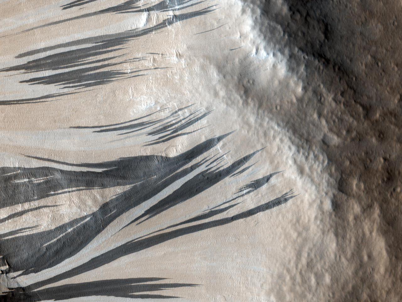
Tikhonravov Crater Dust Avalanches
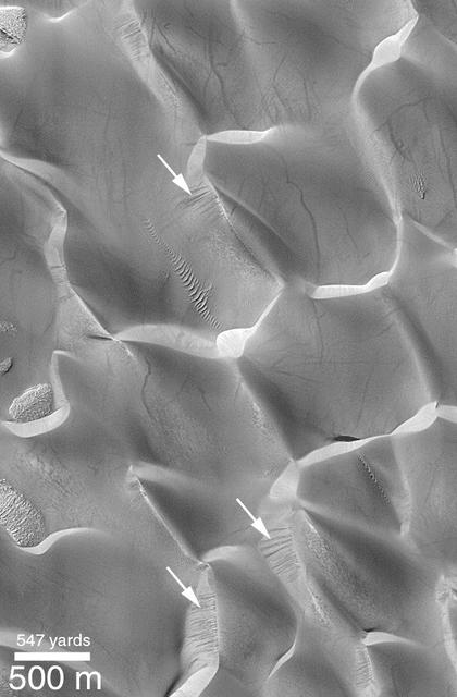
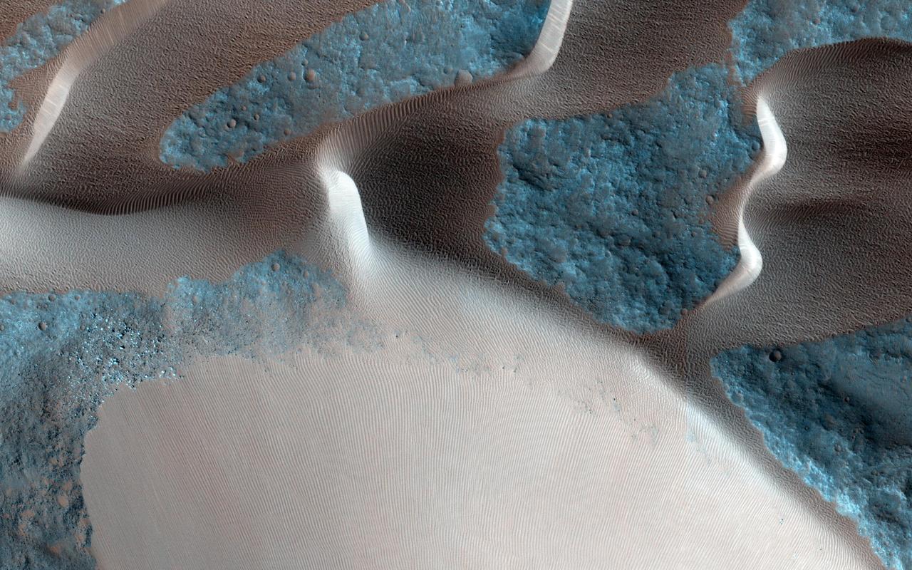
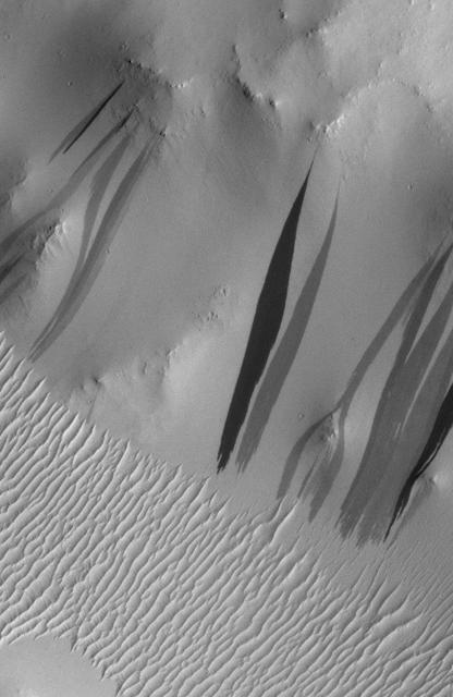
Kaiser Dune Avalanches
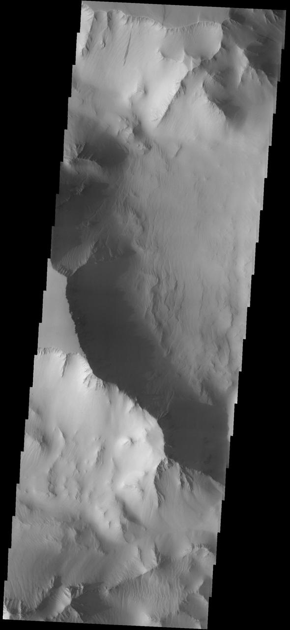
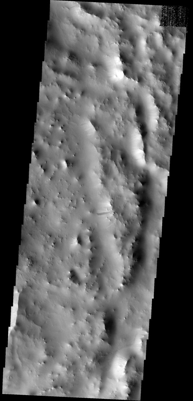
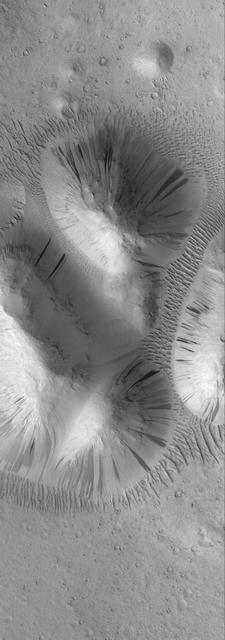
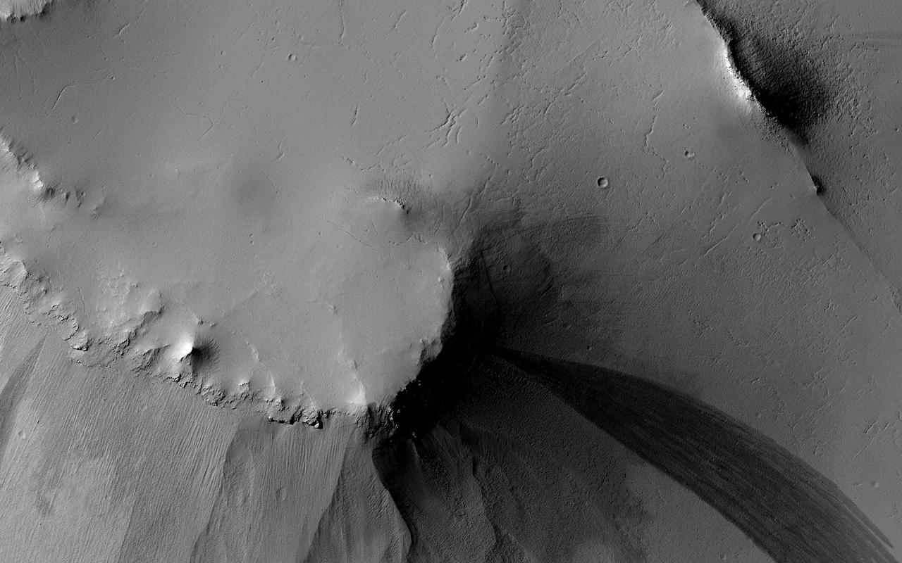
Rock Avalanche in Robinson Crater
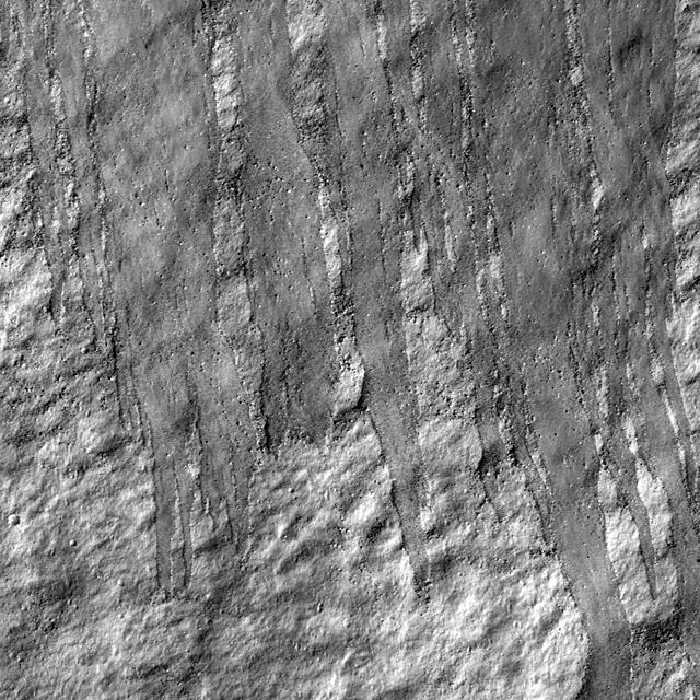
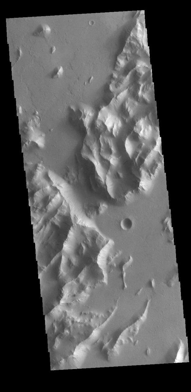
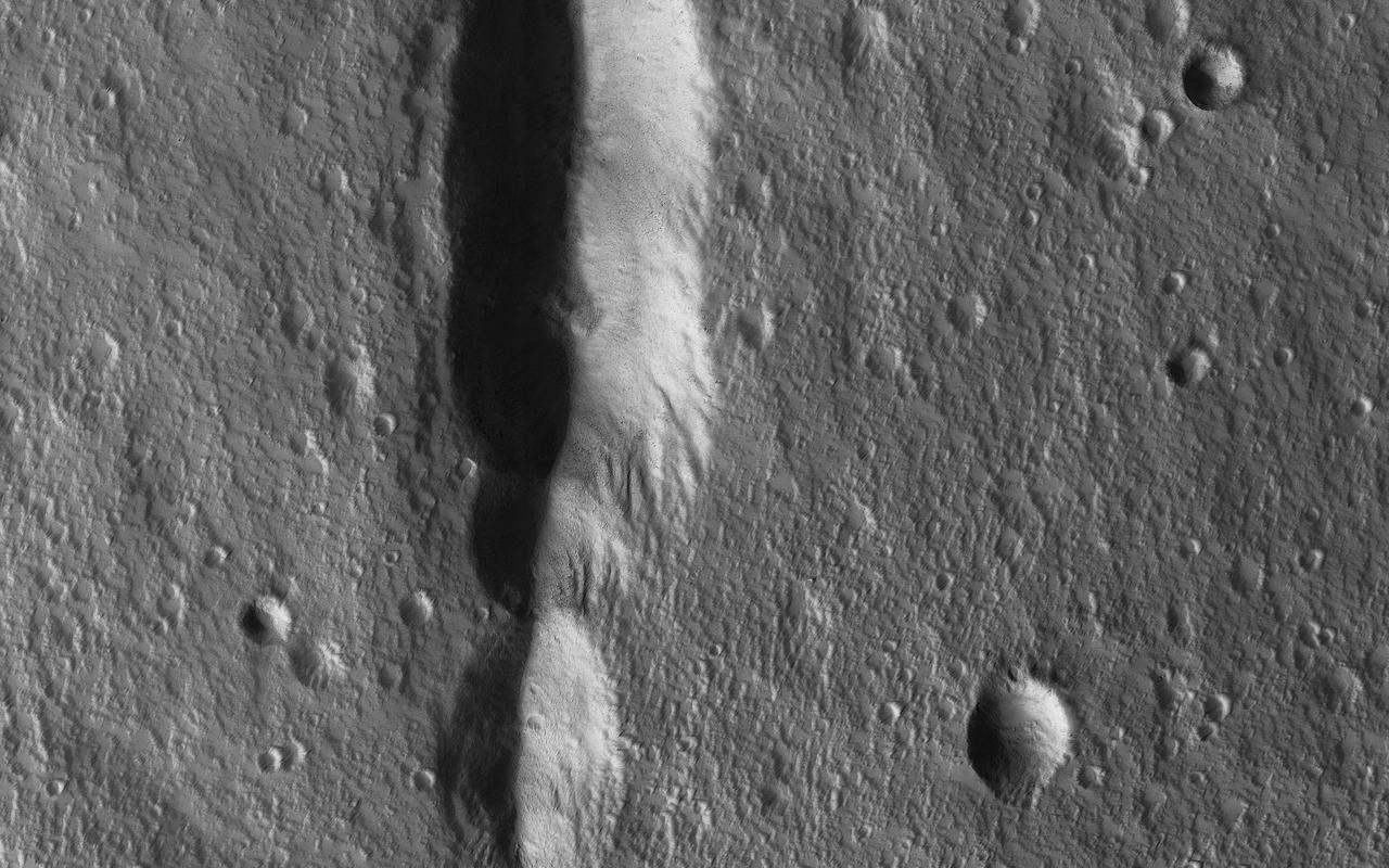
Lycus Sulci Dust Avalanches
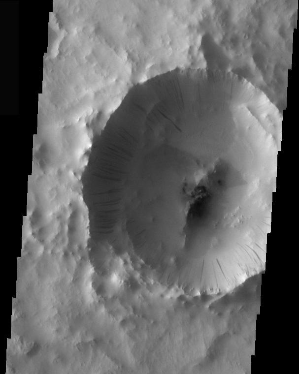
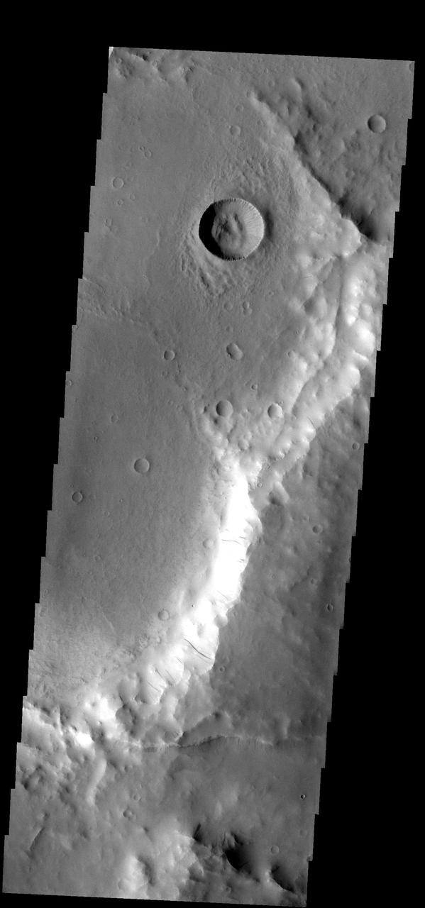
Crater Dust Avalanches
Crater Dust Avalanches
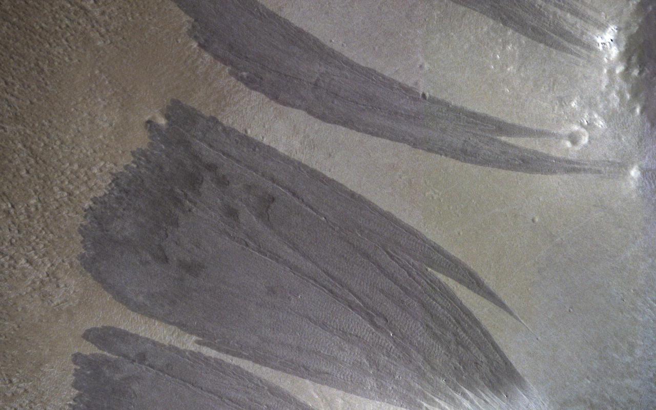
Dune Avalanche Scars
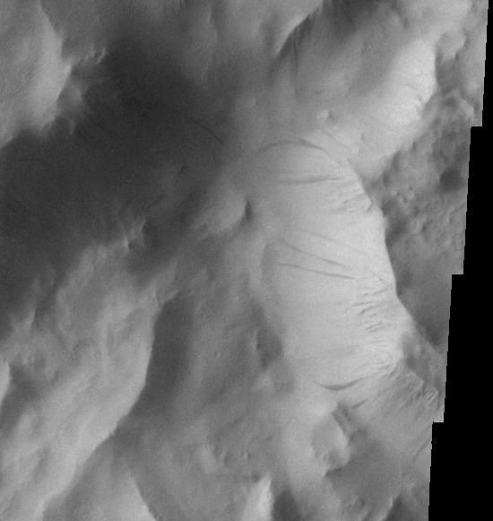
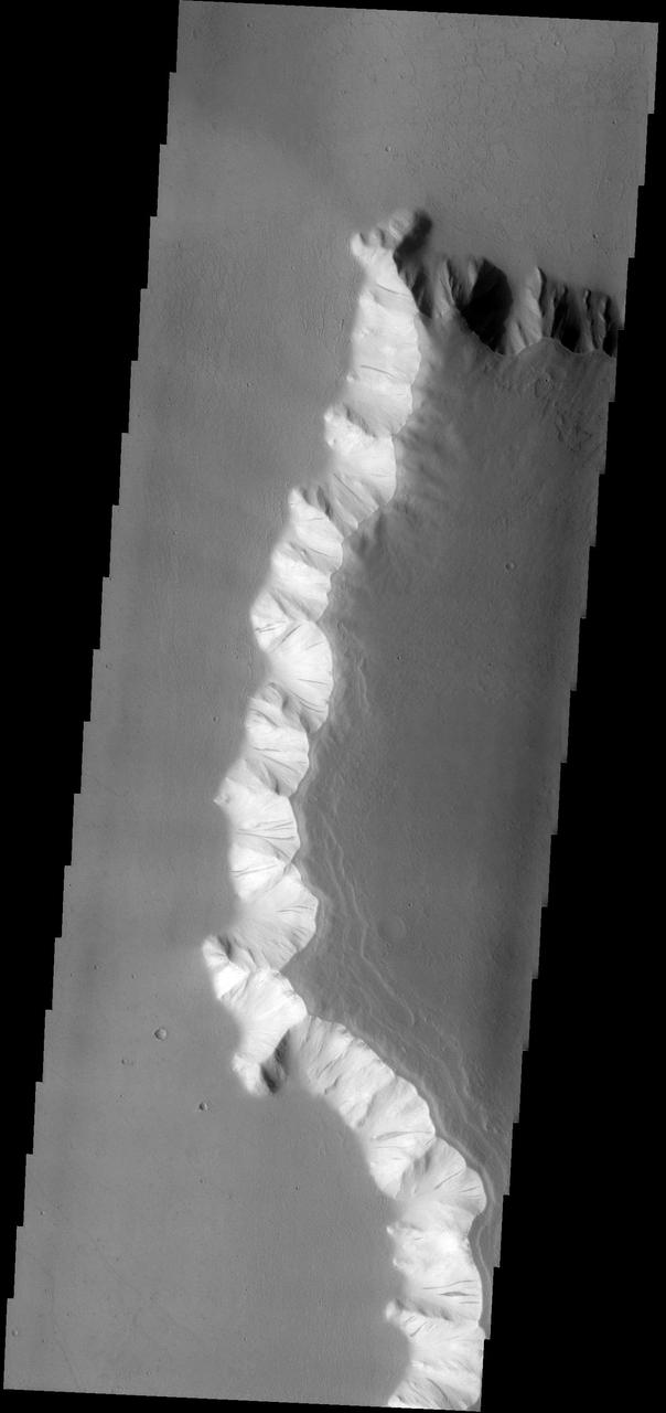
Hebes Chasma Dust Avalanches
This image from NASA Mars Odyssey spacecraft shows crater wall dust avalanches in southern Arabia Terra.
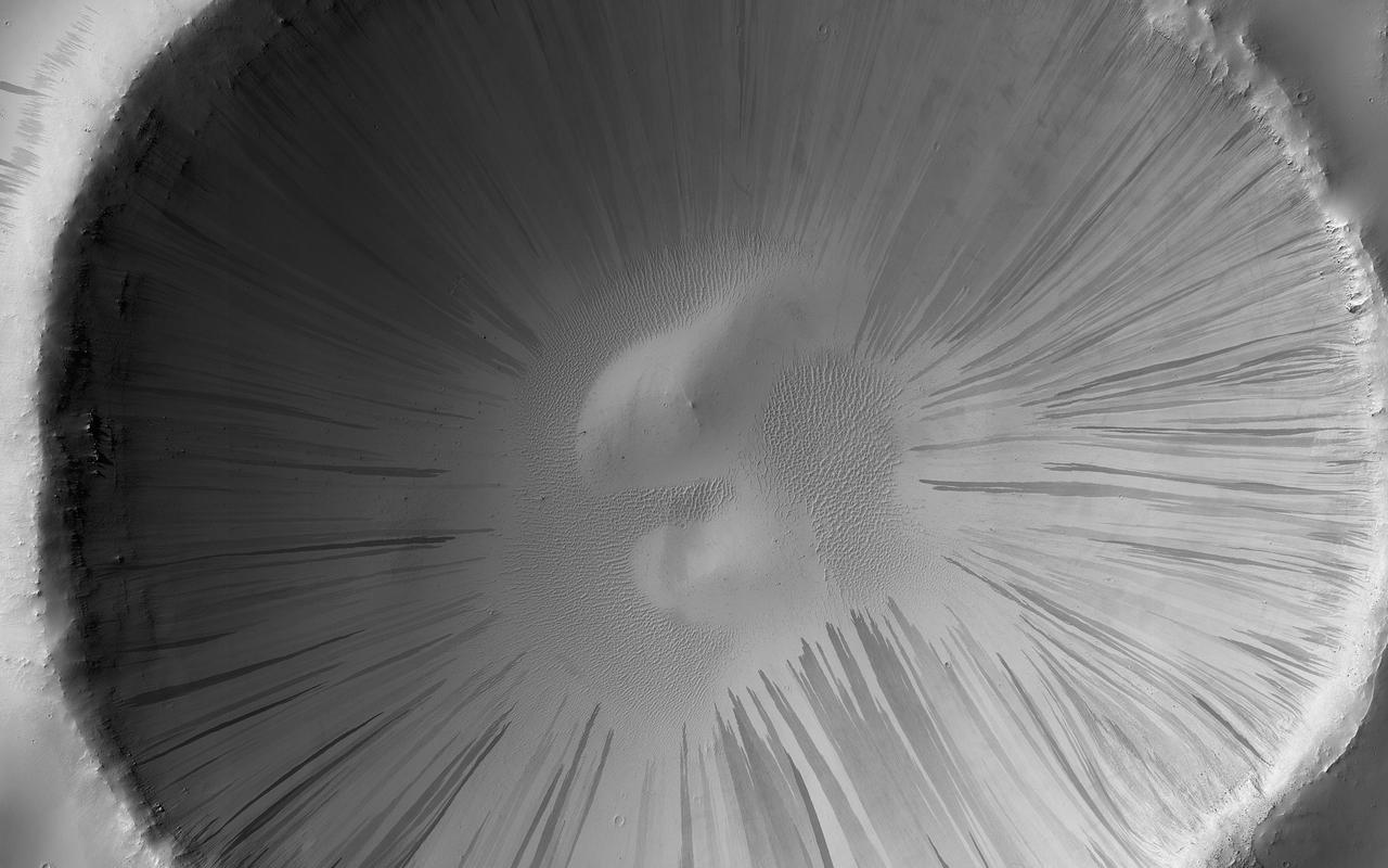
Recent Sand Avalanching on Rabe Crater Dunes
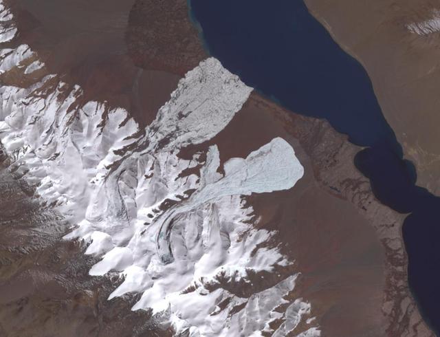
On July 17, 2016, one of the largest ice avalanches ever recorded tumbled down a Tibetan mountain, killing 9 people. The cause of the collapse is still unclear. On September 22, a second glacier, 1.9 miles (3 kilometers) farther south, collapsed. Geologists investigating the July collapse warned about the possibility of a second collapse, which did occur. The image covers an area of 7.8 by 10.2 miles (12.6 by 16.4 kilometers), was acquired October 4, 2017, and is located at 334 degrees north, 82.3 degrees east. http://photojournal.jpl.nasa.gov/catalog/PIA21069
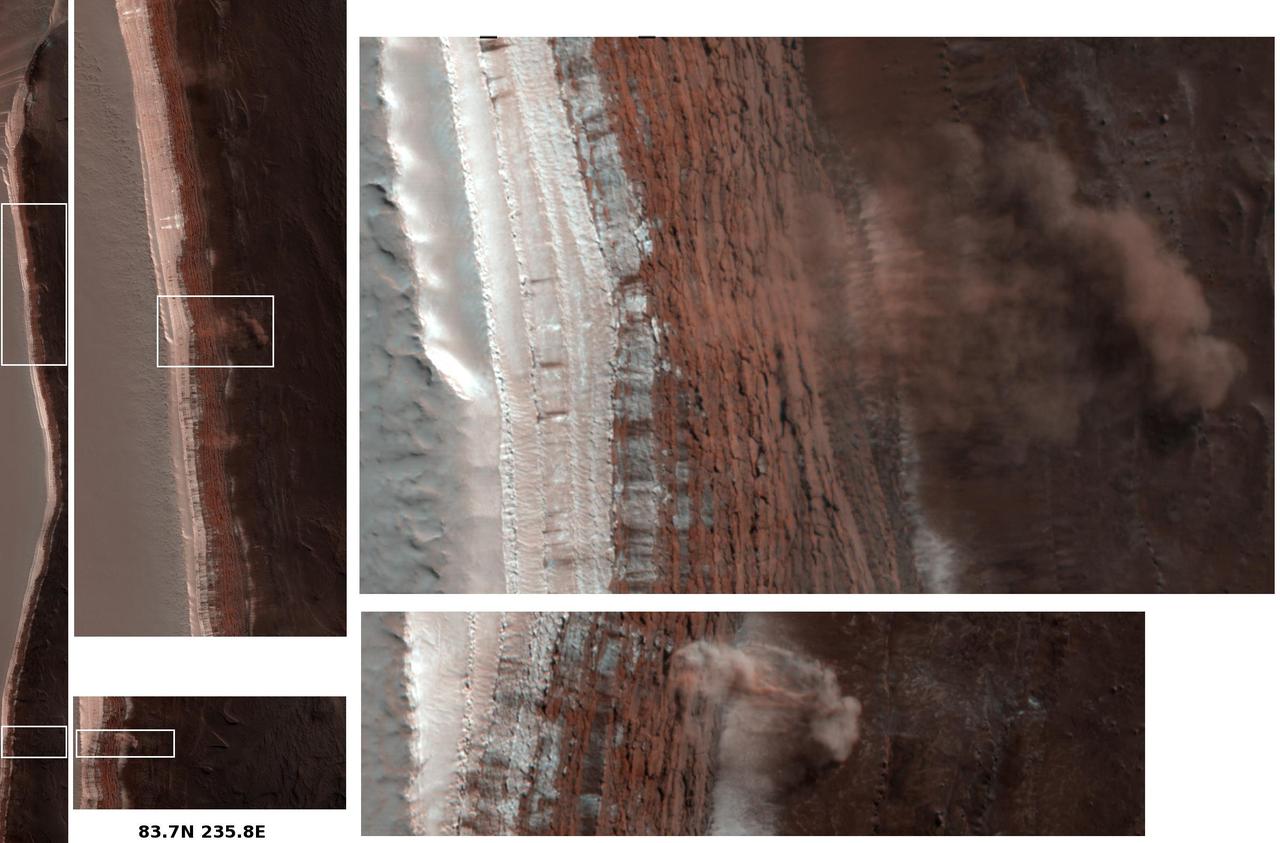
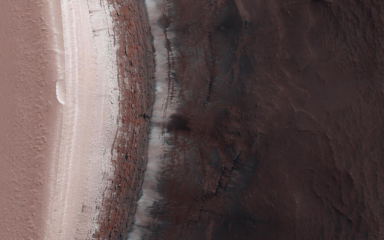
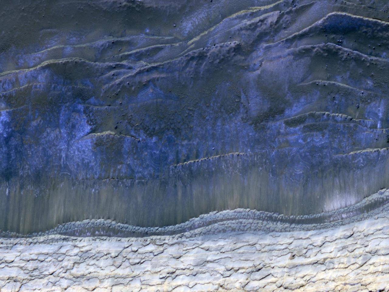
The North Polar Layered Deposits (NPLD) are large layered deposits of dusty water-ice in the northern polar region of Mars. The layering we see is caused mainly by slight variations in the dust-to-ice ratio, which records variations in the Martian climate over time. Another interesting aspect of the NPLD is the fact that we have observed on its scarps numerous avalanche events. Avalanches have also been spotted at this scarp. Spring monitoring is key to constrain frequency of avalanches and timing of "avalanche season" onset on Mars. Can you spot any avalanches in the image? This caption is partly based on the science rationale behind acquiring this image. https://photojournal.jpl.nasa.gov/catalog/PIA24864
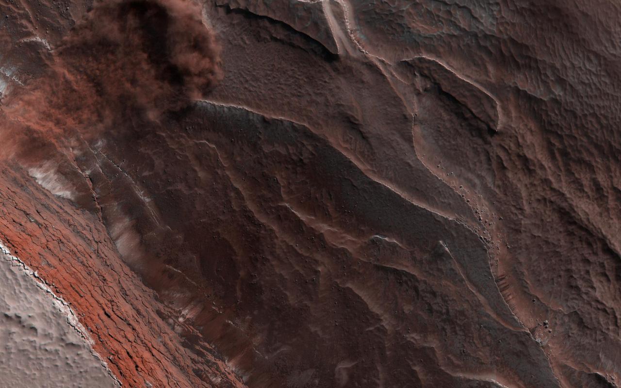
Changes on the Martian surface are detected by imaging the same area more than once. In this image acquired on May 13, 2018, NASA's Mars Reconnaissance Orbiter observes several new dust avalanches on the slopes of ridges within the Olympus Mons Aureole. These changes occurred within six years. (Also see the animated GIF). Dust avalanches create slope streaks that expose darker materials usually hidden below a lighter-toned layer. Cascading fine-grained material easily diverts around boulders or alters direction when encountering a change in slope (see the top right corner of the first close-up). The dark steak in another close-up is approximately 1 kilometer in length that not seen in a previous image. Past avalanche sites are still visible and fading slowly as dust settles out of the atmosphere and is deposited on the dark streaks over time. More information is available at https://photojournal.jpl.nasa.gov/catalog/PIA22595
HiRISE has been imaging new dark features discovered by MRO's Context Camera, which are mostly new impact sites. In this scene we see what appears to be a new impact cluster and, extending downhill from the craters, new dark slope streaks. These slope streaks are formed by dry dust avalanches. We've also seen large new dust avalanches associated with new impacts at previous locations. https://photojournal.jpl.nasa.gov/catalog/PIA23181
The High-Resolution Imaging Science Experiment (Hi-RISE) camera aboard NASA's Mars Reconnaissance Orbiter captured this avalanche plunging down a 1,640-foot-tall (500-meter-tall) cliff on May 29, 2019. The image also reveals layers at Mars' north pole during spring. As temperatures increase and vaporize ice, the destabilized ice blocks break loose and kick up dust. https://photojournal.jpl.nasa.gov/catalog/PIA24035
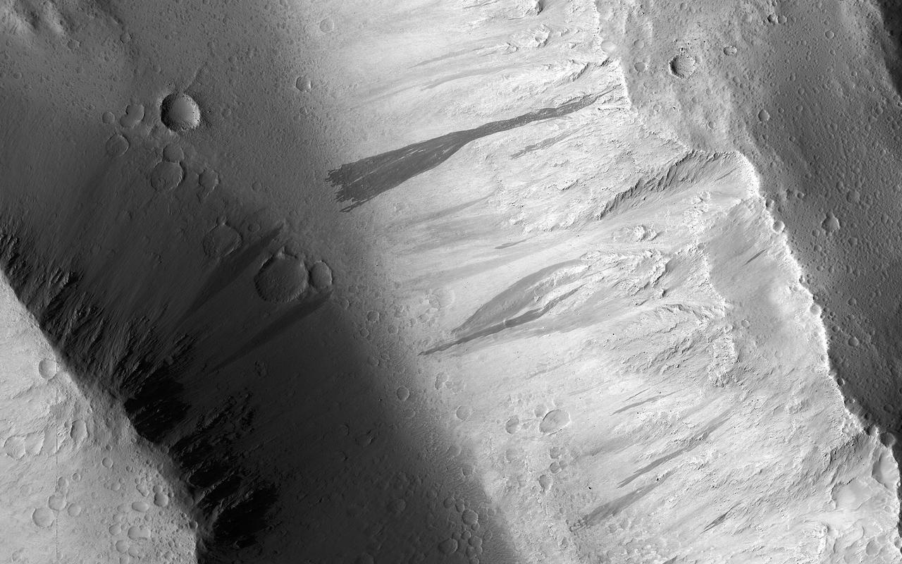
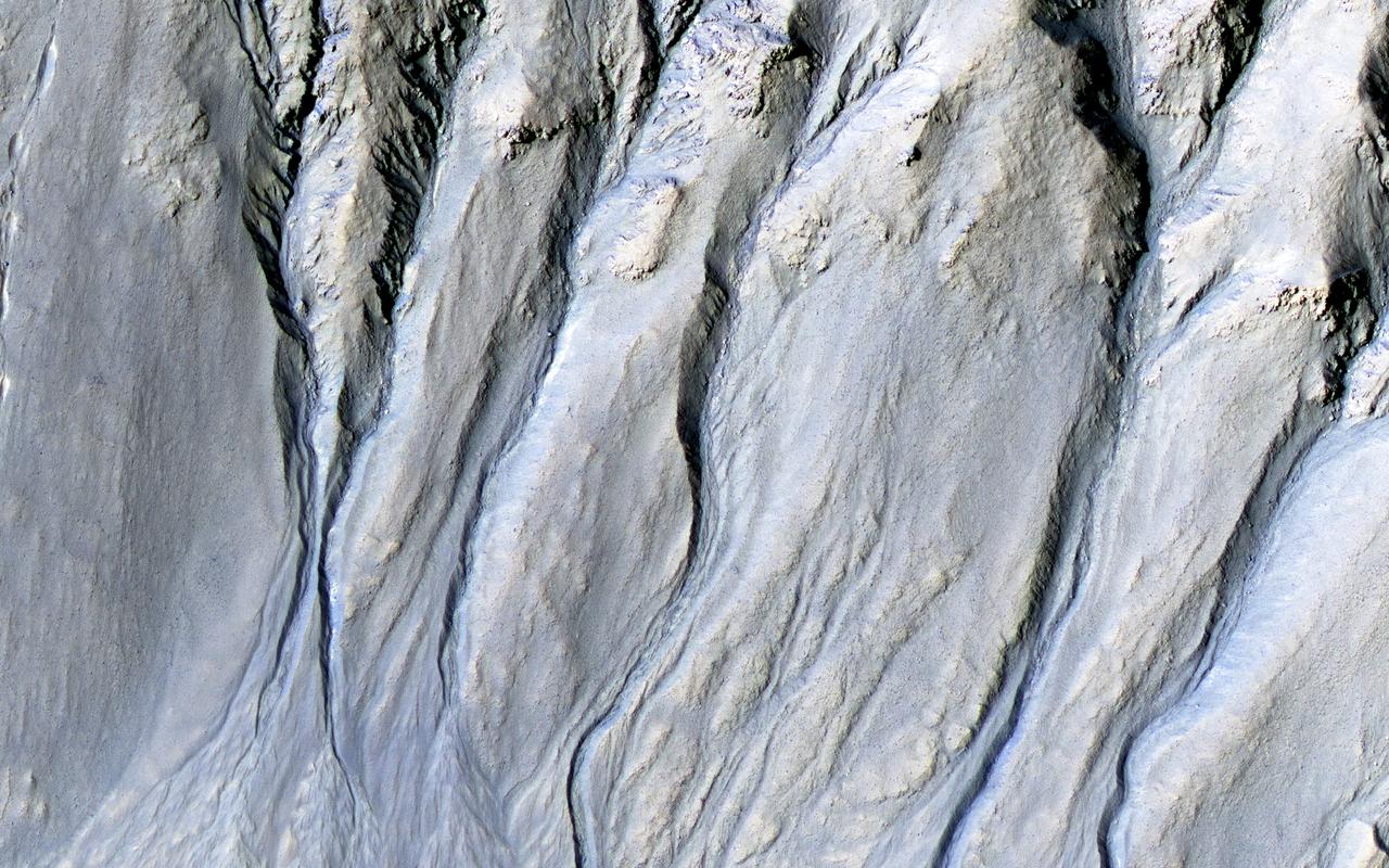
Amazingly, this image has captured at least four Martian avalanches, or debris falls, in action. It was taken on February 19, 2008, by the High Resolution Imaging Science Experiment HiRISE camera on NASA Mars Reconnaissance Orbiter.

On Friday, April 26, 2014, an avalanche on Mount Everest killed at least 13 Sherpa guides. NASA Terra spacecraft looked toward the northeast, with Mount Everest center, and Lhotse, the fourth-highest mountain on Earth, on the skyline to right center.
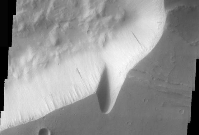
One of the major extended-mission objectives for HiRISE has been to re-image parts of the surface to look for changes. Such observations can tell us what processes are active today. This image was acquired as part of a series to look for sand movement in Meroe Patera, not far from the active sand dunes of Nili Patera. Our image shows that sand dunes are missing downwind (to the left) of a crater near the center of the observation, because sand falls into the crater and is trapped. Zooming in on the sand-coated crater wall and comparing it with older images revealed a surprise: several major sand flows slumped down into the crater (towards the upper left), leaving small ridges (called "levees") along their path and rounded piles of sand at the end. What caused these slumps? Dry ice, which is thought to cause flows in some gullies and the North polar dunes, does not occur this close to the equator. There is no sign of recurring slope lineae, the leading candidates for liquid on the Martian surface. Instead, it is most likely that these were dry flows. They are far larger than the avalanches commonly seen on sand dunes, typified by the shorter light streaks visible in the lower left part of the "after" image, so they might have been triggered by a Mars-quake or an unusually strong wind. http://photojournal.jpl.nasa.gov/catalog/PIA19305
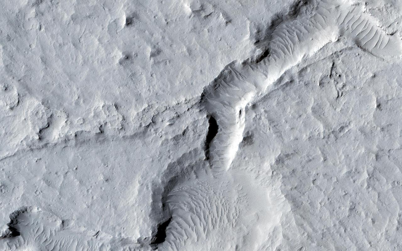
This dust avalanche is located in part of Noctis Labyrinthus
These dust avalanches occur in a crater within Iani Chaos
The eastern wall of Echus Chasma has numerous dust avalanches
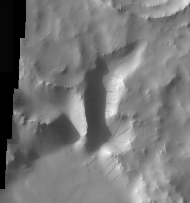
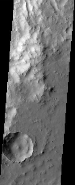
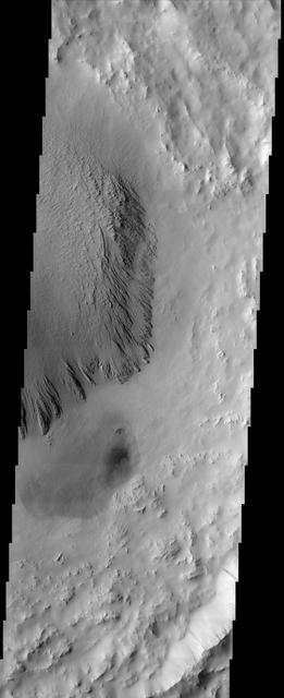
This dust avalanche is located on the rim material of an unnamed crater to the east of Tikhonravov Crater
Dust and sand slide down slopes on Mars in little avalanches. Dark slope streaks are thought to be the result of the relatively bright colored dust avalanching down slopes, revealing the darker, coarser sand underneath. This image is the latest in a sequence of images of this crater that started in 2013. The goal is to watch the dusty slopes, and try to understand more about the processes that drive these little avalanches. https://photojournal.jpl.nasa.gov/catalog/PIA23757
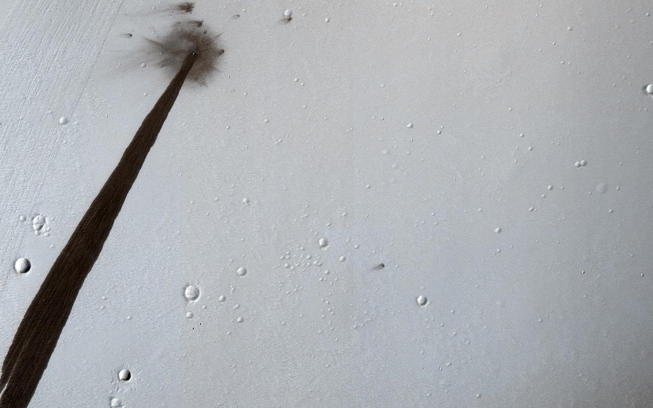
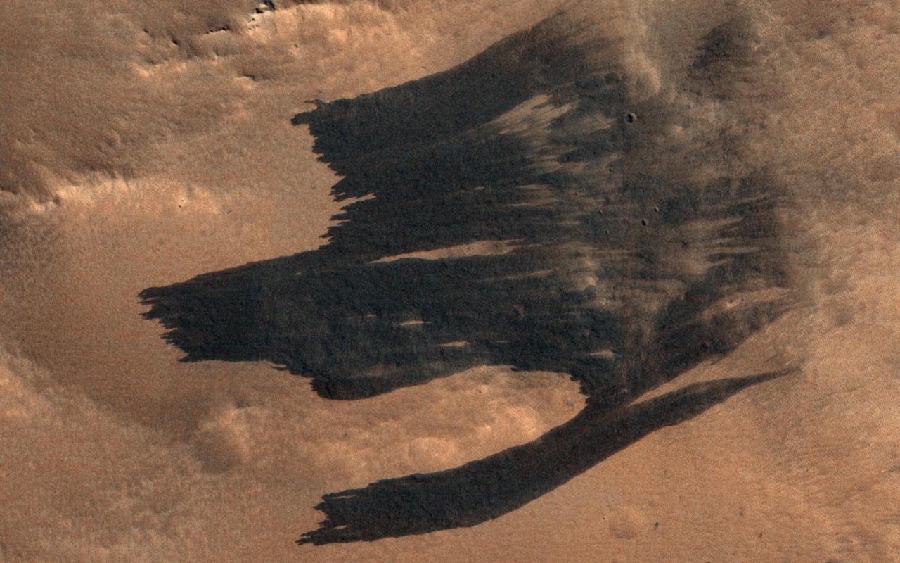
This HiRISE image from NASA's Mars Reconnaissance Orbiter (MRO) captures a new, dated (within about a decade) impact crater that triggered a slope streak. When the meteoroid hit the surface and exploded to make the crater, it also destabilized the slope and initiated this avalanche. The crater itself is only 5 meters across, but the streak it started is 1 kilometer long! Slope streaks are created when dry dust avalanches leave behind dark swaths on dusty Martian hills. The faded scar of an old avalanche is also visible to the side of the new dark streak. https://photojournal.jpl.nasa.gov/catalog/PIA22513
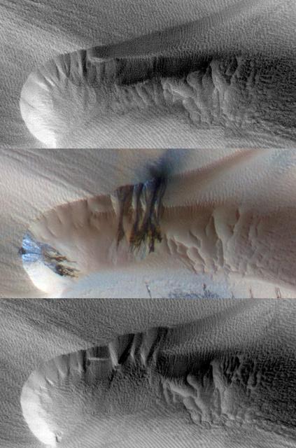
We have been monitoring the slope streaks on this hill for several years. There are definitive changes between this September 2018 image and a previous one in December 2016. Earlier streaks have since faded and new, darker streaks are visible. These streaks are tens of meters wide. These features are small avalanches of dust and sand from the hillsides. The surface dust is lighter in color, but when it avalanches away, it reveals underlying larger-grained sand particles that are much darker. Over time, the dust slowly rains down from the atmosphere and the streaks fade as they are coated with dust. https://photojournal.jpl.nasa.gov/catalog/PIA22897
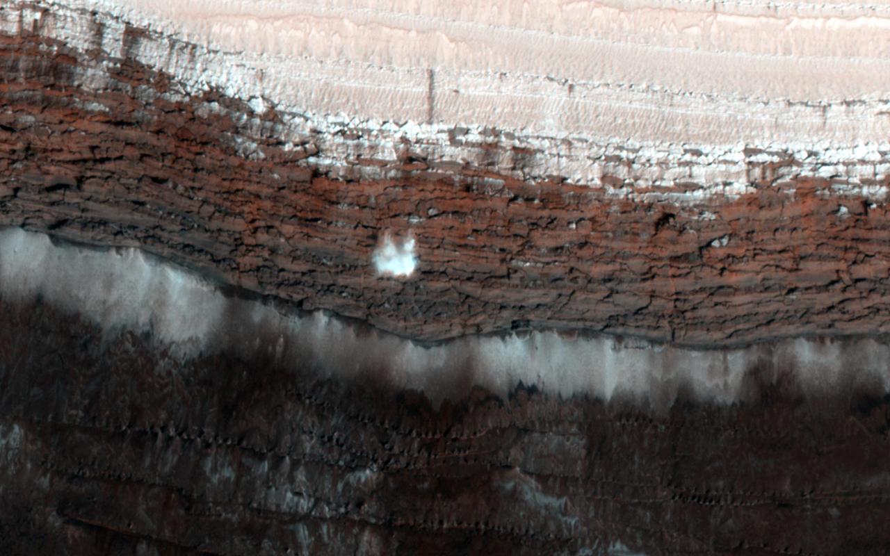
This image from NASA Mars Reconnaissance Orbiter spacecraft shows a channel system flowing to the southwest toward the huge Hellas impact basin. Click on the image for larger version The scarp at the edge of the North Polar layered deposits of Mars is the site of the most frequent frost avalanches seen by HiRISE. At this season, northern spring, frost avalanches are common and HiRISE monitors the scarp to learn more about the timing and frequency of the avalanches, and their relationship to the evolution of frost on the flat ground above and below the scarp. This picture managed to capture a small avalanche in progress, right in the color strip. See if you can spot it in the browse image, and then click on the cutout to see it at full resolution. The small white cloud in front of the brick red cliff is likely carbon dioxide frost dislodged from the layers above, caught in the act of cascading down the cliff. It is larger than it looks, more than 20 meters across, and (based on previous examples) it will likely kick up clouds of dust when it hits the ground. The avalanches tend to take place at a season when the North Polar region is warming, suggesting that the avalanches may be triggered by thermal expansion. The avalanches remind us, along with active sand dunes, dust devils, slope streaks and recurring slope lineae, that Mars is an active and dynamic planet. http://photojournal.jpl.nasa.gov/catalog/PIA19961
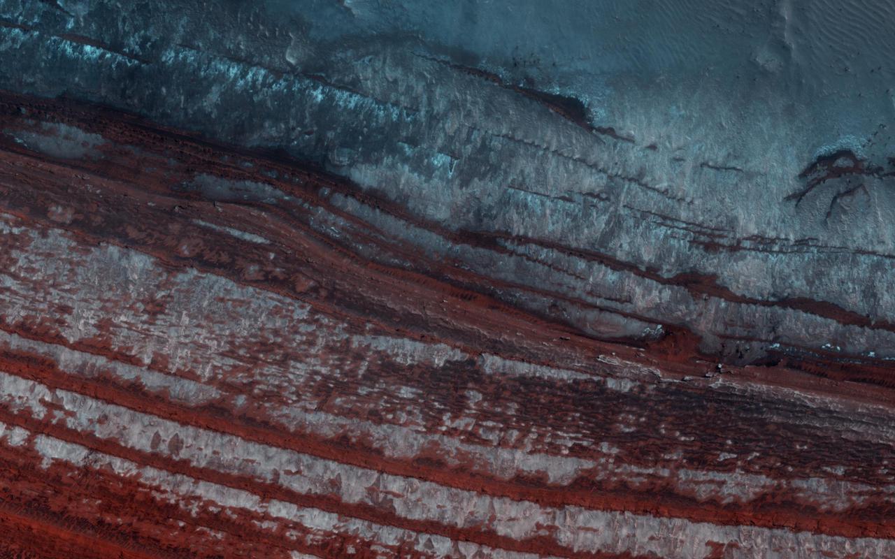
Every spring the sun shines on the side of the stack of layers at the North Pole of Mars known as the north polar layered deposits. The warmth destabilizes the ice and blocks break loose. When they reach the bottom of the more than 500 meter tall cliff face, the blocks kick up a cloud of dust. (In the cutout, the top layer of the north polar cap is to the lower left.) The layers beneath are different colors and textures depending on the amount of dust mixed with ice. https://photojournal.jpl.nasa.gov/catalog/PIA23453
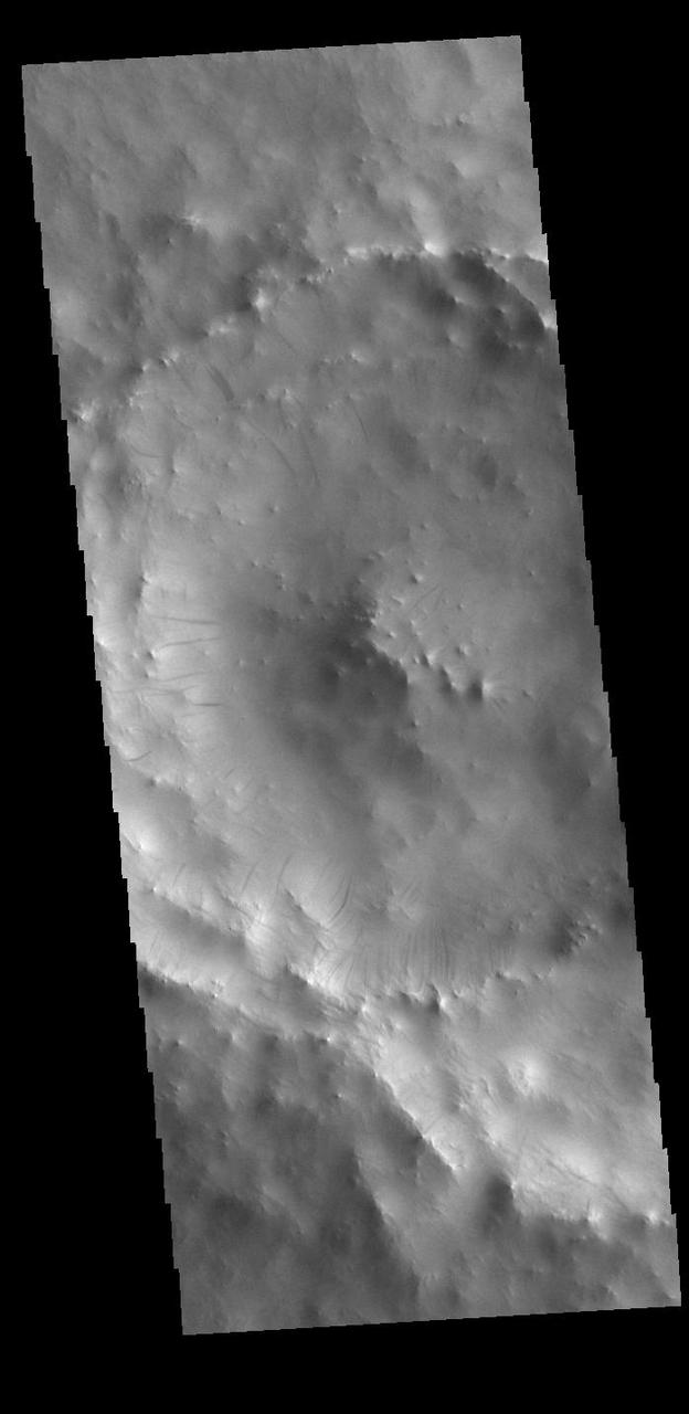
NASA 2001 Mars Odyssey spacecraft shows that the dust avalanches found on this crater rim have exposed darker rocky material on an otherwise dust coated slope. This unnamed crater is located east of Schiaparelli Crater.
This MOC image shows a wide, flat-floored trough flanked by several smaller, branching troughs in the Olympica Fossae region of Mars. Dark- and intermediate-toned slope streaks -- created by dry avalanches of dust -- occur on the trough walls
This image from NASA Mars Odyssey shows deposits in a crater located in Arabia Terra. Arabia is generally dust covered and dark streaks or dust avalanches are present in the crater walls.
In the northern section of this from image NASA Mars Reconnaissance Orbiter, we see flat terrain that is probably an ancient lava field. These dust avalanches are common in dust-covered regions on Mars.
An ice cap about three kilometers (two miles) thick exists at the North Pole of Mars. In some locations its edge is a cliff about 800 meters (half a mile) high that is an almost-vertical wall of ice. With HiRISE images like this one we can look at this cliff face and see it is broken up into jagged blocks. Debris piles at the base of the cliff show where these blocks have fallen out. In the spring, we also sometimes see avalanches pouring down these cliff faces and this image was taken to search for more of them. No avalanches are visible this time., however. For reasons we don't understand, the number of avalanches varies from year to year and this spring appears to be a low-avalanche year. https://photojournal.jpl.nasa.gov/catalog/PIA25949
These dark streaks, also known as "slope streaks," on Mars resulted from dust avalanches. They were captured by NASA's Mars Reconnaissance Orbiter using its High-Resolution Imaging Science Experiment (HiRISE) camera on Dec. 26, 2017. https://photojournal.jpl.nasa.gov/catalog/PIA25235
These dark streaks, also known as "slope streaks," in an area of Mars called Acheron Fossae resulted from dust avalanches. The High-Resolution Imaging Science Experiment (HiRISE) camera aboard NASA's Mars Reconnaissance Orbiter captured them on Dec. 3, 2006. https://photojournal.jpl.nasa.gov/catalog/PIA25234

The rugged, arcuate rim of the 90 km crater Reuyl dominates this NASA Mars Odyssey image. Reuyl crater is at the southern edge of a region known to be blanketed in thick dust based on its high albedo brightness and low thermal inertia values.
One of the most actively changing areas on Mars are the steep edges of the North Polar layered deposits. This image from NASA's Mars Reconnaissance Orbiter (MRO) shows many new ice blocks compared to an earlier image in December 2006. An animation shows one example, where a section of ice cliff collapsed. The older image (acquired in bin-2 mode) is not as sharp as the newer one. HiRISE has been re-imaging regions first photographed in 2006 through 2007, six Mars years ago. This long baseline allows us to see large, rare changes as well as many smaller changes. More information is available at https://photojournal.jpl.nasa.gov/catalog/PIA22535
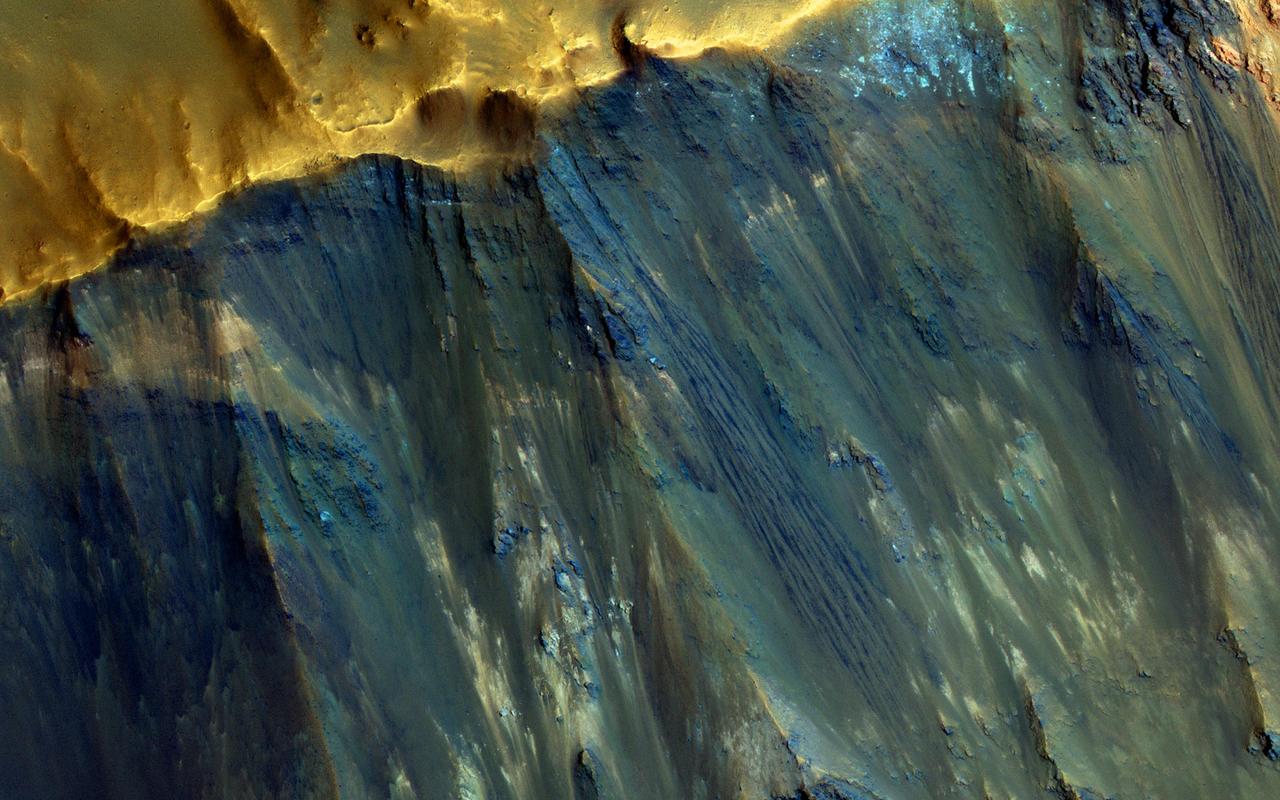
Relatively dark slope streaks are common on steep dust-mantled slopes of Mars. When imaged under high sun illumination they appear to be just a dark stain without topographic relief. However, when imaged with the sun low in the sky (and at high resolution), we can clearly see the topographic signature. Surface material has been removed from the upper slopes and deposited in lobes, as expected from landslides (also called "mass movements"). https://photojournal.jpl.nasa.gov/catalog/PIA24692
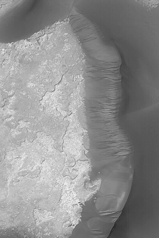
This image from NASA Mars Reconnaissance Orbiter shows the scarp that demarcates the boundary between layered deposits covering the north polar region and the lower surrounding terrain, which includes sand dunes. Original release date March 3, 2010.
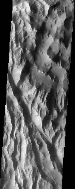
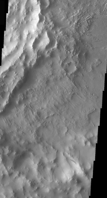
This NASA Mars Odyssey image shows Lycus Sulci, a region of ridges and hills located north-northwest of the volcano Olympus Mons. Several dust avalanches on the flanks of the roughly textured surfaces suggest a thick coating of fine-grained materials.
Dozens of dark slope streaks, created by dry avalanches of dust, extend from toward the base of dust-covered buttes. Large, dust-covered, windblown ripples surround the group and occupy some of the low-lying areas between individual buttes
Three images of the same location, taken by NASA Mars Reconnaissance Orbiter at different times on Mars, show seasonal activity causing sand avalanches and ripple changes on a Martian dune. Time sequence of the images progresses from top to bottom.
![This image from NASA Mars Reconnaissance Orbiter shows a new impact site originally detected by the Context Camera onboard MRO. The crater is on a dusty slope, which also has several dark slope streaks due to dust avalanches. A previous impact at another place on Mars triggered a major dust avalanche, but this one did not. This tells us that the dust here is more stable (stronger and/or on a lower slope). The map is projected here at a scale of 25 centimeters (9.8 inches) per pixel. [The original image scale is 27.1 centimeters (9.8 inches) per pixel (with 1 x 1 binning); objects on the order of 81 centimeters (30 inches) across are resolved.] North is up. http://photojournal.jpl.nasa.gov/catalog/PIA21459](https://images-assets.nasa.gov/image/PIA21459/PIA21459~medium.jpg)
This image from NASA Mars Reconnaissance Orbiter shows a new impact site originally detected by the Context Camera onboard MRO. The crater is on a dusty slope, which also has several dark slope streaks due to dust avalanches. A previous impact at another place on Mars triggered a major dust avalanche, but this one did not. This tells us that the dust here is more stable (stronger and/or on a lower slope). The map is projected here at a scale of 25 centimeters (9.8 inches) per pixel. [The original image scale is 27.1 centimeters (9.8 inches) per pixel (with 1 x 1 binning); objects on the order of 81 centimeters (30 inches) across are resolved.] North is up. http://photojournal.jpl.nasa.gov/catalog/PIA21459
Slope streaks are common in the tropics of Mars. Once thought to be caused by flowing water, most scientists now believe that they are avalanches of dust. They are typically darker than their surroundings and often fan outwards downslope. This suggests that the dust sediment is sticky, so that the avalanche broadens as it flows downhill. Slope streaks are known to fade over time, but the slope streaks at this monitoring site in Arabia Terra go beyond that. Here, old slope streaks appear to be brighter than the surrounding terrain. A comparison between HiRISE images taken in 2008 and in 2019 shows very few changes in the dark and bright streaks. We can see three new dark streaks in our more recent image. These were the only changes spotted among the hundreds of streaks observed in the monitoring site, suggesting that new streak formation and fading take place on time scales of at least decades. https://photojournal.jpl.nasa.gov/catalog/PIA24912
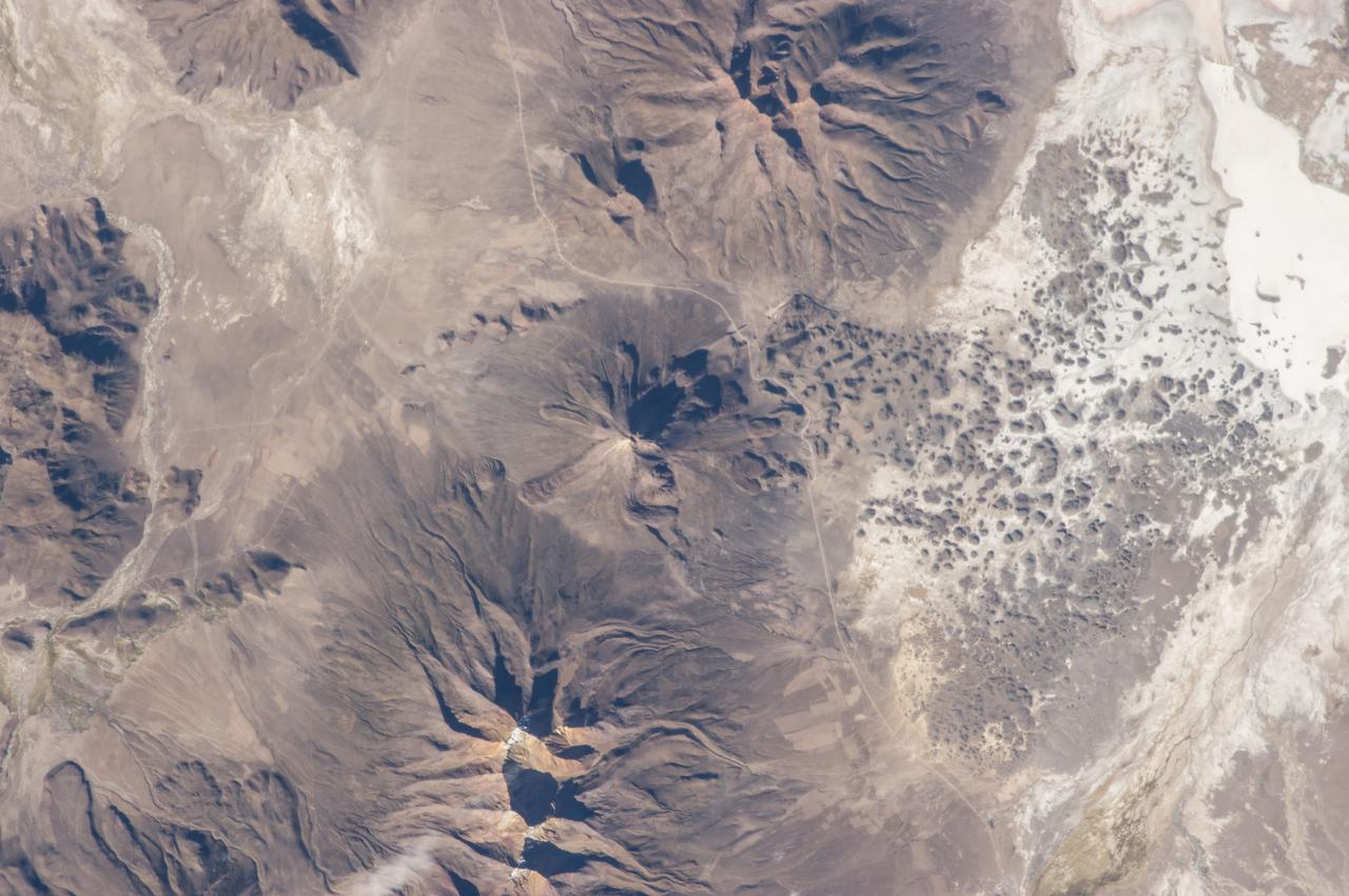
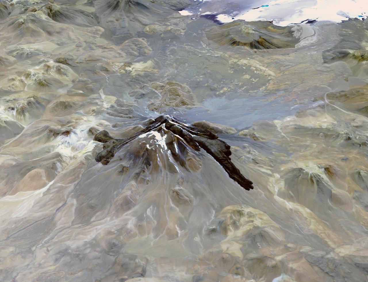
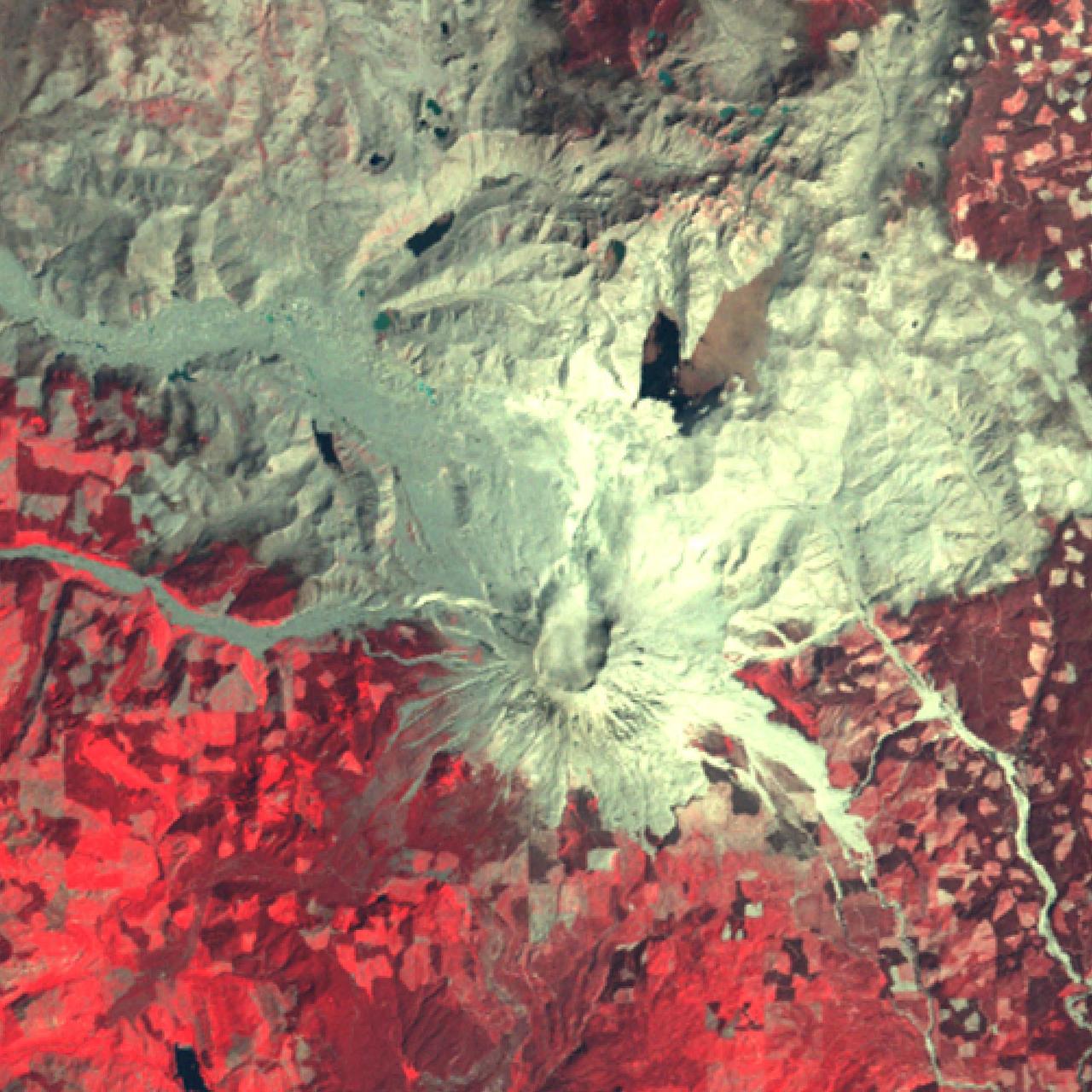
ISS035-E-18006 (8 April 2013) --- One of the Expedition 35 crew members aboard the Earth-orbiting International Space Station photographed this image of Tata Sabaya Volcano, located in the Altiplano region of Bolivia. The volcano rises to a summit elevation of 5430 meters above sea level. While its current form is that of a “youthful” stratovolcano, the regional geological evidence indicates an older, eventful history, according to scientists. The scientists say that prior to approximately 12,000 years ago (during the late Pleistocene Epoch), a large debris avalanche was formed by collapse of the ancestral Tata Sabaya volcano. Debris from the avalanche swept into the nearby Salar de Coipasa –at that time filled with a lake larger than today – significantly changing its northwestern coastline. Timing of the event is obtained from tufa deposits formed on debris islands during a high stand of the Coipasa lake – illustrating the geological principle of cross-cutting relationships, in that the debris avalanche had to have occurred before the tufa deposits were formed in the lake. The Tata Sabaya stratovolcano is located at image center. Several young lava flows are visible on the northwestern and western flanks of the volcano. Peaks visible to the northeast and southwest appear to be volcanoes as well, but unlike Tata Sabaya there is no record of recent activity from either of them (according to the Smithsonian National Museum of Natural History’s Global Volcanism Program). As the Altiplano became more arid and the Coipasa Lake shrank, much of the hummocky terrain of the debris avalanche became exposed over an area of more than 300 square kilometers. The hummocky terrain is clearly visible at image right. White salt deposits of the salar surround many of the individual hummocks, making them “islands” once again.
Sometimes a central pit forms inside some Martian craters, especially when there substantial ground ice. Such is the case in this observation from NASA Mars Reconnaissance Orbiter spacecraft. Sometimes what we call "mass wasting" processes (think small avalanches or landslides) occur on the slopes of the central pit. We took this image to search for any recent activity that would add to or modify previously identified gullies. http://photojournal.jpl.nasa.gov/catalog/PIA20005
Dark streaks mark the inner rim of this unnamed crater in Terra Sabaea. There are several suggested mechanisms to form these features. Two of the mechanisms are that the dusty surface has been altered to reveal darker rock beneath from motion of downward moving dust avalanches, or the surface is darkening by fluid or other surface staining. Orbit Number: 87336 Latitude: 14.6769 Longitude: 27.535 Instrument: VIS Captured: 2021-08-22 13:18 https://photojournal.jpl.nasa.gov/catalog/PIA25210
This image shows the very steep outer scarp of the north polar layered deposits. Every year there is a lot of slope activity in the springtime when sunlight warms these slopes. In this image we can see many dark streaks extending down the slope, but no sign yet of larger avalanches that were common in past years. https://photojournal.jpl.nasa.gov/catalog/PIA24695
Dark streaks mark the inner rim of this unnamed crater in Terra Sabaea. There are several suggested mechanisms to form these features. Two of the mechanisms are that the dusty surface has been altered to reveal darker rock beneath from motion of downward moving dust avalanches, or the surface is darkening by fluid or other surface staining. Orbit Number: 94910 Latitude: 12.9036 Longitude: 41.7337 Instrument: VIS Captured: 2023-05-08 04:41 https://photojournal.jpl.nasa.gov/catalog/PIA26216

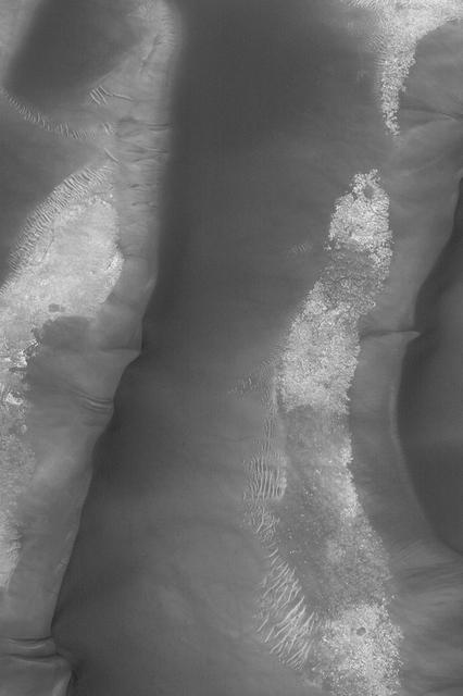
NASA's Mars Reconnaissance Orbiter (MRO) observed sand dunes in the north polar regions of Mars showing light coatings of pale orange dust blown partially across the dark basaltic sand. Around the edges of the dunes, patches of seasonal dry ice remain. These patches will be gone soon as they sublimate (turn from ice to gas) in the summer sun. Some blocks of ice are visible at the foot of an alcove formed by a sand avalanche down the slipface of the dune. https://photojournal.jpl.nasa.gov/catalog/PIA22511
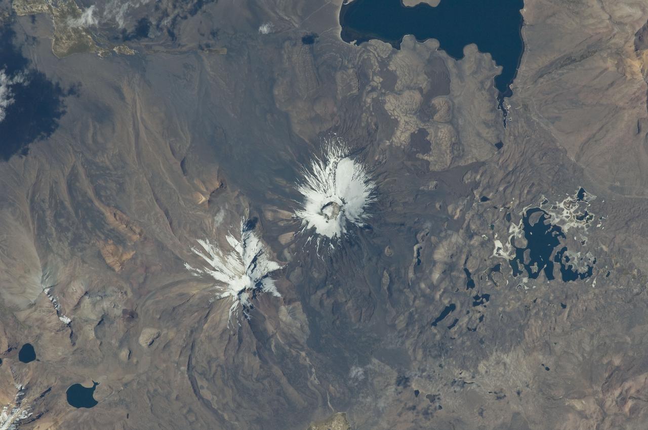
ISS029-E-020003 (7 Oct. 2011) --- Parinacota Volcano in the Chile-Bolivia border region, South America is featured in this image photographed by an Expedition 29 crew member on the International Space Station. Volcan Parinacota (?flamingo lake? in the regional Aymara language) is a potentially active stratovolcano located on the Altiplano, a high plateau situated within the Andes Mountains of west-central South America. While no direct observations of eruptive activity are recorded, surface exposure age-dating of lava flows suggests that activity occurred as recently as 290 AD approximately 300 years, according to scientists. Local Aymara stories also suggest that the volcano has erupted during the past 1,000 years. This detailed photograph highlights the symmetrical cone of Parinacota, with its well-developed summit crater (elevation 6,348 meters above sea level) at center. Dark brown to dark gray surfaces to the east and west of the summit include lava flows, pyroclastic deposits, and ash. A companion volcano, Pomerape, is located across a low saddle to the north ? scientists believe this volcano last erupted during the Pleistocene Epoch (extending from approximately 3 million to 12,000 years ago). The summits of both volcanoes are covered by white permanent snowpack and small glaciers. Together, the two volcanoes form the Nevados de Payachata volcanic area. Eruptive activity at Parinacota has directly influenced development of the local landscape beyond the emplacement of volcanic deposits ? approximately 8,000 years ago the western flank of the volcano collapsed, creating a debris avalanche that traveled 22 kilometers to the west. This debris avalanche blocked drainages, leading to the formation of Lake Chungara to the south (upper right). The uneven, hummocky surface of the debris avalanche deposit provides ample catchments for water, as evidenced by the numerous small ponds and Cotacotani Lake to the west.
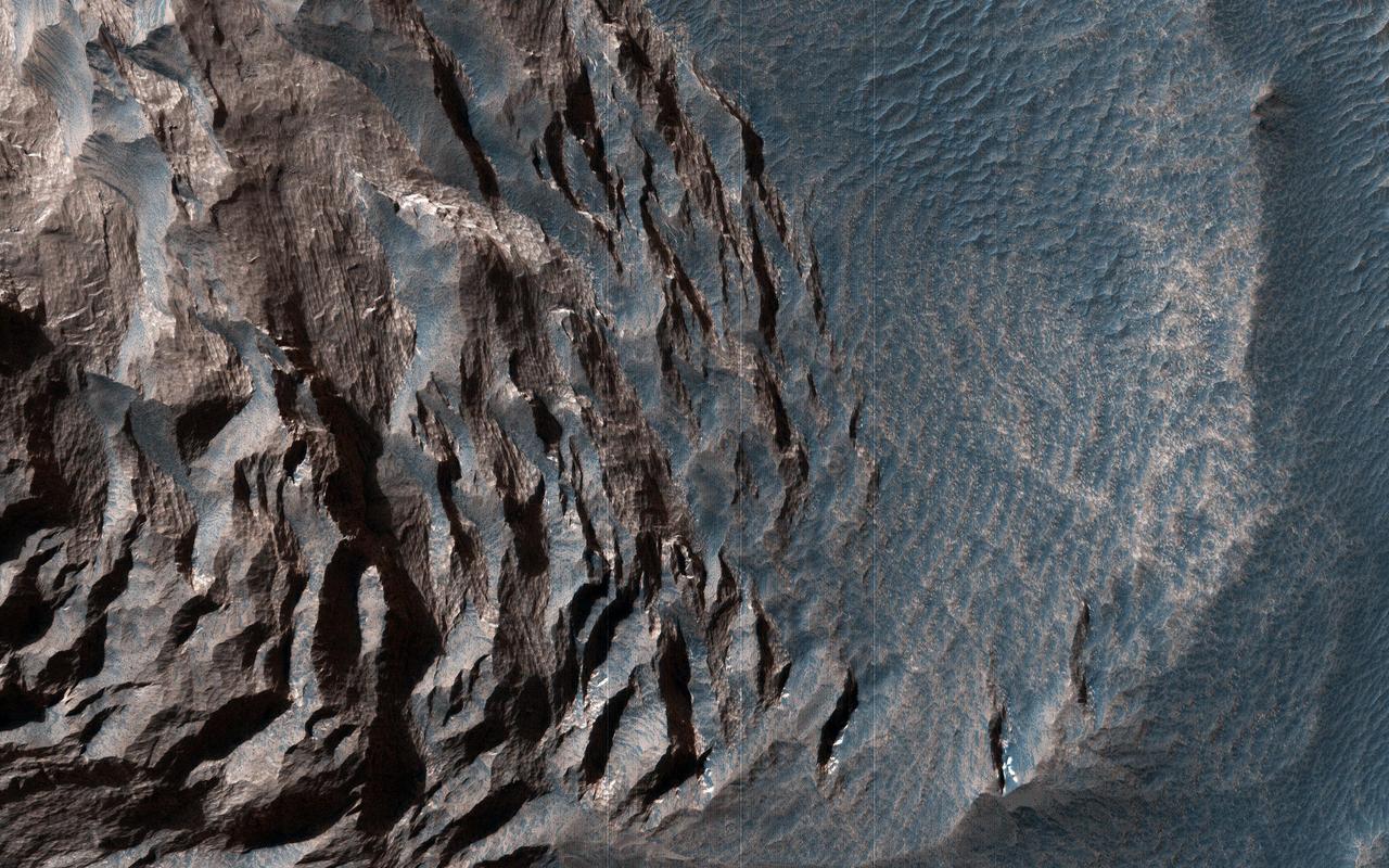
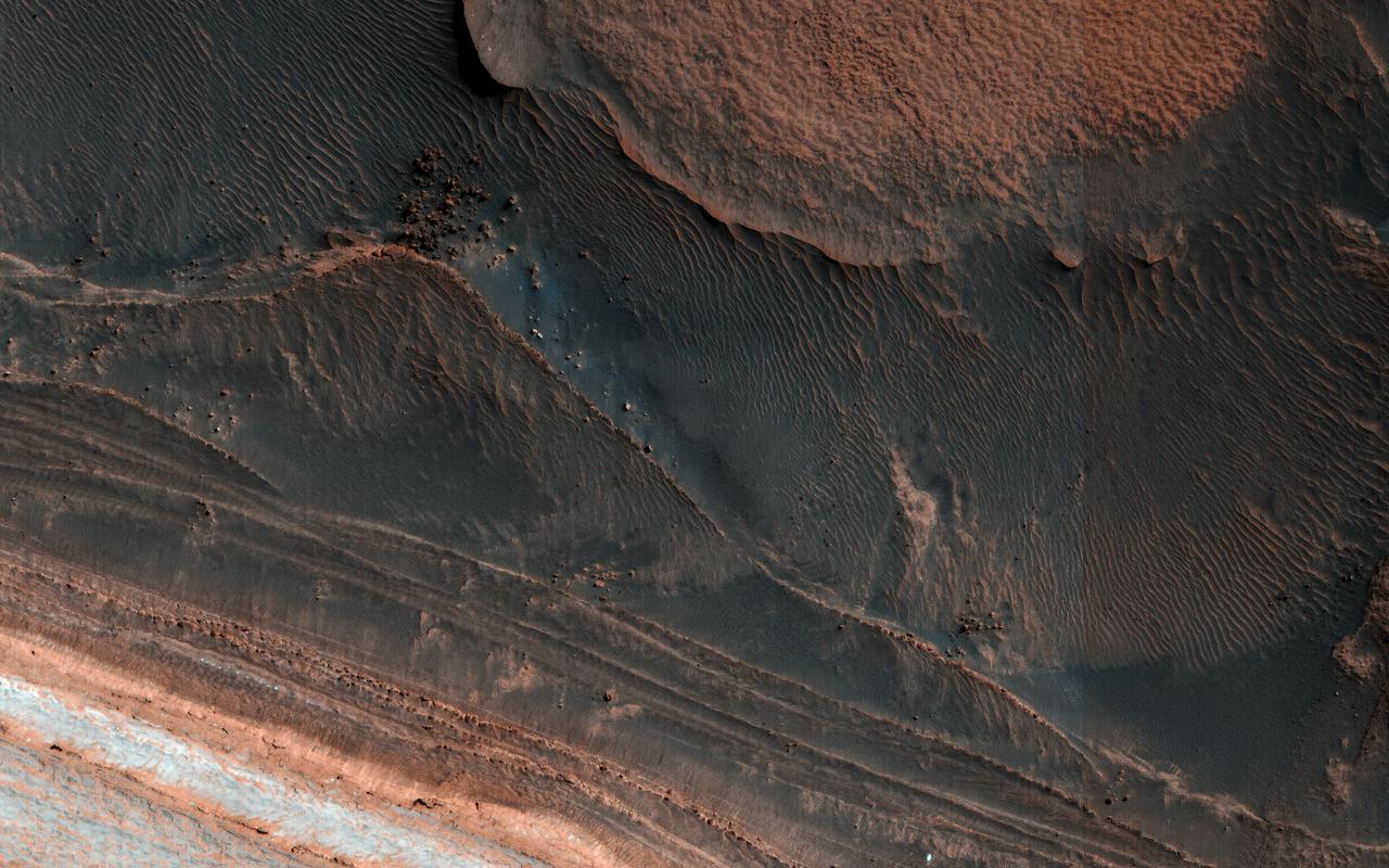
Layered sedimentary rocks are key to understanding the geologic history of a planet, recording the sequence of deposition and the changes over time in the materials that were deposited. These layered sediments are on the floor of eastern Coprates Chasma in Valles Marineris, the grandest canyon on Mars. They are erosional remnants of a formerly much more extensive sedimentary deposit that once filled the floor of the canyon but is nowadays reduced to isolated mesas. The origin of the deposits is not yet known. Various theories attribute the sediments to wind blown dust and sand, or to volcanic materials, or accumulations of debris from avalanches originating from the canyon walls, or even to lakebed sediments laid down when the canyons were filled with liquid water. Some sediments are devoid of boulders or blocks larger than the limit of resolution (about 0.5 meters), so avalanche debris is unlikely. We see fine laminations with a horizontal spacing of about 2 meters and a vertical separation less than 2 meters. No previous orbital observations were capable of resolving such fine scale layering. https://photojournal.jpl.nasa.gov/catalog/PIA23583
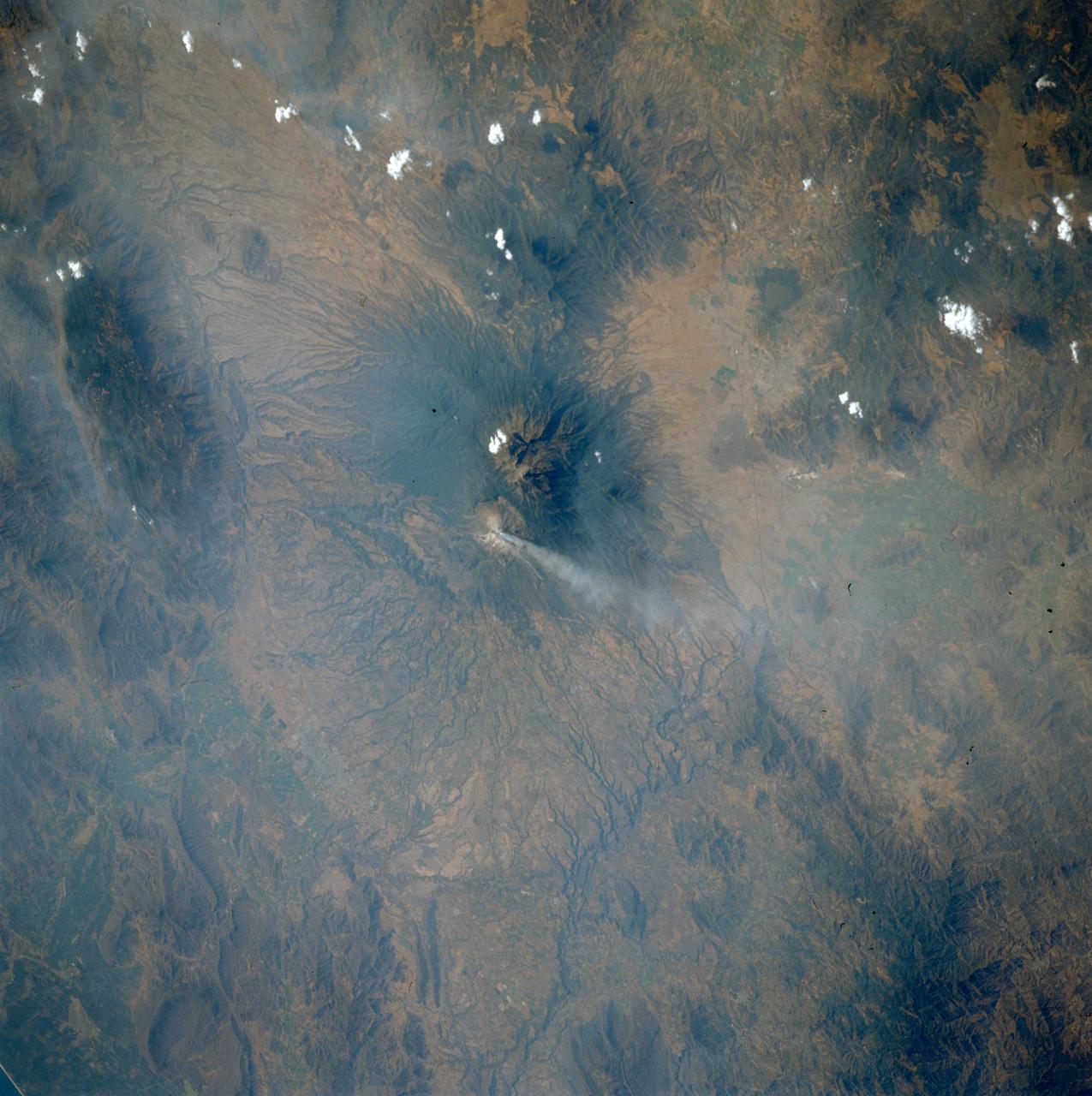
STS039-75-101 (28 April-6 May 1991) --- Spending over eight days in Earth orbit, the STS-39 crew was able to return with photographic coverage of highly variegated geographic scenery, including a number of volcanoes such as Mexico's Colima. Located south of Guadalajara, Colima is Mexico's most active volcano. The current activity started in the first part of March 1991 with avalanches occurring, followed by lava extrusion and ash emission. Colima is captured here in action. The steam plume drifts eastward from the 13,325 ft. summit. Scars from recent landslides can be seen on the southwest flank of the summit.
Lycus Sulci is a low lying area of ridges and valleys found to the northwest of Olympus Mons. It is not yet understood how this feature formed or how it relates to the formation of Olympus Mons itself. This VIS image shows the ridge forms that are typical of this region. Dark slope streaks are common on the cliff faces. There are several suggested mechanisms to form these features. Two of the mechanisms are that the dusty surface has been altered to reveal darker rock beneath from motion of downward moving dust avalanches, or the surface is darkening by fluid or other surface staining. Orbit Number: 94804 Latitude: 15.0303 Longitude: 219.406 Instrument: VIS Captured: 2023-04-29 11:14 https://photojournal.jpl.nasa.gov/catalog/PIA26173

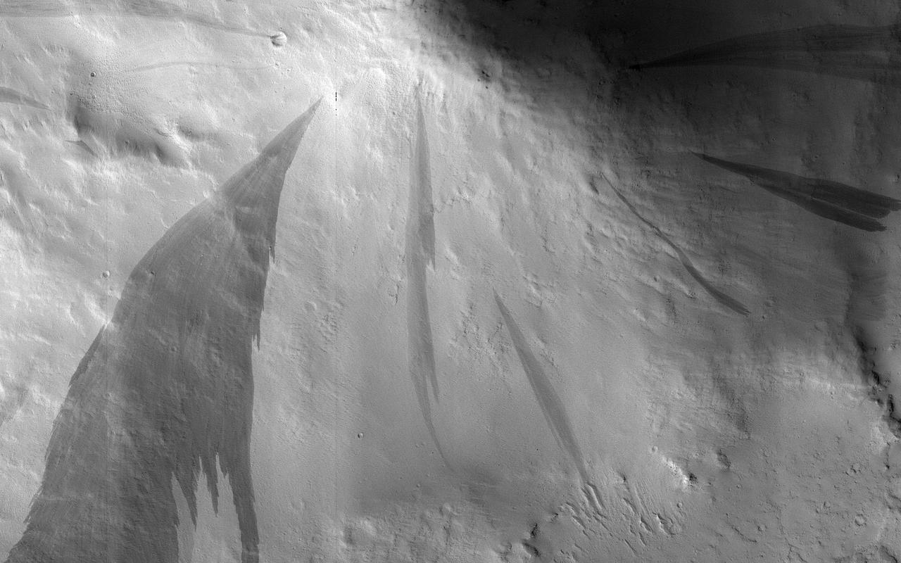
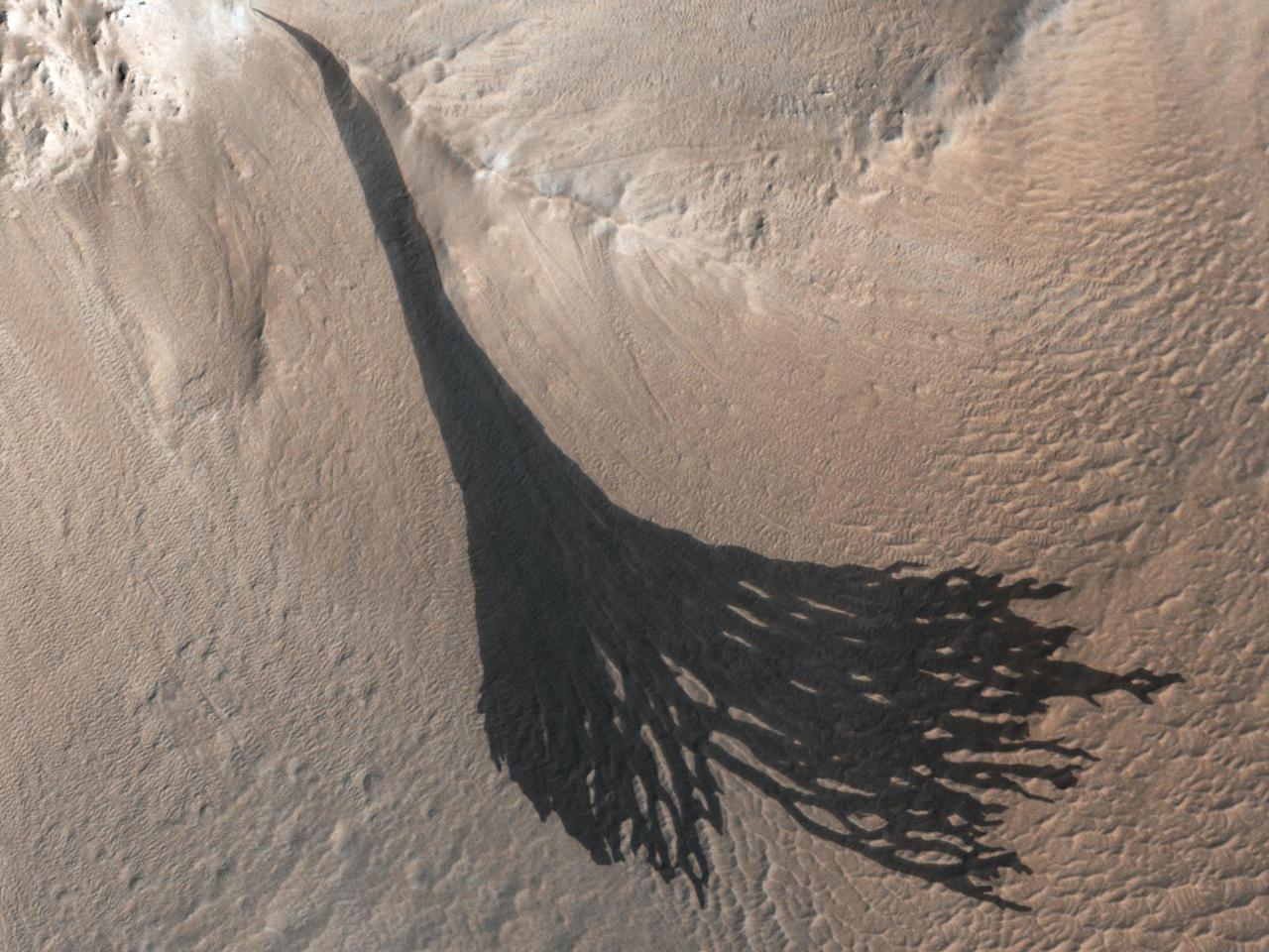
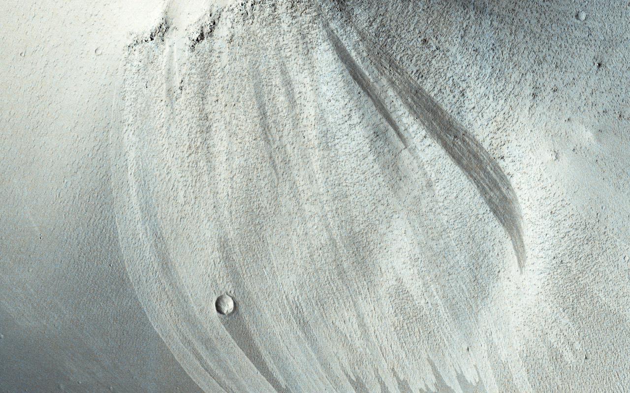
This image from NASA's Mars Reconnaissance Orbiter (MRO) shows streaks forming on slopes when dust cascades downhill. The dark streak is an area of less dust compared to the brighter and reddish surroundings. What triggers these avalanches is not known, but might be related to sudden warming of the surface. These streaks are often diverted by the terrain they flow down. This one has split into many smaller streaks where it encountered minor obstacles. These streaks fade away over decades as more dust slowly settles out of the Martian sky. https://photojournal.jpl.nasa.gov/catalog/PIA22240
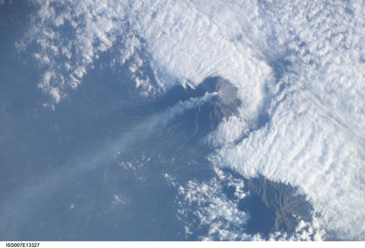
ISS007-E-13327 (24 August 2003) --- This view featuring Java’s Merapi volcano was photographed by one of the Expedition 7 crewmembers onboard the International Space Station (ISS). At 2,911 meters, the summit of Merapi and its vigorous steam plume rises above a bank of stratus clouds. One of Indonesia’s most active volcanoes, it has been almost continuously active for nearly ten years, including periodic pyroclastic flows and avalanches. The volcano is located less than 25 miles north of the city of Yogykarta in central Java.
Impact craters expose the subsurface materials on steep slopes. However, these slopes often experience rockfalls and debris avalanches that keep the surface clean of dust, revealing a variety of hues, like in this enhanced-color image, representing different rock types. The bright reddish material at the top of the crater rim is from a coating of the Martian dust. The long streamers of material are from downslope movements. Also revealed in this slope are a variety of bedrock textures, with a mix of layered and jumbled deposits. This sample is typical of the Martian highlands, with lava flows and water-lain materials depositing layers, then broken up and jumbled by many impact events. http://photojournal.jpl.nasa.gov/catalog/PIA14454
Llullaillaco is a stratovolcano at the border of Argentina and Chile. It lies on a high plateau close to the Atacama Desert. At an elevation of 6723 m ASL, it is the second highest active volcano in the world. About 150,000 years ago the volcano's southeastern flank collapsed, producing a debris avalanche that traveled 25 kilometers. The youngest dated rocks are about 5600 years old; but there are local reports of activity from the 1800s. The perspective image looking east was acquired December 19, 2014 and is located at 24.7 degrees south, 68.5 degrees west. https://photojournal.jpl.nasa.gov/catalog/PIA22721
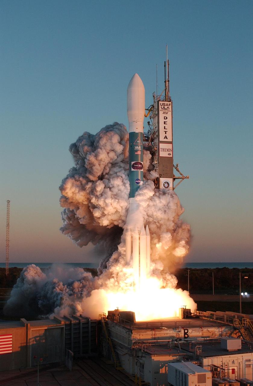
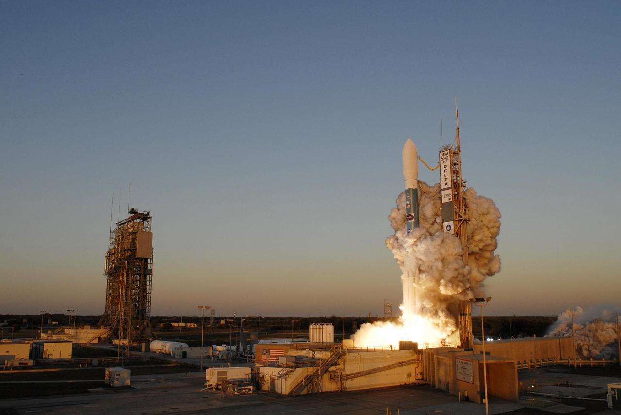
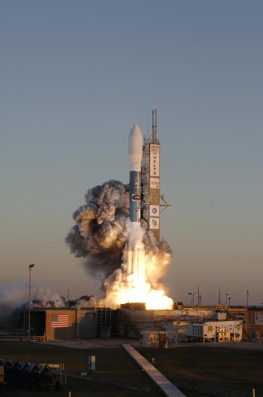
KENNEDY SPACE CENTER, FLA. -- At Cape Canaveral Air Force Station, clouds of smoke form around the Delta II rocket with NASA's THEMIS spacecraft aboard as it blasts off Pad 17-B at 6:01 p.m. EST. THEMIS, an acronym for Time History of Events and Macroscale Interactions during Substorms, consists of five identical probes that will track violent, colorful eruptions near the North Pole. This will be the largest number of scientific satellites NASA has ever launched into orbit aboard a single rocket. The THEMIS mission aims to unravel the mystery behind auroral substorms, an avalanche of magnetic energy powered by the solar wind that intensifies the northern and southern lights. The mission will investigate what causes auroras in the Earth’s atmosphere to dramatically change from slowly shimmering waves of light to wildly shifting streaks of bright color. Photo credit: NASA/Jerry Cannon

At Cape Canaveral Air Force Station, clouds of smoke encompass the Delta II rocket with NASA's THEMIS spacecraft aboard as it blasts off Pad 17-B, in sight of the Atlantic Ocean, at 6:01 p.m. EST. THEMIS, an acronym for Time History of Events and Macroscale Interactions during Substorms, consists of five identical probes that will track violent, colorful eruptions near the North Pole. This will be the largest number of scientific satellites NASA has ever launched into orbit aboard a single rocket. The THEMIS mission aims to unravel the mystery behind auroral substorms, an avalanche of magnetic energy powered by the solar wind that intensifies the northern and southern lights. The mission will investigate what causes auroras in the Earth’s atmosphere to dramatically change from slowly shimmering waves of light to wildly shifting streaks of bright color.

Amid billows of smoke, the Delta II rocket with NASA's THEMIS spacecraft aboard blasts off Pad 17-B at Cape Canaveral Air Force Station at 6:01 p.m. EST. THEMIS, an acronym for Time History of Events and Macroscale Interactions during Substorms, consists of five identical probes that will track violent, colorful eruptions near the North Pole. This will be the largest number of scientific satellites NASA has ever launched into orbit aboard a single rocket. The THEMIS mission aims to unravel the mystery behind auroral substorms, an avalanche of magnetic energy powered by the solar wind that intensifies the northern and southern lights. The mission will investigate what causes auroras in the Earth’s atmosphere to dramatically change from slowly shimmering waves of light to wildly shifting streaks of bright color.
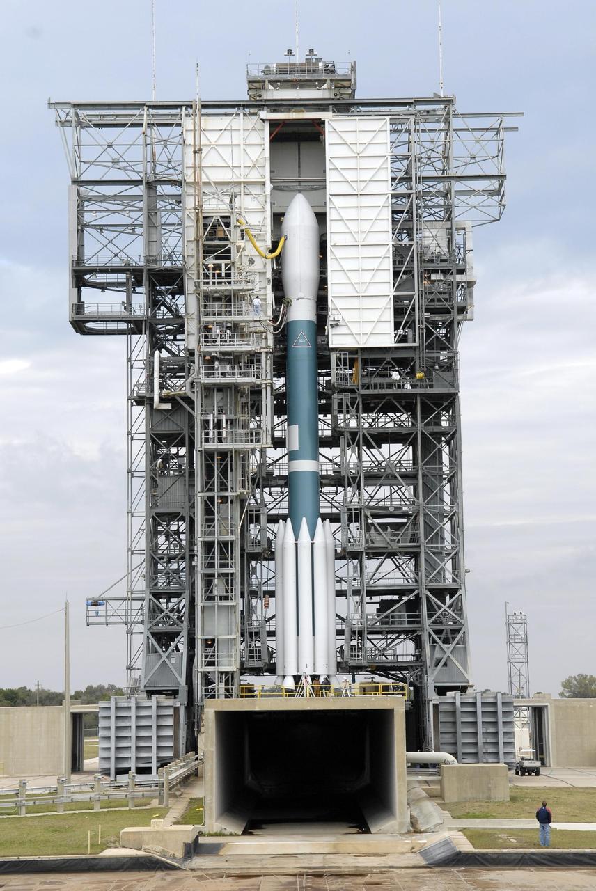
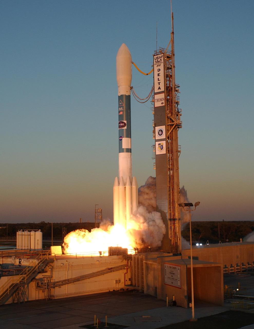
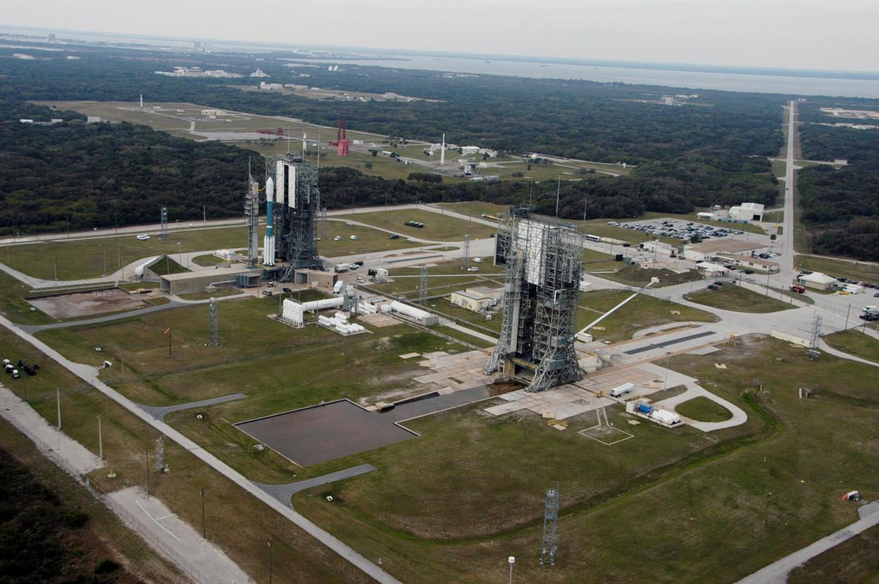
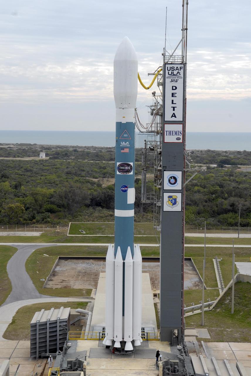
KENNEDY SPACE CENTER, FLA. -- At Launch Pad 17-B at Cape Canaveral Air Force Station, the mobile service tower surrounds the Delta II rocket with the THEMIS spacecraft atop. THEMIS, an acronym for Time History of Events and Macroscale Interactions during Substorms, consists of five identical probes that will track violent, colorful eruptions near the North Pole. This will be the largest number of scientific satellites NASA has ever launched into orbit aboard a single rocket. The THEMIS mission aims to unravel the mystery behind auroral substorms, an avalanche of magnetic energy powered by the solar wind that intensifies the northern and southern lights. The mission will investigate what causes auroras in the Earth’s atmosphere to dramatically change from slowly shimmering waves of light to wildly shifting streaks of bright color. Launch is scheduled for 6:05 p.m. Photo credit: NASA/Kim Shiflett
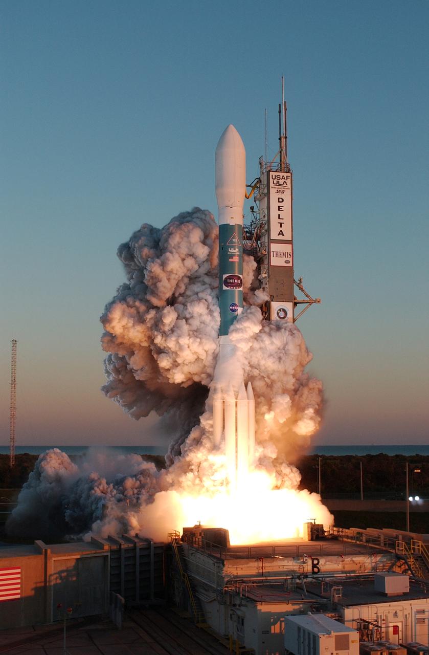
At Cape Canaveral Air Force Station, clouds of smoke form around the Delta II rocket with NASA's THEMIS spacecraft aboard as it blasts off Pad 17-B at 6:01 p.m. EST. THEMIS, an acronym for Time History of Events and Macroscale Interactions during Substorms, consists of five identical probes that will track violent, colorful eruptions near the North Pole. This will be the largest number of scientific satellites NASA has ever launched into orbit aboard a single rocket. The THEMIS mission aims to unravel the mystery behind auroral substorms, an avalanche of magnetic energy powered by the solar wind that intensifies the northern and southern lights. The mission will investigate what causes auroras in the Earth’s atmosphere to dramatically change from slowly shimmering waves of light to wildly shifting streaks of bright color.

At Cape Canaveral Air Force Station, the Delta II rocket with NASA's THEMIS spacecraft aboard begins its ascent from Pad 17-B, in sight of the Atlantic Ocean, at 6:01 p.m. EST. THEMIS, an acronym for Time History of Events and Macroscale Interactions during Substorms, consists of five identical probes that will track violent, colorful eruptions near the North Pole. This will be the largest number of scientific satellites NASA has ever launched into orbit aboard a single rocket. The THEMIS mission aims to unravel the mystery behind auroral substorms, an avalanche of magnetic energy powered by the solar wind that intensifies the northern and southern lights. The mission will investigate what causes auroras in the Earth’s atmosphere to dramatically change from slowly shimmering waves of light to wildly shifting streaks of bright color.
KENNEDY SPACE CENTER, FLA. -- At Launch Pad 17-B at Cape Canaveral Air Force Station, the mobile service tower moves away from the Delta II rocket with the THEMIS spacecraft atop. THEMIS, an acronym for Time History of Events and Macroscale Interactions during Substorms, consists of five identical probes that will track violent, colorful eruptions near the North Pole. This will be the largest number of scientific satellites NASA has ever launched into orbit aboard a single rocket. The THEMIS mission aims to unravel the mystery behind auroral substorms, an avalanche of magnetic energy powered by the solar wind that intensifies the northern and southern lights. The mission will investigate what causes auroras in the Earth’s atmosphere to dramatically change from slowly shimmering waves of light to wildly shifting streaks of bright color. Launch is scheduled for 6:05 p.m. Photo credit: NASA/Kim Shiflett

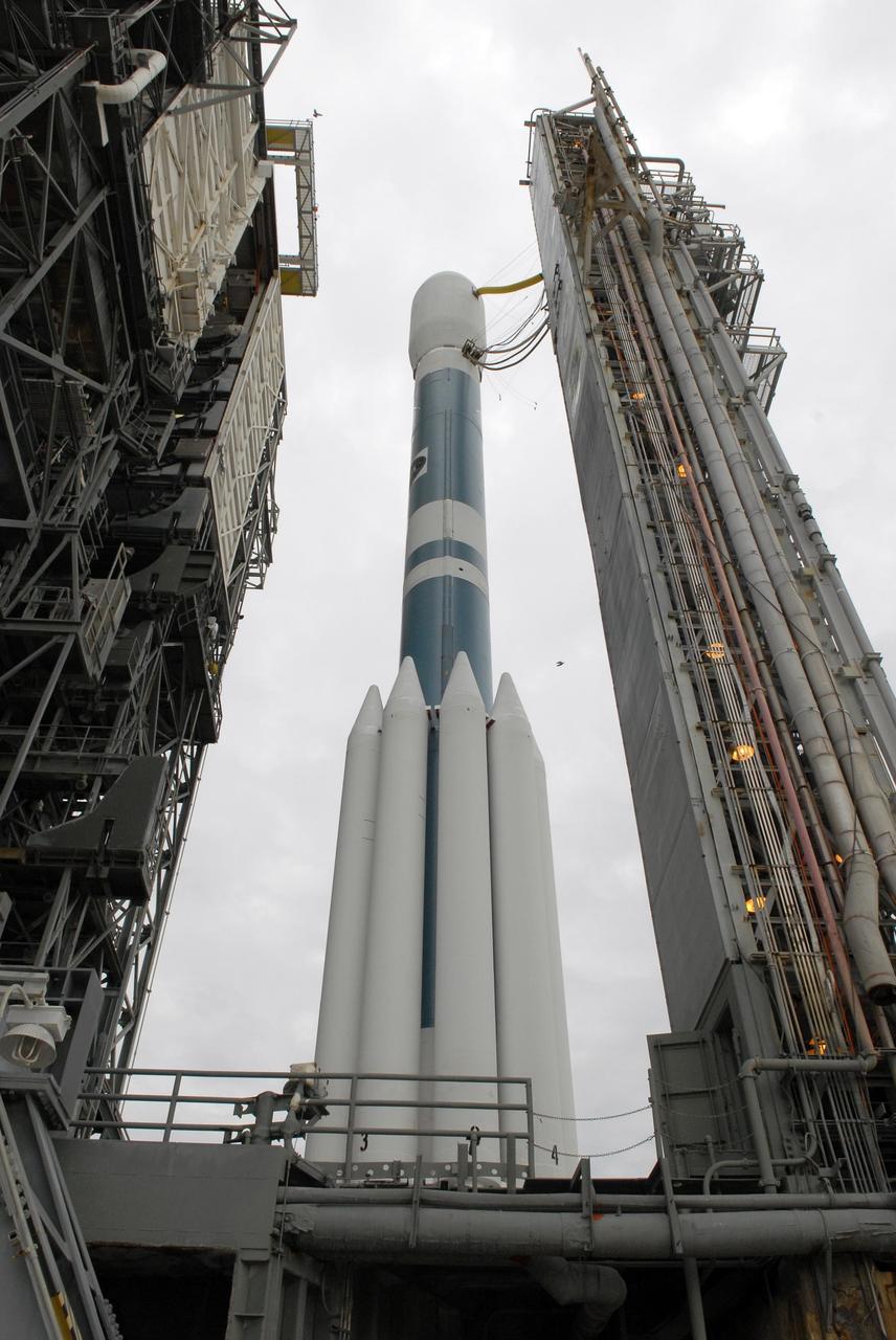
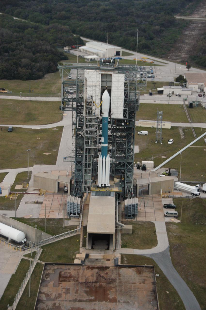
In this close-up aerial view, the Delta II rocket with the THEMIS spacecraft atop sits ready for launch on Pad 17-B at Cape Canaveral Air Force Station. THEMIS, an acronym for Time History of Events and Macroscale Interactions during Substorms, consists of five identical probes that will track violent, colorful eruptions near the North Pole. This will be the largest number of scientific satellites NASA has ever launched into orbit aboard a single rocket. The THEMIS mission aims to unravel the mystery behind auroral substorms, an avalanche of magnetic energy powered by the solar wind that intensifies the northern and southern lights. The mission will investigate what causes auroras in the Earth’s atmosphere to dramatically change from slowly shimmering waves of light to wildly shifting streaks of bright color. Launch is scheduled for 6:05 p.m.
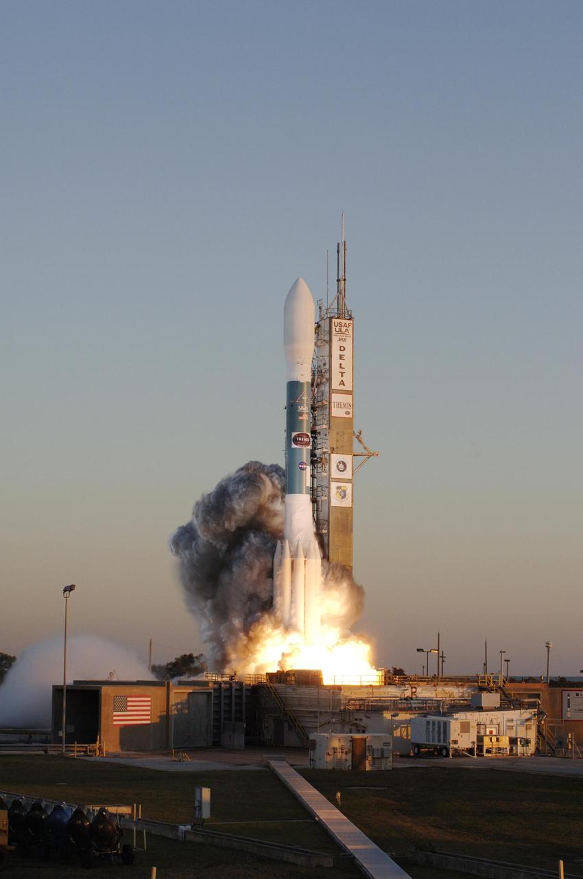
KENNEDY SPACE CENTER, FLA. -- At Cape Canaveral Air Force Station, the Delta II rocket with NASA's THEMIS spacecraft aboard lifts off Pad 17-B on a crisp Florida evening at 6:01 p.m. EST. THEMIS, an acronym for Time History of Events and Macroscale Interactions during Substorms, consists of five identical probes that will track violent, colorful eruptions near the North Pole. This will be the largest number of scientific satellites NASA has ever launched into orbit aboard a single rocket. The THEMIS mission aims to unravel the mystery behind auroral substorms, an avalanche of magnetic energy powered by the solar wind that intensifies the northern and southern lights. The mission will investigate what causes auroras in the Earth’s atmosphere to dramatically change from slowly shimmering waves of light to wildly shifting streaks of bright color. Photo credit: NASA/Jerry Cannon
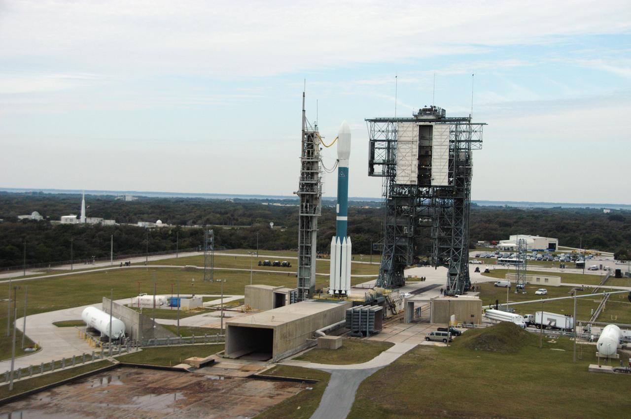
In this aerial view, the Delta II rocket with the THEMIS spacecraft sits ready for launch on Pad 17-B at Cape Canaveral Air Force Station, as the mobile service tower moves away from the pad. THEMIS, an acronym for Time History of Events and Macroscale Interactions during Substorms, consists of five identical probes that will track violent, colorful eruptions near the North Pole. This will be the largest number of scientific satellites NASA has ever launched into orbit aboard a single rocket. The THEMIS mission aims to unravel the mystery behind auroral substorms, an avalanche of magnetic energy powered by the solar wind that intensifies the northern and southern lights. The mission will investigate what causes auroras in the Earth’s atmosphere to dramatically change from slowly shimmering waves of light to wildly shifting streaks of bright color. Launch is scheduled for 6:05 p.m.

KENNEDY SPACE CENTER, FLA. -- Clouds of smoke encompass the Delta II rocket with NASA's THEMIS spacecraft aboard as it blasts off Pad 17-B at Cape Canaveral Air Force Station at 6:01 p.m. EST. THEMIS, an acronym for Time History of Events and Macroscale Interactions during Substorms, consists of five identical probes that will track violent, colorful eruptions near the North Pole. This will be the largest number of scientific satellites NASA has ever launched into orbit aboard a single rocket. The THEMIS mission aims to unravel the mystery behind auroral substorms, an avalanche of magnetic energy powered by the solar wind that intensifies the northern and southern lights. The mission will investigate what causes auroras in the Earth’s atmosphere to dramatically change from slowly shimmering waves of light to wildly shifting streaks of bright color. Photo credit: NASA/Sandra Joseph, Ralph Hernandez
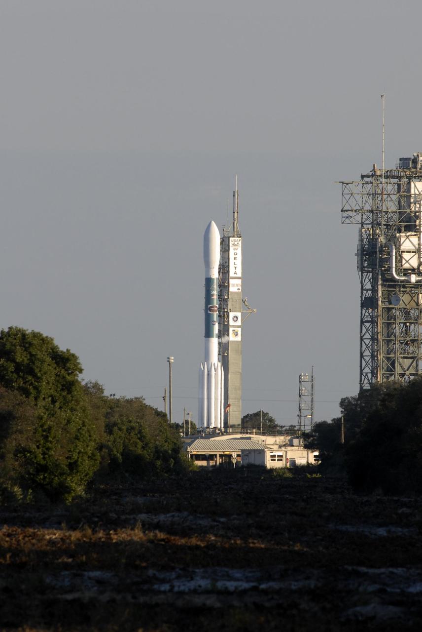
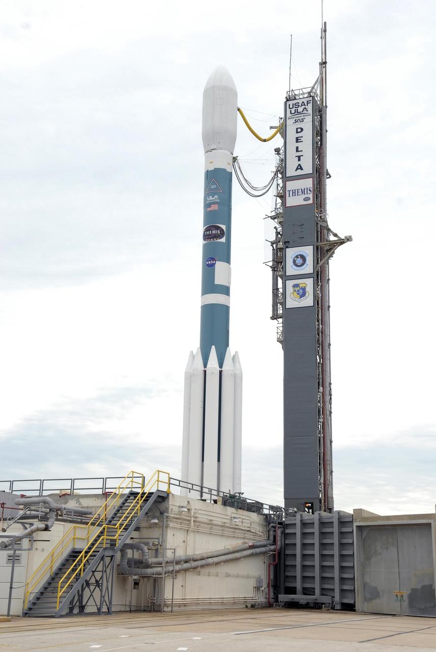
KENNEDY SPACE CENTER, FLA. -- At Cape Canaveral Air Force Station, the Delta II rocket with the THEMIS spacecraft atop awaits launch on Pad 17-B. Friday's launch attempt was scrubbed due to upper-level wind violation. The launch window is 6:01 p.m. to 6:19 p.m. EST on Saturday. THEMIS, an acronym for Time History of Events and Macroscale Interactions during Substorms, consists of five identical probes that will track violent, colorful eruptions near the North Pole. This will be the largest number of scientific satellites NASA has ever launched into orbit aboard a single rocket. The THEMIS mission aims to unravel the mystery behind auroral substorms, an avalanche of magnetic energy powered by the solar wind that intensifies the northern and southern lights. The mission will investigate what causes auroras in the Earth’s atmosphere to dramatically change from slowly shimmering waves of light to wildly shifting streaks of bright color. Photo credit: NASA/Kim Shiflett
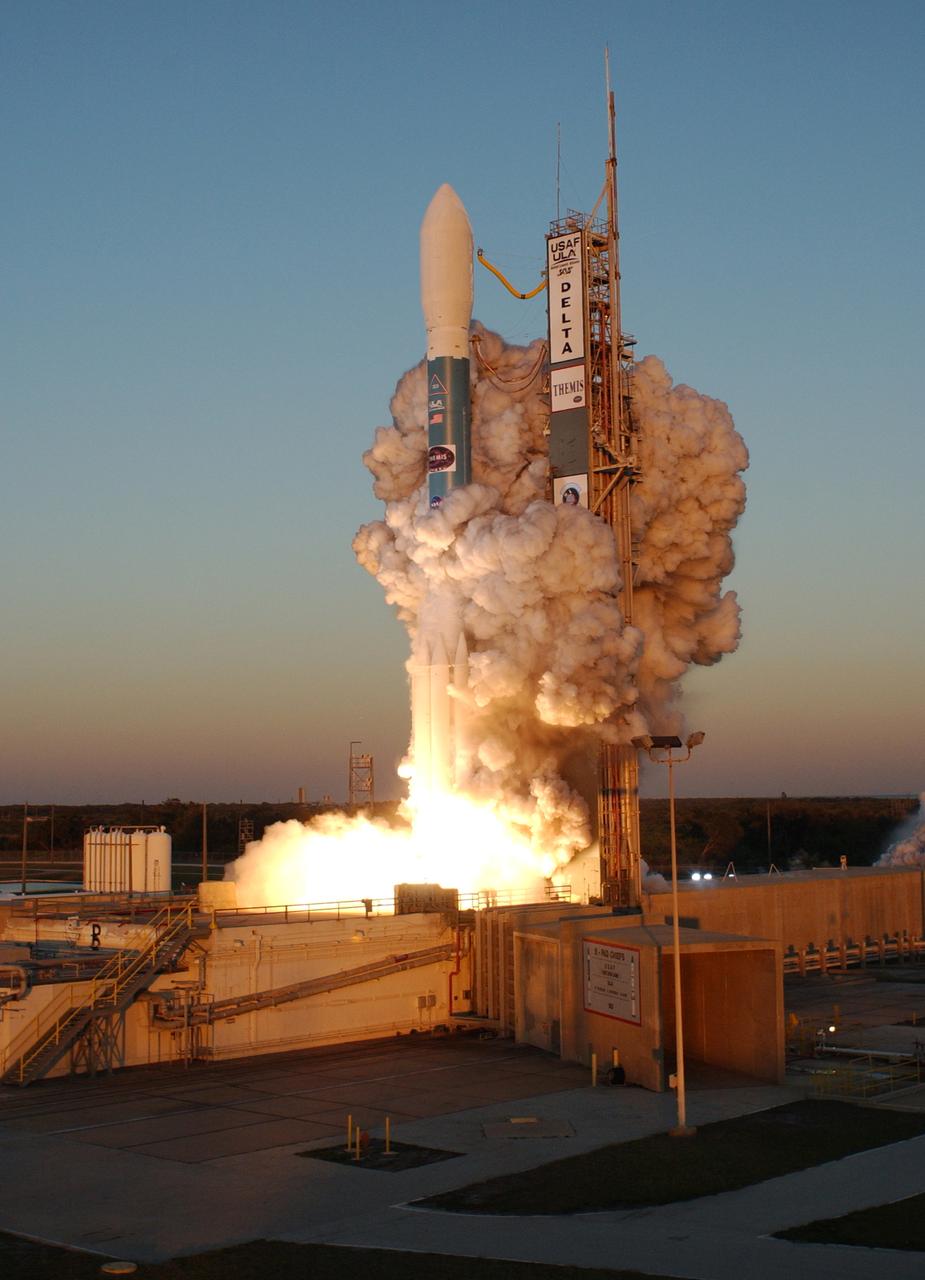
Clouds of smoke encompass the Delta II rocket with NASA's THEMIS spacecraft aboard as it blasts off Pad 17-B at Cape Canaveral Air Force Station at 6:01 p.m. EST. THEMIS, an acronym for Time History of Events and Macroscale Interactions during Substorms, consists of five identical probes that will track violent, colorful eruptions near the North Pole. This will be the largest number of scientific satellites NASA has ever launched into orbit aboard a single rocket. The THEMIS mission aims to unravel the mystery behind auroral substorms, an avalanche of magnetic energy powered by the solar wind that intensifies the northern and southern lights. The mission will investigate what causes auroras in the Earth’s atmosphere to dramatically change from slowly shimmering waves of light to wildly shifting streaks of bright color
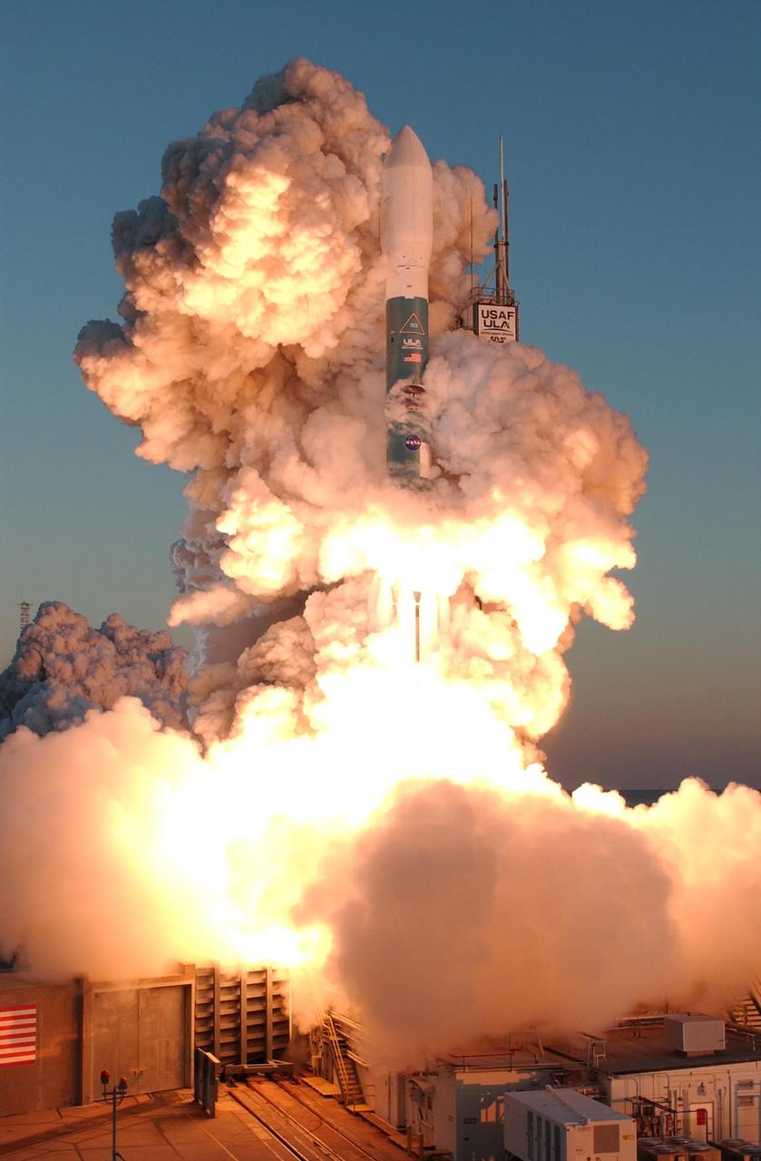
KENNEDY SPACE CENTER, FLA. -- At Cape Canaveral Air Force Station, clouds of smoke envelop the Delta II rocket with NASA's THEMIS spacecraft aboard as it blasts off Pad 17-B at 6:01 p.m. EST. THEMIS, an acronym for Time History of Events and Macroscale Interactions during Substorms, consists of five identical probes that will track violent, colorful eruptions near the North Pole. This will be the largest number of scientific satellites NASA has ever launched into orbit aboard a single rocket. The THEMIS mission aims to unravel the mystery behind auroral substorms, an avalanche of magnetic energy powered by the solar wind that intensifies the northern and southern lights. The mission will investigate what causes auroras in the Earth’s atmosphere to dramatically change from slowly shimmering waves of light to wildly shifting streaks of bright color. Photo credit: NASA/Jerry Cannon
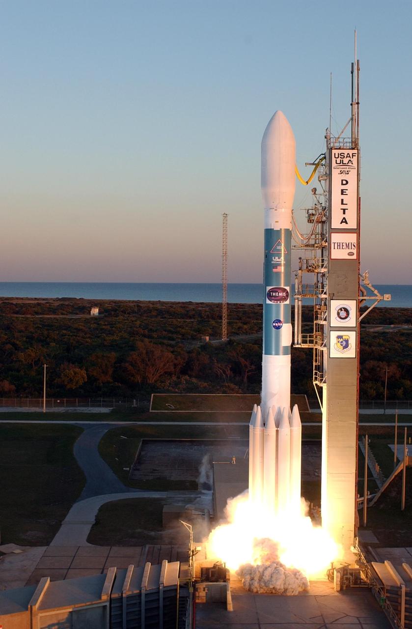
KENNEDY SPACE CENTER, FLA. -- At Cape Canaveral Air Force Station, the Delta II rocket with NASA's THEMIS spacecraft aboard begins its ascent from Pad 17-B, in sight of the Atlantic Ocean, at 6:01 p.m. EST. THEMIS, an acronym for Time History of Events and Macroscale Interactions during Substorms, consists of five identical probes that will track violent, colorful eruptions near the North Pole. This will be the largest number of scientific satellites NASA has ever launched into orbit aboard a single rocket. The THEMIS mission aims to unravel the mystery behind auroral substorms, an avalanche of magnetic energy powered by the solar wind that intensifies the northern and southern lights. The mission will investigate what causes auroras in the Earth’s atmosphere to dramatically change from slowly shimmering waves of light to wildly shifting streaks of bright color. Photo credit: NASA/Regina MItchell-Ryall, Robert Murray, Tony Gray
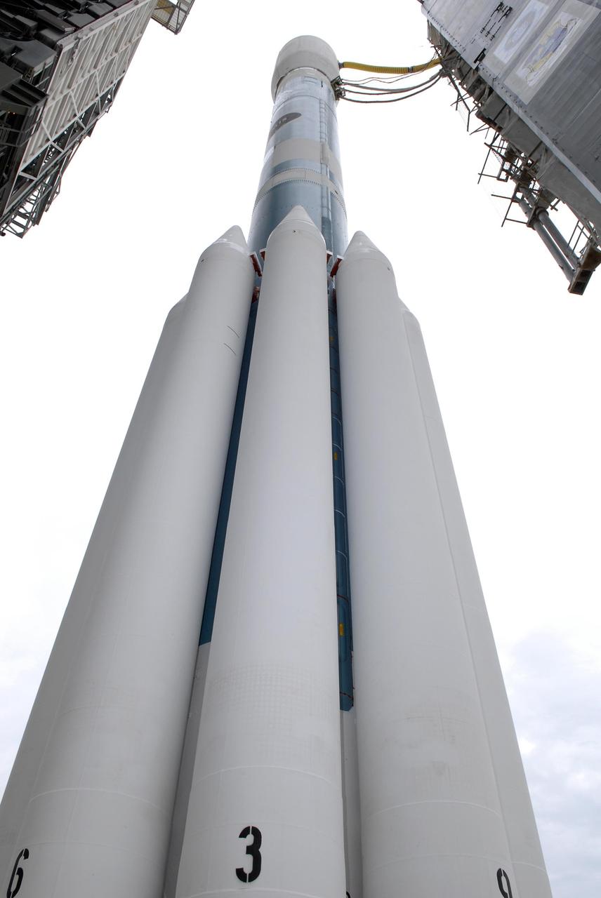
KENNEDY SPACE CENTER, FLA. -- At Launch Pad 17-B at Cape Canaveral Air Force Station, an unusual view of the Delta II rocket with the THEMIS spacecraft atop gives the solid rocket boosters a "larger than life" appearance as the mobile service tower moves away. THEMIS, an acronym for Time History of Events and Macroscale Interactions during Substorms, consists of five identical probes that will track violent, colorful eruptions near the North Pole. This will be the largest number of scientific satellites NASA has ever launched into orbit aboard a single rocket. The THEMIS mission aims to unravel the mystery behind auroral substorms, an avalanche of magnetic energy powered by the solar wind that intensifies the northern and southern lights. The mission will investigate what causes auroras in the Earth’s atmosphere to dramatically change from slowly shimmering waves of light to wildly shifting streaks of bright color. Launch is scheduled for 6:05 p.m. Photo credit: NASA/Kim Shiflett
The Delta II rocket with the THEMIS spacecraft atop sits ready for launch on Pad 17-B at Cape Canaveral Air Force Station in this aerial view of the launch complex area as the mobile service tower begins to move away. THEMIS, an acronym for Time History of Events and Macroscale Interactions during Substorms, consists of five identical probes that will track violent, colorful eruptions near the North Pole. This will be the largest number of scientific satellites NASA has ever launched into orbit aboard a single rocket. The THEMIS mission aims to unravel the mystery behind auroral substorms, an avalanche of magnetic energy powered by the solar wind that intensifies the northern and southern lights. The mission will investigate what causes auroras in the Earth’s atmosphere to dramatically change from slowly shimmering waves of light to wildly shifting streaks of bright color. Launch is scheduled for 6:05 p.m.
Intricate gullies have formed on the northern wall of this impact crater located in the Terra Cimmeria region in this image from NASA's Mars Reconnaissance Orbiter (MRO). This crater may have formed in a region rich in ground water. This ground water likely flowed down the wall, eventually eroding numerous gullies while carrying sediments to form fan deposits. Ultimately the water likely infiltrated and froze beneath the surface. Other hypotheses say gullies form through carbon dioxide frost avalanches that we can see today. What about this chain of pits snaking their way downhill? After material was transported, subsurface voids may have formed, removing support for the overlying material. The collapse of the surface into the cavities below likely resulted in the pits and troughs, perhaps beginning a new cycle of gully formation. https://photojournal.jpl.nasa.gov/catalog/PIA22239

KENNEDY SPACE CENTER, FLA. -- The Delta II rocket with the THEMIS spacecraft atop sits ready for launch on Pad 17-B at Cape Canaveral Air Force Station after the mobile service tower moves away from the pad. THEMIS, an acronym for Time History of Events and Macroscale Interactions during Substorms, consists of five identical probes that will track violent, colorful eruptions near the North Pole. This will be the largest number of scientific satellites NASA has ever launched into orbit aboard a single rocket. The THEMIS mission aims to unravel the mystery behind auroral substorms, an avalanche of magnetic energy powered by the solar wind that intensifies the northern and southern lights. The mission will investigate what causes auroras in the Earth’s atmosphere to dramatically change from slowly shimmering waves of light to wildly shifting streaks of bright color. Launch is scheduled for 6:05 p.m. Photo credit: NASA/Kim Shiflett
Mount St. Helens, Washington, erupted 40 years ago, on May 18, 1980. A massive debris avalanche, triggered by an earthquake of magnitude 5.1, caused a lateral eruption that reduced the elevation of the mountain's summit from 2,950 m to 2,549 m, leaving a 1.6 km wide horseshoe-shaped crater. The collapse of the northern flank resulted in massive volcanic mudflows. Since 1980, new lava built a dome in the crater, and occasional steam and ash plumes have been emitted. The Landsat MSS image was acquired July 31, 1980, and the ASTER image (Figure 1) on July 28, 2019. The images cover an area of 30 by 30 km, and are located at 46.2 degrees north, 122.2 degrees west. https://photojournal.jpl.nasa.gov/catalog/PIA23913
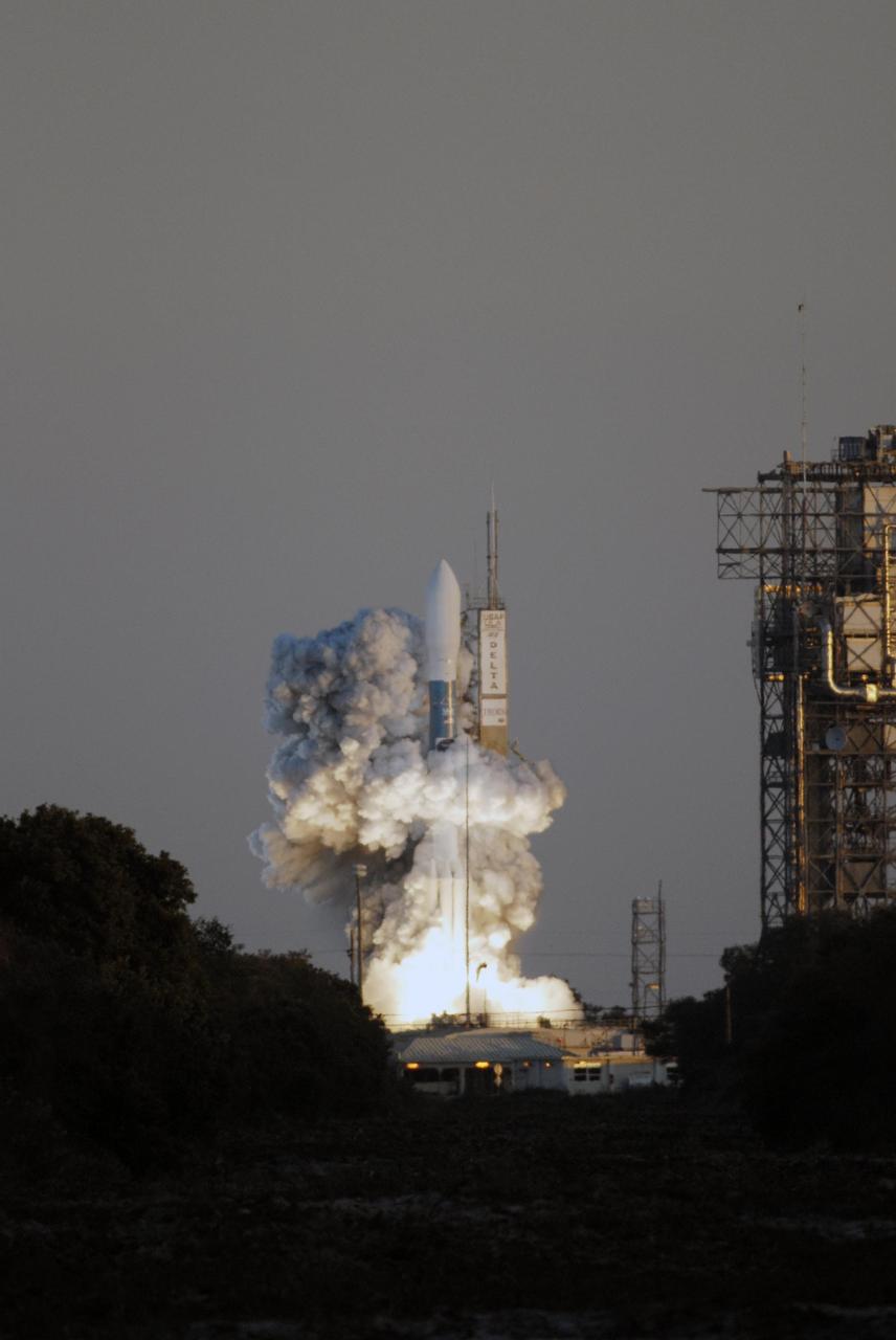
KENNEDY SPACE CENTER, FLA. -- Amid billows of smoke, the Delta II rocket with NASA's THEMIS spacecraft aboard lifts off Pad 17-B at Cape Canaveral Air Force Station at 6:01 p.m. EST. THEMIS, an acronym for Time History of Events and Macroscale Interactions during Substorms, consists of five identical probes that will track violent, colorful eruptions near the North Pole. This will be the largest number of scientific satellites NASA has ever launched into orbit aboard a single rocket. The THEMIS mission aims to unravel the mystery behind auroral substorms, an avalanche of magnetic energy powered by the solar wind that intensifies the northern and southern lights. The mission will investigate what causes auroras in the Earth’s atmosphere to dramatically change from slowly shimmering waves of light to wildly shifting streaks of bright color. Photo credit: NASA/Kim Shiflett

KENNEDY SPACE CENTER, FLA. -- In this close-up aerial view, the Delta II rocket with the THEMIS spacecraft atop sits ready for launch on Pad 17-B at Cape Canaveral Air Force Station as the mobile service tower moves away from the pad. THEMIS, an acronym for Time History of Events and Macroscale Interactions during Substorms, consists of five identical probes that will track violent, colorful eruptions near the North Pole. This will be the largest number of scientific satellites NASA has ever launched into orbit aboard a single rocket. The THEMIS mission aims to unravel the mystery behind auroral substorms, an avalanche of magnetic energy powered by the solar wind that intensifies the northern and southern lights. The mission will investigate what causes auroras in the Earth’s atmosphere to dramatically change from slowly shimmering waves of light to wildly shifting streaks of bright color. Launch is scheduled for 6:05 p.m. Photo credit: NASA/George Shelton
KENNEDY SPACE CENTER, FLA. -- Amid billows of smoke, the Delta II rocket with NASA's THEMIS spacecraft aboard blasts off Pad 17-B at Cape Canaveral Air Force Station at 6:01 p.m. EST. THEMIS, an acronym for Time History of Events and Macroscale Interactions during Substorms, consists of five identical probes that will track violent, colorful eruptions near the North Pole. This will be the largest number of scientific satellites NASA has ever launched into orbit aboard a single rocket. The THEMIS mission aims to unravel the mystery behind auroral substorms, an avalanche of magnetic energy powered by the solar wind that intensifies the northern and southern lights. The mission will investigate what causes auroras in the Earth’s atmosphere to dramatically change from slowly shimmering waves of light to wildly shifting streaks of bright color. Photo credit: NASA/Sandra Joseph, Ralph Hernandez

KENNEDY SPACE CENTER, FLA. -- In this aerial view, the Delta II rocket with the THEMIS spacecraft sits ready for launch on Pad 17-B at Cape Canaveral Air Force Station, as the mobile service tower moves away from the pad. THEMIS, an acronym for Time History of Events and Macroscale Interactions during Substorms, consists of five identical probes that will track violent, colorful eruptions near the North Pole. This will be the largest number of scientific satellites NASA has ever launched into orbit aboard a single rocket. The THEMIS mission aims to unravel the mystery behind auroral substorms, an avalanche of magnetic energy powered by the solar wind that intensifies the northern and southern lights. The mission will investigate what causes auroras in the Earth’s atmosphere to dramatically change from slowly shimmering waves of light to wildly shifting streaks of bright color. Launch is scheduled for 6:05 p.m. Photo credit: NASA/George Shelton
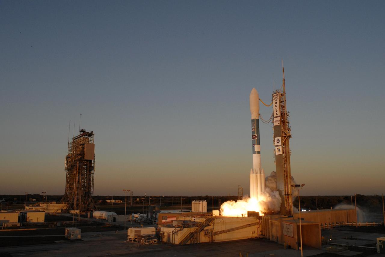
KENNEDY SPACE CENTER, FLA. -- At Cape Canaveral Air Force Station, the Delta II rocket with NASA's THEMIS spacecraft aboard begins its ascent from Pad 17-B on a crisp Florida evening at 6:01 p.m. EST. THEMIS, an acronym for Time History of Events and Macroscale Interactions during Substorms, consists of five identical probes that will track violent, colorful eruptions near the North Pole. This will be the largest number of scientific satellites NASA has ever launched into orbit aboard a single rocket. The THEMIS mission aims to unravel the mystery behind auroral substorms, an avalanche of magnetic energy powered by the solar wind that intensifies the northern and southern lights. The mission will investigate what causes auroras in the Earth’s atmosphere to dramatically change from slowly shimmering waves of light to wildly shifting streaks of bright color. Photo credit: NASA/Sandra Joseph, Ralph Hernandez
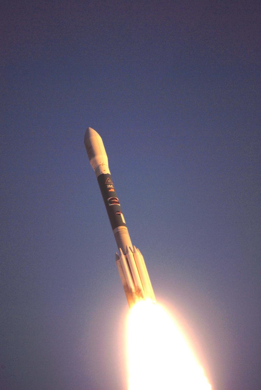
KENNEDY SPACE CENTER, FLA. -- The Delta II rocket with NASA's THEMIS spacecraft aboard begins its journey to orbit at 6:01 p.m. EST from Pad 17-B at Cape Canaveral Air Force Station. THEMIS, an acronym for Time History of Events and Macroscale Interactions during Substorms, consists of five identical probes that will track violent, colorful eruptions near the North Pole. This will be the largest number of scientific satellites NASA has ever launched into orbit aboard a single rocket. The THEMIS mission aims to unravel the mystery behind auroral substorms, an avalanche of magnetic energy powered by the solar wind that intensifies the northern and southern lights. The mission will investigate what causes auroras in the Earth’s atmosphere to dramatically change from slowly shimmering waves of light to wildly shifting streaks of bright color. Photo credit: NASA/Ken Thornsley
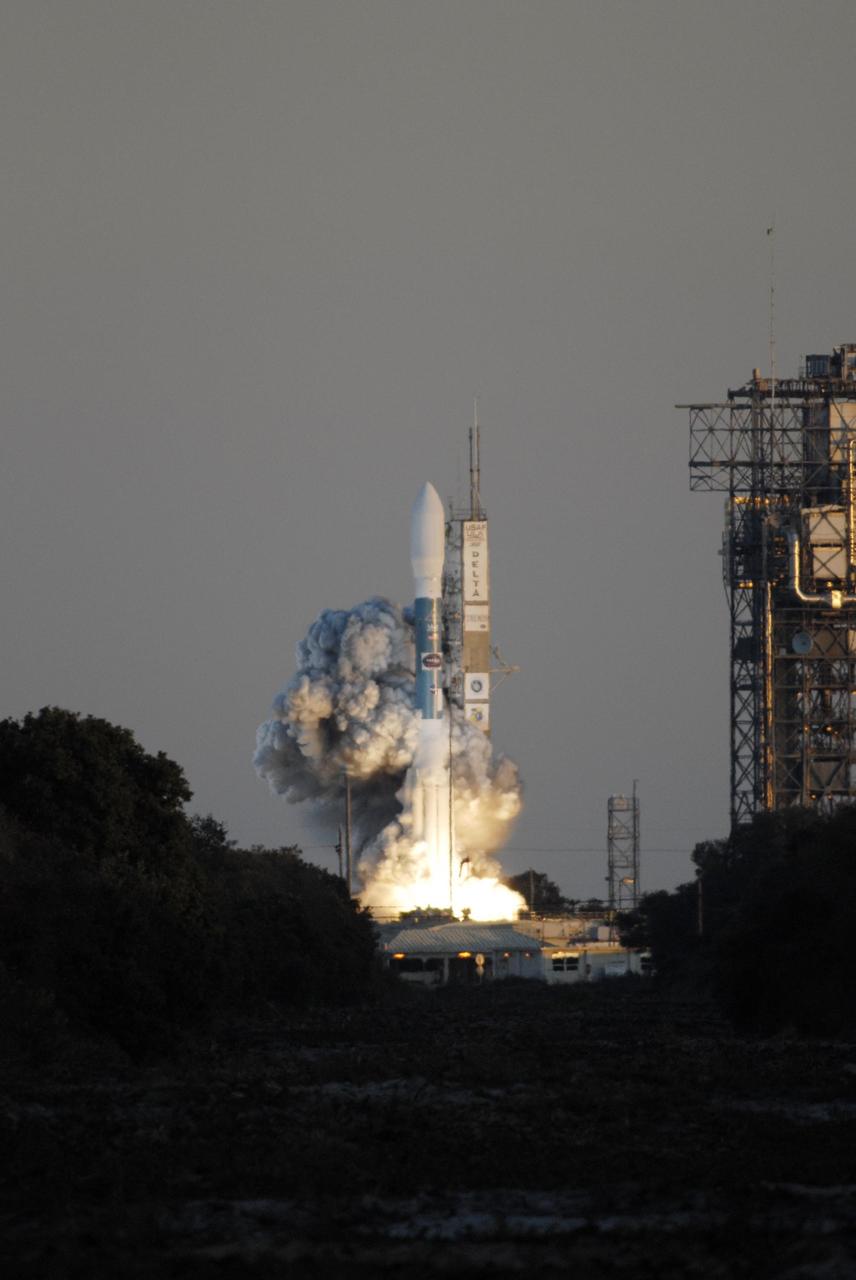
KENNEDY SPACE CENTER, FLA. -- Amid billows of smoke, the Delta II rocket with NASA's THEMIS spacecraft aboard lifts off Pad 17-B at Cape Canaveral Air Force Station at 6:01 p.m. EST. THEMIS, an acronym for Time History of Events and Macroscale Interactions during Substorms, consists of five identical probes that will track violent, colorful eruptions near the North Pole. This will be the largest number of scientific satellites NASA has ever launched into orbit aboard a single rocket. The THEMIS mission aims to unravel the mystery behind auroral substorms, an avalanche of magnetic energy powered by the solar wind that intensifies the northern and southern lights. The mission will investigate what causes auroras in the Earth’s atmosphere to dramatically change from slowly shimmering waves of light to wildly shifting streaks of bright color. Photo credit: NASA/Kim Shiflett
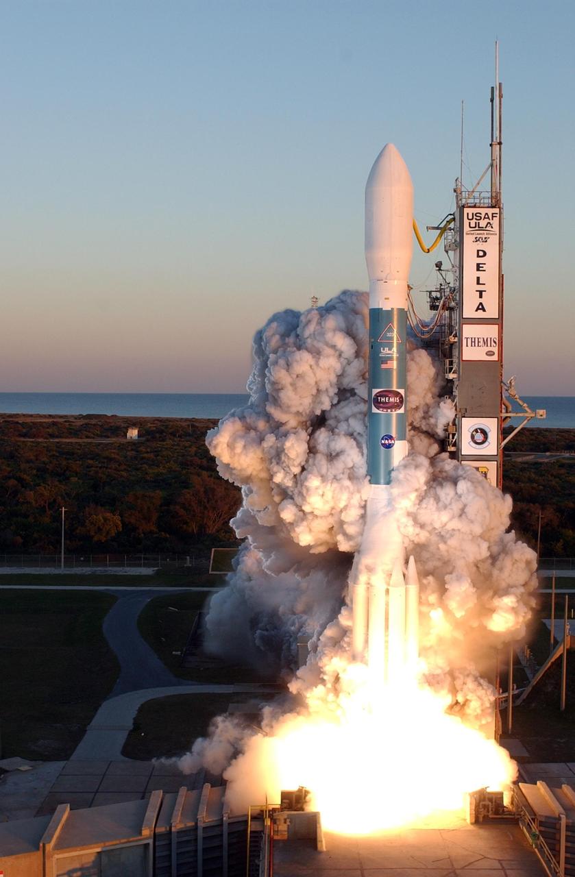
KENNEDY SPACE CENTER, FLA. -- At Cape Canaveral Air Force Station, clouds of smoke encompass the Delta II rocket with NASA's THEMIS spacecraft aboard as it blasts off Pad 17-B, in sight of the Atlantic Ocean, at 6:01 p.m. EST. THEMIS, an acronym for Time History of Events and Macroscale Interactions during Substorms, consists of five identical probes that will track violent, colorful eruptions near the North Pole. This will be the largest number of scientific satellites NASA has ever launched into orbit aboard a single rocket. The THEMIS mission aims to unravel the mystery behind auroral substorms, an avalanche of magnetic energy powered by the solar wind that intensifies the northern and southern lights. The mission will investigate what causes auroras in the Earth’s atmosphere to dramatically change from slowly shimmering waves of light to wildly shifting streaks of bright color. Photo credit: NASA/Regina Mitchell-Ryall, Robert Murray, Tony Gray
KENNEDY SPACE CENTER, FLA. -- The Delta II rocket with the THEMIS spacecraft atop sits ready for launch on Pad 17-B at Cape Canaveral Air Force Station in this aerial view of the launch complex area as the mobile service tower begins to move away. THEMIS, an acronym for Time History of Events and Macroscale Interactions during Substorms, consists of five identical probes that will track violent, colorful eruptions near the North Pole. This will be the largest number of scientific satellites NASA has ever launched into orbit aboard a single rocket. The THEMIS mission aims to unravel the mystery behind auroral substorms, an avalanche of magnetic energy powered by the solar wind that intensifies the northern and southern lights. The mission will investigate what causes auroras in the Earth’s atmosphere to dramatically change from slowly shimmering waves of light to wildly shifting streaks of bright color. Launch is scheduled for 6:05 p.m. Photo credit: NASA/George Shelton

KENNEDY SPACE CENTER, FLA. -- In this close-up aerial view, the Delta II rocket with the THEMIS spacecraft atop sits ready for launch on Pad 17-B at Cape Canaveral Air Force Station. THEMIS, an acronym for Time History of Events and Macroscale Interactions during Substorms, consists of five identical probes that will track violent, colorful eruptions near the North Pole. This will be the largest number of scientific satellites NASA has ever launched into orbit aboard a single rocket. The THEMIS mission aims to unravel the mystery behind auroral substorms, an avalanche of magnetic energy powered by the solar wind that intensifies the northern and southern lights. The mission will investigate what causes auroras in the Earth’s atmosphere to dramatically change from slowly shimmering waves of light to wildly shifting streaks of bright color. Launch is scheduled for 6:05 p.m. Photo credit: NASA/George Shelton
In this close-up aerial view, the Delta II rocket with the THEMIS spacecraft atop sits ready for launch on Pad 17-B at Cape Canaveral Air Force Station as the mobile service tower begins to move away. THEMIS, an acronym for Time History of Events and Macroscale Interactions during Substorms, consists of five identical probes that will track violent, colorful eruptions near the North Pole. This will be the largest number of scientific satellites NASA has ever launched into orbit aboard a single rocket. The THEMIS mission aims to unravel the mystery behind auroral substorms, an avalanche of magnetic energy powered by the solar wind that intensifies the northern and southern lights. The mission will investigate what causes auroras in the Earth’s atmosphere to dramatically change from slowly shimmering waves of light to wildly shifting streaks of bright color. Launch is scheduled for 6:05 p.m.

At Cape Canaveral Air Force Station, clouds of smoke envelop the Delta II rocket with NASA's THEMIS spacecraft aboard as it blasts off Pad 17-B at 6:01 p.m. EST. THEMIS, an acronym for Time History of Events and Macroscale Interactions during Substorms, consists of five identical probes that will track violent, colorful eruptions near the North Pole. This will be the largest number of scientific satellites NASA has ever launched into orbit aboard a single rocket. The THEMIS mission aims to unravel the mystery behind auroral substorms, an avalanche of magnetic energy powered by the solar wind that intensifies the northern and southern lights. The mission will investigate what causes auroras in the Earth’s atmosphere to dramatically change from slowly shimmering waves of light to wildly shifting streaks of bright color.
KENNEDY SPACE CENTER, FLA. -- The Delta II rocket with the THEMIS spacecraft atop sits ready for launch on Pad 17-B at Cape Canaveral Air Force Station after the mobile service tower moves away from the pad. THEMIS, an acronym for Time History of Events and Macroscale Interactions during Substorms, consists of five identical probes that will track violent, colorful eruptions near the North Pole. This will be the largest number of scientific satellites NASA has ever launched into orbit aboard a single rocket. The THEMIS mission aims to unravel the mystery behind auroral substorms, an avalanche of magnetic energy powered by the solar wind that intensifies the northern and southern lights. The mission will investigate what causes auroras in the Earth’s atmosphere to dramatically change from slowly shimmering waves of light to wildly shifting streaks of bright color. Launch is scheduled for 6:05 p.m. Photo credit: NASA/Kim Shiflett
KENNEDY SPACE CENTER, FLA. -- Clouds of smoke encompass the Delta II rocket with NASA's THEMIS spacecraft aboard as it blasts off Pad 17-B at Cape Canaveral Air Force Station at 6:01 p.m. EST. THEMIS, an acronym for Time History of Events and Macroscale Interactions during Substorms, consists of five identical probes that will track violent, colorful eruptions near the North Pole. This will be the largest number of scientific satellites NASA has ever launched into orbit aboard a single rocket. The THEMIS mission aims to unravel the mystery behind auroral substorms, an avalanche of magnetic energy powered by the solar wind that intensifies the northern and southern lights. The mission will investigate what causes auroras in the Earth’s atmosphere to dramatically change from slowly shimmering waves of light to wildly shifting streaks of bright color. Photo credit: NASA/Sandra Joseph, Ralph Hernandez
KENNEDY SPACE CENTER, FLA. -- The Delta II rocket with the THEMIS spacecraft atop sits ready for launch on Pad 17-B at Cape Canaveral Air Force Station after the mobile service tower moves away from the pad. THEMIS, an acronym for Time History of Events and Macroscale Interactions during Substorms, consists of five identical probes that will track violent, colorful eruptions near the North Pole. This will be the largest number of scientific satellites NASA has ever launched into orbit aboard a single rocket. The THEMIS mission aims to unravel the mystery behind auroral substorms, an avalanche of magnetic energy powered by the solar wind that intensifies the northern and southern lights. The mission will investigate what causes auroras in the Earth’s atmosphere to dramatically change from slowly shimmering waves of light to wildly shifting streaks of bright color. Launch is scheduled for 6:05 p.m. Photo credit: NASA/Kim Shiflett
KENNEDY SPACE CENTER, FLA. -- Amid billows of smoke, the Delta II rocket with NASA's THEMIS spacecraft aboard blasts off Pad 17-B at Cape Canaveral Air Force Station at 6:01 p.m. EST. THEMIS, an acronym for Time History of Events and Macroscale Interactions during Substorms, consists of five identical probes that will track violent, colorful eruptions near the North Pole. This will be the largest number of scientific satellites NASA has ever launched into orbit aboard a single rocket. The THEMIS mission aims to unravel the mystery behind auroral substorms, an avalanche of magnetic energy powered by the solar wind that intensifies the northern and southern lights. The mission will investigate what causes auroras in the Earth’s atmosphere to dramatically change from slowly shimmering waves of light to wildly shifting streaks of bright color. Photo credit: NASA/Jerry Cannon
This image of the floor of an old impact crater in Arabia Terra shows evidence of multiple different geological processes, both ancient and modern. The linear ridges and scarps formed eons ago, perhaps as fractures filled with lava or some other dark material that is more resistant to erosion than the surrounding materials in the crater floor. Boulders up to 3 meters in diameter are strewn downslope on both sides of the dark ridge near the center of the picture. The nearby knob is the source of several long dark slope streaks. These dark streaks are probably caused by dust avalanches that remove bright dust and reveal the darker subsurface below. These streaks likely formed within the last few years, based on HiRISE observations of slope streaks elsewhere on Mars. https://photojournal.jpl.nasa.gov/catalog/PIA23584
The light-toned deposits that formed in two gully sites on Mars during the Mars Global Surveyor (MGS) Mars Orbiter Camera (MOC) mission in the 1999 to 2005 period are considered to be the result of sediment transport by a fluid with the physical properties of liquid water. The young, light-toned gully deposits were found in a crater in Terra Sirenum (see PIA09027 or MOC2-1618) and in a crater east of the Hellas basin in the Centauri Montes region (see PIA09028 or MOC2-1619). In their study of how the light-toned gully deposits may have formed, the MOC team considered their resemblance to light- and dark-toned slope streaks found elsewhere on Mars. Slope streaks are most commonly believed to have formed by downslope movement of extremely dry, very fine-grained dust, through processes thought by some to be analogous to terrestrial snow avalanche formation. http://photojournal.jpl.nasa.gov/catalog/PIA09030
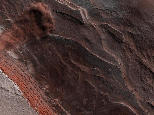
During the 2018 Mars dust storm, we obtained a clear view of the summit of the giant volcano Elysium Mons. We see the western rim and floor of the caldera, and a chain of pits (called a "catena") extending from the caldera towards the north. The chain of pits likely formed by volcanic processes, such as the collapse of a lava tube after it drained. Or by a tectonic process, such as a rift in the rocks below that drained loose material from the surface. An unexpected feature of this catena is the presence of avalanches in two of the pits (marked A and B in the cutout, with the uphill direction towards the top of the image.) The flows in both pits could be ancient, produced during the formation of the catena, but they are not found in the other pits in the chain. They might have formed more recently by the collapse of steep dust deposits like those in a degraded crater to the left of the catena. https://photojournal.jpl.nasa.gov/catalog/PIA22728

KENNEDY SPACE CENTER, FLA. -- In this close-up aerial view, the Delta II rocket with the THEMIS spacecraft atop sits ready for launch on Pad 17-B at Cape Canaveral Air Force Station as the mobile service tower begins to move away. THEMIS, an acronym for Time History of Events and Macroscale Interactions during Substorms, consists of five identical probes that will track violent, colorful eruptions near the North Pole. This will be the largest number of scientific satellites NASA has ever launched into orbit aboard a single rocket. The THEMIS mission aims to unravel the mystery behind auroral substorms, an avalanche of magnetic energy powered by the solar wind that intensifies the northern and southern lights. The mission will investigate what causes auroras in the Earth’s atmosphere to dramatically change from slowly shimmering waves of light to wildly shifting streaks of bright color. Launch is scheduled for 6:05 p.m. Photo credit: NASA/George Shelton

In this close-up aerial view, the Delta II rocket with the THEMIS spacecraft atop sits ready for launch on Pad 17-B at Cape Canaveral Air Force Station as the mobile service tower moves away from the pad. THEMIS, an acronym for Time History of Events and Macroscale Interactions during Substorms, consists of five identical probes that will track violent, colorful eruptions near the North Pole. This will be the largest number of scientific satellites NASA has ever launched into orbit aboard a single rocket. The THEMIS mission aims to unravel the mystery behind auroral substorms, an avalanche of magnetic energy powered by the solar wind that intensifies the northern and southern lights. The mission will investigate what causes auroras in the Earth’s atmosphere to dramatically change from slowly shimmering waves of light to wildly shifting streaks of bright color. Launch is scheduled for 6:05 p.m.
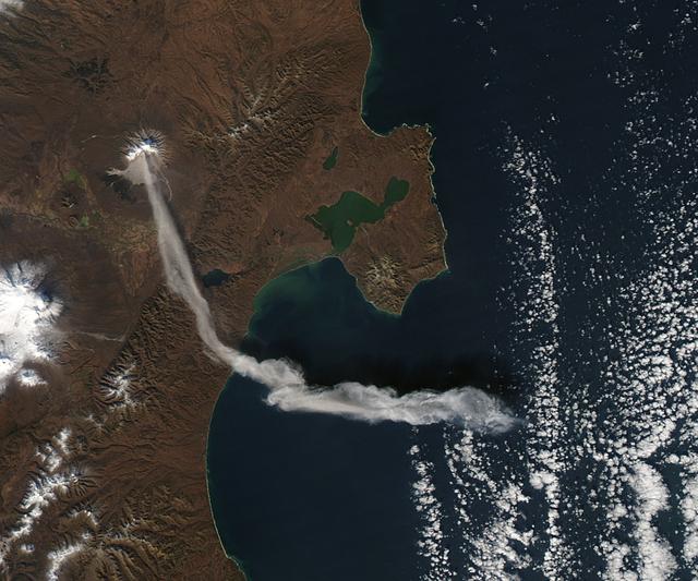
When NASA’s Terra satellite passed over Russia’s Kamchatka Peninsula at noon local time (00:00 Universal Time) on October 6, 2012, Shilveluch Volcano was quiet. By the time NASA’s Aqua satellite passed over the area two hours later (bottom image), the volcano had erupted and sent a plume of ash over the Kamchatskiy Zaliv. The plume traveled about 90 kilometers (55 miles) toward the south-southeast, where a change in wind direction began pushing the plume toward the east. On October 6, 2012, the Kamchatka Volcanic Emergency Response Team (KVERT) reported that the ash plume from Shiveluch reached an altitude of 3 kilometers (9,800 feet) above sea level, and had traveled some 220 kilometers (140 miles) from the volcano summit. Shiveluch (also spelled Sheveluch) ranks among the biggest and most active volcanoes on the Kamchatka Peninsula. Rising to 3,283 meters (10,771 feet) above sea level, Shiveluch is a stratovolcano composed of alternating layers of hardened lava, compacted ash, and rocks ejected by previous eruptions. The beige-colored expanse of rock on the volcano’s southern slopes (visible in both images) is due to an explosive eruption that occurred in 1964. Part of Shiveluch’s southern flank collapsed, and the light-colored rock is avalanche debris left by that event. High-resolution imagery of Shiveluch shows very little vegetation within that avalanche zone. On October 6, 2012, KVERT cited observations from the Moderate Resolution Imaging Spectroradiometer (MODIS) instruments on Terra and Aqua in detecting the Shiveluch eruption. This was not the first time that MODIS observed a Shiveluch eruption shortly after it started. In 2007, MODIS captured an image within minutes of the eruption’s start, before winds could blow the ash away from the summit. When NASA’s Terra satellite passed over Russia’s Kamchatka Peninsula at noon local time (00:00 Universal Time) on October 6, 2012, Shilveluch Volcano was quiet (top image). By the time NASA’s Aqua satellite passed over the area two hours later (bottom image), the volcano had erupted and sent a plume of ash over the Kamchatskiy Zaliv. The plume traveled about 90 kilometers (55 miles) toward the south-southeast, where a change in wind direction began pushing the plume toward the east. On October 6, 2012, the Kamchatka Volcanic Emergency Response Team (KVERT) reported that the ash plume from Shiveluch reached an altitude of 3 kilometers (9,800 feet) above sea level, and had traveled some 220 kilometers (140 miles) from the volcano summit. Shiveluch (also spelled Sheveluch) ranks among the biggest and most active volcanoes on the Kamchatka Peninsula. Rising to 3,283 meters (10,771 feet) above sea level, Shiveluch is a stratovolcano composed of alternating layers of hardened lava, compacted ash, and rocks ejected by previous eruptions. The beige-colored expanse of rock on the volcano’s southern slopes (visible in both images) is due to an explosive eruption that occurred in 1964. Part of Shiveluch’s southern flank collapsed, and the light-colored rock is avalanche debris left by that event. High-resolution imagery of Shiveluch shows very little vegetation within that avalanche zone. On October 6, 2012, KVERT cited observations from the Moderate Resolution Imaging Spectroradiometer (MODIS) instruments on Terra and Aqua in detecting the Shiveluch eruption. This was not the first time that MODIS observed a Shiveluch eruption shortly after it started. In 2007, MODIS captured an image within minutes of the eruption’s start, before winds could blow the ash away from the summit. Credit: <b><a href="http://www.earthobservatory.nasa.gov/" rel="nofollow"> NASA Earth Observatory</a></b> <b><a href="http://www.nasa.gov/audience/formedia/features/MP_Photo_Guidelines.html" rel="nofollow">NASA image use policy.</a></b> <b><a href="http://www.nasa.gov/centers/goddard/home/index.html" rel="nofollow">NASA Goddard Space Flight Center</a></b> enables NASA’s mission through four scientific endeavors: Earth Science, Heliophysics, Solar System Exploration, and Astrophysics. Goddard plays a leading role in NASA’s accomplishments by contributing compelling scientific knowledge to advance the Agency’s mission. <b>Follow us on <a href="http://twitter.com/NASA_GoddardPix" rel="nofollow">Twitter</a></b> <b>Like us on <a href="http://www.facebook.com/pages/Greenbelt-MD/NASA-Goddard/395013845897?ref=tsd" rel="nofollow">Facebook</a></b> <b>Find us on <a href="http://instagrid.me/nasagoddard/?vm=grid" rel="nofollow">Instagram</a></b>
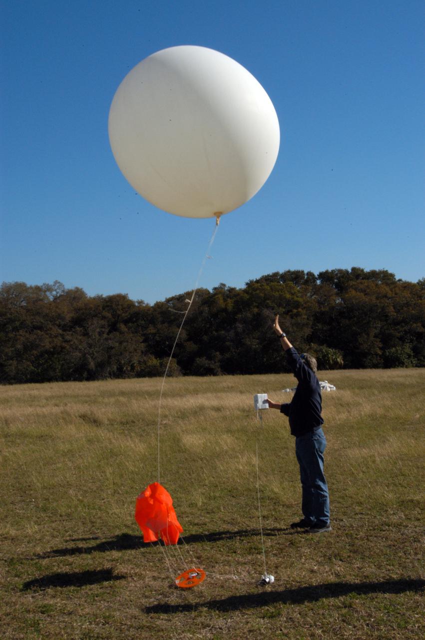
A worker releases a weather balloon at the Cape Canaveral Air Force Station weather station. The balloon is equipped with a radiosonde, an instrument that transmits measurements on atmospheric pressure, humidity, temperature and winds as it ascends. The data will be used to determine if conditions are acceptable for the launch of NASA's THEMIS mission. THEMIS, an acronym for Time History of Events and Macroscale Interactions during Substorms, consists of five identical probes that will track violent, colorful eruptions near the North Pole. This will be the largest number of scientific satellites NASA has ever launched into orbit aboard a single rocket. The THEMIS mission aims to unravel the mystery behind auroral substorms, an avalanche of magnetic energy powered by the solar wind that intensifies the northern and southern lights. The mission will investigate what causes auroras in the Earth’s atmosphere to dramatically change from slowly shimmering waves of light to wildly shifting streaks of bright color. Launch is planned from Pad 17-B in a window that extends from 6:01 to 6:19 p.m. EST.