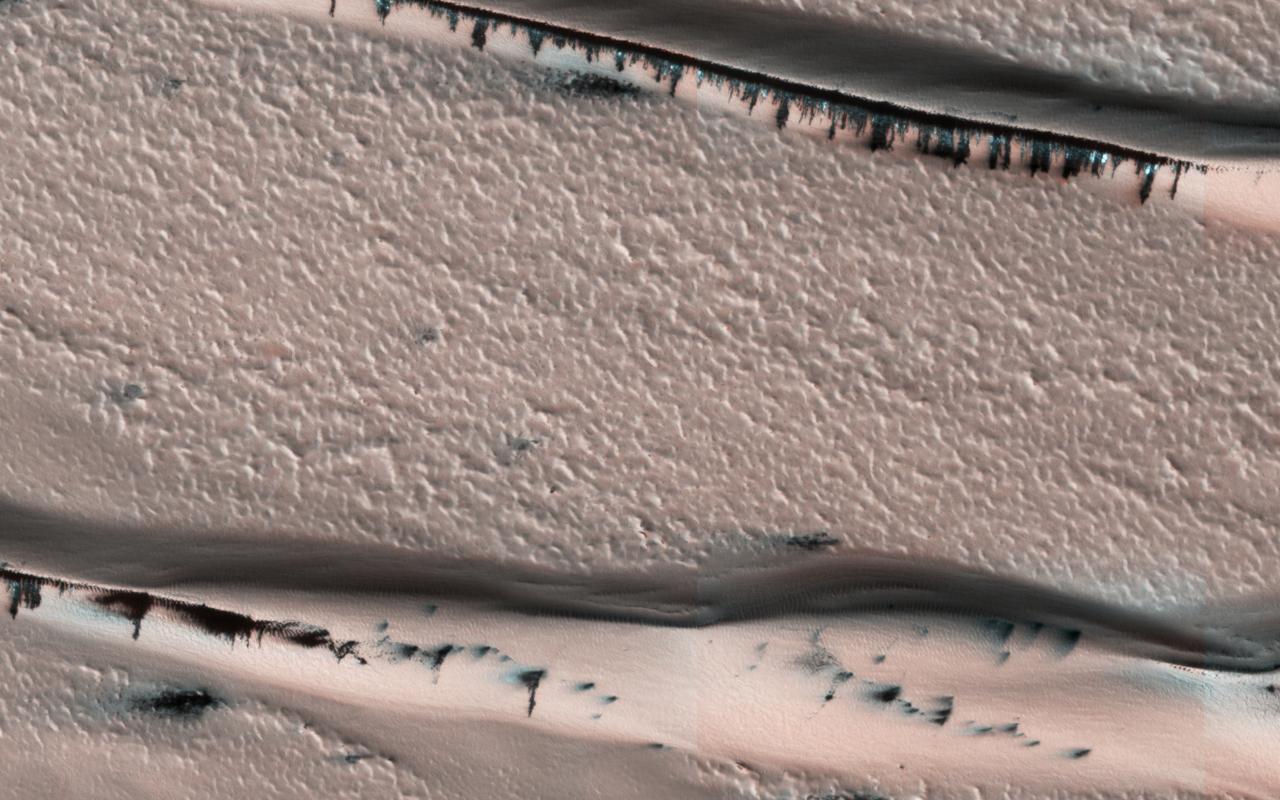
Barchan Dunes
Dark Barchan Dunes
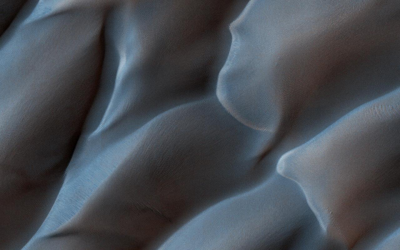
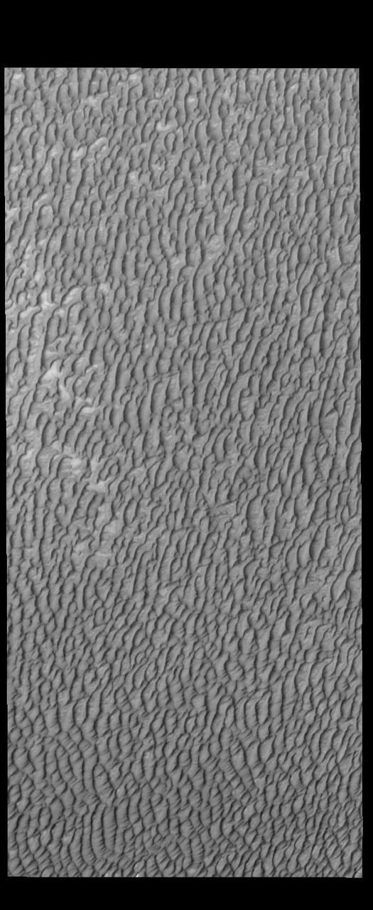
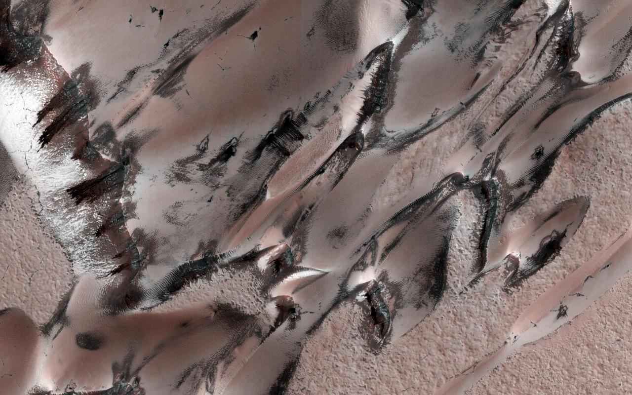
On the west (left) side of this image from NASA's Mars Reconnaissance Orbiter, fairly textbook-looking barchan sand dunes sit atop the bedrock. Barchan dunes pointing in the opposite direction are just a few kilometers away to the east. In between these opposing barchan dunes are star dunes. Barchan dunes form when the sand-moving wind is fairly unidirectional. Star dunes, in contrast, form when the sand-moving wind comes from multiple directions -- not all at once, but from varying directions at different times of day or year. Where is the sand coming from? As with most places on Mars...well, that's an area of on-going research. But the star dunes are telling us that this area seems to be accumulating sand. https://photojournal.jpl.nasa.gov/catalog/PIA21934
This observation from NASA Mars Reconnaissance Orbiter shows both dome and barchan dunes in a small sand dune field on the floor of Newton Crater, an approximately 300 kilometer 130 mile wide crater in the Southern hemisphere of Mars.
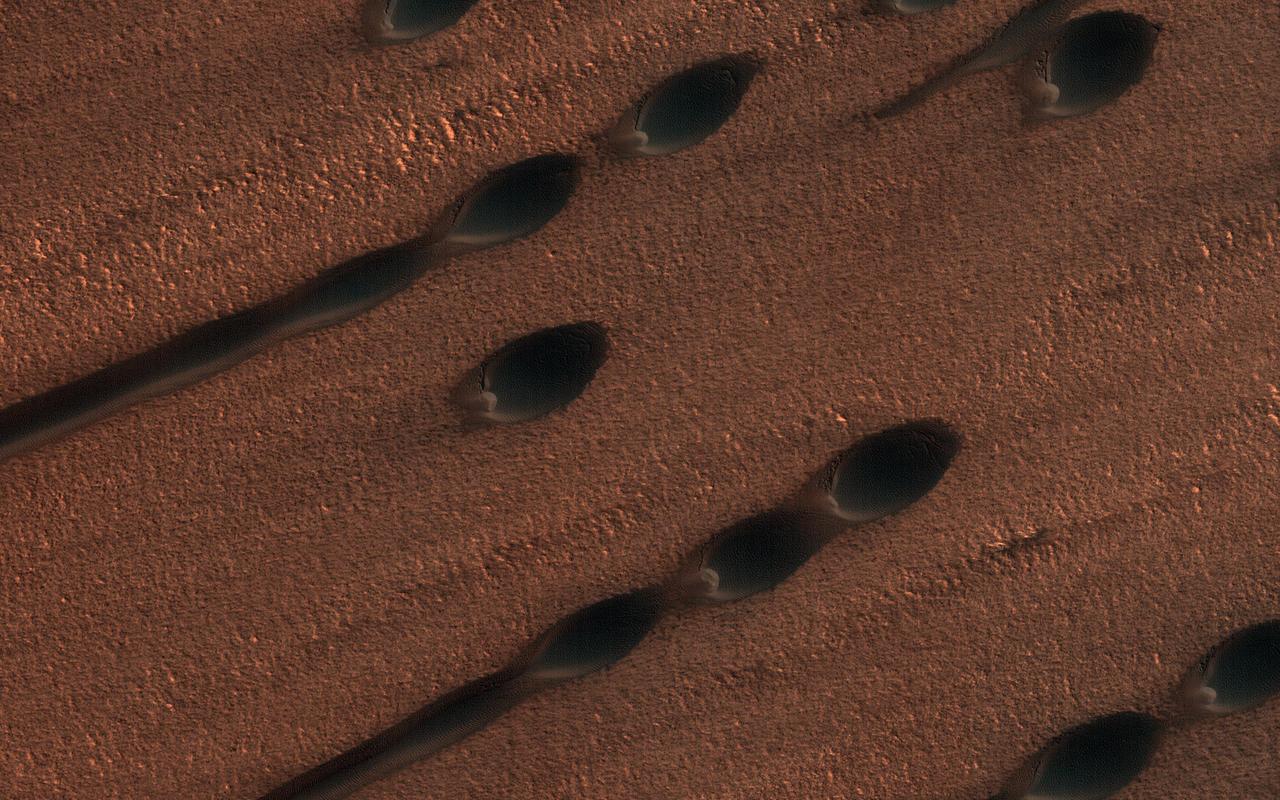
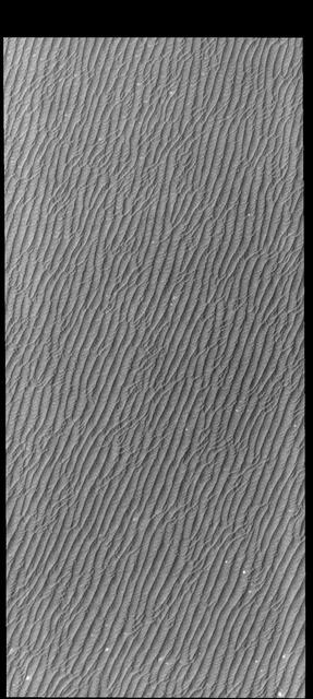
This image shows two types of sand dunes on Mars. The small dots are called barchan dunes, and from their shape we can tell that they are upwind. The downwind dunes are long and linear. These two types of dune each show the wind direction in different ways: the barchans have a steep slope and crescent-shaped "horns" that point downwind, while the linear dunes are stretched out along the primary wind direction. Linear dunes, however, typically indicate a wind regime with at least two different prevailing winds, which stretch out the sand along their average direction. In several places in this image, you can find barchan dunes turning into linear dunes as they are stretched out, but they both seem into indicate the same wind direction. https://photojournal.jpl.nasa.gov/catalog/PIA23669

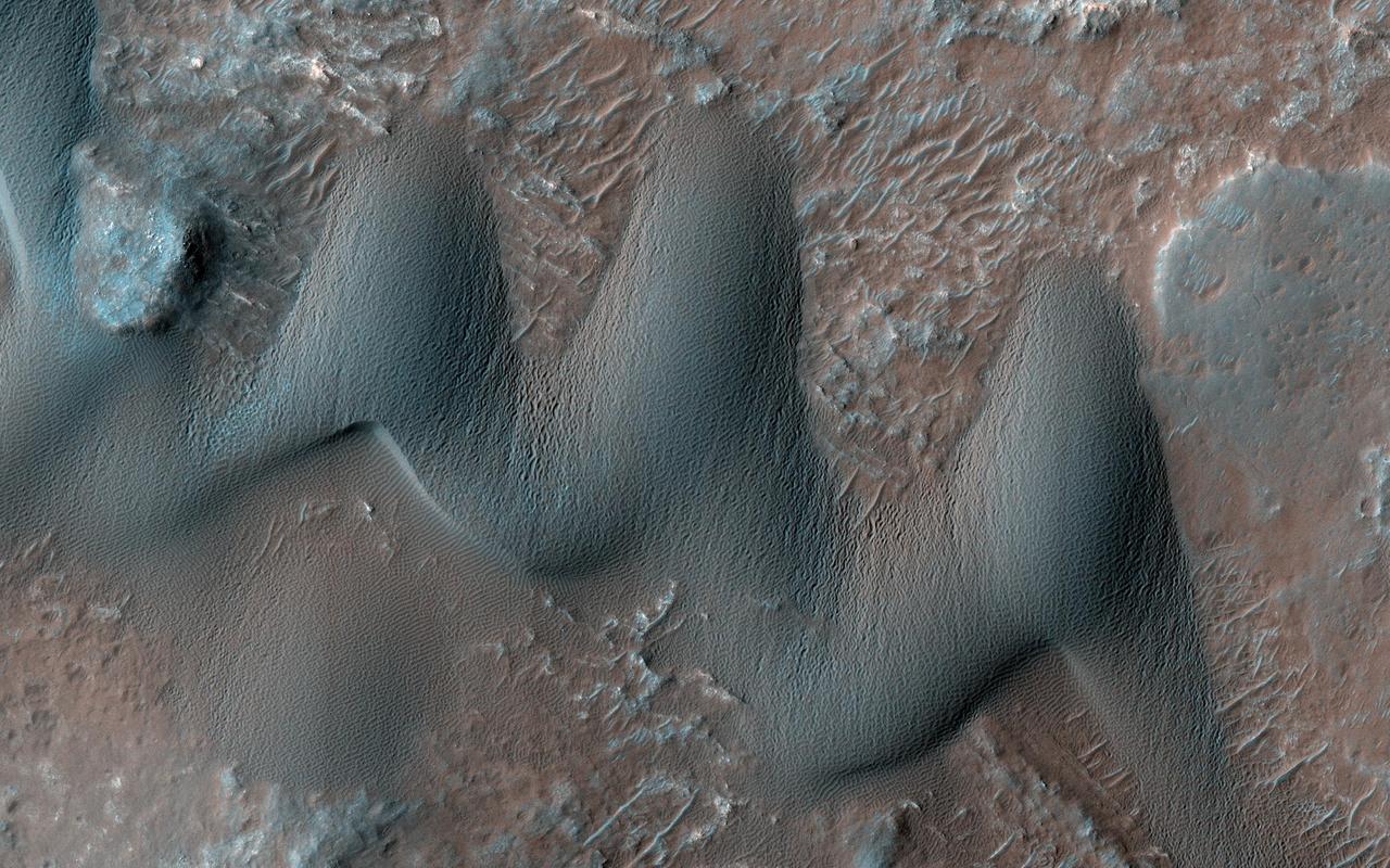
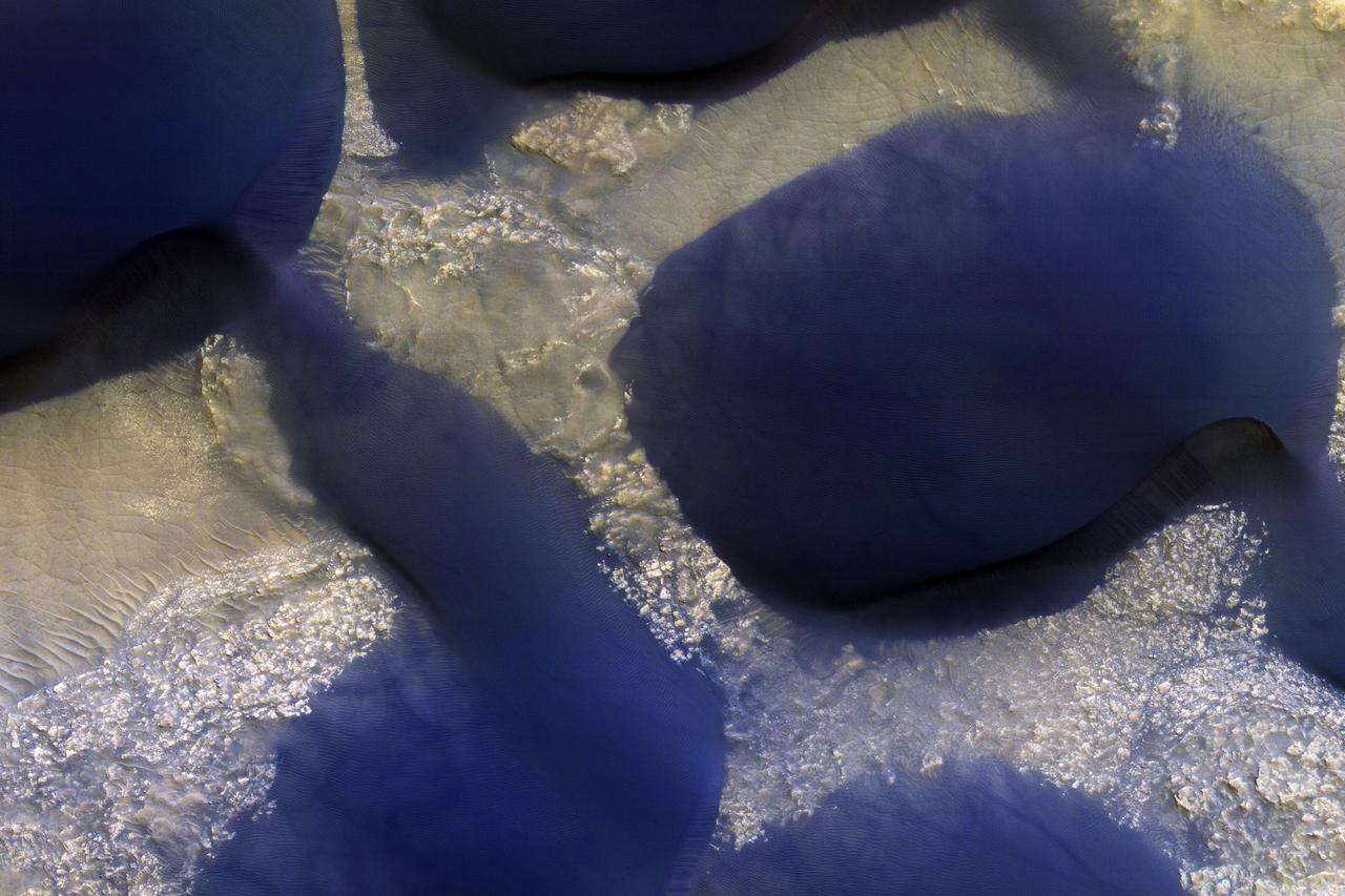
Sand dunes often accumulate in the floors of craters. In this region of Lyot Crater NASA's Mars Reconnaissance Orbiter (MRO) shows a field of classic barchan dunes. Just to the south of the group of barchan dunes is one large dune with a more complex structure. This particular dune, appearing like turquoise blue in enhanced color, is made of finer material and/or has a different composition than the surrounding. https://photojournal.jpl.nasa.gov/catalog/PIA22512
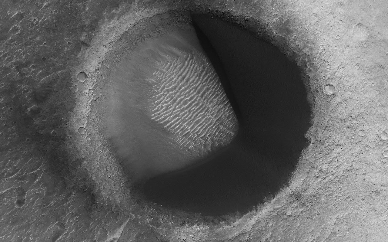
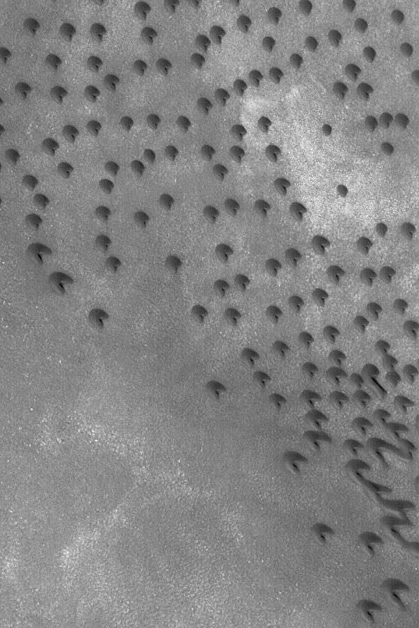
This image from NASA's Mars Reconnaissance Orbiter shows barchan sand dunes, common on Mars and often forming vast dune fields within very large (tens to hundreds of kilometers) impact basins. The regions upwind of barchans are usually devoid of sandy bedforms, so if you were walking in a downwind direction, then the barchans would seem to appear out of nowhere. As you walk downwind, you would notice the barchans link up ("joining arms") and eventually slope into featureless sand sheets. We call this progression of dunes a "Herschel-type dune field" named after the first place this sequence was described: Herschel Crater. But here is something interesting: a barchan dune filling the upwind portion of a small impact crater in a Pac-Man-like shape. This "dune-in-a-crater" is nearly at the highest extent of the field. It is also probably a rare configuration, and over the next few tens of thousands of years the sand will be blown out of the crater. https://photojournal.jpl.nasa.gov/catalog/PIA22456
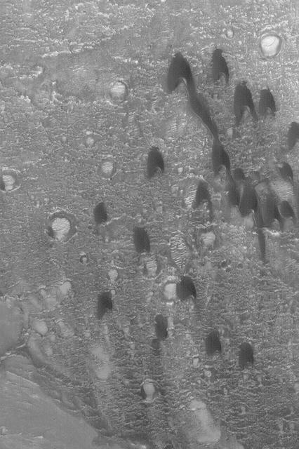
This image from NASA Mars Reconnaissance Orbiter spacecraft shows modified barchan dunes with shapes that resemble raptor claws. The unusual morphology of these dunes suggests a limited supply of windblown sand. Winds likely blew from the northeast resulting in elongate dunes with an asymmetric downwind point. The transverse crests of the smaller ripples/mega-ripple bed-forms surrounding the dune, echo the dominant downwind direction towards the southwest. This locality is in the Northern Lowlands directly east of Dokka Crater in Scandia Cavi. http://photojournal.jpl.nasa.gov/catalog/PIA19962
This image from NASA Mars Odyssey spacecraft shows the eastern portion of a region on Mars called Hesperia Planum. Immediately visible in the image is the dark barchan type dunes that are being blown against the southeast wall of the crater.
This image taken by NASA Mars Odyssey spacecraft shows a portion of Maunder Crater with a number of interesting features including a series of barchan dunes that are traveling from right to left and gullies.
Sand dunes commonly form when particles that are being moved around by the wind find a natural barrier to accumulate and build a hill-like formation. Scientists study dunes because their shape and size can give us valuable information about the wind directions and speeds in current and past climates. For instance, barchan dunes are crescent-shaped, and they form when the wind blows mainly from one direction (perpendicular to the crescent long edge). On the other hand, "star" dunes have three or more "arms," and form in environments that that are affected by multiple wind directions. Our image shows an area on Mars with both star and barchan dunes next to each other. This implies that wind directions have changed with time, or that the surrounding landscape is creating complex wind patterns. Scientists can study HiRISE images collected over time of the same dunes to observe whether they are moving or not, and if so, how fast. By observing multiple dune systems over many seasons, we can get a better picture of wind regimes on Mars and possibly how they have evolved with time. https://photojournal.jpl.nasa.gov/catalog/PIA23849

In this image many sand dunes are visible. They have an elongated crescent form and are called "barchan dunes." They are formed by the continuous action of the wind, blowing in the same direction, giving this particular shape. The orientation of these dunes tell us that the prevailing wind blows from the right to the left (east to west). The wind is continuously moving sand grains up the longer dune slope, towards the top. The small ripples on the slope are caused by this movement. When the sand grains arrive at the top, they fall down the steeper and shorter slope, which as a consequence, has no ripples. It is this gradual sand movement that causes the dunes to slowly move over time. https://photojournal.jpl.nasa.gov/catalog/PIA23056
This ASTER image covers an area of 10.5 x 15 km in southern Afghanistan and was acquired on August 20, 2000. The band 3-2-1 composite shows part of an extensive field of barchan sand dunes south of Kandahar. The shape of the dunes indicates that the prevailing wind direction is from the west. The image is located at 30.7 degrees north latitude and 65.7 degrees east longitude. http://photojournal.jpl.nasa.gov/catalog/PIA11099
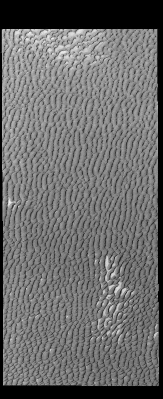
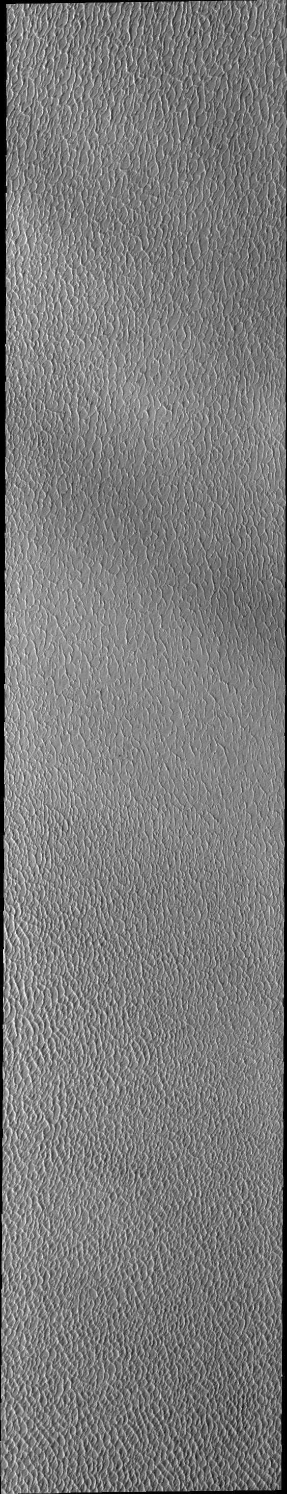
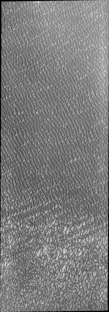
This VIS image highlights the dune form/dune density aspects of Olypmia Undae. In the center there is a brighter, diagonal region of few dunes. These dunes are the arc or crescent shape of barchan dunes. As more sand becomes available the barchan dunes begin to merge into transverse dunes. The region of dunes surrounding the bright swath still have the underlying surface visible, and the transverse dunes have a lace-like layout. In the regions with a significant abundance of sand have developed the tightly packed transverse dunes with the wave-like distribution. Olympia Undae is a vast dune field in the north polar region of Mars. It consists of a broad sand sea or erg that partly rings the north polar cap from about 120° to 240°E longitude and 78° to 83°N latitude. The dune field covers an area of approximately 470,000 km2 (bigger than California, smaller than Texas). Olympia Undae is the largest continuous dune field on Mars. Olympia Undae is not the only dune field near the north polar cap, several other smaller fields exist in the same latitude, but in other ranges of longitude, e.g. Abolos and Siton Undae. Barchan and transverse dune forms are the most common. In regions with limited available sand individual barchan dunes will form, the surface beneath and between the dunes is visible. In regions with large sand supplies, the sand sheet covers the underlying surface, and dune forms are found modifying the surface of the sand sheet. In this case transverse dunes are more common. Barchan dunes "point" down wind, transverse dunes are more linear and form parallel to the wind direction. The "square" shaped transverse dunes in Olympia Undae are due to two prevailing wind directions. The density of dunes and the alignments of the dune crests varies with location, controlled by the amount of available sand and the predominant winds over time. The Odyssey spacecraft has spent over 15 years in orbit around Mars, circling the planet more than 71,000 times. It holds the record for longest working spacecraft at Mars. THEMIS, the IR/VIS camera system, has collected data for the entire mission and provides images covering all seasons and lighting conditions. Over the years many features of interest have received repeated imaging, building up a suite of images covering the entire feature. From the deepest chasma to the tallest volcano, individual dunes inside craters and dune fields that encircle the north pole, channels carved by water and lava, and a variety of other feature, THEMIS has imaged them all. For the next several months the image of the day will focus on the Tharsis volcanoes, the various chasmata of Valles Marineris, and the major dunes fields. We hope you enjoy these images! Orbit Number: 13238 Latitude: 80.7247 Longitude: 173.91 Instrument: VIS Captured: 2004-12-08 09:25 https://photojournal.jpl.nasa.gov/catalog/PIA22296
This image shows us a cross-section of a dune field. Dune shape depends on several factors, including the amount of sand present and the local wind directions. This dune field displays several distinct dune morphologies. We see both individual barchan-like dunes and more complex dune shapes. The dunes are arranged in a linear fashion at the northern extent of the field, first in areas with lots of sand, and then with relatively sand-free patches in between dune crests. HiRISE has observed dune activity in other similar fields, but this is our first image over this group of dunes. A second image is needed to determine if these dunes are also evolving and moving. https://photojournal.jpl.nasa.gov/catalog/PIA23021
This VIS image of Olympia Undae was collected during north polar spring. The dunes are still partially covered by the winter frosts; as the region heats up the frost will dissipate to reveal the dark sand beneath. The density of dunes and the alignments of the dune crests varies with location, controlled by the amount of available sand and the predominant winds over time. Olympia Undae is a vast dune field in the north polar region of Mars. It consists of a broad sand sea or erg that partly rings the north polar cap from about 120° to 240°E longitude and 78° to 83°N latitude. The dune field covers an area of approximately 470,000 km2 (bigger than California, smaller than Texas). Olympia Undae is the largest continuous dune field on Mars. Olympia Undae is not the only dune field near the north polar cap, several other smaller fields exist in the same latitude, but in other ranges of longitude, e.g. Abolos and Siton Undae. Barchan and transverse dune forms are the most common. In regions with limited available sand individual barchan dunes will form, the surface beneath and between the dunes is visible. In regions with large sand supplies, the sand sheet covers the underlying surface, and dune forms are found modifying the surface of the sand sheet. In this case transverse dunes are more common. Barchan dunes "point" down wind, transverse dunes are more linear and form parallel to the wind direction. The "square" shaped transverse dunes in Olympia Undae are due to two prevailing wind directions. Orbit Number: 94436 Latitude: 80.4194 Longitude: 227.978 Instrument: VIS Captured: 2023-03-30 04:29 https://photojournal.jpl.nasa.gov/catalog/PIA26028

This VIS image of Olympia Undae was collected at the very end of north polar spring. As the season changes into summertime, the dune crests have lost all the winter frosts completely revealing the darker sand beneath. The density of dunes and the alignments of the dune crests varies with location, controlled by the amount of available sand and the predominant winds over time. Olympia Undae is a vast dune field in the north polar region of Mars. It consists of a broad sand sea or erg that partly rings the north polar cap from about 120° to 240°E longitude and 78° to 83°N latitude. The dune field covers an area of approximately 470,000 km2 (bigger than California, smaller than Texas). Olympia Undae is the largest continuous dune field on Mars. Olympia Undae is not the only dune field near the north polar cap, several other smaller fields exist in the same latitude, but in other ranges of longitude, e.g. Abolos and Siton Undae. Barchan and transverse dune forms are the most common. In regions with limited available sand individual barchan dunes will form, the surface beneath and between the dunes is visible. In regions with large sand supplies, the sand sheet covers the underlying surface, and dune forms are found modifying the surface of the sand sheet. In this case transverse dunes are more common. Barchan dunes "point" down wind, transverse dunes are more linear and form parallel to the wind direction. The "square" shaped transverse dunes in Olympia Undae are due to two prevailing wind directions. Orbit Number: 78980 Latitude: 80.645 Longitude: 225.957 Instrument: VIS Captured: 2019-10-04 13:10 https://photojournal.jpl.nasa.gov/catalog/PIA23539
This VIS image of Olympia Undae was collected during north polar spring. The dune crests are losing the winter frosts, revealing the dark sand beneath. The density of dunes and the alignments of the dune crests varies with location, controlled by the amount of available sand and the predominant winds over time. Olympia Undae is a vast dune field in the north polar region of Mars. It consists of a broad sand sea or erg that partly rings the north polar cap from about 120° to 240°E longitude and 78° to 83°N latitude. The dune field covers an area of approximately 470,000 km2 (bigger than California, smaller than Texas). Olympia Undae is the largest continuous dune field on Mars. Olympia Undae is not the only dune field near the north polar cap, several other smaller fields exist in the same latitude, but in other ranges of longitude, e.g. Abolos and Siton Undae. Barchan and transverse dune forms are the most common. In regions with limited available sand individual barchan dunes will form, the surface beneath and between the dunes is visible. In regions with large sand supplies, the sand sheet covers the underlying surface, and dune forms are found modifying the surface of the sand sheet. In this case transverse dunes are more common. Barchan dunes "point" down wind, transverse dunes are more linear and form parallel to the wind direction. The "square" shaped transverse dunes in Olympia Undae are due to two prevailing wind directions. Orbit Number: 94504 Latitude: 81.3452 Longitude: 209.327 Instrument: VIS Captured: 2023-04-04 18:46 https://photojournal.jpl.nasa.gov/catalog/PIA26032
This VIS image of Olympia Undae was collected early in north polar spring. The dunes are still covered by the winter frosts; as the region heats up the frost will dissipate to reveal the dark sand beneath. The density of dunes and the alignments of the dune crests varies with location, controlled by the amount of available sand and the predominant winds over time. Olympia Undae is a vast dune field in the north polar region of Mars. It consists of a broad sand sea or erg that partly rings the north polar cap from about 120° to 240°E longitude and 78° to 83°N latitude. The dune field covers an area of approximately 470,000 km2 (bigger than California, smaller than Texas). Olympia Undae is the largest continuous dune field on Mars. Olympia Undae is not the only dune field near the north polar cap, several other smaller fields exist in the same latitude, but in other ranges of longitude, e.g. Abolos and Siton Undae. Barchan and transverse dune forms are the most common. In regions with limited available sand individual barchan dunes will form, the surface beneath and between the dunes is visible. In regions with large sand supplies, the sand sheet covers the underlying surface, and dune forms are found modifying the surface of the sand sheet. In this case transverse dunes are more common. Barchan dunes "point" down wind, transverse dunes are more linear and form parallel to the wind direction. The "square" shaped transverse dunes in Olympia Undae are due to two prevailing wind directions. Orbit Number: 93727 Latitude: 79.5915 Longitude: 159.786 Instrument: VIS Captured: 2023-01-30 19:25 https://photojournal.jpl.nasa.gov/catalog/PIA25874
This VIS image of Olympia Undae was collected during north polar summer. The dune crests have completely lost the winter frosts, revealing the dark sand. The density of dunes and the alignments of the dune crests varies with location, controlled by the amount of available sand and the predominant winds over time. Olympia Undae is a vast dune field in the north polar region of Mars. It consists of a broad sand sea or erg that partly rings the north polar cap from about 120° to 240°E longitude and 78° to 83°N latitude. The dune field covers an area of approximately 470,000 km2 (bigger than California, smaller than Texas). Olympia Undae is the largest continuous dune field on Mars. Olympia Undae is not the only dune field near the north polar cap, several other smaller fields exist in the same latitude, but in other ranges of longitude, e.g. Abolos and Siton Undae. Barchan and transverse dune forms are the most common. In regions with limited available sand individual barchan dunes will form, the surface beneath and between the dunes is visible. In regions with large sand supplies, the sand sheet covers the underlying surface, and dune forms are found modifying the surface of the sand sheet. In this case transverse dunes are more common. Barchan dunes "point" down wind, transverse dunes are more linear and form parallel to the wind direction. The "square" shaped transverse dunes in Olympia Undae are due to two prevailing wind directions. Orbit Number: 87767 Latitude: 81.8559 Longitude: 167.732 Instrument: VIS Captured: 2021-09-27 01:24 https://photojournal.jpl.nasa.gov/catalog/PIA25269
Olympia Undae is a vast dune field in the north polar region of Mars. It consists of a broad sand sea or erg that partly rings the north polar cap from about 120° to 240°E longitude and 78° to 83°N latitude. The dune field covers an area of approximately 470,000 km2 (bigger than California, smaller than Texas). Olympia Undae is the largest continuous dune field on Mars. Olympia Undae is not the only dune field near the north polar cap, several other smaller fields exist in the same latitude, but in other ranges of longitude, e.g. Abolos and Siton Undae. Barchan and transverse dune forms are the most common. In regions with limited available sand individual barchan dunes will form, the surface beneath and between the dunes is visible. In regions with large sand supplies, the sand sheet covers the underlying surface, and dune forms are found modifying the surface of the sand sheet. In this case transverse dunes are more common. Barchan dunes "point" down wind, transverse dunes are more linear and form parallel to the wind direction. The "square" shaped transverse dunes in Olympia Undae are due to two prevailing wind directions. The Odyssey spacecraft has spent over 15 years in orbit around Mars, circling the planet more than 71,000 times. It holds the record for longest working spacecraft at Mars. THEMIS, the IR/VIS camera system, has collected data for the entire mission and provides images covering all seasons and lighting conditions. Over the years many features of interest have received repeated imaging, building up a suite of images covering the entire feature. From the deepest chasma to the tallest volcano, individual dunes inside craters and dune fields that encircle the north pole, channels carved by water and lava, and a variety of other feature, THEMIS has imaged them all. For the next several months the image of the day will focus on the Tharsis volcanoes, the various chasmata of Valles Marineris, and the major dunes fields. We hope you enjoy these images! Orbit Number: 27652 Latitude: 80.983 Longitude: 170.458 Instrument: VIS Captured: 2008-03-09 04:03 https://photojournal.jpl.nasa.gov/catalog/PIA22288
This VIS image of Olympia Undae was collected at the beginning of north polar spring. As the season changes into springtime, the dune crests still show most of the winter frosts completely covering the darker sand beneath. The density of dunes and the alignments of the dune crests varies with location, controlled by the amount of available sand and the predominant winds over time. Olympia Undae is a vast dune field in the north polar region of Mars. It consists of a broad sand sea or erg that partly rings the north polar cap from about 120° to 240°E longitude and 78° to 83°N latitude. The dune field covers an area of approximately 470,000 km2 (bigger than California, smaller than Texas). Olympia Undae is the largest continuous dune field on Mars. Olympia Undae is not the only dune field near the north polar cap, several other smaller fields exist in the same latitude, but in other ranges of longitude, e.g. Abolos and Siton Undae. Barchan and transverse dune forms are the most common. In regions with limited available sand individual barchan dunes will form, the surface beneath and between the dunes is visible. In regions with large sand supplies, the sand sheet covers the underlying surface, and dune forms are found modifying the surface of the sand sheet. In this case transverse dunes are more common. Barchan dunes "point" down wind, transverse dunes are more linear and form parallel to the wind direction. The "square" shaped transverse dunes in Olympia Undae are due to two prevailing wind directions. Orbit Number: 85881 Latitude: 81.5324 Longitude: 216.986 Instrument: VIS Captured: 2021-04-24 18:26 https://photojournal.jpl.nasa.gov/catalog/PIA24882
This VIS image of Olympia Undae was collected at the start polar spring. As the season changes into springtime, the dune crests are just starting to shed the winter frosts which completely hide the darker sand beneath. The density of dunes and the alignments of the dune crests varies with location, controlled by the amount of available sand and the predominant winds over time. Olympia Undae is a vast dune field in the north polar region of Mars. It consists of a broad sand sea or erg that partly rings the north polar cap from about 120° to 240°E longitude and 78° to 83°N latitude. The dune field covers an area of approximately 470,000 km2 (bigger than California, smaller than Texas). Olympia Undae is the largest continuous dune field on Mars. Olympia Undae is not the only dune field near the north polar cap, several other smaller fields exist in the same latitude, but in other ranges of longitude, e.g. Abolos and Siton Undae. Barchan and transverse dune forms are the most common. In regions with limited available sand individual barchan dunes will form, the surface beneath and between the dunes is visible. In regions with large sand supplies, the sand sheet covers the underlying surface, and dune forms are found modifying the surface of the sand sheet. In this case transverse dunes are more common. Barchan dunes "point" down wind, transverse dunes are more linear and form parallel to the wind direction. The "square" shaped transverse dunes in Olympia Undae are due to two prevailing wind directions. Orbit Number: 85826 Latitude: 80.894 Longitude: 222.032 Instrument: VIS Captured: 2021-04-20 05:51 https://photojournal.jpl.nasa.gov/catalog/PIA24878
This VIS image of Olympia Undae was collected at the middle of north polar spring. As the season changes towards summertime, the dune crests are just starting to lose the winter frosts, revealing the darker sand beneath. The density of dunes and the alignments of the dune crests varies with location, controlled by the amount of available sand and the predominant winds over time. Olympia Undae is a vast dune field in the north polar region of Mars. It consists of a broad sand sea or erg that partly rings the north polar cap from about 120° to 240°E longitude and 78° to 83°N latitude. The dune field covers an area of approximately 470,000 km2 (bigger than California, smaller than Texas). Olympia Undae is the largest continuous dune field on Mars. Olympia Undae is not the only dune field near the north polar cap, several other smaller fields exist in the same latitude, but in other ranges of longitude, e.g. Abolos and Siton Undae. Barchan and transverse dune forms are the most common. In regions with limited available sand individual barchan dunes will form, the surface beneath and between the dunes is visible. In regions with large sand supplies, the sand sheet covers the underlying surface, and dune forms are found modifying the surface of the sand sheet. In this case transverse dunes are more common. Barchan dunes "point" down wind, transverse dunes are more linear and form parallel to the wind direction. The "square" shaped transverse dunes in Olympia Undae are due to two prevailing wind directions. Orbit Number: 86013 Latitude: 80.6153 Longitude: 226.709 Instrument: VIS Captured: 2021-05-05 15:23 https://photojournal.jpl.nasa.gov/catalog/PIA24221
This VIS image of Olympia Undae was collected during north polar spring. The dunes are still partially covered by the winter frosts; as the region heats up the frost will dissipate to reveal the dark sand beneath. The density of dunes and the alignments of the dune crests varies with location, controlled by the amount of available sand and the predominant winds over time. Olympia Undae is a vast dune field in the north polar region of Mars. It consists of a broad sand sea or erg that partly rings the north polar cap from about 120° to 240°E longitude and 78° to 83°N latitude. The dune field covers an area of approximately 470,000 km2 (bigger than California, smaller than Texas). Olympia Undae is the largest continuous dune field on Mars. Olympia Undae is not the only dune field near the north polar cap, several other smaller fields exist in the same latitude, but in other ranges of longitude, e.g. Abolos and Siton Undae. Barchan and transverse dune forms are the most common. In regions with limited available sand individual barchan dunes will form, the surface beneath and between the dunes is visible. In regions with large sand supplies, the sand sheet covers the underlying surface, and dune forms are found modifying the surface of the sand sheet. In this case transverse dunes are more common. Barchan dunes "point" down wind, transverse dunes are more linear and form parallel to the wind direction. The "square" shaped transverse dunes in Olympia Undae are due to two prevailing wind directions. Orbit Number: 94624 Latitude: 80.6784 Longitude: 204.452 Instrument: VIS Captured: 2023-04-14 15:59 https://photojournal.jpl.nasa.gov/catalog/PIA26039
This VIS image of Olympia Undae was collected in the middle of north polar spring. As the season changes into summertime, the dune crests will lose all the winter frosts, completely revealing the darker sand beneath. The density of dunes and the alignments of the dune crests varies with location, controlled by the amount of available sand and the predominant winds over time. Olympia Undae is a vast dune field in the north polar region of Mars. It consists of a broad sand sea or erg that partly rings the north polar cap from about 120° to 240°E longitude and 78° to 83°N latitude. The dune field covers an area of approximately 470,000 km2 (bigger than California, smaller than Texas). Olympia Undae is the largest continuous dune field on Mars. Olympia Undae is not the only dune field near the north polar cap, several other smaller fields exist in the same latitude, but in other ranges of longitude, e.g. Abolos and Siton Undae. Barchan and transverse dune forms are the most common. In regions with limited available sand individual barchan dunes will form, the surface beneath and between the dunes is visible. In regions with large sand supplies, the sand sheet covers the underlying surface, and dune forms are found modifying the surface of the sand sheet. In this case transverse dunes are more common. Barchan dunes "point" down wind, transverse dunes are more linear and form parallel to the wind direction. The "square" shaped transverse dunes in Olympia Undae are due to two prevailing wind directions. Orbit Number: 86712 Latitude: 80.9536 Longitude: 222.236 Instrument: VIS Captured: 2021-07-02 04:40 https://photojournal.jpl.nasa.gov/catalog/PIA24991
This VIS image of Olympia Undae was collected at the start of north polar spring. The dune crests have not yet lost the winter frosts, which still cover the dark sand beneath. The density of dunes and the alignments of the dune crests varies with location, controlled by the amount of available sand and the predominant winds over time. Olympia Undae is a vast dune field in the north polar region of Mars. It consists of a broad sand sea or erg that partly rings the north polar cap from about 120° to 240°E longitude and 78° to 83°N latitude. The dune field covers an area of approximately 470,000 km2 (bigger than California, smaller than Texas). Olympia Undae is the largest continuous dune field on Mars. Olympia Undae is not the only dune field near the north polar cap, several other smaller fields exist in the same latitude, but in other ranges of longitude, e.g. Abolos and Siton Undae. Barchan and transverse dune forms are the most common. In regions with limited available sand individual barchan dunes will form, the surface beneath and between the dunes is visible. In regions with large sand supplies, the sand sheet covers the underlying surface, and dune forms are found modifying the surface of the sand sheet. In this case transverse dunes are more common. Barchan dunes "point" down wind, transverse dunes are more linear and form parallel to the wind direction. The "square" shaped transverse dunes in Olympia Undae are due to two prevailing wind directions. Orbit Number: 93875 Latitude: 81.2131 Longitude: 213.454 Instrument: VIS Captured: 2023-02-11 23:53 https://photojournal.jpl.nasa.gov/catalog/PIA25908
This VIS image of Olympia Undae was collected at the middle of north polar summer. The density of dunes and the alignments of the dune crests varies with location, controlled by the amount of available sand and the predominant winds over time. Olympia Undae is a vast dune field in the north polar region of Mars. It consists of a broad sand sea or erg that partly rings the north polar cap from about 120° to 240°E longitude and 78° to 83°N latitude. The dune field covers an area of approximately 470,000 km2 (bigger than California, smaller than Texas). Olympia Undae is the largest continuous dune field on Mars. Olympia Undae is not the only dune field near the north polar cap, several other smaller fields exist in the same latitude, but in other ranges of longitude, e.g. Abolos and Siton Undae. Barchan and transverse dune forms are the most common. In regions with limited available sand individual barchan dunes will form, the surface beneath and between the dunes is visible. In regions with large sand supplies, the sand sheet covers the underlying surface, and dune forms are found modifying the surface of the sand sheet. In this case transverse dunes are more common. Barchan dunes "point" down wind, transverse dunes are more linear and form parallel to the wind direction. The "square" shaped transverse dunes in Olympia Undae are due to two prevailing wind directions. Orbit Number: 88180 Latitude: 80.9111 Longitude: 135.309 Instrument: VIS Captured: 2021-10-31 01:32 https://photojournal.jpl.nasa.gov/catalog/PIA25158
This VIS image of Olympia Undae was collected during north polar summer. The density of dunes and the alignments of the dune crests varies with location, controlled by the amount of available sand and the predominant winds over time. Olympia Undae is a vast dune field in the north polar region of Mars. It consists of a broad sand sea or erg that partly rings the north polar cap from about 120° to 240°E longitude and 78° to 83°N latitude. The dune field covers an area of approximately 470,000 km2 (bigger than California, smaller than Texas). Olympia Undae is the largest continuous dune field on Mars. Olympia Undae is not the only dune field near the north polar cap, several other smaller fields exist in the same latitude, but in other ranges of longitude, e.g. Abolos and Siton Undae. Barchan and transverse dune forms are the most common. In regions with limited available sand individual barchan dunes will form, the surface beneath and between the dunes is visible. In regions with large sand supplies, the sand sheet covers the underlying surface, and dune forms are found modifying the surface of the sand sheet. In this case transverse dunes are more common. Barchan dunes "point" down wind, transverse dunes are more linear and form parallel to the wind direction. Transverse dunes cover the top half of this image. Orbit Number: 80092 Latitude: 81.4474 Longitude: 183.52 Instrument: VIS Captured: 2020-01-04 02:42 https://photojournal.jpl.nasa.gov/catalog/PIA23751
This VIS image of Olympia Undae was collected during north polar summer. The density of dunes and the alignments of the dune crests varies with location, controlled by the amount of available sand and the predominant winds over time. Olympia Undae is a vast dune field in the north polar region of Mars. It consists of a broad sand sea or erg that partly rings the north polar cap from about 120° to 240°E longitude and 78° to 83°N latitude. The dune field covers an area of approximately 470,000 km2 (bigger than California, smaller than Texas). Olympia Undae is the largest continuous dune field on Mars. Olympia Undae is not the only dune field near the north polar cap, several other smaller fields exist in the same latitude, but in other ranges of longitude, e.g. Abolos and Siton Undae. Barchan and transverse dune forms are the most common. In regions with limited available sand individual barchan dunes will form, the surface beneath and between the dunes is visible. In regions with large sand supplies, the sand sheet covers the underlying surface, and dune forms are found modifying the surface of the sand sheet. In this case transverse dunes are more common. Barchan dunes "point" down wind, transverse dunes are more linear and form parallel to the wind direction. The "square" shaped transverse dunes in Olympia Undae are due to two prevailing wind directions. Orbit Number: 88192 Latitude: 81.2425 Longitude: 148.338 Instrument: VIS Captured: 2021-11-01 01:15 https://photojournal.jpl.nasa.gov/catalog/PIA25192
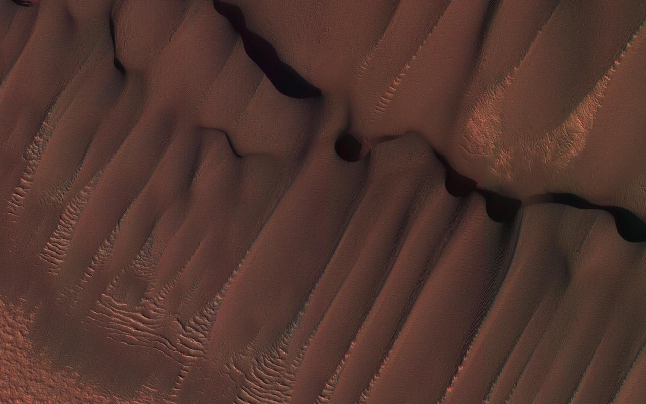
The large dark feature is a classic Martian sand dune. Most sand on Earth is made from the mineral quartz, which is white and bright. On Mars, most sand is composed of dark basalt, a volcanic rock. For this reason, dunes on Mars are darker than those on Earth. The dunes in this observation, within Wirtz Crater, are known as "barchans." The steepest slope is on the eastern (right) side, partially in shadow, and represents the direction the dune is migrating as the sand is blown and transported by the wind. Small ripples are visible on much of the dune surface. The dark streaks on the dune are tracks left by passing vortices known to us as dust devils. These raise dust off the dune, revealing a darker substrate. http://photojournal.jpl.nasa.gov/catalog/PIA12289
This VIS image of Olympia Undae was collected during north polar summer. Olympia Undae is a vast dune field in the north polar region of Mars. It consists of a broad sand sea or erg that partly rings the north polar cap from about 120° to 240°E longitude and 78° to 83°N latitude. The dune field covers an area of approximately 470,000 km2 (bigger than California, smaller than Texas). Olympia Undae is the largest continuous dune field on Mars. Olympia Undae is not the only dune field near the north polar cap, several other smaller fields exist in the same latitude, but in other ranges of longitude, e.g. Abolos and Siton Undae. Barchan and transverse dune forms are the most common. In regions with limited available sand individual barchan dunes will form, the surface beneath and between the dunes is visible. In regions with large sand supplies, the sand sheet covers the underlying surface, and dune forms are found modifying the surface of the sand sheet. In this case transverse dunes are more common. Barchan dunes "point" down wind, transverse dunes are more linear and form parallel to the wind direction. The "square" shaped transverse dunes in Olympia Undae are due to two prevailing wind directions. Orbit Number: 80440 Latitude: 80.7922 Longitude: 225.187 Instrument: VIS Captured: 2020-02-01 18:23 https://photojournal.jpl.nasa.gov/catalog/PIA23833
Kaiser Crater is located in the southern hemisphere in the Noachis region west of Hellas Planitia. Kaiser Crater is just one of several large craters with extensive dune fields on the crater floor. Other nearby dune filled craters are Proctor, Russell, and Rabe. Kaiser Crater is 207 km (129 miles) in diameter. The dunes are located in the southeastern part of the crater floor. Most of the individual dunes in Kaiser Crater are barchan dunes. Barchan dunes are crescent shaped with the points of the crescent pointing downwind. The sand is blown up the low angle side of the dune and then tumbles down the steep slip face. This dune type forms on hard surfaces where there is limited amounts of sand. Barchan dunes can merge together over time with increased sand in the local area. The Odyssey spacecraft has spent over 15 years in orbit around Mars, circling the planet more than 69000 times. It holds the record for longest working spacecraft at Mars. THEMIS, the IR/VIS camera system, has collected data for the entire mission and provides images covering all seasons and lighting conditions. Over the years many features of interest have received repeated imaging, building up a suite of images covering the entire feature. From the deepest chasma to the tallest volcano, individual dunes inside craters and dune fields that encircle the north pole, channels carved by water and lava, and a variety of other feature, THEMIS has imaged them all. For the next several months the image of the day will focus on the Tharsis volcanoes, the various chasmata of Valles Marineris, and the major dunes fields. We hope you enjoy these images! Orbit Number: 1036 Latitude: -46.7795 Longitude: 20.2075 Instrument: VIS Captured: 2002-03-09 20:07 https://photojournal.jpl.nasa.gov/catalog/PIA22172
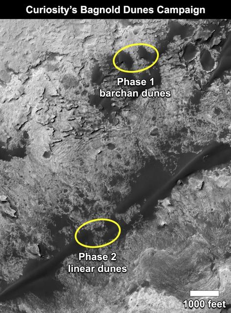
This map shows the two locations of a research campaign by NASA's Curiosity Mars rover mission to investigate active sand dunes inside Gale Crater on Mars. The Bagnold Dunes form a dark band on the northwestern flank of Mount Sharp, inside the crater. In late 2015 and early 2016, Curiosity examined crescent-shaped dunes, called barchans, which are convex on the downwind (leeward) side. This was the first close-up study of active sand dunes anywhere other than Earth. In February 2017, the rover reached a location where the dunes are linear in shape, and the mission began Phase 2 of its dunes campaign. http://photojournal.jpl.nasa.gov/catalog/PIA21269
This VIS image of Olympia Undae was collected during north polar summer. The dunes are now completely frost free and are dark in color due to being made of basaltic sand. The surface between the dunes, where visible, is a bright tone. In some regions of dense dunes, the bright material may be a deposit on the dunes rather than the underlying surface. The presence of gypsum has been suggested for Olympia Undae, gypsum is a lighter tone than basalt in this filter of the THEMIS VIS camera. Olympia Undae is a vast dune field in the north polar region of Mars. It consists of a broad sand sea or erg that partly rings the north polar cap from about 120° to 240°E longitude and 78° to 83°N latitude. The dune field covers an area of approximately 470,000 km2 (bigger than California, smaller than Texas). Olympia Undae is the largest continuous dune field on Mars. Olympia Undae is not the only dune field near the north polar cap, several other smaller fields exist in the same latitude, but in other ranges of longitude, e.g. Abolos and Siton Undae. Barchan and transverse dune forms are the most common. In regions with limited available sand individual barchan dunes will form, the surface beneath and between the dunes is visible. In regions with large sand supplies, the sand sheet covers the underlying surface, and dune forms are found modifying the surface of the sand sheet. In this case transverse dunes are more common. Barchan dunes "point" down wind, transverse dunes are more linear and form parallel to the wind direction. The "square" shaped transverse dunes in Olympia Undae are due to two prevailing wind directions. The density of dunes and the alignments of the dune crests varies with location, controlled by the amount of available sand and the predominant winds over time. The Odyssey spacecraft has spent over 15 years in orbit around Mars, circling the planet more than 71,000 times. It holds the record for longest working spacecraft at Mars. THEMIS, the IR/VIS camera system, has collected data for the entire mission and provides images covering all seasons and lighting conditions. Over the years many features of interest have received repeated imaging, building up a suite of images covering the entire feature. From the deepest chasma to the tallest volcano, individual dunes inside craters and dune fields that encircle the north pole, channels carved by water and lava, and a variety of other feature, THEMIS has imaged them all. For the next several months the image of the day will focus on the Tharsis volcanoes, the various chasmata of Valles Marineris, and the major dunes fields. We hope you enjoy these images! Orbit Number: 21125 Latitude: 81.5387 Longitude: 181.591 Instrument: VIS Captured: 2006-09-18 18:07 https://photojournal.jpl.nasa.gov/catalog/PIA22294

This VIS image of Olympia Undae was collected during north polar summer. The dunes are now completely frost free and are dark in color due to being made of basaltic sand. The surface between the dunes, where visible, is a bright tone. In some regions of dense dunes, the bright material may be a deposit on the dunes rather than the underlying surface. The presence of gypsum has been suggested for Olympia Undae, gypsum is a lighter tone than basalt in this filter of the THEMIS VIS camera. Olympia Undae is a vast dune field in the north polar region of Mars. It consists of a broad sand sea or erg that partly rings the north polar cap from about 120° to 240°E longitude and 78° to 83°N latitude. The dune field covers an area of approximately 470,000 km2 (bigger than California, smaller than Texas). Olympia Undae is the largest continuous dune field on Mars. Olympia Undae is not the only dune field near the north polar cap, several other smaller fields exist in the same latitude, but in other ranges of longitude, e.g. Abolos and Siton Undae. Barchan and transverse dune forms are the most common. In regions with limited available sand individual barchan dunes will form, the surface beneath and between the dunes is visible. In regions with large sand supplies, the sand sheet covers the underlying surface, and dune forms are found modifying the surface of the sand sheet. In this case transverse dunes are more common. Barchan dunes "point" down wind, transverse dunes are more linear and form parallel to the wind direction. The "square" shaped transverse dunes in Olympia Undae are due to two prevailing wind directions. The density of dunes and the alignments of the dune crests varies with location, controlled by the amount of available sand and the predominant winds over time. The Odyssey spacecraft has spent over 15 years in orbit around Mars, circling the planet more than 71,000 times. It holds the record for longest working spacecraft at Mars. THEMIS, the IR/VIS camera system, has collected data for the entire mission and provides images covering all seasons and lighting conditions. Over the years many features of interest have received repeated imaging, building up a suite of images covering the entire feature. From the deepest chasma to the tallest volcano, individual dunes inside craters and dune fields that encircle the north pole, channels carved by water and lava, and a variety of other feature, THEMIS has imaged them all. For the next several months the image of the day will focus on the Tharsis volcanoes, the various chasmata of Valles Marineris, and the major dunes fields. We hope you enjoy these images! Orbit Number: 12614 Latitude: 80.8745 Longitude: 174.688 Instrument: VIS Captured: 2004-10-18 00:23 https://photojournal.jpl.nasa.gov/catalog/PIA22293

This VIS image of Olympia Undae was collected early in north polar spring. The crests of the dunes are light colored, indicative of a frost covering. As the season changes into summertime, the dune crests will lose the frost and reveal the darker sand beneath. The linear nature of transverse dunes can be seen at the bottom of the image. The density of dunes and the alignments of the dune crests varies with location, controlled by the amount of available sand and the predominant winds over time. Olympia Undae is a vast dune field in the north polar region of Mars. It consists of a broad sand sea or erg that partly rings the north polar cap from about 120° to 240°E longitude and 78° to 83°N latitude. The dune field covers an area of approximately 470,000 km2 (bigger than California, smaller than Texas). Olympia Undae is the largest continuous dune field on Mars. Olympia Undae is not the only dune field near the north polar cap, several other smaller fields exist in the same latitude, but in other ranges of longitude, e.g. Abolos and Siton Undae. Barchan and transverse dune forms are the most common. In regions with limited available sand individual barchan dunes will form, the surface beneath and between the dunes is visible. In regions with large sand supplies, the sand sheet covers the underlying surface, and dune forms are found modifying the surface of the sand sheet. In this case transverse dunes are more common. Barchan dunes "point" down wind, transverse dunes are more linear and form parallel to the wind direction. The "square" shaped transverse dunes in Olympia Undae are due to two prevailing wind directions. The Odyssey spacecraft has spent over 15 years in orbit around Mars, circling the planet more than 71,000 times. It holds the record for longest working spacecraft at Mars. THEMIS, the IR/VIS camera system, has collected data for the entire mission and provides images covering all seasons and lighting conditions. Over the years many features of interest have received repeated imaging, building up a suite of images covering the entire feature. From the deepest chasma to the tallest volcano, individual dunes inside craters and dune fields that encircle the north pole, channels carved by water and lava, and a variety of other feature, THEMIS has imaged them all. For the next several months the image of the day will focus on the Tharsis volcanoes, the various chasmata of Valles Marineris, and the major dunes fields. We hope you enjoy these images! Orbit Number: 10380 Latitude: 79.7273 Longitude: 176.363 Instrument: VIS Captured: 2004-04-17 02:00 https://photojournal.jpl.nasa.gov/catalog/PIA22290

This VIS image of Olympia Undae was collected during north polar spring. The crests of the dunes and other surfaces are light colored, indicative of a frost covering. At the top right of the image is a region of smooth surfaces. This is the ejecta from Jojutla Crater. The ejecta is a higher elevation than the rest of the surface, and dunes are "climbing" or "skirting" the ejecta regions. The density of dunes and the alignments of the dune crests varies with location, controlled by the amount of available sand and the predominant winds over time, and, in this case, the presence of different surface elevations. As the season changes into summertime, the dune crests will lose the frost and reveal the darker sand beneath. This loss of frost is just starting to be visible at the bottom of the image. Olympia Undae is a vast dune field in the north polar region of Mars. It consists of a broad sand sea or erg that partly rings the north polar cap from about 120° to 240°E longitude and 78° to 83°N latitude. The dune field covers an area of approximately 470,000 km2 (bigger than California, smaller than Texas). Olympia Undae is the largest continuous dune field on Mars. Olympia Undae is not the only dune field near the north polar cap, several other smaller fields exist in the same latitude, but in other ranges of longitude, e.g. Abolos and Siton Undae. Barchan and transverse dune forms are the most common. In regions with limited available sand individual barchan dunes will form, the surface beneath and between the dunes is visible. In regions with large sand supplies, the sand sheet covers the underlying surface, and dune forms are found modifying the surface of the sand sheet. In this case transverse dunes are more common. Barchan dunes "point" down wind, transverse dunes are more linear and form parallel to the wind direction. The "square" shaped transverse dunes in Olympia Undae are due to two prevailing wind directions. The Odyssey spacecraft has spent over 15 years in orbit around Mars, circling the planet more than 71,000 times. It holds the record for longest working spacecraft at Mars. THEMIS, the IR/VIS camera system, has collected data for the entire mission and provides images covering all seasons and lighting conditions. Over the years many features of interest have received repeated imaging, building up a suite of images covering the entire feature. From the deepest chasma to the tallest volcano, individual dunes inside craters and dune fields that encircle the north pole, channels carved by water and lava, and a variety of other feature, THEMIS has imaged them all. For the next several months the image of the day will focus on the Tharsis volcanoes, the various chasmata of Valles Marineris, and the major dunes fields. We hope you enjoy these images! Orbit Number: 27352 Latitude: 80.9139 Longitude: 185.126 Instrument: VIS Captured: 2008-02-13 11:10 https://photojournal.jpl.nasa.gov/catalog/PIA22291
This VIS image of Olympia Undae was collected during north polar spring. The crests of the dunes and other surfaces are light colored, indicative of a frost covering. The density of dunes and the alignments of the dune crests varies with location, controlled by the amount of available sand and the predominant winds over time. As the season changes into summertime, the dune crests will lose the frost and reveal the darker sand beneath. Olympia Undae is a vast dune field in the north polar region of Mars. It consists of a broad sand sea or erg that partly rings the north polar cap from about 120° to 240°E longitude and 78° to 83°N latitude. The dune field covers an area of approximately 470,000 km2 (bigger than California, smaller than Texas). Olympia Undae is the largest continuous dune field on Mars. Olympia Undae is not the only dune field near the north polar cap, several other smaller fields exist in the same latitude, but in other ranges of longitude, e.g. Abolos and Siton Undae. Barchan and transverse dune forms are the most common. In regions with limited available sand individual barchan dunes will form, the surface beneath and between the dunes is visible. In regions with large sand supplies, the sand sheet covers the underlying surface, and dune forms are found modifying the surface of the sand sheet. In this case transverse dunes are more common. Barchan dunes "point" down wind, transverse dunes are more linear and form parallel to the wind direction. The "square" shaped transverse dunes in Olympia Undae are due to two prevailing wind directions. The Odyssey spacecraft has spent over 15 years in orbit around Mars, circling the planet more than 71,000 times. It holds the record for longest working spacecraft at Mars. THEMIS, the IR/VIS camera system, has collected data for the entire mission and provides images covering all seasons and lighting conditions. Over the years many features of interest have received repeated imaging, building up a suite of images covering the entire feature. From the deepest chasma to the tallest volcano, individual dunes inside craters and dune fields that encircle the north pole, channels carved by water and lava, and a variety of other feature, THEMIS has imaged them all. For the next several months the image of the day will focus on the Tharsis volcanoes, the various chasmata of Valles Marineris, and the major dunes fields. We hope you enjoy these images! Orbit Number: 27402 Latitude: 81.2035 Longitude: 183.317 Instrument: VIS Captured: 2008-02-17 13:59 https://photojournal.jpl.nasa.gov/catalog/PIA22292

This VIS image was collected at the height of summer. It is during this season that winds are able to move sand sized particles, slowly modifying the dunes. Olympia Undae is a vast dune field in the north polar region of Mars. It consists of a broad sand sea or erg that partly rings the north polar cap from about 120° to 240°E longitude and 78° to 83°N latitude. The dune field covers an area of approximately 470,000 km2 (bigger than California, smaller than Texas). Olympia Undae is the largest continuous dune field on Mars. Olympia Undae is not the only dune field near the north polar cap, several other smaller fields exist in the same latitude, but in other ranges of longitude, e.g. Abolos and Siton Undae. Barchan and transverse dune forms are the most common. In regions with limited available sand individual barchan dunes will form, the surface beneath and between the dunes is visible. In regions with large sand supplies, the sand sheet covers the underlying surface, and dune forms are found modifying the surface of the sand sheet. In this case transverse dunes are more common. Barchan dunes "point" down wind, transverse dunes are more linear and form parallel to the wind direction. The "square" shaped transverse dunes in Olympia Undae are due to two prevailing wind directions. The density of dunes and the alignments of the dune crests varies with location, controlled by the amount of available sand and the predominant winds over time. The Odyssey spacecraft has spent over 15 years in orbit around Mars, circling the planet more than 71,000 times. It holds the record for longest working spacecraft at Mars. THEMIS, the IR/VIS camera system, has collected data for the entire mission and provides images covering all seasons and lighting conditions. Over the years many features of interest have received repeated imaging, building up a suite of images covering the entire feature. From the deepest chasma to the tallest volcano, individual dunes inside craters and dune fields that encircle the north pole, channels carved by water and lava, and a variety of other feature, THEMIS has imaged them all. For the next several months the image of the day will focus on the Tharsis volcanoes, the various chasmata of Valles Marineris, and the major dunes fields. We hope you enjoy these images! Orbit Number: 13475 Latitude: 80.7459 Longitude: 177.171 Instrument: VIS Captured: 2004-12-27 21:44 https://photojournal.jpl.nasa.gov/catalog/PIA22297

This VIS image of Olympia Undae was collected early in north polar spring. The crests of the dunes are light colored, indicative of a frost covering. As the season changes into summertime, the dune crests will lose the frost and reveal the darker sand beneath. The margin of the north polar cap is visible at the top of the image. Olympia Undae is a vast dune field in the north polar region of Mars. It consists of a broad sand sea or erg that partly rings the north polar cap from about 120° to 240°E longitude and 78° to 83°N latitude. The dune field covers an area of approximately 470,000 km2 (bigger than California, smaller than Texas). Olympia Undae is the largest continuous dune field on Mars. Olympia Undae is not the only dune field near the north polar cap, several other smaller fields exist in the same latitude, but in other ranges of longitude, e.g. Abolos and Siton Undae. Barchan and transverse dune forms are the most common. In regions with limited available sand individual barchan dunes will form, the surface beneath and between the dunes is visible. In regions with large sand supplies, the sand sheet covers the underlying surface, and dune forms are found modifying the surface of the sand sheet. In this case transverse dunes are more common. Barchan dunes "point" down wind, transverse dunes are more linear and form parallel to the wind direction. The "square" shaped transverse dunes in Olympia Undae are due to two prevailing wind directions. The Odyssey spacecraft has spent over 15 years in orbit around Mars, circling the planet more than 71,000 times. It holds the record for longest working spacecraft at Mars. THEMIS, the IR/VIS camera system, has collected data for the entire mission and provides images covering all seasons and lighting conditions. Over the years many features of interest have received repeated imaging, building up a suite of images covering the entire feature. From the deepest chasma to the tallest volcano, individual dunes inside craters and dune fields that encircle the north pole, channels carved by water and lava, and a variety of other feature, THEMIS has imaged them all. For the next several months the image of the day will focus on the Tharsis volcanoes, the various chasmata of Valles Marineris, and the major dunes fields. We hope you enjoy these images! Orbit Number: 10293 Latitude: 83.0224 Longitude: 174.743 Instrument: VIS Captured: 2004-04-09 22:04 https://photojournal.jpl.nasa.gov/catalog/PIA22289
This dune field formed near the base of the North Polar cap. Dunes require a source of loose particulate material to form. The source of the northern dune fields around the polar cap may be from the layers of dusty ice that are eroded by strong polar winds. This image was taken during the Martian northern summer, so there is no frost present on the dunes. The dunes closest to the base of the polar cap are long and parallel, indicating strong winds from the direction of the cap. As they get farther away from the polar cap, they start to form more crescent shaped dunes, called barchan dunes. Repeated observations by HiRISE of dunes like these show measurable changes in some locations. This discovery adds to the growing evidence that there are active processes happening all over the surface of Mars today. http://photojournal.jpl.nasa.gov/catalog/PIA11181
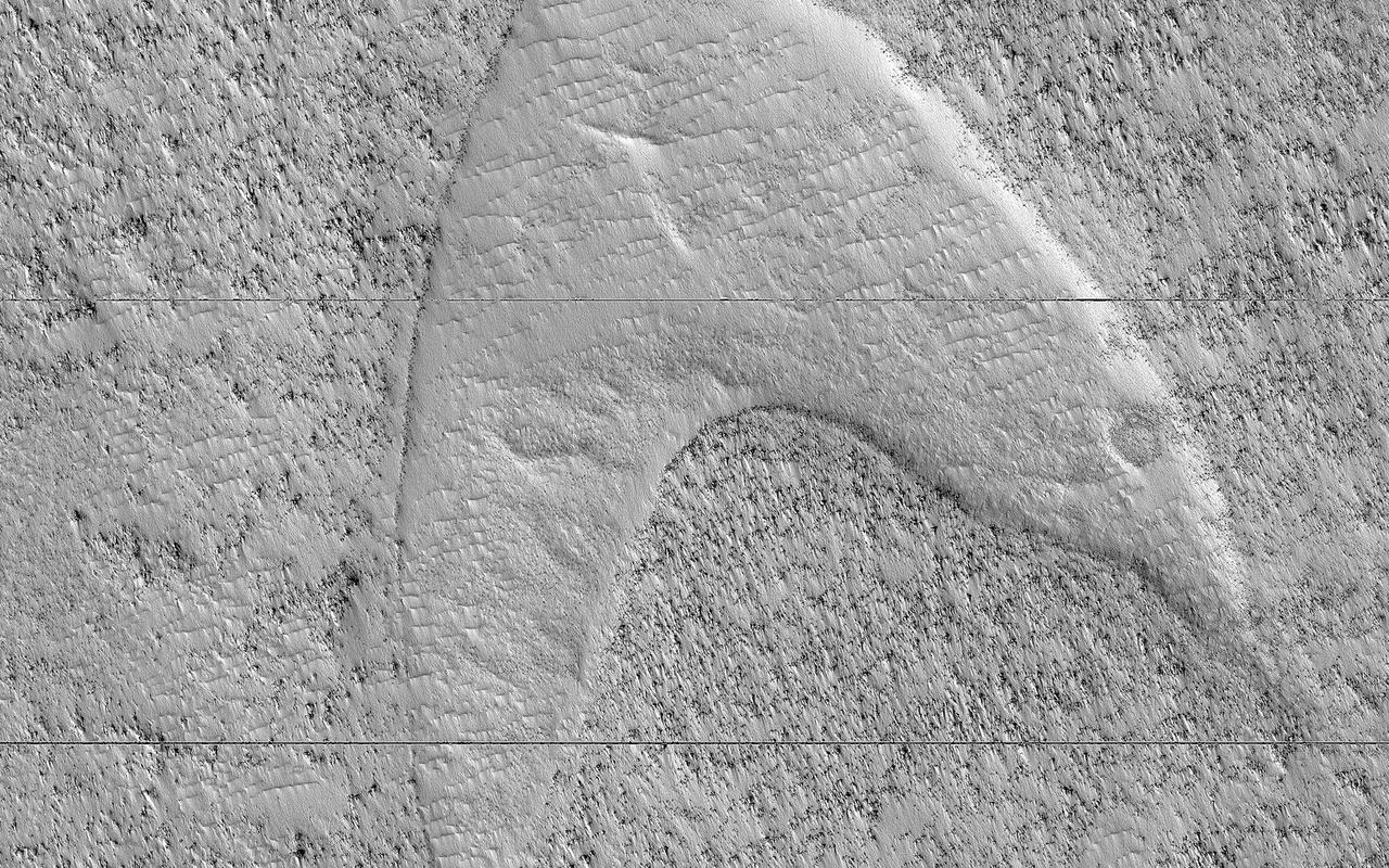
These curious chevron shapes in southeast Hellas Planitia are the result of a complex story of dunes, lava, and wind. Long ago, there were large crescent-shaped (barchan) dunes that moved across this area, and at some point, there was an eruption. The lava flowed out over the plain and around the dunes, but not over them. The lava solidified, but these dunes still stuck up like islands. However, they were still just dunes, and the wind continued to blow. Eventually, the sand piles that were the dunes migrated away, leaving these "footprints" in the lava plain. These are also called "dune casts" and record the presence of dunes that were surrounded by lava. Enterprising viewers will make the discovery that these features look conspicuously like a famous logo: and you'd be right, but it's only a coincidence. https://photojournal.jpl.nasa.gov/catalog/PIA23288
This VIS image of Olympia Undae was collected during north polar summer. The dunes are now completely frost free and are dark in color due to being made of basaltic sand. The surface between the dunes, where visible, is a bright tone. In some regions of dense dunes, the bright material may be a deposit on the dunes rather than the underlying surface. The presence of gypsum has been suggested for Olympia Undae, gypsum is a lighter tone than basalt in this filter of the THEMIS VIS camera. This VIS image hightlights the density of dunes, the bottom third of the image has fewer dunes, spaced farther apart than the top two thirds of the image. The bottom of the image "looks" like lace, while the top with the dense dunes with aligned dune crests "looks" like waves in an ocean. The term used for dune fields on Mar is undae (unda singular). This term translates from Latin as water waves and is used to mean undulatory in planetary nomenclature. All non-Earth dune fields in the solar system are called unda/undae. Olympia Undae is a vast dune field in the north polar region of Mars. It consists of a broad sand sea or erg that partly rings the north polar cap from about 120° to 240°E longitude and 78° to 83°N latitude. The dune field covers an area of approximately 470,000 km2 (bigger than California, smaller than Texas). Olympia Undae is the largest continuous dune field on Mars. Olympia Undae is not the only dune field near the north polar cap, several other smaller fields exist in the same latitude, but in other ranges of longitude, e.g. Abolos and Siton Undae. Barchan and transverse dune forms are the most common. In regions with limited available sand individual barchan dunes will form, the surface beneath and between the dunes is visible. In regions with large sand supplies, the sand sheet covers the underlying surface, and dune forms are found modifying the surface of the sand sheet. In this case transverse dunes are more common. Barchan dunes "point" down wind, transverse dunes are more linear and form parallel to the wind direction. The "square" shaped transverse dunes in Olympia Undae are due to two prevailing wind directions. The density of dunes and the alignments of the dune crests varies with location, controlled by the amount of available sand and the predominant winds over time. The Odyssey spacecraft has spent over 15 years in orbit around Mars, circling the planet more than 71,000 times. It holds the record for longest working spacecraft at Mars. THEMIS, the IR/VIS camera system, has collected data for the entire mission and provides images covering all seasons and lighting conditions. Over the years many features of interest have received repeated imaging, building up a suite of images covering the entire feature. From the deepest chasma to the tallest volcano, individual dunes inside craters and dune fields that encircle the north pole, channels carved by water and lava, and a variety of other feature, THEMIS has imaged them all. For the next several months the image of the day will focus on the Tharsis volcanoes, the various chasmata of Valles Marineris, and the major dunes fields. We hope you enjoy these images! Orbit Number: 13138 Latitude: 80.8321 Longitude: 178.781 Instrument: VIS Captured: 2004-11-30 03:49 https://photojournal.jpl.nasa.gov/catalog/PIA22295
This image covers a unique polar dune field during northern spring, revealing some interesting patterns. The main "megadune" formation comprises giant crescent-shaped dunes called "barchans," which have been migrating (from upper-right to lower-left) over the past several centuries or more. Light-toned seasonal carbon dioxide frost and ice that accumulated over the winter still covers the majority of the surface, and is now starting to defrost and sublimate in complex patterns. (This depends on the slope aspect and incoming solar illumination). As frost is removed, the darker "coal-black" nature of the dune sand is revealed. For example, compare with this image taken in summer, when frost is gone and the dunes are migrating. The striped patterns of the carbon dioxide frost and linear nature of the dune field give it a sea serpent-like appearance. https://photojournal.jpl.nasa.gov/catalog/PIA24699
ISS028-E-044444 (8 Sept. 2011) --- This image, photographed by an Expedition 28 crew member on the International Space Station, highlights a sand dune field within the Burqin-Haba River-Jimunai Desert near the borders of China, Mongolia, Russia and Kazakhstan. The dune field (approximately 32 kilometers long) is located immediately to the west-northwest of the city of Burqin (not shown), and is part of the Junggar Basin, a region of active petroleum production in northwestern China. The Irtysh River, with associated wetlands and riparian vegetation (appearing grey-green in the image) flows from its headwaters in the Altay Mountains to the east towards Siberia to the west (right to left). Tan sandy linear dunes at center on the south side of the Irtysh River dominate the view. The linear dunes are formed from mobile barchan (crescent-shaped) dunes moving from left to right in this view; the barchans eventually merge to form the large linear dunes some of which reach 50-100 meters in height. Sand moving along the southern edge of the dune field appears to be feeding a southeastern lobe with a separate population of linear dunes (lower right). The Burqin-Haba River-Jimunai Desert area also includes darker gravel covered surfaces that form pavements known locally as gobi. These are somewhat indistinguishable from vegetated areas arresting some of the dunes at the resolution of the image, but tend to be located on the flat regions between the dunes.
This image is located in Meroe Patera (longitude: 292W/68E, latitude: 7.01), which is a small region within Syrtis Major Planitia. Syrtis Major is a low-relief shield volcano whose lava flows make up a plateau more than 1000 km across. These flows are of Hesperian age (Martian activity of intermediate age) and are believed to have originated from a series of volcanic depressions, called calderas. The caldera complex lies on extensions of the ring faults associated with the Isidis impact basin toward the northeast - thus Syrtis Major volcanism may be associated with post-impact adjustments of the Martian crust. The most striking feature in this image is the light streaks across the image that lead to dunes in the lower left region. Wind streaks are albedo markings interpreted to be formed by aeolian action on surface materials. Most are elongate and allow an interpretation of effective wind directions. Many streaks are time variable and thus provide information on seasonal or long-term changes in surface wind directions and strengths. The wind streaks in this image are lighter than their surroundings and are the most common type of wind streak found on Mars. These streaks are formed downwind from crater rims (as in this example), mesas, knobs, and other positive topographic features. The dune field in this image is a mixture of barchan dunes and transverse dunes. Dunes are among the most distinctive aeolian feature on Mars, and are similar in form to barchan and transverse dunes on Earth. This similarity is the best evidence to indicate that martian dunes are composed of sand-sized material, although the source and composition of the sand remain controversial. Both the observations of dunes and wind streaks indicate that this location has a windy environment - and these winds are persistent enough to product dunes, as sand-sized material accumulates in this region. These features also indicate that the winds in this region are originating from the right side of the image, and moving towards the left. http://photojournal.jpl.nasa.gov/catalog/PIA04012
This view from NASA's Mars Reconnaissance Orbiter shows the downwind stretches of a sand sheet in central part of the much larger Herschel Crater. This sandy province began kilometers upwind in a string of barchan sand dunes. As the north-to-south blowing wind weakened downwind, it could no longer fashion the sand into dunes but rather into amorphously-shaped sand sheets. While perhaps not awe-inspiringly beautiful, sand sheets can tell us about Mars' current and past environmental conditions as a piece of the puzzle for understanding habitability. Having dunes upwind of sheets is the opposite situation Earth has, where upwind sand sheets evolve downwind into sand dunes. This mystery is receiving ongoing research to to understand these sandy differences between Earth and Mars. https://photojournal.jpl.nasa.gov/catalog/PIA21933
![Sand dunes are scattered across Mars and one of the larger populations exists in the Southern hemisphere, just west of the Hellas impact basin. The Hellespontus region features numerous collections of dark, dune formations that collect both within depressions such as craters, and among "extra-crater" plains areas. This image displays the middle portion of a large dune field composed primarily of crescent-shaped "barchan" dunes. Here, the steep, sunlit side of the dune, called a slip face, indicates the down-wind side of the dune and direction of its migration. Other long, narrow linear dunes known as "seif" dunes are also here and in other locales to the east. NB: "Seif" comes from the Arabic word meaning "sword." The map is projected here at a scale of 25 centimeters (9.8 inches) per pixel. [The original image scale is 25.5 centimeters (10 inches) per pixel (with 1 x 1 binning); objects on the order of 77 centimeters (30.3 inches) across are resolved.] North is up. http://photojournal.jpl.nasa.gov/catalog/PIA21571](https://images-assets.nasa.gov/image/PIA21571/PIA21571~medium.jpg)
Sand dunes are scattered across Mars and one of the larger populations exists in the Southern hemisphere, just west of the Hellas impact basin. The Hellespontus region features numerous collections of dark, dune formations that collect both within depressions such as craters, and among "extra-crater" plains areas. This image displays the middle portion of a large dune field composed primarily of crescent-shaped "barchan" dunes. Here, the steep, sunlit side of the dune, called a slip face, indicates the down-wind side of the dune and direction of its migration. Other long, narrow linear dunes known as "seif" dunes are also here and in other locales to the east. NB: "Seif" comes from the Arabic word meaning "sword." The map is projected here at a scale of 25 centimeters (9.8 inches) per pixel. [The original image scale is 25.5 centimeters (10 inches) per pixel (with 1 x 1 binning); objects on the order of 77 centimeters (30.3 inches) across are resolved.] North is up. http://photojournal.jpl.nasa.gov/catalog/PIA21571
This image from NASA's Mars Reconnaisance Orbiter (MRO) shows a dune field in Chasma Boreale, which is a large trough that cuts into the North Polar ice cap. Some of the dunes in this image are quite long and sinuous with a slight bulge at one end like a "head," giving it the appearance of a snake. However, most of the dunes visible here are of the type referred to as "barchan," which are characterized by their crescent shape. For these types of dunes, the "mouth" of the crescent points in the downwind direction, indicating that the winds are traveling east-west. The diverse dune morphologies here suggest that the wind-direction changes over a very small area. Because Mars has a similar axial tilt to Earth, it also experiences seasons. When we took this image, Mars was in late spring. At this time of year, the dunes in this image are almost completely covered by frost. But this will soon change! Small portions of the underlying dark basaltic sands of these dunes are becoming increasingly visible with the active removal of their seasonal coating of ice. A look at a series of images demonstrates the the transition from early to late spring, marked by defrosting and the gradual growth of dark spots. By summer, the dunes will be defrosted, and will appear completely black. https://photojournal.jpl.nasa.gov/catalog/PIA22053
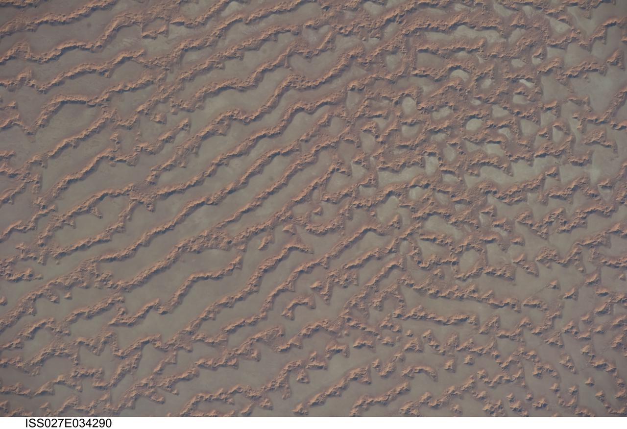
ISS027-E-034290 (16 May 2011) --- Ar Rub al Khali Sand Sea, Arabian Peninsula is featured in this image photographed by an Expedition 27 crew member on the International Space Station. The Ar Rub al Khali, also known as the “Empty Quarter”, is a large region of sand dunes and interdune flats known as a sand sea (or erg). This photograph highlights a part of the Ar Rub al Khali located close to its southeastern margin in the Sultanate of Oman. Reddish-brown, large linear sand dunes alternate with blue-gray interdune salt flats known as sabkhas at left. The major trend of the linear dunes is transverse to northwesterly trade winds that originate in Iraq (known as the Shamal winds). Formation of secondary barchan (crescent-shaped) and star dunes (dune crests in several directions originating from a single point, looking somewhat like a starfish from above) on the linear dunes is supported by southwesterly winds that occur during the monsoon season (Kharif winds). The long linear dunes begin to break up into isolated large star dunes to the northeast and east (right). This is likely a result of both wind pattern interactions and changes in the sand supply to the dunes. The Empty Quarter covers much of the south-central portion of the Arabian Peninsula, and with an area of approximately 660,000 square kilometers it is the largest continuous sand desert on Earth. The Empty Quarter is so called as the dominantly hyperarid climate and difficulty of travel through the dunes has not encouraged permanent settlement within the region. There is geological and archeological evidence to support cooler and wetter past climates in the region together with human settlement. This evidence includes exposed lakebed sediments, scattered stone tools, and the fossils of hippopotamus, water buffalo, and long-horned cattle.
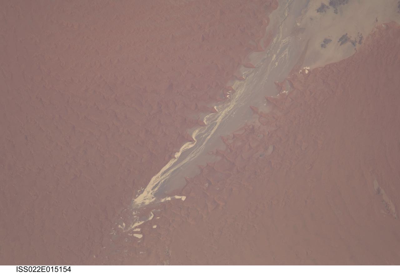
ISS022-E-015154 (24 Dec. 2009) --- Tsauchab River and Sossus Vlei Lakebed, Namibia are featured in this image photographed by an Expedition 22 crew member on the International Space Station. Taken on Christmas Eve of 2009, this image shows the lower 45 kilometers of the Tsauchab River, a famous landmark for Namibians, tourists, and for orbiting astronauts. The Tsauchab River bed is seen jutting into the sea of red dunes near Namibia?s hyper arid coast, where it ends in a series of light-toned silty muds of the dry lake floor, known locally as Sossus Vlei (small lake). Because of the present arid climate, few people have ever seen the Tsauchab River with flowing water or a lake in Sossus Vlei. In times past, however, the Tsauchab appears to have reached the Atlantic coast, another 55 kilometers further west. Like several other rivers of the coastal Namib Desert, the Tsauchab brings sediment down from the hinterland to the coastal lowland. According the scientists, this sediment is then blown from the river beds, and over probably tens of millions of years, has accumulated as the red dunes of the impressive Namib Sand Sea. In this view the sand is heaped up in the form of numerous ?star dunes,? each characterized by long arms extending in several directions. These compare with the better-known barchan dunes (not present in image) that display two horns pointing downwind, which form in areas where winds generally blow from one direction only. By contrast, star dunes are apparently generated in a variable wind regime. In this part of the Sand Sea, winds are mainly from the south, but easterly winds, channeled along the Tsauchab valley, provide another component. And warm dry winter winds?similar to the Santa Ana winds of California, which can cause the hottest annual temperatures to occur briefly on winter days?blow from the northeast. These northeasterly winds are likely responsible for the regular dune arms that point into the valley from both sides. These large dunes facing the river valley are promoted as the highest dunes in the world. Although continuous dune slopes allow hikers to gain more than 300 meters of altitude from the river bottom, this could be misleading since the main base of the dunes lies on a terrace 180 meters above the river.