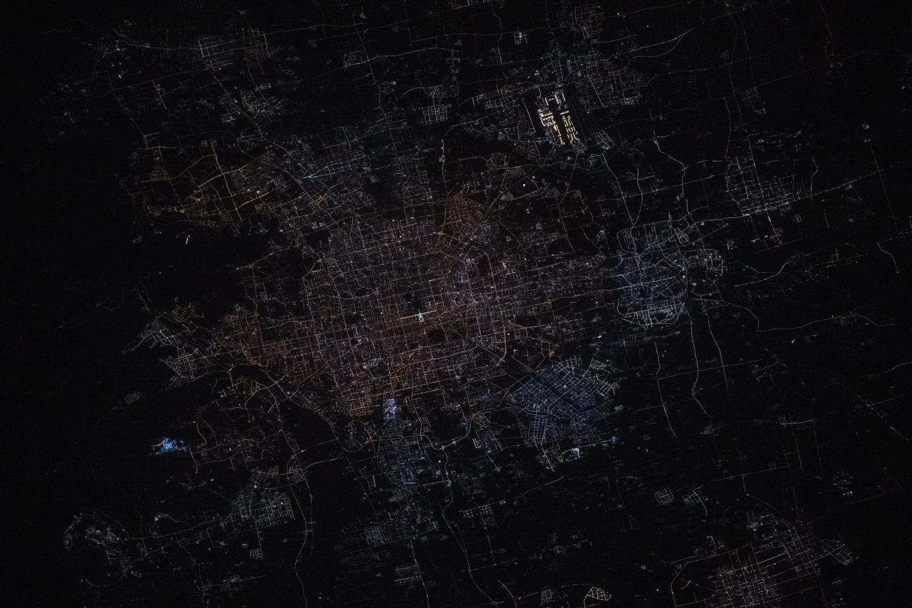
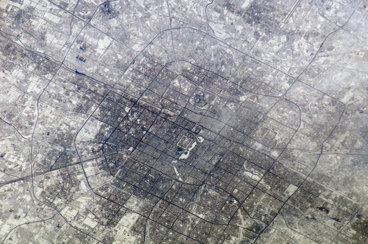
iss072e444944 (Dec. 28, 2024) --- Beijing, China's capital city with a population of about 21.9 million residents, is pictured at approximately 1:31 a.m. local time from the International Space Station as it orbited 259 miles above. Highlights in this photograph include the Forbidden City's well-lit Meridian Gate (center) and the Beijing Capital International Airport (upper right).

iss072e401952 (Dec. 21, 2024) --- The city lights (from left) of Tianjin, Langfang, and Beijing, three cities in China with a combined population of about 41.2 million, are pictured at approximately 4 a.m. local time from the International Space Station as it orbited 259 miles above the Asian nation.
On October 17, 2015, the Moderate Resolution Imaging Spectroradiometer (MODIS) aboard NASA’s Terra satellite captured this true-color image of a thick haze hanging over eastern China. In the north, the large city of Beijing is completely obscured from view, as is much of the landscape. The haze thins slightly over the Bohai Sea. Further south, sediment pours into the East China Sea near the city of Shanghai. Heavy haze is common in this region, and tends to worsen in October through January, when cold, heavy air traps pollutants near the surface of the Earth. It is likely that this scene was caused by such a temperature inversion. Normally, air is warmest near the surface of the Earth. But sometimes a mass of warm air will move the cooler air, so the atmosphere actually warms with the altitude. Cool air does not have energy to rise through the warm air, vertical circulation slows and air becomes trapped near the surface. Any pollution that is emitted into the cooler air will also get trapped, increasing low-level air pollution and haze. Credit: NASA/GSFC/Jeff Schmaltz/MODIS Land Rapid Response Team
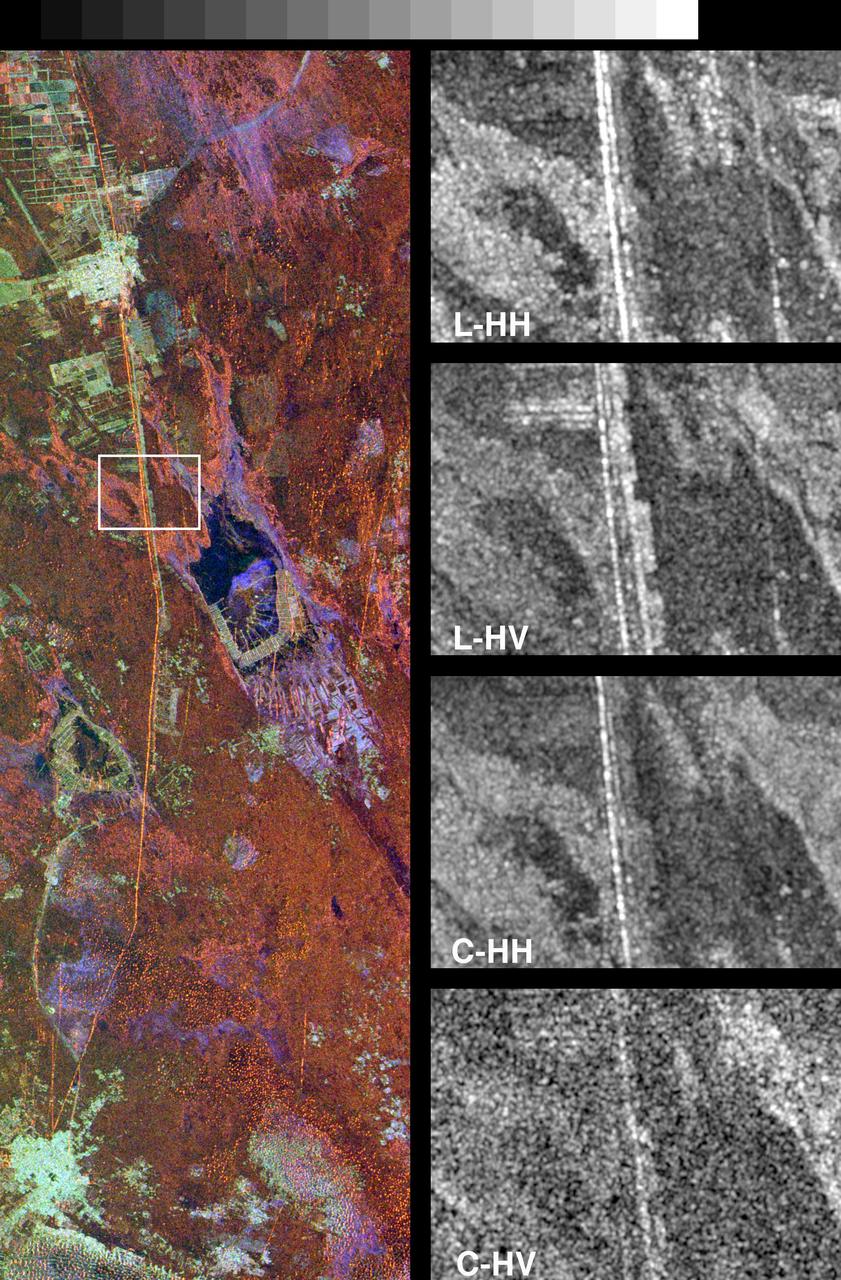
These spaceborne radar images show a segment of the Great Wall of China in a desert region of north-central China, about 700 kilometers 434 miles west of Beijing.
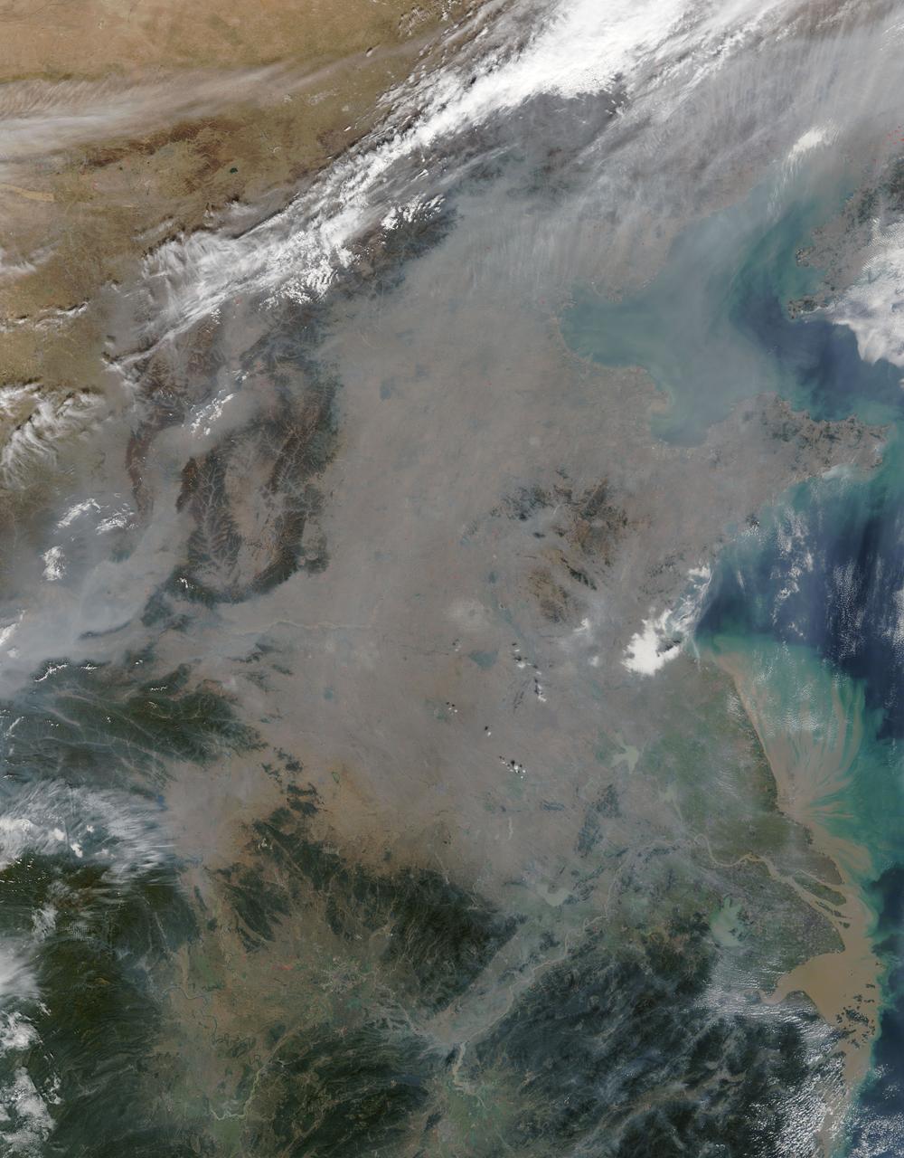
A thick layer of haze blanketed the North China Plain on October 9, 2014, when the Moderate Resolution Imaging Spectroradiometer (MODIS) on NASA’s Terra satellite acquired this natural-color image at 2:50 Coordinated Universal Time (10:50 a.m. local time). The haze obscured many features usually visible in MODIS imagery of the area, including China’s largest city, Beijing. On the day this image was acquired, measurements from ground-based sensors at the U.S. Consulate in Beijing reported PM2.5 measurements of 334 micrograms per cubic meter of air. Fine, airborne particulate matter (PM) that is smaller than 2.5 microns (about one thirtieth the width of a human hair) is considered dangerous because it is small enough to enter the passages of the human lungs. Most PM2.5 aerosol particles come from the burning of fossil fuels and biomass (wood fires and agricultural burning). The World Health Organization considers PM2.5 to be safe when it is below 25. Haze in this region tends to worsen in the fall and winter, when cold, heavy air traps pollutants near the surface. In this case, the haze was likely trapped by a temperature inversion. Normally, air is warmest near the surface of the Earth. Occasionally, a mass of warm air will move over cooler air so that the atmosphere actually warms with altitude. Since the cool air does not have the energy to rise through the warm air, vertical circulation slows and air becomes trapped near the surface. Any pollutant that enters the air gets trapped as well, and haze builds up over time. Daily satellite images of the North China Plain show that visible haze began to accumulate on October 7, 2014. NASA image courtesy Jeff Schmaltz, LANCE MODIS Rapid Response. Caption by Adam Voiland. Read more: <a href="http://earthobservatory.nasa.gov/NaturalHazards/view.php?id=84530&eocn=home&eoci=nh" rel="nofollow">earthobservatory.nasa.gov/NaturalHazards/view.php?id=8453...</a> Credit: <b><a href="http://www.earthobservatory.nasa.gov/" rel="nofollow"> NASA Earth Observatory</a></b> <b><a href="http://www.nasa.gov/audience/formedia/features/MP_Photo_Guidelines.html" rel="nofollow">NASA image use policy.</a></b> <b><a href="http://www.nasa.gov/centers/goddard/home/index.html" rel="nofollow">NASA Goddard Space Flight Center</a></b> enables NASA’s mission through four scientific endeavors: Earth Science, Heliophysics, Solar System Exploration, and Astrophysics. Goddard plays a leading role in NASA’s accomplishments by contributing compelling scientific knowledge to advance the Agency’s mission. <b>Follow us on <a href="http://twitter.com/NASAGoddardPix" rel="nofollow">Twitter</a></b> <b>Like us on <a href="http://www.facebook.com/pages/Greenbelt-MD/NASA-Goddard/395013845897?ref=tsd" rel="nofollow">Facebook</a></b> <b>Find us on <a href="http://instagram.com/nasagoddard?vm=grid" rel="nofollow">Instagram</a></b>
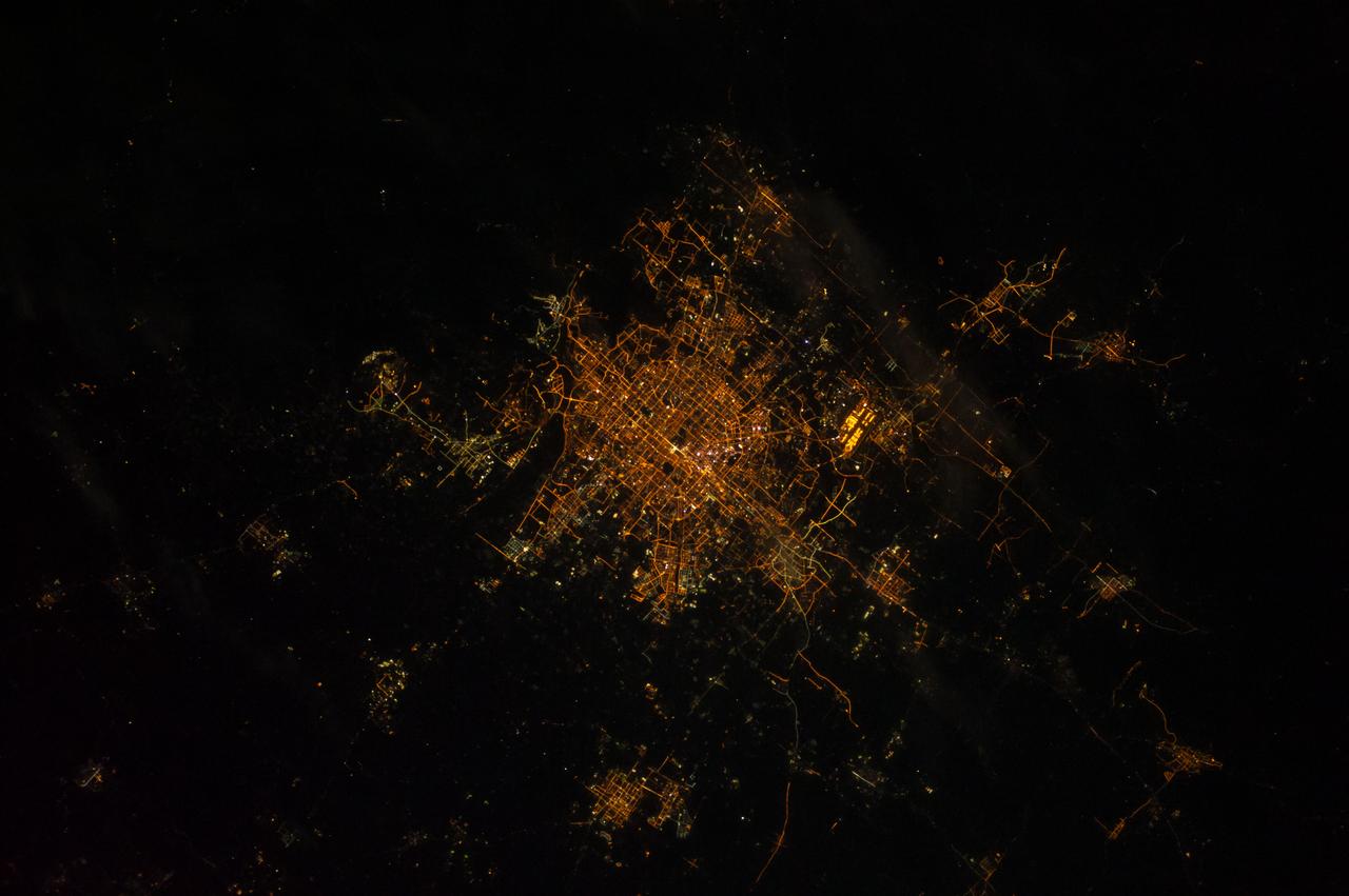
ISS010-E-18196 (18 February 2005) --- The large city Beijing (Peking), China is featured in this image photographed by an Expedition 10 crewmember on the International Space Station.
Earth observation taken during a night pass by the Expedition 40 crew aboard the International Space Station (ISS). Folder lists this as: Beijing wide angle.
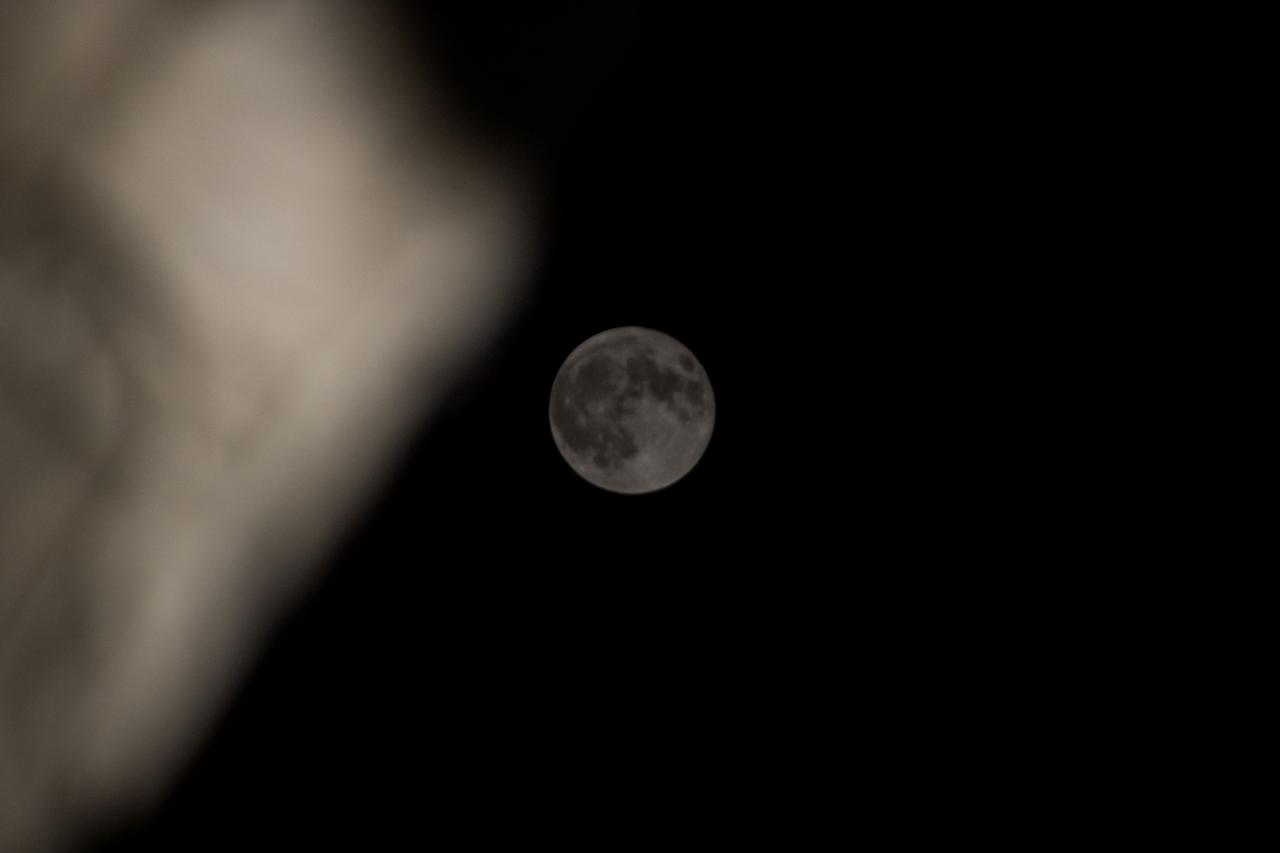
iss071e675220 (Sept. 18, 2024) -- September's full moon, known as the "Harvest Moon," is pictured from the International Space Station as it orbited 260 miles above Beijing.
Earth observation taken during a night pass by the Expedition 40 crew aboard the International Space Station (ISS). Folder lists this as: Beijing wide angle.
Earth observation taken during a night pass by the Expedition 40 crew aboard the International Space Station (ISS). Folder lists this as: Perhaps Beijing.
iss065e013034 (May 1, 2021) --- The night lights of Beijing and Tianjin in China are pictured from the International Space Station as it orbited 264 miles above the Asian continent near the Yellow Sea.
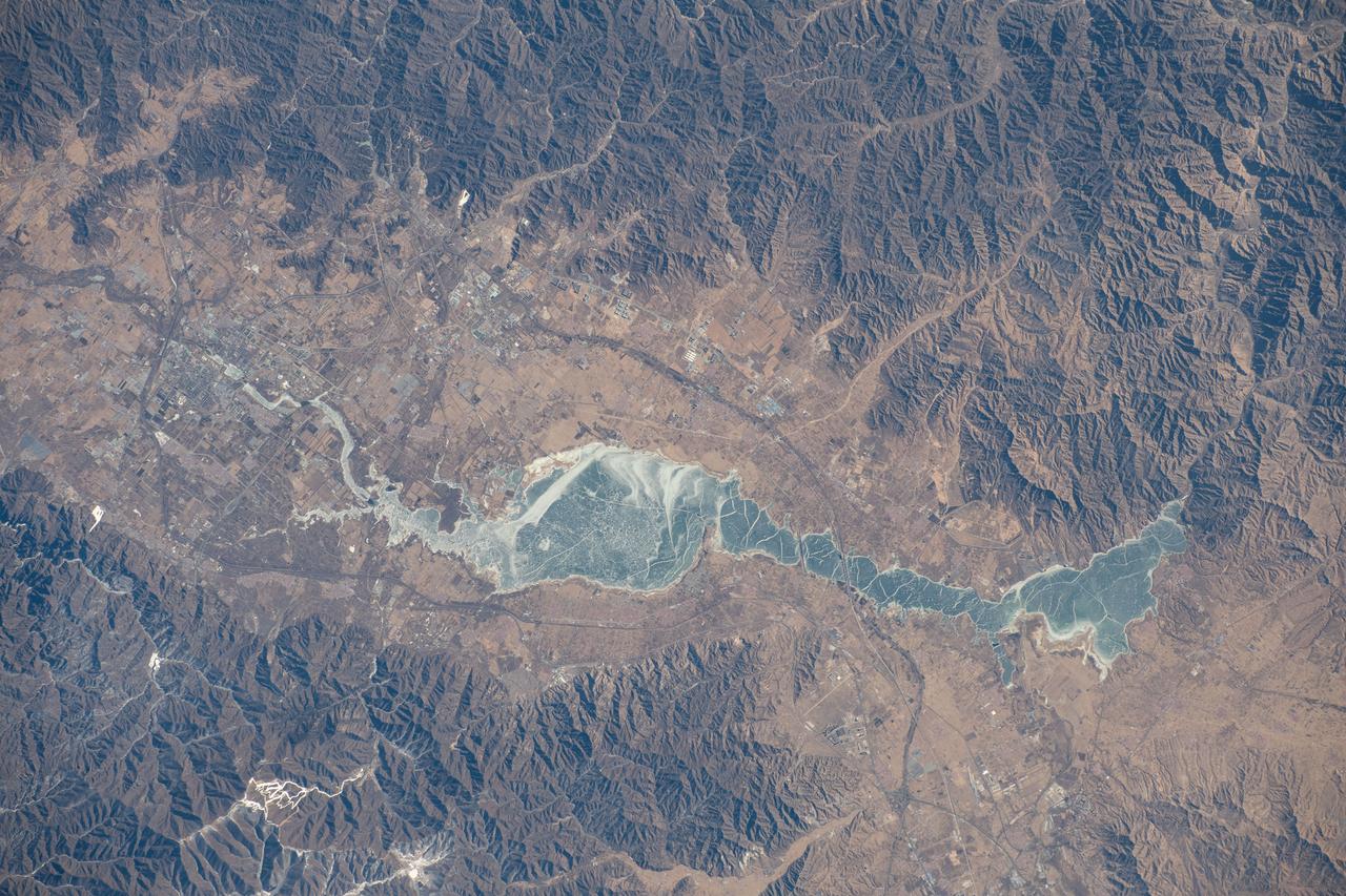
iss070e093517 (Feb. 15, 2024) --- The Guanting Reservoir, northwest of Beijing, China, and surrounded by several smaller cities, is pictured from the International Space Station as it orbited 262 miles above.
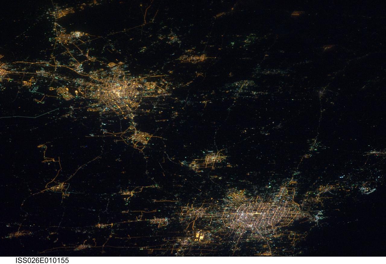
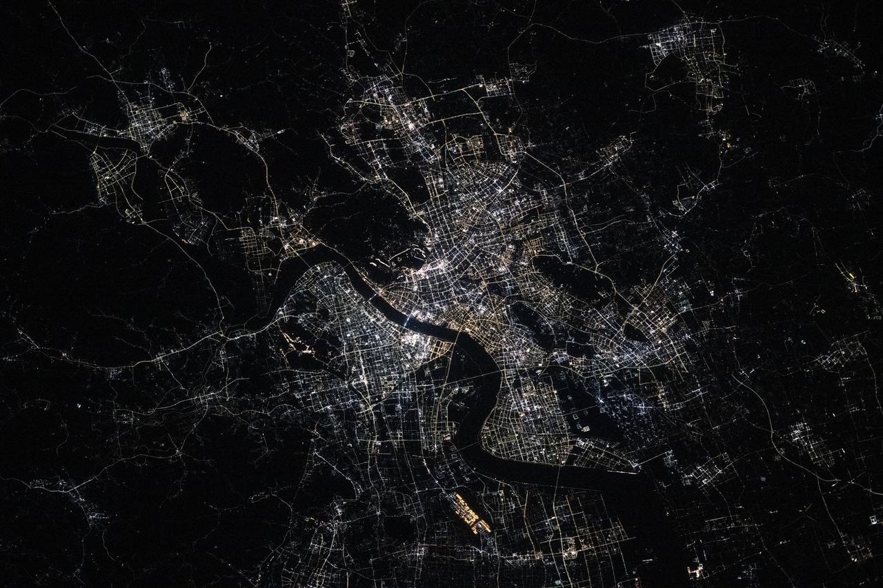
ISS026-E-010155 (14 Dec. 2010) --- Cities at night in northern China are featured in this image photographed by an Expedition 26 crew member on the International Space Station. This striking photograph features two of China’s most populous cities—Beijing and Tianjin—both located in the northern part of the country near the Bohai Gulf. The United Nations estimated 2010 population for the Beijing metropolitan area is approximately 12 million, with the population of the Tianjin metropolitan area estimated to be over 7 million. Taken at night time, the image dramatically indicates the developed extent of both metropolitan areas. The smaller city of Langfang, located midway between Beijing and Tianjin, also is clearly visible as are several other smaller developed areas to the northeast. The dark regions surrounding the well-lit urban areas are mainly agricultural fields, with wheat and corn being the major crops. Beijing (also known as Peking) is one of the recognized ancient capital cities—and the current capital—of the People’s Republic of China. The regular grid pattern of the city is clearly visible at lower upper right; concentric rings of major roadways around the city center have been added as the metropolitan area has expanded. Tianjin is a major trade center with connection to seaports on the Bohai Gulf. The city was established following the integration of the Grand Canal of China, a major artificial waterway extending from Beijing southwards to Hangzhou over a distance of 1,176 kilometers. This image was acquired by astronauts onboard the space station when it was located approximately 630 kilometers away (ground distance) over the Yellow Sea near the western coastline of North Korea. The flattened perspective of the urban areas is a result of the viewing angle and distance from the ISS. The city light patterns are very clear, indicating that there was little cloud cover or haze in the region at the time the image was taken.
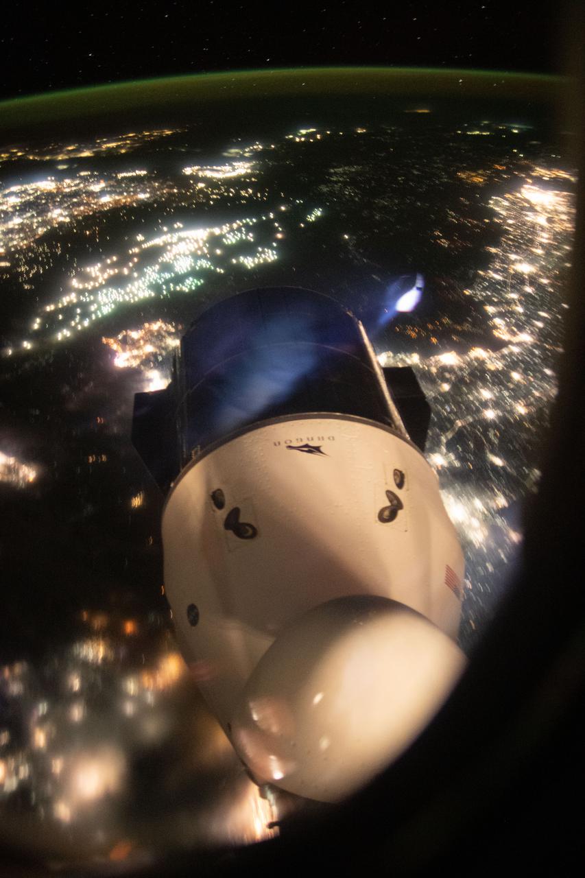
iss065e434288 (Sept. 30, 2021) --- The SpaceX Cargo Dragon resupply ship is pictured from a window on the SpaceX Crew Dragon vehicle. The International Space Station was orbiting 263 miles above Beijing, China, and about to cross over the Yellow Sea at the time this photograph was taken.
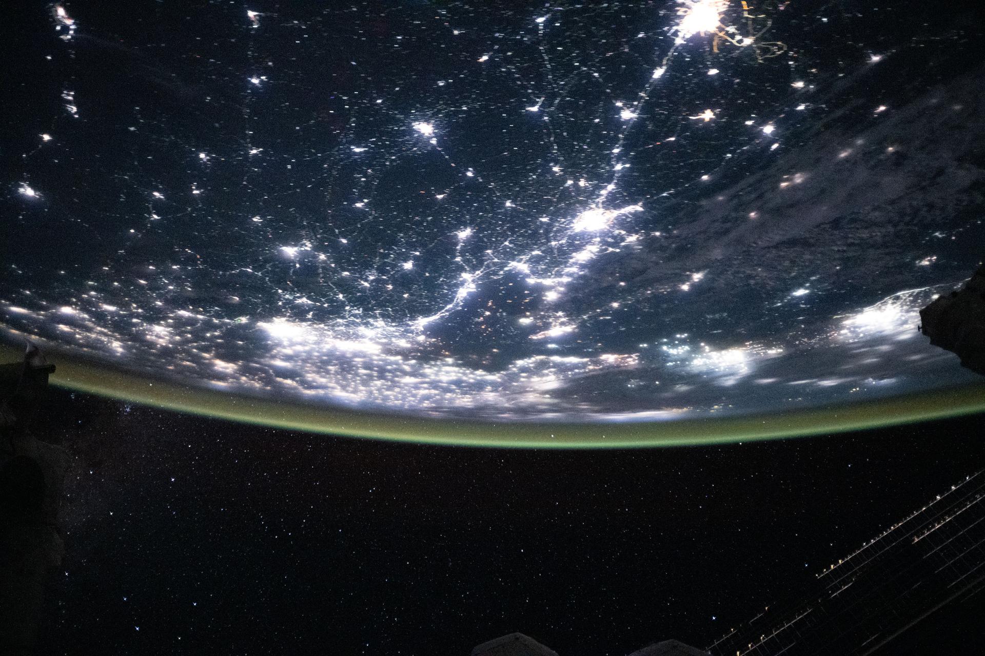
iss073e0824130 (Sept. 14, 2025) --- The Korean Peninsula—highlighted by Seoul, South Korea (bottom left)—and Northeast China—illuminated by the Beijing Municipality (top left)—are pictured from the International Space Station as it orbited 262 miles above Asia at approximately 12:42 a.m. local time.

ISS012-E-21250 (2 March 2006) --- Dust and smog in northeast China are featured in this image photographed by an Expedition 12 crewmember on the International Space Station. Much of the land surface is obscured in this oblique image of the North China Plain and parts of Inner Mongolia. In the center of the view a mass of gray smog—mainly industrial pollution and smoke from domestic burning—obscures Beijing and surrounding cities. Numerous plumes with their source points appear within the mass. Beijing suffers some of the worst air pollution in the world from these chronic sources, and the characteristic colors and textures of the smog can be easily seen through windows of the International Space Station. The coastline of Bo Hai Bay, 300 kilometers east of Beijing, is visible at left. The light brown material in Bo Hai Bay is sediment from the Yellow and other rivers. Separated from the smog mass by a band of puffy, white cumulus clouds is a light brown plume of dust. The line of white cloud has developed along the escarpment that separates the heavily populated North China Plain – location of the largest population agglomeration on Earth – and the sparsely populated semi-desert plains of Inner Mongolia. Observers saw a number of dust events in most Northern Hemisphere deserts in the spring of 2006, and the Gobi and the Takla Makan deserts of western China were no exception. Dust plumes originating in these deserts typically extend eastward hundreds of kilometers, regularly depositing dust on Beijing, the Korean peninsula and Japan. Some plumes even extend over the Pacific Ocean. In extreme cases, visible masses of Gobi-derived dust have reached North America.
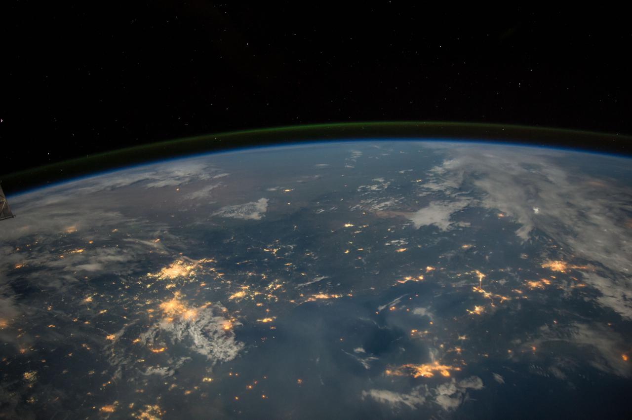
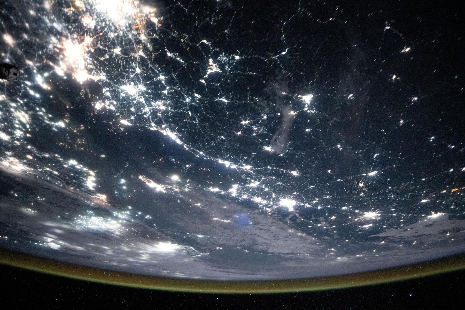
iss073e0820756 (Sept. 14, 2025) --- The densely urbanized region surrounding the Bohai Sea (center) on China's east coast includes several major metropolitan areas, from Beijing (left center) to Changchun (top right), and Seoul, South Korea (far right). A yellow-green airglow blankets Earth's horizon in this image captured from the International Space Station as it orbited 263 miles above the surface at approximately 11:06 p.m. local time.
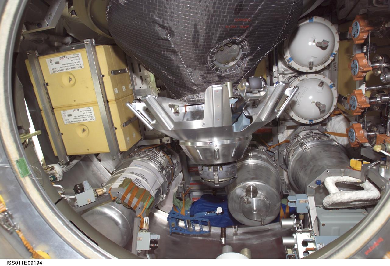
ISS011-E-09194 (19 June 2005) --- View of stowage items and the probe-and-cone docking mechanism in the hatch of the Progress 18 resupply craft, which docked to the aft port of the Zvezda Service Module of the International Space Station at 7:42 p.m. (CDT) on June 18 as the station flew approximately 225 statute miles above a point near Beijing, China. Progress delivered two tons of supplies, food, water, fuel and equipment to the Expedition 11 crewmembers onboard the station.
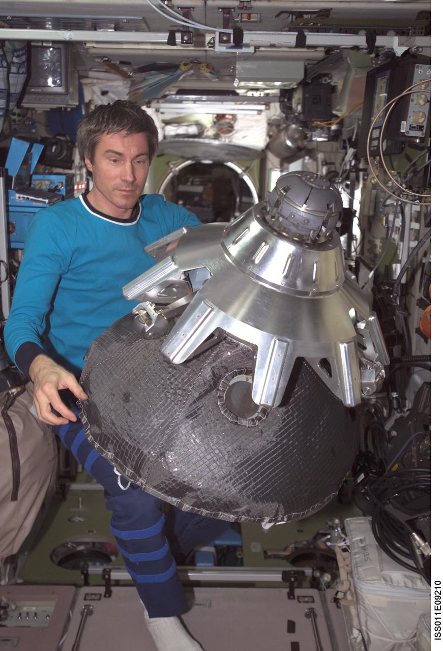
ISS011-E-09210 (19 June 2005) --- Cosmonaut Sergei K. Krikalev, Expedition 11 commander representing Russia's Federal Space Agency, holds the dismantled probe-and-cone docking mechanism from the Progress 18 spacecraft in the Zvezda Service Module of the International Space Station (ISS). The Progress docked to the aft port of the Service Module at 7:42 p.m. (CDT) as the two spacecraft flew approximately 225 statute miles, above a point near Beijing, China.

ISS011-E-09205 (19 June 2005) --- Astronaut John L. Phillips, Expedition 11 NASA ISS science officer and flight engineer, works on the dismantled probe-and-cone docking mechanism from the Progress 18 spacecraft in the Zvezda Service Module of the International Space Station (ISS). The Progress docked to the aft port of the Service Module at 7:42 p.m. (CDT) as the two spacecraft flew approximately 225 statute miles, above a point near Beijing, China.

ISS011-E-09204 (19 June 2005) --- Cosmonaut Sergei K. Krikalev, Expedition 11 commander representing Russia's Federal Space Agency, dismantles the probe-and-cone docking mechanism in the Progress 18 spacecraft. The Progress docked to the aft port of the Zvezda Service Module of the International Space Station (ISS) at 7:42 p.m. (CDT) as the Station flew approximately 225 statute miles, above a point near Beijing, China.
iss073e0420079 (July 3, 2025) --- Hangzhou, China—home to approximately 13 million people and the southern end of the Grand Canal, the longest artificial river in the world—glows in this nighttime view from the International Space Station. The canal stretches over 1,200 miles from its starting point in Beijing. This photograph was taken at approximately 9:55 p.m. local time while the station was orbiting 259 miles above Earth.
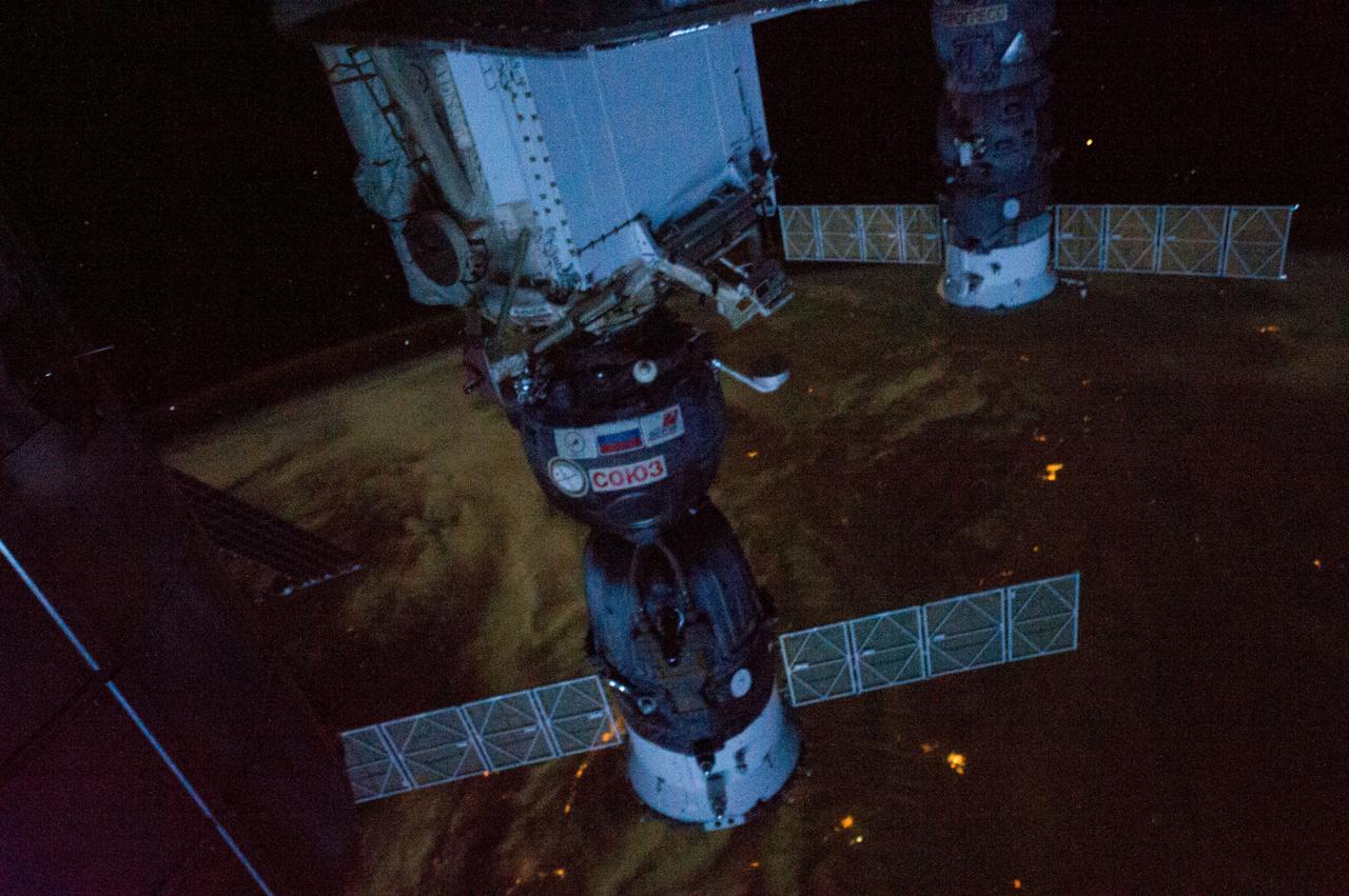
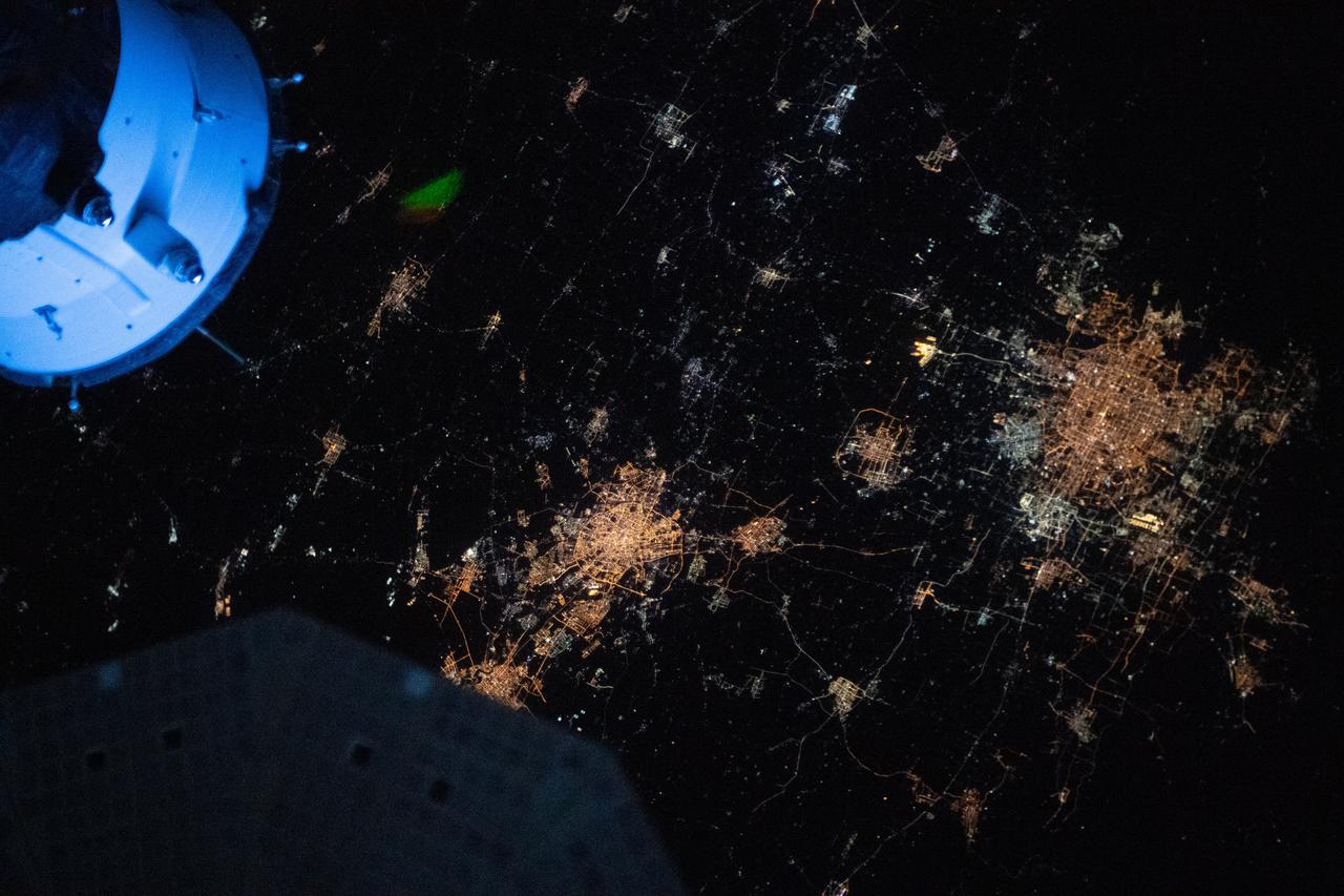
ISS034-E-039039 (1 Feb. 2013) --- The International Space Station was flying over northern China about 500 miles southwest of Beijing when one of the Expedition 32 crew members photographed this interesting night view. Local time was nearly 4 a.m., which means this panoramic view is looking away from daybreak. Two Russian spacecraft -- a Soyuz (center frame) and a Progress -- dominate the foreground. The Soyuz is docked to the Mini-Research Module 1 (MRM-1). The Permanent Multipurpose Module (PMM) is also visible (silhouette at left edge).
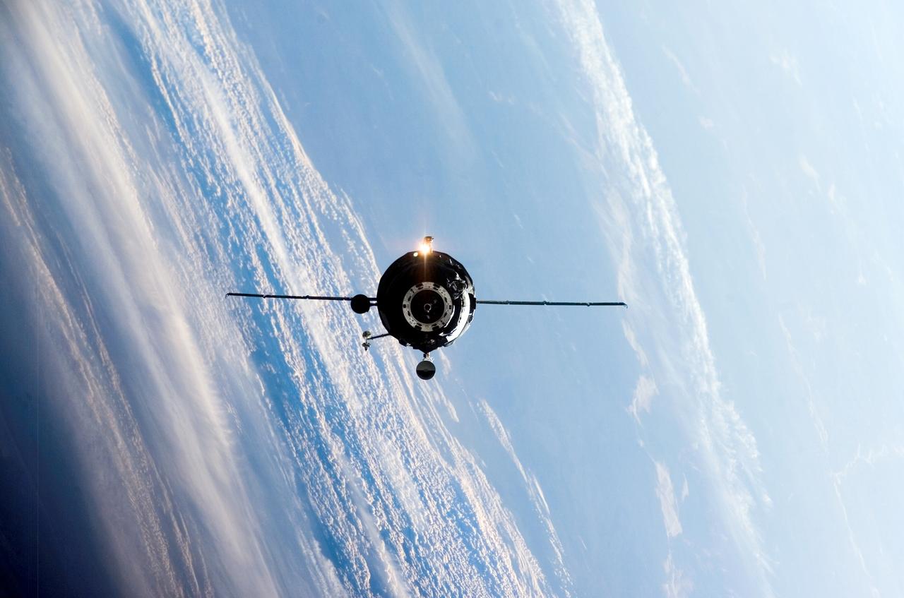
ISS011-E-09178 (18 June 2005) --- Backdropped by a blue and white Earth, an unpiloted Progress supply vehicle approaches the international space station. The Progress 18 resupply craft launched at 6:09 p.m. (CDT) on June 16, 2005 from the Baikonur Cosmodrome in Kazakhstan to deliver two tons of supplies, food, water, fuel and equipment to the Expedition 11 crewmembers onboard the station. Progress docked to the aft port of the Zvezda Service Module at 7:42 p.m. (CDT) on June 18 as the station flew approximately 225 statute miles, above a point near Beijing, China.
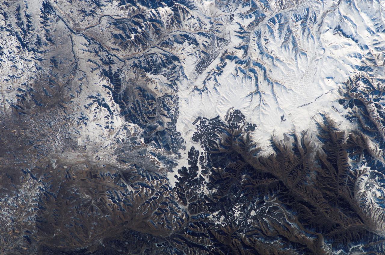
ISS010-E-08497 (24 November 2004) --- This picture, apparently the first verifiable photo showing the Great Wall of China from low earth orbit, was taken by International Space Station Commander Leroy Chiao. Chiao used a digital still camera with a 400mm lens when he snapped the photo early in the Expedition 10 mission on Nov. 24, 2004. The land mass featured is in the central part of Inner Mongolia, about 200 miles north of Beijing. A small section of the wall is visible just below true center of the photo at 42.5 degrees north latitude and 117.4 east longitude, according to NASA scientists studying the Space Station imagery.
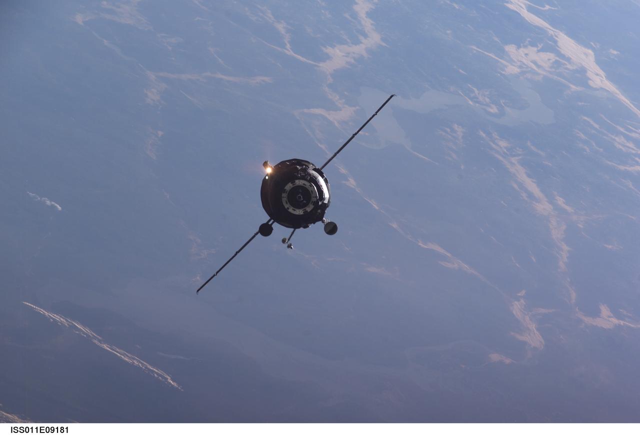
ISS011-E-09181 (18 June 2005) --- An unpiloted Progress supply vehicle approaches the International Space Station. The Progress 18 resupply craft launched at 6:09 p.m. (CDT) on June 16, 2005 from the Baikonur Cosmodrome in Kazakhstan to deliver two tons of supplies, food, water, fuel and equipment to the Expedition 11 crew members onboard the station. Progress docked to the aft port of the Zvezda Service Module at 7:42 p.m. (CDT) on June 18 as the station flew approximately 225 statute miles above a point near Beijing, China.
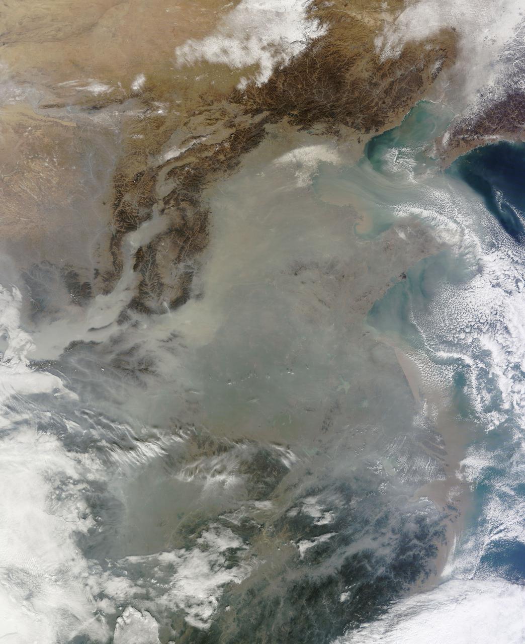
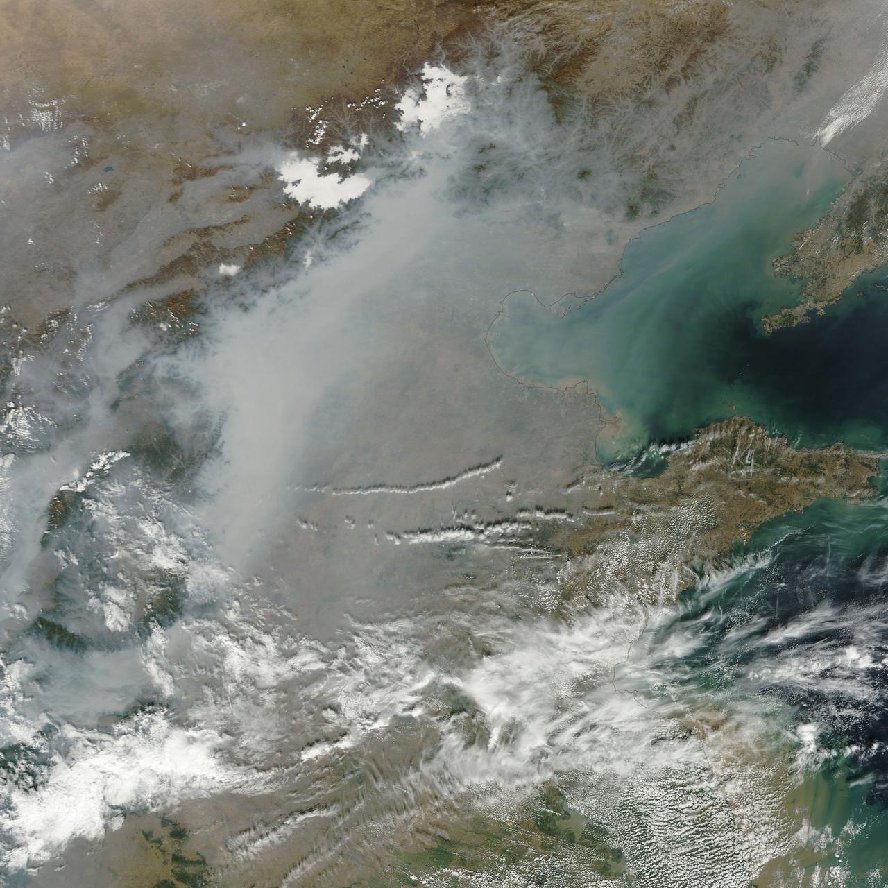
The skies over northern China were shrouded with a thick haze in late December, 2013. The Moderate Resolution Imaging Spectroradiometer (MODIS) aboard the Terra satellite captured this true-color image on December 23. The dense, gray haze obscures almost all the land and much of the coastal waters from view south and east of the Taihang Mountains. Clearer air covers the region north of the mountains, although fingers of haze roll through most river valleys. The cities of Beijing and Hebei, both west of the Bohai Sea are complete enshrouded. By December 24 the smog levels in some area exceeded World Health Organization-recommended levels by 30 times, according to Bloomberg News. The concentration of PM2.5, which are fine air particulates, were reported at 421 micrograms per cubic meter at 2 p.m. near Tiananmen Square in Beijing, while levels were 795 in Xi’an and 740 in Zhengzhou. The World Health Organization (WHO) recommends 24-hour exposure to PM2.5 concentrations no higher than 25 micrograms per cubic meter. While not the sole cause of haze and pollution, the use of coal as a very cheap energy source adds to the problem, particularly north of the Huai River. Prior to 1980, the government policy provided free coal for fuel boilers for all people living north of the Huai River. The widespread use of coal allows people in the north to stay warm in winter, but they have paid a price in air quality. According to Michael Greenstone, a Professor of Environmental Economics at Massachusetts Institute of Technology (MIT), whose research team published a paper on sustained exposure to air pollution on life expectancy in the region, air pollution, as measured by total suspended particulates, was about 55% higher north of the Huai River than south of it, for a difference of around 184 micrograms of particulate matter per cubic meter. The research, published in Proceedings of the National Academy of Sciences in July, 2013, also noted life expectancies were about 5.5 years lower in the north, owing to an increased incidence of cardiorespiratory mortality. Air pollution is an on-going issue for the government of China, and Beijing’s Five-Year Clean Air Action Plan aims to reduce overall particle density by over 25 percent on the PM2.5 scale by 2017, and also takes aim at shutting down all coal-burning plants. Credit: NASA/GSFC/Jeff Schmaltz/MODIS Land Rapid Response Team <b><a href="http://www.nasa.gov/audience/formedia/features/MP_Photo_Guidelines.html" rel="nofollow">NASA image use policy.</a></b> <b><a href="http://www.nasa.gov/centers/goddard/home/index.html" rel="nofollow">NASA Goddard Space Flight Center</a></b> enables NASA’s mission through four scientific endeavors: Earth Science, Heliophysics, Solar System Exploration, and Astrophysics. Goddard plays a leading role in NASA’s accomplishments by contributing compelling scientific knowledge to advance the Agency’s mission. <b>Follow us on <a href="http://twitter.com/NASA_GoddardPix" rel="nofollow">Twitter</a></b> <b>Like us on <a href="http://www.facebook.com/pages/Greenbelt-MD/NASA-Goddard/395013845897?ref=tsd" rel="nofollow">Facebook</a></b> <b>Find us on <a href="http://instagram.com/nasagoddard?vm=grid" rel="nofollow">Instagram</a></b>
ISS012-E-18779 (28 Feb. 2006) --- Winter in the Dasht-e-Lut Desert, eastern Iran is featured in this image photographed by an Expedition 12 crew member on the International Space Station. The image takes advantage of the low angle of illumination to reveal linear geological structures of the Iranian mountain range bordering the western edge of the basin known as Dasht-e-Lut. The range rises 1818 meters (6000 feet) above sea level and lies 750 kilometers (466 miles) north of the Persian Gulf. The convoluted appearance results from erosion of folded and faulted rocks – softer rocks erode away quickly, leaving more resistant rock to form linear ridges perpendicular to the direction of compression. While not a major oil producing region like the Zagros Fold Belt to the southwest, the mountains of east-central Iran contain economically important deposits of copper and other metals. Little vegetation is visible from space in the arid interior basin of the Dasht-e-Lut. Iran is climatically part of the Afro-Asian belt of deserts that stretch from the Cape Verde islands off West Africa all the way to Mongolia near Beijing. The patchy, elongated, light-colored feature in the foreground (parallel to the mountain range) is the northernmost of the Dasht dry lakes that stretch southward 300 kilometers (186 miles). High country is the source of precipitation-derived water in all near-tropical deserts. Agricultural fields (small dark patches in the image) that depend on this precipitation are located down slope near the margin of the dry, salty soils of the lake.
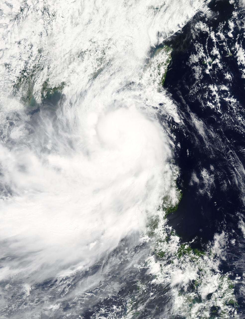
NASA's Aqua satellite captured a picture of Tropical Storm Linfa in the South China Sea on July 7 when it was between southern Taiwan and the northern Philippines. Aqua passed over Linfa on July 7 at 05:25 UTC (1:25 a.m. EDT) and the Moderate Resolution Imaging Spectroradiometer or MODIS instrument captured a visible image of the storm. Bands of thunderstorms wrapping into the center of circulation from the south, draped over western Luzon. The MODIS image showed the tight concentration of thunderstorms around Linfa's center were located over the South China Sea. Fragmented bands of thunderstorms north of the center were brushing over Southern Taiwan while clouds from another band of fragmented thunderstorms stretched northwest through the Taiwan Strait. On July 7 at 1500 UTC (11 a.m. EDT), Tropical Storm Linfa's maximum sustained winds had increased to 50 knots (57.5 mph/92.6 kph), up from 45 knots (51.7 mph/83.3 kph) six hours before. Linfa strengthened in the warm waters of the South China Sea now that its center has moved away from the northern Philippines and was no longer over land. Linfa was centered near 21.0 North latitude and 118.8 East longitude, about 277 nautical miles (319 miles/513.3 km) east-southeast of Hong Kong, China. Linfa has tracked northward at 3 knots (3.5 mph/5.5 kph). China's National Meteorological Centre has (CNMC) issued a yellow category warning of typhoon at 6:00 a.m. July 7, Beijing Time. CNMC noted that Linfa is the tenth typhoon this year and at that time it was centered about 430 km (267.2 miles) southeast of border between Fujian and Guangdong For updated warnings and watches from the China Meteorological Service, visit: <a href="http://www.cma.gov.cn/en/WeatherWarnings/" rel="nofollow">www.cma.gov.cn/en/WeatherWarnings/</a>. Linfa is moving north between Luzon and Taiwan. The Joint Typhoon Warning Center expects Linfa to strengthen to 60 knots (69 mph/111 kph) by mid-day on July 9, before weakening and then making landfall in mainland China. Credit: NASA/GSFC/Jeff Schmaltz/MODIS Land Rapid Response Team <b><a href="http://www.nasa.gov/audience/formedia/features/MP_Photo_Guidelines.html" rel="nofollow">NASA image use policy.</a></b> <b><a href="http://www.nasa.gov/centers/goddard/home/index.html" rel="nofollow">NASA Goddard Space Flight Center</a></b> enables NASA’s mission through four scientific endeavors: Earth Science, Heliophysics, Solar System Exploration, and Astrophysics. Goddard plays a leading role in NASA’s accomplishments by contributing compelling scientific knowledge to advance the Agency’s mission. <b>Follow us on <a href="http://twitter.com/NASAGoddardPix" rel="nofollow">Twitter</a></b> <b>Like us on <a href="http://www.facebook.com/pages/Greenbelt-MD/NASA-Goddard/395013845897?ref=tsd" rel="nofollow">Facebook</a></b> <b>Find us on <a href="http://instagrid.me/nasagoddard/?vm=grid" rel="nofollow">Instagram</a></b>