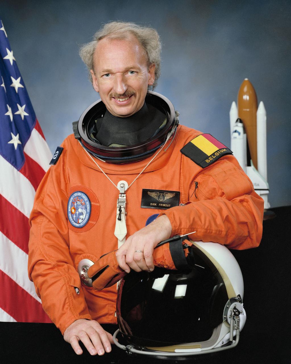
S91-51295 (1991) --- Astronaut Dirk Frimout, payload specialist representing the European Space Agency (ESA).
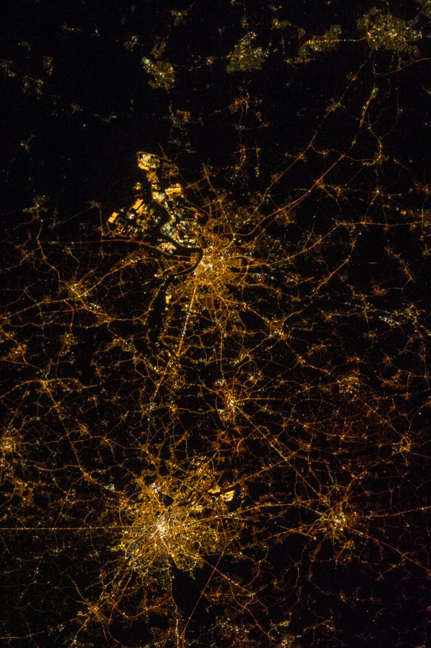
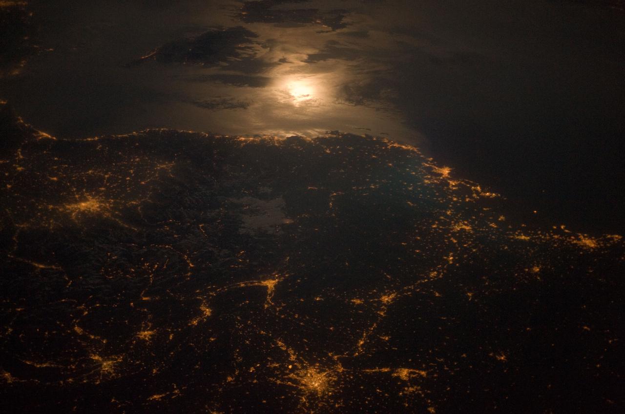
Earth observation taken by the Expedition 39 crew aboard the ISS. Image was released by astronaut on Twitter and downlinked in folder: Belgium area at night.
![jsc2022e057892 (5/12/2022) --- The SpaceOMIX team traveling to Space Applications Services, Brussels, Belgium for sample integration [Credit: Space Applications Services, NV/SA]](https://images-assets.nasa.gov/image/jsc2022e057892/jsc2022e057892~medium.jpg)
jsc2022e057892 (5/12/2022) --- The SpaceOMIX team traveling to Space Applications Services, Brussels, Belgium for sample integration [Credit: Space Applications Services, NV/SA]
![jsc2022e057886 (5/12/2022) --- ICE Cubes mission control centre at the Space Applications Services, Brussels, Belgium [credit: Space Applications Services, NV/SA]](https://images-assets.nasa.gov/image/jsc2022e057886/jsc2022e057886~medium.jpg)
jsc2022e057886 (5/12/2022) --- ICE Cubes mission control centre at the Space Applications Services, Brussels, Belgium [credit: Space Applications Services, NV/SA]
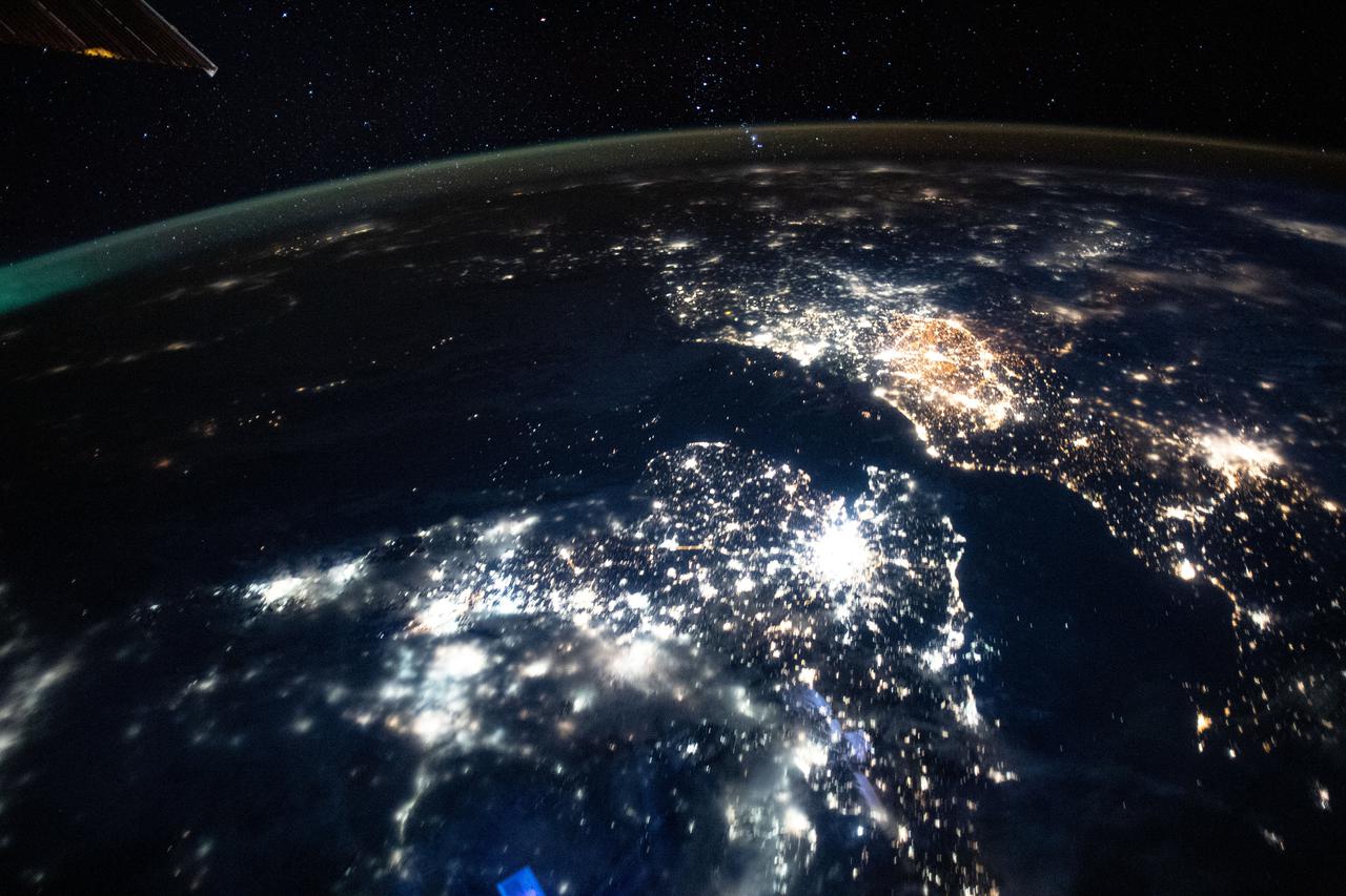
iss065e385457 (Sept. 15, 2021) --- The International Space Station was orbiting 265 miles above the north Atlantic Ocean when an Expedition 65 crew member captured this photograph of the city lights of England, The Netherlands, Belgium and France.
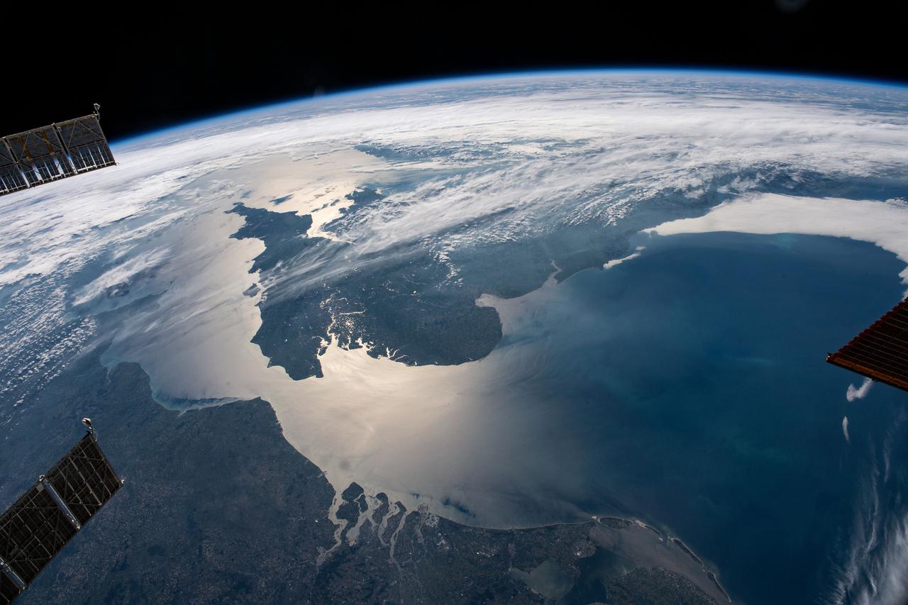
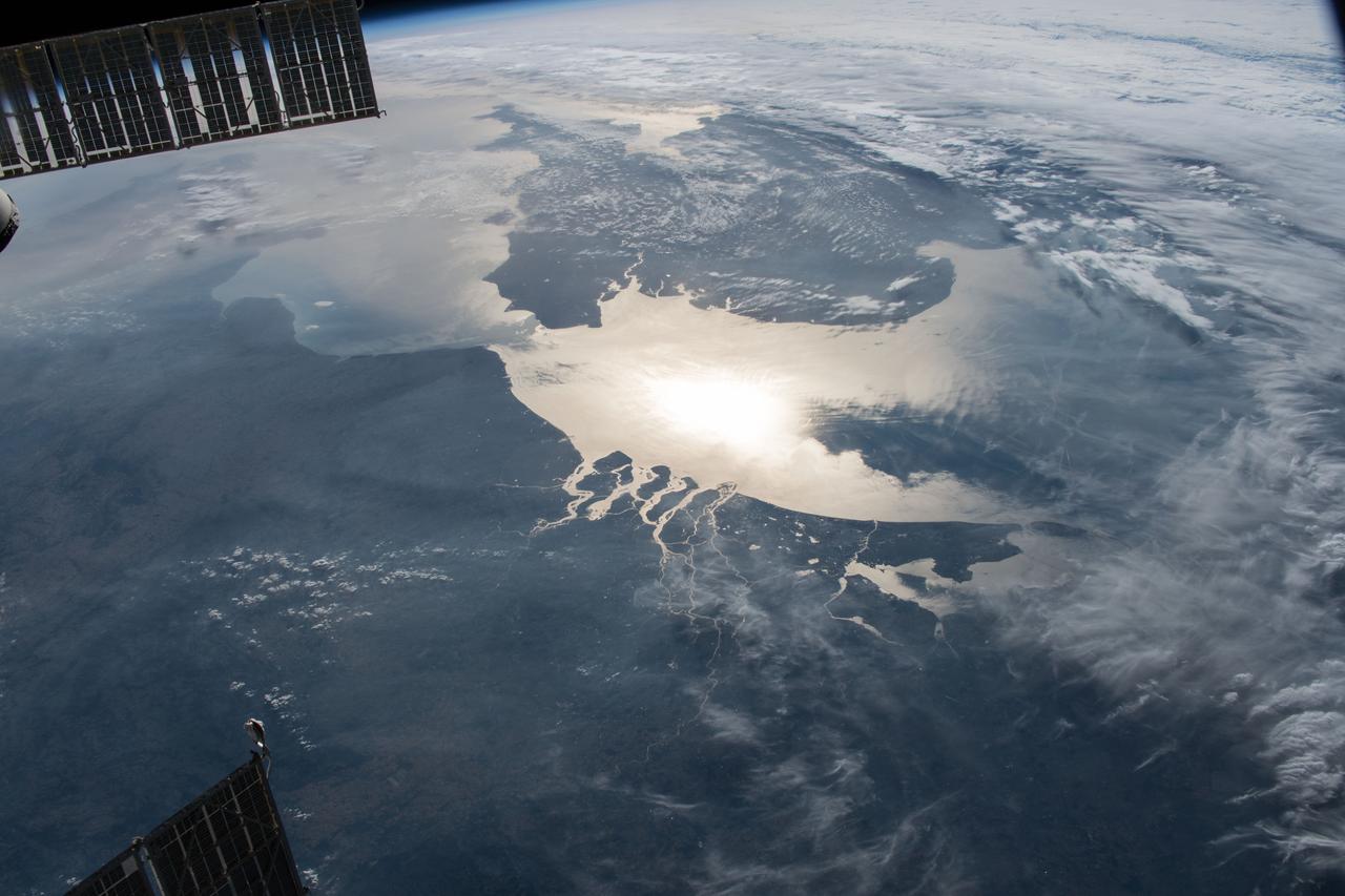
iss065e083895 (June 1, 2021) --- The sun's glint beams across the English Channel and the North Sea in between southern England and the coasts of France, Belgium and The Netherlands, in this photograph from the International Space Station as it orbited 263 miles above.
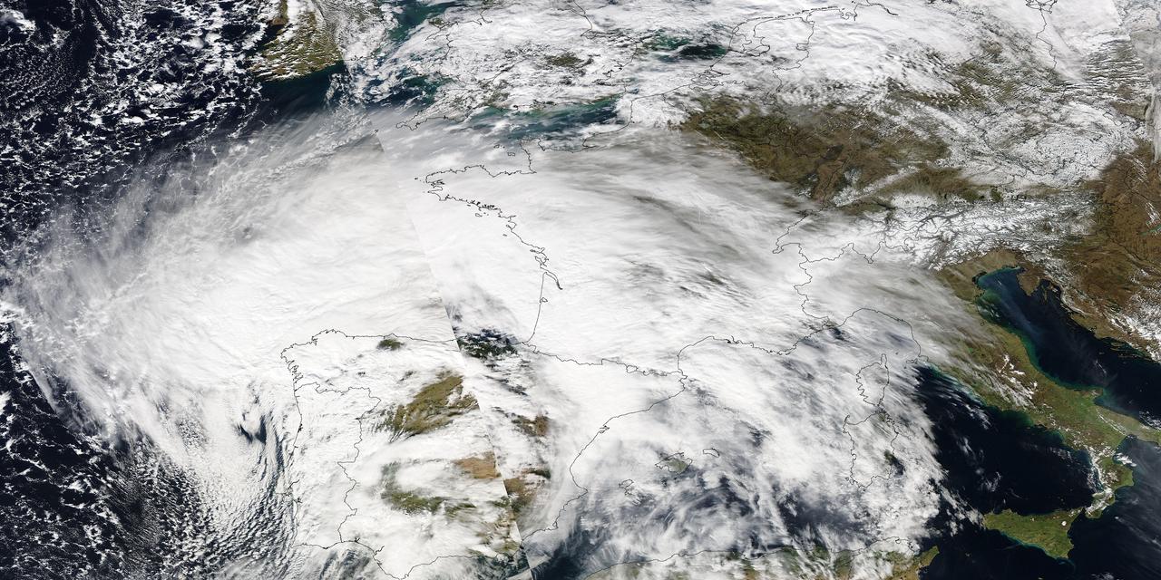
Image acquired February 27, 2010: An extratropical cyclone named Xynthia brought hurricane-force winds and high waves to Western Europe at the end of February 2010, CNN reported. Winds as fast as 200 kilometers (125 miles) per hour reached as far inland as Paris, and at the storm’s peak, hurricane-force winds extended from Portugal to the Netherlands. Hundreds of people had to take refuge from rising waters on their rooftops. By March 1, at least 58 people had died, some of them struck by falling trees. Most of the deaths occurred in France, but the storm also caused casualties in England, Germany, Belgium, Spain, and Portugal. The Moderate Resolution Imaging Spectroradiometer (MODIS) on NASA’s Aqua satellite captured this image of Western Europe, acquired in two separate overpasses on February 27, 2010. MODIS captured the eastern half of the image around 10:50 UTC, and the western half about 12:30 UTC. Forming a giant comma shape, clouds stretch from the Atlantic Ocean to northern Italy. NASA image courtesy MODIS Rapid Response Team at NASA Goddard Space Flight Center. Caption by Michon Scott. Instrument: Aqua - MODIS For more information related to this image go to: <a href="http://earthobservatory.nasa.gov/NaturalHazards/view.php?id=42881" rel="nofollow">earthobservatory.nasa.gov/NaturalHazards/view.php?id=42881</a>
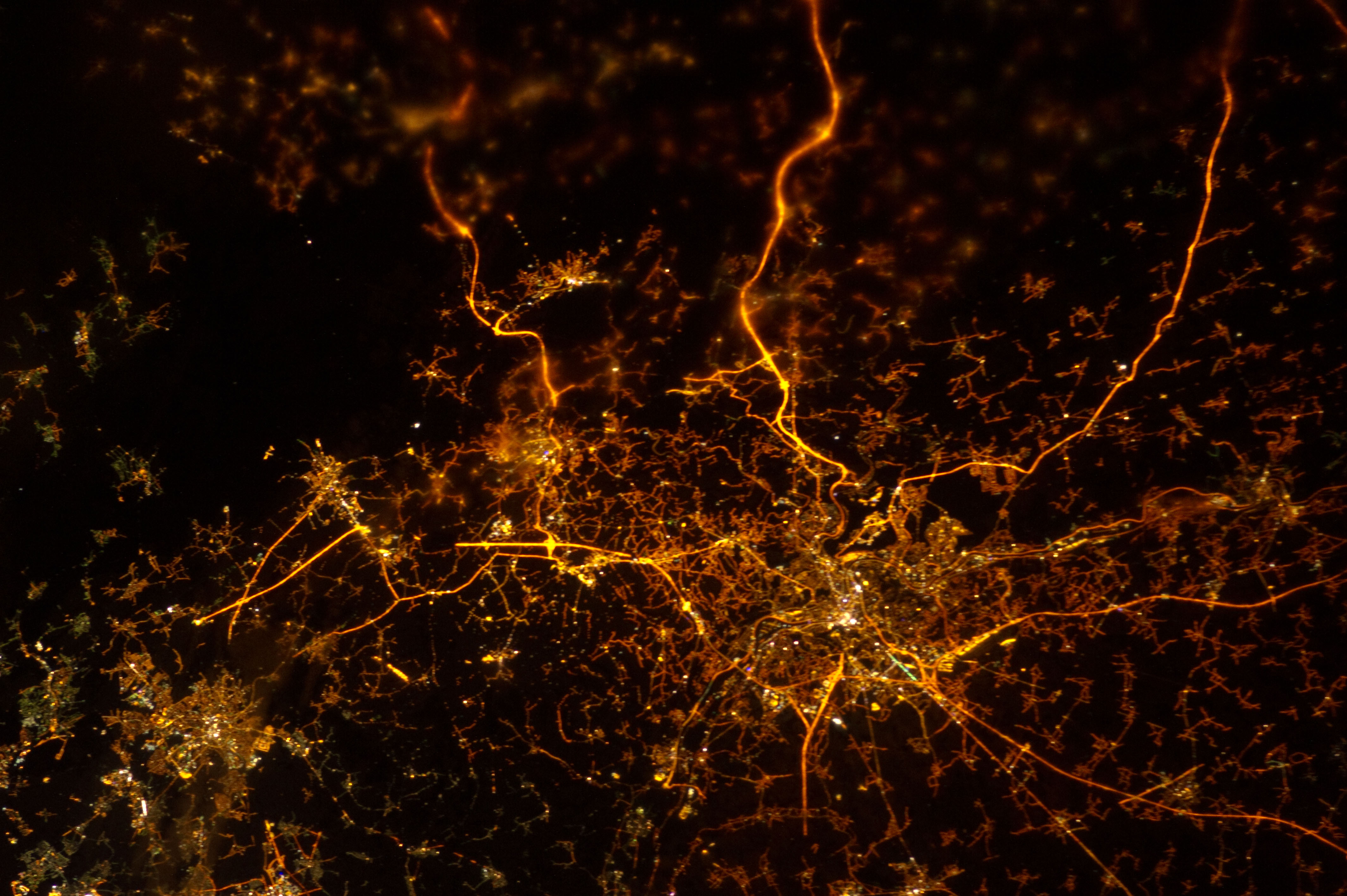
ISS034-E-005935 (8 Dec. 2012) --- A nighttime view of Liege, Belgium is featured in this image photographed by an Expedition 34 crew member on the International Space Station. To paraphrase the old expression, “all roads lead to Liege” – or at least one could get that impression from this nighttime photograph. The brightly lit core of the Liege urban area appears to lie at the center of a network of roadways—traceable by continuous orange lighting—extending outwards into the rural, and relatively dark, Belgium countryside. For a sense of scale the distance from left to right is approximately 70 kilometers. The region at upper left to the southeast of Verviers includes agricultural fields and forest; hence it appears almost uniformly dark at night. The image was taken using the European Space Agency’s Nodding mechanism, also known as the NightPod. NightPod is an electro-mechanical mount system designed to compensate digital cameras for the motion of the space station relative to Earth. The primary mission goal was to take high-resolution, long exposure digital imagery of Earth from the station’s Cupola, particularly cities at night. While the official NightPod mission has been completed, the mechanism remains onboard for crew members to use. Liege is the third most populous metropolitan region in Belgium (after Brussels and Antwerp); it includes 52 municipalities, including the nearby city of Seraing.
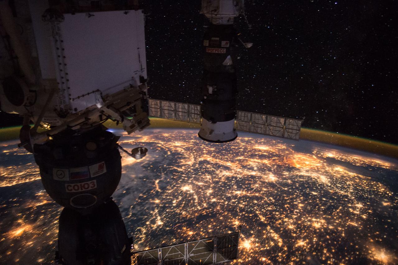
ISS049e009356 (09/24/2016) --- Earth observation taken during a night pass by the Expedition 49 crew aboard the International Space Station. Framed by the docked Soyuz and Progress spacecraft is Western Europe. The bright, dense lights in the East are the Netherlands, Belgium. The dark strip is the Alps
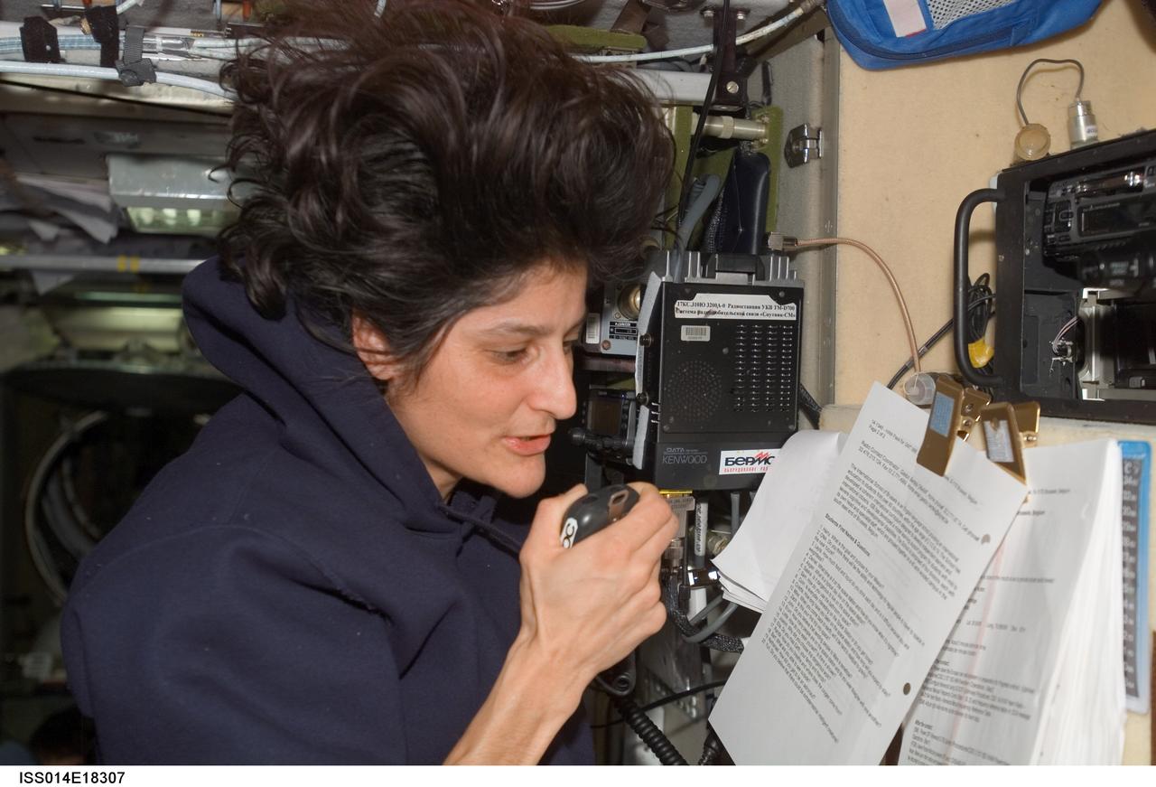
ISS014-E-18307 (27 March 2007) --- Astronaut Sunita L. Williams, Expedition 14 flight engineer, talks with students at the International School of Brussels in Belgium during an Amateur Radio on the International Space Station (ARISS) contact in the Zvezda Service Module.
iss056e127185 (Aug. 6, 2018) --- The International Space Station was orbiting above Germany when an Expedition 56 crew member photographed the English Channel and the North Sea, lit by the Sun's glint, separating the United Kingdom from the European countries of France, Belgium and the Netherlands.
ISS014-E-18306 (27 March 2007) --- Astronaut Sunita L. Williams, Expedition 14 flight engineer, talks with students at the International School of Brussels in Belgium during an Amateur Radio on the International Space Station (ARISS) contact in the Zvezda Service Module.
ISS030-E-048067 (22 Jan. 2012) --- With hardware from the Earth-orbiting International Space Station appearing in the near foreground, a night time European panorama reveals city lights from Belgium and the Netherlands at bottom center, the British Isles partially obscured by solar array panels at left, the North Sea at left center, and Scandinavia at right center beneath the end effector of the Space Station Remote Manipulator System or Canadarm2.
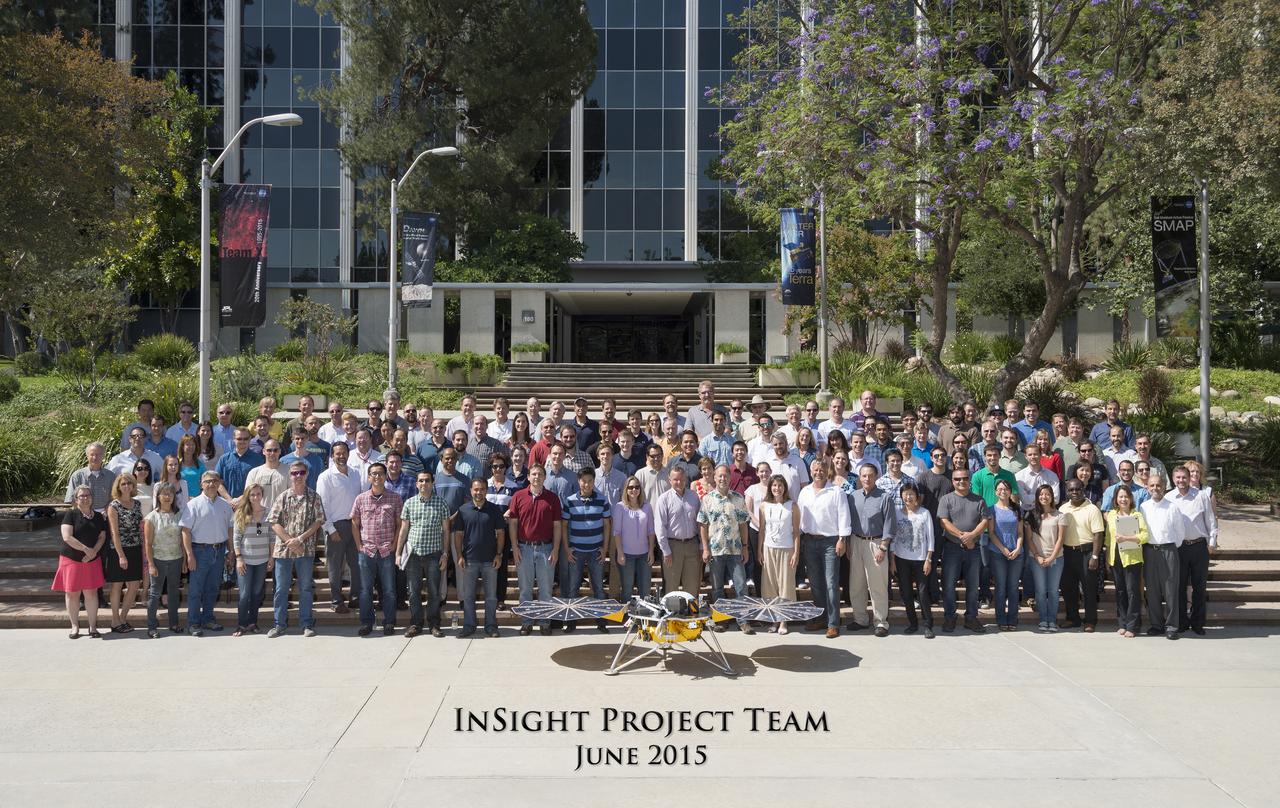
The InSight Team at NASA's Jet Propulsion Laboratory, JPL, in June 2015. The InSight team is comprised of scientists and engineers from multiple disciplines and is a unique collaboration between countries and organizations around the world. The science team includes co-investigators from the U.S., France, Germany, Austria, Belgium, Canada, Japan, Switzerland and the United Kingdom. https://photojournal.jpl.nasa.gov/catalog/PIA22234
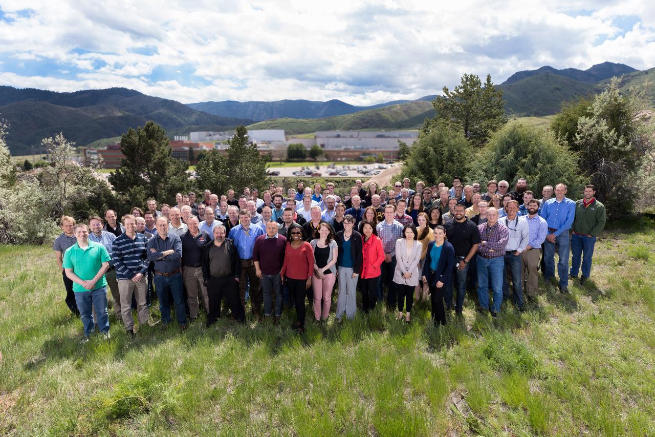
The InSight Team at Lockheed Martin Space in May 2017 The InSight team is comprised of scientists and engineers from multiple disciplines and is a unique collaboration between countries and organizations around the world. The science team includes co-investigators from the U.S., France, Germany, Austria, Belgium, Canada, Japan, Switzerland and the United Kingdom. https://photojournal.jpl.nasa.gov/catalog/PIA22235
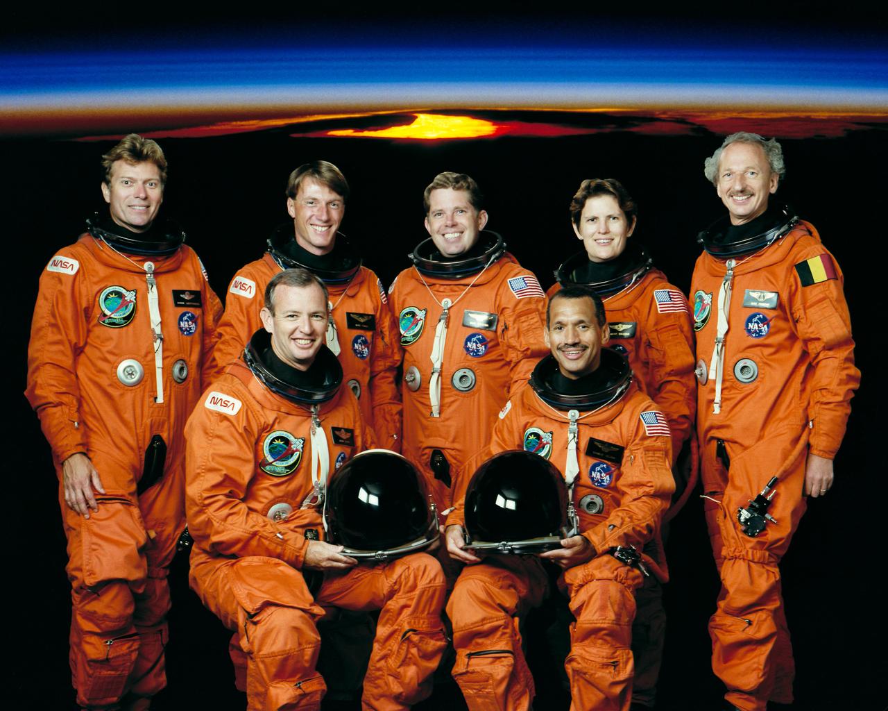
STS045-S-002 (January 1992) --- The seven crew members for NASA's STS-45 mission are pictured in their partial-pressure launch and entry suits. In front are astronauts Charles F. Bolden, Jr. (right), mission commander, and Brian Duffy, pilot. Back row, left to right, are payload specialist Byron K. Lichtenberg; astronauts C. Michael Foale and David C. Leestma, mission specialists; Kathryn D. Sullivan, payload commander; and payload specialist Dirk Frimout, of Belgium. The Atmospheric Laboratory for Applications and Science (ATLAS) is scheduled for a March 1992 launch aboard the Space Shuttle Atlantis.

This artist's digital concept depicts the completely assembled International Space Station (ISS) passing over Florida. As a gateway to permanent human presence in space, the Space Station Program is to expand knowledge benefiting all people and nations. The ISS is a multidisciplinary laboratory, technology test bed, and observatory that will provide unprecedented undertakings in scientific, technological, and international experimentation. Experiments to be conducted in the ISS include: microgravity research, Earth science, space science, life sciences, space product development, and engineering research and technology. The sixteen countries participating the ISS are: United States, Russian Federation, Canada, Japan, United Kingdom, Germany, Italy, France, Norway, Netherlands, Belgium, Spain, Denmark, Sweden, Switzerland, and Brazil.

This artist's concept depicts the completely assembled International Space Station (ISS) passing over Florida and the Bahamas. As a gateway to permanent human presence in space, the Space Station Program is to expand knowledge benefiting all people and nations. The ISS is a multidisciplinary laboratory, technology test bed, and observatory that will provide unprecedented undertakings in scientific, technological, and international experimentation. Experiments to be conducted in the ISS include: microgravity research, Earth science, space science, life sciences, space product development, and engineering research and technology. The sixteen countries participating in the ISS are: United States, Russian Federation, Canada, Japan, United Kingdom, Germany, Italy, France, Norway, Netherlands, Belgium, Spain, Denmark, Sweden, Switzerland, and Brazil.
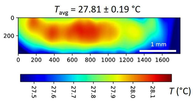
jsc2024e065172 (10/3/2024) --- A temperature map is seen within a microgel suspension illuminated by the Colloidal Solids (COLIS) near infrared laser (NIR). Reference ground tests for the Colloidal Solids (COLIS) investigation show spatial variation of the sample temperature while illuminating an aqueous, dense suspension of thermosensitive microgels with a 0.5 s pulse of NIR laser light. The NIR beam propagates from left to right. The sample temperature with no NIR laser is uniform and set to 27°C. The temperature values are inferred from the change in scattered intensity at a scattering angle of 90°, as recorded by one of the complementary metal-oxide-semiconductor (CMOS) cameras of COLIS. Results from this investigation are expected to provide a deeper understanding of soft solid interactions with gravity and microgravity, paving the way for the design of new materials. Image courtesy of Redwire Space Laboratories, Kruibeke – Belgium.

This artist's concept depicts the completely assembled International Space Station (ISS) passing over the Straits of Gibraltar and the Mediterranean Sea. As a gateway to permanent human presence in space, the Space Station Program is to expand knowledge benefiting all people and nations. The ISS is a multidisciplinary laboratory, technology test bed, and observatory that will provide unprecedented undertakings in scientific, technological, and international experimentation. Experiments to be conducted in the ISS include: microgravity research, Earth science, space science, life sciences, space product development, and engineering research and technology. The sixteen countries participating the ISS are: United States, Russian Federation, Canada, Japan, United Kingdom, Germany, Italy, France, Norway, Netherlands, Belgium, Spain, Denmark, Sweden, Switzerland, and Brazil.
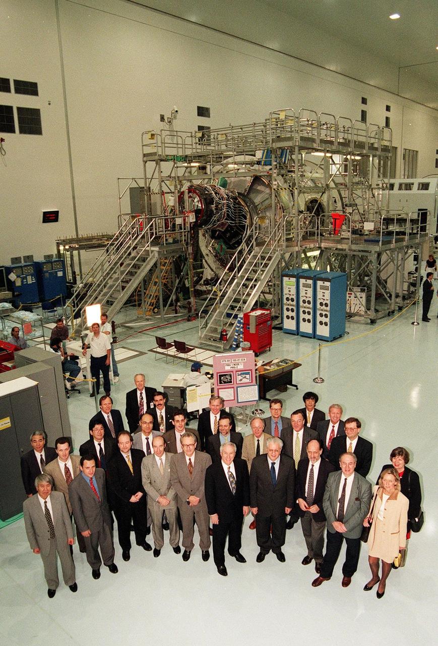
CAPE CANAVERAL, Fla. -- In the International Space Station Processing Facility at NASA's Kennedy Space Center in Florida, senior government officials from 15 countries participating in the space station program signed agreements in Washington D.C. on Jan. 29 to establish the framework of cooperation among the partners on the design, development, operation and utilization of the space station. Acting Secretary of State Strobe Talbott signed the 1998 Intergovernmental Agreement on Space Station Cooperation with representatives of Russia, Japan, Canada, and participating countries of the European Space Agency ESA -- Belgium, Denmark, France, Germany, Italy, the Netherlands, Norway, Spain, Sweden, Switzerland, and the United Kingdom. Some of these officials then toured Kennedy's Space Station Processing Facility SSPF with NASA Administrator Daniel Goldin, at front, sixth from the left. They are, left to right, front to back: Hidetoshi Murayama, National Space Development Agency of Japan NASDA Louis Laurent, Embassy of France Haakon Blankenborg, Norwegian Parliament Standing Committee on Foreign Affairs His Excellency Joris Vos, ambassador of the Netherlands His Excellency Tom Vraalsen, ambassador of Norway Goldin Luigi Berlinguer, Italian minister for education, scientific, and technological research Antonio Rodota, director general, ESA Yvan Ylieff, Belgian minister of science and chairman of the ESA Ministerial Council Jacqueline Ylieff Masaaki Komatsu, Kennedy local NASDA representative and interpreter Serge Ivanets, space attache, Embassy of Russia Hiroshi Fujita, Science and Technology Agency of Japan Akira Mizutani, Japanese Ministry of Foreign Affairs Peter Grognard, science attache', Royal Embassy of Belgium Michelangelo Pipan, Italian diplomatic counselor to the minister His Excellency Gerhard Fulda, German Federal Foreign Office Jorg Feustel-Buechl, ESA director of manned space flight and microgravity A. Yakovenko, Russian Ministry of Foreign Affairs JoAnn Morgan, Kennedy associate director for Advanced Development and Shuttle Upgrades Steve Francois, director, International Space Station and Shuttle Processing Roy Tharpe, Boeing launch site manager Jon Cowart, ISS elements manager John Schumacher, NASA associate administrator for external relations Didier Kechemair, space advistor to the French minister for education, research, and technology Yoshinori Yoshimura, NASDA and Loren Shriver, Kennedy deputy director for launch and payload processing. Node 1 of the ISS is in the background. Photo Credit: NASA
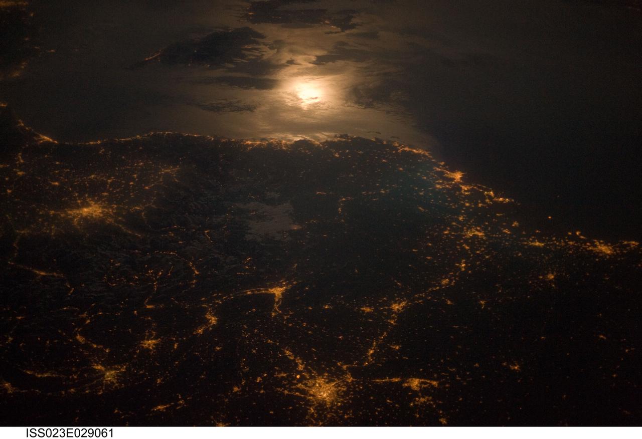
ISS023-E-029061 (28 April 2010) --- City lights at night along the France-Italy border, Europe are featured in this image photographed by an Expedition 23 crew member on the International Space Station (ISS). The brightly lit metropolitan areas of Torino (Italy), Lyon, and Marseille (both in France) stand out amidst numerous smaller urban areas in this dramatic photograph. The image captures the night time appearance of the France-Italy border area between the mountainous Alps to the north (not shown) and the island of Corsica in the Ligurian Sea to the south (top). The full moon reflects brightly on the water surface and also illuminates the tops of low patchy clouds over the border (center). This image was taken by an ISS crew member at approximately 11:55 p.m. local time when the station was located over the France-Belgium border near Luxembourg. Crew members orbiting Earth frequently collect images that include sunglint, or sunlight that reflects off a water surface at such an angle that it travels directly back towards the observer. Sunglint typically lends a mirror-like appearance to the water surface. During clear sky conditions reflected light from the moon can produce the same effect (moon glint) as illustrated in this view. The observer was looking towards the southeast at an oblique viewing angle at the time the image was taken; in other words, looking outwards from the ISS, not straight down towards Earth.
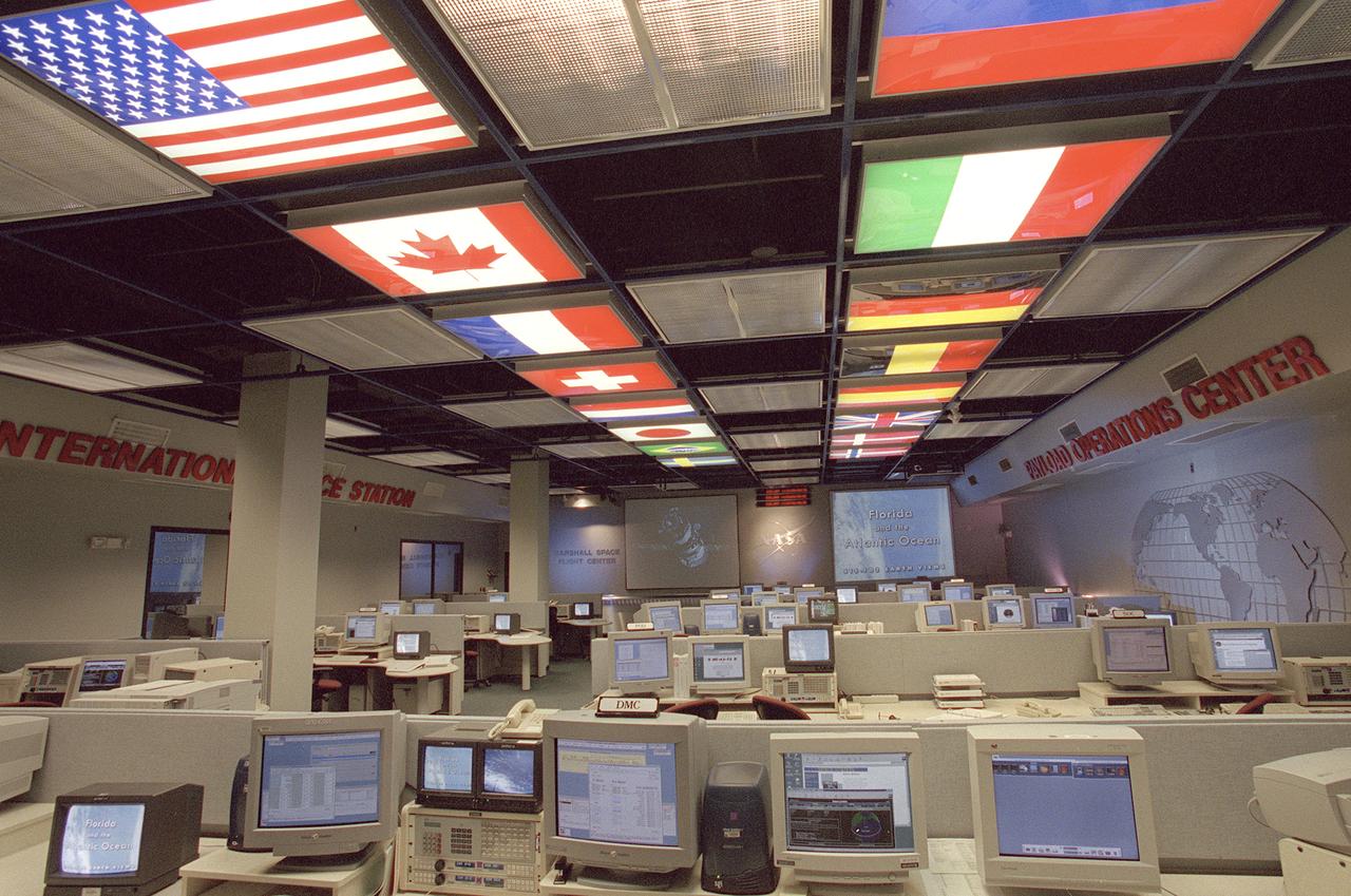
The International Space Station (ISS) Payload Operations Center (POC) at NASA's Marshall Space Flight Center (MSFC) in Huntsville, Alabama, is the world's primary science command post for the International Space Station (ISS), the most ambitious space research facility in human history. The Payload Operations team is responsible for managing all science research experiments aboard the Station. The center is also home for coordination of the mission-plarning work of variety of international sources, all science payload deliveries and retrieval, and payload training and safety programs for the Station crew and all ground personnel. Within the POC, critical payload information from the ISS is displayed on a dedicated workstation, reading both S-band (low data rate) and Ku-band (high data rate) signals from a variety of experiments and procedures operated by the ISS crew and their colleagues on Earth. The POC is the focal point for incorporating research and experiment requirements from all international partners into an integrated ISS payload mission plan. This photograph is an overall view of the MSFC Payload Operations Center displaying the flags of the countries participating the ISS. The flags at the left portray The United States, Canada, France, Switzerland, Netherlands, Japan, Brazil, and Sweden. The flags at the right portray The Russian Federation, Italy, Germany, Belgium, Spain, United Kingdom, Denmark, and Norway.
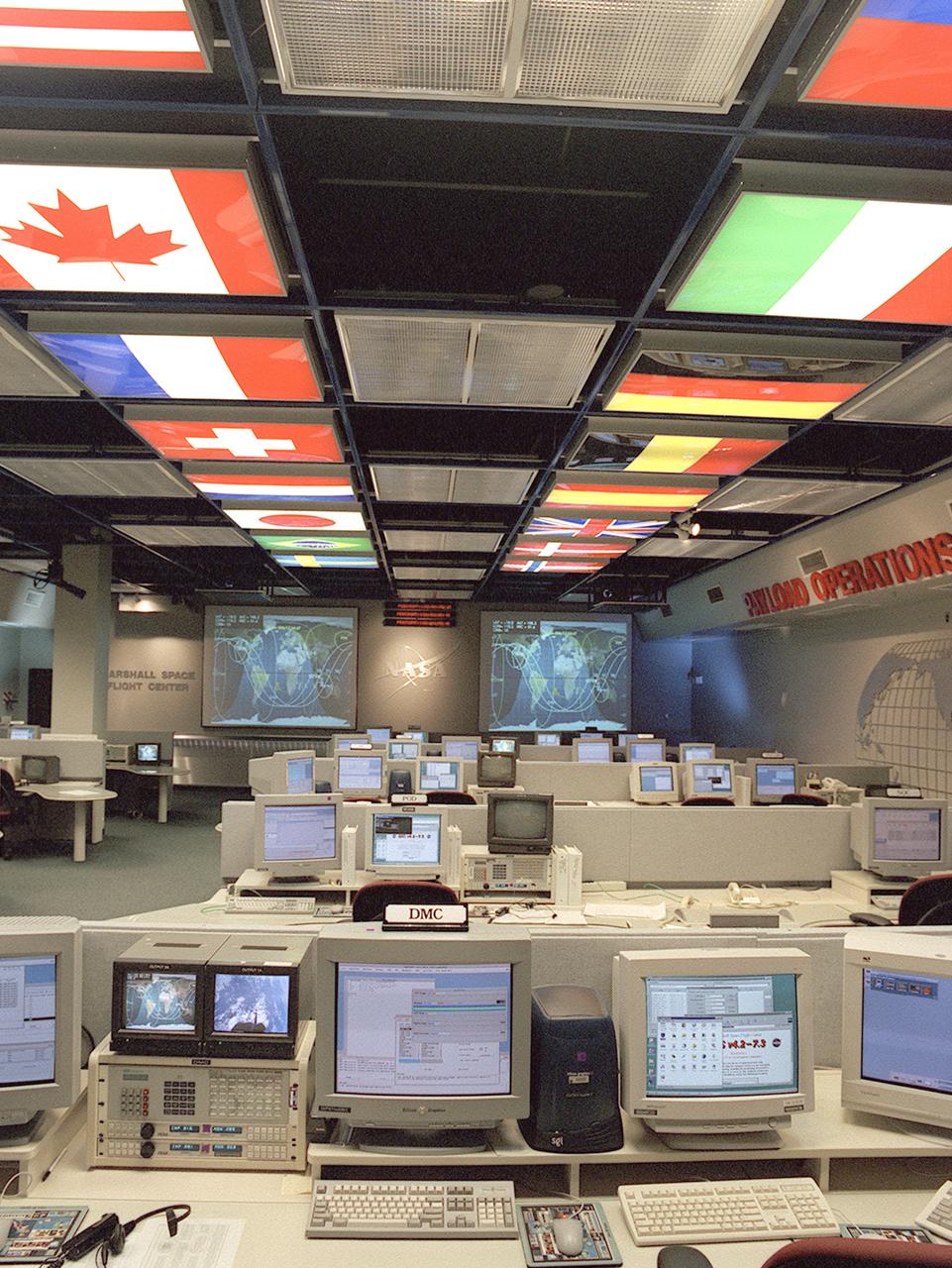
The International Space Station (ISS) Payload Operations Center (POC) at NASA's Marshall Space Flight Center (MSFC) in Huntsville, Alabama, is the world's primary science command post for the (ISS), the most ambitious space research facility in human history. The Payload Operations team is responsible for managing all science research experiments aboard the Station. The center is also home for coordination of the mission-plarning work of variety of international sources, all science payload deliveries and retrieval, and payload training and safety programs for the Station crew and all ground personnel. Within the POC, critical payload information from the ISS is displayed on a dedicated workstation, reading both S-band (low data rate) and Ku-band (high data rate) signals from a variety of experiments and procedures operated by the ISS crew and their colleagues on Earth. The POC is the focal point for incorporating research and experiment requirements from all international partners into an integrated ISS payload mission plan. This photograph is an overall view of the MSFC Payload Operations Center displaying the flags of the countries participating in the ISS. The flags at the left portray The United States, Canada, France, Switzerland, Netherlands, Japan, Brazil, and Sweden. The flags at the right portray The Russian Federation, Italy, Germany, Belgium, Spain, United Kingdom, Denmark, and Norway.
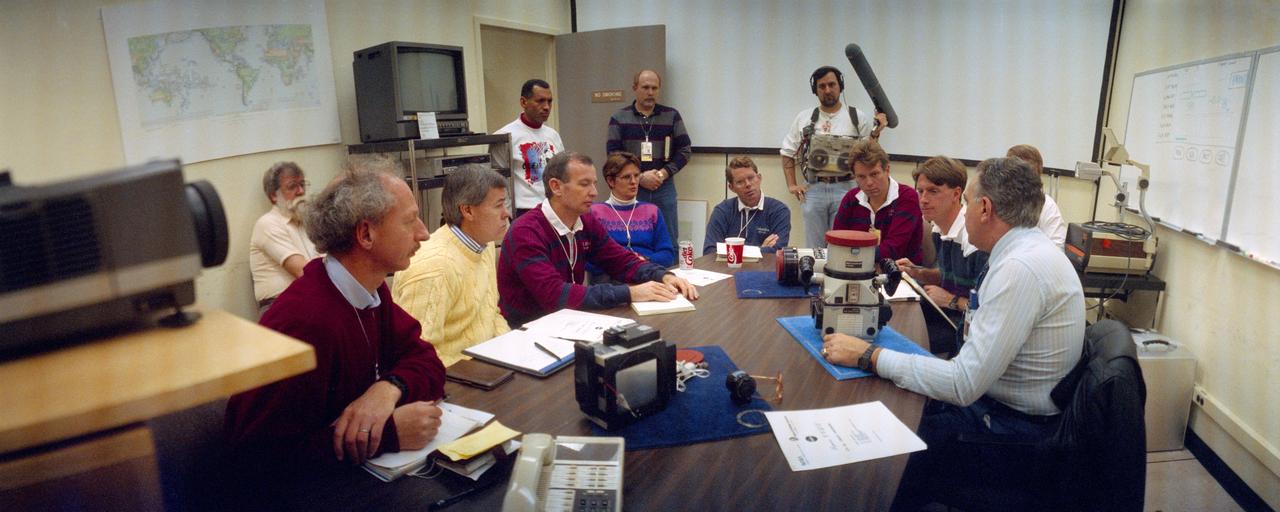
S92-26522 (Feb 1992) --- Crewmembers assigned to NASA's STS-45 mission are briefed on the use of the Linhof camera in the flight operations facility at the Johnson Space Center (JSC). Charles F. Bolden, mission commander, stands at left. Other crewmembers (seated clockwise around the table from lower left) are Dirk Frimout of Belgium representing the European Space Agency as payload specialist; Charles R. (Rick) Chappell, backup payload specialist; Brian Duffy, pilot; Kathryn D. Sullivan, payload commander; David C. Leestma, mission specialist; Byron K. Lichtenberg, payload specialist; and C. Michael Foale, mission specialist. James H. Ragan (far right), head of the flight equipment section of the flight systems branch in JSC's Man Systems Division, briefs the crewmembers. Donald C. Carico, of the crew training staff and Rockwell International, stands near Bolden. The camera, used for out-the-window observations, is expected to be used frequently on the Atmospheric Laboratory for Applications and Science (ATLAS-1) mission, scheduled for a March date with the Space Shuttle Atlantis.
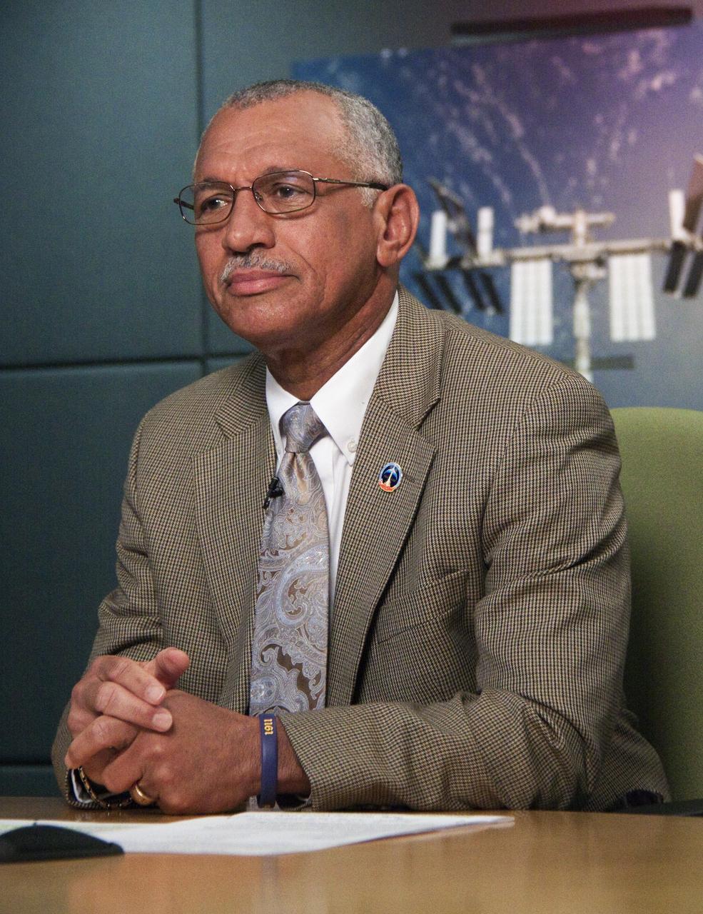
CAPE CANAVERAL, Fla. -- NASA Administrator Charlie Bolden talks to the International Space Station's Expedition 25 crew from the Operations Support Building II at NASA's Kennedy Space Center in Florida. The call to the station is part of a global celebration of 10 years of continuous human presence aboard the orbiting laboratory. More than 196 people have visited the station, which has completed more than 57,000 orbits of Earth and traveled about 1.5 billion miles. The station is a venture of international cooperation among NASA, the Russian Federal Space Agency, Canadian Space Agency, Japan Aerospace Exploration Agency (JAXA), and 11 members of the European Space Agency (ESA): Belgium, Denmark, France, Germany, Italy, the Netherlands, Norway, Spain, Sweden, Switzerland and the United Kingdom. More than 100,000 people in space agencies and contractor facilities in 37 U.S. states and throughout the world are involved in this endeavor. For more information about the work and experiments taking place aboard the station today, visit www.nasa.gov/mission_pages/station/main/index.html. Photo credit: NASA/Jack Pfaller
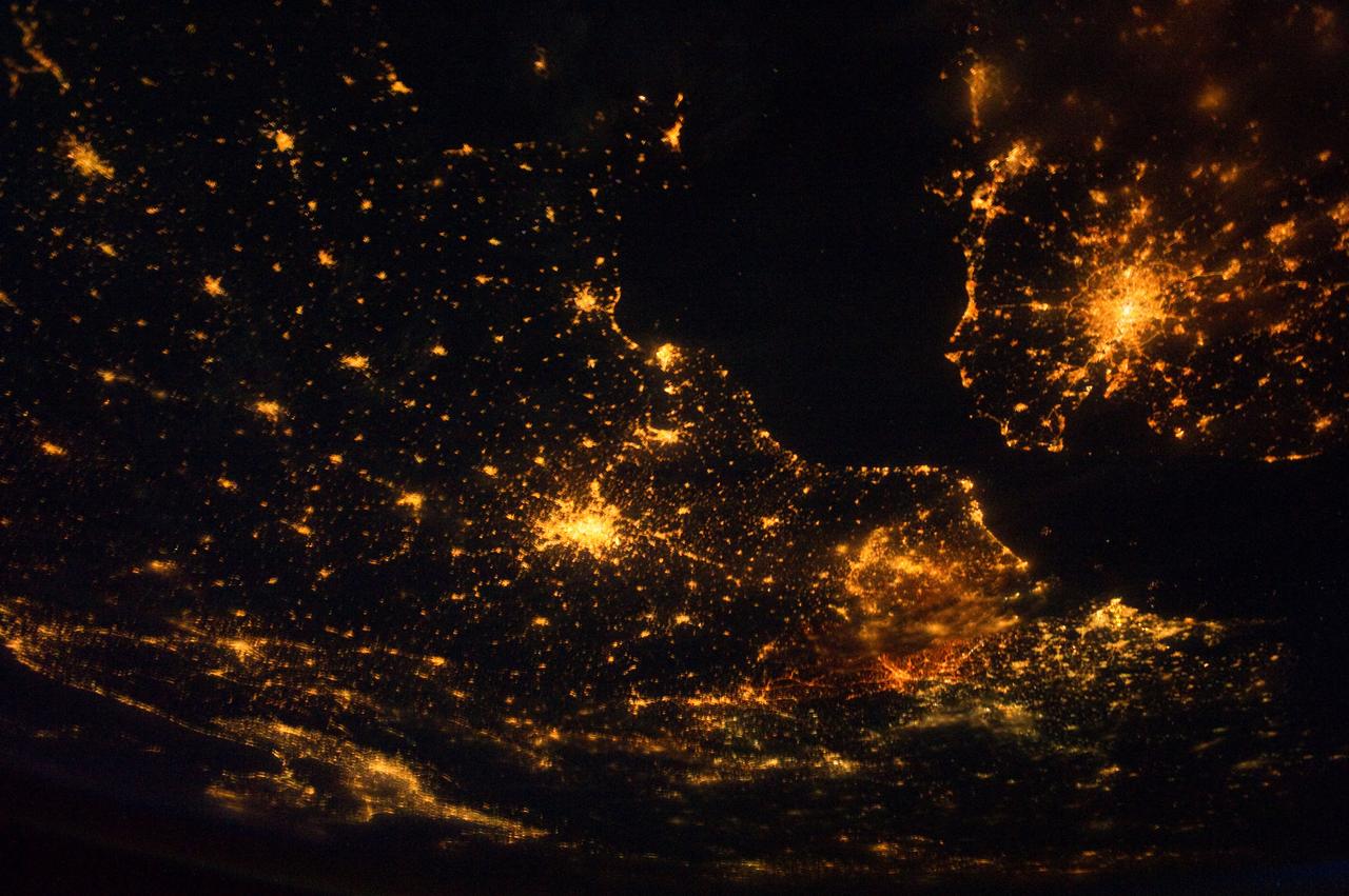
ISS028-E-024360 (10 Aug. 2011) --- This night time view of northwestern Europe is featured in this image photographed by an Expedition 28 crew member on the International Space Station. Several of the oldest cities of northwestern Europe are highlighted in this photograph taken at 00:25:26 Greenwich Mean Time (GMT). While the landscape is dotted with numerous clusters of lights from individual urban areas, the metropolitan areas of London (United Kingdom), Paris (France), Brussels (Belgium) and Amsterdam (Netherlands) stand out due to their large light ?footprints?. The metropolitan area of Milan, Italy is also visible at lower left. This photograph was taken with a short camera lens, providing the large field of view recorded in the image. To give a sense of scale, the centers of the London and Paris metropolitan areas are approximately 340 kilometers distant from each other. The image is also oblique, or taken while looking outward at an angle from the station; this tends to foreshorten the image, making the distance between Paris and Milan (approximately 640 kilometers) appear less than that of Paris to London. In contrast to the land surface defined by the city lights, the English Channel at right presents a uniform dark appearance. Similarly, the Alps (bottom center) to the north of Milan are also largely devoid of lights. While much of the atmosphere was clear at the time the image was taken, the lights of the Brussels metropolitan area are dimmed by thin cloud cover.
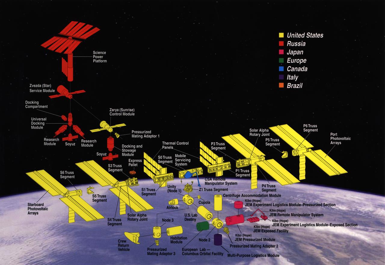
The International Space Station (ISS) is an unparalleled international scientific and technological cooperative venture that will usher in a new era of human space exploration and research and provide benefits to people on Earth. On-Orbit assembly began on November 20, 1998, with the launch of the first ISS component, Zarya, on a Russian Proton rocket. The Space Shuttle followed on December 4, 1998, carrying the U.S.-built Unity cornecting Module. Sixteen nations are participating in the ISS program: the United States, Canada, Japan, Russia, Brazil, Belgium, Denmark, France, Germany, Italy, the Netherlands, Norway, Spain, Sweden, Switzerland, and the United Kingdom. The ISS will include six laboratories and be four times larger and more capable than any previous space station. The United States provides two laboratories (United States Laboratory and Centrifuge Accommodation Module) and a habitation module. There will be two Russian research modules, one Japanese laboratory, referred to as the Japanese Experiment Module (JEM), and one European Space Agency (ESA) laboratory called the Columbus Orbital Facility (COF). The station's internal volume will be roughly equivalent to the passenger cabin volume of two 747 jets. Over five years, a total of more than 40 space flights by at least three different vehicles - the Space Shuttle, the Russian Proton Rocket, and the Russian Soyuz rocket - will bring together more than 100 different station components and the ISS crew. Astronauts will perform many spacewalks and use new robotics and other technologies to assemble ISS components in space.
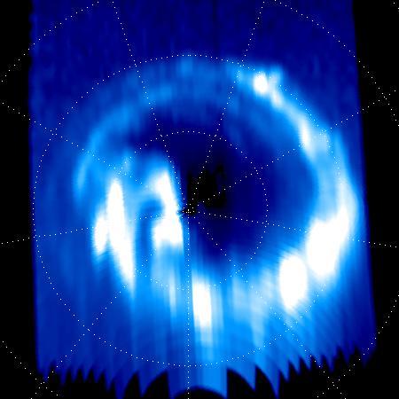
On Sept. 14, 2017, one day before making its final plunge into Saturn's atmosphere, NASA's Cassini spacecraft used its Ultraviolet Imaging Spectrograph, or UVIS, instrument to capture this final view of ultraviolet auroral emissions in the planet's north polar region. The view is centered on the north pole of Saturn, with lines of latitude visible for 80, 70 and 60 degrees. Lines of longitude are spaced 40 degrees apart. The planet's day side is at bottom, while the night side is at top. A sequence of images from this observation has also been assembled into a movie sequence. The last image in the movie was taken about an hour before the still image, which was the actual final UVIS auroral image. Auroral emissions are generated by charged particles traveling along the invisible lines of Saturn's magnetic field. These particles precipitate into the atmosphere, releasing light when they strike gas molecules there. Several individual auroral structures are visible here, despite that this UVIS view was acquired at a fairly large distance from the planet (about 424,000 miles or 683,000 kilometers). Each of these features is connected to a particular phenomenon in Saturn's magnetosphere. For instance, it is possible to identify auroral signatures here that are related to the injection of hot plasma from the dayside magnetosphere, as well as auroral features associated with a change in the magnetic field's shape on the magnetosphere's night side. Several possible scenarios have been postulated over the years to explain Saturn's changing auroral emissions, but researchers are still far from a complete understanding of this complicated puzzle. Researchers will continue to analyze the hundreds of image sequences UVIS obtained of Saturn's auroras during Cassini's 13-year mission, with many new discoveries likely to be made. This image and movie sequence were produced by the Laboratory for Planetary and Atmospheric Physics (LPAP) of the STAR Institute of the University of Liege in Belgium, in collaboration with the UVIS Team. The animation is available at https://photojournal.jpl.nasa.gov/catalog/PIA21899
City lights at night along the France-Italy border, Europe are featured in this image photographed by an Expedition 23 crew member on the International Space Station (ISS). The brightly lit metropolitan areas of Torino (Italy), Lyon, and Marseille (both in France) stand out amidst numerous smaller urban areas in this dramatic photograph. The image captures the night time appearance of the France-Italy border area between the mountainous Alps to the north (not shown) and the island of Corsica in the Ligurian Sea to the south (top). The full moon reflects brightly on the water surface and also illuminates the tops of low patchy clouds over the border (center). This image was taken by an ISS crew member at approximately 11:55 p.m. local time when the station was located over the France-Belgium border near Luxembourg. Crew members orbiting Earth frequently collect images that include sunglint, or sunlight that reflects off a water surface at such an angle that it travels directly back towards the observer. Sunglint typically lends a mirror-like appearance to the water surface. During clear sky conditions reflected light from the moon can produce the same effect (moon glint) as illustrated in this view. The observer was looking towards the southeast at an oblique viewing angle at the time the image was taken; in other words, looking outwards from the ISS, not straight down towards Earth. Credit: NASA <b><a href="http://www.nasa.gov/audience/formedia/features/MP_Photo_Guidelines.html" rel="nofollow">NASA image use policy.</a></b> <b><a href="http://www.nasa.gov/centers/goddard/home/index.html" rel="nofollow">NASA Goddard Space Flight Center</a></b> enables NASA’s mission through four scientific endeavors: Earth Science, Heliophysics, Solar System Exploration, and Astrophysics. Goddard plays a leading role in NASA’s accomplishments by contributing compelling scientific knowledge to advance the Agency’s mission. <b>Follow us on <a href="http://twitter.com/NASAGoddardPix" rel="nofollow">Twitter</a></b> <b>Like us on <a href="http://www.facebook.com/pages/Greenbelt-MD/NASA-Goddard/395013845897?ref=tsd" rel="nofollow">Facebook</a></b> <b>Find us on <a href="http://instagram.com/nasagoddard?vm=grid" rel="nofollow">Instagram</a></b>
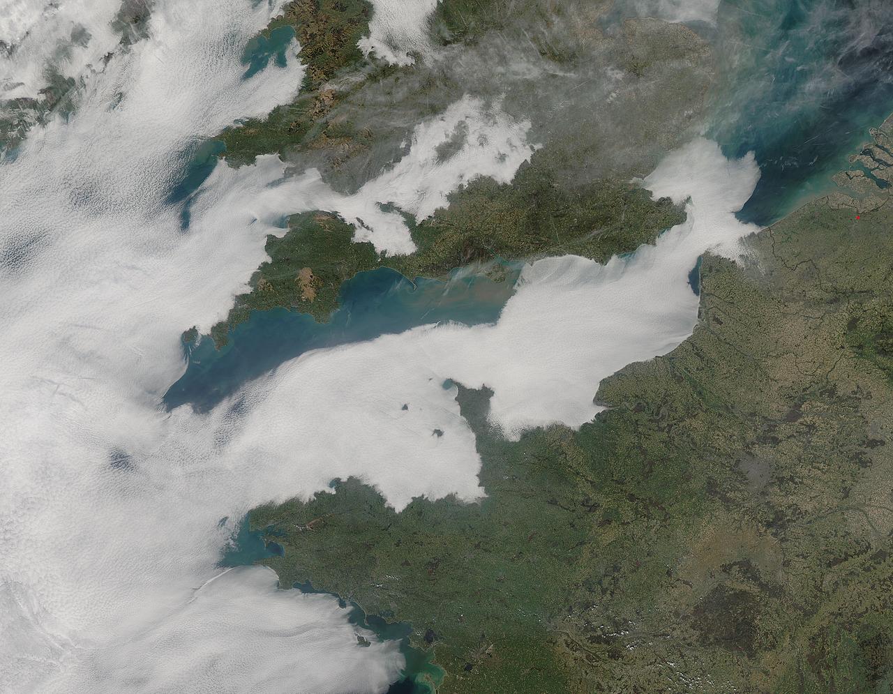
A thick blanket of low clouds covered the English Channel, Celtic Sea and Irish Sea on March 13, 2014. The fog also crept over major cities in the United Kingdom and Ireland. While citizens living in parts of Ireland, England, Wales, Scotland and Northern Ireland were posting ground-based photos of fog-shrouded landscape on social media, the internet and news outlets, the scene was also captured from space. The Moderate Resolution Imaging Spectroradiometer (MODIS) aboard NASA’s Aqua captured this true-color image of the cloudy day at 13:00 UTC (1:00 p.m. in London) on that same day. The dense fog (low clouds) affected air travel, causing the cancellation of hundreds of flights going through London City Airport, where visibility was reported at less than 100 meters (328 ft) – less than the length of an American football field. Flights were also cancelled at Heathrow, Gatwick and Manchester. A private helicopter flying to Northern Ireland went down in by the fog near the Norfolk-Suffolk border, with loss of four lives. Driving was little better in many areas, causing the Met Office to issue a yellow weather warning and to caution drivers of difficult conditions. The lowest visibility of the day was reported at Roches Point weather station. Located at the southeastern tip of Cork Harbor, Ireland, the station reported visibility of less than 50 meters (164 ft) – the length of an Olympic size swimming pool. In this image, the fog-covered Celtic Sea is located in the southwest. Ireland lies under tendrils of low cloud in the northwest corner of the image. Banks of clouds part around England, near the center of the image, and southern Wales (top and center) completely under the foggy blanket. Fog also creeps over the coasts of France, Belgium and the Netherlands on the east side of the English Channel. Credit: NASA/GSFC/Jeff Schmaltz/MODIS Land Rapid Response Team <b><a href="http://www.nasa.gov/audience/formedia/features/MP_Photo_Guidelines.html" rel="nofollow">NASA image use policy.</a></b> <b><a href="http://www.nasa.gov/centers/goddard/home/index.html" rel="nofollow">NASA Goddard Space Flight Center</a></b> enables NASA’s mission through four scientific endeavors: Earth Science, Heliophysics, Solar System Exploration, and Astrophysics. Goddard plays a leading role in NASA’s accomplishments by contributing compelling scientific knowledge to advance the Agency’s mission. <b>Follow us on <a href="http://twitter.com/NASAGoddardPix" rel="nofollow">Twitter</a></b> <b>Like us on <a href="http://www.facebook.com/pages/Greenbelt-MD/NASA-Goddard/395013845897?ref=tsd" rel="nofollow">Facebook</a></b> <b>Find us on <a href="http://instagram.com/nasagoddard?vm=grid" rel="nofollow">Instagram</a></b>
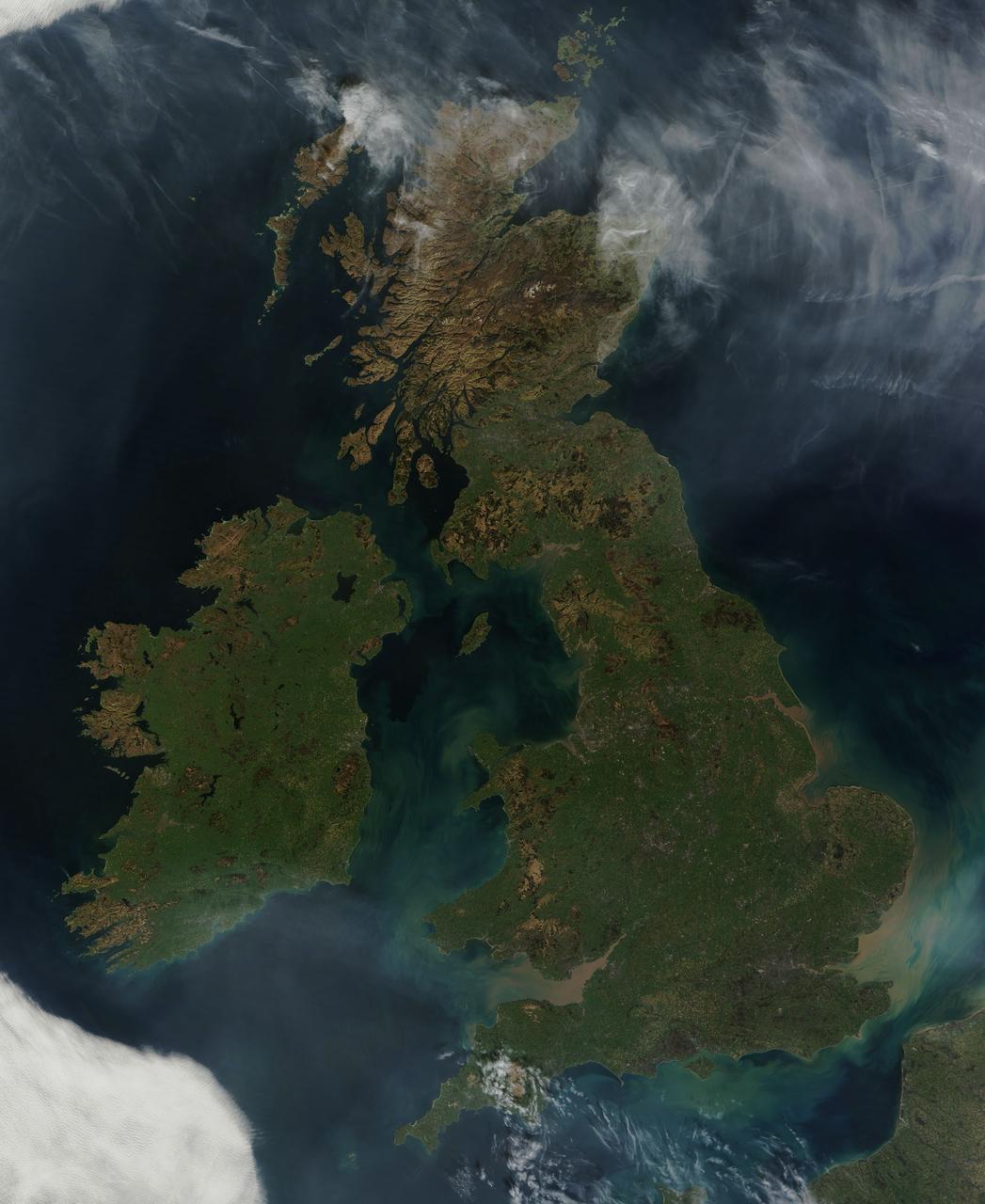
NASA image acquired March 26, 2012 This nearly cloud-free view of Great Britain and Ireland was acquired by the Moderate Resolution Imaging Spectroradiometer (MODIS) aboard NASA’s Terra satellite on March 26, 2012. Just a few days into spring, most of the land appears green, although not quite as brilliant as the summertime hues that give Ireland the nickname “the Emerald Island”. The islands of Ireland (west) and Great Britain (east) are separated by the Irish Sea, which is filled with the turquoise, green and tan swirls typical of sediment, although blooming algae could also contribute some color to the waters. To the southeast, the English Channel separates the island of Great Britain from France (south) and Belgium (north). London can be seen as a gray circle situated inland on the tan-colored River Thames. The sediment from the Thames flows into the English Channel due east of London. The United Kingdom is made up of Wales, Scotland and England, all located primarily on the island of Great Britain, and of Northern Ireland, which comprises the northern section of the island of Ireland. Dublin, in the Republic of Ireland, can be seen as a gray smudge on the eastern coast of the island. Almost due west Galway can be seen as a linear gray streak on the northern coast of Galway Bay, with the blue waters of Loch Corrib to the north. Most of the United Kingdom and Ireland are part of the Celtic broadleaf forest ecoregion, where acid-loving oak and mixed oak forests abound, along with fen and swamp forests and ombrotrophic mires. A portion of the Scottish Highlands, in the north of Great Britain, are covered by the Caledon conifer forest ecoregion. The Caledonia conifers once covered a large area of Scotland, but now only about 1% of the original forest survives, mostly high in the cooler areas of the Highlands. NASA/GSFC/Jeff Schmaltz/MODIS Land Rapid Response Team <b><a href="http://www.nasa.gov/audience/formedia/features/MP_Photo_Guidelines.html" rel="nofollow">NASA image use policy.</a></b> <b><a href="http://www.nasa.gov/centers/goddard/home/index.html" rel="nofollow">NASA Goddard Space Flight Center</a></b> enables NASA’s mission through four scientific endeavors: Earth Science, Heliophysics, Solar System Exploration, and Astrophysics. Goddard plays a leading role in NASA’s accomplishments by contributing compelling scientific knowledge to advance the Agency’s mission. <b>Follow us on <a href="http://twitter.com/NASA_GoddardPix" rel="nofollow">Twitter</a></b> <b>Like us on <a href="http://www.facebook.com/pages/Greenbelt-MD/NASA-Goddard/395013845897?ref=tsd" rel="nofollow">Facebook</a></b> <b>Find us on <a href="http://instagrid.me/nasagoddard/?vm=grid" rel="nofollow">Instagram</a></b>