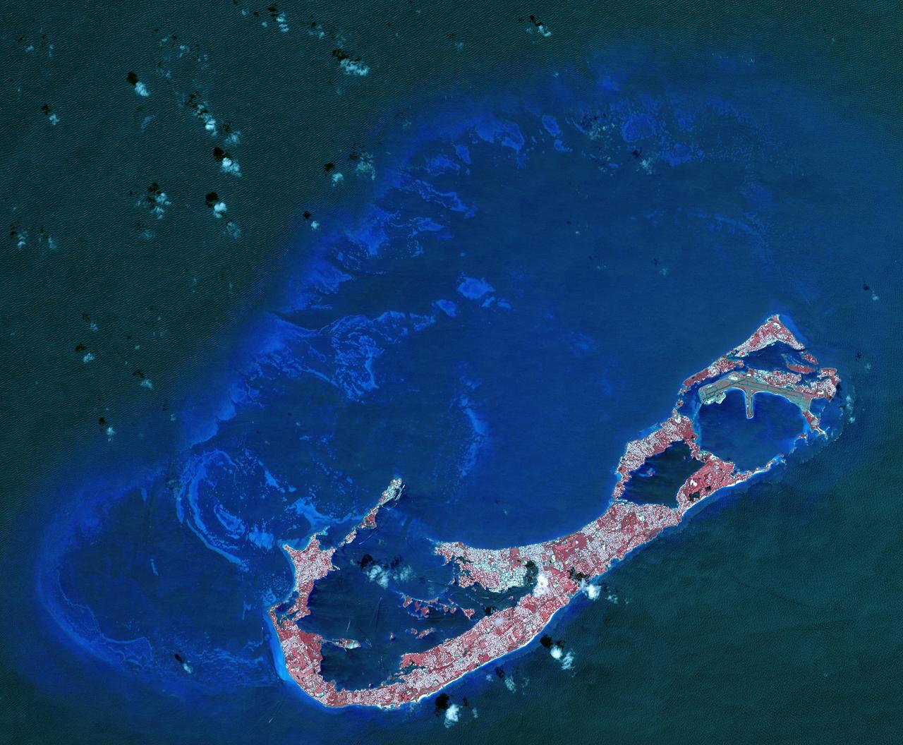
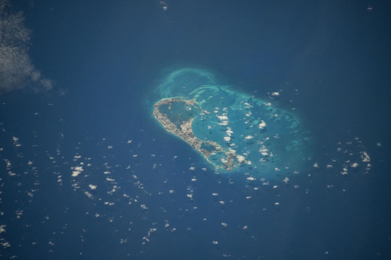
Bermuda is a British Overseas Territory in the western Atlantic off the east coast of North America. The uninhabited islands were first discovered in 1503 by the Spanish explorer Juan de Bermudez. In 1609 the English Virginia Colony settled Bermuda, and it has remained a British colony for over 400 years. Bermuda's economy is dominated by offshore insurance, and tourism, resulting in a very high GDP per capita. The image was acquired April 19, 2009, covers an area of 29.4 by 40.7 kilometers, and is located at 32.3 degrees north, 64.8 degrees west. http://photojournal.jpl.nasa.gov/catalog/PIA21315
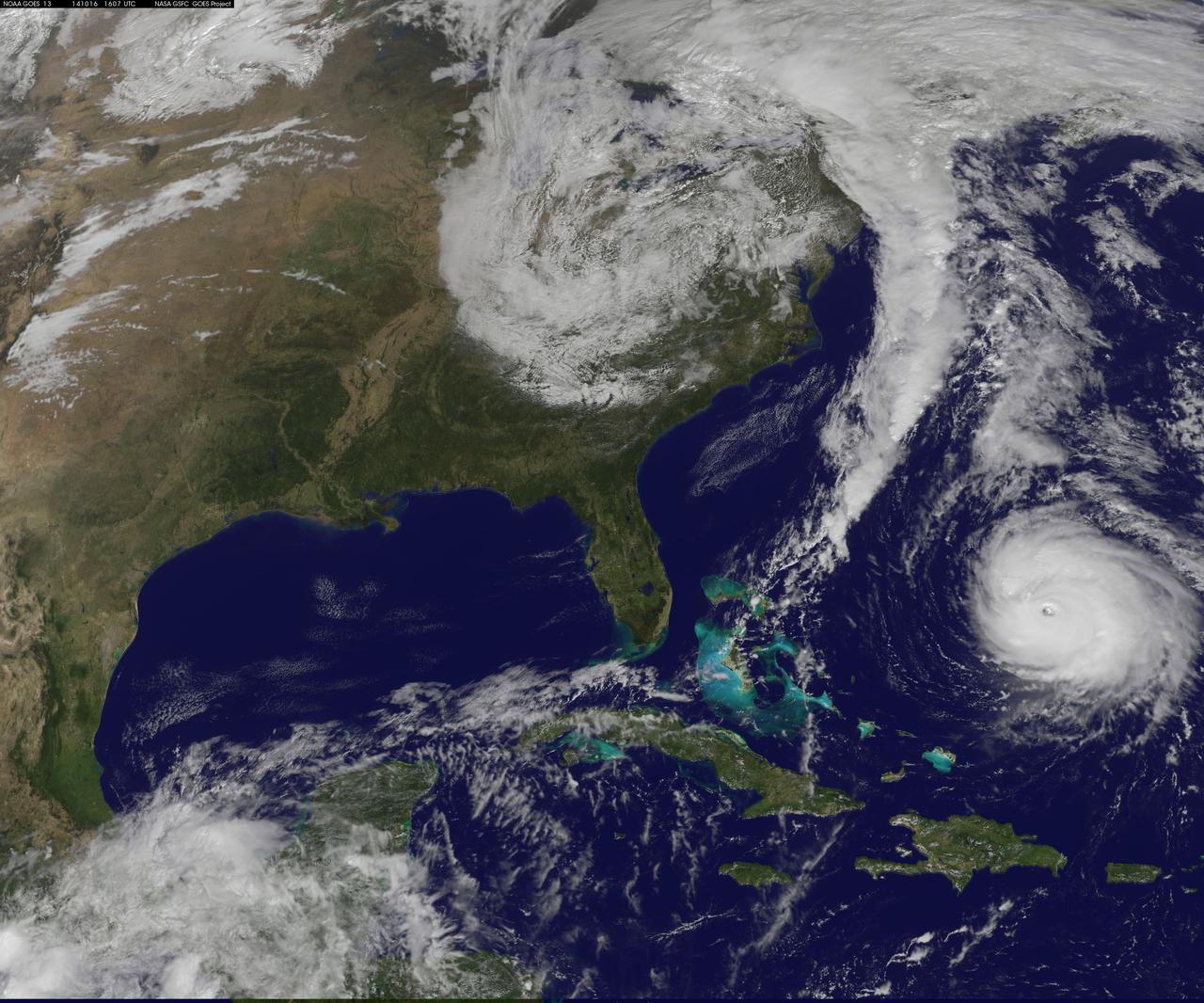
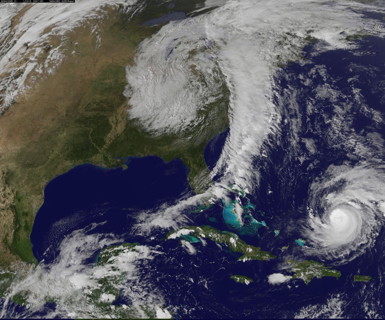
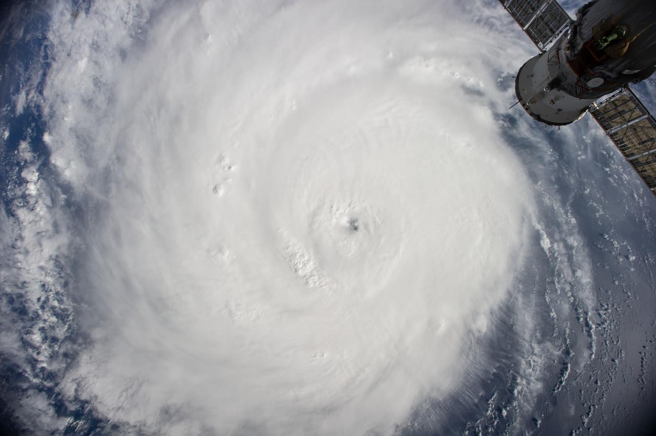
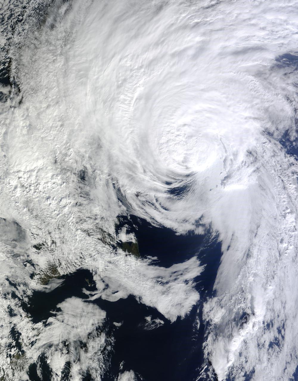
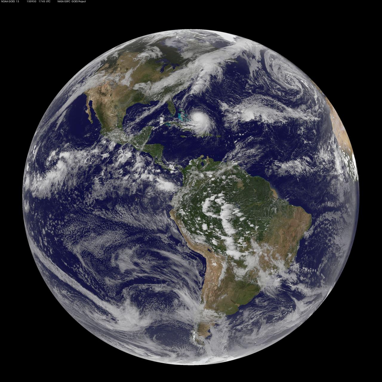
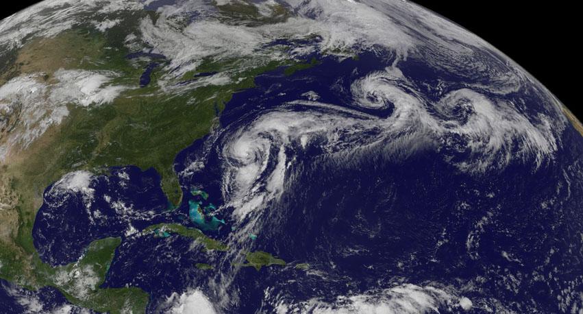
Hurricane Gonzalo is moving toward the northwest near 12 mph. A turn toward the north-northwest and then north is expected during the next day or so, followed by a north northeastward acceleration by late Thursday. Maximum sustained winds are near 130 mph making Gonzalo a Category 4 hurricane on the Saffir-Simpson Hurricane Wind Scale. Tropical storm conditions are possible on Bermuda by late Thursday night, with hurricane conditions possible on Friday. Large swells generated by Gonzalo will reach much of the U.S. east coast and Bermuda on Thursday. These swells are likely to cause life-threatening surf and rip current conditions. This image was taken by GOES 13 at 1607 UTC on October 16, 2014. Caption: NOAA Image Credit: NOAA/NASA GOES Project <b><a href="http://www.nasa.gov/audience/formedia/features/MP_Photo_Guidelines.html" rel="nofollow">NASA image use policy.</a></b> <b><a href="http://www.nasa.gov/centers/goddard/home/index.html" rel="nofollow">NASA Goddard Space Flight Center</a></b> enables NASA’s mission through four scientific endeavors: Earth Science, Heliophysics, Solar System Exploration, and Astrophysics. Goddard plays a leading role in NASA’s accomplishments by contributing compelling scientific knowledge to advance the Agency’s mission. <b>Follow us on <a href="http://twitter.com/NASAGoddardPix" rel="nofollow">Twitter</a></b> <b>Like us on <a href="http://www.facebook.com/pages/Greenbelt-MD/NASA-Goddard/395013845897?ref=tsd" rel="nofollow">Facebook</a></b> <b>Find us on <a href="http://instagram.com/nasagoddard?vm=grid" rel="nofollow">Instagram</a></b>
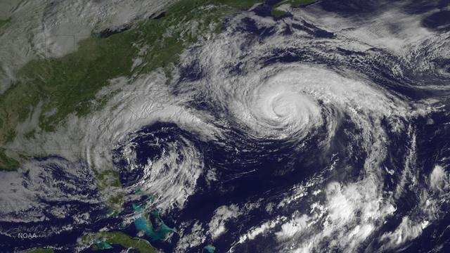
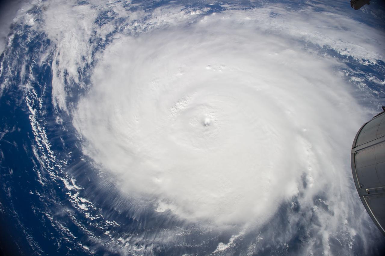
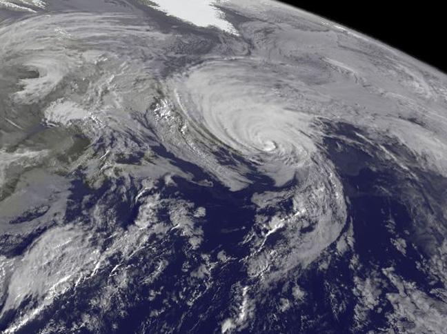
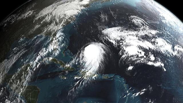
Hurricane Joaquin is seen in the Atlantic Ocean north of Bermuda in this image taken by GOES East at 1315 UTC (9:15 a.m. EDT) on October 5, 2015. Credit: NASA/NOAA via <b><a href="www.nnvl.noaa.gov/" rel="nofollow"> NOAA Environmental Visualization Laboratory</a></b> <b><a href="http://goes.gsfc.nasa.gov/" rel="nofollow">Credit: NOAA/NASA GOES Project</a></b> <b><a href="http://www.nasa.gov/audience/formedia/features/MP_Photo_Guidelines.html" rel="nofollow">NASA image use policy.</a></b> <b><a href="http://www.nasa.gov/centers/goddard/home/index.html" rel="nofollow">NASA Goddard Space Flight Center</a></b> enables NASA’s mission through four scientific endeavors: Earth Science, Heliophysics, Solar System Exploration, and Astrophysics. Goddard plays a leading role in NASA’s accomplishments by contributing compelling scientific knowledge to advance the Agency’s mission. <b>Follow us on <a href="http://twitter.com/NASAGoddardPix" rel="nofollow">Twitter</a></b> <b>Like us on <a href="http://www.facebook.com/pages/Greenbelt-MD/NASA-Goddard/395013845897?ref=tsd" rel="nofollow">Facebook</a></b> <b>Find us on <a href="http://instagrid.me/nasagoddard/?vm=grid" rel="nofollow">Instagram</a></b>
Hurricane Joaquin is seen in the Atlantic Ocean north of Bermuda in this image taken by GOES East at 1315 UTC (9:15 a.m. EDT) on October 5, 2015. <b><a href="http://goes.gsfc.nasa.gov/" rel="nofollow">Credit: NOAA/NASA GOES Project</a></b> <b><a href="http://www.nasa.gov/audience/formedia/features/MP_Photo_Guidelines.html" rel="nofollow">NASA image use policy.</a></b> <b><a href="http://www.nasa.gov/centers/goddard/home/index.html" rel="nofollow">NASA Goddard Space Flight Center</a></b> enables NASA’s mission through four scientific endeavors: Earth Science, Heliophysics, Solar System Exploration, and Astrophysics. Goddard plays a leading role in NASA’s accomplishments by contributing compelling scientific knowledge to advance the Agency’s mission. <b>Follow us on <a href="http://twitter.com/NASAGoddardPix" rel="nofollow">Twitter</a></b> <b>Like us on <a href="http://www.facebook.com/pages/Greenbelt-MD/NASA-Goddard/395013845897?ref=tsd" rel="nofollow">Facebook</a></b> <b>Find us on <a href="http://instagrid.me/nasagoddard/?vm=grid" rel="nofollow">Instagram</a></b>
iss071e206529 (June 19, 2024) -- In the North Atlantic Ocean lies Bermuda, an archipelago of more than 180 islands and islets. As the International Space Station orbited 265 miles above, NASA astronaut Matthew Dominick captured this photo.
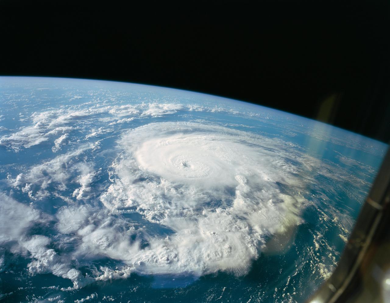
STS047-151-618 (19 Sept 1992) --- A large format Earth observation camera captured this scene of Hurricane Bonnie during the late phase of the mission. Bonnie was located about 500 miles from Bermuda near a point centered at 35.4 degrees north latitude and 56.8 degrees west longitude. The Linhof camera was aimed through one of Space Shuttle Endeavour's aft flight deck windows (note slight reflection at right). The crew members noticed the well defined eye in this hurricane, compared to an almost non-existent eye in the case of Hurricane Iniki, which was relatively broken up by the mission's beginning. Six NASA astronauts and a Japanese payload specialist conducted eight days of in-space research.
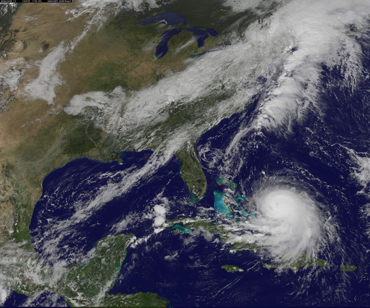
On Oct. 16 at 17:45 UTC NASA's Terra satellite captured this image of Hurricane Gonzalo in the Atlantic Ocean. Image Credit: NASA Goddard MODIS Rapid Response Team-- NASA and NOAA satellites have been providing continuous coverage of Hurricane Gonzalo as it moves toward Bermuda. NASA's Terra satellite saw thunderstorms wrapped tightly around the center with large bands of thunderstorms wrapping into it. NOAA's GOES-East satellite provided and "eye-opening" view of Gonzalo, still a Category 4 hurricane on Oct. 16. A hurricane warning is in effect for Bermuda and that means that hurricane conditions are expected within the warning area, meaning the entire island. Read more: <a href="http://www.nasa.gov/content/goddard/gonzalo-atlantic-ocean/index.html#.VEFIDN6FxgM" rel="nofollow">www.nasa.gov/content/goddard/gonzalo-atlantic-ocean/index...</a> <b><a href="http://www.nasa.gov/audience/formedia/features/MP_Photo_Guidelines.html" rel="nofollow">NASA image use policy.</a></b> <b><a href="http://www.nasa.gov/centers/goddard/home/index.html" rel="nofollow">NASA Goddard Space Flight Center</a></b> enables NASA’s mission through four scientific endeavors: Earth Science, Heliophysics, Solar System Exploration, and Astrophysics. Goddard plays a leading role in NASA’s accomplishments by contributing compelling scientific knowledge to advance the Agency’s mission. <b>Follow us on <a href="http://twitter.com/NASAGoddardPix" rel="nofollow">Twitter</a></b> <b>Like us on <a href="http://www.facebook.com/pages/Greenbelt-MD/NASA-Goddard/395013845897?ref=tsd" rel="nofollow">Facebook</a></b> <b>Find us on <a href="http://instagram.com/nasagoddard?vm=grid" rel="nofollow">Instagram</a></b>
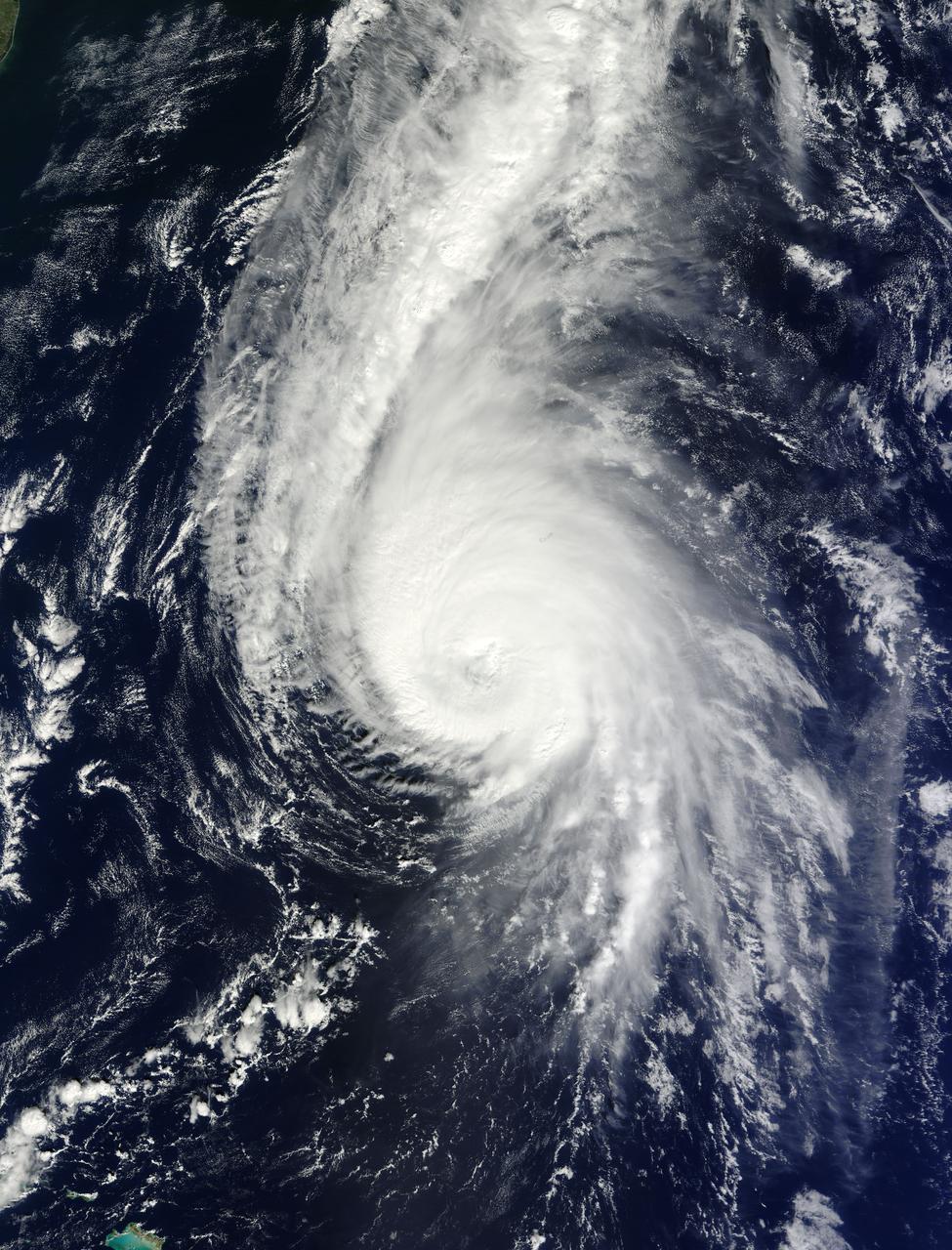
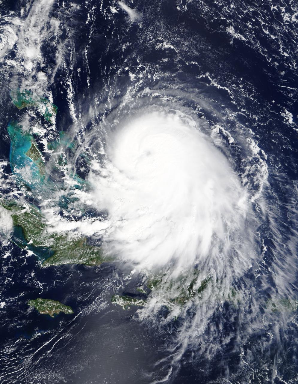
Hurricane Gonzalo has made the jump to major hurricane status and on Oct. 15 was a Category 4 storm on the Saffir-Simpson Hurricane Scale. NOAA's GOES-East satellite provided imagery of the storm. According to the National Hurricane Center, Gonzalo is the first category 4 hurricane in the Atlantic basin since Ophelia in 2011. NOAA's GOES-East satellite provides visible and infrared images of weather from its orbit in a fixed position over the Earth. On Oct. 15 at 15:15 UTC (11:15 a.m. EDT) GOES saw Gonzalo had tightly wrapped bands of thunderstorms spiraling into the center of its circulation. The eye of the storm was obscured by high clouds in the image. NOAA aircraft data and microwave images clearly show concentric eyewalls, with the inner radius of maximum winds now only about 4-5 nautical miles from the center. NOAA manages the GOES satellites, while NASA/NOAA's GOES Project at NASA's Goddard Space Flight Center in Greenbelt, Maryland created the image. The NASA/NOAA GOES Project creates images and animations from GOES data. At 11 a.m. EDT on Oct. 15, Gonzalo's maximum sustained winds increased to near 130 mph (215 kph) and the National Hurricane Center (NHC) noted that fluctuations in intensity are expected over the next couple of days. Gonzalo's cloud-covered eye was located near latitude 23.5 north and longitude 68.0 west, about 640 miles (1,025 km) south-southwest of Bermuda. Gonzalo is moving toward the northwest near 12 mph (19 kph). The minimum central pressure recently reported by an air force reconnaissance aircraft was 949 millibars. Tropical storm conditions are possible in Bermuda by late Thursday night, Oct. 16, and hurricane conditions are possible over Bermuda on Friday Oct. 16. Ocean swells however, will be felt over a much larger area, reached the U.S. east coast on Oct. 16. Large swells generated by Gonzalo are affecting portions of the Virgin Islands, the northern coasts of Puerto Rico and the Dominican Republic and portions of the Bahamas. Swells will reach much of the east coast of the United States and Bermuda on Thursday. By late Oct. 16, Gonzalo is expected to turn to the northeast and the center is expected to approach Bermuda sometime on Oct. 17. Credit: NASA/GSFC/Jeff Schmaltz/MODIS Land Rapid Response Team <b><a href="http://www.nasa.gov/audience/formedia/features/MP_Photo_Guidelines.html" rel="nofollow">NASA image use policy.</a></b> <b><a href="http://www.nasa.gov/centers/goddard/home/index.html" rel="nofollow">NASA Goddard Space Flight Center</a></b> enables NASA’s mission through four scientific endeavors: Earth Science, Heliophysics, Solar System Exploration, and Astrophysics. Goddard plays a leading role in NASA’s accomplishments by contributing compelling scientific knowledge to advance the Agency’s mission. <b>Follow us on <a href="http://twitter.com/NASAGoddardPix" rel="nofollow">Twitter</a></b> <b>Like us on <a href="http://www.facebook.com/pages/Greenbelt-MD/NASA-Goddard/395013845897?ref=tsd" rel="nofollow">Facebook</a></b> <b>Find us on <a href="http://instagram.com/nasagoddard?vm=grid" rel="nofollow">Instagram</a></b>
On Oct. 17 at 15:15 UTC (11:15 a.m EDT) the MODIS instrument aboard NASA's Aqua satellite saw Hurricane Gonzalo's northern quadrant over Bermuda as it moved to landfall. ..Credit: NASA Goddard MODIS Rapid Response Team ..<b><a href="http://www.nasa.gov/audience/formedia/features/MP_Photo_Guidelines.html" rel="nofollow">NASA image use policy.</a></b> <b><a href="http://www.nasa.gov/centers/goddard/home/index.html" rel="nofollow">NASA Goddard Space Flight Center</a></b> enables NASA’s mission through four scientific endeavors: Earth Science, Heliophysics, Solar System Exploration, and Astrophysics. Goddard plays a leading role in NASA’s accomplishments by contributing compelling scientific knowledge to advance the Agency’s mission. <b>Follow us on <a href="http://twitter.com/NASAGoddardPix" rel="nofollow">Twitter</a></b> <b>Like us on <a href="http://www.facebook.com/pages/Greenbelt-MD/NASA-Goddard/395013845897?ref=tsd" rel="nofollow">Facebook</a></b> <b>Find us on <a href="http://instagram.com/nasagoddard?vm=grid" rel="nofollow">Instagram</a></b>
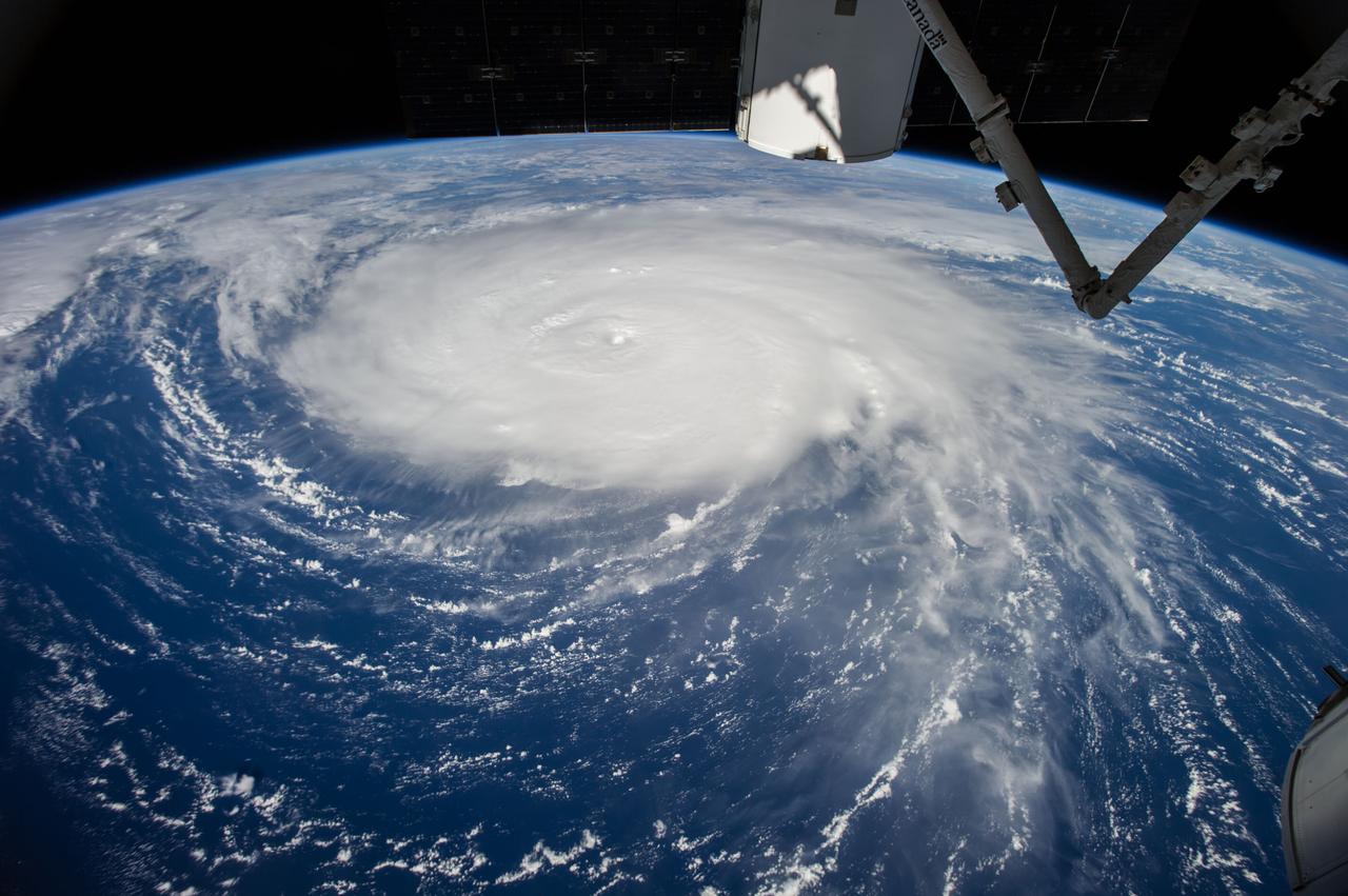
ISS049e034763 (10/12/2016) --- Hurricane Nichole spreads out over Bermuda bringing high winds and flooding water.

iss055e000908 (March 5, 2018) --- Russia's Progress 68 resupply ship is pictured docked to the Pirs docking compartment as the International Space Station orbited over the Atlantic Ocean south of the island of Bermuda.
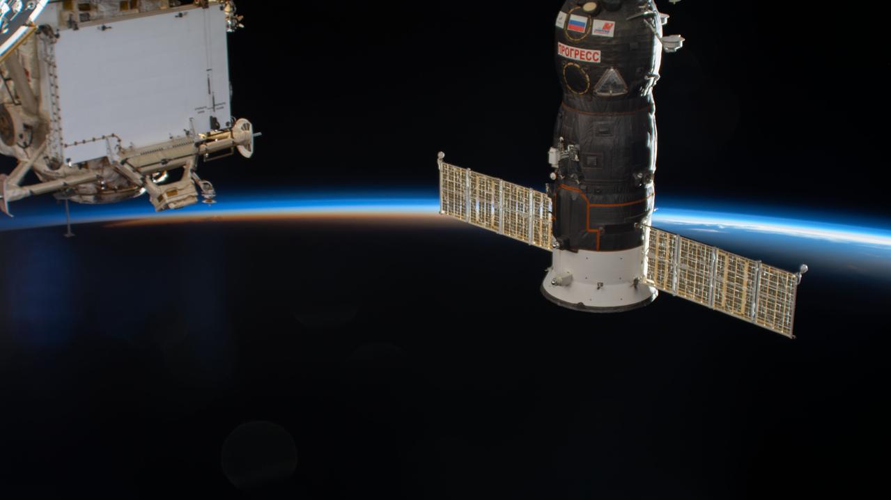
iss063e066603 (Aug. 6, 2020) --- The International Space Station soars into an orbital sunset over the Atlantic Ocean near Bermuda. Russia's Progress 76 resupply ship pictured is in the foreground docked to the Pirs docking compartment.
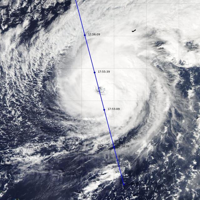
NASA's CloudSat satellite completed an eye overpass of Hurricane Nicole on Oct. 12, 2016, at 10:55 a.m. PDT (17:55 UTC) as the storm was moving toward Bermuda. At the time the system had sustained winds of 109 miles per hour (95 knots), with a minimum pressure of 962 millibars. CloudSat viewed the system just as it was going through a period of intensification (from 98 miles per hour, or 85 knots, to 121 miles per hour (105 knots) during a 12-hour period. http://photojournal.jpl.nasa.gov/catalog/PIA21098
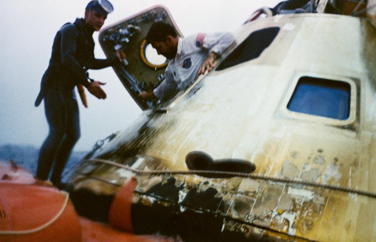
Astronaut Walter M. Schirra, Jr., Apollo 7 commander, egresses the spacecraft during recovery operations in the Atlantic. He is assisted by a member of the U.S. Navy frogman team. The Apollo 7 spacecraft splashed down at 7:11 a.m., October 22, 1968, approximately 200 nautical miles south-southwest of Bermuda.
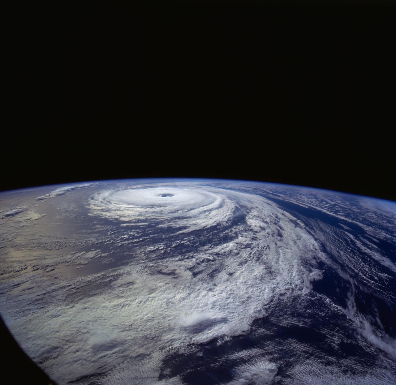
ISS041-E-078255 (16 Oct. 2014) --- One of the crew members aboard the International Space Station took this picture of Hurricane Gonzalo on Oct. 16, 2014. The storm's eye appears in the center of the frame. Gonzalo hit Bermuda on the following day, as a powerful Category 2 storm, with winds estimated at 110 miles per hour.
ISS041-E-078247 (16 Oct. 2014) --- One of the crew members aboard the International Space Station took this picture of Hurricane Gonzalo on Oct. 16, 2014. The storm's eye appears in the center of the frame. Gonzalo hit Bermuda on the following day, as a powerful Category 2 storm, with winds estimated at 110 miles per hour.
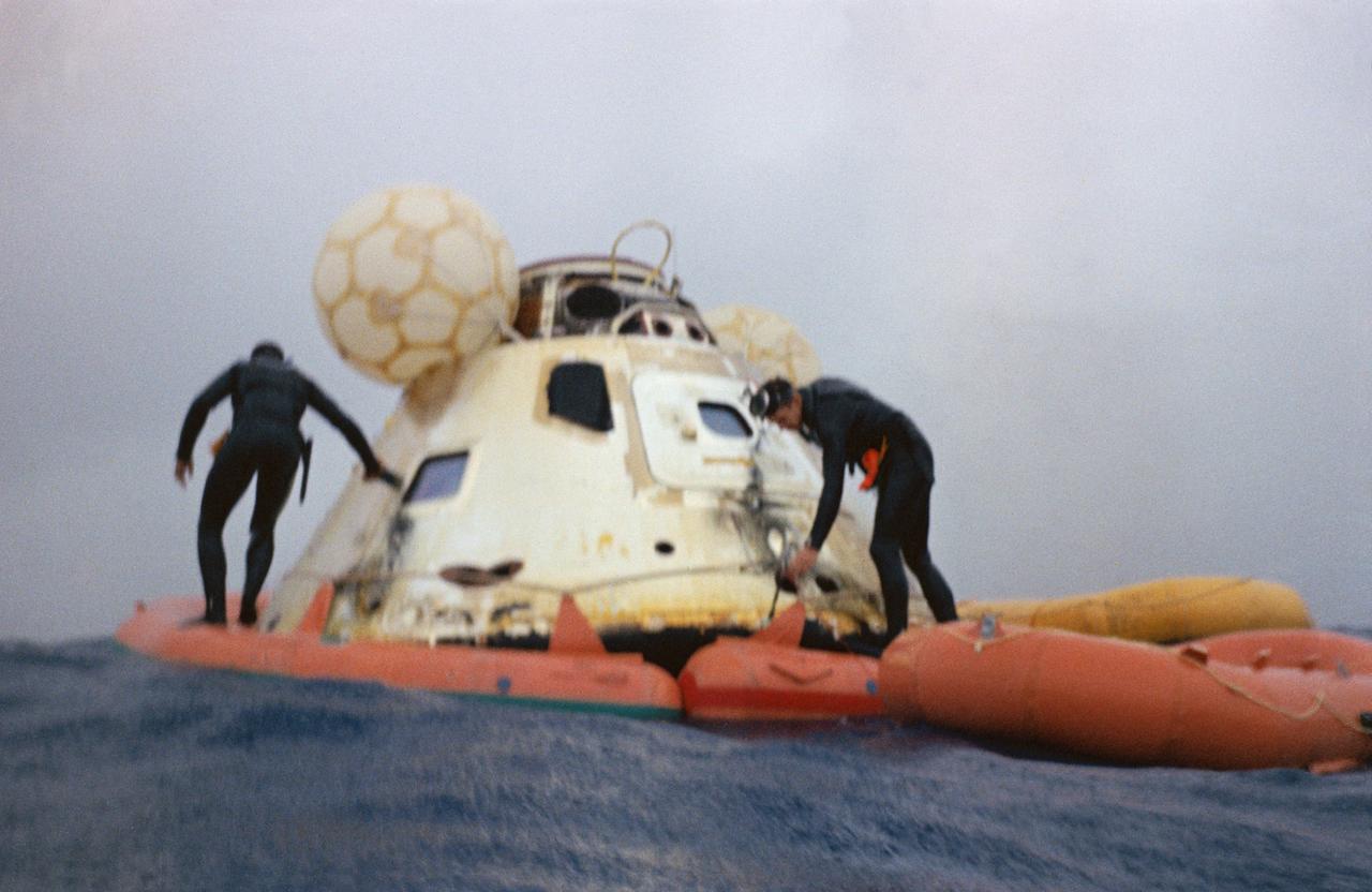
U.S. Navy frogmen attach a flotation collar to the Apollo 7 command module during recovery operations in the Atlantic. The Apollo 7 spacecraft splashed down at 7:11 a.m., October 22, 1968, approximately 200 nautical miles south-southwest of Bermuda.
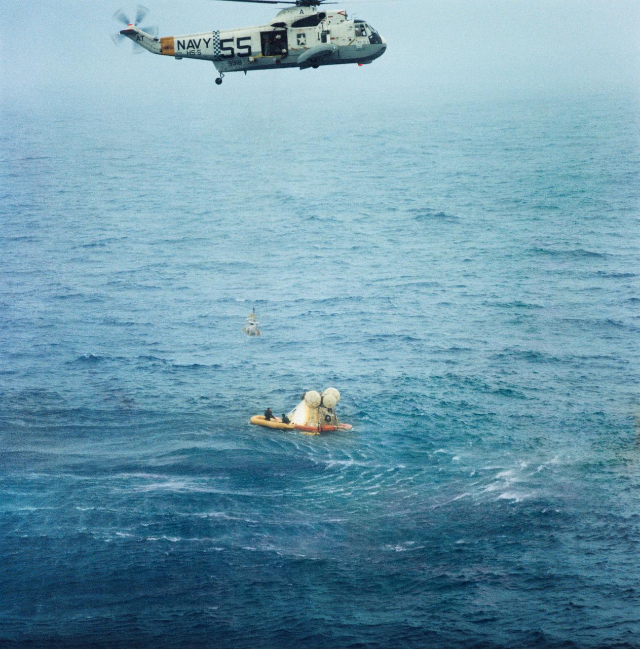
S68-49661 (22 Oct. 1968) --- A member of the Apollo 7 crew is hoisted up to a recovery helicopter from the USS Essex during recovery operations. The Apollo 7 spacecraft splashed down at 7:11 a.m., Oct. 22, 1968, approximately 200 nautical miles south-southwest of Bermuda. Photo credit: NASA
On Oct. 19 at 1500 UTC (11 a.m. EDT), the MODIS instrument aboard NASA's Terra satellite captured this visible image of Hurricane Gonzalo east of Newfoundland, Canada. ..Credit: NASA Goddard MODIS Rapid Response Team ..<b><a href="http://www.nasa.gov/audience/formedia/features/MP_Photo_Guidelines.html" rel="nofollow">NASA image use policy.</a></b> <b><a href="http://www.nasa.gov/centers/goddard/home/index.html" rel="nofollow">NASA Goddard Space Flight Center</a></b> enables NASA’s mission through four scientific endeavors: Earth Science, Heliophysics, Solar System Exploration, and Astrophysics. Goddard plays a leading role in NASA’s accomplishments by contributing compelling scientific knowledge to advance the Agency’s mission. <b>Follow us on <a href="http://twitter.com/NASAGoddardPix" rel="nofollow">Twitter</a></b> <b>Like us on <a href="http://www.facebook.com/pages/Greenbelt-MD/NASA-Goddard/395013845897?ref=tsd" rel="nofollow">Facebook</a></b> <b>Find us on <a href="http://instagram.com/nasagoddard?vm=grid" rel="nofollow">Instagram</a></b>
NOAA's GOES-East satellite captured a visible image of the storm on Sunday, Oct. 18 at 1145 UTC (7:45 a.m. EDT) that showed it in the North Atlantic, blanketing eastern Canada and stretching east over open waters. ..Credit: NOAA/NASA GOES Project..<b><a href="http://www.nasa.gov/audience/formedia/features/MP_Photo_Guidelines.html" rel="nofollow">NASA image use policy.</a></b> <b><a href="http://www.nasa.gov/centers/goddard/home/index.html" rel="nofollow">NASA Goddard Space Flight Center</a></b> enables NASA’s mission through four scientific endeavors: Earth Science, Heliophysics, Solar System Exploration, and Astrophysics. Goddard plays a leading role in NASA’s accomplishments by contributing compelling scientific knowledge to advance the Agency’s mission. <b>Follow us on <a href="http://twitter.com/NASAGoddardPix" rel="nofollow">Twitter</a></b> <b>Like us on <a href="http://www.facebook.com/pages/Greenbelt-MD/NASA-Goddard/395013845897?ref=tsd" rel="nofollow">Facebook</a></b> <b>Find us on <a href="http://instagram.com/nasagoddard?vm=grid" rel="nofollow">Instagram</a></b>
On Oct. 18 at 17:35 UTC (1:35 p.m EDT) the MODIS instrument aboard NASA's Aqua satellite saw Hurricane Gonzalo approaching Newfoundland. ..Credit: NASA Goddard MODIS Rapid Response Team..<b><a href="http://www.nasa.gov/audience/formedia/features/MP_Photo_Guidelines.html" rel="nofollow">NASA image use policy.</a></b> <b><a href="http://www.nasa.gov/centers/goddard/home/index.html" rel="nofollow">NASA Goddard Space Flight Center</a></b> enables NASA’s mission through four scientific endeavors: Earth Science, Heliophysics, Solar System Exploration, and Astrophysics. Goddard plays a leading role in NASA’s accomplishments by contributing compelling scientific knowledge to advance the Agency’s mission. <b>Follow us on <a href="http://twitter.com/NASAGoddardPix" rel="nofollow">Twitter</a></b> <b>Like us on <a href="http://www.facebook.com/pages/Greenbelt-MD/NASA-Goddard/395013845897?ref=tsd" rel="nofollow">Facebook</a></b> <b>Find us on <a href="http://instagram.com/nasagoddard?vm=grid" rel="nofollow">Instagram</a></b>
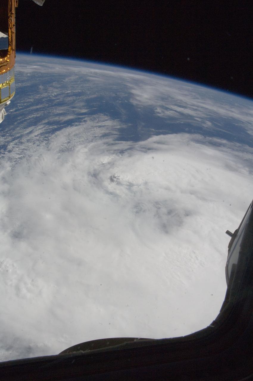
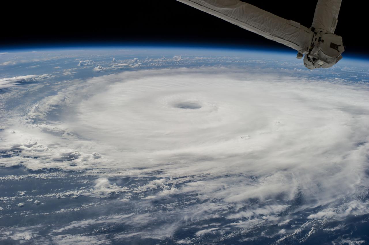
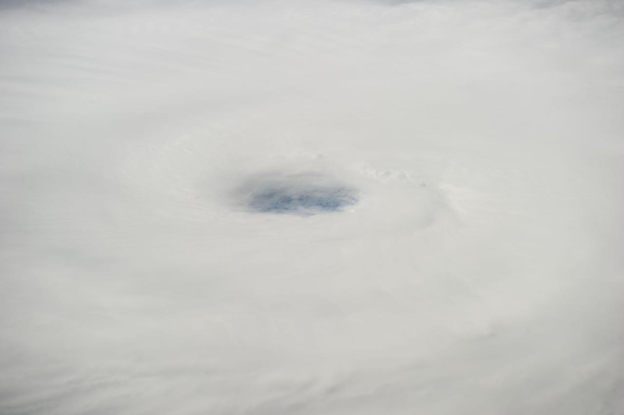
ISS032-E-025605 (9 Sept. 2012) --- Tropical Storm Leslie is clearly seen in the Atlantic Ocean on Sept. 9, 2012, as photographed by one of the Expedition 32 crew members aboard the Cupola of the International Space Station. At the time of the photo, Leslie was centered near 33.4 degrees north latitude and 62.1 degrees west longitude (approximately 175 miles east-northeast of Bermuda) moving northward at 14 miles per hour with winds of 60 miles per hour.
ISS032-E-025610 (9 Sept. 2012) --- Partially obstructed by two Russian spacecraft in the foreground, Tropical Storm Leslie is clearly seen in the Atlantic Ocean on Sept. 9, 2012, as photographed by one of the Expedition 32 crew members aboard the International Space Station. At the time of the photo, Leslie was centered near 33.4 degrees north latitude and 62.1 degrees west longitude (approximately 175 miles east-northeast of Bermuda) moving northward at 14 miles per hour with winds of 60 miles per hour.
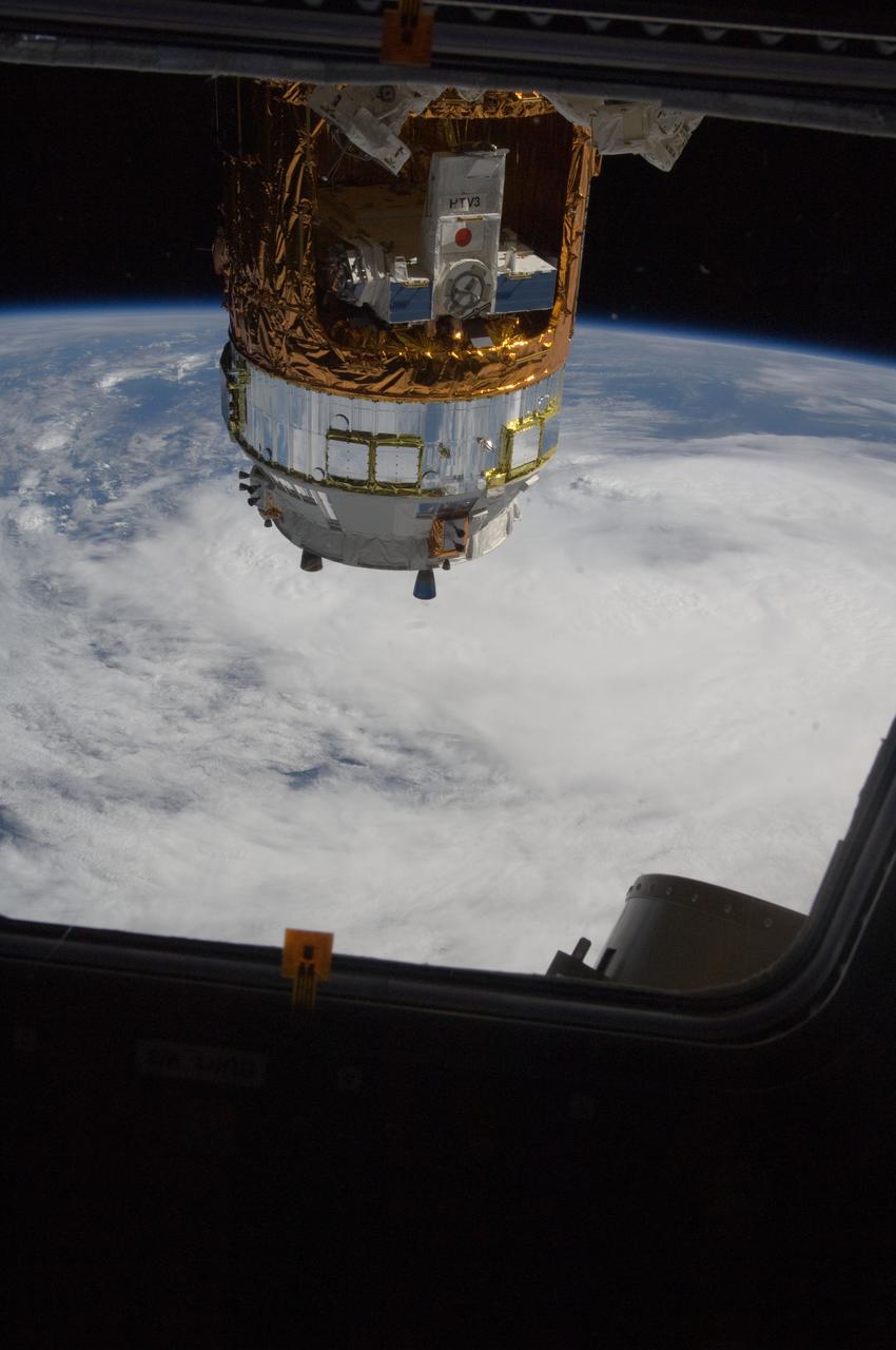
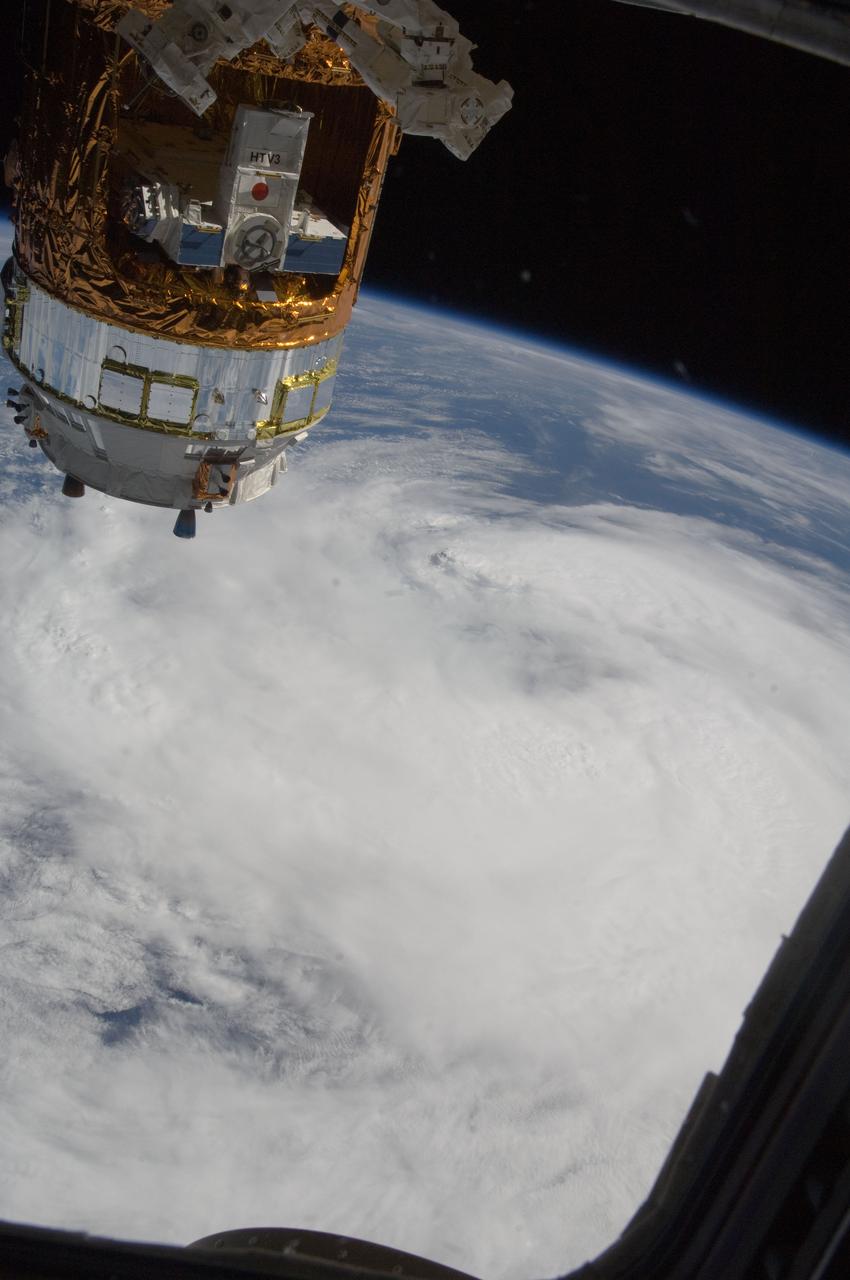
ISS032-E-025592 (9 Sept. 2012) --- Partially obstructed by the HTV-3 (H-II Transfer Vehicle) of the Japan Aerospace Exploration Agency (JAXA), Tropical Storm Leslie is clearly seen in the Atlantic Ocean on Sept. 9, 2012, as photographed by one of the Expedition 32 crew members aboard the Cupola of the International Space Station. At the time of the photo Leslie was centered near 33.4 degrees north latitude and 62.1degrees west longitude (approximately 175 miles east-northeast of Bermuda) moving northward at 14
ISS043E185040 (05/10/2015) --- Earth observation taken by the Expedition 43 crew of the International Space Station. These islands have often been referred to as the "jewel of the Atlantic" and are only 2 two hours by commercial plane from the USA. NASA astronaut Scott Kelly tweeted this image on May 10, 2015 with this comment: "Bermuda, your clouds and remoteness have shielded you for a long time, but I finally got my eye on you.#YearInSpace".
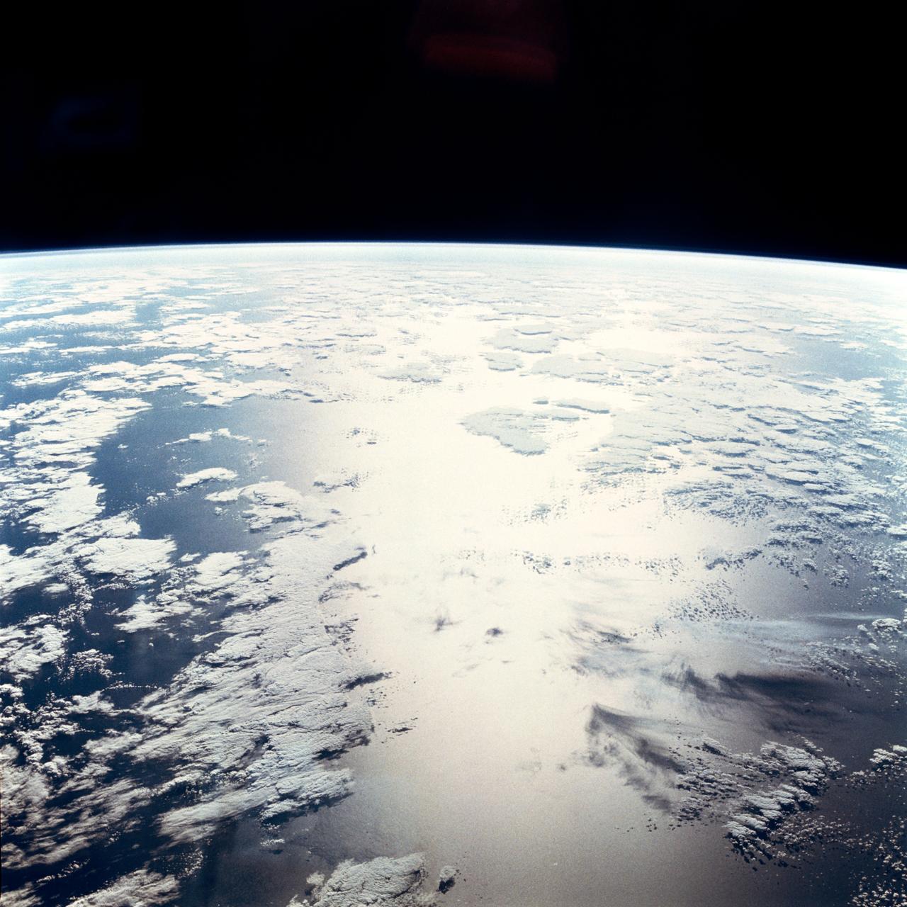
From 165 nautical miles above the earth, the STS-66 astronauts were able to capture detail in a number of storm systems around the globe during their 11-day stay in space aboard the Space Shuttle Atlantis. A 70mm handheld Hasselblad was used to photograph Hurricane Florence in the Atlantic Ocean, about 400 miles from Bermuda.
ISS041-E-078241 (16 Oct. 2014) --- One of the crew members aboard the International Space Station photographed this oblique scene of Hurricane Gonzalo on Oct. 16, 2014. The storm's eye is barely visible just above the center of the frame. Gonzalo hit Bermuda on the following day, as a powerful Category 2 storm, with winds estimated at 110 miles per hour.
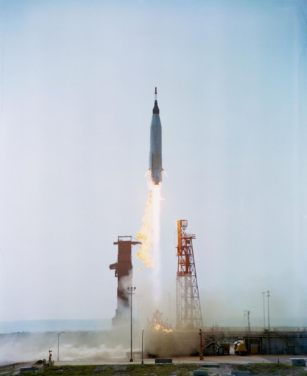
S63-07135 (16 May 1963) --- This was the Nation?s sixth manned orbital space flight, and the ?Faith 7? spacecraft was piloted by astronaut L. Gordon Cooper Jr. The launch was originally scheduled for May 14, 1963, but due to a malfunction in the radar tracking system at Bermuda. The launch was ?scrubbed? 12 minutes before countdown would have been completed. At midnight, May 15, 1963, countdown was resumed and liftoff occurred at 8:04 a.m. (EST), May 16, 1963. Astronaut L. Gordon Cooper Jr., completed a total of 22.9 orbits and spent 34 hours, 20 minutes in space flight. The launch and recovery was highly successful and was the last of the Mercury flights.
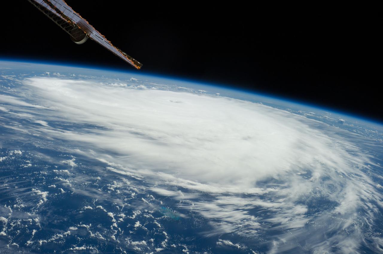
ISS041-E-011814 (16 Sept. 2014) --- Though having been upgraded from a tropical storm to a Category 2 hurricane, the Atlantic-borne Edouard thus far has avoided land interests as it reached maximum sustained winds of 105 miles per hout, churning in ocean waters several hundred miles southeast of Bermuda. The Expedition 41 crew members onboard the International Space Station photographed and distributed a series of images via station-to-ground downlinks and via social media. This photo was taken at 15:29:04 GMT on Sept. 16, 2014. Though it had well-defined eye at this juncture, the eye does not show clearly in this image, as it does in others.
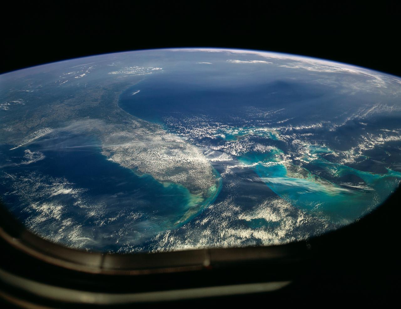
STS004-41-1206 (27 June-4July 1982) --- Sunglint reflects off the water of the North Atlantic Ocean in an area to the east of the Bahamas Islands sometimes called the Sargasso Sea. The area has also been referred to as the ?Bermuda Triangle.? Astronauts Thomas K. Mattingly II, STS-4 commander, and Henry W. Hartsfield Jr., pilot, spent seven days and one hour aboard the Earth-orbiting space shuttle Columbia and performed a variety of duties in addition to those of recording 70mm and 35mm imagery. Photo credit: NASA
ISS032-E-025597 (9 Sept. 2012) --- Partially obstructed by the HTV-3 (H-II Transfer Vehicle) of the Japan Aerospace Exploration Agency (JAXA), Tropical Storm Leslie is clearly seen in the Atlantic Ocean on Sept. 9, 2012, as photographed by one of the Expedition 32 crew members aboard the Cupola of the International Space Station. At the time of the photo Leslie was centered near 33.4 degrees north latitude and 62.1degrees west longitude (approximately 175 miles east-northeast of Bermuda) moving northward at 14 miles per hour with winds of 60 miles per hour.
ISS041-E-011535 (16 Sept. 2014) --- Though having been upgraded from a tropical storm to a Category 2 hurricane, the Atlantic-borne Edouard thus far has avoided land interests as it reached maximum sustained winds, churning in ocean waters several hundred miles southeast of Bermuda. The Expedition 41 crew members onboard the International Space Station photographed and distributed a series of images via station-to-ground downlinks and via social media. This photo was taken at 13:51:53 GMT on Sept. 16, 2014.
STS031-151-155 (26 April 1990) --- The Florida peninsula and smog over the northeastern U.S. coast are featured in this image photographed by a Space Shuttle Discovery crewmember during STS-31 mission. According to scientists, a mass of aerosol haze stretches across the top of the entire view. Meteorological, visibility and sulfate-content data showed that the haze was indeed industrial smog haze, rather than cloud. The air mass was transported west to east (left to right) around the north limb of a high pressure cell. It moved offshore for at least 1500 kilometers reaching the Atlantic islands of Bermuda. The leading edge of the haze mass can be detected far to the south, near the Bahamas--indicating that aerosols from the industrial Northeast were transported around the high, back directly toward the large population centers of Florida.
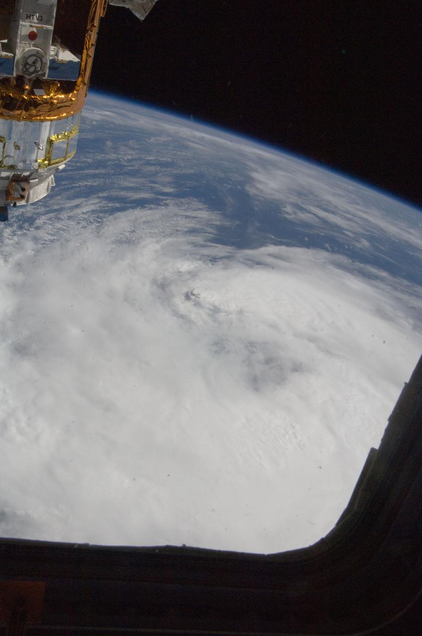
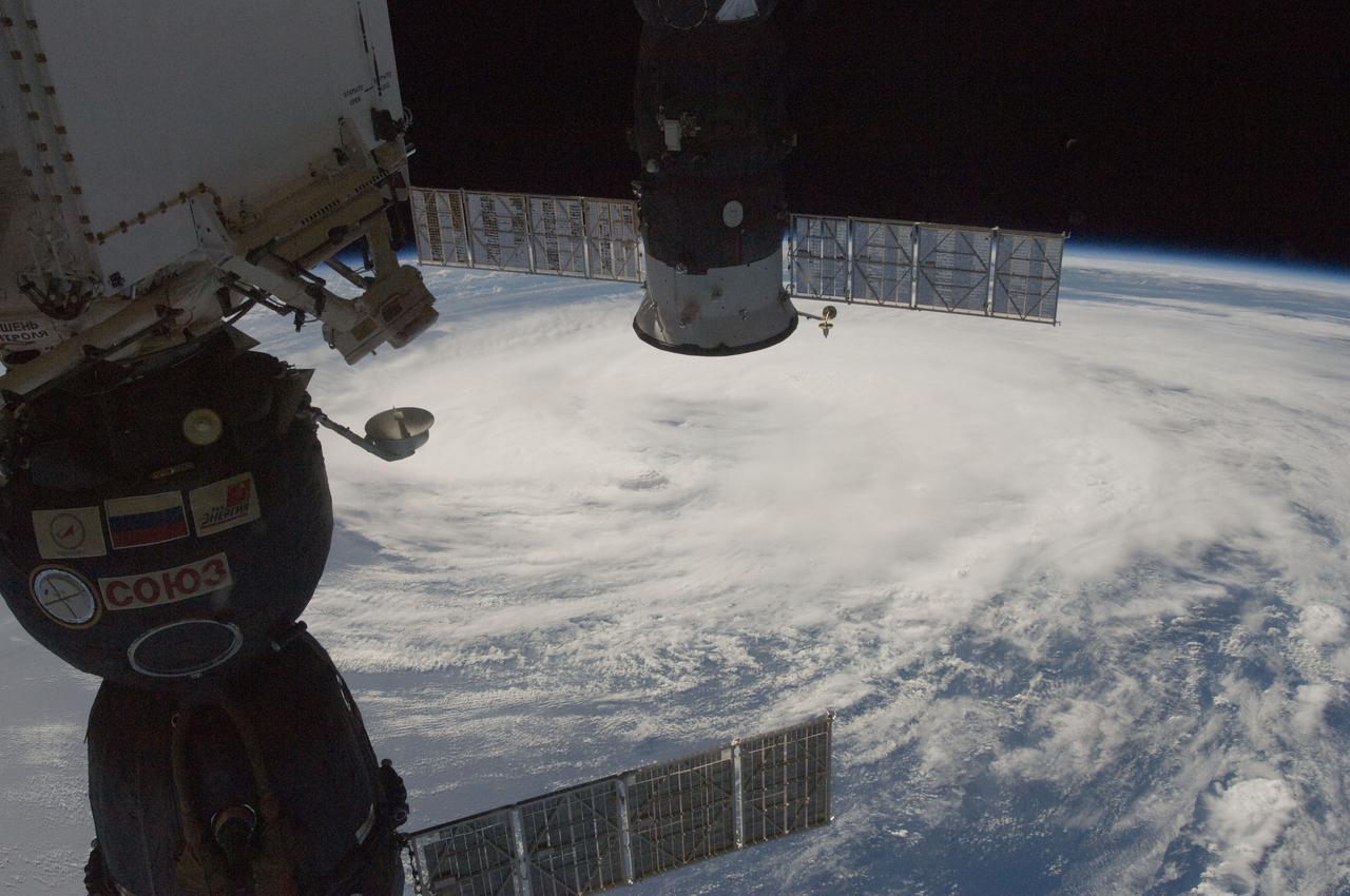
ISS032-E-025603 (9 Sept. 2012) --- Tropical Storm Leslie is clearly seen in the Atlantic Ocean on Sept. 9, 2012, as photographed by one of the Expedition 32 crew members aboard the Cupola of the International Space Station. At the time of the photo, Leslie was centered near 33.4 degrees north latitude and 62.1 degrees west longitude (approximately 175 miles east-northeast of Bermuda) moving northward at 14 miles per hour with winds of 60 miles per hour. The HTV-3 (H-II Transfer Vehicle) of the Japan Aerospace Exploration Agency (JAXA), which will be disconnected from the orbital outpost and sent to fall into Earth's atmosphere after fully completing its mission, is in the upper left corner.
ISS041-E-011536 (16 Sept. 2014) --- This is the eye of Hurricane Edouard in the Atlantic Ocean, as photographed by one of the Expedition 41 crew members who utilized a 200mm focal length from a position onboard the International Space Station. The crew members photographed and distributed a series of images of the storm via station-to-ground downlinks and via social media. Though having been upgraded from a tropical storm to a Category 2 hurricane, the Atlantic-borne Edouard thus far has avoided land interests as it reached maximum sustained winds of 105 miles per hour, churning in ocean waters several hundred miles southeast of Bermuda. This photo was taken at 13:52:40 GMT on Sept. 16, 2014.
Joaquin became a tropical storm Monday evening (EDT) midway between the Bahamas and Bermuda and has now formed into Hurricane Joaquin, the 3rd of the season--the difference is Joaquin could impact the US East Coast. NASA's GPM satellite captured Joaquin Tuesday, September 29th at 21:39 UTC (5:39 pm EDT). Credit: NASA's Scientific Visualization Studio Data provided by the joint NASA/JAXA GPM mission. Download/read more: <a href="http://svs.gsfc.nasa.gov/cgi-bin/details.cgi?aid=4367" rel="nofollow">svs.gsfc.nasa.gov/cgi-bin/details.cgi?aid=4367</a> <b><a href="http://www.nasa.gov/audience/formedia/features/MP_Photo_Guidelines.html" rel="nofollow">NASA image use policy.</a></b> <b><a href="http://www.nasa.gov/centers/goddard/home/index.html" rel="nofollow">NASA Goddard Space Flight Center</a></b> enables NASA’s mission through four scientific endeavors: Earth Science, Heliophysics, Solar System Exploration, and Astrophysics. Goddard plays a leading role in NASA’s accomplishments by contributing compelling scientific knowledge to advance the Agency’s mission. <b>Follow us on <a href="http://twitter.com/NASAGoddardPix" rel="nofollow">Twitter</a></b> <b>Like us on <a href="http://www.facebook.com/pages/Greenbelt-MD/NASA-Goddard/395013845897?ref=tsd" rel="nofollow">Facebook</a></b> <b>Find us on <a href="http://instagrid.me/nasagoddard/?vm=grid" rel="nofollow">Instagram</a></b>
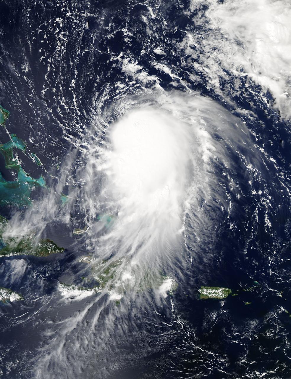
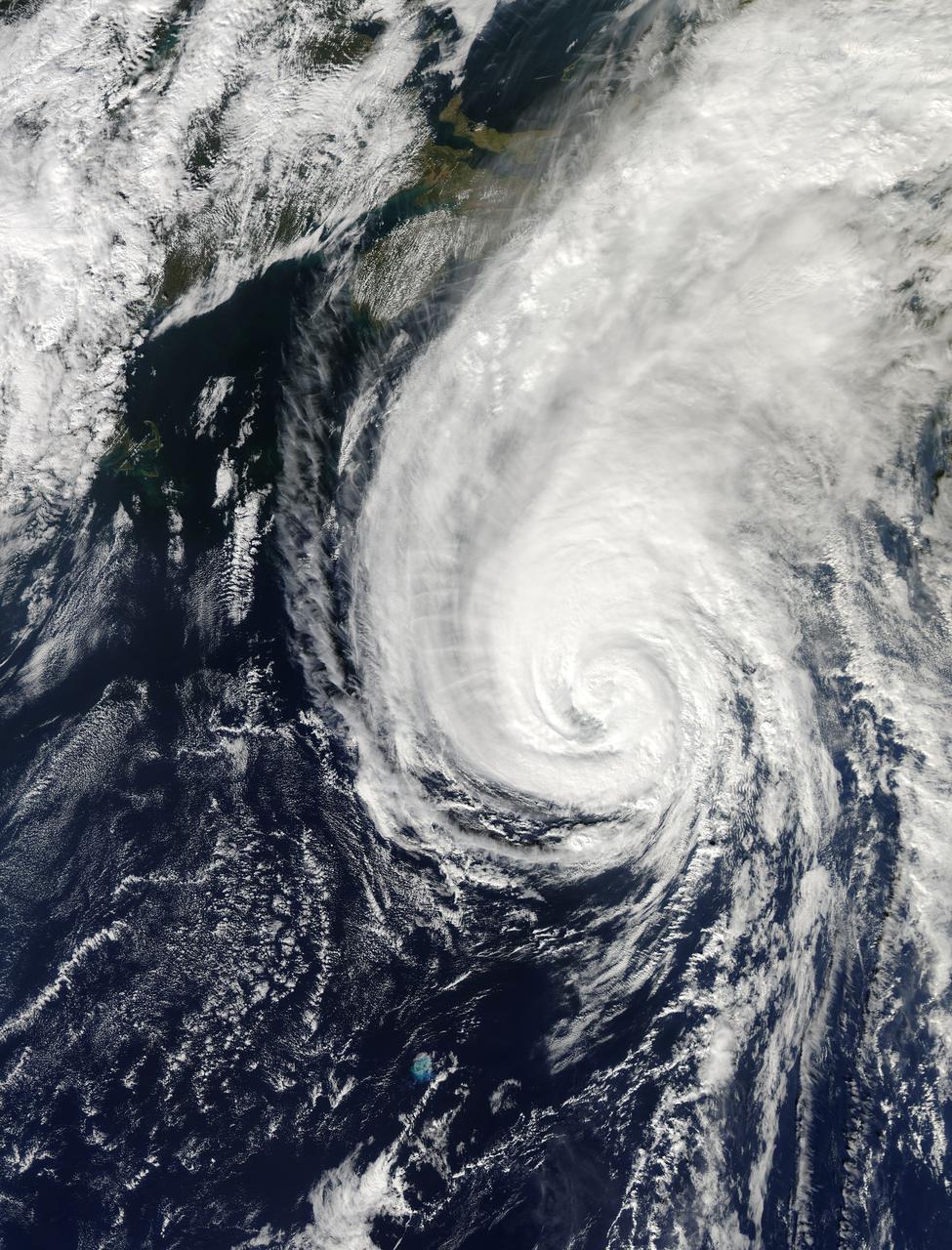
NASA's Aqua satellite captured this image of Joaquin near the Bahamas on Sept. 29 at 18:10 UTC (2:10 p.m. EDT). Credit: NASA Goddard MODIS Rapid Response Team At 11 a.m. EDT (1500 UTC) on Wednesday, September 30, 2015 the center of Hurricane Joaquin was located near latitude 24.7 North, longitude 72.6 West. That puts the center of Joaquin about 215 miles (345 km) east-northeast of the Central Bahamas. Joaquin became a tropical storm Monday evening (EDT), September 29 when it was midway between the Bahamas and Bermuda. By 8 a.m. EDT on September 30, it strengthened into a hurricane and has become the third hurricane of the Atlantic Hurricane season. On September 30, the National Hurricane Center issued a Hurricane Warning for the central Bahamas including Cat Island, the Exumas, Long Island, Rum Cay, and San Salvador. A Hurricane Watch is in effect for the northwestern Bahamas including the Abacos, Berry Islands, Bimini, Eleuthera, Grand Bahama Island, and New Providence, but excluding Andros Island. <b><a href="http://www.nasa.gov/audience/formedia/features/MP_Photo_Guidelines.html" rel="nofollow">NASA image use policy.</a></b> <b><a href="http://www.nasa.gov/centers/goddard/home/index.html" rel="nofollow">NASA Goddard Space Flight Center</a></b> enables NASA’s mission through four scientific endeavors: Earth Science, Heliophysics, Solar System Exploration, and Astrophysics. Goddard plays a leading role in NASA’s accomplishments by contributing compelling scientific knowledge to advance the Agency’s mission. <b>Follow us on <a href="http://twitter.com/NASAGoddardPix" rel="nofollow">Twitter</a></b> <b>Like us on <a href="http://www.facebook.com/pages/Greenbelt-MD/NASA-Goddard/395013845897?ref=tsd" rel="nofollow">Facebook</a></b> <b>Find us on <a href="http://instagrid.me/nasagoddard/?vm=grid" rel="nofollow">Instagram</a></b>
The MODIS instrument on NASA's Terra satellite captured Hurricane Joaquin off the Bahamas at 15:45 UTC (11:45 a.m. EDT) on September 30, 2015. Credit: NASA/GSFC/Jeff Schmaltz/MODIS Land Rapid Response Team At 11 a.m. EDT (1500 UTC) on Wednesday, September 30, 2015 the center of Hurricane Joaquin was located near latitude 24.7 North, longitude 72.6 West. That puts the center of Joaquin about 215 miles (345 km) east-northeast of the Central Bahamas. Joaquin became a tropical storm Monday evening (EDT), September 29 when it was midway between the Bahamas and Bermuda. By 8 a.m. EDT on September 30, it strengthened into a hurricane and has become the third hurricane of the Atlantic Hurricane season. On September 30, the National Hurricane Center issued a Hurricane Warning for the central Bahamas including Cat Island, the Exumas, Long Island, Rum Cay, and San Salvador. A Hurricane Watch is in effect for the northwestern Bahamas including the Abacos, Berry Islands, Bimini, Eleuthera, Grand Bahama Island, and New Providence, but excluding Andros Island. <b><a href="http://www.nasa.gov/audience/formedia/features/MP_Photo_Guidelines.html" rel="nofollow">NASA image use policy.</a></b> <b><a href="http://www.nasa.gov/centers/goddard/home/index.html" rel="nofollow">NASA Goddard Space Flight Center</a></b> enables NASA’s mission through four scientific endeavors: Earth Science, Heliophysics, Solar System Exploration, and Astrophysics. Goddard plays a leading role in NASA’s accomplishments by contributing compelling scientific knowledge to advance the Agency’s mission. <b>Follow us on <a href="http://twitter.com/NASAGoddardPix" rel="nofollow">Twitter</a></b> <b>Like us on <a href="http://www.facebook.com/pages/Greenbelt-MD/NASA-Goddard/395013845897?ref=tsd" rel="nofollow">Facebook</a></b> <b>Find us on <a href="http://instagrid.me/nasagoddard/?vm=grid" rel="nofollow">Instagram</a></b>
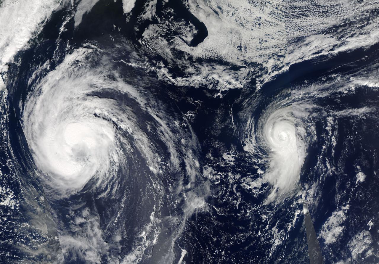
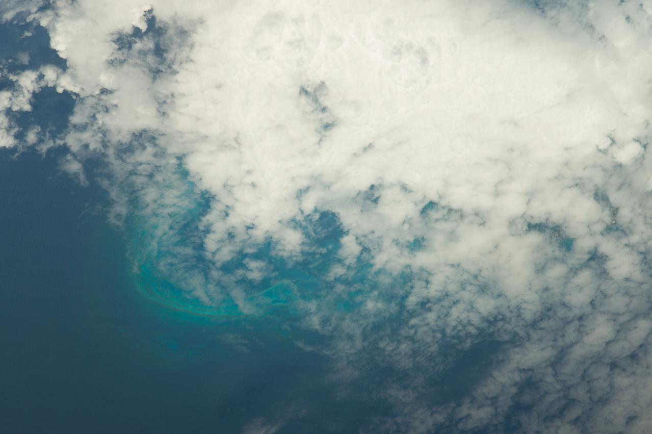
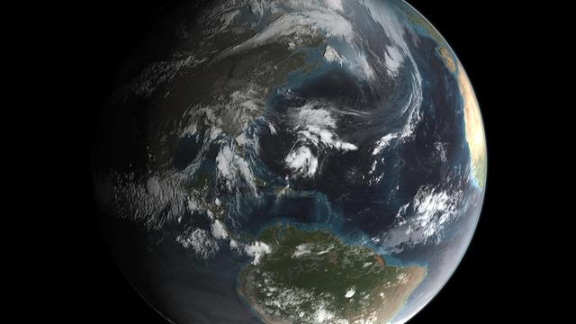
This visible image of Tropical Storm Leslie and Hurricane Michael was taken by the MODIS instrument aboard both NASA's Aqua and Terra satellites on Sept. 9 at 12:50 p.m. EDT. Credit: NASA Goddard/MODIS Rapid Response Team -- Satellite images from two NASA satellites were combined to create a full picture of Tropical Storm Leslie and Hurricane Michael spinning in the Atlantic Ocean. Imagery from NASA's Aqua and Terra satellites showed Leslie now past Bermuda and Michael in the north central Atlantic, and Leslie is much larger than the smaller, more powerful Michael. Images of each storm were taken by the Moderate Resolution Imaging Spectroradiometer, or MODIS instrument that flies onboard both the Aqua and Terra satellites. Both satellites captured images of both storms on Sept. 7 and Sept. 10. The image from Sept. 7 showed a much more compact Michael with a visible eye. By Sept. 10, the eye was no longer visible in Michael and the storm appeared more elongated from south to north. To continue reading go to: <a href="http://1.usa.gov/NkUPqn" rel="nofollow">1.usa.gov/NkUPqn</a> <b><a href="http://www.nasa.gov/audience/formedia/features/MP_Photo_Guidelines.html" rel="nofollow">NASA image use policy.</a></b> <b><a href="http://www.nasa.gov/centers/goddard/home/index.html" rel="nofollow">NASA Goddard Space Flight Center</a></b> enables NASA’s mission through four scientific endeavors: Earth Science, Heliophysics, Solar System Exploration, and Astrophysics. Goddard plays a leading role in NASA’s accomplishments by contributing compelling scientific knowledge to advance the Agency’s mission. <b>Follow us on <a href="http://twitter.com/NASA_GoddardPix" rel="nofollow">Twitter</a></b> <b>Like us on <a href="http://www.facebook.com/pages/Greenbelt-MD/NASA-Goddard/395013845897?ref=tsd" rel="nofollow">Facebook</a></b> <b>Find us on <a href="http://instagrid.me/nasagoddard/?vm=grid" rel="nofollow">Instagram</a></b>
NOAA's GOES-East satellite captured this visible image of Hurricane Joaquin east of the Bahamas on Sept. 30 at 1745 UTC (1:45 p.m. EDT). Credit: NASA/NOAA GOES Project At 11 a.m. EDT (1500 UTC) on Wednesday, September 30, 2015 the center of Hurricane Joaquin was located near latitude 24.7 North, longitude 72.6 West. That puts the center of Joaquin about 215 miles (345 km) east-northeast of the Central Bahamas. Joaquin became a tropical storm Monday evening (EDT), September 29 when it was midway between the Bahamas and Bermuda. By 8 a.m. EDT on September 30, it strengthened into a hurricane and has become the third hurricane of the Atlantic Hurricane season. On September 30, the National Hurricane Center issued a Hurricane Warning for the central Bahamas including Cat Island, the Exumas, Long Island, Rum Cay, and San Salvador. A Hurricane Watch is in effect for the northwestern Bahamas including the Abacos, Berry Islands, Bimini, Eleuthera, Grand Bahama Island, and New Providence, but excluding Andros Island. <b><a href="http://www.nasa.gov/audience/formedia/features/MP_Photo_Guidelines.html" rel="nofollow">NASA image use policy.</a></b> <b><a href="http://www.nasa.gov/centers/goddard/home/index.html" rel="nofollow">NASA Goddard Space Flight Center</a></b> enables NASA’s mission through four scientific endeavors: Earth Science, Heliophysics, Solar System Exploration, and Astrophysics. Goddard plays a leading role in NASA’s accomplishments by contributing compelling scientific knowledge to advance the Agency’s mission. <b>Follow us on <a href="http://twitter.com/NASAGoddardPix" rel="nofollow">Twitter</a></b> <b>Like us on <a href="http://www.facebook.com/pages/Greenbelt-MD/NASA-Goddard/395013845897?ref=tsd" rel="nofollow">Facebook</a></b> <b>Find us on <a href="http://instagrid.me/nasagoddard/?vm=grid" rel="nofollow">Instagram</a></b>
Joaquin became a tropical storm Monday evening (EDT) midway between the Bahamas and Bermuda and has now formed into Hurricane Joaquin, the 3rd of the season--the difference is Joaquin could impact the US East Coast. NASA's GPM satellite captured Joaquin Tuesday, September 29th at 21:39 UTC (5:39 pm EDT). Credit: NASA's Scientific Visualization Studio Data provided by the joint NASA/JAXA GPM mission. Download/read more: <a href="http://svs.gsfc.nasa.gov/cgi-bin/details.cgi?aid=4367" rel="nofollow">svs.gsfc.nasa.gov/cgi-bin/details.cgi?aid=4367</a> <b><a href="http://www.nasa.gov/audience/formedia/features/MP_Photo_Guidelines.html" rel="nofollow">NASA image use policy.</a></b> <b><a href="http://www.nasa.gov/centers/goddard/home/index.html" rel="nofollow">NASA Goddard Space Flight Center</a></b> enables NASA’s mission through four scientific endeavors: Earth Science, Heliophysics, Solar System Exploration, and Astrophysics. Goddard plays a leading role in NASA’s accomplishments by contributing compelling scientific knowledge to advance the Agency’s mission. <b>Follow us on <a href="http://twitter.com/NASAGoddardPix" rel="nofollow">Twitter</a></b> <b>Like us on <a href="http://www.facebook.com/pages/Greenbelt-MD/NASA-Goddard/395013845897?ref=tsd" rel="nofollow">Facebook</a></b> <b>Find us on <a href="http://instagrid.me/nasagoddard/?vm=grid" rel="nofollow">Instagram</a></b>
Hurricane Cristobal is located west of Bermuda still holding to hurricane strength with a small window of opportunity for strengthening further before it moves to higher latitudes and over cooler waters in a couple of days. Currently, the satellite presentation resembles a subtropical cyclone with weak convection which is not concentrated near the center. Cristobal slowed down earlier this morning, but it has resumed a northward motion at 10 knots. This image was taken by GOES East at 1145Z on August 27, 2014. Caption Credit: NASA/NOAA via <b><a href="www.nnvl.noaa.gov/" rel="nofollow"> NOAA Environmental Visualization Laboratory</a></b> <b><a href="http://goes.gsfc.nasa.gov/" rel="nofollow">Credit: NOAA/NASA GOES Project</a></b> <b><a href="http://www.nasa.gov/audience/formedia/features/MP_Photo_Guidelines.html" rel="nofollow">NASA image use policy.</a></b> <b><a href="http://www.nasa.gov/centers/goddard/home/index.html" rel="nofollow">NASA Goddard Space Flight Center</a></b> enables NASA’s mission through four scientific endeavors: Earth Science, Heliophysics, Solar System Exploration, and Astrophysics. Goddard plays a leading role in NASA’s accomplishments by contributing compelling scientific knowledge to advance the Agency’s mission. <b>Follow us on <a href="http://twitter.com/NASAGoddardPix" rel="nofollow">Twitter</a></b> <b>Like us on <a href="http://www.facebook.com/pages/Greenbelt-MD/NASA-Goddard/395013845897?ref=tsd" rel="nofollow">Facebook</a></b> <b>Find us on <a href="http://instagram.com/nasagoddard?vm=grid" rel="nofollow">Instagram</a></b>
NOAA's GOES-East satellite captured this visible image of Hurricane Joaquin east of the Bahamas on Sept. 30 at 1745 UTC (1:45 p.m. EDT). Credit: NASA/NOAA GOES Project At 11 a.m. EDT (1500 UTC) on Wednesday, September 30, 2015 the center of Hurricane Joaquin was located near latitude 24.7 North, longitude 72.6 West. That puts the center of Joaquin about 215 miles (345 km) east-northeast of the Central Bahamas. Joaquin became a tropical storm Monday evening (EDT), September 29 when it was midway between the Bahamas and Bermuda. By 8 a.m. EDT on September 30, it strengthened into a hurricane and has become the third hurricane of the Atlantic Hurricane season. On September 30, the National Hurricane Center issued a Hurricane Warning for the central Bahamas including Cat Island, the Exumas, Long Island, Rum Cay, and San Salvador. A Hurricane Watch is in effect for the northwestern Bahamas including the Abacos, Berry Islands, Bimini, Eleuthera, Grand Bahama Island, and New Providence, but excluding Andros Island. <b><a href="http://www.nasa.gov/audience/formedia/features/MP_Photo_Guidelines.html" rel="nofollow">NASA image use policy.</a></b> <b><a href="http://www.nasa.gov/centers/goddard/home/index.html" rel="nofollow">NASA Goddard Space Flight Center</a></b> enables NASA’s mission through four scientific endeavors: Earth Science, Heliophysics, Solar System Exploration, and Astrophysics. Goddard plays a leading role in NASA’s accomplishments by contributing compelling scientific knowledge to advance the Agency’s mission. <b>Follow us on <a href="http://twitter.com/NASAGoddardPix" rel="nofollow">Twitter</a></b> <b>Like us on <a href="http://www.facebook.com/pages/Greenbelt-MD/NASA-Goddard/395013845897?ref=tsd" rel="nofollow">Facebook</a></b> <b>Find us on <a href="http://instagrid.me/nasagoddard/?vm=grid" rel="nofollow">Instagram</a></b>
-- Joaquin became a tropical storm Monday evening (EDT) midway between the Bahamas and Bermuda and has now formed into a hurricane, the 3rd of the season--the difference is Joaquin could impact the US East Coast. GPM captured Joaquin Tuesday, September 29th at 21:39 UTC (5:39 pm EDT) as the hurricane moved slowly towards the west-southwest about 400 miles east of the northwestern Bahamas. At the time, Joaquin had been battling northerly wind shear, which was impeding the storm's ability to strengthen. However, compared to earlier in the day, the system was beginning to gain the upper hand as the shear began to relax its grip. At the time of this data visualization, Joaquin's low-level center of circulation was located further within the cloud shield, and the rain area was beginning to wrap farther around the center on the eastern side of the storm while showing signs of increased banding and curvature, a sure sign that Joaquin's circulation was intensifying. GPM shows a large area of very intense rain with rain rates ranging from around 50 to 132 mm/hr (~2 to 5 inches, shown in red and magenta) just to the right of the center. This is a strong indication that large amounts of heat are being released into the storm's center, fueling its circulation and providing the means for its intensification. Associated with the area of intense rain is an area of tall convective towers, known as a convective burst, with tops reaching up to 16.3 km (shown in orange). These towers when located near the storm's core are a strong indication that the storm is poised to strengthen as they too reveal the release of heat into the storm. At the time this data was taken, the National Hurricane Center reported that Joaquin's maximum sustained winds had increased to 65 mph from 40 mph earlier in the day, making Joaquin a strong tropical storm but poised to become a hurricane, which occurred this morning at 8:00 am EDT. With the inhibiting wind shear expected to continue to diminish and the system moving over warm waters, the National Hurricane Center is forecasting Joaquin to intensify further, possibly into a major hurricane within the next few days. Credit: NASA's Scientific Visualization Studio Data provided by the joint NASA/JAXA GPM mission <b><a href="http://www.nasa.gov/audience/formedia/features/MP_Photo_Guidelines.html" rel="nofollow">NASA image use policy.</a></b> <b><a href="http://www.nasa.gov/centers/goddard/home/index.html" rel="nofollow">NASA Goddard Space Flight Center</a></b> enables NASA’s mission through four scientific endeavors: Earth Science, Heliophysics, Solar System Exploration, and Astrophysics. Goddard plays a leading role in NASA’s accomplishments by contributing compelling scientific knowledge to advance the Agency’s mission. <b>Follow us on <a href="http://twitter.com/NASAGoddardPix" rel="nofollow">Twitter</a></b> <b>Like us on <a href="http://www.facebook.com/pages/Greenbelt-MD/NASA-Goddard/395013845897?ref=tsd" rel="nofollow">Facebook</a></b> <b>Find us on <a href="http://instagrid.me/nasagoddard/?vm=grid" rel="nofollow">Instagram</a></b>