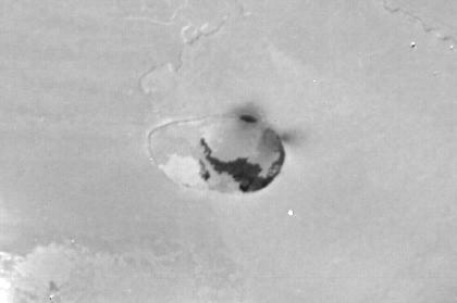
Io Caldera
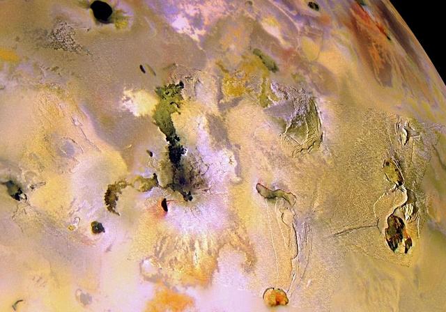
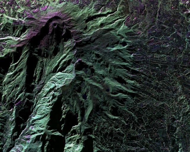
Ionian Mountains and Calderas, in Color
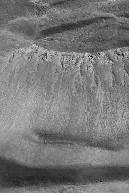
Ascraeus Mons Caldera Wall

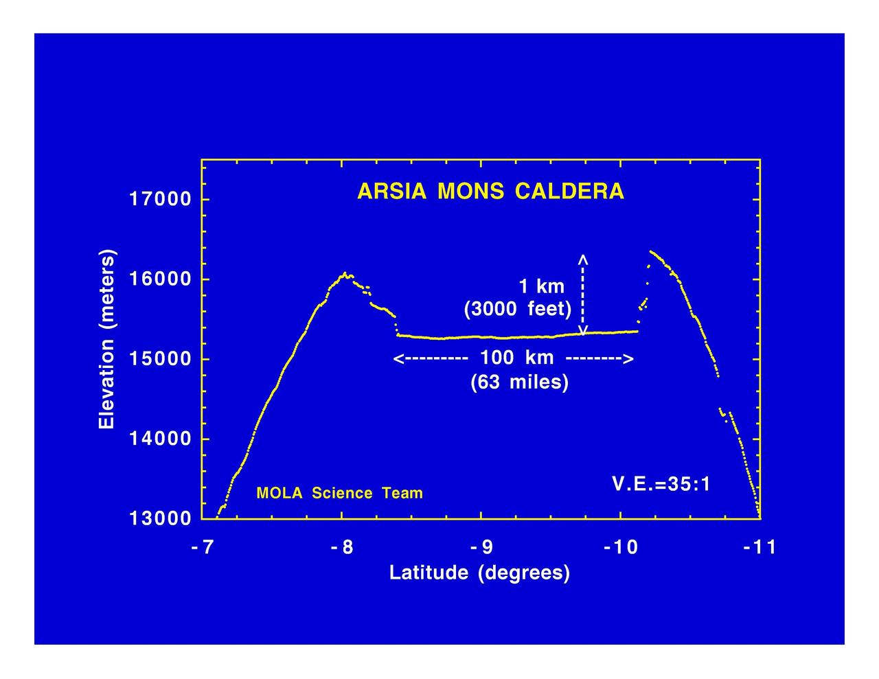
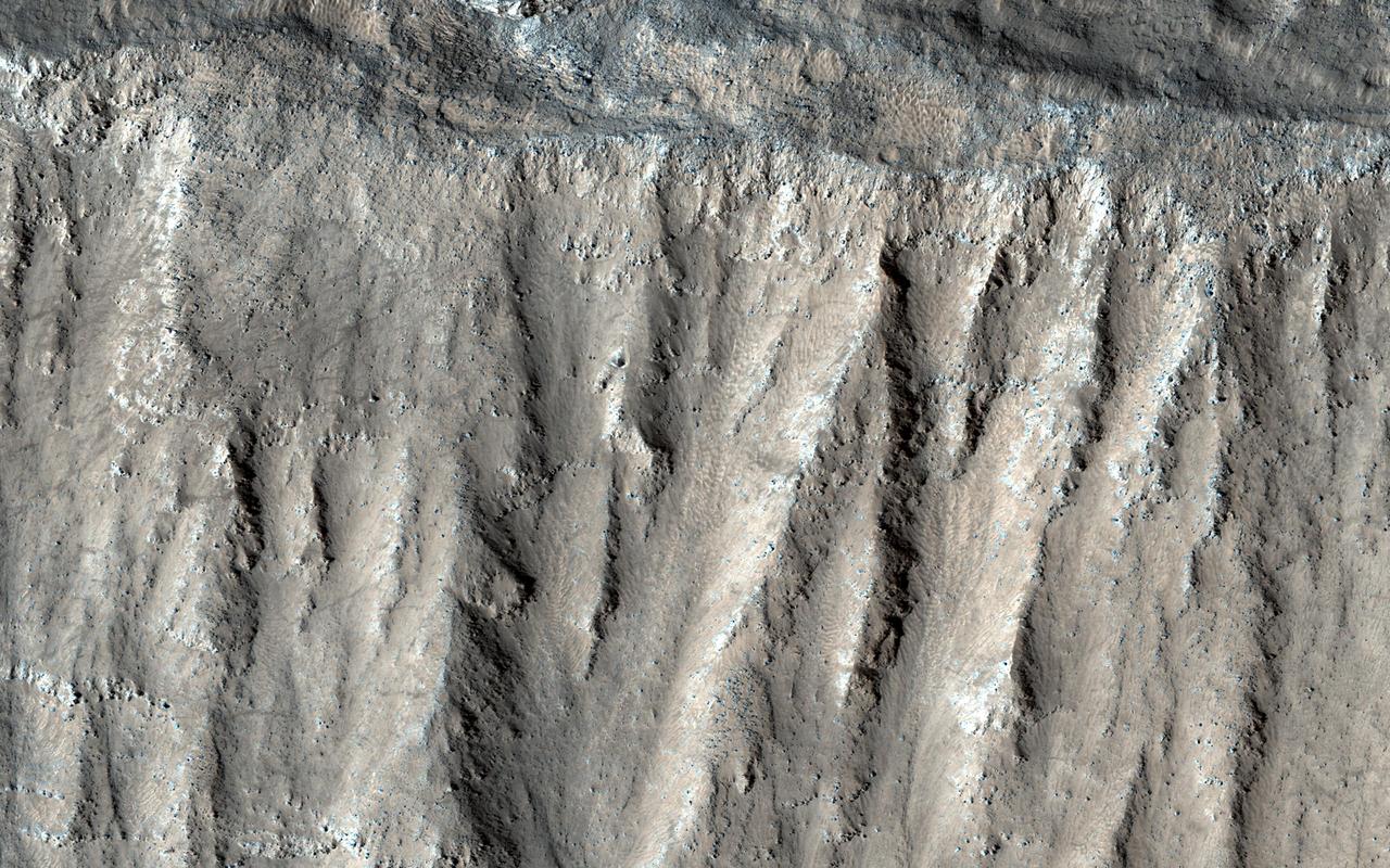
Arsia Mons Caldera Rim
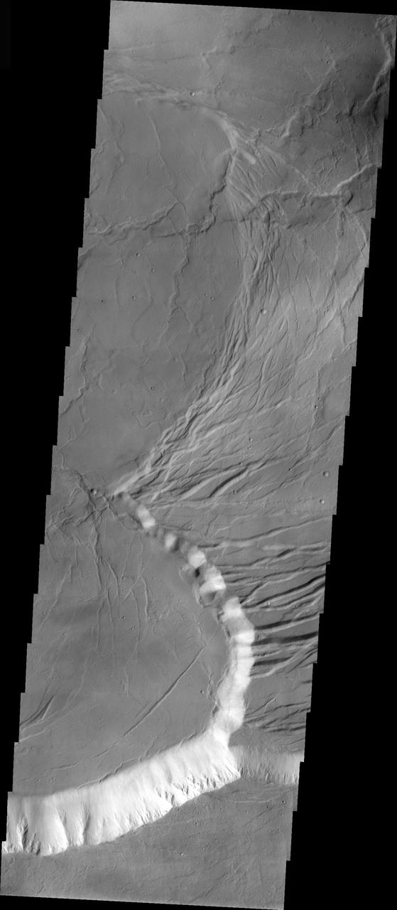
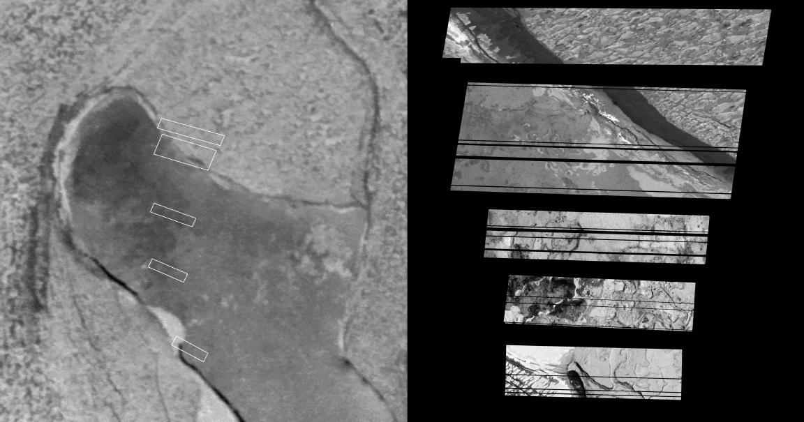
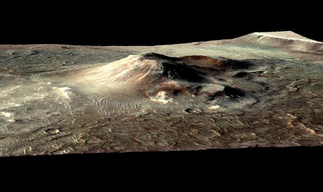
Pele Hot Caldera Margin
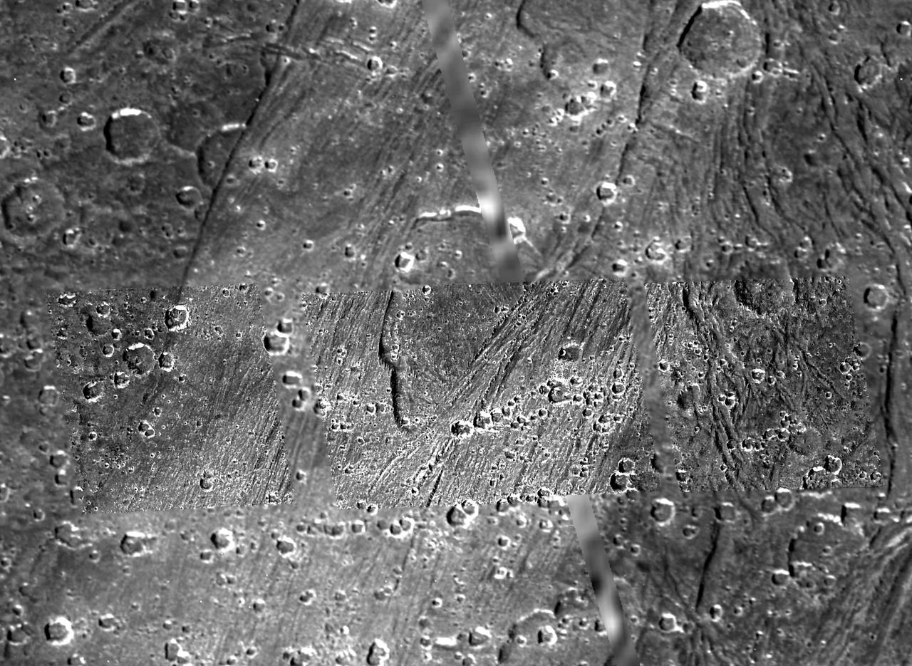
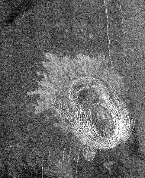
Caldera-like depression on Ganymede
Ceraunius Caldera Floor
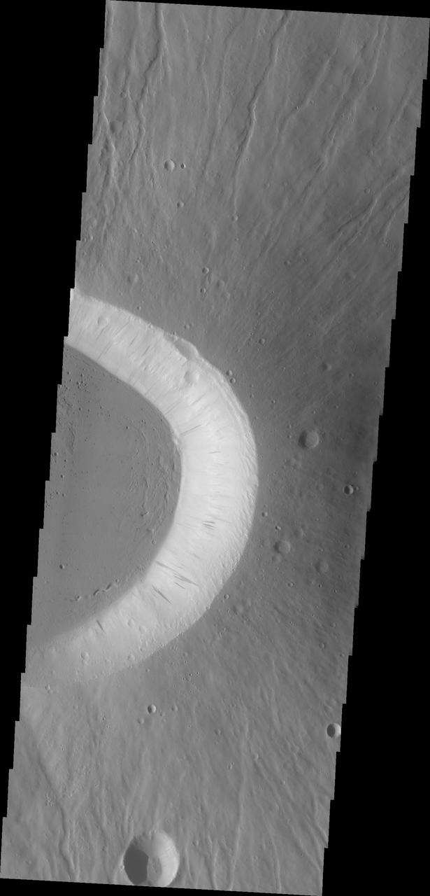
Ascraeus Caldera Wall
Arsia Mons Caldera
Arsia Mons Caldera
Caldera in Sippar Sulcus, Ganymede
This image from NASA 2001 Mars Odyssey spacecraft shows part of the caldera rim of Nili Patera. Dunes are located within the caldera.
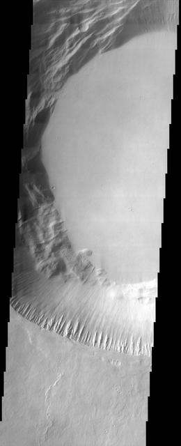
Sample Tharsis Tholus Caldera Wall
Arcuate Fractures in Olympus Mons Caldera
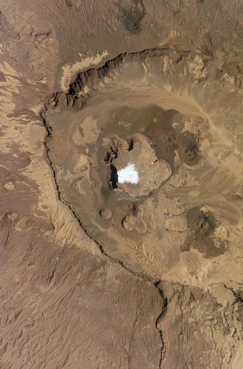
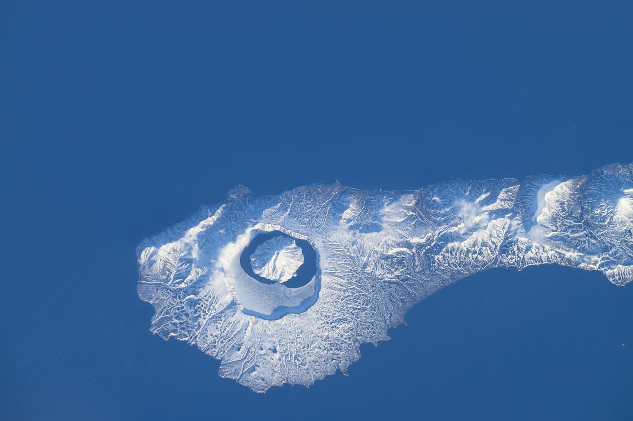
More than 9,000 years ago, a catastrophic volcanic eruption created a huge caldera on the southern end of Onekotan Island, one of the Kuril Islands, located off the southern tip of Russia’s Kamchatka Peninsula. Today, the ancient Tao-Rusyr Caldera is filled by the deep blue waters of Kal’tsevoe Lake. The Advanced Land Imager (ALI) on NASA’s Earth Observing-1 (EO-1) satellite acquired this true-color image of southern Onekotan on June 10, 2009. In this late-spring shot, snow or ice lingers on the land, forming white streaks on a brown-and-green land surface. In the northwest quadrant of the caldera is Krenitzyn Peak, which rises to a height of 1,325 meters (4,347 feet). Like the other Kuril Islands, Onekotan lies along the Pacific “Ring of Fire.” The Kuril Island volcanoes are fueled by magma generated by the subduction of the Pacific Plate under the Eurasian Plate, which takes place along a deep trench about 200 kilometers (120 miles) to the islands’ east. The only historical eruption at Krenitzyn Peak occurred in 1952, a week after a magnitude 9.0 earthquake along the subduction fault. NASA Earth Observatory image created by Robert Simmon, using EO-1 ALI data provided courtesy of the NASA EO-1 team. Caption by Michon Scott and Rebecca Lindsey. <b><a href="http://www.nasa.gov/audience/formedia/features/MP_Photo_Guidelines.html" rel="nofollow">NASA image use policy.</a></b> <b><a href="http://www.nasa.gov/centers/goddard/home/index.html" rel="nofollow">NASA Goddard Space Flight Center</a></b> enables NASA’s mission through four scientific endeavors: Earth Science, Heliophysics, Solar System Exploration, and Astrophysics. Goddard plays a leading role in NASA’s accomplishments by contributing compelling scientific knowledge to advance the Agency’s mission. <b>Follow us on <a href="http://twitter.com/NASAGoddardPix" rel="nofollow">Twitter</a></b> <b>Like us on <a href="http://www.facebook.com/pages/Greenbelt-MD/NASA-Goddard/395013845897?ref=tsd" rel="nofollow">Facebook</a></b> <b>Find us on <a href="http://instagrid.me/nasagoddard/?vm=grid" rel="nofollow">Instagram</a></b>
A large volcanic crater known as a caldera is located at the summit of all of the Tharsis volcanoes. These calderas are produced by massive volcanic explosions and collapse.Today's VIS image shows the summit caldera of Arsia Mons. Several small volcanic vents are visible on the caldera floor. It is not uncommon for calderas to have "flat" floors after the final explosive eruption the empties the subsurface magma chamber. There may still be some magma or superheated rock left after the collapse that will fill in part of the depression. Additionally, over time erosion will work to level the topography. Within the Arsia Mons caldera there was renewed activity from several small vents that occurred along the alignment of the NE/SW trend of the three large volcanoes. This ongoing, low volume activity is similar to the lava lake in Kilauea in Hawaii. Arsia Mons is the southernmost of the Tharsis volcanoes. It is 450 km (270 miles) in diameter, almost 20 km (12 miles) high, and the summit caldera is 120 km (72 miles) wide. For comparison, the largest volcano on Earth is Mauna Loa. From its base on the sea floor, Mauna Loa measures only 6.3 miles high and 75 miles in diameter.The Arsia Mons summit caldera is larger than many volcanoes on Earth. Orbit Number: 84328 Latitude: -8.58304 Longitude: 239.166 Instrument: VIS Captured: 2020-12-17 20:11 https://photojournal.jpl.nasa.gov/catalog/PIA24393
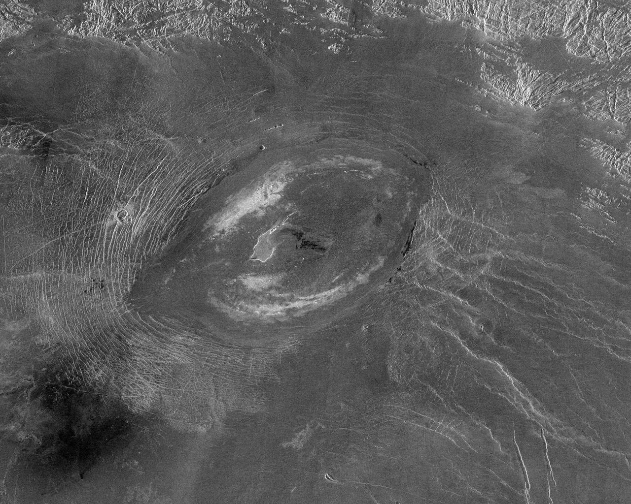
Pavonis Mons is the middle of the three large volcanoes on the Tharsis bulge. This image from NASA Mars Odyssey spacecraft covers the edge of the volcano caldera. Outside of the caldera, numerous lava flows and impact craters can be seen.
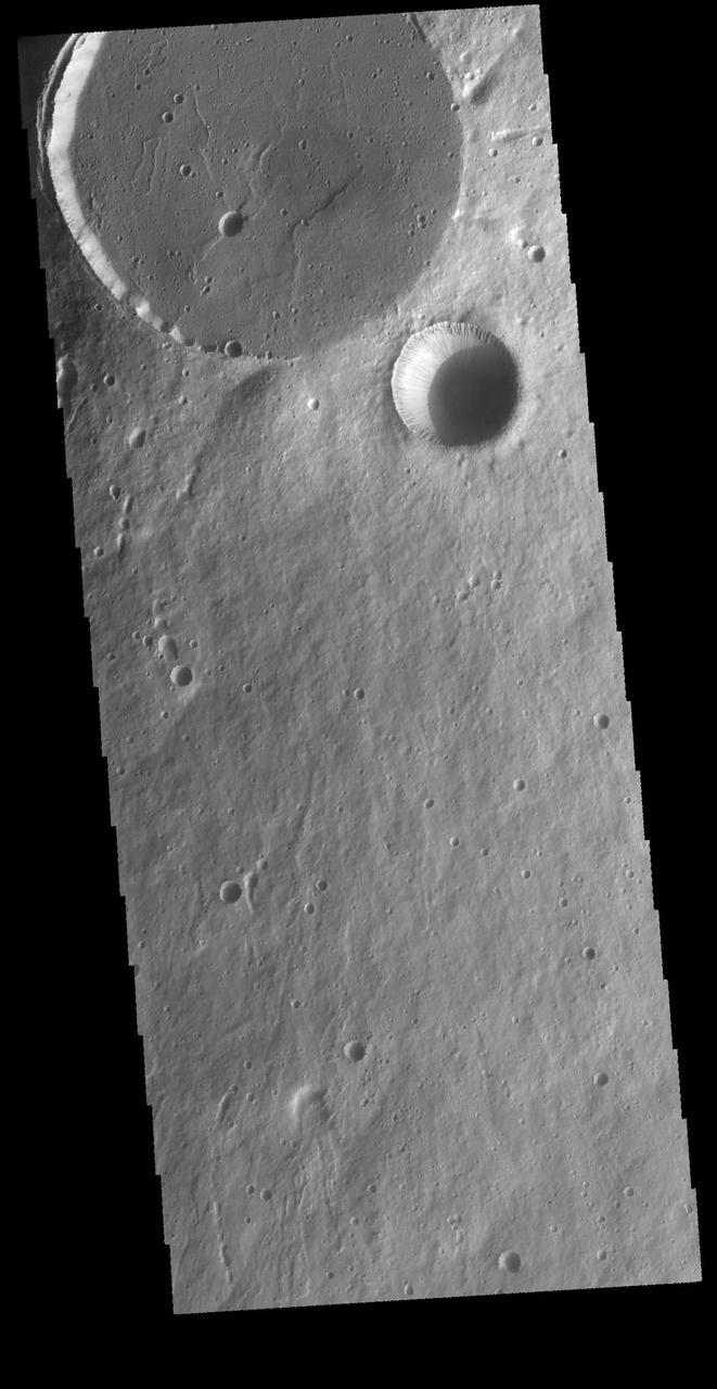
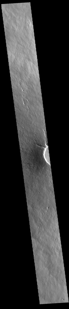
This VIS image shows two circular features. The flat floored feature at the top of the image is the summit caldera of Elysium Mons and was formed by volcanic activity. The bowl-shaped feature next to the caldera is an impact crater. Orbit Number: 65587 Latitude: 24.3248 Longitude: 146.842 Instrument: VIS Captured: 2016-09-26 07:14 http://photojournal.jpl.nasa.gov/catalog/PIA21159
Snapshots of Chaac: Io Calderas Up Close

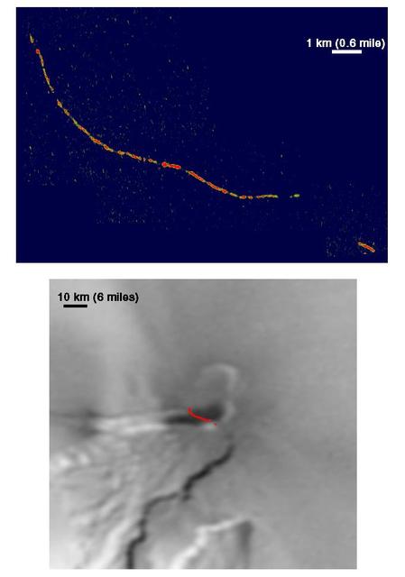
Galileo Discovers Caldera at Prometheus Volcano, Io
The Rinjani, Indonesia caldera-forming eruption is thought to have occurred in the 13th century. This 1257 Samalas eruption is now considered the likely source of high concentrations of sulfur found in widely dispersed ice core samples and may have been the most powerful volcanic blast since humans learned to write. The massive eruption may have triggered an episode of global cooling and failed harvests. Before this eruption, the Segara Anak caldera was a volcanic mountain named Samalas, which was higher than Rinjani. The image was acquired June 22, 2022, covers an area of 19.8 by 20.2 km, and is located at 8.4 degrees south, 116.4 degrees east. https://photojournal.jpl.nasa.gov/catalog/PIA26281
Calderas on Ganymede?
This image from NASA 2001 Mars Odyssey spacecraft shows part of the summit caldera on Arsia Mons.
This is a view of the Emi Koussi Caldera captured by the Expedition Six Crew Observation (CEO) experiment aboard the International Space Station (ISS). Rising 2.3 km above the surrounding sandstone plains, Emi Koussi is a 6.5 km wide volcano located at the south end of the Tibesti Mountains in the central Sahara desert. The volcano is one of several in the Tibesti massif and has been used as a close analog to the famous Martian volcano Elysium Mons. Major charnels can be seen on volcanoes on both planets that indicate low points in caldera rims where lava spilled out of the pre-collapsed craters.
This photograph of Jupiter satellite Io taken by NASA Voyager 1 shows what appears to be a volcanic caldera that is venting gasses the bright blue patch at left center.
Today's VIS image shows part of the summit caldera of Olympus Mons. Scarps and extensional features (graben) record multiple stages of caldera collapse at the summit of Olympus Mons. Olympus Mons is the largest volcano in the solar system, reaching heights over 40 km (25 miles) tall from base to summit, with the base covering an area as large as the state of Arizona. For comparison, Mauna Loa is 9 km (5.5 miles) tall measured from its base on the sea floor. Orbit Number: 87666 Latitude: 18.7403 Longitude: 226.733 Instrument: VIS Captured: 2021-09-18 17:27 https://photojournal.jpl.nasa.gov/catalog/PIA25230
Elysium Mons Volcano - Detail of Southern Caldera Wall and Floor
This image from NASA Mars Odyssey shows part of the summit caldera of Pavonis Mons, the middle of three Tharsis volcanos that form a line southeast of Olympus Mons and northwest of Vallis Marineris.
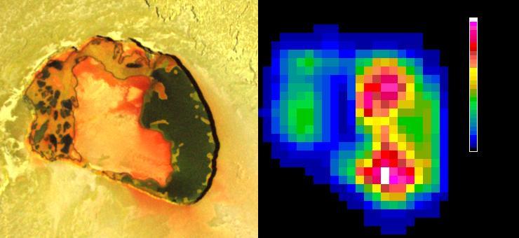
Tupan Caldera, a volcanic crater on Jupiter moon Io, has a relatively cool area, possibly an island, in its center, as indicated by infrared imagery from NASA Galileo spacecraft during an Oct. 16, 2001 flyby.
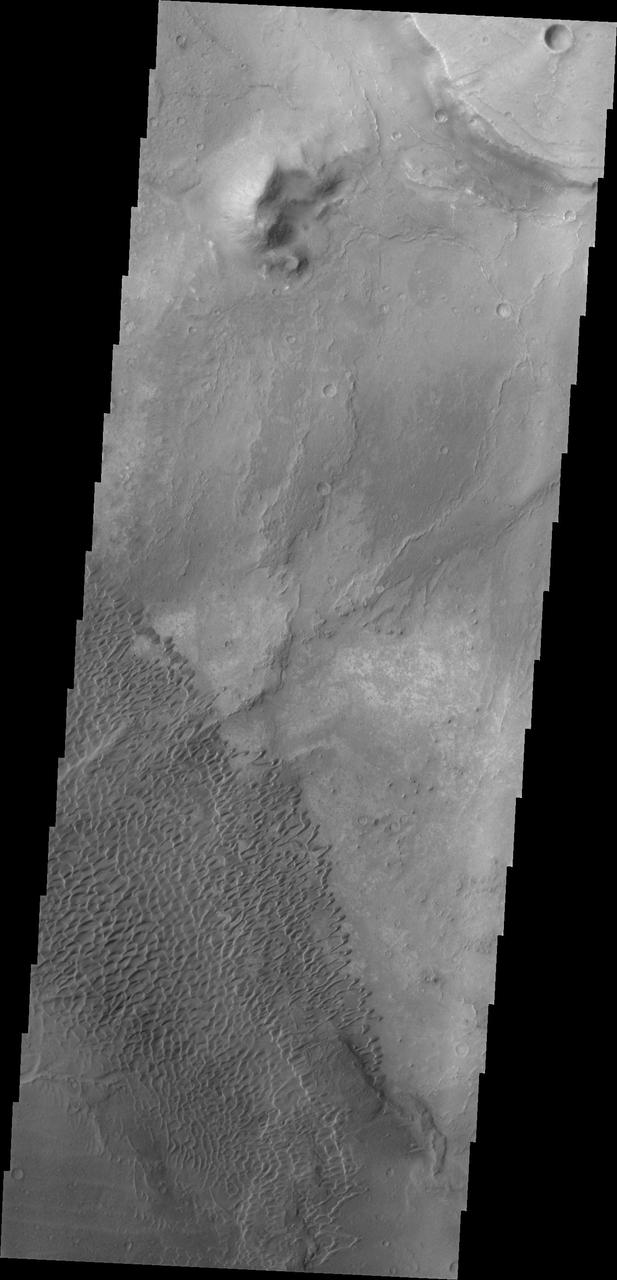
This image shows part of the Nili Patera dune field. High resolution imaging by other spacecraft has revealed that the dunes in this region are moving. Winds are blowing the dunes across a rough surface of regional volcanic lava flows. The paterae are calderas on the volcanic complex called Syrtis Major Planum. Dunes are found in both Nili and Meroe Paterae and in the region between the two calderas. The Odyssey spacecraft has spent over 15 years in orbit around Mars, circling the planet more than 69000 times. It holds the record for longest working spacecraft at Mars. THEMIS, the IR/VIS camera system, has collected data for the entire mission and provides images covering all seasons and lighting conditions. Over the years many features of interest have received repeated imaging, building up a suite of images covering the entire feature. From the deepest chasma to the tallest volcano, individual dunes inside craters and dune fields that encircle the north pole, channels carved by water and lava, and a variety of other feature, THEMIS has imaged them all. For the next several months the image of the day will focus on the Tharsis volcanoes, the various chasmata of Valles Marineris, and the major dunes fields. We hope you enjoy these images! Orbit Number: 38248 Latitude: 8.87797 Longitude: 67.3841 Instrument: VIS Captured: 2010-07-29 16:30 https://photojournal.jpl.nasa.gov/catalog/PIA22004
This image shows part of the steep wall of the caldera (a large volcanic crater) at the top of Ascraeus Mons, one of Mars' giant volcanoes. We can see chutes carved into the soft dust that has built up on the slope, with some similarities to gully landforms elsewhere on the planet. https://photojournal.jpl.nasa.gov/catalog/PIA22804
This image from NASA Magellan spacecraft reveals Sacajawea Patera, a large, elongate caldera located in Western Ishtar Terra on the smooth plateau of Lakshmi Planum.
This image from NASA Magellan spacecraft is of Sachs Patera on Venus, centered at 49 degrees north, 334 degrees east. Defined as a sag-caldera, Sachs is an elliptical depression 130 meters (81 feet) in depth, spanning 40 kilometers (25 miles) in width along its longest axis. The morphology implies that a chamber of molten material drained and collapsed, forming a depression surrounded by concentric scarps spaced 2-to-5 kilometers (1.2- to-3 miles) apart. The arc-shaped set of scarps, extending out to the north from the prominent ellipse, is evidence for a separate episode of withdrawal; the small lobe-shaped extension to the southwest may represent an additional event. Solidified lava flows 10-to-25 kilometers (6-to-16 miles) long, give the caldera its flower-like appearance. The flows are a lighter tone of gray in the radar data because the lava is blockier in texture and consequently returns more radar waves. Much of the lava, which was evacuated from the chamber, probably traveled to other locations underground, while some of it may have surfaced further south. This is unlike calderas on Earth, where a rim of lava builds up in the immediate vicinity of the caldera. http://photojournal.jpl.nasa.gov/catalog/PIA00473
STS026-038-056 (29 Sept. - 3 Oct. 1988) --- Tambora Caldera, Sumbawa Island, Indonesia as photographed with a 70mm handheld Hasselblad camera. Tambora is a 6-kilometer-wide and 650-meter-deep Caldera formed in 1815 as a result of a huge volcanic eruption. Gases from the eruption were ejected high into Earth's atmosphere and transported around the globe. The atmospheric gases trapped part of the incoming sunglint, resulting in extremely cold weather. In New England, snow fell in June, and freezes occurred throughout the summer of 1816, which became known as "the year without a summer." This photo was shown by the STS-26 astronaut crew during its Oct. 11, l988 post-flight press conference.
This image shows a portion of the summit caldera of Olympus Mons
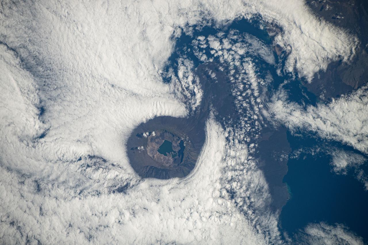
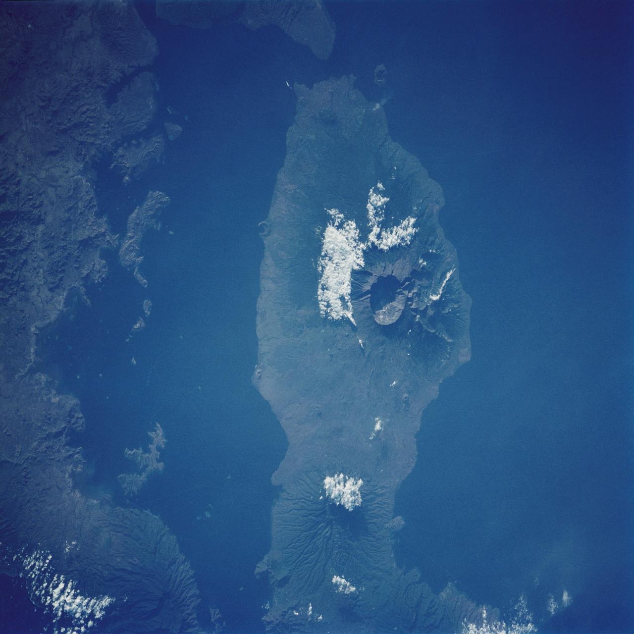
iss072e011909 (Oct. 3, 2024) -- Situated in the Galapagos is Fernandina Island. Pictured here is Fernandina's caldera, which stretches about 4 miles ( 6.5 kilometers) wide, with a sheet of clouds forming around it. As the International Space Station orbited 257 miles above, NASA astronaut Don Pettit captured this image.
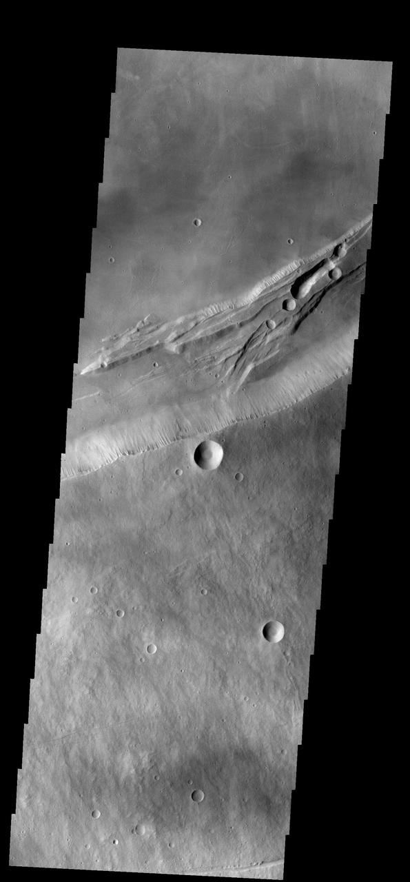
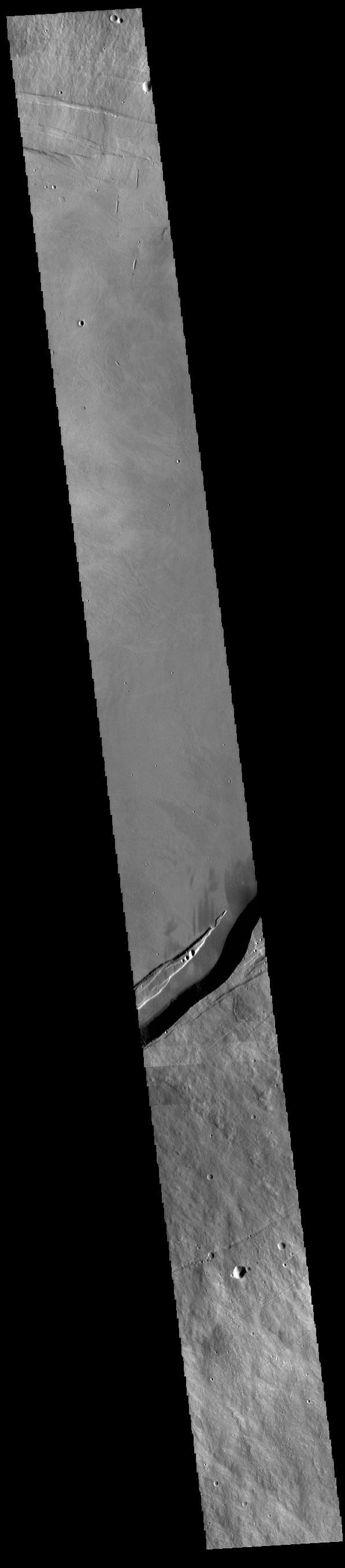
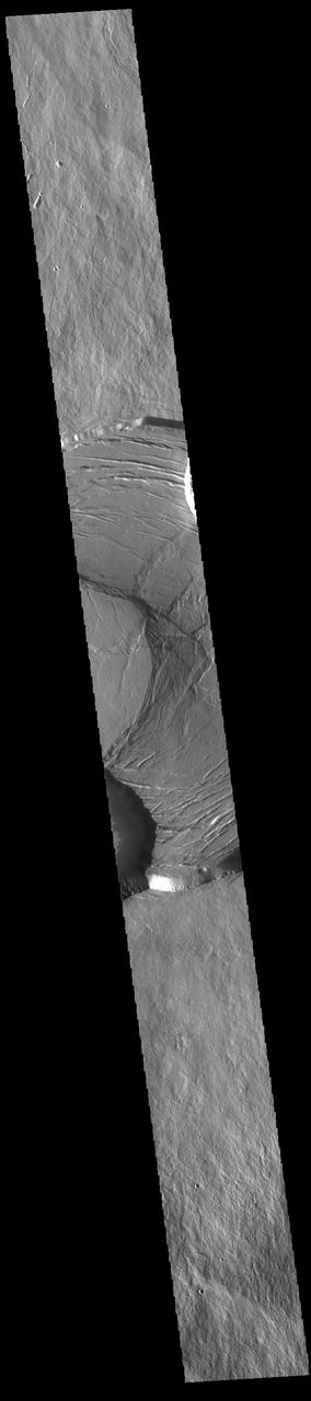
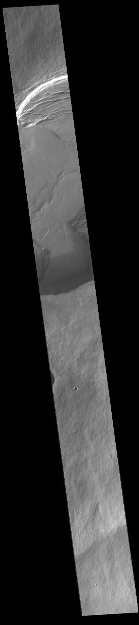
This VIS image shows part of the complex caldera at the summit of Ascraeus Mons. Ascraeus Mons is the northernmost and tallest of the three large aligned Tharsis volcanoes. Calderas are found at the tops of volcanoes and are the source region for magma that rises from an underground lava source to erupt at the surface. Volcanoes are formed by repeated flows from the central caldera. The final eruptions can pool within the summit caldera, leaving a flat surface as they cool. Calderas are also a location of collapse, creating rings of tectonic faults that form the caldera rim. Ascraeus Mons has several caldera features at its summit. Ascraeus Mons is 18 km (11 miles) tall, for comparison Mauna Kea – the tallest volcano on Earth – is 10 km tall (6.2 miles, measured from the base below sea level). Orbit Number: 86205 Latitude: 11.3492 Longitude: 255.876 Instrument: VIS Captured: 2021-05-21 10:18 https://photojournal.jpl.nasa.gov/catalog/PIA24227
This VIS image shows part of the complex caldera at the summit of Ascraeus Mons. Ascraeus Mons is the northernmost and tallest of the three large aligned Tharsis volcanoes. Calderas are found at the tops of volcanoes and are the source region for magma that rises from an underground lava source to erupt at the surface. Volcanoes are formed by repeated flows from the central caldera. The final eruptions can pool within the summit caldera, leaving a flat surface as they cool. Calderas are also a location of collapse, creating rings of tectonic faults that form the caldera rim. Ascraeus Mons has several caldera features at its summit. Ascraeus Mons is 18 km (11 miles) tall, for comparison Mauna Kea — the tallest volcano on Earth — is 10 km tall (6.2 miles, measured from the base below sea level). Orbit Number: 79142 Latitude: 11.5042 Longitude: 256.023 Instrument: VIS Captured: 2019-10-17 20:56 https://photojournal.jpl.nasa.gov/catalog/PIA23575
This VIS image shows part of the complex caldera at the summit of Ascraeus Mons. Ascraeus Mons is the northernmost and tallest of the three large aligned Tharsis volcanoes. Calderas are found at the tops of volcanoes and are the source region for magma that rises from an underground lava source to erupt at the surface. Volcanoes are formed by repeated flows from the central caldera. The final eruptions can pool within the summit caldera, leaving a flat surface as they cool. Calderas are also a location of collapse, creating rings of tectonic faults that form the caldera rim. Ascraeus Mons has several caldera features at its summit. Ascraeus Mons is 18 km (11 miles) tall, for comparison Mauna Kea – the tallest volcano on Earth – is 10 km tall (6.2 miles, measured from the base below sea level). Orbit Number: 89125 Latitude: 11.0029 Longitude: 256.08 Instrument: VIS Captured: 2022-01-16 20:38 https://photojournal.jpl.nasa.gov/catalog/PIA25349
This image shows the summit of Hecates Tholus. The summit caldera is located in the top of the image

A large volcanic crater known as a caldera is located at the summit of all of the Tharsis volcanoes. These calderas are produced by massive volcanic explosions and collapse.Today's VIS image shows the summit caldera of Arsia Mons. Several small volcanic vents are visible on the caldera floor. It is not uncommon for calderas to have "flat" floors after the final explosive eruption the empties the subsurface magma chamber. There may still be some magma or superheated rock left after the collapse that will fill in part of the depression. Additionally, over time erosion will work to level the topography. Within the Arsia Mons caldera there was renewed activity from several small vents that occurred along the alignment of the NE/SW trend of the three large volcanoes. This ongoing, low volume activity is similar to the lava lake in Kilauea in Hawaii. Arsia Mons is the southernmost of the Tharsis volcanoes. It is 450 km (270 miles) in diameter, almost 20 km (12 miles) high, and the summit caldera is 120 km (72 miles) wide. For comparison, the largest volcano on Earth is Mauna Loa. From its base on the sea floor, Mauna Loa measures only 6.3 miles high and 75 miles in diameter.The Arsia Mons summit caldera is larger than many volcanoes on Earth. Orbit Number: 79230 Latitude: -9.4441 Longitude: 239.984 Instrument: VIS Captured: 2019-10-25 02:43 https://photojournal.jpl.nasa.gov/catalog/PIA23639
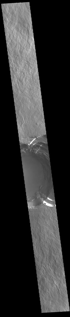
This image shows part of the two summit calderas of Pavonis Mons. The surface in the majority of the image is the floor of the larger caldera. The smaller caldera occupies the bottom of the image. In both calderas the floor is predominately flat. The final summit flow would have pooled in the caldera and cooled forming the flat floor. Pavonis Mons is one of the three aligned Tharsis Volcanoes. The four Tharsis volcanoes are Ascreaus Mons, Pavonis Mons, Arsia Mons, and Olympus Mars. All four are shield type volcanoes. Shield volcanoes are formed by lava flows originating near or at the summit, building up layers upon layers of lava. The Hawaiian islands on Earth are shield volcanoes. The three aligned volcanoes are located along a topographic rise in the Tharsis region. Along this trend there are increased tectonic features and additional lava flows. Pavonis Mons is the smallest of the four volcanoes, rising 14km above the mean Mars surface level with a width of 375km. It has a complex summit caldera, with the smallest caldera deeper than the larger caldera. Like most shield volcanoes the surface has a low profile. In the case of Pavonis Mons the average slope is only 4 degrees. The Odyssey spacecraft has spent over 15 years in orbit around Mars, circling the planet more than 69000 times. It holds the record for longest working spacecraft at Mars. THEMIS, the IR/VIS camera system, has collected data for the entire mission and provides images covering all seasons and lighting conditions. Over the years many features of interest have received repeated imaging, building up a suite of images covering the entire feature. From the deepest chasma to the tallest volcano, individual dunes inside craters and dune fields that encircle the north pole, channels carved by water and lava, and a variety of other feature, THEMIS has imaged them all. For the next several months the image of the day will focus on the Tharsis volcanoes, the various chasmata of Valles Marineris, and the major dunes fields. We hope you enjoy these images! Orbit Number: 17590 Latitude: 1.13446 Longitude: 247.411 Instrument: VIS Captured: 2005-12-01 17:26 https://photojournal.jpl.nasa.gov/catalog/PIA22020
Tofua Island in the central part of the Tonga Islands group is the summit of a large stratovolcano that contains a 5-km-wide caldera. Three post-caldera cones were constructed at the northern end of a caldera lake. The easternmost cone produced lava flows, some of which have traveled into the caldera lake. The current eruption period began in October 2015 and has more recently consisted of thermal activity. The image was acquired October 10, 2023, covers an area of 11.6 by 12 km, and is located at 19.7 degrees south, 175.1 degrees west. https://photojournal.jpl.nasa.gov/catalog/PIA26393
This image shows part smaller summit caldera of Pavonis Mons. This caldera is approximately 5km deep. Near the bottom of the image is a region where part of the caldera side has collapsed into the bottom of the caldera. In shield volcanoes calderas are typically formed where the surface collapses into the void formed by an emptied magma chamber. Pavonis Mons is one of the three aligned Tharsis Volcanoes. The four Tharsis volcanoes are Ascreaus Mons, Pavonis Mons, Arsia Mons, and Olympus Mars. All four are shield type volcanoes. Shield volcanoes are formed by lava flows originating near or at the summit, building up layers upon layers of lava. The Hawaiian islands on Earth are shield volcanoes. The three aligned volcanoes are located along a topographic rise in the Tharsis region. Along this trend there are increased tectonic features and additional lava flows. Pavonis Mons is the smallest of the four volcanoes, rising 14km above the mean Mars surface level with a width of 375km. It has a complex summit caldera, with the smallest caldera deeper than the larger caldera. Like most shield volcanoes the surface has a low profile. In the case of Pavonis Mons the average slope is only 4 degrees. The Odyssey spacecraft has spent over 15 years in orbit around Mars, circling the planet more than 69000 times. It holds the record for longest working spacecraft at Mars. THEMIS, the IR/VIS camera system, has collected data for the entire mission and provides images covering all seasons and lighting conditions. Over the years many features of interest have received repeated imaging, building up a suite of images covering the entire feature. From the deepest chasma to the tallest volcano, individual dunes inside craters and dune fields that encircle the north pole, channels carved by water and lava, and a variety of other feature, THEMIS has imaged them all. For the next several months the image of the day will focus on the Tharsis volcanoes, the various chasmata of Valles Marineris, and the major dunes fields. We hope you enjoy these images! Orbit Number: 32776 Latitude: 0.446561 Longitude: 247.283 Instrument: VIS Captured: 2009-05-05 03:21 https://photojournal.jpl.nasa.gov/catalog/PIA22023
This VIS image shows a cross section of Pavonis Mons, including the central part of the smaller summit caldera (circular depression). On the top side of the caldera is a complex region of fault related collapse of the wall of the caldera. Several intersecting faults are visible there. The faults would have formed areas of weakness in the caldera wall, precipitating into gravity driven down slope movement of materials. This caldera is approximately 5km (3 miles) deep, much deeper that the larger caldera that surrounds the northern and eastern sides of the small caldera. Pavonis Mons, like the other large volcanoes in the region, is a shield volcano. Shield volcanoes are formed by lava flows originating near or at the summit, building up layers upon layers of lava. In shield volcanoes summit calderas are typically formed where the surface collapses into the void formed by an emptied magma chamber. Pavonis Mons is one of the three aligned Tharsis Volcanoes. In order from north to south are Ascreaus Mons, Pavonis Mons and Arsia Mons. The three aligned volcanoes are located along a topographic rise in the Tharsis region. Along this trend there are increased tectonic features and additional lava flows that arose from the flanks of the volcanoes rather than the summit. Pavonis Mons is the smallest of the three volcanoes, rising 14 km (8 miles) above the mean Mars surface level with a width of 375 km (233 miles). Like most shield volcanoes the surface has a low profile. In the case of Pavonis Mons the average slope is only 4 degrees. Orbit Number: 86118 Latitude: 0.356409 Longitude: 247.166 Instrument: VIS Captured: 2021-05-14 06:19 https://photojournal.jpl.nasa.gov/catalog/PIA24223
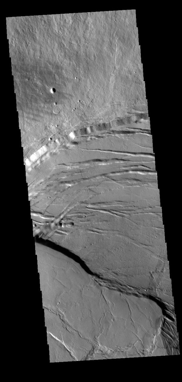
This image shows the eastern part of the complex caldera at the summit of the volcano. Calderas are found at the tops of volcanoes and are the source region for magma that rises from an underground lava source to erupt at the surface. Volcanoes are formed by repeated flows from the central caldera. The final eruptions can pool within the summit caldera, leaving a flat surface as they cool. Calderas are also a location of collapse, creating rings of tectonic faults that form the caldera rim. This image is dominated by the ring of faults that defines the outer margin of the caldera. Ascraeus Mons has several caldera features at its summit. The Odyssey spacecraft has spent over 15 years in orbit around Mars, circling the planet more than 69000 times. It holds the record for longest working spacecraft at Mars. THEMIS, the IR/VIS camera system, has collected data for the entire mission and provides images covering all seasons and lighting conditions. Over the years many features of interest have received repeated imaging, building up a suite of images covering the entire feature. From the deepest chasma to the tallest volcano, individual dunes inside craters and dune fields that encircle the north pole, channels carved by water and lava, and a variety of other feature, THEMIS has imaged them all. For the next several months the image of the day will focus on the Tharsis volcanoes, the various chasmata of Valles Marineris, and the major dunes fields. We hope you enjoy these images! Orbit Number: 53334 Latitude: 11.2134 Longitude: 255.911 Instrument: VIS Captured: 2013-12-22 10:29 https://photojournal.jpl.nasa.gov/catalog/PIA21829
This image shows part of the complex caldera at the summit of the volcano. Calderas are found at the tops of volcanoes and are the source region for magma that rises from an underground lava source to erupt at the surface. Volcanoes are formed by repeated flows from the central caldera. The final eruptions can pool within the summit caldera, leaving a flat surface as they cool. This image shows part of two of the summit calderas, each with a floor at different elevations. Calderas are also a location of collapse, creating rings of tectonic faults that form the caldera rim. Ascraeus Mons has several caldera features at its summit. The Odyssey spacecraft has spent over 15 years in orbit around Mars, circling the planet more than 69000 times. It holds the record for longest working spacecraft at Mars. THEMIS, the IR/VIS camera system, has collected data for the entire mission and provides images covering all seasons and lighting conditions. Over the years many features of interest have received repeated imaging, building up a suite of images covering the entire feature. From the deepest chasma to the tallest volcano, individual dunes inside craters and dune fields that encircle the north pole, channels carved by water and lava, and a variety of other feature, THEMIS has imaged them all. For the next several months the image of the day will focus on the Tharsis volcanoes, the various chasmata of Valles Marineris, and the major dunes fields. We hope you enjoy these images! Orbit Number: 63076 Latitude: 11.3749 Longitude: 255.364 Instrument: VIS Captured: 2016-03-03 11:14 https://photojournal.jpl.nasa.gov/catalog/PIA21830
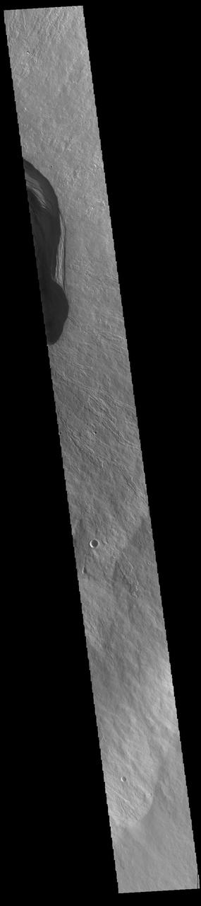
This THEMIS image shows part of the caldera floor of Arsia Mons. It is not uncommon for calderas to have "flat" floors after the final explosive eruption that empties the subsurface magma chamber. There may still be some magma or superheated rock left after the collapse that will fill in part of the depression. Additionally, over time erosion will work to level the topography. Within Arsia Mons there was renewed activity that occurred within the caldera along the alignment of the NE/SW trend of the three large volcanoes. This ongoing, low volume actitivity is similar to the lava lake in Kilauea in Hawaii. Small flows are visible throughout this image. Arsia Mons is the southernmost of the Tharsis volcanoes. It is 270 miles (450km) in diameter, almost 12 miles (20km) high, and the summit caldera is 72 miles (120km) wide. For comparison, the largest volcano on Earth is Mauna Loa. From its base on the sea floor, Mauna Loa measures only 6.3 miles high and 75 miles in diameter. A large volcanic crater known as a caldera is located at the summit of all of the Tharsis volcanoes. These calderas are produced by massive volcanic explosions and collapse. The Arsia Mons summit caldera is larger than many volcanoes on Earth. The Odyssey spacecraft has spent over 15 years in orbit around Mars, circling the planet more than 69000 times. It holds the record for longest working spacecraft at Mars. THEMIS, the IR/VIS camera system, has collected data for the entire mission and provides images covering all seasons and lighting conditions. Over the years many features of interest have received repeated imaging, building up a suite of images covering the entire feature. From the deepest chasma to the tallest volcano, individual dunes inside craters and dune fields that encircle the north pole, channels carved by water and lava, and a variety of other feature, THEMIS has imaged them all. For the next several months the image of the day will focus on the Tharsis volcanoes, the various chasmata of Valles Marineris, and the major dunes fields. We hope you enjoy these images! Orbit Number: 19588 Latitude: -9.19485 Longitude: 239.276 Instrument: VIS Captured: 2006-05-15 03:33 https://photojournal.jpl.nasa.gov/catalog/PIA22156
This image from NASA 2001 Mars Odyssey shows the central portion of the complex caldera at the summit of Olympus Mons.
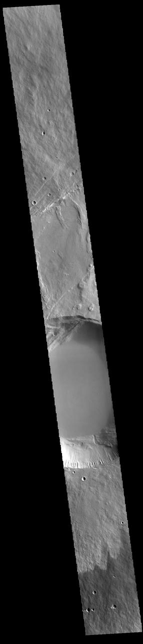
This image captured by NASA 2001 Mars Odyssey spacecraft shows part of the caldera at the summit of Arsia Mons.

This image captured by NASA 2001 Mars Odyssey spacecraft shows part of the complex caldera at the summit of Ascraeus Mons.
This image captured by NASA 2001 Mars Odyssey shows the southern summit caldera of Ascraeus Mons.
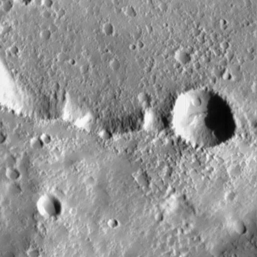
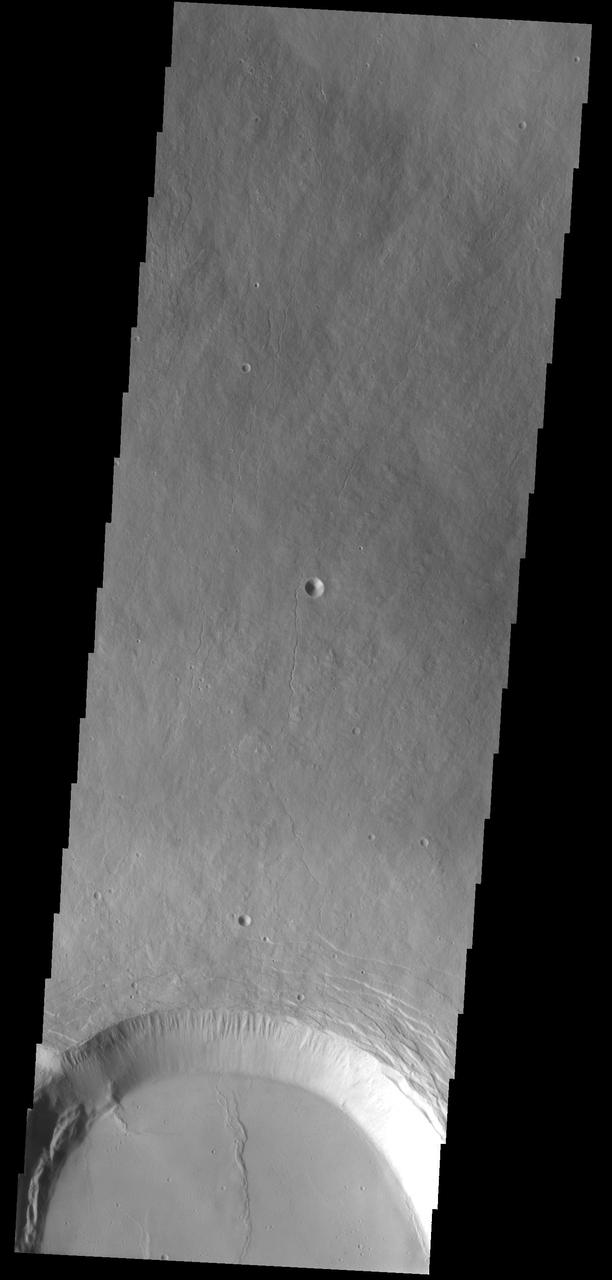
Today image shows the eastern side of the summit caldera of Ceraunius Tholus as seen by NASA 2001 Mars Odyssey spacecraft.
This image captured by NASA 2001 Mars Odyssey spacecraft shows part of the caldera system on the summit of Olympus Mons.
Today image shows the eastern portion of the complex caldera at the summit of Olympus Mon as seen by NASA 2001 Mars Odyssey spacecraft.
This image captured by NASA Mars Odyssey shows one edge of the complex caldera at the summit of Olympus Mons.
Part of the summit caldera of Olympus Mons is visible at the bottom of this image as seen by NASA 2001 Mars Odyssey spacecraft.
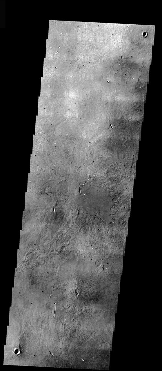
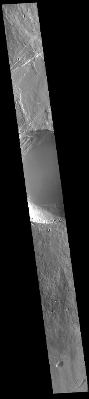
This image from NASA Mars Odyssey shows part of the summit caldera of Ceraunius Tholus, one of the smaller volcanoes of the Tharsis region.
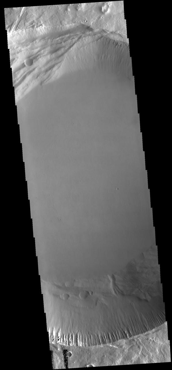
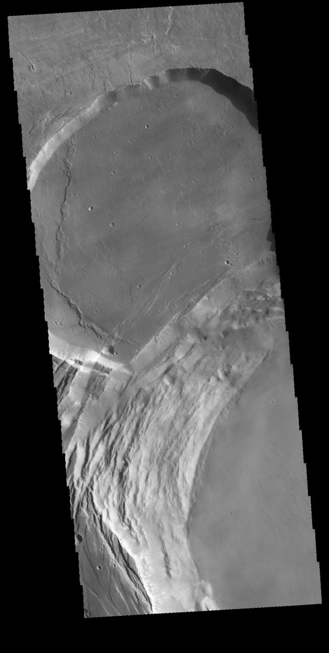
This image from NASA 2001 Mars Odyssey spacecraft shows the summit caldera of Pavonis Mons.
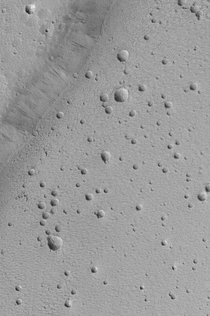
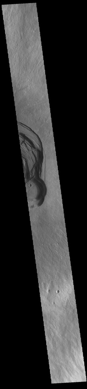
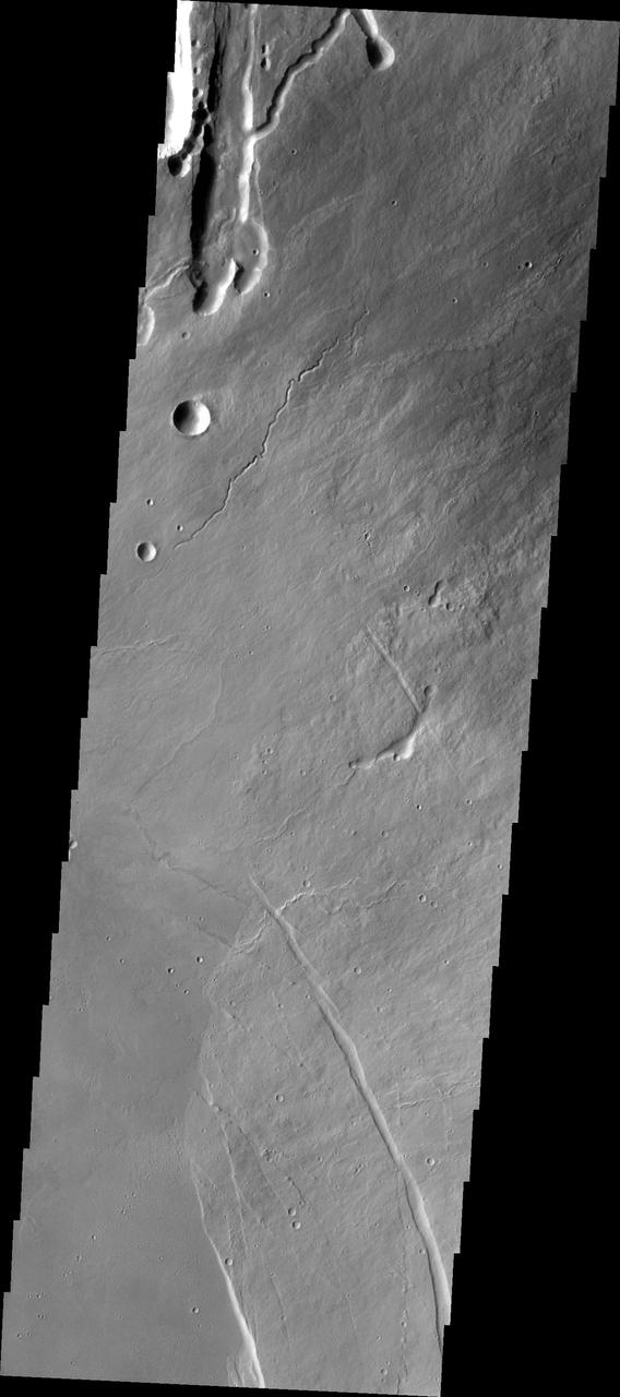
This image shows part of the summit caldera of Ceraunius Tholus. Channels are common on the flanks of this volcano
This image captured by NASA 2001 Mars Odyssey spacecraft shows the eastern part of the complex caldera at the summit of Ascraeus Mons.
This image captured by NASA 2001 Mars Odyssey spacecraft shows part of the summit caldera of Ascraeus Mons.
This image shows part of the complex caldera at the summit of the volcano. Calderas are found at the tops of volcanoes and are the source region for magma that rises from an underground lava source to erupt at the surface. Volcanoes are formed by repeated flows from the central caldera. The final eruptions can pool within the summit caldera, leaving a flat surface as they cool. Calderas are also a location of collapse, creating rings of tectonic faults that form the caldera rim. Ascraeus Mons has several caldera features at its summit. The Odyssey spacecraft has spent over 15 years in orbit around Mars, circling the planet more than 69000 times. It holds the record for longest working spacecraft at Mars. THEMIS, the IR/VIS camera system, has collected data for the entire mission and provides images covering all seasons and lighting conditions. Over the years many features of interest have received repeated imaging, building up a suite of images covering the entire feature. From the deepest chasma to the tallest volcano, individual dunes inside craters and dune fields that encircle the north pole, channels carved by water and lava, and a variety of other feature, THEMIS has imaged them all. For the next several months the image of the day will focus on the Tharsis volcanoes, the various chasmata of Valles Marineris, and the major dunes fields. We hope you enjoy these images! Orbit Number: 17440 Latitude: 11.128 Longitude: 255.731 Instrument: VIS Captured: 2005-11-19 08:59 https://photojournal.jpl.nasa.gov/catalog/PIA21822

This image shows part of the complex caldera at the summit of the volcano. Calderas are found at the tops of volcanoes and are the source region for magma that rises from an underground lava source to erupt at the surface. Volcanoes are formed by repeated flows from the central caldera. The final eruptions can pool within the summit caldera, leaving a flat surface as they cool. Calderas are also a location of collapse, creating rings of tectonic faults that form the caldera rim. Ascraeus Mons has several caldera features at its summit. The Odyssey spacecraft has spent over 15 years in orbit around Mars, circling the planet more than 69000 times. It holds the record for longest working spacecraft at Mars. THEMIS, the IR/VIS camera system, has collected data for the entire mission and provides images covering all seasons and lighting conditions. Over the years many features of interest have received repeated imaging, building up a suite of images covering the entire feature. From the deepest chasma to the tallest volcano, individual dunes inside craters and dune fields that encircle the north pole, channels carved by water and lava, and a variety of other feature, THEMIS has imaged them all. For the next several months the image of the day will focus on the Tharsis volcanoes, the various chasmata of Valles Marineris, and the major dunes fields. We hope you enjoy these images! Orbit Number: 52847 Latitude: 11.2724 Longitude: 255.564 Instrument: VIS Captured: 2013-11-12 08:41 https://photojournal.jpl.nasa.gov/catalog/PIA21828
This VIS image shows a cross section of Pavonis Mons, including the central part of the smaller summit caldera (circular depression). On the top side of the caldera is a complex region of fault related collapse of the wall of the caldera. Several intersecting faults are visible there. The faults would have formed areas of weakness in the caldera wall, precipitating into gravity driven down slope movement of materials. This caldera is approximately 5km (3 miles) deep, much deeper that the larger caldera that surrounds the northern and eastern sides of the small caldera. Pavonis Mons, like the other large volcanoes in the region, is a shield volcano. Shield volcanoes are formed by lava flows originating near or at the summit, building up layers upon layers of lava. In shield volcanoes summit calderas are typically formed where the surface collapses into the void formed by an emptied magma chamber. Pavonis Mons is one of the three aligned Tharsis Volcanoes. In order from north to south are Ascreaus Mons, Pavonis Mons and Arsia Mons. The three aligned volcanoes are located along a topographic rise in the Tharsis region. Along this trend there are increased tectonic features and additional lava flows that arose from the flanks of the volcanoes rather than the summit. Pavonis Mons is the smallest of the three volcanoes, rising 14 km (8 miles) above the mean Mars surface level with a width of 375 km (233 miles). Like most shield volcanoes the surface has a low profile. In the case of Pavonis Mons the average slope is only 4 degrees. Orbit Number: 88177 Latitude: 0.900987 Longitude: 247.141 Instrument: VIS Captured: 2021-10-30 19:09 https://photojournal.jpl.nasa.gov/catalog/PIA25157
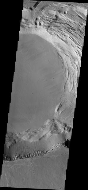
This THEMIS image shows part of the caldera floor of Arsia Mons. It is not uncommon for calderas to have "flat" floors after the final explosive eruption the empties the subsurface magma chamber. There may still be some magma or superheated rock left after the collapse that will fill in part of the depression. Additionally, over time erosion will work to level the topography. Within Arsia Mons there was renewed activity that occurred within the caldera along the alignment of the NE/SW trend of the three large volcanoes. This ongoing, low volume actitivity is similar to the lava lake in Kilauea in Hawaii. Small flows are visible throughout this image. In the center of the image is a small "L" shaped feature. This is the summit vent for the volcanic flows around it. The flows have lapped up against the caldera wall, filling in faults left by the caldera formation and increasing the elevation of the surface in this region of the caldera. Arsia Mons is the southernmost of the Tharsis volcanoes. It is 270 miles (450km) in diameter, almost 12 miles (20km) high, and the summit caldera is 72 miles (120km) wide. For comparison, the largest volcano on Earth is Mauna Loa. From its base on the sea floor, Mauna Loa measures only 6.3 miles high and 75 miles in diameter. A large volcanic crater known as a caldera is located at the summit of all of the Tharsis volcanoes. These calderas are produced by massive volcanic explosions and collapse. The Arsia Mons summit caldera is larger than many volcanoes on Earth. The Odyssey spacecraft has spent over 15 years in orbit around Mars, circling the planet more than 69000 times. It holds the record for longest working spacecraft at Mars. THEMIS, the IR/VIS camera system, has collected data for the entire mission and provides images covering all seasons and lighting conditions. Over the years many features of interest have received repeated imaging, building up a suite of images covering the entire feature. From the deepest chasma to the tallest volcano, individual dunes inside craters and dune fields that encircle the north pole, channels carved by water and lava, and a variety of other feature, THEMIS has imaged them all. For the next several months the image of the day will focus on the Tharsis volcanoes, the various chasmata of Valles Marineris, and the major dunes fields. We hope you enjoy these images! Orbit Number: 19874 Latitude: -8.57834 Longitude: 240.452 Instrument: VIS Captured: 2006-06-07 18:39 https://photojournal.jpl.nasa.gov/catalog/PIA22157
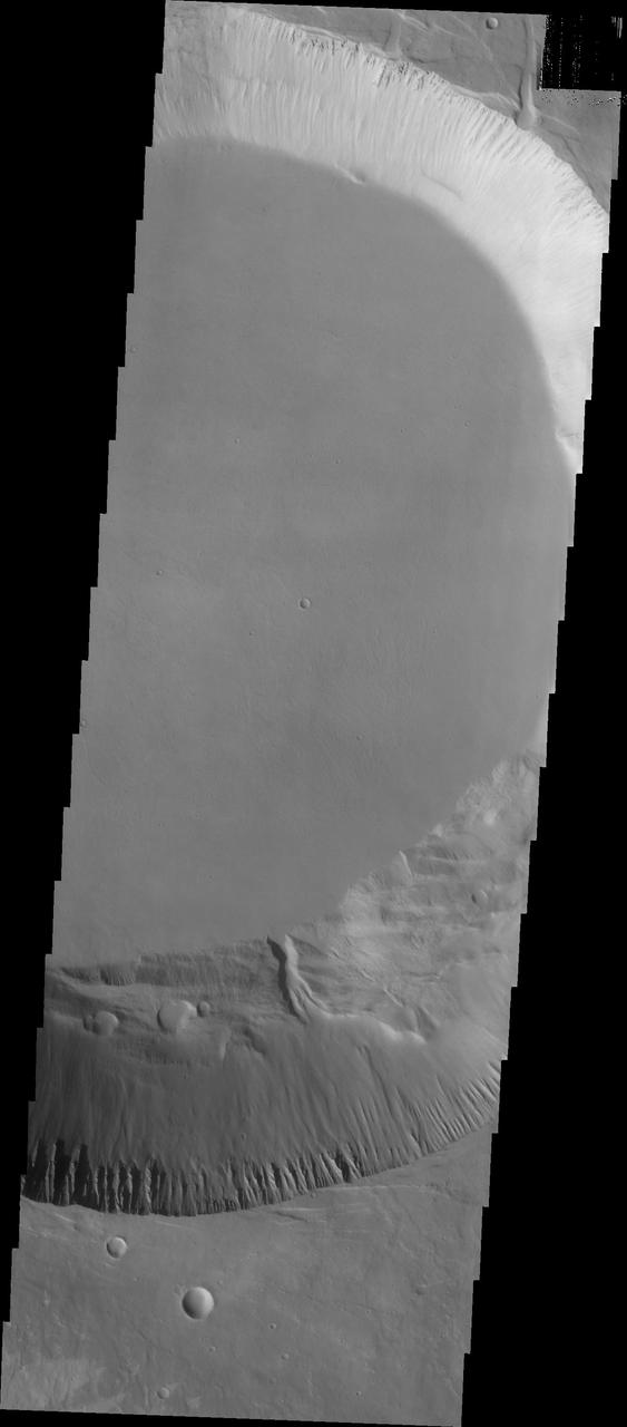
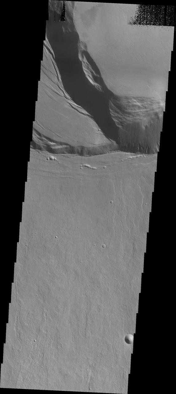
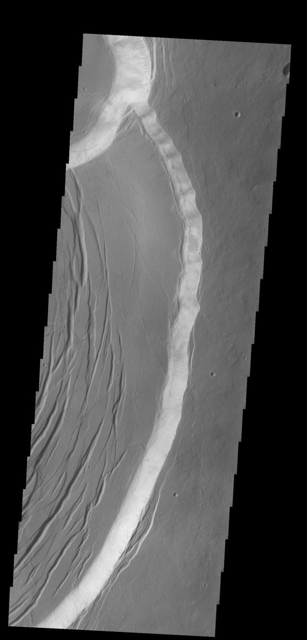
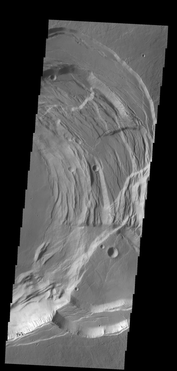
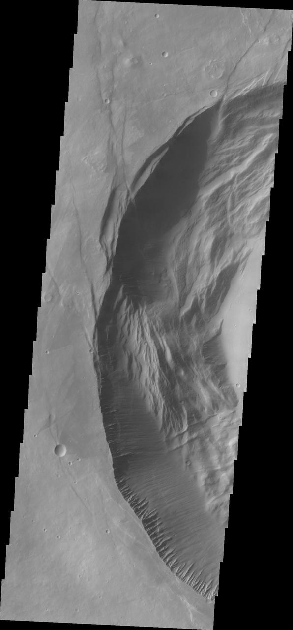
Arsia Mons is the southernmost of the Tharsis volcanoes. It is 270 miles (450km) in diameter, almost 12 miles (20km) high, and the summit caldera is 72 miles (120km) wide. For comparison, the largest volcano on Earth is Mauna Loa. From its base on the sea floor, Mauna Loa measures only 6.3 miles high and 75 miles in diameter. A large volcanic crater known as a caldera is located at the summit of all of the Tharsis volcanoes. These calderas are produced by massive volcanic explosions and collapse. The Arsia Mons summit caldera is larger than many volcanoes on Earth. This THEMIS image shows a portion of the western wall of the caldera, revealing the steep walls and linear features associated with the collapse that formed the caldera. The Odyssey spacecraft has spent over 15 years in orbit around Mars, circling the planet more than 69000 times. It holds the record for longest working spacecraft at Mars. THEMIS, the IR/VIS camera system, has collected data for the entire mission and provides images covering all seasons and lighting conditions. Over the years many features of interest have received repeated imaging, building up a suite of images covering the entire feature. From the deepest chasma to the tallest volcano, individual dunes inside craters and dune fields that encircle the north pole, channels carved by water and lava, and a variety of other feature, THEMIS has imaged them all. For the next several months the image of the day will focus on the Tharsis volcanoes, the various chasmata of Valles Marineris, and the major dunes fields. We hope you enjoy these images! Orbit Number: 4424 Latitude: -9.02841 Longitude: 238.916 Instrument: VIS Captured: 2002-12-13 17:18 https://photojournal.jpl.nasa.gov/catalog/PIA22150
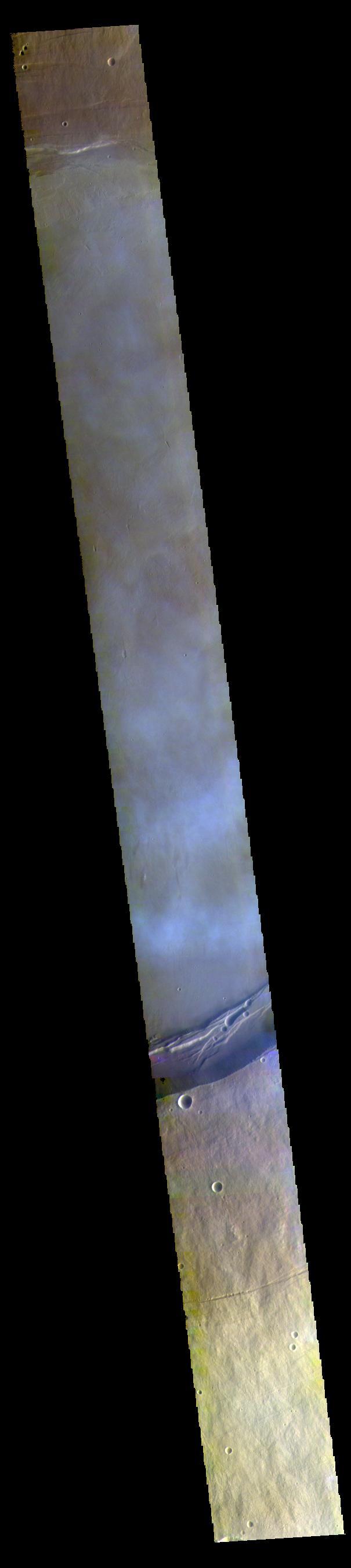
This false color image captured by NASA 2001 Mars Odyssey spacecraft shows part of the summit caldera of Arsia Mons. The mottled bluish tones are from clouds.
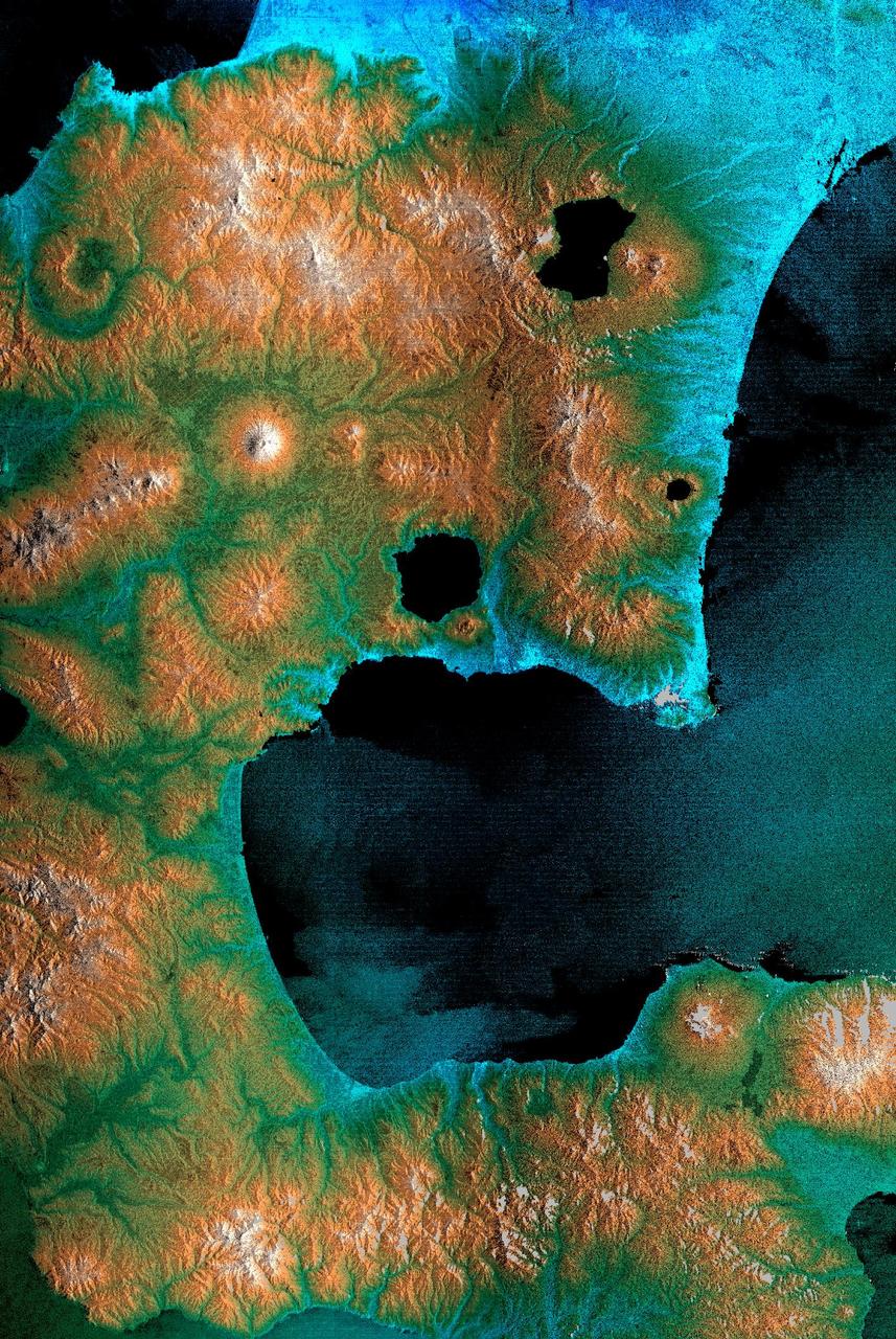
This perspective view shows the caldera of the Okmok volcano in Alaska Aleutian Islands acquired by NASA Airborne Synthetic Aperture Radar AIRSAR in 2001.
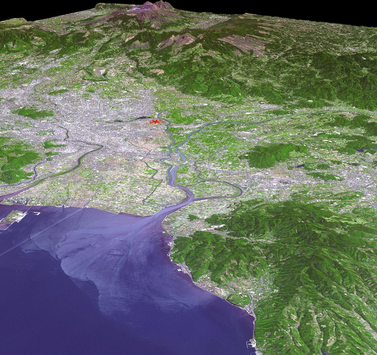
This image from NASA Terra spacecraft shows a perspective view, looking toward the Aso volcanic caldera, which indicates the epicenter with a red star.
Dunes appear on the floor of Nili Patera, one of the two volcanic calderas of Syrtis Major in this image taken by NASA 2001 Mars Odyssey.
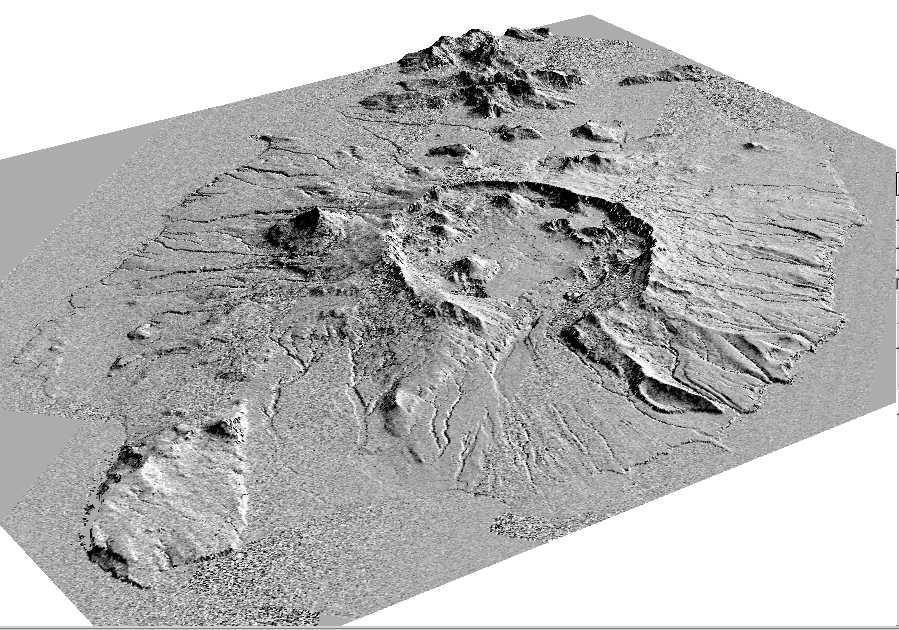
This perspective view shows the caldera of the Okmok volcano in Alaska Aleutian Islands acquired by NASA Airborne Synthetic Aperture Radar AIRSAR in 2001.
This Mars Global Surveyor MGS Mars Orbiter Camera MOC image shows a channel extending northward from the Elysium Mons caldera at the volcano summit
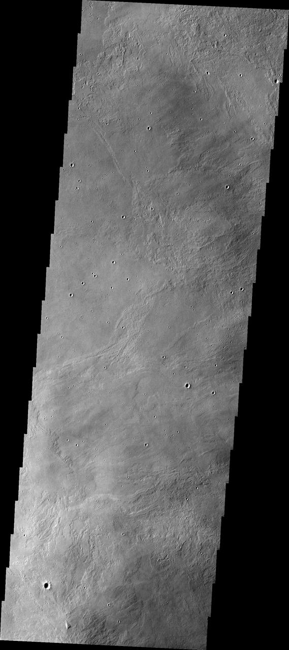
This VIS image shows part of the summit caldera on Arsia Mons. Orbit Number: 80977 Latitude: -9.5156 Longitude: 240.199 Instrument: VIS Captured: 2020-03-16 23:04 https://photojournal.jpl.nasa.gov/catalog/PIA23932
This VIS image shows part of the summit of Ascraeus Mons. Ascraeus Mons is the northernmost and tallest of the three large aligned Tharsis volcanoes. Calderas are found at the tops of volcanoes and are the source region for magma that rises from an underground lava source to erupt at the surface. Volcanoes are formed by repeated flows from the central caldera. The final eruptions can pool within the summit caldera, leaving a flat surface as they cool. Calderas are also a location of collapse, creating rings of tectonic faults that form the caldera rim. Ascraeus Mons has several caldera features at its summit. Ascraeus Mons is 18 km (11 miles) tall, for comparison Mauna Kea – the tallest volcano on Earth – is 10 km tall (6.2 miles, measured from the base below sea level). Orbit Number: 94366 Latitude: 11.3736 Longitude: 255.73 Instrument: VIS Captured: 2023-03-24 09:40 https://photojournal.jpl.nasa.gov/catalog/PIA26021
This VIS image shows part of the summit of Ascraeus Mons. Ascraeus Mons is the northernmost and tallest of the three large aligned Tharsis volcanoes. Calderas are found at the tops of volcanoes and are the source region for magma that rises from an underground lava source to erupt at the surface. Volcanoes are formed by repeated flows from the central caldera. The final eruptions can pool within the summit caldera, leaving a flat surface as they cool. Calderas are also a location of collapse, creating rings of tectonic faults that form the caldera rim. Ascraeus Mons has several caldera features at its summit. Ascraeus Mons is 18 km (11 miles) tall, for comparison Mauna Kea – the tallest volcano on Earth – is 10 km tall (6.2 miles, measured from the base below sea level). Orbit Number: 94653 Latitude: 10.5186 Longitude: 256.223 Instrument: VIS Captured: 2023-04-17 00:48 https://photojournal.jpl.nasa.gov/catalog/PIA26053
This VIS image shows part of the summit of Ascraeus Mons. Ascraeus Mons is the northernmost and tallest of the three large aligned Tharsis volcanoes. Calderas are found at the tops of volcanoes and are the source region for magma that rises from an underground lava source to erupt at the surface. Volcanoes are formed by repeated flows from the central caldera. The final eruptions can pool within the summit caldera, leaving a flat surface as they cool. Calderas are also a location of collapse, creating rings of tectonic faults that form the caldera rim. Ascraeus Mons has several caldera features at its summit. Ascraeus Mons is 18 km (11 miles) tall, for comparison Mauna Kea – the tallest volcano on Earth – is 10 km tall (6.2 miles, measured from the base below sea level). Orbit Number: 93767 Latitude: 11.2722 Longitude: 11.2722 Instrument: VIS Captured: 2023-02-03 01:58 https://photojournal.jpl.nasa.gov/catalog/PIA25875
Today's VIS image shows part of the summit caldera of Olympus Mons. Scarps and extensional features (graben) record multiple stages of caldera collapse at the summit of Olympus Mons. Olympus Mons is the largest volcano in the solar system, reaching heights of over 40 km (25 miles) tall from base to summit, with the base covering an area as large as the state of Arizona. For comparison, Mauna Loa is 9 km (5.5 miles) tall measured from its base on the sea floor. Orbit Number: 85894 Latitude: 18.264 Longitude: 226.925 Instrument: VIS Captured: 2021-04-25 19:46 https://photojournal.jpl.nasa.gov/catalog/PIA24885

Today's VIS image shows part of the summit caldera of Olympus Mons. Scarps and extensional features (graben) record multiple stages of caldera collapse at the summit of Olympus Mons. Olympus Mons is the largest volcano in the solar system, reaching heights of over 40 km (25 miles) tall from base to summit, with the base covering an area as large as the state of Arizona. For comparison, Mauna Loa is 9 km (5.5 miles) tall measured from its base on the sea floor. Orbit Number: 80291 Latitude: 18.2581 Longitude: 226.932 Instrument: VIS Captured: 2020-01-20 11:36 https://photojournal.jpl.nasa.gov/catalog/PIA23818
Today's VIS image shows the upper elevations of Olympus Mons, including part of the summit caldera. Scarps and extensional features (graben) record multiple stages of caldera collapse at the summit of Olympus Mons. Olympus Mons is the largest volcano in the solar system, reaching heights over 40 km (25 miles) tall from base to summit, with the base covering an area as large as the state of Arizona. For comparison, Mauna Loa is 9 km (5.5 miles) tall measured from its base on the sea floor. Orbit Number: 90561 Latitude: 17.6564 Longitude: 226.782 Instrument: VIS Captured: 2022-05-15 02:28 https://photojournal.jpl.nasa.gov/catalog/PIA25476
This image shows the western part of the smaller summit caldera on Pavonis Mons. On this side of the caldera is a complex region of fault related collapse of the wall of the caldera. Several intersecting faults are visible to the top and center part of the image. The faults would have formed areas of weakness in the caldera wall, precipitating into gravity driven down slope movement of materials. This caldera is approximately 5km deep. In shield volcanoes calderas are typically formed where the surface collapses into the void formed by an emptied magma chamber. Pavonis Mons is one of the three aligned Tharsis Volcanoes. The four Tharsis volcanoes are Ascreaus Mons, Pavonis Mons, Arsia Mons, and Olympus Mars. All four are shield type volcanoes. Shield volcanoes are formed by lava flows originating near or at the summit, building up layers upon layers of lava. The Hawaiian islands on Earth are shield volcanoes. The three aligned volcanoes are located along a topographic rise in the Tharsis region. Along this trend there are increased tectonic features and additional lava flows. Pavonis Mons is the smallest of the four volcanoes, rising 14km above the mean Mars surface level with a width of 375km. It has a complex summit caldera, with the smallest caldera deeper than the larger caldera. Like most shield volcanoes the surface has a low profile. In the case of Pavonis Mons the average slope is only 4 degrees. The Odyssey spacecraft has spent over 15 years in orbit around Mars, circling the planet more than 69000 times. It holds the record for longest working spacecraft at Mars. THEMIS, the IR/VIS camera system, has collected data for the entire mission and provides images covering all seasons and lighting conditions. Over the years many features of interest have received repeated imaging, building up a suite of images covering the entire feature. From the deepest chasma to the tallest volcano, individual dunes inside craters and dune fields that encircle the north pole, channels carved by water and lava, and a variety of other feature, THEMIS has imaged them all. For the next several months the image of the day will focus on the Tharsis volcanoes, the various chasmata of Valles Marineris, and the major dunes fields. We hope you enjoy these images! Orbit Number: 36607 Latitude: 0.609285 Longitude: 246.862 Instrument: VIS Captured: 2010-03-16 13:44 https://photojournal.jpl.nasa.gov/catalog/PIA22024

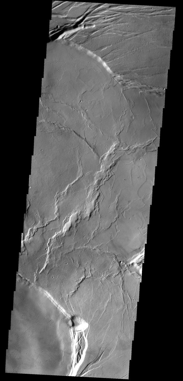
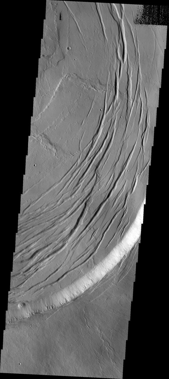
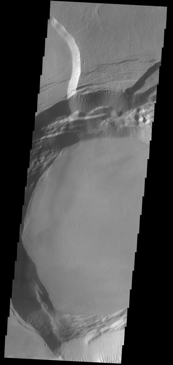
This THEMIS image shows part of the southern margin of the summit caldera. This image contains a variety of features representing the major events related to the formation of the volcano. At the top of the image a small linear vent has produced lava flows increasing the elevation of the surface around it. The flat floor of the caldera surrounds the vent and the cliff faces at the center of the image were created during the collapse event that formed the caldera. Depressions at the bottom illustrate collapse into empty voids like lava tubes. Arsia Mons is the southernmost of the Tharsis volcanoes. It is 270 miles (450 km) in diameter, almost 12 miles (20 km) high, and the summit caldera is 72 miles (120 km) wide. For comparison, the largest volcano on Earth is Mauna Loa. From its base on the sea floor, Mauna Loa measures only 6.3 miles high and 75 miles in diameter. A large volcanic crater known as a caldera is located at the summit of all of the Tharsis volcanoes. These calderas are produced by massive volcanic explosions and collapse. The Arsia Mons summit caldera is larger than many volcanoes on Earth. The Odyssey spacecraft has spent over 15 years in orbit around Mars, circling the planet more than 69000 times. It holds the record for longest working spacecraft at Mars. THEMIS, the IR/VIS camera system, has collected data for the entire mission and provides images covering all seasons and lighting conditions. Over the years many features of interest have received repeated imaging, building up a suite of images covering the entire feature. From the deepest chasma to the tallest volcano, individual dunes inside craters and dune fields that encircle the north pole, channels carved by water and lava, and a variety of other feature, THEMIS has imaged them all. For the next several months the image of the day will focus on the Tharsis volcanoes, the various chasmata of Valles Marineris, and the major dunes fields. We hope you enjoy these images! Orbit Number: 63900 Latitude: -10.0873 Longitude: 239.197 Instrument: VIS Captured: 2016-05-10 07:58 https://photojournal.jpl.nasa.gov/catalog/PIA22159

This image obtained by NASA Magellan spacecraft reveals Sacajawea Patera, a large, elongate caldera located in western Ishtar Terra on the smooth plateau of Lakshmi Planum. http://photojournal.jpl.nasa.gov/catalog/PIA00216
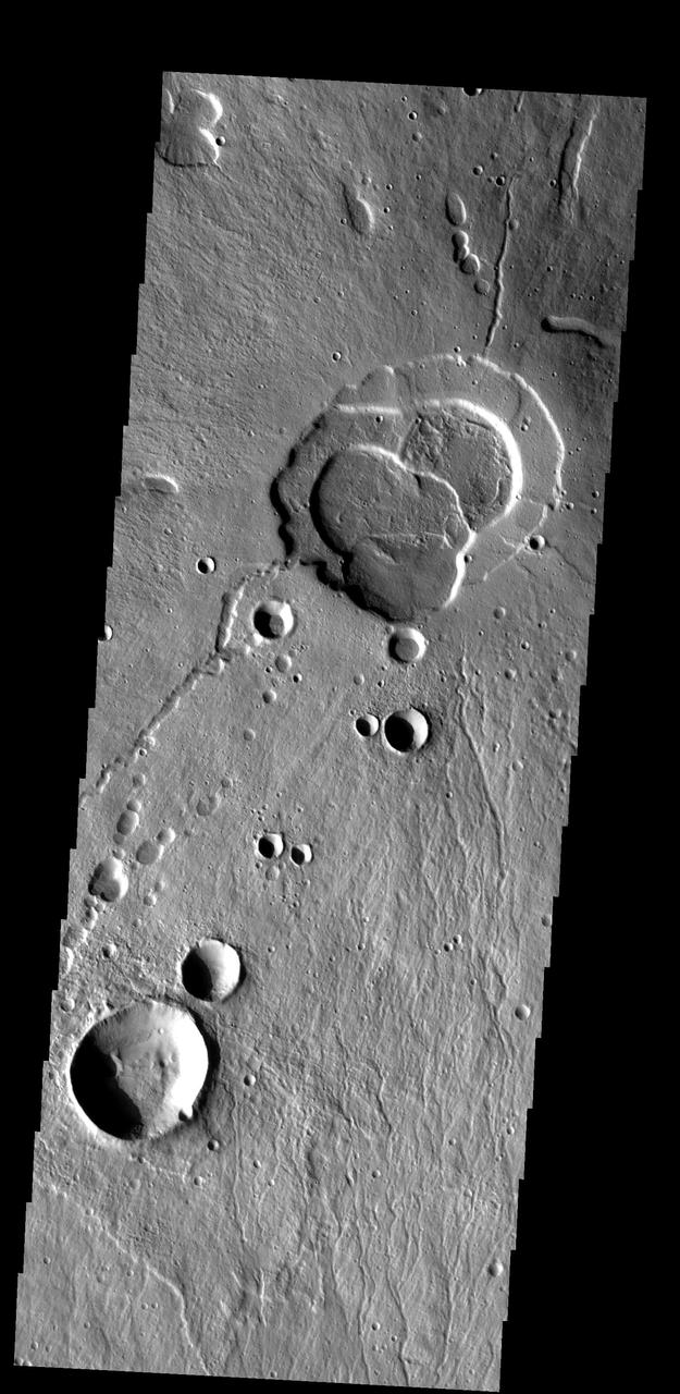
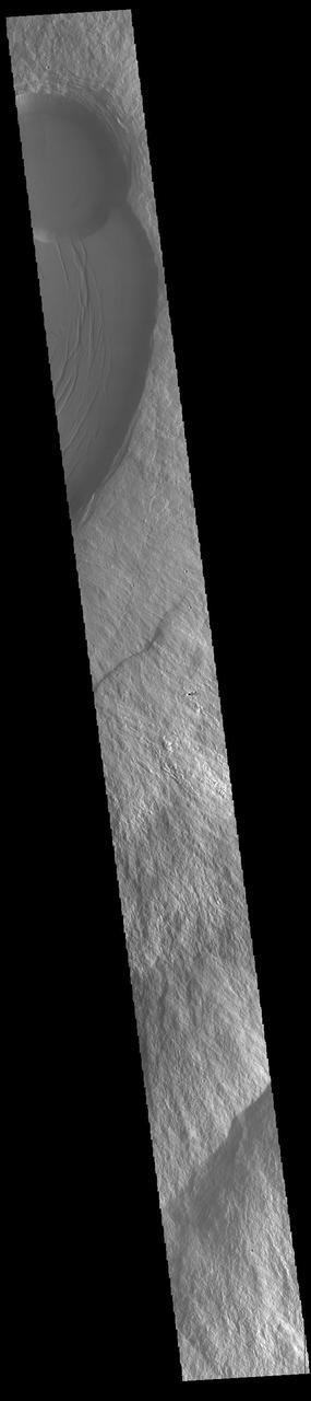
Click on the image for larger version This image shows a circular impact crater and an oval volcanic caldera on the southern flank of a large volcano on Mars called Pavonis Mons. The caldera is also the source of numerous finger-like lava flows and at least one sinuous lava channel. Both the caldera and the crater are degraded by aeolian (wind) erosion. The strong prevailing winds have apparently carved deep grooves into the terrain. When looking at the scene for the first time, the image seems motion blurred. However, upon a closer look, the smaller, young craters are pristine, so the image must be sharp and the "blurriness" is due to the processes acting on the terrain. This suggests that the deflation-produced grooves, along with the crater and the caldera, are old features and deflation is not very active today. Alternatively, perhaps these craters are simply too young to show signs of degradation. This deeply wind-scoured terrain type is unique to Mars. Wind-carved stream-lined landforms on Earth are called "yardangs," but they don't form extensive terrains like this one. The basaltic lavas on the flanks of this volcano have been exposed to wind for such a long time that there are no parallels on Earth. Terrestrial landscapes and terrestrial wind patterns change much more rapidly than on Mars. http://photojournal.jpl.nasa.gov/catalog/PIA21064
This image captured by NASA's 2001 Mars Odyssey spacecraft shows part of the summit caldera of Arsia Mons. Orbit Number: 63900 Latitude: -10.0873 Longitude: 239.197 Instrument: VIS Captured: 2016-05-10 07:58 http://photojournal.jpl.nasa.gov/catalog/PIA20778
![Today's VIS image shows a cross section of Albor Tholus, a volcano found in the Elysium volcanic complex. The volcanic caldera is at the top of the image. The caldera is unusual in that it is very deep compared to volcano height. The top elevation of Albor Tholus is approximately 4.5km, the deepest part of the caldera measures 3km below this [an elevation of only 1.5km]. Orbit Number: 87756 Latitude: 17.9743 Longitude: 150.411 Instrument: VIS Captured: 2021-09-26 03:18 https://photojournal.jpl.nasa.gov/catalog/PIA25267](https://images-assets.nasa.gov/image/PIA25267/PIA25267~medium.jpg)
Today's VIS image shows a cross section of Albor Tholus, a volcano found in the Elysium volcanic complex. The volcanic caldera is at the top of the image. The caldera is unusual in that it is very deep compared to volcano height. The top elevation of Albor Tholus is approximately 4.5km, the deepest part of the caldera measures 3km below this [an elevation of only 1.5km]. Orbit Number: 87756 Latitude: 17.9743 Longitude: 150.411 Instrument: VIS Captured: 2021-09-26 03:18 https://photojournal.jpl.nasa.gov/catalog/PIA25267
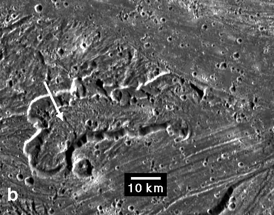
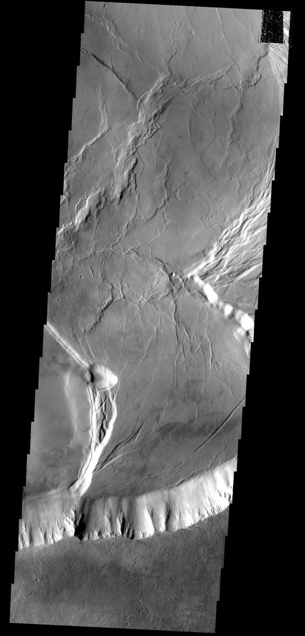
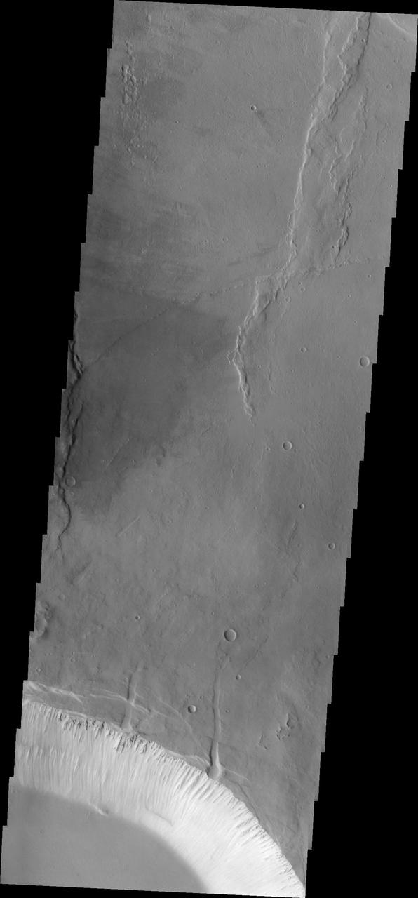
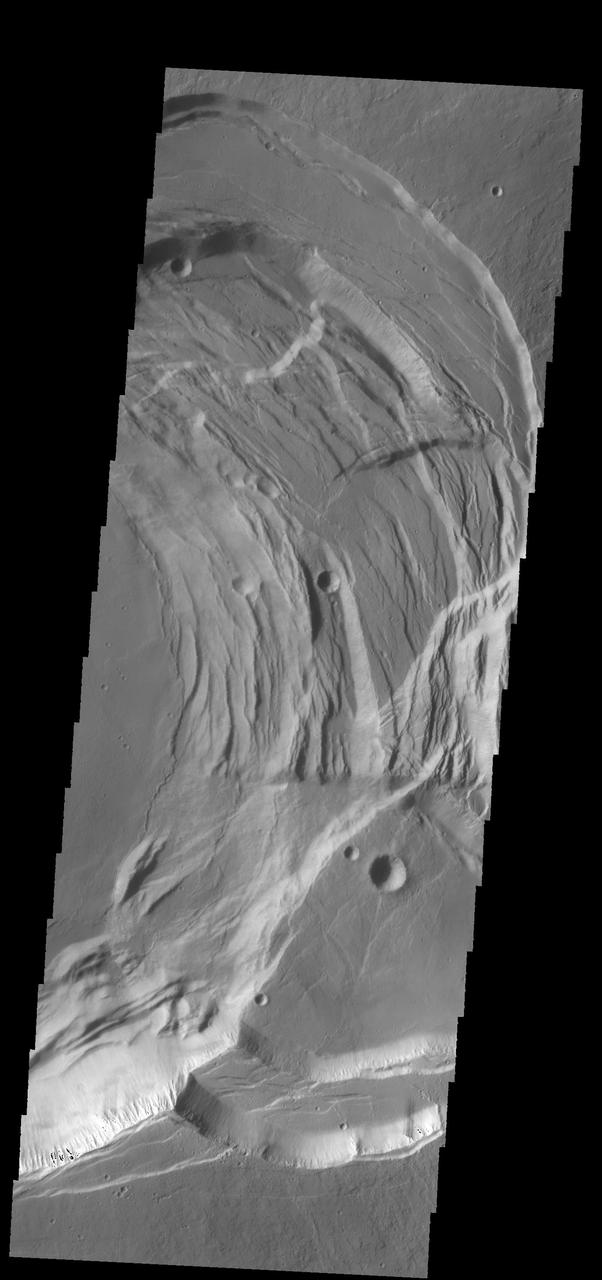
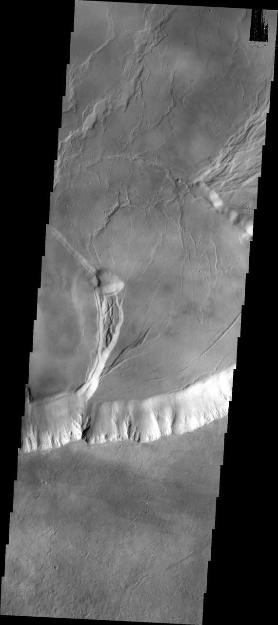
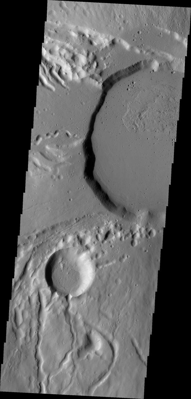
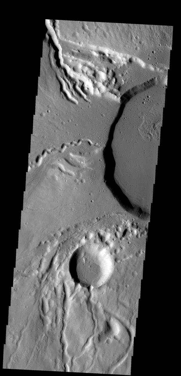
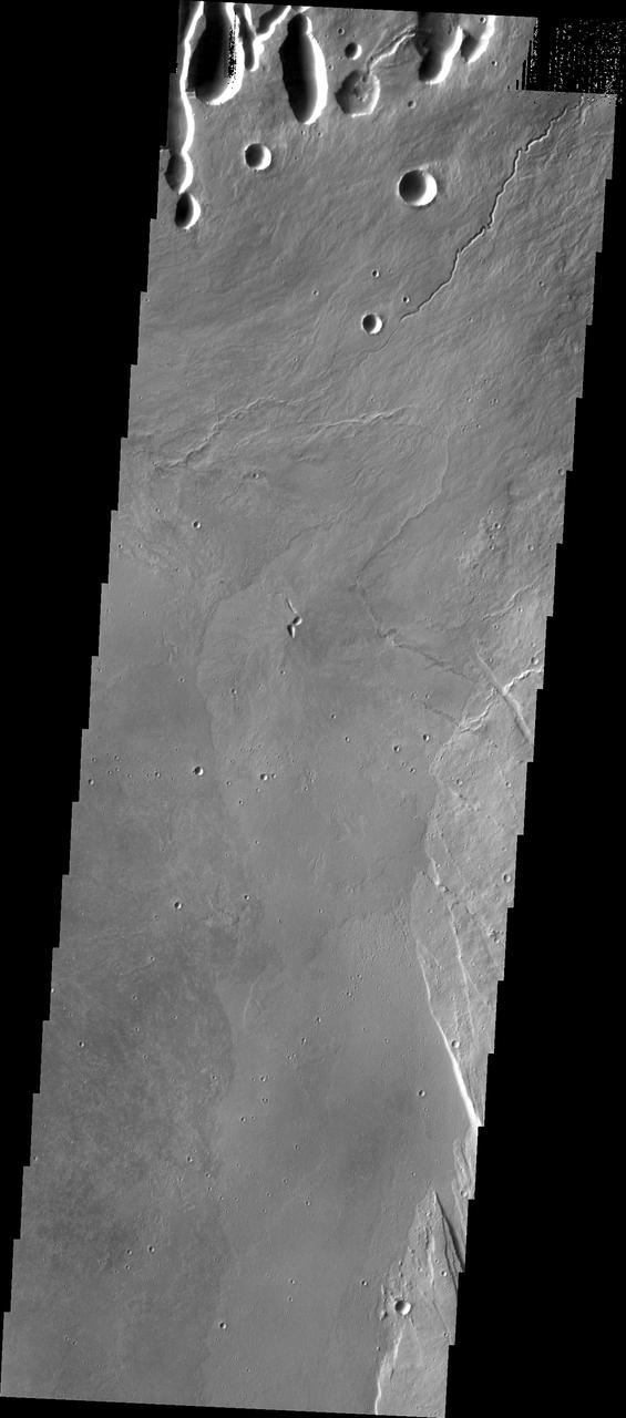
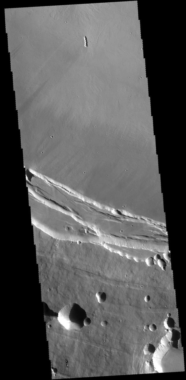
The lava channels and collapse features in this image from NASA 2001 Mars Odyssey spacecraft are located near the summit of Arsia Mons. The fracture in the lower right part of the image marks the boundary of the summit caldera.
At the top right of this NASA Mars Odyssey image, the rim of the caldera of Pavonis Mons, one of four exceptionally large volcanoes in the Tharsis region, is barely visible with steep cliffs formed by the collapse of a portion of the volcano summit.
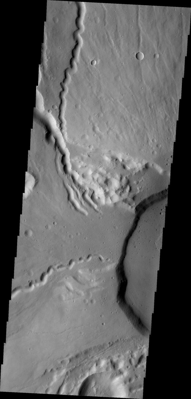
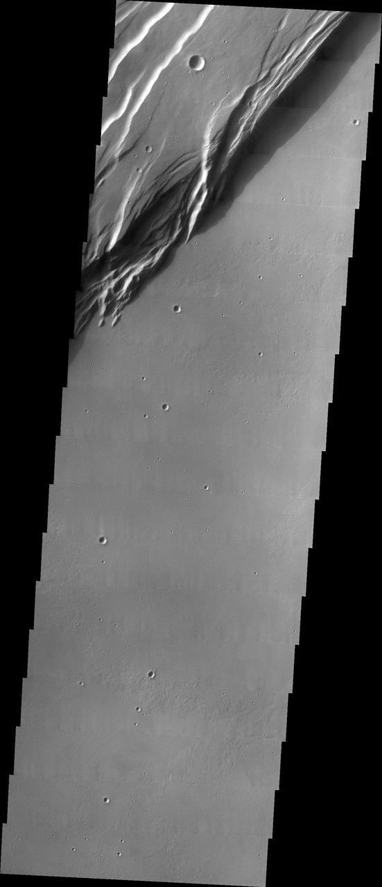
This NASA 2001 Mars Odyssey spacecraft image shows the western edge of the summit caldera of Ceranus Tholus, one of the smaller volcanic constructs of the Tharsis region. Several channels dissect the western flank of the volcano.
This false color image from NASA Mars Reconnaissance Orbiter indicates that the volcanic cone in the Nili Patera caldera on Mars has hydrothermal mineral deposits on the southern flanks and nearby terrains.
The southeast part of the island of Hokkaido, Japan, is an area dominated by volcanoes and volcanic caldera. The active Usu Volcano is at the lower right edge of the circular Lake Toya-Ko and near the center of the image.
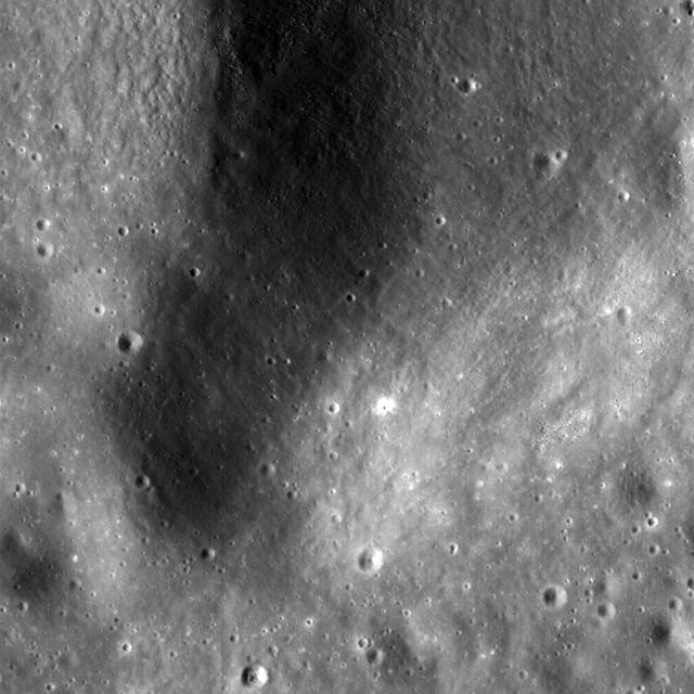
This NASA Lunar Reconnaissance Orbiter LRO image is of the summit crater of Hortensius Dome Phi. Summit craters of all the Hortensius Domes show no raised rims and are not circular, indicating they are analogous to volcanic calderas.
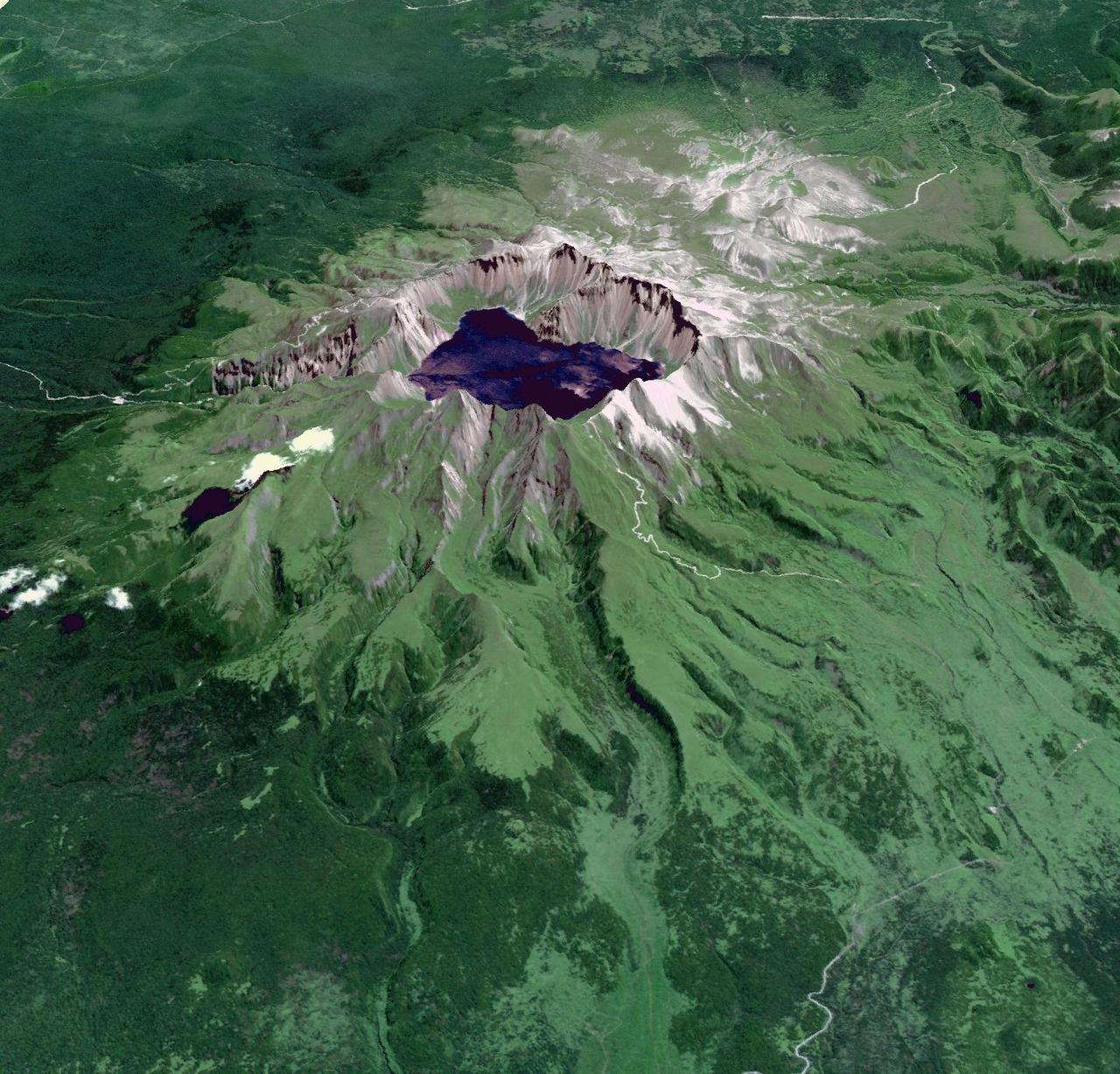
This image from NASA Terra spacecraft shows Baektu Mountain, an active volcano on the border between North Korea and China. Rising to 2744 m, its summit caldera is filled with a crater lake, Heaven Lake.
This false-color image of Colombia Galeras Volcano, was acquired by UAVSAR on March 13, 2013. A highly active volcano, Galeras features a breached caldera and an active cone that produces numerous small to moderate explosive eruptions.
ISS018-E-010206 (3 Dec. 2008) --- Mount Nemrut in Turkey is featured in this image photographed by an Expedition 18 crewmember on the International Space Station. This detailed view centers on the summit caldera of Mount Nemrut (Nemrut Dagi in Turkish), a stratovolcano located in the eastern Anatolia region of Turkey along the shoreline of Lake Van. Winter snow blankets the 2,948 meter elevation summit of the mountain, highlighting the brown caldera rim (a caldera is a large, usually circular or elliptical, collapse feature caused by the rapid emptying of an underlying magma chamber). The snow also highlights the irregular shape and wrinkled surfaces of several lava flows present in the eastern portion of the caldera. Lava flows associated with Mt. Nemrut range in composition from thin, fluid basalt to thick, glassy obsidian. A coldwater caldera lake occupies the western half of the summit. The geologic record at Mt. Nemrut indicates numerous prehistoric explosive eruptions during the Holocene Epoch ?which, according to scientists, began approximately 10,000 years ago and extends to the present day ? with eruption of lava last observed during 1441. The last well-documented explosive eruption occurred during 1650. Volcanism at Mt. Nemrut is the result of tectonic activity associated with the collision of the Arabian and Eurasian Plates; this collision is ongoing, and the presence of a warm water lake in the caldera suggests that the volcano is merely quiescent at present.
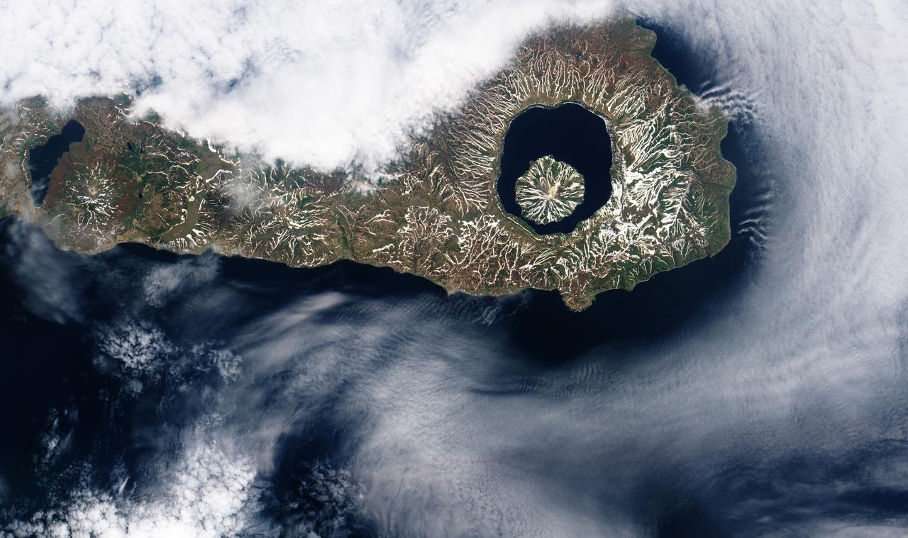
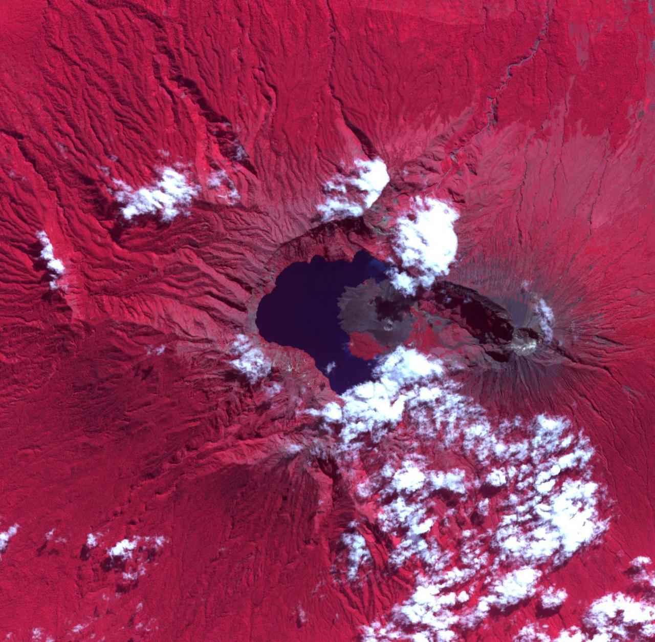
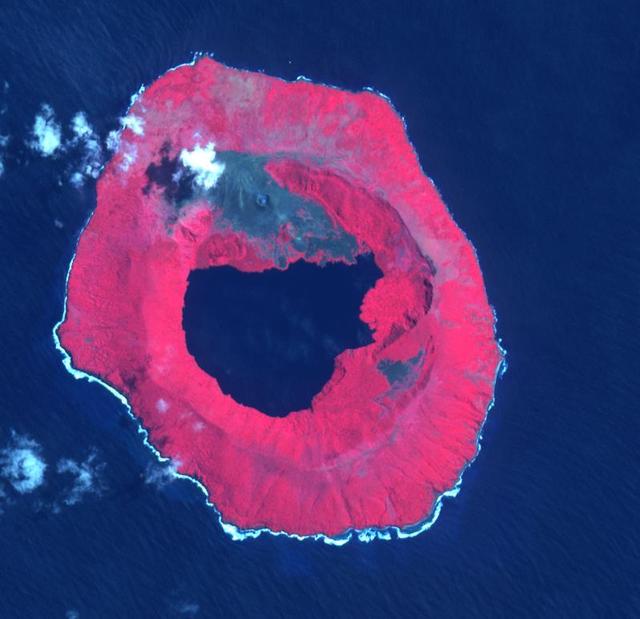
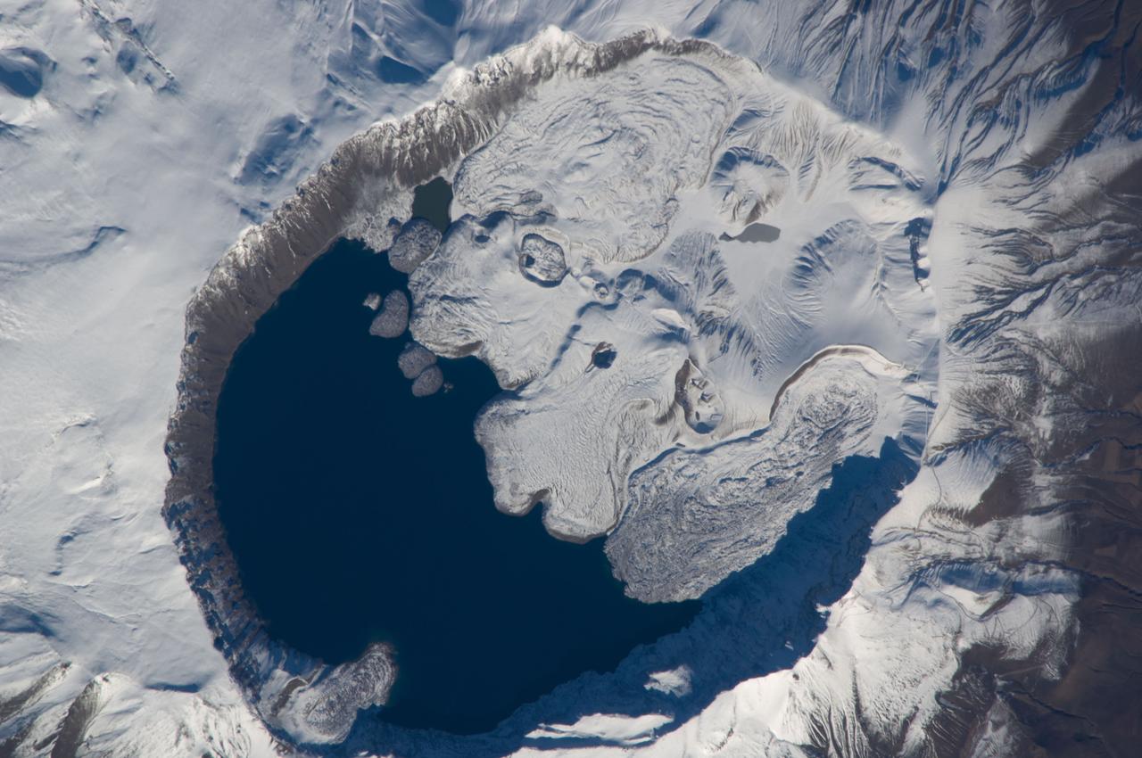
iss071e046424 (April 29, 2024) --- The snow-covered Onekotan Island, part of Russia's Kuril Islands, is home to the Tao-Rusyr Caldera stratovolcano in this photograph. Inside the caldera is the Krenitsyna Volcano peak surrounded by the partially ice-covered Kol'tsevoe Lake. The International Space Station was orbiting 259 miles above the Pacific Ocean at the time of this photograph.
Today's VIS image shows a cross section of Elysium Mons, including part of the summit caldera. Unlike the Tharsis volcanoes to the east, there are very few identifiable lava flows on the flanks of the Elysium Mons. In profile the volcano looks like Mt. Fuji in Japan. Mt. Fuji is a stratovolcano. A stratovolcano, also known as a composite volcano, is a conical volcano built up by multiple layers of lava and ash erupting solely from the summit caldera. The Tharsis volcanoes are shield volcanoes, which will host flank eruptions, but rarely ash eruptions. Elysium Mons is 12.6km (7.8 miles) tall. For comparison, Mt. Fuji is 3.7 km (2.3 miles) tall. Orbit Number: 93908 Latitude: 24.4791 Longitude: 146.667 Instrument: VIS Captured: 2023-02-14 16:41 https://photojournal.jpl.nasa.gov/catalog/PIA25925
Today's VIS image shows a cross section of Elysium Mons, including part of the summit caldera. Unlike the Tharsis volcanoes to east, there are very few identifiable lava flows on the flanks of the Elysium Mons. In profile the volcano looks like Mt. Fuji in Japan. Mt. Fuji is a stratovolcano. A stratovolcano, also known as a composite volcano, is a conical volcano built up by multiple layers of lava and ash erupting solely from the summit caldera. The Tharsis volcanoes are shield volcanoes, which will host flank eruptions, but rarely ash eruptions. Elysium Mons is 12.6km (7.8 miles) tall. For comparison, Mt. Fuji is 3.7 km (2.3 miles) tall. Orbit Number: 94794 Latitude: 24.68 Longitude: 146.541 Instrument: VIS Captured: 2023-04-28 15:31 https://photojournal.jpl.nasa.gov/catalog/PIA26171
The circular feature near the top of this VIS image is part of the summit caldera of Olympus Mons. Scarps and extensional features (graben) record multiple stages of caldera collapse at the summit of Olympus Mons. Huge lava flows poured down the side of the volcano. Olympus Mons is the largest volcano in the solar system, reaching heights over 40 km (25 miles) tall from base to summit, with the base covering an area as large as the state of Arizona. For comparison, Mauna Loa is 9 km (5.5 miles) tall measured from its base on the sea floor. Orbit Number: 85295 Latitude: 17.523 Longitude: 227.462 Instrument: VIS Captured: 2021-03-07 12:04 https://photojournal.jpl.nasa.gov/catalog/PIA24826
Today's VIS image shows a cross section of Elysium Mons, including the entire summit caldera. Unlike the Tharsis volcanoes to east, there are very few identifiable lava flows on the flanks of the Elysium Mons. In profile the volcano looks like Mt. Fuji in Japan. Mt. Fuji is a stratovolcano. A stratovolcano, also known as a composite volcano, is a conical volcano built up by multiple layers of lava and ash erupting solely from the summit caldera. The Tharsis volcanoes are shield volcanoes, which will host flank eruptions, but rarely ash eruptions. Elysium Mons is 12.6km (7.8 miles) tall. For comparison, Mt. Fuji is 3.7 km (2.3 miles) tall. Orbit Number: 86633 Latitude: 24.5225 Longitude: 146.837 Instrument: VIS Captured: 2021-06-25 16:09 https://photojournal.jpl.nasa.gov/catalog/PIA24959