Cape Verde
View of Cape St. Mary from Cape Verde
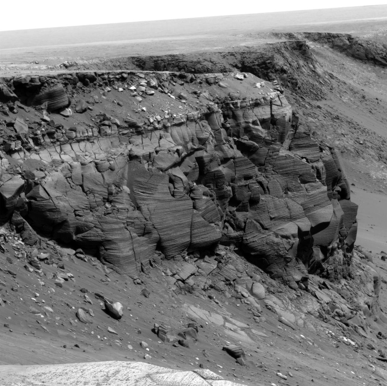
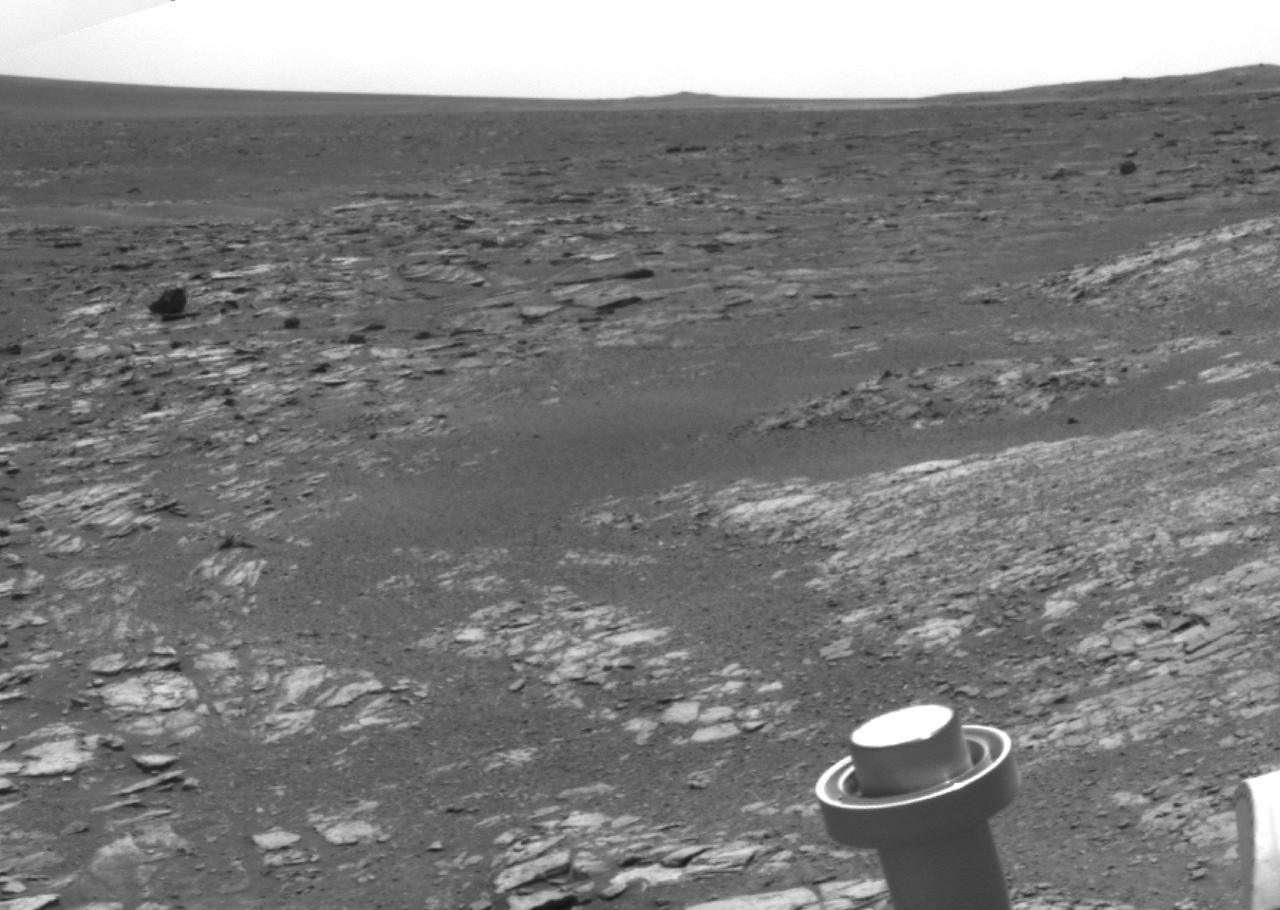
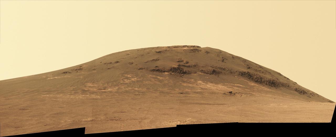
Opportunity at Crater Cape Verde
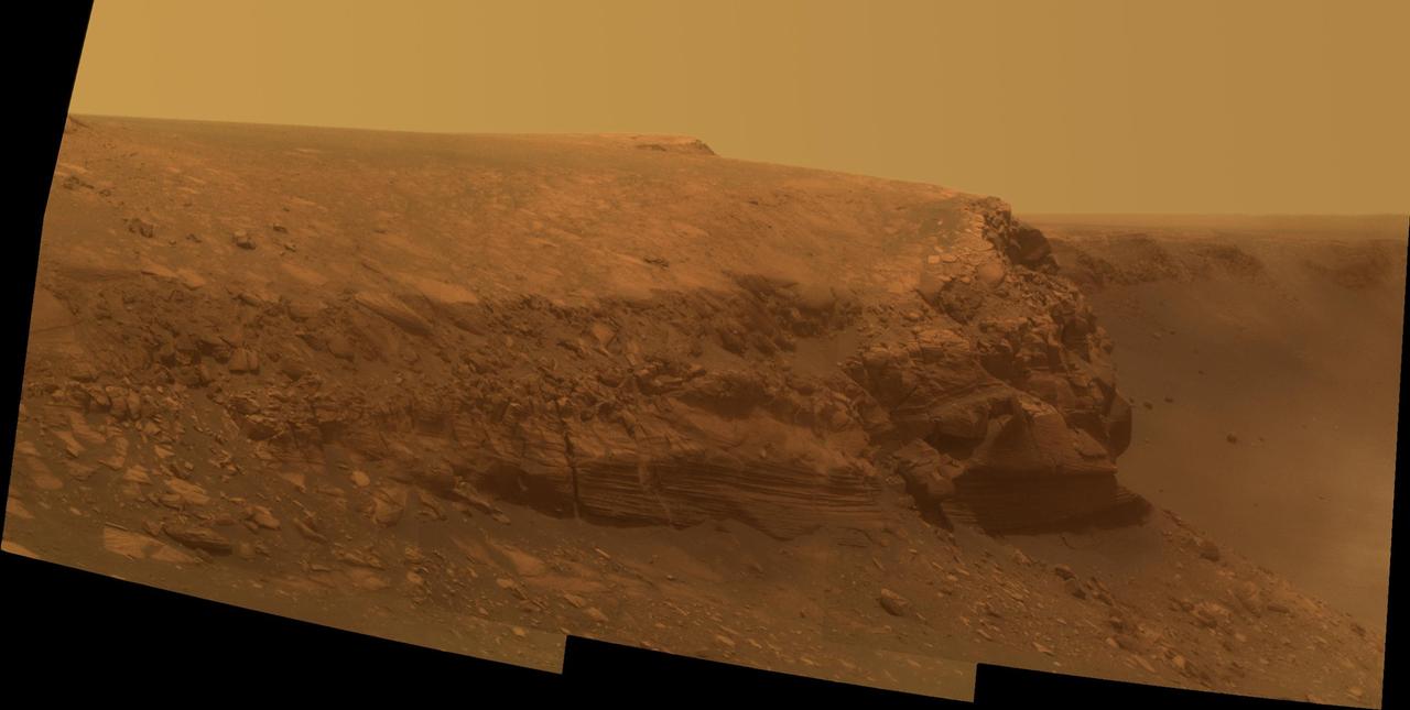
Cape St. Mary
Cape Verde in False Color
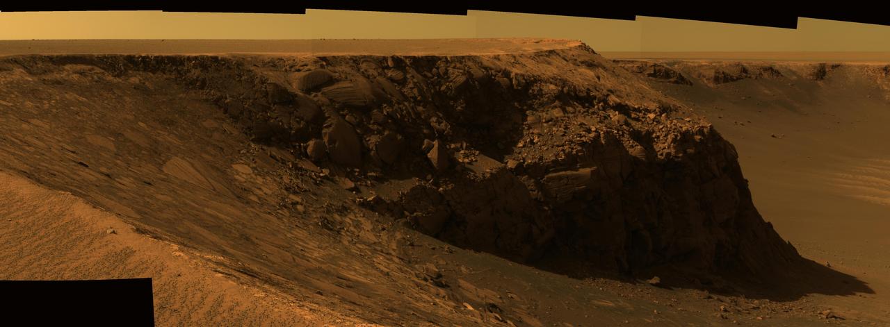
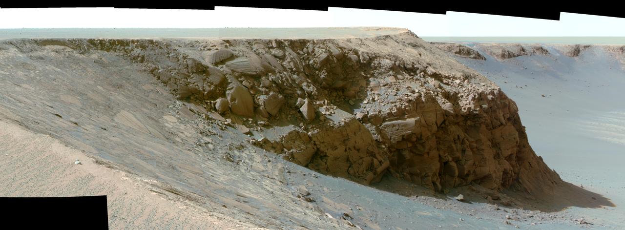
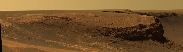
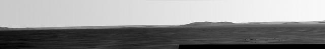
View of Cape Verde from Cape St. Mary in Mid-Afternoon
View of Cape St. Mary from Cape Verde False Color
View of Cape Verde from Cape St. Mary in Late Morning
View of Cape St. Mary from Cape Verde Altered Contrast
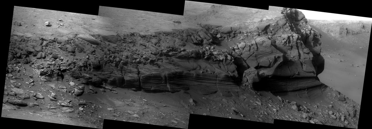
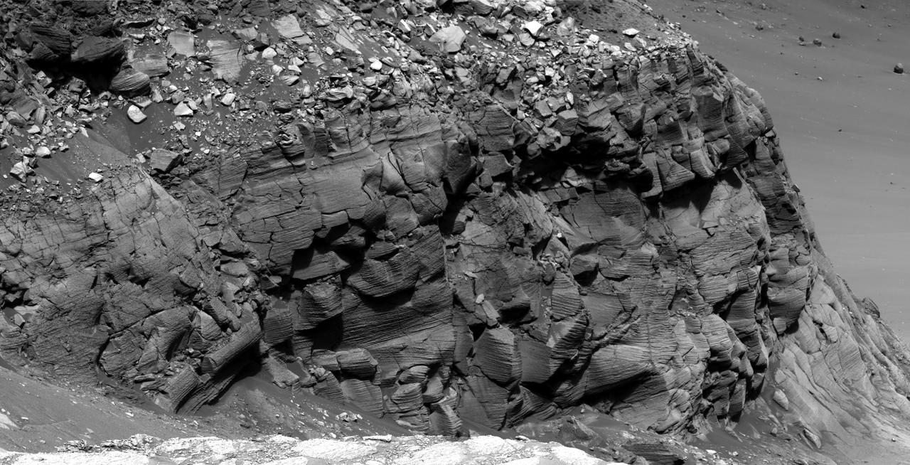
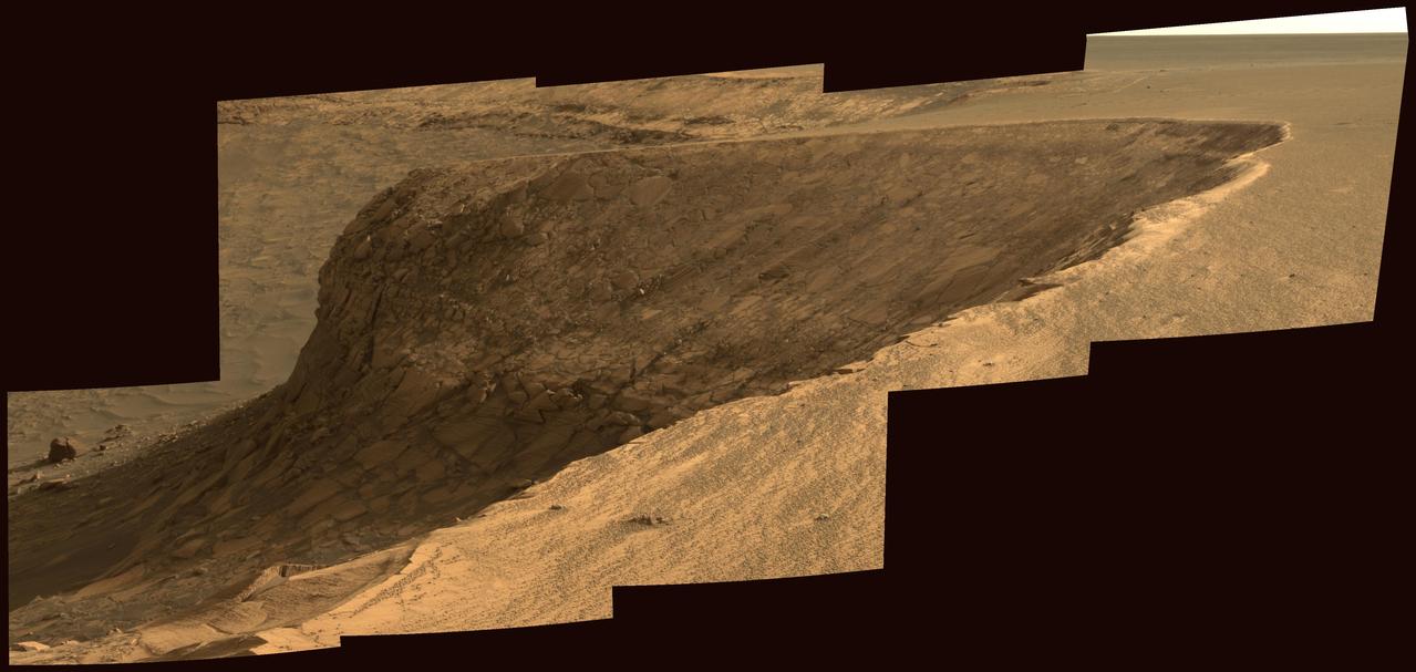
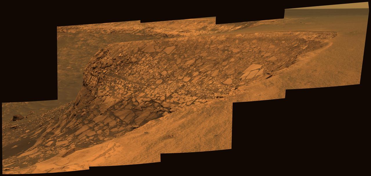
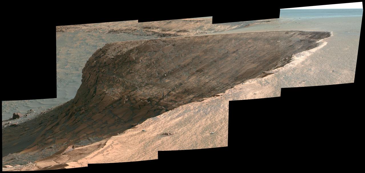
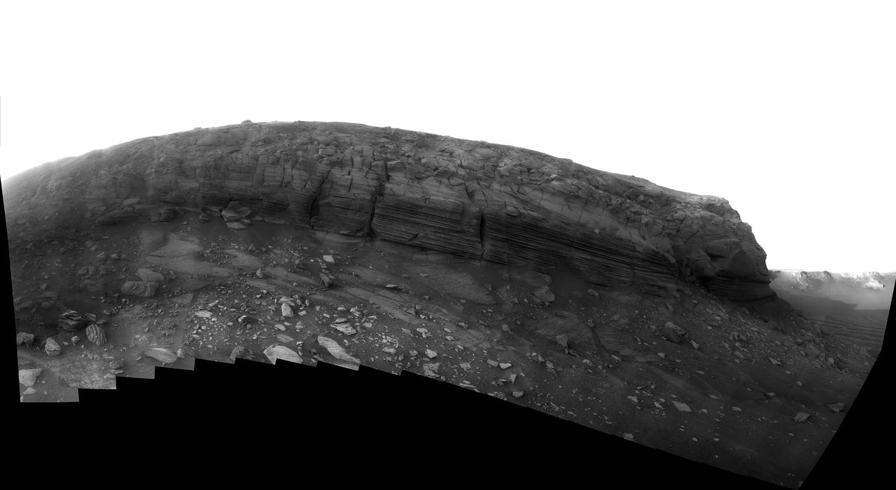
Layers of Cape Verde in Victoria Crater
View of Cape Verde from Cape St. Mary in Mid-Afternoon False Color
View of Cape Verde from Cape St. Mary in Late Morning False Color
Dusk Lighting of Layered Textures in Cape Verde
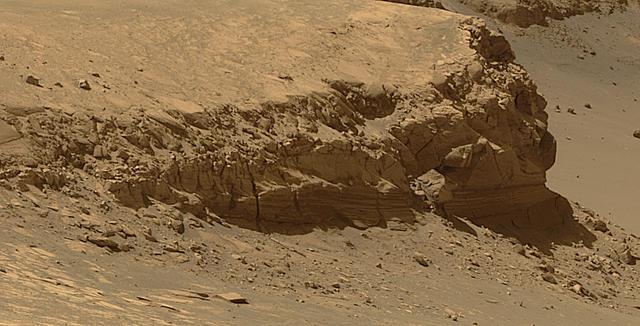
Layers of Cape Verde in Victoria Crater Enhanced
Opportunity at Crater Cape Verde Red Filter
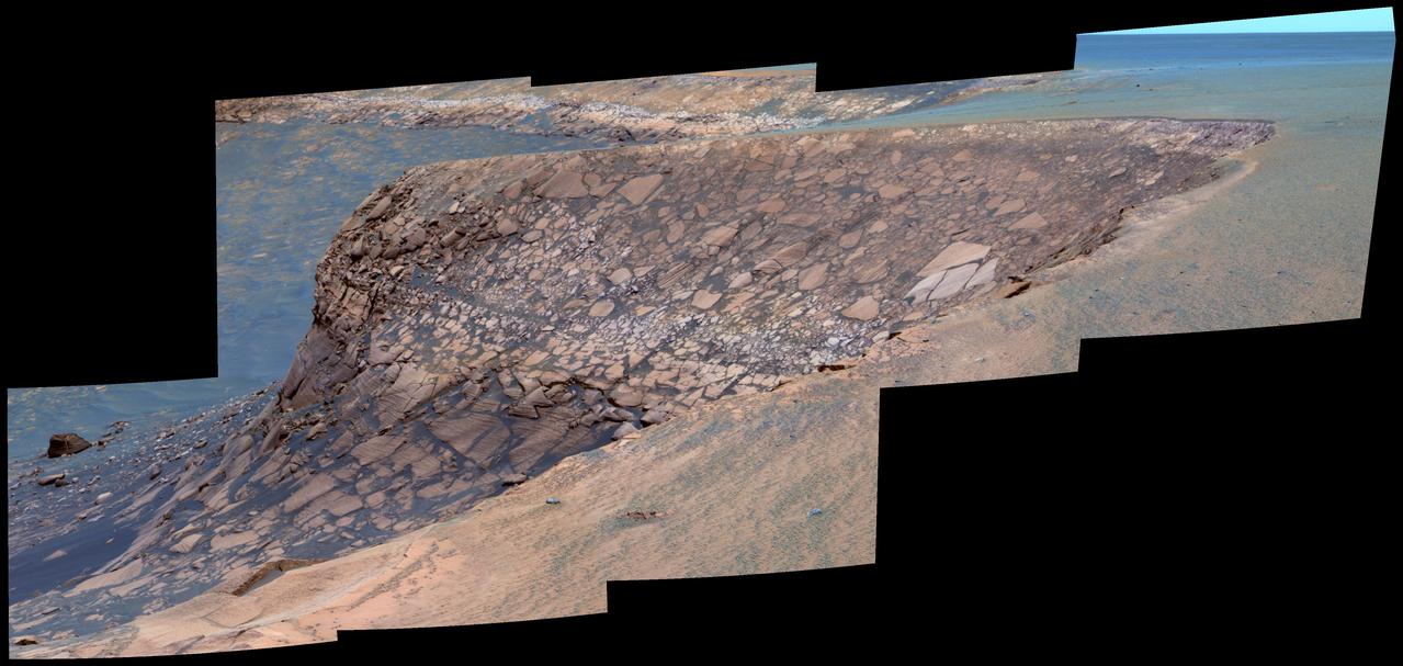
Layers of Cape Verde in Victoria Crater False Color
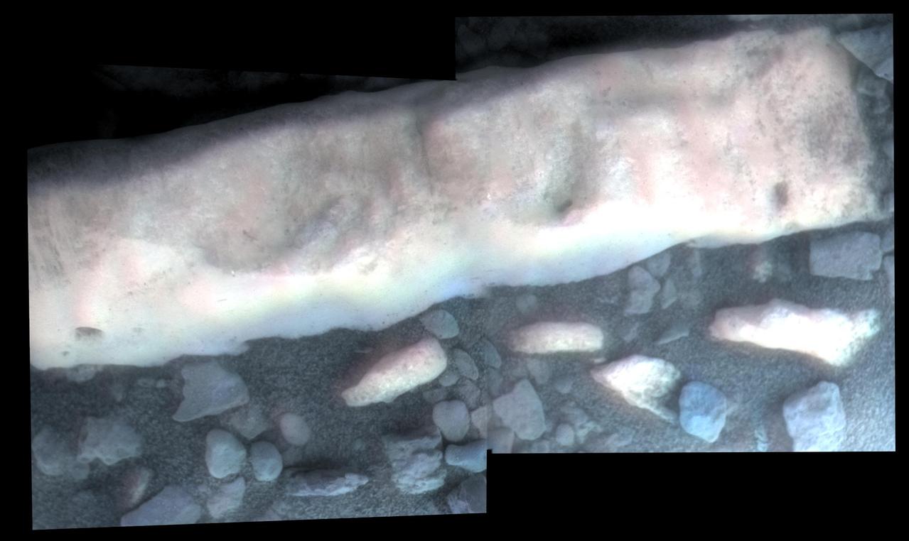
Details of Layers in Victoria Crater Cape St. Vincent
Panorama from Cape Verde False Color
Opportunity Second Martian Birthday at Cape Verde
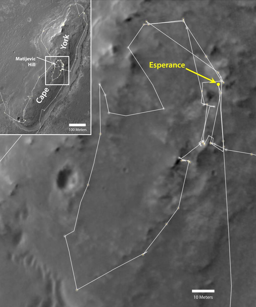
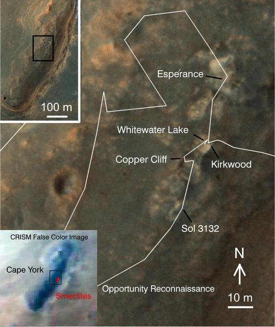
NASA Mars Exploration Rover Opportunity drove onto the Cape York segment of the rim of Endeavour Crater in August 2011 and departed Cape York in May 2013. The location of a rock target called Esperance is indicated in the main map.
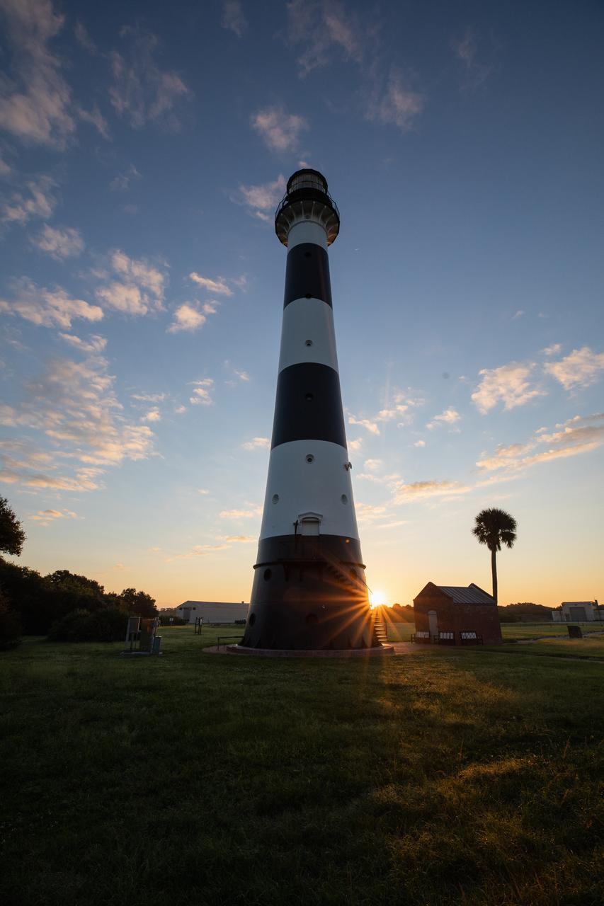
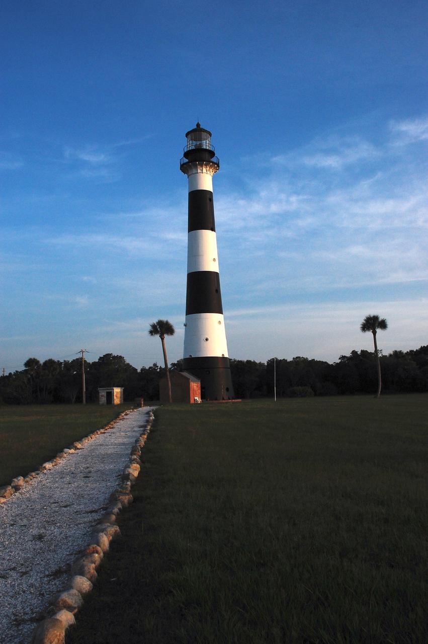
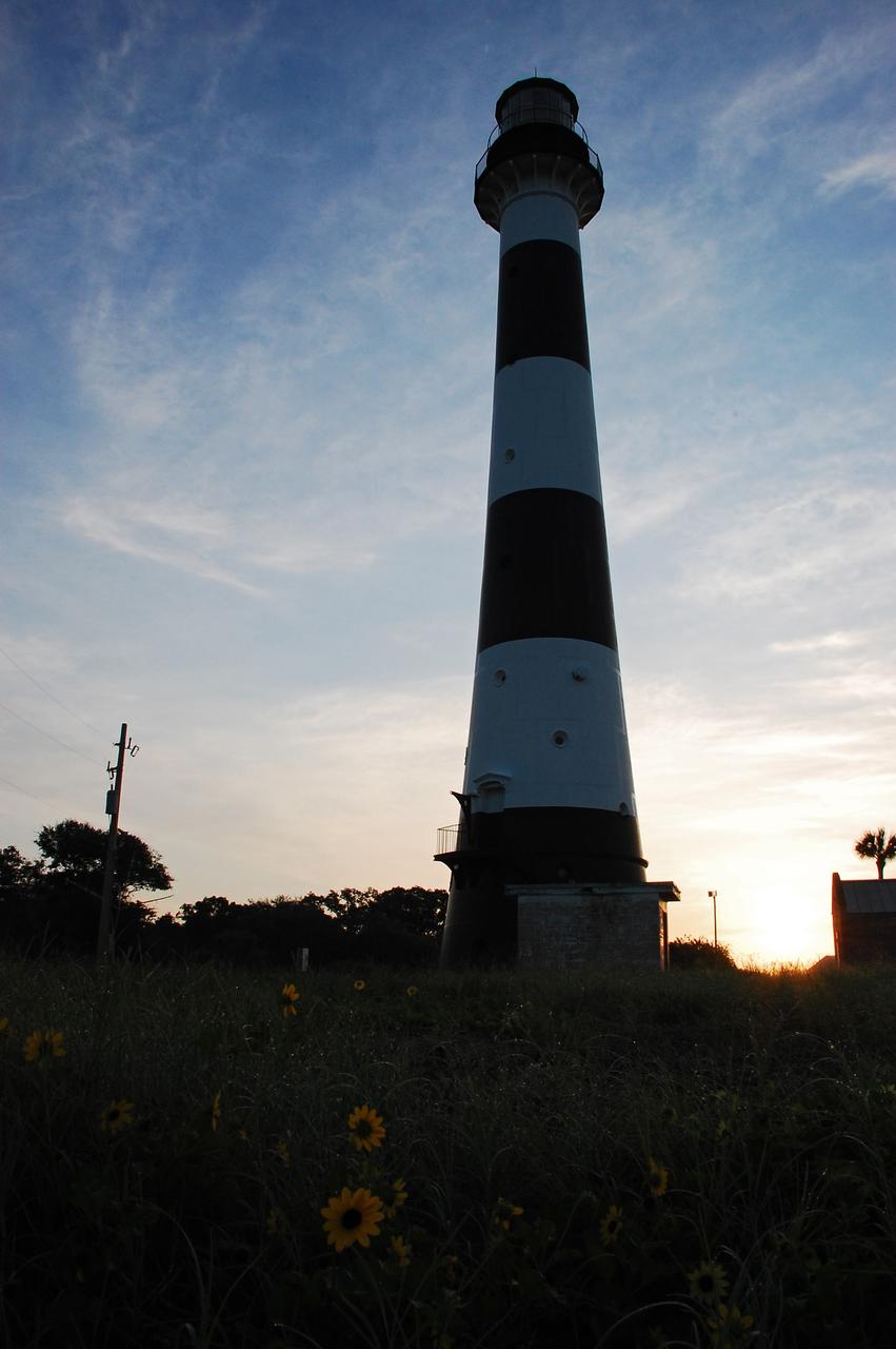
The sun rises behind Cape Canaveral Lighthouse at Cape Canaveral Air Force Station in Florida on Oct. 13, 2020.
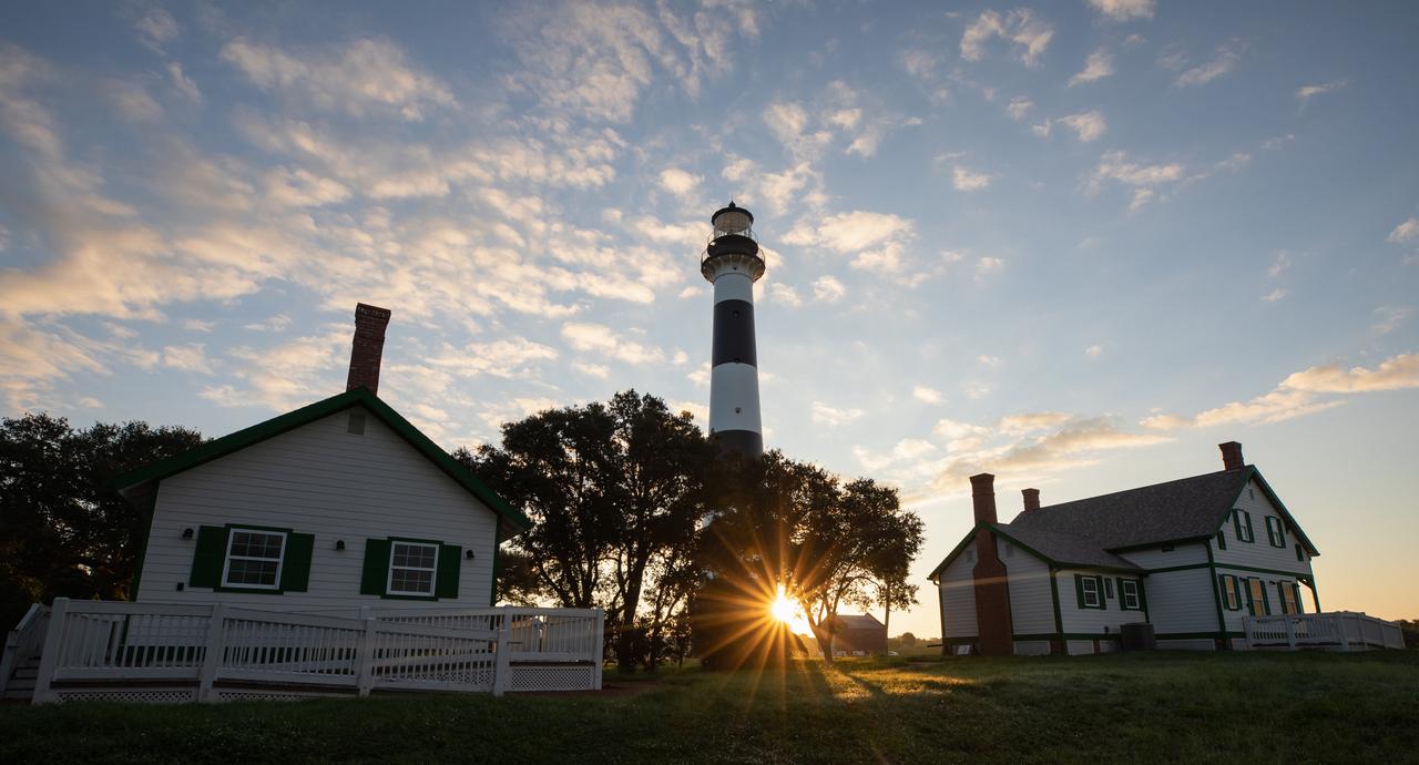
The sun rises behind Cape Canaveral Lighthouse at Cape Canaveral Air Force Station in Florida on Oct. 13, 2020.
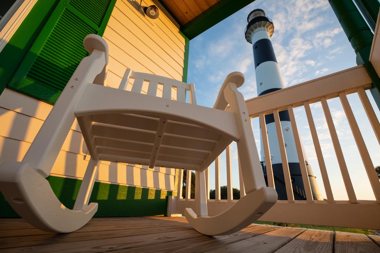
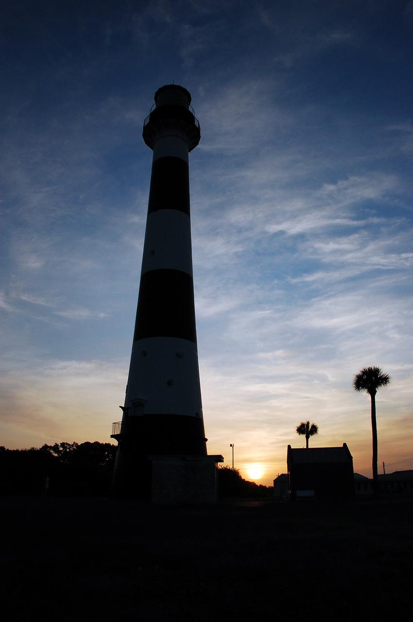
The Cape Canaveral Lighthouse at Cape Canaveral Air Force Station in Florida stands tall during an Oct. 13, 2020, sunrise.
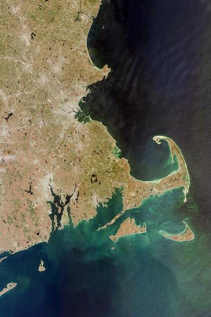
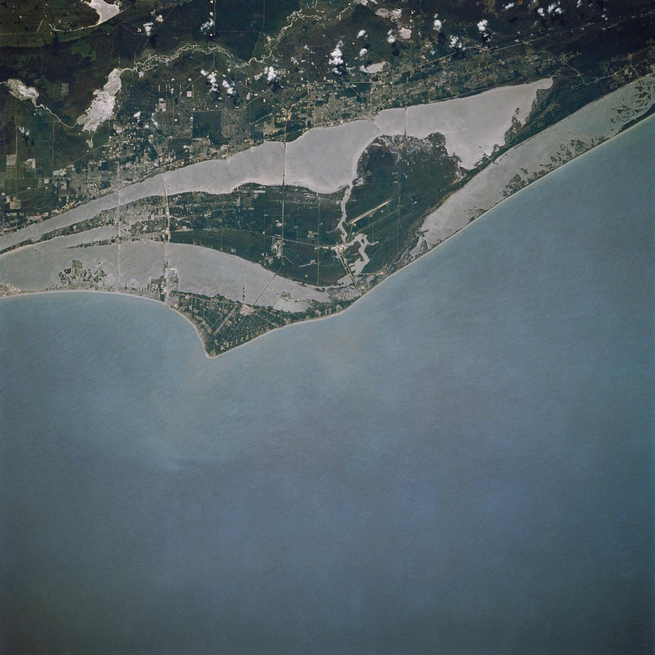
This image acquired on April 13, 2000 from NASA Terra satellite shows west side of Cape Cod Bay.
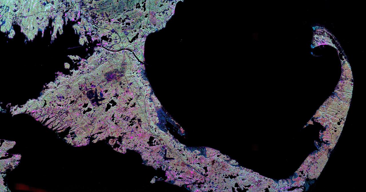
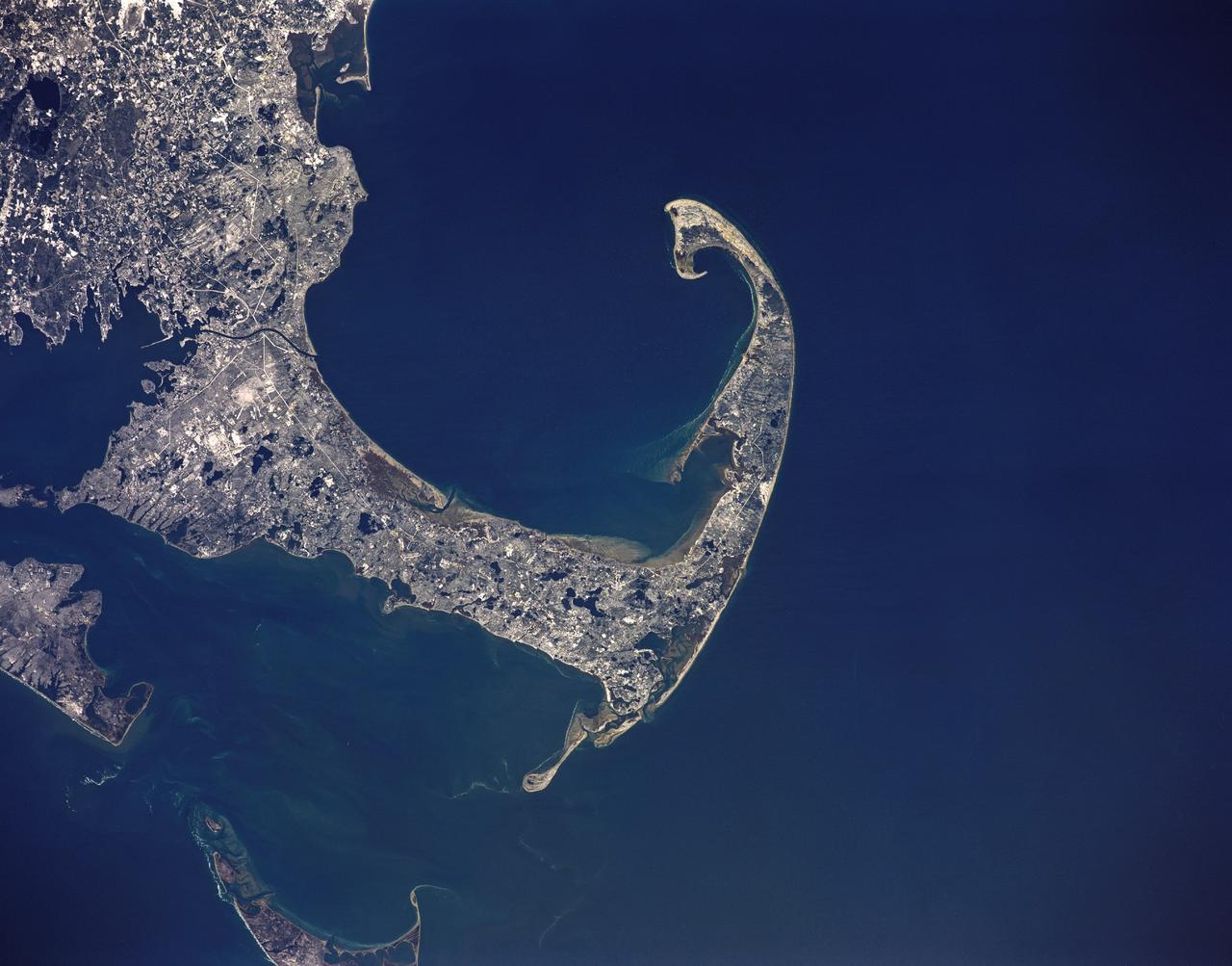
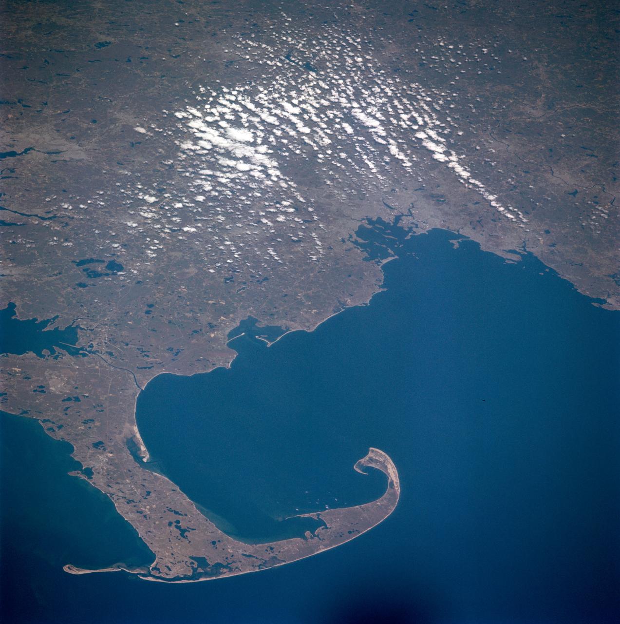
The distinctive curve of Cape Cod, Massachusetts and the greater Boston urban area are very clear of the northeastern coast of the United States in this image from NASA EarthKAM.

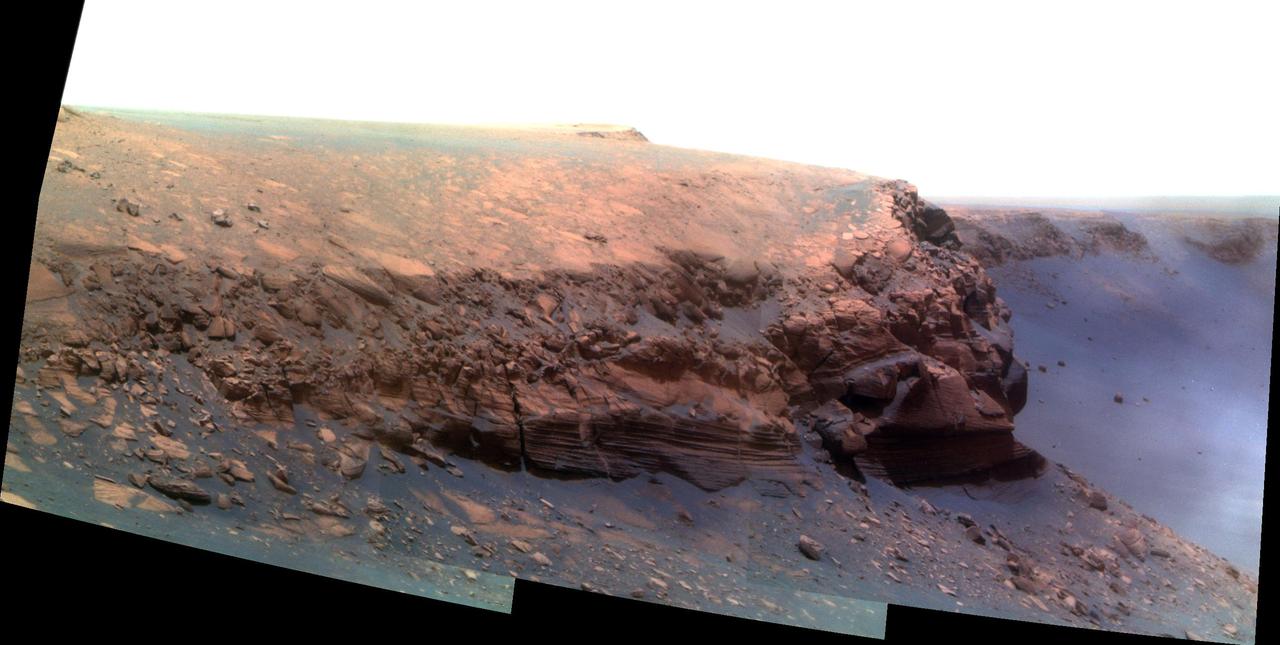
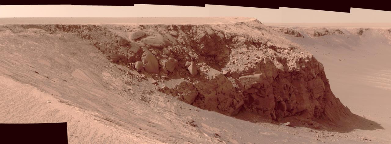
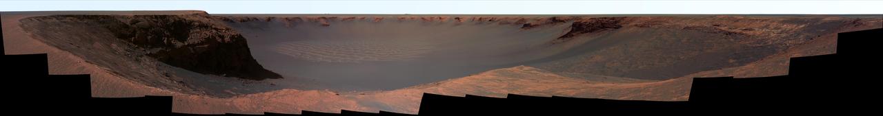
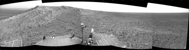
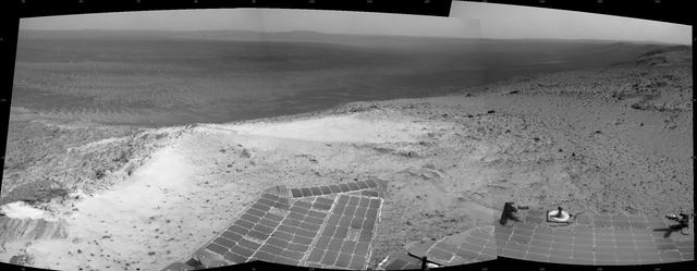
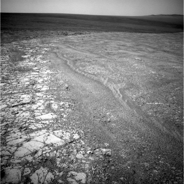
NASA Mars Exploration Rover Opportunity captured this vista of Victoria Crater from the viewpoint of Cape Verde, one of the promontories that are part of the scalloped rim of the crater.
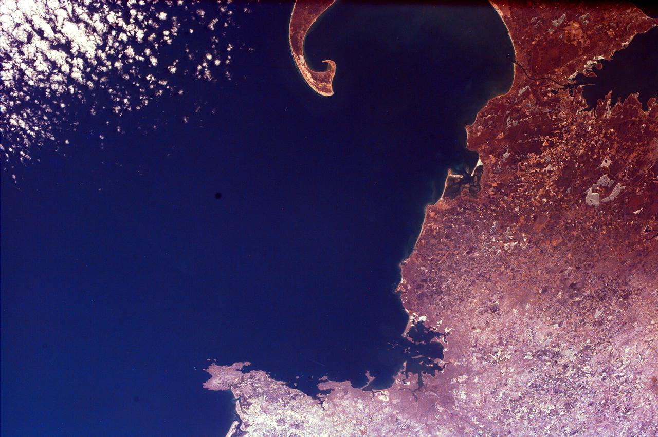
This spaceborne radar image shows the famous hook of Cape Cod, Massachusetts. The Cape, which juts out into the Atlantic Ocean about 100 kilometers 62 miles southeast of Boston.
The southernmost tip of Africa is marked by the Cape Agulhas lighthouse. The warm Atlantic Agulhas current meets the cold water Indian Ocean Benguela current, creating treacherous seas that have claimed many ships over the last 450 years. The image covers an area of 22.5 by 41.1 kilometers, was acquired September 27, 2006, and is located at 34.8 degrees south, 20 degrees east. http://photojournal.jpl.nasa.gov/catalog/PIA21014
Cape Horn is the southernmost point of the Tierra Del Fuego archipelago of Southern Chile, and marks the northern boundary of the Drake Passage where the Atlantic and Pacific Oceans meet. For decades after its 1616 discovery, it was a milestone for the clipper route by which sailing ships carried trade around the world (Wikipedia). Unfortunately, it was also a graveyard for sailing ships due to strong winds, large waves, strong currents, and icebergs. The 1914 opening of the Panama Canal greatly reduced the need for ships to traverse this dangerous passage. The image was acquired December 20, 2009, covers an area of 28.3 by 36.0 kilometers, and is located at 56 degrees south, 67.3 degrees west. https://photojournal.jpl.nasa.gov/catalog/PIA23118
NASA Mars Exploration Rover Opportunity recorded this view of the summit of Cape Tribulation, on the western rim of Endeavour Crater on the day before the rover drove to the top.
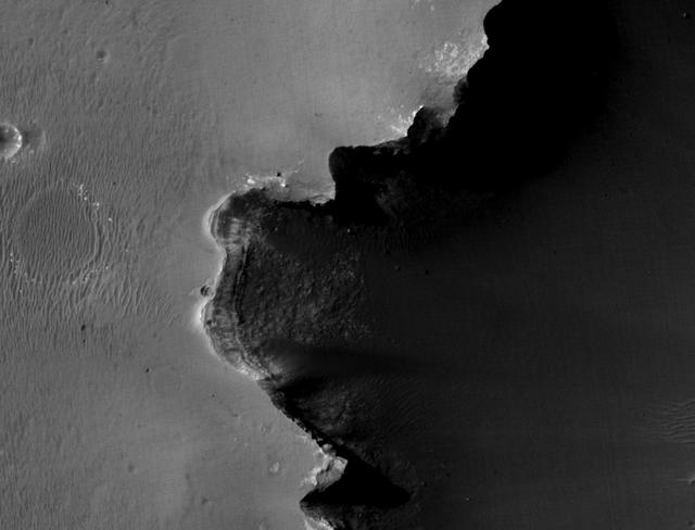
A region known as Cape York on the western rim of Endeavour Crater, where the Opportunity rover worked for 20 months, is highlighted in these images from NASA Mars Reconnaissance Orbiter.
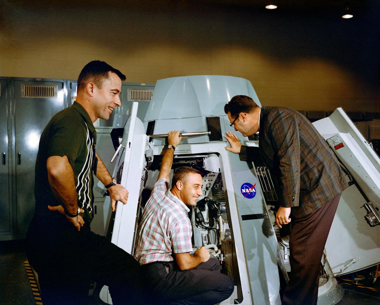
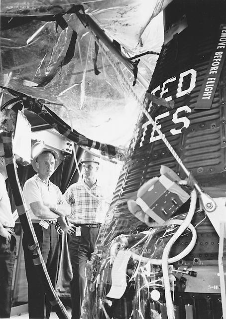
S64-40294 (19 Nov. 1964) --- Astronauts Virgil I. Grissom (center) and John W. Young (left), prime crew for the Gemini-Titan 3 mission, are shown inspecting the inside of Gemini spacecraft at the Mission Control Center at Cape Kennedy, Florida. Riley D. McCafferty is at right. Photo credit: NASA
Cape Town and the Cape of Good Hope, South Africa, appear on the left west of this anaglyph from NASA Shuttle Radar Topography Mission. 3D glasses are necessary to view this image.

An aerial view of NASA’s Kennedy Space Center and the surrounding Cape Canaveral, Fla. area is seen, Wednesday, May 13, 2026. Photo Credit: (NASA/John Kraus)
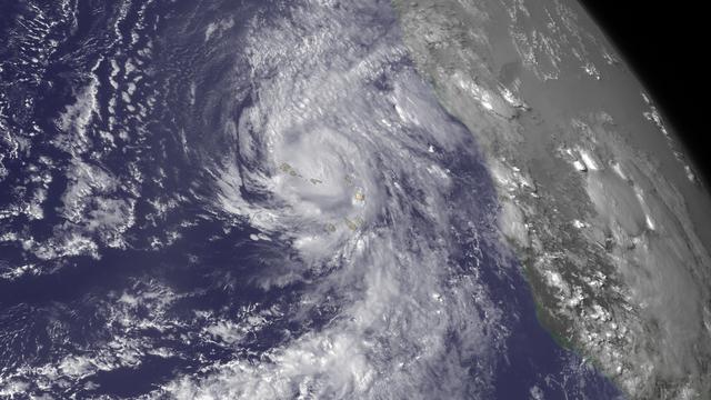
Hurricane Fred is bringing very heavy rains to the Cape Verde Islands. From the National Hurricane Center's Hurricane Fred Forecast Discussion: "According to the official Atlantic tropical cyclone record, which begins in 1851, Fred is the first hurricane to pass through the Cape Verde Islands since 1892. We caution, however, that the database is less reliable prior to the satellite era (mid 1960s onward)." This image was taken by GOES East on August 31, 2015. Credit: NASA/NOAA via <b><a href="www.nnvl.noaa.gov/" rel="nofollow"> NOAA Environmental Visualization Laboratory</a></b> <b><a href="http://www.nasa.gov/audience/formedia/features/MP_Photo_Guidelines.html" rel="nofollow">NASA image use policy.</a></b> <b><a href="http://www.nasa.gov/centers/goddard/home/index.html" rel="nofollow">NASA Goddard Space Flight Center</a></b> enables NASA’s mission through four scientific endeavors: Earth Science, Heliophysics, Solar System Exploration, and Astrophysics. Goddard plays a leading role in NASA’s accomplishments by contributing compelling scientific knowledge to advance the Agency’s mission. <b>Follow us on <a href="http://twitter.com/NASAGoddardPix" rel="nofollow">Twitter</a></b> <b>Like us on <a href="http://www.facebook.com/pages/Greenbelt-MD/NASA-Goddard/395013845897?ref=tsd" rel="nofollow">Facebook</a></b> <b>Find us on <a href="http://instagrid.me/nasagoddard/?vm=grid" rel="nofollow">Instagram</a></b> <b><a href="http://goes.gsfc.nasa.gov/" rel="nofollow">Credit: NOAA/NASA GOES Project</a></b>
SL2-106-1194 (22 June 1973) --- This overhead view of the central eastern shore of Florida shows the Cape Canaveral and Kennedy Space Center (28.5N, 80.5W), where all of the NASA manned space missions originate. Sprinkled along the jutting cape are a number of KSC launch pads from the earlier Mercury, Gemini Apollo and Skylab series of spaceflights. Merritt Island, just south of Kennedy Space Center, is where the spacecraft liftoff tracking station is located. Photo credit: NASA
NASA Mars Exploration Rover Opportunity recorded this view of the summit of Cape Tribulation, on the western rim of Endeavour Crater on the day before the rover drove to the top. You need 3D glasses to view this image.
NASA Mars Exploration Rover Opportunity recorded this view of the summit of Cape Tribulation, on the western rim of Endeavour Crater on the day before the rover drove to the top.
STS030-76-042 (4-8 May 1989) --- For two decades, astronauts have been photographing their launching area from space, but in terms of sharpness and clarity, NASA photo experts feel, few rival this STS-30 vertical scene over the Cape Canaveral area. Sprinkled along the jutting cape feature are a number of launching pads of Kennedy Space Center, and nearby is seen the Shuttle landing facility. Titusville can be seen just above center on the north; Cocoa, Cocoa Beach and Merritt Island are south, near bottom of the frame. St. Johns, Banana and Indian Rivers are easily traced as well.
STS036-151-225 (2 March 1990) --- Surrounded by waters of the Atlantic Ocean, Cape Cod Bay and Nantucket Sound, the jutting Cape Cod feature caught the attention of the astronaut crewmembers aboard the Earth-orbiting Space Shuttle Atlantis, 126 nautical miles above Earth. Parts of Martha's Vineyard and Nantucket are in bottom left corner. Plymouth Bay is in upper left corner. Center point coordinates are 42 degrees north latitude and 70 degrees west longitude. A large format Linhof camera (4" x 5" film) was used to expose the frame.
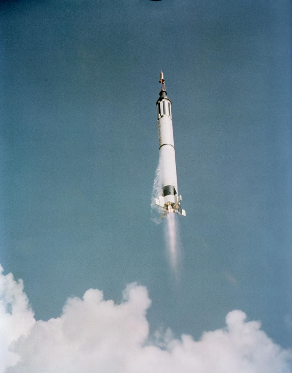
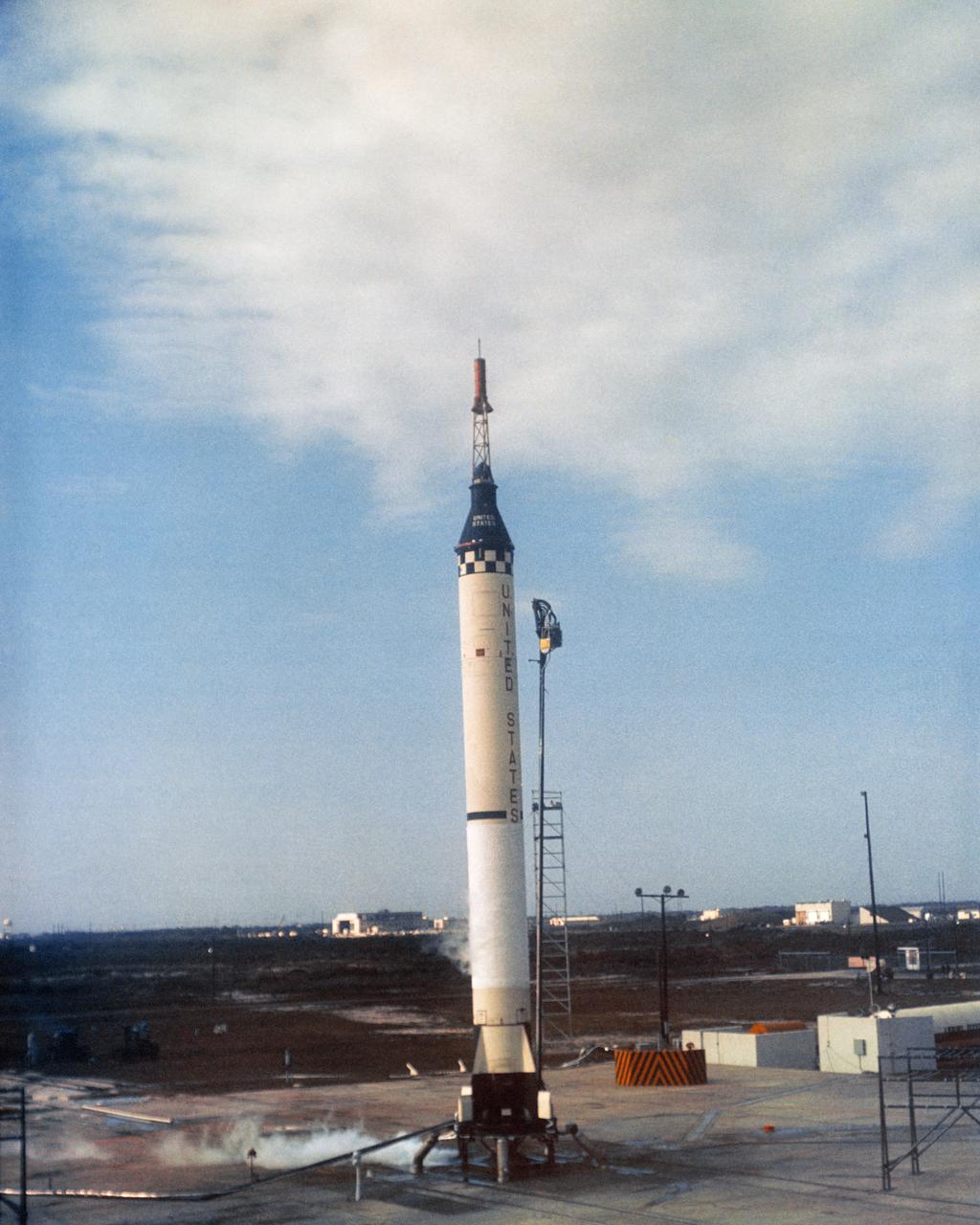
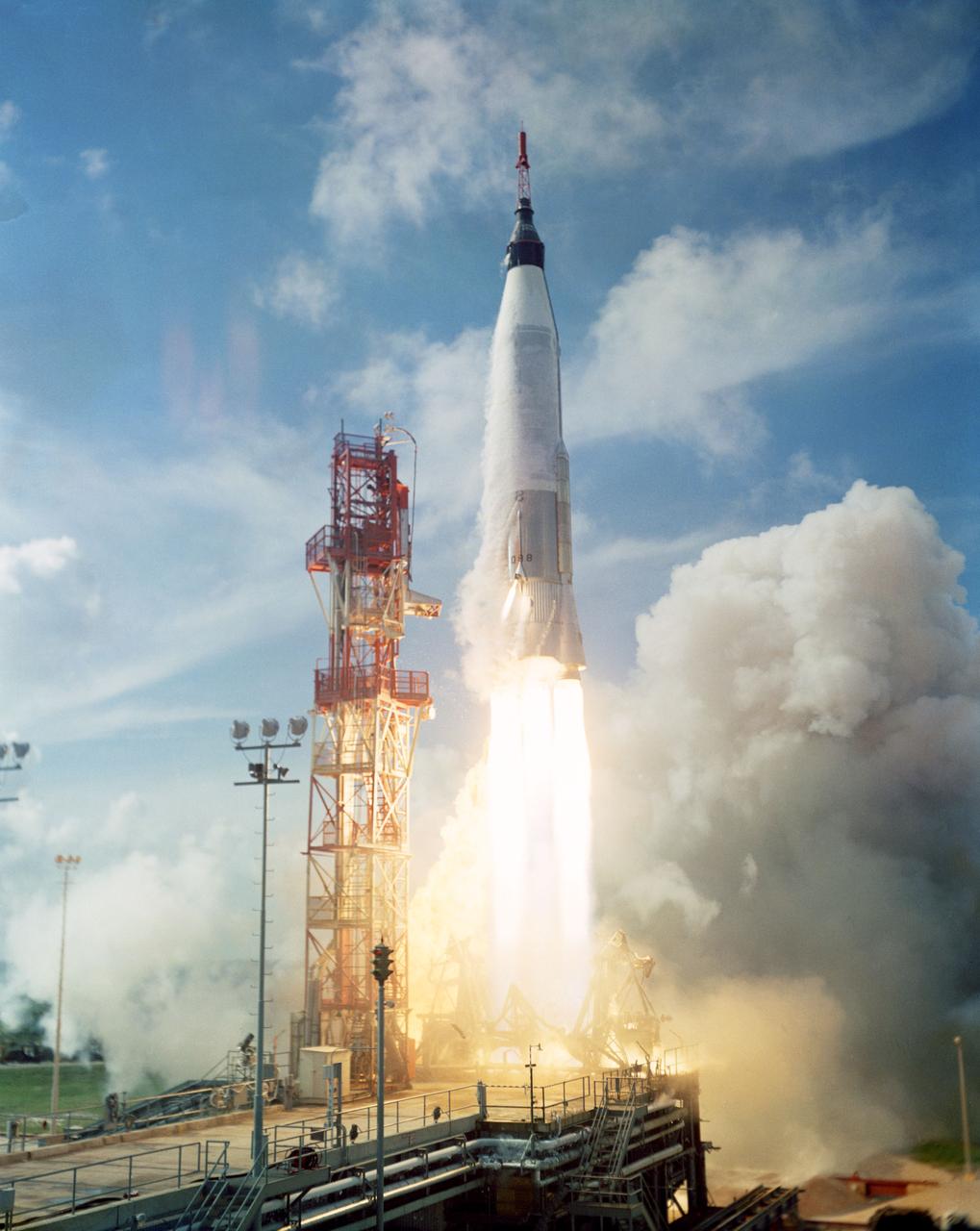
S61-01908 (5 May 1961) --- This is the launch of the Mercury-Redstone 3 (MR-3) spacecraft from Cape Canaveral on a suborbital mission -- the first U.S. manned spaceflight. The spacecraft is already headed towards its suborbital mission. Photo credit: NASA or National Aeronautics and Space Administration
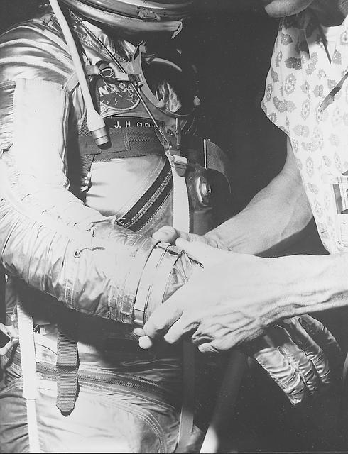
S62-00249 (1962) --- View of astronaut John H. Glenn Jr. being fitted with gloves for his spacesuit during preflight training activities at Cape Canaveral, Florida. Glenn is assisted by suit technician Joe Schmitt. Photo credit: NASA
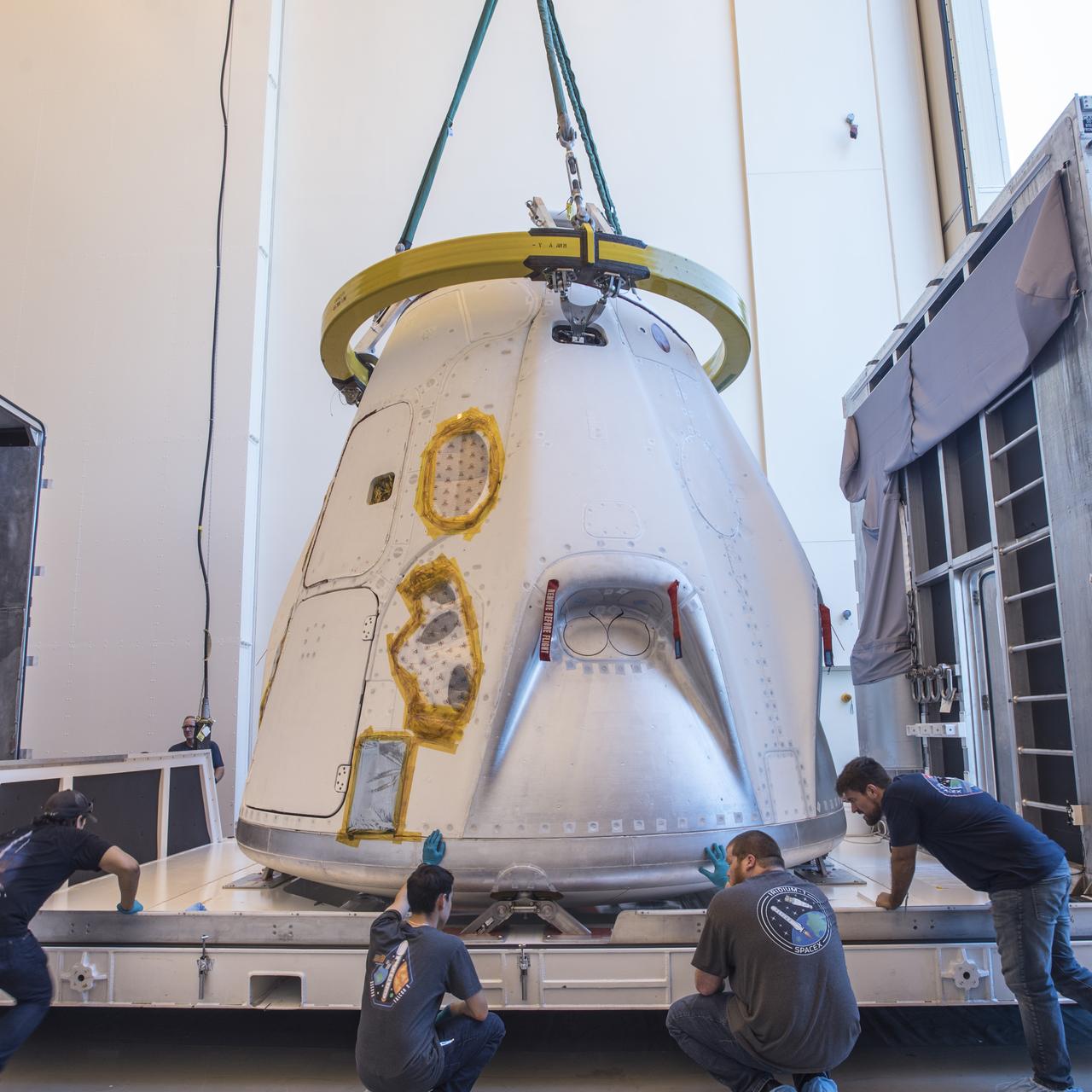
The SpaceX Crew Dragon spacecraft that will be used for the company’s uncrewed flight test, known as Demonstration Mission 1, arrived to Cape Canaveral Air Force Station in Florida on Tuesday, July 10, 2018. The spacecraft recently underwent thermal vacuum and acoustic testing at NASA’s Plum Brook Station in Ohio. The Demonstration Mission 1 flight test is part of NASA’s Commercial Crew Transportation Capability contract with the goal of returning human spaceflight launch capabilities to the United States.
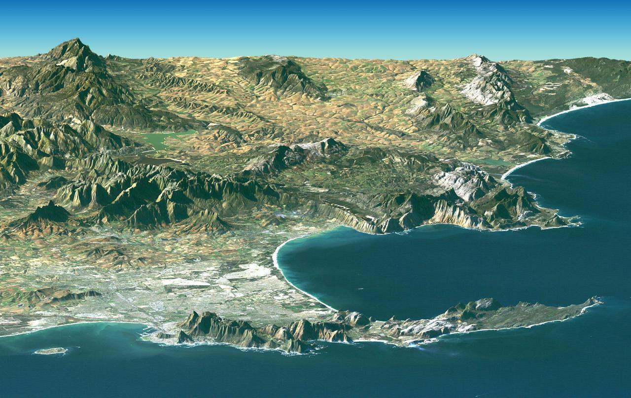
Cape Town and the Cape of Good Hope, South Africa, appear in the foreground of this perspective view generated from a Landsat satellite image and elevation data from NASA Space Shuttle Endeavour.
NASA Mars Exploration Rover Opportunity used its navigation camera to acquire this view looking toward the southwest. The scene includes tilted rocks at the edge of a bench surrounding Cape York, with Burns formation rocks exposed in Botany Bay.
Rising highest above the horizon in the right half of the image, captured by NASA Mars Exporation Rover, is a portion of the western rim of Endeavour Crater including a ridge informally named Cape Tribulation.
NASA Mars Exploration Rover Opportunity recorded this view of the western edge of Cape York, a segment of the rim of Endeavour Crater. A bright vein, informally named Homestake, is visible on the right side of the image.
NASA Mars Exploration Rover Opportunity inspected this mineral vein, called Homestake, in November 2011 at the northern end of the Cape York section of Endeavour Crater western rim.
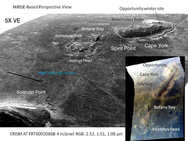
This graphic combines a perspective view from NASA Mars Reconnaissance Orbiter of the Botany Bay and Cape York areas of the rim of Endeavour Crater on Mars, and an inset with mapping-spectrometer data.
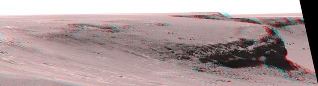
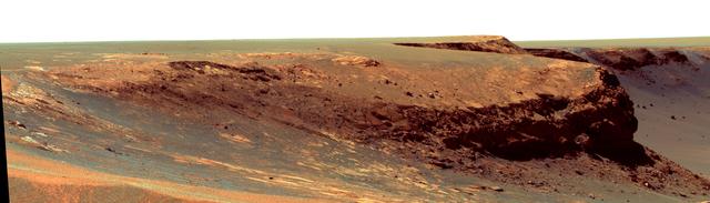
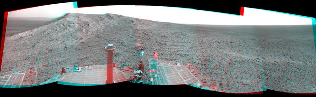
This anaglyph from from NASA Mars Exploration Rover Opportunity is of Victoria crater, looking north from Duck Bay towards the dramatic promontory called Cape Verde. 3D glasses are necessary to view this image.
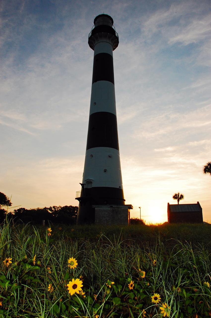
Cape Canaveral Air Force Station, Fla. -- A warm glow envelopes the Cape Canaveral Lighthouse as dawn breaks over the Cape.. The Canaveral light is the only operating lighthouse owned by the U.S. Air Force. In 2000, the Coast Guard transferred ownership of the lighthouse structure and its grounds to the Air Force, which is now responsible for maintaining it. The U.S. Coast Guard continues to operate the modern first-order beacon as an active navigational aid. The first lighthouse at Cape Canaveral was built near the tip of the Cape in 1848. The structure was only about 60 feet high with a rather dim light powered by whale oil. In 1859, work began nearby on a new, taller iron structure. Construction was halted during the Civil War, and the lighthouse finally was finished in 1868. The structure, with a brick lining inside its iron exterior, was painted with its "daymark" black and white horizontal bands in 1873 to make it easier to identify during the day as a navigation point. Between 1892 and 1894, the lighthouse was dismantled and moved to its new home about a mile from the coast, where it stands today. Photo credit: NASA/Ben Smegelsky
Astronauts John H. Glenn Jr. (center), and John Peterson (right), in gantry viewing Mercury Spacecraft during assembly. CAPE CANAVERAL, FL B&W
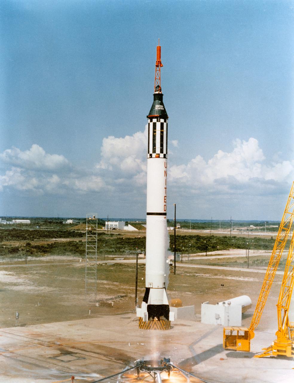
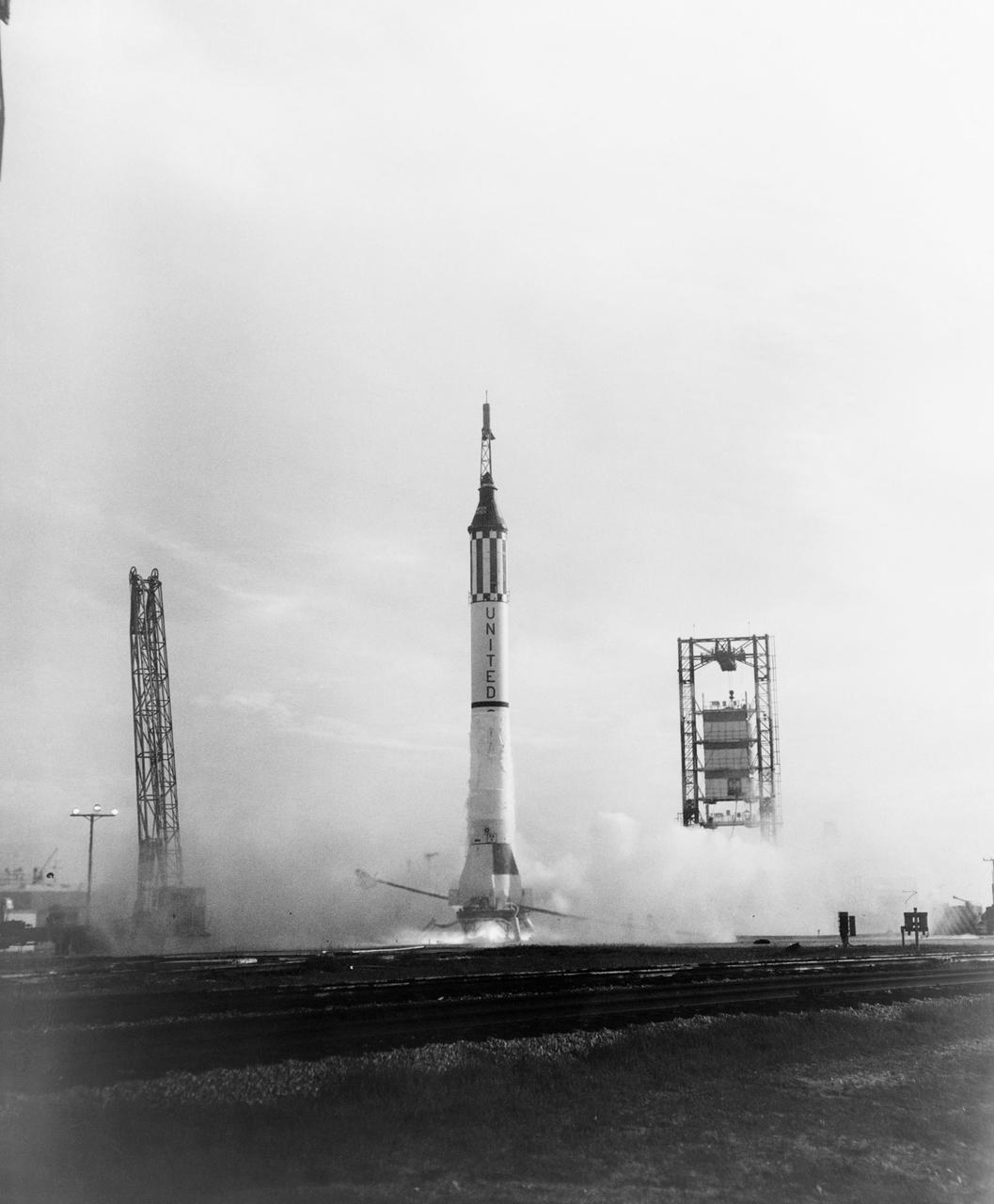
S61-01927 (5 May 1961) --- Mercury-Redstone 3 (MR-3), the United States' first manned spaceflight, is launched from Cape Canaveral on a suborbital mission. Astronaut Alan B. Shepard Jr. was the pilot of the Mercury spacecraft, designated "Freedom 7". The spacecraft attained a maximum speed of 5,180 miles per hour (mph), reached an altitude of 116 1/2 statute miles, and landed 302 statute miles downrange from Cape Canaveral, Florida. Photo credit: NASA or National Aeronautics and Space Administration
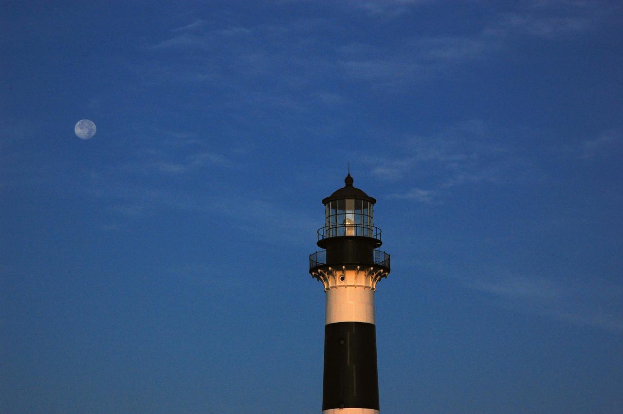
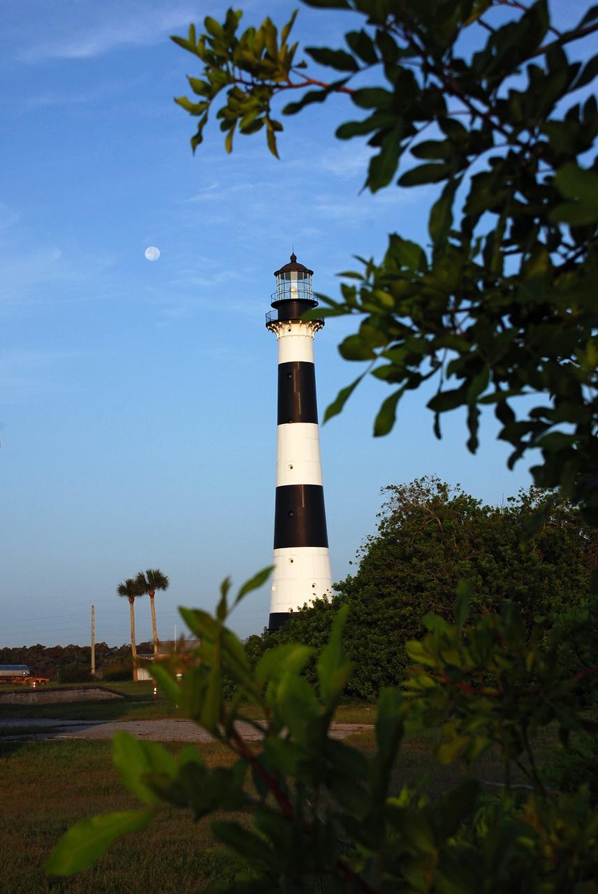
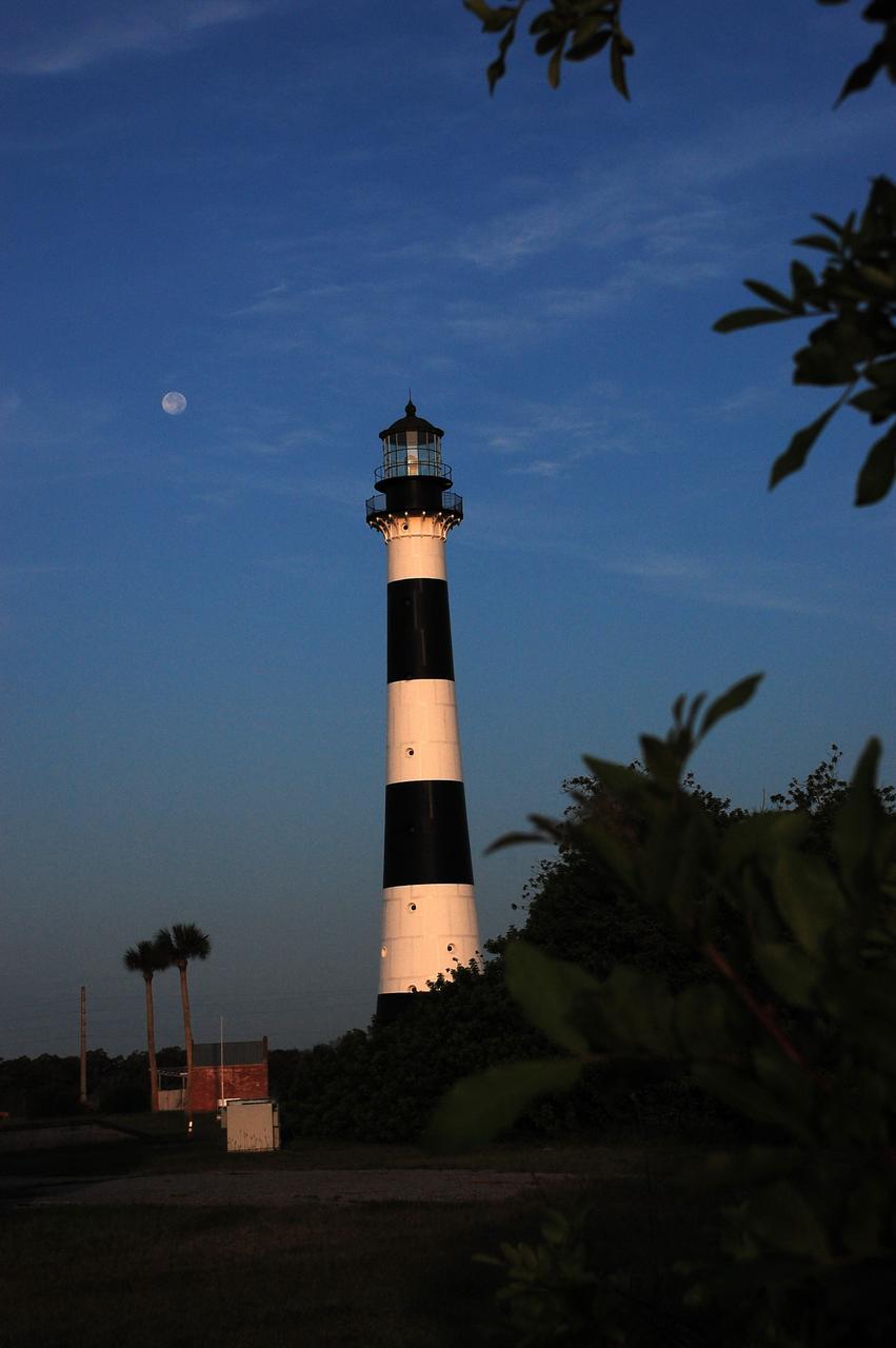
Cape Canaveral Air Force Station, Fla. -- The lantern room of the Cape Canaveral Lighthouse, with its modern first-order optic, takes on a warm glow as dawn breaks and a full moon still shines overhead. The Canaveral light is the only operating lighthouse owned by the U.S. Air Force. In 2000, the Coast Guard transferred ownership of the lighthouse structure and its grounds to the Air Force, which is now responsible for maintaining it. The U.S. Coast Guard continues to operate the beacon as an active navigational aid. The first lighthouse at Cape Canaveral was built near the tip of the Cape in 1848. The structure was only about 60 feet high with a rather dim light powered by whale oil. In 1859, work began nearby on a new, taller iron structure. Construction was halted during the Civil War, and the lighthouse finally was finished in 1868. The structure, with a brick lining inside its iron exterior, was painted with its "daymark" black and white horizontal bands in 1873 to make it easier to identify during the day as a navigation point. Between 1892 and 1894, the lighthouse was dismantled and moved to its new home about a mile from the coast, where it stands today. Photo credit: NASA/Ben Smegelsky
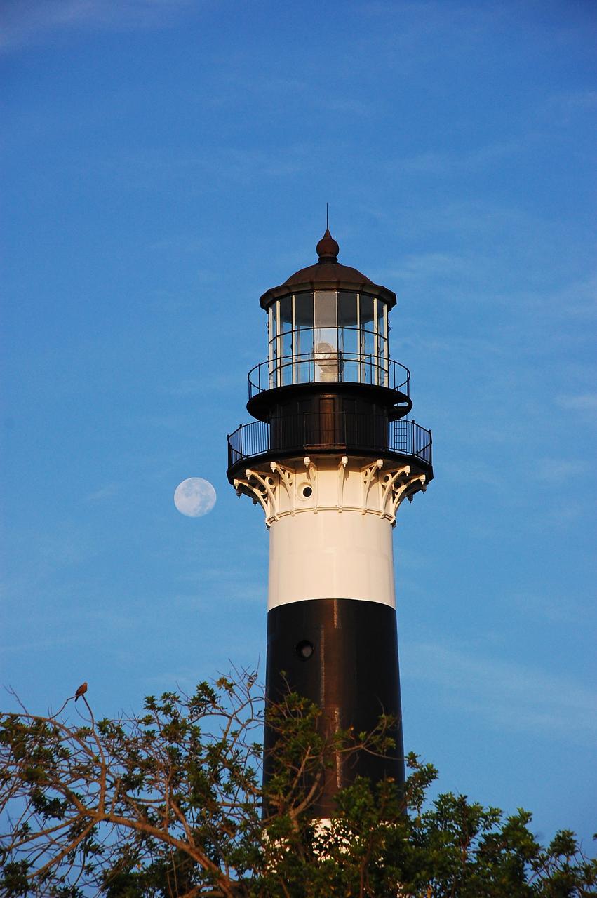
Cape Canaveral Air Force Station, Fla. -- The lantern room of the Cape Canaveral Lighthouse, with its modern first-order optic, takes on a warm glow as dawn breaks and a full moon still shines overhead. The Canaveral light is the only operating lighthouse owned by the U.S. Air Force. In 2000, the Coast Guard transferred ownership of the lighthouse structure and its grounds to the Air Force, which is now responsible for maintaining it. The U.S. Coast Guard continues to operate the beacon as an active navigational aid. The first lighthouse at Cape Canaveral was built near the tip of the Cape in 1848. The structure was only about 60 feet high with a rather dim light powered by whale oil. In 1859, work began nearby on a new, taller iron structure. Construction was halted during the Civil War, and the lighthouse finally was finished in 1868. The structure, with a brick lining inside its iron exterior, was painted with its "daymark" black and white horizontal bands in 1873 to make it easier to identify during the day as a navigation point. Between 1892 and 1894, the lighthouse was dismantled and moved to its new home about a mile from the coast, where it stands today. Photo credit: NASA/Ben Smegelsky
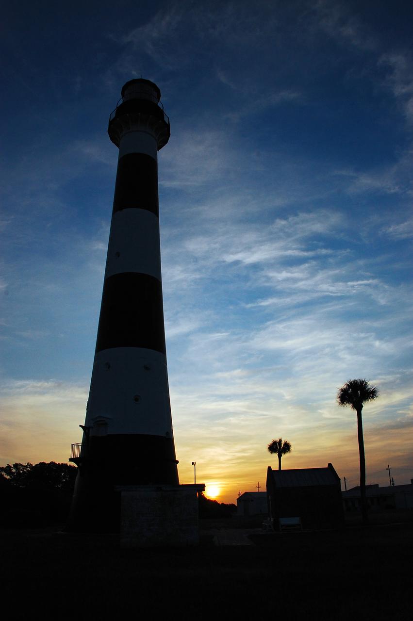
Cape Canaveral Air Force Station, Fla. -- As the sun rises, the Cape Canaveral Lighthouse is silhouetted against the early morning sky. The Canaveral light is the only operating lighthouse owned by the U.S. Air Force. In 2000, the Coast Guard transferred ownership of the lighthouse structure and its grounds to the Air Force, which is now responsible for maintaining it. The U.S. Coast Guard continues to operate the modern first-order beacon as an active navigational aid. The first lighthouse at Cape Canaveral was built near the tip of the Cape in 1848. The structure was only about 60 feet high with a rather dim light powered by whale oil. In 1859, work began nearby on a new, taller iron structure. Construction was halted during the Civil War, and the lighthouse finally was finished in 1868. The structure, with a brick lining inside its iron exterior, was painted with its "daymark" black and white horizontal bands in 1873 to make it easier to identify during the day as a navigation point. Between 1892 and 1894, the lighthouse was dismantled and moved to its new home about a mile from the coast, where it stands today. Photo credit: NASA/Ben Smegelsky
Cape Canaveral Air Force Station, Fla. -- As the sun rises, the Cape Canaveral Lighthouse is silhouetted against the early morning sky. The Canaveral light is the only operating lighthouse owned by the U.S. Air Force. In 2000, the Coast Guard transferred ownership of the lighthouse structure and its grounds to the Air Force, which is now responsible for maintaining it. The U.S. Coast Guard continues to operate the modern first-order beacon as an active navigational aid. The first lighthouse at Cape Canaveral was built near the tip of the Cape in 1848. The structure was only about 60 feet high with a rather dim light powered by whale oil. In 1859, work began nearby on a new, taller iron structure. Construction was halted during the Civil War, and the lighthouse finally was finished in 1868. The structure, with a brick lining inside its iron exterior, was painted with its "daymark" black and white horizontal bands in 1873 to make it easier to identify during the day as a navigation point. Between 1892 and 1894, the lighthouse was dismantled and moved to its new home about a mile from the coast, where it stands today. Photo credit: NASA/Ben Smegelsky
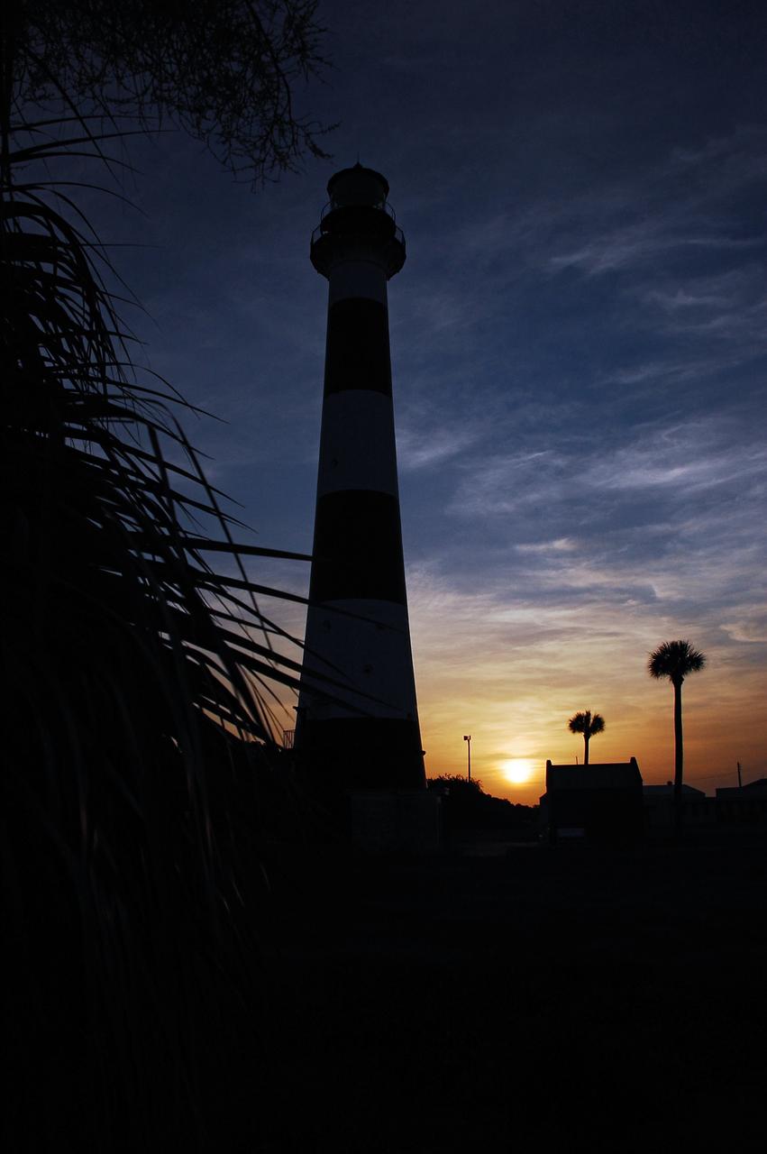
Cape Canaveral Air Force Station, Fla. -- As the sun rises, the Cape Canaveral Lighthouse is silhouetted against the early morning sky. The Canaveral light is the only operating lighthouse owned by the U.S. Air Force. In 2000, the Coast Guard transferred ownership of the lighthouse structure and its grounds to the Air Force, which is now responsible for maintaining it. The U.S. Coast Guard continues to operate the modern first-order beacon as an active navigational aid. The first lighthouse at Cape Canaveral was built near the tip of the Cape in 1848. The structure was only about 60 feet high with a rather dim light powered by whale oil. In 1859, work began nearby on a new, taller iron structure. Construction was halted during the Civil War, and the lighthouse finally was finished in 1868. The structure, with a brick lining inside its iron exterior, was painted with its "daymark" black and white horizontal bands in 1873 to make it easier to identify during the day as a navigation point. Between 1892 and 1894, the lighthouse was dismantled and moved to its new home about a mile from the coast, where it stands today. Photo credit: NASA/Ben Smegelsky
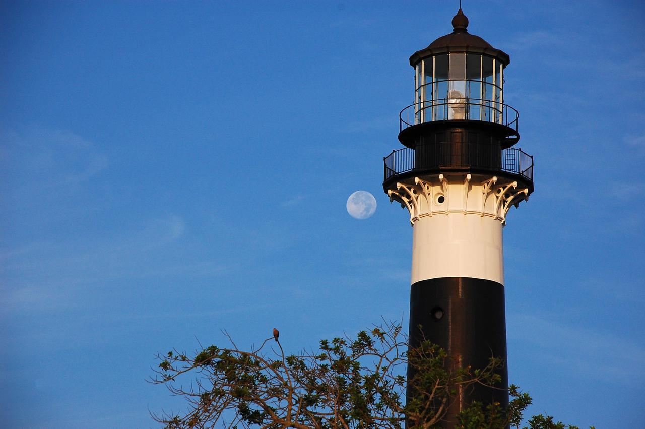
Cape Canaveral Air Force Station, Fla. -- The lantern room of the Cape Canaveral Lighthouse, with its modern first-order optic, takes on a warm glow as dawn breaks and a full moon still shines overhead. The Canaveral light is the only operating lighthouse owned by the U.S. Air Force. In 2000, the Coast Guard transferred ownership of the lighthouse structure and its grounds to the Air Force, which is now responsible for maintaining it. The U.S. Coast Guard continues to operate the beacon as an active navigational aid. The first lighthouse at Cape Canaveral was built near the tip of the Cape in 1848. The structure was only about 60 feet high with a rather dim light powered by whale oil. In 1859, work began nearby on a new, taller iron structure. Construction was halted during the Civil War, and the lighthouse finally was finished in 1868. The structure, with a brick lining inside its iron exterior, was painted with its "daymark" black and white horizontal bands in 1873 to make it easier to identify during the day as a navigation point. Between 1892 and 1894, the lighthouse was dismantled and moved to its new home about a mile from the coast, where it stands today. Photo credit: NASA/Ben Smegelsky
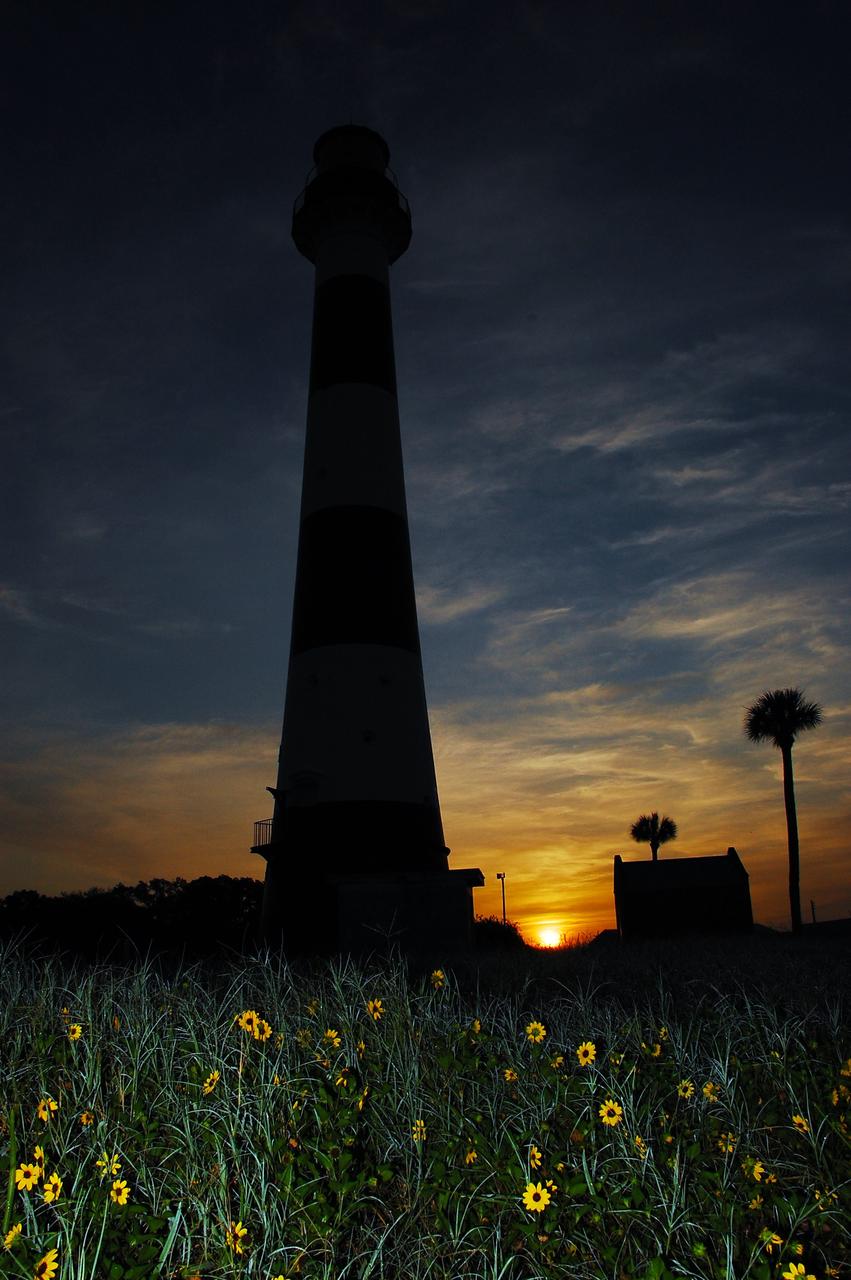
Cape Canaveral Air Force Station, Fla. -- As the sun rises, the Cape Canaveral Lighthouse is silhouetted against the early morning sky. The Canaveral light is the only operating lighthouse owned by the U.S. Air Force. In 2000, the Coast Guard transferred ownership of the lighthouse structure and its grounds to the Air Force, which is now responsible for maintaining it. The U.S. Coast Guard continues to operate the modern first-order beacon as an active navigational aid. The first lighthouse at Cape Canaveral was built near the tip of the Cape in 1848. The structure was only about 60 feet high with a rather dim light powered by whale oil. In 1859, work began nearby on a new, taller iron structure. Construction was halted during the Civil War, and the lighthouse finally was finished in 1868. The structure, with a brick lining inside its iron exterior, was painted with its "daymark" black and white horizontal bands in 1873 to make it easier to identify during the day as a navigation point. Between 1892 and 1894, the lighthouse was dismantled and moved to its new home about a mile from the coast, where it stands today. Photo credit: NASA/Ben Smegelsky
Cape Canaveral Air Force Station, Fla. -- A warm glow envelopes the Cape Canaveral Lighthouse as dawn breaks and a full moon still shines overhead. The Canaveral light is the only operating lighthouse owned by the U.S. Air Force. In 2000, the Coast Guard transferred ownership of the lighthouse structure and its grounds to the Air Force, which is now responsible for maintaining it. The U.S. Coast Guard continues to operate the modern first-order beacon as an active navigational aid. The first lighthouse at Cape Canaveral was built near the tip of the Cape in 1848. The structure was only about 60 feet high with a rather dim light powered by whale oil. In 1859, work began nearby on a new, taller iron structure. Construction was halted during the Civil War, and the lighthouse finally was finished in 1868. The structure, with a brick lining inside its iron exterior, was painted with its "daymark" black and white horizontal bands in 1873 to make it easier to identify during the day as a navigation point. Between 1892 and 1894, the lighthouse was dismantled and moved to its new home about a mile from the coast, where it stands today. Photo credit: NASA/Ben Smegelsky
Cape Canaveral Air Force Station, Fla. -- A warm glow envelopes the Cape Canaveral Lighthouse as dawn breaks and a full moon still shines overhead. The Canaveral light is the only operating lighthouse owned by the U.S. Air Force. In 2000, the Coast Guard transferred ownership of the lighthouse structure and its grounds to the Air Force, which is now responsible for maintaining it. The U.S. Coast Guard continues to operate the modern first-order beacon as an active navigational aid. The first lighthouse at Cape Canaveral was built near the tip of the Cape in 1848. The structure was only about 60 feet high with a rather dim light powered by whale oil. In 1859, work began nearby on a new, taller iron structure. Construction was halted during the Civil War, and the lighthouse finally was finished in 1868. The structure, with a brick lining inside its iron exterior, was painted with its "daymark" black and white horizontal bands in 1873 to make it easier to identify during the day as a navigation point. Between 1892 and 1894, the lighthouse was dismantled and moved to its new home about a mile from the coast, where it stands today. Photo credit: NASA/Ben Smegelsky
Cape Canaveral Air Force Station, Fla. -- As the sun rises, the Cape Canaveral Lighthouse is silhouetted against the early morning sky. The Canaveral light is the only operating lighthouse owned by the U.S. Air Force. In 2000, the Coast Guard transferred ownership of the lighthouse structure and its grounds to the Air Force, which is now responsible for maintaining it. The U.S. Coast Guard continues to operate the modern first-order beacon as an active navigational aid. The first lighthouse at Cape Canaveral was built near the tip of the Cape in 1848. The structure was only about 60 feet high with a rather dim light powered by whale oil. In 1859, work began nearby on a new, taller iron structure. Construction was halted during the Civil War, and the lighthouse finally was finished in 1868. The structure, with a brick lining inside its iron exterior, was painted with its "daymark" black and white horizontal bands in 1873 to make it easier to identify during the day as a navigation point. Between 1892 and 1894, the lighthouse was dismantled and moved to its new home about a mile from the coast, where it stands today. Photo credit: NASA/Ben Smegelsky
Cape Canaveral Air Force Station, Fla. -- As the sun rises, the Cape Canaveral Lighthouse is silhouetted against the early morning sky. The Canaveral light is the only operating lighthouse owned by the U.S. Air Force. In 2000, the Coast Guard transferred ownership of the lighthouse structure and its grounds to the Air Force, which is now responsible for maintaining it. The U.S. Coast Guard continues to operate the modern first-order beacon as an active navigational aid. The first lighthouse at Cape Canaveral was built near the tip of the Cape in 1848. The structure was only about 60 feet high with a rather dim light powered by whale oil. In 1859, work began nearby on a new, taller iron structure. Construction was halted during the Civil War, and the lighthouse finally was finished in 1868. The structure, with a brick lining inside its iron exterior, was painted with its "daymark" black and white horizontal bands in 1873 to make it easier to identify during the day as a navigation point. Between 1892 and 1894, the lighthouse was dismantled and moved to its new home about a mile from the coast, where it stands today. Photo credit: NASA/Ben Smegelsky
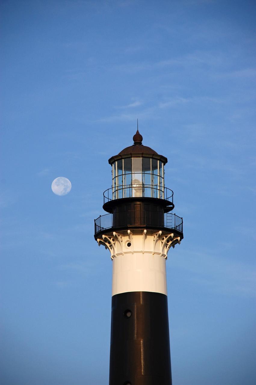
Cape Canaveral Air Force Station, Fla. -- The lantern room of the Cape Canaveral Lighthouse, with its modern first-order optic, takes on a warm glow as dawn breaks and a full moon still shines overhead. The Canaveral light is the only operating lighthouse owned by the U.S. Air Force. In 2000, the Coast Guard transferred ownership of the lighthouse structure and its grounds to the Air Force, which is now responsible for maintaining it. The U.S. Coast Guard continues to operate the beacon as an active navigational aid. The first lighthouse at Cape Canaveral was built near the tip of the Cape in 1848. The structure was only about 60 feet high with a rather dim light powered by whale oil. In 1859, work began nearby on a new, taller iron structure. Construction was halted during the Civil War, and the lighthouse finally was finished in 1868. The structure, with a brick lining inside its iron exterior, was painted with its "daymark" black and white horizontal bands in 1873 to make it easier to identify during the day as a navigation point. Between 1892 and 1894, the lighthouse was dismantled and moved to its new home about a mile from the coast, where it stands today. Photo credit: NASA/Ben Smegelsky
NASA-NOAA's Suomi NPP satellite passed over Australia's Cape Barren Island and captured an image of phytoplankton and smoke from fires that resembled an eye and eyebrow. The Tasmanian Fire Service reported that a vegetation fire near Thunder and Lightning Bay, Cape Barren Island started on December 4 and was still blazing on December 8. Cape Barren Island is one of a trail of islands in the Bass Strait of the South Pacific Ocean, between southeastern Australia and Tasmania. This natural-color satellite image from Dec. 7 was collected by the Visible Infrared Imaging Radiometer Suite (VIIRS) instrument that flies aboard NASA-NOAA's Suomi NPP satellite. The red dots in the image represent heat signatures from the fires as detected by VIIRS. A light grey stream of smoke was blowing to the southeast in what could be seen as the "eyebrow" to the "eye" or swirl of blue and green phytoplankton below it. Phytoplankton are tiny microscopic plant-like organisms that form the base of the marine food chain. Like land plants, phytoplankton contain chlorophyll which is used in photosynthesis to turn sunlight into chemical energy. The chlorophyll gives the phytoplankton their green color, which is visible from space when large numbers of the organism group together. NASA image courtesy MODIS Rapid Response Team #nasagoddard #earth #smoke #Phytoplankton #science b><a href="http://www.nasa.gov/audience/formedia/features/MP_Photo_Guidelines.html" rel="nofollow">NASA image use policy.</a> <b><a href="http://www.nasa.gov/centers/goddard/home/index.html" rel="nofollow">NASA Goddard Space Flight Center</a></b> enables NASA’s mission through four scientific endeavors: Earth Science, Heliophysics, Solar System Exploration, and Astrophysics. Goddard plays a leading role in NASA’s accomplishments by contributing compelling scientific knowledge to advance the Agency’s mission. <b>Follow us on <a href="http://twitter.com/NASAGoddardPix" rel="nofollow">Twitter</a></b> <b>Like us on <a href="http://www.facebook.com/pages/Greenbelt-MD/NASA-Goddard/395013845897?ref=tsd" rel="nofollow">Facebook</a></b> <b>Find us on <a href="http://instagrid.me/nasagoddard/?vm=grid" rel="nofollow">Instagram</a></b>
STS001-11-173 (12-14 April 1981) --- Space shuttle Columbia's view of Cape Cod, Boston, Plymouth, Glouster, Providence, Lowell, Taunton, and Worcester. Photo credit: NASA
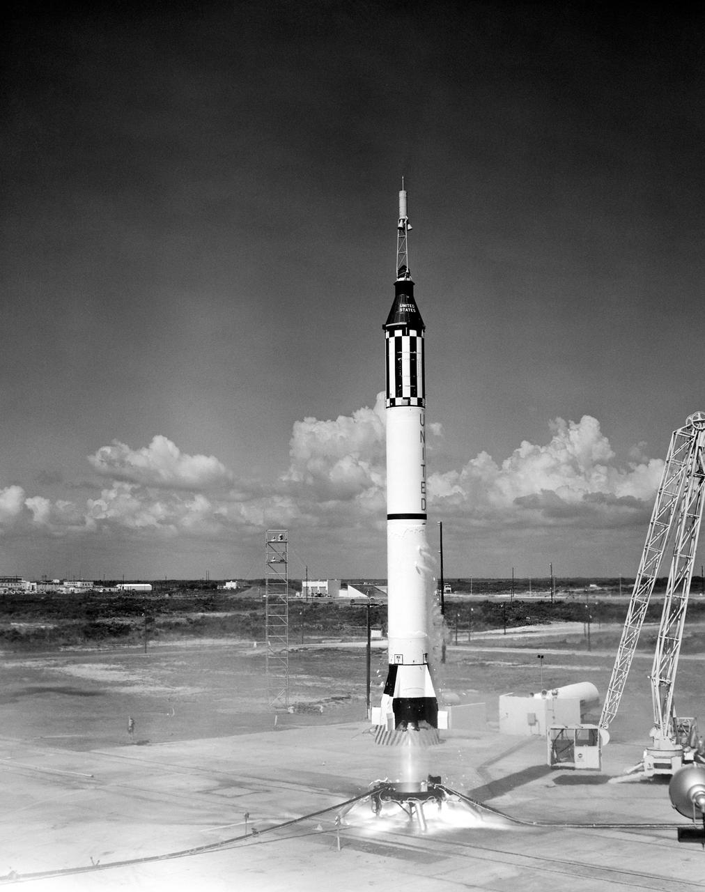
S61-02408 (5 May 1961) --- Launching of the Mercury-Redstone 3 (MR-3) rocket from Cape Canaveral on astronaut Alan B. Shepard?s suborbital mission. Photo credit: NASA or National Aeronautics and Space Administration
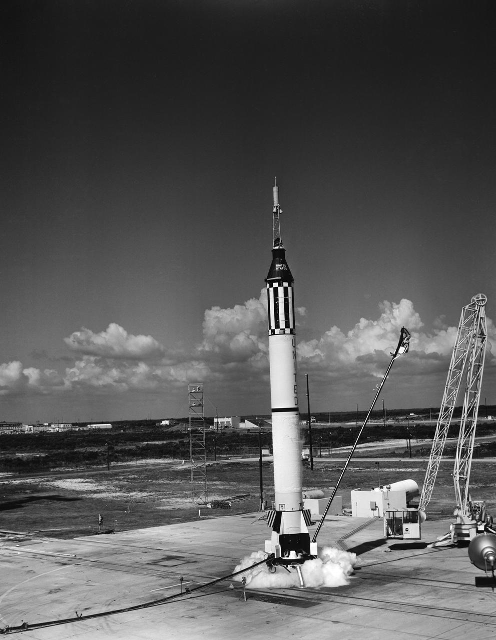
S61-02407 (5 May 1961) --- Launching of the Mercury-Redstone 3 (MR-3) rocket from Cape Canaveral on astronaut Alan B. Shepard?s suborbital mission. Photo credit: NASA or National Aeronautics and Space Administration
NASA's Mars Exploration Rover Opportunity worked for 30 months on a raised segment of Endeavour Crater's rim called "Cape Tribulation" until departing that segment in mid-April 2017, southbound toward a new destination. This view looks back at the southern end of Cape Tribulation from about two football fields' distance away. The component images were taken by the rover's Panoramic Camera (Pancam) on April 21, during the 4,707th Martian day, or sol, of Opportunity's mission on Mars. Wheel tracks can be traced back to see the rover's route as it descended and departed Cape Tribulation. For scale, the distance between the two parallel tracks is about 3.3 feet (1 meter). The rover drove from the foot of Cape Tribulation to the head of "Perseverance Valley" in seven drives totaling about one-fifth of a mile (one-third of a kilometer). The elevation difference between the highest point visible in this scene and the rover's location when the images were taken is about 180 feet (55 meters). This view looks northward. It merges exposures taken through three of the Pancam's color filters, centered on wavelengths of 753 nanometers (near-infrared), 535 nanometers (green) and 432 nanometers (violet). It is presented in approximately true color. https://photojournal.jpl.nasa.gov/catalog/PIA21497
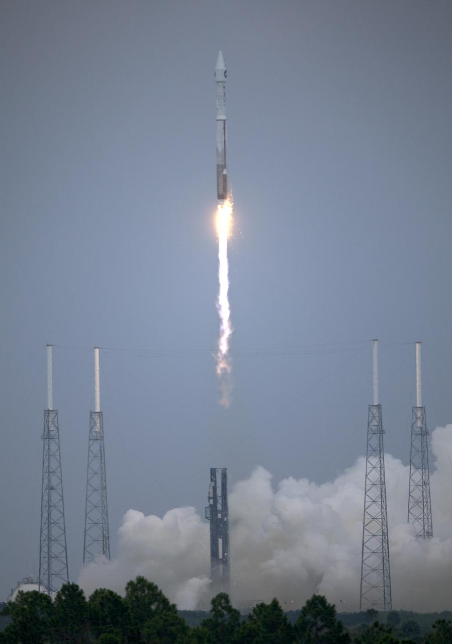
The Lunar Reconnaissance Orbiter and Lunar Crater Observation and Sensing Satellite are bound for the moon after a flawless liftoff Thursday, June 18, 2009, from Cape Canaveral Air Force Station in Florida aboard an Atlas V rocket. Photo Credit: (NASA/Bill Ingalls)
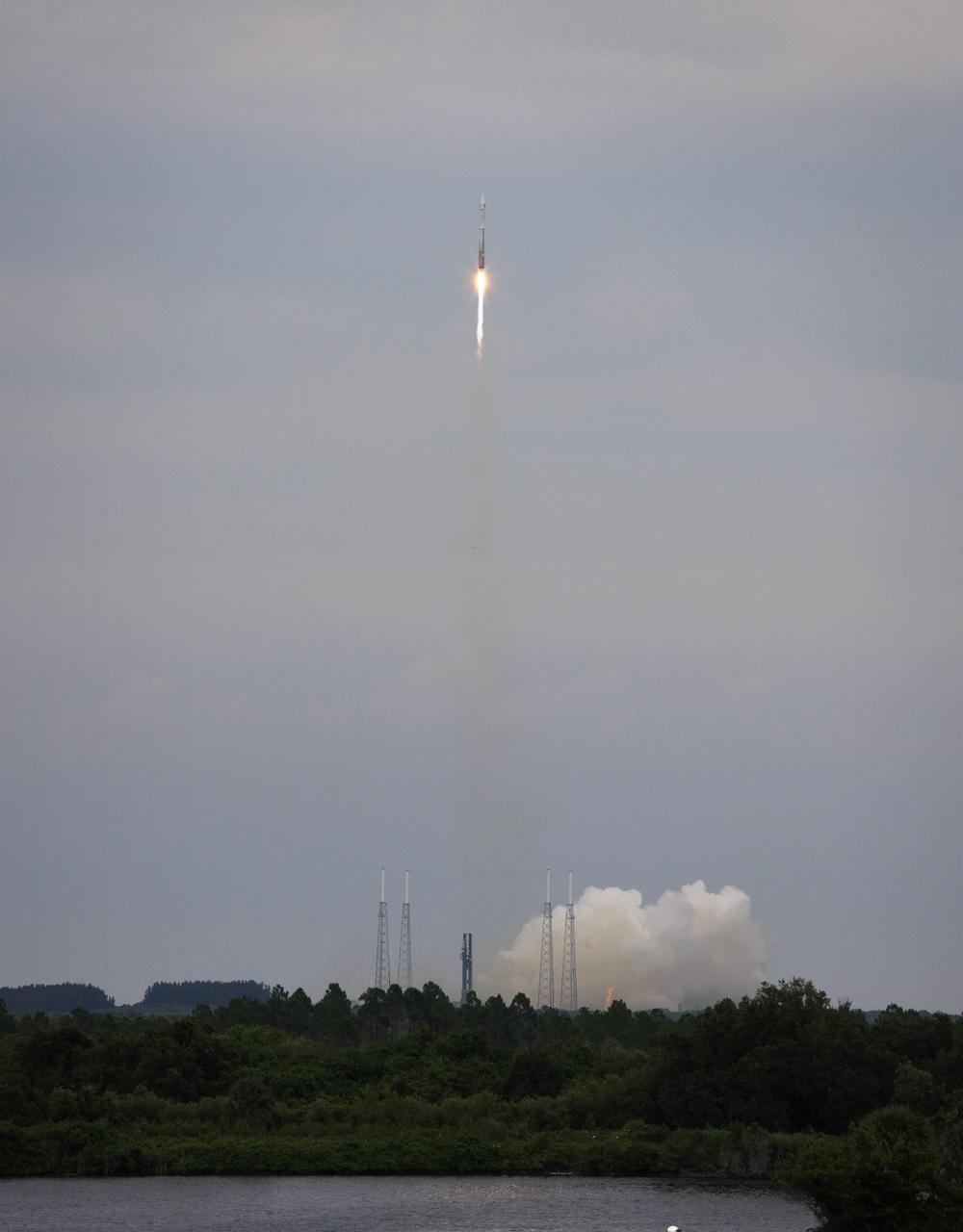
The Lunar Reconnaissance Orbiter and Lunar Crater Observation and Sensing Satellite are bound for the moon after a flawless liftoff Thursday, June 18, 2009, from Cape Canaveral Air Force Station in Florida aboard an Atlas V rocket. Photo Credit: (NASA/Bill Ingalls)

NASA Social participants are reflected in the sunglasses of former NASA astronaut Garrett Reisman, now a senior engineer working on astronaut safety and mission assurance for Space Exploration Technologies, or SpaceX, as he speaks with them, Friday, May 18, 2012, at the launch complex where the company's Falcon 9 rocket is set to launch early Friday morning at Cape Canaveral Air Force Station in Cape Canaveral, Fla. Photo Credit: (NASA/Paul E. Alers)
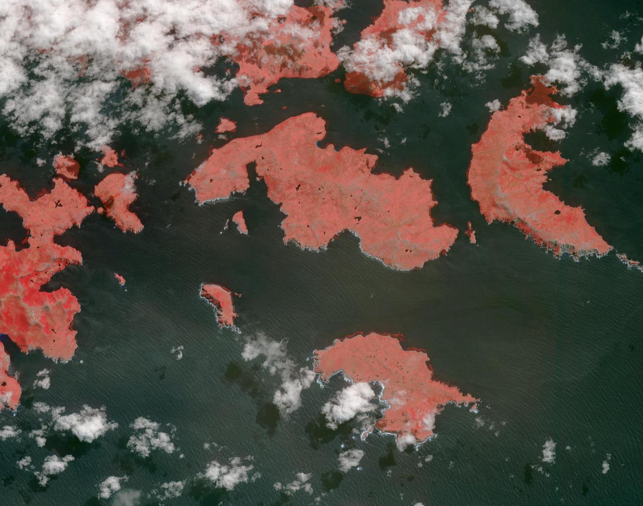
STS068-261-062 (30 September-11 October 1994) --- Vals Cape (left) is the prominent point of the island of New Guinea (Indonesia's Irian Jaya) that juts southwest into the Arafura Sea, pointing towards Australia. The part of New Guinea in this northwest-looking view is entirely low-lying swampland with very low population density. The Digul River, snaking across the middle of the view, drains the high mountain chain, which runs along the spine of the island.
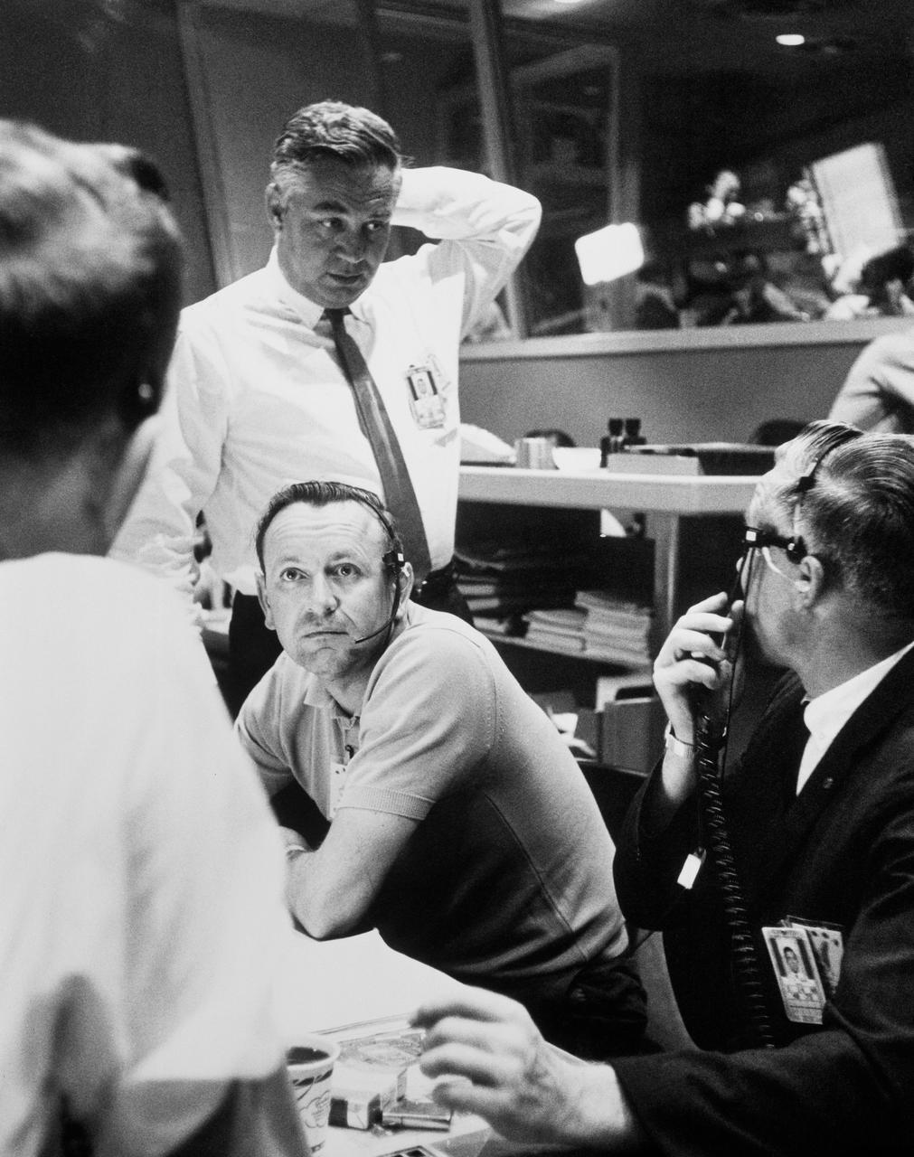
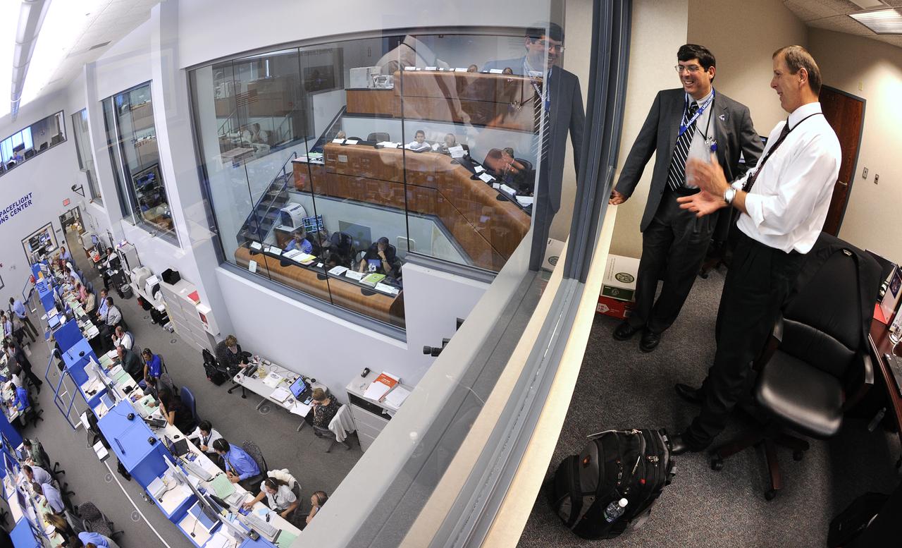
S63-07881 (15-16 May 1963) --- Walter C. Williams, Flight Operations Director; and Chris Kraft, Chief of the Flight Operations Division, MSC, are shown in the Mercury Control Center, Cape Canaveral, Florida, as the decision to go for the full 22 orbits is made for the Mercury Atlas 9 (MA-9) mission. Photo credit: NASA
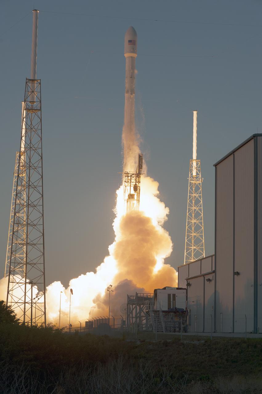
Open Image KSC-2015-1368.KSC-2015-1368 (02/11/2015) --- The SpaceX Falcon 9 rocket carrying NOAA’s Deep Space Climate Observatory spacecraft, or DSCOVR, lifts off from Space Launch Complex 40 at Cape Canaveral Air Force Station in Florida. Liftoff occurred at 6:03 p.m. EST. DSCOVR is a partnership between NOAA, NASA and the U.S. Air Force, and will maintain the nation's real-time solar wind monitoring capabilities. To learn more about DSCOVR, visit <a href="http://www.nesdis.noaa.gov/DSCOVR" rel="nofollow">www.nesdis.noaa.gov/DSCOVR</a>. Photo credit: NASA/Tony Gray and Tim Powers
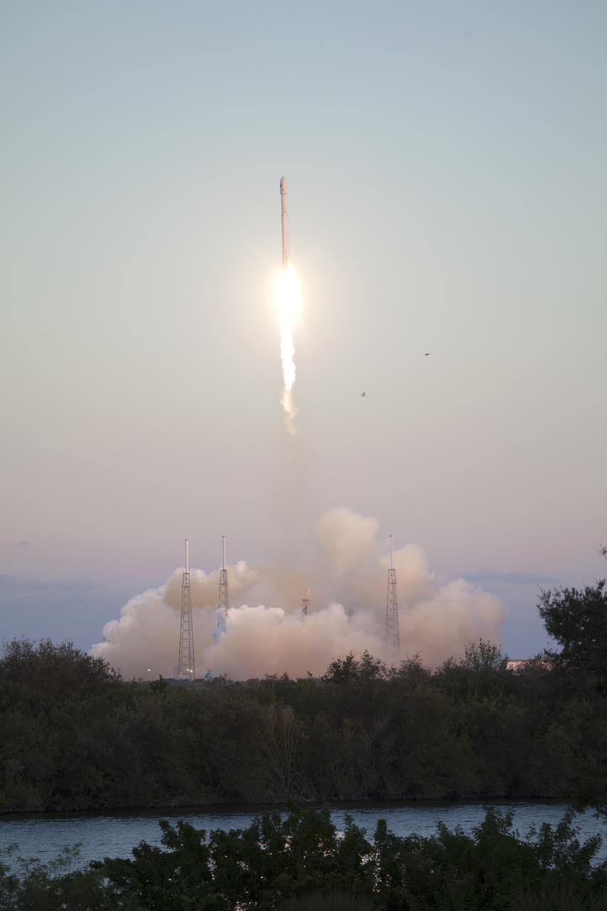
KSC-2015-1341 (02/11/2015) --- The SpaceX Falcon 9 rocket carrying NOAA’s Deep Space Climate Observatory spacecraft, or DSCOVR, lifts off from Space Launch Complex 40 at Cape Canaveral Air Force Station in Florida. Liftoff occurred at 6:03 p.m. EST. DSCOVR is a partnership between NOAA, NASA and the U.S. Air Force, and will maintain the nation's real-time solar wind monitoring capabilities. To learn more about DSCOVR, visit <a href="http://www.nesdis.noaa.gov/DSCOVR" rel="nofollow">www.nesdis.noaa.gov/DSCOVR</a>. Photo credit: NASA/Ben Smegelsky
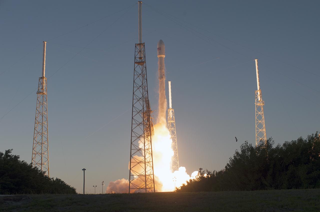
KSC-2015-1363 (02/11/2015) --- The SpaceX Falcon 9 rocket carrying NOAA’s Deep Space Climate Observatory spacecraft, or DSCOVR, lifts off from Space Launch Complex 40 at Cape Canaveral Air Force Station in Florida at 6:03 p.m. EST. DSCOVR is a partnership between NOAA, NASA and the U.S. Air Force, and will maintain the nation's real-time solar wind monitoring capabilities. To learn more about DSCOVR, visit <a href="http://www.nesdis.noaa.gov/DSCOVR" rel="nofollow">www.nesdis.noaa.gov/DSCOVR</a>. Photo credit: NASA/Tony Gray and Tim Powers
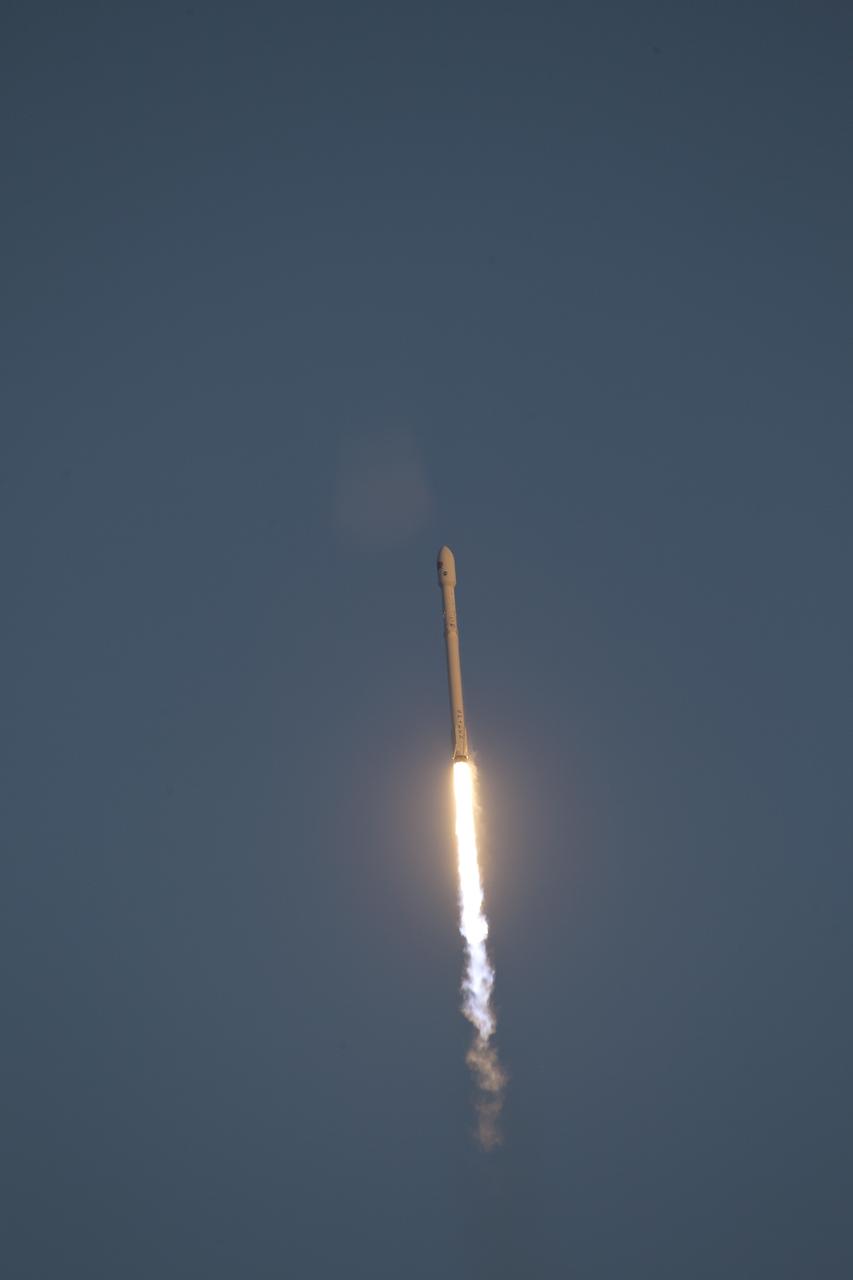
KSC-2015-1342 (02/11/2015) --- Backdropped by a bright blue sky, the SpaceX Falcon 9 rocket carrying NOAA’s Deep Space Climate Observatory spacecraft, or DSCOVR, soars away from Space Launch Complex 40 at Cape Canaveral Air Force Station in Florida. Liftoff occurred at 6:03 p.m. EST. DSCOVR is a partnership between NOAA, NASA and the U.S. Air Force, and will maintain the nation's real-time solar wind monitoring capabilities. To learn more about DSCOVR, visit <a href="http://www.nesdis.noaa.gov/DSCOVR" rel="nofollow">www.nesdis.noaa.gov/DSCOVR</a>. Photo credit: NASA/Ben Smegelsky..
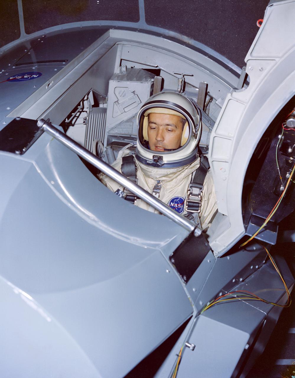
Astronauts James A. McDivitt and Edward H. White II, are shown going through tests in a Gemini Crew Simulator at the Cape. CAPE KENNEDY, FL CN
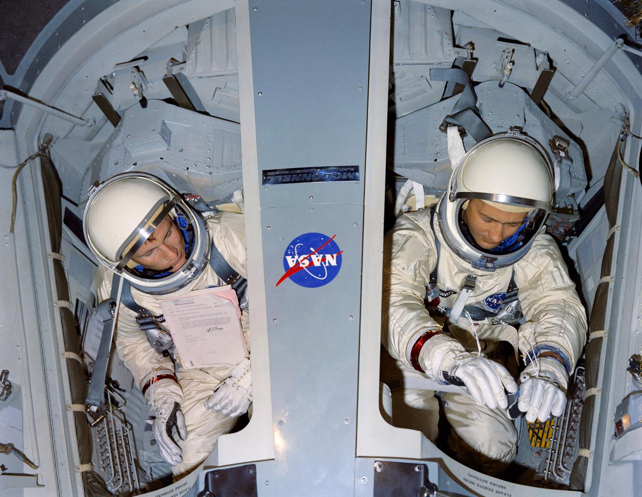
Astronauts Edward H. White II and James A. McDivitt are shown going through tests in a Gemini Crew Simulator at the Cape. CAPE KENNEDY, FL CN
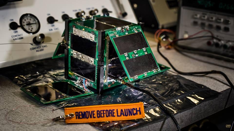
CAPE-2: Cajun Advanced Picosatellite Experiment – ELaNa IV CAPE-2 was developed by students from the University of Louisiana Lafayette to engage, inspire and educate K-12 students to encourage them to pursue STEM careers. The secondary focus is the technology demonstration of deployed solar panels to support the following payloads: text to speech, voice repeater, tweeting, email, file transfer and data collection from buoys. Launched by NASA’s CubeSat Launch Initiative on the ELaNa IV mission as an auxiliary payload aboard the U.S. Air Force-led Operationally Responsive Space (ORS-3) Mission on November 19, 2013.
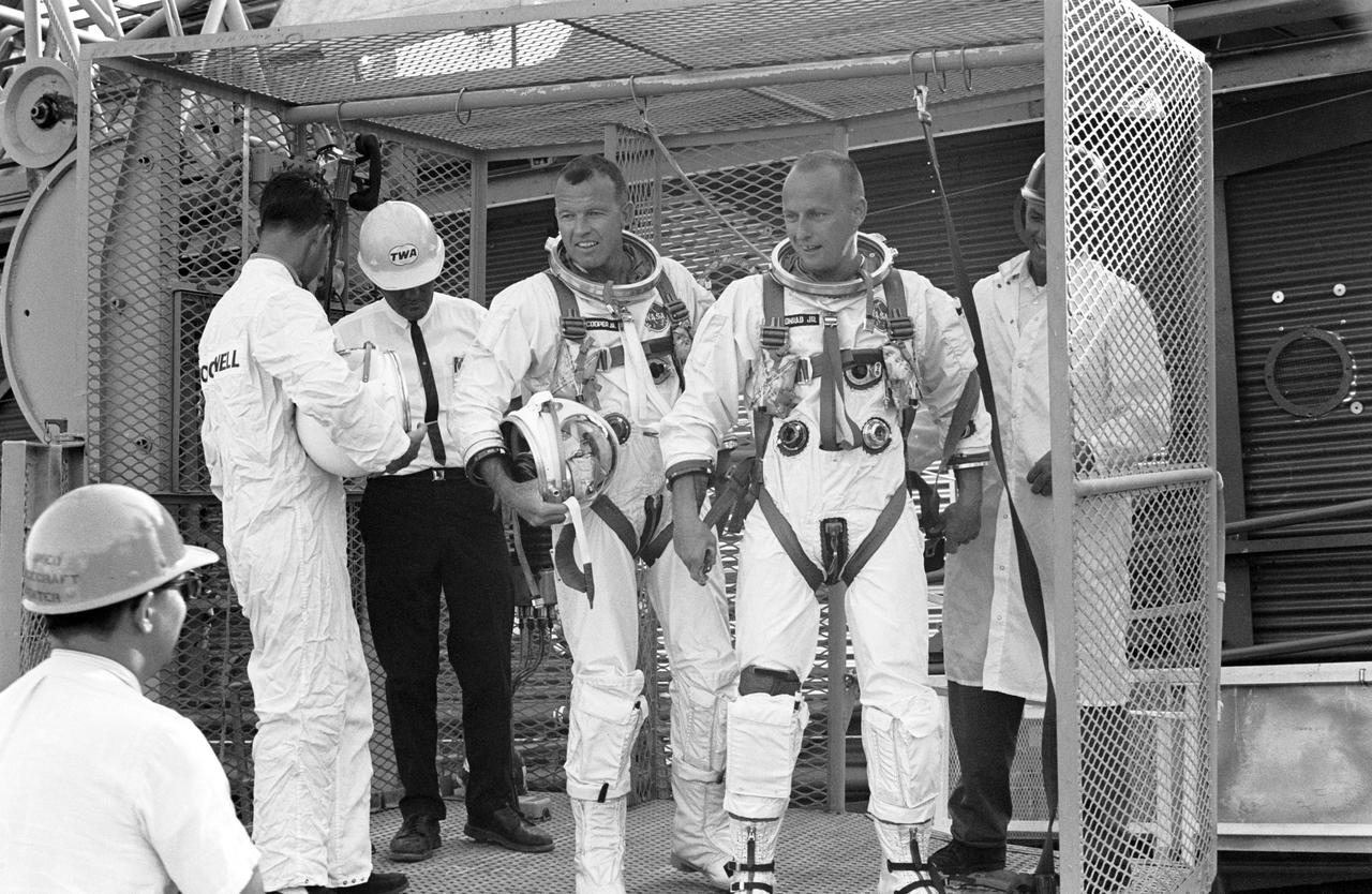
S65-41890 (6 Aug. 1965) --- Astronauts L. Gordon Cooper Jr. (left) and Charles Conrad Jr., prime crew for the Gemini-5 spaceflight, prepare to be hoisted to the white room atop gantry at Pad 19 at Cape Kennedy, Florida, during a simulation exercise for the mission.
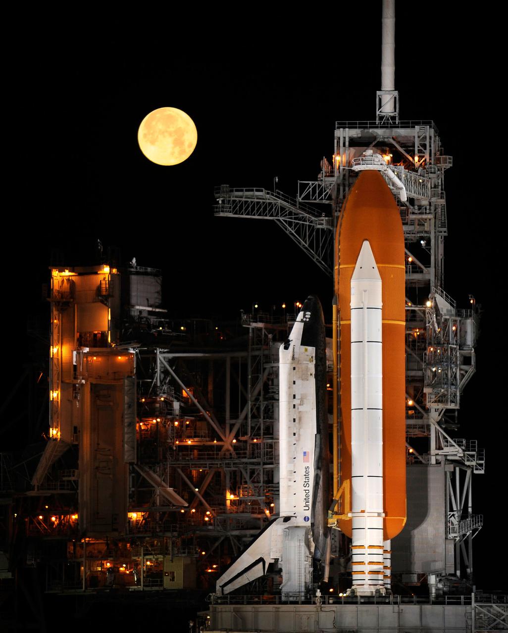
A nearly full Moon sets as the space shuttle Discovery sits atop Launch pad 39A at the Kennedy Space Center in Cape Canaveral, Florida, Wednesday, March 11, 2009. Photo Credit: (NASA/Bill Ingalls)
United Launch Alliance (ULA) team members work in the Atlas V Spaceflight Operations Center prior to the launch of the Lunar Reconnaissance Orbiter and Lunar Crater Observation and Sensing Satellite Thursday, June 18, 2009, from Cape Canaveral Air Force Station, Florida. Photo Credit: (NASA/Bill Ingalls)
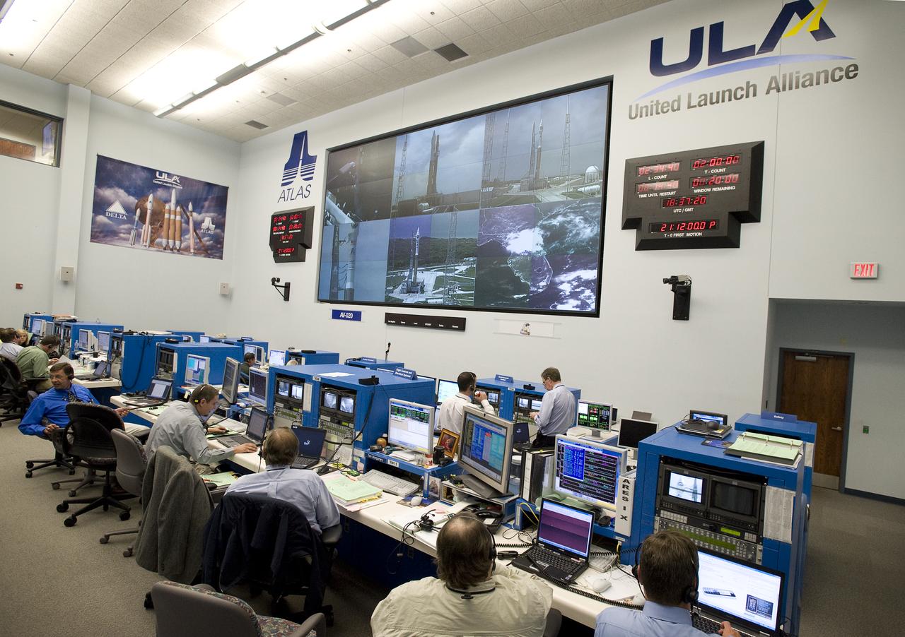
United Launch Alliance (ULA) team members work in the Atlas V Spaceflight Operations Center prior to the launch of the Lunar Reconnaissance Orbiter and Lunar Crater Observation and Sensing Satellite Thursday, June 18, 2009, from Cape Canaveral Air Force Station, Florida. . Photo Credit: (NASA/Bill Ingalls)
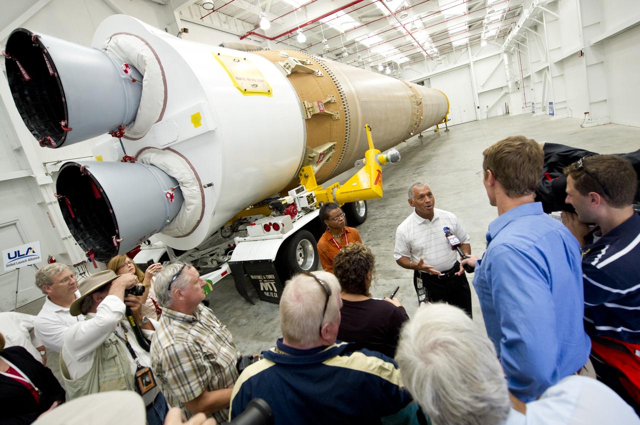
NASA Administrator Charles Bolden, stands in front of the United Launch Alliance Atlas V first stage booster while taking questions from the media, Wednesday, Sept. 7, 2011, at the Cape Canaveral Air Force Station in Cape Canaveral, Fla. The booster will help send NASA's Mars Science Laboratory Curiosity rover to Mars later this year. Photo Credit: (NASA/Bill Ingalls)
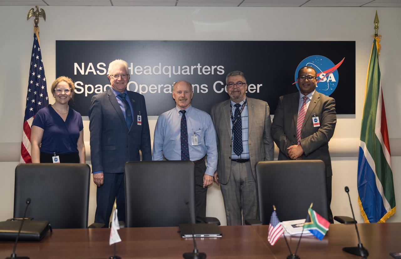
From left to right, Provincial Minister for Finance and Economic Opportunities of the Western Cape Government, Mireille Wenger, Premier of the Western Cape Government, Alan Winde, NASA Associate Administrator for the Space Operations Mission Directorate, Ken Bowersox, NASA Deputy Associate Administrator for Space Communications and Navigation, Badri Younes, and Director-General of the Western Cape Government, Dr. Harry Malila, pose for a photo in the Space Operations Center during a meeting with NASA and Western Cape Government representatives, to discuss the path forward for development of an antenna for the Lunar Exploration Ground Sites (LEGS) mission in Matjiesfontein, South Africa, and other opportunities, Tuesday, June 13, 2023, at the Mary W. Jackson NASA Headquarters building in Washington. Photo Credit: (NASA/Aubrey Gemignani)
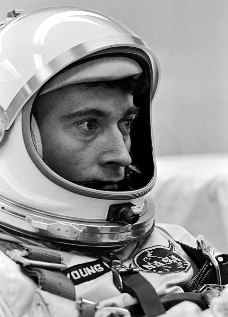
Closeup of Astronaut John W. Young, Pilot for the Gemini-III Spaceflight. CAPE KENNEDY, FL
The space shuttle Endeavour is seen at launch pad 39A at NASA's Kennedy Space Center in Cape Canaveral, Florida on Saturday, July 11, 2009. NASA is hopeful that Endeavour will launch with the crew of STS-127 on Sunday. Photo Credit: (NASA/Bill Ingalls)
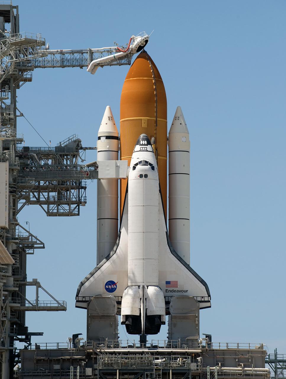
The space shuttle Endeavour is seen at launch pad 39A at NASA's Kennedy Space Center in Cape Canaveral, Florida on Saturday, July 11, 2009. NASA is hopeful that Endeavour will launch with the crew of STS-127 on Sunday. Photo Credit: (NASA/Bill Ingalls)

Provincial Minister for Finance and Economic Opportunities of the Western Cape Government, Mireille Wenger, provides remarks during a meeting with the Premier of the Western Cape Government, Alan Winde, right, NASA representatives, and a delegation from South Africa, to discuss the path forward for development of an antenna for the Lunar Exploration Ground Sites (LEGS) mission in Matjiesfontein, South Africa, and other opportunities, Tuesday, June 13, 2023, at the Mary W. Jackson NASA Headquarters building in Washington. Photo Credit: (NASA/Aubrey Gemignani)
NASA Acting Administrator Chris Scolese, 2nd from right, looks out over the Atlas V Spaceflight Operations Center prior to the launch of the Lunar Reconnaissance Orbiter and Lunar Crater Observation and Sensing Satellite Thursday, June 18, 2009, from Cape Canaveral Air Force Station, Florida. Photo Credit: (NASA/Bill Ingalls)

NASA Administrator Jared Isaacman is seen during a helicopter flight, Friday, May 29, 2026, at Cape Canaveral Space Force Station in Florida. The flight surveyed Launch Complex 36 following a New Glenn hotfire test anomaly on May 28. Photo Credit: (NASA/John Kraus)
S63-02651 (21 July 1961) --- This is a ground-level view of the Mercury-Redstone (MR-4) launch of Virgil I. Grissom on July 21, 1961, from Cape Canaveral, Florida. Photo credit: NASA
S61-03249 (13 Sept. 1961) --- View of the launch of the Mercury-Atlas 4 (MA-4) spacecraft from Cape Canaveral, Florida on Sept. 13, 1961. Photo credit: NASA
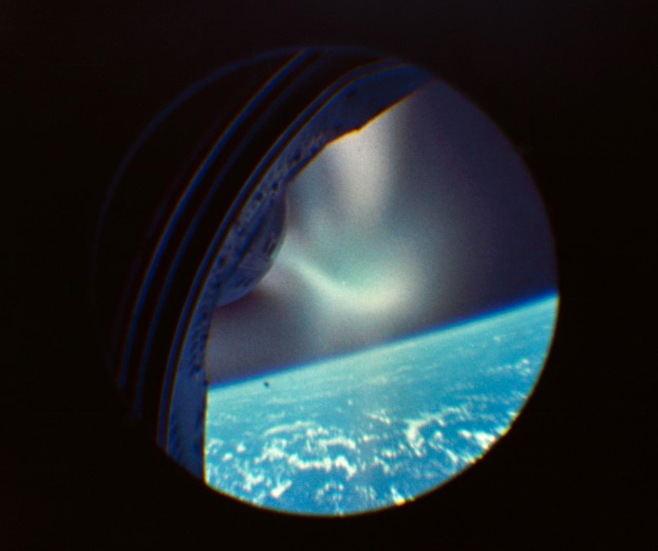
This photograph is an enlargement of a frame from a 16mm motion picture film which was mounted within the spacecraft to take film through the hatch window. CAPE KENNEDY, FL CN

S61-04623 (1961) --- Astronaut John H. Glenn Jr. looks into a Celestial Training Device (globe) during training in the Aeromedical Laboratory at Cape Canaveral, Florida. Photo credit: NASA
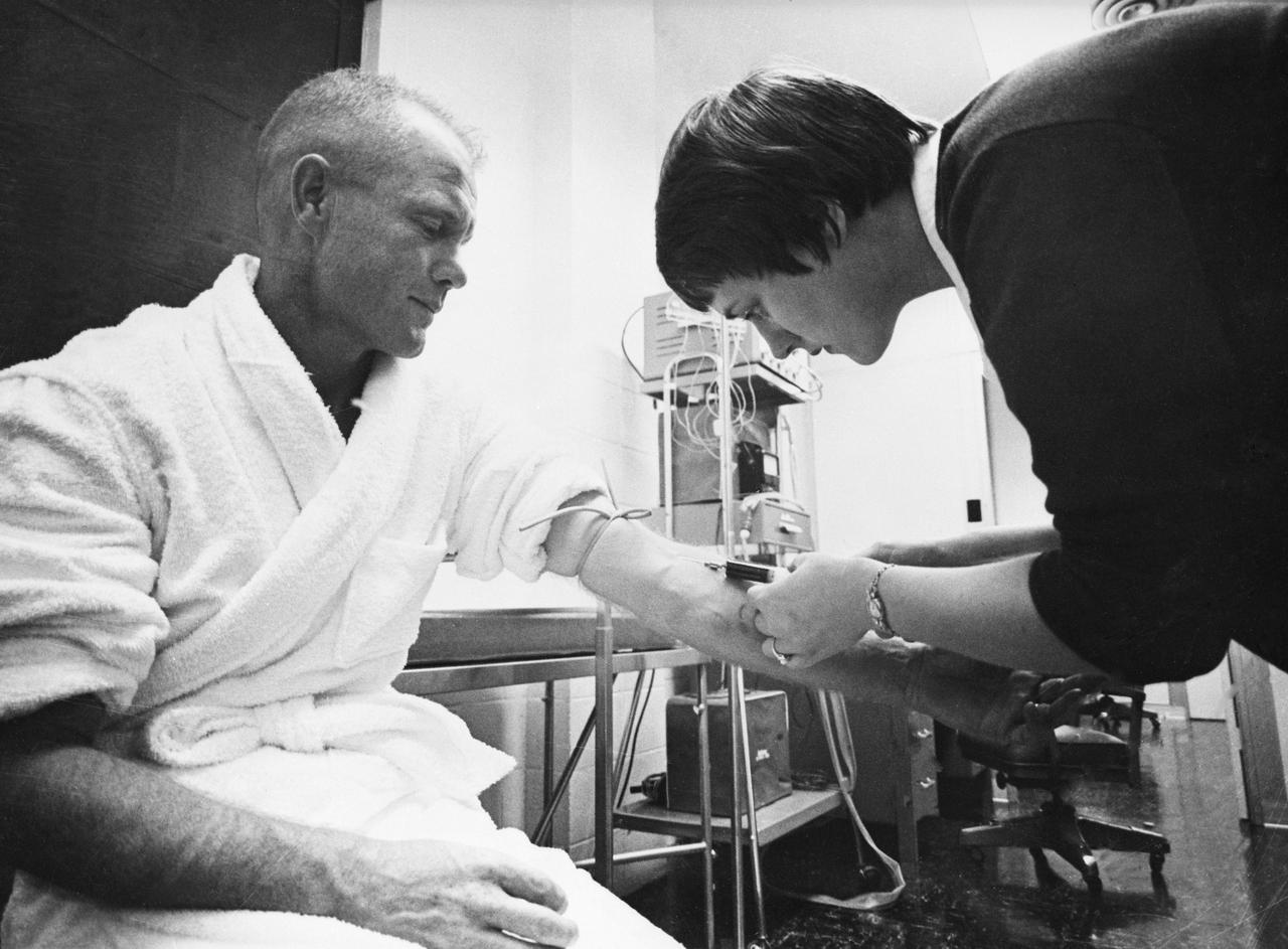
S61-02579 (1961) --- Astronaut nurse Delores B. O'Hara, R.N., in the Aeromedical Laboratory at Cape Canaveral, Florida, takes a blood sample from Mercury astronaut John H. Glenn Jr. Photo credit: NASA
S61-03121 (21 July 1961) --- Mercury-Redstone 4 (MR-4) launch of Virgil I. Grissom on July 21, 1961, from Cape Canaveral, Florida. Photo credit: NASA