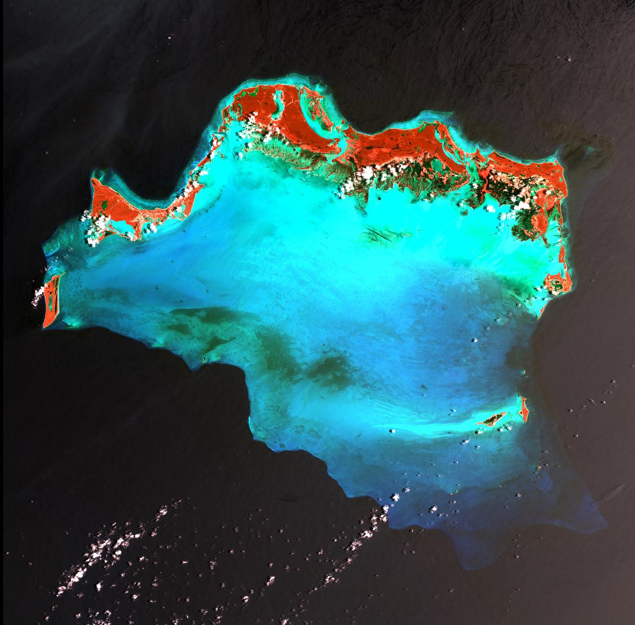
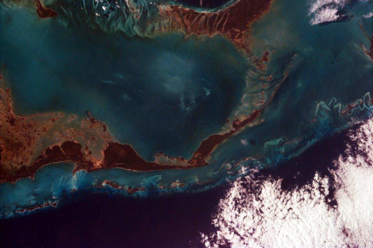
Caribbean Luxury - April 24th, 2003 Description: The Caicos Islands (pronounced KAY-kohss) in the northern Caribbean are a popular tourist attraction, renowned for their beautiful beaches, clear waters, scuba diving, and luxury resorts. The islands lie primarily along the northern perimeter of the submerged Caicos Bank (turquoise), a shallow limestone platform formed of sand, algae, and coral reefs covering 6,140 square kilometers (2,370 square miles). Credit: USGS/NASA/Landsat 7 To learn more about the Landsat satellite go to: <a href="http://landsat.gsfc.nasa.gov/" rel="nofollow">landsat.gsfc.nasa.gov/</a> <b><a href="http://www.nasa.gov/centers/goddard/home/index.html" rel="nofollow">NASA Goddard Space Flight Center</a></b> enables NASA’s mission through four scientific endeavors: Earth Science, Heliophysics, Solar System Exploration, and Astrophysics. Goddard plays a leading role in NASA’s accomplishments by contributing compelling scientific knowledge to advance the Agency’s mission. <b>Follow us on <a href="http://twitter.com/NASA_GoddardPix" rel="nofollow">Twitter</a></b> <b>Join us on <a href="http://www.facebook.com/pages/Greenbelt-MD/NASA-Goddard/395013845897?ref=tsd" rel="nofollow">Facebook</a></b>
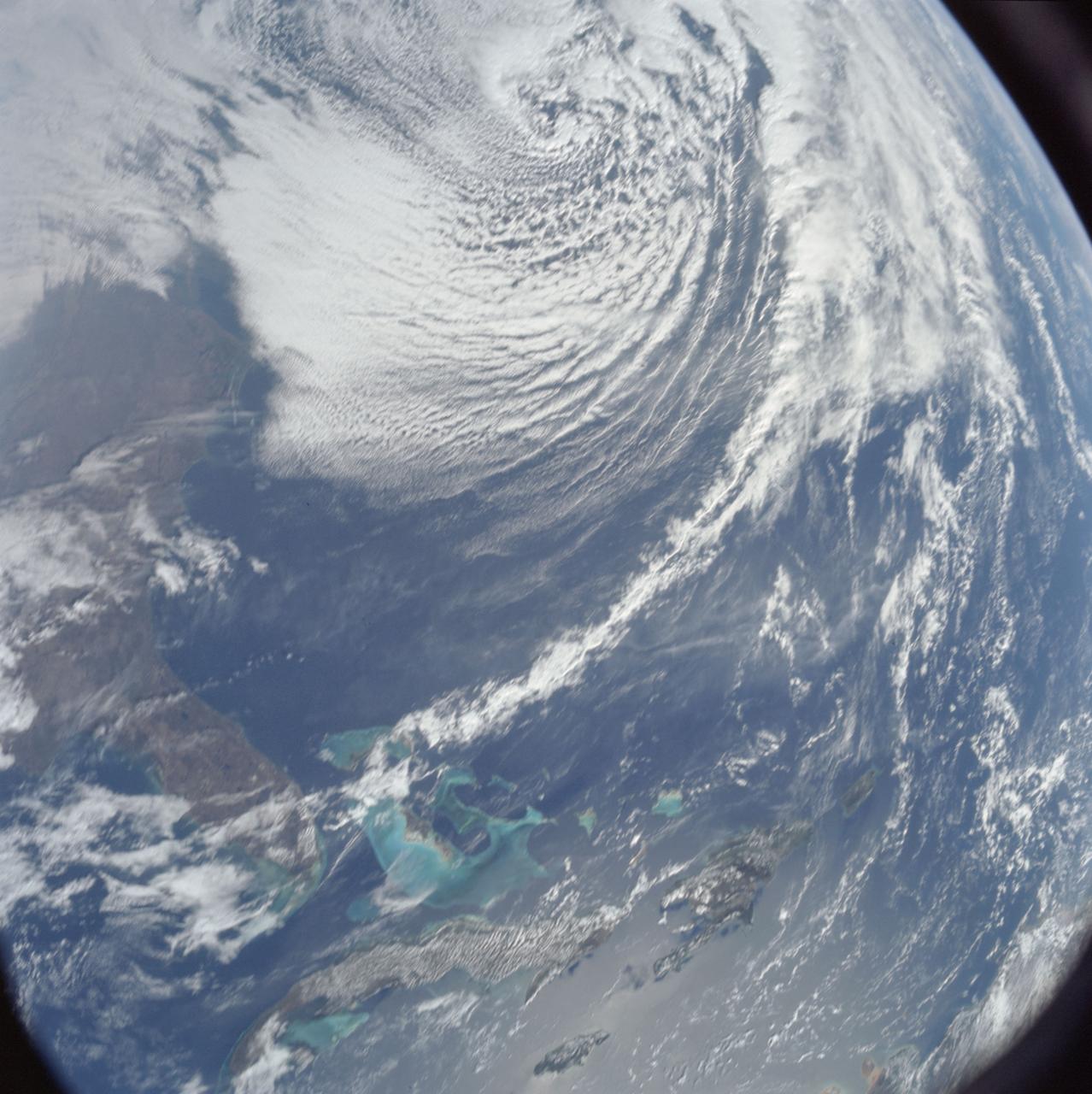
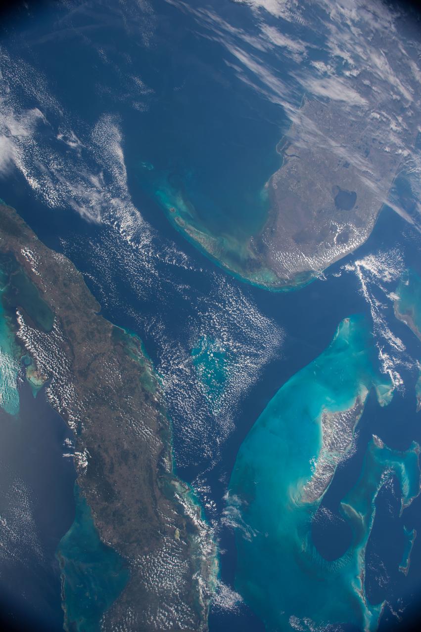
AS08-16-2581 (21-27 Dec. 1968) --- This photograph of Earth was taken from the Apollo 8 spacecraft while it was in Earth orbit. Most of the southeastern United States and the Caribbean Sea area, the U.S. coastline from Chesapeake Bay to the Florida Peninsula can be seen. The Bahamas and the islands of Cuba, Jamaica, Hispaniola and Puerto Rico extend across the Caribbean, the light blue of the shallow Bahama banks contrasting sharply with the darker hue of the deeper water, especially in the Tongue of the Ocean area.
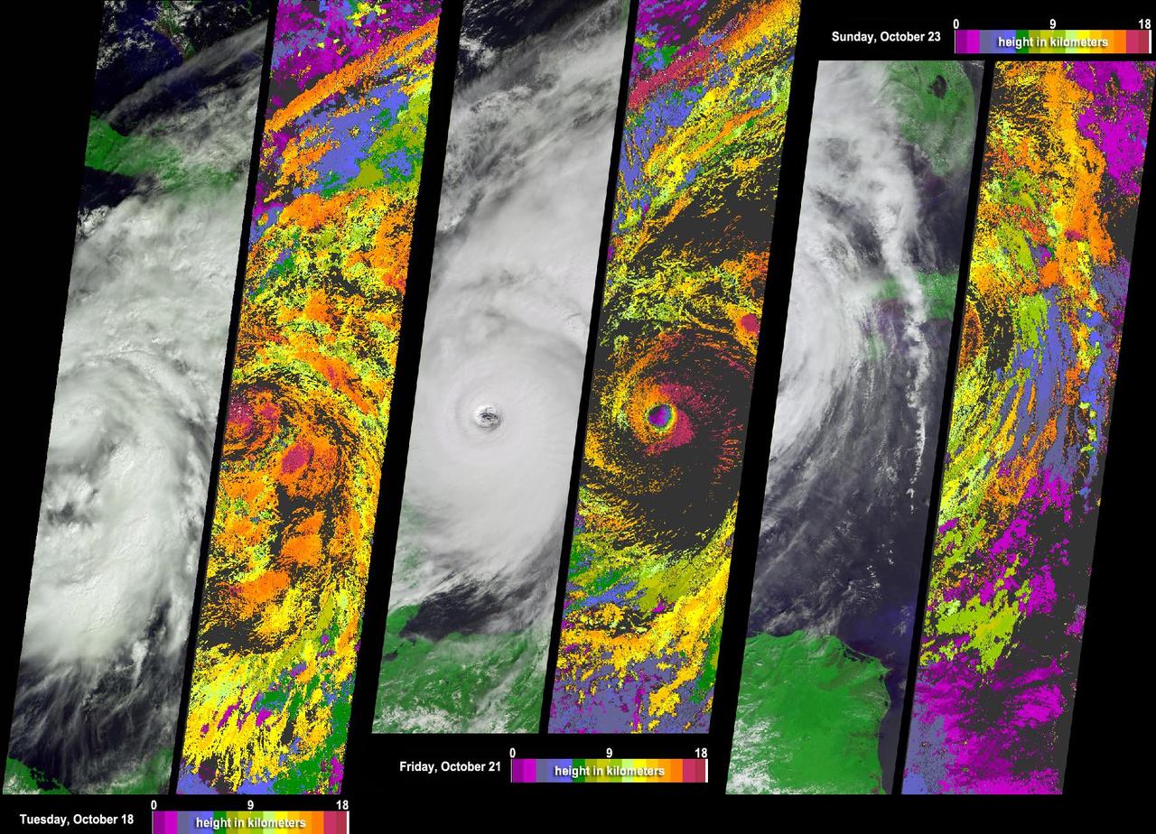
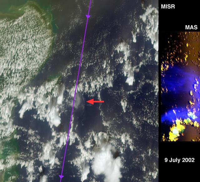
NASA Terra spacecraft acquired this sequence of images and cloud-top height observations for Hurricane Wilma as it progressed across the Caribbean in October 2005.
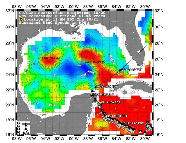
This sea surface height map of the Gulf of Mexico and the northwestern Caribbean Sea, with the Florida peninsula on the upper right, is based on altimeter data from three satellites including NASA Jason-1.
STS054-74-049 (13-19 Jan. 1993) --- St. Croix is the largest, and most industrial of the U.S. Virgin Islands. This photograph captures St. Croix's features in great detail. The large industrial complex in the middle of the southern shore is the world's largest petroleum refinery. The main city, Christiansted, can be seen across the island on the north shore. The reefs around the eastern end of St. Croix are preserved as a submarine national park -- Buck Island Reef National Park -- around the small island off the north shore of the eastern end of St. Croix.
iss072e394498 (Dec. 18, 2024) --- Venezuala's Falcón Municipality on the coast of the Caribbean Sea is pictured from the International Space Station as it orbited 261 miles above.
iss073e0379768 (July 20, 2025) --- Colombia's La Guajira Peninsula on the Caribbean Sea, with its desert region and beautiful coastline, is pictured from the International Space Station as it orbited 258 miles above.
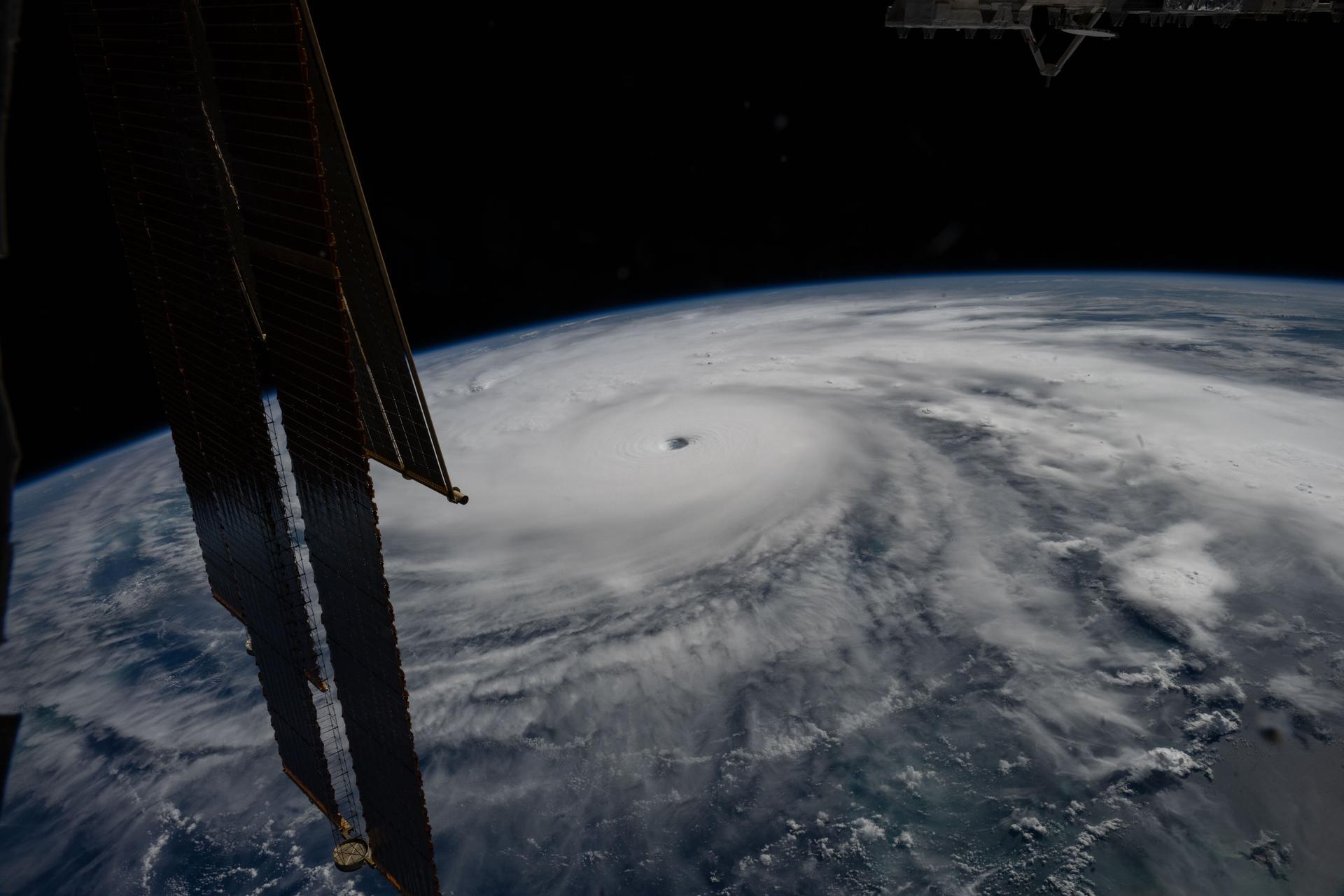
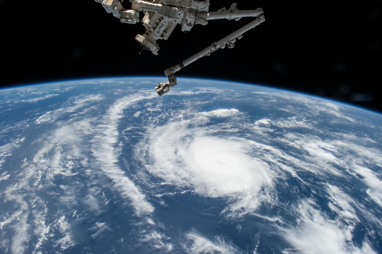
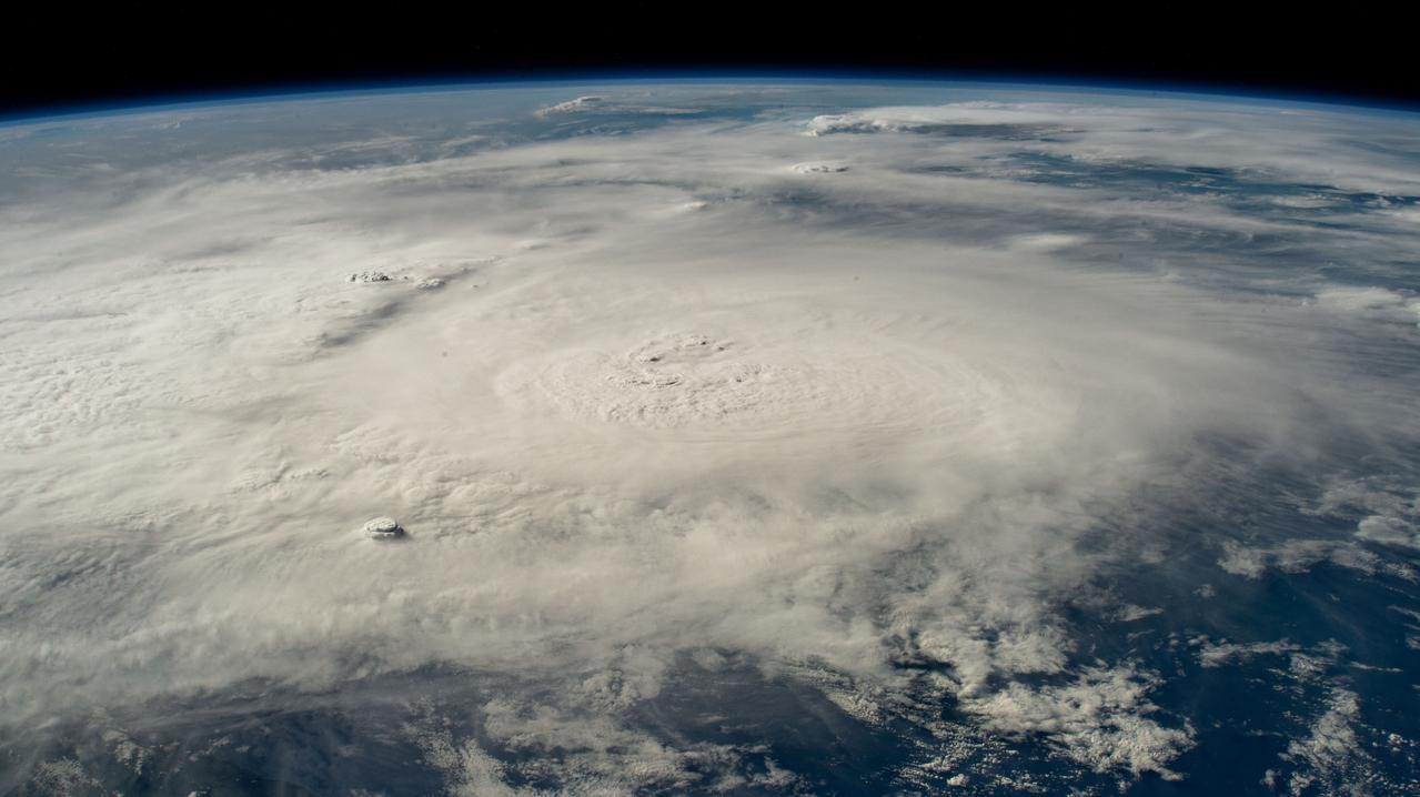
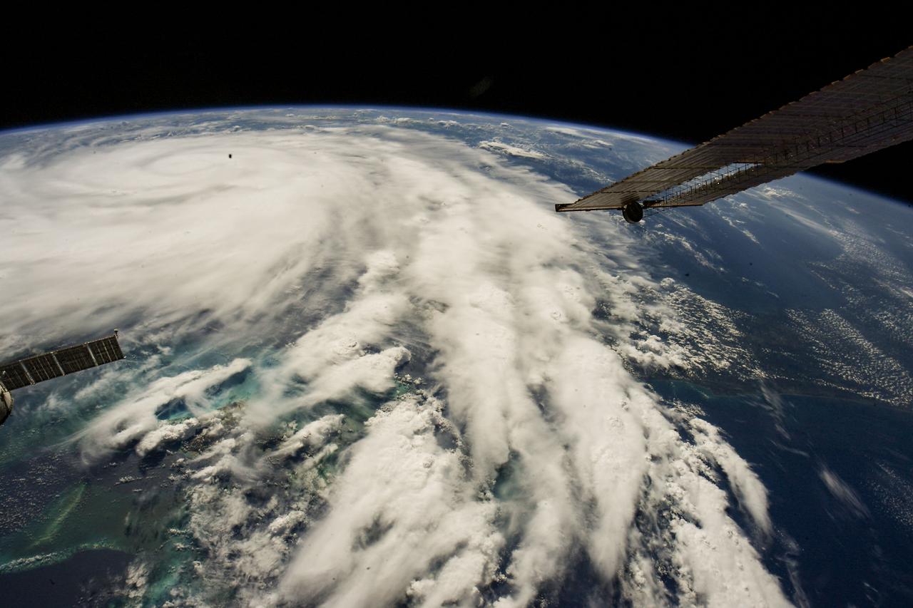
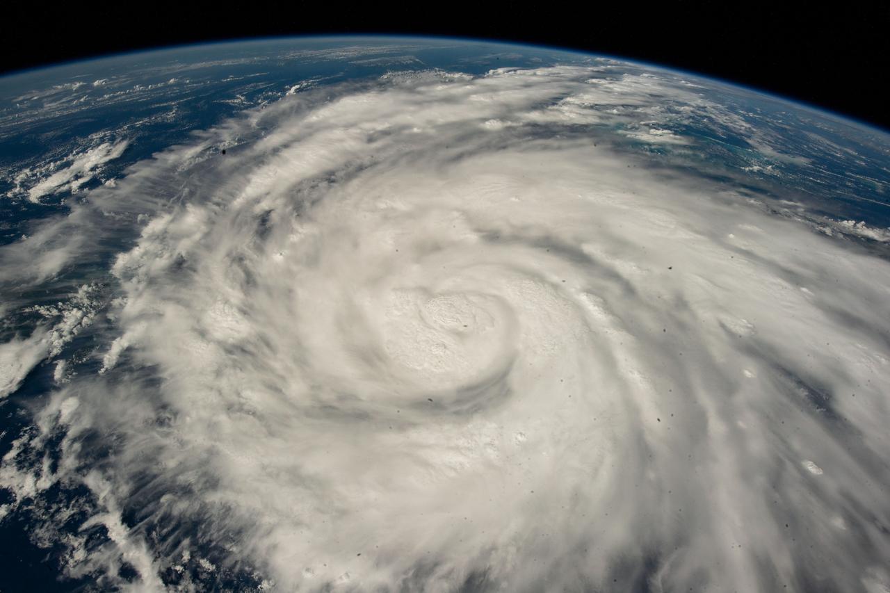
iss073e1044319 (Oct. 28, 2025) --- Category 5 Hurricane Melissa, one of the most powerful storms to strike the Caribbean in recent history, is pictured about 50 miles south of Jamaica in this photograph from the International Space Station as it orbited 262 miles above the Yucatan Peninsula.
STS069-731-031 (9 September 1995) --- Hurricane Luis is captured on film in its latter days in the Caribbean in this 70mm frame. During the 11-plus day mission, the astronauts aboard the Space Shuttle Endeavour caught with their cameras at least two large oceanic storms. A second one later in the flight, named Marilyn, followed a similar path, leaving havoc in its wake on several islands. Endeavour with a five-member crew, launched on September 7, 1995, from the Kennedy Space Center (KSC) and ended its mission there September 18, 1995, with a successful landing on Runway 33. The multifaceted mission carried astronauts David M. Walker, mission commander; Kenneth D. Cockrell, pilot; and James S. Voss (payload commander), James H. Newman, Michael L. Gernhardt, all mission specialists.
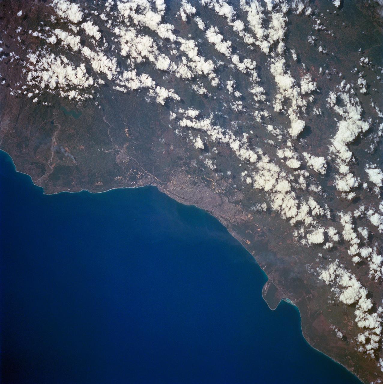
STS060-84-063 (3-11 Feb 1994) --- This is an excellent photograph of the coastal city of Santo Domingo on the Caribbean Sea. The airports including De las Americas International Airport are clearly seen. This photo illustrates the resolving power of the films. For example, two isolated smoke plumes are clearly seen each side of the city.
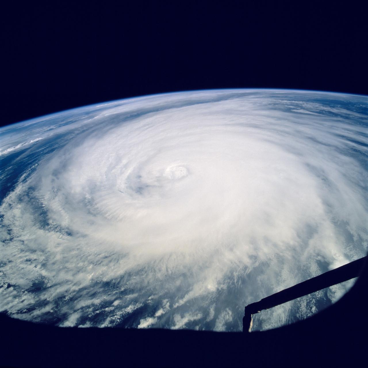
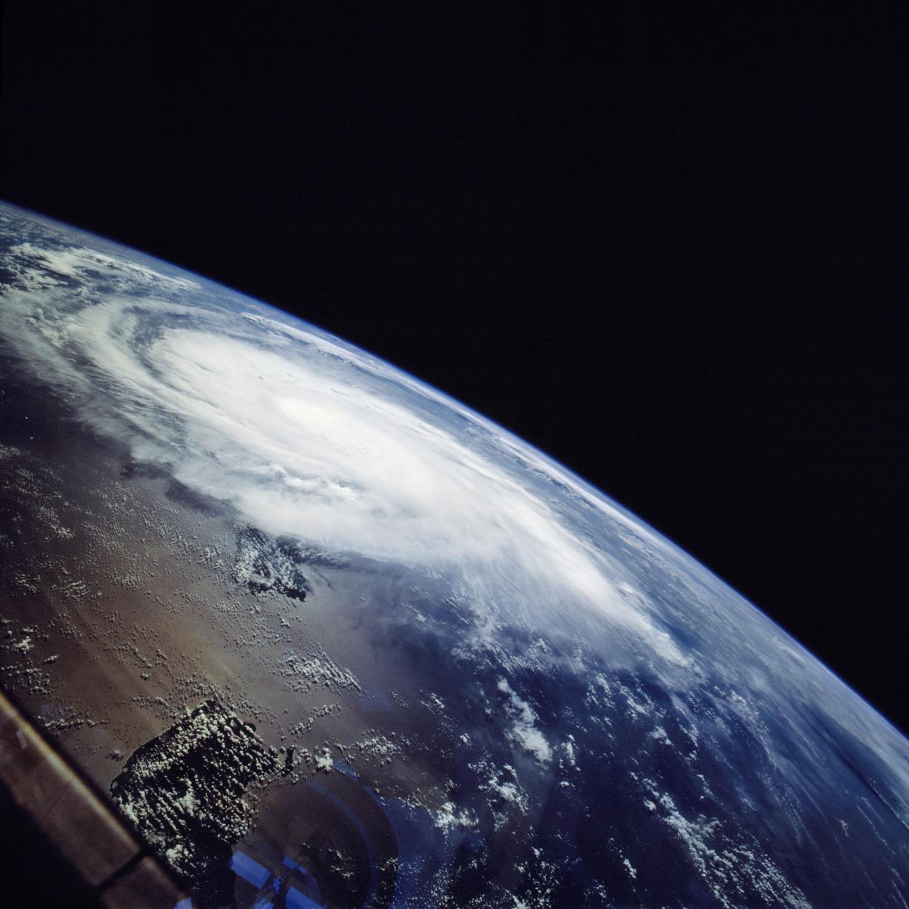
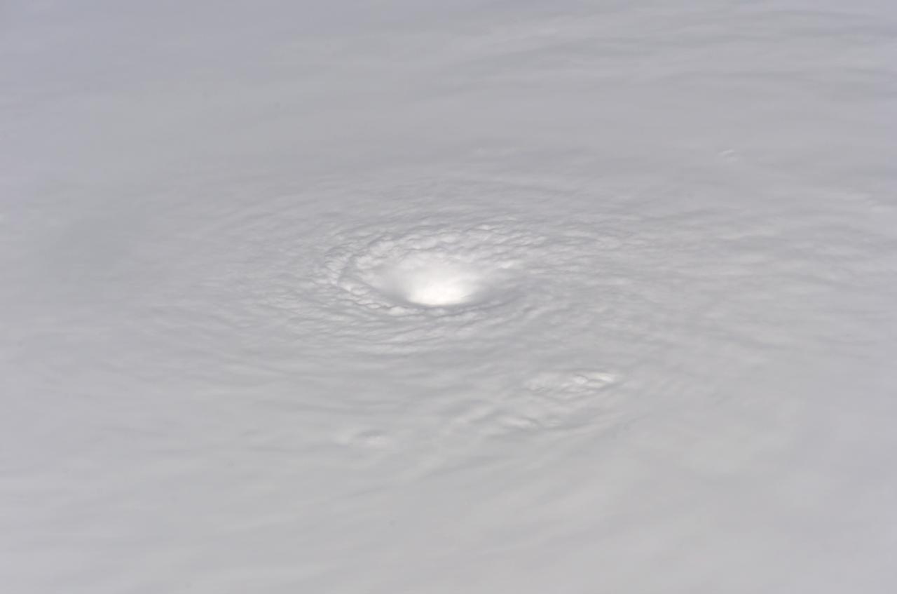
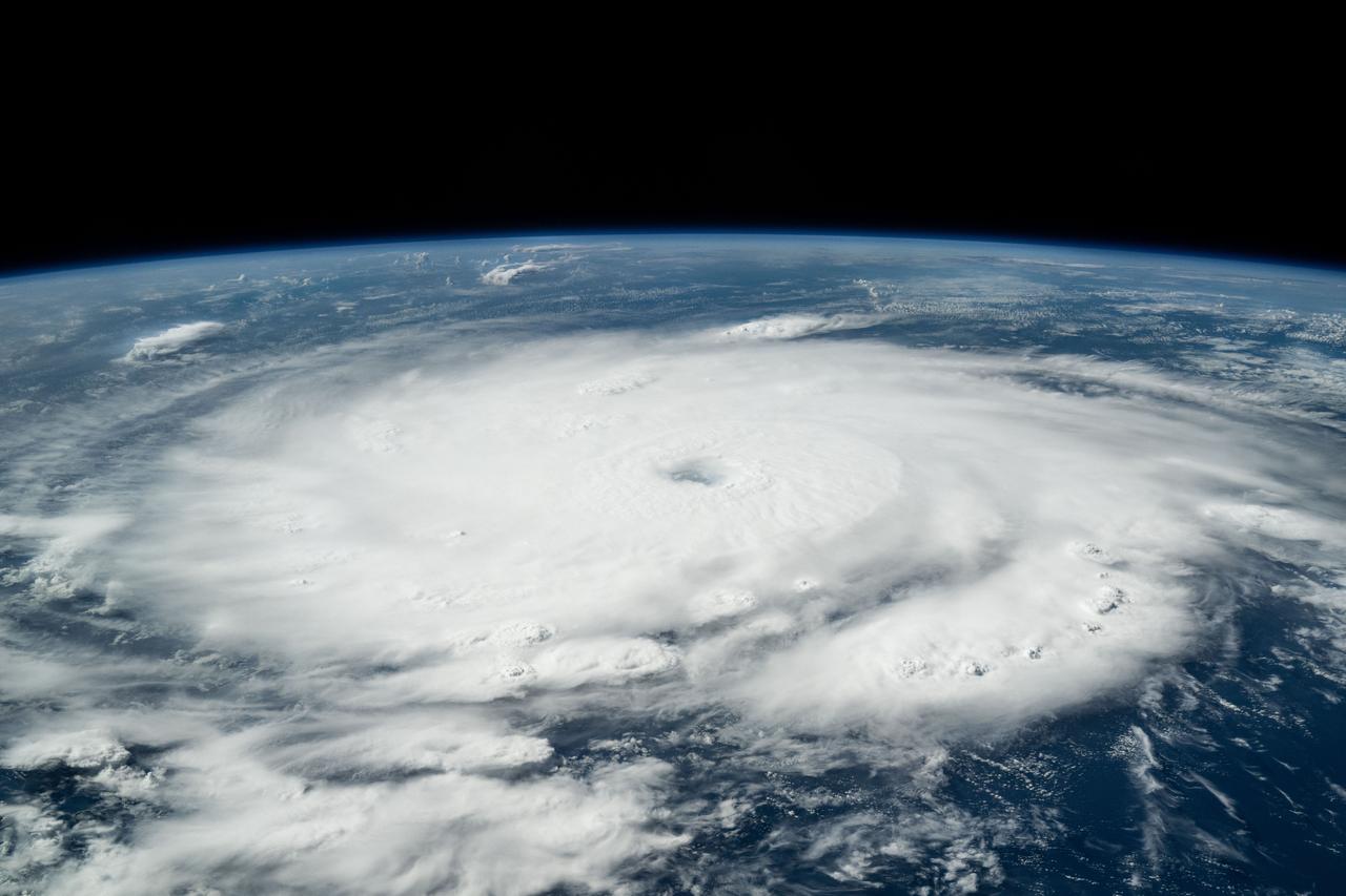
This image hosts a look at the eye of Hurricane Ivan, one of the strongest hurricanes on record, as the storm topped the western Caribbean Sea on Saturday, September 11, 2004. The hurricane was photographed by astronaut Edward M. (Mike) Fincke from aboard the International Space Station (ISS) at an altitude of approximately 230 miles. At the time, the category 5 storm sustained winds in the eye of the wall that were reported at about 160 mph. Crew Earth Observations record Earth surface changes over time, as well as more fleeting events such as storms, floods, fires, and volcanic eruptions.
STS069-720-026 (17 September 1995) --- Hurricane Marilyn is captured on film as it moves over the Caribbean on September 17, 1995, in this 70mm frame. A motion picture lens on the handheld Hasselblad gives a "fish-eye" effect to the scene. Note the end of the Space Shuttle Endeavour's Remote Manipulator System (RMS) arm, which stayed quite busy during the flight supporting a space walk and extensive operations with two temporarily free-flying spacecraft. During the 11-plus day mission, the astronauts aboard the Endeavour caught with their cameras at least two large oceanic storms. Another hurricane, named Luis, followed a similar path earlier in the flight. Endeavour, with a five-member crew, launched on September 7, 1995, from the Kennedy Space Center (KSC) and ended its mission there September 18, 1995, with a successful landing on Runway 33. The multifaceted mission carried the crew of astronauts David M. Walker, mission commander; Kenneth D. Cockrell, pilot; and James S. Voss (payload commander), James H. Newman, Michael L. Gernhardt, all mission specialists.
This montage is a natural-color view of the Caribbean Sea east of the Yucatan Peninsula as seen by NASA Terra satellite.
S73-35079 (July-September 1973) --- A near vertical view of the Caribbean coast of Venezuela is seen in this Skylab 3 Earth Resources Experiment Package S190-B (five-inch Earth terrain camera) photograph taken from the Skylab space station in Earth orbit. The large body of water is the Golfo de Venezuela; and the major land mass is the Peninsula de Paraguana. The view is looking northward from the mouth of the Golfete de Coro and Punta Cardon to Punta Macolla. The peninsula is connected to the Venezuelan mainland by the narrow strip of land in the most easterly corner of the picture. The dry, arid climate on the peninsula is indicated by sparse vegetation and the abundance of sand dunes. The highest point is about 2,700 feet above the sea and is the conspicuous black spot. Old raised shoreline features appear as streaks parallel to the Golfete de Coro. Sand dunes and stream erosion have modified these features. Water of the Golfete de Coro is red from the high sediment content. The streaks in the water off the peninsula is apparently an effect of wind which is blowing sand and water offshore. The EREP investigator Dr. Jose Antonio Galavis, of the Ministerio de Mines e Hidrocarburos, will use this information to map geology and coastal sedimentation in the Peninsula de Paraguana. Federal agencies participating with NASA on the EREP projects are the Departments of Agriculture, Commerce, Interior, the Environmental Protection Agency and the Corps of Engineers. All EREP photography is available to the public through the Department of Interior?s Earth Resources Observations Systems Data Center, Sioux Falls, South Dakota, 57198. (Alternate number SL3-83-237) Photo credit: NASA
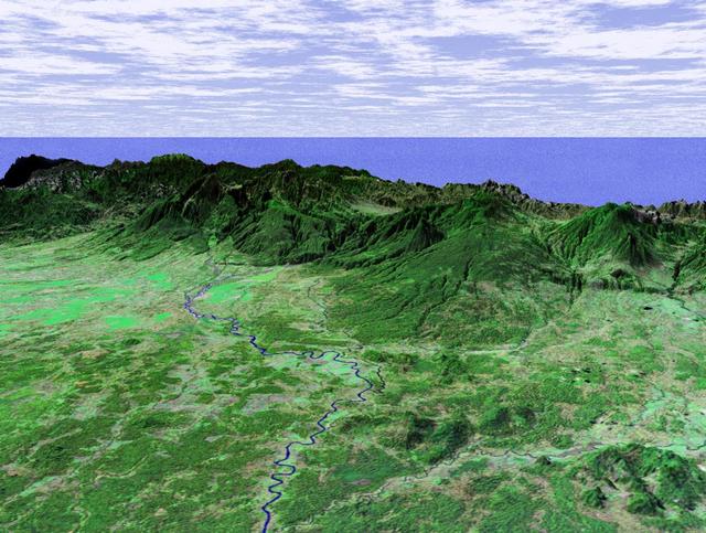
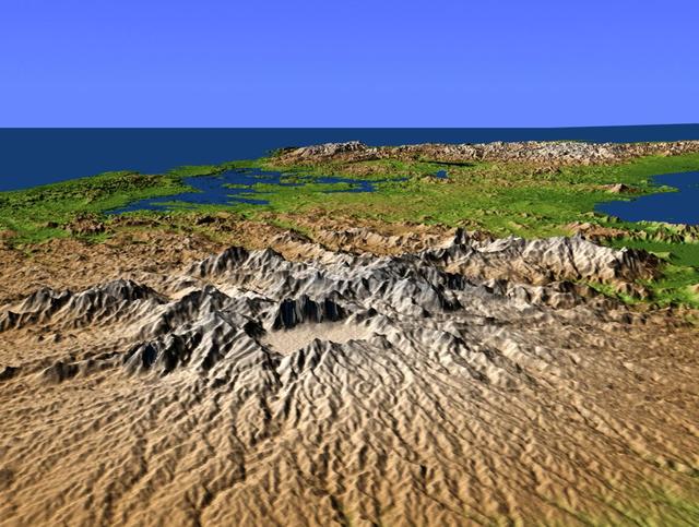
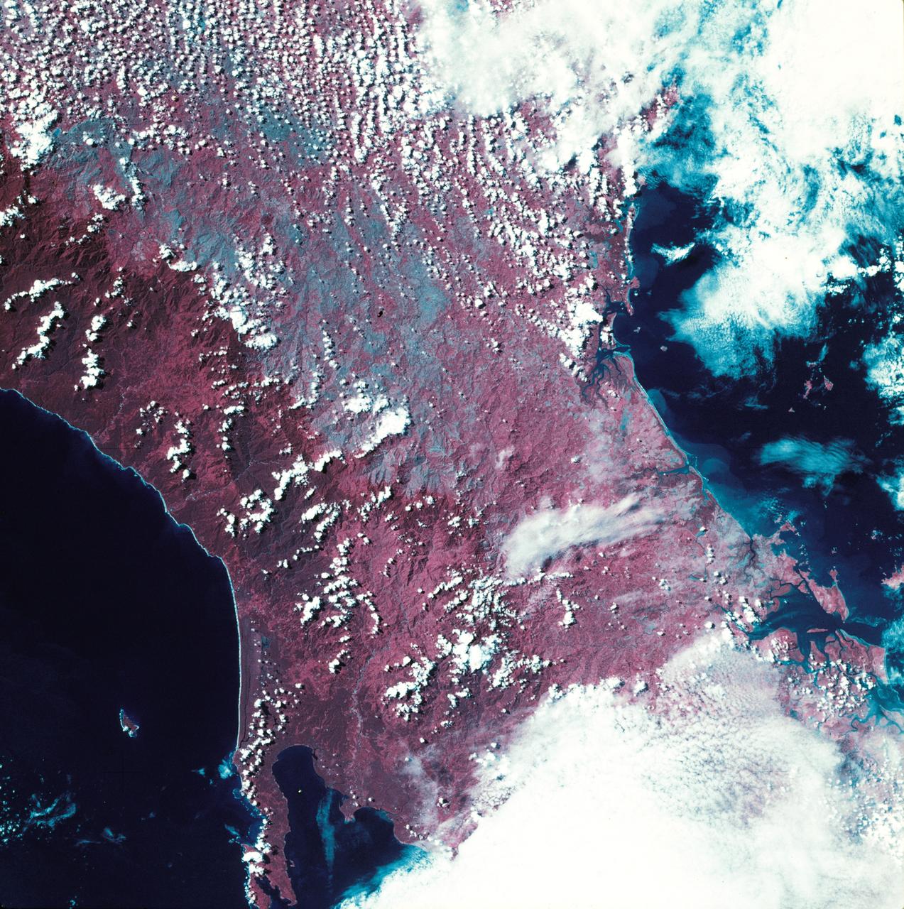
This perspective view taken in February 2000 from NASA Landsat and SRTM shows the Caribbean coastal plain of Costa Rica, with the Cordillera Central rising in the background.
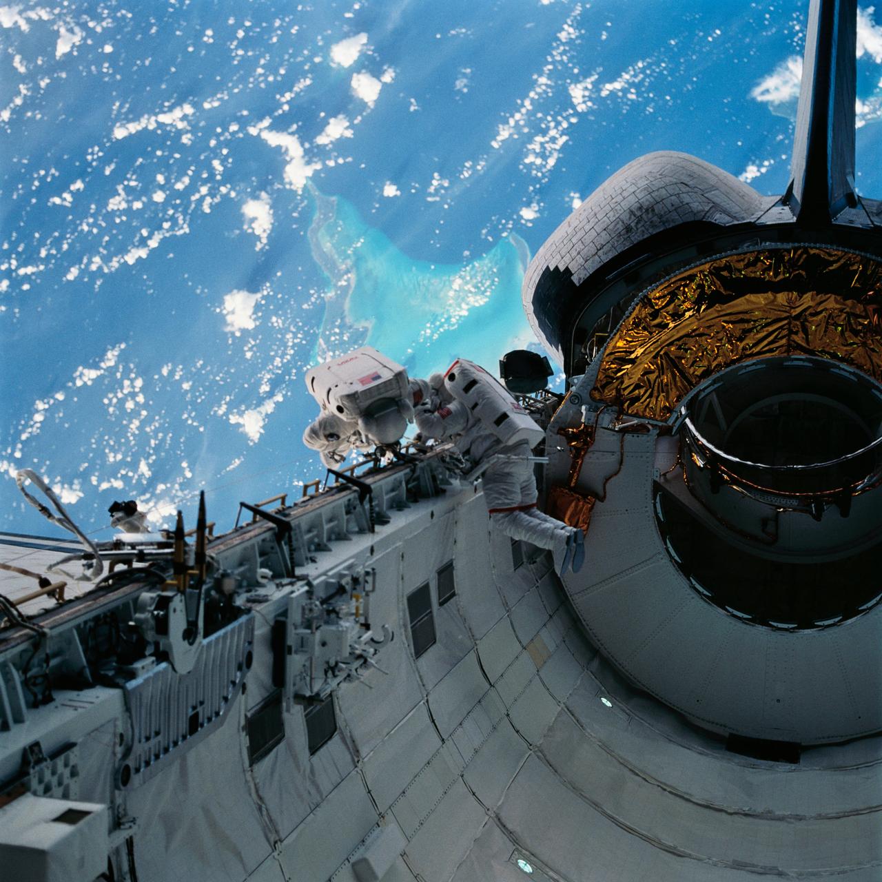
With the Caribbean Sea and part of the Bahama Islands chain as a backdrop, two STS-51 crewmembers evaluate procedures and gear to be used on the upcoming Hubble Space Telescope (HST)-servicing mission. Sharing the lengthy extravehicular activity in and around Discovery's cargo bay were astronauts James H. Newman (left), and Carl E. Walz, mission specialists.
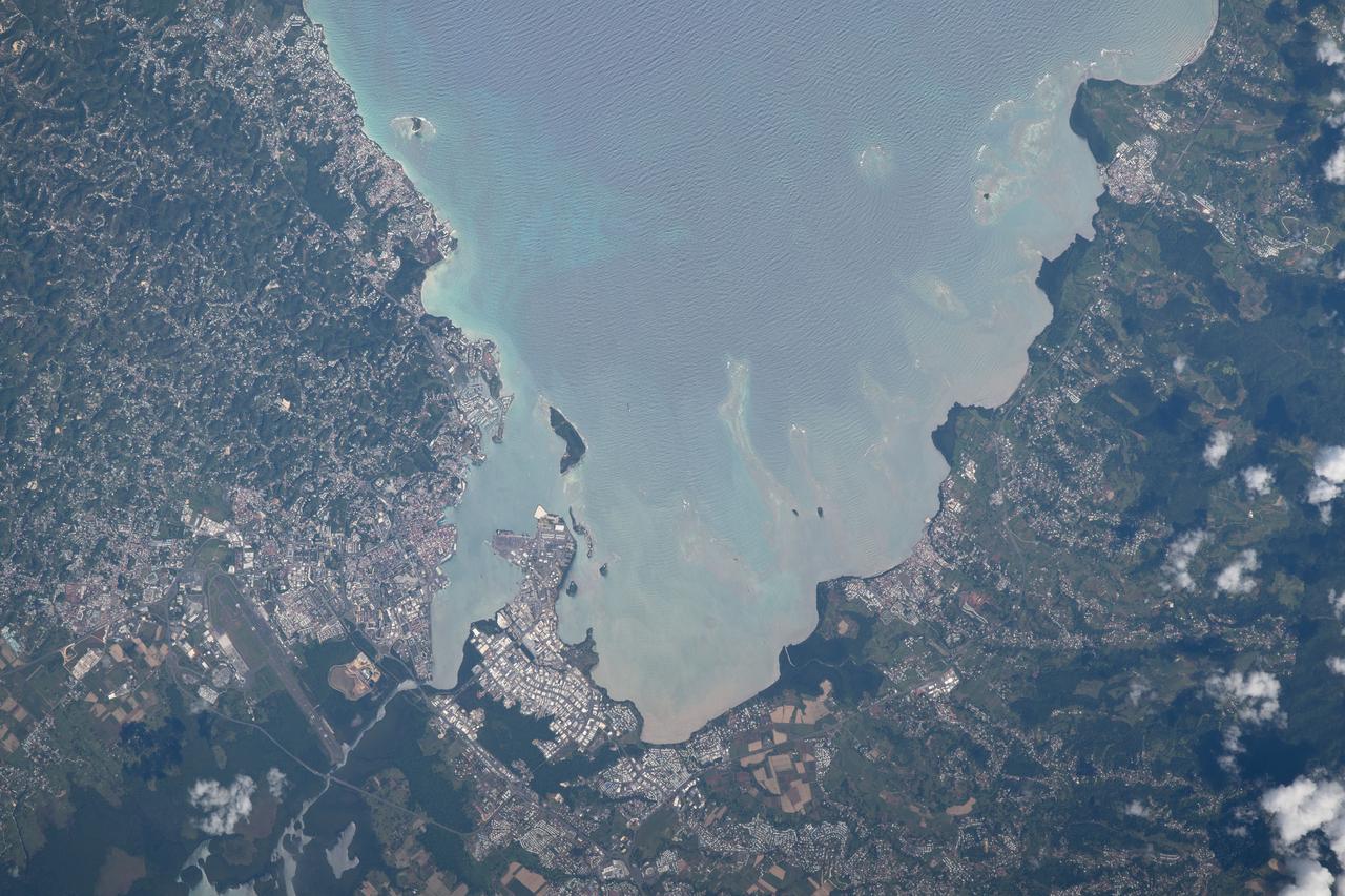
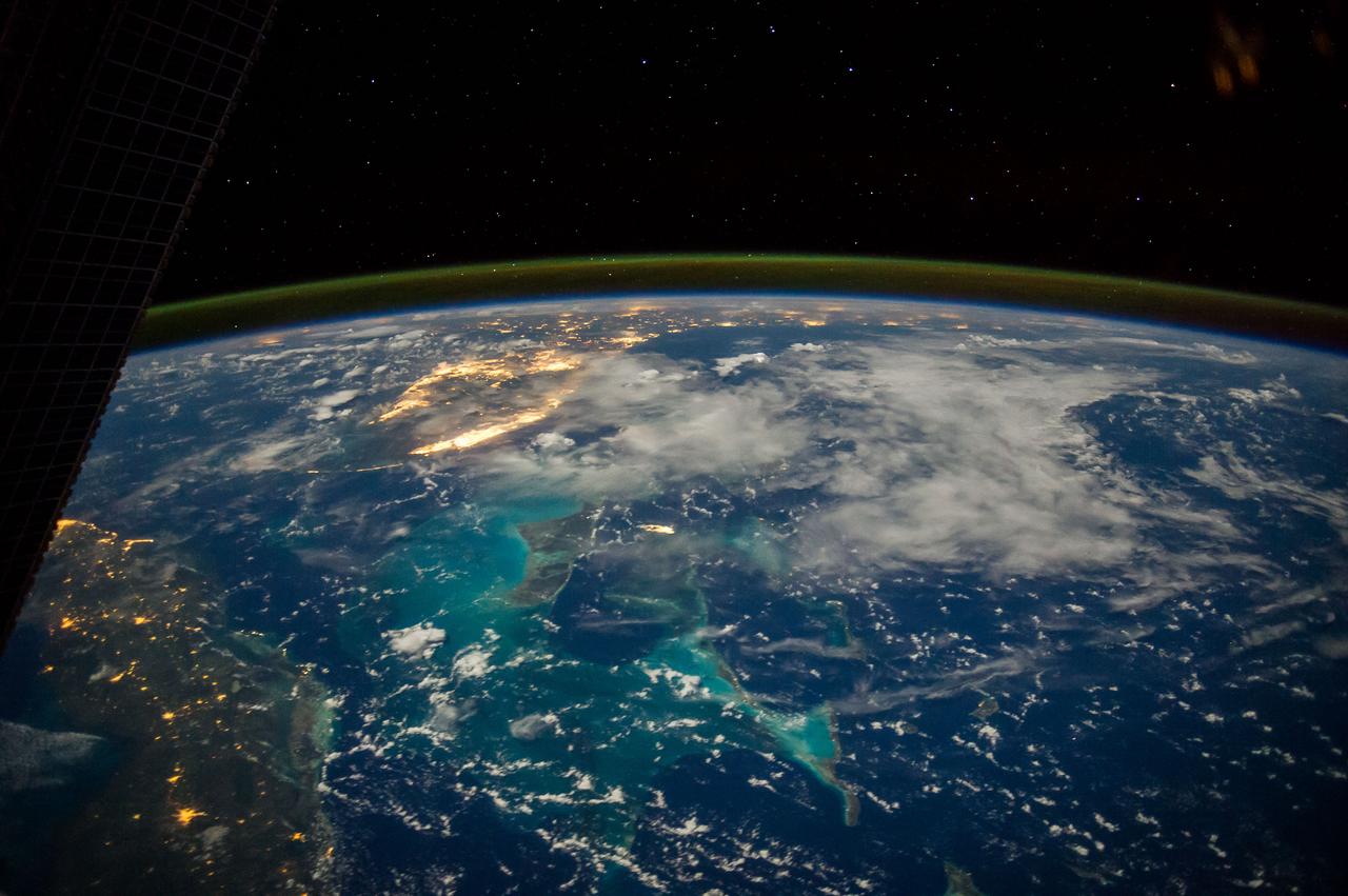
GMT353_21_17_Terry Virts_South Florida Caribbean zoom_123
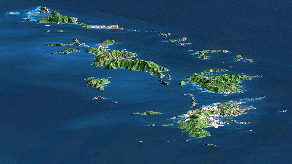
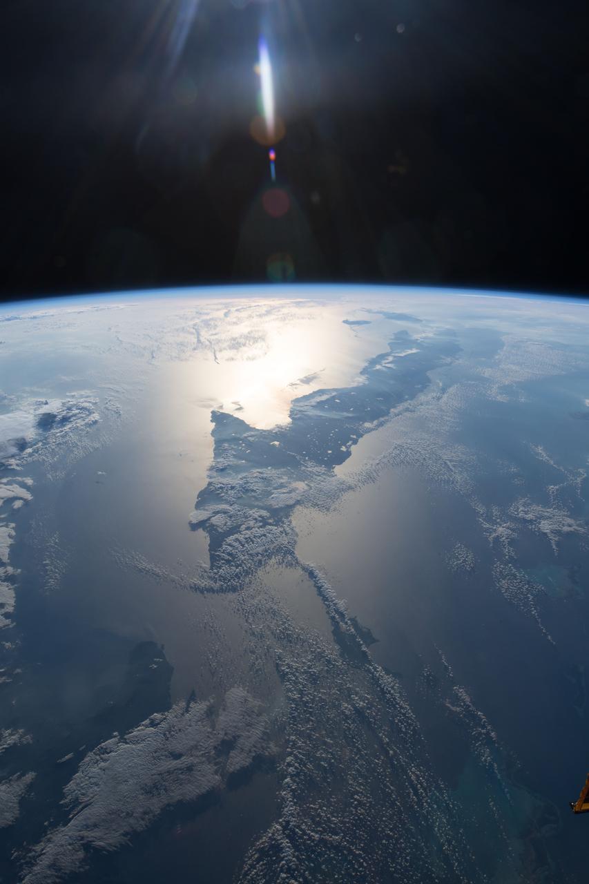
St. Thomas, St. John, Tortola, and Virgin Gorda are the four main islands front to back of this east-looking view of the U.S. Virgin Islands and British Virgin Islands, along the northeast perimeter of the Caribbean Sea.
This perspective view from NASA Shuttle Radar Topography Mission SRTM, acquired on February 2000, shows central Panama, with the remnants of the extinct volcano El Valle in the foreground and the Caribbean Sea in the distance.

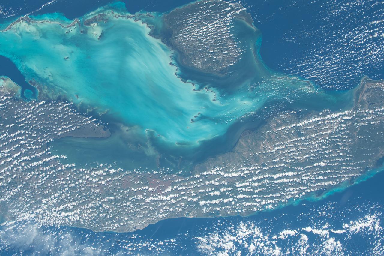
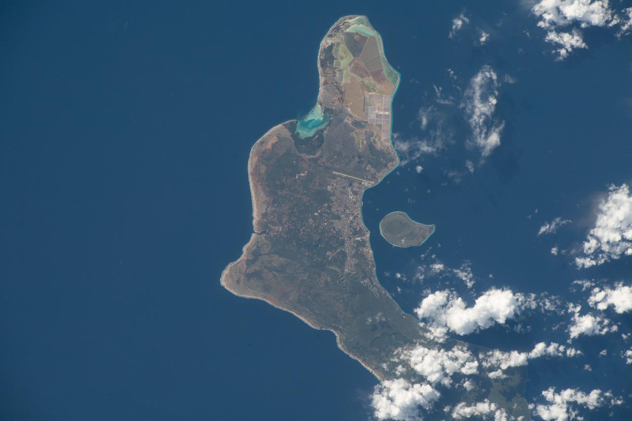
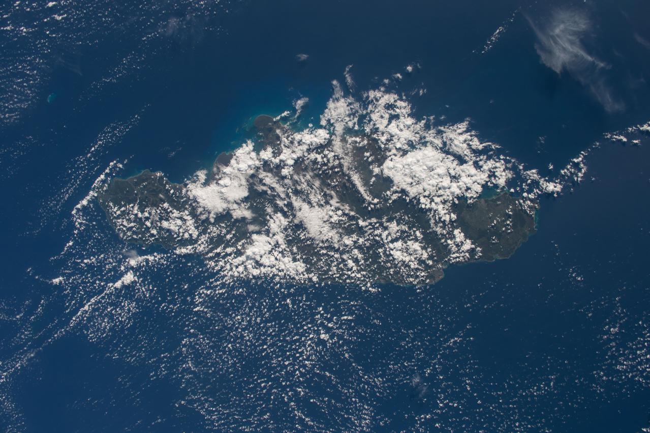
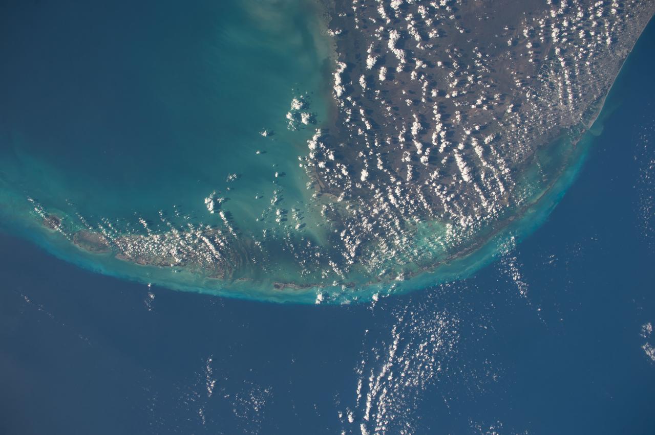
Grand Turk Island is an island in the Turks and Caicos Islands in the Caribbean, and contains the territory capital, Cockburn Town. NASA Terra spacecraft acquired this image on September 18, 2001.

iss072e420661 (Jan. 1, 2025) --- New Year's Day dawns on Cuba as the sunlight gleams off its Atlantic and Caribbean coasts in this photograph from the International Space Station as it orbited 260 miles above the Gulf of Mexico.
STS069-715-019 (15 September 1995) --- This photograph of Hurricane Marilyn was captured on film as it moves over Puerto Rico, in this 70mm frame. The southern half of Puerto Rico can be seen outside the cloud cover. The island of Hispaniola is seen in lower left-hand corner. During the 11-plus day mission, the astronauts aboard the Space Shuttle Endeavour caught with their cameras at least two large oceanic storms. Another hurricane, named Luis, followed a similar path earlier in the flight. Endeavour, with a five-member crew, launched on September 7, 1995, from the Kennedy Space Center (KSC) and ended its mission there September 18, 1995, with a successful landing on Runway 33. The multifaceted mission carried the crew of astronauts David M. Walker, mission commander; Kenneth D. Cockrell, pilot; and James S. Voss (payload commander), James H. Newman, Michael L. Gernhardt, all mission specialists.
SL3-27-224 (July-September 1973) --- A vertical view of the western portion of the Republic of Panama on the Isthmus of Panama as photographed from Earth orbit by one of the six lenses of the Itek-furnished S190-A Multispectral Photographic Facility Experiment aboard the Skylab space station. This picture was taken with 2443 infrared color film. The large, clear body of water on the north side of the isthmus is Golfo de los Mosquitos, an extension of the Caribbean Sea. The large, partly cloud-covered body of water on the south side of the isthmus is Golfo de Chiriqui, an extension of the Pacific Ocean. Federal agencies participating with NASA on the EREP project are the Department of Agriculture, Commerce, Interior, the Environmental Protection Agency and the Corps of Engineers. All EREP photography is available to the public through the Department of Interior?s Earth Resources Observation Systems Data Center, Sioux Falls, South Dakota, 57198. Photo credit: NASA
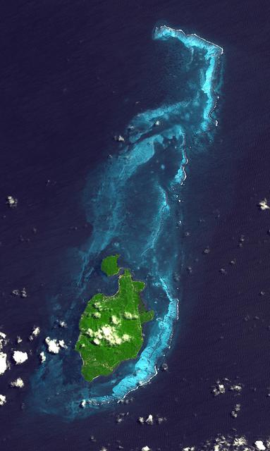
Providencia Island, located in the Caribbean Sea, is part of Colombia even though located 800 km northwest of mainland Colombia. The small island has an area of 17 square kilometers. First settled in 1629 by Puritans on the Seaflower ship, the island was taken by Spain in 1641. Providencia is the center point of the UNESCO Marine Protected Area the Seaflower Biosphere Reserve. The image was acquired July 28, 2010, covers an area of 17.4 by 29 km, and is located at 13.3 degrees north, 81.3 degrees west. https://photojournal.jpl.nasa.gov/catalog/PIA24281

iss065e023015 (May 6, 2021) --- Guantanamo Bay in Cuba is pictured from the International Space Station as it orbited 261 miles above the Caribbean Sea.
ISS044E059041 (08/21/2015) --- Hurricane Danny as seen from the International Space Station as it traversed the Caribbean Sea headed for Puerto Rico, the Dominican Republic and Cuba.

iss064e002042 (Oct. 27, 2020) --- The Atrato River in northwestern Colombia, which leads to the Caribbean Sea, is pictured from the International Space Station.
iss063e032020 (June 21, 2020) --- What looks like land is actually a Saharan dust cloud that has blown over the Atlantic Ocean and is nearing the Caribbean Sea.
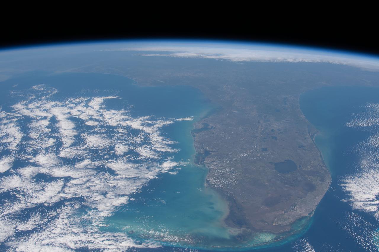
iss062e069492 (Feb. 28, 2020) --- The Florida peninsula is pictured looking northward as the International Space Station orbited 263 miles above the Caribbean Sea.
iss057e114400 (Dec. 7, 2018) --- The International Space Station flies 252 miles above the island nation of Cuba and the Gulf of Batabano in the Caribbean Sea.
iss063e032007 (June 21, 2020) --- What looks like land is actually a Saharan dust cloud that has blown over the Atlantic Ocean and is nearing the Caribbean Sea.
iss069e025190 (June 25, 2023) -- Clouds lightly cover the Cayman Islands as the International Space Station orbited 258 miles above the Caribbean Sea.
iss063e002083 (April 22, 2020) --- Baie-Mahault (bottom center) is a city in the French overseas region of Guadeloupe, an island group in the southern Caribbean Sea.
ISS038-E-021401 (24 Dec. 2013) --- The Caribbean country of Cuba is pictured in this high oblique image, photographed by one of the Expedition 38 crew members aboard the International Space Station. Andros ISland, part of the Bahamas, is Cuba is an archipelago of islands in the northern Caribbean Sea at the confluence with the Gulf of Mexico and the Atlantic Ocean. A Russian Soyuz spacecraft is docked to the station.
ISS038-E-019899 (23 Dec. 2013) --- The Caribbean country of Cuba appears at the top of this high oblique image, photographed by one of the Expedition 38 crew members aboard the International Space Station. Andros Island, part of the Bahamas, is in the bottom of the frame. Cuba is an archipelago of islands in the northern Caribbean Sea at the confluence with the Gulf of Mexico and the Atlantic Ocean. A Russian Soyuz spacecraft is docked to the station.
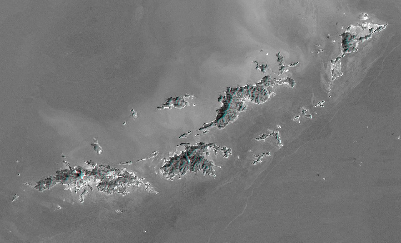
St. Thomas, St. John, Tortola, and Virgin Gorda are the four main islands lower left to upper right of this map-view anaglyph of the U.S. Virgin Islands and British Virgin Islands from NASA Shuttle Radar Topography Mission. 3D glasses are necessary.
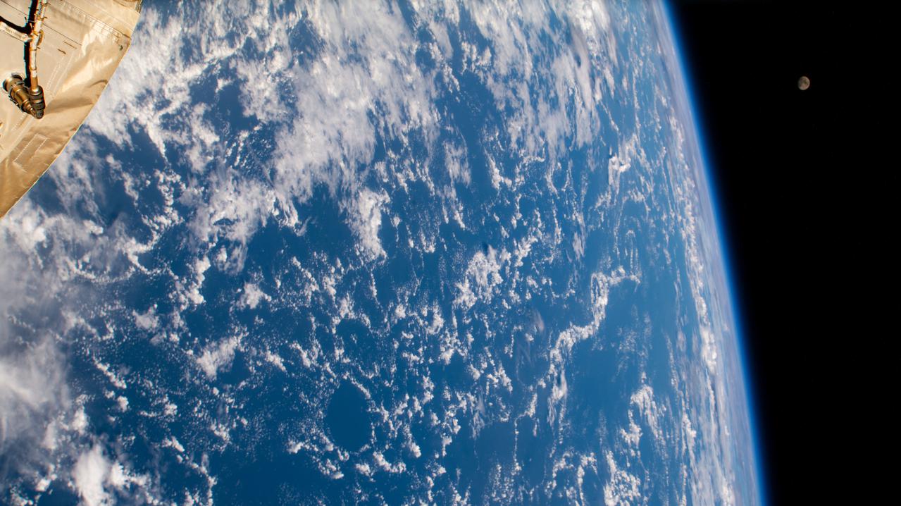
iss065e280824 (Aug. 19, 2021) --- The waxing gibbous Moon (upper right) is pictured from the International Space Station as it orbited 262 miles above the Atlantic Ocean just east of the Lesser Antilles, a group of islands in the Caribbean Sea.
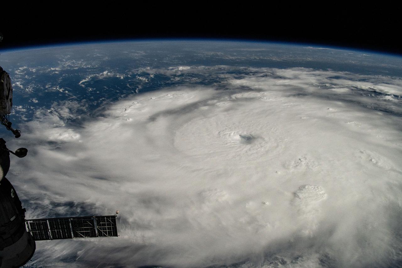
iss071e245405 (July 1, 2024) --- Hurricane Beryl is pictured as a Category 4 storm off the coast of Grenada in the Caribbean Sea as the International Space Station orbited 263 miles above.
iss068e036406 (Jan. 2, 2023) --- The island of Bonaire off the coast of Venezuela, one of three island municipalities comprising the Caribbean Netherlands, is pictured from the International Space Station as it orbited 258 miles above.
iss071e245678 (July 1, 2024) --- Hurricane Beryl is pictured as a Category 4 storm south of Barbados from the International Space Station as it orbited 262 miles above the Caribbean Sea.
iss068e023212 (Nov. 20, 2022) --- The sun's glint beams across the Caribbean Sea and the Atlantic Ocean highlighting Cuba and Haiti in this photograph from the International Space Station as it orbited 258 miles above.
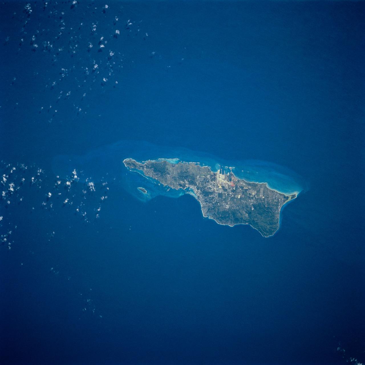
ISS042E135484 (01/10/2015) --- NASA astronaut Terry Virts flight engineer of Expedition 42 on the International Space Station tweeted this Caribbean image of the sunny isle of #"Jamaica" on Jan. 10, 2015.
ISS012-E-05259 (19 Oct. 2005) --- Hurricane Wilma is featured in this image photographed by an Expedition 12 crewmember on the International Space Station as it passes over the Caribbean Sea, 340 miles southeast of Cozumel, Mexico.
iss071e256908 (July 2, 2024) --- Hurricane Beryl is pictured as a Category 5 storm southwest of Barbados in the Caribbean Sea as the International Space Station orbited 263 miles above.
iss061e061245 (Nov. 26, 2019) --- The International Space Station orbits 255 miles above the Atlantic Ocean looking southwest over Cuba as the Sun's glint beams off the Caribbean Sea.
iss071e266892 (July 3, 2024) --- Hurricane Beryl is pictured as a Category 4 storm above the Caribbean Sea from the International Space Station as it orbited 263 miles above western Cuba.
iss071e245501 (July 1, 2024) --- Hurricane Beryl is pictured as a Category 4 storm off the coast of Grenada in the Caribbean Sea as the International Space Station orbited 262 miles above.
iss071e245371 (July 1, 2024) --- Hurricane Beryl is pictured as a Category 4 storm off the coast of Grenada in the Caribbean Sea as the International Space Station orbited 262 miles above.
iss071e245377 (July 1, 2024) --- The eye of Hurricane Beryl, a Category 4 storm off the coast of Grenada in the Caribbean Sea, is pictured as the International Space Station orbited 263 miles above.
iss061e026166 (Oct. 31, 2019) --- The island nation of Cuba is pictured in the rich blue waters between the Caribbean Sea and the Atlantic Ocean as the International Space Station orbited 255 miles above.
jsc2021e019119 (May 2, 2021) --- This composite photograph, a combination of several distinct photographs, of Cuba, the Bahamas and southern Florida was captured as the International Space Station orbited 263 miles above the Caribbean Sea.
iss071e245675 (July 1, 2024) --- Hurricane Beryl is pictured as a Category 4 storm south of Barbados from the International Space Station as it orbited 262 miles above the Caribbean Sea.
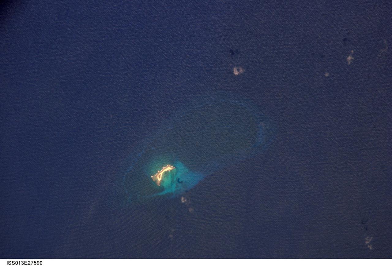
ISS013-E-27590 (27 May 2006) --- Aves Island, Caribbean Sea is featured in this image photographed by an Expedition 13 crewmember on the International Space Station. This image is a rare almost cloud free view of the island and the submerged fringing coral reef that surrounds it. Scientists believe the crosshatch-like pattern of roughness on the surrounding sea surface was caused by variable winds at the time of image acquisition. The island itself currently stands a mere 4 meters above the surrounding sea surface, and in high seas it can be completely submerged. While the low elevation of the island makes it a hazard to shipping, it also provides a major nesting site for green sea turtles (Chelonia mydas) in the Caribbean.
ISS038-E-021397 (24 Dec. 2013) --- The Caribbean country of Cuba is pictured in this nadir image, photographed by one of the Expedition 38 crew members aboard the International Space Station. (Note: North is at the top of the picture.) Cuba is an archipelago of islands in the northern Caribbean Sea at the confluence with the Gulf of Mexico and the Atlantic Ocean. In the southeast, the dark coastal area is home to the Sierra Maestra mountains. It is the highest mountain range on the island, with Pico Turquino reaching nearly 2000 meters. On the central southern coast of the island is the Sierra Del Escambray mountain range, including the 1160 meter-high Pico San Juan, Cuba's second highest peak.

In this ASTER image of Soufriere Hills Volcano on Montserrat in the Caribbean, continued eruptive activity is evident by the extensive smoke and ash plume streaming towards the west-southwest. Significant eruptive activity began in 1995, forcing the authorities to evacuate more than 7,000 of the island's original population of 11,000. The primary risk now is to the northern part of the island and to the airport. Small rockfalls and pyroclastic flows (ash, rock and hot gases) are common at this time due to continued growth of the dome at the volcano's summit. This image was acquired on October 29, 2002 by the Advanced Spaceborne Thermal Emission and Reflection Radiometer (ASTER) on NASA's Terra satellite. With its 14 spectral bands from the visible to the thermal infrared wavelength region, and its high spatial resolution of 15 to 90 meters (about 50 to 300 feet), ASTER images Earth to map and monitor the changing surface of our planet. http://photojournal.jpl.nasa.gov/catalog/PIA03880
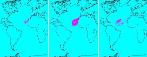
In July of 2005, a continent-sized cloud of hot air and dust originating from the Sahara Desert crossed the Atlantic Ocean and headed towards Florida and the Caribbean, captured by the Atmospheric Infrared Sounder onboard NASA Aqua satellite. A Saharan Air Layer, or SAL, forms when dry air and dust rise from Africa's west coast and ride the trade winds above the Atlantic Ocean. These dust clouds are not uncommon, especially during the months of July and August. They start when weather patterns called tropical waves pick up dust from the desert in North Africa, carry it a couple of miles into the atmosphere and drift westward. http://photojournal.jpl.nasa.gov/catalog/PIA00448
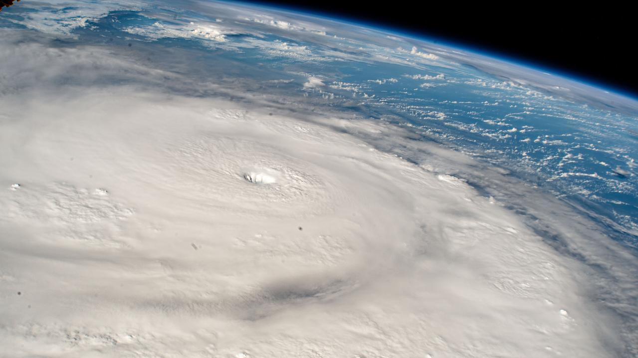
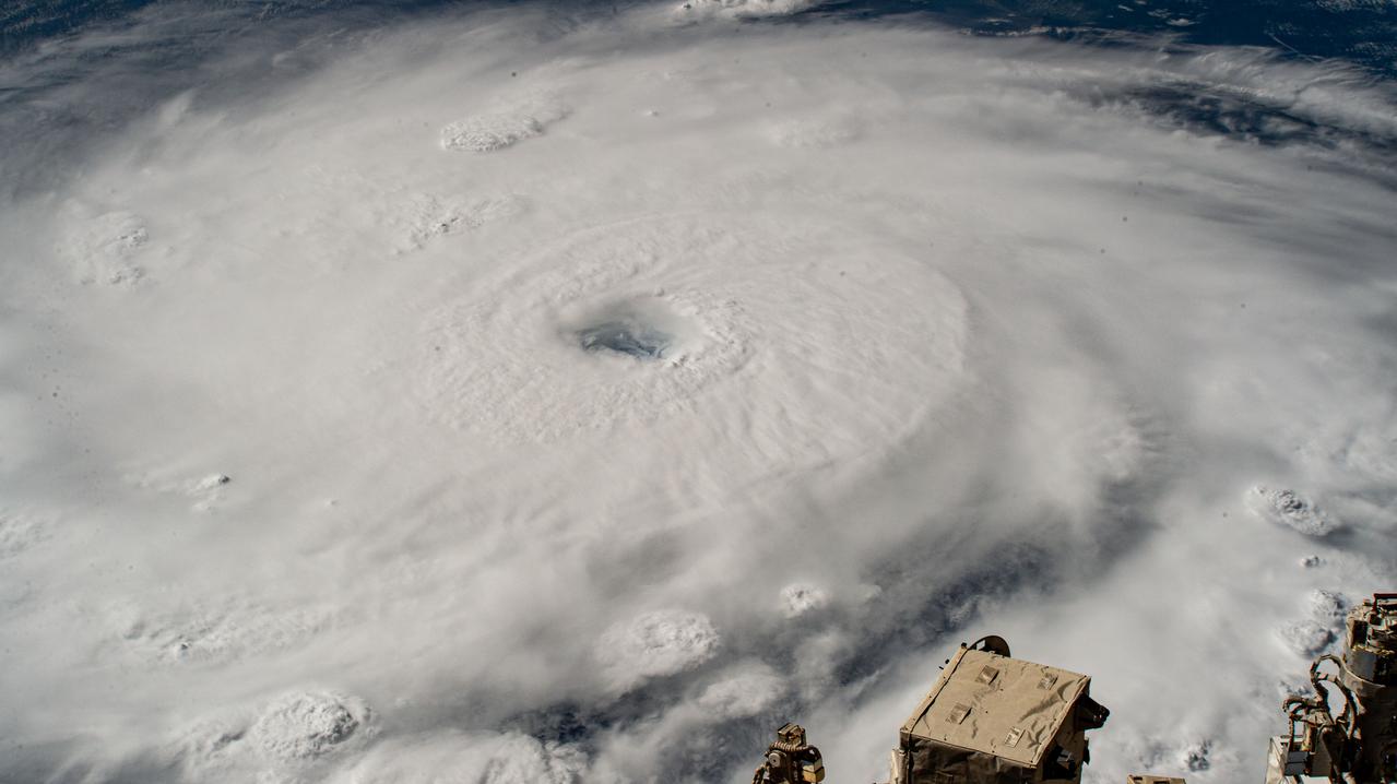
S118-E-07937 (18 Aug. 2007) --- Crewmembers on the Space Shuttle Endeavour captured this image around Noon CDT of Hurricane Dean in the Caribbean. At the time the shuttle and International Space Station passed overhead, the Category 4 storm was moving westerly at 17 mph nearing Jamaica carrying sustained winds of 150 mph.

iss064e025495 (Jan. 21, 2021) --- JAXA (Japan Aerospace Exploration Agency) astronaut and Expedition 64 Flight Engineer Soichi Noguchi enjoys the view of Earth below from the seven-windowed cupola as the International Space Station orbited 260 miles above the Caribbean Sea.
iss067e381585 (Sept. 26, 2022) --- Hurricane Ian is pictured from the International Space Station as it orbited 258 miles above the Caribbean Sea east of Belize. At the time of this photograph, Ian was just south of Cuba gaining strength and heading toward Florida.

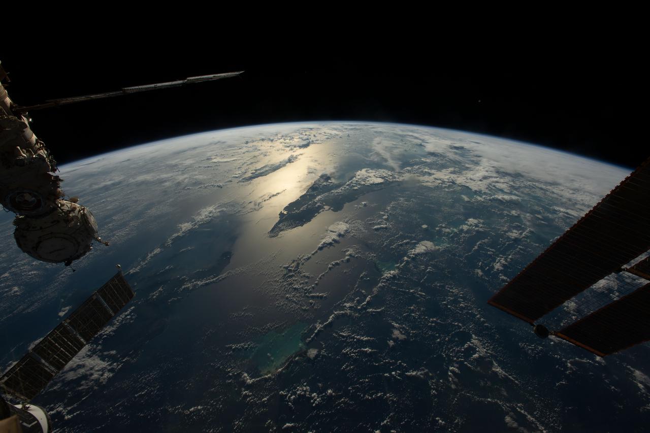
iss067e362302 (Sept. 15, 2022) --- The Soyuz MS-21 crew ship is pictured attached to the Prichal docking module as the International Space Station orbited 259 miles above the Caribbean Sea in between the island nations of Grenada and Trinidad and Tobago..
ISS042E300570 (03/04/2015) --- NASA Astronaut Terry Virts on the International Space Station tweeted this sunny day Caribbean image out to his social media fans on Mar. 4, 2015 with this attached comment: "#Cuba is surrounded by some unbelievable beaches and blue-green waters".
ISS042E135486 (01/10/2015) --- Just another sunny day in the Caribbean sea as viewed by astronauts aboard the International Space Station. This image was tweeted out by NASA astronaut Terry Virts as he captured the Earth observation of #Cuba and #Bahamas on Jan. 10, 2015.
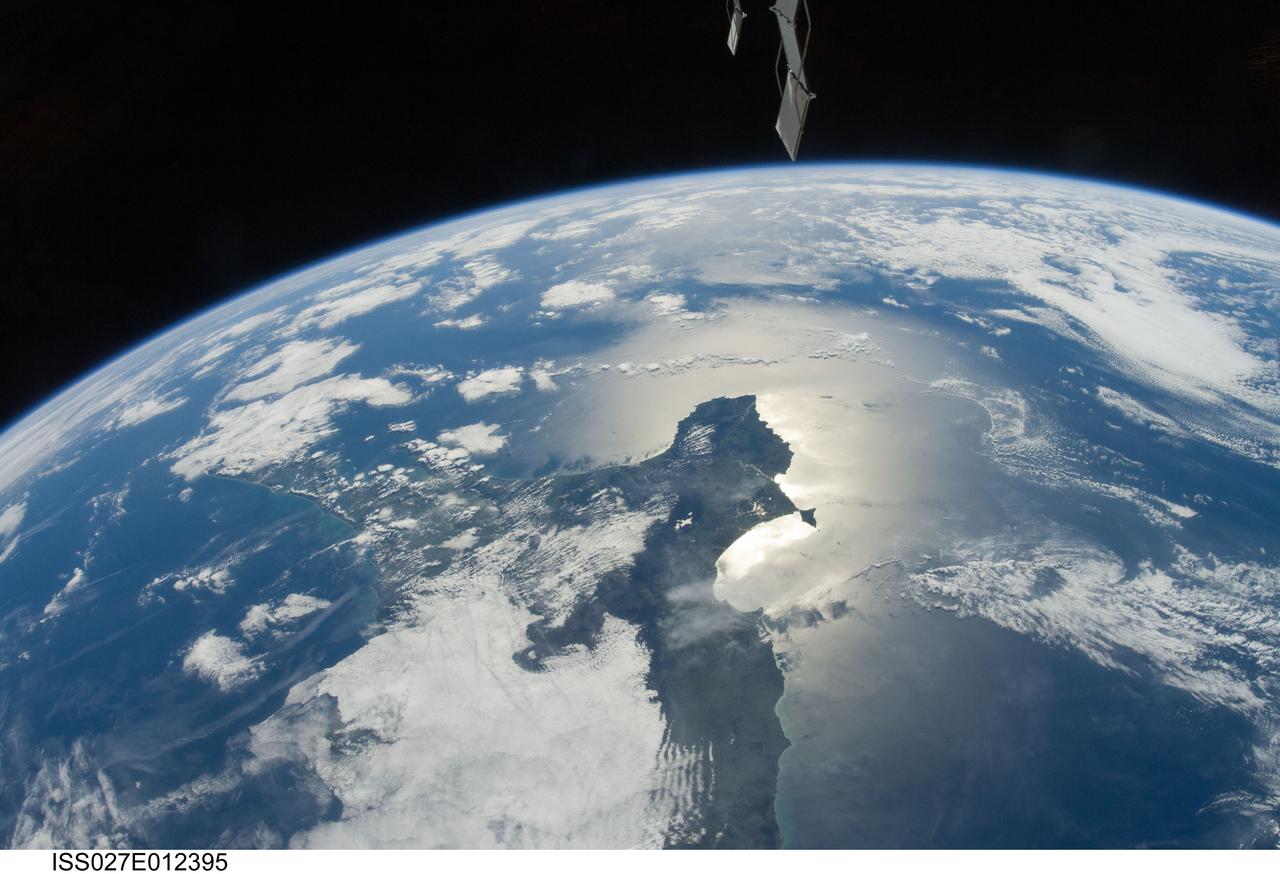
ISS027-E-012395 (13 April 2011)--– One of the Expedition 27 crew members aboard the International Space Station photographed this southeastward looking panoramic view centered on the Azuero Peninsula of Panama. The southwestern Caribbean Sea and the cloud-covered Isthmus of Panama are to the left and the Gulf of Panama and the eastern Pacific Ocean with sun glint are on the right.

iss054e012391 (Jan. 1, 2018) --- Despite the cloudiness during this nighttime photograph taken by Expedition 54 crew members aboard the International Space Station, the Caribbean islands of (from top left to bottom right) Puerto Rico, Cuba, Haiti and the Dominican Republic are seen from an altitude of 250 miles.
iss055e005471 (March 25, 2018) --- This view of Cuba looks from east to west and reaches the cities of Santiago de Cuba on its west coast and Havana on its east coast. The sun's glint is reflected off the Caribbean Sea on Cuba's southern coast.
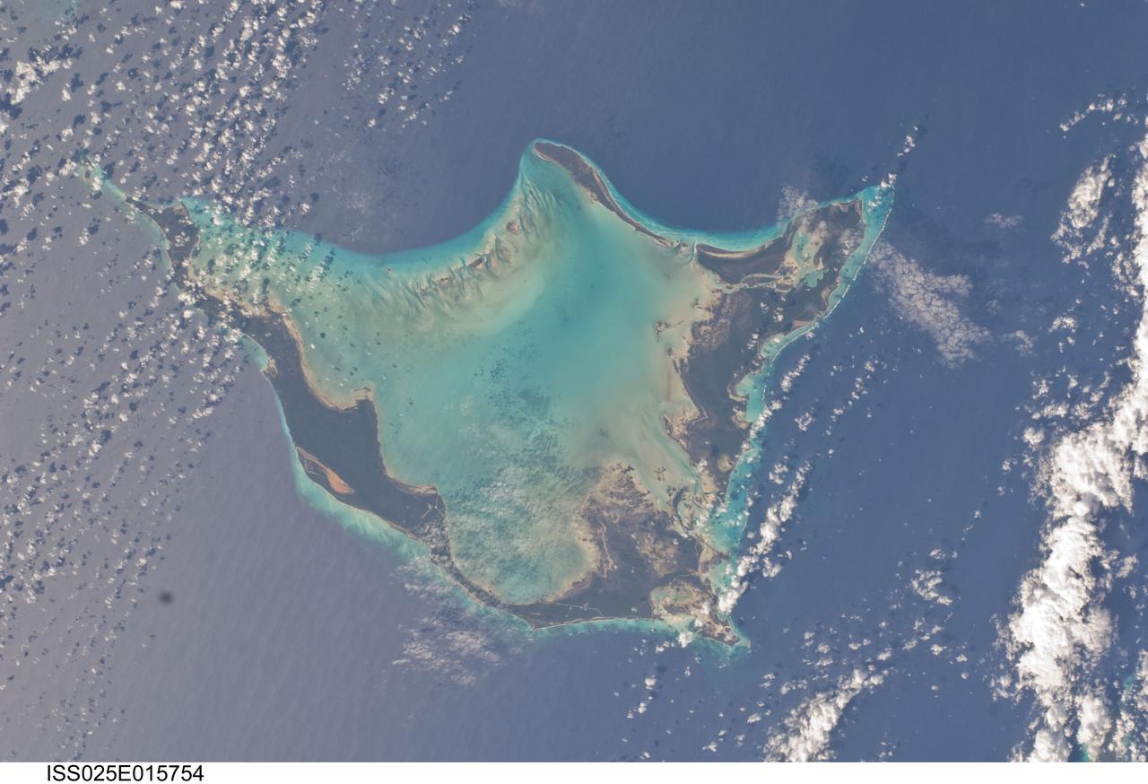
ISS025-E-015754 (16 Nov. 2010) --- Photographed by one the Expedition 25 crew members aboard the International Space Station, orbiting 220 miles above Earth, this horseshoe shaped feature is Acklins Island in the Bahamas chain in the Caribbean.
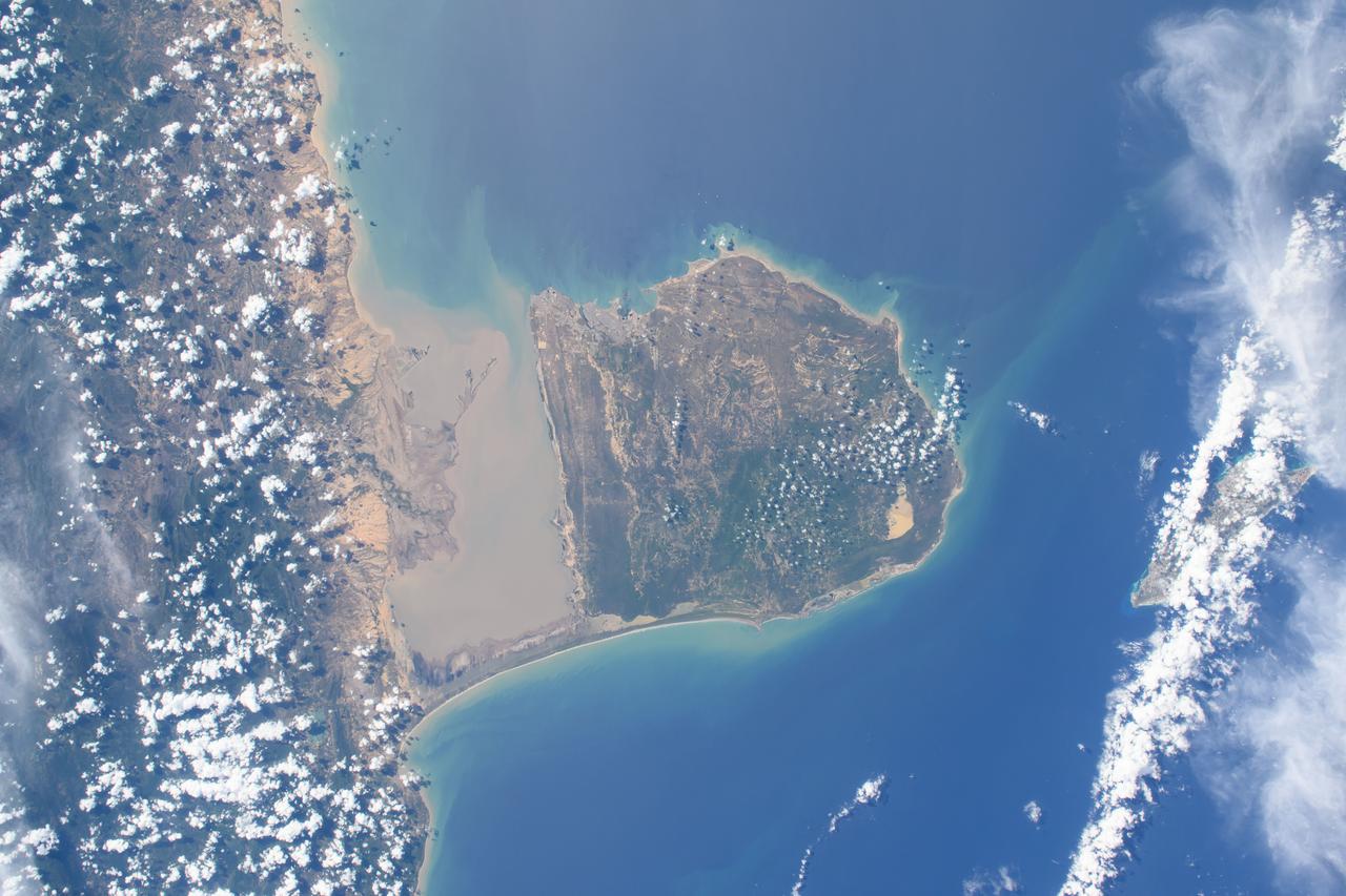
ISS040-E-018752 (24 June 2014) --- One of the Expedition 40 crew members aboard the International Space Station, flying at an altitude of 223 nautical miles, photographed this image of the Caribbean Coast of Belize near the point where it borders Mexico's Yucatan Peninsula. Belize has more than 200 islands or ?cayes.?

iss055e023899 (April 15, 2018) --- The United States island territory of Puerto Rico and the surrounding blue waters of the Caribbean Sea on its southern coast and the Atlantic Ocean on its northern coast were pictured by an Expedition 55 crew member aboard the International Space Station.
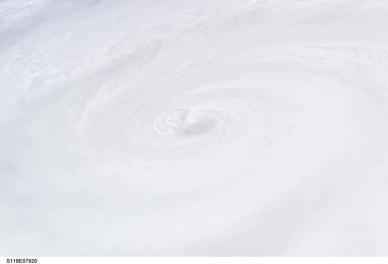
S118-E-07920 (18 Aug. 2007) --- Crewmembers on the Space Shuttle Endeavour captured this image around Noon CDT of Hurricane Dean in the Caribbean. At the time the shuttle and International Space Station passed overhead, the Category 4 storm was moving westerly at 17 mph nearing Jamaica carrying sustained winds of 150 mph.
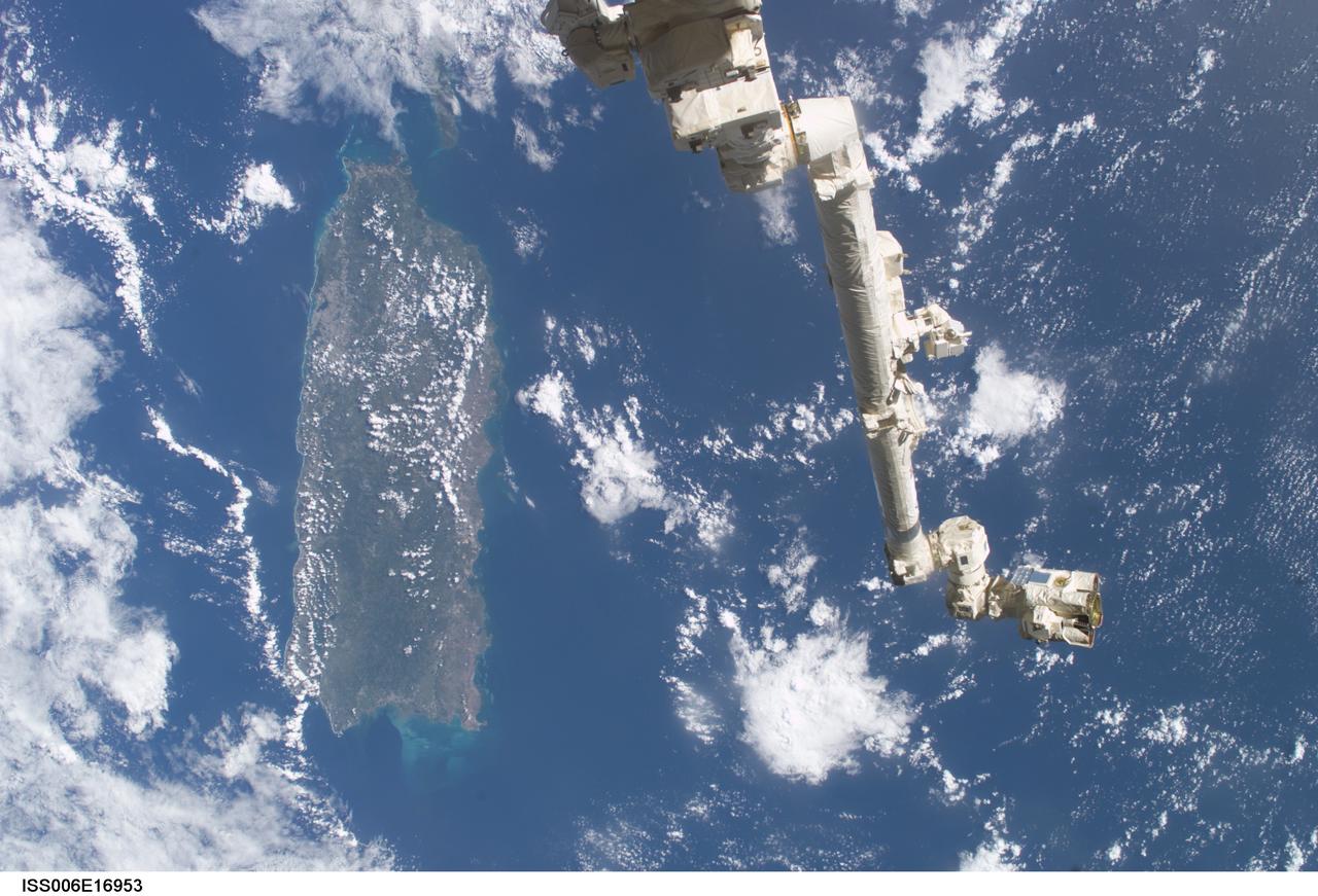
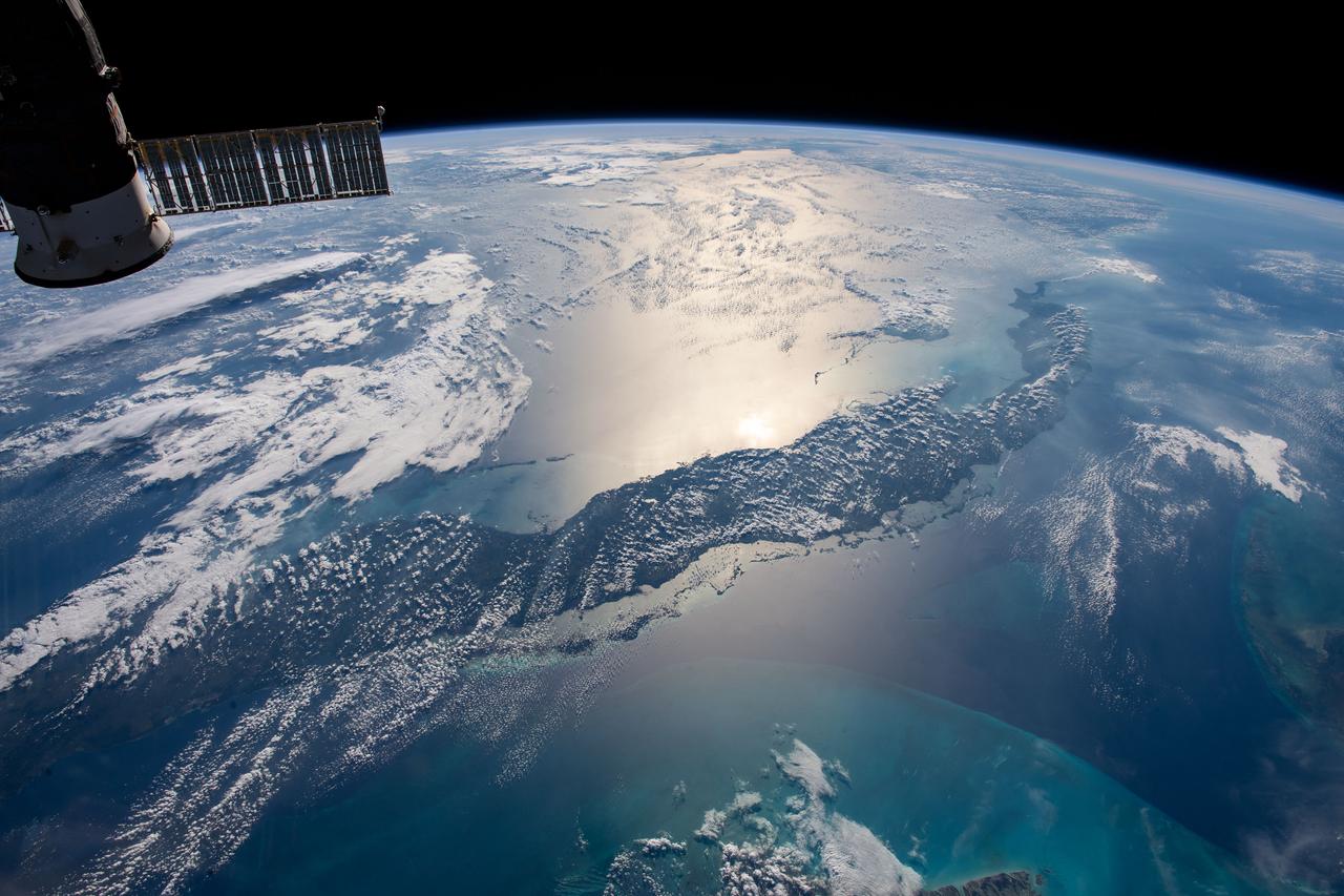
ISS006-E-16953 (9 January 2003) --- The Space Station Remote Manipulator System (SSRMS) or Canadarm2 is backdropped against the Caribbean Sea in this digital still camera's view taken from the International Space Station (ISS). Puerto Rico is in the left side of the frame.

iss071e009021 (April 15, 2024) -- The Zapata Peninsula on the southern coast of Cuba is pictured from the International Space Station as it orbited nearly 260 miles above. Both a Biosphere Reserve and National Park, it's home to diverse ecosystems, including coral reefs in the cove of the Caribbean Sea.
iss067e381585 (Sept. 26, 2022) --- Hurricane Ian is pictured from the International Space Station as it orbited 258 miles above the Caribbean Sea east of Belize. At the time of this photograph, Ian was just south of Cuba gaining strength and heading toward Florida.
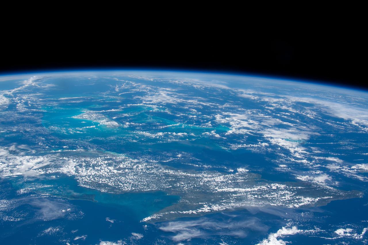
This image from NASA EarthKAM captures the tropical beauty of the major islands of the Little Bahama Bank, the most northerly of the island groups that comprise the Bahamas.
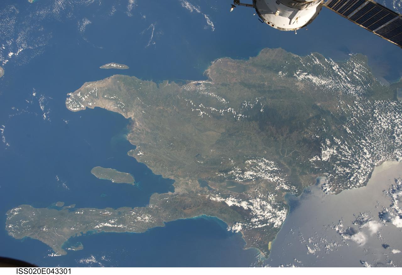
ISS020-E-043301 (28 Sept. 2009) ?-- A view of the Caribbean island of Hispaniola from the International Space Station. This island is comprised of Haiti (in the center left of the image) and the Dominican Republic and is part of the Greater Antilles island chain which lies along the geological boarder of the North America Plate and the Caribbean Plate. A major fault line in the region, Enriquillo-Plantain Garden Fault, runs along the longer peninsula, in the foreground, and just south of Port-Au-Prince. Part of a docked Russian spacecraft can be seen in the foreground. The epicenter of the recent disastrous earthquake occurred near this fault. This image was taken by the Expedition 20 crew on the International Space Station on Sept. 28, 2009 using a 25 mm lens setting.
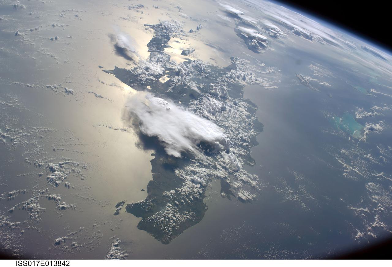
ISS017-E-013842 (19 Aug. 2008) --- A serene view of a portion of the Greater Antilles islands in the Caribbean Sea. The island of Hispaniola is in the foreground, comprised of the Dominican Republic and Haiti (in the sunglint). Looking toward the horizon, the eastern tip of Cuba is seen through the clouds and thunderstorms that are scattered over the islands. The light blue shallower areas, to the right or north of Hispaniola and extending toward the Earths limb, are the Turks and Caicos islands and the Acklins Islands. The Great Inagua island is off the coast of Haiti. These islands are located along the geological border of the North American Plate (to the right) and the Caribbean Plate (to the left). The photo was taken by the Expedition 17 crew onboard the International Space Station on Aug 19, 2008 with a 28 mm lens.
Saint Croix is a district of the U.S. Virgin Islands, in the Caribbean Sea. First inhabited by indigenous groups, the island was visited by Columbus in 1493. By the end of the 16th century, the island was uninhabited, the native population dispersed or killed. Starting in the 17th century, the island was successively claimed by the Spanish, the French, the French West India Company, and, for the next 200 years, the Danish West India Company. In 1801 the British invaded and took control; followed by Denmark-Norway a year later. Then again the British, and again Denmark in 1815. One hundred years later, in 1915, Denmark sold the Virgin Islands to the United States, and the inhabitants were granted US citizenship. Saint Croix was home to HOVENSA, one of the world's largest oil refineries. In 2012, the refinery closed, and tourism is now the main source of revenue (Wikipedia). The image covers an area of 18.7 by 36.2 km, was acquired March 10, 2011, and is located at 17.7 degrees north, 64.7 degrees west. https://photojournal.jpl.nasa.gov/catalog/PIA22894
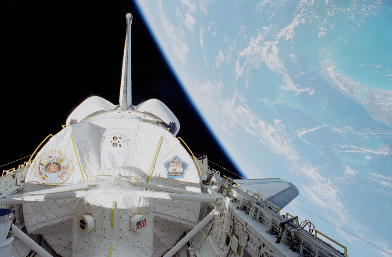
STS083-464-005 (4-8 April 1997) --- This view, photographed not long after orbital insertion, shows Spacelab Module in the cargo bay of the Space Shuttle Columbia, backdropped against the darkness of space and the Bahama Islands area of the Caribbean Sea. The logo on the left pays tribute to the various nations participating in the mission. The decal on the right is the pentagonal logo for the Microgravity Science Laboratory 1 (MSL-1) mission.
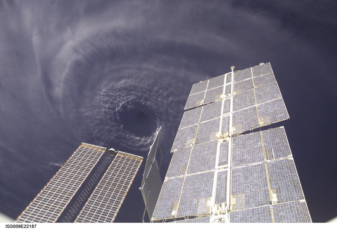
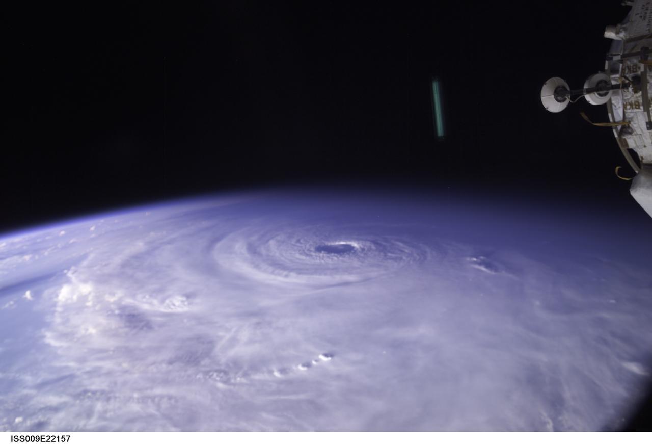
ISS009-E-22187 (11 September 2004) --- This image features the eye of Hurricane Ivan at center, partially framed by solar array panels on the International Space Station. One of the strongest hurricanes on record, Ivan was photographed Saturday from an altitude of about 230 miles by Astronaut Edward M. (Mike) Fincke, NASA ISS science officer and flight engineer, aboard the orbital outpost. At the time, Ivan was in the western Caribbean Sea and reported to have winds of 160 mph.
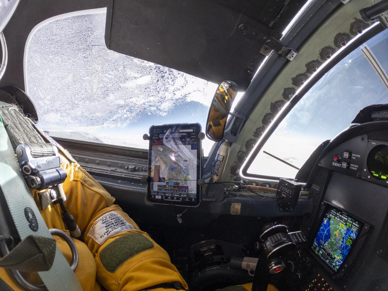
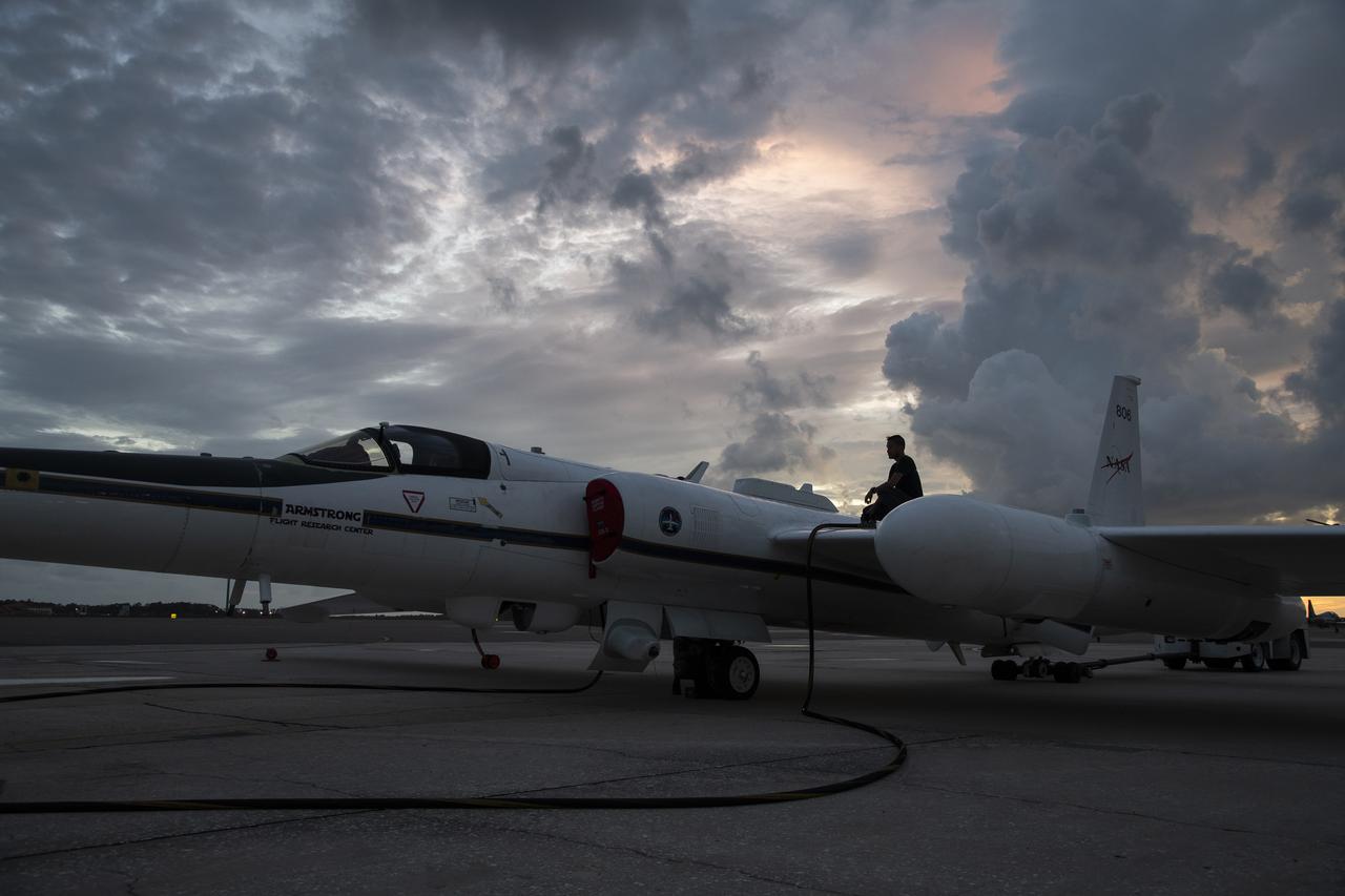
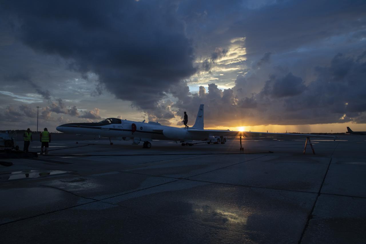
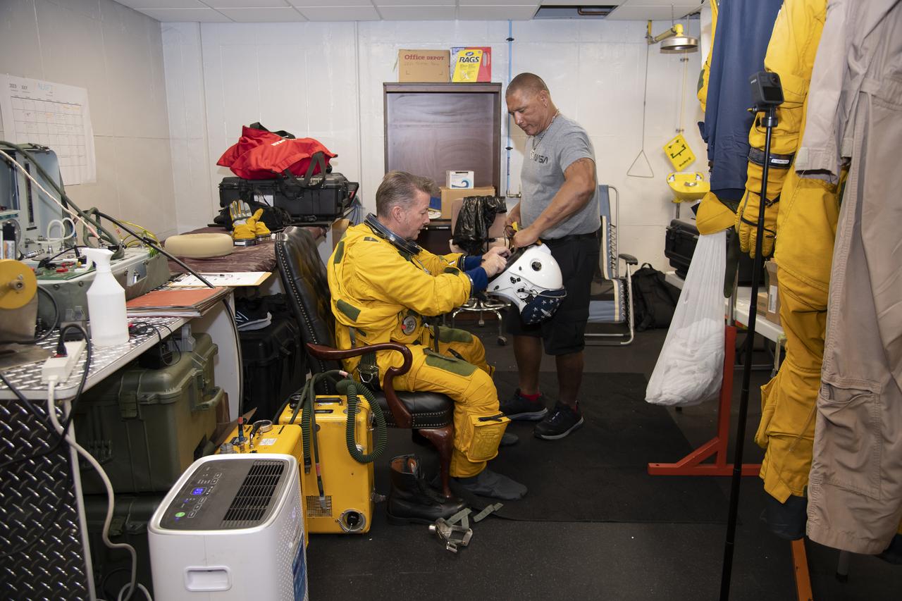
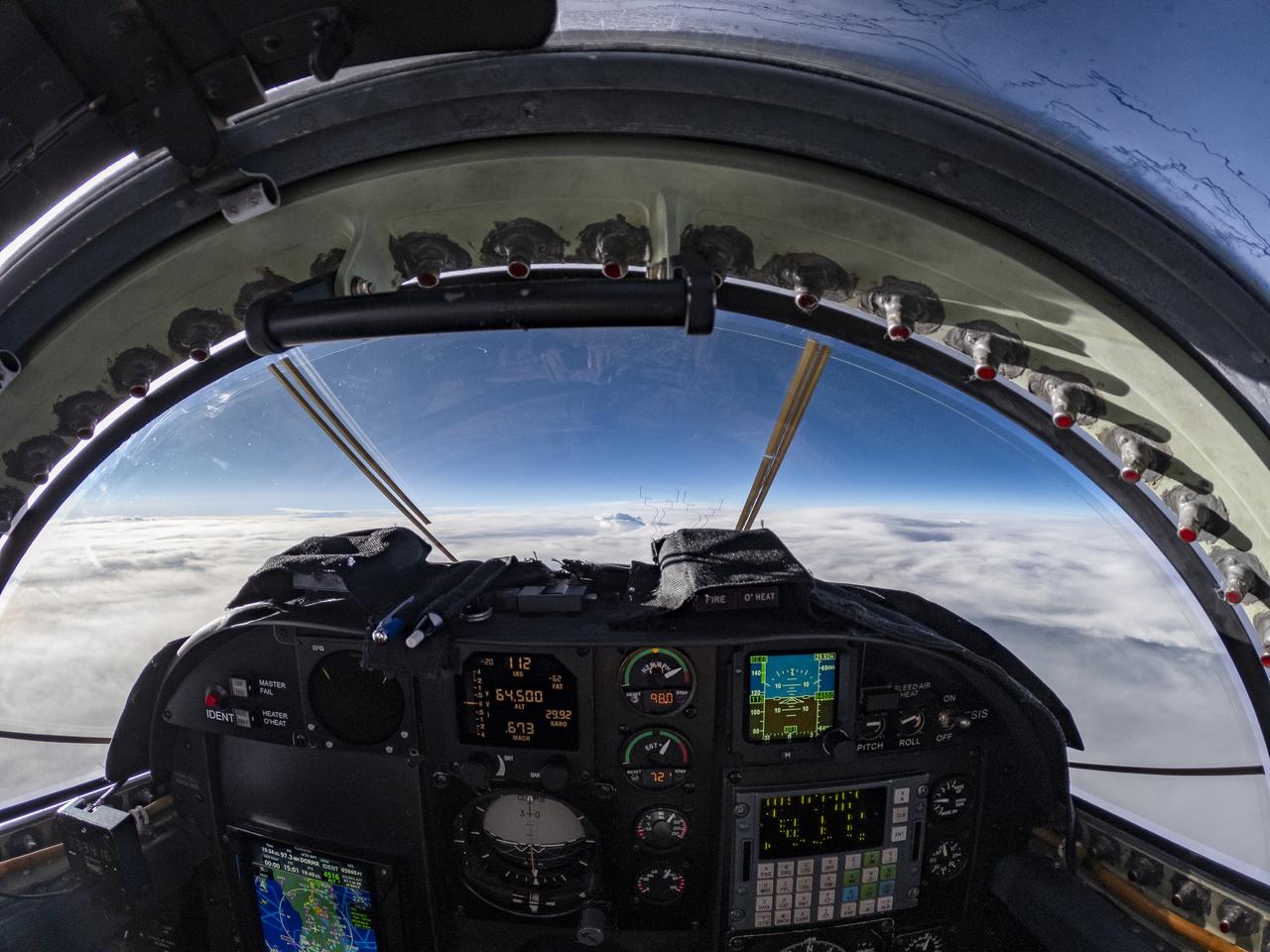
The ALOFT mission, Airborne Lightning Observatory for Fly’s eye simulator and Terrestrial gamma ray flashes, is a collaboration between NASA and the University of Bergen, Norway. NASA Armstrong Flight Research Center’s ER-2 aircraft flies just above the height of thunderclouds over the Floridian and Caribbean coastlines to collect data about lightning glows and terrestrial gamma ray flashes. Scientists expect to collect more accurate data than ever before that can advance the study of high-energy radiation emissions from thunderstorms.
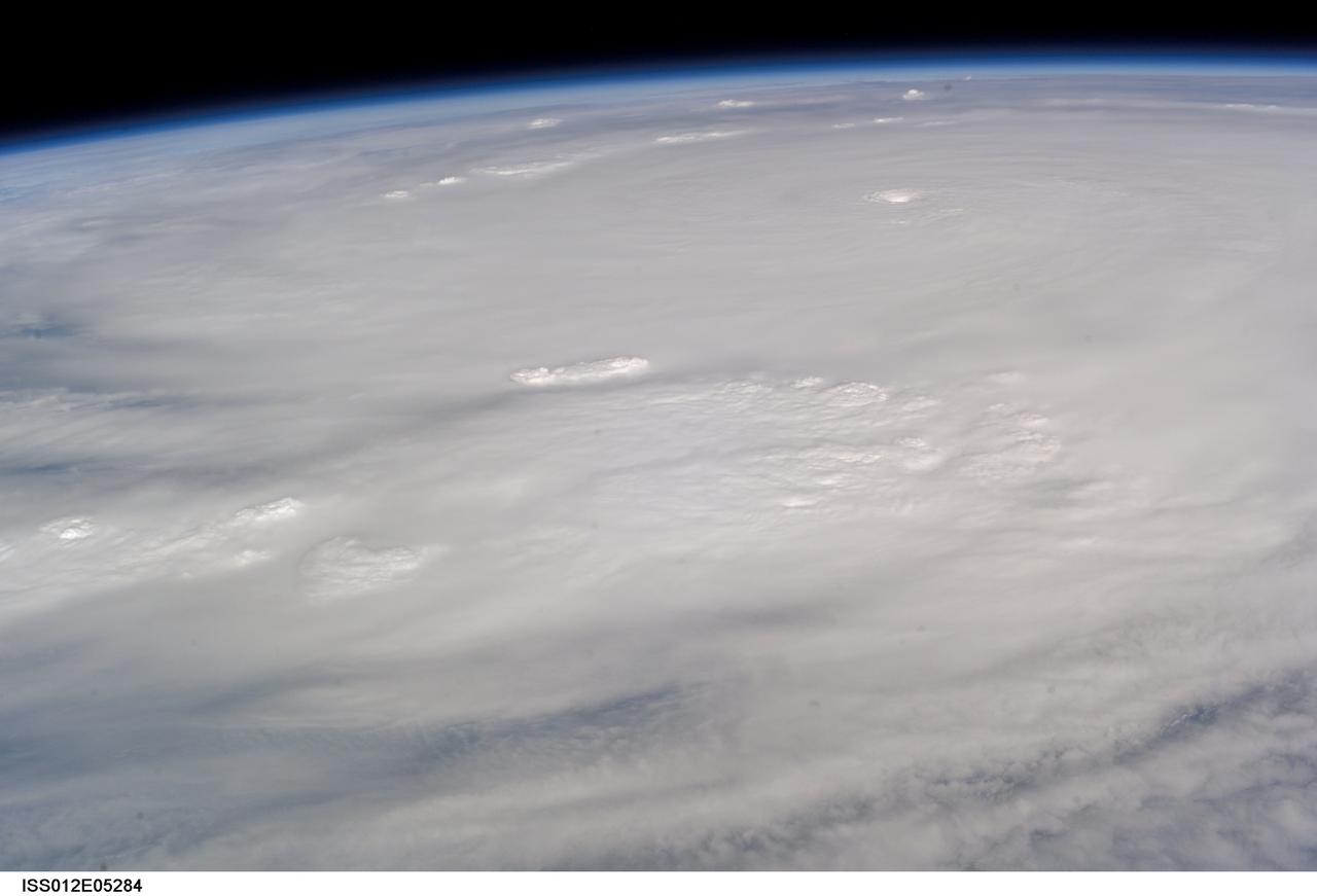
ISS012-E-5284 (19 Oct. 2005) --- This image of Hurricane Wilma was taken at 8:24 a.m. CDT Wednesday, Oct. 19, by the crew aboard NASA's international space station as the complex flew 222 miles above the storm. At the time, Wilma was the strongest Atlantic hurricane in history, with winds near 175 miles per hour. The storm was located in the Caribbean Sea, 340 miles southeast of Cozumel, Mexico.

The ALOFT mission, Airborne Lightning Observatory for Fly’s eye simulator and Terrestrial gamma ray flashes, is a collaboration between NASA and the University of Bergen, Norway. NASA Armstrong Flight Research Center’s ER-2 aircraft flies just above the height of thunderclouds over the Floridian and Caribbean coastlines to collect data about lightning glows and terrestrial gamma ray flashes. Scientists expect to collect more accurate data than ever before that can advance the study of high-energy radiation emissions from thunderstorms.

The ALOFT mission, Airborne Lightning Observatory for Fly’s eye simulator and Terrestrial gamma ray flashes, is a collaboration between NASA and the University of Bergen, Norway. NASA Armstrong Flight Research Center’s ER-2 aircraft flies just above the height of thunderclouds over the Floridian and Caribbean coastlines to collect data about lightning glows and terrestrial gamma ray flashes. Scientists expect to collect more accurate data than ever before that can advance the study of high-energy radiation emissions from thunderstorms.
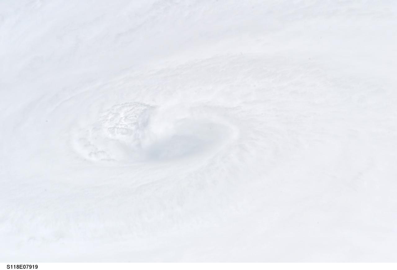
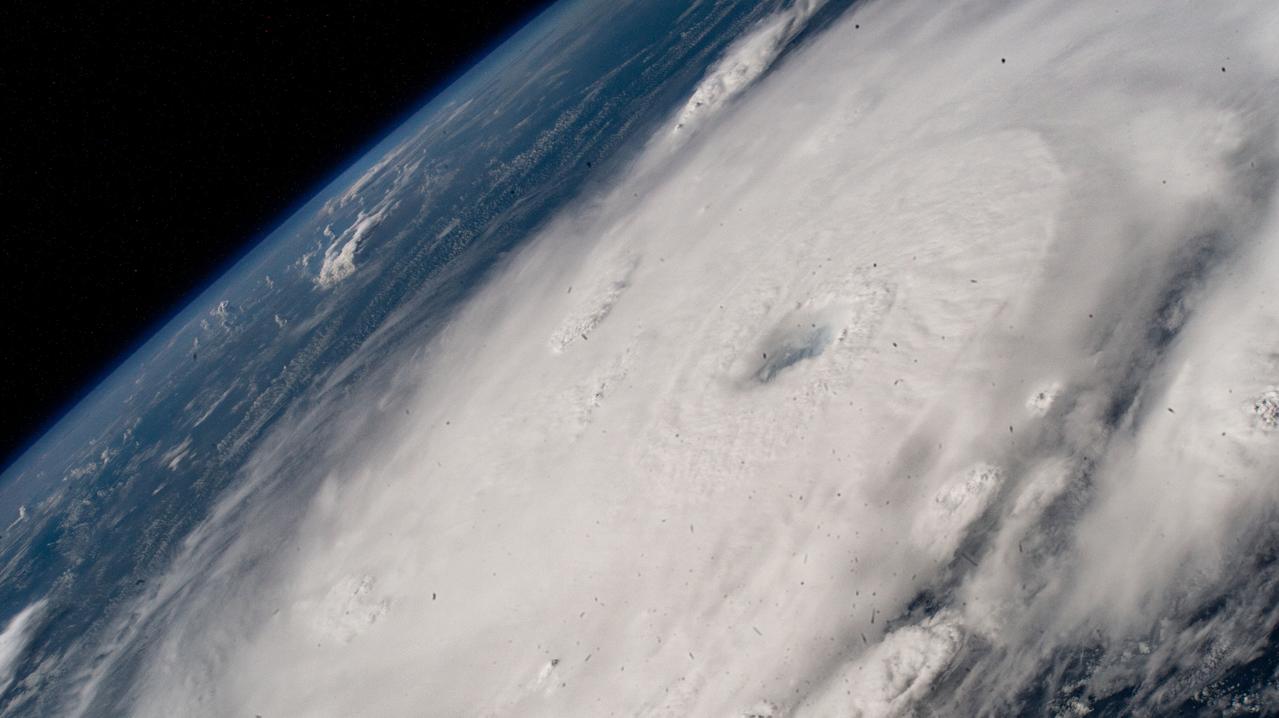
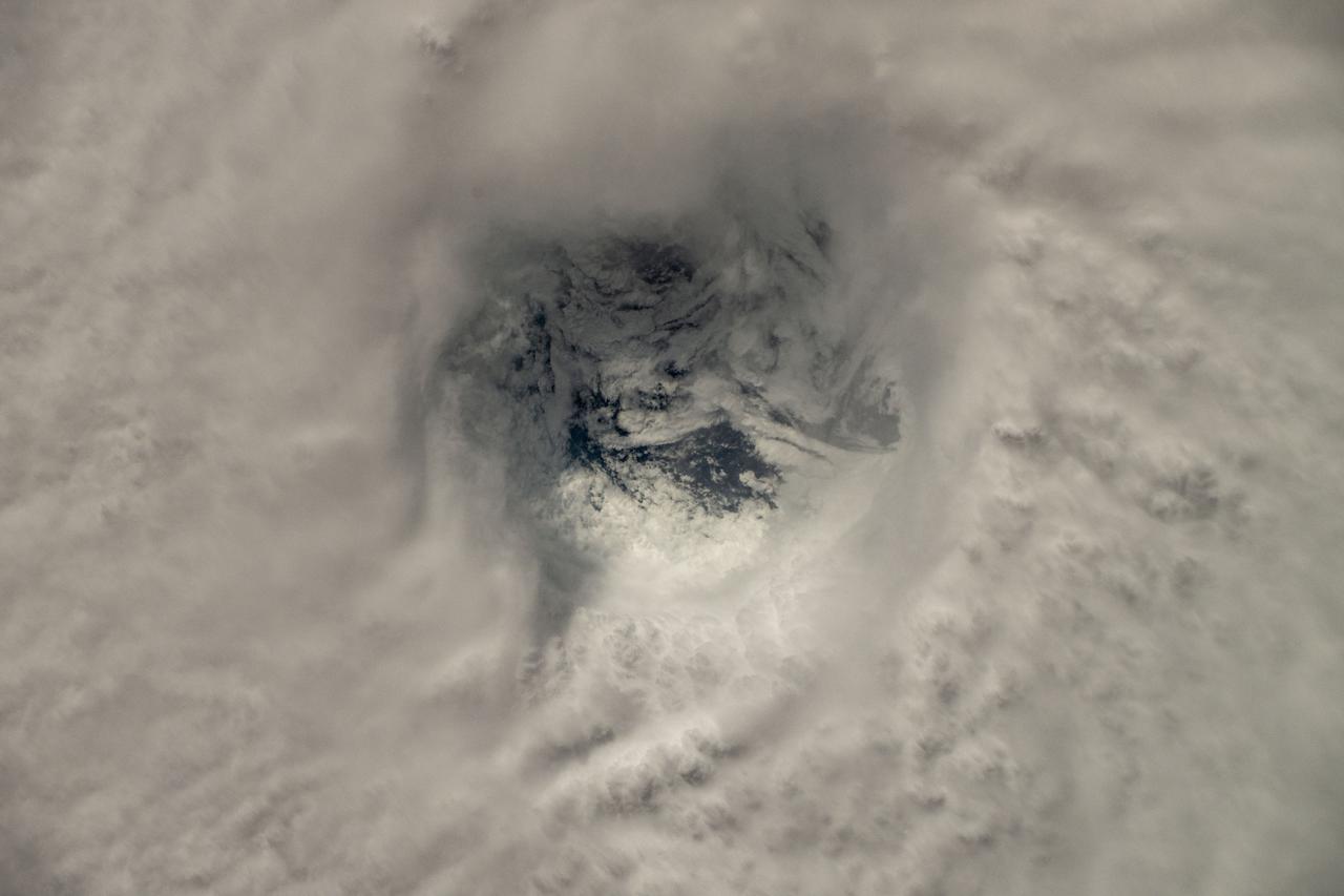
S118-E-07919 (18 Aug. 2007) --- A still photo close-up of the eye of Category 4 Hurricane Dean. Crewmembers on the Space Shuttle Endeavour captured this image around Noon CDT of Hurricane Dean in the Caribbean. At the time the shuttle and International Space Station passed overhead, the Category 4 storm was moving westerly at 17 mph nearing Jamaica carrying sustained winds of 150 mph.
The ALOFT mission, Airborne Lightning Observatory for Fly’s eye simulator and Terrestrial gamma ray flashes, is a collaboration between NASA and the University of Bergen, Norway. NASA Armstrong Flight Research Center’s ER-2 aircraft flies just above the height of thunderclouds over the Floridian and Caribbean coastlines to collect data about lightning glows and terrestrial gamma ray flashes. Scientists expect to collect more accurate data than ever before that can advance the study of high-energy radiation emissions from thunderstorms.
The ALOFT mission, Airborne Lightning Observatory for Fly’s eye simulator and Terrestrial gamma ray flashes, is a collaboration between NASA and the University of Bergen, Norway. NASA Armstrong Flight Research Center’s ER-2 aircraft flies just above the height of thunderclouds over the Floridian and Caribbean coastlines to collect data about lightning glows and terrestrial gamma ray flashes. Scientists expect to collect more accurate data than ever before that can advance the study of high-energy radiation emissions from thunderstorms.
The ALOFT mission, Airborne Lightning Observatory for Fly’s eye simulator and Terrestrial gamma ray flashes, is a collaboration between NASA and the University of Bergen, Norway. NASA Armstrong Flight Research Center’s ER-2 aircraft flies just above the height of thunderclouds over the Floridian and Caribbean coastlines to collect data about lightning glows and terrestrial gamma ray flashes. Scientists expect to collect more accurate data than ever before that can advance the study of high-energy radiation emissions from thunderstorms.
The ALOFT mission, Airborne Lightning Observatory for Fly’s eye simulator and Terrestrial gamma ray flashes, is a collaboration between NASA and the University of Bergen, Norway. NASA Armstrong Flight Research Center’s ER-2 aircraft flies just above the height of thunderclouds over the Floridian and Caribbean coastlines to collect data about lightning glows and terrestrial gamma ray flashes. Scientists expect to collect more accurate data than ever before that can advance the study of high-energy radiation emissions from thunderstorms.
The ALOFT mission, Airborne Lightning Observatory for Fly’s eye simulator and Terrestrial gamma ray flashes, is a collaboration between NASA and the University of Bergen, Norway. NASA Armstrong Flight Research Center’s ER-2 aircraft flies just above the height of thunderclouds over the Floridian and Caribbean coastlines to collect data about lightning glows and terrestrial gamma ray flashes. Scientists expect to collect more accurate data than ever before that can advance the study of high-energy radiation emissions from thunderstorms.
The ALOFT mission, Airborne Lightning Observatory for Fly’s eye simulator and Terrestrial gamma ray flashes, is a collaboration between NASA and the University of Bergen, Norway. NASA Armstrong Flight Research Center’s ER-2 aircraft flies just above the height of thunderclouds over the Floridian and Caribbean coastlines to collect data about lightning glows and terrestrial gamma ray flashes. Scientists expect to collect more accurate data than ever before that can advance the study of high-energy radiation emissions from thunderstorms.
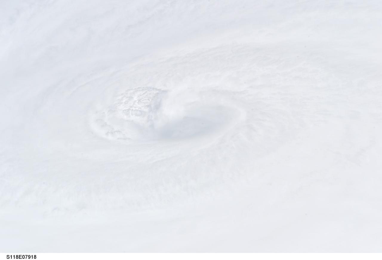
S118-E-07918 (18 Aug. 2007) --- A still photo close-up of the eye of Category 4 Hurricane Dean. Crewmembers on the Space Shuttle Endeavour captured this image around Noon CDT of Hurricane Dean in the Caribbean. At the time the shuttle and International Space Station passed overhead, the Category 4 storm was moving westerly at 17 mph nearing Jamaica carrying sustained winds of 150 mph.

The ALOFT mission, Airborne Lightning Observatory for Fly’s eye simulator and Terrestrial gamma ray flashes, is a collaboration between NASA and the University of Bergen, Norway. NASA Armstrong Flight Research Center’s ER-2 aircraft flies just above the height of thunderclouds over the Floridian and Caribbean coastlines to collect data about lightning glows and terrestrial gamma ray flashes. Scientists expect to collect more accurate data than ever before that can advance the study of high-energy radiation emissions from thunderstorms.
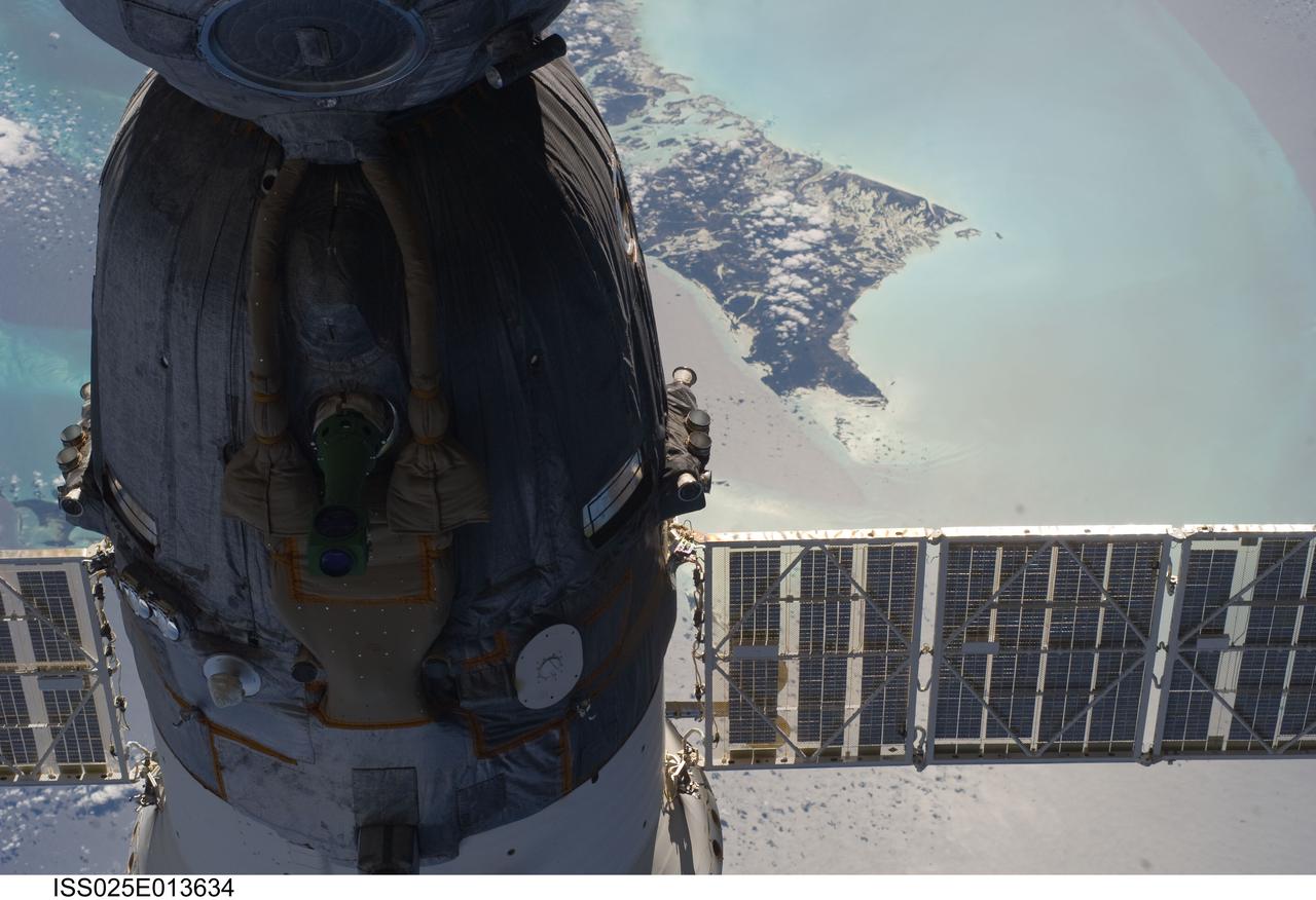
ISS025-E-013634 (9 Nov. 2010) --- The Soyuz TMA-19 spacecraft dominates the foreground of this image exposed by one of the Expedition 25 crew members as the International Space Station and the docked Russian spacecraft were 220 miles above the Caribbean Sea. The island of Andros, in the Bahamas chain, can be seen in the background. Three members of the current six-person staffing aboard the orbital complex are expected to return to Earth in the Soyuz in about two and half weeks.
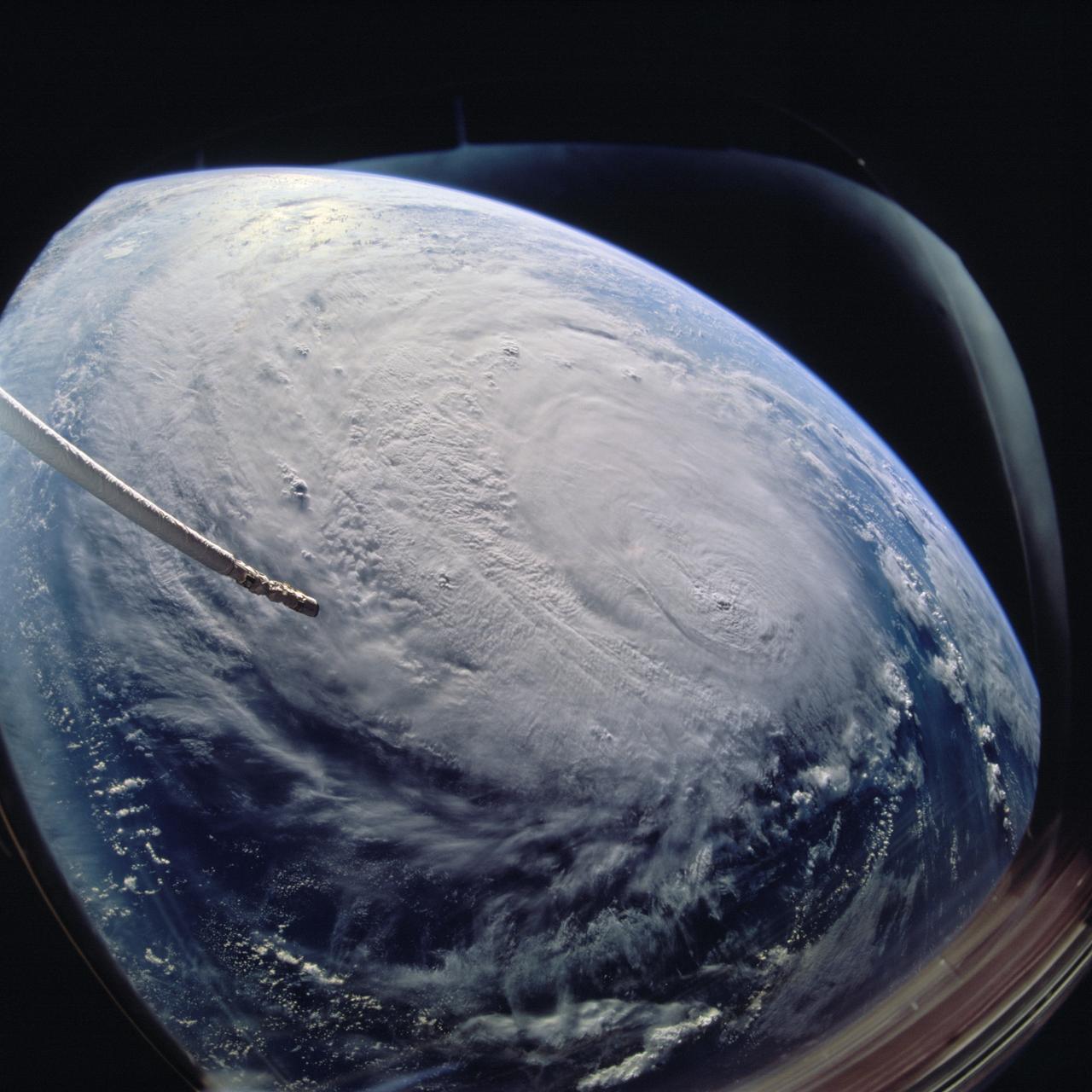
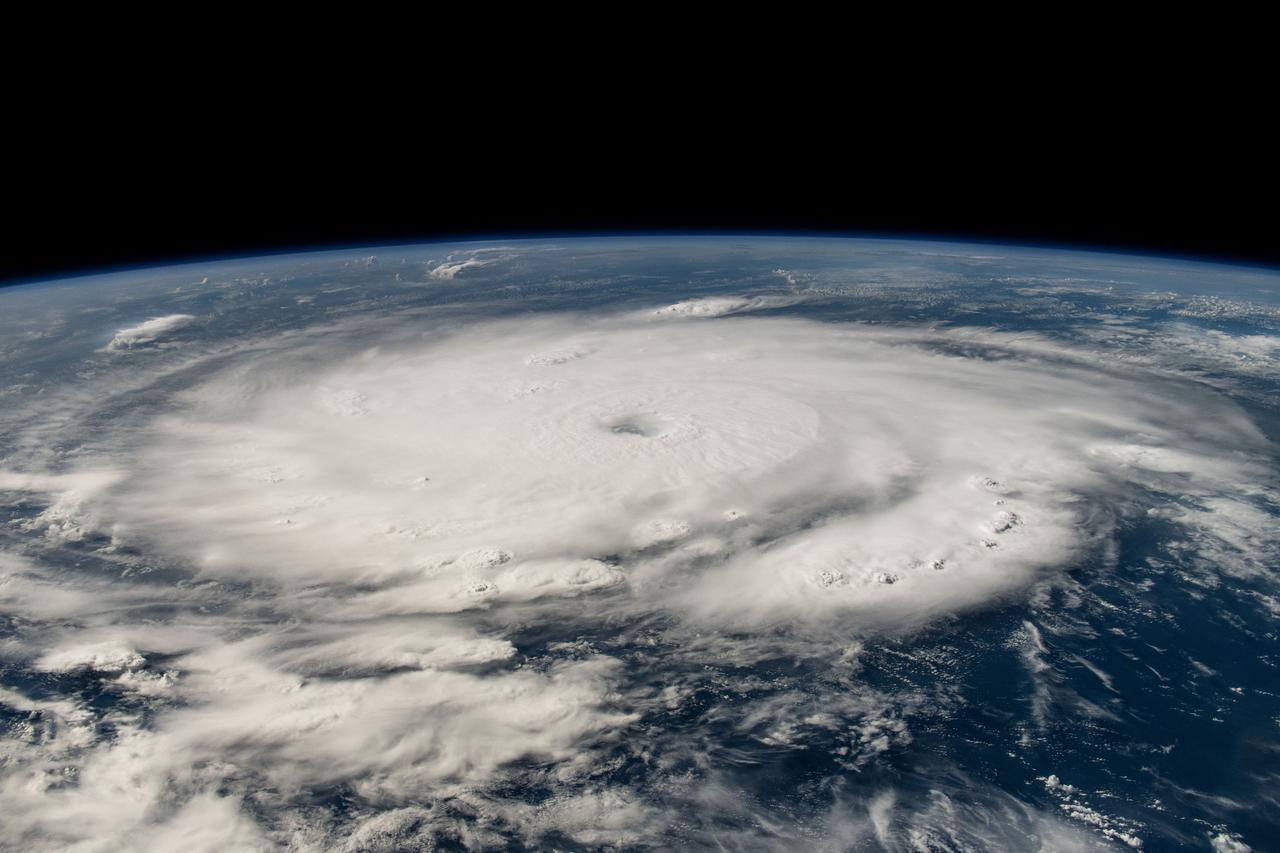
ISS009-E-22157 (11 September 2004) ---- This image of Hurricane Ivan, one of the strongest hurricanes on record, was taken Saturday from an altitude of about 230 miles by Astronaut Edward M. (Mike) Fincke, NASA ISS science officer and flight engineer, looking out the window of the International Space Station. At the time, Ivan was in the western Caribbean Sea and reported to have winds of 160 mph
ISS040-E-063578 (15 July 2014) --- One of the Expedition 40 crew members aboard the Earth-orbiting International Space Station, flying some 225 nautical miles above the Caribbean Sea in the early morning hours of July 15, photographed this north-looking panorama that includes parts of Cuba, the Bahamas and Florida, and even runs into several other areas in the southeastern U.S. The long stretch of lights to the left of center frame gives the shape of Miami.

The ALOFT mission, Airborne Lightning Observatory for Fly’s eye simulator and Terrestrial gamma ray flashes, is a collaboration between NASA and the University of Bergen, Norway. NASA Armstrong Flight Research Center’s ER-2 aircraft flies just above the height of thunderclouds over the Floridian and Caribbean coastlines to collect data about lightning glows and terrestrial gamma ray flashes. Scientists expect to collect more accurate data than ever before that can advance the study of high-energy radiation emissions from thunderstorms.
The ALOFT mission, Airborne Lightning Observatory for Fly’s eye simulator and Terrestrial gamma ray flashes, is a collaboration between NASA and the University of Bergen, Norway. NASA Armstrong Flight Research Center’s ER-2 aircraft flies just above the height of thunderclouds over the Floridian and Caribbean coastlines to collect data about lightning glows and terrestrial gamma ray flashes. Scientists expect to collect more accurate data than ever before that can advance the study of high-energy radiation emissions from thunderstorms.
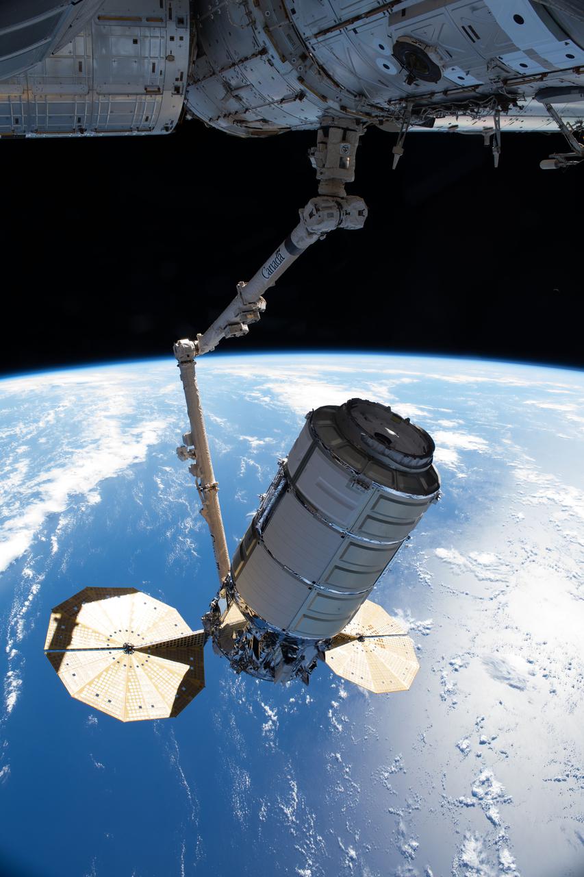
iss065e241472 (Aug. 12, 2021) --- Northrop Grumman's Cygnus space freighter, in the grips of the Canadarm2 robotic arm, is remotely maneuvered by ground controllers toward the International Space Station's Unity module where it was installed for three months of cargo operations. The International Space Station was orbiting 261 miles above the Atlantic Ocean near the Caribbean Sea at the time of this photograph.
The ALOFT mission, Airborne Lightning Observatory for Fly’s eye simulator and Terrestrial gamma ray flashes, is a collaboration between NASA and the University of Bergen, Norway. NASA Armstrong Flight Research Center’s ER-2 aircraft flies just above the height of thunderclouds over the Floridian and Caribbean coastlines to collect data about lightning glows and terrestrial gamma ray flashes. Scientists expect to collect more accurate data than ever before that can advance the study of high-energy radiation emissions from thunderstorms.

The ALOFT mission, Airborne Lightning Observatory for Fly’s eye simulator and Terrestrial gamma ray flashes, is a collaboration between NASA and the University of Bergen, Norway. NASA Armstrong Flight Research Center’s ER-2 aircraft flies just above the height of thunderclouds over the Floridian and Caribbean coastlines to collect data about lightning glows and terrestrial gamma ray flashes. Scientists expect to collect more accurate data than ever before that can advance the study of high-energy radiation emissions from thunderstorms.
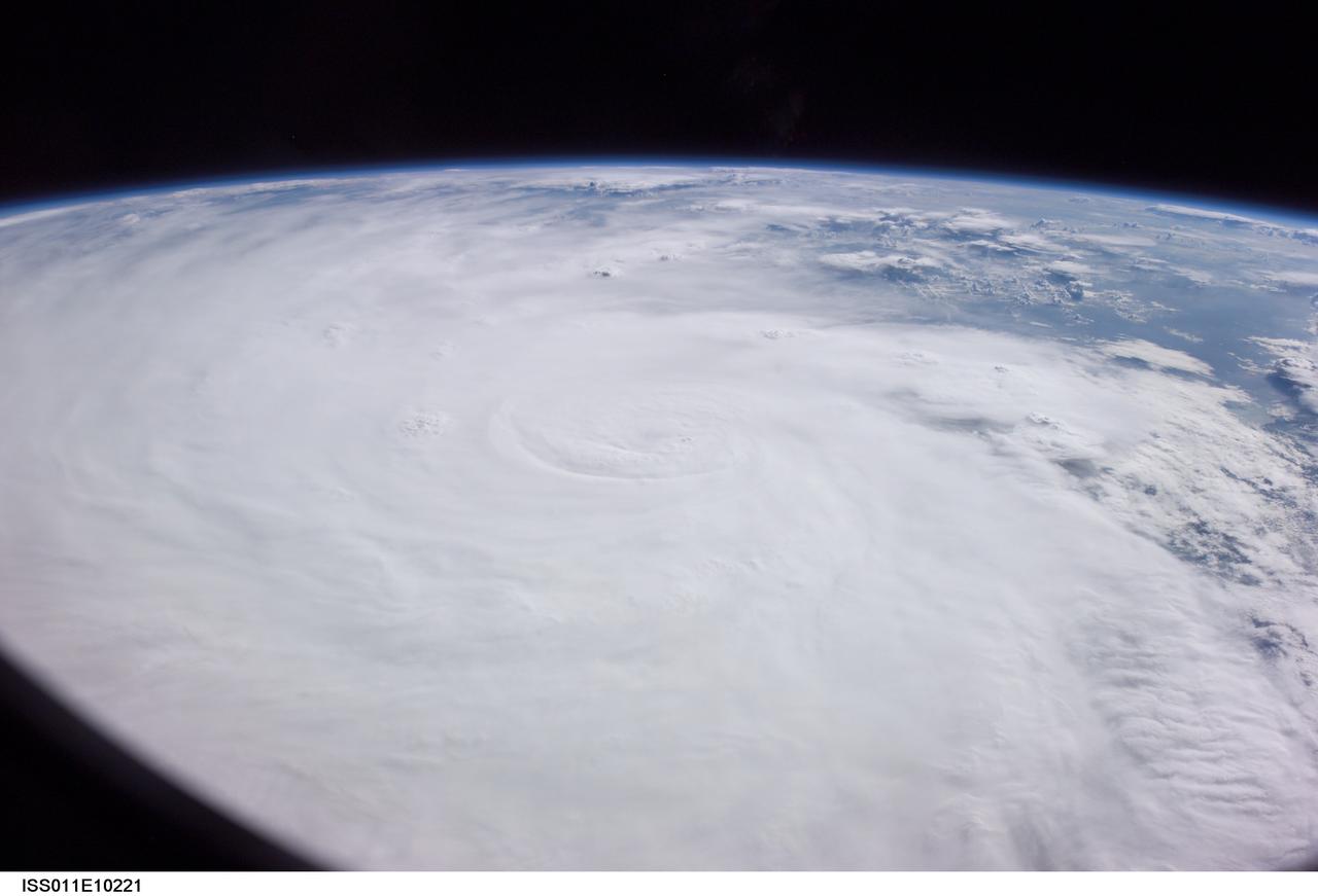
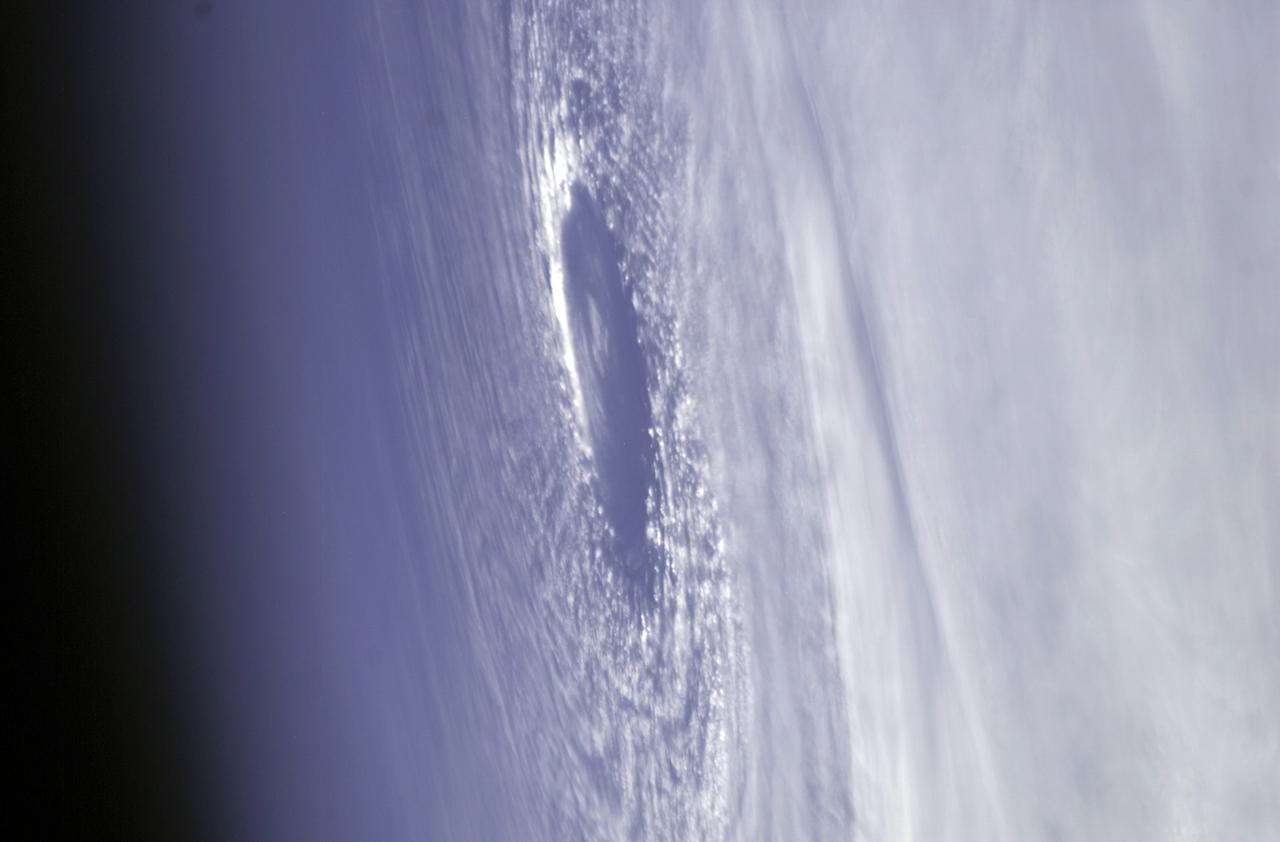
ISS011-E-10221 (7 July 2005) --- At the time of this Expedition 11 digital still camera's image, Hurricane Dennis was churning northwestward through the Caribbean Sea between Jamaica and eastern Cuba packing winds of up to 115 miles per hour. Even though the hurricane had just attained Category 3 intensity, the eye had not yet cleared. This high-oblique, panoramic view, taken through a 28mm lens at 21:14:00 gmt, is looking southwest.