
Data from the American Airlines ramp tower at Charlotte airport is among the information to be coordinated as part of ATD-2.

American Airlines aircraft in the gate area at Charlotte Douglas International Airport where ATD-2 began in 2017.
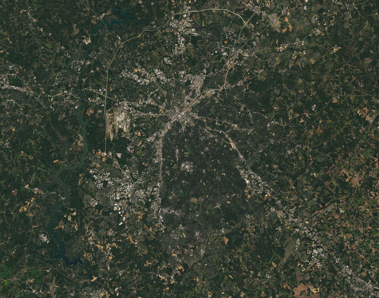
Landsat 7 image of the Charlotte, NC area acquired Oct 18, 2015. Landsat 7 is a U.S. satellite used to acquire remotely sensed images of the Earth's land surface and surrounding coastal regions. It is maintained by the Landsat 7 Project Science Office at the NASA Goddard Space Flight Center in Greenbelt, MD...Landsat satellites have been acquiring images of the Earth’s land surface since 1972. Currently there are more than 2 million Landsat images in the National Satellite Land Remote Sensing Data Archive. For more information visit: <a href="http://landsat.usgs.gov/" rel="nofollow">landsat.usgs.gov/</a>..To learn more about the Landsat satellite go to:.<a href="http://landsat.gsfc.nasa.gov/" rel="nofollow">landsat.gsfc.nasa.gov/</a> Credit: NASA/GSFC/Landsat 7 <b><a href="http://www.nasa.gov/audience/formedia/features/MP_Photo_Guidelines.html" rel="nofollow">NASA image use policy.</a></b> <b><a href="http://www.nasa.gov/centers/goddard/home/index.html" rel="nofollow">NASA Goddard Space Flight Center</a></b> enables NASA’s mission through four scientific endeavors: Earth Science, Heliophysics, Solar System Exploration, and Astrophysics. Goddard plays a leading role in NASA’s accomplishments by contributing compelling scientific knowledge to advance the Agency’s mission. <b>Follow us on <a href="http://twitter.com/NASAGoddardPix" rel="nofollow">Twitter</a></b> <b>Like us on <a href="http://www.facebook.com/pages/Greenbelt-MD/NASA-Goddard/395013845897?ref=tsd" rel="nofollow">Facebook</a></b> <b>Find us on <a href="http://instagrid.me/nasagoddard/?vm=grid" rel="nofollow">Instagram</a></b>
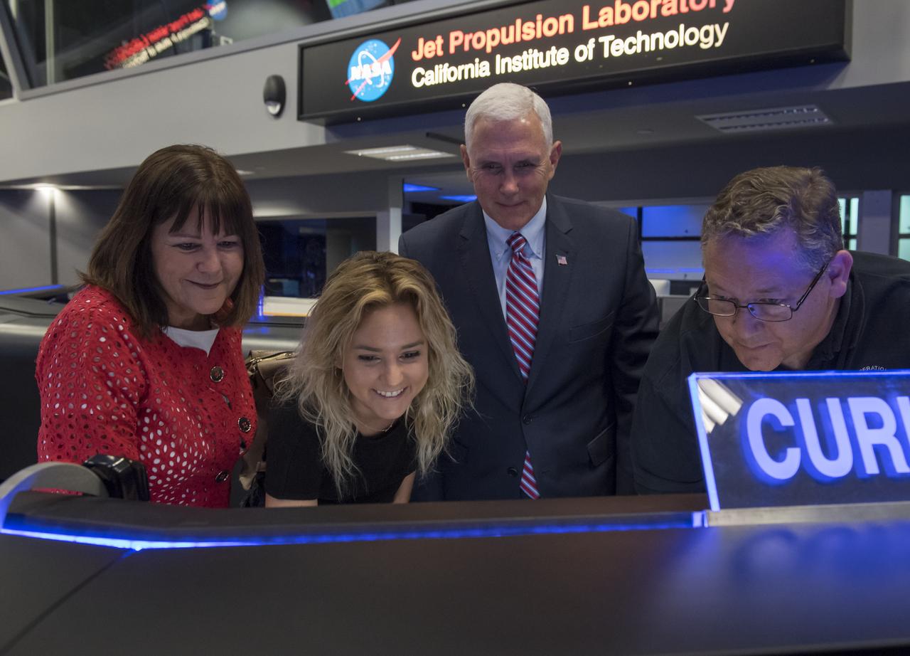
U.S. Vice President Mike Pence, his wife Karen, and their daughter Charlotte are shown how to send a command to the Curiosity rover on Mars by Mars Curiosity Mission ACE Walt Hoffman during a tour of NASA's Jet Propulsion Laboratory, Saturday, April 28, 2018 in Pasadena, California. Hoffman asked Charlotte Pence if she would do the honors of sending the command to the rover. Photo Credit: (NASA/Bill Ingalls)
U.S. Vice President Mike Pence, 2nd from left, his wife Karen, and daughter Charlotte are given a tour of NASA's Jet Propulsion Laboratory by JPL Director Michael Watkins, Saturday, April 28, 2018 in Pasadena, California. Photo Credit: (NASA/Bill Ingalls)
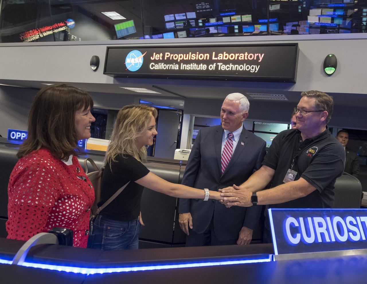
U.S. Vice President Mike Pence, his wife Karen, and their daughter Charlotte shake hands with Mars Curiosity Mission ACE Walt Hoffman, right, during a tour of NASA's Jet Propulsion Laboratory, Saturday, April 28, 2018 in Pasadena, California. Photo Credit: (NASA/Bill Ingalls)
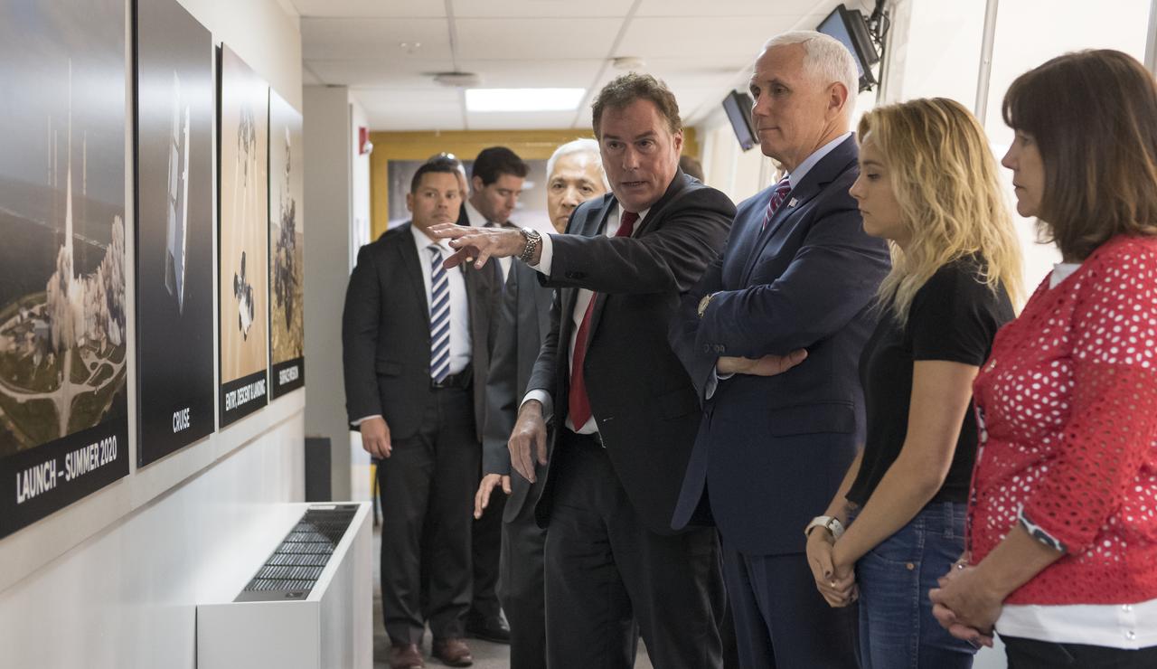
JPL Director Michael Watkins, left, explains to U.S. Vice President Mike Pence, daughter of Mike Pence, Charlotte Pence, and wife of Mike Pence, Karen Pence the progress for the Mars 2020 mission while inside the Spacecraft Assembly Facility (SAF) during a tour of NASA's Jet Propulsion Laboratory, Saturday, April 28, 2018 in Pasadena, California. Photo Credit: (NASA/Bill Ingalls)
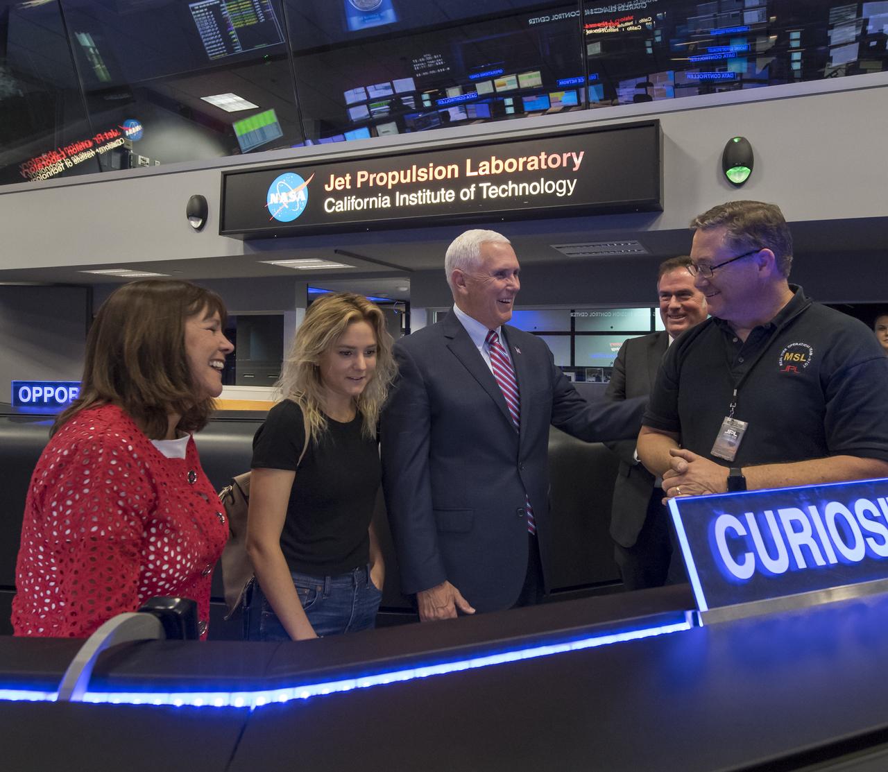
U.S. Vice President Mike Pence, 3rd from left, his wife Karen, and their daughter Charlotte meet with JPL Director Michael Watkins, and Mars Curiosity Mission ACE Walt Hoffman, right, during a tour of NASA's Jet Propulsion Laboratory, Saturday, April 28, 2018 in Pasadena, California. Photo Credit: (NASA/Bill Ingalls)
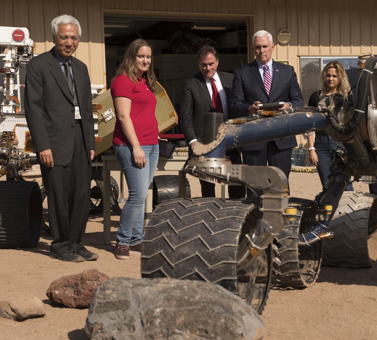
U.S. Vice President Mike Pence gives commands to a rover nicknamed "Scarecrow" as NASA Mars Exploration Manager Li Fuk, left, Mars Curiosity Engineering Operations Team Chief Megan Lin, JPL Director Michael Watkins, and daughter of Mike Pence, Charlotte Pence, right, look on, Saturday, April 28, 2018 in Pasadena, California. Scarecrow is used to test mobility of rovers on Mars. Photo Credit: (NASA/Bill Ingalls)
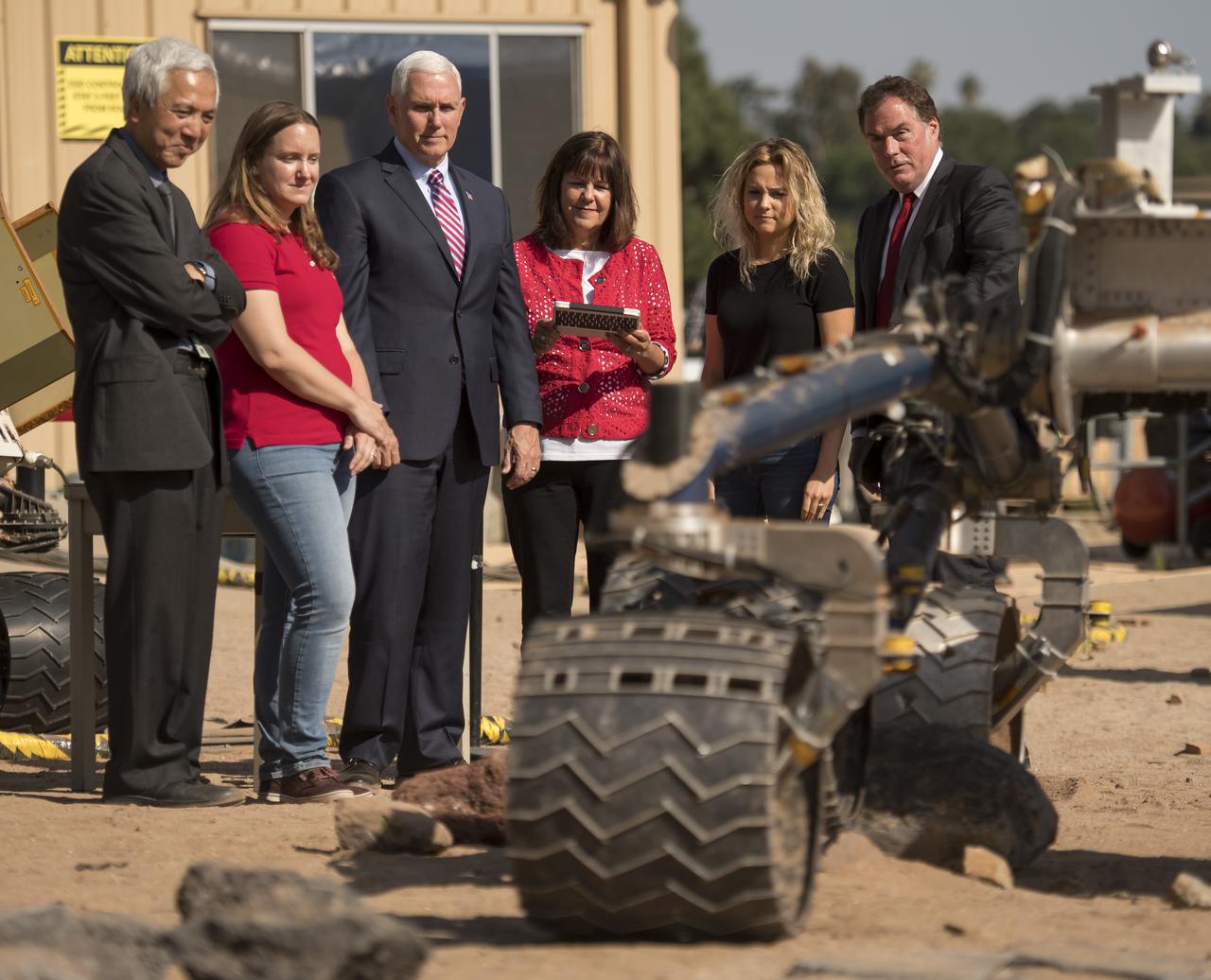
Second Lady Karen Pence gives commands to a rover nicknamed "Scarecrow" as NASA Mars Exploration Manager Li Fuk, left, Mars Curiosity Engineering Operations Team Chief Megan Lin, Vice President Mike Pence, daughter of Mike Pence, Charlotte Pence, and JPL Director Michael Watkins, right, look on, Saturday, April 28, 2018 in Pasadena, California. Scarecrow is used to test mobility of rovers on Mars. Photo Credit: (NASA/Bill Ingalls)
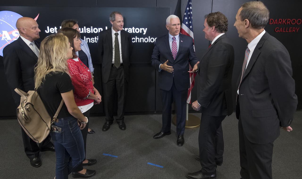
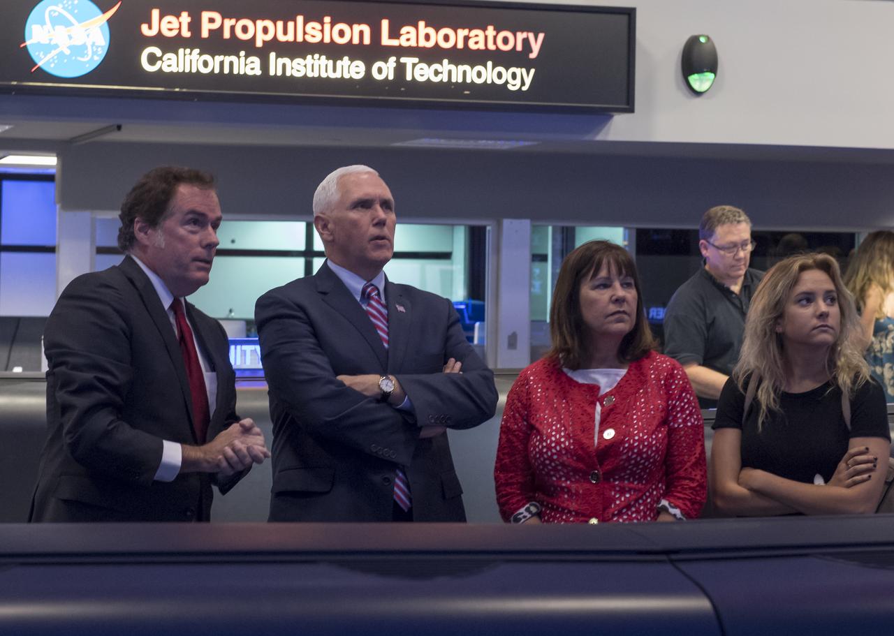
U.S. Vice President Mike Pence, 3rd from right, tours NASA's Jet Propulsion Laboratory along with his wife Karen, and daughter Charlotte, Saturday, April 28, 2018 in Pasadena, California. Joining the Vice President t and his family on the tour are: UAG Chairman, Admiral (Ret) James Ellis , left, JPL Distinguished Visiting Scientist and Spouse of UAG Chairman James Ellis, Elisabeth Pate-Cornell, behind Mrs. Pence, California Institute of Technology President Thomas Rosenbaum, JPL Director Michael Watkins, and JPL Deputy Director Lt. Gen. (Ret) Larry James, right. Photo Credit: (NASA/Bill Ingalls)
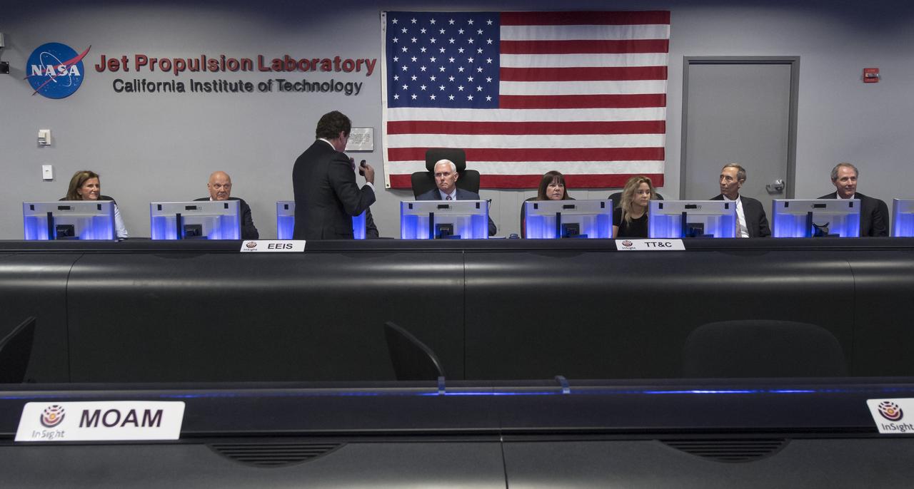
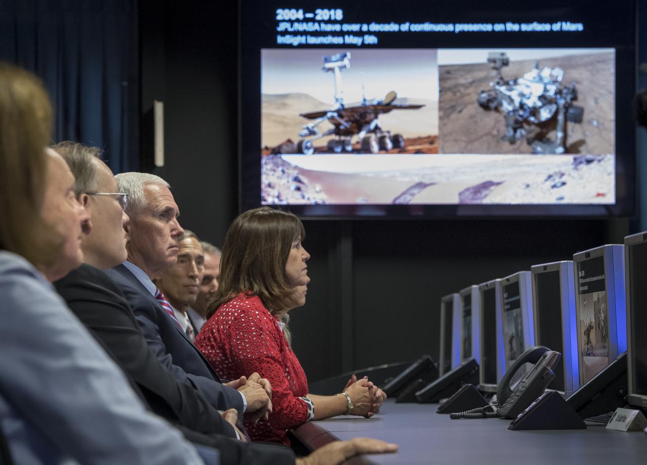
JPL Director Michael Watkins, standing, explains the history of NASA's Jet Propulsion Laboratory and the use of the Mission Support Area to Vice President Mike Pence, seated next to his wife Karen and daughter Charlotte Pence, during a tour of JPL, Saturday, April 28, 2018 in Pasadena, California. Joining the Vice President was, JPL Distinguished Visiting Scientist and Spouse of UAG Chairman James Ellis, Elisabeth Pate-Cornell, left, UAG Chairman, Admiral (Ret) James Ellis, JPL Deputy Director Lt. Gen. (Ret) Larry James, and California Institute of Technology President Thomas Rosenbaum. Photo Credit: (NASA/Bill Ingalls)
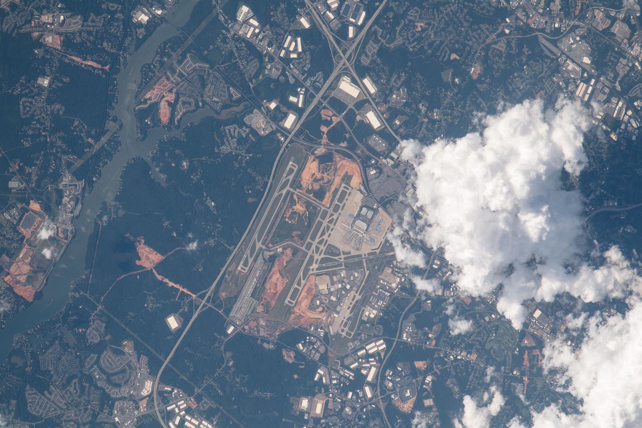
iss069e037287 (July 26, 2023) -- Charlotte Douglas International Airport (CLT), ranked one of the world's busiest airports, is pictured as the International Space Station orbited 260 miles above.
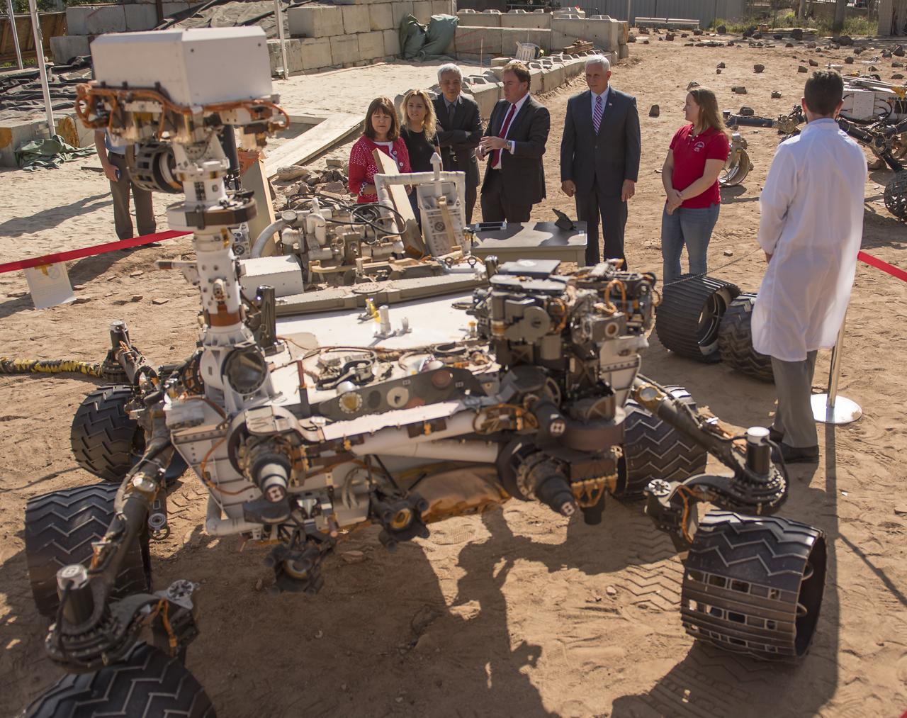
U.S. Vice President Mike Pence, 5th from left, joined by his wife Karen Pence, left, and daughter Charlotte Pence. 2nd from left, view the Vehicle System Test Bed (VSTB) rover in the Mars Yard during a tour of NASA's Jet Propulsion Laboratory, Saturday, April 28, 2018 in Pasadena, California. NASA Mars Exploration Manager Li Fuk, 2nd from left, JPL Director Michael Watkins, Mars Curiosity Engineering Operations Team Chief Megan Lin, and MSL Engineer Sean McGill, right, helped explain to the Vice President and his family how they use these test rovers. Photo Credit: (NASA/Bill Ingalls)
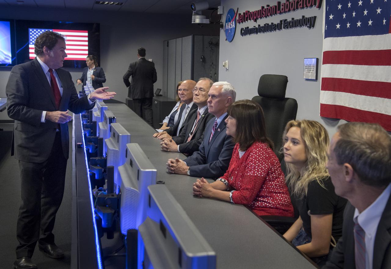
JPL Director Michael Watkins, left, explains the history of NASA's Jet Propulsion Laboratory and the use of the Mission Support Area to Vice President Mike Pence, seated 4th from left, during a tour of JPL, Saturday, April 28, 2018 in Pasadena, California. Joining the Vice President was, JPL Distinguished Visiting Scientist and Spouse of UAG Chairman James Ellis, Elisabeth Pate-Cornell, left, UAG Chairman, Admiral (Ret) James Ellis, Executive Director of the National Space Council Scott Pace, wife of Mike Pence, Karen Pence, daughter of Mike Pence, Charlotte Pence, and JPL Deputy Director Lt. Gen. (Ret) Larry James. Photo Credit: (NASA/Bill Ingalls)
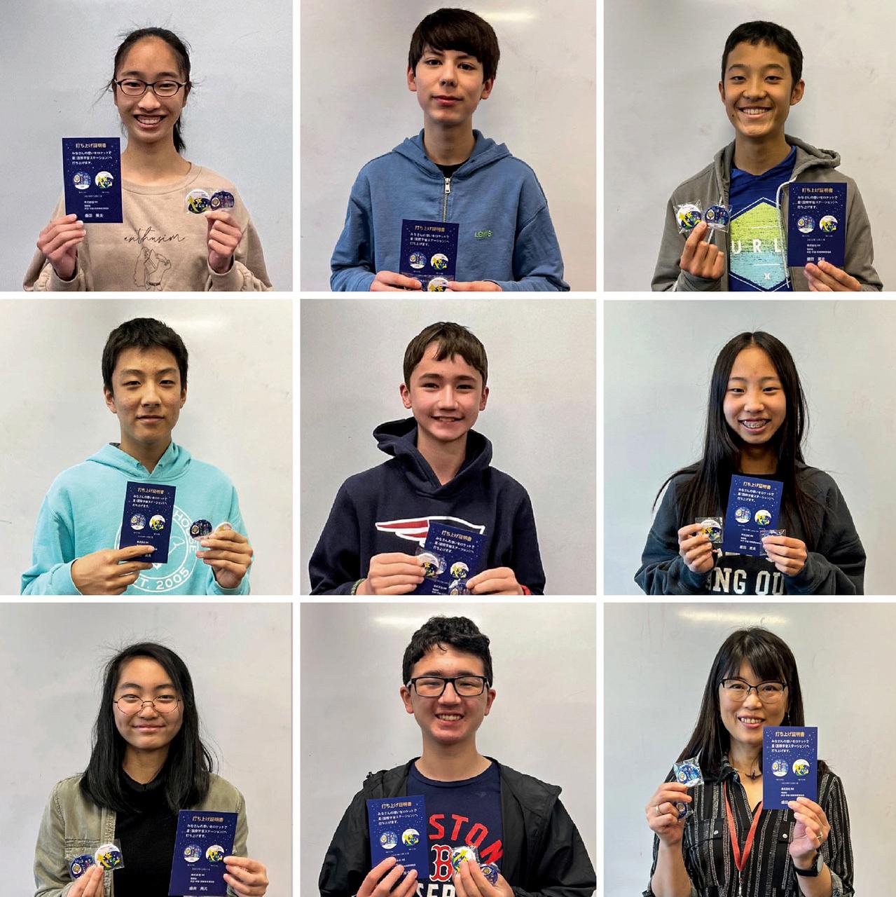
jsc2023e038728 (6/22/2023) --- Students hold Hoshi-Tomo badges at The Japanese Language School in Charlotte, North Carolina. Two types of Hoshi-Tomo badges were designed by students. “Hoshi” implies star(s), planet(s), or the Earth in Japanese. “Tomo” means friend(s) in Japanese. I-Space Essay provides students and teachers the online opportunity to create wishes, which are delivered to the International Space Station's Japanese Experimental Module Kibo. Image courtesy of Mitsumura-Tosho and IHI Corporation.

An example of collaboration between NASA and the FAA, at NASA’s air traffic management laboratory near the Dallas/Ft. Worth International Airport in Texas, researchers Al Capps (seated) and Paul Borchers demonstrate tools that air traffic managers have been successfully testing since 2017 at the Charlotte Douglas International Airport in North Carolina to more efficiently direct departing traffic.

STS072-727-085 (11-20 Jan. 1996) --- The northern third of the Great Barrier Reef stretches 650 kilometers (km) along the coast of Queensland from south of Cairns to past Princess Charlotte Bay at the base of the Cape York Peninsula. The predominant westerly waves of the ocean create shallower (lighter-colored) convex-eastward rims to coral atolls along the outer edge of the barrier reef. In contrast, islands within the lagoon show the effect of predominant southerly, more-or-less offshore winds. Arcuate clouds suggest that winds were offshore at the time the photograph was taken.
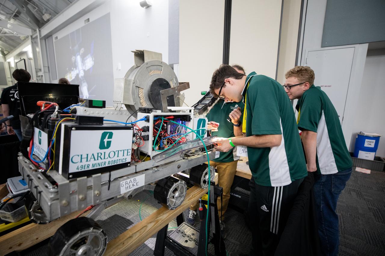
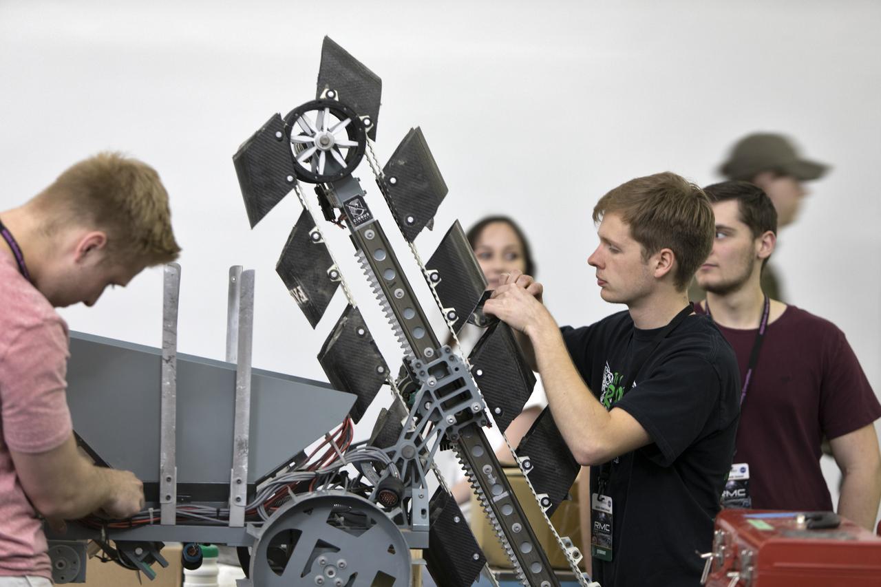
Students from the University of North Carolina at Charlotte prepare their robotic miner for its turn to dig in the mining arena during NASA’s LUNABOTICS competition on May 23, 2022, at the Center for Space Education near the Kennedy Space Center Visitor Complex in Florida. More than 35 teams from around the U.S. have designed and built remote-controlled robots for the mining competition. Teams use their autonomous or remote-controlled robots to maneuver and dig in a supersized sandbox filled with rocks and simulated lunar soil, or regolith. The objective of the challenge is to see which team’s robot can collect and deposit the most rocky regolith within a specified amount of time.
U.S. Vice President Mike Pence can be seen with his wife Karen Pence as they toured NASA's Jet Propulsion Laboratory, Saturday, April 28, 2018 in Pasadena, California. The vice President was also joined by his daughter Charlotte Pence, JPL Distinguished Visiting Scientist and Spouse of UAG Chairman James Ellis, Elisabeth Pate-Cornell , UAG Chairman, Admiral (Ret) James Ellis , Executive Director of the National Space Council Scott Pace, JPL Deputy Director Lt. Gen. (Ret) Larry James, and California Institute of Technology President Thomas Rosenbaum. Photo Credit: (NASA/Bill Ingalls)
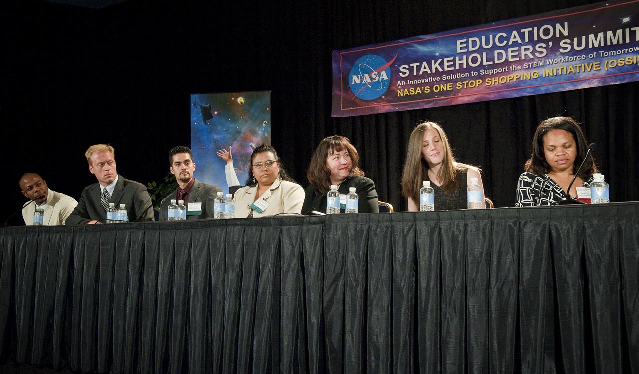
NASA Student Ambassadors and Facilitator are seen on a panel at the NASA Education Stakeholders’ Summit One Stop Shopping Initiative (OSSI), Monday, Sep. 13, 2010, at the Westfields Marriott Conference Center in Chantilly, VA. From left to right are: Quenton Bonds, University of South Florida; Geoffrey Wawrzyniak, Purdue University; Heriberto Reynoso, University of Texas at Brownsville; Marie Kingbird-Lowry, Leech Lake Tribal College; Kareen Borders, University of Washington; Katelyn Doran, University of North Carolina at Charlotte and Ashanti Johnson, PhD, Executive Director, Institute for Broadening Participation. (Photo Credit: NASA/Carla Cioffi)
On the first day of NASA's 9th Robotic Mining Competition, set-up day on May 14, team members from the University of North Carolina at Charlotte work on their robot miner in the RobotPits in the Educator Resource Center at Kennedy Space Center Visitor Complex in Florida. More than 40 student teams from colleges and universities around the U.S. will use their mining robots to dig in a supersized sandbox filled with BP-1, or simulated Lunar soil, gravel and rocks, and participate in other competition requirements. The Robotic Mining Competition is a NASA Human Exploration and Operations Mission Directorate project designed to encourage students in science, technology, engineering and math, or STEM fields. The project provides a competitive environment to foster innovative ideas and solutions that could be used on NASA's deep space missions.

ISS030-E-055569 (29 Jan. 2012) --- Southeastern USA at night is featured in this image photographed by an Expedition 30 crew member on the International Space Station. The brightly lit metropolitan areas of Atlanta, GA (center) and Jacksonville, FL (lower right) appear largest in the image with numerous other urban areas forming an interconnected network of light across the region. A large dark region to the northwest of Jacksonville, FL is the Okefenokee National Wildlife Refuge; likewise the ridges of the Appalachian Mountains form dark swaths to the north of Atlanta, GA and west of Charlotte, NC (center). The faint gold and green line of airglow—caused by ultraviolet radiation exciting the gas molecules in the upper atmosphere—parallels the horizon (or Earth limb).
Inside the Apollo-Saturn V Center at the Kennedy Space Center Visitor Complex in Florida, team members from the University of North Carolina at Charlotte receive third-place in the Caterpillar Autonomy Award during the award ceremony for NASA's 8th Annual Robotic Mining Competition. More than 40 student teams from colleges and universities around the U.S. used their uniquely-designed mining robots to dig in a supersized sandbox filled with BP-1, or simulated Martian soil, and participated in other competition requirements, May 22-26, at the visitor complex. The Robotic Mining Competition is a NASA Human Exploration and Operations Mission Directorate project designed to encourage students in science, technology, engineering and math, or STEM fields. The project provides a competitive environment to foster innovative ideas and solutions that could be used on NASA's Journey to Mars.
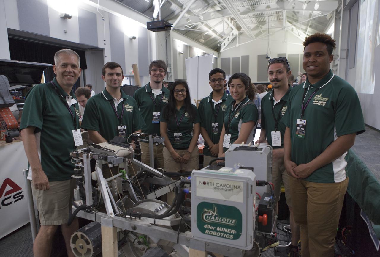
Team members and their faculty advisor, far left, from The University of North Carolina at Charlotte pause with their robot miner in the RobotPits on the fourth day of NASA's 9th Robotic Mining Competition, May 17, at NASA's Kennedy Space Center Visitor Complex in Florida. More than 40 student teams from colleges and universities around the U.S. will use their mining robots to dig in a supersized sandbox filled with BP-1, or simulated Lunar soil, gravel and rocks, and participate in other competition requirements. The Robotic Mining Competition is a NASA Human Exploration and Operations Mission Directorate project designed to encourage students in science, technology, engineering and math, or STEM fields. The project provides a competitive environment to foster innovative ideas and solutions that could be used on NASA's deep space missions.

Landsat 7 image of the Santa Clara area acquired Nov 16, 2015. Landsat 7 is a U.S. satellite used to acquire remotely sensed images of the Earth's land surface and surrounding coastal regions. It is maintained by the Landsat 7 Project Science Office at the NASA Goddard Space Flight Center in Greenbelt, MD...Landsat satellites have been acquiring images of the Earth’s land surface since 1972. Currently there are more than 2 million Landsat images in the National Satellite Land Remote Sensing Data Archive. For more information visit: <a href="http://landsat.usgs.gov/" rel="nofollow">landsat.usgs.gov/</a>..To learn more about the Landsat satellite go to:.<a href="http://landsat.gsfc.nasa.gov/" rel="nofollow">landsat.gsfc.nasa.gov/</a> Credit: NASA/GSFC/Landsat 7 <b><a href="http://www.nasa.gov/audience/formedia/features/MP_Photo_Guidelines.html" rel="nofollow">NASA image use policy.</a></b> <b><a href="http://www.nasa.gov/centers/goddard/home/index.html" rel="nofollow">NASA Goddard Space Flight Center</a></b> enables NASA’s mission through four scientific endeavors: Earth Science, Heliophysics, Solar System Exploration, and Astrophysics. Goddard plays a leading role in NASA’s accomplishments by contributing compelling scientific knowledge to advance the Agency’s mission. <b>Follow us on <a href="http://twitter.com/NASAGoddardPix" rel="nofollow">Twitter</a></b> <b>Like us on <a href="http://www.facebook.com/pages/Greenbelt-MD/NASA-Goddard/395013845897?ref=tsd" rel="nofollow">Facebook</a></b> <b>Find us on <a href="http://instagrid.me/nasagoddard/?vm=grid" rel="nofollow">Instagram</a></b>
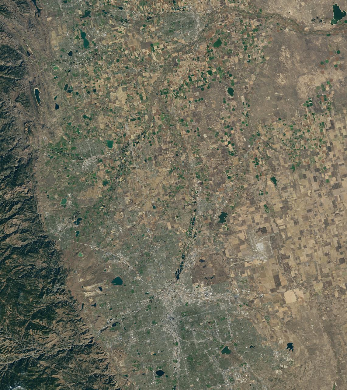
Landsat 7 image of Denver area acquired Nov 3, 2015. Landsat 7 is a U.S. satellite used to acquire remotely sensed images of the Earth's land surface and surrounding coastal regions. It is maintained by the Landsat 7 Project Science Office at the NASA Goddard Space Flight Center in Greenbelt, MD...Landsat satellites have been acquiring images of the Earth’s land surface since 1972. Currently there are more than 2 million Landsat images in the National Satellite Land Remote Sensing Data Archive. For more information visit: <a href="http://landsat.usgs.gov/" rel="nofollow">landsat.usgs.gov/</a>..To learn more about the Landsat satellite go to:.<a href="http://landsat.gsfc.nasa.gov/" rel="nofollow">landsat.gsfc.nasa.gov/</a> Credit: NASA/GSFC/Landsat 7 <b><a href="http://www.nasa.gov/audience/formedia/features/MP_Photo_Guidelines.html" rel="nofollow">NASA image use policy.</a></b> <b><a href="http://www.nasa.gov/centers/goddard/home/index.html" rel="nofollow">NASA Goddard Space Flight Center</a></b> enables NASA’s mission through four scientific endeavors: Earth Science, Heliophysics, Solar System Exploration, and Astrophysics. Goddard plays a leading role in NASA’s accomplishments by contributing compelling scientific knowledge to advance the Agency’s mission. <b>Follow us on <a href="http://twitter.com/NASAGoddardPix" rel="nofollow">Twitter</a></b> <b>Like us on <a href="http://www.facebook.com/pages/Greenbelt-MD/NASA-Goddard/395013845897?ref=tsd" rel="nofollow">Facebook</a></b> <b>Find us on <a href="http://instagrid.me/nasagoddard/?vm=grid" rel="nofollow">Instagram</a></b>
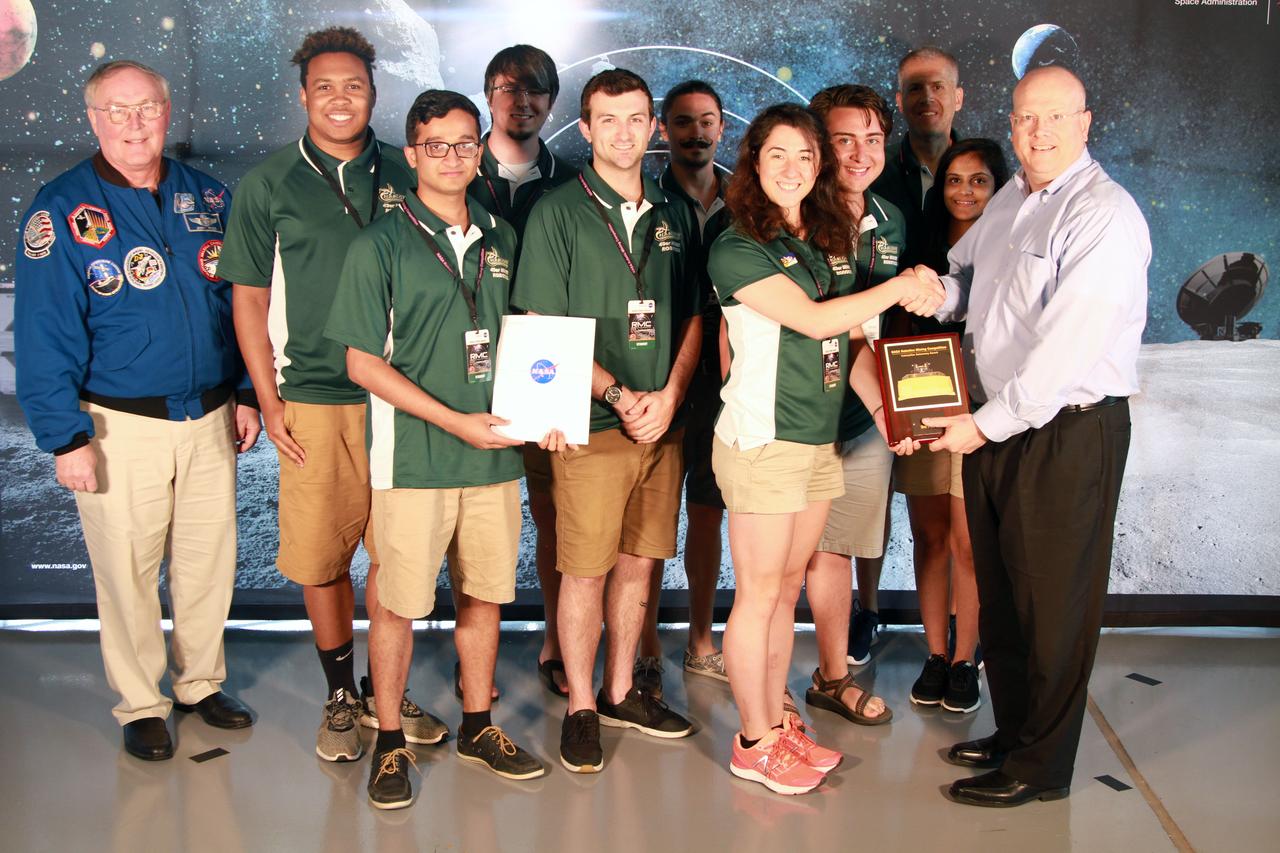
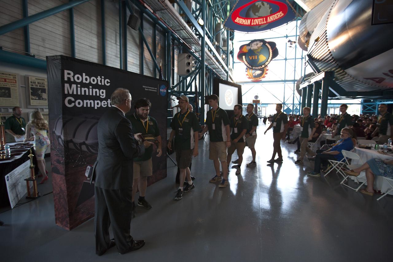
NASA's 9th Annual Robotic Mining Competition concludes with an awards ceremony May 18, 2018, at the Apollo/Saturn V Center at the Kennedy Space Center Visitor Complex in Florida. The team from the University of North Carolina at Charlotte received third place in the Caterpillar Award for Autonomy. At left is retired NASA astronaut Jerry Ross. At right is Eric Reiners, program manager with the Innovation & Technology Development Division of Caterpillar Inc. More than 40 student teams from colleges and universities around the U.S. participated in the competition, May 14-18, by using their mining robots to dig in a supersized sandbox filled with BP-1, or simulated lunar soil, gravel and rocks, and participate in other competition requirements. The Robotic Mining Competition is a NASA Human Exploration and Operations Mission Directorate project designed to encourage students in science, technology, engineering and math, or STEM fields. The project provides a competitive environment to foster innovative ideas and solutions that could be used on NASA's deep space missions.
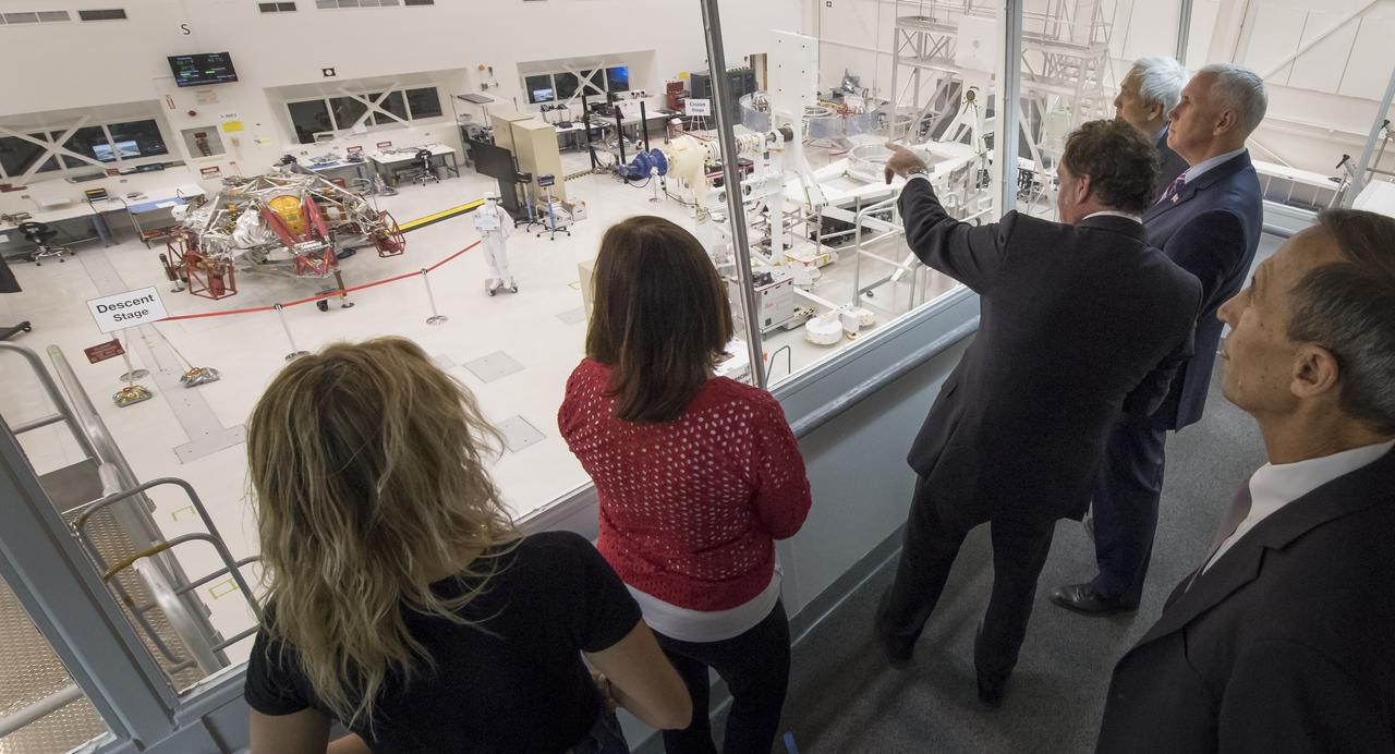
U.S. Vice President Mike Pence, 2nd from right, is shown the Mars 2020 spacecraft descent stage from inside the Spacecraft Assembly Facility (SAF) by JPL Director Michael Watkins, to the Vice President's left, and NASA Mars Exploration Manager Li Fuk at NASA's Jet Propulsion Laboratory, Saturday, April 28, 2018 in Pasadena, California. Mars 2020 is a Mars rover mission by NASA's Mars Exploration Program with a planned launch in 2020. Photo Credit: (NASA/Bill Ingalls)
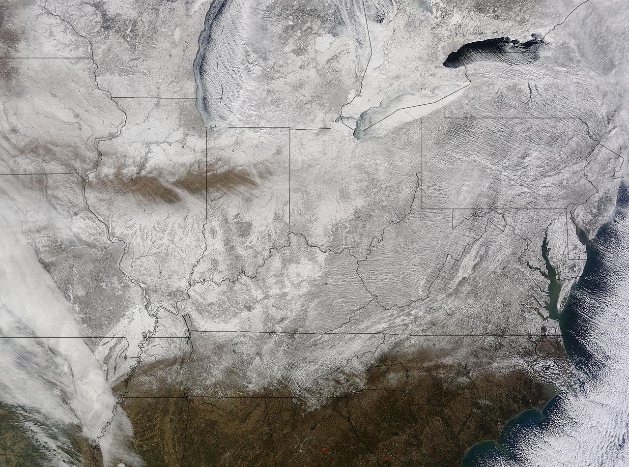
NASA's Terra satellite captured an image of the snow-covered eastern U.S. that looks like the states have been sitting in a freezer. In addition to the snow cover, Arctic and Siberian air masses have settled in over the Eastern U.S. triggering many record low temperatures in many states. On Feb. 19 at 16:40 UTC (11:40 a.m. EST), the Moderate Resolution Imaging Spectroradiometer (MODIS) instrument that flies aboard NASA's Terra satellite captured a picture of the snowy landscape. The snow cover combined with the frosty air mass made the eastern U.S. feel like the inside of freezer. The MODIS image was created at NASA's Goddard Space Flight Center in Greenbelt, Maryland. On the morning of Feb. 20, NOAA's Weather Prediction Center (WPC) noted, "There were widespread subzero overnight lows Thursday night (Feb. 19) extending from Illinois to western Virginia, and numerous record lows were set. Bitterly-cold arctic air is setting numerous temperature records across the eastern U.S. and will keep temperatures well below normal on Friday (Feb. 20)." In Baltimore, Maryland, a low temperature of 1F broke the record low for coldest morning recorded at the Thurgood Marshall Baltimore Washington-International Airport. In Louisville, Kentucky, temperatures dropped to -6F, breaking the old record low of 0F, according to meteorologist Brian Goode of WAVE-TV. Meanwhile, Richmond Kentucky bottomed out at a frigid -32F. In North Carolina, a record low temperature was set at Charlotte where the overnight temperature bottomed out at 7F breaking the old record of 13F in 1896. In Asheville, temperatures dropped to just 4F breaking the old record of 10F in 1979. Temperature records for Asheville extend back to 1876. Several records were also broken in Georgia, according to Matt Daniel, a meteorologist at WMAZ-TV, Macon Georgia, who cited data from the National Weather Service. Daniel said that Macon set a new record low when the temperature dropped to 18F, beating the previous record of 21F set in 1958. Athens broke a new record low, too dropping to 14F and beating the old record of 18F set in 1958/1928. NOAA's NPC noted that "Highs on Friday (Feb. 20) will struggle to get out of the teens from the Ohio Valley to the Mid-Atlantic region. After Friday, temperatures are forecast to moderate and get closer to February averages as a storm system approaches from the west." Image Credit: NASA Goddard MODIS Rapid Response Team <b><a href="http://www.nasa.gov/audience/formedia/features/MP_Photo_Guidelines.html" rel="nofollow">NASA image use policy.</a></b> <b><a href="http://www.nasa.gov/centers/goddard/home/index.html" rel="nofollow">NASA Goddard Space Flight Center</a></b> enables NASA’s mission through four scientific endeavors: Earth Science, Heliophysics, Solar System Exploration, and Astrophysics. Goddard plays a leading role in NASA’s accomplishments by contributing compelling scientific knowledge to advance the Agency’s mission. <b>Follow us on <a href="http://twitter.com/NASAGoddardPix" rel="nofollow">Twitter</a></b> <b>Like us on <a href="http://www.facebook.com/pages/Greenbelt-MD/NASA-Goddard/395013845897?ref=tsd" rel="nofollow">Facebook</a></b> <b>Find us on <a href="http://instagram.com/nasagoddard?vm=grid" rel="nofollow">Instagram</a></b>