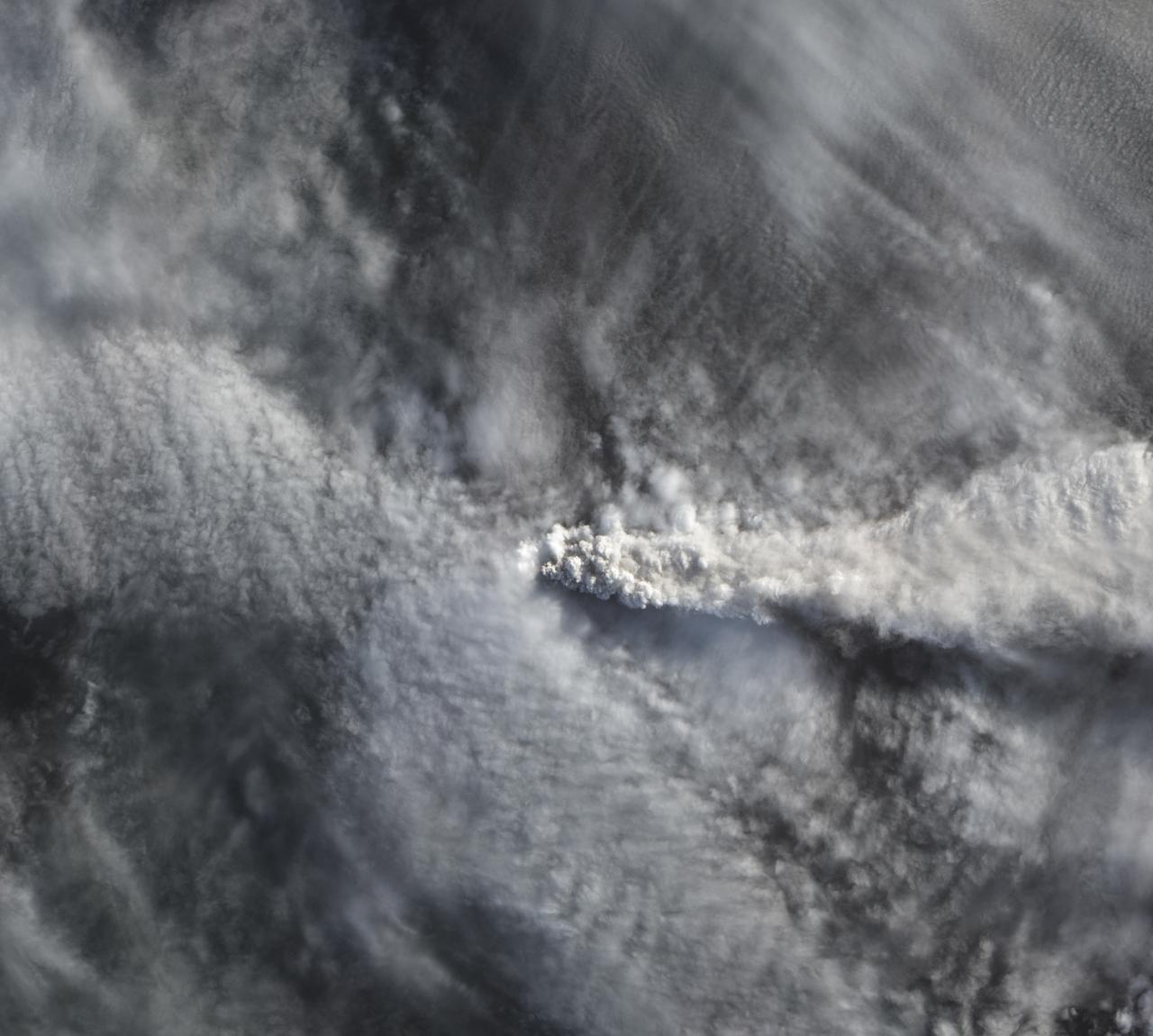
The natural color image below, acquired on April 25 by the Advanced Land Imager on NASA’s Earth Observing-1 satellite, shows Calbuco’s plume rising above the cloud deck over Chile.
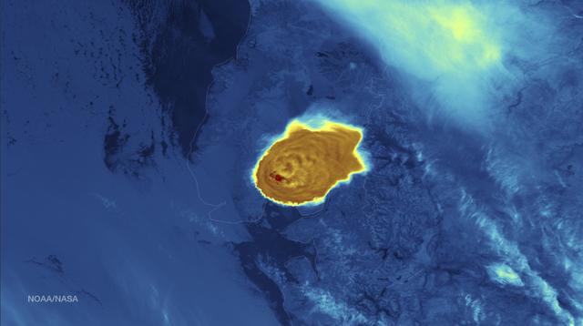
Calbuco Volcano in southern Chile has erupted for the first time since 1972, with the last major eruption occurring in 1961 that sent ash columns 12-15 kilometers high. This image was taken by the Suomi NPP satellite's VIIRS instrument in a high resolution infrared channel around 0515Z on April 23, 2015. Credit: NOAA/NASA/NPP/VIIRS

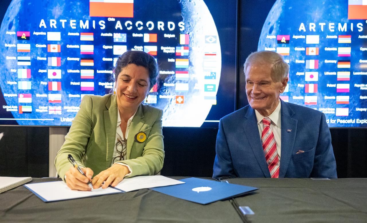
The flags of the United States and Chile are seen during an Artemis Accords signing ceremony Friday, Oct. 25, 2024, at the Mary W. Jackson NASA Headquarters building in Washington. The Republic of Chile is the 47th country to sign the Artemis Accords, which establish a practical set of principles to guide space exploration cooperation among nations participating in NASA’s Artemis program. Photo Credit: (NASA/Keegan Barber)

The natural color image below, acquired on April 25 by the Advanced Land Imager on NASA’s Earth Observing-1 satellite, shows Calbuco’s plume rising above the cloud deck over Chile. Read more here: <a href="http://earthobservatory.nasa.gov/IOTD/view.php?id=85791&eocn=home&eoci=iotd_title" rel="nofollow">earthobservatory.nasa.gov/IOTD/view.php?id=85791&eocn...</a> Credit: <b><a href="http://www.earthobservatory.nasa.gov/" rel="nofollow"> NASA Earth Observatory</a></b> <b><a href="http://www.nasa.gov/audience/formedia/features/MP_Photo_Guidelines.html" rel="nofollow">NASA image use policy.</a></b> <b><a href="http://www.nasa.gov/centers/goddard/home/index.html" rel="nofollow">NASA Goddard Space Flight Center</a></b> enables NASA’s mission through four scientific endeavors: Earth Science, Heliophysics, Solar System Exploration, and Astrophysics. Goddard plays a leading role in NASA’s accomplishments by contributing compelling scientific knowledge to advance the Agency’s mission. <b>Follow us on <a href="http://twitter.com/NASAGoddardPix" rel="nofollow">Twitter</a></b> <b>Like us on <a href="http://www.facebook.com/pages/Greenbelt-MD/NASA-Goddard/395013845897?ref=tsd" rel="nofollow">Facebook</a></b> <b>Find us on <a href="http://instagrid.me/nasagoddard/?vm=grid" rel="nofollow">Instagram</a></b>

Chile pepper plants growing in the Advanced Plant Habitat (APH) aboard the International Space Station recently bore fruit. The peppers developed from flowers that bloomed over the past few weeks. Studies of fruit development in microgravity are limited, but overcoming the challenges of growing fruit in microgravity is important to NASA for long-duration missions during which crew members will need good sources of Vitamin C to supplement their diets.

Chile pepper plants growing in the Advanced Plant Habitat (APH) aboard the International Space Station recently bore fruit. The peppers developed from flowers that bloomed over the past few weeks. Studies of fruit development in microgravity are limited, but overcoming the challenges of growing fruit in microgravity is important to NASA for long-duration missions during which crew members will need good sources of Vitamin C to supplement their diets.

Chile pepper plants growing in the Advanced Plant Habitat (APH) aboard the International Space Station recently bore fruit. The peppers developed from flowers that bloomed over the past few weeks. Studies of fruit development in microgravity are limited, but overcoming the challenges of growing fruit in microgravity is important to NASA for long-duration missions during which crew members will need good sources of Vitamin C to supplement their diets.
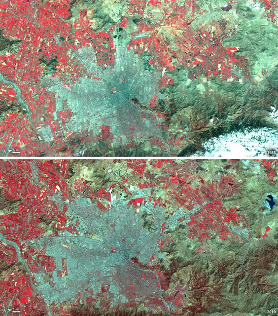
Santiago, Chile, ranks among the world's fastest growing cities. Chile is South America's fifth largest economy with strong export and tourism markets. More than a third of Chile's population lives in Santiago as of 2009. Taken on January 9, 1985, and January 30, 2010, this pair of images from the Landsat 5 satellite illustrates the city's steady growth. The images were made with infrared and visible light (Landsat bands 4, 3, and 2) so that plant-covered land is red. Bare or sparsely vegetated land is tan, and the city is dark silver. In the fifteen years that elapsed between 1985 and 2010, the city expanded away from the Andes Mountains along spoke-like lines, which are major roads. ---- NASA and the U.S. Department of the Interior through the U.S. Geological Survey (USGS) jointly manage Landsat, and the USGS preserves a 40-year archive of Landsat images that is freely available over the Internet. The next Landsat satellite, now known as the Landsat Data Continuity Mission (LDCM) and later to be called Landsat 8, is scheduled for launch in 2013. In honor of Landsat’s 40th anniversary in July 2012, the USGS released the LandsatLook viewer – a quick, simple way to go forward and backward in time, pulling images of anywhere in the world out of the Landsat archive. <b><a href="http://www.nasa.gov/audience/formedia/features/MP_Photo_Guidelines.html" rel="nofollow">NASA image use policy.</a></b> <b><a href="http://www.nasa.gov/centers/goddard/home/index.html" rel="nofollow">NASA Goddard Space Flight Center</a></b> enables NASA’s mission through four scientific endeavors: Earth Science, Heliophysics, Solar System Exploration, and Astrophysics. Goddard plays a leading role in NASA’s accomplishments by contributing compelling scientific knowledge to advance the Agency’s mission. <b>Follow us on <a href="http://twitter.com/NASA_GoddardPix" rel="nofollow">Twitter</a></b> <b>Like us on <a href="http://www.facebook.com/pages/Greenbelt-MD/NASA-Goddard/395013845897?ref=tsd" rel="nofollow">Facebook</a></b> <b>Find us on <a href="http://instagrid.me/nasagoddard/?vm=grid" rel="nofollow">Instagram</a></b>

Calbuco Volcano in southern Chile has erupted for the first time since 1972, with the last major eruption occurring in 1961 that sent ash columns 12-15 kilometers high. This image was taken by the Suomi NPP satellite's VIIRS instrument in a high resolution infrared channel around 0515Z on April 23, 2015. Credit: NOAA/NASA/NPP/VIIRS <b><a href="http://goes.gsfc.nasa.gov/" rel="nofollow">Credit: NOAA/NASA GOES Project</a></b> <b><a href="http://www.nasa.gov/audience/formedia/features/MP_Photo_Guidelines.html" rel="nofollow">NASA image use policy.</a></b> <b><a href="http://www.nasa.gov/centers/goddard/home/index.html" rel="nofollow">NASA Goddard Space Flight Center</a></b> enables NASA’s mission through four scientific endeavors: Earth Science, Heliophysics, Solar System Exploration, and Astrophysics. Goddard plays a leading role in NASA’s accomplishments by contributing compelling scientific knowledge to advance the Agency’s mission. <b>Follow us on <a href="http://twitter.com/NASAGoddardPix" rel="nofollow">Twitter</a></b> <b>Like us on <a href="http://www.facebook.com/pages/Greenbelt-MD/NASA-Goddard/395013845897?ref=tsd" rel="nofollow">Facebook</a></b> <b>Find us on <a href="http://instagrid.me/nasagoddard/?vm=grid" rel="nofollow">Instagram</a></b>

Chilean Minister of Science, Technology, Knowledge, and Innovation Aisén Etcheverry Escudero, second from left, delivers remarks during an Artemis Accords signing ceremony Friday, Oct. 25, 2024, at the Mary W. Jackson NASA Headquarters building in Washington. The Republic of Chile is the 47th country to sign the Artemis Accords, which establish a practical set of principles to guide space exploration cooperation among nations participating in NASA’s Artemis program. Photo Credit: (NASA/Keegan Barber)

Chilean Ambassador to the United States Juan Gabriel Valdés, left, delivers remarks during an Artemis Accords signing ceremony Friday, Oct. 25, 2024, at the Mary W. Jackson NASA Headquarters building in Washington. The Republic of Chile is the 47th country to sign the Artemis Accords, which establish a practical set of principles to guide space exploration cooperation among nations participating in NASA’s Artemis program. Photo Credit: (NASA/Keegan Barber)

United States Department of State Acting Assistant Secretary in the Bureau of Oceans and International Environmental and Scientific Affairs Jennifer R. Littlejohn, right, delivers remarks during an Artemis Accords signing ceremony Friday, Oct. 25, 2024, at the Mary W. Jackson NASA Headquarters building in Washington. The Republic of Chile is the 47th country to sign the Artemis Accords, which establish a practical set of principles to guide space exploration cooperation among nations participating in NASA’s Artemis program. Photo Credit: (NASA/Keegan Barber)

Chilean Minister of Science, Technology, Knowledge, and Innovation Aisén Etcheverry Escudero, center, delivers remarks during an Artemis Accords signing ceremony Friday, Oct. 25, 2024, at the Mary W. Jackson NASA Headquarters building in Washington. The Republic of Chile is the 47th country to sign the Artemis Accords, which establish a practical set of principles to guide space exploration cooperation among nations participating in NASA’s Artemis program. Photo Credit: (NASA/Keegan Barber)

NASA Administrator Bill Nelson, second from right, delivers remarks during an Artemis Accords signing ceremony Friday, Oct. 25, 2024, at the Mary W. Jackson NASA Headquarters building in Washington. The Republic of Chile is the 47th country to sign the Artemis Accords, which establish a practical set of principles to guide space exploration cooperation among nations participating in NASA’s Artemis program. Photo Credit: (NASA/Keegan Barber)

NASA Administrator Bill Nelson delivers remarks during an Artemis Accords signing ceremony Friday, Oct. 25, 2024, at the Mary W. Jackson NASA Headquarters building in Washington. The Republic of Chile is the 47th country to sign the Artemis Accords, which establish a practical set of principles to guide space exploration cooperation among nations participating in NASA’s Artemis program. Photo Credit: (NASA/Keegan Barber)

United States Department of State Acting Assistant Secretary in the Bureau of Oceans and International Environmental and Scientific Affairs Jennifer R. Littlejohn, right, delivers remarks during an Artemis Accords signing ceremony Friday, Oct. 25, 2024, at the Mary W. Jackson NASA Headquarters building in Washington. The Republic of Chile is the 47th country to sign the Artemis Accords, which establish a practical set of principles to guide space exploration cooperation among nations participating in NASA’s Artemis program. Photo Credit: (NASA/Keegan Barber)

NASA Administrator Bill Nelson delivers remarks during an Artemis Accords signing ceremony Friday, Oct. 25, 2024, at the Mary W. Jackson NASA Headquarters building in Washington. The Republic of Chile is the 47th country to sign the Artemis Accords, which establish a practical set of principles to guide space exploration cooperation among nations participating in NASA’s Artemis program. Photo Credit: (NASA/Keegan Barber)

Chilean Ambassador to the United States Juan Gabriel Valdés, left, delivers remarks during an Artemis Accords signing ceremony Friday, Oct. 25, 2024, at the Mary W. Jackson NASA Headquarters building in Washington. The Republic of Chile is the 47th country to sign the Artemis Accords, which establish a practical set of principles to guide space exploration cooperation among nations participating in NASA’s Artemis program. Photo Credit: (NASA/Keegan Barber)

NASA Administrator Bill Nelson, second from right, delivers remarks during an Artemis Accords signing ceremony Friday, Oct. 25, 2024, at the Mary W. Jackson NASA Headquarters building in Washington. The Republic of Chile is the 47th country to sign the Artemis Accords, which establish a practical set of principles to guide space exploration cooperation among nations participating in NASA’s Artemis program. Photo Credit: (NASA/Keegan Barber)
On May 2, 2008 Chile Chaiten Volcano erupted after 9,000 years of inactivity. NASA Terra spacecraft captured this image on May 28, 2008.
S66-54834 (14 Sept. 1966) --- Peru, Bolivia, Chile, Lake Titicaca and La Paz, as seen from the Gemini-11 spacecraft during its 34th revolution of Earth. Photo credit: NASA
NASA Administrator Bill Nelson, right, looks on as Chilean Minister of Science, Technology, Knowledge, and Innovation Aisén Etcheverry Escudero, left, signs the Artemis Accords Friday, Oct. 25, 2024, at the Mary W. Jackson NASA Headquarters building in Washington. The Republic of Chile is the 47th country to sign the Artemis Accords, which establish a practical set of principles to guide space exploration cooperation among nations participating in NASA’s Artemis program. Photo Credit: (NASA/Keegan Barber)

iss066e008110 (October 20, 2021) -- NASA astronaut and Expedition 65 Flight Engineer Mark Vande Hei prepares to photograph chile peppers growing in the Advanced Plant Habitat as part of the Plant Habit-04 experiment being conducted aboard the International Space Station. The chile pepper seeds started growing on July 12, 2021, and represent one of the longest and most challenging plant experiments attempted aboard the orbiting laboratory. They will be harvested twice, once in late October and again in late November. Astronauts will sanitize the peppers, eat part of their harvest, and return the rest to Earth for analysis. What we learn will inform future crop growth and food supplementation activities for deep space exploration.

NASA Terra spacecraft captured this image of the Laguna del Maule volcanic field which straddles the Andean range crest between Chile and Argentina.
iss066e008125 (October 20, 2021) -- NASA astronaut and Expedition 65 Flight Engineer Mark Vande Hei prepares for the routine debris removal procedure for chile peppers growing in the Advanced Plant Habitat as part of the Plant Habit-04 experiment being conducted aboard the International Space Station. The chile pepper seeds started growing on July 12, 2021, and represent one of the longest and most challenging plant experiments attempted aboard the orbiting laboratory. They will be harvested twice, once in late October and again in late November. Astronauts will sanitize the peppers, eat part of their harvest, and return the rest to Earth for analysis. What we learn will inform future crop growth and food supplementation activities for deep space exploration.
This perspective view from NASA Shuttle Radar Topography Mission of coastal Chile indicates the epicenter red marker of the 8.8 earthquake on Feb. 27, 2010, just offshore of the Maule region in the Bahia de Chanco.
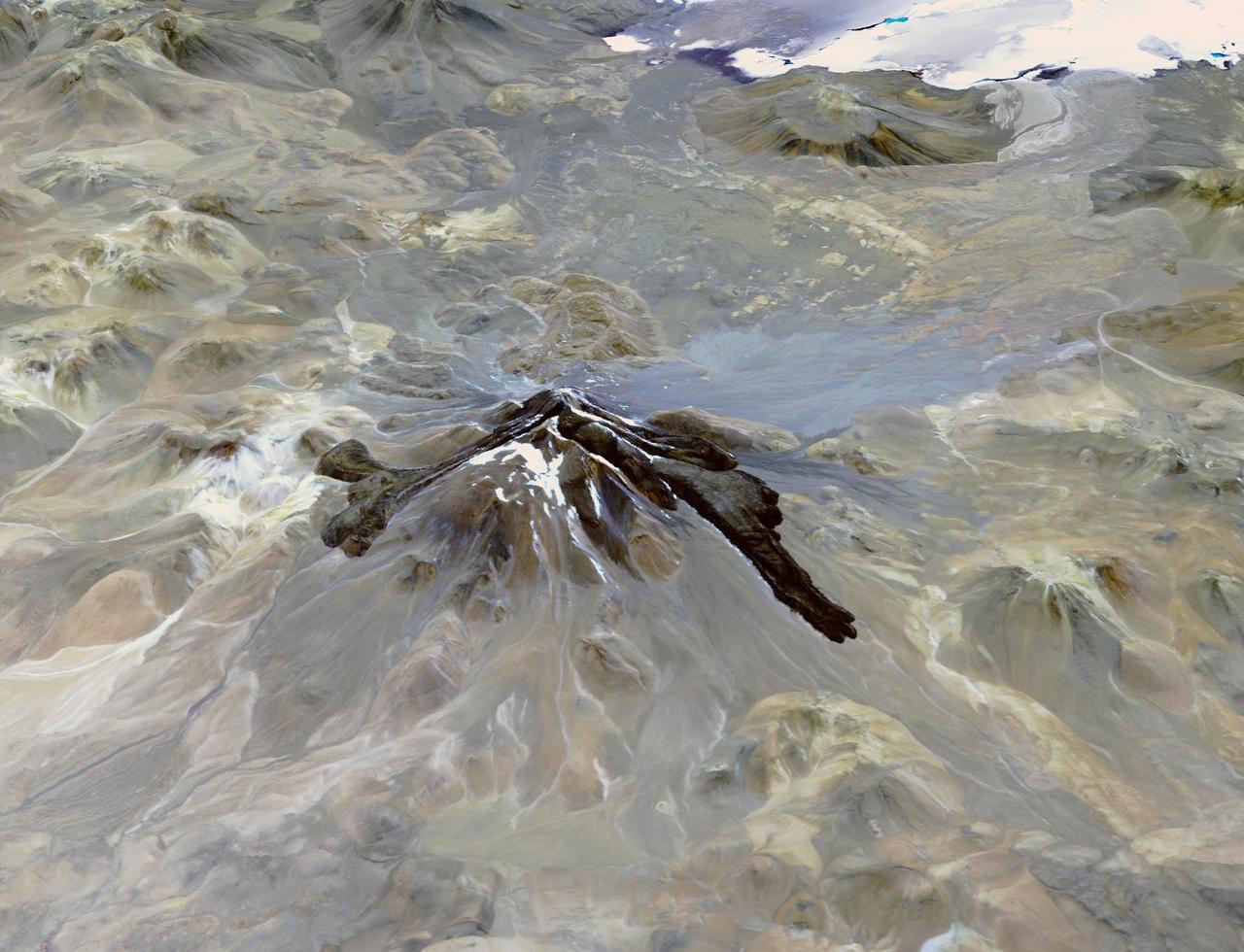
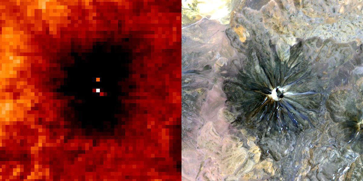
Llullaillaco is a stratovolcano at the border of Argentina and Chile. It lies on a high plateau close to the Atacama Desert. At an elevation of 6723 m ASL, it is the second highest active volcano in the world. About 150,000 years ago the volcano's southeastern flank collapsed, producing a debris avalanche that traveled 25 kilometers. The youngest dated rocks are about 5600 years old; but there are local reports of activity from the 1800s. The perspective image looking east was acquired December 19, 2014 and is located at 24.7 degrees south, 68.5 degrees west. https://photojournal.jpl.nasa.gov/catalog/PIA22721
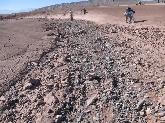
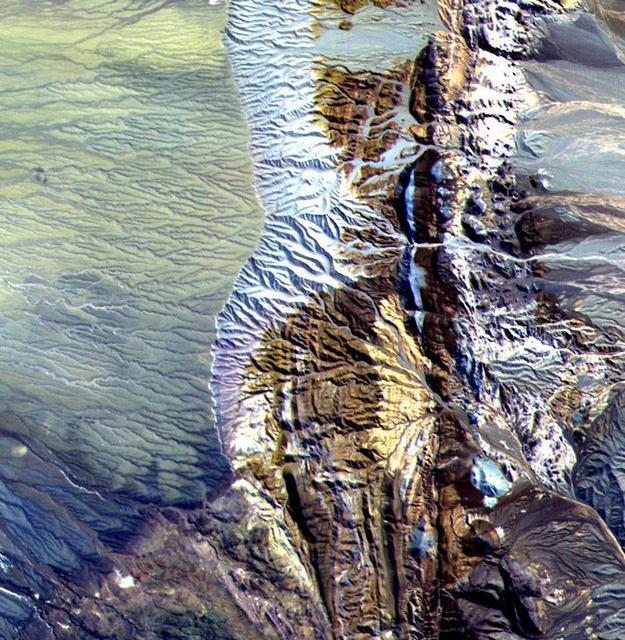
This image shows a dry streambed on an alluvial fan in the Atacama Desert, Chile, revealing the typical patchy, heterogeneous mixture of grain sizes deposited together.

From left to right, Chilean Ambassador to the United States Juan Gabriel Valdés, Chilean Minister of Science, Technology, Knowledge, and Innovation Aisén Etcheverry Escudero, NASA Administrator Bill Nelson, and United States Department of State Acting Assistant Secretary in the Bureau of Oceans and International Environmental and Scientific Affairs Jennifer R. Littlejohn pose for a photo after the signing of the Artemis Accords, Friday, Oct. 25, 2024, at the Mary W. Jackson NASA Headquarters building in Washington. The Republic of Chile is the 47th country to sign the Artemis Accords, which establish a practical set of principles to guide space exploration cooperation among nations participating in NASA’s Artemis program. Photo Credit: (NASA/Keegan Barber)
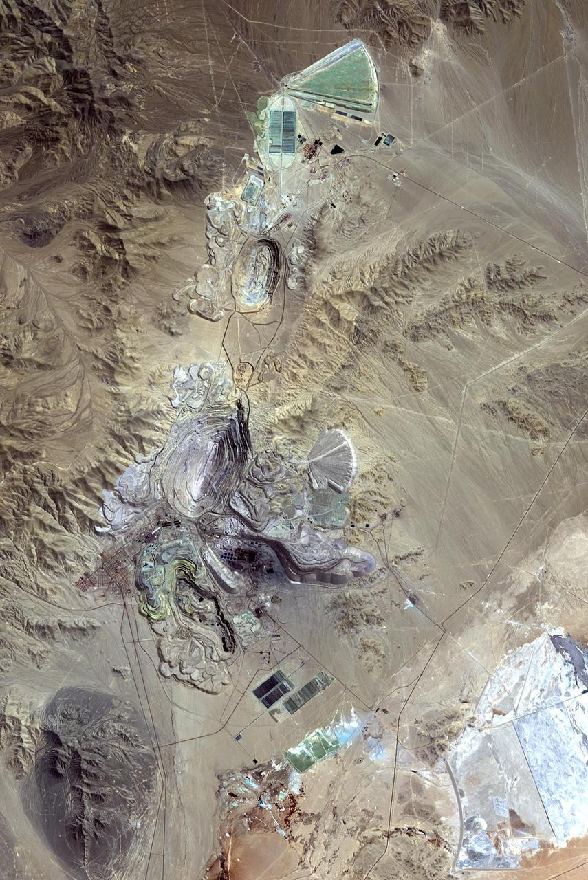
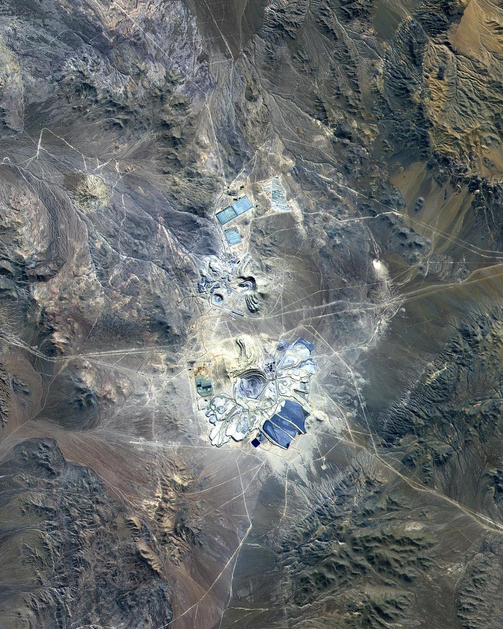
Chuquicamata, in Chile's Atacama Desert, is the largest open pit copper mine in the world, by excavated volume. The copper deposits were first exploited in pre-Hispanic times. Open pit mining began in the early 20th century when a method was developed to work low grade oxidized copper ores. The image was acquired September 2, 2007, covers an area of 19.5 by 29.3 km, and is located at 22.1 degrees south, 68.9 degrees west. http://photojournal.jpl.nasa.gov/catalog/PIA20973
iss058e006004 (Jan. 26, 2019) --- This photograph of South America from bottom to top looks from the northeast coast of Argentina to southwest across Chile, the Andes mountains and the Pacific Ocean. The International Space Station was orbiting 259 miles above the Atlantic coast of the South American continent.
Chaiten Volcano, Chile continues to erupt after first exploding in May 2008 following about 9,000 years of inactivity. This image from NASA Terra spacecraft shows vegetation in red. You can clearly see the extent of the plume.
Cape Horn is the southernmost point of the Tierra Del Fuego archipelago of Southern Chile, and marks the northern boundary of the Drake Passage where the Atlantic and Pacific Oceans meet. For decades after its 1616 discovery, it was a milestone for the clipper route by which sailing ships carried trade around the world (Wikipedia). Unfortunately, it was also a graveyard for sailing ships due to strong winds, large waves, strong currents, and icebergs. The 1914 opening of the Panama Canal greatly reduced the need for ships to traverse this dangerous passage. The image was acquired December 20, 2009, covers an area of 28.3 by 36.0 kilometers, and is located at 56 degrees south, 67.3 degrees west. https://photojournal.jpl.nasa.gov/catalog/PIA23118

iss066e084304 (November 26, 2021) --- NASA astronaut and Crew-3 member Tom Marshburn looks at chiles growing inside of the Advanced Plant Habitat. Crew-3 performed the second harvest of chiles aboard the International Space Station for the Plant Habitat-04 experiment. This plant experiment, one of the station’s most complex to date because of the long germination and growing times, will add to NASA’s knowledge of growing food crops for long-duration space missions.

This color-coded shaded relief view from NASA Shuttle Radar Topography Mission of coastal Chile indicates the epicenter red marker of the 8.8 earthquake on Feb. 27, 2010, just offshore of the Maule region in the Bahia de Chanco.
This ASTER image was acquired on May 2, 2000 over the North Patagonia Ice Sheet, Chile near latitude 47 degrees south, longitude 73 degrees west. The image covers 36 x 30 km. The false color composite displays vegetation in red. The image dramatically shows a single large glacier, covered with crevasses. A semi-circular terminal moraine indicates that the glacier was once more extensive than at present. ASTER data are being acquired over hundreds of glaciers worldwide to measure their changes over time. Since glaciers are sensitive indicators of warming or cooling, this program can provide global data set critical to understand climate change. This image is located at 46.5 degrees south latitude and 73.9 degrees west longitude. http://photojournal.jpl.nasa.gov/catalog/PIA02670
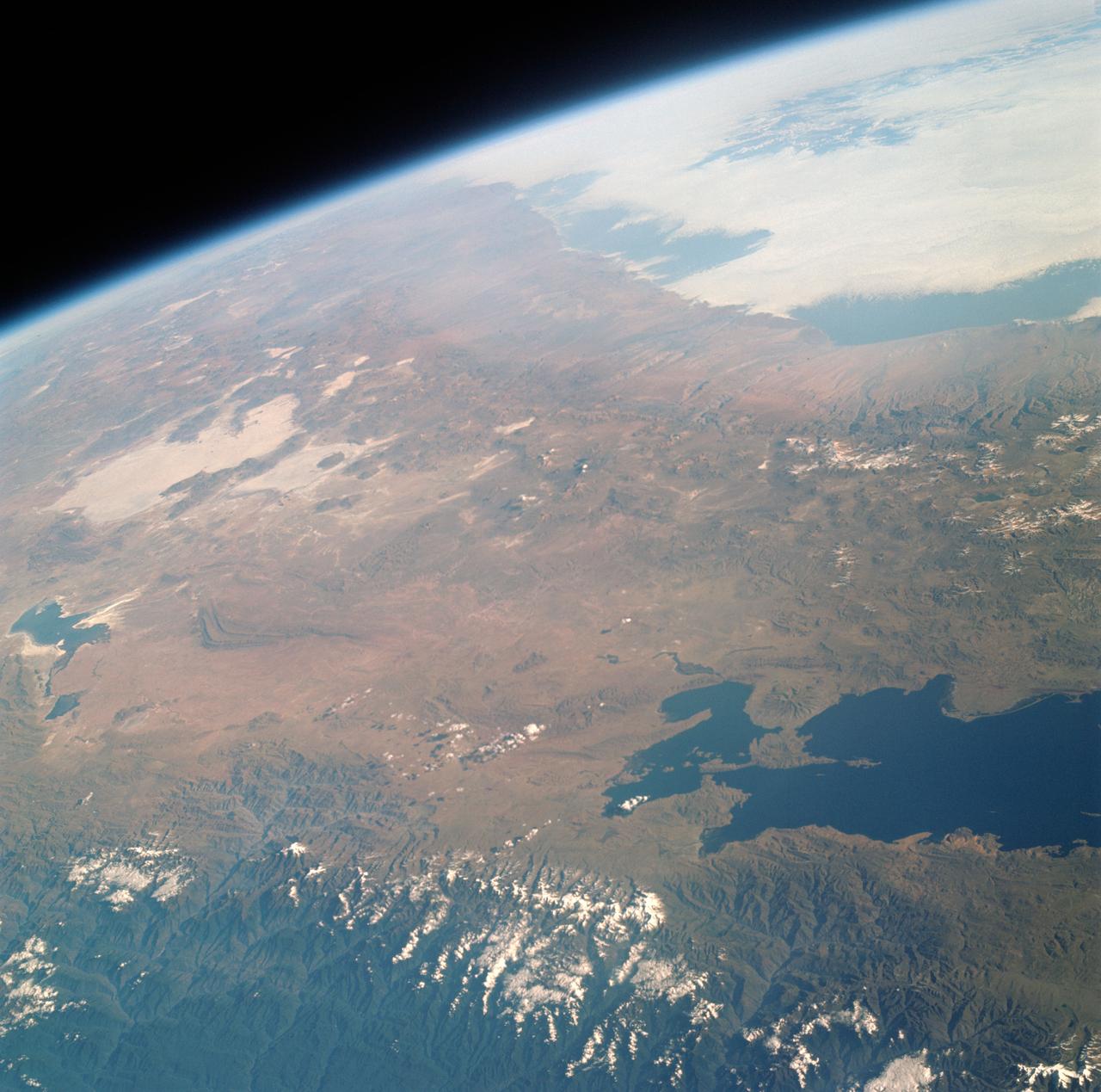
STS-65 Earth observation taken aboard Columbia, Orbiter Vehicle (OV) 102, shows Northern Chile and the Andes Mountains. This color photograph is a panoramic (southern view) that features Chile and the Andes Mountains of South America. The Atacama Desert, one of the driest regions on Earth, is clearly visible along the Chilean coast. In the near left foreground is the Salar de Arizaro. Salar Punta Negra in the center foreground appears to be partially filled with water. On the right side of the view, a coastal plateau rises from the Pacific Ocean and meets the Andes Mountains that appear as a backbone running north to south along the border of Chile and Argentina. In the distant left portion of the view can be seen the hazy Chaco Plains and Pampas.
This 10.5 by 11 km sub-area in northern Chile was acquired by ASTER on April 7, 2000. Dramatically displayed is a geological angular unconformity: a contact between layers of rock at different angles. On the right side of the image, Cretaceous sediments were tilted upward to an angle of about 50 degrees, then eroded. On this surface volcanic pyroclastic deposits were deposited as a flat sheet. The section of rocks has been eroding from the east, exposing the tilted and flat rock layers. The image is located at 24.8 degrees south latitude and 69.1 degrees west longitude. http://photojournal.jpl.nasa.gov/catalog/PIA11159
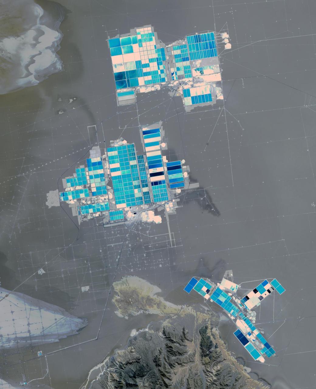
Salar de Atacama (Atacama salt flats) in Chile's Atacama Desert receives 2 mm rain per year. Its attraction are the brines 40 m below ground. They are pumped to the surface into large evaporation pans. After the water has vanished, a yellowish greasy solution is left behind that contains lithium. In fact, Salar de Atacama produces 27% of the world's annual supply. Mining lithium here is less expensive to produce than from neighboring Salar de Uyuni, which is estimated to have half of the lithium reserves in the world. The image was acquired August 21, 2017, covers an area of 22.5 by 27.8 km, and is located at 23.5 degrees south, 68.3 degrees west. https://photojournal.jpl.nasa.gov/catalog/PIA23420

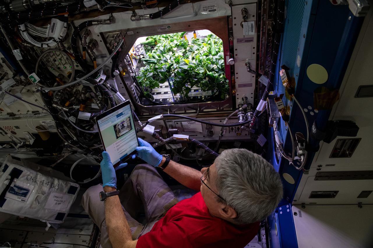
(iss065e163671) July 12, 2021 --- NASA astronaut and Expedition 65 Flight Engineer Shane Kimbrough inserts a device called a science carrier into the Advanced Plant Habitat (APH), which contains 48 Hatch chile pepper seeds NASA started growing on July 12, 2021 as part of the Plant Habitat-04 experiment. Astronauts on station and a team of researchers at Kennedy will work together to monitor the peppers’ growth for about four months before harvesting them. This will be one of the longest and most challenging plant experiments attempted aboard the orbital lab.

(iss065e163668) July 12, 2021 --- NASA astronaut and Expedition 65 Flight Engineer Shane Kimbrough inserts a device called a science carrier into the Advanced Plant Habitat (APH), which contains 48 Hatch chile pepper seeds NASA started growing on July 12, 2021 as part of the Plant Habitat-04 experiment. Astronauts on station and a team of researchers at Kennedy will work together to monitor the peppers’ growth for about four months before harvesting them. This will be one of the longest and most challenging plant experiments attempted aboard the orbital lab.
iss073e0384067 (July 12, 2025) --- The Andes Mountains run through Chile and Bolivia on the South American continent. The eastern slope of the Andes in Bolivia captures moisture from the Amazon basin creating more rainfall on that side of the nation and contributes to an arid climate on South America's Pacific coast. The International Space Station was orbiting 260 miles above Chile when this photograph was taken.

STS109-E-5887 (9 March 2002) --- This view of a good portion of the country of Chile was recorded with a digital still camera by one of the STS-109 astronauts aboard the Space Shuttle Columbia. Chile's Pacific Coast is featured and the country's borders with three other nations--Bolivia, Peru and Argentina--almost or just barely made it into the frame in three different directions. Punta Angamos and Punta Tetas are readily visible on the anvil shaped peninsular feature, near the city of Antofagasta.

iss072e572361 (Jan. 28, 2025) --- The Andes mountain range separates the South American nations of Chile and Argentina significantly impacting the climate of both countries. The elevation of the Andes creates a dry climate to the west and a rainy climate to the east. The International Space Station was orbiting 266 miles above Los Ángeles, Chile, at the time of this photograph.
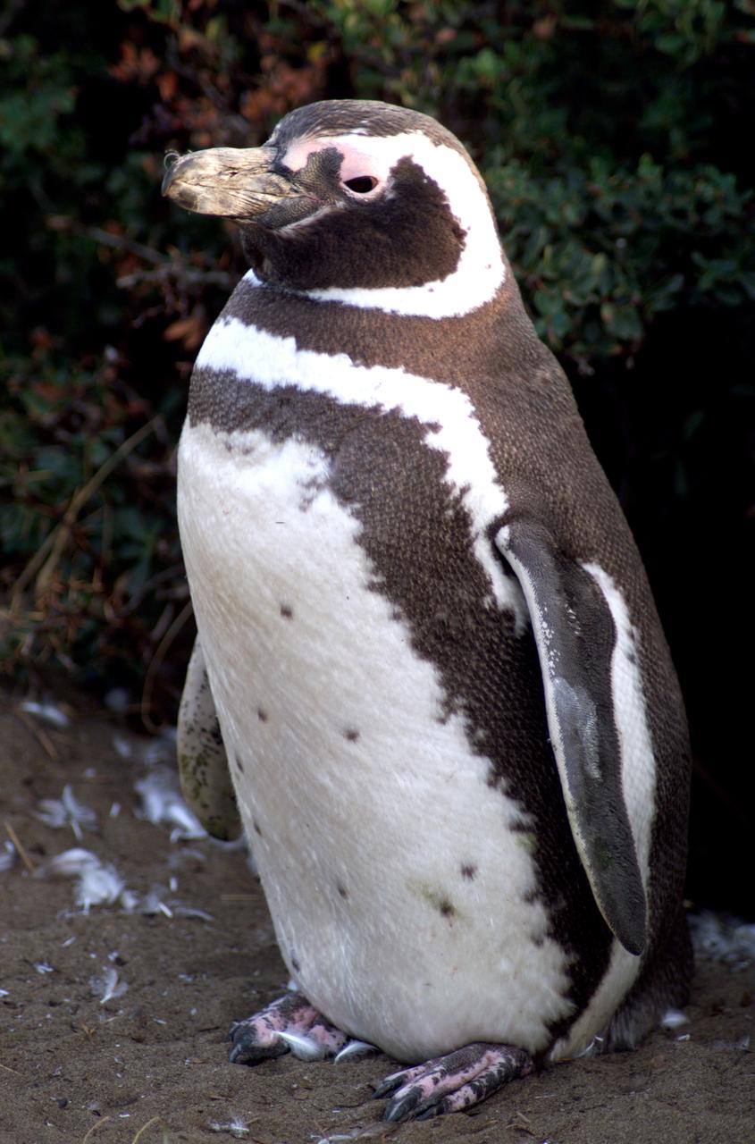
A penguin near Punta Arena, Chile, photographed in its natural summer habitat during NASA's AirSAR 2004 campaign. AirSAR 2004 is a three-week expedition in Central and South America by an international team of scientists that is using an all-weather imaging tool, called the Airborne Synthetic Aperture Radar (AirSAR), located onboard NASA's DC-8 airborne laboratory. Scientists from many parts of the world are combining ground research with NASA's AirSAR technology to improve and expand on the quality of research they are able to conduct.
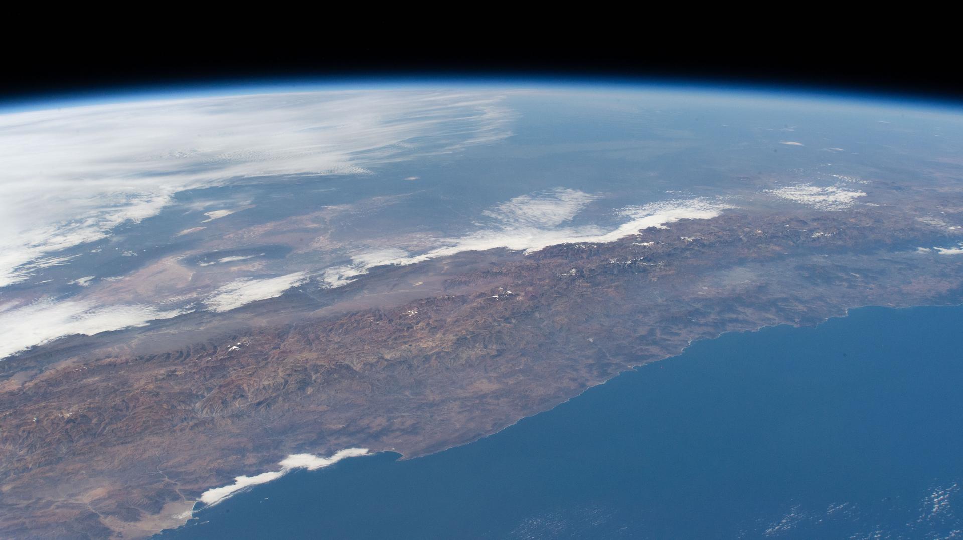
iss074e0349412 (March 3, 2026) --- The Andes mountain range running between Chile and Argentina creates distinct differences in climate and geography between the two South American nations. Chile’s Pacific coastline contributes to its moderate temperatures, with the Atacama Desert in the north being one of the driest places on Earth, while its central and southern regions are cooler and wetter. Argentina’s western side is more arid because the Andes block moisture from the Pacific Ocean, while the country’s Atlantic coastline receives more precipitation than its interior and western regions. Credit: NASA
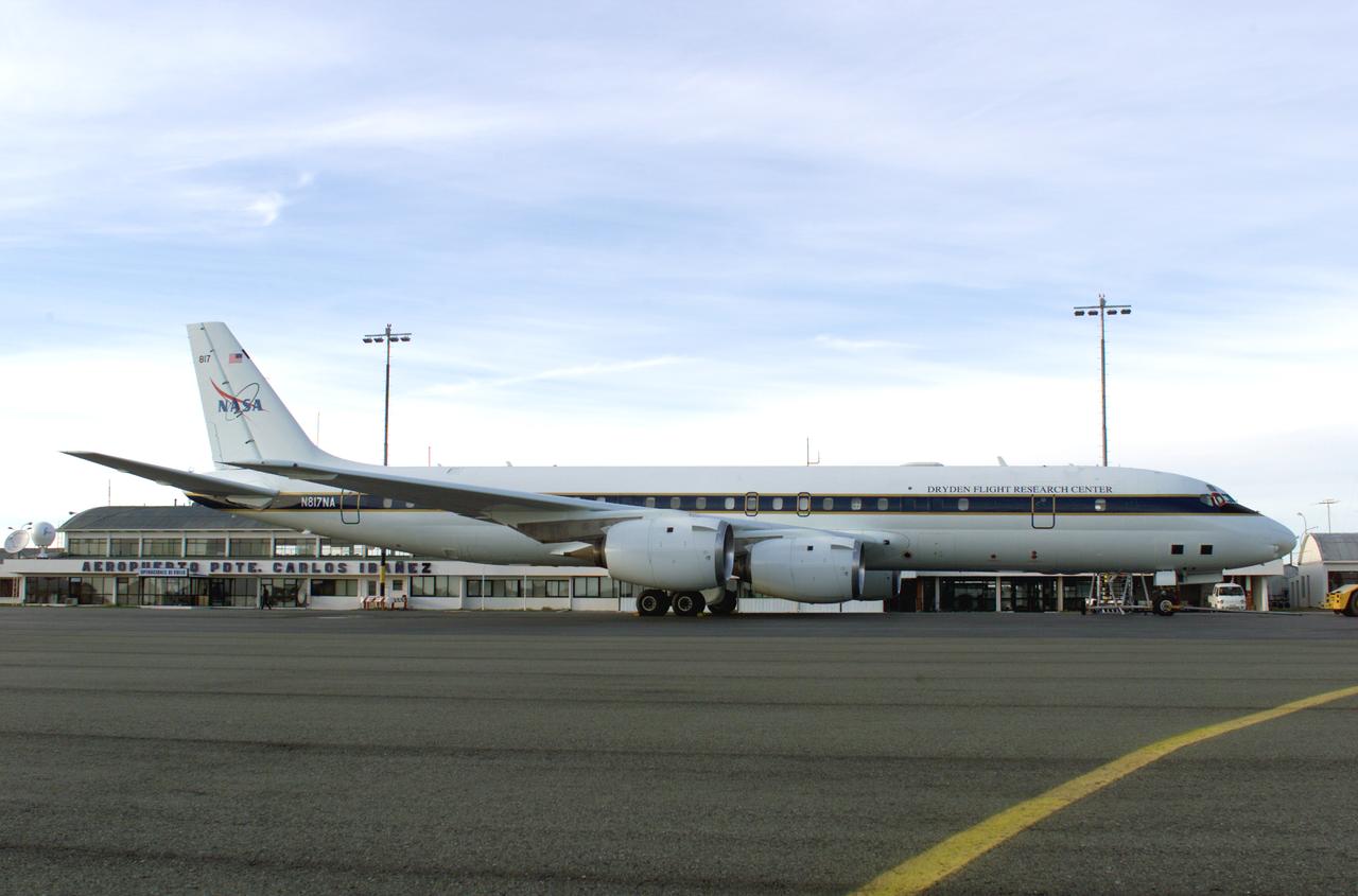
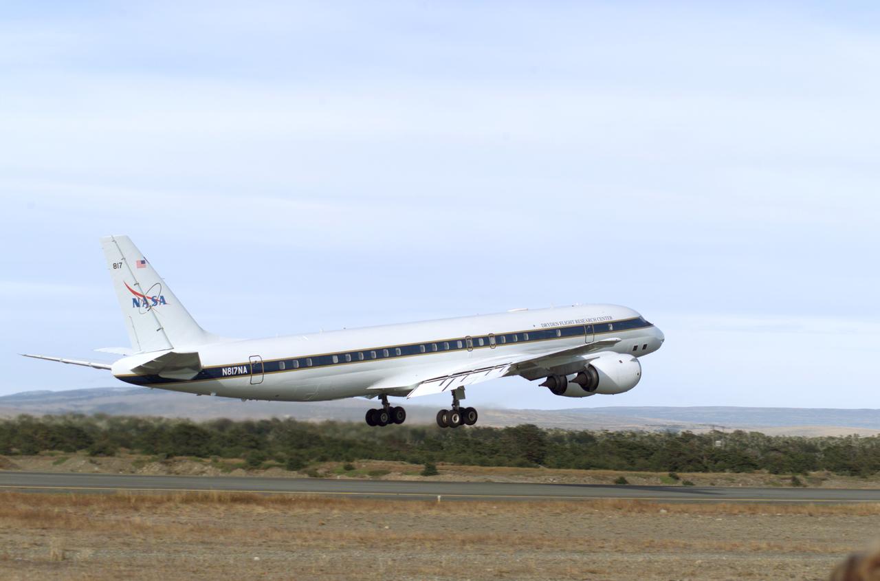
NASA’s DC-8 aircraft prior to launch from Carlos Ibanez International Airport in Punta Arenas, Chile, during AirSAR 2004. AirSAR 2004 is a three-week expedition in Central and South America by an international team of scientists that is using an all-weather imaging tool, called the Airborne Synthetic Aperture Radar (AirSAR), located onboard NASA's DC-8 airborne laboratory. Scientists from many parts of the world are combining ground research with NASA's AirSAR technology to improve and expand on the quality of research they are able to conduct.

NASA’s DC-8 aircraft at Carlos Ibanez International Airport in Punta Arenas, Chile. A portion of AirSAR hardware is visible on the left rear fuselage. AirSAR 2004 is a three-week expedition in Central and South America by an international team of scientists that is using an all-weather imaging tool, called the Airborne Synthetic Aperture Radar (AirSAR), located onboard NASA's DC-8 airborne laboratory. Scientists from many parts of the world are combining ground research with NASA's AirSAR technology to improve and expand on the quality of research they are able to conduct.
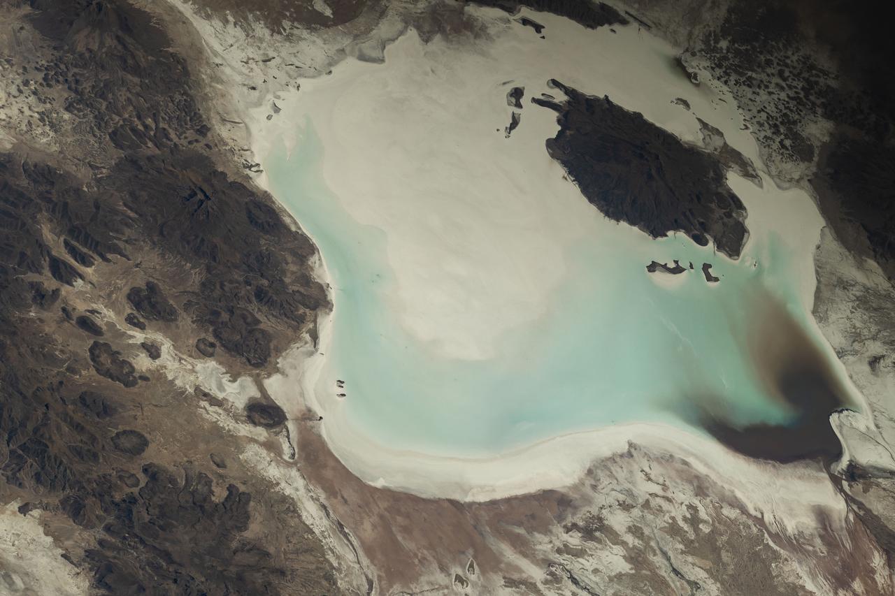
iss073e0248069 (June 24, 2025) --- Lake Coipasa, a basin created by tectonic activity with a high salt concentration surrounded by the Coipasa Salt Flats, in Bolivia near the border with Chile is pictured from the International Space Station as it orbited 264 miles above South America. The volcano Wila Pukarini (upper right) is located inside the lake.
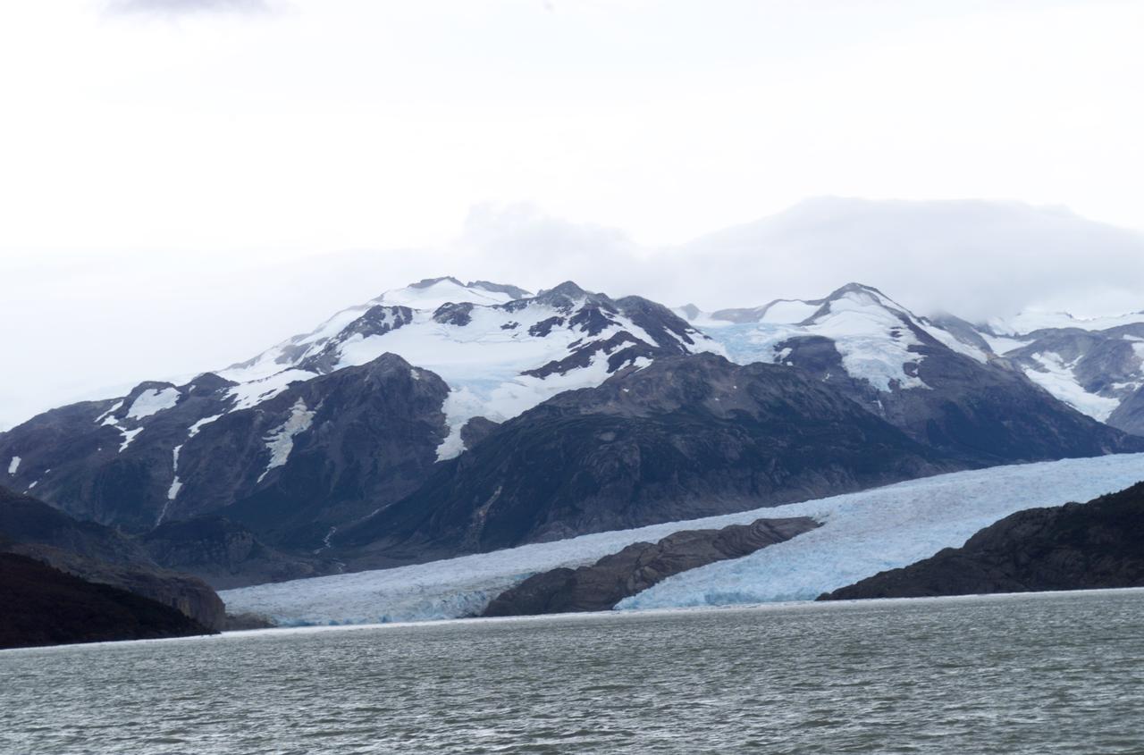
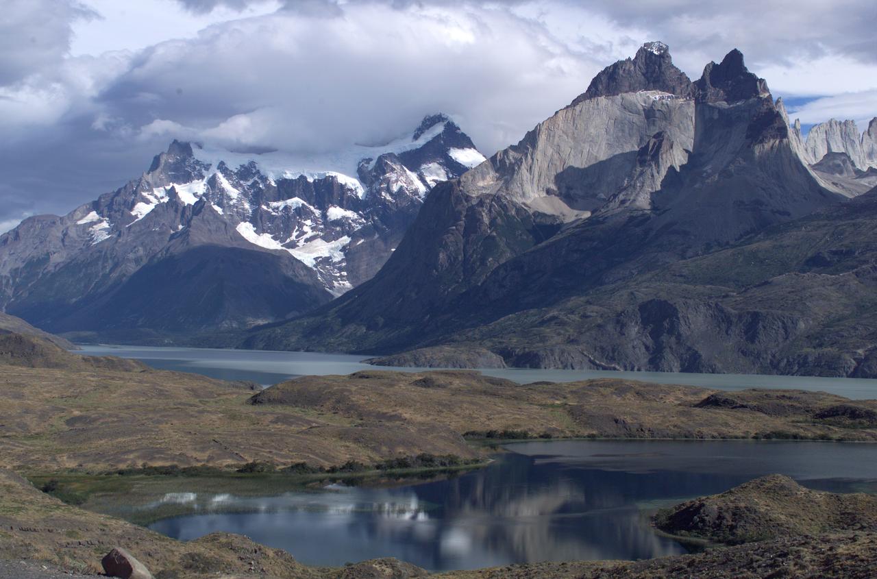
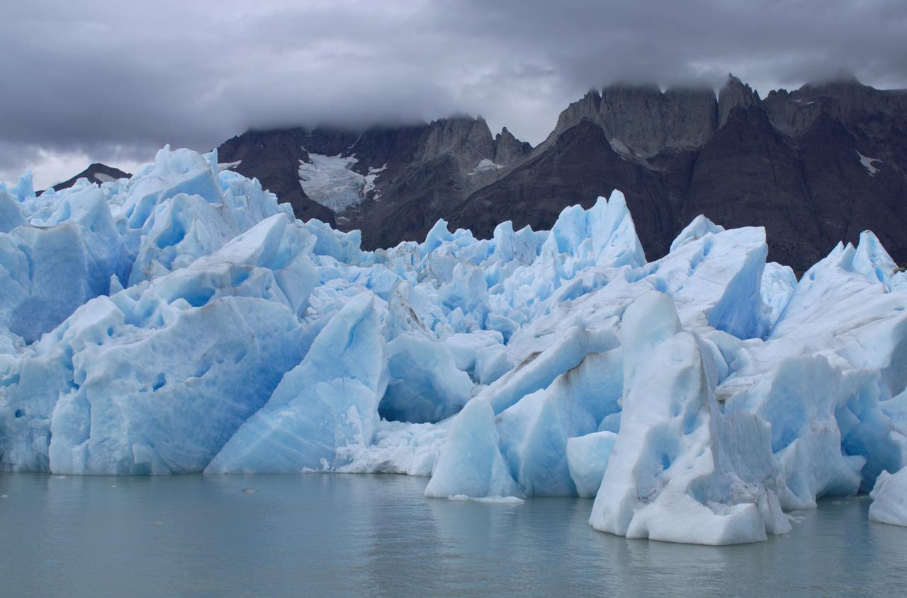
Glacier Grey view from Lago Grey (Grey Lake), photographed during NASA's AirSAR 2004 campaign in Chile. Land visible in this photo was covered by glacier just 6 years earlier. AirSAR 2004 is a three-week expedition in Central and South America by an international team of scientists that is using an all-weather imaging tool, called the Airborne Synthetic Aperture Radar (AirSAR), located onboard NASA's DC-8 airborne laboratory. Scientists from many parts of the world are combining ground research with NASA's AirSAR technology to improve and expand on the quality of research they are able to conduct. Founded in 1959, Torres del Paine National Park encompasses 450,000 acres in the Patagonia region of Chile. This region is being studied by NASA using a DC-8 equipped with an Airborne Synthetic Aperture Radar (AirSAR) developed by scientists from NASA’s Jet Propulsion Laboratory. This is a very sensitive region that is important to scientists because the temperature has been consistently rising causing a subsequent melting of the region’s glaciers. AirSAR will provide a baseline model and unprecedented mapping of the region. This data will make it possible to determine whether the warming trend is slowing, continuing or accelerating. AirSAR will also provide reliable information on ice shelf thickness to measure the contribution of the glaciers to sea level.
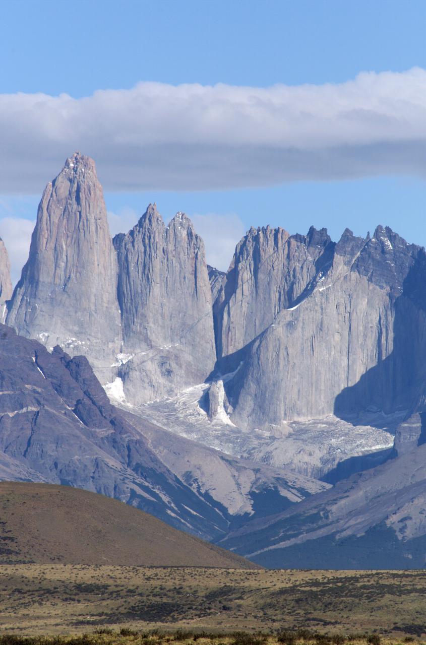
The Cuernos del Paine mountains in Torres del Paine National Park in Chile, photographed during NASA's AirSAR 2004 campaign. AirSAR 2004 is a three-week expedition in Central and South America by an international team of scientists that is using an all-weather imaging tool, called the Airborne Synthetic Aperture Radar (AirSAR), located onboard NASA's DC-8 airborne laboratory. Scientists from many parts of the world are combining ground research with NASA's AirSAR technology to improve and expand on the quality of research they are able to conduct. Founded in 1959, Torres del Paine National Park encompasses 450,000 acres in the Patagonia region of Chile. This region is being studied by NASA using a DC-8 equipped with an Airborne Synthetic Aperture Radar (AirSAR) developed by scientists from NASA’s Jet Propulsion Laboratory. This is a very sensitive region that is important to scientists because the temperature has been consistently rising causing a subsequent melting of the region’s glaciers. AirSAR will provide a baseline model and unprecedented mapping of the region. This data will make it possible to determine whether the warming trend is slowing, continuing or accelerating. AirSAR will also provide reliable information on ice shelf thickness to measure the contribution of the glaciers to sea level.
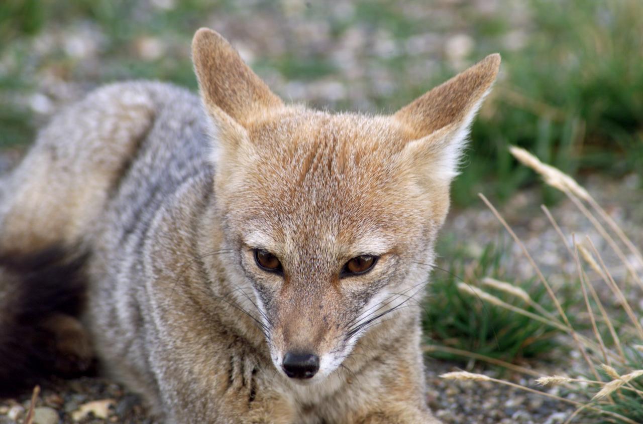
A fox at Torres del Paine National Park in Chile during NASA's AirSAR 2004 campaign. AirSAR 2004 is a three-week expedition in Central and South America by an international team of scientists that is using an all-weather imaging tool, called the Airborne Synthetic Aperture Radar (AirSAR), located onboard NASA's DC-8 airborne laboratory. Scientists from many parts of the world are combining ground research with NASA's AirSAR technology to improve and expand on the quality of research they are able to conduct. Founded in 1959, Torres del Paine National Park encompasses 450,000 acres in the Patagonia region of Chile. This region is being studied by NASA using a DC-8 equipped with an Airborne Synthetic Aperture Radar (AirSAR) developed by scientists from NASA’s Jet Propulsion Laboratory. This is a very sensitive region that is important to scientists because the temperature has been consistently rising causing a subsequent melting of the region’s glaciers. AirSAR will provide a baseline model and unprecedented mapping of the region. This data will make it possible to determine whether the warming trend is slowing, continuing or accelerating. AirSAR will also provide reliable information on ice shelf thickness to measure the contribution of the glaciers to sea level.
The Cuernos del Paine mountains in Torres del Paine National Park, Chile, during NASA's AirSAR 2004 campaign. AirSAR 2004 is a three-week expedition in Central and South America by an international team of scientists that is using an all-weather imaging tool, called the Airborne Synthetic Aperture Radar (AirSAR), located onboard NASA's DC-8 airborne laboratory. Scientists from many parts of the world are combining ground research with NASA's AirSAR technology to improve and expand on the quality of research they are able to conduct. Founded in 1959, Torres del Paine National Park encompasses 450,000 acres in the Patagonia region of Chile. This region is being studied by NASA using a DC-8 equipped with an Airborne Synthetic Aperture Radar (AirSAR) developed by scientists from NASA’s Jet Propulsion Laboratory. This is a very sensitive region that is important to scientists because the temperature has been consistently rising causing a subsequent melting of the region’s glaciers. AirSAR will provide a baseline model and unprecedented mapping of the region. This data will make it possible to determine whether the warming trend is slowing, continuing or accelerating. AirSAR will also provide reliable information on ice shelf thickness to measure the contribution of the glaciers to sea level.
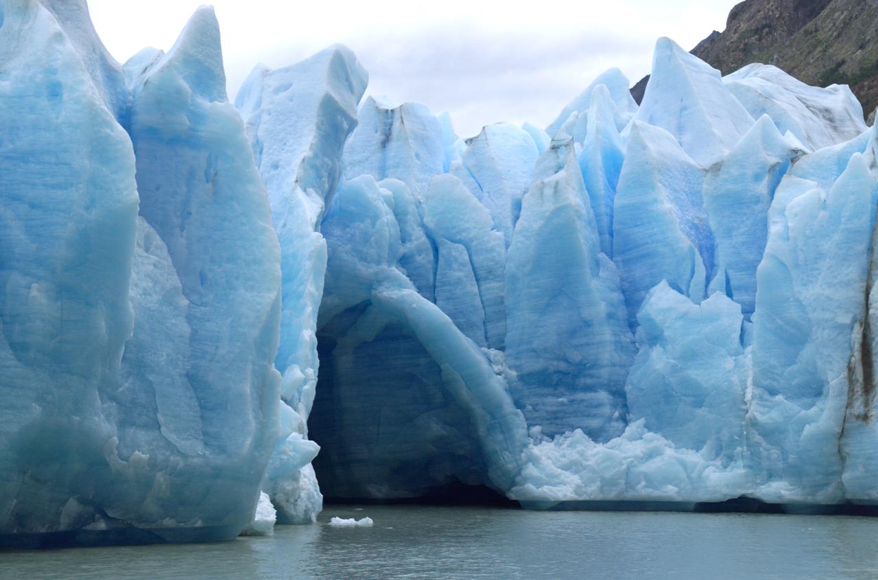
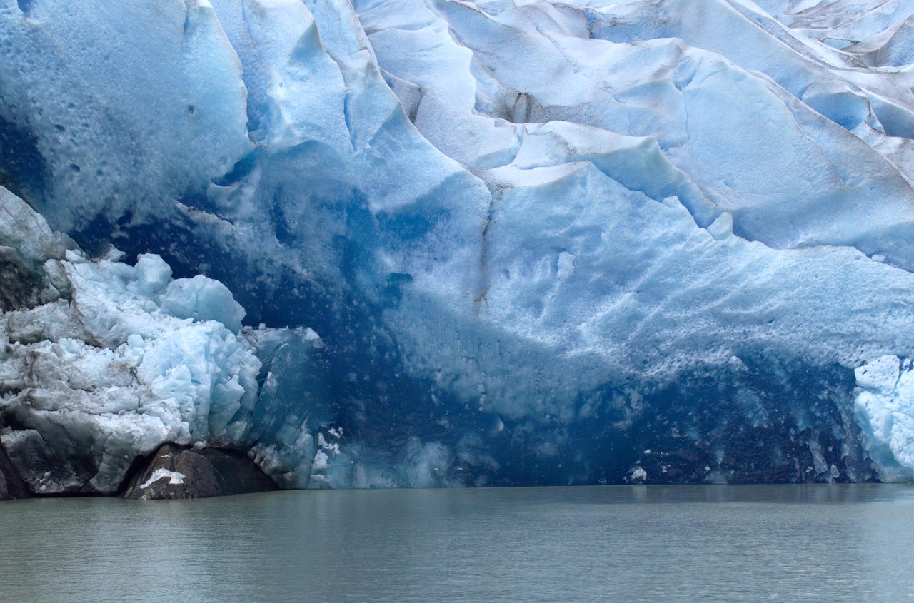
A cave in Glacier Grey in Torres del Paine National Park, seen during NASA's AirSAR 2004 campaign in Chile. AirSAR 2004 is a three-week expedition in Central and South America by an international team of scientists that is using an all-weather imaging tool, called the Airborne Synthetic Aperture Radar (AirSAR), located onboard NASA's DC-8 airborne laboratory. Scientists from many parts of the world are combining ground research with NASA's AirSAR technology to improve and expand on the quality of research they are able to conduct. Founded in 1959, Torres del Paine National Park encompasses 450,000 acres in the Patagonia region of Chile. This region is being studied by NASA using a DC-8 equipped with an Airborne Synthetic Aperture Radar (AirSAR) developed by scientists from NASA’s Jet Propulsion Laboratory. This is a very sensitive region that is important to scientists because the temperature has been consistently rising causing a subsequent melting of the region’s glaciers. AirSAR will provide a baseline model and unprecedented mapping of the region. This data will make it possible to determine whether the warming trend is slowing, continuing or accelerating. AirSAR will also provide reliable information on ice shelf thickness to measure the contribution of the glaciers to sea level.
NASA's DC-8 flying laboratory takes off from Carlos Ibanez International Airport in Punta Arenas, Chile, during NASA's AirSAR 2004 campaign. AirSAR 2004 is a three-week expedition in Central and South America by an international team of scientists that is using an all-weather imaging tool, called the Airborne Synthetic Aperture Radar (AirSAR), located onboard NASA's DC-8 airborne laboratory. Scientists from many parts of the world are combining ground research with NASA's AirSAR technology to improve and expand on the quality of research they are able to conduct.
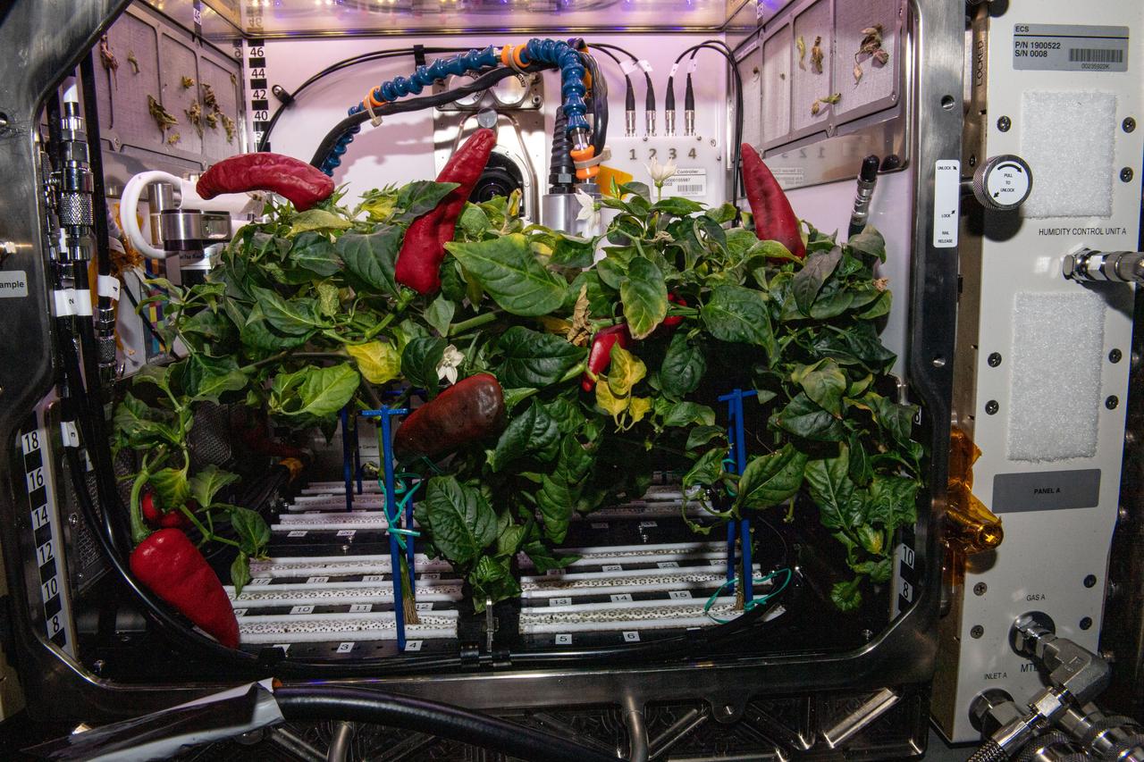
View of Chile Peppers growing inside the Advanced Plant Habitat in the Columbus Module during Expedition 66.
STS061-101-023 (8 Dec 1993) --- This color photograph is a spectacular, panoramic (southeastern view) shot that features the northern half of the country of Chile and the Andes Mountains of South America. The Atacama Desert, one of the driest regions on earth, is clearly visible along the northern Chilean coast. This desert extends from roughly Arica in the north to the city of Caldera in the south, a distance of six hundred miles. Some parts of this very arid region go for more than twenty years without measurable precipitation. It is an area of dramatic and abrupt elevation changes. For example, from the waters edge there is an escarpment of the coastal plateau that rises like an unbroken wall two or three thousand feet above the Pacific Ocean. From the coastal plateau, there is an even more dramatic increase in elevation -- from two thousand feet above sea level to an average elevation of thirteen thousand feet above sea level in the Bolivian Altiplano. This elevation change occurs within a one hundred to two hundred mile distance from the Pacific Ocean. The north-south trending spine of the Andes Mountains can be seen on this photograph. Several of the volcanic peaks in this mountain chain exceed 20,000 feet above sea level. Interspersed with these volcanic peaks, numerous dry lake beds (salars) can be seen as highly reflective surfaces. The largest of these salars (Salar de Uyuni) is visible at the edge of the Hubble Space Telescope (HST). Offshore, the cold Peruvian current produces low stratus clouds that can be found along this coastline at certain times of the year. This is the same type of meteorological phenomena that is found along the southern California coast and the Skeleton coast of southwestern Africa.

Dr. Tom Mace, NASA DFRC Director of Airborne Sciences, talks with a student from Punta Arenas, Chile, during a tour of the DC-8 aircraft while it was in the country supporting the AirSAR 2004 campaign. AirSAR 2004 is a three-week expedition by an international team of scientists that uses an all-weather imaging tool, called the Airborne Synthetic Aperture Radar (AirSAR) which is located onboard NASA's DC-8 airborne laboratory. Scientists from many parts of the world including NASA's Jet Propulsion Laboratory are combining ground research done in several areas in Central and South America with NASA's AirSAR technology to improve and expand on the quality of research they are able to conduct. In South America and Antarctica, AirSAR collected imagery and data to help determine the contribution of Southern Hemisphere glaciers to sea level rise due to climate change. In Patagonia, researchers found this contribution had more than doubled from 1995 to 2000, compared to the previous 25 years. AirSAR data will make it possible to determine whether that trend is continuing or accelerating. AirSAR will also provide reliable information on ice shelf thickness to measure the contribution of the glaciers to sea level.
STS068-260-078 (30 September-11 October 1994) --- The ice visible along the bottom of this view is the north end of the larger (southern) of two great remaining ice field of the Andes Mountains in Chile. The longest glacier visible here flows down into the Calen Fjord (an arm of the Pacific Ocean known as Canal Baker) where numerous calved icebergs can be seen floating. The other three glaciers end in glacier-cut valleys with small lakes - the bigger lake has numerous icebergs as well. the river snaking through the mountains to the fjord drains water from the great Lake O'Higgins, which lies out of the picture to the right. Glacial mud can be seen emptying into the fjord and discoloring the water with its milky color.
Close-up view of Grey Glacier from Lago Grey (Grey Lake), taken during NASA's AirSAR 2004 campaign in Chile. AirSAR 2004 is a three-week expedition in Central and South America by an international team of scientists that is using an all-weather imaging tool, called the Airborne Synthetic Aperture Radar (AirSAR), located onboard NASA's DC-8 airborne laboratory. Scientists from many parts of the world are combining ground research with NASA's AirSAR technology to improve and expand on the quality of research they are able to conduct. Founded in 1959, Torres del Paine National Park encompasses 450,000 acres in the Patagonia region of Chile. This region is being studied by NASA using a DC-8 equipped with an Airborne Synthetic Aperture Radar (AirSAR) developed by scientists from NASA’s Jet Propulsion Laboratory. This is a very sensitive region that is important to scientists because the temperature has been consistently rising causing a subsequent melting of the region’s glaciers. AirSAR will provide a baseline model and unprecedented mapping of the region. This data will make it possible to determine whether the warming trend is slowing, continuing or accelerating. AirSAR will also provide reliable information on ice shelf thickness to measure the contribution of the glaciers to sea level.
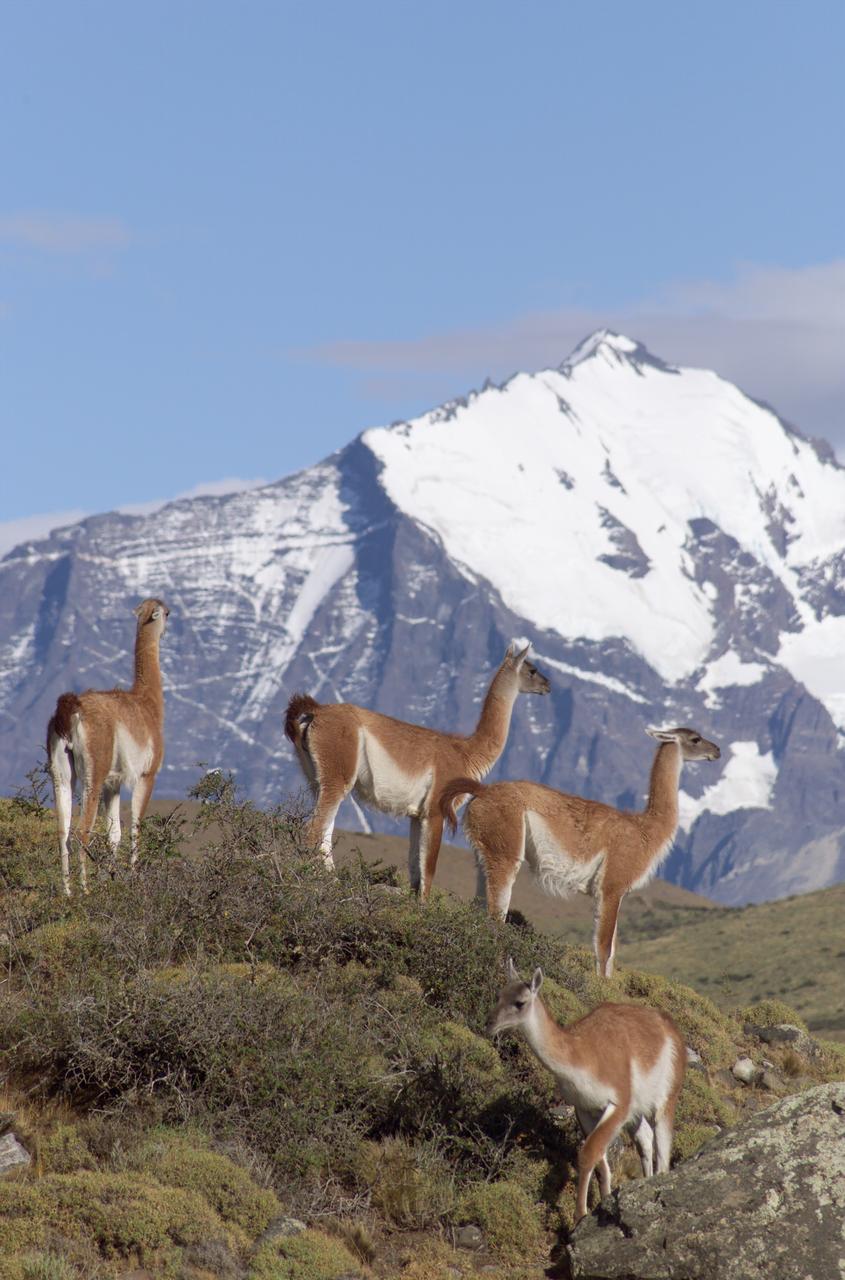
The Cuernos del Paine mountains in Torres del Paine National Park in Chile provide a backdrop to a herd of guanacos during NASA's AirSAR 2004 campaign. AirSAR 2004 is a three-week expedition in Central and South America by an international team of scientists that is using an all-weather imaging tool, called the Airborne Synthetic Aperture Radar (AirSAR), located onboard NASA's DC-8 airborne laboratory. Scientists from many parts of the world are combining ground research with NASA's AirSAR technology to improve and expand on the quality of research they are able to conduct. Founded in 1959, Torres del Paine National Park encompasses 450,000 acres in the Patagonia region of Chile. This region is being studied by NASA using a DC-8 equipped with an Airborne Synthetic Aperture Radar (AirSAR) developed by scientists from NASA’s Jet Propulsion Laboratory. This is a very sensitive region that is important to scientists because the temperature has been consistently rising causing a subsequent melting of the region’s glaciers. AirSAR will provide a baseline model and unprecedented mapping of the region. This data will make it possible to determine whether the warming trend is slowing, continuing or accelerating. AirSAR will also provide reliable information on ice shelf thickness to measure the contribution of the glaciers to sea level.
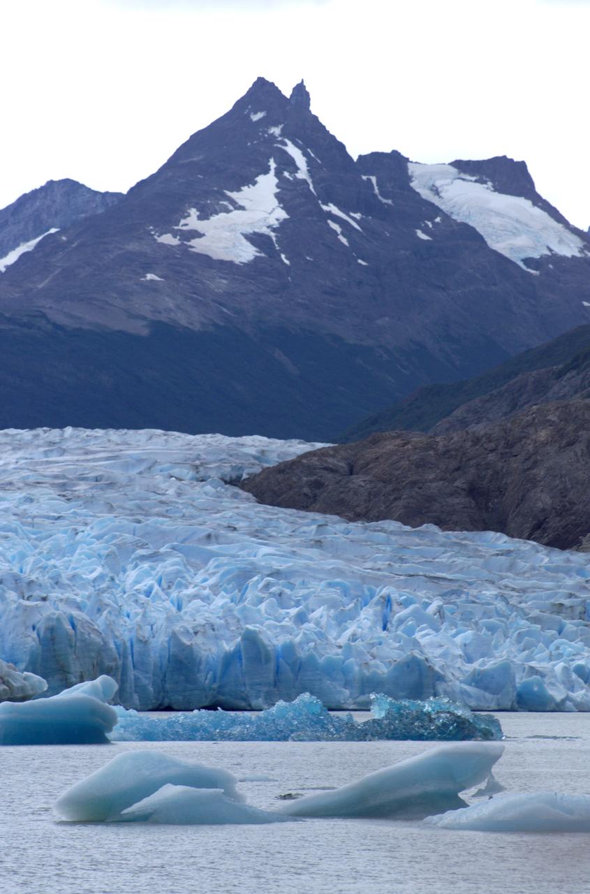
Glacier Grey in front of the Cuernos del Paine mountains, photographed from Lago Grey (Grey Lake) during NASA's AirSAR 2004 campaign in Chile. AirSAR 2004 is a three-week expedition in Central and South America by an international team of scientists that is using an all-weather imaging tool, called the Airborne Synthetic Aperture Radar (AirSAR), located onboard NASA's DC-8 airborne laboratory. Scientists from many parts of the world are combining ground research with NASA's AirSAR technology to improve and expand on the quality of research they are able to conduct. Founded in 1959, Torres del Paine National Park encompasses 450,000 acres in the Patagonia region of Chile. This region is being studied by NASA using a DC-8 equipped with an Airborne Synthetic Aperture Radar (AirSAR) developed by scientists from NASA’s Jet Propulsion Laboratory. This is a very sensitive region that is important to scientists because the temperature has been consistently rising causing a subsequent melting of the region’s glaciers. AirSAR will provide a baseline model and unprecedented mapping of the region. This data will make it possible to determine whether the warming trend is slowing, continuing or accelerating. AirSAR will also provide reliable information on ice shelf thickness to measure the contribution of the glaciers to sea level.
View of Glacier Grey from Lago Grey (Grey Lake), with the Cuernos del Paine mountains in the background, seen during NASA's AirSAR 2004 campaign in Chile. AirSAR 2004 is a three-week expedition in Central and South America by an international team of scientists that is using an all-weather imaging tool, called the Airborne Synthetic Aperture Radar (AirSAR), located onboard NASA's DC-8 airborne laboratory. Scientists from many parts of the world are combining ground research with NASA's AirSAR technology to improve and expand on the quality of research they are able to conduct. Founded in 1959, Torres del Paine National Park encompasses 450,000 acres in the Patagonia region of Chile. This region is being studied by NASA using a DC-8 equipped with an Airborne Synthetic Aperture Radar (AirSAR) developed by scientists from NASA’s Jet Propulsion Laboratory. This is a very sensitive region that is important to scientists because the temperature has been consistently rising causing a subsequent melting of the region’s glaciers. AirSAR will provide a baseline model and unprecedented mapping of the region. This data will make it possible to determine whether the warming trend is slowing, continuing or accelerating. AirSAR will also provide reliable information on ice shelf thickness to measure the contribution of the glaciers to sea level.
A January 6, 2002 ASTER nighttime thermal infrared image of Chiliques volcano in Chile shows a hot spot in the summit crater and several others along the upper flanks of the edifice, indicating new volcanic activity. Examination of an earlier nighttime thermal infrared image from May 24, 2000 showed no thermal anomaly. Chiliques volcano was previously thought to be dormant. Rising to an elevation of 5778 m, Chiliques is a simple stratovolcano with a 500-m-diameter circular summit crater. This mountain is one of the most important high altitude ceremonial centers of the Incas. It is rarely visited due to its difficult accessibility. Climbing to the summit along Inca trails, numerous ruins are encountered; at the summit there are a series of constructions used for rituals. There is a beautiful lagoon in the crater that is almost always frozen. The daytime image was acquired on November 19, 2000 and was created by displaying ASTER bands 1,2 and 3 in blue, green and red. The nighttime image was acquired January 6, 2002, and is a color-coded display of a single thermal infrared band. The hottest areas are white, and colder areas are darker shades of red. Both images cover an area of 7.5 x 7.5 km, and are centered at 23.6 degrees south latitude, 67.6 degrees west longitude. Both images cover an area of 7.5 x 7.5 km, and are centered at 23.6 degrees south latitude, 67.6 degrees west longitude. http://photojournal.jpl.nasa.gov/catalog/PIA03493

iss066e023273 (October 29, 2021) -- ESA (European Space Agency) astronaut and Expedition 66 commander Thomas Pesquet is seen with a green chile pepper during a taste test as part of the Plant Habitat-04 investigation aboard the International Space Station. The chile peppers started growing on July 12, 2021, and represent one of the longest and most challenging plant experiments attempted aboard the orbiting laboratory. The chile peppers started growing on July 12, 2021, and represent one of the longest and most challenging plant experiments attempted aboard the orbiting laboratory. NASA astronaut and Expedition 66 flight engineer Mark Vande Hei conducted the first harvest of the pepper crop on October 29, 2021. Crew members sanitized the peppers and completed a scientific survey after their taste test. The Crew-3 astronauts will take over the crop when they arrive at the orbiting laboratory, and will conduct a final harvest of the peppers in late November. They will also sanitize and sample the crop, and complete surveys. Some peppers and their leaves from the final harvest will return to Earth for further analysis. What we learn will inform future crop growth and food supplementation activities for deep space exploration.
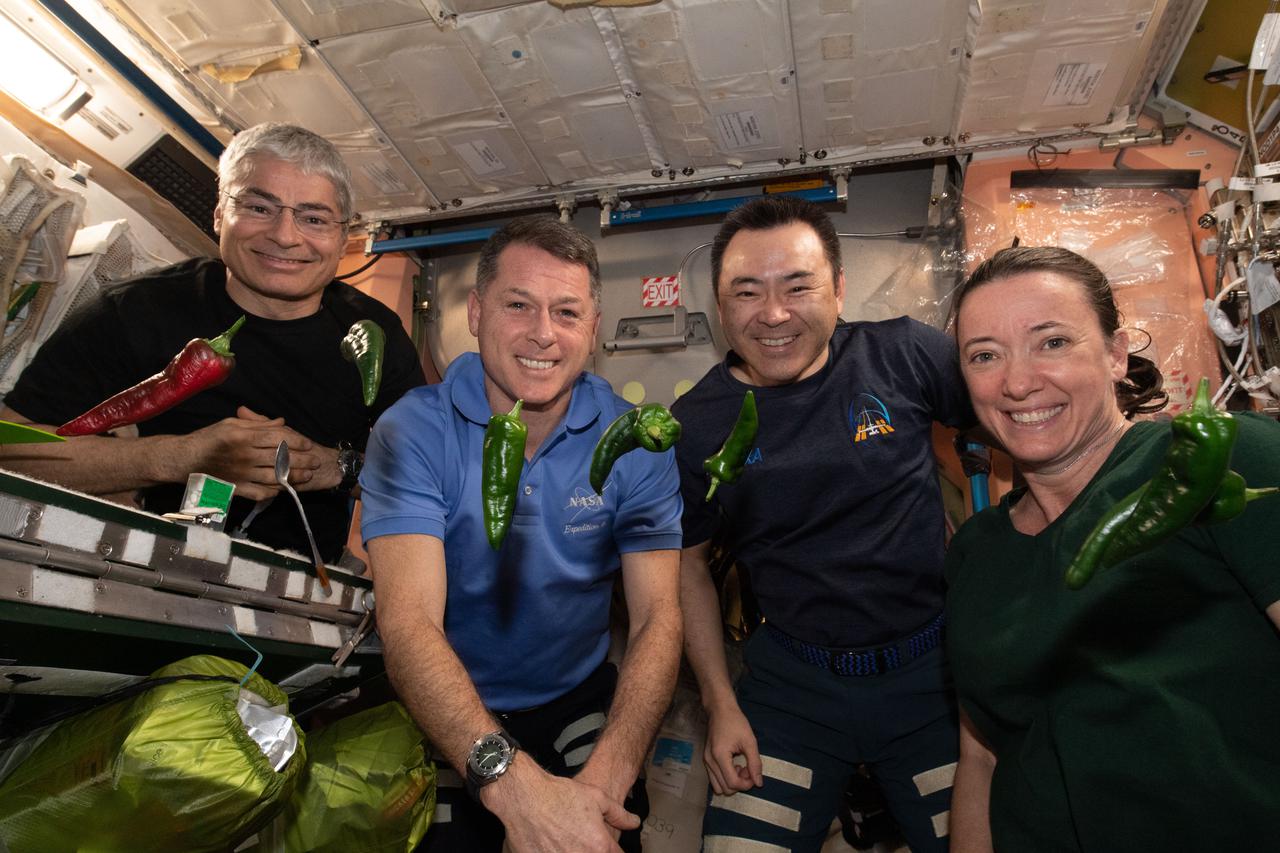
iss066e023259 (October 29, 2021) -- Expedition 66 astronauts are pictured with the first harvest of chile peppers grown aboard the International Space Station as part of the Plant Habitat-04 investigation. The chile peppers started growing on July 12, 2021, and represent one of the longest and most challenging plant experiments attempted aboard the orbiting laboratory. The chile peppers started growing on July 12, 2021, and represent one of the longest and most challenging plant experiments attempted aboard the orbiting laboratory. NASA astronaut and Expedition 66 flight engineer Mark Vande Hei conducted the first harvest of the pepper crop on October 29, 2021. Crew members sanitized the peppers and completed a scientific survey after their taste test. The Crew-3 astronauts will take over the crop when they arrive at the orbiting laboratory, and will conduct a final harvest of the peppers in late November. They will also sanitize and sample the crop, and complete surveys. Some peppers and their leaves from the final harvest will return to Earth for further analysis. What we learn will inform future crop growth and food supplementation activities for deep space exploration. Pictured, from left, are Expedition 66 flight engineers NASA astronauts Mark Vande Hei and Shane Kimbrough, JAXA (Japan Aerospace Exploration) astronaut Aki Hoshide, and NASA astronaut Megan McArthur.

iss066e023260 (October 29, 2021) -- Expedition 66 astronauts are pictured with the first harvest of chile peppers grown aboard the International Space Station as part of the Plant Habitat-04 investigation. The chile peppers started growing on July 12, 2021, and represent one of the longest and most challenging plant experiments attempted aboard the orbiting laboratory. The chile peppers started growing on July 12, 2021, and represent one of the longest and most challenging plant experiments attempted aboard the orbiting laboratory. NASA astronaut and Expedition 66 flight engineer Mark Vande Hei conducted the first harvest of the pepper crop on October 29, 2021. Crew members sanitized the peppers and completed a scientific survey after their taste test. The Crew-3 astronauts will take over the crop when they arrive at the orbiting laboratory, and will conduct a final harvest of the peppers in late November. They will also sanitize and sample the crop, and complete surveys. Some peppers and their leaves from the final harvest will return to Earth for further analysis. What we learn will inform future crop growth and food supplementation activities for deep space exploration. Pictured, from left, are Expedition 66 flight engineers NASA astronauts Mark Vande Hei and Shane Kimbrough, JAXA (Japan Aerospace Exploration) astronaut Aki Hoshide, and NASA astronaut Megan McArthur.
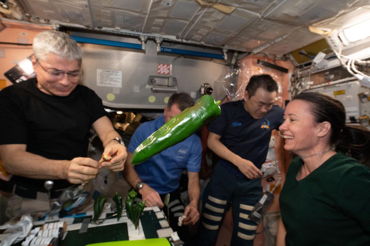
iss066e023272 (October 29, 2021) -- A green chile pepper is seen floating as Expedition 66 crew members conduct a taste test as part of the Plant Habitat-04 investigation aboard the International Space Station. The chile peppers started growing on July 12, 2021, and represent one of the longest and most challenging plant experiments attempted aboard the orbiting laboratory. The chile peppers started growing on July 12, 2021, and represent one of the longest and most challenging plant experiments attempted aboard the orbiting laboratory. NASA astronaut and Expedition 66 flight engineer Mark Vande Hei conducted the first harvest of the pepper crop on October 29, 2021. Crew members sanitized the peppers and completed a scientific survey after their taste test. The Crew-3 astronauts will take over the crop when they arrive at the orbiting laboratory, and will conduct a final harvest of the peppers in late November. They will also sanitize and sample the crop, and complete surveys. Some peppers and their leaves from the final harvest will return to Earth for further analysis. What we learn will inform future crop growth and food supplementation activities for deep space exploration.
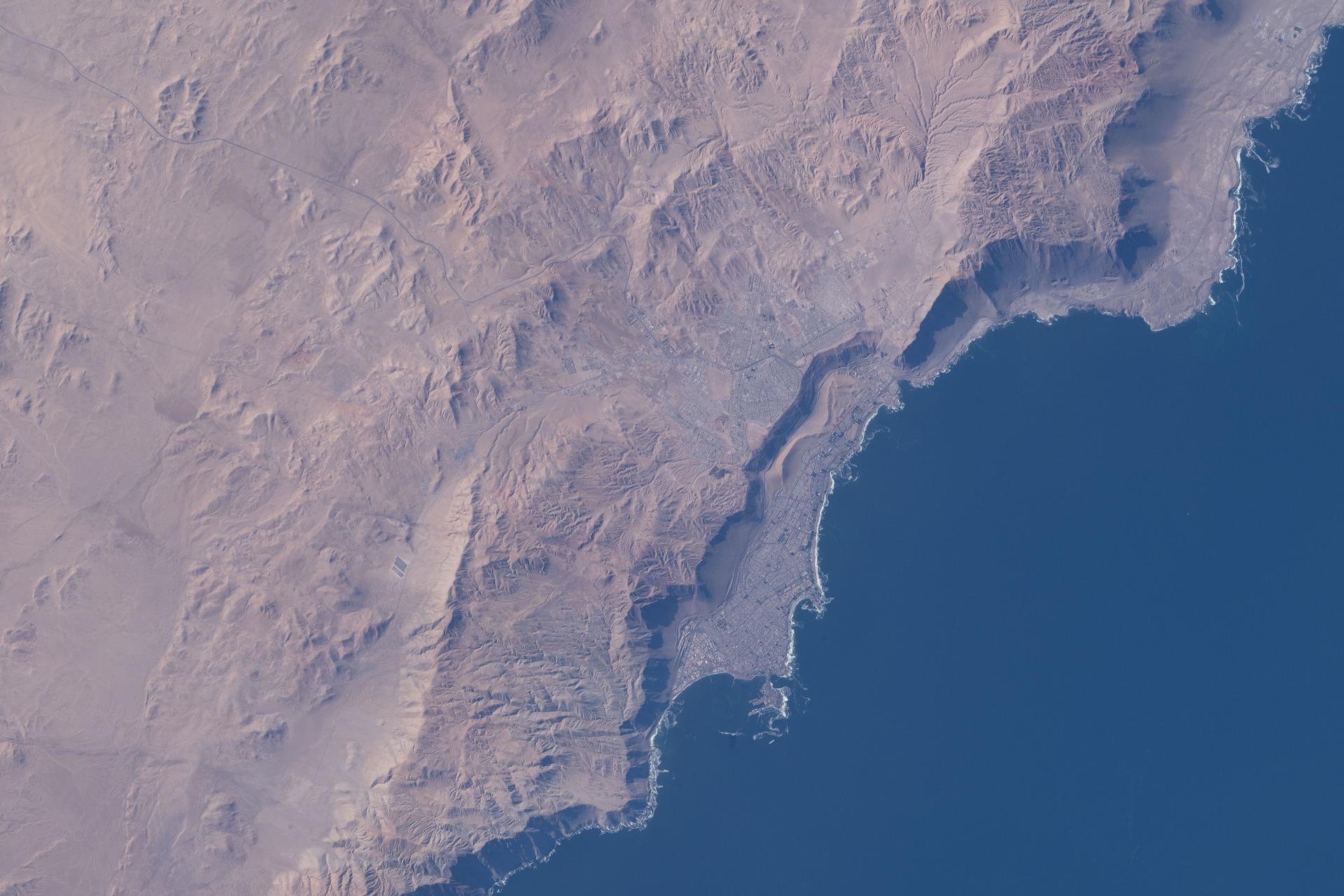
iss074e0362030 (March 5, 2026) --- Iquique, Chile, with a population of over 230,000, lies at the base of a steep coastal slope just west of the Atacama Desert—one of the world’s driest regions—on the South American nation’s Pacific coast. The International Space Station was orbiting 264 miles above at the time of this photograph. Credit: NASA/Jessica Meir

iss074e0089803 (Jan. 16, 2026) --- Earth's thin blue atmosphere traces the planet's horizon as the sun's glint beams off a partly cloudy Pacific Ocean west of Chile on the South American continent. The International Space Station was orbiting 271 miles above Earth at the time of this photograph.

iss066e023179 (October 29, 2021) -- NASA astronaut and Expedition 66 Flight Engineer Mark Vande Hei samples a red chile pepper grown as part of the Plant Habitat-04 experiment aboard the International Space Station. The chile pepper seeds started growing on July 12, 2021, and represent one of the longest and most challenging plant experiments attempted aboard the orbiting laboratory. Vande Hei conducted the first harvest of the pepper crop on October 29, 2021. Crew members sanitized the peppers and completed a scientific survey after their taste test. The Crew-3 astronauts will take over the crop when they arrive at the orbiting laboratory, and will conduct a final harvest of the peppers in late November. They will also sanitize and sample the crop, and complete surveys. Some peppers from the final harvest and their leaves will return to Earth for further analysis. What we learn will inform future crop growth and food supplementation activities for deep space exploration.
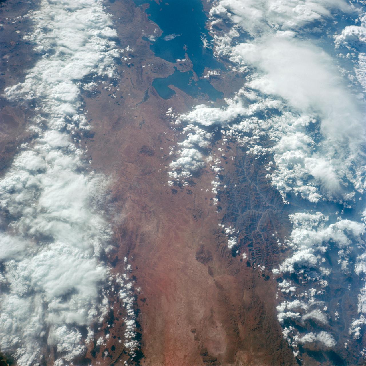
S66-38313 (5 June 1966) --- Areas of Peru (upper right), Chile (top center) and Bolivia as seen from the Gemini-9 spacecraft during its 35th revolution of Earth. The large body of water at lower right is Lake Titicaca. The smaller lake at left edge is Lake Poopo. Salar de Uyuni is the large light-colored area at upper left. At the bottom of the picture is the snow-capped Cordillera Real range of the Andes Mountains. The Pacific coastline of Peru and Chile is at upper right. The range running parallel with the coastline is the Cordillera Occidental. The image was taken with a modified 70mm Hasselblad camera, using Eastman Kodak, Ektachrome MS (S.O. 217) color film. Photo credit: NASA
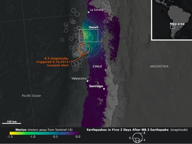
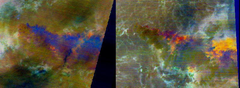
On Sept. 16, 2015, a magnitude 8.3 earthquake struck near the coast of central Chile along the boundary of the Nazca and South American tectonic plates. Dubbed the Illapel earthquake, the shaking lasted at least three minutes and propelled a 15-foot (4.5-meter) tsunami that washed into Coquimbo and other coastal areas. Smaller tsunami waves raced across the Pacific and showed up on the shores of Hawaii and other islands. The earthquake and tsunami caused substantial damage in several Chilean coastal towns, and at least 13 deaths have been reported. Demanding building codes and extensive disaster preparedness helped to limit the loss of life and property. The maps above, known as interferograms, show how the quake moved the ground, as observed by the Copernicus Sentinel-1A satellite (operated by the European Space Agency) and reported by ground stations to the U.S. Geological Survey. Sentinel-1A carries a synthetic aperture radar (SAR) instrument, which beams radio signals toward the ground and measures the reflections to determine the distance between the ground and the satellite. By comparing measurements made on Aug. 24 and Sept. 17, Cunren Liang, Eric Fielding, and other researchers from NASA's Jet Propulsion Laboratory were able to determine how the land surface shifted during and after the earthquake. Interferograms can be used to estimate where the fault moved deep in Earth and which areas have increased stress and higher likelihood of future earthquakes. The details can also provide important information to better understand the earthquake process. On both the close-up and the broad-view maps, the amount of land motion is represented in shades from yellow to purple. Areas where the ground shifted the most (vertically, horizontally, or both) are represented in yellow, while areas with little change are represented in purple. Circles show the location of earthquakes and aftershocks in the two days after the initial 8.3 earthquake, as reported by the USGS National Earthquake Information Center. Larger quakes are represented by larger circles. The base map layer uses a digital elevation model and a bathymetry map to show the contours of the land surface and seafloor. The interferograms above show that land moved as much as 1.4 meters toward to satellite (generally in the vertical direction) near the coast, and early estimates of the horizontal motion suggest it was as much as 2 meters. While SAR can see through clouds and the dark of night, it cannot see much through water. It is likely that much of the ground deformation from the earthquake occurred underwater, which explains the formation of the tsunami and the location of many aftershocks. http://photojournal.jpl.nasa.gov/catalog/PIA20002
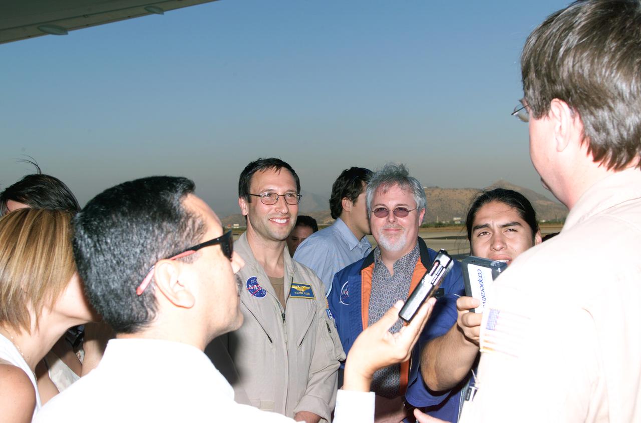
L to R; NASA Dryden Mission Manager Walter Klein (in tan flight suit), JPL AirSAR Scientist Tim Miller, and Mission Manager David Bushman briefing press in Santiago, Chile, for NASA's AirSAR 2004 mission. AirSAR 2004 is a three-week expedition by an international team of scientists that uses an all-weather imaging tool, called the Airborne Synthetic Aperture Radar (AirSAR) which is located onboard NASA's DC-8 airborne laboratory. Scientists from many parts of the world including NASA's Jet Propulsion Laboratory are combining ground research done in several areas in Central and South America with NASA's AirSAR technology to improve and expand on the quality of research they are able to conduct. In South America and Antarctica, AirSAR collected imagery and data to help determine the contribution of Southern Hemisphere glaciers to sea level rise due to climate change. In Patagonia, researchers found this contribution had more than doubled from 1995 to 2000, compared to the previous 25 years. AirSAR data will make it possible to determine whether that trend is continuing or accelerating. AirSAR will also provide reliable information on ice shelf thickness to measure the contribution of the glaciers to sea level.

NASA Dryden Mission Manager Walter Klein poses with school children that visited the DC-8 during AirSAR 2004 in Punta Arenas, Chile. AirSAR 2004 is a three-week expedition by an international team of scientists that uses an all-weather imaging tool, called the Airborne Synthetic Aperture Radar (AirSAR) which is located onboard NASA's DC-8 airborne laboratory. Scientists from many parts of the world including NASA's Jet Propulsion Laboratory are combining ground research done in several areas in Central and South America with NASA's AirSAR technology to improve and expand on the quality of research they are able to conduct. In South America and Antarctica, AirSAR collected imagery and data to help determine the contribution of Southern Hemisphere glaciers to sea level rise due to climate change. In Patagonia, researchers found this contribution had more than doubled from 1995 to 2000, compared to the previous 25 years. AirSAR data will make it possible to determine whether that trend is continuing or accelerating. AirSAR will also provide reliable information on ice shelf thickness to measure the contribution of the glaciers to sea level.

NASA Dryden Mission Manager Walter Klein talks with school children from Punta Arenas, Chile, during a tour of the DC-8 aircraft while it was in the country supporting the AirSAR 2004 campaign. AirSAR 2004 is a three-week expedition by an international team of scientists that uses an all-weather imaging tool, called the Airborne Synthetic Aperture Radar (AirSAR) which is located onboard NASA's DC-8 airborne laboratory. Scientists from many parts of the world including NASA's Jet Propulsion Laboratory are combining ground research done in several areas in Central and South America with NASA's AirSAR technology to improve and expand on the quality of research they are able to conduct. In South America and Antarctica, AirSAR collected imagery and data to help determine the contribution of Southern Hemisphere glaciers to sea level rise due to climate change. In Patagonia, researchers found this contribution had more than doubled from 1995 to 2000, compared to the previous 25 years. AirSAR data will make it possible to determine whether that trend is continuing or accelerating. AirSAR will also provide reliable information on ice shelf thickness to measure the contribution of the glaciers to sea level.

School children from Punta Arenas, Chile, talk with Dr. David Imel, an AirSAR scientist from NASA JPL, during AirSAR 2004. AirSAR 2004 is a three-week expedition by an international team of scientists that uses an all-weather imaging tool, called the Airborne Synthetic Aperture Radar (AirSAR) which is located onboard NASA's DC-8 airborne laboratory. Scientists from many parts of the world including NASA's Jet Propulsion Laboratory are combining ground research done in several areas in Central and South America with NASA's AirSAR technology to improve and expand on the quality of research they are able to conduct. In South America and Antarctica, AirSAR collected imagery and data to help determine the contribution of Southern Hemisphere glaciers to sea level rise due to climate change. In Patagonia, researchers found this contribution had more than doubled from 1995 to 2000, compared to the previous 25 years. AirSAR data will make it possible to determine whether that trend is continuing or accelerating. AirSAR will also provide reliable information on ice shelf thickness to measure the contribution of the glaciers to sea level.
This ASTER image covers 30 by 37 km in the Atacama Desert, Chile and was acquired on April 23, 2000. The Escondida Cu-Au-Ag open-pit mine is at an elevation of 3050 m, and came on stream in 1990. Current capacity is 127,000 tons/day of ore; in 1999 production totaled 827,000 tons of copper, 150,000 ounces of gold and 3.53 million ounces of silver. Primary concentration of the ore is done on-site; the concentrate is then sent to the coast for further processing through a 170 km long, 9 pipe. Escondida is related geologically to three porphyry bodies intruded along the Chilean West Fissure Fault System. A high grade supergene cap overlies primary sulfide ore. This image is a conventional 3-2-1 RGB composite. Figure 1 displays SWIR bands 4-6-8 in RGB, and highlights lithologic and alteration differences of surface units. The image is located at 24.3 degrees south latitude and 69.1 degrees west longitude. http://photojournal.jpl.nasa.gov/catalog/PIA11090

iss073e0381336 (July 18, 2025) --- Santiago, Chile, the South American nation's capital and largest city with a metropolitan population of over 6.9 million, is pictured at approximately 4:57 a.m. local time from the International Space Station as it orbited 266 miles above. Santiago rests in the Chilean Central Valley in between the Andes Mountains and the Chilean Coastal Range on the Pacific coast.

Chilean Air Force Captain Saez and Dr. Tom Mace, DFRC Director of Airborne Sciences, discuss airborne science during a DC-8 ferry flight from Santiago to Punta Arenas, Chile. AirSAR 2004 is a three-week expedition by an international team of scientists that uses an all-weather imaging tool, called the Airborne Synthetic Aperture Radar (AirSAR) which is located onboard NASA's DC-8 airborne laboratory. Scientists from many parts of the world including NASA's Jet Propulsion Laboratory are combining ground research done in several areas in Central and South America with NASA's AirSAR technology to improve and expand on the quality of research they are able to conduct. In South America and Antarctica, AirSAR collected imagery and data to help determine the contribution of Southern Hemisphere glaciers to sea level rise due to climate change. In Patagonia, researchers found this contribution had more than doubled from 1995 to 2000, compared to the previous 25 years. AirSAR data will make it possible to determine whether that trend is continuing or accelerating. AirSAR will also provide reliable information on ice shelf thickness to measure the contribution of the glaciers to sea level.
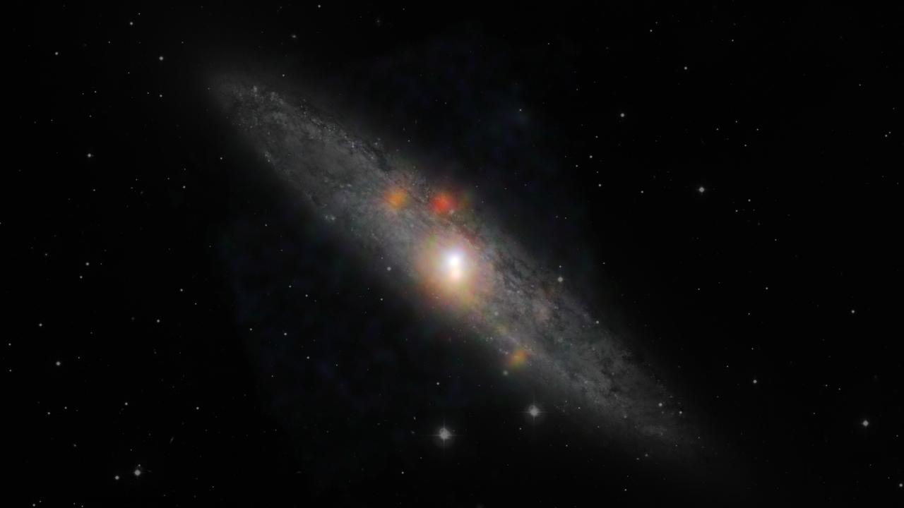
The Sculptor galaxy is seen in a new light, in this composite image from NASA Nuclear Spectroscopic Telescope Array NuSTAR and the European Southern Observatory in Chile.

NASA DC-8 Mission Manager Walter Klein poses with a group of Chilean Students onboard the aircraft at Carlos Ibanez del Campo International Airport in Punta Arenas, Chile. AirSAR 2004 is a three-week expedition by an international team of scientists that is using an all-weather imaging tool, called the Airborne Synthetic Aperture Radar (AirSAR) which is located onboard NASA's DC-8 airborne laboratory. Scientists from many parts of the world including NASA's Jet Propulsion Laboratory are combining ground research done in several areas in Central and South America with NASA's AirSAR technology to improve and expand on the quality of research they are able to conduct. In South America and Antarctica, AirSAR will collect imagery and data to help determine the contribution of Southern Hemisphere glaciers to sea level rise due to climate change. In Patagonia, researchers found this contribution had more than doubled from 1995 to 2000, compared to the previous 25 years. AirSAR data will make it possible to determine whether that trend is decreasing, continuing or accelerating. AirSAR will also provide reliable information on ice shelf thickness to measure the contribution of the glaciers to sea level.

iss066e023165 (October 29, 2021) -- A red chile pepper is seen floating above a cutting board during the tasting of peppers grown as part of the Plant Habitat-04 investigation aboard the International Space Station. The chile peppers started growing on July 12, 2021, and represent one of the longest and most challenging plant experiments attempted aboard the orbiting laboratory. NASA astronaut and Expedition 66 flight engineer Mark Vande Hei conducted the first harvest of the pepper crop on October 29, 2021. Crew members sanitized the peppers and completed a scientific survey after their taste test. The Crew-3 astronauts will take over the crop when they arrive at the orbiting laboratory, and will conduct a final harvest of the peppers in late November. They will also sanitize and sample the crop, and complete surveys. Some peppers and their leaves from the final harvest will return to Earth for further analysis. What we learn will inform future crop growth and food supplementation activities for deep space exploration.
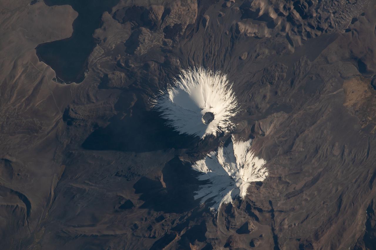
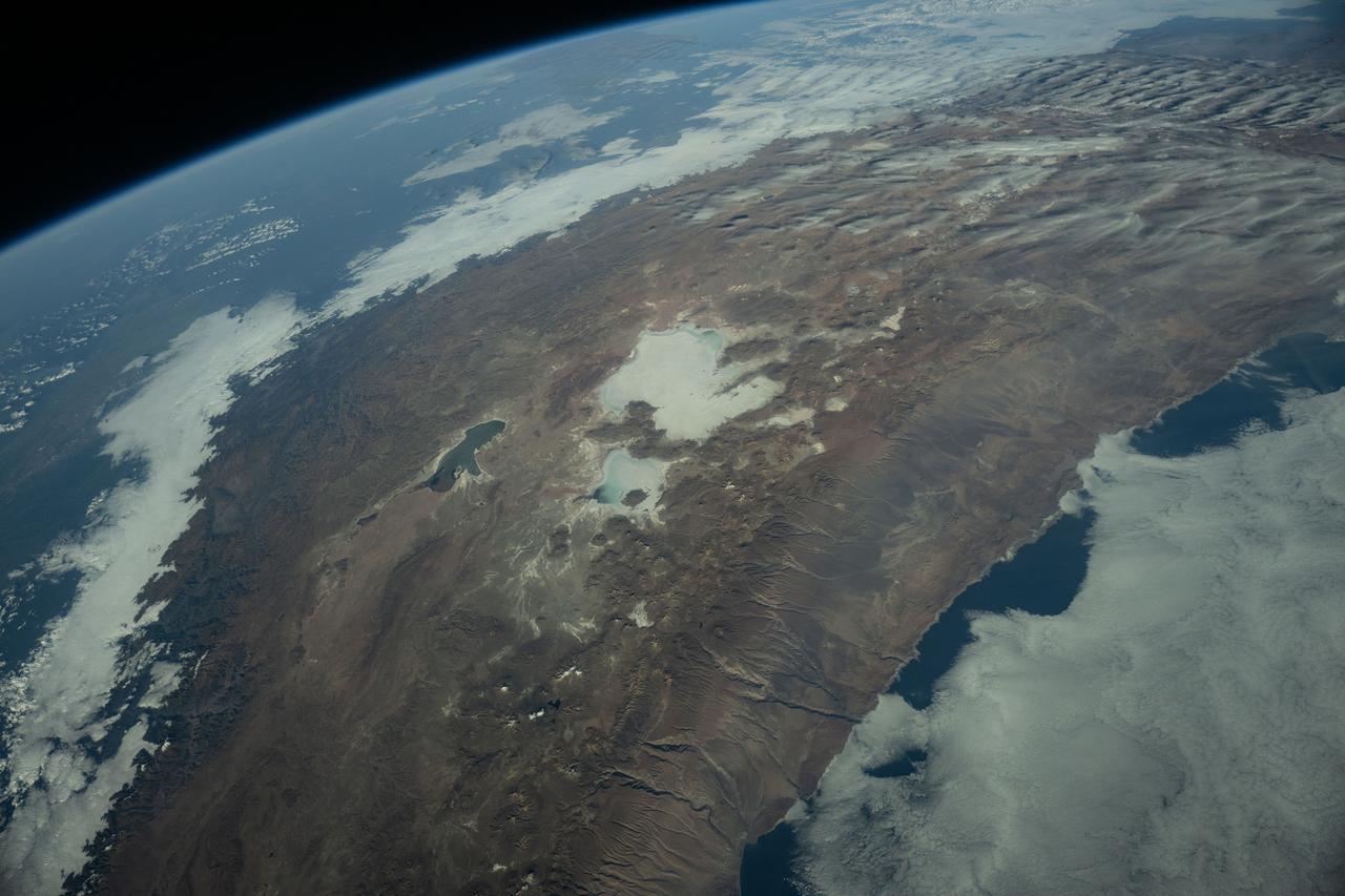
iss067e147189 (June 21, 2022) --- The Parinacota and Pomerape stratovolcanoes (top to bottom) are pictured from the International Space Station as it orbited 263 miles above the South American nation of Chile. Parinacota is a dormant volcano on the Chile-Bolivia border and its peak is about 20,800 feet. Pomerape, last active over 100,000 years ago, is also on the Chile- Bolivia border with an elevation of about 20,600 feet. At top left, is Chungará Lake in northern Chile which rests about 14,800 feet above sea level.

iss058e000188 (Dec. 24, 2018) --- The cloud-covered Pacific coast of the South American nation of Chile contrasts with the Andes Mountain range and the cloud formations extending over Argentina.

The Thurston Island calving front off of western Antarctica as seen from the window of NASA's DC-8 on Nov. 5, 2014. Image Credit: NASA/Jim Yungel NASA’s Operation IceBridge collected some rare images on a flight out of Punta Arenas, Chile on Nov. 5, 2014, on a science flight over western Antarctica dubbed Ferrigno-Alison-Abbott 01. The crew snapped a few shots of a calving front of the Antarctic ice sheet. This particular flight plan was designed to collect data on changes in ice elevation along the coast near the Ferrigno and Alison ice streams, on the Abbot Ice Shelf, and grounded ice along the Eights Coast.

A sea of icebergs float near the Thurston Island calving front off of western Antarctica as seen on the IceBridge flight on Nov. 5, 2014. Image Credit: NASA/Jim Yungel NASA’s Operation IceBridge collected some rare images on a flight out of Punta Arenas, Chile on Nov. 5, 2014, on a science flight over western Antarctica dubbed Ferrigno-Alison-Abbott 01. The crew snapped a few shots of a calving front of the Antarctic ice sheet. This particular flight plan was designed to collect data on changes in ice elevation along the coast near the Ferrigno and Alison ice streams, on the Abbot Ice Shelf, and grounded ice along the Eights Coast.

A small hole in the clouds revealed newly formed sea ice in the Bellingshausen Sea next to an ice berg on Nov. 5, 2014 flight. Image Credit: NASA/Digital Mapping System NASA’s Operation IceBridge collected some rare images on a flight out of Punta Arenas, Chile on Nov. 5, 2014, on a science flight over western Antarctica dubbed Ferrigno-Alison-Abbott 01. The crew snapped a few shots of a calving front of the Antarctic ice sheet. This particular flight plan was designed to collect data on changes in ice elevation along the coast near the Ferrigno and Alison ice streams, on the Abbot Ice Shelf, and grounded ice along the Eights Coast.

Snow is blown off of the Thurston Island calving front off of western Antarctica as seen on the IceBridge flight on Nov. 5, 2014. Image Credit: NASA/Jim Yungel NASA’s Operation IceBridge collected some rare images on a flight out of Punta Arenas, Chile on Nov. 5, 2014, on a science flight over western Antarctica dubbed Ferrigno-Alison-Abbott 01. The crew snapped a few shots of a calving front of the Antarctic ice sheet. This particular flight plan was designed to collect data on changes in ice elevation along the coast near the Ferrigno and Alison ice streams, on the Abbot Ice Shelf, and grounded ice along the Eights Coast.

Mountain peaks through the ice cover on Thurston Island off of western Antarctica as seen on the IceBridge flight on Nov. 5, 2014. Image Credit: NASA/Jim Yungel NASA’s Operation IceBridge collected some rare images on a flight out of Punta Arenas, Chile on Nov. 5, 2014, on a science flight over western Antarctica dubbed Ferrigno-Alison-Abbott 01. The crew snapped a few shots of a calving front of the Antarctic ice sheet. This particular flight plan was designed to collect data on changes in ice elevation along the coast near the Ferrigno and Alison ice streams, on the Abbot Ice Shelf, and grounded ice along the Eights Coast.

NASA’s Operation IceBridge collected some rare images on a flight out of Punta Arenas, Chile on Nov. 5, 2014, on a science flight over western Antarctica dubbed Ferrigno-Alison-Abbott 01. Following a routine calibration pass over Punta Arenas airport, the NASA DC-8 overflew the USS Constellation which is being towed for demolition after 53 yeas of service. The crew then snapped a few shots of a calving front of the Antarctic ice sheet. This particular flight plan was designed to collect data on changes in ice elevation along the coast near the Ferrigno and Alison ice streams, on the Abbot Ice Shelf, and grounded ice along the Eights Coast.

NASA DC-8 Ground Support Technicians Mark Corlew and Mike Lakowski perform routine maintenance on the aircraft at Carlos Ibanez del Campo International Airport in Punta Arenas, Chile. AirSAR 2004 is a three-week expedition by an international team of scientists that is using an all-weather imaging tool, called the Airborne Synthetic Aperture Radar (AirSAR) which is located onboard NASA's DC-8 airborne laboratory. Scientists from many parts of the world including NASA's Jet Propulsion Laboratory are combining ground research done in several areas in Central and South America with NASA's AirSAR technology to improve and expand on the quality of research they are able to conduct. In South America and Antarctica, AirSAR will collect imagery and data to help determine the contribution of Southern Hemisphere glaciers to sea level rise due to climate change. In Patagonia, researchers found this contribution had more than doubled from 1995 to 2000, compared to the previous 25 years. AirSAR data will make it possible to determine whether that trend is decreasing, continuing or accelerating. AirSAR will also provide reliable information on ice shelf thickness to measure the contribution of the glaciers to sea level.

NASA DC-8 Ground Support Technician Joe Niquette performs routine maintenance on the DC-8 aircraft at Carlos Ibanez del Campo International Airport in Punta Arenas, Chile. AirSAR 2004 is a three-week expedition by an international team of scientists that is using an all-weather imaging tool, called the Airborne Synthetic Aperture Radar (AirSAR) which is located onboard NASA's DC-8 airborne laboratory. Scientists from many parts of the world including NASA's Jet Propulsion Laboratory are combining ground research done in several areas in Central and South America with NASA's AirSAR technology to improve and expand on the quality of research they are able to conduct. In South America and Antarctica, AirSAR will collect imagery and data to help determine the contribution of Southern Hemisphere glaciers to sea level rise due to climate change. In Patagonia, researchers found this contribution had more than doubled from 1995 to 2000, compared to the previous 25 years. AirSAR data will make it possible to determine whether that trend is decreasing, continuing or accelerating. AirSAR will also provide reliable information on ice shelf thickness to measure the contribution of the glaciers to sea level.
GMT017_23_04_Koichi Wakata_1026_CEO Chile
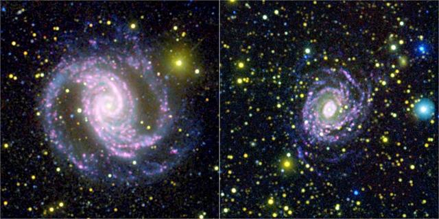
These two photographs were made by combining data from NASA Galaxy Evolution Explorer spacecraft and the Cerro Tololo Inter-American Observatory in Chile to learn that not all galaxies make stars of different sizes in the same quantities.
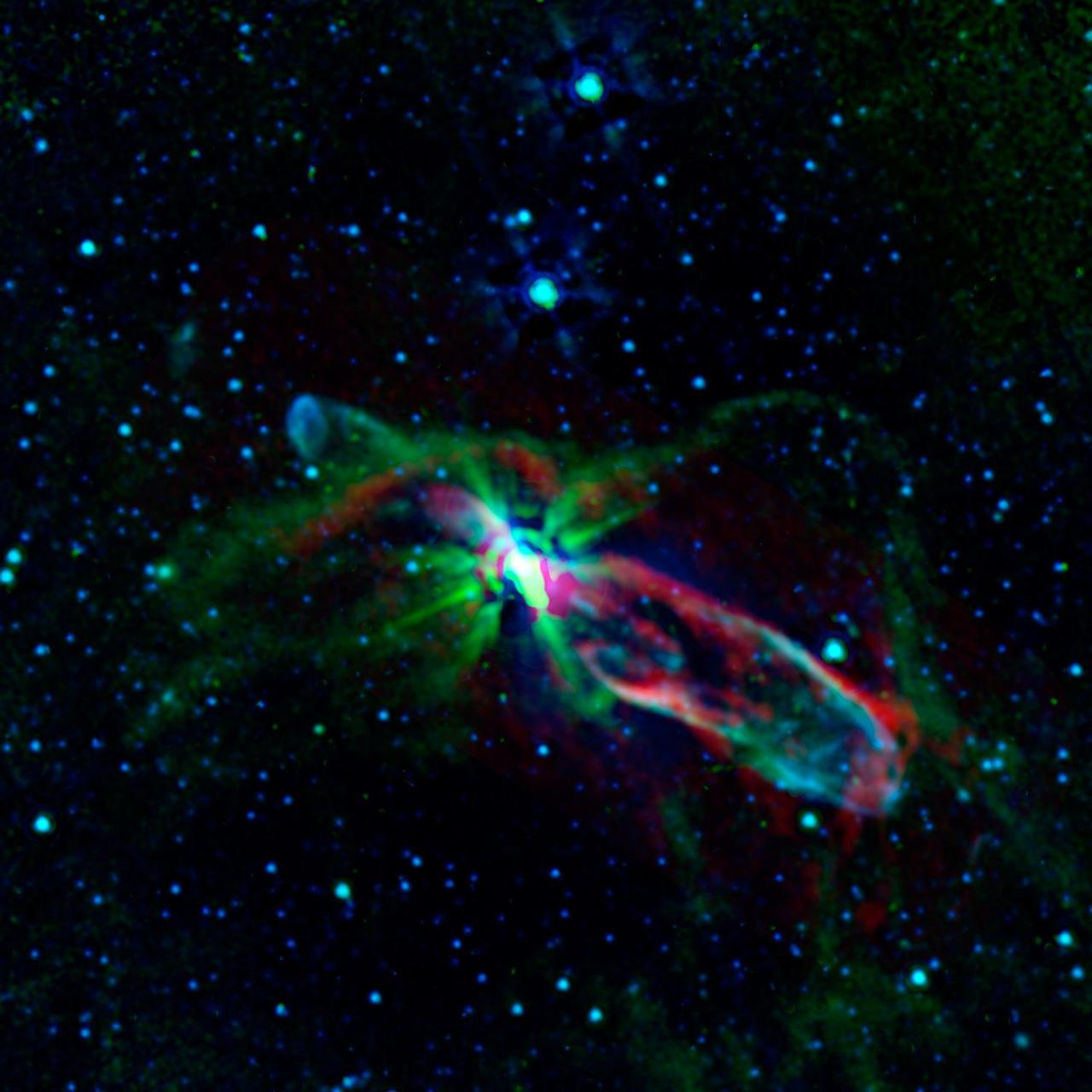
Combined observations from NASA Spitzer Space Telescope and the newly completed Atacama Large Millimetre/submillimeter Array ALMA in Chile have revealed the throes of stellar birth in the well-studied object known as HH 46/47.

These thermal images show a hot south pole on the planet Neptune. These warmer temperatures provide an avenue for methane to escape out of the deep atmosphere. The images were obtained with the Very Large Telescope in Chile Sept. 1 and 2, 2006.
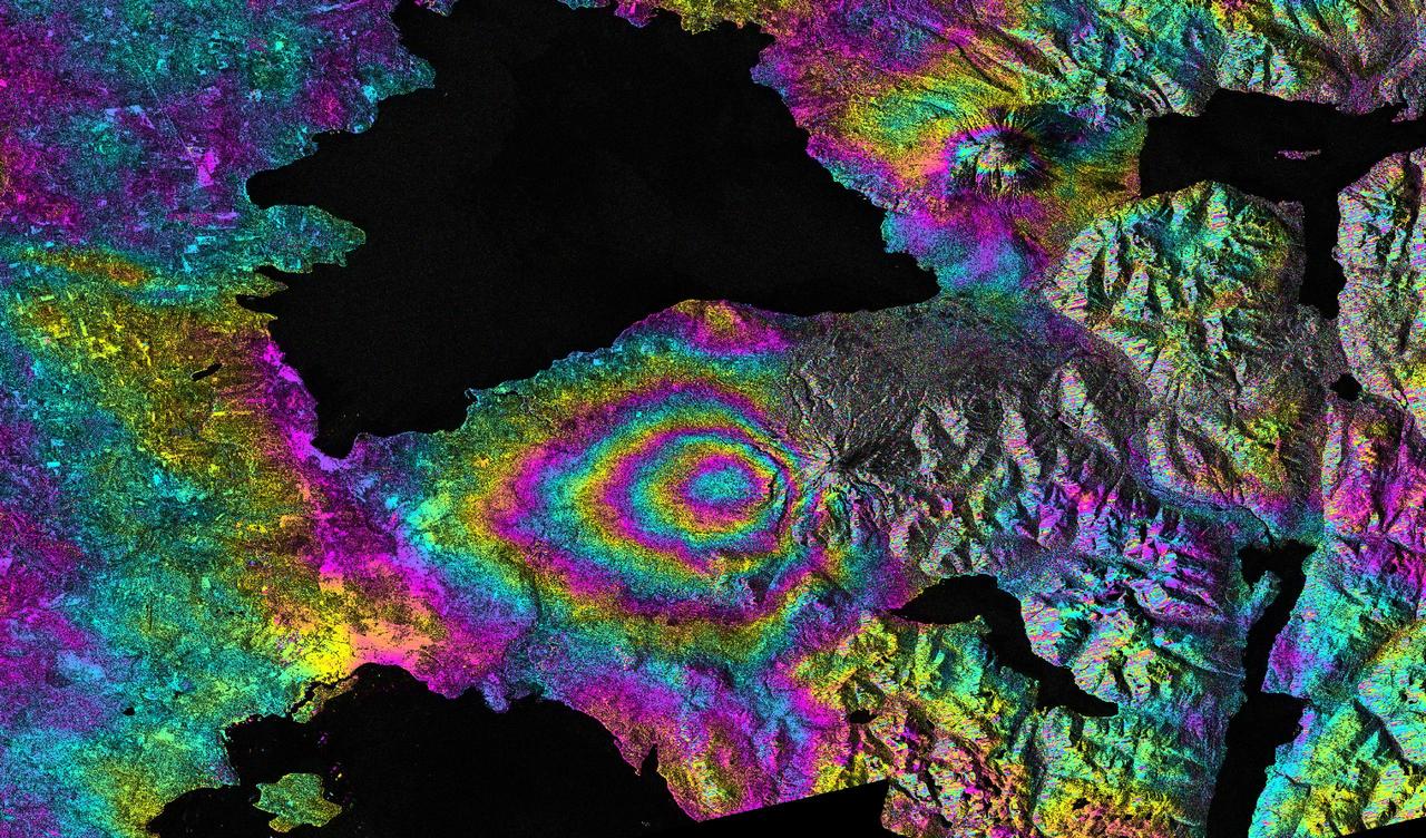
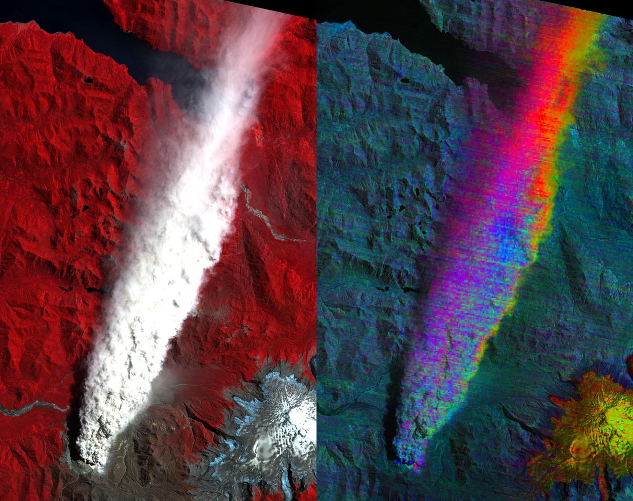
This satellite interferometric synthetic aperture radar image-pair shows relative deformation of the Earth surface when nn April 22-23, 2015, significant explosive eruptions occurred at Calbuco volcano, Chile.

JPL scientist Dr. David Imel and U.S. Air Force Colonel Gwen Linde, the Defense Department Attache Officer assigned to the Chilean Embassy, lead Chilean students on a tour of the DC-8 aircraft at Carlos Ibanez del Campo International Airport in Punta Arenas, Chile. AirSAR 2004 is a three-week expedition by an international team of scientists that is using an all-weather imaging tool, called the Airborne Synthetic Aperture Radar (AirSAR) which is located onboard NASA's DC-8 airborne laboratory. Scientists from many parts of the world including NASA's Jet Propulsion Laboratory are combining ground research done in several areas in Central and South America with NASA's AirSAR technology to improve and expand on the quality of research they are able to conduct. In South America and Antarctica, AirSAR will collect imagery and data to help determine the contribution of Southern Hemisphere glaciers to sea level rise due to climate change. In Patagonia, researchers found this contribution had more than doubled from 1995 to 2000, compared to the previous 25 years. AirSAR data will make it possible to determine whether that trend is decreasing, continuing or accelerating. AirSAR will also provide reliable information on ice shelf thickness to measure the contribution of the glaciers to sea level.

NASA DC-8 Pilots Craig Bomben and Bill Brockett explain the DC-8 cockpit to Chilean students onboard the DC-8 aircraft at Carlos Ibanez del Campo International Airport in Punta Arenas, Chile. AirSAR 2004 is a three-week expedition by an international team of scientists that is using an all-weather imaging tool, called the Airborne Synthetic Aperture Radar (AirSAR) which is located onboard NASA's DC-8 airborne laboratory. Scientists from many parts of the world including NASA's Jet Propulsion Laboratory are combining ground research done in several areas in Central and South America with NASA's AirSAR technology to improve and expand on the quality of research they are able to conduct. In South America and Antarctica, AirSAR will collect imagery and data to help determine the contribution of Southern Hemisphere glaciers to sea level rise due to climate change. In Patagonia, researchers found this contribution had more than doubled from 1995 to 2000, compared to the previous 25 years. AirSAR data will make it possible to determine whether that trend is decreasing, continuing or accelerating. AirSAR will also provide reliable information on ice shelf thickness to measure the contribution of the glaciers to sea level.