Martian City Map
HIGH SCHOOL STUDENTS FROM NORTH ALABAMA GATHER AT THE U.S. SPACE AND ROCKET CENTER'S DAVIDSON CENTER FOR THE "ROBOTS TO ROCKET CITY" EVENT SHOWCASING THEIR INDIVIDUAL ROBOTS PRIOR TO LATER COMPETITIONS.
HIGH SCHOOL STUDENTS FROM NORTH ALABAMA GATHER AT THE U.S. SPACE AND ROCKET CENTER'S DAVIDSON CENTER FOR THE "ROBOTS TO ROCKET CITY" EVENT SHOWCASING THEIR INDIVIDUAL ROBOTS PRIOR TO LATER COMPETITIONS.

HIGH SCHOOL STUDENTS FROM NORTH ALABAMA GATHER AT THE U.S. SPACE AND ROCKET CENTER'S DAVIDSON CENTER FOR THE "ROBOTS TO ROCKET CITY" EVENT SHOWCASING THEIR INDIVIDUAL ROBOTS PRIOR TO LATER COMPETITIONS.
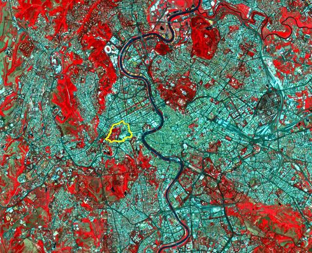
This image from NASA Terra spacecraft shows the Vatican City State, a sovereign city-state, whose area is a 44 hectare walled enclave west of the Tiber River, within the city of Rome.
The 2002 Winter Olympics are hosted by Salt Lake City at several venues within the city, in nearby cities, and within the adjacent Wasatch Mountains.
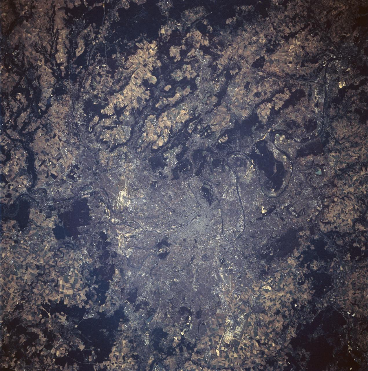
STS047-94-010 (12 - 20 Sept 1992) --- This 250mm Hasselblad color photo of Paris, France recorded during this mission, shows urban land uses in great detail. Several airports are clear, including the two major international airports of Orly and Le Bourget. Paris was founded in pre-Roman times on an island in the Seine River and continued as a Roman outpost. The easily defensible location was one of the keys to the growth of this island city. The city expanded from its island state to become a major urban center in Europe because of its location, its easy access by river traffic, and its productive hinterland.

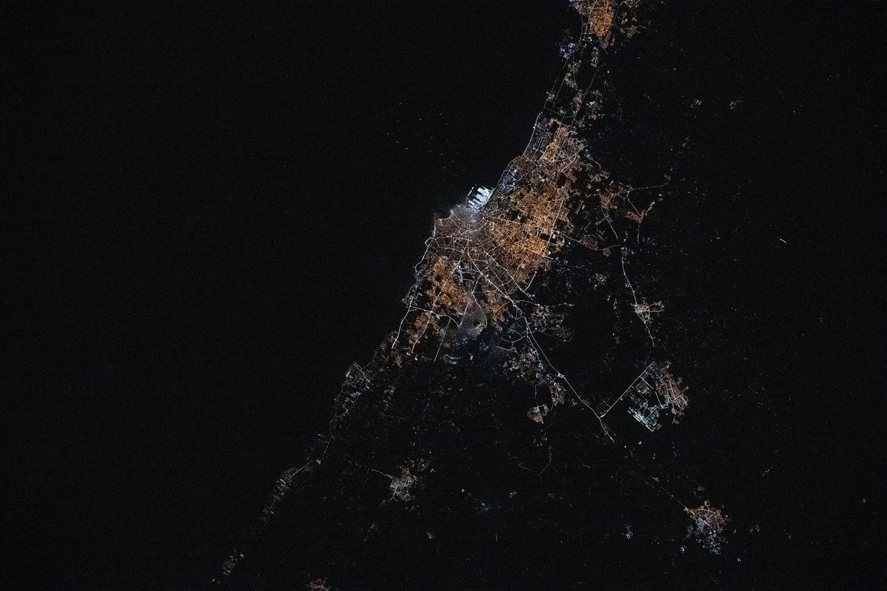
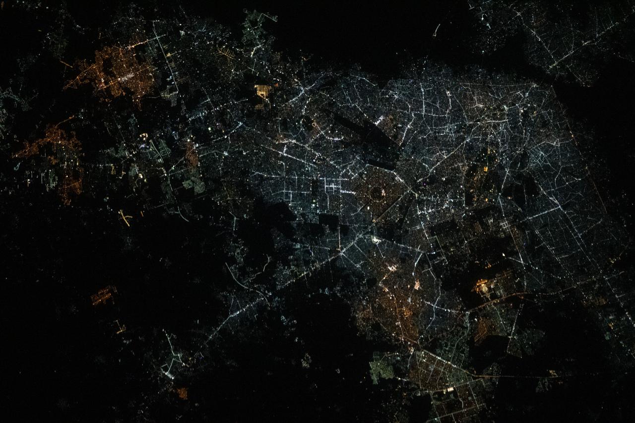
iss072e519889 (Jan. 23, 2025) --- The city lights of Kuwait City, the capital of Kuwait with a population of about 3 million on the Persian Gulf coast, are pictured at approximately 9:49 p.m. local time from the International Space Station as it orbited 258 miles above.
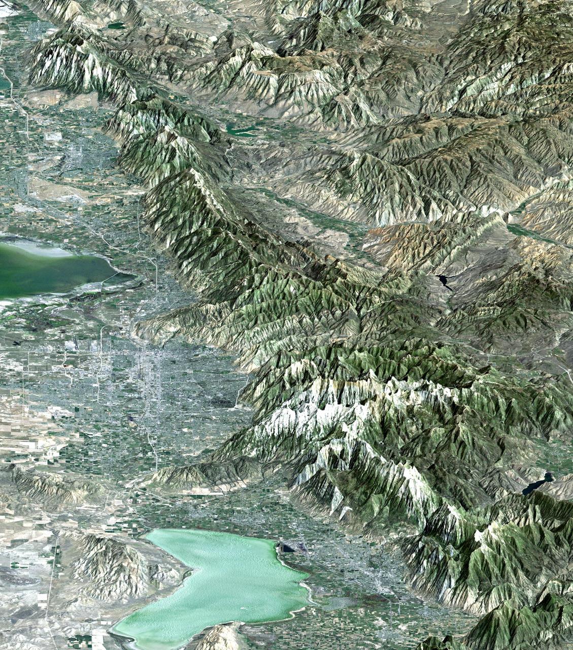
The 2002 Winter Olympics are hosted by Salt Lake City at several venues within the city, in nearby cities, and within the adjacent Wasatch Mountains.
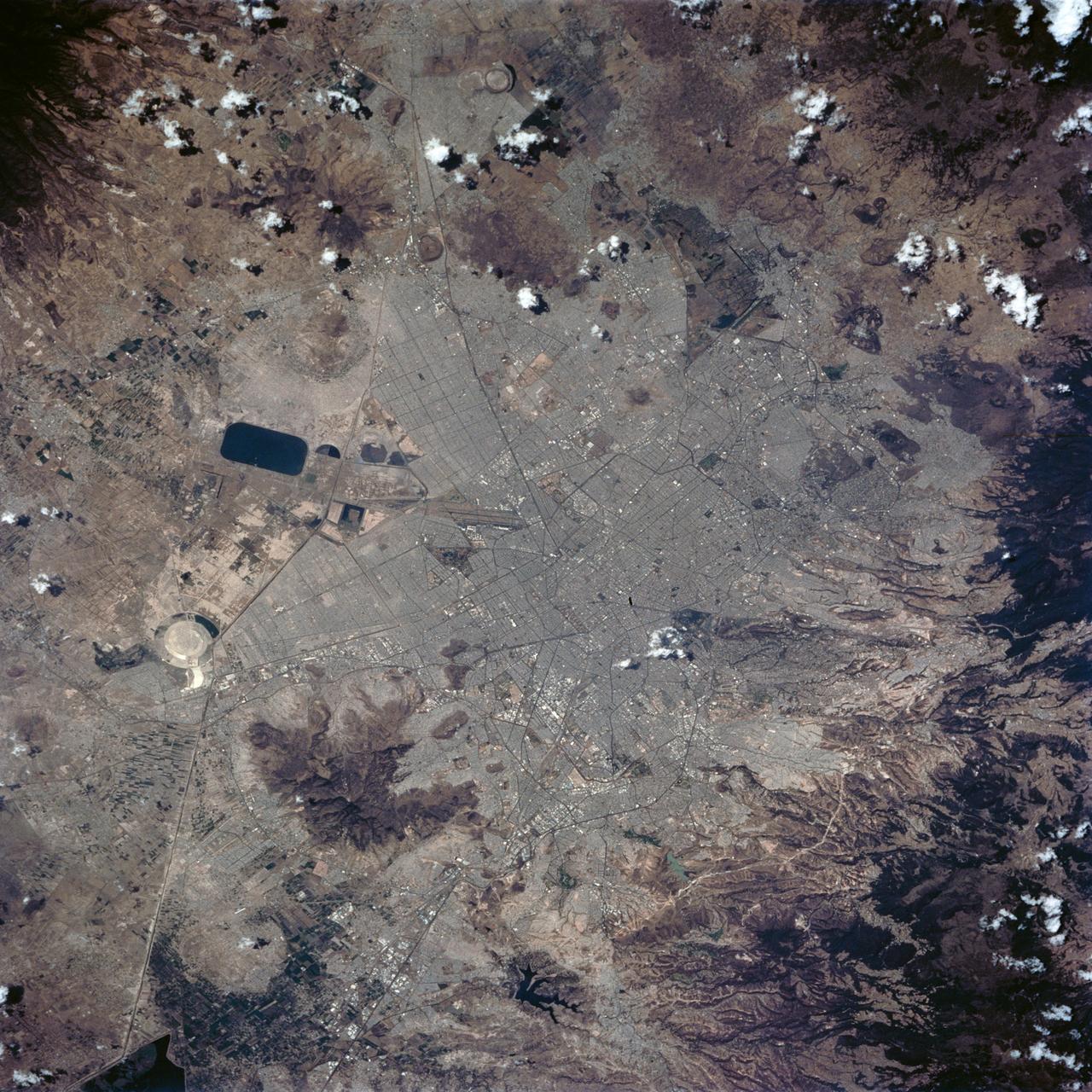
STS062-84-028 (4-18 March 1994) --- According to NASA scientists this image is the clearest photo of Mexico City taken from United States manned spacecraft. North is to the upper right. Mexico City sits in a basin surrounded by large volcanoes. The restricted atmospheric circulation in the basin, coupled with the inevitable air emissions produced by a city of 20 million people has created a critical air pollution problem for the city. In most photographs of the region, Mexico City is obscured by haze. Scientists feel the clear atmosphere in this photograph may be due, in part, to the stringent air emission restrictions now in place. The clarity of the photograph allows many key cultural features to be identified, including all of the major boulevards, the horse track (western part of the city), the university (south of the city), and the museum areas. Large, man-made ponds east of the city also stand out.

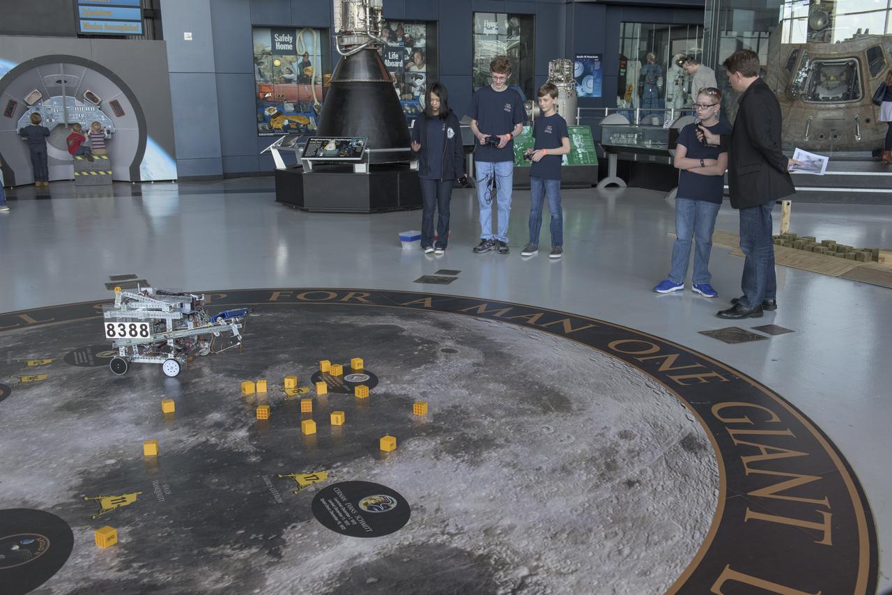
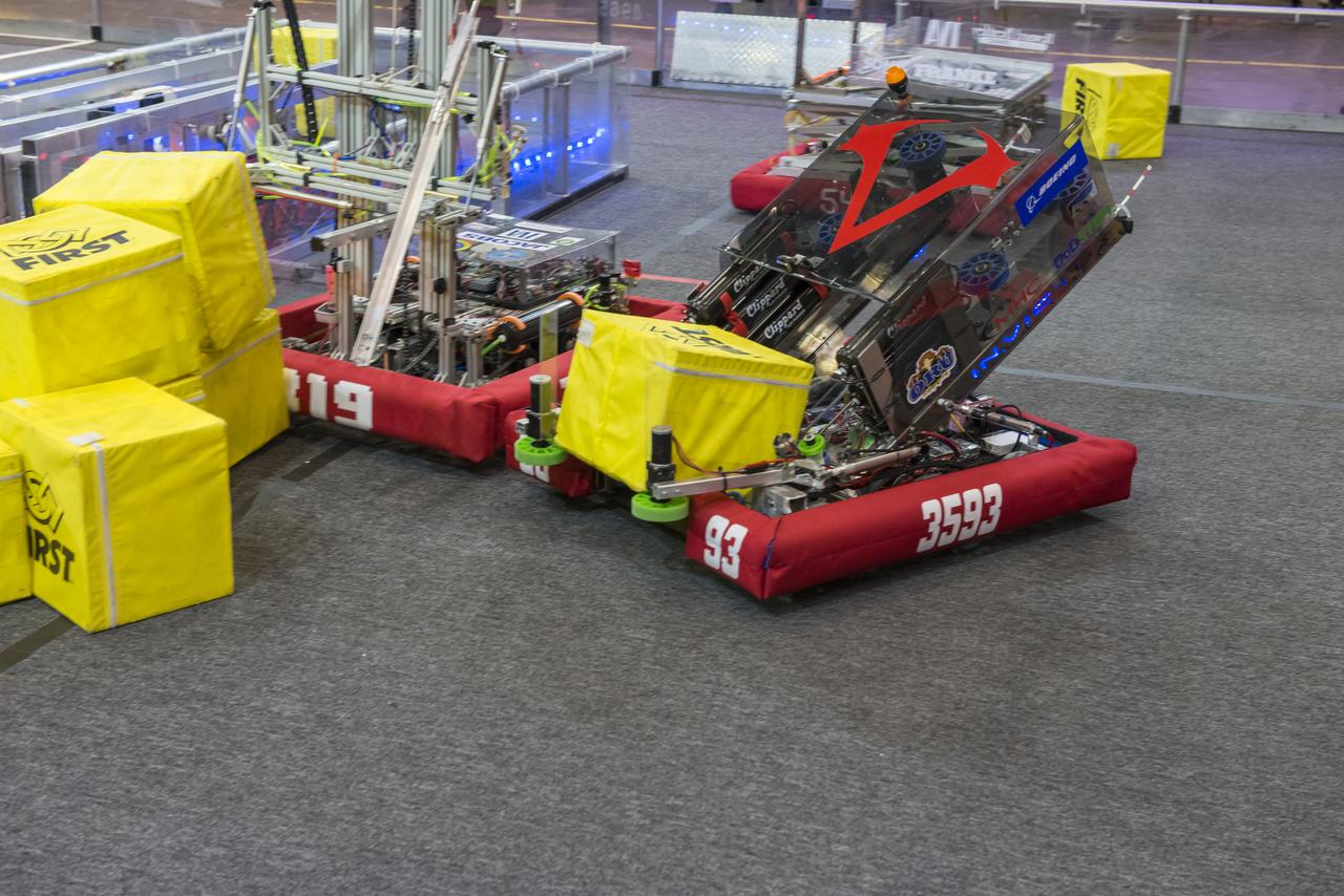
The First Robotics Rocket City Regional Competition was held at the Von Braun Civic Center in Huntsville, Alabama on March 16, 2018. High school robotics teams from throughout the U.S., as well as a team from Brazil, competed.

The First Robotics Rocket City Regional Competition was held at the Von Braun Civic Center in Huntsville, Alabama on March 16, 2018. High school robotics teams from throughout the U.S., as well as a team from Brazil, competed.

The First Robotics Rocket City Regional Competition was held at the Von Braun Civic Center in Huntsville, Alabama on March 16, 2018. High school robotics teams from throughout the U.S., as well as a team from Brazil, competed.

The First Robotics Rocket City Regional Competition was held at the Von Braun Civic Center in Huntsville, Alabama on March 16, 2018. High school robotics teams from throughout the U.S., as well as a team from Brazil, competed.

The First Robotics Rocket City Regional Competition was held at the Von Braun Civic Center in Huntsville, Alabama on March 16, 2018. High school robotics teams from throughout the U.S., as well as a team from Brazil, competed.

The First Robotics Rocket City Regional Competition was held at the Von Braun Civic Center in Huntsville, Alabama on March 16, 2018. High school robotics teams from throughout the U.S., as well as a team from Brazil, competed.
The First Robotics Rocket City Regional Competition was held at the Von Braun Civic Center in Huntsville, Alabama on March 16, 2018. High school robotics teams from throughout the U.S., as well as a team from Brazil, competed.

The First Robotics Rocket City Regional Competition was held at the Von Braun Civic Center in Huntsville, Alabama on March 16, 2018. High school robotics teams from throughout the U.S., as well as a team from Brazil, competed.
The 2002 Winter Olympics are hosted by Salt Lake City at several venues within the city, in nearby cities, and within the adjacent Wasatch Mountains. This simulated natural color image presents a late spring view of north central Utah that includes all of the Olympic sites. The image extends from Ogden in the north, to Provo in the south; and includes the snow-capped Wasatch Mountains and the eastern part of the Great Salt Lake. This image was acquired on May 28, 2000 by the Advanced Spaceborne Thermal Emission and Reflection Radiometer (ASTER) on NASA's Terra satellite. With its 14 spectral bands from the visible to the thermal infrared wavelength region, and its high spatial resolution of 15 to 90 meters (about 50 to 300 feet), ASTER will image Earth for the next 6 years to map and monitor the changing surface of our planet. http://photojournal.jpl.nasa.gov/catalog/PIA03464

The First Robotics Rocket City Regional Competition was held at the Von Braun Civic Center in Huntsville, Alabama on March 16, 2018. High school robotics teams from throughout the U.S., as well as a team from Brazil, competed. Costumed students were the normal at this event and lent it much color.
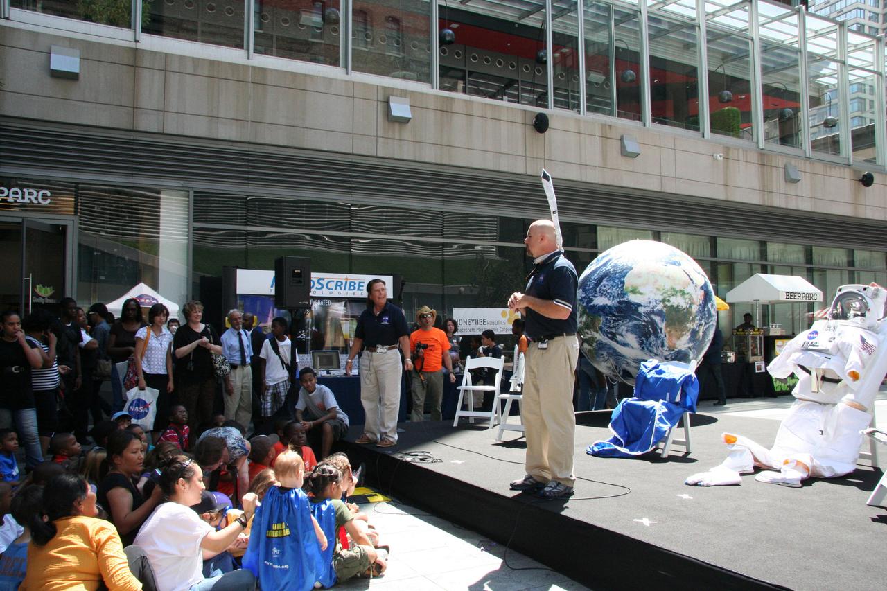
Chris Copelan (right), education program specialist at Stennis Space Center, and Maria Lott, Stennis Astro Camp director, talk about living and working in space with visitors gathered for the 'What's Your Favorite Space?' event in New York City on Aug. 17. Stennis educators teamed with peers from three other NASA centers to present a variety of hands-on activities and informational presentations during the event.
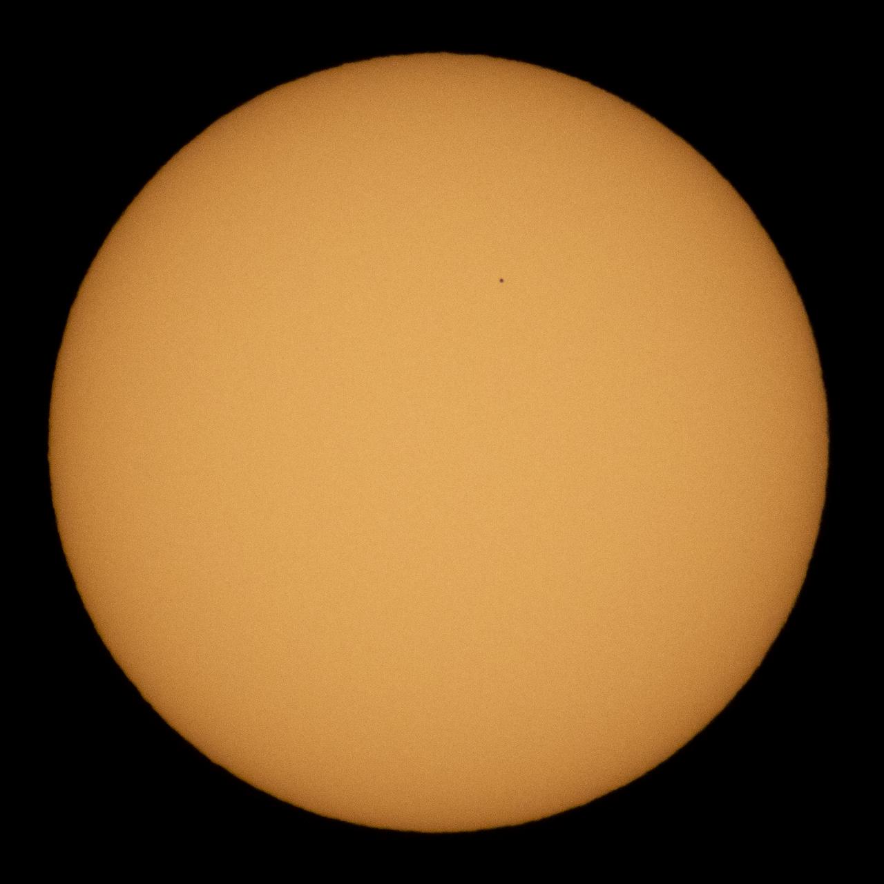
The planet Mercury is seen in silhouette as it transits across the face of the sun, Monday, Nov. 11, 2019 in Salt Lake City, Utah. Mercury’s last transit was in 2016. the next won't happen again until 2032. Photo Credit: (NASA/Joel Kowsky)

The largest city wall in the world is in Nanjing, China. It was built between 1366 and 1386 by the Ming Dynasty Emperor Zhu Yuangzhang to enclose and fortify his capital city. The wall is over 33 km long, is constructed from 350 million bricks, and is 14 meters wide, and 14-20 meters high. Its 13 massive gates today have been restored and house museums telling the story of the city of Nanjing. The ASTER image was acquired October 25, 2014, covers an area of 20.5 by 21.6 kilometers, and is located at 32.1 degrees north and 118.7 degrees east. https://photojournal.jpl.nasa.gov/catalog/PIA22735
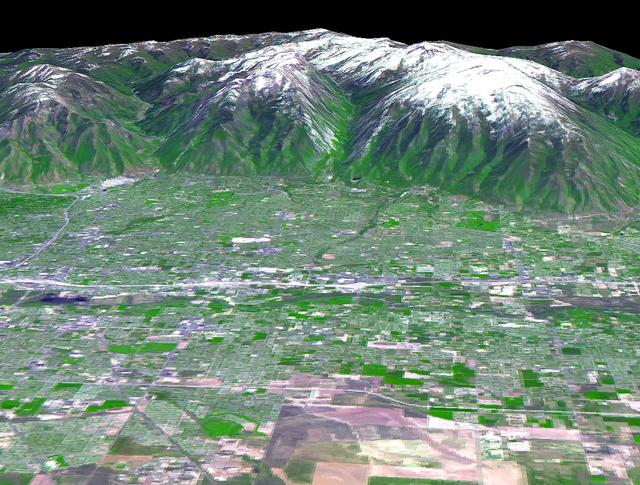
The 2002 Winter Olympics are hosted by Salt Lake City at several venues within the city, in nearby cities, and within the adjacent Wasatch Mountains. This 3-D perspective view, in simulated natural colors, presents a late spring view over Salt Lake City towards the snow-capped Wasatch Mountains to the east. The image was created by draping ASTER image data over digital topography data from the US Geological Survey's National Elevation Data. This image was acquired on May 28, 2000 by the Advanced Spaceborne Thermal Emission and Reflection Radiometer (ASTER) on NASA's Terra satellite. With its 14 spectral bands from the visible to the thermal infrared wavelength region, and its high spatial resolution of 15 to 90 meters (about 50 to 300 feet), ASTER will image Earth for the next 6 years to map and monitor the changing surface of our planet. http://photojournal.jpl.nasa.gov/catalog/PIA03466

iss058e005276 (Jan. 19, 2019) --- This nighttime shot from the International Space Station taken 258 miles above the English Channel shows the lights of the northern European cities of (clockwise from top right) London, Amsterdam, The Hague, Rotterdam, Antwerp and Brussels and other surrounding cities.
iss072e519089 (Jan. 21, 2025) --- The city lights of Lima, Peru, the South American nation's capital and most populous city with approximately 10.1 million residents on the Pacific coast, are pictured from the International Space Station at approximately 1:43 a.m. local time as it orbited 261 miles above.
iss072e519516 (Jan. 22, 2025) --- The city lights of Osaka, Japan, the island nation's third most populous city split by the Yodo River, are pictured at approximately 10:25 p.m. local time from the International Space Station as it orbited 258 miles above the Philippine Sea.

The First Robotics Rocket City Regional Competition was held at the Von Braun Civic Center in Huntsville, Alabama on March 16, 2018. High school robotics teams from throughout the U.S., as well as a team from Brazil, competed. Pictured is the Brazilian team prior to competition

The First Robotics Rocket City Regional Competition was held at the Von Braun Civic Center in Huntsville, Alabama on March 16, 2018. High school robotics teams from throughout the U.S., as well as a team from Brazil, competed. The Brazilian team sings their national anthem.
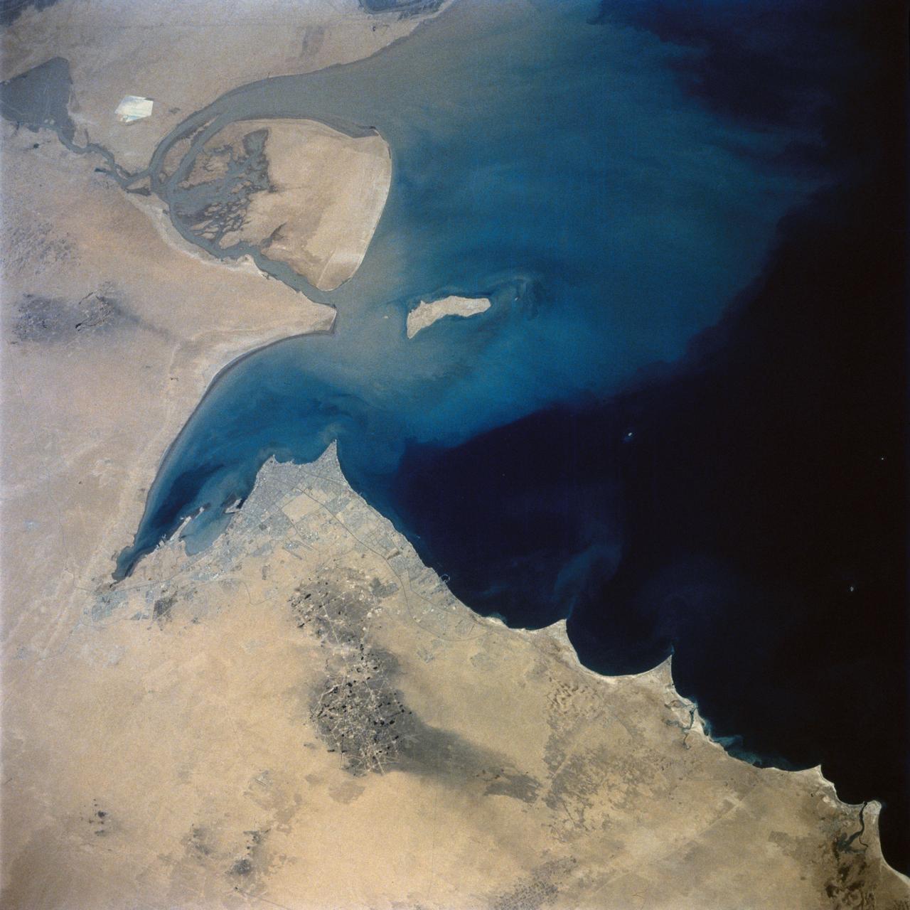
This view of the northern Persian Gulf shows Kuwait City and the Tigris and Euphrates River Deltas (29.5N, 48.5E). The oil laden sands and oil lakes of the Kuwait Oil Fields to the north and south of the city are clearly visible as dark patches surrounded by oil free desert sands. Comparison with earlier photos indicate that the oil laden sands are slowly being covered with clean sand carried by strong NW winds called Shmals.

STS-135 mission specialist Sandra Magnus, has some make up applied prior to her appearance on CNN American Morning, Tuesday, Aug. 16, 2011, in New York City. The crew from space shuttle Atlantis (STS-135) is in New York City for a three-day visit. Photo Credit: (NASA/Paul E. Alers)
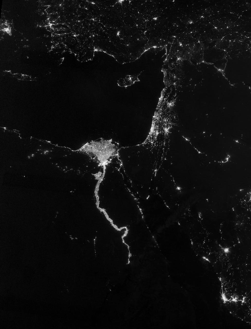
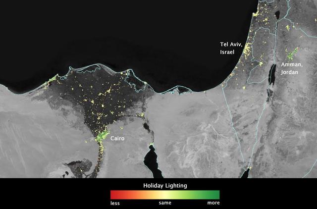
NASA image acquired October 13, 2012 The Nile River Valley and Delta comprise less than 5 percent of Egypt’s land area, but provide a home to roughly 97 percent of the country’s population. Nothing makes the location of human population clearer than the lights illuminating the valley and delta at night. On October 13, 2012, the Visible Infrared Imaging Radiometer Suite (VIIRS) on the Suomi NPP satellite captured this nighttime view of the Nile River Valley and Delta. This image is from the VIIRS “day-night band,” which detects light in a range of wavelengths from green to near-infrared and uses filtering techniques to observe signals such as gas flares, auroras, wildfires, city lights, and reflected moonlight. The city lights resemble a giant calla lily, just one with a kink in its stem near the city of Luxor. Some of the brightest lights occur around Cairo, but lights are abundant along the length of the river. Bright city lights also occur along the Suez Canal and around Tel Aviv. Away from the lights, however, land and water appear uniformly black. This image was acquired near the time of the new Moon, and little moonlight was available to brighten land and water surfaces. NASA Earth Observatory image by Jesse Allen and Robert Simmon, using VIIRS Day-Night Band data from the Suomi National Polar-orbiting Partnership. Suomi NPP is the result of a partnership between NASA, the National Oceanic and Atmospheric Administration, and the Department of Defense. Caption by Michon Scott. Instrument: Suomi NPP - VIIRS Credit: <b><a href="http://www.earthobservatory.nasa.gov/" rel="nofollow"> NASA Earth Observatory</a></b> <b>Click here to view all of the <a href="http://earthobservatory.nasa.gov/Features/NightLights/" rel="nofollow"> Earth at Night 2012 images </a></b> <b>Click here to <a href="http://earthobservatory.nasa.gov/NaturalHazards/view.php?id=79807" rel="nofollow"> read more </a> about this image </b> <b><a href="http://www.nasa.gov/audience/formedia/features/MP_Photo_Guidelines.html" rel="nofollow">NASA image use policy.</a></b> <b><a href="http://www.nasa.gov/centers/goddard/home/index.html" rel="nofollow">NASA Goddard Space Flight Center</a></b> enables NASA’s mission through four scientific endeavors: Earth Science, Heliophysics, Solar System Exploration, and Astrophysics. Goddard plays a leading role in NASA’s accomplishments by contributing compelling scientific knowledge to advance the Agency’s mission. <b>Follow us on <a href="http://twitter.com/NASA_GoddardPix" rel="nofollow">Twitter</a></b> <b>Like us on <a href="http://www.facebook.com/pages/Greenbelt-MD/NASA-Goddard/395013845897?ref=tsd" rel="nofollow">Facebook</a></b> <b>Find us on <a href="http://instagram.com/nasagoddard?vm=grid" rel="nofollow">Instagram</a></b>
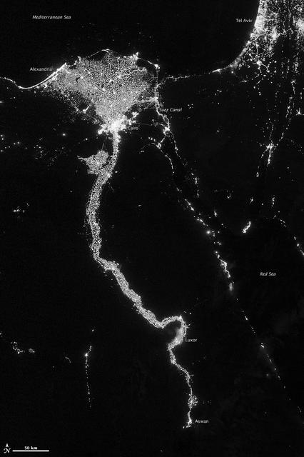
NASA image acquired October 13, 2012 The Nile River Valley and Delta comprise less than 5 percent of Egypt’s land area, but provide a home to roughly 97 percent of the country’s population. Nothing makes the location of human population clearer than the lights illuminating the valley and delta at night. On October 13, 2012, the Visible Infrared Imaging Radiometer Suite (VIIRS) on the Suomi NPP satellite captured this nighttime view of the Nile River Valley and Delta. This image is from the VIIRS “day-night band,” which detects light in a range of wavelengths from green to near-infrared and uses filtering techniques to observe signals such as gas flares, auroras, wildfires, city lights, and reflected moonlight. The city lights resemble a giant calla lily, just one with a kink in its stem near the city of Luxor. Some of the brightest lights occur around Cairo, but lights are abundant along the length of the river. Bright city lights also occur along the Suez Canal and around Tel Aviv. Away from the lights, however, land and water appear uniformly black. This image was acquired near the time of the new Moon, and little moonlight was available to brighten land and water surfaces. NASA Earth Observatory image by Jesse Allen and Robert Simmon, using VIIRS Day-Night Band data from the Suomi National Polar-orbiting Partnership. Suomi NPP is the result of a partnership between NASA, the National Oceanic and Atmospheric Administration, and the Department of Defense. Caption by Michon Scott. Instrument: Suomi NPP - VIIRS Credit: <b><a href="http://www.earthobservatory.nasa.gov/" rel="nofollow"> NASA Earth Observatory</a></b> <b>Click here to view all of the <a href="http://earthobservatory.nasa.gov/Features/NightLights/" rel="nofollow"> Earth at Night 2012 images </a></b> <b>Click here to <a href="http://earthobservatory.nasa.gov/NaturalHazards/view.php?id=79807" rel="nofollow"> read more </a> about this image </b> <b><a href="http://www.nasa.gov/audience/formedia/features/MP_Photo_Guidelines.html" rel="nofollow">NASA image use policy.</a></b> <b><a href="http://www.nasa.gov/centers/goddard/home/index.html" rel="nofollow">NASA Goddard Space Flight Center</a></b> enables NASA’s mission through four scientific endeavors: Earth Science, Heliophysics, Solar System Exploration, and Astrophysics. Goddard plays a leading role in NASA’s accomplishments by contributing compelling scientific knowledge to advance the Agency’s mission. <b>Follow us on <a href="http://twitter.com/NASA_GoddardPix" rel="nofollow">Twitter</a></b> <b>Like us on <a href="http://www.facebook.com/pages/Greenbelt-MD/NASA-Goddard/395013845897?ref=tsd" rel="nofollow">Facebook</a></b> <b>Find us on <a href="http://instagram.com/nasagoddard?vm=grid" rel="nofollow">Instagram</a></b>
STS-36 Earth observation shows New York City, New York at night lit up along the Eastern seaboard of the United States and the Atlantic Ocean. The city lights designate the densely populated central city and the major highways surrounding it.
The 2002 Winter Olympics are hosted by Salt Lake City at several venues within the city, in nearby cities, and within the adjacent Wasatch Mountains. This simulated natural color image presents a snowy, winter view of north central Utah that includes all of the Olympic sites. The image extends from Ogden in the north, to Provo in the south; and includes the snow-capped Wasatch Mountains and the eastern part of the Great Salt Lake. This image was acquired on February 8, 2001 by the Advanced Spaceborne Thermal Emission and Reflection Radiometer (ASTER) on NASA's Terra satellite. With its 14 spectral bands from the visible to the thermal infrared wavelength region, and its high spatial resolution of 15 to 90 meters (about 50 to 300 feet), ASTER will image Earth for the next 6 years to map and monitor the changing surface of our planet. http://photojournal.jpl.nasa.gov/catalog/PIA03465
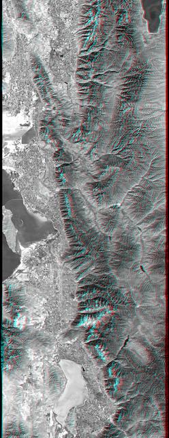
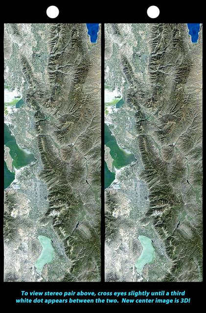
This anaglyph, from NASA Shuttle Radar Topography Mission, is of Salt Lake City, Utah. 3D glasses are necessary to view this image.
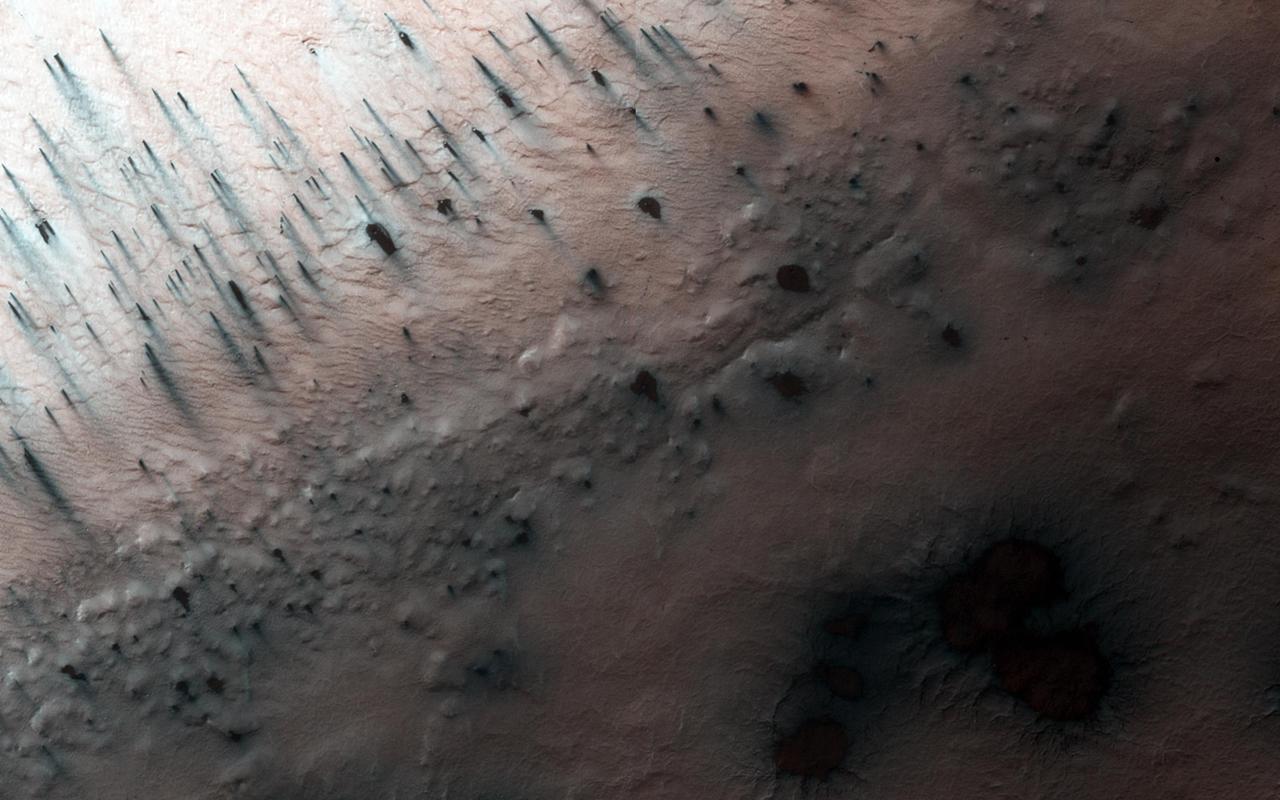
This image, acquired by NASA Mars Reconnaissance Orbiter, shows there are a few more fans on the ridge as spring activity progresses in Inca City. In Inca City another week has passed, and there are a few more fans on the ridge. We are studying the sequence of spring activity with the help of citizen scientists at the Planetfour website, sponsored by Zooniverse. Citizens of planet Earth log on and identify and measure fans and blotches in the South polar region of Mars imaged by HiRISE. With their help we can study the polar weather by looking at how the fan directions change through the spring. We see how the number of fans and blotches depends on the thickness of the ice layer and how high the sun is in the sky. http://photojournal.jpl.nasa.gov/catalog/PIA18894
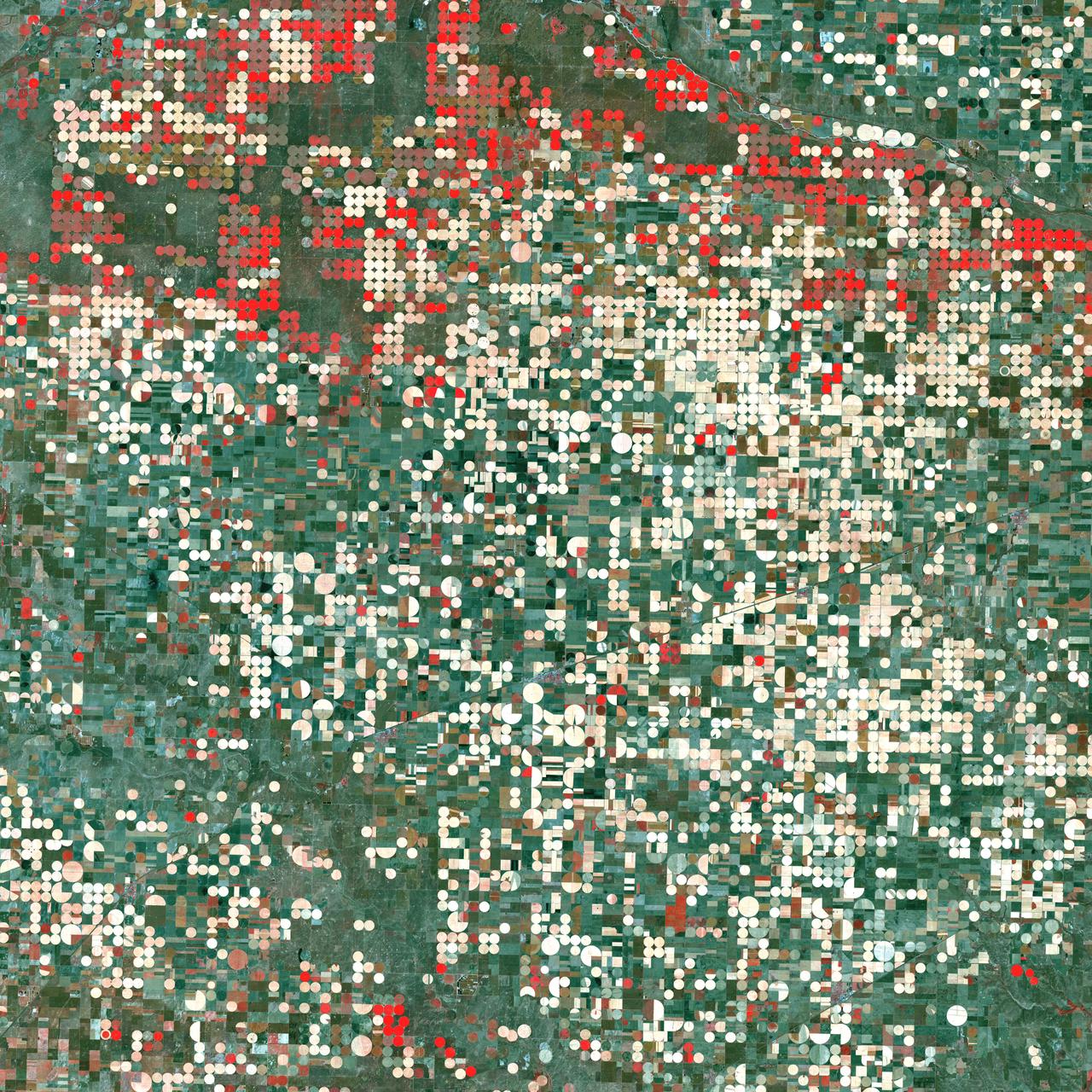
Center pivot irrigation systems create red circles of healthy vegetation in this image of croplands near Garden City, Kansas. This image was acquired by Landsat 7’s Enhanced Thematic Mapper plus (ETM+) sensor on September 25, 2000. This is a false-color composite image made using near infrared, red, and green wavelengths. The image has also been sharpened using the sensor’s panchromatic band. Credit: NASA/GSFC/Landsat <b><a href="http://www.nasa.gov/centers/goddard/home/index.html" rel="nofollow">NASA Goddard Space Flight Center</a></b> enables NASA’s mission through four scientific endeavors: Earth Science, Heliophysics, Solar System Exploration, and Astrophysics. Goddard plays a leading role in NASA’s accomplishments by contributing compelling scientific knowledge to advance the Agency’s mission. <b>Follow us on <a href="http://twitter.com/NASA_GoddardPix" rel="nofollow">Twitter</a></b> <b>Join us on <a href="http://www.facebook.com/pages/Greenbelt-MD/NASA-Goddard/395013845897?ref=tsd" rel="nofollow">Facebook</a></b>

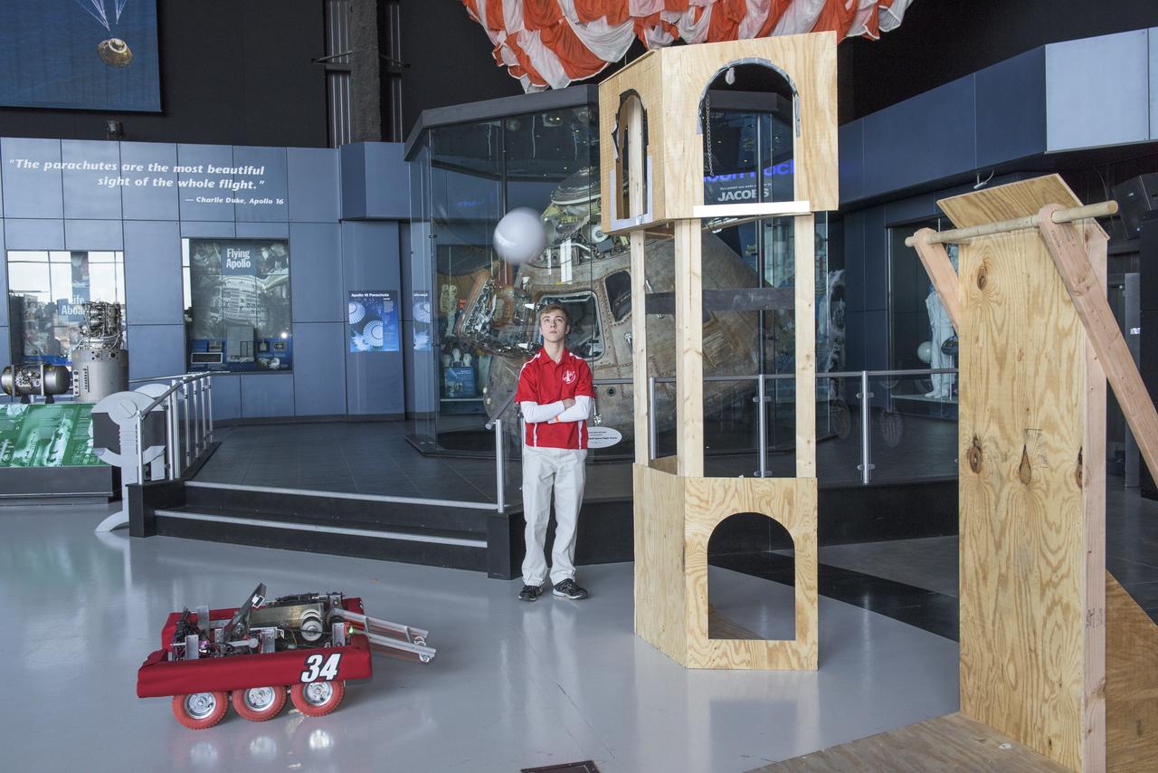
Johnny Stephenson, director of NASA Marshall Space Flight Center's Office of Strategic Analysis & Communications, addresses the crowd during the March 16 award ceremony following the first day of competition at the FIRST Robotics Rocket City Regional at the Von Braun Center in Huntsville. Ed Sparks, of the Morgan County Mech Tech team, received the award for Volunteer of the Year at the March 16 award ceremony. Mech Tech, comprised of students from five high schools in Morgan County, Alabama, also won the Industrial Design Award. The team was one of three regional finalists that will advance to the FIRST national championships April 18-21 in Houston. The other two regional finalists were Burning Magnetos of Fort Dorchester High School in North Charleston, South Carolina, and OGRE of Opelika High School in Opelika, Alabama. Mech Tech and Golden Hurricane from Columbia High School in Huntsville, were "house" teams sponsored by Marshall.
iss072e399194 (Dec. 19, 2024) --- The city lights of Salt Lake City, the capital of Utah, and its surrounding suburbs are pictured at about 5:17 a.m. local time from the International Space Station as it orbited 258 miles above.
iss072e645691 (Feb. 17, 2025) --- The city lights of Casablanca, Morocco's largest city with a population of over 3.2 million on the Atlantic coast, are pictured at approximately 5:47 a.m. local time from the International Space Station as it orbited 260 miles above the African nation.
iss072e445670 (Dec. 28, 2024) --- The city lights of Almaty, Kazakhstan's largest city with a population of about 2.25 million residents at the foot of the Tian Shan mountain range, are pictured at approximately 1:38 a.m. local time from the International Space Station as it orbited 260 miles above the Central Asian nation.
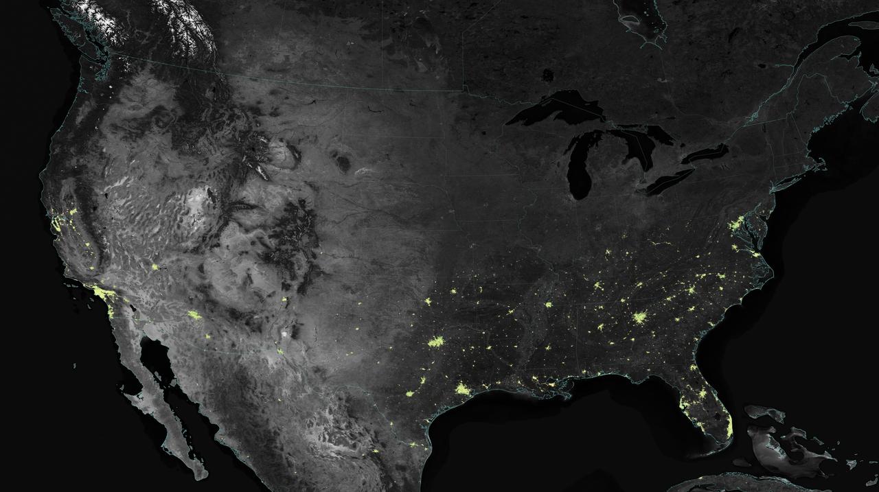
City lights shine brighter during the holidays in the United States when compared with the rest of the year, as shown using a new analysis of daily data from the NASA-NOAA Suomi NPP satellite. Dark green pixels are areas where lights are 50 percent brighter, or more, during December. Because snow reflects so much light, the researchers could only analyze snow-free cities. They focused on the U.S. West Coast from San Francisco and Los Angeles, and cities south of a rough imaginary line from St. Louis to Washington, D.C. Credit: Jesse Allen, NASA’s Earth Observatory Read more: <a href="http://www.nasa.gov/content/goddard/satellite-sees-holiday-lights-brighten-cities" rel="nofollow">www.nasa.gov/content/goddard/satellite-sees-holiday-light...</a> <b><a href="http://www.nasa.gov/audience/formedia/features/MP_Photo_Guidelines.html" rel="nofollow">NASA image use policy.</a></b> <b><a href="http://www.nasa.gov/centers/goddard/home/index.html" rel="nofollow">NASA Goddard Space Flight Center</a></b> enables NASA’s mission through four scientific endeavors: Earth Science, Heliophysics, Solar System Exploration, and Astrophysics. Goddard plays a leading role in NASA’s accomplishments by contributing compelling scientific knowledge to advance the Agency’s mission. <b>Follow us on <a href="http://twitter.com/NASAGoddardPix" rel="nofollow">Twitter</a></b> <b>Like us on <a href="http://www.facebook.com/pages/Greenbelt-MD/NASA-Goddard/395013845897?ref=tsd" rel="nofollow">Facebook</a></b> <b>Find us on <a href="http://instagram.com/nasagoddard?vm=grid" rel="nofollow">Instagram</a></b>
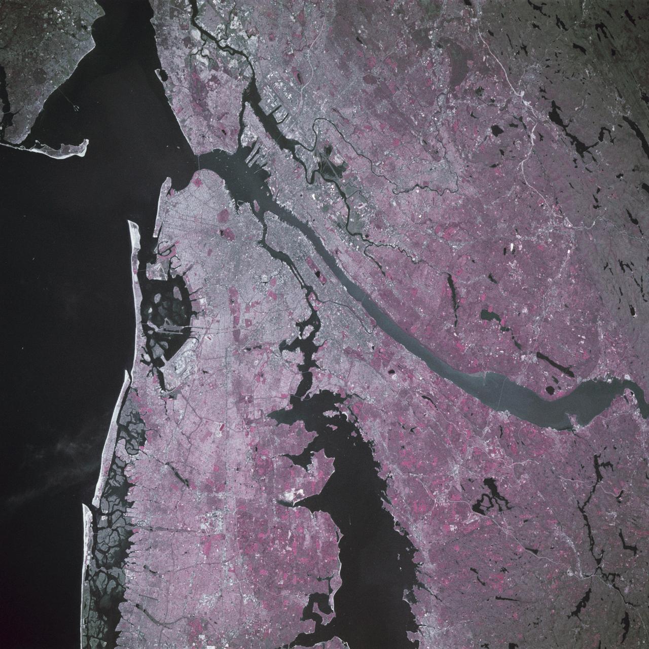
STS039-88-054 (28 April-6 May 1991) --- The dense urban development of the New York City metropolitan area in downstate New York, Long Island and New Jersey shows up as gray and white on this color Infrared photograph. The scene was taken on a remarkably clear spring day. Almost all the major man-made structures of the area are obvious, including ship traffic in and out of New York Harbor, the piers, all of the bridges spanning the area rivers and connecting Manhattan Island with New Jersey, the Bronx, Brooklyn and Queens, the three major airports (Newark, La Guardia and JFK), the New York State thruway, as well as Shea Stadium and Yankee Stadium. The reds and pinks are vegetated areas. Central Park clearly shows up on Manhattan, as do the string of parks along the cliffs (formed by the Palisades sill) along the west side of the Hudson north of the George Washington Bridge.
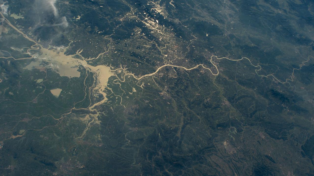
iss071e439833 (Aug. 8, 2024) --- Xiang River runs through the city of Changsha (center) in China's province of Hunan. At far left, the city of Yueyang lies on the bank of Dongdongting Lake in Hunan's humid, subtropical region. The International Space Station was orbiting 262 miles above the Asian nation at the time of this photograph.

The Eastern U.S., Europe, and Japan are brightly lit by their cities, while interiors of Africa, Asia, Australia, and South America are dark and lightly populated in this image created in 2000 by NASA Goddard Space Flight Center.
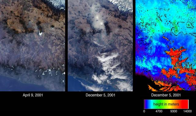
Mexico City has one of the world most serious air pollution problems. These images from NASA Terra satellite were captured on April 9 and December 5, 2001.

Expedition 28 crew members, Flight Engineer Mike Fossum, left, Soyuz commander Sergei Volkov, center, and Flight Engineer Satoshi Furukawa, pose for a photograph on the grounds of the Gagarin Cosmonaut Training Center, Wednesday, May 25, 2011 in Star City, Russia. The crew later departed for Baikonur, Kazakhstan in preparation for their June launch onboard a Soyuz rocket. Photo Credit: (NASA/Bill Ingalls)

Expedition 28 crew members, Flight Engineer Satoshi Furukawa, left, Soyuz commander Sergei Volkov, center, and Flight Engineer Mike Fossum, answer reporters questions during a crew departure press conference held on the grounds of the Gagarin Cosmonaut Training Center, Wednesday, May 25, 2011 in Star City, Russia. The crew later departed for Baikonur, Kazakhstan in preparation for their June launch onboard a Soyuz rocket. Photo Credit: (NASA/Bill Ingalls)

Expedition 28 crew members, Flight Engineer Satoshi Furukawa, left, Soyuz commander Sergei Volkov, center, and Flight Engineer Mike Fossum, answer reporters questions during a crew departure press conference held on the grounds of the Gagarin Cosmonaut Training Center, Wednesday, May 25, 2011 in Star City, Russia. The crew later departed for Baikonur, Kazakhstan in preparation for their June launch onboard a Soyuz rocket. Photo Credit: (NASA/Bill Ingalls)
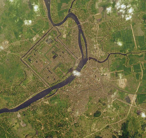
This image from NASA Terra satellite is of Hue, Vietnam. The Perfume River flows through the Capital City, the Imperial City, the Forbidden Purple City and the inner city.

The night side of Earth twinkles with light, and the first thing to stand out is the cities. “Nothing tells us more about the spread of humans across the Earth than city lights,” asserts Chris Elvidge, a NOAA scientist who has studied them for 20 years. This new global view and animation of Earth’s city lights is a composite assembled from data acquired by the Suomi National Polar-orbiting Partnership (Suomi NPP) satellite. The data was acquired over nine days in April 2012 and thirteen days in October 2012. It took satellite 312 orbits and 2.5 terabytes of data to get a clear shot of every parcel of Earth’s land surface and islands. This new data was then mapped over existing Blue Marble imagery of Earth to provide a realistic view of the planet. The nighttime view in visible light was made possible by the new “day-night band” of Suomi NPP’s Visible Infrared Imaging Radiometer Suite. VIIRS detects light in a range of wavelengths from green to near-infrared and uses filtering techniques to observe dim signals such as city lights, auroras, wildfires, and reflected moonlight. This low-light sensor can distinguish night lights with ten to hundreds of times better light detection capability than scientists had before. Named for satellite meteorology pioneer Verner Suomi, NPP flies over any given point on Earth&rsquos surface twice each day at roughly 1:30 a.m. and 1:30 p.m. The polar-orbiting satellite flies 824 kilometers (512 miles) above the surface as it circles the planet 14 times a day. Data is sent once per orbit to a ground station in Svalbard, Norway, and continuously to local direct broadcast users around the world. The mission is managed by NASA with operational support from NOAA and its Joint Polar Satellite System, which manages the satellite's ground system. NASA Earth Observatory image and animation by Robert Simmon, using Suomi NPP VIIRS data provided courtesy of Chris Elvidge (NOAA National Geophysical Data Center). Suomi NPP is the result of a partnership between NASA, NOAA, and the Department of Defense. Caption by Mike Carlowicz. Instrument: Suomi NPP - VIIRS Credit: <b><a href="http://www.earthobservatory.nasa.gov/" rel="nofollow"> NASA Earth Observatory</a></b> <b>Click here to view all of the <a href="http://earthobservatory.nasa.gov/Features/NightLights/" rel="nofollow"> Earth at Night 2012 images </a></b> <b>Click here to <a href="http://earthobservatory.nasa.gov/NaturalHazards/view.php?id=79803" rel="nofollow"> read more </a> about this image </b> <b><a href="http://www.nasa.gov/audience/formedia/features/MP_Photo_Guidelines.html" rel="nofollow">NASA image use policy.</a></b> <b><a href="http://www.nasa.gov/centers/goddard/home/index.html" rel="nofollow">NASA Goddard Space Flight Center</a></b> enables NASA’s mission through four scientific endeavors: Earth Science, Heliophysics, Solar System Exploration, and Astrophysics. Goddard plays a leading role in NASA’s accomplishments by contributing compelling scientific knowledge to advance the Agency’s mission. <b>Follow us on <a href="http://twitter.com/NASA_GoddardPix" rel="nofollow">Twitter</a></b> <b>Like us on <a href="http://www.facebook.com/pages/Greenbelt-MD/NASA-Goddard/395013845897?ref=tsd" rel="nofollow">Facebook</a></b> <b>Find us on <a href="http://instagram.com/nasagoddard?vm=grid" rel="nofollow">Instagram</a></b>

Salt Lake City, Utah, Winter 2001 The 2002 Winter Olympics are hosted by Salt Lake City at several venues within the city, in nearby cities, and within the adjacent Wasatch Mountains. This simulated natural color image presents a snowy, winter view of north central Utah that includes all of the Olympic sites. The image extends from Ogden in the north, to Provo in the south; and includes the snow-capped Wasatch Mountains and the eastern part of the Great Salt Lake. This image was acquired on February 8, 2001 by the Advanced Spaceborne Thermal Emission and Reflection Radiometer (ASTER) on NASA's Terra satellite. With its 14 spectral bands from the visible to the thermal infrared wavelength region, and its high spatial resolution of 15 to 90 meters (about 50 to 300 feet), ASTER will image Earth for the next 6 years to map and monitor the changing surface of our planet. ASTER is one of five Earth-observing instruments launched December 18,1999, on NASA's Terra satellite. The instrument was built by Japan's Ministry of Economy, Trade and Industry. A joint U.S./Japan science team is responsible for validation and calibration of the instrument and the data products. Dr. Anne Kahle at NASA's Jet Propulsion Laboratory, Pasadena, California, is the U.S. Science team leader; Bjorn Eng of JPL is the project manager. ASTER is the only high resolution imaging sensor on Terra. The Terra mission is part of NASA's Earth Science Enterprise, along-term research and technology program designed to examine Earth's land, oceans, atmosphere, ice and life as a total integrated system. The broad spectral coverage and high spectral resolution of ASTER will provide scientists in numerous disciplines with critical information for surface mapping, and monitoring dynamic conditions and temporal change. Example applications are: monitoring glacial advances and retreats; monitoring potentially active volcanoes; identifying crop stress; determining cloud morphology and physical properties; wetlands evaluation; thermal pollution monitoring; coral reef degradation; surface temperature mapping of soils and geology; and measuring surface heat balance. Image credit: NASA/GSFC/METI/ERSDAC/JAROS, and U.S./Japan ASTER Science Team Credit: <b><a href="http://www.earthobservatory.nasa.gov/" rel="nofollow"> NASA Earth Observatory</a></b> <b><a href="http://www.nasa.gov/audience/formedia/features/MP_Photo_Guidelines.html" rel="nofollow">NASA image use policy.</a></b> <b><a href="http://www.nasa.gov/centers/goddard/home/index.html" rel="nofollow">NASA Goddard Space Flight Center</a></b> enables NASA’s mission through four scientific endeavors: Earth Science, Heliophysics, Solar System Exploration, and Astrophysics. Goddard plays a leading role in NASA’s accomplishments by contributing compelling scientific knowledge to advance the Agency’s mission. <b>Follow us on <a href="http://twitter.com/NASAGoddardPix" rel="nofollow">Twitter</a></b> <b>Like us on <a href="http://www.facebook.com/pages/Greenbelt-MD/NASA-Goddard/395013845897?ref=tsd" rel="nofollow">Facebook</a></b> <b>Find us on <a href="http://instagram.com/nasagoddard?vm=grid" rel="nofollow">Instagram</a></b>
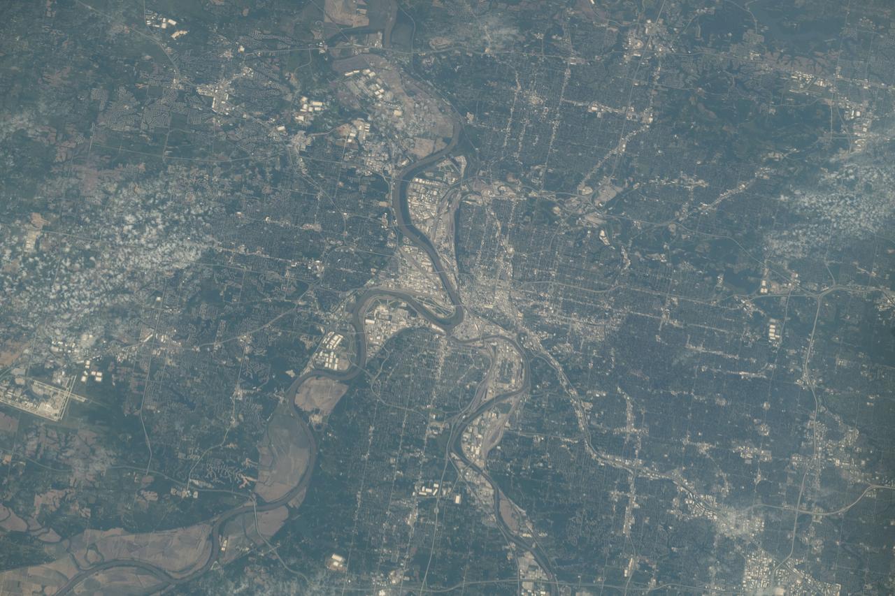
iss073e0134680 (May 31, 2025) --- Kansas City, the largest city in Missouri with a population of about 516,000 and split by the Missouri River, is pictured from the International Space Station as it orbited 262 miles above the midwestern United States.

NASA Deputy Administrator Pam Melroy gives opening remarks at the 25th meeting of the Space-Based Positioning, Navigation, and Timing National Advisory Board, Thursday, Dec. 9, 2021, at the Sheraton Pentagon City Hotel in Arlington, Va. Photo Credit: (NASA/Aubrey Gemignani)
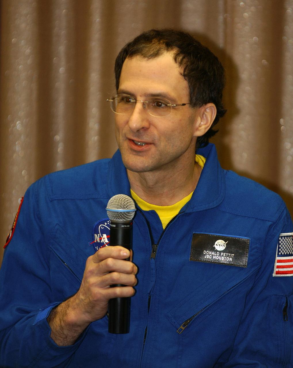
Expedition 6 International Space Station Science Officer Don Pettit speaks during a press conference at the Gagarin Cosmonaut Training Center in Star City, Russia, Thursday, May 6, 2003. Photo Credit: (NASA/Bill Ingalls)

NASA Deputy Administrator Pam Melroy gives opening remarks at the 25th meeting of the Space-Based Positioning, Navigation, and Timing National Advisory Board, Thursday, Dec. 9, 2021, at the Sheraton Pentagon City Hotel in Arlington, Va. Photo Credit: (NASA/Aubrey Gemignani)

NASA Deputy Administrator Pam Melroy gives opening remarks at the 25th meeting of the Space-Based Positioning, Navigation, and Timing National Advisory Board, Thursday, Dec. 9, 2021, at the Sheraton Pentagon City Hotel in Arlington, Va. Photo Credit: (NASA/Aubrey Gemignani)

NASA Deputy Administrator Pam Melroy gives opening remarks at the 25th meeting of the Space-Based Positioning, Navigation, and Timing National Advisory Board, Thursday, Dec. 9, 2021, at the Sheraton Pentagon City Hotel in Arlington, Va. Photo Credit: (NASA/Aubrey Gemignani)

Expedition 9 Flight Engineer Michael Fincke, lower left, greets his wife and children for the first time in six months after exiting the Gargarin Cosmonaut Training Center's airplane in Star City, Russia, Sunday October 24, 2004. Photo Credit: (NASA/Bill Ingalls)

NASA Deputy Administrator Pam Melroy gives opening remarks at the 25th meeting of the Space-Based Positioning, Navigation, and Timing National Advisory Board, Thursday, Dec. 9, 2021, at the Sheraton Pentagon City Hotel in Arlington, Va. Photo Credit: (NASA/Aubrey Gemignani)

NASA Deputy Administrator Pam Melroy gives opening remarks at the 25th meeting of the Space-Based Positioning, Navigation, and Timing National Advisory Board, Thursday, Dec. 9, 2021, at the Sheraton Pentagon City Hotel in Arlington, Va. Photo Credit: (NASA/Aubrey Gemignani)
SL3-22-0322 (July-September 1973) --- An oblique view of the Salt Lake City, Utah area as photographed from Earth orbit by one of the six lenses of the Itek-furnished S190-A Multispectral Photographic Facility Experiment aboard the Skylab space station. Approximately two-thirds of the Great Salt Lake is in view. The smaller body of water south of Salt Lake City is Utah Lake. The Wasatch Range is on the east side of the Great Salt Lake. Federal agencies participating with NASA on the EREP project are the Departments of Agriculture, Commerce, Interior, the Environmental Protection Agency and the Corps of Engineers. All EREP photography is available to the public through the Department of Interior?s Earth Resources Observations Systems Data Center, Sioux Falls, South Dakota, 57198. Photo credit: NASA
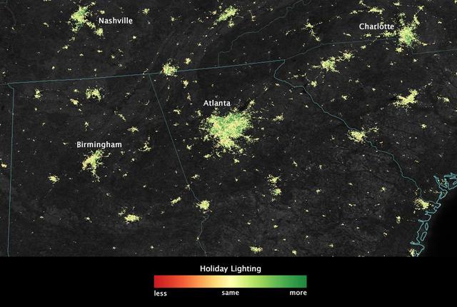
City lights shine brighter during the holidays in the United States when compared with the rest of the year, as shown using a new analysis of daily data from the NASA-NOAA Suomi NPP satellite. Dark green pixels are areas where lights are 50 percent brighter, or more, during December. Because snow reflects so much light, the researchers could only analyze snow-free cities. They focused on the U.S. West Coast from San Francisco and Los Angeles, and cities south of a rough imaginary line from St. Louis to Washington, D.C. Credit: Jesse Allen, NASA’s Earth Observatory Read more: <a href="http://www.nasa.gov/content/goddard/satellite-sees-holiday-lights-brighten-cities." rel="nofollow">www.nasa.gov/content/goddard/satellite-sees-holiday-light...</a>.<b><a href="http://www.nasa.gov/audience/formedia/features/MP_Photo_Guidelines.html" rel="nofollow">NASA image use policy.</a></b> <b><a href="http://www.nasa.gov/centers/goddard/home/index.html" rel="nofollow">NASA Goddard Space Flight Center</a></b> enables NASA’s mission through four scientific endeavors: Earth Science, Heliophysics, Solar System Exploration, and Astrophysics. Goddard plays a leading role in NASA’s accomplishments by contributing compelling scientific knowledge to advance the Agency’s mission. <b>Follow us on <a href="http://twitter.com/NASAGoddardPix" rel="nofollow">Twitter</a></b> <b>Like us on <a href="http://www.facebook.com/pages/Greenbelt-MD/NASA-Goddard/395013845897?ref=tsd" rel="nofollow">Facebook</a></b> <b>Find us on <a href="http://instagram.com/nasagoddard?vm=grid" rel="nofollow">Instagram</a></b>
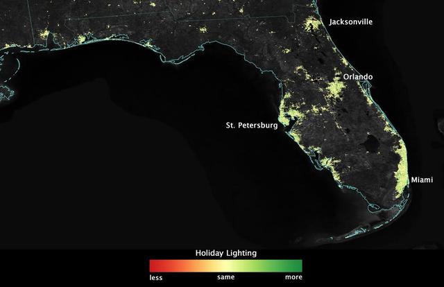
City lights shine brighter during the holidays in the United States when compared with the rest of the year, as shown using a new analysis of daily data from the NASA-NOAA Suomi NPP satellite. Dark green pixels are areas where lights are 50 percent brighter, or more, during December. Because snow reflects so much light, the researchers could only analyze snow-free cities. They focused on the U.S. West Coast from San Francisco and Los Angeles, and cities south of a rough imaginary line from St. Louis to Washington, D.C. Credit: Jesse Allen, NASA’s Earth Observatory Read more: <a href="http://www.nasa.gov/content/goddard/satellite-sees-holiday-lights-brighten-cities." rel="nofollow">www.nasa.gov/content/goddard/satellite-sees-holiday-light...</a>.<b><a href="http://www.nasa.gov/audience/formedia/features/MP_Photo_Guidelines.html" rel="nofollow">NASA image use policy.</a></b> <b><a href="http://www.nasa.gov/centers/goddard/home/index.html" rel="nofollow">NASA Goddard Space Flight Center</a></b> enables NASA’s mission through four scientific endeavors: Earth Science, Heliophysics, Solar System Exploration, and Astrophysics. Goddard plays a leading role in NASA’s accomplishments by contributing compelling scientific knowledge to advance the Agency’s mission. <b>Follow us on <a href="http://twitter.com/NASAGoddardPix" rel="nofollow">Twitter</a></b> <b>Like us on <a href="http://www.facebook.com/pages/Greenbelt-MD/NASA-Goddard/395013845897?ref=tsd" rel="nofollow">Facebook</a></b> <b>Find us on <a href="http://instagram.com/nasagoddard?vm=grid" rel="nofollow">Instagram</a></b>

The crew return bus pulls away from the Gargarin Cosmonaut Training Center's airplane in Star City, Russia. The Soyuz capsule carrying Expedition 9 Flight Engineer Michael Fincke, Expedition 9 Commander Gennady Padalka and Russian Space Forces cosmonaut Yuri Shargin landed approximately 85 kilometers northeast of Arkalyk in northern Kazakhstan, Sunday, October 24, 2004. Photo Credit: (NASA/Bill Ingalls)

Expedition 30 Flight Engineer Anatoly Ivanishin is welcomed home by colleagues and family in Star City, Russia on Saturday, April 28, 2012. Russian Cosmonaut Ivanishin, Expedition 30 Commander Daniel Burbank, and Russian Cosmonaut Anton Shkaplerov landed outside of Arkalyk, Kazakhstan earlier in the day from over five months onboard the International Space Station where they served as members of the Expedtion 29 and 30 crews. Photo Credit: (NASA/Carla Cioffi)
iss069e009939 (May 10, 2023) --- The city lights of Lahore, Pakistan's second largest city, were pictured by UAE (United Arab Emirates) astronaut and Expedition 69 Flight Engineer Sultan Alneyadi from the International Space Station as it orbited 259 miles above.

iss073e0088816 (May 16, 2025) --- The International Space Station was soaring 259 miles above central Mexico with a faint atmospheric glow crowning Earth's horizon at approximately 2:58 a.m. local time when this photograph was taken. The city lights of Mexico City, the nation's capital and largest city with a population of 9.21 million, and its surrounding suburbs dominate the nightscape.
iss072e518202 (Jan. 23, 2025) --- This long-duration photograph highlights the city lights of Mexico's Yucatan peninsula, Earth's atmospheric glow, and star trails above taken from the International Space Station as it orbited 258 miles above.
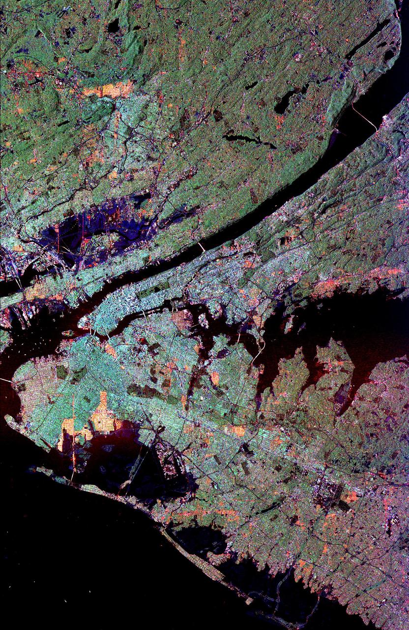
This radar image of the New York city metropolitan area. The island of Manhattan appears in the center of the image. The green-colored rectangle on Manhattan is Central Park.

iss072e401952 (Dec. 21, 2024) --- The city lights (from left) of Tianjin, Langfang, and Beijing, three cities in China with a combined population of about 41.2 million, are pictured at approximately 4 a.m. local time from the International Space Station as it orbited 259 miles above the Asian nation.

iss072e445581 (Dec. 28, 2024) --- The city lights of Tashkent, Uzbekistan's capital and most populous city with a population of about 3.1 million residents, are pictured at approximately 1:36 a.m. local time from the International Space Station as it orbited 259 miles above Central Asia.
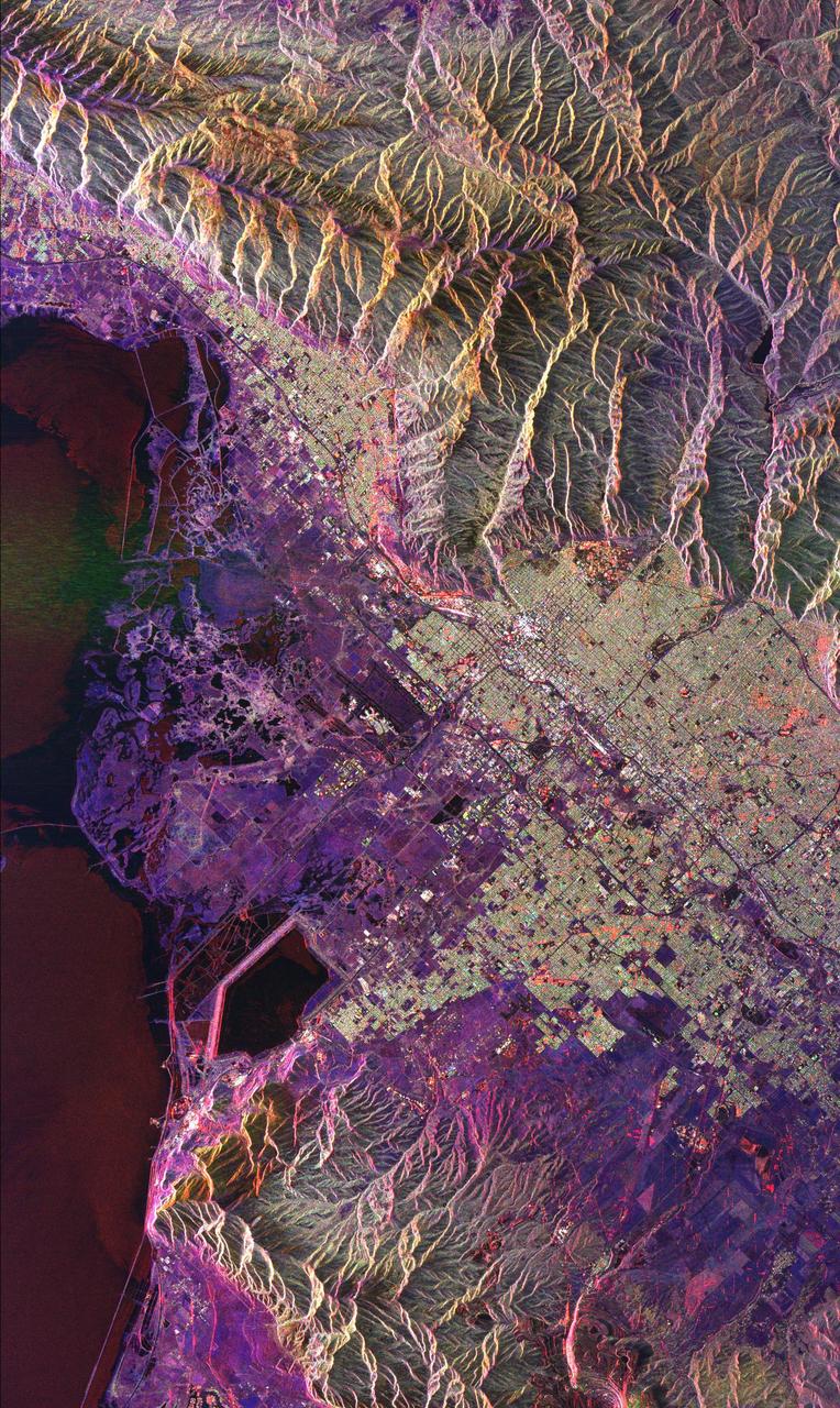
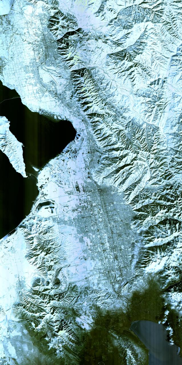
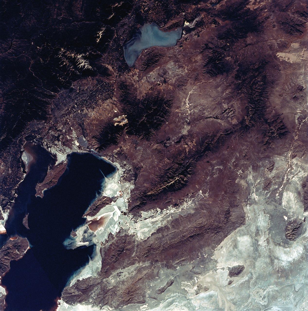
This radar image of Salt Lake City, Utah, illustrates the different land use patterns that are present in the Utah Valley. Salt Lake City lies between the shores of the Great Salt Lake (the dark area on the left side of the image) and the Wasatch Front Range (the mountains in the upper half of the image). The Salt Lake City area is of great interest to urban planners because of the combination of lake, valley and alpine environments that coexist in the region. Much of the southern shore of the Great Salt Lake is a waterfowl management area. The green grid pattern in the right center of the image is Salt Lake City and its surrounding communities. The Salt Lake City airport is visible as the brown rectangle near the center of the image. Interstate Highway 15 runs from the middle right edge to the upper left of the image. The bright white patch east of Interstate 15 is the downtown area, including Temple Square and the state capitol. The University of Utah campus is the yellowish area that lies at the base of the mountains, east of Temple Square. The large reservoir in the lower left center is a mine tailings pond. The semi-circular feature in the mountains at the bottom edge of the image is the Kennecott Copper Mine. The area shown is 60 kilometers by 40 kilometers (37 miles by 25 miles) and is centered at 40.6 degrees north latitude, 112.0 degrees west longitude. North is toward the upper left. This image was acquired by the Spaceborne Imaging Radar-C/X-Band Synthetic Aperture Radar (SIR-C/X-SAR) aboard the space shuttle Endeavour on April 10, 1994. The colors in this image represent the following radar channels and polarizations: red is L-band, horizontally transmitted and received; green is L-band, horizontally transmitted and vertically received; and blue is C-band, horizontally transmitted and vertically received. SIR-C/X-SAR, a joint mission of the German, Italian and United States space agencies, is part of NASA's Mission to Planet Earth program. http://photojournal.jpl.nasa.gov/catalog/PIA01798

Expedition 10 Commander Leroy Chiao, left, is greeted by his wife after arriving in Star City, Russia from Kazakhstan, Monday, April 25, 2005. The Expedition 10 crew brought their Soyuz TMA-5 capsule to a pre-dawn landing April 25 northeast of the town of Arkalyk to wrap up a six-month mission aboard the International Space Station for Chiao and Sharipov, and a ten-day mission for Vittori, who flew under a commercial contract between ESA and the Russian Federal Space Agency. Photo Credit: (NASA/Bill Ingalls)

Expedition 10 Flight Engineer Salizhan Sharipov, on bus, looks out at well wishers after arriving back at Star City, Russia from Kazakhstan, Monday, April 25, 2005. Expedition 10 Commander Leroy Chiao, Flight Engineer Salizhan Sharipov and European Space Agency astronaut Roberto Vittori brought their Soyuz TMA-5 capsule to a pre-dawn landing April 25 northeast of the town of Arkalyk to wrap up a six-month mission aboard the International Space Station for Chiao and Sharipov, and a ten-day mission for Vittori, who flew under a commercial contract between ESA and the Russian Federal Space Agency. Photo Credit: (NASA/Bill Ingalls)
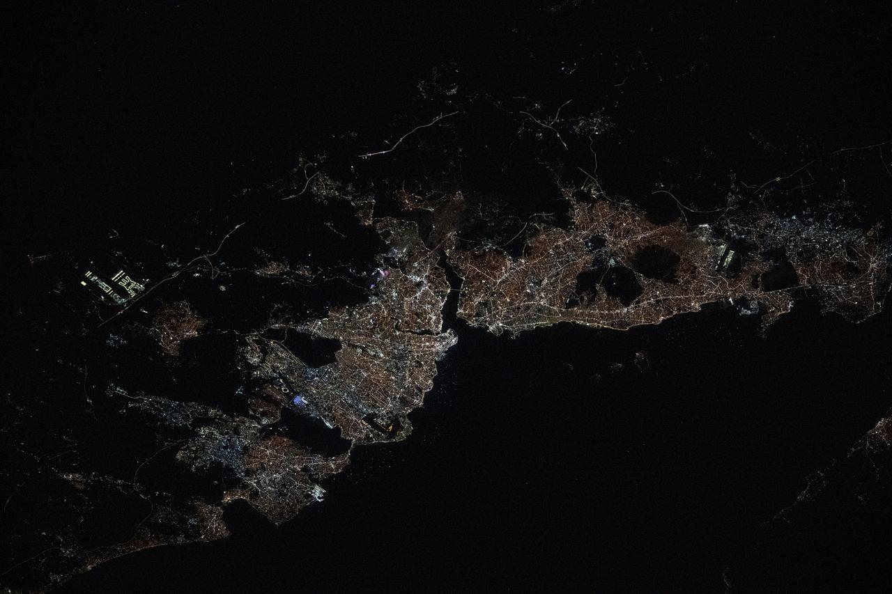
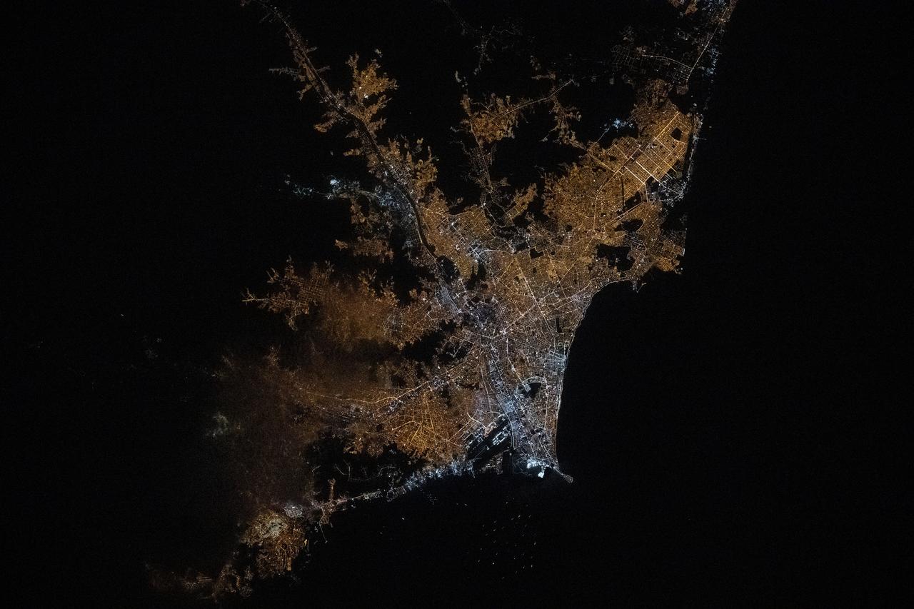
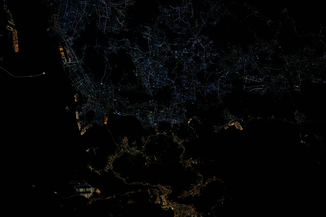
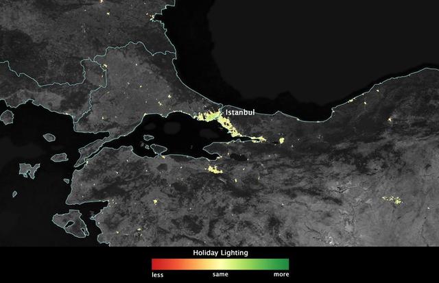
iss072e519796 (Jan. 23, 2025) --- The city lights of Istanbul, Turkiye, with a population of about 15.7 million split by the Bosphorus strait in between the Sea of Mammara and the Black Sea, are pictured at approximately 9:44 p.m. local time from the International Space Staation as it orbited 259 miles above.
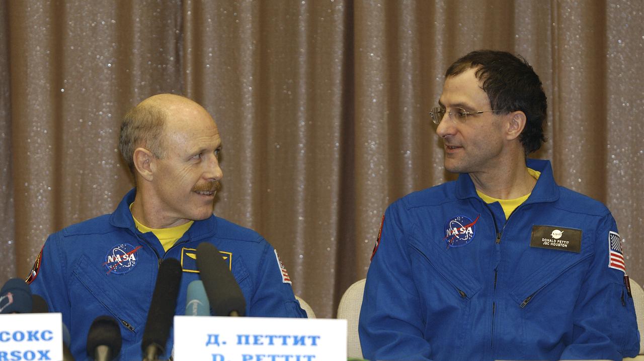
Expedition 6 Commander Ken Bowersox, left and NASA International Space Station Science Officer Don Pettit speak during a press conference at the Gagarin Cosmonaut Training Center in Star City, Russia, Thursday, May 6, 2003. Photo Credit: (NASA/Bill Ingalls)
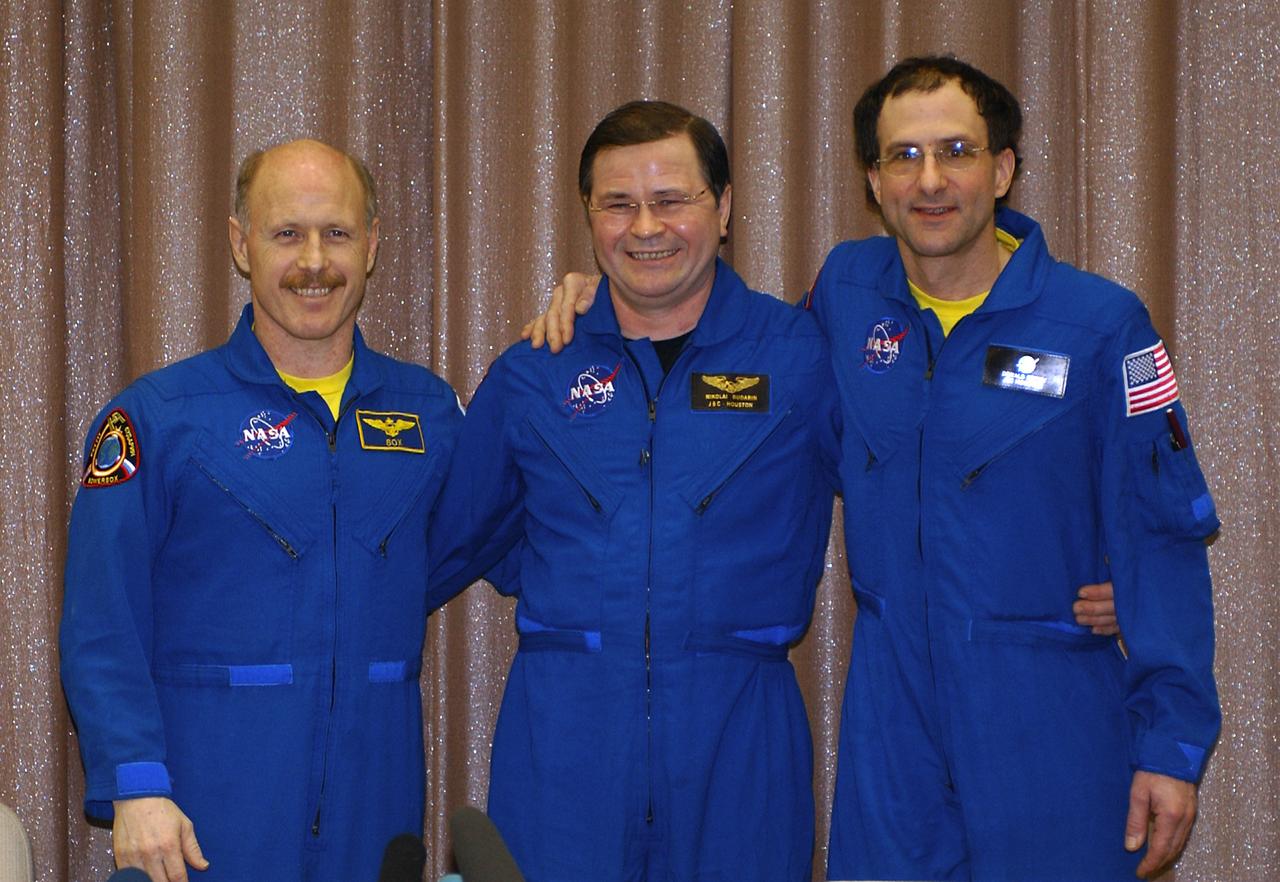
Expedition 6 Flight Engineer Nikolai Budarin, left, Commander Ken Bowersox and International Space Station Science Officer Don Pettit, right, pose for photos at a press conference at the Gagarin Cosmonaut Training Center in Star City, Russia, Thursday, May 6, 2003. Photo Credit: (NASA/Bill Ingalls)

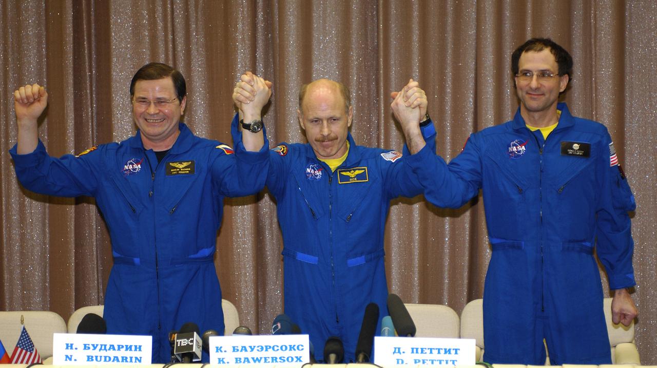
Expedition 6 Flight Engineer Nikolai Budarin, left, Commander Ken Bowersox and NASA International Space Station Science Officer Don Pettit, right, answer questions during a press conference at the Gagarin Cosmonaut Training Center in Star City, Russia, Thursday, May 6, 2003. Photo Credit: (NASA/Bill Ingalls)
Expedition 6 Flight Engineer Nikolai Budarin, left, Commander Ken Bowersox and International Space Station Science Officer Don Pettit, right, pose for photos at a press conference at the Gagarin Cosmonaut Training Center in Star City, Russia, Thursday, May 6, 2003. Photo Credit: (NASA/Bill Ingalls)

Renita Fincke follows the arrival of her husband, NASA astronaut Michael Fincke, to the Gagarin Cosmonaut Training Center while holding their 4 month-old baby Tarali Fincke, Sunday, October 24, 2004, in Star City, Russia. Photo Credit: (NASA/Bill Ingalls)

The night side of Earth twinkles with light, and the first thing to stand out is the cities. “Nothing tells us more about the spread of humans across the Earth than city lights,” asserts Chris Elvidge, a NOAA scientist who has studied them for 20 years. This new global view and animation of Earth’s city lights is a composite assembled from data acquired by the Suomi National Polar-orbiting Partnership (Suomi NPP) satellite. The data was acquired over nine days in April 2012 and thirteen days in October 2012. It took satellite 312 orbits and 2.5 terabytes of data to get a clear shot of every parcel of Earth’s land surface and islands. This new data was then mapped over existing Blue Marble imagery of Earth to provide a realistic view of the planet. The nighttime view in visible light was made possible by the new “day-night band” of Suomi NPP’s Visible Infrared Imaging Radiometer Suite. VIIRS detects light in a range of wavelengths from green to near-infrared and uses filtering techniques to observe dim signals such as city lights, auroras, wildfires, and reflected moonlight. This low-light sensor can distinguish night lights with ten to hundreds of times better light detection capability than scientists had before. Named for satellite meteorology pioneer Verner Suomi, NPP flies over any given point on Earth&rsquos surface twice each day at roughly 1:30 a.m. and 1:30 p.m. The polar-orbiting satellite flies 824 kilometers (512 miles) above the surface as it circles the planet 14 times a day. Data is sent once per orbit to a ground station in Svalbard, Norway, and continuously to local direct broadcast users around the world. The mission is managed by NASA with operational support from NOAA and its Joint Polar Satellite System, which manages the satellite's ground system. NASA Earth Observatory image and animation by Robert Simmon, using Suomi NPP VIIRS data provided courtesy of Chris Elvidge (NOAA National Geophysical Data Center). Suomi NPP is the result of a partnership between NASA, NOAA, and the Department of Defense. Caption by Mike Carlowicz. Instrument: Suomi NPP - VIIRS Credit: <b><a href="http://www.earthobservatory.nasa.gov/" rel="nofollow"> NASA Earth Observatory</a></b> <b>Click here to view all of the <a href="http://earthobservatory.nasa.gov/Features/NightLights/" rel="nofollow"> Earth at Night 2012 images </a></b> <b>Click here to <a href="http://earthobservatory.nasa.gov/NaturalHazards/view.php?id=79803" rel="nofollow"> read more </a> about this image </b> <b><a href="http://www.nasa.gov/audience/formedia/features/MP_Photo_Guidelines.html" rel="nofollow">NASA image use policy.</a></b> <b><a href="http://www.nasa.gov/centers/goddard/home/index.html" rel="nofollow">NASA Goddard Space Flight Center</a></b> enables NASA’s mission through four scientific endeavors: Earth Science, Heliophysics, Solar System Exploration, and Astrophysics. Goddard plays a leading role in NASA’s accomplishments by contributing compelling scientific knowledge to advance the Agency’s mission. <b>Follow us on <a href="http://twitter.com/NASA_GoddardPix" rel="nofollow">Twitter</a></b> <b>Like us on <a href="http://www.facebook.com/pages/Greenbelt-MD/NASA-Goddard/395013845897?ref=tsd" rel="nofollow">Facebook</a></b> <b>Find us on <a href="http://instagram.com/nasagoddard?vm=grid" rel="nofollow">Instagram</a></b>

Expedition 16 Flight Engineer and Soyuz Commander Yuri Malenchenko, second from left, and Expedition 16 Commander Peggy Whitson meet with Russian officials at the foot of the airplane steps after they arrived at Chkalovsky Airport near Star City, Russia, Friday, April 19, 2008. Whitson, Malechenko and Yi landed their Soyuz TMA-11 spacecraft on April 19, 2008 in central Kazakhstan to complete 192 days in space for Whitson and Malenchenko and 11 days in orbit for Yi. Photo Credit: (NASA/Bill Ingalls)

Expedition 16 Commander Peggy Whitson, bottom, South Korean spaceflight participant So-yeon Yi and Flight Engineer and Soyuz Commander Yuri Malenchenko, top, walk down the airplane steps as they arrive at Chkalovsky Airport near Star City, Russia, Friday, April 19, 2008. Whitson, Malechenko and Yi landed their Soyuz TMA-11 spacecraft on April 19, 2008 in central Kazakhstan to complete 192 days in space for Whitson and Malenchenko and 11 days in orbit for Yi. Photo Credit: (NASA/Bill Ingalls)

Members of the 11th expedition to the International Space Station, astronaut John Phillips, top left, and cosmonaut Sergei Krikalev, front, arrive at Star City, Russia, Tuesday, Oct. 11, 2005. The crew landed near Arlalyk, Kazakhstan after a six-month mission in orbit. Along with American businessman Greg Olsen, who visited the station for more than a week, Phillips and Krikalev returned to Earth aboard a Russian Soyuz spacecraft. Photo Credit: (NASA/Bill Ingalls)

Expedition 30 Flight Engineers Anatoly Ivanishin, far left, and Anton Shkaplerov are welcomed home by colleagues and family in Star City, Russia on Saturday, April 28, 2012. Russian Cosmonauts Ivanishin, Shkaplerov and Expedition 30 Commander Daniel Burbank landed outside of Arkalyk, Kazakhstan earlier in the day from over five months onboard the International Space Station where they served as members of the Expedtion 29 and 30 crews. Photo Credit: (NASA/Carla Cioffi)

Russian Federal Space Agency Deputy General-Director Nikolai Moiseev, center, Renita Fincke, wife of Expedition 9 Flight Engineer Michael Fincke, second from right with baby, and other officials and family members celebrate the return of the Expedition 9 crew to Star City, Russia after their Soyuz capsule landed safely approximately 85 kilometers northeast of Arkalyk in northern Kazakhstan, Sunday, October 24, 2004. Photo Credit: (NASA/Bill Ingalls)
iss072e399613 (Dec. 20, 2024) --- The city lights of Hong Kong (bottom center) and Shenzhen, China, are different colors due to their historical differences. Shenzhen is a younger, more futuristic city, while Hong Kong is an older city illuminating its historical landmarks and its harbor. The International Space Station was orbiting 255 miles above southeastern China at the time of this photograph.
In several cities in the Middle East, city lights brighten during the Muslim holy month of Ramadan, as seen using a new analysis of daily data from the NASA-NOAA Suomi NPP satellite. Dark green pixels are areas where the lights are 50 percent brighter, or more, during Ramadan. Credit: Jesse Allen, NASA’s Earth Observatory Read more: <a href="http://www.nasa.gov/content/goddard/satellite-sees-holiday-lights-brighten-cities" rel="nofollow">www.nasa.gov/content/goddard/satellite-sees-holiday-light...</a> <b><a href="http://www.nasa.gov/audience/formedia/features/MP_Photo_Guidelines.html" rel="nofollow">NASA image use policy.</a></b> <b><a href="http://www.nasa.gov/centers/goddard/home/index.html" rel="nofollow">NASA Goddard Space Flight Center</a></b> enables NASA’s mission through four scientific endeavors: Earth Science, Heliophysics, Solar System Exploration, and Astrophysics. Goddard plays a leading role in NASA’s accomplishments by contributing compelling scientific knowledge to advance the Agency’s mission. <b>Follow us on <a href="http://twitter.com/NASAGoddardPix" rel="nofollow">Twitter</a></b> <b>Like us on <a href="http://www.facebook.com/pages/Greenbelt-MD/NASA-Goddard/395013845897?ref=tsd" rel="nofollow">Facebook</a></b> <b>Find us on <a href="http://instagram.com/nasagoddard?vm=grid" rel="nofollow">Instagram</a></b>
In several cities in the Middle East, city lights brighten during the Muslim holy month of Ramadan, as seen using a new analysis of daily data from the NASA-NOAA Suomi NPP satellite. Dark green pixels are areas where the lights are 50 percent brighter, or more, during Ramadan. Credit: Jesse Allen, NASA’s Earth Observatory Read more: <a href="http://www.nasa.gov/content/goddard/satellite-sees-holiday-lights-brighten-cities" rel="nofollow">www.nasa.gov/content/goddard/satellite-sees-holiday-light...</a> <b><a href="http://www.nasa.gov/audience/formedia/features/MP_Photo_Guidelines.html" rel="nofollow">NASA image use policy.</a></b> <b><a href="http://www.nasa.gov/centers/goddard/home/index.html" rel="nofollow">NASA Goddard Space Flight Center</a></b> enables NASA’s mission through four scientific endeavors: Earth Science, Heliophysics, Solar System Exploration, and Astrophysics. Goddard plays a leading role in NASA’s accomplishments by contributing compelling scientific knowledge to advance the Agency’s mission. <b>Follow us on <a href="http://twitter.com/NASAGoddardPix" rel="nofollow">Twitter</a></b> <b>Like us on <a href="http://www.facebook.com/pages/Greenbelt-MD/NASA-Goddard/395013845897?ref=tsd" rel="nofollow">Facebook</a></b> <b>Find us on <a href="http://instagram.com/nasagoddard?vm=grid" rel="nofollow">Instagram</a></b>
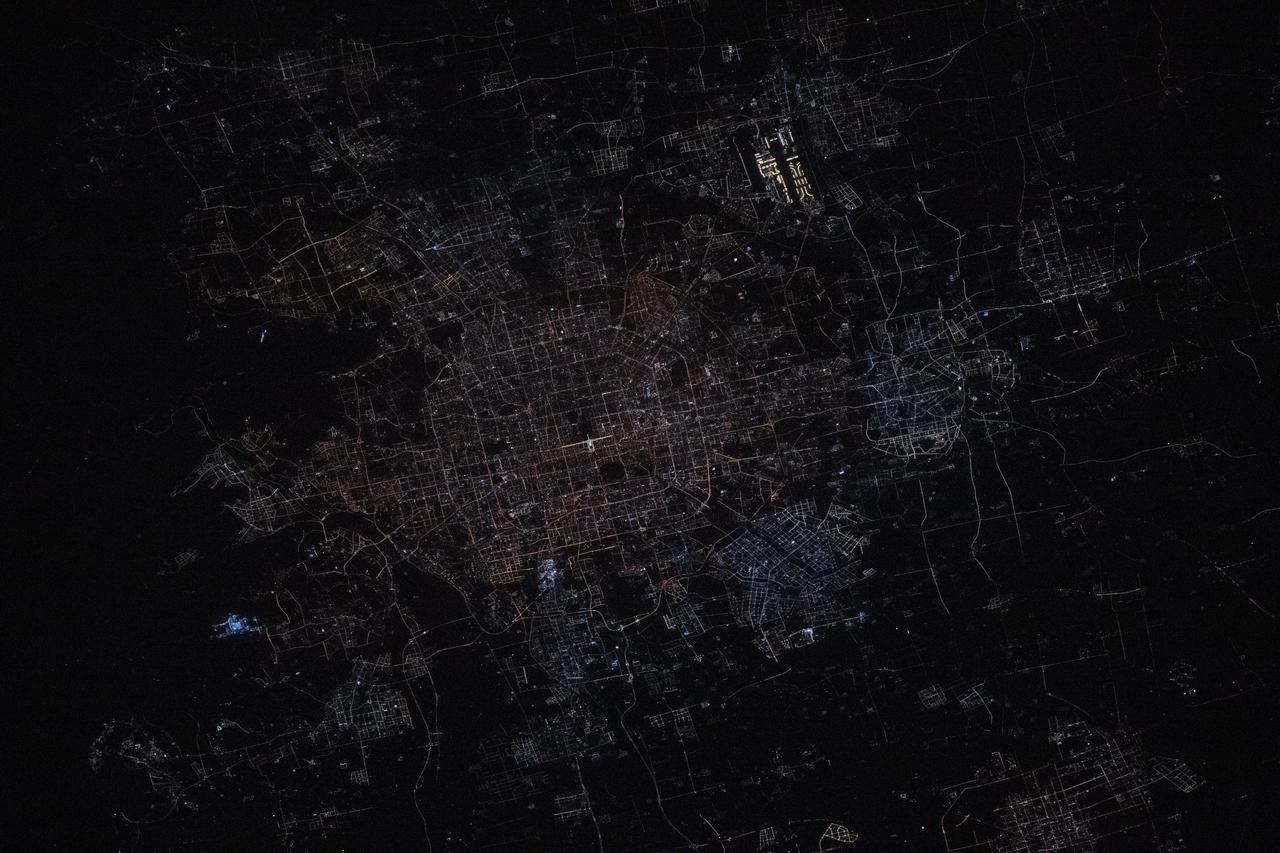
iss072e444944 (Dec. 28, 2024) --- Beijing, China's capital city with a population of about 21.9 million residents, is pictured at approximately 1:31 a.m. local time from the International Space Station as it orbited 259 miles above. Highlights in this photograph include the Forbidden City's well-lit Meridian Gate (center) and the Beijing Capital International Airport (upper right).
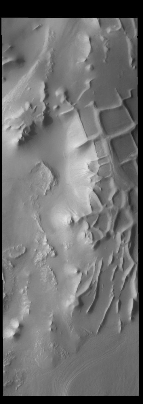
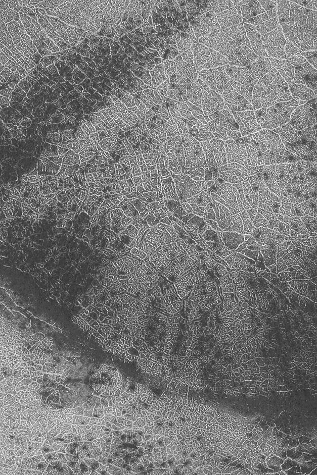
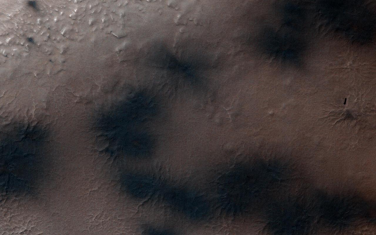
Angustus Labyrinthus is a unique region near the south polar cap. The squares formed by intersecting ridges earned the feature the informal name of the Inca City when it was discovered in Mariner 9 images in 1972. The linear ridges are believed to have formed by volcanic and tectonic forces, where magma filled fractures in the subsurface and then erosion revealed the magmatic material. Orbit Number: 84158 Latitude: -81.3484 Longitude: 296.938 Instrument: VIS Captured: 2020-12-03 20:45 https://photojournal.jpl.nasa.gov/catalog/PIA24408
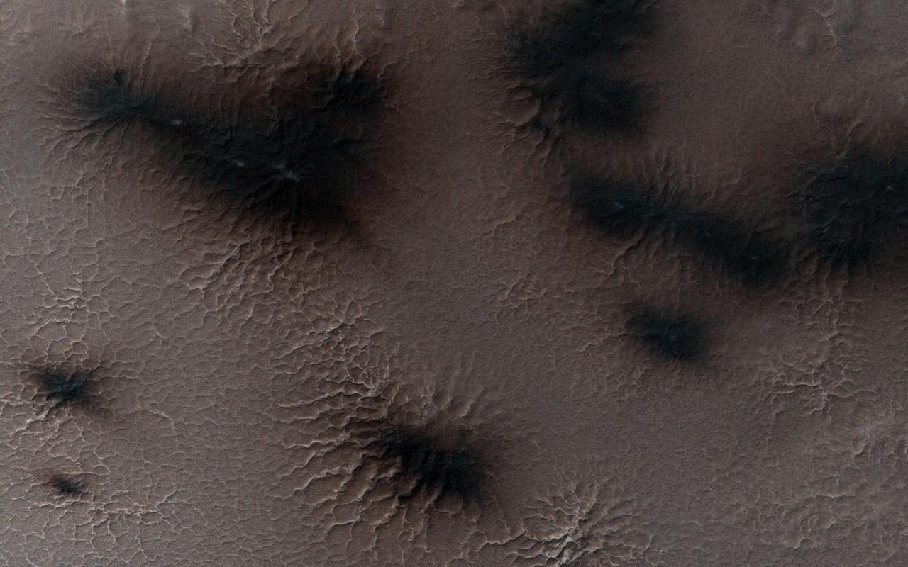
It is about two weeks later in Inca City and the season is officially spring. Numerous changes have occurred. Large blotches of dust cover the araneiforms. Dark spots on the ridge show places where the seasonal polar ice cap has ruptured, releasing gas and fine material from the surface below. At the bottom of the image fans point in more than one direction from a single source, showing that the wind has changed direction while gas and dust were flowing out. Was the flow continuous or has the vent opened and closed? http://photojournal.jpl.nasa.gov/catalog/PIA18893
A significant event has occurred in Inca City. The layer of seasonal ice has started to develop long cracks as evidenced by NASA Mars Reconnaissance Orbiter. Fans of dust are emerging from long linear cracks. The cracks form when large plates of ice have no easily ruptured weak spots to release the pressure from gas building up underneath, so the ice simply cracks. There are also more fans on the ridge at the top of the image, and more have appeared in between the araneiforms. We do not have any analogous processes occurring naturally on Earth: this is truly Martian. http://photojournal.jpl.nasa.gov/catalog/PIA18896
iss072e399852 (Dec. 20, 2024) --- The city lights of Busan, South Korea, a port city with a population of over 3.3 million on the Korean Strait, are pictured at approximately 4:19 a.m. local time from the International Space Station as it orbited 257 miles above.
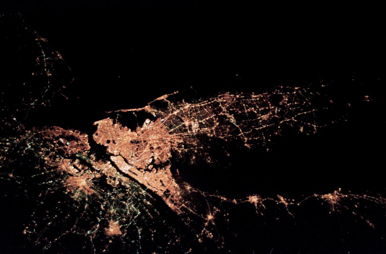
STS059-50-003 (9-20 April 1994) --- This 35mm night image of the New York City metropolitan area was captured by the crew of the STS-59 crew during the Space Radar Laboratory (SRL) mission. Scientists studying film from the Space Shuttle Endeavour feel this is the best nocturnal view of this region from the manned space program.
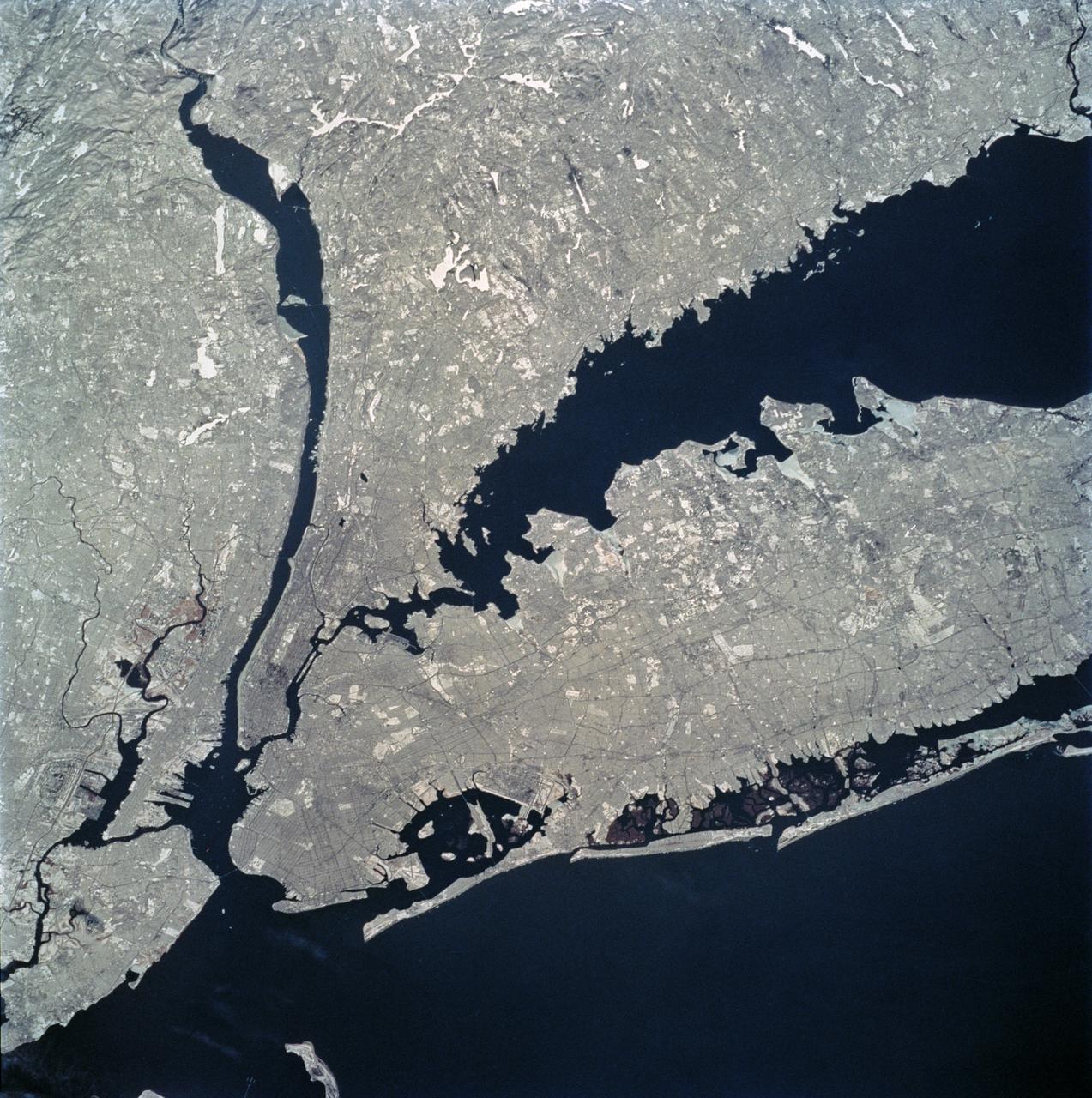
STS062-81-010 (4-18 March 1994) --- The recent heavy snowfalls help to accentuate the major transportation networks, (railroads, highways and airports), throughout the New York City metropolitan area. This particular scene also highlights the land-water boundaries and the lighter open spaces, such as parks, cemeteries and recreational areas. The snows have produced a white blanket effect on these areas. Even some of the snow-covered lakes can be discerned. The boroughs of Staten Island, Brooklyn, Queens, The Bronx and Manhattan are also recognizable on the photograph.
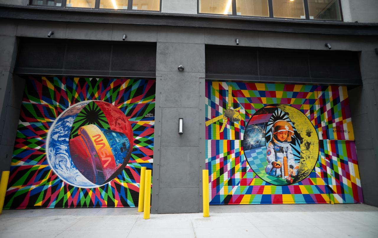
The inaugural murals for the relaunched NASA Art Program appear side-by-side at 350 Hudson Street, Monday, Sept. 23, 2024, in New York City. The murals, titled “To the Moon, and Back,” were created by New York-based artist team Geraluz and WERC and use geometrical patterns to invite deeper reflection on the exploration, creativity, and connection with the cosmos. Photo Credit: (NASA/Joel Kowsky)

Amaru Alvarez, 5, the son of the artist team Geraluz and WERC and model for the mural, poses for picture with the mural “To the Moon, and Back” by the New York-based artist team that was created as part of the reimagined NASA Art Program, Tuesday, September 24, 2024, at 350 Hudson Street in New York City. The murals use geometrical patterns to invite deeper reflection on the exploration, creativity, and connection with the cosmos. Photo Credit: (NASA/Joel Kowsky)