
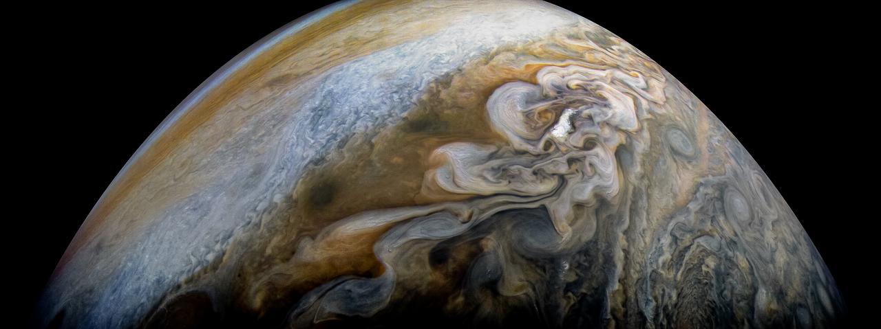
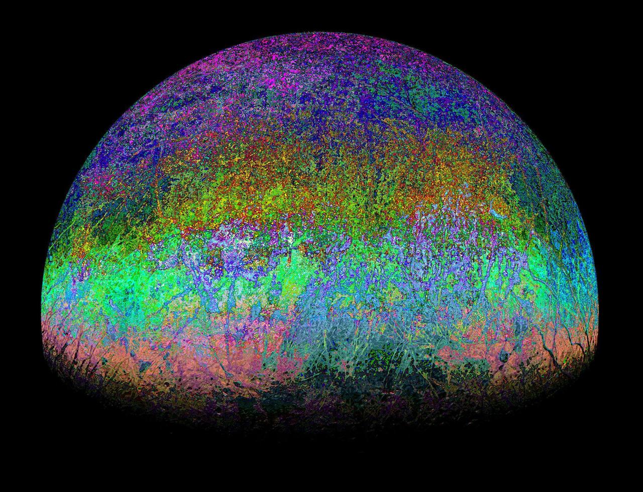
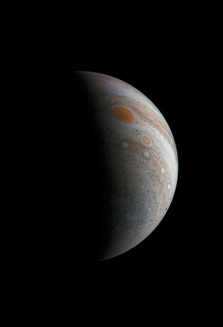
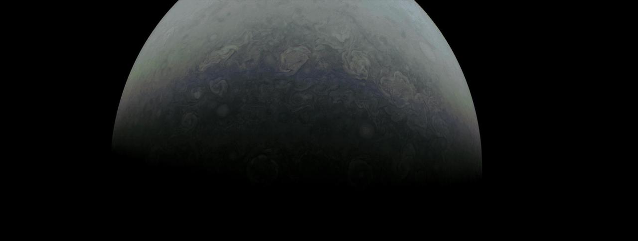
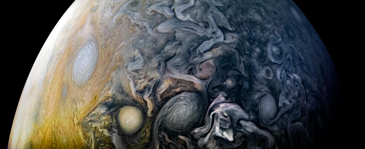
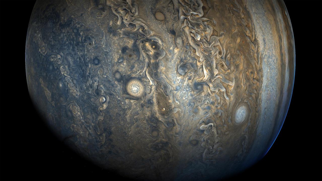
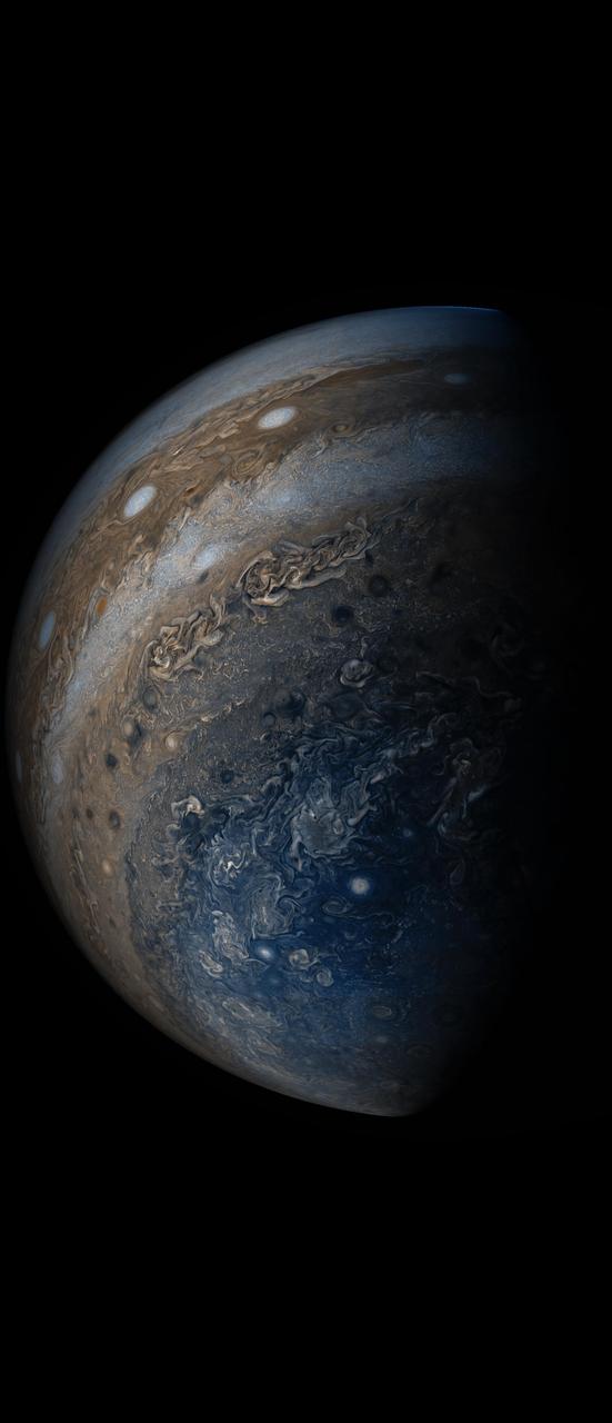
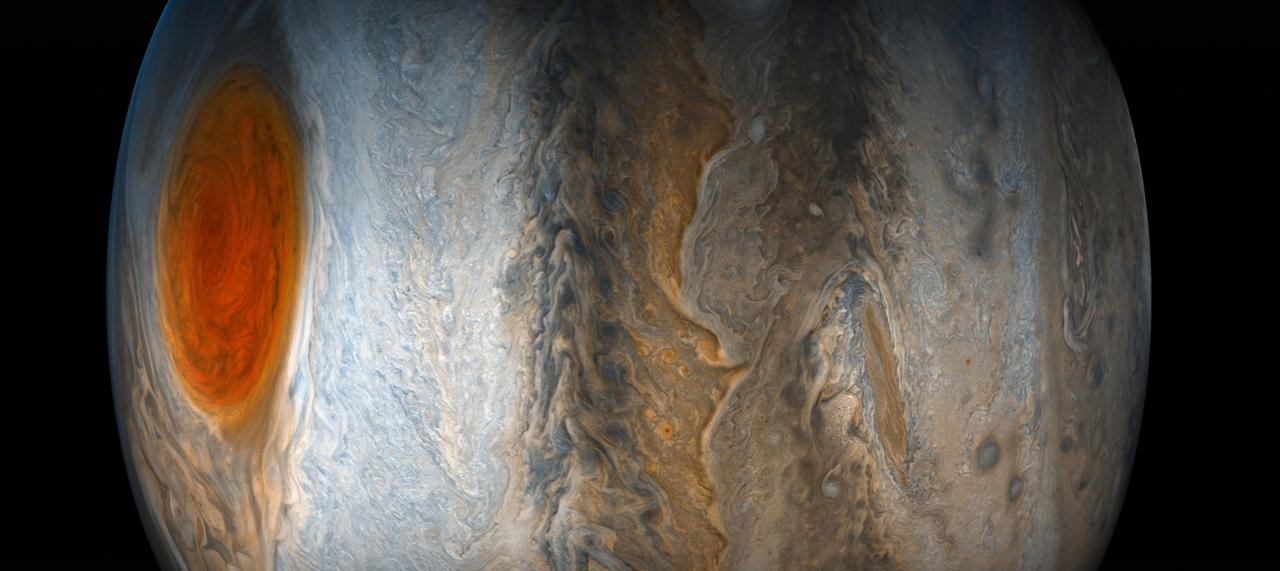
This image of Jupiter's southern hemisphere was captured by NASA's Juno spacecraft as it performed a close flyby of the gas giant planet on Dec. 16, 2017. Juno captured this color-enhanced image at 10:24 a.m. PST (1:24 p.m. EST) when the spacecraft was about 19,244 miles (30,970 kilometers) from the tops of Jupiter's clouds at a latitude of 49.9 degrees south -- roughly halfway between the planet's equator and its south pole. Citizen scientist Gerald Eichstädt processed this image using data from the JunoCam imager. https://photojournal.jpl.nasa.gov/catalog/PIA21977. - Enhanced image by Gerald Eichstädt based on images provided courtesy of NASA/JPL-Caltech/SwRI/MSSS
See swirling cloud formations in the northern area of Jupiter's north temperate belt in this new view taken by NASA's Juno spacecraft. The color-enhanced image was taken on Feb. 7 at 5:42 a.m. PST (8:42 a.m. EST), as Juno performed its eleventh close flyby of Jupiter. At the time the image was taken, the spacecraft was about 5,086 miles (8,186 kilometers) from the tops of the clouds of the planet at a latitude of 39.9 degrees. Citizen scientist Kevin M. Gill processed this image using data from the JunoCam imager. https://photojournal.jpl.nasa.gov/catalog/PIA21978 . - Enhanced image by Kevin M. Gill (CC-BY) based on images provided courtesy of NASA/JPL-Caltech/SwRI/MSSS

This image of Jupiter's swirling south polar region was captured by NASA's Juno spacecraft as it neared completion of its tenth close flyby of the gas giant planet. The "empty" space above and below Jupiter in this color-enhanced image can trick the mind, causing the viewer to perceive our solar system's largest planet as less colossal than it is. In reality, Jupiter is wide enough to fit 11 Earths across its clouded disk. The spacecraft captured this image on Dec. 16, 2017, at 11:07 PST (2:07 p.m. EST) when the spacecraft was about 64,899 miles (104,446 kilometers) from the tops of the clouds of the planet at a latitude of 83.9 degrees south -- almost directly over Jupiter's south pole. The spatial scale in this image is 43.6 miles/pixel (70.2 kilometers/pixel). Citizen scientist Gerald Eichstädt processed this image using data from the JunoCam imager. https://photojournal.jpl.nasa.gov/catalog/PIA21975
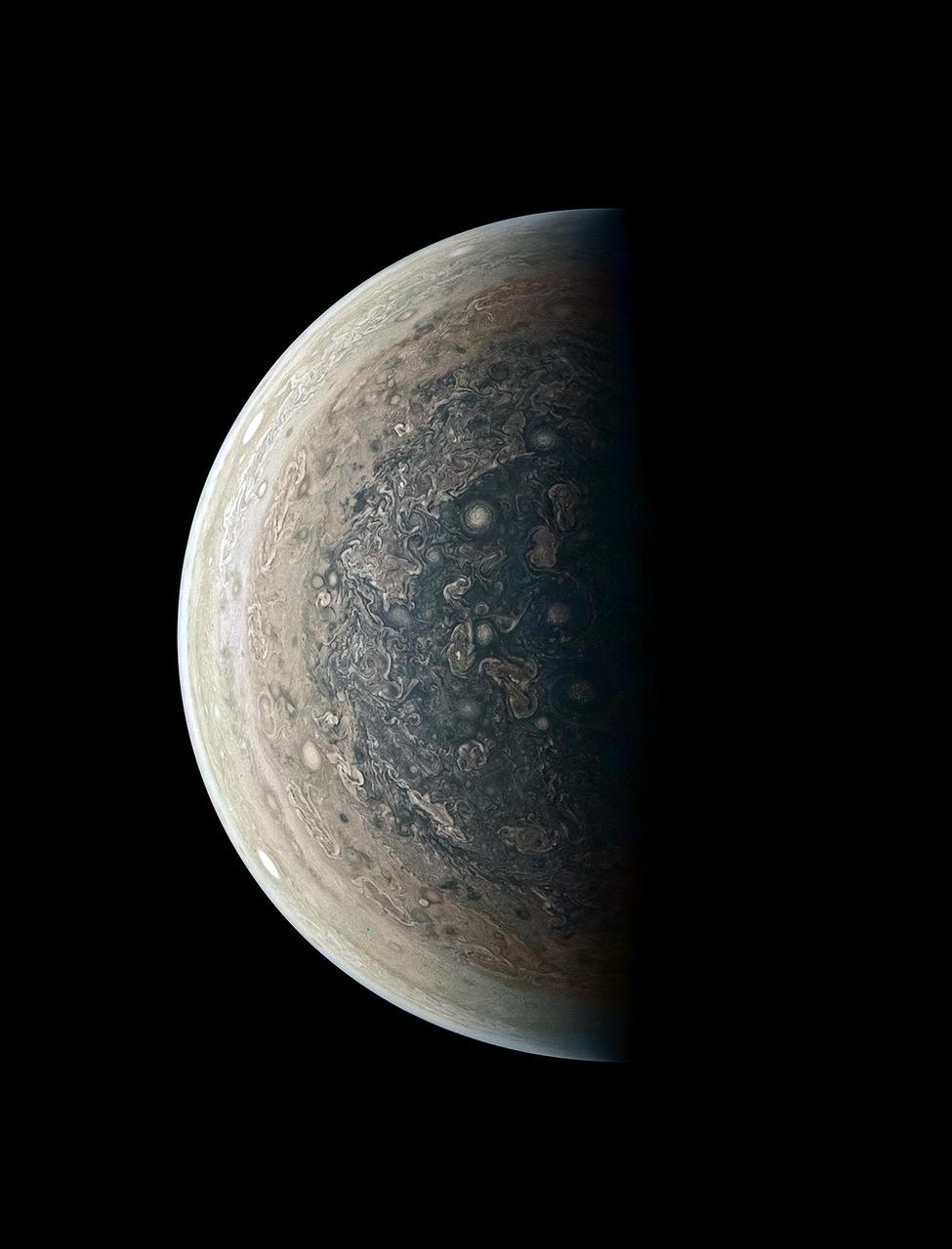
This image of Jupiter's southern hemisphere was captured by NASA's Juno spacecraft on the outbound leg of a close flyby of the gas-giant planet. The color-enhanced image was taken at 11:31 p.m. PDT on May 23, 2018 (2:31 a.m. EDT on May 24), as the spacecraft performed its 13th close flyby of Jupiter. At the time, Juno was about 44,300 miles (71,400 kilometers) from the planet's cloud tops, above a southern latitude of 71 degrees. JunoCam takes advantage of Juno's unique polar orbit, studying the atmospheric dynamics and clouds right up to Jupiter's poles, which no spacecraft has ever done before. Citizen scientist Kevin M. Gill created this image using data from the spacecraft's JunoCam imager. https://photojournal.jpl.nasa.gov/catalog/PIA22425 . - Enhanced image by Kevin M. Gill (CC-BY) based on images provided courtesy of NASA/JPL-Caltech/SwRI/MSSS

See a jet stream speeding through Jupiter's atmosphere in this new view taken by NASA's Juno spacecraft. The jet stream, called Jet N2, was captured along the dynamic northern temperate belts of the gas giant planet. It is the white stream visible from top left to bottom right in the image. The color-enhanced image was taken at 10:34 p.m. PST on May 23 (1:34 a.m. EST on May 24), as Juno performed its 13th close flyby of Jupiter. At the time the image was taken, the spacecraft was about 3,516 miles (5,659 kilometers) from the tops of the clouds of the planet at a northern latitude of 32.9 degrees. Citizen scientists Gerald Eichstädt and Seán Doran created this image using data from the spacecraft's JunoCam imager. The view is a composite of several separate JunoCam images that were re-projected, blended, and healed. https://photojournal.jpl.nasa.gov/catalog/PIA22422
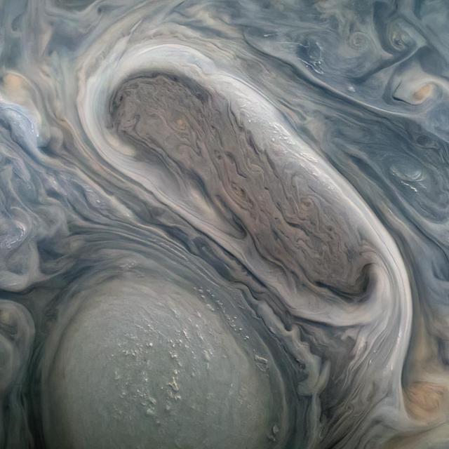
This image captures a high-altitude cloud formation surrounded by swirling patterns in the atmosphere of Jupiter's North North Temperate Belt region. The North North Temperate Belt is one of Jupiter's many colorful, swirling cloud bands. Scientists have wondered for decades how deep these bands extend. Gravity measurements collected by Juno during its close flybys of the planet have now provided an answer. Juno discovered that these bands of flowing atmosphere actually penetrate deep into the planet, to a depth of about 1,900 miles (3,000 kilometers). NASA's Juno spacecraft took this color-enhanced image at 10:11 p.m. PDT on July 15, 2018 (1:11 a.m. EDT on July 16), as the spacecraft performed its 14th close flyby of Jupiter. At the time, Juno was about 3,900 miles (6,200 kilometers) from the planet's cloud tops, above a latitude of 36 degrees. Citizen scientist Jason Major created this image using data from the spacecraft's JunoCam imager. https://photojournal.jpl.nasa.gov/catalog/PIA22426 . - Enhanced image by Jason Major based on images provided courtesy of NASA/JPL-Caltech/SwRI/MSSS
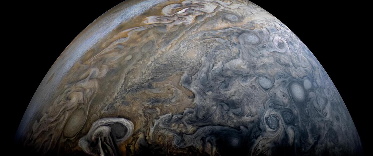
Tumultuous tempests in Jupiter's northern hemisphere are seen in this portrait taken by NASA's Juno spacecraft. Like our home planet, Jupiter has cyclones and anticyclones, along with fast-moving jet streams that circle its globe. This image captures a jet stream, called Jet N6, located on the far right of the image. It is next to an anticyclonic white oval that is the brighter circular feature in the top right corner. The North North Little Red Spot is also visible in this view. The image was taken at 10 p.m. PDT on July 15, 2018 (1 a.m. EDT on July 16), as the spacecraft performed its 14th close flyby of Jupiter. At the time, Juno was about 10,600 miles (17,000 kilometers) from the planet's cloud tops, above a latitude of 59 degrees. Citizen scientists Brian Swift and Seán Doran created this image using data from the spacecraft's JunoCam imager. The image has been rotated clockwise so that north is to the right. The stars were artfully added to the background for effect. https://photojournal.jpl.nasa.gov/catalog/PIA22428

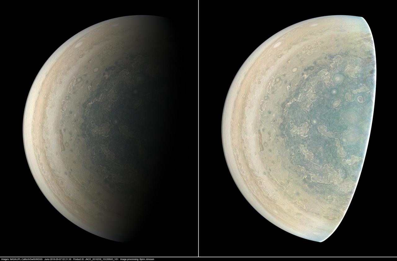
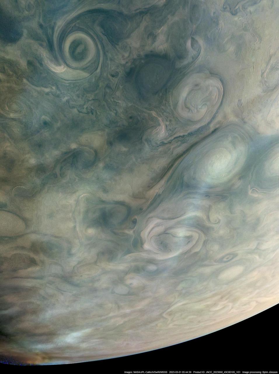
See Jupiter's northern polar belt region in this view taken by NASA's Juno spacecraft. This color-enhanced image was taken on Dec. 16, 2017 at 9:47 a.m. PST (12:47 p.m. EST), as Juno performed its tenth close flyby of Jupiter. At the time the image was taken, the spacecraft was about 5,600 miles (8,787 kilometers) from the tops of the clouds of the planet at a latitude of 38.4 degrees north. Citizen scientist Björn Jónsson processed this image using data from the JunoCam imager. This image has been processed from the raw JunoCam framelets by removing the effects of global illumination. Jónsson then increased the contrast and color and sharpened smallscale features. The image has also been cropped. While at first glance the view may appear to be in Jupiter's south, the raw source images were obtained when Juno was above the planet's northern hemisphere looking south, potentially causing a sense of disorientation to the viewer. The geometry of the scene can be explored using the time of the image and the Juno mission module of NASA's Eyes on the Solar System. https://photojournal.jpl.nasa.gov/catalog/PIA21976. - Enhanced image by Björn Jónsson (CC-NC-SA) based on images provided courtesy of NASA/JPL-Caltech/SwRI/MSSS
A swirling storm somersaults through Jupiter's South Equatorial Belt in this view taken by NASA's Juno spacecraft. This feature -- not to be confused with the planet's iconic Great Red Spot -- is escorted by several smaller, reddish vortices above and to the left. This natural color view offers an approximation of what Jupiter would look like to human eyes from Juno's vantage point near the time of closest approach in its orbit. Jupiter's stunning appearance is due to its atmosphere of colorful cloud bands and spots. The vivid red and orange hues are created by chemicals of uncertain composition called "chromophores." The image was taken at 10:28 p.m. PDT on July 15, 2018 (1:28 a.m. EDT on July 16), as the spacecraft performed its 14th close flyby of Jupiter. At the time, Juno was about 4,900 miles (8,000 kilometers) from the planet's cloud tops, above a southern latitude of 36 degrees. Citizen scientist Björn Jónsson created this image using data from the spacecraft's JunoCam imager. https://photojournal.jpl.nasa.gov/catalog/PIA22427. - Enhanced image by Björn Jónsson (CC-NC-SA) based on images provided courtesy of NASA/JPL-Caltech/SwRI/MSSS

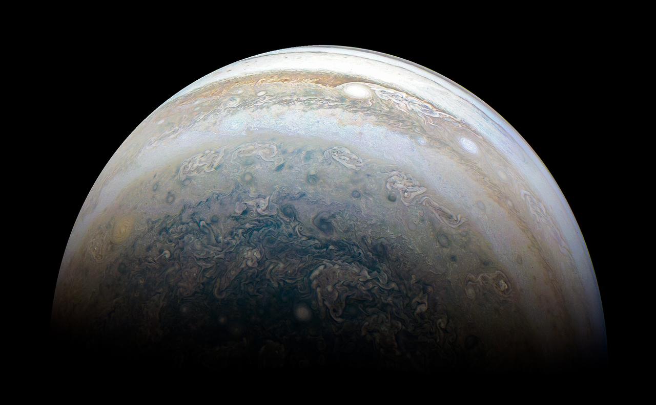
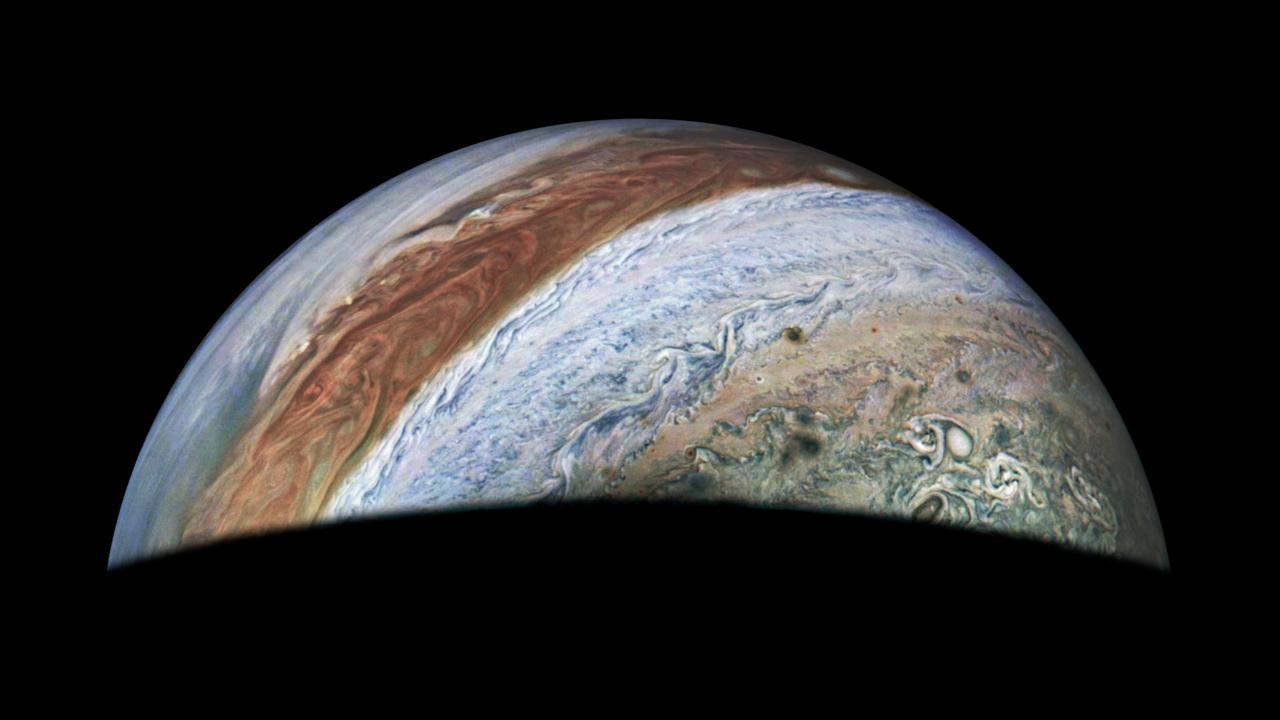
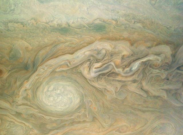
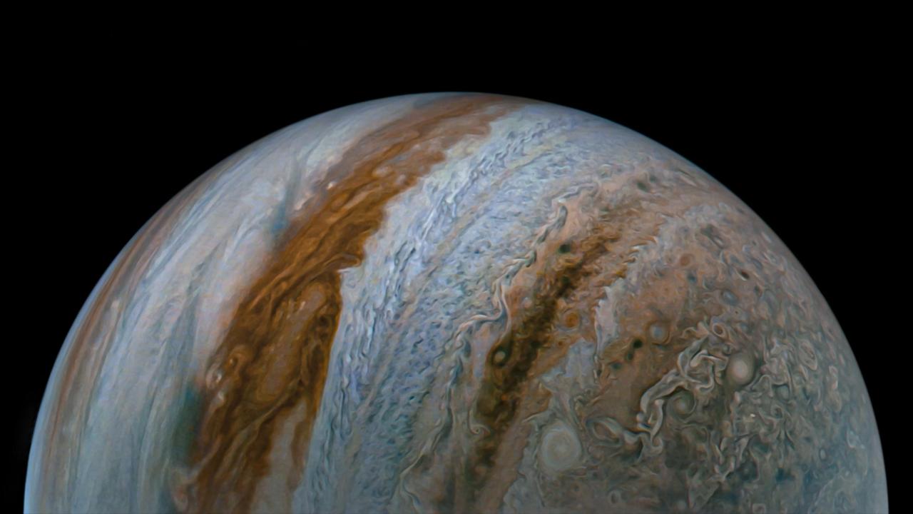
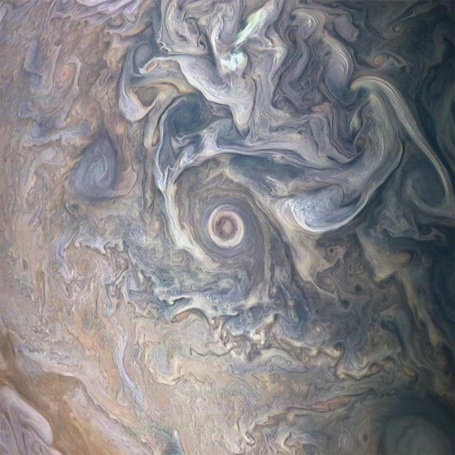
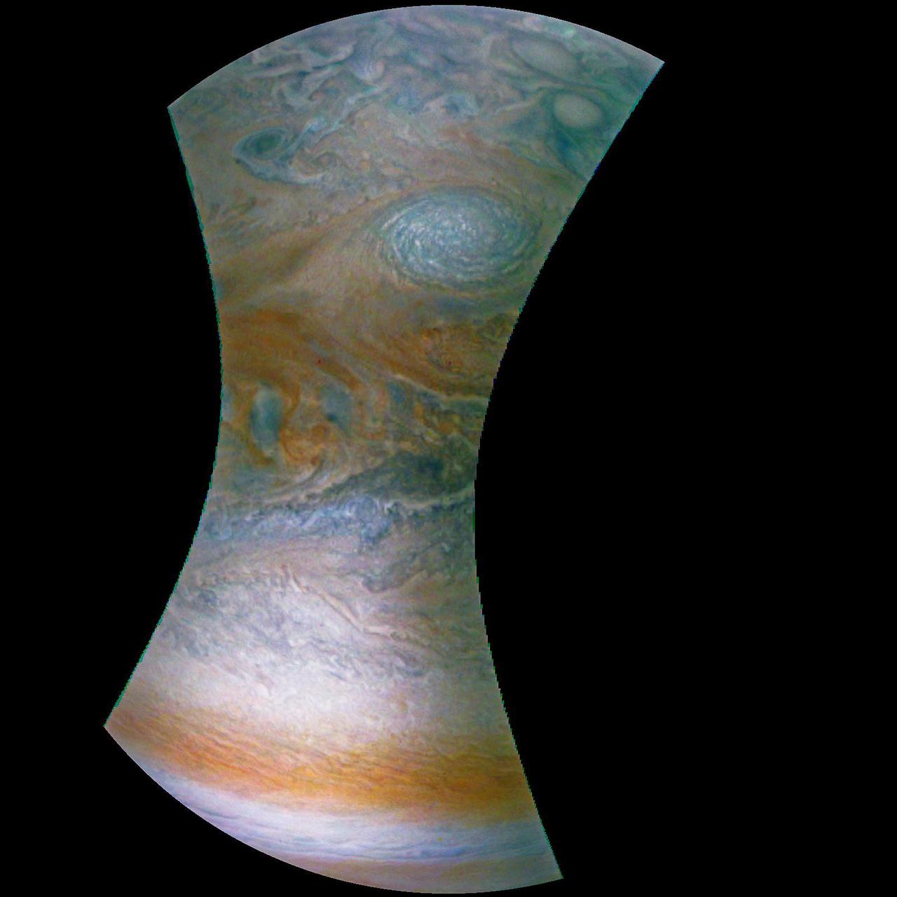
Colorful swirling cloud belts dominate Jupiter's southern hemisphere in this image captured by NASA's Juno spacecraft. Jupiter appears in this color-enhanced image as a tapestry of vibrant cloud bands and storms. The dark region in the far left is called the South Temperate Belt. Intersecting the belt is a ghost-like feature of slithering white clouds. This is the largest feature in Jupiter's low latitudes that's a cyclone (rotating with clockwise motion). This image was taken on Dec. 16, 2017 at 10:12 PST (1:12 p.m. EST), as Juno performed its tenth close flyby of Jupiter. At the time the image was taken, the spacecraft was about 8,453 miles (13,604 kilometers) from the tops of the clouds of the planet at a latitude of 27.9 degrees south. The spatial scale in this image is 5.6 miles/pixel (9.1 kilometers/pixel). Citizen scientist Kevin M. Gill processed this image using data from the JunoCam imager. https://photojournal.jpl.nasa.gov/catalog/PIA21974 . - Enhanced image by Kevin M. Gill (CC-BY) based on images provided courtesy of NASA/JPL-Caltech/SwRI/MSSS

This image captures the swirling cloud formations around the south pole of Jupiter, looking up toward the equatorial region. NASA's Juno spacecraft took the color-enhanced image during its eleventh close flyby of the gas giant planet on Feb. 7 at 7:11 a.m. PST (10:11 a.m. EST). At the time, the spacecraft was 74,896 miles (120,533 kilometers) from the tops of Jupiter's clouds at 84.9 degrees south latitude. Citizen scientist Gerald Gerald Eichstädt processed this image using data from the JunoCam imager. This image was created by reprocessing raw JunoCam data using trajectory and pointing data from the spacecraft. This image is one in a series of images taken in an experiment to capture the best results for illuminated parts of Jupiter's polar region. To make features more visible in Jupiter's terminator -- the region where day meets night -- the Juno team adjusted JunoCam so that it would perform like a portrait photographer taking multiple photos at different exposures, hoping to capture one image with the intended light balance. For JunoCam to collect enough light to reveal features in Jupiter's dark twilight zone, the much brighter illuminated day-side of Jupiter becomes overexposed with the higher exposure. https://photojournal.jpl.nasa.gov/catalog/PIA21980. - Enhanced image by Gerald Eichstädt based on images provided courtesy of NASA/JPL-Caltech/SwRI/MSSS
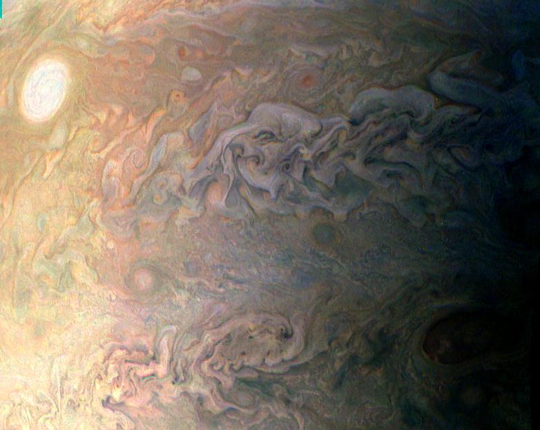
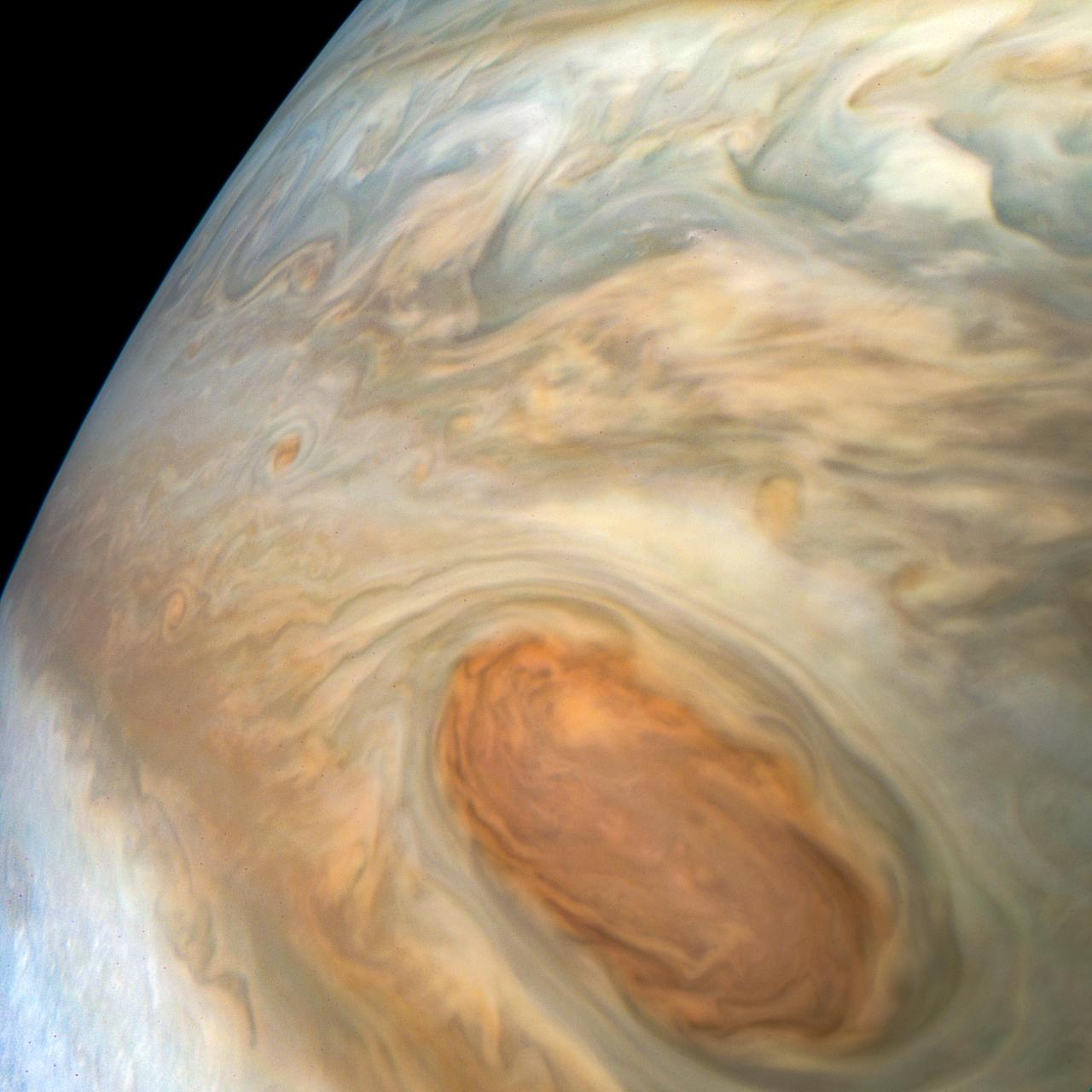
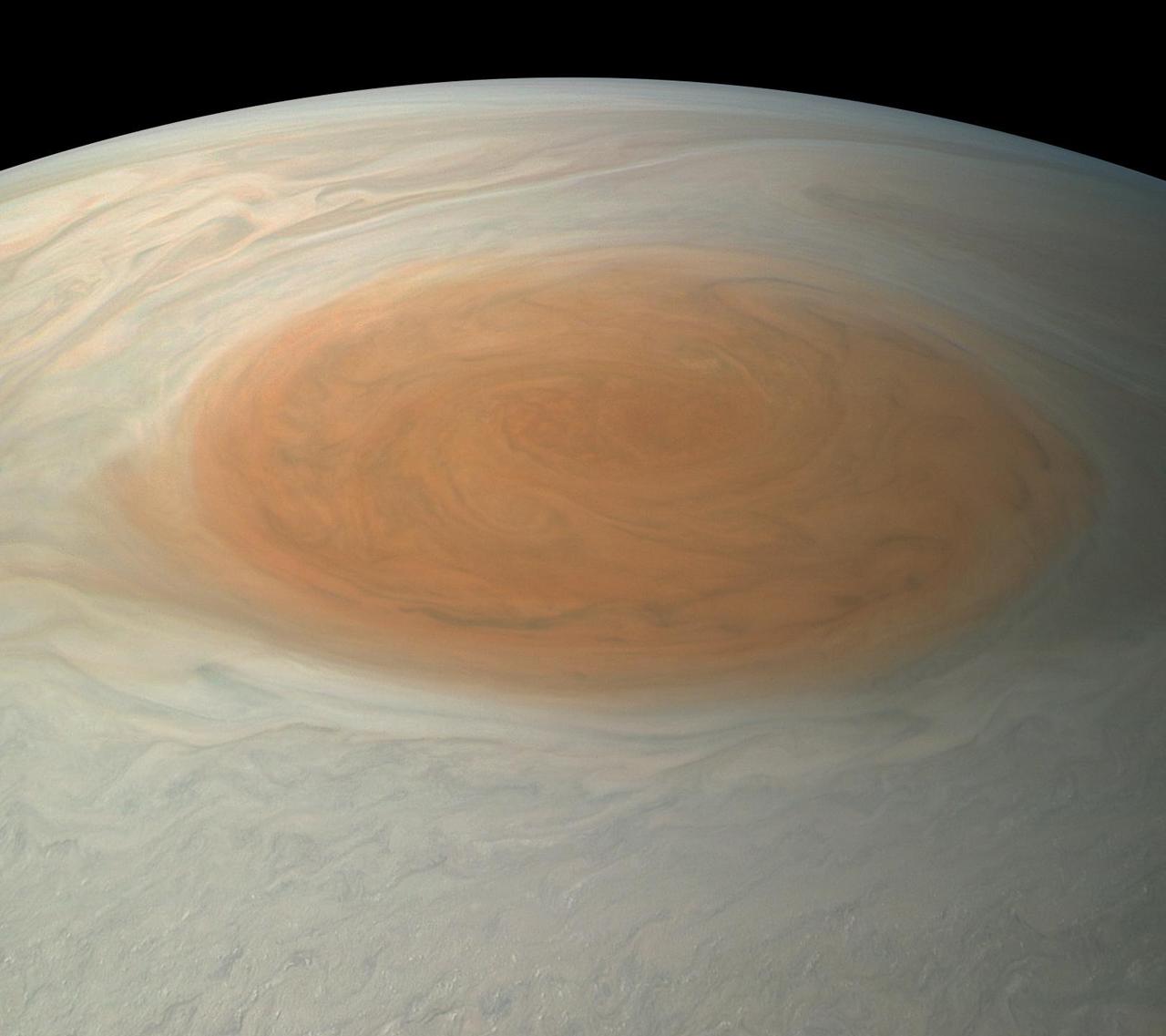
The easternmost edge of Jupiter's Great Red Spot and surrounding south tropical disturbance are captured in this image from NASA's Juno spacecraft. At left, wispy tendrils from the Red Spot give the atmosphere a layered appearance as they partially obscure cloud features below. Jupiter's appearance is a tapestry of vivid colors and swirling atmospheric vortices. Many aspects of the planet's atmosphere are still a mystery. For example, the origin of individual storms or churning cloud features is unknown. By studying Jupiter's weather up close for the first time, Juno is helping researchers better understand how atmospheres work in general -- including our own. What we learn about Jupiter's atmosphere will also help scientists understand how gas-giant planets work in general, including those now being discovered beyond our solar system. This color-enhanced image was taken at 3:01 a.m. PDT on April 1, 2018 (6:01 a.m. EDT), as the spacecraft performed its 12th close flyby of Jupiter. At the time, Juno was about 7,900 miles (12,750 kilometers) from the planet's cloud tops, above a southern latitude of approximately 26 degrees. Citizen scientist Kevin M. Gill created this image using data from the spacecraft's JunoCam imager. https://photojournal.jpl.nasa.gov/catalog/PIA22429 . - Enhanced image by Kevin M. Gill (CC-BY) based on images provided courtesy of NASA/JPL-Caltech/SwRI/MSSS

This series of images captures cloud patterns near Jupiter's south pole, looking up towards the planet's equator. NASA's Juno spacecraft took the color-enhanced time-lapse sequence of images during its eleventh close flyby of the gas giant planet on Feb. 7 between 7:21 a.m. and 8:01 a.m. PST (10:21 a.m. and 11:01 a.m. EST). At the time, the spacecraft was between 85,292 to 124,856 miles (137,264 to 200,937 kilometers) from the tops of the clouds of the planet with the images centered on latitudes from 84.1 to 75.5 degrees south. At first glance, the series might appear to be the same image repeated. But closer inspection reveals slight changes, which are most easily noticed by comparing the far left image with the far right image. Directly, the images show Jupiter. But, through slight variations in the images, they indirectly capture the motion of the Juno spacecraft itself, once again swinging around a giant planet hundreds of millions of miles from Earth. https://photojournal.jpl.nasa.gov/catalog/PIA21979. - Enhanced image by Gerald Eichstädt based on images provided courtesy of NASA/JPL-Caltech/SwRI/MSSS
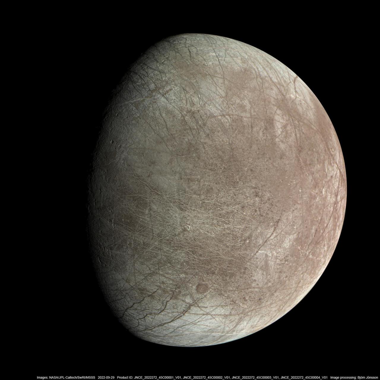
This photo illustration of Jupiter and the three Jovian moons NASA's Juno mission has flown past was generated from data collected by the spacecraft's JunoCam imager. Ganymede, the moon furthest to the left, was imaged by JunoCam as it flew past on June 8, 2021. Citizen scientist Kevin M. Gill created this image using data from JunoCam. The moon second from the left is Europa, which Juno imaged on Sept. 29, 2022. Citizen scientist Kevin M. Gill created this image using data from JunoCam. The image of Io was captured during a flyby of the moon on May 16, 2023. Citizen scientist Thomas Thomopoulos created this image using data from JunoCam. The image of Jupiter was captured on Dec. 15, 2022. Citizen scientist Kevin M. Gill created this image using data from JunoCam. https://photojournal.jpl.nasa.gov/catalog/PIA25966

This artist concept shows K2-138, the first multi-planet system discovered by citizen scientists. The central star is slightly smaller and cooler than our Sun. The five known planets are all between the size of Earth and Neptune. Planet b may potentially be rocky, but planets c, d, e, and f likely contain large amounts of ice and gas. All five planets have orbital periods shorter than 13 days and are all incredibly hot, ranging from 800 to 1,800 degrees Fahrenheit. https://photojournal.jpl.nasa.gov/catalog/PIA22088
This image of the sunlit part of Jupiter and its swirling atmosphere was created by a citizen scientist (Alex Mai) using data from Juno's JunoCam instrument. JunoCam's raw images are available at www.missionjuno.swri.edu/junocam for the public to peruse and process into image products. http://photojournal.jpl.nasa.gov/catalog/PIA21108 . - Enhanced image by Alex Mai (CC-BY) based on images provided courtesy of NASA/JPL-Caltech/SwRI/MSSS
This view of Jupiter was captured by the JunoCam instrument aboard NASA's Juno spacecraft during the mission's 62nd close flyby of the giant planet on June 13, 2024. Citizen scientist Jackie Branc made the image using raw JunoCam data. https://photojournal.jpl.nasa.gov/catalog/PIA26350

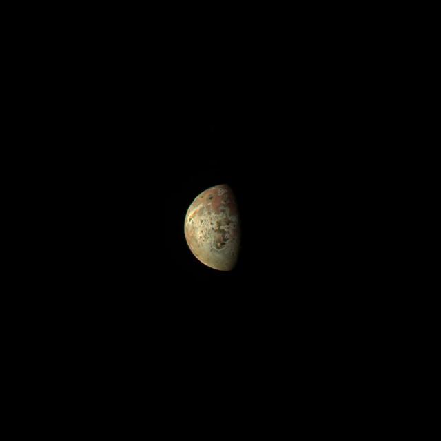
The JunoCam instrument aboard NASA's Juno spacecraft captured this view of Jupiter's moon Io – the first-ever image of the moon's south polar region – during Juno's 60th flyby of Jupiter on Apr. 9, 2024. Citizen scientist Thomas Thomopoulos made this image by applying further processing to an image created from raw JunoCam data by another citizen scientist, Gerald Eichstädt. At the time the raw image was taken, Juno was about 10,250 miles (16,500 kilometers) above the surface of Io. https://photojournal.jpl.nasa.gov/catalog/PIA25697
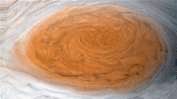
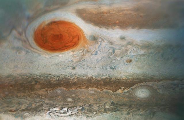
This enhanced-color image of Jupiter's Great Red Spot was created by citizen scientist Gerald Eichstädt using data from the JunoCam imager on NASA's Juno spacecraft. The image was taken on July 10, 2017 at 07:10 p.m. PDT (10:10 p.m. EDT), as the Juno spacecraft performed its 7th close flyby of Jupiter. At the time the image was taken, the spacecraft was about 8,648 miles (13,917 kilometers) from the tops of the clouds of the planet. https://photojournal.jpl.nasa.gov/catalog/PIA21772. - Enhanced image by Gerald Eichstädt based on images provided courtesy of NASA/JPL-Caltech/SwRI/MSSS
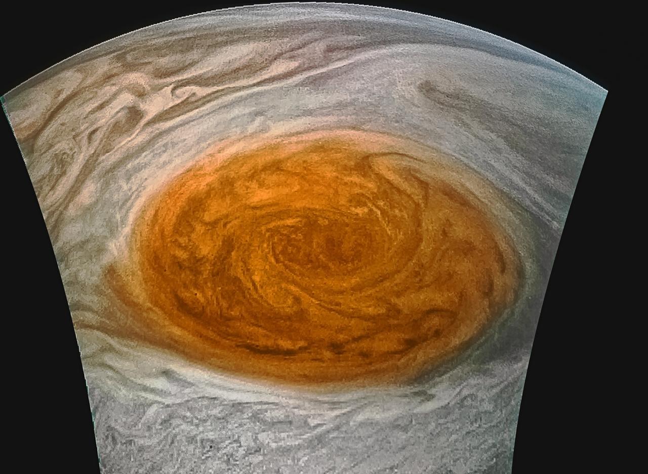
This enhanced-color image of Jupiter's Great Red Spot was created by citizen scientist Jason Major using data from the JunoCam imager on NASA's Juno spacecraft. The image was taken on July 10, 2017 at 07:10 p.m. PDT (10:10 p.m. EDT), as the Juno spacecraft performed its 7th close flyby of Jupiter. At the time the image was taken, the spacecraft was about 8,648 miles (13,917 kilometers) from the tops of the clouds of the planet. https://photojournal.jpl.nasa.gov/catalog/PIA21772 . - Enhanced image by Jason Major based on images provided courtesy of NASA/JPL-Caltech/SwRI/MSSS
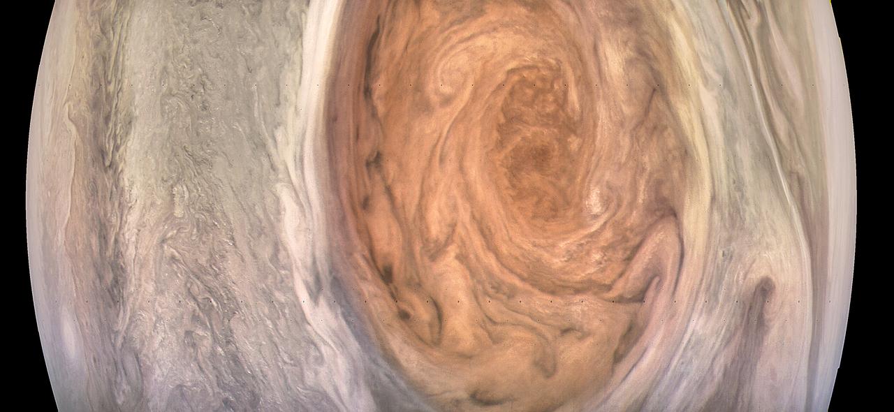
This enhanced-color image of Jupiter's Great Red Spot was created by citizen scientist Kevin Gill using data from the JunoCam imager on NASA's Juno spacecraft. The image was taken on July 10, 2017 at 07:07 p.m. PDT (10:07 p.m. EDT), as the Juno spacecraft performed its 7th close flyby of Jupiter. At the time the image was taken, the spacecraft was about 6,130 miles (9,866 kilometers) from the tops of the clouds of the planet. https://photojournal.jpl.nasa.gov/catalog/PIA21395 . - Enhanced image by Kevin M. Gill (CC-BY) based on images provided courtesy of NASA/JPL-Caltech/SwRI/MSSS
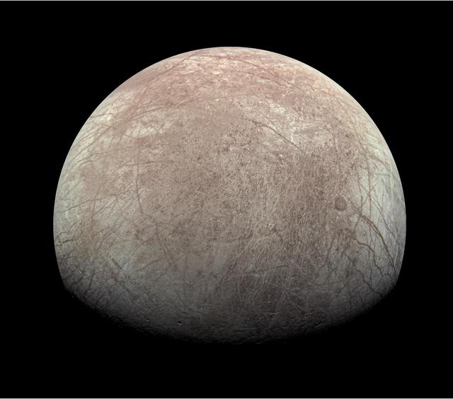
This highly stylized view of Jupiter's icy moon Europa is based on an image captured by JunoCam, the public engagement camera aboard NASA's Juno spacecraft, during the mission's close flyby on Sept. 29, 2022. Citizen scientist Fernando Garcia Navarro created the image by processing a JunoCam previously worked on by fellow citizen scientist Kevin M. Gill. Navarro calls his rendering "Fall Colors of Europa." In processing raw images taken by JunoCam, members of the public create deep-space portraits of the Jovian moon that aren't only awe-inspiring but also worthy of further scientific scrutiny. Juno citizen scientists have played an invaluable role in processing the numerous JunoCam images obtained during science operations at Jupiter. https://photojournal.jpl.nasa.gov/catalog/PIA25335
This image of Jupiter's norther polar region was processed by citizen scientist Emma Wälimäki. The data for the image was collected during Juno's 29th perijove (PJ) pass on Sept. 16, 2020. https://photojournal.jpl.nasa.gov/catalog/PIA24239
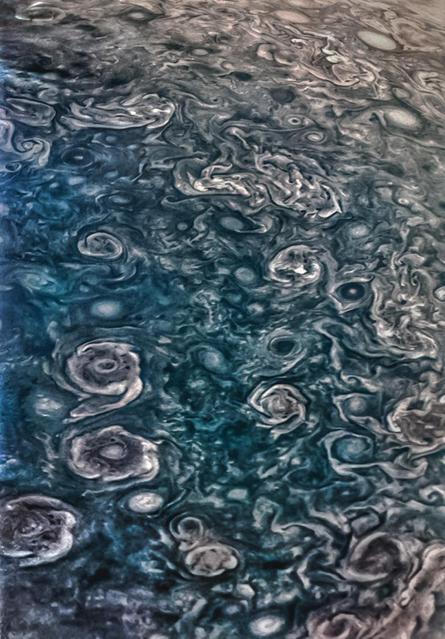
This enhanced-color image of Jupiter's south pole and its swirling atmosphere was created by citizen scientist Roman Tkachenko using data from the JunoCam imager on NASA's Juno spacecraft. Juno acquired the image, looking directly at the Jovian south pole, on February 2, 2017, at 6:06 a.m. PST (9:06 a.m. EST) from an altitude of about 63,400 miles (102,100 kilometers) above Jupiter's cloud tops. Cyclones swirl around the south pole, and white oval storms can be seen near the limb -- the apparent edge of the planet. http://photojournal.jpl.nasa.gov/catalog/PIA21381
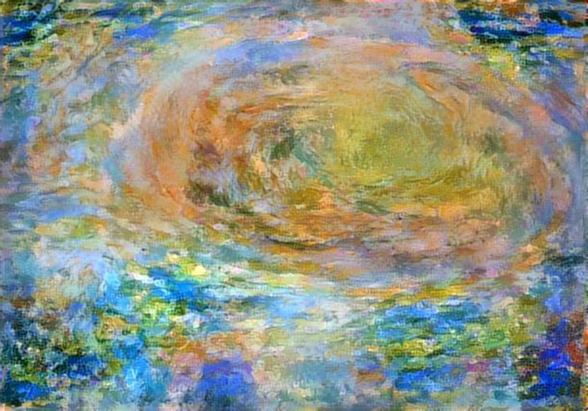
Citizen scientist David Englund created this avant-garde Jovian artwork using data from the JunoCam imager on NASA's Juno spacecraft. The unique interpretation of Jupiter's Great Red Spot was done in a style that pays tribute to French Impressionist painter Claude Monet. The original image was taken on July 10, 2017 at 7:12 p.m. PDT (10:12 p.m. EDT), as the Juno spacecraft performed its 7th close flyby of Jupiter. At the time the image was taken, the spacecraft was 10,274 miles (16,535 kilometers) from the tops of the clouds of the planet, at a latitude of -36.9 degrees. https://photojournal.jpl.nasa.gov/catalog/PIA21779 . - Enhanced image by David Englund based on images provided courtesy of NASA/JPL-Caltech/SwRI/MSSS
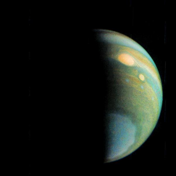
This image of a crescent Jupiter and the iconic Great Red Spot was created by a citizen scientist (Roman Tkachenko) using data from Juno's JunoCam instrument. You can also see a series of storms shaped like white ovals, known informally as the "string of pearls." Below the Great Red Spot a reddish long-lived storm known as Oval BA is visible. The image was taken on Dec. 11, 2016 at 2:30 p.m. PST (5:30 p.m. EST), as the Juno spacecraft performed its third close flyby of Jupiter. At the time the image was taken, the spacecraft was about 285,100 miles (458,800 kilometers) from the planet. http://photojournal.jpl.nasa.gov/catalog/PIA21376 . - Enhanced image by Roman Tkachenko (CC-BY) based on images provided courtesy of NASA/JPL-Caltech/SwRI/MSSS
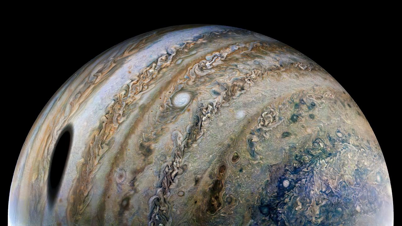
Citizen scientist Thomas Thomopoulos created this enhanced-color image using raw data from the JunoCam instrument. At the time the raw image was taken, the Juno spacecraft was about 44,000 miles (71,000 kilometers) above Jupiter's cloud tops, at a latitude of about 55 degrees south, and 15 times closer than Ganymede, which orbits about 666,000 miles (1.1 million kilometers) away from Jupiter. An observer at Jupiter's cloud tops within the oval shadow would experience a total eclipse of the Sun. Total eclipses are more common on Jupiter than Earth for several reasons. Jupiter has four major moons (Galilean satellites) that often pass between Jupiter and the Sun: in seven days, Ganymede transits once; Europa, twice; and Io, four times. And since Jupiter's moons orbit in a plane close to Jupiter's orbital plane, the moon shadows are often cast upon the planet. JunoCam captured this image from very close to Jupiter, making Ganymede's shadow appear especially large. https://photojournal.jpl.nasa.gov/catalog/PIA25015

In this illustration, an asteroid (bottom left) breaks apart under the powerful gravity of LSPM J0207+3331, the oldest, coldest white dwarf known to be surrounded by a ring of dusty debris. Scientists think the system’s infrared signal is best explained by two distinct rings composed of dust supplied by crumbling asteroids. Credit: NASA’s Goddard Space Flight Center/Scott Wiessinger https://svs.gsfc.nasa.gov/13147
This JunoCam image depicts one of the eight circumpolar cyclones that surround a central cyclone at the gas giant's north pole. The data from this view of one of Jupiter's circumpolar cyclones was collected during Juno's 29th perijove (PJ) pass on Sept. 16, 2020, and processed by citizen scientist Gerald Eichstädt. https://photojournal.jpl.nasa.gov/catalog/PIA24238
This image, acquired by NASA Mars Reconnaissance Orbiter, shows there are a few more fans on the ridge as spring activity progresses in Inca City. In Inca City another week has passed, and there are a few more fans on the ridge. We are studying the sequence of spring activity with the help of citizen scientists at the Planetfour website, sponsored by Zooniverse. Citizens of planet Earth log on and identify and measure fans and blotches in the South polar region of Mars imaged by HiRISE. With their help we can study the polar weather by looking at how the fan directions change through the spring. We see how the number of fans and blotches depends on the thickness of the ice layer and how high the sun is in the sky. http://photojournal.jpl.nasa.gov/catalog/PIA18894

This artist's illustration shows the planetary system K2-138, which was discovered by citizen scientists in 2017 using data from NASA's Kepler space telescope. Five planets were initially detected in the system. In 2018, scientists using NASA's Spitzer Space Telescope found evidence of a sixth planet in the system. https://photojournal.jpl.nasa.gov/catalog/PIA23002
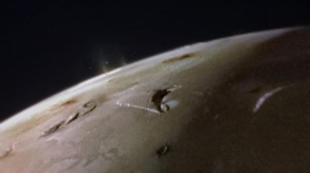
The JunoCam instrument aboard NASA's Juno spacecraft captured two volcanic plumes rising above the horizon of Jupiter's moon Io on Feb. 3, 2024. Mission scientists think the plumes were emitted either by two vents from one giant volcano, or two volcanoes near each other. The JunoCam instrument imaged the plumes from a distance of about 2,400 miles (3,800 kilometers). Citizen scientist Andrea Luck made this image from raw JunoCam data. https://photojournal.jpl.nasa.gov/catalog/PIA26340

This image captures a close-up view of a storm with bright cloud tops in the northern hemisphere of Jupiter. NASA's Juno spacecraft took this color-enhanced image on Feb. 7 at 5:38 a.m. PST (8:38 a.m. EST) during its 11th close flyby of the gas giant planet. At the time, the spacecraft was 7,578 miles (12,195 kilometers) from the tops of Jupiter's clouds at 49.2 degrees north latitude. Citizen scientist Matt Brealey processed the image using data from the JunoCam imager. Citizen scientist Gustavo B C then adjusted colors and embossed Matt Brealey's processing of this storm. https://photojournal.jpl.nasa.gov/catalog/PIA21981 . - Enhanced image by Matt Brealey / Gustavo B C based on images provided courtesy of NASA/JPL-Caltech/SwRI/MSSS
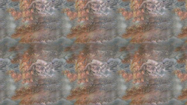
When team members from NASA's Juno mission invited the public to process JunoCam images, they did not anticipate that they would receive back such beautiful, creative expressions of art. The oranges and grayed-out regions of blue-green in this tiled and color-enhanced image resemble a color scheme much like Romantic era paintings, but more abstract. The lack of discreet objects to focus on allows the mind to seek familiar Earthly shapes, and the brightest spots seem to draw the eye. Citizen scientist Eric Jorgensen created this Jovian artwork with a JunoCam image taken when the spacecraft was at an altitude of 11,100 miles (17,800 kilometers) above Jupiter's cloudtops on Dec. 11, 2016 at 9:22 a.m. PT (12:22 p.m. ET). http://photojournal.jpl.nasa.gov/catalog/PIA21385 . - Enhanced image by Eric Jorgensen based on images provided courtesy of NASA/JPL-Caltech/SwRI/MSSS
On April 9, 2022, as NASA's Juno mission completed its 41st close flyby of Jupiter, its JunoCam instrument captured what it would look like to ride along with the spacecraft. Citizen scientist Andrea Luck created this animated sequence using raw JunoCam image data. At about 87,000 miles (140,000 kilometers) in diameter, Jupiter is the largest planet in the solar system. At the point of closest approach on April 9, Juno was just over 2,050 miles (3,300 kilometers) above Jupiter's colorful cloud tops. At that moment, it was traveling at about 131,000 MPH (210,000 kilometers per hour) relative to the planet. By comparison, at closest approach Juno was more than 10 times closer to Jupiter than satellites in geosynchronous orbit are to Earth, traveling at a speed about five times faster than the Apollo missions did when they left Earth for the Moon. Movie available at https://photojournal.jpl.nasa.gov/catalog/PIA25016
This false color view of Jupiter's polar haze was created by citizen scientist Gerald Eichstädt using data from the JunoCam instrument on NASA's Juno spacecraft. The image was taken on Dec. 11, 2016 at 2:30 p.m. PST (5:30 p.m. EST), when the spacecraft was 285,000 miles (459,000 kilometers) from Jupiter on the outbound leg of its third close flyby. This image is composited from four images taken through different filters: red, green, blue and methane. When the near-infrared methane image is processed with the others, the result is a false color product that highlights high clouds and high altitude hazes. The Great Red Spot and Oval BA (just below the Great Red Spot) are high in Jupiter's atmosphere, thus bright in this picture. The high-altitude haze layer over the south pole partially obscures our view of the storms below. By combining the methane data with the visible light images, we can learn about the vertical structure of Jupiter's atmosphere. http://photojournal.jpl.nasa.gov/catalog/PIA21379. - Enhanced image by Gerald Eichstädt based on images provided courtesy of NASA/JPL-Caltech/SwRI/MSSS
Winds around Jupiter's Great Red Spot are simulated in this JunoCam view that has been animated using a model of the winds there. The wind model, called a velocity field, was derived from data collected by NASA's Voyager spacecraft and Earth-based telescopes. NASA's Juno spacecraft acquired the original, static view during passage over the spot on July 10, 2017. Citizen scientists Gerald Eichstädt and Justin Cowart turned the JunoCam data into a color image mosaic. Juno scientists Shawn Ewald and Andrew Ingersoll applied the velocity data to the image to produce a looping animation. An animation is available at https://photojournal.jpl.nasa.gov/catalog/PIA22178
This amateur-processed image was taken on Dec. 11, 2016, at 9:27 a.m. PST (12:27 p.m. EST), as NASA's Juno spacecraft performed its third close flyby of Jupiter. At the time the image was taken, the spacecraft was about 15,200 miles (24,400 kilometers) from the gas giant planet. The citizen scientist (Eric Jorgensen) cropped the JunoCam image and enhanced the color to draw attention to Jupiter's swirling clouds southeast of the "pearl." The "pearl" is one of eight massive rotating storms at 40 degrees south latitude on Jupiter, known colloquially as the "string of pearls." The processing of this image highlights the turbulence of the clouds in the south temperate belt of the planet. http://photojournal.jpl.nasa.gov/catalog/PIA21377 . - Enhanced image by Eric Jorgensen based on images provided courtesy of NASA/JPL-Caltech/SwRI/MSSS

This close-up view of Jupiter captures the turbulent region just west of the Great Red Spot in the South Equatorial Belt, with resolution better than any previous pictures from Earth or other spacecraft. NASA's Juno spacecraft captured this image with its JunoCam citizen science instrument when the spacecraft was a mere 5,400 miles (8,700 kilometers) above Jupiter's cloudtops on Dec. 11, 2016 at 9:14 a.m. PT (12:14 p.m. ET). Citizen scientist Sergey Dushkin produced the sublime color processing and cropped the image to draw viewers' eyes to the dynamic clouds. http://photojournal.jpl.nasa.gov/catalog/PIA21384 . - Enhanced image by Sergey Dushkin based on images provided courtesy of NASA/JPL-Caltech/SwRI/MSSS
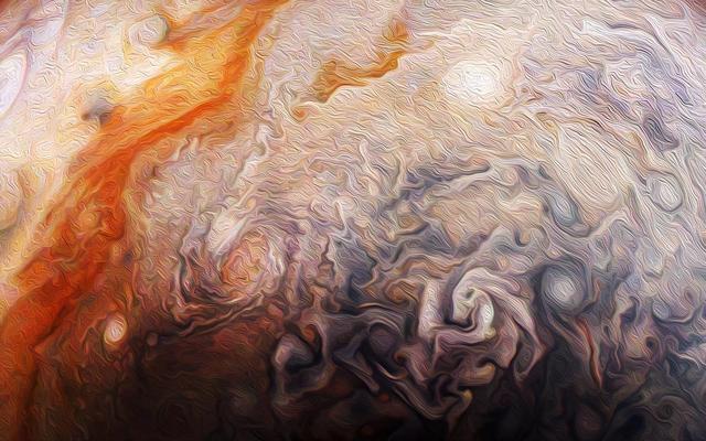
Citizen scientist Rick Lundh created this abstract Jovian artwork using data from the JunoCam imager onboard NASA's Juno spacecraft. The original image captures a close-up view of numerous storms in the northern hemisphere of Jupiter. To produce this artwork, Lundh selected a more contrasting part of one of Jupiter's storms, then cropped the image and applied an oil-painting filter. https://photojournal.jpl.nasa.gov/catalog/PIA21983 . - Enhanced image by Rick Lundh based on images provided courtesy of NASA/JPL-Caltech/SwRI/MSSS
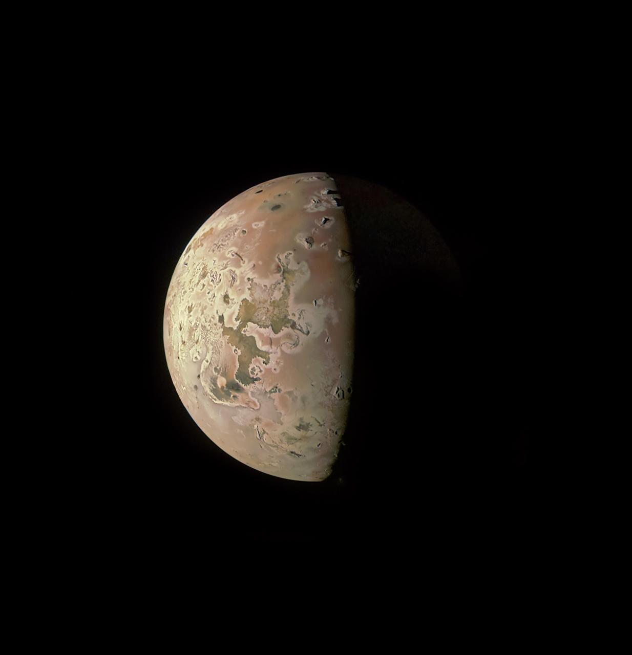
This image of the Jovian moon Io was generated using data collected by the JunoCam imager aboard NASA's Juno spacecraft during a flyby of the moon on March 1, 2023. At the time of closest approach, Juno was about 32,000 miles (51,500 kilometers) away from Io. The image's resolution is about 22 miles (35 kilometers) per pixel. Citizen scientist Kevin M. Gill created this image using data from JunoCam. https://photojournal.jpl.nasa.gov/catalog/PIA25885
JunoCam, the color public engagement camera aboard NASA's Juno spacecraft, captured this sequence of images during its 46th close pass by the giant planet on Sept. 29, 2022. Citizen scientist Gerald Eichstädt processed the images to enhance their color and contrast, and assembled them together into this animation. Movie available at https://photojournal.jpl.nasa.gov/catalog/PIA25723

This movie was generated using imagery collected on Oct. 29, 2018, during Juno's 16th perijove (the point at which an orbit comes closest to Jupiter's center). Citizen scientists Gerald Eichstädt created this movie using data from the spacecraft's JunoCam imager. Movie available at https://photojournal.jpl.nasa.gov/catalog/PIA22906. - Enhanced image by Gerald Eichstädt (CC-BY) based on images provided courtesy of NASA/JPL-Caltech/SwRI/MSSS/SPICE
Jupiter's northern circumpolar cyclones are captured in this color-enhanced image from NASA's Juno spacecraft. The image was taken at 5:42 p.m. PDT (8:42 p.m. EDT) on Sept. 6, 2018, as the spacecraft performed its 15th close flyby of Jupiter. Citizen scientist Gerald Eichstädt created this image using data from the spacecraft's JunoCam imager. https://photojournal.jpl.nasa.gov/catalog/PIA22932. - Enhanced image by Gerald Eichstädt based on images provided courtesy of NASA/JPL-Caltech/SwRI/MSSS
This mosaic combines color-enhanced images taken over Jupiter's north pole when the lighting was excellent for detecting high bands of haze. The images were taken in the final hours of Juno's perijove 12 approach on April 1, 2018. Citizen scientists Gerald Eichstädt and John Rogers created this image using data from the spacecraft's JunoCam imager. https://photojournal.jpl.nasa.gov/catalog/PIA22934. - Enhanced image by Gerald Eichstädt and John Rogers based on images provided courtesy of NASA/JPL-Caltech/SwRI/MSSS
NASA's Juno spacecraft captured this stunning Jovian cloudscape at 5:38 a.m. PST (8:38 a.m. EST) on Feb. 7, 2018, as the spacecraft performed its 11th close flyby of Jupiter. Citizen scientist Kevin M. Gill created this color-enhanced image using data from the spacecraft's JunoCam imager. https://photojournal.jpl.nasa.gov/catalog/PIA22931. - Enhanced image by Kevin M. Gill (CC-BY) based on images provided courtesy of NASA/JPL-Caltech/SwRI/MSSS

This composite image of the Jovian moon Io was generated using data collected by the JunoCam imager aboard NASA's Juno spacecraft during four separate flybys. The resolution of the images gets progressively better as the distance between spacecraft and moon decreases with each flyby. The image of the moon on the far left has a resolution 44 miles (71 kilometers) per pixel. It was taken on April 9, 2022, during Juno's 41st orbit of Jupiter (perijove 41, or PJ41), when the spacecraft flew past Io at a distance of about 66,000 miles (106,000 kilometers). Note the gray, roughly triangular patch at the terminator near the moon's center. Citizen scientist Björn Jónsson created this image using data from JunoCam. The center-left image was acquired on July 5, 2022, during Juno's 43rd orbit of Jupiter (PJ43) at a distance of 53,000 miles (86,000 kilometers). The resolution in this image has improved to 36 miles (58 kilometers) per pixel. In this view, more detail of the gray patch is seen (from a different perspective). Citizen scientist Jason Perry created this image using data from JunoCam. By the time the center-right image of Io was taken on Dec. 14, 2022, (PJ47), the distance between spacecraft and moon had decreased to 40,000 miles (64,000 kilometers), which increased the resolution to 27 miles (43 kilometers) per pixel. Here, the gray triangle appears as three distinct volcanoes with the central vents visible as dark spots in their centers. Characteristics of other nearby volcanoes also begin to stand out. Citizen scientist Mike Ravine created this image using data from JunoCam. The far-right image, taken during Juno's 49th flyby (PJ49) on March 1, 2023, shows that the spacecraft again approached the moon from a changed perspective, allowing different territory on Io's surface to be viewed. The triplet of volcanoes that make up the gray triangular patch are visible near the top of the image, and more detail of the volcanic terrain can be made out. The altitude at the time of closest approach was about 32,000 miles (51,500 kilometers), allowing resolution to increase to 22 miles (35 kilometers) per pixel. Citizen scientist Kevin M. Gill created this image using data from JunoCam. https://photojournal.jpl.nasa.gov/catalog/PIA25887
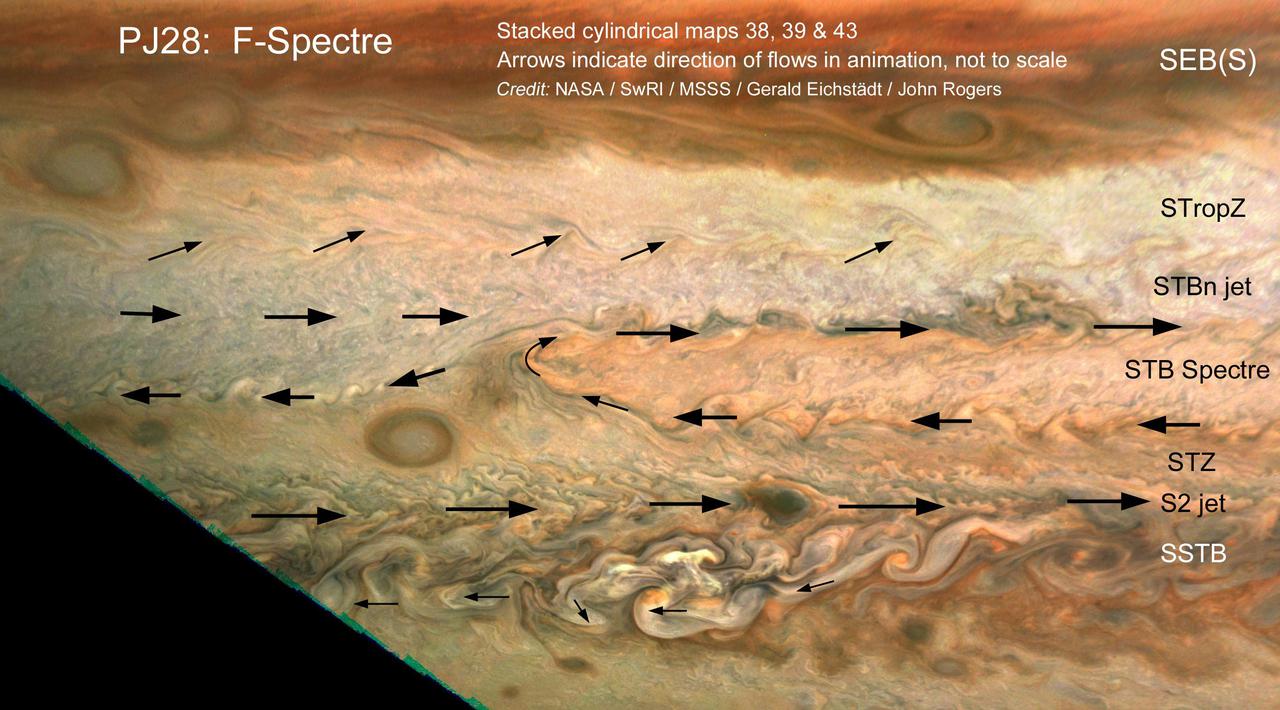
The motion of small clouds on Jupiter is used to determine wind direction (indicated with arrows) in this work by citizen scientists John Rogers and Gerald Eichstädt. Using multiple images to track the motion of clouds was enabled by the Juno spacecraft's slow departure from Jupiter's southern hemisphere on perijove pass 28, on July 25, 2020. Zonal winds are a well-known phenomenon on Jupiter, correlating with its familiar belts and zones. Within a latitudinal band there can be regional circulation, such as the South Temperate Belt (STB) Spectre shown in this image. The STB Spectre is cyclonic (winds rotating in clockwise direction), spread out in latitude but confined in longitude. This work is representative of an ongoing and fruitful collaboration of amateur astronomers with the Juno project. John Rogers analyzed cloud movement in three JunoCam images processed by citizen scientist Gerald Eichstädt to identify winds. Latitudinal belts and zones ( labeled with the conventions used by the amateur astronomy community and professional observers), are: SEB(S): South Equatorial Belt (south); STropZ: South Tropical Zone; STBn jet: South Temperate Belt (north) jet; STZ: South Temperate Zone; and SSTB: South South Temperate Belt. https://photojournal.jpl.nasa.gov/catalog/PIA24235
This composite of images from the JunoCam imager aboard NASA's Juno spacecraft shows the eight circumpolar cyclones around a central cyclone located at Jupiter's north pole. The sizes of these cyclones range from 1,500 miles (2,400 kilometers) to 1,740 miles (2,800 kilometers) across — about the same distance from the southern tip of Texas to the border with Canada. The composite depicts the remarkable stability of the octogonal configuration: No cyclones have arrived or disappeared since Juno began its mission in 2016. The evolution of Juno's elliptical orbit is bringing the spacecraft closer to the north pole on each pass. At the beginning of Juno's mission the northern polar cyclone was hidden in polar night, but as the Sun moves toward the northern hemisphere, it is beginning to emerge into the daylight. As a visible camera JunoCam can only take pictures when the cyclones are in daylight, it took four perijove passes to see all eight. The original JunoCam images used to produce this composite were taken during consecutive science passes on Feb. 17, April 10, June 2, and July 25 of 2020. Citizen scientist Gerald Eichstädt processed the images to enhance the color and contrast. Citizen scientist John Rogers created the composite and added the labels. https://photojournal.jpl.nasa.gov/catalog/PIA24237
This view of Jupiter's icy moon Europa was captured by JunoCam, the public engagement camera aboard NASA's Juno spacecraft, during the mission's close flyby on Sept. 29, 2022. Citizen scientist Björn Jónsson processed the view to create this image. Jónsson processed the image to enhance the color and contrast. The resolution is about 0.6 miles (1 kilometer) per pixel. JunoCam took the image at an altitude of 945 miles (1,521 kilometers) above a region of the moon called Annwn Regio. In the image, terrain beside the day-night boundary is revealed to be rugged, with pits and troughs. Numerous bright and dark ridges and bands stretch across a fractured surface, revealing the tectonic stresses that the moon has endured over millennia. The circular dark feature at the lower right is Callanish Crater. JunoCam images of Europa help fill in gaps in the maps from images obtained during by NASA's Voyager and Galileo missions. In processing raw images taken by JunoCam, members of the public create deep-space portraits of the Jovian moon that aren't only awe-inspiring but also worthy of further scientific scrutiny. Juno citizen scientists have played an invaluable role in processing the numerous JunoCam images obtained during science operations at Jupiter. https://photojournal.jpl.nasa.gov/catalog/PIA25334
This pair of images shows the same portion of Jupiter's moon Europa before and after it was processed. The original (minimally processed) image, left, was captured by JunoCam, the public engagement camera aboard NASA's Juno spacecraft, during the mission's close flyby on Sept. 29, 2022. Captured at an altitude of 945 miles (1,521 kilometers) above a region of the moon called Annwn Regio, it was minimally processed. Citizen scientist Navaneeth Krishnan reprocessed the image to produce the version on the right. The enhanced color contrast causes larger surface features to stand out more. An example of the results can be seen in the lower right of this image, where the pits and a small rectangular block (reflecting more light than surrounding features) cast notable shadows. Small-scale texturing of the surface in the image needs to be carefully studied to distinguish between features and artifacts from processing, but the image serves both art and science by drawing us deeper into Europa's alien landscape. In processing raw images taken by JunoCam, members of the public create deep-space portraits of the Jovian moon that aren't only awe-inspiring but also worthy of further scientific scrutiny. Juno citizen scientists have played an invaluable role in processing the numerous JunoCam images obtained during science operations at Jupiter. https://photojournal.jpl.nasa.gov/catalog/PIA25333
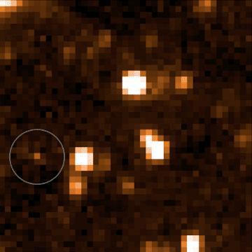
This image shows data from NASA's Near-Earth Object Wide-Field Infrared Survey Explorer (NEOWISE), launched in 2009 under the moniker WISE. The object in the bottom left corner is a brown dwarf officially named WISEA J153429.75-104303.3 and nicknamed “The Accident.” The Accident was discovered by citizen scientist Dan Caselden, who was using an online program he built to find brown dwarfs in NEOWISE data. Caselden's program attempted to remove the stationary objects emitting infrared light (like distant stars) from the NEOWISE maps and highlight moving objects that had characteristics similar to those of known brown dwarfs. He was looking at one such brown dwarf candidate when he spotted WISEA J153429.75-104303.3, which hadn't been highlighted by the program because it did not match the program's profile of a brown dwarf. The Accident confused scientists because it was faint in some key wavelengths, suggesting it was very cold (and old), but bright in others, indicating a higher temperature. A study in the Astrophysical Journal Letters posits that The Accident might be 10 billion to 13 billion years old – at least double the median age of other known brown dwarfs. That means it would have formed when our galaxy was much younger and had a different chemical makeup. The paper's authors think The Accident's brightness in certain wavelengths is an indicator that it contains very little methane, meaning it probably formed when the Milky Way was still young and carbon-poor. (Methane is composed of hydrogen and carbon). The study relies on additional observations using the W. M. Keck Observatory in Hawaii and NASA's Hubble and Spitzer Space Telescopes. Movie available at https://photojournal.jpl.nasa.gov/catalog/PIA24578
See intricate cloud patterns in the northern hemisphere of Jupiter in this new view taken by NASA's Juno spacecraft. The color-enhanced image was taken on April 1, 2018 at 2:32 a.m. PST (5:32 a.m. EST), as Juno performed its twelfth close flyby of Jupiter. At the time the image was taken, the spacecraft was about 7,659 miles (12,326 kilometers) from the tops of the clouds of the planet at a northern latitude of 50.2 degrees. Citizen scientist Kevin M. Gill processed this image using data from the JunoCam imager. https://photojournal.jpl.nasa.gov/catalog/PIA21984 . - Enhanced image by Kevin M. Gill (CC-BY) based on images provided courtesy of NASA/JPL-Caltech/SwRI/MSSS
A multitude of bright white "pop-up" storms in this Jupiter cloudscape appear in this image from NASA's Juno spacecraft. This color-enhanced image was taken at 1:55 p.m. PDT (4:55 p.m. EDT) on Oct. 29, 2018, as the spacecraft performed its 16th close flyby of Jupiter. Citizen scientists Gerald Eichstädt and Seán Doran created this image using data from the spacecraft's JunoCam imager. https://photojournal.jpl.nasa.gov/catalog/PIA22935 **Image Credit: Enhanced Image by Gerald Eichstädt and Seán Doran (CC BY-NC-SA) based on images provided courtesy of NASA/JPL-Caltech/SwRI/MSSS
NASA Juno spacecraft skimmed the upper wisps of Jupiter atmosphere when JunoCam snapped this image on Feb. 2, 2017. from an altitude of about 9,000 miles 14,500 kilometers above the giant planet swirling cloudtops. Streams of clouds spin off a rotating oval-shaped cloud system in the Jovian southern hemisphere. Citizen scientist Roman Tkachenko reconstructed the color and cropped the image to draw viewers' eyes to the storm and the turbulence around it. http://photojournal.jpl.nasa.gov/catalog/PIA21383 . - Enhanced image by Roman Tkachenko (CC-BY) based on images provided courtesy of NASA/JPL-Caltech/SwRI/MSSS
This image was taken at 7:21 p.m. PDT (10:21 p.m. EDT) on Sept. 6, 2018, as the spacecraft performed its 15th close flyby of Jupiter. The version of the image on the left side shows Jupiter in approximate true color, while the same image on the right has been processed to bring out detail close to the terminator and reveals four of the five southern circumpolar cyclones plus the cyclone in the center. Citizen scientist Björn Jónsson created this image using data from the spacecraft's JunoCam imager. https://photojournal.jpl.nasa.gov/catalog/PIA22933. - Enhanced image by Björn Jónsson (CC-NC-SA) based on images provided courtesy of NASA/JPL-Caltech/SwRI/MSSS
A cyclonic storm in Jupiter's northern hemisphere is captured in this image from NASA's Juno spacecraft. Many bright white cloud tops can be seen popping up in and around the arms of the rotating storm. The color-enhanced image was taken at 9:25 a.m. PST (12:25 p.m. EST) on Feb. 12, 2019, as the spacecraft performed its 17th science flyby of Jupiter. At the time, Juno was about 5,000 miles (8,000 kilometers) from the planet's cloud tops, above approximately 44 degrees north latitude. Citizen scientists Gerald Eichstädt and Seán Doran created this image using data from the spacecraft's JunoCam imager. https://photojournal.jpl.nasa.gov/catalog/PIA22947
JunoCam images aren't just for art and science -- sometimes they are processed to bring a chuckle. This image, processed by citizen scientist Jason Major, is titled "Jovey McJupiterface." By rotating the image 180 degrees and orienting it from south up, two white oval storms turn into eyeballs, and the "face" of Jupiter is revealed. The original image was acquired by JunoCam on NASA's Juno spacecraft on May 19, 2017 at 11:20 a.m. PT (2: 20 p.m. ET) from an altitude of 12,075 miles (19,433 kilometers). https://photojournal.jpl.nasa.gov/catalog/PIA21394 . - Enhanced image by Jason Major based on images provided courtesy of NASA/JPL-Caltech/SwRI/MSSS
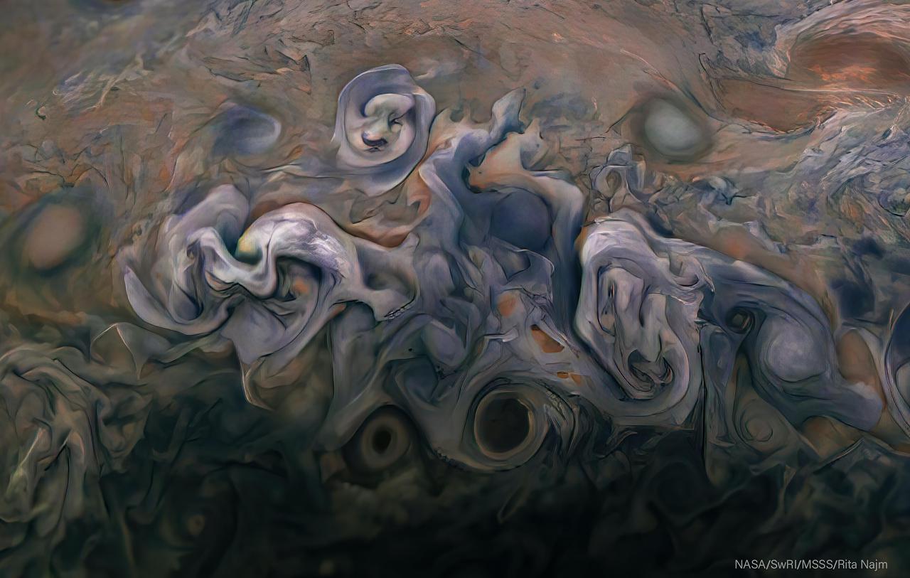
Images from the Juno spacecraft's visible-light amera JunoCam are posted after every close pass for the public to enjoy and process themselves. JunoCam's images of Jupiter inspire art and science. An image taken by JunoCam during Juno's 25th perijove pass on February 17, 2020, inspired citizen scientist Rita Najm to enhance its color and contrast and to give it the impression of a painting that's ready to be framed. The original JunoCam image used to produce this view was taken from from an altitude of about 7,900 miles (12,700 kilometers) above Jupiter's cloud tops. https://photojournal.jpl.nasa.gov/catalog/PIA24293

A south tropical disturbance that has just passed Jupiter's iconic Great Red Spot is captured in this color-enhanced image from NASA's Juno spacecraft. Threads of orange haze are pulled from the Great Red Spot by the turbulence of the south tropical disturbance. The image was taken at 3:04 a.m. PDT (6:04 p.m. EDT) on April 1, 2018, as the spacecraft performed its 12th close flyby of Jupiter. Citizen scientist Kevin M. Gill created this image using data from the spacecraft's JunoCam imager. https://photojournal.jpl.nasa.gov/catalog/PIA22938. - Enhanced image by Kevin M. Gill (CC-BY) based on images provided courtesy of NASA/JPL-Caltech/SwRI/MSSS
This enhanced color view of Jupiter's cloud tops was processed by citizen scientist Bjorn Jonsson using data from the JunoCam instrument on NASA's Juno spacecraft. The image highlights a massive counterclockwise rotating storm that appears as a white oval in the gas giant's southern hemisphere. Juno acquired this image on Feb. 2, 2017, at 6:13 a.m. PDT (9:13 a.m. EDT), as the spacecraft performed a close flyby of Jupiter. When the image was taken, the spacecraft was about 9,000 miles (14,500 kilometers) from the planet. https://photojournal.jpl.nasa.gov/catalog/PIA21391
On March 1, 2023, NASA's Juno mission completed its 49th close flyby of Jupiter. As the spacecraft flew low over the giant planet's cloud tops, its JunoCam instrument captured this look at bands of high-altitude haze forming above cyclones in an area known at Jet N7. Citizen scientist Björn Jónsson processed a raw image from the JunoCam instrument, enhancing the contrast and sharpness. At the time the image was taken, Juno was about 5,095 miles (8,200 kilometers) above Jupiter's cloud tops, at a latitude of about 66 degrees. https://photojournal.jpl.nasa.gov/catalog/PIA25725
This image revealing the north polar region of the Jovian moon Io was taken on October 15, 2023, by the JunoCam imager aboard NASA's Juno spacecraft. Since the high latitudes were not well covered in imagery gathered by NASA's Voyager and Galileo missions, three of the peaks captured here were observed for the first time. Those mountains are seen at the upper part of the image, near the terminator (the line dividing day and night). At the time the image was taken, the Juno spacecraft was about 7,270 miles (11,700 kilometers) above Io's surface. Citizen scientist Ted Stryk made this image using raw data from the JunoCam instrument, processing the data to enhance details. https://photojournal.jpl.nasa.gov/catalog/PIA26234
A long, brown oval known as a "brown barge" in Jupiter's North North Equatorial Belt is captured in this color-enhanced image from NASA's Juno spacecraft. This image was taken at 6:01 p.m. PDT (9:01 p.m. EDT) on Sept. 6, 2018, as the spacecraft performed its 15th close flyby of Jupiter. Citizen scientist Kevin M. Gill created this image using data from the spacecraft's JunoCam imager. https://photojournal.jpl.nasa.gov/catalog/PIA22939. - Enhanced image by Kevin M. Gill (CC-BY) based on images provided courtesy of NASA/JPL-Caltech/SwRI/MSSS
A "brown barge" in Jupiter's South Equatorial Belt is captured in this color-enhanced image from NASA's Juno spacecraft. This color-enhanced image was taken at 10:28 p.m. PDT on July 15, 2018 (1:28 a.m. EDT on July 16), as the spacecraft performed its 14th close flyby of Jupiter. Citizen scientist Joaquin Camarena created this image using data from the spacecraft's JunoCam imager. https://photojournal.jpl.nasa.gov/catalog/PIA22940. Enhanced image by Joaquin Camarena based on images provided courtesy of NASA/JPL-Caltech/SwRI/MSSS
Detailed structure in the clouds of Jupiter's South Equatorial Belt brown barge is visible in this color-enhanced image taken at 10:28 p.m. PDT on July 15, 2018 (1:28 a.m. EDT on July 16), as the spacecraft performed its 14th close flyby of the gas giant planet. Citizen scientist Kevin M. Gill created this image using data from the spacecraft's JunoCam imager. https://photojournal.jpl.nasa.gov/catalog/PIA22941. Enhanced image by Kevin M. Gill (CC-BY) based on images provided courtesy of NASA/JPL-Caltech/SwRI/MSSS
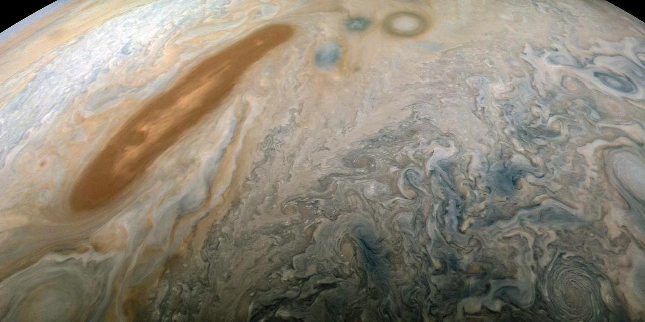
This striking image of Jupiter was captured by NASA's Juno spacecraft as it performed its eighth flyby of the gas giant planet. The image was taken on Sept. 1, 2017 at 2:58 p.m. PDT (5:58 p.m. EDT). At the time the image was taken, the spacecraft was 4,707 miles (7,576 kilometers) from the tops of the clouds of the planet at a latitude of about -17.4 degrees. Citizen scientist Gerald Eichstädt processed this image using data from the JunoCam imager. Points of interest are "Whale's Tail" and "Dan's Spot." https://photojournal.jpl.nasa.gov/catalog/PIA21966. - Enhanced image by Gerald Eichstädt based on images provided courtesy of NASA/JPL-Caltech/SwRI/MSSS
JunoCam, the visible light imager aboard NASA's Juno, captured this view of Jupiter's northern high latitudes during the spacecraft's 69th flyby of the giant planet on Jan. 28, 2025. Jupiter's belts and zones stand out in this enhanced color rendition, along with the turbulence along their edges caused by winds going in different directions. The original JunoCam image used to produce this view was taken from an altitude of about 36,000 miles (58,000 kilometers) above Jupiter's cloud tops. Citizen scientist Jackie Branc processed the image. https://photojournal.jpl.nasa.gov/catalog/PIA26595
NASA's Juno spacecraft captured this view of Jupiter during the mission's 54th close flyby of the giant planet on Sept. 7, 2023. The colorful zones and belts in Jupiter's atmosphere run from the cloud tops down to approximately 1,860 miles (3,000 kilometers). Citizen scientist Tanya Oleksuik made this image using raw data from the JunoCam instrument, processing the data to enhance details in cloud features and colors. At the time the raw image was taken, the Juno spacecraft was about 52,400 miles (about 84,400 kilometers) above Jupiter's cloud tops. https://photojournal.jpl.nasa.gov/catalog/PIA26077
During its 65th close flyby of Jupiter on Sept. 20, 2024, NASA's Juno spacecraft captured this series of images as it approached the giant planet and swung low over its north polar region. Juno's recent orbits have provided exceptionally clear views of Jupiter's circumpolar cyclones. At closest approach in this series of images, the Juno spacecraft was about 6,800 miles (11,000 kilometers) above the cloud tops, at a latitude of 82 degrees north of the equator. Citizen scientist Brian Swift made this image using raw data from the JunoCam instrument, applying digital processing techniques to enhance color and clarity. https://photojournal.jpl.nasa.gov/catalog/PIA25730
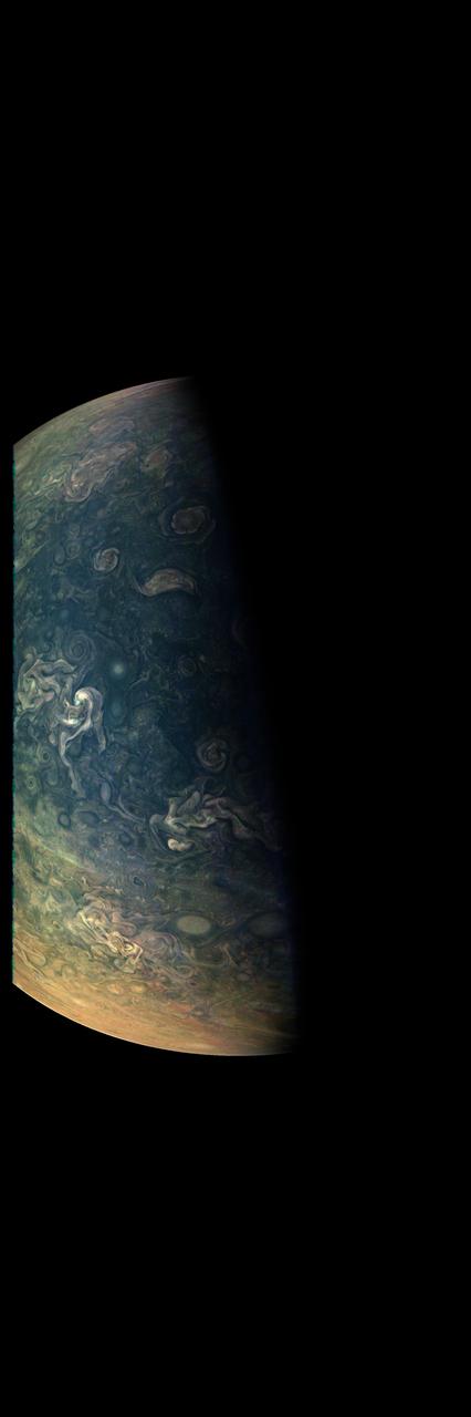
During its 61st close flyby of Jupiter on May 12, 2024, NASA's Juno spacecraft captured this color-enhanced view of the giant planet's northern hemisphere. It provides a detailed view of chaotic clouds and cyclonic storms in an area known to scientists as a folded filamentary region. In these regions, the zonal jets that create the familiar banded patterns in Jupiter's clouds break down, leading to turbulent patterns and cloud structures that rapidly evolve over the course of only a few days. Citizen scientist Gary Eason made this image using raw data from the JunoCam instrument, applying digital processing techniques to enhance color and clarity. At the time the raw image was taken, the Juno spacecraft was about 18,000 miles (29,000 kilometers) above Jupiter's cloud tops, at a latitude of about 68 degrees north of the equator. https://photojournal.jpl.nasa.gov/catalog/PIA25729
NASA's Juno mission captured this view of Jupiter's intriguing, icy moon Europa during a close pass on Sept. 29, 2022. The contrast has been enhanced to help scientists look for signs of eruptions along the limb and terminator – the dividing line between the day and night sides of the moon. None were identified. When processed this way, the image shows features on Europa's night side illuminated by sunlight reflected from Jupiter, also called Jupiter shine. Along the terminator, low-angle sunlight highlights topography on the moon's surface. At the time the image was taken, the Juno spacecraft was 945 miles (1,521 kilometers) from Europa. Citizen scientist Brian Swift processed the image from raw data from the spacecraft's JunoCam public engagement camera, brightening darker regions and enhancing the contrast. https://photojournal.jpl.nasa.gov/catalog/PIA25694
Intricate swirls in Jupiter's volatile northern hemisphere are captured in this color-enhanced image from NASA's Juno spacecraft. Bursts of bright-white "pop-up" clouds appear scattered throughout the scene, with some visibly casting shadows on the neighboring cloud layers beneath them. Juno scientists are using shadows to determine the distances between cloud layers in Jupiter's atmosphere, which provide clues to their composition and origin. This image was taken at 10:27 p.m. PDT on May 23, 2018 (1:27 a.m. EDT on May 24) as the spacecraft performed its 13th close flyby of Jupiter. At the time, Juno was about 7,050 miles (11,350 kilometers) from the planet's cloud tops, above a northern latitude of approximately 49 degrees. Citizen scientists Gerald Eichstädt and Seán Doran created this image using data from the spacecraft's JunoCam imager. https://photojournal.jpl.nasa.gov/catalog/PIA22687
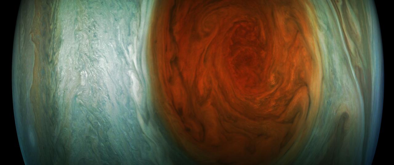
This image of Jupiter's iconic Great Red Spot (GRS) was created by citizen scientist Björn Jónsson using data from the JunoCam imager on NASA's Juno spacecraft. This true-color image offers a natural color rendition of what the Great Red Spot and surrounding areas would look like to human eyes from Juno's position. The tumultuous atmospheric zones in and around the Great Red Spot are clearly visible. The image was taken on July 10, 2017 at 07:10 p.m. PDT (10:10 p.m. EDT), as the Juno spacecraft performed its seventh close flyby of Jupiter. At the time the image was taken, the spacecraft was about 8,648 miles (13,917 kilometers) from the tops of the clouds of the planet at a latitude of -32.6 degrees. https://photojournal.jpl.nasa.gov/catalog/PIA21775. - Enhanced image by Björn Jónsson (CC-NC-SA) based on images provided courtesy of NASA/JPL-Caltech/SwRI/MSSS
This view of Jupiter's icy moon Europa was captured by JunoCam, the public engagement camera aboard NASA's Juno spacecraft, during the mission's close flyby on Sept. 29, 2022. The picture is a composite of JunoCam's second, third, and fourth images taken during the flyby, as seen from the perspective of the fourth image. North is to the left. The images have a resolution of just over 0.5 to 2.5 miles per pixel (1 to 4 kilometers per pixel). As with our Moon and Earth, one side of Europa always faces Jupiter, and that is the side of Europa visible here. Europa's surface is crisscrossed by fractures, ridges, and bands, which have erased terrain older than about 90 million years. Citizen scientist Kevin M. Gill processed the images to enhance the color and contrast. https://photojournal.jpl.nasa.gov/catalog/PIA25695
See Jupiter's southern hemisphere in beautiful detail in this new image taken by NASA's Juno spacecraft. The color-enhanced view captures one of the white ovals in the "String of Pearls," one of eight massive rotating storms at 40 degrees south latitude on the gas giant planet. The image was taken on Oct. 24, 2017 at 11:11 a.m. PDT (2:11 p.m. EDT), as Juno performed its ninth close flyby of Jupiter. At the time the image was taken, the spacecraft was 20,577 miles (33,115 kilometers) from the tops of the clouds of the planet at a latitude of minus 52.96 degrees. The spatial scale in this image is 13.86 miles/pixel (22.3 kilometers/pixel). Citizen scientists Gerald Eichstädt and Seán Doran processed this image using data from the JunoCam imager. https://photojournal.jpl.nasa.gov/catalog/PIA21970
This image captures the dynamic nature of Jupiter's northern temperate belt. The view reveals a white, oval-shaped anticyclonic storm called WS-4. NASA's Juno spacecraft took this color-enhanced image on April 1 at 2:38 a.m. PST (5:38 a.m. EST) during its 12th close flyby of the gas giant planet. At the time, the spacecraft was 4,087 miles (6,577 kilometers) from the tops of Jupiter's clouds at 35.6 degrees north latitude. This image was created by citizen scientist Emma Walimaki using data from the JunoCam imager on NASA's Juno spacecraft. https://photojournal.jpl.nasa.gov/catalog/PIA22420 . - Enhanced image by Emma Walimaki based on images provided courtesy of NASA/JPL-Caltech/SwRI/MSSS
Small bright clouds dot Jupiter's entire south tropical zone in this image acquired by JunoCam on NASA's Juno spacecraft on May 19, 2017, at an altitude of 7,990 miles (12,858 kilometers). Although the bright clouds appear tiny in this vast Jovian cloudscape, they actually are cloud towers roughly 30 miles (50 kilometers) wide and 30 miles (50 kilometers) high that cast shadows on the clouds below. On Jupiter, clouds this high are almost certainly composed of water and/or ammonia ice, and they may be sources of lightning. This is the first time so many cloud towers have been visible, possibly because the late-afternoon lighting is particularly good at this geometry. Citizen scientists Gerald Eichstädt and Seán Doran created this image using data from the spacecraft's JunoCam imager. https://photojournal.jpl.nasa.gov/catalog/PIA21647

Jupiter's northernmost cyclone, perched near the gas giant's north pole, is visible to the right along the bottom edge of this image, which was taken Sept. 29, 2022, by the JunoCam public engagement camera aboard NASA's Juno spacecraft. Jupiter has eight circumpolar cyclones, and four are visible in this image, framing the northernmost cyclone. A small anticyclone (which spins counterclockwise) has wedged its way in just above the northernmost cyclone. This image was acquired on Juno's 45th pass of Jupiter from an altitude of 17,248 miles (27,758 kilometers) and shows features as small as 11.6 miles (18.7 kilometers) across. Citizen scientist Navaneeth Krishnan S processed the images to enhance the color and contrast. https://photojournal.jpl.nasa.gov/catalog/PIA25692

In the final minutes of a recent close flyby of Jupiter, NASA's Juno spacecraft captured a departing view of the planet's swirling southern hemisphere. This color-enhanced image was taken at 7:13 p.m. PDT on Sept. 6, 2018 (10:13 p.m. EDT) as the spacecraft performed its 15th close flyby of Jupiter. At the time, Juno was about 55,600 miles (89,500 kilometers) from the planet's cloud tops, above a southern latitude of approximately 75 degrees. Citizen scientist Gerald Eichstädt created this image using data from the spacecraft's JunoCam imager. https://photojournal.jpl.nasa.gov/catalog/PIA22690. - Enhanced image by Gerald Eichstädt based on images provided courtesy of NASA/JPL-Caltech/SwRI/MSSS

Waves of clouds at 37.8 degrees latitude dominate this three-dimensional Jovian cloudscape, courtesy of NASA's Juno spacecraft. JunoCam obtained this enhanced-color picture on May 19, 2017, at 5:50 UTC from an altitude of 5,500 miles (8,900 kilometers). Details as small as 4 miles (6 kilometers) across can be identified in this image. The small bright high clouds are about 16 miles (25 kilometers) across and in some areas appear to form "squall lines" (a narrow band of high winds and storms associated with a cold front). On Jupiter, clouds this high are almost certainly composed of water and/or ammonia ice. Citizen scientists Gerald Eichstädt and Seán Doran created this image using data from the spacecraft's JunoCam imager. https://photojournal.jpl.nasa.gov/catalog/PIA21646
NASA's Juno spacecraft captured this view of an area within a Jovian jet stream showing a vortex that has an intensely dark center. Nearby, other features display bright, high altitude clouds that have puffed up into the sunlight. The color-enhanced image was taken at 12:55 a.m. PDT (3:55 a.m. EDT) on May 29, 2019, as the spacecraft performed its 20th science flyby of Jupiter. At the time, Juno was about 9,200 miles (14,800 kilometers) from the planet's cloud tops, above approximately 52 degrees north latitude. Citizen scientists Gerald Eichstädt and Seán Doran created this image using data from the spacecraft's JunoCam imager. https://photojournal.jpl.nasa.gov/catalog/PIA22948

This enhanced color view of Jupiter's south pole was created by citizen scientist Gabriel Fiset using data from the JunoCam instrument on NASA's Juno spacecraft. Oval storms dot the cloudscape. Approaching the pole, the organized turbulence of Jupiter's belts and zones transitions into clusters of unorganized filamentary structures, streams of air that resemble giant tangled strings. The image was taken on Dec. 11, 2016 at 9:44 a.m. PST (12:44 p.m. EST), from an altitude of about 32,400 miles (52,200 kilometers) above the planet's beautiful cloud tops. https://photojournal.jpl.nasa.gov/catalog/PIA21390 . - Enhanced image by Gabriel Fiset (CC-BY) based on images provided courtesy of NASA/JPL-Caltech/SwRI/MSSS

NASA's Juno spacecraft was a little more than one Earth diameter from Jupiter when it captured this mind-bending, color-enhanced view of the planet's tumultuous atmosphere. Jupiter completely fills the image, with only a hint of the terminator (where daylight fades to night) in the upper right corner, and no visible limb (the curved edge of the planet). Juno took this image of colorful, turbulent clouds in Jupiter's northern hemisphere on Dec. 16, 2017 at 9:43 a.m. PST (12:43 p.m. EST) from 8,292 miles (13,345 kilometers) above the tops of Jupiter's clouds, at a latitude of 48.9 degrees. The spatial scale in this image is 5.8 miles/pixel (9.3 kilometers/pixel).. Citizen scientists Gerald Eichstädt and Seán Doran processed this image using data from the JunoCam imager. https://photojournal.jpl.nasa.gov/catalog/PIA21973
This enhanced-color image of Jupiter's bands of light and dark clouds was created by citizen scientists Gerald Eichstädt and Seán Doran using data from the JunoCam imager on NASA's Juno spacecraft. Three of the white oval storms known as the "String of Pearls" are visible near the top of the image. Each of the alternating light and dark atmospheric bands in this image is wider than Earth, and each rages around Jupiter at hundreds of miles (kilometers) per hour. The lighter areas are regions where gas is rising, and the darker bands are regions where gas is sinking. Juno acquired the image on May 19, 2017, at 11:30 a.m. PST (2:30 p.m. EST) from an altitude of about 20,800 miles (33,400 kilometers) above Jupiter's cloud tops. https://photojournal.jpl.nasa.gov/catalog/PIA21393

A multitude of magnificent, swirling clouds in Jupiter's dynamic North North Temperate Belt is captured in this image from NASA's Juno spacecraft. Appearing in the scene are several bright-white "pop-up" clouds as well as an anticyclonic storm, known as a white oval. This color-enhanced image was taken at 1:58 p.m. PDT on Oct. 29, 2018 (4:58 p.m. EDT) as the spacecraft performed its 16th close flyby of Jupiter. At the time, Juno was about 4,400 miles (7,000 kilometers) from the planet's cloud tops, at a latitude of approximately 40 degrees north. Citizen scientists Gerald Eichstädt and Seán Doran created this image using data from the spacecraft's JunoCam imager. https://photojournal.jpl.nasa.gov/catalog/PIA22692
NASA's Juno spacecraft was racing away from Jupiter following its seventh close pass of the planet when JunoCam snapped this image on May 19, 2017, from about 29,100 miles (46,900 kilometers) above the cloud tops. The spacecraft was over 65.9 degrees south latitude, with a lovely view of the south polar region of the planet. This image was processed to enhance color differences, showing the amazing variety in Jupiter's stormy atmosphere. The result is a surreal world of vibrant color, clarity and contrast. Four of the white oval storms known as the "String of Pearls" are visible near the top of the image. Interestingly, one orange-colored storm can be seen at the belt-zone boundary, while other storms are more of a cream color. Citizen scientists Gerald Eichstädt and Seán Doran processed this image using data from the JunoCam imager. https://photojournal.jpl.nasa.gov/catalog/PIA21392
A south tropical disturbance has just passed Jupiter's iconic Great Red Spot and is captured stealing threads of orange haze from the Great Red Spot in this series of color-enhanced images from NASA's Juno spacecraft. From left to right, this sequence of images was taken between 2:57 a.m. and 3:36 a.m. PDT (5:57 a.m. and 6:36 a.m. EDT) on April 1, 2018, as the spacecraft performed its 12th close flyby of Jupiter. Citizen scientists Gerald Eichstädt and Seán Doran created this image using data from the spacecraft's JunoCam imager. https://photojournal.jpl.nasa.gov/catalog/PIA22937 ** Image Credit: Enhanced Image by Gerald Eichstädt and Seán Doran (CC BY-NC-SA) based on images provided courtesy of NASA/JPL-Caltech/SwRI/MSSS

The main image and the inset image were taken by the JunoCam imager about NASA's Juno spacecraft a few hours before its closest approach to Jupiter on its 38th perijove pass, on Nov. 29, 2021, during an encounter with the Jovian moon Io. After snapping a series of Io images, JunoCam acquired this picture of Jupiter and Io together. Much fainter and more distant is Jupiter's moon Callisto, barely visible below and to the right of Io. The original JunoCam image used to produce this view was taken from an altitude of 15,404 miles (24,791 kilometers) above Jupiter's cloud tops near its north pole. At the time, Io was at a distance of 270,648 miles (435,567 kilometers), and Callisto was almost 1.2 million miles (2 million kilometers). Citizen scientist Brian Swift processed the main image and inset to enhance the color and contrast. https://photojournal.jpl.nasa.gov/catalog/PIA25032
Clouds in a Jovian jet stream, called Jet N5, swirl in the center of this color-enhanced image from NASA's Juno spacecraft. A brown oval known as a "brown barge" can be seen in the North North Temperate Belt region in the top-left portion of the image. This image was taken at 5:58 p.m. PDT on Sept. 6, 2018 (8:58 p.m. EDT) as the spacecraft performed its 15th close flyby of Jupiter. At the time, Juno was 7,600 miles (12,300 kilometers) from the planet's cloud tops, above a northern latitude of approximately 52 degrees. Citizen scientists Brian Swift and Seán Doran created this image using data from the spacecraft's JunoCam imager. The view has been rotated 90 degrees to the right from the original image. https://photojournal.jpl.nasa.gov/catalog/PIA22689
This enhanced-color image of a mysterious dark spot on Jupiter seems to reveal a Jovian "galaxy" of swirling storms. Juno acquired this JunoCam image on Feb. 2, 2017, at 5:13 a.m. PDT (8:13 a.m. EDT), at an altitude of 9,000 miles (14,500 kilometers) above the giant planet's cloud tops. This publicly selected target was simply titled "Dark Spot." In ground-based images it was difficult to tell that it is a dark storm. Citizen scientist Roman Tkachenko enhanced the color to bring out the rich detail in the storm and surrounding clouds. Just south of the dark storm is a bright, oval-shaped storm with high, bright, white clouds, reminiscent of a swirling galaxy. As a final touch, he rotated the image 90 degrees, turning the picture into a work of art. http://photojournal.jpl.nasa.gov/catalog/PIA21386 . - Enhanced image by Roman Tkachenko (CC-BY) based on images provided courtesy of NASA/JPL-Caltech/SwRI/MSSS

Swirling clouds on Jupiter are shown in an image taken by the JunoCam public engagement camera aboard NASA's Juno spacecraft on Feb. 25, 2022. Juno's orbit around Jupiter changes every time the spacecraft passes the giant planet, with the point of closest approach – perijove, or "PJ" – moving steadily northward. As the perijove changes, the resolution of images taken in the northern hemisphere steadily increases. This zoomed-in cutout of a JunoCam image, acquired on PJ40 at 54 degrees north, shows new detail in the clouds and storms. Taken at an altitude of 4,133 miles (6,652 kilometers), the image reveals features as small as 2.8 miles (4.5 kilometers) across. Citizen scientist Kevin M. Gill processed the images to enhance color and contrast. https://photojournal.jpl.nasa.gov/catalog/PIA25691
During its 36th low pass over Jupiter, NASA's Juno spacecraft captured this view of striking cloud bands and swirls in the giant planet's mid-southern latitudes. The dark, circular vortex near the center of the image is a cyclone that spans roughly 250 miles (about 400 kilometers). The color at its center is likely to be the result of descending winds that cleared out upper-level clouds, revealing darker material below. Citizen scientist Brian Swift used a raw JunoCam image digitally projected onto a sphere to create this view. It has been rotated so that north is up. The original image was taken on Sept. 2, 2021, at 4:09 p.m. PDT (7:09 p.m. EDT). At the time, the spacecraft was about 16,800 miles (about 27,000 kilometers) above Jupiter's cloud tops, at a latitude of about 31 degrees south. https://photojournal.jpl.nasa.gov/catalog/PIA23610
Jupiter's moon Europa was captured by the JunoCam instrument aboard NASA's Juno spacecraft during the mission's close flyby on Sept. 29, 2022. The picture is a composite of JunoCam's second, third, and fourth images taken during the flyby, as seen from the perspective of the fourth image. North is at the top. The resolution of images ranges from just over 0.5 to 2.5 miles per pixel (1 to 4 kilometers per pixel). As with our Moon and Earth, one side of Europa always faces Jupiter, and that is the side of Europa visible here. Europa's surface is crisscrossed by fractures, ridges, and bands, which have erased terrain older than about 90 million years. Citizen scientist Björn Jónsson processed the images to enhance the color and contrast. https://photojournal.jpl.nasa.gov/catalog/PIA26331
This image of Jupiter's iconic Great Red Spot and surrounding turbulent zones was captured by NASA's Juno spacecraft. The color-enhanced image is a combination of three separate images taken on April 1 between 3:09 a.m. PDT (6:09 a.m. EDT) and 3:24 a.m. PDT (6:24 a.m. EDT), as Juno performed its 12th close flyby of Jupiter. At the time the images were taken, the spacecraft was 15,379 miles (24,749 kilometers) to 30,633 miles (49,299 kilometers) from the tops of the clouds of the planet at a southern latitude spanning 43.2 to 62.1 degrees. Citizen scientists Gerald Eichstädt and Seán Doran processed this image using data from the JunoCam imager. https://photojournal.jpl.nasa.gov/catalog/PIA21985

Jupiter's moon Amalthea casts a shadow on the gas giant planet in this image captured by NASA's Juno spacecraft. The elongated shape of the shadow is a result of both the location of the moon with relation to Jupiter in this image as well as the irregular shape of the moon itself. The image was taken on Sept. 1, 2017 at 2:46 p.m. PDT (5:46 p.m. EDT), as Juno performed its eighth close flyby of Jupiter. At the time the image was taken, the spacecraft was 2,397 miles (3,858 kilometers) from the tops of the clouds of the planet at a latitude of 17.6 degrees. Citizen scientists Gerald Eichstädt and Seán Doran processed this image using data from the JunoCam imager. The image has been rotated so that the top of the image is actually the equatorial regions while the bottom of the image is of the northern polar regions of the planet. https://photojournal.jpl.nasa.gov/catalog/PIA21969
This image shows two of Jupiter's large rotating storms, captured by Juno's visible-light imager, JunoCam, on Juno's 38th perijove pass, on Nov. 29, 2021. This image was acquired at 50 degrees 5 minutes north latitude, at an altitude of 3,815 miles (6,140 kilometers). Atmospheric details as small as 2.5 miles (4 kilometers) can be discerned in the image. Bright "pop-up" clouds are visible above the lower storm, casting shadows on the cloud bank below. Although the pop-up clouds appear small in comparison to the large storm below, such clouds are typically 31 miles (50 kilometers) across. Citizen scientist Kevin M. Gill processed the image to enhance the color and contrast, using raw JunoCam data. https://photojournal.jpl.nasa.gov/catalog/PIA25031
This striking Jovian vista was created by citizen scientists Gerald Eichstädt and Seán Doran using data from the JunoCam imager on NASA's Juno spacecraft. The tumultuous Great Red Spot is fading from Juno's view while the dynamic bands of the southern region of Jupiter come into focus. North is to the left of the image, and south is on the right. The image was taken on July 10, 2017 at 7:12 p.m. PDT (10:12 p.m. EDT), as the Juno spacecraft performed its seventh close flyby of Jupiter. At the time the image was taken, the spacecraft was 10,274 miles (16,535 kilometers) from the tops of the clouds of the planet at a latitude of -36.9 degrees. https://photojournal.jpl.nasa.gov/catalog/PIA21778 **Image Credit: Enhanced Image by Gerald Eichstädt and Seán Doran (CC BY-NC-SA) based on images provided courtesy of NASA/JPL-Caltech/SwRI/MSSS https://creativecommons.org/licenses/by-nc-sa/3.0/
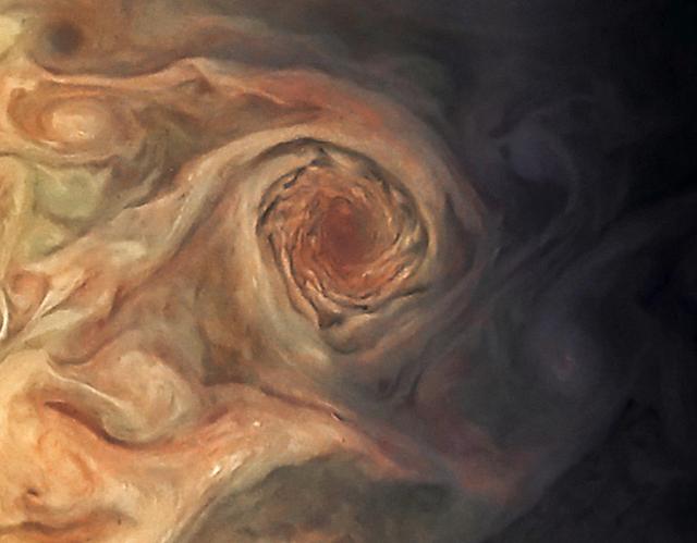
This image, taken by the JunoCam imager on NASA's Juno spacecraft, highlights a swirling storm just south of one of the white oval storms on Jupiter. The image was taken on March 27, 2017, at 2:12 a.m. PDT (5:12 a.m. EDT), as the Juno spacecraft performed a close flyby of Jupiter. At the time the image was taken, the spacecraft was about 12,400 miles (20,000 kilometers) from the planet. Citizen scientist Jason Major enhanced the color and contrast in this image, turning the picture into a Jovian work of art. He then cropped it to focus our attention on this beautiful example of Jupiter's spinning storms. https://photojournal.jpl.nasa.gov/catalog/PIA21387 . - Enhanced image by Jason Major (CC-BY) based on images provided courtesy of NASA/JPL-Caltech/SwRI/MSSS
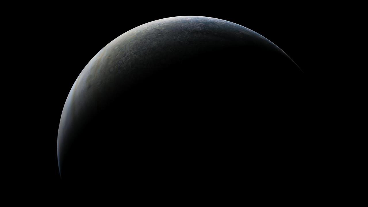
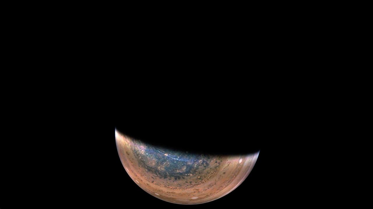
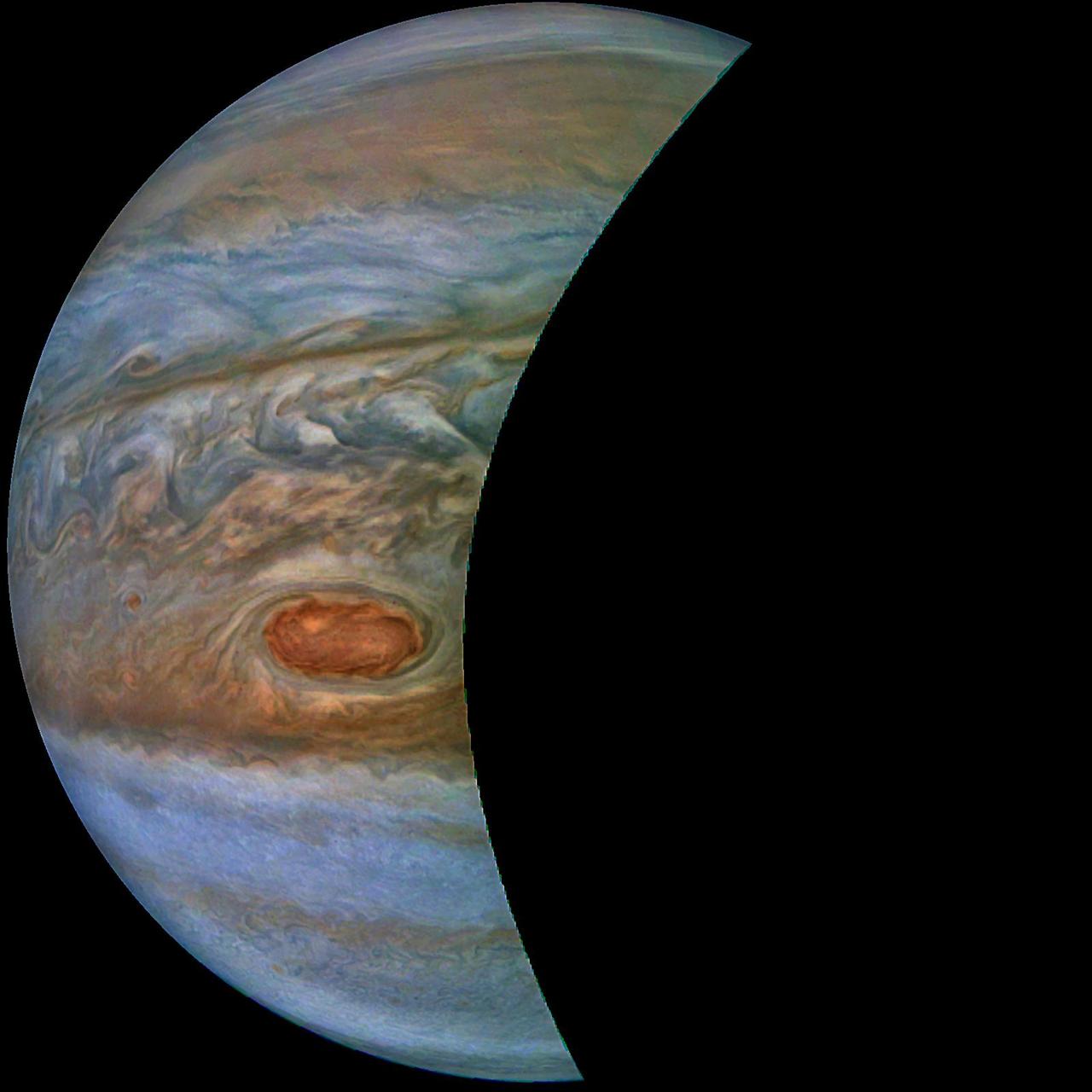
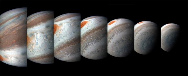
If you could ride along with NASA's Juno spacecraft as it approaches Jupiter during one of its regular close passes by the giant planet, you would be treated to a striking vista similar to this one. Unlike the Moon or Venus, this view of Jupiter in a crescent phase is impossible to see from Earth, even using a telescope. Since Jupiter's orbit is outside Earth's, an observer on Earth can only see the side of Jupiter that is illuminated by the Sun, so the planet always appears full. Citizen scientist Kevin M. Gill created this mosaic using raw data from the JunoCam instrument. It comprises seven images taken during Juno's 39th close pass by Jupiter on Jan. 12, 2022. https://photojournal.jpl.nasa.gov/catalog/PIA25013