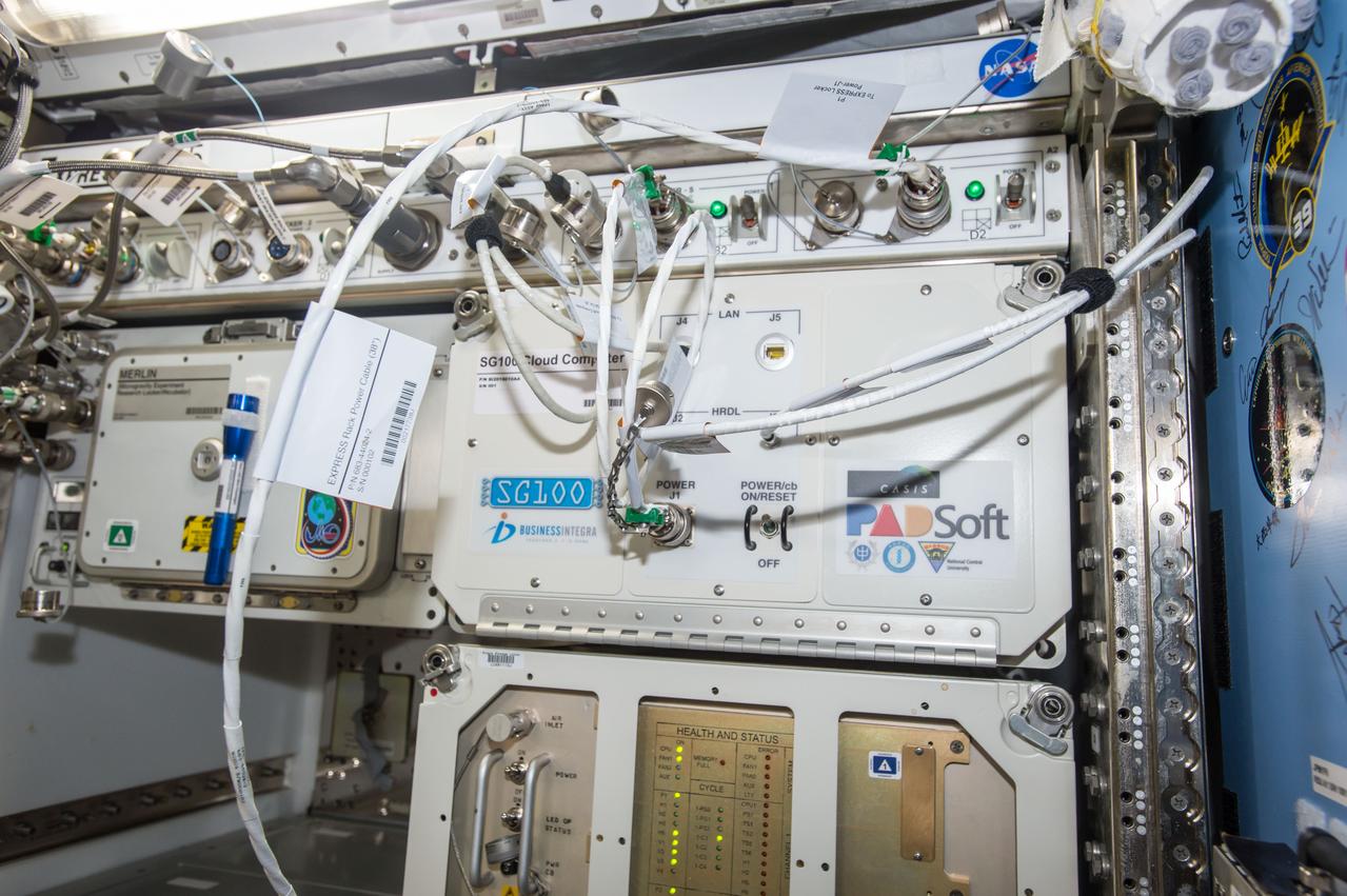
iss051e045046 (5/17/2017) --- The SG100 Cloud Computing Payload, shown here installed in the Kibo Japanese Pressurized Module (JPM) aboard the International Space Station (ISS), tests a space-rated, single-board computer designed to allow engineers, scientists and researchers to perform significant amounts of onboard analysis prior to downlink to the ground.

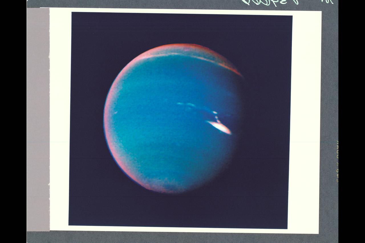
This computer enhancement of a NASA Voyager 2 image, emphasizes the high-level haze in Uranus upper atmosphere. Clouds are obscured by the overlying atmosphere.

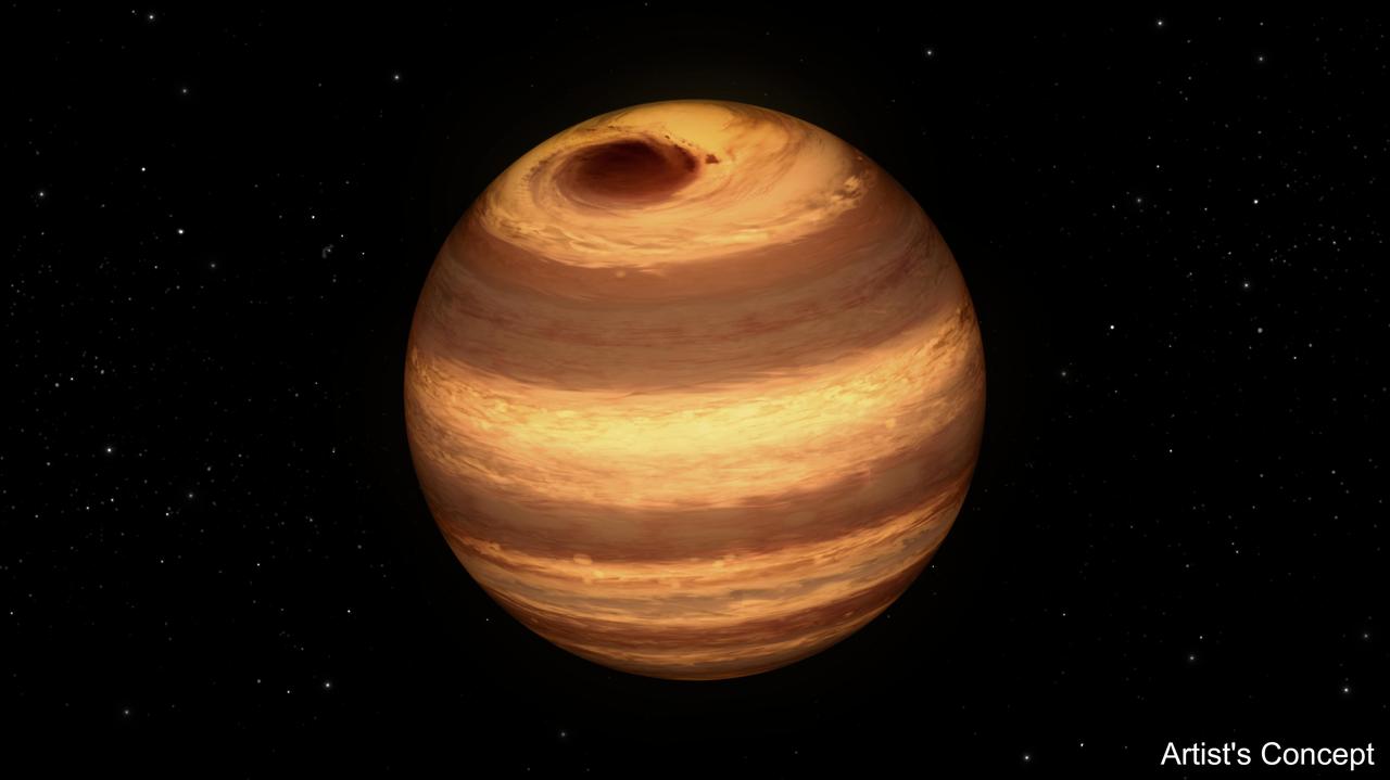
Hot Jupiters are exoplanets that orbit their stars so tightly that their temperatures are extremely high, reaching over 2,400 degrees Fahrenheit (1600 Kelvin). They are also tidally locked, so one side of the planet always faces the sun and the other is in permanent darkness. Research suggests that the "dayside" is largely free of clouds, while the "nightside" is heavily clouded. This illustration represents how hot Jupiters of different temperatures and different cloud compositions might appear to a person flying over the dayside of these planets on a spaceship, based on computer modeling. Cooler planets are entirely cloudy, whereas hotter planets have morning clouds only. Clouds of different composition have different colors, whereas the clear sky is bluer than on Earth. For the hottest planets, the atmosphere is hot enough on the evening side to glow like a charcoal. Figure 1 shows an approximation of what various hot Jupiters might look like based on a combination of computer modeling and data from NASA's Kepler Space Telescope. From left to right it shows: sodium sulfide clouds (1000 to 1200 Kelvin), manganese sulfide clouds (1200 to 1600 Kelvin), magnesium silicate clouds (1600 to 1800 Kelvin), magnesium silicate and aluminum oxide clouds (1800 Kelvin) and clouds composed of magnesium silicate, aluminum oxide, iron and calcium titanate (1900 to 2200 Kelvin). http://photojournal.jpl.nasa.gov/catalog/PIA21074

Obama Administration launches Cloud Computing Initiative at Ames Research Center with Vivek Kundra, White House Chief Federal Information Officer making presentation.
JSC2000E-01557 (January 2000) --- This partially computer-generated scene depicts anticipated coverage by the Shuttle Radar Topography Mission (SRTM) of topographic features on Earth. Heavy cloud cover, hurricanes and cyclonic storms can prevent optical cameras on satellites or aircraft from imaging some areas. SRTM radar, with its long wavelength, will penetrate clouds as well as providing its own illumination, making it independent of daylight.
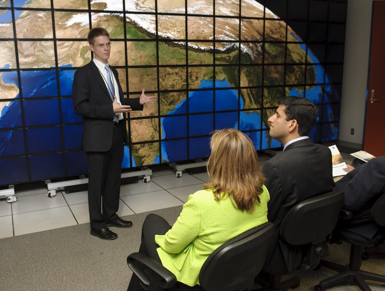
Obama Administration launches Cloud Computing Initiative at Ames Research Center. Vivek Kundra, White House Chief Federal Information Officer (right) and Lori Garver, NASA Deputy Administrator (left) get a tour & demo NASAS Supercomputing Center Hyperwall by Chris Kemp.
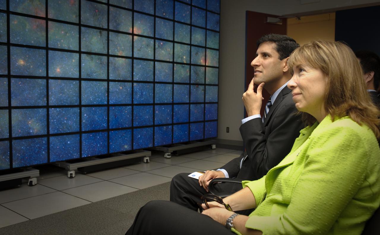
Obama Administration launches Cloud Computing Initiative at Ames Research Center. Vivek Kundra, White House Chief Federal Information Officer (right) and Lori Garver, NASA Deputy Administrator (left) get a tour & demo NASAS Supercomputing Center Hyperwall.
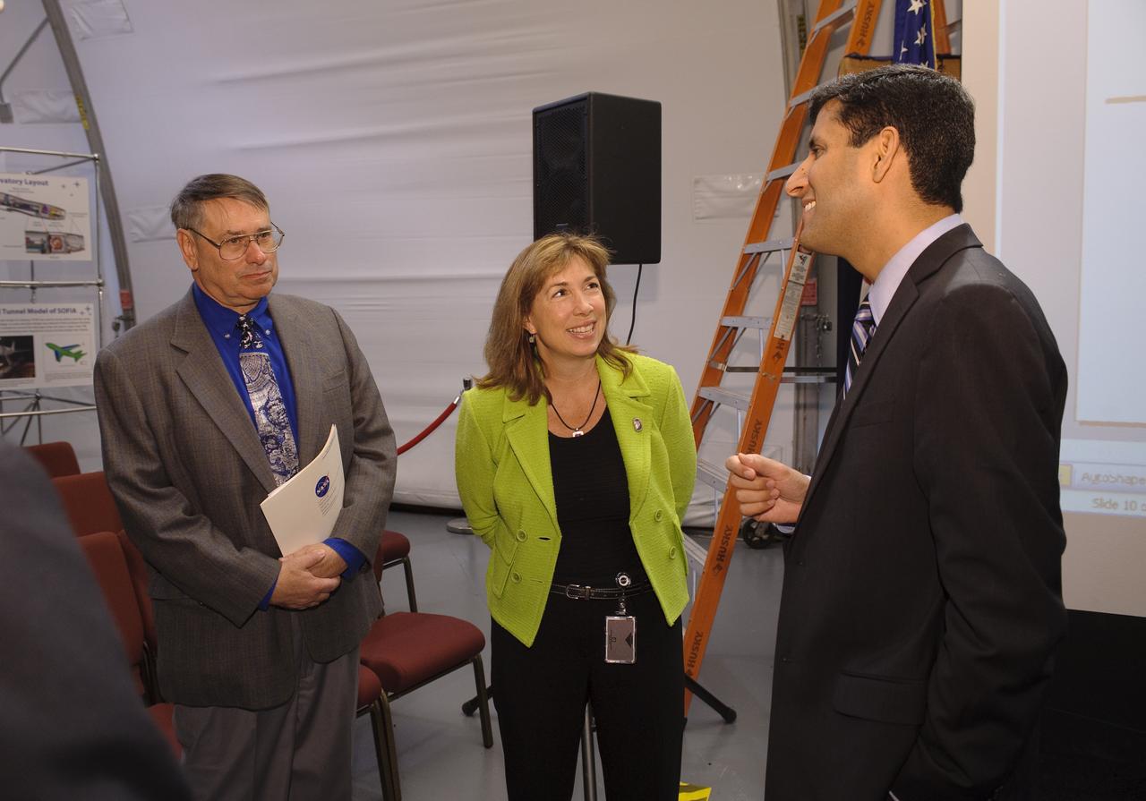
Obama Administration launches Cloud Computing Initiative at Ames Research Center with left to right; S. Pete Worden, Center Director, Lori Garver, NASA Deputy Administrator, Vivek Kundra, White House Chief Federal Information Officer
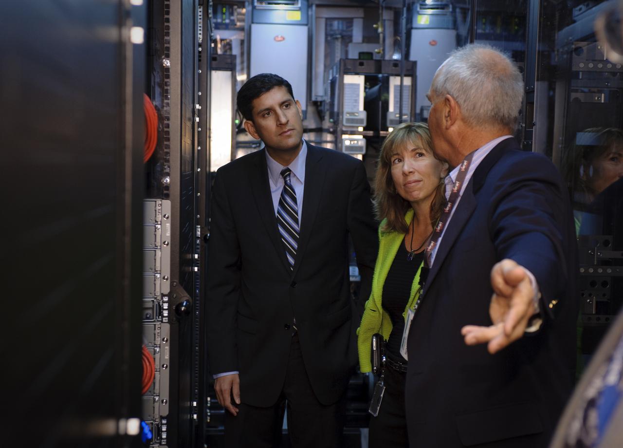
Obama Administration launches Cloud Computing Initiative at Ames Research Center. Vivek Kundra, White House Chief Federal Information Officer (left) and Lori Garver, NASA Deputy Administrator (ctr) get a tour of the NASA Nebula Infrastructure with Bobby Cates (right).

Obama Administration launches Cloud Computing Initiative at Ames Research Center. Vivek Kundra, White House Chief Federal Information Officer (ctr) and Lori Garver, NASA Deputy Administrator (right) get a tour of the NASA Nebula Infrastructure with Bobby Cates (on left).
P-34666 This false color photograph of Neptune was reconstructed from two images taken by Voyager 2's wide angle camera, through the orange and two different methane filters. Objects that deep in the atmosphere are blue, while those at higher altitudes are white. Light at methane wavelengths is mostly absorbed in the deeper atmosphere. The bright, white feature is a high altitude cloud just south of the Great dark Spot. The hard, sharp inner boundary within the bright cloud is an artifact of computer processing on Earth. Other, smaller clouds associated with the Great Dark Spot are white or pink, and are also at high altitudes. Neptune's limb looks reddish because Voyager 2 is viewing it tangentially, and the sunlight is scattered back to space before it can be absorbed by methane. A long, narrow band of high-altitude clouds near the top of the image is located at 25 degrees north latitude, and faint hazes mark the equator and polor regions
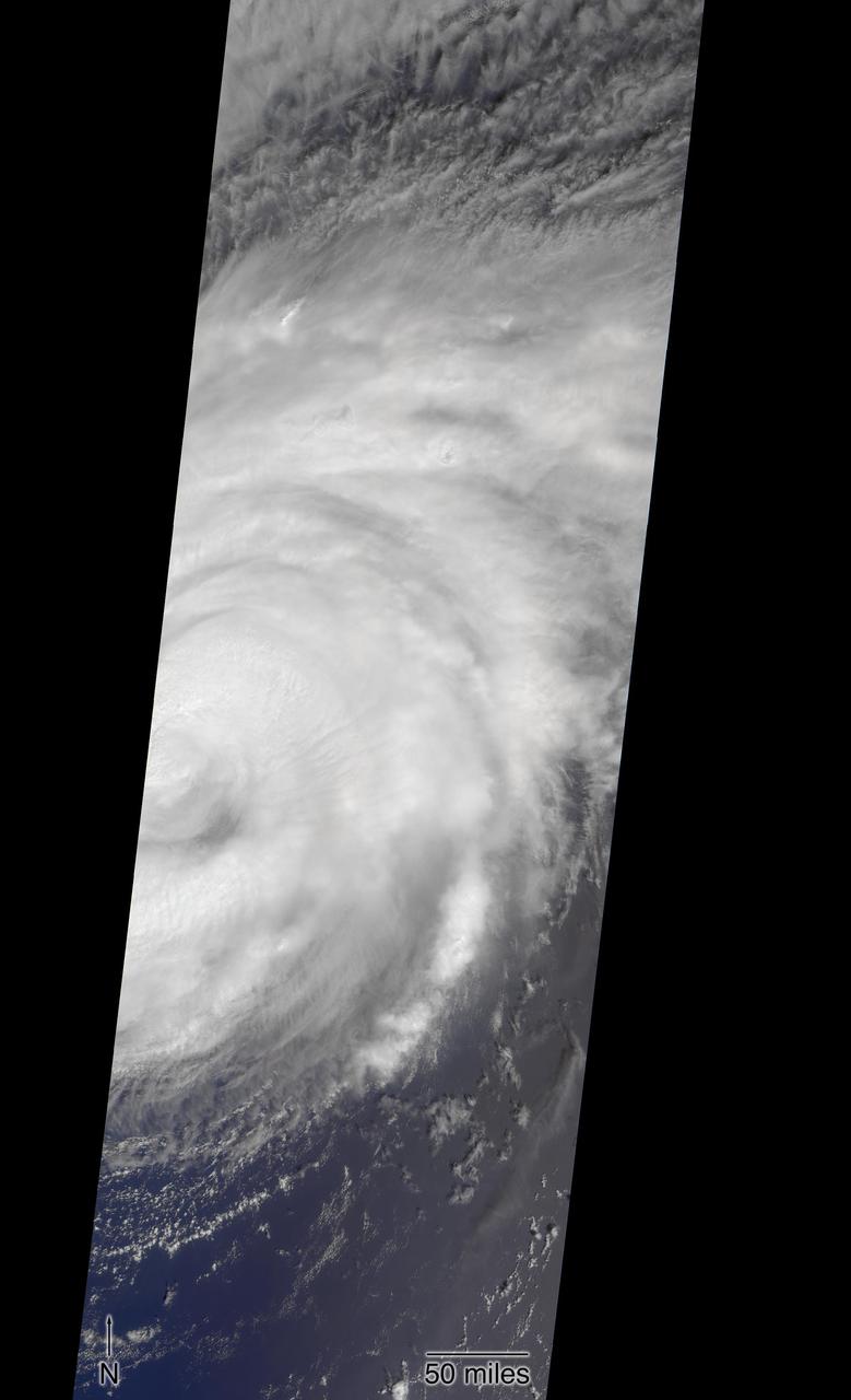
NASA's Multi-angle Imaging SpectroRadiometer (MISR) passed over Hurricane Florence as it approached the eastern coast of the United States on Thursday, September 13, 2018. At the time the image was acquired, Florence was a large Category 2 storm and coastal areas were already being hit with tropical-storm-force winds. The MISR instrument, flying onboard NASA's Terra satellite, carries nine cameras that observe Earth at different angles. It takes about seven minutes for all the cameras to observe the same location. The motion of the clouds during that time is used to compute wind speed at the cloud tops. These images show Florence as viewed by the central, downward-looking camera (left) and the storm's wind speeds (right). In the right image, the length of the arrows is proportional to wind speed and their colors show the altitude of the cloud tops in kilometers. The data show that the cloud top winds near the center of the storm were approximately 70 mph (113 kph), and the maximum cloud-top wind speed throughout the storm was 90 mph (145 kph). The wind data also shows that the lowest clouds are moving counter-clockwise, indicating inflow into the southern part of the hurricane, while the high clouds to the north of the hurricane show a clockwise outflow. https://photojournal.jpl.nasa.gov/catalog/PIA22700
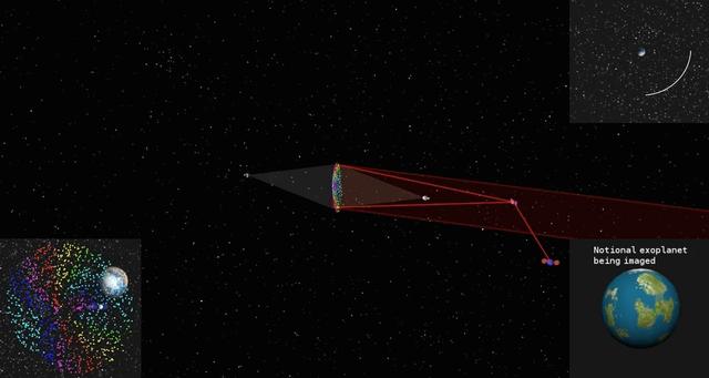
This simulated image shows how a cloud of glitter in geostationary orbit would be illuminated and controlled by two laser beams. As the cloud orbits Earth, grains scatter the sun's light at different angles like many tiny prisms, similar to how rainbows are produced from light being dispersed by water droplets. That is why the project concept is called "Orbiting Rainbows." The cloud functions like a reflective surface, allowing the exoplanet (displayed in the bottom right) to be imaged. The orbit path is shown in the top right. On the bottom left, Earth's image is seen behind the cloud. To image an exoplanet, the cloud would need to have a diameter of nearly 98 feet (30 meters). This simulation confines the cloud to a 3.3 x 3.3 x 3.3 foot volume (1 x 1 x 1 meter volume) to simplify the computations. The elements of the orbiting telescope are not to scale. Orbiting Rainbows is currently in Phase II development through the NASA Innovative Advanced Concepts (NIAC) Program. It was one of five technology proposals chosen for continued study in 2014. In the current phase, Orbiting Rainbows researchers are conducting small-scale ground experiments to demonstrate how granular materials can be manipulated using lasers and simulations of how the imaging system would behave in orbit. http://photojournal.jpl.nasa.gov/catalog/PIA19318

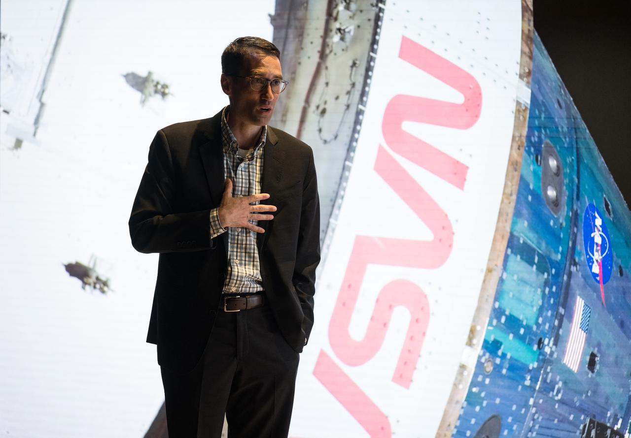
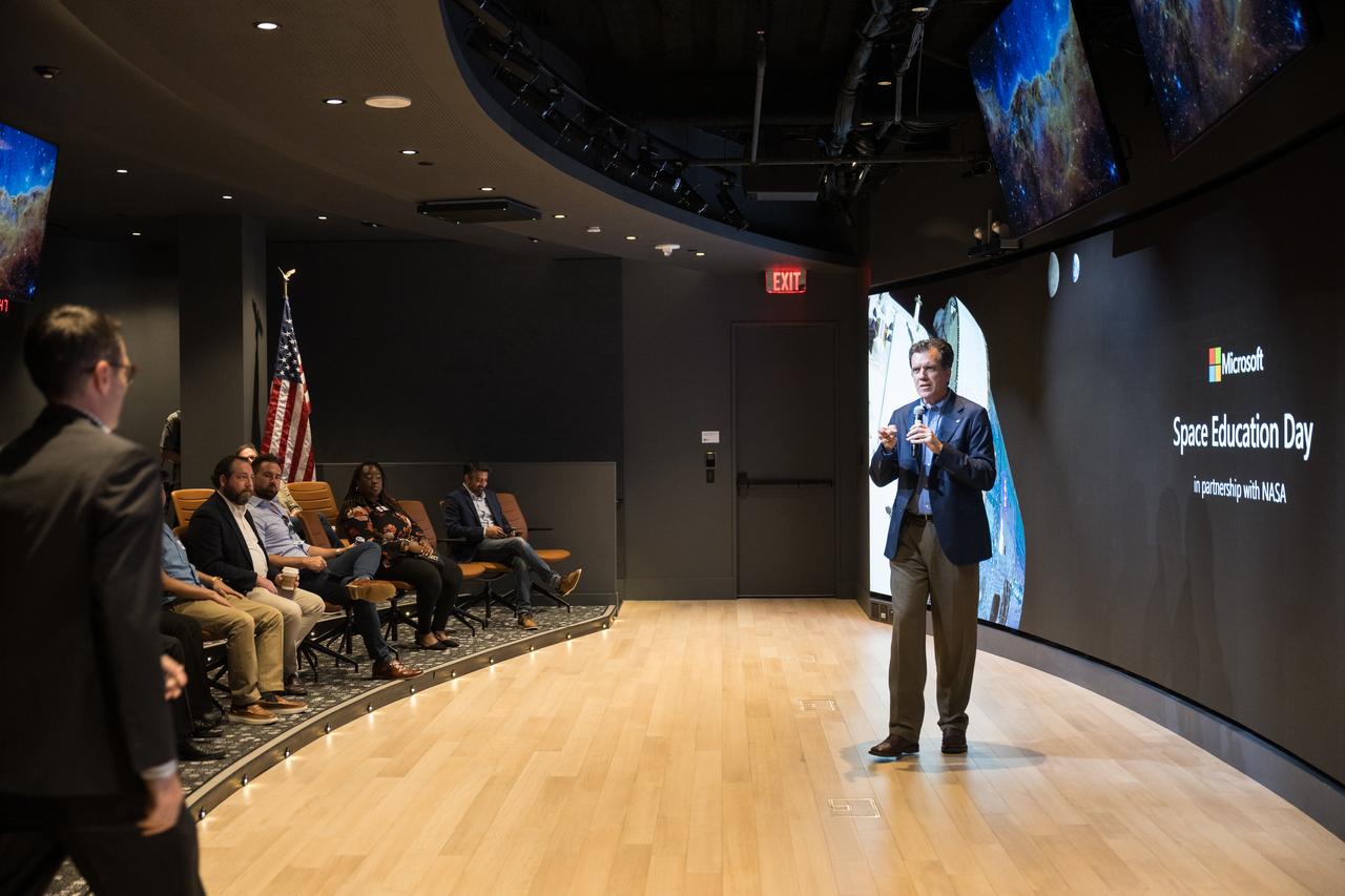
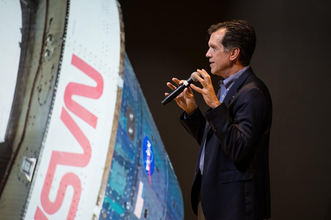
NASA Strategic Partnerships Manager for STEM Engagement, Rob LaSalvia, provides remarks during Space Education Day, Tuesday, June 20, 2023, at the Microsoft Technology Center in Arlington, Va. Microsoft hosted the event to showcase the collaboration, early successes, and future plans for high quality student engagement through activities that combined space content and technologies like artificial intelligence and cloud computing. Photo Credit: (NASA/Aubrey Gemignani)

NASA Associate Administrator for the STEM Engagement Office, Mike Kincaid, provides remarks during Space Education Day, Tuesday, June 20, 2023, at the Microsoft Technology Center in Arlington, Va. Microsoft hosted the event to showcase the collaboration, early successes, and future plans for high quality student engagement through activities that combined space content and technologies like artificial intelligence and cloud computing. Photo Credit: (NASA/Aubrey Gemignani)

A group of DC area students and staff pose for a group photo at the conclusion of the Space Education Day, Tuesday, June 20, 2023, at the Microsoft Technology Center in Arlington, Va. Microsoft hosted the event to showcase the collaboration, early successes, and future plans for high quality student engagement through activities that combined space content and technologies like artificial intelligence and cloud computing. Photo Credit: (NASA/Aubrey Gemignani)

Microsoft’s Azure Space Senior Director, Stephen Kitay, provides remarks during Space Education Day, Tuesday, June 20, 2023, at the Microsoft Technology Center in Arlington, Va. Microsoft hosted the event to showcase the collaboration, early successes, and future plans for high quality student engagement through activities that combined space content and technologies like artificial intelligence and cloud computing. Photo Credit: (NASA/Aubrey Gemignani)

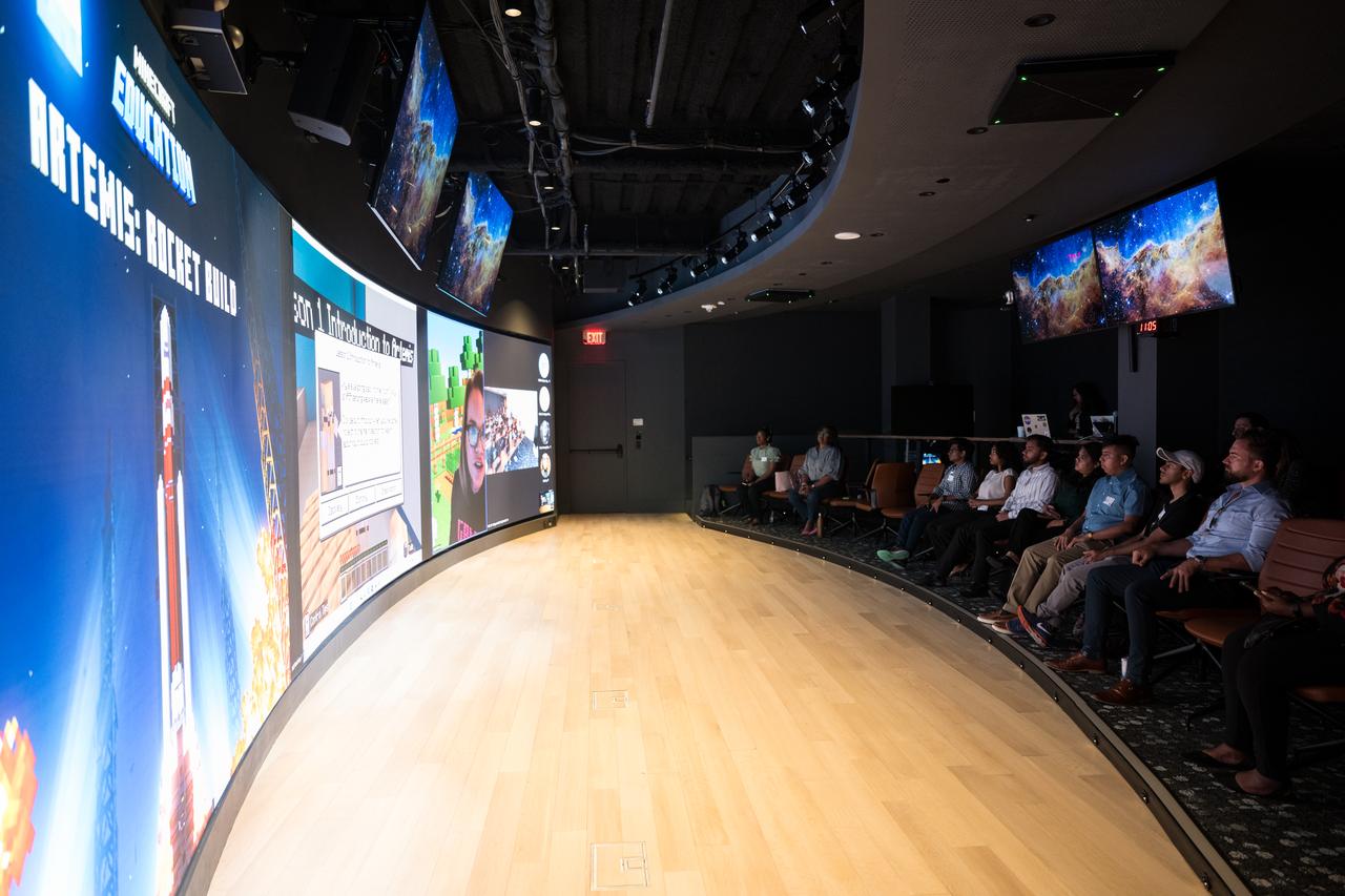
DC area students participate in a Minecraft Artemis demonstration during Space Education Day, Tuesday, June 20, 2023, at the Microsoft Technology Center in Arlington, Va. Microsoft hosted the event to showcase the collaboration, early successes, and future plans for high quality student engagement through activities that combined space content and technologies like artificial intelligence and cloud computing. Photo Credit: (NASA/Aubrey Gemignani)

DC area students participate in a Minecraft Artemis demonstration during Space Education Day, Tuesday, June 20, 2023, at the Microsoft Technology Center in Arlington, Va. Microsoft hosted the event to showcase the collaboration, early successes, and future plans for high quality student engagement through activities that combined space content and technologies like artificial intelligence and cloud computing. Photo Credit: (NASA/Aubrey Gemignani)
Microsoft’s Azure Space Senior Director, Stephen Kitay, provides remarks during Space Education Day, Tuesday, June 20, 2023, at the Microsoft Technology Center in Arlington, Va. Microsoft hosted the event to showcase the collaboration, early successes, and future plans for high quality student engagement through activities that combined space content and technologies like artificial intelligence and cloud computing. Photo Credit: (NASA/Aubrey Gemignani)
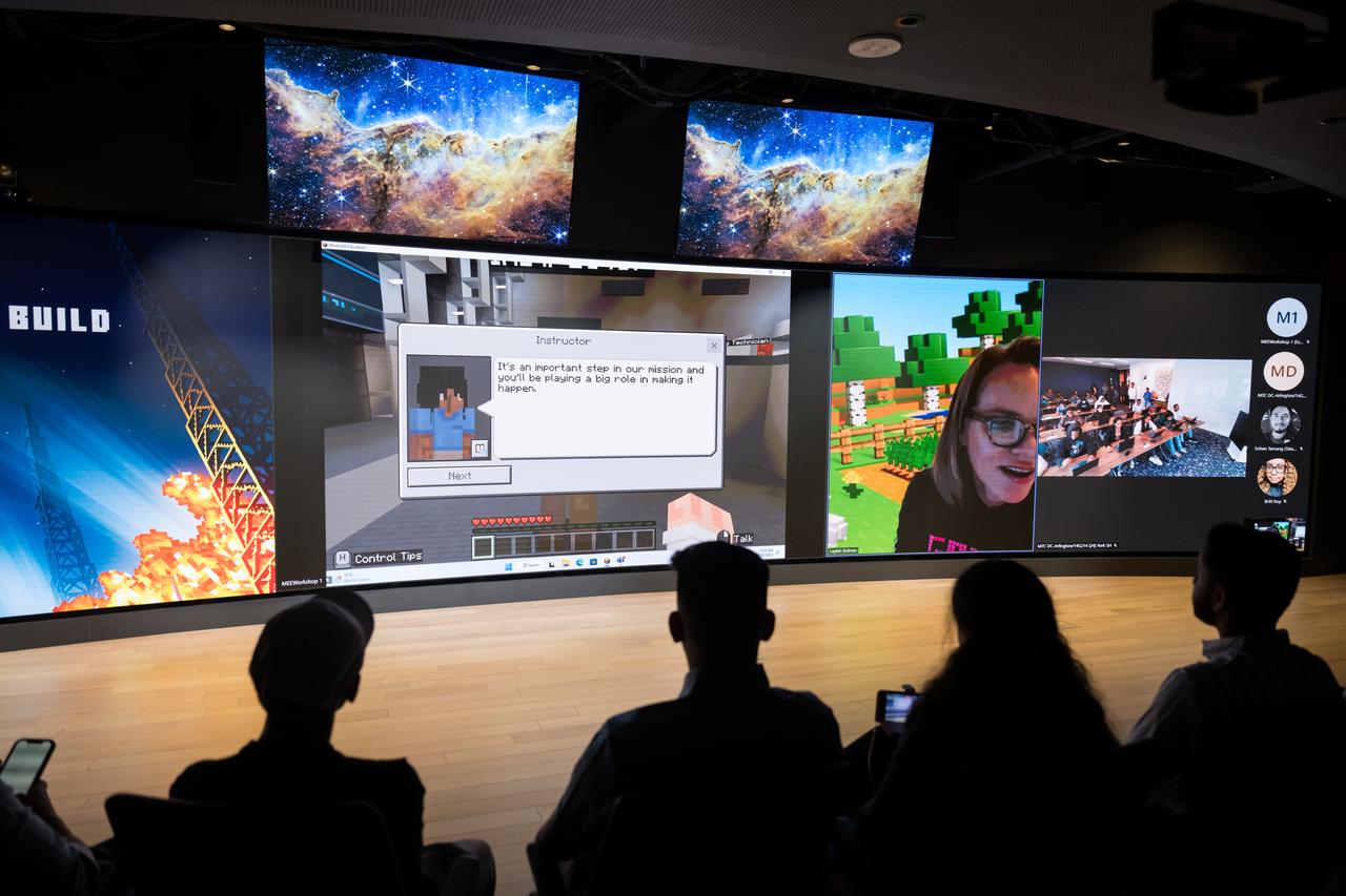
Microsoft Senior Program Manager and Executive Game Producer for Minecraft Education, Laylah Busman, provides instruction to DC area students during Space Education Day, Tuesday, June 20, 2023, at the Microsoft Technology Center in Arlington, Va. Microsoft hosted the event to showcase the collaboration, early successes, and future plans for high quality student engagement through activities that combined space content and technologies like artificial intelligence and cloud computing. Photo Credit: (NASA/Aubrey Gemignani)

DC area students participate in a Minecraft Artemis demonstration during Space Education Day, Tuesday, June 20, 2023, at the Microsoft Technology Center in Arlington, Va. Microsoft hosted the event to showcase the collaboration, early successes, and future plans for high quality student engagement through activities that combined space content and technologies like artificial intelligence and cloud computing. Photo Credit: (NASA/Aubrey Gemignani)

College students present their findings after a hackathon during Space Education Day, Tuesday, June 20, 2023, at the Microsoft Technology Center in Arlington, Va. Microsoft hosted the event to showcase the collaboration, early successes, and future plans for high quality student engagement through activities that combined space content and technologies like artificial intelligence and cloud computing. Photo Credit: (NASA/Aubrey Gemignani)

College students present their findings after a hackathon during Space Education Day, Tuesday, June 20, 2023, at the Microsoft Technology Center in Arlington, Va. Microsoft hosted the event to showcase the collaboration, early successes, and future plans for high quality student engagement through activities that combined space content and technologies like artificial intelligence and cloud computing. Photo Credit: (NASA/Aubrey Gemignani)

DC area students participate in a Minecraft Artemis demonstration during Space Education Day, Tuesday, June 20, 2023, at the Microsoft Technology Center in Arlington, Va. Microsoft hosted the event to showcase the collaboration, early successes, and future plans for high quality student engagement through activities that combined space content and technologies like artificial intelligence and cloud computing. Photo Credit: (NASA/Aubrey Gemignani)

Microsoft Senior Program Manager and Executive Game Producer for Minecraft Education, Laylah Bulman, provides instruction to DC area students during Space Education Day, Tuesday, June 20, 2023, at the Microsoft Technology Center in Arlington, Va. Microsoft hosted the event to showcase the collaboration, early successes, and future plans for high quality student engagement through activities that combined space content and technologies like artificial intelligence and cloud computing. Photo Credit: (NASA/Aubrey Gemignani)

DC area students participate in a Minecraft Artemis demonstration during Space Education Day, Tuesday, June 20, 2023, at the Microsoft Technology Center in Arlington, Va. Microsoft hosted the event to showcase the collaboration, early successes, and future plans for high quality student engagement through activities that combined space content and technologies like artificial intelligence and cloud computing. Photo Credit: (NASA/Aubrey Gemignani)

NASA Associate Administrator for the STEM Engagement Office, Mike Kincaid, provides remarks during Space Education Day, Tuesday, June 20, 2023, at the Microsoft Technology Center in Arlington, Va. Microsoft hosted the event to showcase the collaboration, early successes, and future plans for high quality student engagement through activities that combined space content and technologies like artificial intelligence and cloud computing. Photo Credit: (NASA/Aubrey Gemignani)

College students present their findings after a hackathon during Space Education Day, Tuesday, June 20, 2023, at the Microsoft Technology Center in Arlington, Va. Microsoft hosted the event to showcase the collaboration, early successes, and future plans for high quality student engagement through activities that combined space content and technologies like artificial intelligence and cloud computing. Photo Credit: (NASA/Aubrey Gemignani)
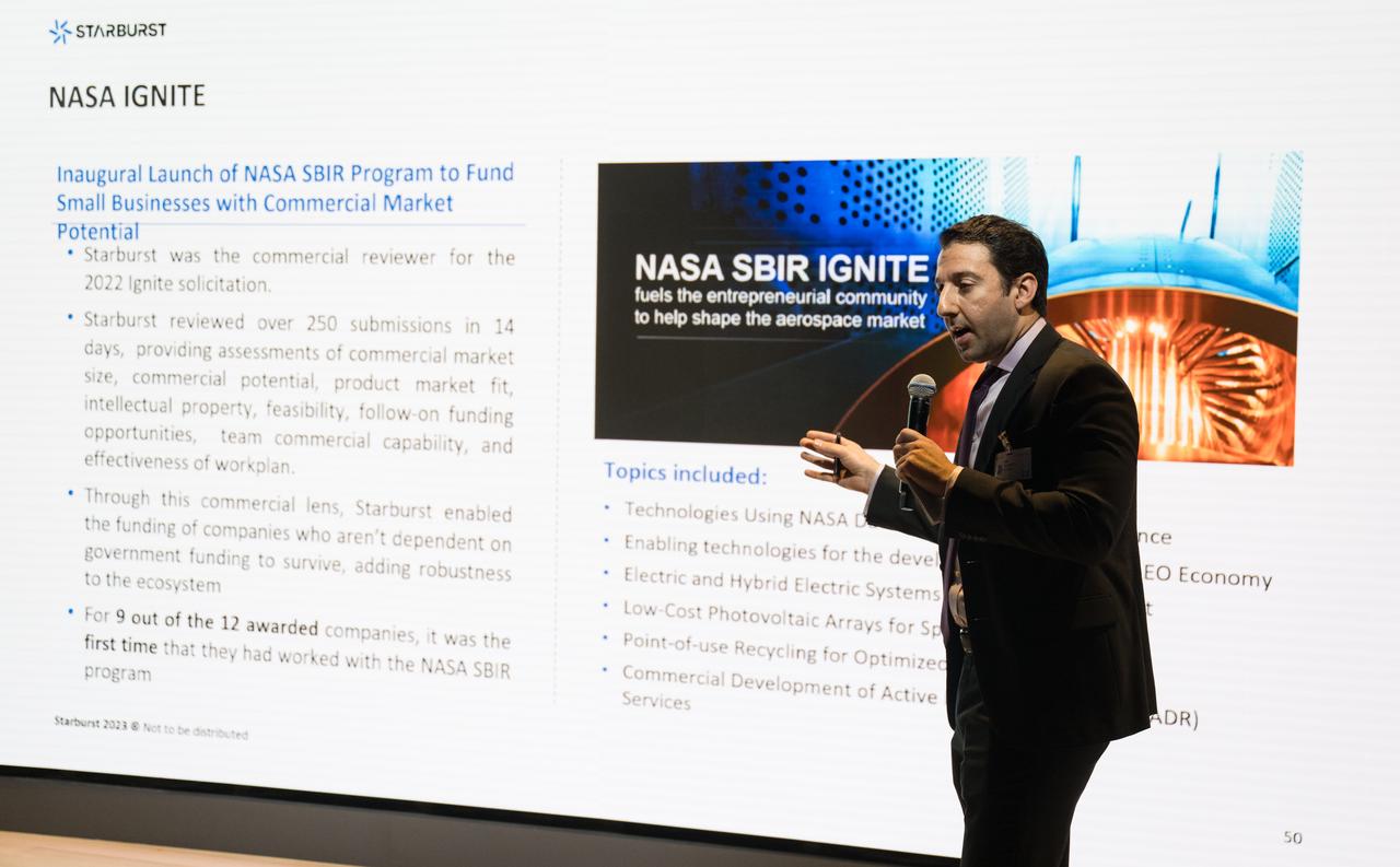
Director of Government Affairs and Business Development for Starburst Aerospace, Robert Ganim, provides remarks during Space Education Day, Tuesday, June 20, 2023, at the Microsoft Technology Center in Arlington, Va. Microsoft hosted the event to showcase the collaboration, early successes, and future plans for high quality student engagement through activities that combined space content and technologies like artificial intelligence and cloud computing. Photo Credit: (NASA/Aubrey Gemignani)
NASA Associate Administrator for the STEM Engagement Office, Mike Kincaid, provides remarks during Space Education Day, Tuesday, June 20, 2023, at the Microsoft Technology Center in Arlington, Va. Microsoft hosted the event to showcase the collaboration, early successes, and future plans for high quality student engagement through activities that combined space content and technologies like artificial intelligence and cloud computing. Photo Credit: (NASA/Aubrey Gemignani)
Microsoft Senior Program Manager and Executive Game Producer for Minecraft Education, Laylah Busman, provides instruction to DC area students during Space Education Day, Tuesday, June 20, 2023, at the Microsoft Technology Center in Arlington, Va. Microsoft hosted the event to showcase the collaboration, early successes, and future plans for high quality student engagement through activities that combined space content and technologies like artificial intelligence and cloud computing. Photo Credit: (NASA/Aubrey Gemignani)

DC area students participate in a Minecraft Artemis demonstration during Space Education Day, Tuesday, June 20, 2023, at the Microsoft Technology Center in Arlington, Va. Microsoft hosted the event to showcase the collaboration, early successes, and future plans for high quality student engagement through activities that combined space content and technologies like artificial intelligence and cloud computing. Photo Credit: (NASA/Aubrey Gemignani)
NASA Associate Administrator for the STEM Engagement Office, Mike Kincaid, provides remarks during Space Education Day, Tuesday, June 20, 2023, at the Microsoft Technology Center in Arlington, Va. Microsoft hosted the event to showcase the collaboration, early successes, and future plans for high quality student engagement through activities that combined space content and technologies like artificial intelligence and cloud computing. Photo Credit: (NASA/Aubrey Gemignani)

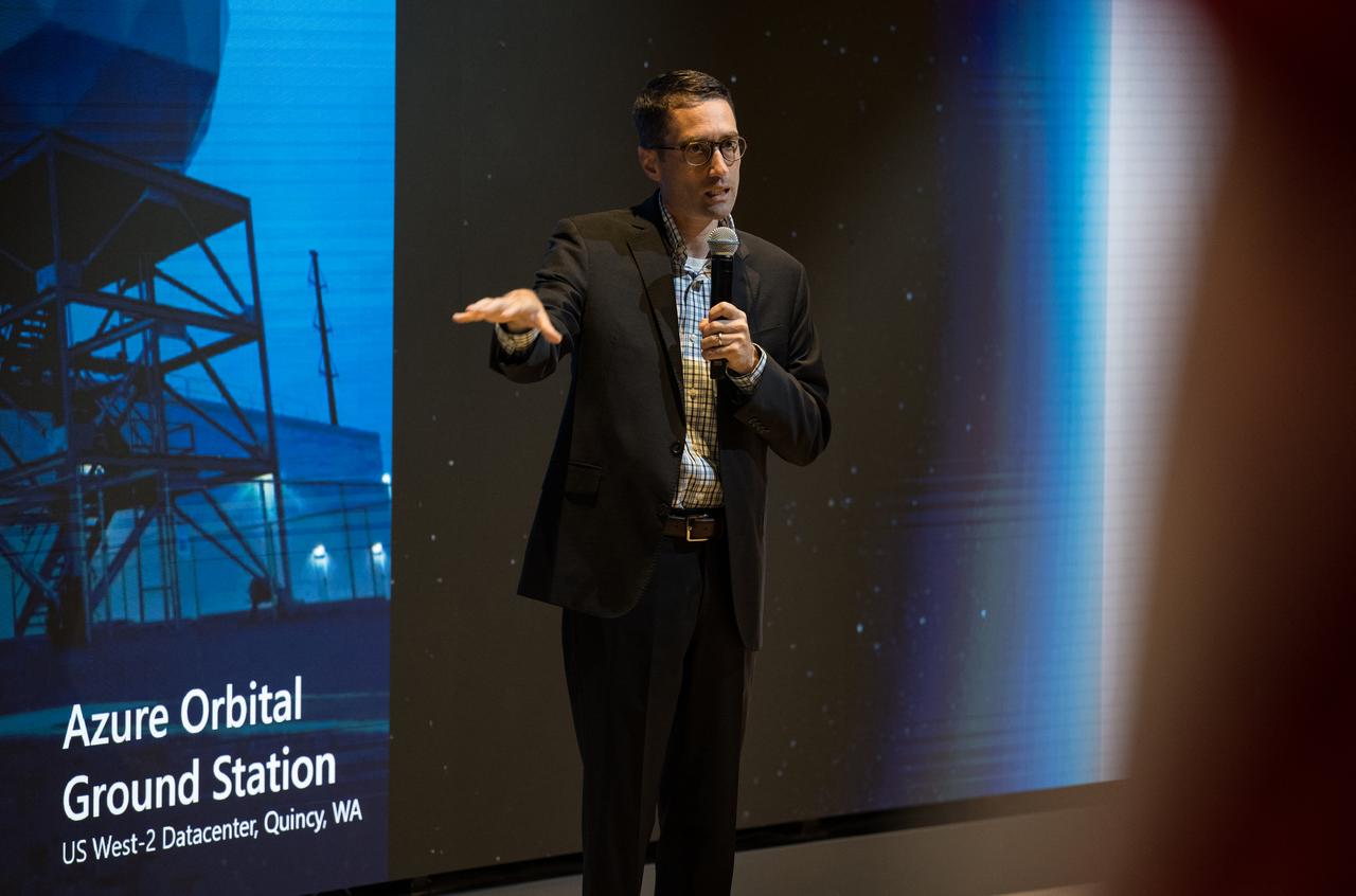
Microsoft’s Azure Space Senior Program Manager, Juan Carlos López, provides remarks during Space Education Day, Tuesday, June 20, 2023, at the Microsoft Technology Center in Arlington, Va. Microsoft hosted the event to showcase the collaboration, early successes, and future plans for high quality student engagement through activities that combined space content and technologies like artificial intelligence and cloud computing. Photo Credit: (NASA/Aubrey Gemignani)

DC area students participate in a Minecraft Artemis demonstration during Space Education Day, Tuesday, June 20, 2023, at the Microsoft Technology Center in Arlington, Va. Microsoft hosted the event to showcase the collaboration, early successes, and future plans for high quality student engagement through activities that combined space content and technologies like artificial intelligence and cloud computing. Photo Credit: (NASA/Aubrey Gemignani)

DC area students participate in a Minecraft Artemis demonstration during Space Education Day, Tuesday, June 20, 2023, at the Microsoft Technology Center in Arlington, Va. Microsoft hosted the event to showcase the collaboration, early successes, and future plans for high quality student engagement through activities that combined space content and technologies like artificial intelligence and cloud computing. Photo Credit: (NASA/Aubrey Gemignani)
Microsoft’s Azure Space Senior Director, Stephen Kitay, provides remarks during Space Education Day, Tuesday, June 20, 2023, at the Microsoft Technology Center in Arlington, Va. Microsoft hosted the event to showcase the collaboration, early successes, and future plans for high quality student engagement through activities that combined space content and technologies like artificial intelligence and cloud computing. Photo Credit: (NASA/Aubrey Gemignani)
College students present their findings after a hackathon during Space Education Day, Tuesday, June 20, 2023, at the Microsoft Technology Center in Arlington, Va. Microsoft hosted the event to showcase the collaboration, early successes, and future plans for high quality student engagement through activities that combined space content and technologies like artificial intelligence and cloud computing. Photo Credit: (NASA/Aubrey Gemignani)

Microsoft's Federal Civilian Team General Manager, Heidi Koblyski, provides remarks during Space Education Day, Tuesday, June 20, 2023, at the Microsoft Technology Center in Arlington, Va. Microsoft hosted the event to showcase the collaboration, early successes, and future plans for high quality student engagement through activities that combined space content and technologies like artificial intelligence and cloud computing. Photo Credit: (NASA/Aubrey Gemignani)

Director of Government Affairs and Business Development for Starburst Aerospace, Robert Ganim, provides remarks during Space Education Day, Tuesday, June 20, 2023, at the Microsoft Technology Center in Arlington, Va. Microsoft hosted the event to showcase the collaboration, early successes, and future plans for high quality student engagement through activities that combined space content and technologies like artificial intelligence and cloud computing. Photo Credit: (NASA/Aubrey Gemignani)

College students present their findings after a hackathon during Space Education Day, Tuesday, June 20, 2023, at the Microsoft Technology Center in Arlington, Va. Microsoft hosted the event to showcase the collaboration, early successes, and future plans for high quality student engagement through activities that combined space content and technologies like artificial intelligence and cloud computing. Photo Credit: (NASA/Aubrey Gemignani)
Director of Government Affairs and Business Development for Starburst Aerospace, Robert Ganim, provides remarks during Space Education Day, Tuesday, June 20, 2023, at the Microsoft Technology Center in Arlington, Va. Microsoft hosted the event to showcase the collaboration, early successes, and future plans for high quality student engagement through activities that combined space content and technologies like artificial intelligence and cloud computing. Photo Credit: (NASA/Aubrey Gemignani)
iss073e0817671 (Oct. 2, 2025) --- NASA astronaut and Expedition 73 Flight Engineer Jonny Kim replaces computer hardware inside the Cold Atom Lab aboard the International Space Station’s Destiny laboratory module. The Cold Atom Lab produces clouds of atoms chilled to about one ten-billionth of a degree above absolute zero—far colder than the average temperature of deep space. This extreme cold allows scientists to study fundamental behaviors and quantum characteristics that are difficult or impossible to observe on Earth.

KENNEDY SPACE CENTER, Fla. -- Under wispy white morning clouds, Space Shuttle Atlantis approaches Launch Pad 39A, which shows the Rotating Service Structure open (left) and the Fixed Service Structure (right). At the RSS, the payload canister is being lifted up to the Payload Changeout Room. This is the Shuttle’s second attempt at rollout. Jan. 2 a failed computer processor on the crawler transporter aborted the rollout and the Shuttle was returned to the Vehicle Assembly Building using a secondary computer processor on the vehicle. Atlantis will fly on mission STS-98, the seventh construction flight to the International Space Station, carrying the U.S. Laboratory, named Destiny. The lab will have five system racks already installed inside the module. After delivery of electronics in the lab, electrically powered attitude control for Control Moment Gyroscopes will be activated. Atlantis is scheduled for launch no earlier than Jan. 19, 2001, with a crew of five
KENNEDY SPACE CENTER, Fla. -- Under wispy white morning clouds, Space Shuttle Atlantis approaches Launch Pad 39A, which shows the Rotating Service Structure open (left) and the Fixed Service Structure (right). At the RSS, the payload canister is being lifted up to the Payload Changeout Room. This is the Shuttle’s second attempt at rollout. Jan. 2 a failed computer processor on the crawler transporter aborted the rollout and the Shuttle was returned to the Vehicle Assembly Building using a secondary computer processor on the vehicle. Atlantis will fly on mission STS-98, the seventh construction flight to the International Space Station, carrying the U.S. Laboratory, named Destiny. The lab will have five system racks already installed inside the module. After delivery of electronics in the lab, electrically powered attitude control for Control Moment Gyroscopes will be activated. Atlantis is scheduled for launch no earlier than Jan. 19, 2001, with a crew of five
This computer-generated image is based on an infrared image of Jupiter's north polar region that was acquired on February 2, 2017, by the Jovian Infrared Auroral Mapper (JIRAM) instrument aboard Juno during the spacecraft's fourth pass over Jupiter. The image shows the structure of the cyclonic pattern observed over Jupiter's North pole: a central cyclone surrounded by eight circumpolar cyclones with diameters ranging from 2,500 to 2,900 miles (4,000 to 4,600 kilometers) across. JIRAM is able to collect images in the infrared wavelengths around 5 micrometers (µm) by measuring the intensity of the heat coming out of the planet. The heat from a planet that is radiated into space is called the radiance. This image is an enhancement of the original JIRAM image. In order to give the picture a 3-D shape, the enhancement starts from the idea that where the radiance has its highest value, there are no clouds and JIRAM can see deeper into the atmosphere. Consequently, all the other areas of the image are originally shaded more or less by clouds of different thickness. Then, to create these pictures, the originals have been inverted to give the thicker clouds the whitish color and the third dimension as the clouds we normally see here in the Earth's atmosphere. https://photojournal.jpl.nasa.gov/catalog/PIA22336

This frame from an animation takes the viewer on a simulated flight into, and then out of, Jupiter's upper atmosphere at the location of the Great Red Spot. The perspective begins about 2,000 miles (3,000 kilometers) above the cloud tops of the planet's southern hemisphere. The bar at far left indicates altitude during the quick descent; a second gauge next to that depicts the dramatic increase in temperature that occurs as the perspective dives deeper down. The clouds turn crimson as the perspective passes through the Great Red Spot. Finally, the view ascends out of the spot. This video was created by combining an image from the JunoCam imager on NASA's Juno spacecraft with a computer-generated animation. The animation is available at https://photojournal.jpl.nasa.gov/catalog/PIA22176. - Enhanced image by Gerald Eichstädt / Justin Cowart based on images provided courtesy of NASA/JPL-Caltech/SwRI/MSSS
X-rays diffracted from a well-ordered protein crystal create sharp patterns of scattered light on film. A computer can use these patterns to generate a model of a protein molecule. To analyze the selected crystal, an X-ray crystallographer shines X-rays through the crystal. Unlike a single dental X-ray, which produces a shadow image of a tooth, these X-rays have to be taken many times from different angles to produce a pattern from the scattered light, a map of the intensity of the X-rays after they diffract through the crystal. The X-rays bounce off the electron clouds that form the outer structure of each atom. A flawed crystal will yield a blurry pattern; a well-ordered protein crystal yields a series of sharp diffraction patterns. From these patterns, researchers build an electron density map. With powerful computers and a lot of calculations, scientists can use the electron density patterns to determine the structure of the protein and make a computer-generated model of the structure. The models let researchers improve their understanding of how the protein functions. They also allow scientists to look for receptor sites and active areas that control a protein's function and role in the progress of diseases. From there, pharmaceutical researchers can design molecules that fit the active site, much like a key and lock, so that the protein is locked without affecting the rest of the body. This is called structure-based drug design.

NASA's Polar Radiant Energy in the Far-InfraRed Experiment (PREFIRE) mission will measure the amount of heat Earth emits into space from two of the coldest, most remote regions on the planet. Data from the mission will improve computer models researchers use to predict how Earth's ice, seas, and weather will change in a warming world. This artist's concept depicts one of two PREFIRE CubeSats in orbit around Earth. Earth absorbs a lot of the Sun's energy at the tropics, and weather and ocean currents transport that heat to the poles. Ice, snow, clouds, and other parts of the polar environment emit the heat into space, much of it in the form of far-infrared radiation. The difference between how much heat Earth absorbs at the tropics and then radiates out to space from the Arctic and Antarctic determines the planet's temperature and drives a dynamic system of climate and weather. But far-infrared emissions at the poles have never been systematically measured. This is where PREFIRE comes in. The mission will help researchers gain a clearer understanding of when and where Earth's poles emit far-infrared radiation, as well as how atmospheric water vapor and clouds influence the amount that escapes to space. PREFIRE is composed of two roughly shoebox-size CubeSats outfitted with specialized miniature heat sensors that will give researchers a more accurate picture of how much heat Earth emits into space. https://photojournal.jpl.nasa.gov/catalog/PIA26185
This image shows one of two shoebox-size satellites that make up NASA's Polar Radiant Energy in the Far-InfraRed Experiment (PREFIRE) mission. PREFIRE will measure the amount of heat Earth emits into space from two of the coldest, most remote regions on the planet. Data from the cube satellites, or CubeSats, will improve computer models researchers use to predict how Earth's ice, seas, and weather will change in a warming world. Earth absorbs a lot of the Sun's energy at the tropics, and weather and ocean currents transport that heat to the poles. Ice, snow, clouds, and other parts of the polar environment emit the heat into space, much of it in the form of far-infrared radiation. The difference between this incoming and outgoing heat helps to determines the planet's temperature and drives a dynamic system of climate and weather. But far-infrared emissions at the poles have never been systematically measured. This is where PREFIRE comes in. The crucial instrument on each spacecraft is a thermal infrared spectrometer, which will measure wavelengths of light in the far-infrared range. The mission will help researchers gain a clearer understanding of when and where Earth's poles emit far-infrared radiation, as well as how atmospheric water vapor and clouds influence the amount that escapes to space. https://photojournal.jpl.nasa.gov/catalog/PIA26186
This computer-generated image shows the structure of the cyclonic pattern observed over Jupiter's south pole. Like in the North, Jupiter's south pole also contains a central cyclone, but it is surrounded by five cyclones with diameters ranging from 3,500 to 4,300 miles (5,600 to 7,000 kilometers) in diameter. Almost all the polar cyclones (at both poles), are so densely packed that their spiral arms come in contact with adjacent cyclones. However, as tightly spaced as the cyclones are, they have remained distinct, with individual morphologies over the seven months of observations detailed in the paper. The data used in generating this image was collected by the Jovian Infrared Auroral Mapper (JIRAM) instrument aboard the Juno spacecraft during the fourth Juno pass over Jupiter on Feb. 2, 2017. JIRAM is able to collect images in the infrared wavelengths around 5 micrometers (µm) by measuring the intensity of the heat coming out of the planet. The heat from the planet is radiated to space and it is called radiance. This image is an enhancement of the original JIRAM image. In order to give the picture a 3-D shape, the enhancement starts from the idea that the radiance has its highest value where there are no clouds and JIRAM can see deeper into the atmosphere. Consequently, all the other areas of the image are originally shaded more or less by clouds of different thickness. Then, to create these pictures, the originals have been inverted to give the thicker clouds the whitish color and the third dimension that we see with normal clouds here in the Earth's atmosphere. https://photojournal.jpl.nasa.gov/catalog/PIA22337
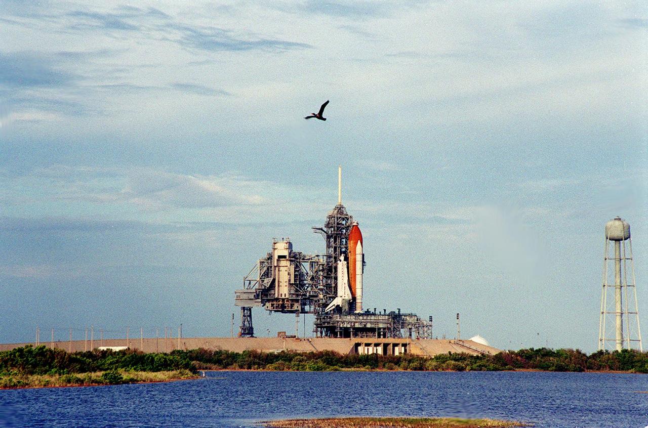
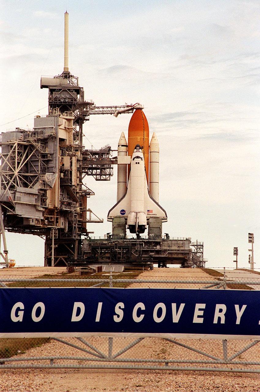
An olivaceous cormorant soars in the cloud-streaked sky near the Space Shuttle Discovery as it waits for liftoff on mission STS-103. To the left of Discovery is the Rotating Service Structure, rolled back on Dec. 16 in preparation for launch. At right is a 290-foot-high water tank with a capacity of 300,000 gallons. The tank is part of the sound suppression water system used during launch. The STS-103 mission, to service the Hubble Space Telescope, is scheduled for launch Dec. 17 at 8:47 p.m. EST from Launch Pad 39B. Mission objectives include replacing gyroscopes and an old computer, installing another solid state recorder, and replacing damaged insulation in the telescope. The mission is expected to last about 8 days and 21 hours. Discovery is expected to land at KSC Sunday, Dec. 26, at about 6:25 p.m. EST
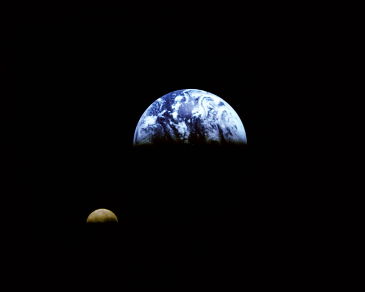
Eight days after its encounter with the Earth, the Galileo spacecraft was able to look back and capture this remarkable view of the Moon in orbit about the Earth, taken from a distance of about 6.2 million kilometers (3.9 million miles). The picture was constructed from images taken through the violet, red, and 1.0-micron infrared filters. The Moon is in the foreground, moving from left to right. The brightly-colored Earth contrasts strongly with the Moon, which reflects only about one-third as much sunlight as the Earth. Contrast and color have been computer-enhanced for both objects to improve visibility. Antarctica is visible through clouds (bottom). The Moon's far side is seen; the shadowy indentation in the dawn terminator is the south-Pole/Aitken Basin, one of the largest and oldest lunar impact features. Alternate Jet Propulsion Laboratory (JPL) number is P-41508. View appears in the Space News Roundup v32 n1 p1, 01-11-93.
Somewhere down there sits the Mars Pathfinder lander and Sojourner rover. This Mars Global Surveyor Mars Orbiter Camera view of the red planet shows the region that includes Ares Vallis and the Chryse Plains upon which both Mars Pathfinder and the Viking 1 landed in 1997 and 1976, respectively. Acidalia Planitia is the dark surface that dominates the center left. The Pathfinder site is immediately south of Acidalia, just left of center in this view. Also shown--the north polar cap is at the top, and Arabia Terra and Sinus Meridiani are to the right. The bluish-white features are clouds. This is a color composite of 9 red and 9 blue image strips taken by the Mars Global Surveyor Mars Orbiter Camera on 9 successive orbits from pole-to-pole during the calibration phase of the mission in March 1999. The color is computer-enhanced and is not shown as it would actually appear to the human eye. http://photojournal.jpl.nasa.gov/catalog/PIA02000
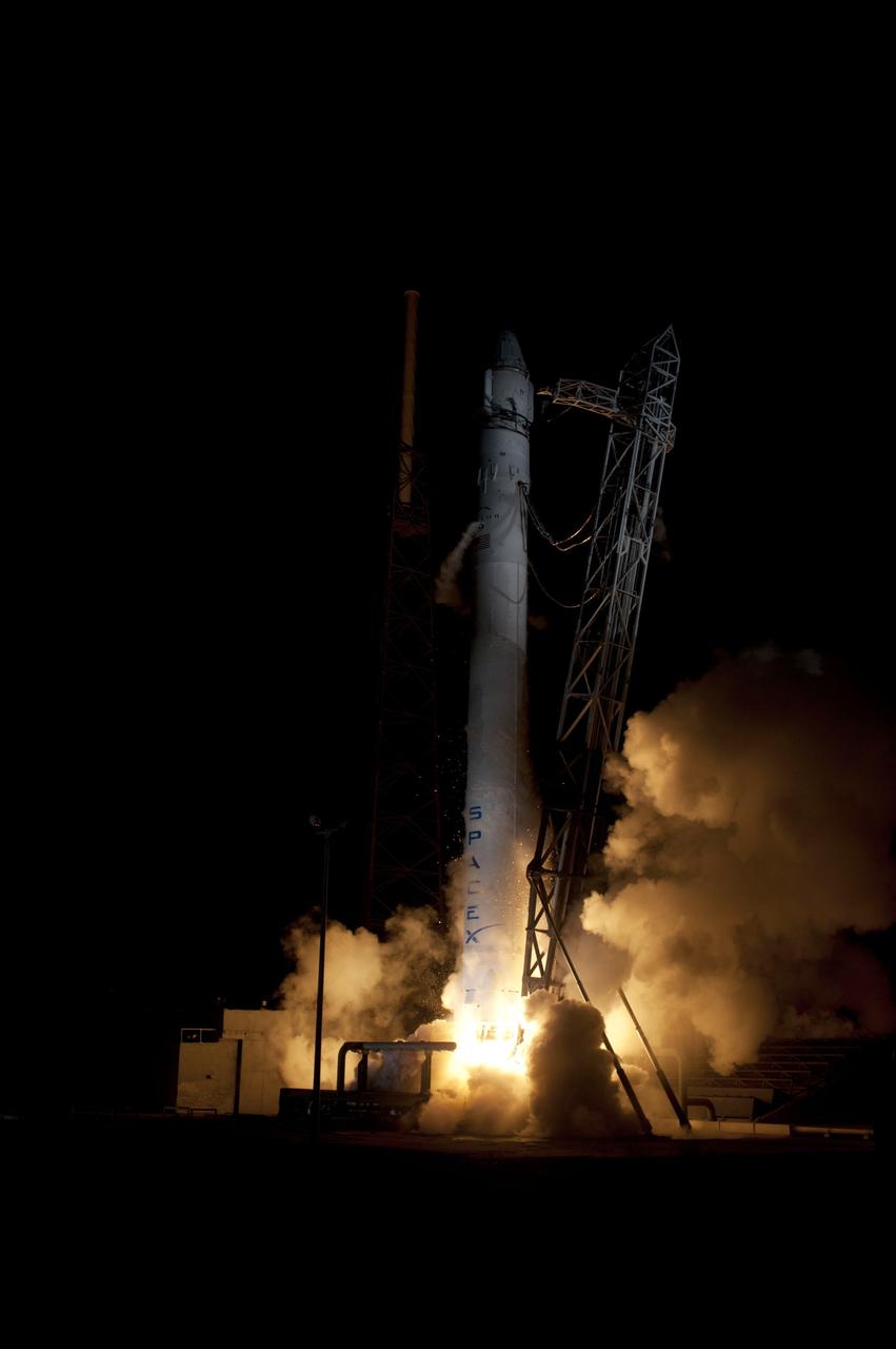
CAPE CANAVERAL, Fla. – An exhaust cloud begins to form around the SpaceX Falcon 9 rocket as it lifts off Space Launch Complex-40 on Cape Canaveral Air Force Station in Florida at 3:44 a.m. EDT. The launch is the company's second demonstration test flight for NASA's Commercial Orbital Transportation Services, or COTS, Program. During the flight, the Dragon capsule will conduct a series of check-out procedures to test and prove its systems, including rendezvous and berthing with the International Space Station. If the capsule performs as planned, the cargo and experiments it is carrying will be transferred to the station. The cargo includes food, water and provisions for the station’s Expedition crews, such as clothing, batteries and computer equipment. Under COTS, NASA has partnered with two aerospace companies to deliver cargo to the station. For more information, visit http://www.nasa.gov/spacex. Photo credit: NASA/Rick Wetherington, Tim Powers and Tim Terry
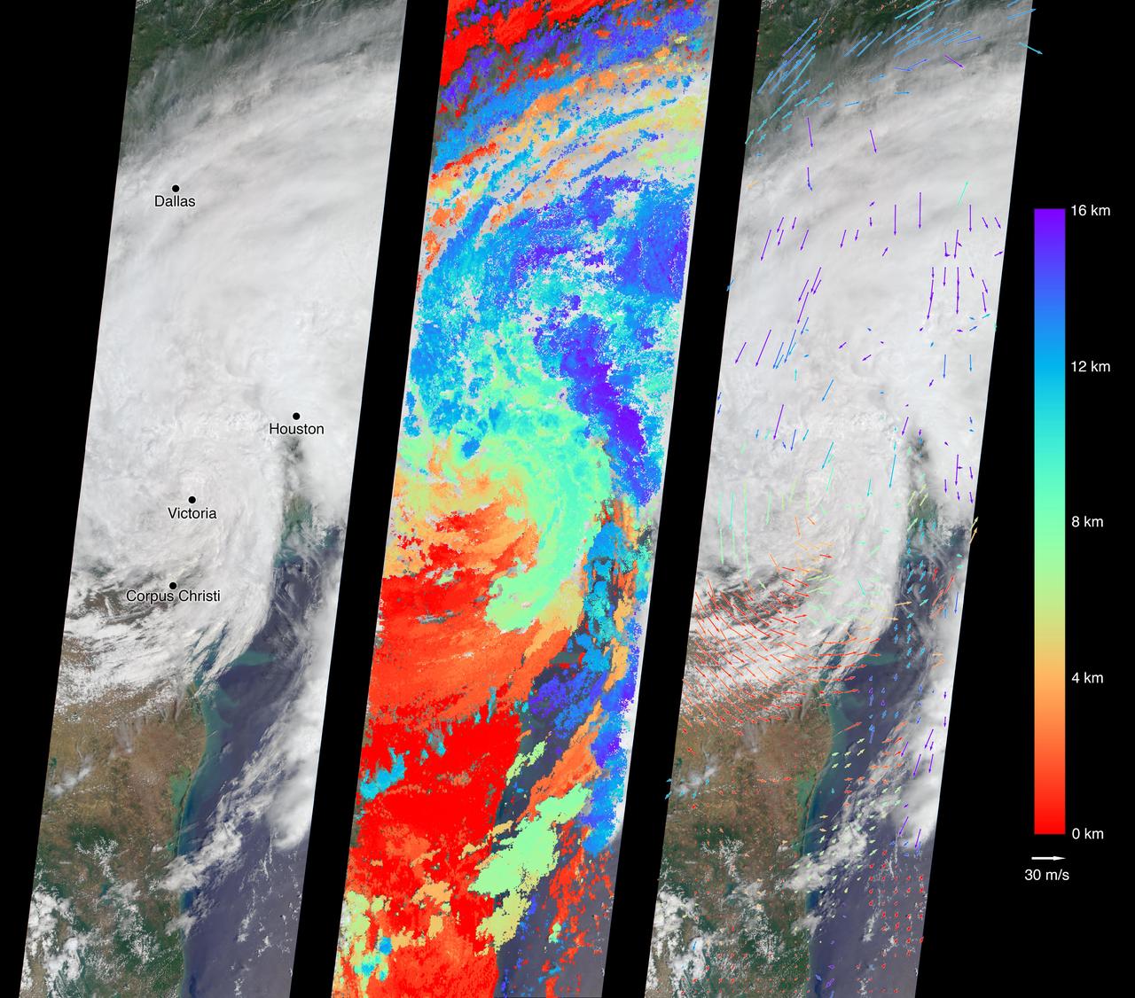
On Aug. 27, 2017, the Multi-angle Imaging SpectroRadiometer (MISR) instrument on NASA's Terra satellite passed over then-Tropical Storm Harvey about noon local time, the day after the storm first made landfall in Texas as a Category 4 hurricane. The MISR instrument is equipped with nine cameras that observe Earth at different angles over a time period of seven minutes. Geometric information from the multiple camera views is used to compute the cloud top heights, and motion of the clouds during the image sequence is used to calculate wind speed. This composite image shows the storm as viewed by the central, downward-looking camera (left), as well as the cloud top heights in kilometers (center) and the wind speeds (right) superimposed on the image. The length of the arrows is proportional to the wind speed, while their color shows the altitude at which the winds were calculated. Also included is an animation made by combining all nine images from the MISR cameras, showing the motion of the storm during the seven-minute period. At this time, the center of the tropical storm was located just northwest of the city of Victoria and maximum wind speeds on the ground were around 40 miles per hour (65 kilometers per hour) according to the National Oceanic and Atmospheric Administration (NOAA), which matches well with the near-surface winds calculated by MISR to the west of Corpus Christi. In the 36 hours or so since it had made landfall, Harvey had weakened considerably -- these images show that the eye had disappeared and much of the circular motion of storm had dissipated, as shown by the calculated wind directions. However, the area of very high clouds and strong winds near Houston shows that the storm was continuing to produce powerful rain bands. At this point, hydrographs managed by NOAA in downtown Houston were already recording flood stage at both the Buffalo Bayou (28 feet or 8.5 meters as of 12:15 p.m. CDT August 27) and the White Oak Bayou (40 feet or 12 meters at last record that morning). The MISR data show the storm clouds reaching an altitude of about 10 miles (16 kilometers). These data were captured during Terra orbit 94108. An animation is available at https://photojournal.jpl.nasa.gov/catalog/PIA21927

jsc2022e062020 (6/30/2022) --- Space Health will create a digital twin of the astronaut from the data collected by the Bio-Monitor and demonstrate how this could be used for autonomous health monitoring on future space missions. (Image courtesy of CSA)
After sunup, which is obscured by a cloud-filled sky, Space Shuttle Discovery waits atop the mobile launcher platform for launch of mission STS-103. At the top is seen the external tank gaseous oxygen vent arm system with the vent hood (commonly called the "beanie cap") poised above the external tank. The retractable arm and the beanie cap are designed to vent gaseous oxygen vapors away from the Space Shuttle. The arm truss section is 65 feet long and the diameter of the vent hood is 13 feet. Extending toward the cabin of the orbiter below is the orbiter access arm, with the environmental chamber (called the White Room) at the end. Through this chamber the crew enters the orbiter. The STS-103 mission, to service the Hubble Space Telescope, is scheduled for launch Dec. 17 at 8:47 p.m. EST. Mission objectives include replacing gyroscopes and an old computer, installing another solid state recorder, and replacing damaged insulation in the telescope. The mission is expected to last about 8 days and 21 hours. Discovery is expected to land at KSC Sunday, Dec. 26, at about 6:25 p.m. EST
KENNEDY SPACE CENTER, FLA. -- As if spawned by the clouds of smoke and steam below, the Space Shuttle Discovery shoots into the night sky on mission STS-103. The brilliant light creates a reflection of the launch in the water nearby. Liftoff occurred at 7:50 p.m. EST from Launch Pad 39B. On board are Commander Curtis L. Brown Jr., Pilot Scott J. Kelly and Mission Specialists Steven L. Smith, C. Michael Foale (Ph.D.), John M. Grunsfeld (Ph.D.), Claude Nicollier of Switzerland and Jean-François Clervoy of France. Nicollier and Clervoy are with the European Space Agency. STS-103 is a Hubble Servicing Mission, with three planned space walks designed to install new equipment and replace old. The primary objective is to replace the gyroscopes that make up the three Rate Sensor Units. Extravehicular activities include installing a new computer, changing out one of the Fine Guidance Sensors, replacing a tape recorder with a new solid state recorder, and installing a voltage/temperature improvement kit, and begin repairing the insulation on the telescope's outer surface. After the 7-day, 21-hour mission, Discovery is expected to land at KSC Monday, Dec. 27, at about 5:24 p.m. EST. This is the 27th flight of Discovery and the 96th mission in the Space Shuttle Program. It is the third launch at Kennedy Space Center in 1999

Turning night into day for a few moments while belching clouds of smoke and steam, Space Shuttle Discovery hurtles into the black sky on mission STS-103. The successful liftoff occurred at 7:50 p.m. EST from Launch Pad 39B. On board are Commander Curtis L. Brown Jr., Pilot Scott J. Kelly and Mission Specialists Steven L. Smith, C. Michael Foale (Ph.D.), John M. Grunsfeld (Ph.D.), Claude Nicollier of Switzerland and Jean-François Clervoy of France. Nicollier and Clervoy are with the European Space Agency. STS-103 is a Hubble Servicing Mission, with three planned space walks designed to install new equipment and replace old. The primary objective is to replace the gyroscopes that make up the three Rate Sensor Units. Extravehicular activities include installing a new computer, changing out one of the Fine Guidance Sensors, replacing a tape recorder with a new solid state recorder, and installing a voltage/temperature improvement kit, and begin repairing the insulation on the telescope's outer surface. After the 7-day, 21-hour mission, Discovery is targeted to land at KSC Monday, Dec. 27, at about 5:24 p.m. EST. This is the 27th flight of Discovery and the 96th mission in the Space Shuttle Program. It is the third launch at Kennedy Space Center in 1999
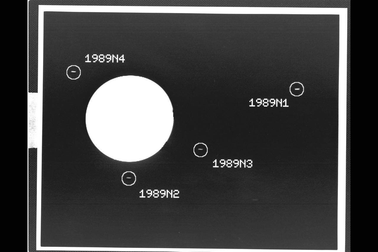
P-34540 Range: 37.3 million kilometers (23.6 million miles) This image captured by the Voyager 2 spacecraft was used to confirm the discovery of three new satellites orbiting Neptune. The 46-second exposure was taken with the narrow angle camera and shows the large globe of the planet to be severely overexposed and almost pure white in appearance. The image has been computer-processed to accentuate the new moons, which otherwise would be hard to distinguish from background noise. The satellite 1989N1, at right in this frame, was discovered by Voyager 2 in early July 1989. The new satellites confirmed later are 1989N2, 1989N3 and 1989N4. Each of the moons appears as a small streak, an effect caused by movement of the spacecraft during the long exposure. The new moons occupy nearly circular and equatorial orbits ranging from about 27,300 to 48,300 kilometers (17,000 to 30,000 miles) from Neptunes's cloud tops, and are estimated to range in diameter from about 100 to 200 kilometers (about 60 to 125 miles).

Space Shuttle Discovery hurtles through clouds of smoke and steam in its successful launch on mission STS-103. Liftoff occurred at 7:50 p.m. EST from Launch Pad 39B. On board are Commander Curtis L. Brown Jr., Pilot Scott J. Kelly and Mission Specialists Steven L. Smith, C. Michael Foale (Ph.D.), John M. Grunsfeld (Ph.D.), Claude Nicollier of Switzerland and Jean-François Clervoy of France. Nicollier and Clervoy are with the European Space Agency. STS-103 is a Hubble Servicing Mission, with three planned space walks designed to install new equipment and replace old. The primary objective is to replace the gyroscopes that make up the three Rate Sensor Units. Extravehicular activities include installing a new computer, changing out one of the Fine Guidance Sensors, replacing a tape recorder with a new solid state recorder, and installing a voltage/temperature improvement kit, and begin repairing the insulation on the telescope's outer surface. After the 7-day, 21-hour mission, Discovery is targeted to land at KSC Monday, Dec. 27, at about 5:24 p.m. EST. This is the 27th flight of Discovery and the 96th mission in the Space Shuttle Program. It is the third launch at Kennedy Space Center in 1999
A cloud-streaked sky provides backdrop for Space Shuttle Discovery as it waits for liftoff on mission STS-103 from Launch Pad 39B. The tower at its left is the Fixed Service Structure, topped by the 80-foot-tall fiberglass mast that helps provide protection from lightning strikes. Below it, extending outward, is the external tank gaseous oxygen vent arm system with the vent hood (commonly called the "beanie cap") poised above the external tank. The retractable arm and the beanie cap are designed to vent gaseous oxygen vapors away from the Space Shuttle. The arm truss section is 65 feet long and the diameter of the vent hood is 13 feet. Extending toward the cabin of the orbiter below is the orbiter access arm, with the environmental chamber (called the White Room) at the end. Through this chamber the crew enters the orbiter. The STS-103 mission, to service the Hubble Space Telescope, is scheduled for launch Dec. 17 at 8:47 p.m. EST. Mission objectives include replacing gyroscopes and an old computer, installing another solid state recorder, and replacing damaged insulation in the telescope. The mission is expected to last about 8 days and 21 hours. Discovery is expected to land at KSC Sunday, Dec. 26, at about 6:25 p.m. EST

This false-color image composite from NASA's Spitzer Space Telescope reveals hidden populations of newborn stars at the heart of the colliding "Antennae" galaxies. These two galaxies, known individually as NGC 4038 and 4039, are located around 68 million light-years away and have been merging together for about the last 800 million years. The latest Spitzer observations provide a snapshot of the tremendous burst of star formation triggered in the process of this collision, particularly at the site where the two galaxies overlap. The image is a composite of infrared data from Spitzer and visible-light data from Kitt Peak National Observatory, Tucson, Ariz. Visible light from stars in the galaxies (blue and green) is shown together with infrared light from warm dust clouds heated by newborn stars (red). The two nuclei, or centers, of the merging galaxies show up as yellow-white areas, one above the other. The brightest clouds of forming stars lie in the overlap region between and left of the nuclei. Throughout the sky, astronomers have identified many of these so-called "interacting" galaxies, whose spiral discs have been stretched and distorted by their mutual gravity as they pass close to one another. The distances involved are so large that the interactions evolve on timescales comparable to geologic changes on Earth. Observations of such galaxies, combined with computer models of these collisions, show that the galaxies often become forever bound to one another, eventually merging into a single, spheroidal-shaped galaxy. Wavelengths of 0.44 microns are represented in blue, .70 microns in green and 8.0 microns in red. This image was taken on Dec. 24, 2003. http://photojournal.jpl.nasa.gov/catalog/PIA06854
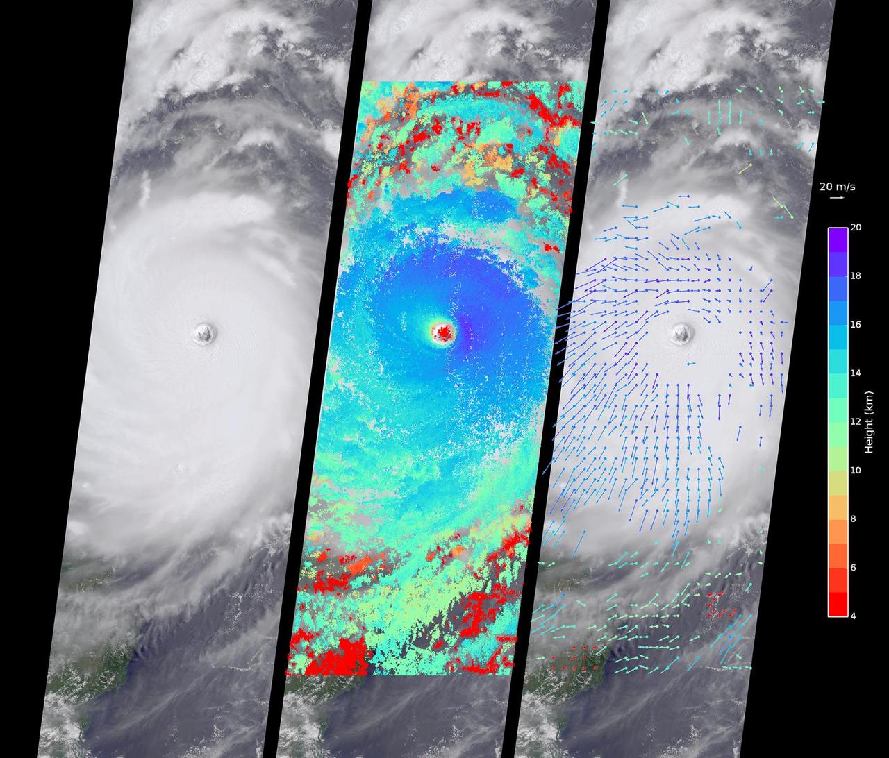
Typhoon Nepartak, the first large typhoon in the northwest Pacific this season, is currently taking aim at the east coast of Taiwan. Over the past few days, Nepartak has rapidly gained strength, growing from a tropical storm to the equivalent of a Category 5 hurricane with sustained wind speeds of more than 160 miles (258 kilometers) per hour. Taiwan's Central Weather Bureau has issued a torrential rain warning, bracing for likely flooding as 5 to 15 inches (13 to 38 centimeters) of rain are expected to fall over Taiwan during the storm's passage. Waves of up to 40 feet (12 meters) are predicted on the coast as the typhoon approaches, and air and train travel have been severely impacted. The typhoon is currently moving at about 10 miles per hour (16 kilometers) to the west-northwest, and is predicted to pass over Taiwan within the next day and then hit the coast of mainland China. Central and eastern China are poorly situated to absorb the rainfall from Nepartak after suffering the effects of severe monsoon flooding, which has killed at least 140 people in the past week. The Multi-angle Imaging SpectroRadiometer (MISR) instrument aboard NASA's Terra satellite captured this view of Typhoon Nepartak on July 7, 2016, at 10:30 a.m. local time (2:30 a.m. UTC). On the left is an image from the nadir (vertical pointing) camera, which shows the central portion of Nepartak and the storm's eye. The image is about 235 miles (378 kilometers) across. The island of Manila in the Philippines, about 250 miles (400 kilometers) south of Taiwan, is visible to the southwest of the eye. The image shows that Nepartak's center is extremely compact, rather than broken up into spiral bands as is more typical of typhoons. This means that the storm may retain more of its strength as it passes over land. MISR uses nine cameras to capture images of the typhoon from different angles. This provides a stereographic view, which can be used to determine the height of the storm's cloud tops. These heights are plotted in the middle panel, superimposed on the image. This shows that the cloud tops are relatively low, about 2.5 miles (4 kilometers), in the eye, but much higher, up to 12.5 miles (20 kilometers), just outside it. By tracking the motion of clouds as they are viewed by each of the nine cameras over about seven minutes, it is possible to also derive how fast the clouds are moving due to wind. These wind vectors are superimposed on the image in the right panel. The length of each arrow shows the wind speed at that location (compare to the 45 miles per hour or 20 meters per second arrow in the legend), and the color shows the height at which the wind is being computed. The motion of the low-level winds (red and yellow arrows) is counterclockwise, while the motion of the high winds (blue and purple arrows) is mostly clockwise. This is because hurricanes draw in warm, moist air at low altitudes, which then flows upward around the eye, releases its moisture as rain, and moves outward at high altitudes. As is typical of these types of storm systems, the inflowing low winds and the outflowing high winds spin in different directions. http://photojournal.jpl.nasa.gov/catalog/PIA20719
The bridge of the R/V Atlantis houses a sophisticated collection of computer controlled navigation systems, station-keeping controls and communications capabilities. Even in heavy seas, the ship can hold its position within a margin of just a few meters. --- The <b><a href="http://naames.larc.nasa.gov/" rel="nofollow">North Atlantic Aerosols and Marine Ecosystems Study </a></b> (NAAMES) is a five year investigation to resolve key processes controlling ocean system function, their influences on atmospheric aerosols and clouds and their implications for climate. Michael Starobin joined the NAAMES field campaign on behalf of Earth Expeditions and NASA Goddard Space Flight Center’s Office of Communications. He presented stories about the important, multi-disciplinary research being conducted by the NAAMES team, with an eye towards future missions on the NASA drawing board. This is a NAAMES photo essay put together by Starobin, a collection of 49 photographs and captions. Photo and Caption Credit: Michael Starobin <b><a href="http://www.nasa.gov/audience/formedia/features/MP_Photo_Guidelines.html" rel="nofollow">NASA image use policy</a></b> <b><a href="http://www.nasa.gov/centers/goddard/home/index.html" rel="nofollow">NASA Goddard Space Flight Center</a></b> enables NASA’s mission through four scientific endeavors: Earth Science, Heliophysics, Solar System Exploration, and Astrophysics. Goddard plays a leading role in NASA’s accomplishments by contributing compelling scientific knowledge to advance the Agency’s mission. <b>Follow us on <a href="http://twitter.com/NASAGoddardPix" rel="nofollow">Twitter</a></b> <b>Like us on <a href="http://www.facebook.com/pages/Greenbelt-MD/NASA-Goddard/395013845897?ref=tsd" rel="nofollow">Facebook</a></b> <b>Find us on <a href="https://www.instagram.com/nasagoddard/?hl=en" rel="nofollow">Instagram</a></b>
This topographic image acquired by SRTM shows an area south of the Sao Francisco River in Brazil. The scrub forest terrain shows relief of about 400 meters (1300 feet). Areas such as these are difficult to map by traditional methods because of frequent cloud cover and local inaccessibility. This region has little topographic relief, but even subtle changes in topography have far-reaching effects on regional ecosystems. The image covers an area of 57 km x 79 km and represents one quarter of the 225 km SRTM swath. Colors range from dark blue at water level to white and brown at hill tops. The terrain features that are clearly visible in this image include tributaries of the Sao Francisco, the dark-blue branch-like features visible from top right to bottom left, and on the left edge of the image, and hills rising up from the valley floor. The San Francisco River is a major source of water for irrigation and hydroelectric power. Mapping such regions will allow scientists to better understand the relationships between flooding cycles, forestation and human influences on ecosystems. This shaded relief image was generated using topographic data from the Shuttle Radar Topography Mission. A computer-generated artificial light source illuminates the elevation data to produce a pattern of light and shadows. Slopes facing the light appear bright, while those facing away are shaded. On flatter surfaces, the pattern of light and shadows can reveal subtle features in the terrain. Shaded relief maps are commonly used in applications such as geologic mapping and land use planning. http://photojournal.jpl.nasa.gov/catalog/PIA02700
This illustration shows a cool star, called W1906+40, marked by a raging storm near one of its poles. The storm is thought to be similar to the Great Red Spot on Jupiter. Scientists discovered it using NASA's Kepler and Spitzer space telescopes. The location of the storm is estimated to be near the north pole of the star based on computer models of the data. The telescopes cannot see the storm itself, but learned of its presence after observing how the star's light changes over time. The storm travels around with the star, making a full lap about every 9 hours. When it passes into a telescope's field of view, it causes light of particular infrared and visible wavelengths to dip in brightness. The storm has persisted for at least two years. Astronomers aren't sure why it has lasted so long. While planets are known to have cloudy storms, this is the best evidence yet for a star with the same type of storm. The star, W1906+40, belongs to a thermally cool class of objects called L-dwarfs. Some L-dwarfs are considered stars because they fuse atoms and generate light, as our sun does, while others, called brown dwarfs, are known as "failed stars" for their lack of atomic fusion. The L-dwarf W1906+40 is thought to be a star based on estimates of its age (the older the L-dwarf, the more likely it is a star). Its temperature is about 2,200 Kelvin (3,500 degrees Fahrenheit). That may sound scorching hot, but as far as stars go, it is relatively cool. Cool enough, in fact, for clouds to form in its atmosphere. W1906+40 is located 53 light-years away in the constellation Lyra. http://photojournal.jpl.nasa.gov/catalog/PIA20055
KENNEDY SPACE CENTER, FLA. -- Under low clouds and fog, Space Shuttle Discovery makes its trek along the stretch of crawlerway between the Vehicle Assembly Building and Launch Pad 39B atop the mobile launcher platform and crawler transporter. Once at the pad, the orbiter, external tank and solid rocket boosters will undergo final preparations for the STS-103 launch targeted for Dec. 6, 1999, at 2:37 a.m. EST. The mission is a "call-up" due to the need to replace portions of the pointing system the gyros which have begun to fail on the Hubble Space Telescope. Although Hubble is operating normally and conducting its scientific observations, only three of its six gyroscopes are working properly. The gyroscopes allow the telescope to point at stars, galaxies and planets. The STS-103 crew will also be installing a Fine Guidance Sensor, a new enhanced computer, a solid-state digital recorder, and a new spare transmitter to replace older equipment, and replacing degraded insulation on the telescope with new thermal insulation. The crew will also install a Battery Voltage/Temperature Improvement Kit to protect the spacecraft batteries from overcharging and overheating when the telescope goes into a safe mode. Four EVA's are planned to make the necessary repairs and replacements on the telescope. The STS-103 crew members are Commander Curtis L. Brown Jr., Pilot Scott J. Kelly, Mission Specialist Steven L. Smith, Mission Specialist C. Michael Foale (Ph.D.), Mission Specialist John M. Grunsfeld (Ph.D.), and Mission Specialist Claude Nicollier of Switzerland, and Mission Specialist Jean-François Clervoy of France, both with the European Space Agency
KENNEDY SPACE CENTER, FLA. -- Under low clouds and fog, Space Shuttle Discovery makes its trek along the stretch of crawlerway between the Vehicle Assembly Building and Launch Pad 39B atop the mobile launcher platform and crawler transporter. Once at the pad, the orbiter, external tank and solid rocket boosters will undergo final preparations for the STS-103 launch targeted for Dec. 6, 1999, at 2:37 a.m. EST. The mission is a "call-up" due to the need to replace portions of the pointing system the gyros which have begun to fail on the Hubble Space Telescope. Although Hubble is operating normally and conducting its scientific observations, only three of its six gyroscopes are working properly. The gyroscopes allow the telescope to point at stars, galaxies and planets. The STS-103 crew will also be installing a Fine Guidance Sensor, a new enhanced computer, a solid-state digital recorder, and a new spare transmitter to replace older equipment, and replacing degraded insulation on the telescope with new thermal insulation. The crew will also install a Battery Voltage/Temperature Improvement Kit to protect the spacecraft batteries from overcharging and overheating when the telescope goes into a safe mode. Four EVA's are planned to make the necessary repairs and replacements on the telescope. The STS-103 crew members are Commander Curtis L. Brown Jr., Pilot Scott J. Kelly, Mission Specialist Steven L. Smith, Mission Specialist C. Michael Foale (Ph.D.), Mission Specialist John M. Grunsfeld (Ph.D.), and Mission Specialist Claude Nicollier of Switzerland, and Mission Specialist Jean-François Clervoy of France, both with the European Space Agency.
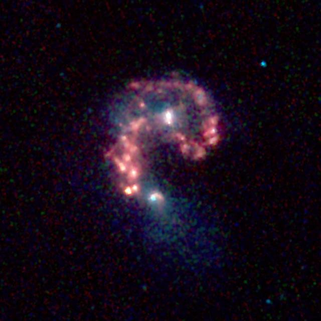
This false-color image from NASA's Spitzer Space Telescope reveals hidden populations of newborn stars at the heart of the colliding "Antennae" galaxies. These two galaxies, known individually as NGC 4038 and 4039, are located around 68 million light-years away and have been merging together for about the last 800 million years. The latest Spitzer observations provide a snapshot of the tremendous burst of star formation triggered in the process of this collision, particularly at the site where the two galaxies overlap. The image was taken by Spitzer's infrared array camera and is a combination of infrared light ranging from 3.6 microns (shown in blue) to 8.0 microns (shown in red). The dust emission (red) is by far the strongest feature in this image. Starlight was systematically subtracted from the longer wavelength data (red) to enhance dust features. The two nuclei, or centers, of the merging galaxies show up as white areas, one above the other. The brightest clouds of forming stars lie in the overlap region between and left of the nuclei. Throughout the sky, astronomers have identified many of these so-called "interacting" galaxies, whose spiral discs have been stretched and distorted by their mutual gravity as they pass close to one another. The distances involved are so large that the interactions evolve on timescales comparable to geologic changes on Earth. Observations of such galaxies, combined with computer models of these collisions, show that the galaxies often become forever bound to one another, eventually merging into a single, spheroidal-shaped galaxy. Wavelengths of 3.6 microns are represented in blue, 4.5 microns in green and 5.8-8.0 microns in red. This image was taken on Dec. 24, 2003. http://photojournal.jpl.nasa.gov/catalog/PIA06853
The R/V Atlantis houses sophisticated science laboratories, including rooms for computer use, “wet” work, chemical analysis and more. --- The <b><a href="http://naames.larc.nasa.gov/" rel="nofollow">North Atlantic Aerosols and Marine Ecosystems Study </a></b> (NAAMES) is a five year investigation to resolve key processes controlling ocean system function, their influences on atmospheric aerosols and clouds and their implications for climate. Michael Starobin joined the NAAMES field campaign on behalf of Earth Expeditions and NASA Goddard Space Flight Center’s Office of Communications. He presented stories about the important, multi-disciplinary research being conducted by the NAAMES team, with an eye towards future missions on the NASA drawing board. This is a NAAMES photo essay put together by Starobin, a collection of 49 photographs and captions. Photo and Caption Credit: Michael Starobin <b><a href="http://www.nasa.gov/audience/formedia/features/MP_Photo_Guidelines.html" rel="nofollow">NASA image use policy</a></b> <b><a href="http://www.nasa.gov/centers/goddard/home/index.html" rel="nofollow">NASA Goddard Space Flight Center</a></b> enables NASA’s mission through four scientific endeavors: Earth Science, Heliophysics, Solar System Exploration, and Astrophysics. Goddard plays a leading role in NASA’s accomplishments by contributing compelling scientific knowledge to advance the Agency’s mission. <b>Follow us on <a href="http://twitter.com/NASAGoddardPix" rel="nofollow">Twitter</a></b> <b>Like us on <a href="http://www.facebook.com/pages/Greenbelt-MD/NASA-Goddard/395013845897?ref=tsd" rel="nofollow">Facebook</a></b> <b>Find us on <a href="https://www.instagram.com/nasagoddard/?hl=en" rel="nofollow">Instagram</a></b>
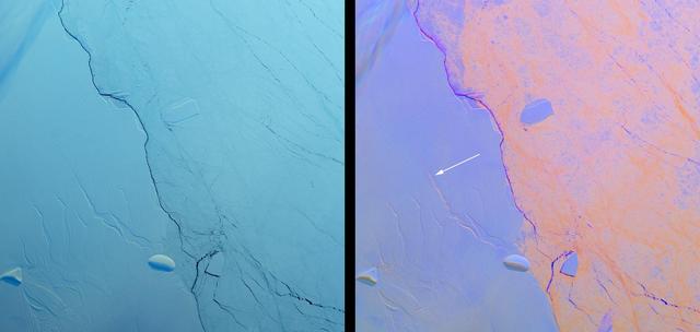
Project MIDAS, a United Kingdom-based group that studies the Larsen Ice Shelf in Antarctica, reported Aug. 18, 2016, that a large crack in the Larsen C shelf has grown by another 13 miles (22 kilometers) in the past six months. The crack is now more than 80 miles (130 kilometers) long. Larsen C is the fourth largest ice shelf in Antarctica, with an area of about 19,300 square miles (50,000 square kilometers), greater than the size of Maryland. Computer modeling by Project MIDAS predicts that the crack will continue to grow and eventually cause between nine and twelve percent of the ice shelf to collapse, resulting in the loss of 2,300 square miles (6,000 square kilometers) of ice -- more than the area of Delaware. This follows the collapse of the Larsen B shelf in 2002 and the Larsen A shelf in 1995, which removed about 1,255 square miles (3,250 square kilometers) and 580 square miles (1,500 square kilometers) of ice, respectively. The Multiangle Imaging SpectroRadiometer (MISR) instrument aboard NASA's Terra satellite flew over Larsen C on Aug. 22, 2016. The MISR instrument views Earth with nine cameras pointed at different angles, which provides information about the texture of the surface. On the left is a natural-color image of the shelf from MISR's vertical-viewing camera. Antarctica is slowly emerging from its polar night, and the low light gives the scene a bluish tint. The Larsen C shelf is on the left, while thinner sea ice is present on the right. A variety of cracks are visible in the Larsen C shelf, all appearing roughly the same. The image is about 130 by 135 miles (210 by 220 kilometers) in size. On the right is a composite image made by combining data from MISR's 46-degree backward-pointing camera (plotted as blue), the vertical-pointing camera (plotted as green), and the 46-degree forward-pointing camera (plotted as red). This has the effect of highlighting surface roughness; smooth surfaces appear as blue-purple, while rough surfaces appear as orange. Clouds near the upper left appear multi-hued because their elevation above the surface causes the different angular views to be slightly displaced. In this composite, the difference between the rough sea ice and the smoother ice shelf is immediately apparent. An examination of the cracks in the ice shelf shows that the large crack Project MIDAS is tracking (indicated by an arrow) is orange in color, demonstrating that it is actively growing. These data were acquired during Terra orbit 88717 http://photojournal.jpl.nasa.gov/catalog/PIA20894
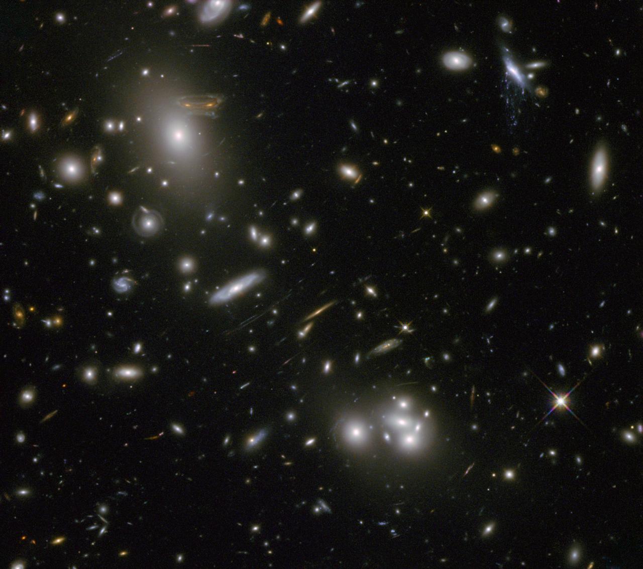
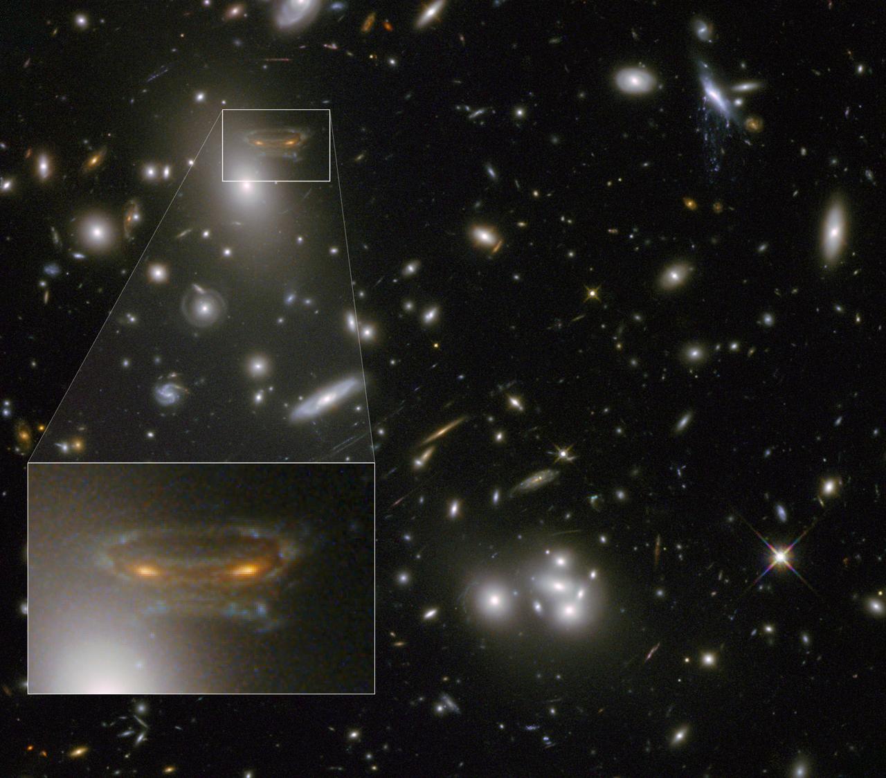
The gravitational field surrounding this massive cluster of galaxies, Abell 68, acts as a natural lens in space to brighten and magnify the light coming from very distant background galaxies. Like a fun house mirror, lensing creates a fantasy landscape of arc-like images and mirror images of background galaxies. The foreground cluster is 2 billion light-years away, and the lensed images come from galaxies far behind it. In this photo, the image of a spiral galaxy at upper left has been stretched and mirrored into a shape similar to that of a simulated alien from the classic 1970s computer game "Space Invaders!" A second, less distorted image of the same galaxy appears to the left of the large, bright elliptical galaxy. In the upper right of the photo is another striking feature of the image that is unrelated to gravitational lensing. What appears to be purple liquid dripping from a galaxy is a phenomenon called ram-pressure stripping. The gas clouds within the galaxy are being stripped out and heated up as the galaxy passes through a region of denser intergalactic gas. This image was taken in infrared light by Hubble’s Wide Field Camera 3, and combined with near-infrared observations from Hubble’s Advanced Camera for Surveys. The image is based in part on data spotted by Nick Rose in the Hubble’s Hidden Treasures image processing competition. The Hubble Space Telescope is a project of international cooperation between NASA and the European Space Agency. NASA's Goddard Space Flight Center in Greenbelt, Md., manages the telescope. The Space Telescope Science Institute (STScI) in Baltimore, Md., conducts Hubble science operations. STScI is operated by the Association of Universities for Research in Astronomy, Inc., in Washington. Credit: NASA and ESA Acknowledgement: N. Rose For image files and more information about Abell 68, visit: <a href="http://hubblesite.org/news/2013/09" rel="nofollow">hubblesite.org/news/2013/09</a> <a href="http://www.spacetelescope.org/news/heic04" rel="nofollow">www.spacetelescope.org/news/heic04</a> <a href="http://heritage.stsci.edu/2013/09" rel="nofollow">heritage.stsci.edu/2013/09</a> <a href="http://www.spacetelescope.org/projects/hiddentreasures/" rel="nofollow">www.spacetelescope.org/projects/hiddentreasures/</a> <b><a href="http://www.nasa.gov/audience/formedia/features/MP_Photo_Guidelines.html" rel="nofollow">NASA image use policy.</a></b> <b><a href="http://www.nasa.gov/centers/goddard/home/index.html" rel="nofollow">NASA Goddard Space Flight Center</a></b> enables NASA’s mission through four scientific endeavors: Earth Science, Heliophysics, Solar System Exploration, and Astrophysics. Goddard plays a leading role in NASA’s accomplishments by contributing compelling scientific knowledge to advance the Agency’s mission. <b>Follow us on <a href="http://twitter.com/NASA_GoddardPix" rel="nofollow">Twitter</a></b> <b>Like us on <a href="http://www.facebook.com/pages/Greenbelt-MD/NASA-Goddard/395013845897?ref=tsd" rel="nofollow">Facebook</a></b> <b>Find us on <a href="http://instagram.com/nasagoddard?vm=grid" rel="nofollow">Instagram</a></b>
The gravitational field surrounding this massive cluster of galaxies, Abell 68, acts as a natural lens in space to brighten and magnify the light coming from very distant background galaxies. Like a fun house mirror, lensing creates a fantasy landscape of arc-like images and mirror images of background galaxies. The foreground cluster is 2 billion light-years away, and the lensed images come from galaxies far behind it. In this photo, the image of a spiral galaxy at upper left has been stretched and mirrored into a shape similar to that of a simulated alien from the classic 1970s computer game "Space Invaders!" A second, less distorted image of the same galaxy appears to the left of the large, bright elliptical galaxy. In the upper right of the photo is another striking feature of the image that is unrelated to gravitational lensing. What appears to be purple liquid dripping from a galaxy is a phenomenon called ram-pressure stripping. The gas clouds within the galaxy are being stripped out and heated up as the galaxy passes through a region of denser intergalactic gas. This image was taken in infrared light by Hubble’s Wide Field Camera 3, and combined with near-infrared observations from Hubble’s Advanced Camera for Surveys. The image is based in part on data spotted by Nick Rose in the Hubble’s Hidden Treasures image processing competition. The Hubble Space Telescope is a project of international cooperation between NASA and the European Space Agency. NASA's Goddard Space Flight Center in Greenbelt, Md., manages the telescope. The Space Telescope Science Institute (STScI) in Baltimore, Md., conducts Hubble science operations. STScI is operated by the Association of Universities for Research in Astronomy, Inc., in Washington. To read more go to: <a href="http://1.usa.gov/Z6uDUp" rel="nofollow">1.usa.gov/Z6uDUp</a> Credit: NASA and ESA Acknowledgement: N. Rose For image files and more information about Abell 68, visit: <a href="http://hubblesite.org/news/2013/09" rel="nofollow">hubblesite.org/news/2013/09</a> <a href="http://www.spacetelescope.org/news/heic04" rel="nofollow">www.spacetelescope.org/news/heic04</a> <a href="http://heritage.stsci.edu/2013/09" rel="nofollow">heritage.stsci.edu/2013/09</a> <a href="http://www.spacetelescope.org/projects/hiddentreasures/" rel="nofollow">www.spacetelescope.org/projects/hiddentreasures/</a> <b><a href="http://www.nasa.gov/audience/formedia/features/MP_Photo_Guidelines.html" rel="nofollow">NASA image use policy.</a></b> <b><a href="http://www.nasa.gov/centers/goddard/home/index.html" rel="nofollow">NASA Goddard Space Flight Center</a></b> enables NASA’s mission through four scientific endeavors: Earth Science, Heliophysics, Solar System Exploration, and Astrophysics. Goddard plays a leading role in NASA’s accomplishments by contributing compelling scientific knowledge to advance the Agency’s mission. <b>Follow us on <a href="http://twitter.com/NASA_GoddardPix" rel="nofollow">Twitter</a></b> <b>Like us on <a href="http://www.facebook.com/pages/Greenbelt-MD/NASA-Goddard/395013845897?ref=tsd" rel="nofollow">Facebook</a></b> <b>Find us on <a href="http://instagram.com/nasagoddard?vm=grid" rel="nofollow">Instagram</a></b>

This image depicts a vast canyon of dust and gas in the Orion Nebula from a 3-D computer model based on observations by NASA's Hubble Space Telescope and created by science visualization specialists at the Space Telescope Science Institute (STScI) in Baltimore, Md. A 3-D visualization of this model takes viewers on an amazing four-minute voyage through the 15-light-year-wide canyon. Credit: NASA, G. Bacon, L. Frattare, Z. Levay, and F. Summers (STScI/AURA) Go here to learn more about Hubble 3D: <a href="http://www.nasa.gov/topics/universe/features/hubble_imax_premiere.html" rel="nofollow">www.nasa.gov/topics/universe/features/hubble_imax_premier...</a> or <a href="http://www.imax.com/hubble/" rel="nofollow">www.imax.com/hubble/</a> Take an exhilarating ride through the Orion Nebula, a vast star-making factory 1,500 light-years away. Swoop through Orion's giant canyon of gas and dust. Fly past behemoth stars whose brilliant light illuminates and energizes the entire cloudy region. Zoom by dusty tadpole-shaped objects that are fledgling solar systems. This virtual space journey isn't the latest video game but one of several groundbreaking astronomy visualizations created by specialists at the Space Telescope Science Institute (STScI) in Baltimore, the science operations center for NASA's Hubble Space Telescope. The cinematic space odysseys are part of the new Imax film "Hubble 3D," which opens today at select Imax theaters worldwide. The 43-minute movie chronicles the 20-year life of Hubble and includes highlights from the May 2009 servicing mission to the Earth-orbiting observatory, with footage taken by the astronauts. The giant-screen film showcases some of Hubble's breathtaking iconic pictures, such as the Eagle Nebula's "Pillars of Creation," as well as stunning views taken by the newly installed Wide Field Camera 3. While Hubble pictures of celestial objects are awe-inspiring, they are flat 2-D photographs. For this film, those 2-D images have been converted into 3-D environments, giving the audience the impression they are space travelers taking a tour of Hubble's most popular targets. "A large-format movie is a truly immersive experience," says Frank Summers, an STScI astronomer and science visualization specialist who led the team that developed the movie visualizations. The team labored for nine months, working on four visualization sequences that comprise about 12 minutes of the movie. "Seeing these Hubble images in 3-D, you feel like you are flying through space and not just looking at picture postcards," Summers continued. "The spacescapes are all based on Hubble images and data, though some artistic license is necessary to produce the full depth of field needed for 3-D." The most ambitious sequence is a four-minute voyage through the Orion Nebula's gas-and-dust canyon, about 15 light-years across. During the ride, viewers will see bright and dark, gaseous clouds; thousands of stars, including a grouping of bright, hefty stars called the Trapezium; and embryonic planetary systems. The tour ends with a detailed look at a young circumstellar disk, which is much like the structure from which our solar system formed 4.5 billion years ago. Based on a Hubble image of Orion released in 2006, the visualization was a collaborative effort between science visualization specialists at STScI, including Greg Bacon, who sculpted the Orion Nebula digital model, with input from STScI astronomer Massimo Roberto; the National Center for Supercomputing Applications at the University of Illinois at Urbana-Champaign; and the Spitzer Science Center at the California Institute of Technology in Pasadena. For some of the sequences, STScI imaging specialists developed new techniques for transforming the 2-D Hubble images into 3-D. STScI image processing specialists Lisa Frattare and Zolt Levay, for example, created methods of splitting a giant gaseous pillar in the Carina Nebula into multiple layers to produce a 3-D effect, giving the structure depth. The Carina Nebula is a nursery for baby stars. Frattare painstakingly removed the thousands of stars in the image so that Levay could separate the gaseous layers on the isolated Carina pillar. Frattare then replaced the stars into both foreground and background layers to complete the 3-D model. For added effect, the same separation was done for both visible and infrared Hubble images, allowing the film to cross-fade between wavelength views in 3-D. In another sequence viewers fly into a field of 170,000 stars in the giant star cluster Omega Centauri. STScI astronomer Jay Anderson used his stellar database to create a synthetic star field in 3-D that matches recent razor-sharp Hubble photos. The film's final four-minute sequence takes viewers on a voyage from our Milky Way Galaxy past many of Hubble's best galaxy shots and deep into space. Some 15,000 galaxies from Hubble's deepest surveys stretch billions of light-years across the universe in a 3-D sequence created by STScI astronomers and visualizers. The view dissolves into a cobweb that traces the universe's large-scale structure, the backbone from which galaxies were born. In addition to creating visualizations, STScI's education group also provided guidance on the "Hubble 3D" Educator Guide, which includes standards-based lesson plans and activities about Hubble and its mission. Students will use the guide before or after seeing the movie. "The guide will enhance the movie experience for students and extend the movie into classrooms," says Bonnie Eisenhamer, STScI's Hubble Formal Education manager. The Hubble Space Telescope is a project of international cooperation between NASA and the European Space Agency (ESA) and is managed by NASA’s Goddard Space Flight Center (GSFC) in Greenbelt, Md. The Space Telescope Science Institute (STScI) conducts Hubble science operations. The institute is operated for NASA by the Association of Universities for Research in Astronomy, Inc., Washington, D.C.