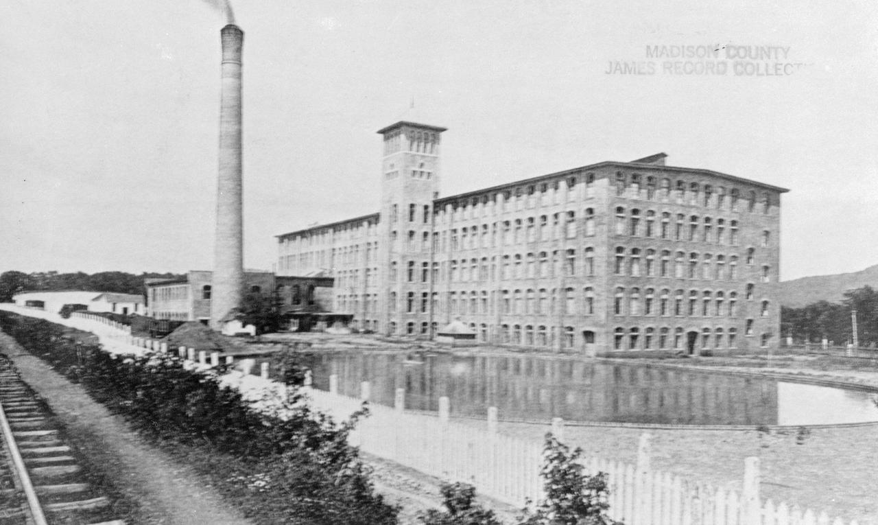
Years before Huntsville, Alabama got its start in missiles and space, the community was known as the State's leading cotton producer. This is a historical photo of the Dallas Cotton Mills printed in "The Huntsville Post" December 27, 1900. (Courtesy of Huntsville/Madison County Public Library)
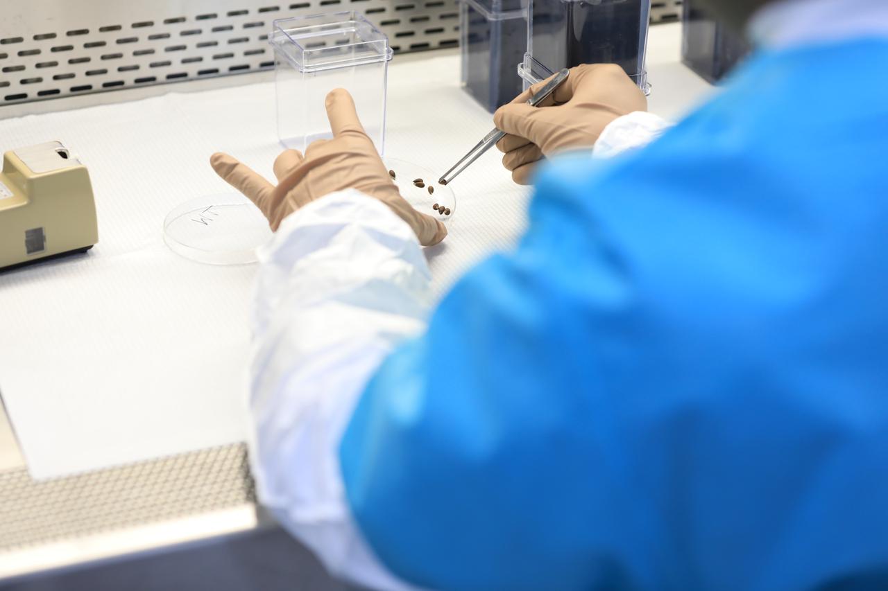
Dr. Arko Bakshi, a research associate with the Department of Botany at the University of Wisconsin, Madison, adds nutrient gel to Target Veggie Chambers, or TVCs, inside a laboratory in the Space Station Processing Facility at Kennedy Space Center in Florida on May 28, 2021. Bakshi waited until the gel solidified and then planted cotton seeds in it as part of the Targeting Improved Cotton Through Orbital Cultivation (TICTOC) experiment, which will launch to the International Space Station aboard SpaceX’s 22nd commercial resupply services mission. TICTOC will investigate how environmental factors and genes control development of roots in the absence of gravity. Liftoff of the SpaceX Falcon 9 rocket and Dragon capsule is scheduled for 1:29 p.m. EDT Thursday, June 3, 2021, from Launch Complex 39A at Kennedy Space Center.
Dr. Arko Bakshi, a research associate with the Department of Botany at the University of Wisconsin, Madison, adds nutrient gel to Target Veggie Chambers, or TVCs, inside a laboratory in the Space Station Processing Facility at Kennedy Space Center in Florida on May 28, 2021. Bakshi waited until the gel solidified and then planted cotton seeds in it as part of the Targeting Improved Cotton Through Orbital Cultivation (TICTOC) experiment, which will launch to the International Space Station aboard SpaceX’s 22nd commercial resupply services mission. TICTOC will investigate how environmental factors and genes control development of roots in the absence of gravity. Liftoff of the SpaceX Falcon 9 rocket and Dragon capsule is scheduled for 1:29 p.m. EDT Thursday, June 3, 2021, from Launch Complex 39A at Kennedy Space Center.
Dr. Arko Bakshi, a research associate with the Department of Botany at the University of Wisconsin, Madison, adds nutrient gel to Target Veggie Chambers, or TVCs, inside a laboratory in the Space Station Processing Facility at Kennedy Space Center in Florida on May 28, 2021. Bakshi waited until the gel solidified and then planted cotton seeds in it as part of the Targeting Improved Cotton Through Orbital Cultivation (TICTOC) experiment, which will launch to the International Space Station aboard SpaceX’s 22nd commercial resupply services mission. TICTOC will investigate how environmental factors and genes control development of roots in the absence of gravity. Liftoff of the SpaceX Falcon 9 rocket and Dragon capsule is scheduled for 1:29 p.m. EDT Thursday, June 3, 2021, from Launch Complex 39A at Kennedy Space Center.
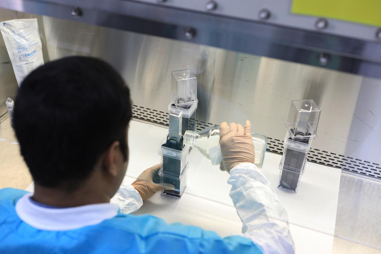
Dr. Arko Bakshi, a research associate with the Department of Botany at the University of Wisconsin, Madison, adds nutrient gel to Target Veggie Chambers, or TVCs, inside a laboratory in the Space Station Processing Facility at Kennedy Space Center in Florida on May 28, 2021. Bakshi waited until the gel solidified and then planted cotton seeds in it as part of the Targeting Improved Cotton Through Orbital Cultivation (TICTOC) experiment, which will launch to the International Space Station aboard SpaceX’s 22nd commercial resupply services mission. TICTOC will investigate how environmental factors and genes control development of roots in the absence of gravity. Liftoff of the SpaceX Falcon 9 rocket and Dragon capsule is scheduled for 1:29 p.m. EDT Thursday, June 3, 2021, from Launch Complex 39A at Kennedy Space Center.
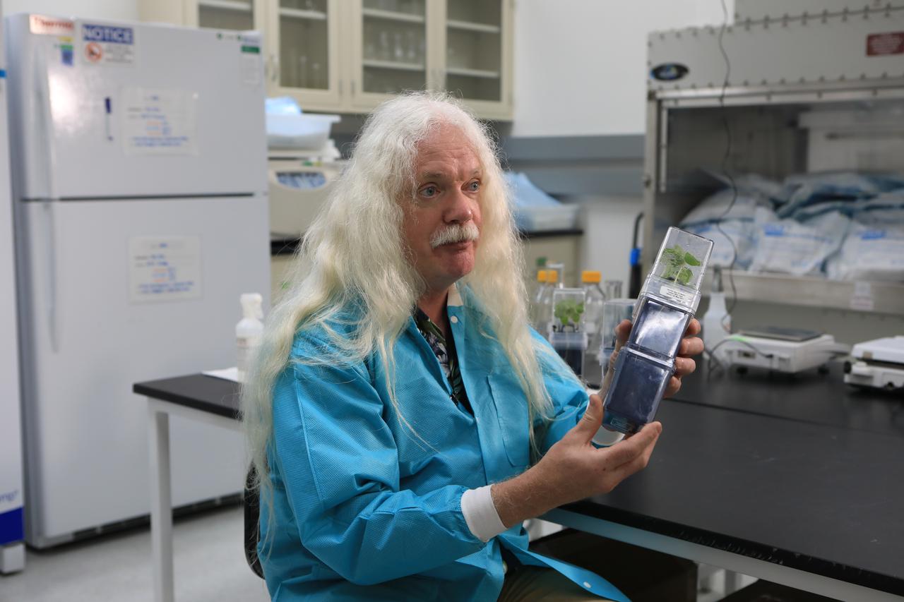
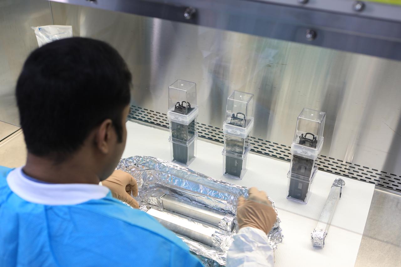
Inside a laboratory in the Space Station Processing Facility at NASA’s Kennedy Space Center in Florida on May 28, 2021, Dr. Simon Gilroy, principal investigator, holds one of several Target Veggie Chambers containing a nutrient gel so that cotton seeds can be planted in them as part of the Targeting Improved Cotton Through Orbital Cultivation (TICTOC) experiment. TICTOC will investigate how environmental factors and genes control development of roots in the absence of gravity. TICTOC will launch to the International Space Station aboard SpaceX’s 22nd Commercial Resupply Services mission. Liftoff of the SpaceX Falcon 9 rocket and Dragon capsule is scheduled for 1:29 p.m. EDT Thursday, June 3, 2021, from Launch Complex 39A at Kennedy Space Center.
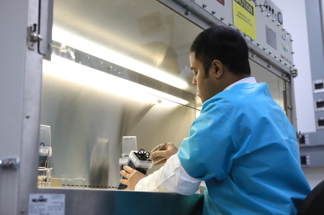
Dr. Arko Bakshi, a research associate with the Department of Botany at the University of Wisconsin, Madison, adds nutrient gel to Target Veggie Chambers, or TVCs, inside a laboratory in the Space Station Processing Facility at Kennedy Space Center in Florida on May 28, 2021. Bakshi waited until the gel solidified and then planted cotton seeds in it as part of the Targeting Improved Cotton Through Orbital Cultivation (TICTOC) experiment, which will launch to the International Space Station aboard SpaceX’s 22nd commercial resupply services mission. TICTOC will investigate how environmental factors and genes control development of roots in the absence of gravity. Liftoff of the SpaceX Falcon 9 rocket and Dragon capsule is scheduled for 1:29 p.m. EDT Thursday, June 3, 2021, from Launch Complex 39A at Kennedy Space Center.
Dr. Arko Bakshi, a research associate with the Department of Botany at the University of Wisconsin, Madison, adds nutrient gel to Target Veggie Chambers, or TVCs, inside a laboratory in the Space Station Processing Facility at Kennedy Space Center in Florida on May 28, 2021. Bakshi waited until the gel solidified and then planted cotton seeds in it as part of the Targeting Improved Cotton Through Orbital Cultivation (TICTOC) experiment, which will launch to the International Space Station aboard SpaceX’s 22nd commercial resupply services mission. TICTOC will investigate how environmental factors and genes control development of roots in the absence of gravity. Liftoff of the SpaceX Falcon 9 rocket and Dragon capsule is scheduled for 1:29 p.m. EDT Thursday, June 3, 2021, from Launch Complex 39A at Kennedy Space Center.
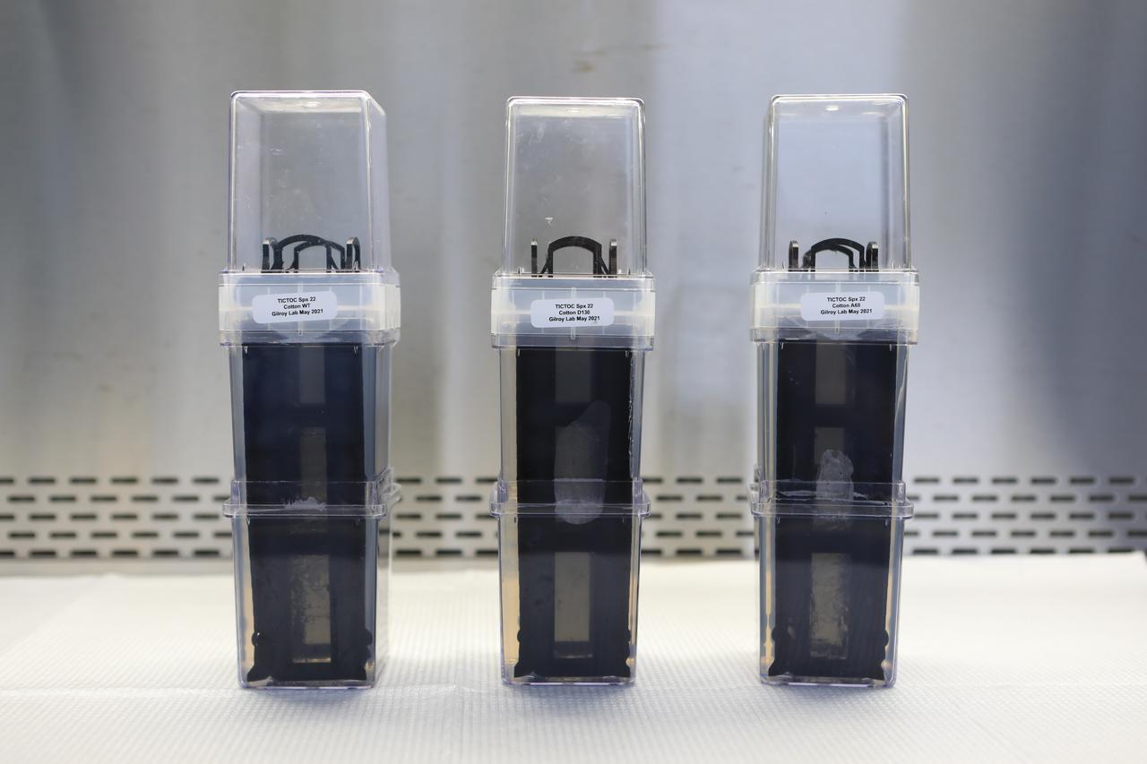
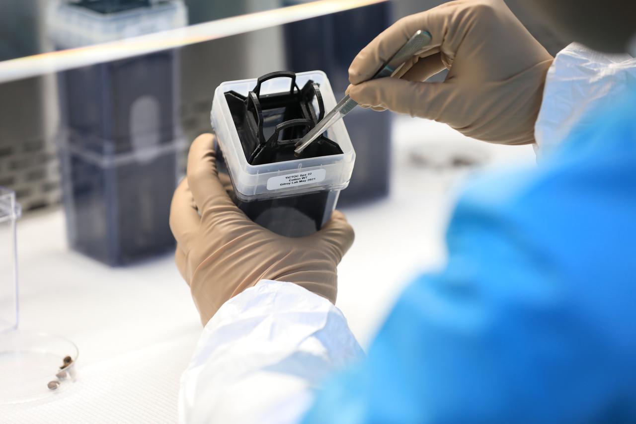
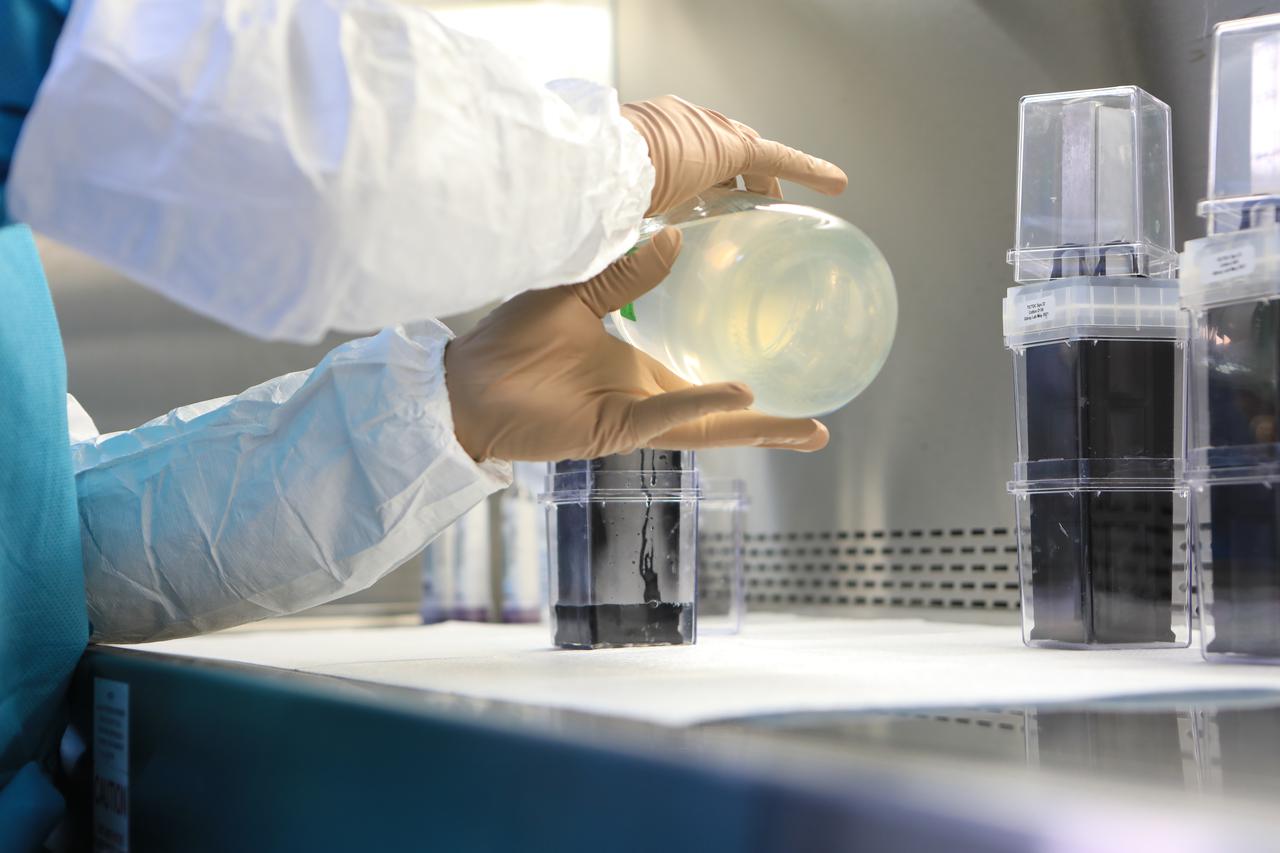
Several Target Veggie Chambers, or TVCs, are in view inside a laboratory in the Space Station Processing Facility at NASA’s Kennedy Space Center in Florida on May 28, 2021. A nutrient gel has been added to them, and when the gel solidified, Dr. Arko Bakshi, a research associate with the Department of Botany at the University of Wisconsin, Madison, planted cotton seeds in them as part of the Targeting Improved Cotton Through Orbital Cultivation (TICTOC) experiment, which will launch to the International Space Station aboard SpaceX’s 22nd commercial resupply services mission. TICTOC will investigate how environmental factors and genes control development of roots in the absence of gravity. Liftoff of the SpaceX Falcon 9 rocket and Dragon capsule is scheduled for 1:29 p.m. EDT Thursday, June 3, 2021, from Launch Complex 39A at Kennedy Space Center.
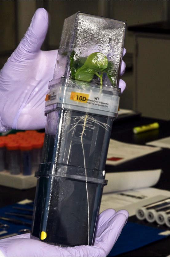
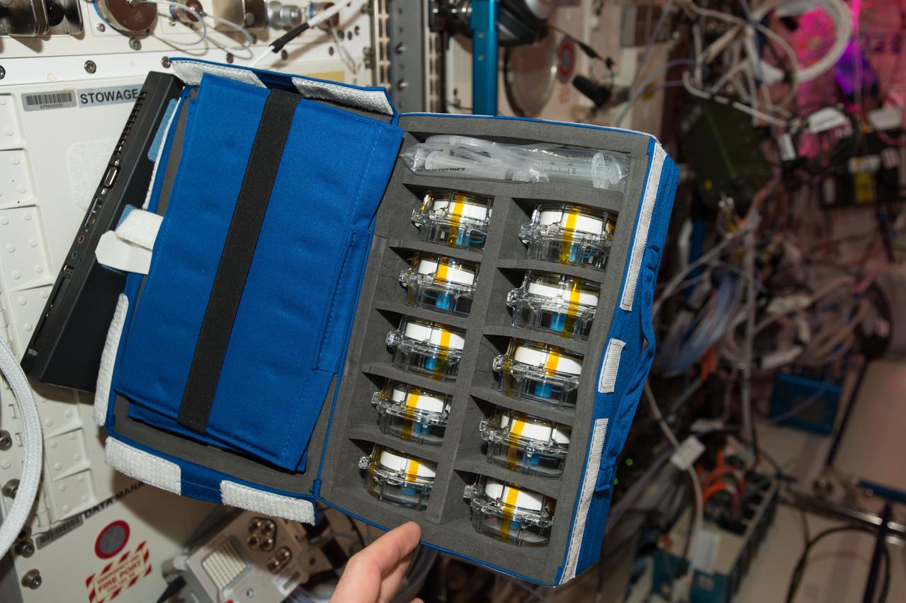
jsc2021e010330 (3/9/2021) --- A preflight photo of the TICTOC cotton growth chamber containing a seedling ready for harvest. Targeting Improved Cotton Through Orbital Cultivation (TICTOC) investigates the morphological and molecular adaptations of cotton seedlings to the microgravity environment encountered in the International Space Station (ISS). Image courtesy of Tom Dreschel.

jsc2021e010332 (5/1/2019) --- The Veggie plant growth hardware at the Kennedy Space Center (KSC) with the TICTOC cotton investigation. Targeting Improved Cotton Through Orbital Cultivation (TICTOC) investigates the morphological and molecular adaptations of cotton seedlings to the microgravity environment encountered in the International Space Station (ISS). Image courtesy of Jeff Richards.
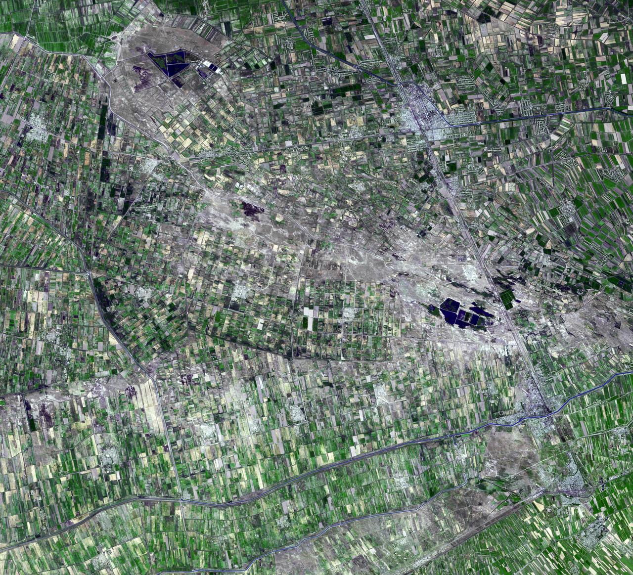
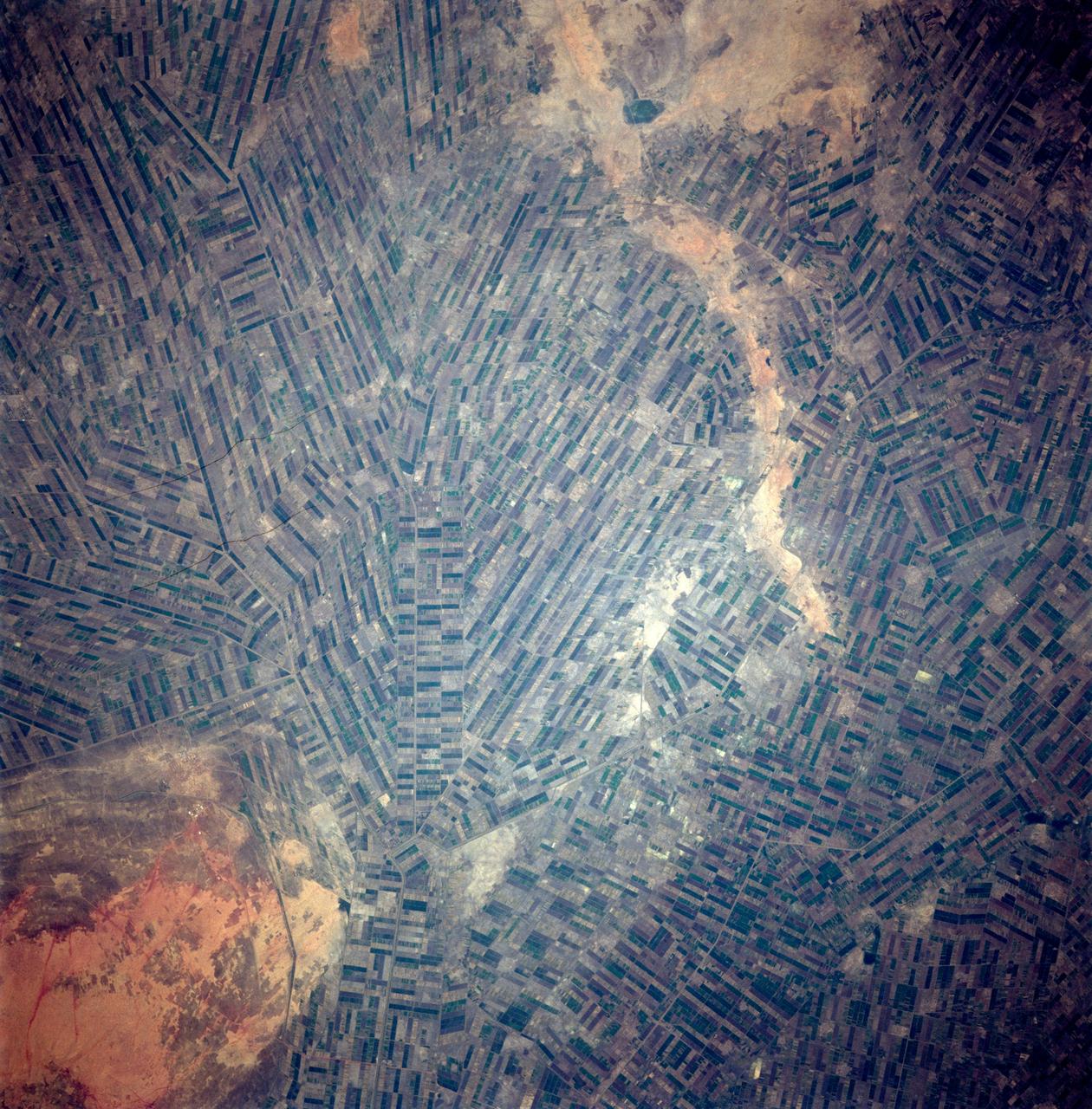
This image captured by NASA Terra spacecraft is of the Jizzax Province in eastern Uzbekistan, one of the main agricultural regions of the country. Uzbekistan is the world sixth largest producer and second-largest exporter of cotton.

jsc2021e010329 (5/1/2019) --- The TICTOC logo designed by Sarah Friedrich. Targeting Improved Cotton Through Orbital Cultivation (TICTOC) investigates the morphological and molecular adaptations of cotton seedlings to the microgravity environment encountered in the International Space Station (ISS)
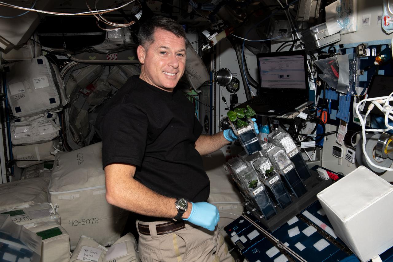
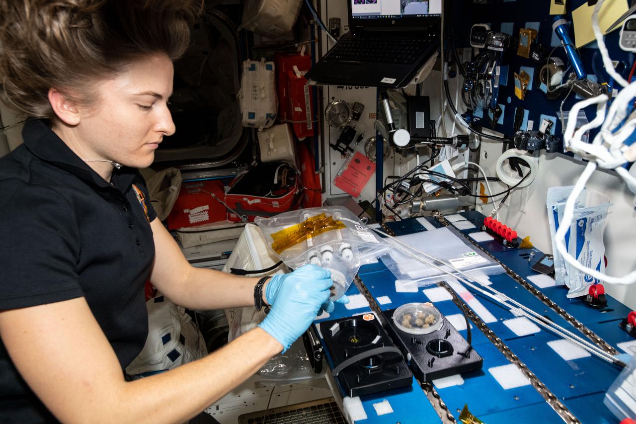
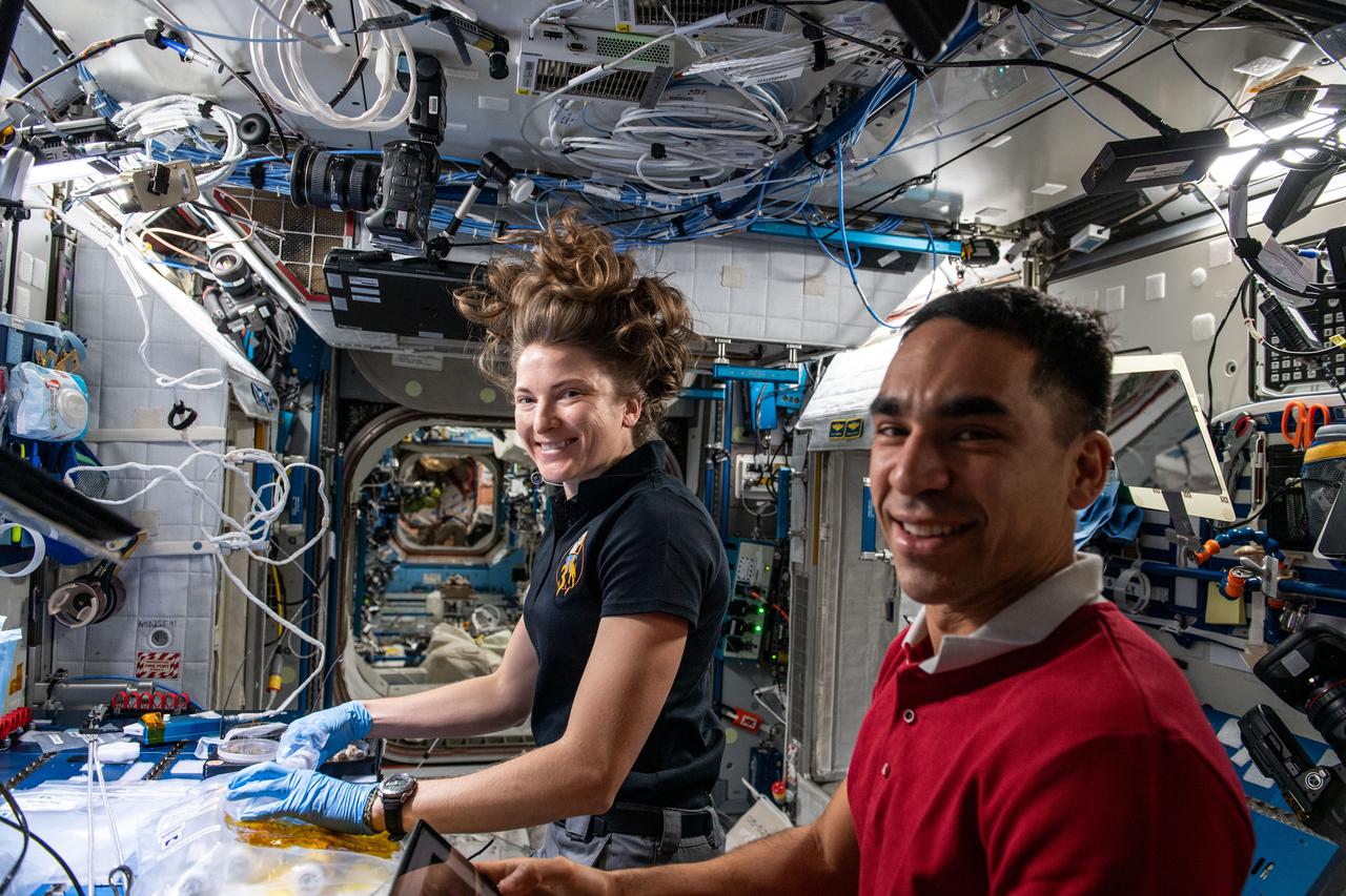
iss065e096005 (June 11, 2021) --- NASA astronaut and Expedition 65 Flight Engineer Shane Kimbrough checks on cotton plants growing for the TICTOC space botany study. The investigation looks at gene expression and root growth in microgravity which may improve both space agriculture and cotton cultivation on Earth.
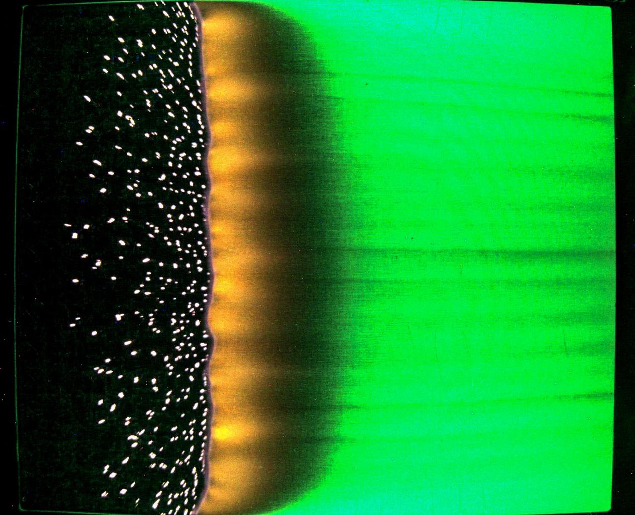
jsc2023e046375 (7/25/2023) --- A sample of fabric burns inside Spacecraft Fire Experiment-IV (Saffire-IV). The sample is a composite fabric made of cotton and fiberglass and is 40 cm wide. The image appears green because green LED lights are used to illuminate the sample during a burn. The flame appears orange in this image and the black region to the right of the flame is the cotton in the sample beginning to heat and char. The bright specks to the left of the flame are smoldering cotton that remains on the fiberglass substrate after the flame passes. In Saffire-VI, this fabric is burned at higher oxygen concentrations. Researchers aim to study realistic flame spread to aid the development of fire safety equipment and strategies for future spacecraft.

iss066e153092 (Fab. 29, 2022) -- Cotton cell samples, held by NASA astronaut and Expedition 66 Flight Engineer Kayla Barron, are pictured growing on a petri dish inside the Advanced Plant Habitat. The samples were grown and harvested for the Plant Habitat-05 space agriculture study that explores genetic expression in cotton cultures to learn more about the process of plant regeneration possibly improving crop production on Earth.
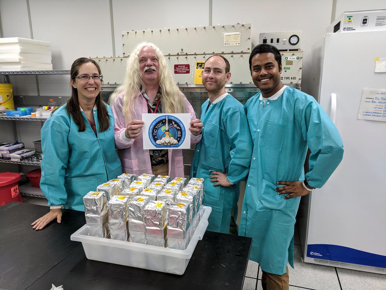
jsc2021e010331 (5/1/2019) --- The Gilroy Lab TICTOC team at their KSC lab: Sarah Swanson, Simon Gilroy, Richard Barker and Arkadipta Bakshi. Targeting Improved Cotton Through Orbital Cultivation (TICTOC) investigates the morphological and molecular adaptations of cotton seedlings to the microgravity environment encountered in the International Space Station (ISS). Image courtesy of Deb Wells
iss066e184149 (March 28, 2022) --- NASA astronaut and Expedition 66 Flight Engineer Raja Chari performs the final harvest of cotton cell cultures as part of the Plant Habitat-05 investigation (PH-05). The space agriculture study explored genetic expression in cotton cell cultures to learn more about the process of plant regeneration, potentially improving crop production on Earth.
iss066e184146 (March 28, 2022) --- NASA astronaut and Expedition 66 Flight Engineer Raja Chari performs the final harvest of cotton cell cultures as part of the Plant Habitat-05 investigation (PH-05). The space agriculture study explored genetic expression in cotton cell cultures to learn more about the process of plant regeneration, potentially improving crop production on Earth.
iss066e139750 (Feb. 10, 2022) --- NASA astronaut and Expedition 66 Flight Engineer Kayla Barron harvests cotton cell samples grown for the Plant Habitat-05 space agriculture experiment that is exploring the genetic architecture of plant regeneration.
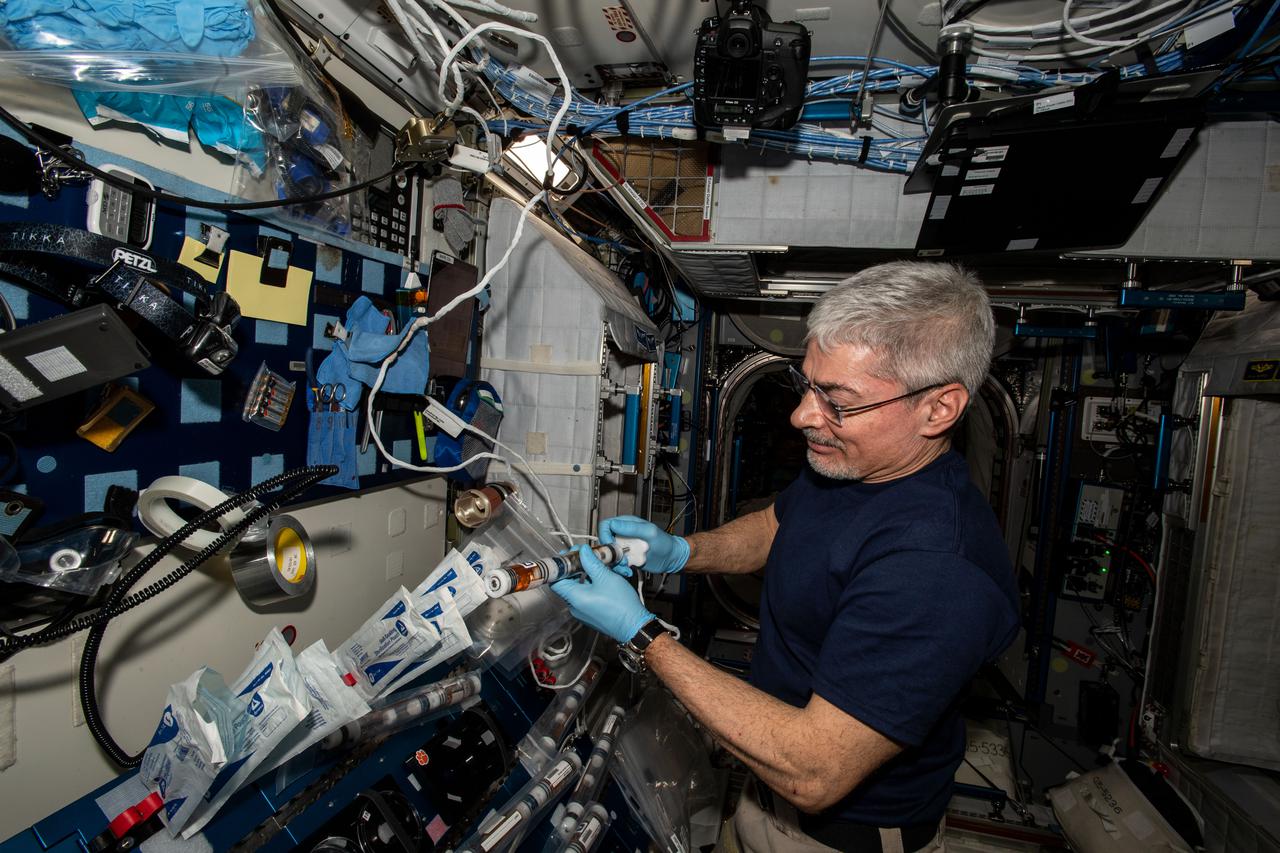
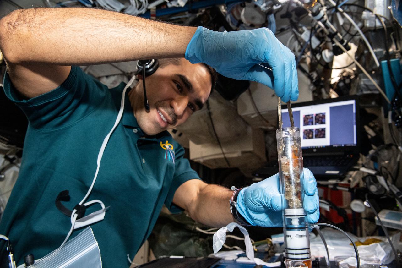
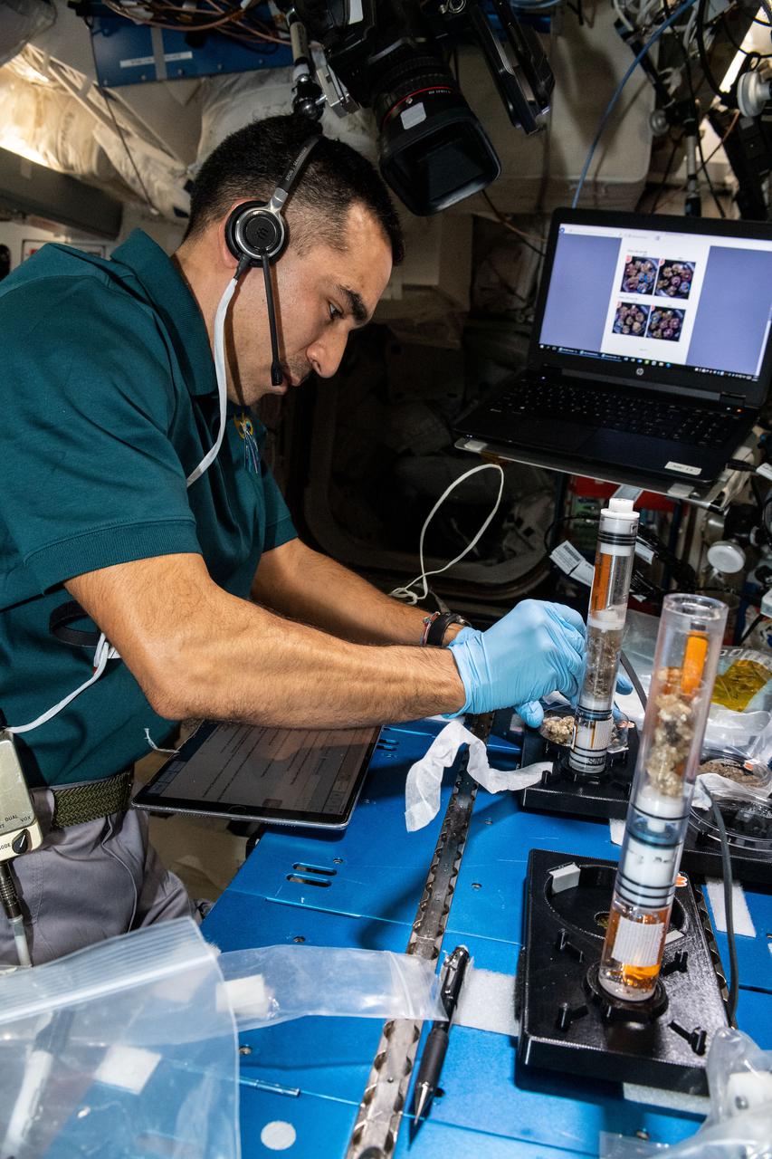
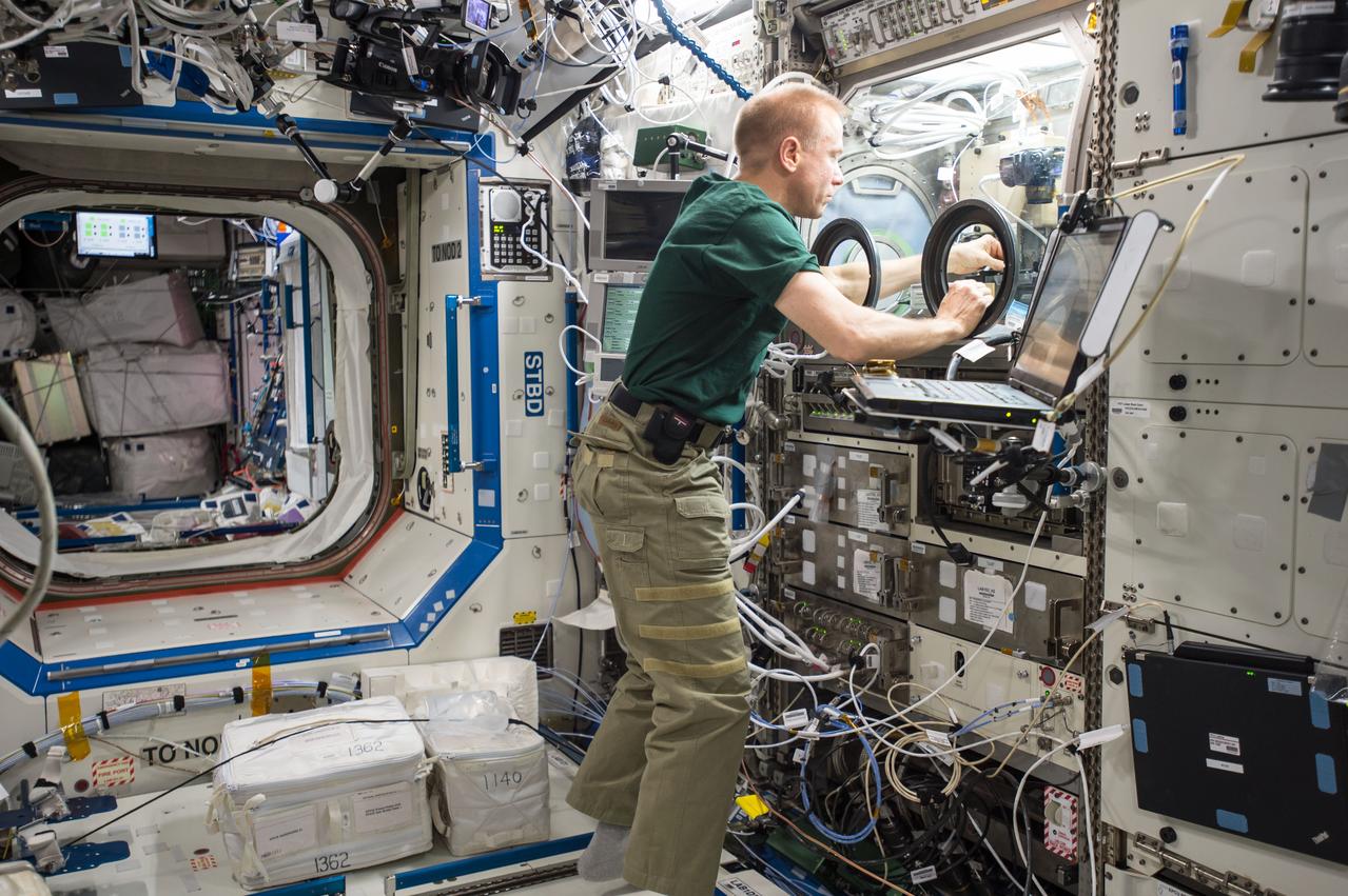
iss066e108544 (Jan. 6, 2022) --- NASA astronaut and Expedition 66 Flight Engineer Mark Vande Hei conducts operations for the Plant Habitat-5 space agriculture experiment that is studying cotton genetics.
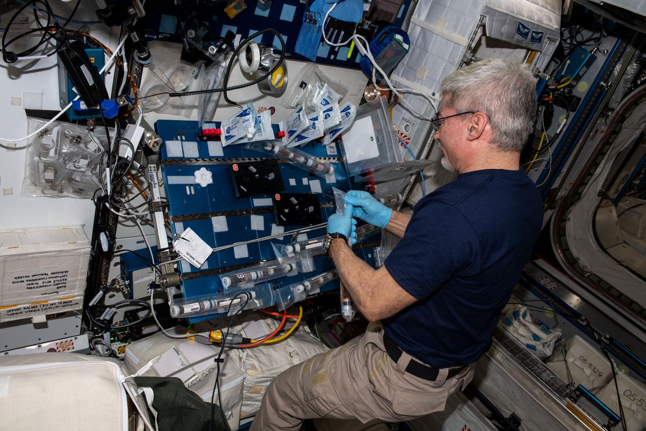
iss066e108295(Jan. 6, 2022) --- NASA astronaut and Expedition 66 Flight Engineer Mark Vande Hei conducts operations for the Plant Habitat-5 space agriculture experiment that is studying cotton genetics.
iss066e108552 (Jan. 6, 2022) --- NASA astronaut and Expedition 66 Flight Engineer Mark Vande Hei conducts operations for the Plant Habitat-5 space agriculture experiment that is studying cotton genetics.
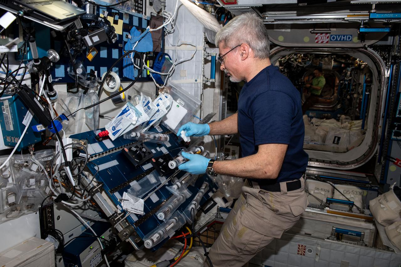
iss066e108292 (Jan. 6, 2022) --- NASA astronaut and Expedition 66 Flight Engineer Mark Vande Hei conducts operations for the Plant Habitat-5 space agriculture experiment that is studying cotton genetics.
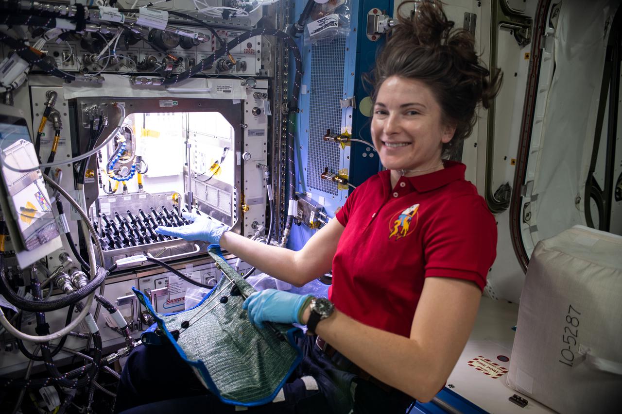
iss066e096821 (Dec. 27, 2021) --- NASA astronaut and Expedition 66 Flight Engineer Kayla Barron sets up the Plant Habitat-05 Growth experiment that is studying cotton genetics in microgravity.
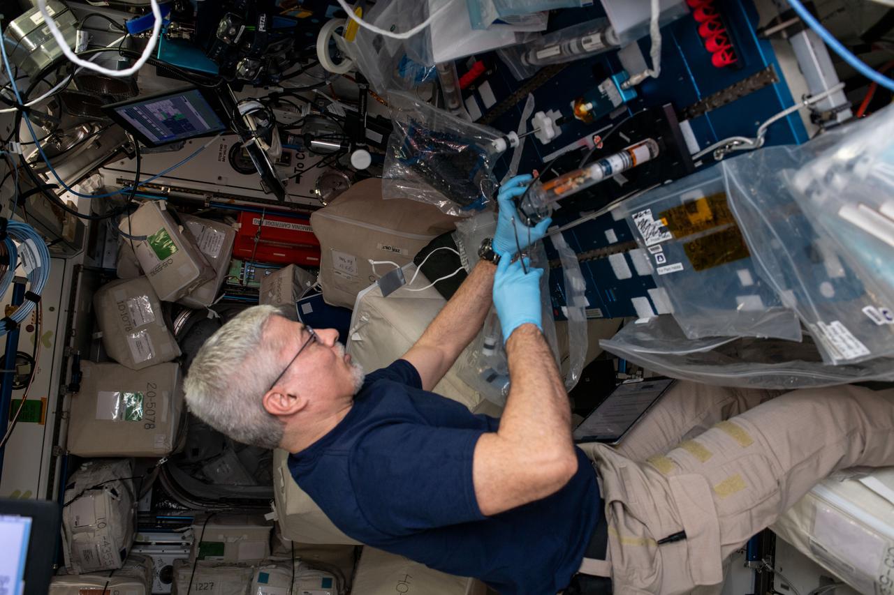
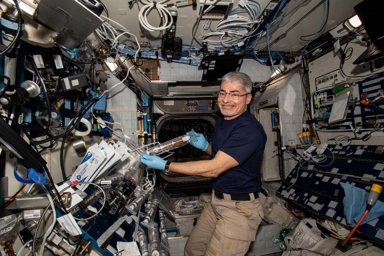
iss066e110821 (Jan. 11, 2022) --- NASA astronaut and Expedition 66 Flight Engineer Mark Vande Hei performs research operations for the Plant Habitat-05 space botany experiment that observes cotton cultures grown on the International Space Station to understand how weightlessness affects plant genetics.
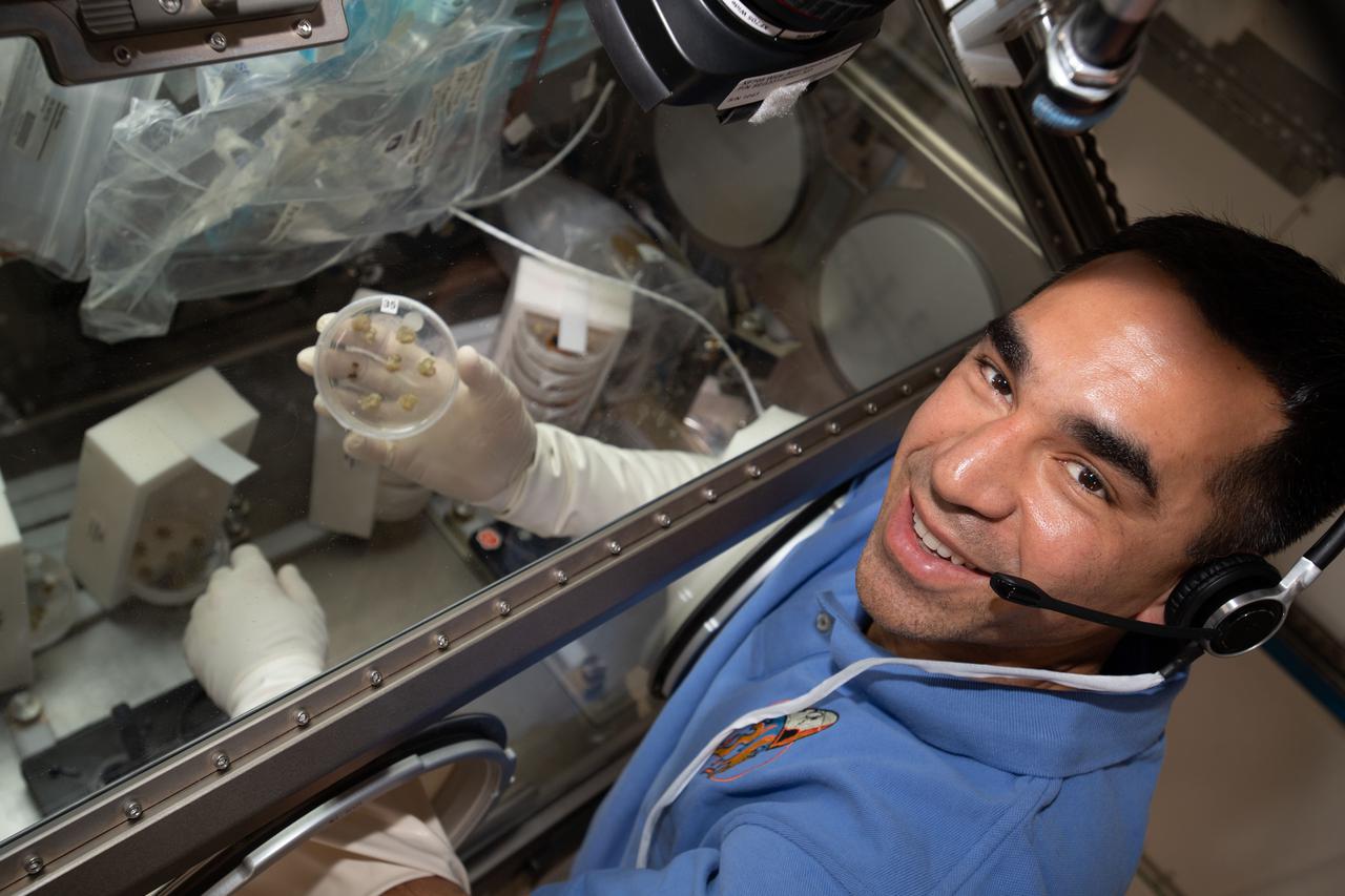
iss066e127275 (Jan. 26, 2022) --- NASA astronaut and Expedition 66 Flight Engineer Raja Chari works inside the Life Science Glovebox and displays cotton cells growing on a petri dish for the Plant Habitat-05 space botany study. The experiment uses the microgravity environment to observe the genetic architecture of plant regeneration.
iss066e140558 (Feb. 10, 2022) --- NASA's Expedition 66 Flight Engineers Kayla Barron and Raja Chari harvest cotton cell samples grown for the Plant Habitat-05 space agriculture experiment that is exploring the genetic architecture of plant regeneration.
iss050e011332 (11/22/2016) --- A view of the Aquapad Sampling kit in a blue cargo transfer bag (CTB). Aquapad aims to improve the speed and efficiency of water potability tests onboard the ISS, by using a device that consists of a simple absorbent cotton, which is injected with 1 milliliter of water, and a tablet computer application,
ISS046e025945 (01/27/2016) --- NASA astronaut Tim Kopra sets up hardware for the Burning and Suppression of Solids – Milliken, or BASS-M, experiment. The BASS-M investigation tests flame-retardant cotton fabrics to determine how well they resist burning in microgravity. Results benefit research on flame-retardant textiles that can be used on Earth and in space
iss066e153087 (Fab. 29, 2022) --- NASA astronaut and Expedition 66 Flight Engineer Kayla Barron works inside the Life Science Glovebox conducting botany research for the Plant Habitat-05 investigation. The space agriculture study explores genetic expression in cotton cultures to learn more about the process of plant regeneration possibly improving crop production on Earth.
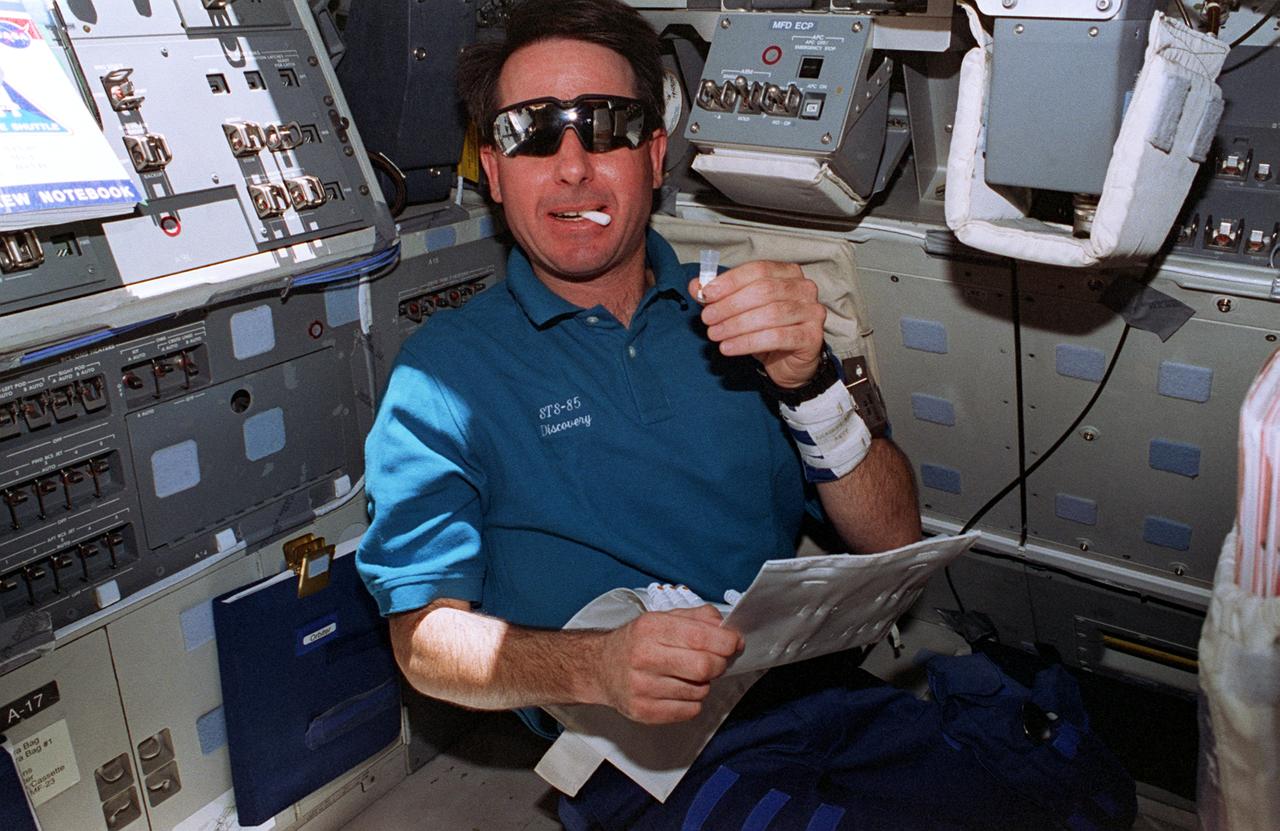
STS006-06-456 (4-9 April 1983) --- Astronaut Paul J. Weitz, STS-6 commander, points out an item in the crew activity plan (CAP) to astronaut Donald H. Peterson as the mission specialist uses a spoon to eat a meal aboard the Earth-orbiting space shuttle Challenger. The two are on the middeck. They are wearing the shirt and trouser portions of the blue cotton multi-piece constant wear garments. This frame was photographed with a 35mm camera. Photo credit: NASA
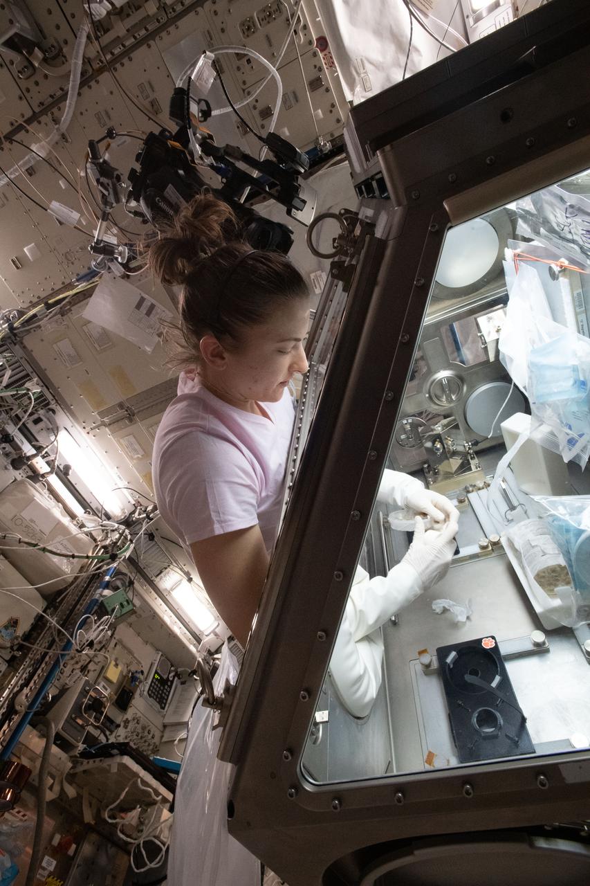
iss066e153063 (Fab. 29, 2022) --- NASA astronaut and Expedition 66 Flight Engineer Kayla Barron works inside the Life Science Glovebox conducting botany research for the Plant Habitat-05 investigation. The space agriculture study explores genetic expression in cotton cultures to learn more about the process of plant regeneration possibly improving crop production on Earth.
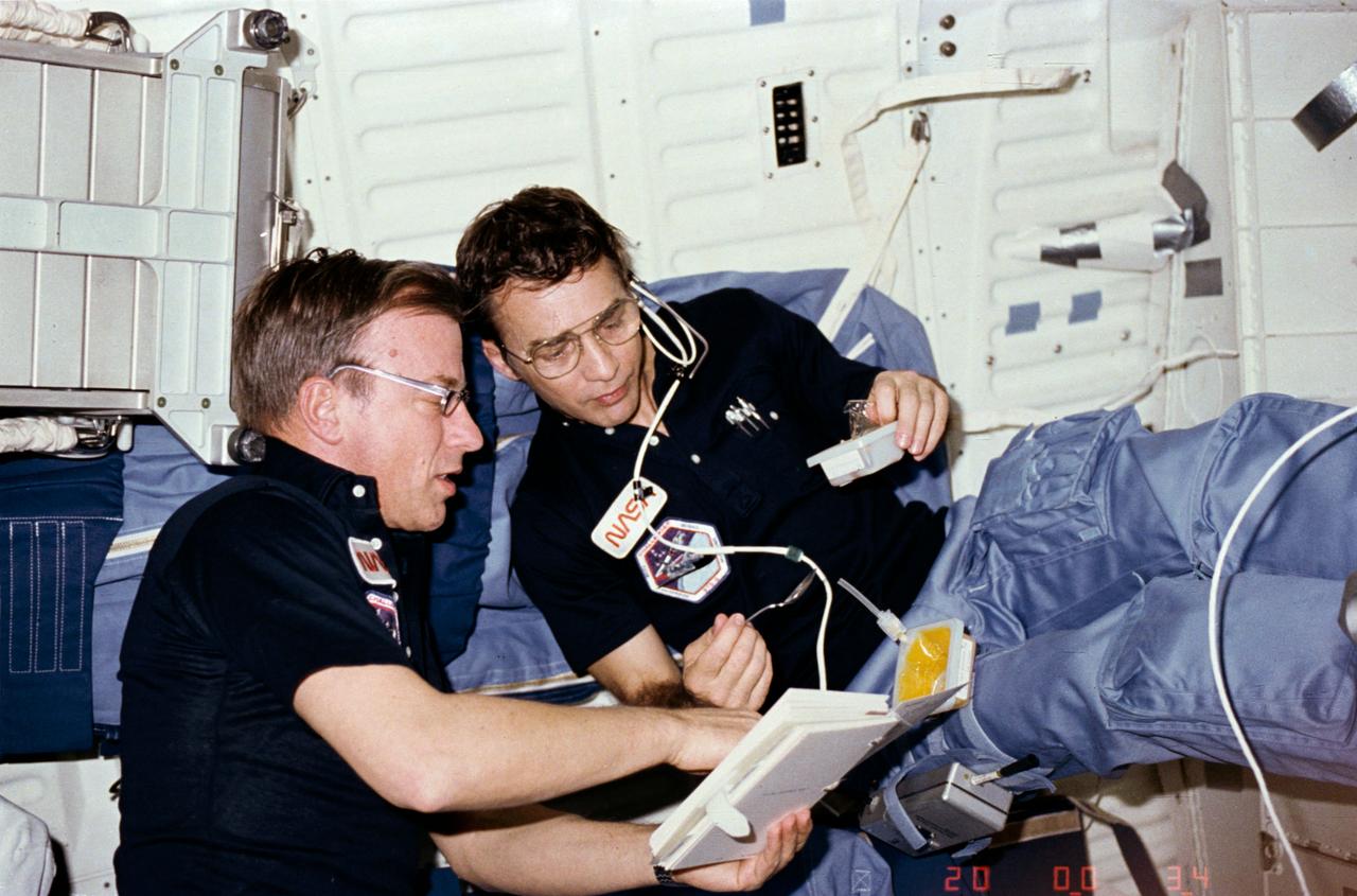
STS085-338-016 (7 - 19 August 1997) --- On the Space Shuttle Discovery's flight deck, astronaut Stephen K. Robinson conducts one phase of the mission's Detailed Supplementary Objectives (DSO). He uses a cotton swab to collect a saliva sample. The wrist band on his left arm is associated with the same DSO. The ongoing test, dealing with circadian rhythm and other biological systems, is in preparation for the International Space Station (ISS).
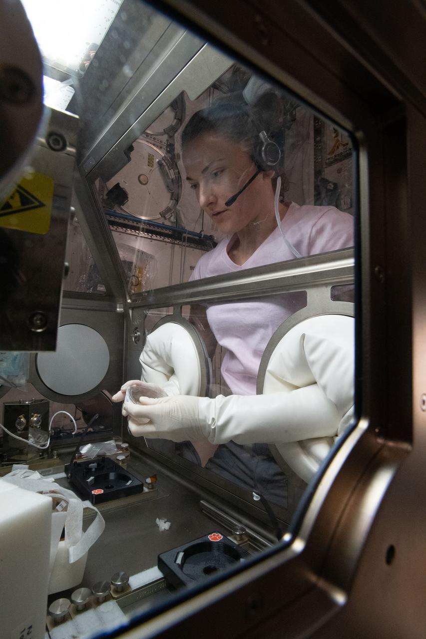
iss066e153069 (Fab. 29, 2022) --- NASA astronaut and Expedition 66 Flight Engineer Kayla Barron works inside the Life Science Glovebox conducting botany research for the Plant Habitat-05 investigation. The space agriculture study explores genetic expression in cotton cultures to learn more about the process of plant regeneration possibly improving crop production on Earth.
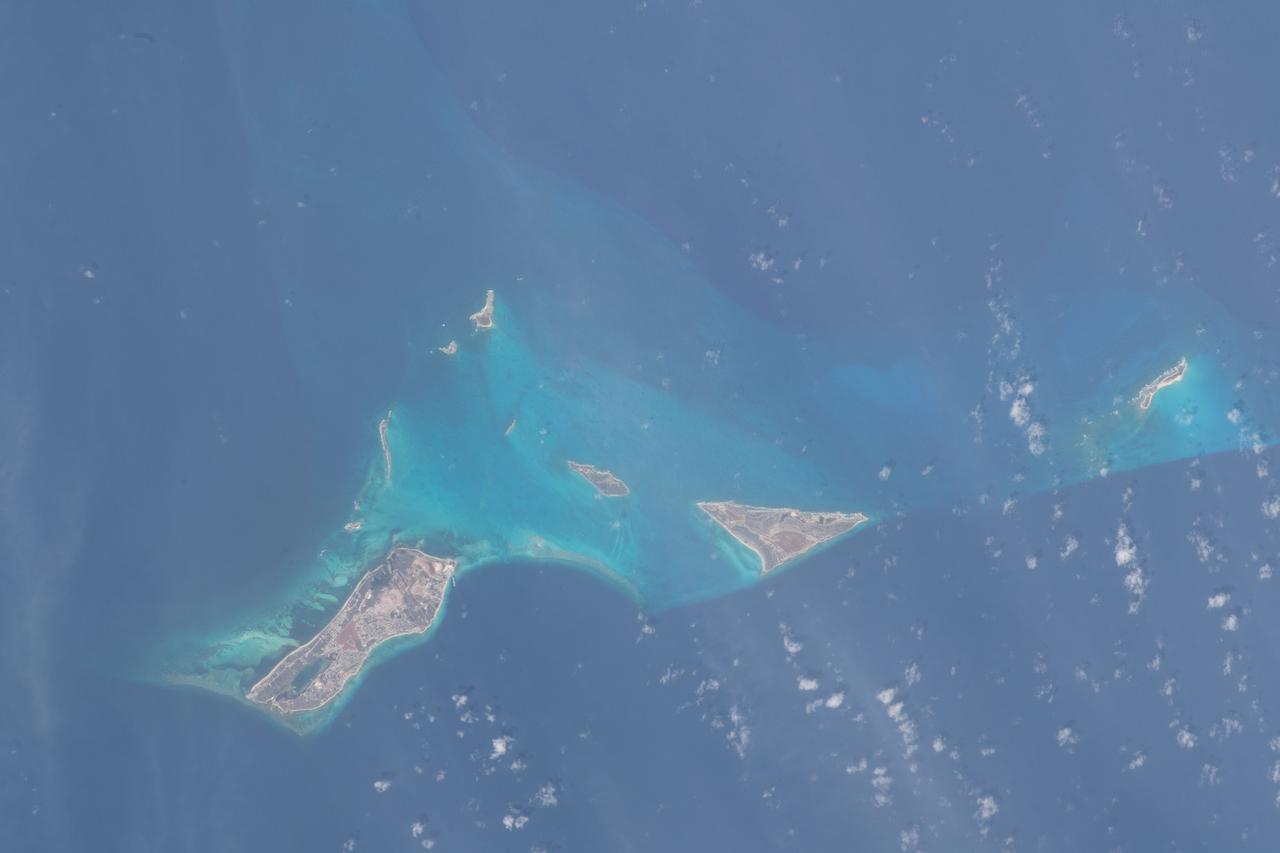
iss069e025034 (June 23, 2023) -- While only eight are inhabited, the Turks and Caicos are home to 40 different islands and cays. As the International Space Station orbited 258 miles above the region on June 23, 2023, United Arab Emirates astronaut and Expedition 69 crew member Sultan Alneyadi captured this photo of Cockburn Town (the Capital of Turks and Caicos Islands), Salt Cay and Cotton Cay.
STS083-747-052 (4-8 April 1997) --- Sunglint on the Indus River, Sukkar, and Rohri, Pakistan. Sukkar city (27.42 north 68.52 east), Sindh province, southeastern Pakistan lies on the west bank of the Indus River, connected with Rohri on the opposite bank by a cantilever bridge. Midstream between the two cities is the strategic island fortress of Bukkur. The old town contains many historic tombs and mosques, including the Mir Ma'sum Shah Minaret (c. AD 1607). An industrial and trade center, it has biscuit, cigarette, oil, lime, and cement factories, and cotton, silk, thread, and flour mills; boat building is also significant. The surrounding region is a vast alluvial plain broken only occasionally by low limestone hills. A portion of the Thar Desert is reaching from the south to Rohri. The Sukkur Barrage, highlighted by the sunglint, was completed in 1932. Nearly 1 mile (1.6 kilometers) long it crosses the Indus River 3 miles (4.8 kilometers) below Sukkur Gorge and feeds irrigation canals. The canals originating from it serve a cultivable area of about five million acres of land producing both food and cash crops, such as wheat, cotton, rice, oilseed, and fruit cultivation.
STS087-717-088 (19 November – 5 December 1997) --- Featured in this view are Sudan’s agricultural projects dependent on irrigation. Just southeast of the confluence of the Blue and White Nile rivers (and the city of Khartoum) is one of the largest irrigation projects in the world, known as the Gezira Scheme. The economy of Sudan is largely based on agriculture. The Gezira Scheme was begun by the British in 1925 and distributes water from the Blue Nile through canals and ditches to tenant farms lying between the Blue and White Nile rivers. Farmers cooperate with the Sudanese government and the Gezira Board. This network of canals and ditches is 2,700 miles (4,300 kilometers) long, and the irrigated area covers 2.5 million acres (1 million hectares). The main crop grown in this region is cotton. This picture is one of the 70mm Earth observations visuals used by the crew at its post flight presentation events.
The first NASA Dropping In a Microgravity Environment (DIME) student competition pilot project came to a conclusion at the Glenn Research Center in April 2001. The competition involved high-school student teams who developed the concept for a microgravity experiment and prepared an experiment proposal. The two student teams - COSI Academy, sponsored by the Columbus Center of Science and Industry, and another team from Cincinnati, Ohio's Sycamore High School, designed a microgravity experiment, fabricated the experimental apparatus, and visited NASA Glenn to operate their experiment in the 2.2 Second Drop Tower. This is the interior of the Sycamore High School (Cincinnati, Ohio) students' experiment to observe the flame spreading on a 100 percent cotton T-shirt under low-g. This image is from a digital still camera; higher resolution is not available.
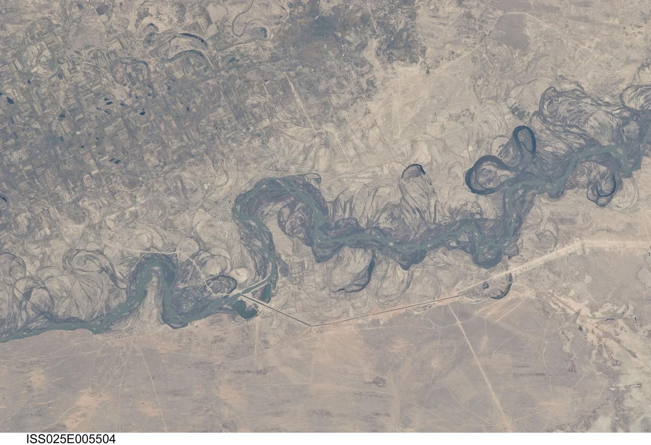
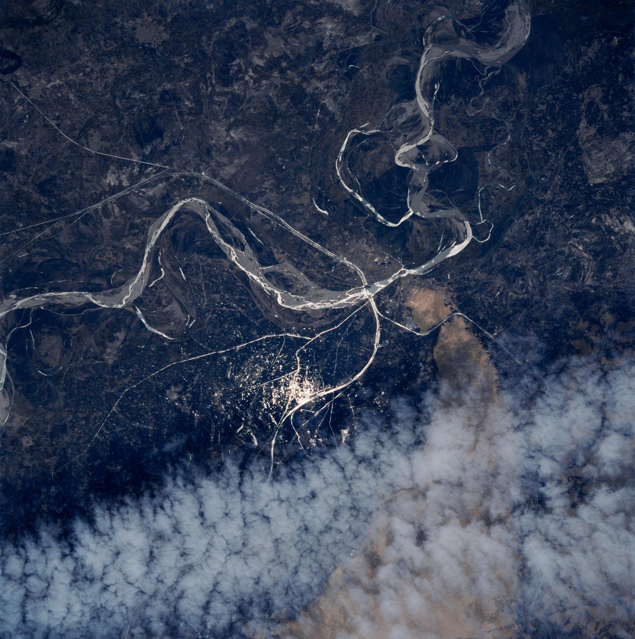
ISS025-E-005504 (30 Sept. 2010) --- Syr Dar’ya River floodplain in Kazakhstan, central Asia is featured in this image photographed by an Expedition 25 crew member on the International Space Station. Central Asia’s most important cotton-growing region is concentrated in the floodplain of the Syr Dar’ya, and is irrigated by water from the river. The floodplain is shown here as a tangle of twisting meanders and loops (center). The darkest areas are brushy vegetation along the present course (filled with blue-green water); wisps of vegetation are also visible along flanking swampy depressions, or sloughs. An older floodplain appears as an area of more diffuse dark vegetation (upper left), where a pattern of relict meander bends is overlain by a rectangular pattern of cotton fields. The straight channel of a new diversion canal—one of sixteen from this point downstream—can be seen along the east bank of the river. The older floodplain area is fed from the Chardara Reservoir immediately upstream (not shown). Half the river flow is controlled from reservoirs, and half from direct water take-off from canals. By contrast with the intensive agricultural use of water shown here, upstream water control in the mountain valleys is oriented more toward power generation. The river flows for a total distance of 2,200 kilometers from the Tien Shan Mountains westward and northwestward to the Aral Sea—the dying waterbody at the low point of the basin far to the northwest. Withdrawals of water from the river for agriculture have continued for many decades. Although the Syr Dar’ya is the second largest river flowing into the sea, its discharge is not very large. As such, it has been easily depleted, with none of its water today reaching the Aral Sea. Control of the river is vested in the Syr Dar’ya Basin Water Organization run by nations with territory in the Syr Dar’ya basin. Some of the organization’s main efforts are accurate gauging of water use along the river course, and repair of canals to reduce widespread water loss by leakage.
STS062-151-182Z (4-18 March 1994) --- This east-looking view shows most of the east-west extent of the country of Sudan. The foreground shows a vegetation-less and almost uninhabited region of northwest Sudan. The rich earth colors are ancient soils (browner and redder tones), a concentrated mass of what may be volcanic cinder cones (dark brown dots - center) and dune and younger river sediments (yellows). The photo would have been difficult to locate had it not been for two recognizable features in the background: a visually well-known inselberg ("island mountain" -- top center) on a large west-bank tributary of the White Nile; and the confluence of the Blue and White Nile's, with the great cotton developments of the Gezira Scheme between them (top left). The Red Sea coast is almost obscured by a dust cloud but can be discerned running across the top of the picture. The clouds at top may be developing over the coastal ranges of Saudi Arabia beyond the Red Sea.
KENNEDY SPACE CENTER, FLA. - Looking like discarded piles of foam or cotton, billows of smoke and steam surround Launch Pad 39B as Space Shuttle Discovery roars toward space. Liftoff occurred at 10:39 a.m. EDT on the historic Return to Flight mission STS-114. It is the 114th Space Shuttle flight and the 31st for Discovery. The 12-day mission is expected to end with touchdown at the Shuttle Landing Facility on Aug. 7. On this mission to the International Space Station the crew will perform inspections on-orbit for the first time of all of the Reinforced Carbon-Carbon (RCC) panels on the leading edge of the wings and the Thermal Protection System tiles using the new Canadian-built Orbiter Boom Sensor System and the data from 176 impact and temperature sensors. Mission Specialists will also practice repair techniques on RCC and tile samples during a spacewalk in the payload bay. During two additional spacewalks, the crew will install the External Stowage Platform-2, equipped with spare part assemblies, and a replacement Control Moment Gyroscope contained in the Lightweight Multi-Purpose Experiment Support Structure.
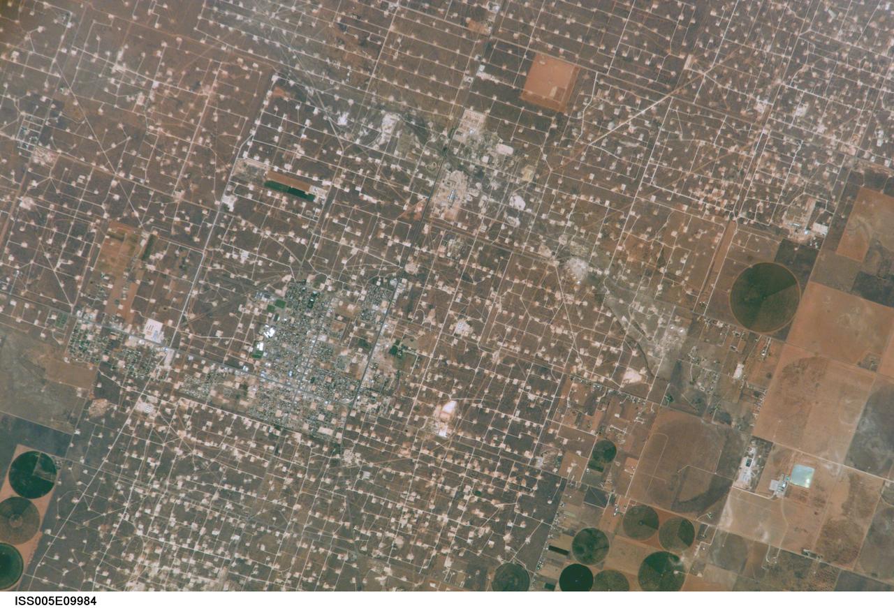
ISS005-E-9984 (17 August 2002) --- This digital still photograph, taken from the International Space Station (ISS) during its fifth staffing, depicts both agriculture and the petroleum industry, which compete for land use near Denver City, Texas. The photo was recently released by the Earth Sciences and Image Analysis Laboratory at Johnson Space Center. The area is southwest of Lubbock near the New Mexico border. According to analysts studying the station imagery, the economy of this region is almost completely dependent on its underground resources of petroleum and water. Both resources result in distinctive land use patterns visible from space. Historically this area has produced vast quantities of oil and gas since development began in the 1930s. A fine, light-colored grid of roads and pipelines connect well sites over this portion of the Wasson Oil Field, one of the state’s most productive. Since the 1940s, agricultural land use has shifted from grazing to irrigated cultivation of cotton, sorghum, wheat, hay, and corn. The water supply is drawn from wells tapping the vast Ogallala Aquifer. Note the large, circular center-pivot irrigation systems in the lower corners of the image. The largest is nearly a mile in diameter.
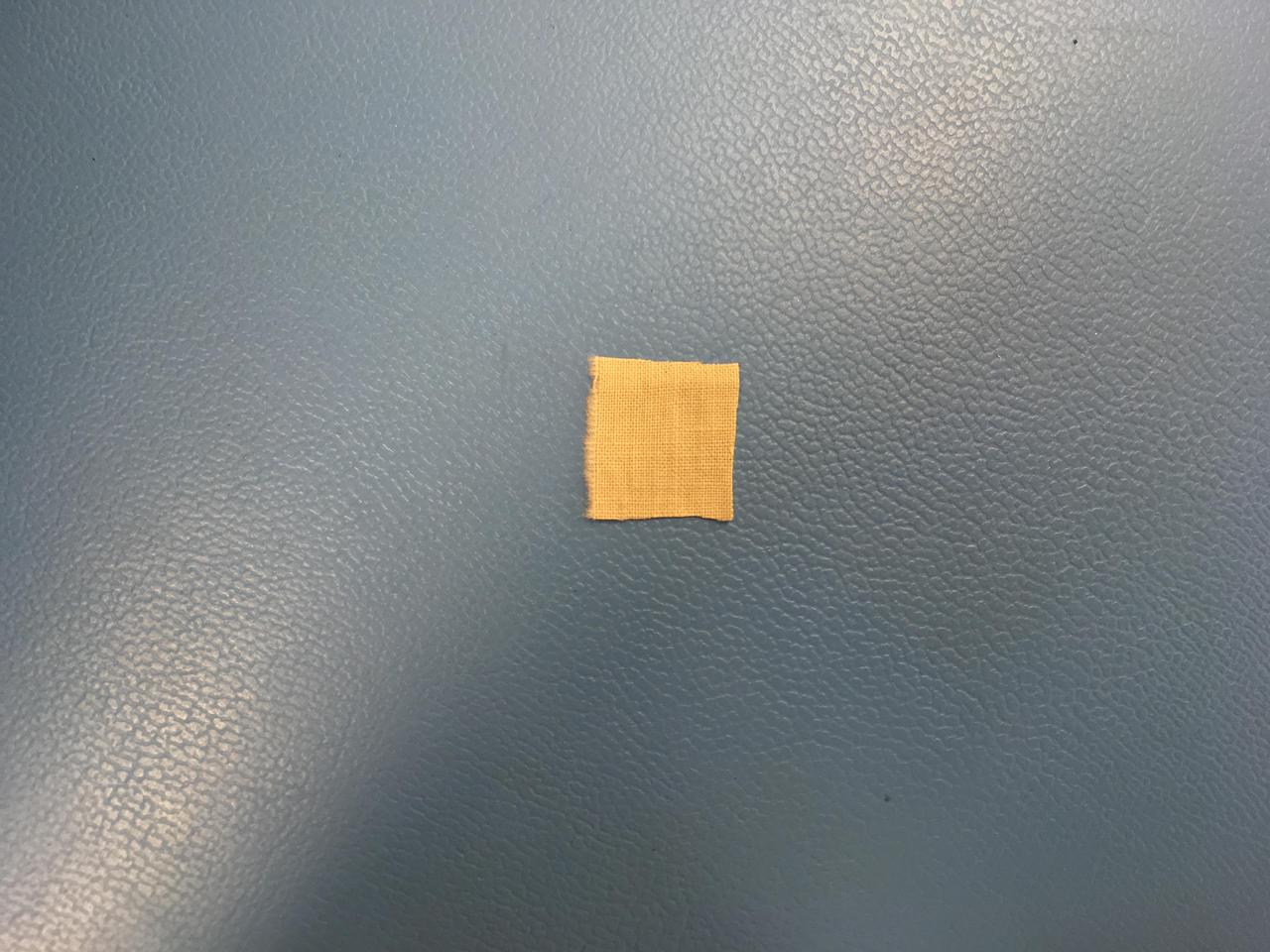
This 0.5-inch x 0.5-inch (1.3 x 1.3 centimeter) square of unbleached muslin material from the Wright brothers' first airplane was encapsulated in a protective polyamide film before being attached to a cable underneath the solar panel of NASA's Ingenuity Mars Helicopter. Procured by the Wrights from a local department store in downtown Dayton, Ohio, the cotton fabric (called "Pride of the West Muslin") was at the time mostly used for ladies undergarments. In the front parlor of their home, the Wrights cut the material into strips and used the family sewing machine to create wing coverings for their airplane Flyer 1, which achieved the first powered, controlled flight on Earth on Dec. 17, 1903. The swatch of material from the Wright brothers' first airplane was obtained from the Carillon Historical Park, in Dayton, Ohio — home to the Wright Brothers National Museum. The image was taken in a clean room at NASA's Jet Propulsion Laboratory on January 15, 2020. https://photojournal.jpl.nasa.gov/catalog/PIA24438
CAPE CANAVERAL, Fla. – NASA Deputy Director Lori Garver, left, participates in an event marking the arrival of NASA's first space-bound Orion capsule at NASA's Kennedy Space Center in Florida. Talking to Garver in Kennedy's Operations and Checkout Building Mission Briefing Room are, from left, Brig. Gen. Anthony J. Cotton, commander of the 45th Space Wing, and Florida Senator Thad Altman. Slated for Exploration Flight Test-1, an uncrewed mission planned for 2014, the capsule will travel farther into space than any human spacecraft has gone in more than 40 years. The capsule was shipped to Kennedy from NASA's Michoud Assembly Facility in New Orleans where the crew module pressure vessel was built. The Orion production team will prepare the module for flight at Kennedy by installing heat-shielding thermal protection systems, avionics and other subsystems. For more information, visit http://www.nasa.gov/orion. Photo credit: NASA/Kim Shiflett
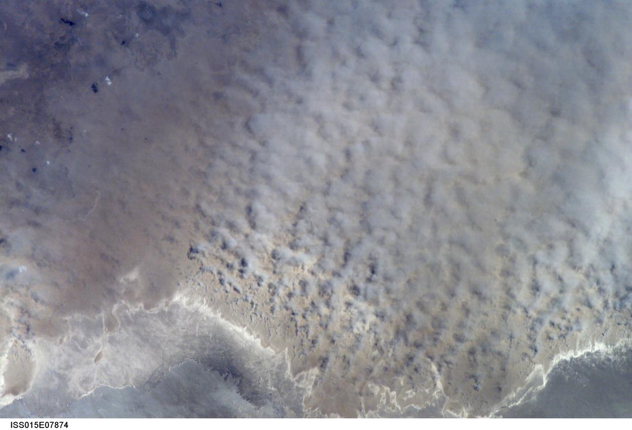
ISS015-E-07874 (12 May 2007) --- A major dust storm (center right) along the east side of the Aral Sea, Kazakhstan, is featured in this image photographed by an Expedition 15 crewmember on the International Space Station while passing over central Asia. The white, irregular lines along the bottom of the image are salt and clay deposits on the present coastline. On the spring day when the ISS crew shot the image, winds were blowing from the west (lower left). The gray, puffy appearance is typical of dust clouds, allowing scientists to distinguish dust from fog and smog. The dust in this image is rising from the sea bed of the Aral Sea, from a point close to the middle of the original Aral Sea of 40--50 years ago, then the fourth largest inland sea on Earth. Heavy extraction of water from the main supply river, the Amu Dary'a, has resulted in rapid shrinking of the sea. According to scientists, dust storms have been occurring in the Aral Sea region for thousands of years, but since the drastic shrinking of the sea over the past half-century an important change in dust composition has occurred. The dust now includes fertilizer and pesticide washed into the Sea from the extensive cotton fields of the Amu Dary'a floodplain. Years of liberal application of agricultural chemicals have resulted in concentration of these pollutants on the sea bed. These are now exposed to the wind and transported hundreds of kilometers in a generally easterly direction. Research suggests that the remobilized chemicals are the cause of high rates of many diseases in the populations along the north, east and southern margins of the Aral Sea. This is one of the unintended consequences of the shrinking of the sea, which has made international news for many years due to the loss of the fishing industry and other significant ecological problems.
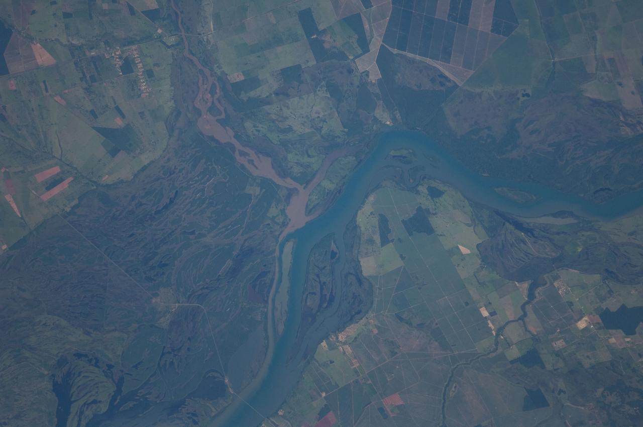
ISS030-E-090012 (5 Feb. 2012) --- The Parana River floodplain along the Mato Grosso–Sao Paulo border, Brazil is featured in this image photographed by an Expedition 30 crew member on the International Space Station. The Parana River appears as a wide, blue strip across this photograph, with muddy brown water of the smaller Verde River entering from the northwest (top left). An extensive wetland (dark green) occupies most of the left half of the image, where the floodplain of the river reaches a width of 11 kilometers. The thin line of a road crossing the floodplain also gives a sense of scale. Above the Parana–Verde confluence (center) the floodplain is much narrower. The floodplain is generated by sediments delivered by both rivers. Evidence for this is that the entire surface of the floodplain is crisscrossed by the wider traces of former Parana R. channels as well as numerous narrower traces of the Verde R. The floodplains along both rivers are bordered by numerous rectangular agricultural fields. Dominant crops along this part of the Parana River are coffee, corn and cotton. Turbid water, such as that in the Verde River, is common in most rivers that drain plowed agricultural land as some topsoil is washed into local rivers after rains. A long tendril of brown water extends from the Verde R. into the main channel of the Parana River where it hugs the west bank, remaining unmixed for many kilometers. This effectively shows the direction of river flow from orbit (right to left for the Parana, upper left to center for the Verde).

Over the last 25 years, Chandler, Arizona has traded its grid of fields for a grid of streets. Founded in 1912 on cotton, grains, alfalfa, and ostrich farms, brown and green irrigated fields still dominate the region southeast of Phoenix in this 1985 natural color image taken by Landsat 5. By 2011, the blue gray city streets in this Landsat 5 image have taken over. Chandler's economy has shifted from agriculture to manufacturing and electronics, and its population boomed from 30,000 people in 1980 to 236,000 in 2010. ---- Survey (USGS) jointly manage Landsat, and the USGS preserves a 40-year archive of Landsat images that is freely available over the Internet. The next Landsat satellite, now known as the Landsat Data Continuity Mission (LDCM) and later to be called Landsat 8, is scheduled for launch in 2013. In honor of Landsat’s 40th anniversary in July 2012, the USGS released the LandsatLook viewer – a quick, simple way to go forward and backward in time, pulling images of anywhere in the world out of the Landsat archive. <b><a href="http://www.nasa.gov/audience/formedia/features/MP_Photo_Guidelines.html" rel="nofollow">NASA image use policy.</a></b> <b><a href="http://www.nasa.gov/centers/goddard/home/index.html" rel="nofollow">NASA Goddard Space Flight Center</a></b> enables NASA’s mission through four scientific endeavors: Earth Science, Heliophysics, Solar System Exploration, and Astrophysics. Goddard plays a leading role in NASA’s accomplishments by contributing compelling scientific knowledge to advance the Agency’s mission. <b>Follow us on <a href="http://twitter.com/NASA_GoddardPix" rel="nofollow">Twitter</a></b> <b>Like us on <a href="http://www.facebook.com/pages/Greenbelt-MD/NASA-Goddard/395013845897?ref=tsd" rel="nofollow">Facebook</a></b> <b>Find us on <a href="http://instagrid.me/nasagoddard/?vm=grid" rel="nofollow">Instagram</a></b>
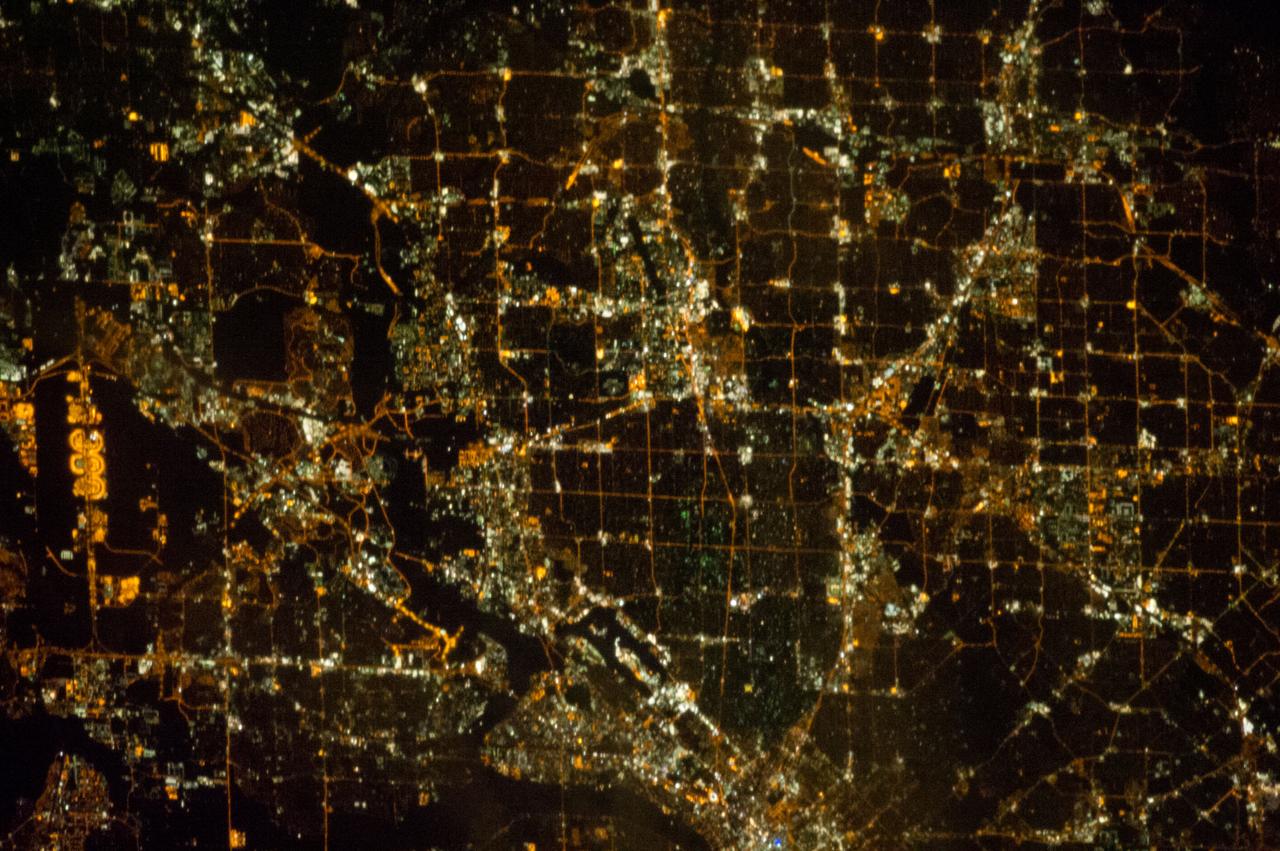
ISS033-E-021663 (15 Nov. 2012) --- A nighttime view of the Dallas, Texas metropolitan area is featured in this image photographed by an Expedition 33 crew member on the International Space Station. Most metropolitan areas of the western United States are configured over large areas with a regular street grid pattern that is highly recognizable from space, particularly at night. The northern Dallas metropolitan area exhibits this pattern. The north-south and east-west grid pattern of major surface streets is highlighted by orange street lighting, lending a fishnet-like appearance to the urban area. Within this framework, smaller residential and commercial buildings and streets give green-gray stipple patterns to some blocks. The airplane terminals of Dallas-Fort Worth International Airport are lit with golden-yellow lights, and surrounded by relatively dark runways and fields at left. Likewise, the runways of Dallas Love Field at lower center are recognizable by their darkness. Other dark areas within the metro region are open space, parks, and water bodies. Dallas is part of the larger Dallas-Fort Worth-Arlington Metropolitan Statistical Area (population 6,526,548 in 2011) as recognized by the U.S. Census Bureau; to most Texans, it is simply ?DFW? or ?the Metroplex.? Several of the larger urban areas within DFW are visible in this image; Dallas, Garland and Richardson all have populations above 100,000 according to the North Central Texas Council of Governments. While historically the economy of Dallas was based in the oil and cotton industries, today commerce, technology, healthcare, and transportation are the major economic drivers.
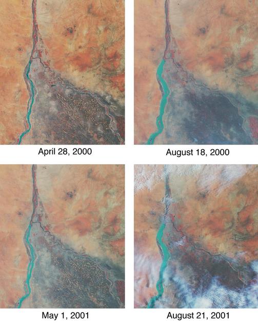
Throughout history, the rising and falling waters of the mighty Nile River have directly impacted the lives of the people who live along its banks. These images of the area around Sudan's capital city of Khartoum capture the river's dynamic nature. Acquired by the Multi-angle Imaging SpectroRadiometer's nadir (vertical-viewing) camera, they display the extent of the Nile waters before and after the onset of the rainy seasons of 2000 (top pair) and 2001 (bottom pair). The images are displayed in "false color," using the camera's near-infrared, green, and blue bands. With this particular spectral combination, water appears in shades of blue and turquoise, and highly vegetated areas show up as bright red. Originating in Uganda and Ethiopia, respectively, the waters of the White Nile (western branch) and Blue Nile (eastern branch) converge at Khartoum (about half-way between image center and the left-hand side), and continue to flow northward as the Great Nile. Although the most obvious feature in these images is the increased width of the White Nile between spring and summer, careful inspection shows that the Great Nile is at its widest in August 2001 (note in particular the area between the clouds near the top of this panel). Heavy rains in the Blue Nile catchment area of the Ethiopian highlands led to a rapid overflow of the river's floodwaters into the main stream of the Great Nile, leading to extensive flooding, the worst effects of which occurred north of Khartoum. According to the Food and Agriculture Organization of the United Nations, tens of thousands of people have fled their homes, and the number of people in need of urgent food assistance in Sudan, estimated at three million earlier in the year, was likely to increase with the onset of these floods. South of the confluence of the White Nile and the Blue Nile, the area of a cross-hatched appearance is the irrigated plain of El Gezira. The Gezira irrigation scheme uses water from the Makwar Dam (now called the Sennar Dam), located across the Blue Nile south of Khartoum. Among the main agricultural products of this region are cotton, millet, peanuts and fodder crops. Overall prospects for Sudan's 2001 grain crop were already poor prior to the flooding due to a late start of the rainy season in parts of the country. Following two consecutive years of serious drought, precipitation arrived too late to save the grain harvest that normally begins in late August. Lower harvests for the past two years coupled with depletion of stocks have led to a rise in cereal prices, reducing access to food for the Sudan's poorer citizens, already suffering from the effects of Africa's longest running civil war. Each of these images represents an area of about 130 kilometers x 150 kilometers. The data were obtained during Terra orbits 1922, 3553, 7281, and 8912. http://photojournal.jpl.nasa.gov/catalog/PIA03420
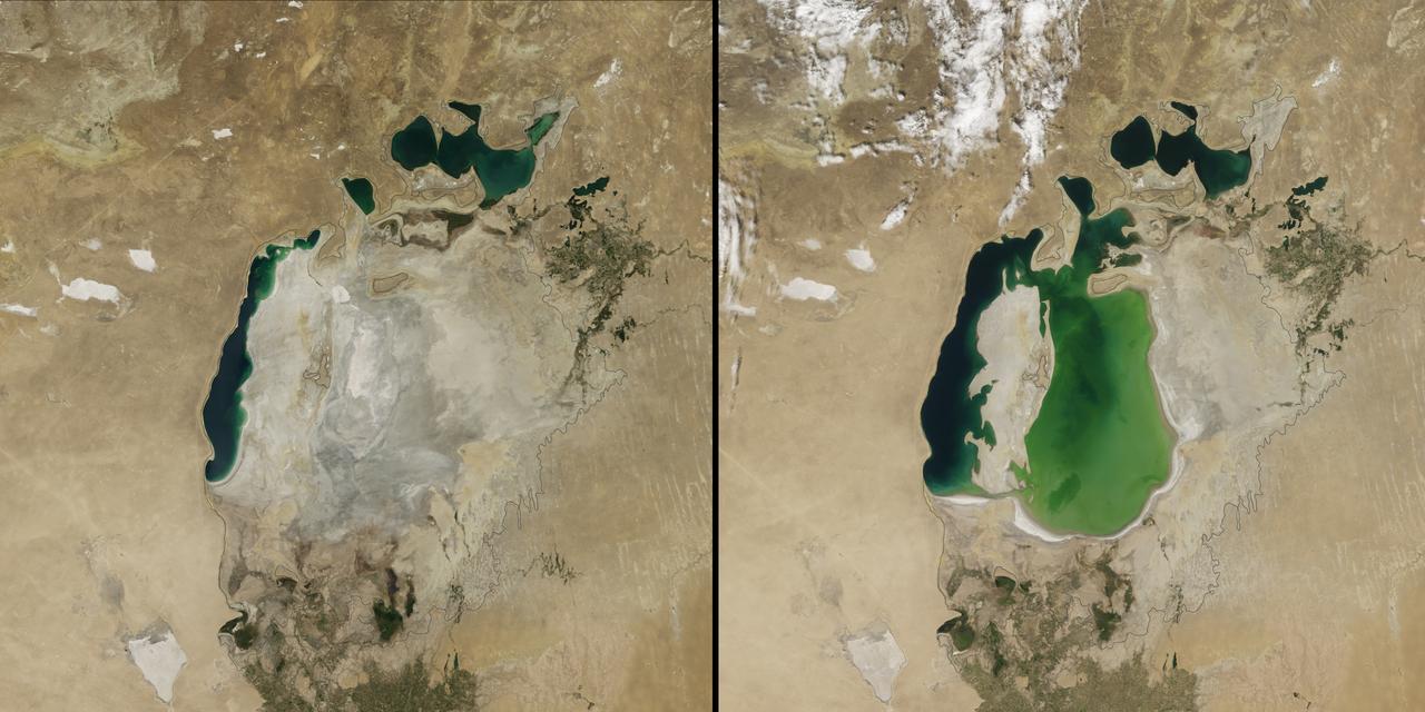
(Aral Sea: left 2014 and right 2000, 1960 extent black line) In the 1960s, the Soviet Union undertook a major water diversion project on the arid plains of Kazakhstan, Uzbekistan, and Turkmenistan. The region’s two major rivers, fed by snowmelt and precipitation in faraway mountains, were used to transform the desert into farms for cotton and other crops. Before the project, the Syr Darya and the Amu Darya rivers flowed down from the mountains, cut northwest through the Kyzylkum Desert, and finally pooled together in the lowest part of the basin. The lake they made, the Aral Sea, was once the fourth largest in the world. Although irrigation made the desert bloom, it devastated the Aral Sea. This series of images from the Moderate Resolution Imaging Spectroradiometer (MODIS) on NASA’s Terra satellite documents the changes. At the start of the series in 2000, the lake was already a fraction of its 1960 extent (black line). The Northern Aral Sea (sometimes called the Small Aral Sea) had separated from the Southern (Large) Aral Sea. The Southern Aral Sea had split into eastern and western lobes that remained tenuously connected at both ends. By 2001, the southern connection had been severed, and the shallower eastern part retreated rapidly over the next several years. Especially large retreats in the eastern lobe of the Southern Sea appear to have occurred between 2005 and 2009, when drought limited and then cut off the flow of the Amu Darya. Water levels then fluctuated annually between 2009 and 2014 in alternately dry and wet years. Dry conditions in 2014 caused the Southern Sea’s eastern lobe to completely dry up for the first time in modern times. Continue reading: <a href="http://1.usa.gov/1nLX9Ku" rel="nofollow">1.usa.gov/1nLX9Ku</a> Read more: <a href="http://1.usa.gov/1pqEnDj" rel="nofollow">1.usa.gov/1pqEnDj</a> Credit: <b><a href="http://www.earthobservatory.nasa.gov/" rel="nofollow"> NASA Earth Observatory</a></b> <b><a href="http://www.nasa.gov/audience/formedia/features/MP_Photo_Guidelines.html" rel="nofollow">NASA image use policy.</a></b> <b><a href="http://www.nasa.gov/centers/goddard/home/index.html" rel="nofollow">NASA Goddard Space Flight Center</a></b> enables NASA’s mission through four scientific endeavors: Earth Science, Heliophysics, Solar System Exploration, and Astrophysics. Goddard plays a leading role in NASA’s accomplishments by contributing compelling scientific knowledge to advance the Agency’s mission. <b>Follow us on <a href="http://twitter.com/NASAGoddardPix" rel="nofollow">Twitter</a></b> <b>Like us on <a href="http://www.facebook.com/pages/Greenbelt-MD/NASA-Goddard/395013845897?ref=tsd" rel="nofollow">Facebook</a></b> <b>Find us on <a href="http://instagram.com/nasagoddard?vm=grid" rel="nofollow">Instagram</a></b>
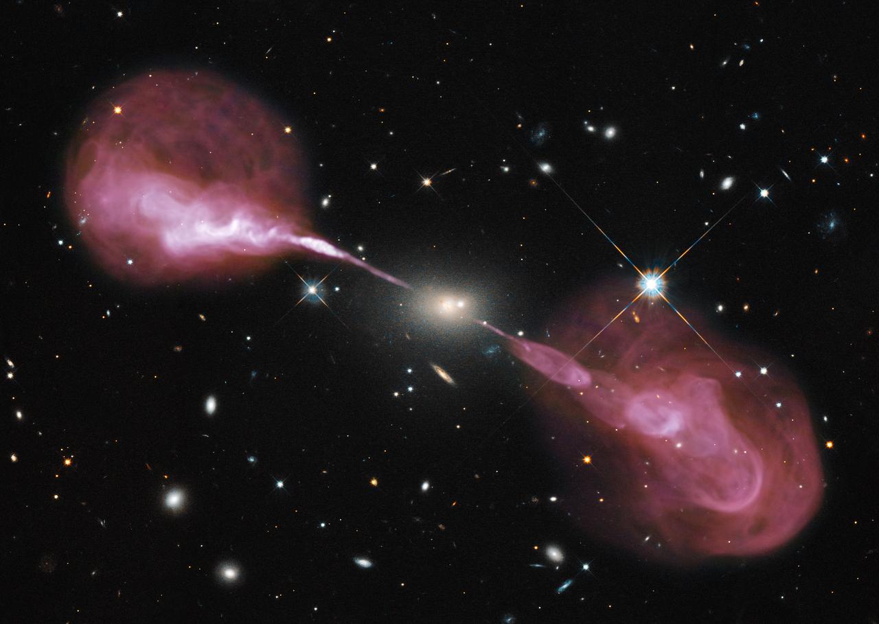
Spectacular jets powered by the gravitational energy of a super massive black hole in the core of the elliptical galaxy Hercules A illustrate the combined imaging power of two of astronomy's cutting-edge tools, the Hubble Space Telescope's Wide Field Camera 3, and the recently upgraded Karl G. Jansky Very Large Array (VLA) radio telescope in New Mexico. <b>To view a video of this go to: <a href="http://bit.ly/Ue2ypS" rel="nofollow">bit.ly/Ue2ypS</a> </b> Some two billion light-years away, the yellowish elliptical galaxy in the center of the image appears quite ordinary as seen by Hubble in visible wavelengths of light. The galaxy is roughly 1,000 times more massive than the Milky Way and harbors a 2.5-billion-solar-mass central black hole that is 1,000 times more massive than the black hole in the Milky Way. But the innocuous-looking galaxy, also known as 3C 348, has long been known as the brightest radio-emitting object in the constellation Hercules. Emitting nearly a billion times more power in radio wavelengths than our Sun, the galaxy is one of the brightest extragalactic radio sources in the entire sky. Credit: NASA, ESA, S. Baum and C. O'Dea (RIT), R. Perley and W. Cotton (NRAO/AUI/NSF), and the Hubble Heritage Team (STScI/AURA) To read more about this image go to: <a href="http://1.usa.gov/Yu7uvX" rel="nofollow">1.usa.gov/Yu7uvX</a> <b><a href="http://www.nasa.gov/audience/formedia/features/MP_Photo_Guidelines.html" rel="nofollow">NASA image use policy.</a></b> <b><a href="http://www.nasa.gov/centers/goddard/home/index.html" rel="nofollow">NASA Goddard Space Flight Center</a></b> enables NASA’s mission through four scientific endeavors: Earth Science, Heliophysics, Solar System Exploration, and Astrophysics. Goddard plays a leading role in NASA’s accomplishments by contributing compelling scientific knowledge to advance the Agency’s mission. <b>Follow us on <a href="http://twitter.com/NASA_GoddardPix" rel="nofollow">Twitter</a></b> <b>Like us on <a href="http://www.facebook.com/pages/Greenbelt-MD/NASA-Goddard/395013845897?ref=tsd" rel="nofollow">Facebook</a></b> <b>Find us on <a href="http://instagram.com/nasagoddard?vm=grid" rel="nofollow">Instagram</a></b>