
This video clip shows a visualisation of the three-dimensional structure of the Pillars of Creation within the star formation region Messier 16 (also called the Eagle Nebula). It is based on new observations of the object using the MUSE instrument on ESO’s Very Large Telescope in Chile. The pillars actually consist of several distinct pieces on either side of the star cluster NGC 6611. Credit: ESO/M. Kornmesser Read more: <a href="http://www.nasa.gov/image-feature/goddard/pillars-of-creation-revealed-in-3-d" rel="nofollow">www.nasa.gov/image-feature/goddard/pillars-of-creation-re...</a> <b><a href="http://www.nasa.gov/audience/formedia/features/MP_Photo_Guidelines.html" rel="nofollow">NASA image use policy.</a></b> <b><a href="http://www.nasa.gov/centers/goddard/home/index.html" rel="nofollow">NASA Goddard Space Flight Center</a></b> enables NASA’s mission through four scientific endeavors: Earth Science, Heliophysics, Solar System Exploration, and Astrophysics. Goddard plays a leading role in NASA’s accomplishments by contributing compelling scientific knowledge to advance the Agency’s mission. <b>Follow us on <a href="http://twitter.com/NASAGoddardPix" rel="nofollow">Twitter</a></b> <b>Like us on <a href="http://www.facebook.com/pages/Greenbelt-MD/NASA-Goddard/395013845897?ref=tsd" rel="nofollow">Facebook</a></b> <b>Find us on <a href="http://instagrid.me/nasagoddard/?vm=grid" rel="nofollow">Instagram</a></b>

This NASA Hubble Space Telescope image, taken in near-infrared light, transforms the pillars into eerie, wispy silhouettes, which are seen against a background of myriad stars. The near-infrared light can penetrate much of the gas and dust, revealing stars behind the nebula as well as hidden away inside the pillars. Some of the gas and dust clouds are so dense that even the near-infrared light cannot penetrate them. New stars embedded in the tops of the pillars, however, are apparent as bright sources that are unseen in the visible image. The ghostly bluish haze around the dense edges of the pillars is material getting heated up by the intense ultraviolet radiation from a cluster of young, massive stars and evaporating away into space. The stellar grouping is above the pillars and cannot be seen in the image. At the top edge of the left-hand pillar, a gaseous fragment has been heated up and is flying away from the structure, underscoring the violent nature of star-forming regions. Astronomers used filters that isolate the light from newly formed stars, which are invisible in the visible-light image. At these wavelengths, astronomers are seeing through the pillars and even through the back wall of the nebula cavity and can see the next generations of stars just as they're starting to emerge from their formative nursery. Credit: NASA, ESA, and the Hubble Heritage Team (STScI/AURA) Read more: <a href="http://1.usa.gov/1HGfkqr" rel="nofollow">1.usa.gov/1HGfkqr</a> <b><a href="http://www.nasa.gov/audience/formedia/features/MP_Photo_Guidelines.html" rel="nofollow">NASA image use policy.</a></b> <b><a href="http://www.nasa.gov/centers/goddard/home/index.html" rel="nofollow">NASA Goddard Space Flight Center</a></b> enables NASA’s mission through four scientific endeavors: Earth Science, Heliophysics, Solar System Exploration, and Astrophysics. Goddard plays a leading role in NASA’s accomplishments by contributing compelling scientific knowledge to advance the Agency’s mission. <b>Follow us on <a href="http://twitter.com/NASAGoddardPix" rel="nofollow">Twitter</a></b> <b>Like us on <a href="http://www.facebook.com/pages/Greenbelt-MD/NASA-Goddard/395013845897?ref=tsd" rel="nofollow">Facebook</a></b> <b>Find us on <a href="http://instagrid.me/nasagoddard/?vm=grid" rel="nofollow">Instagram</a></b>
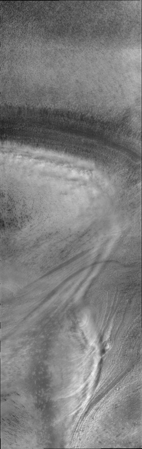
This image captured NASA Mars Odyssey by of low altitude clouds perfectly illustrates how the surface topography of the polar cap controls the creation of visible clouds.

Prometheus dips into the inner F ring at its farthest point from Saturn in its orbit, creating a dark gore and a corresponding bright streamer
Up Close with MESSENGER Flight Path. This image from NASA MESSENGER provides a close-up view, at 50 m/pixel, of the surface MESSENGER imaged for the creation of its flyover video.

ESIG-300 Computer for VMS graphic creation with Chris Sweeney
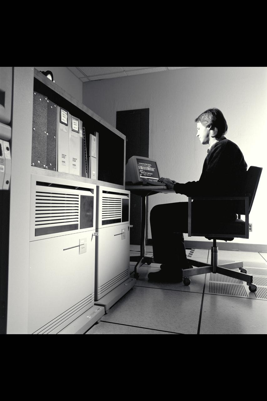
VAX-6000 Computer for VMS graphic creation with Fred Kull
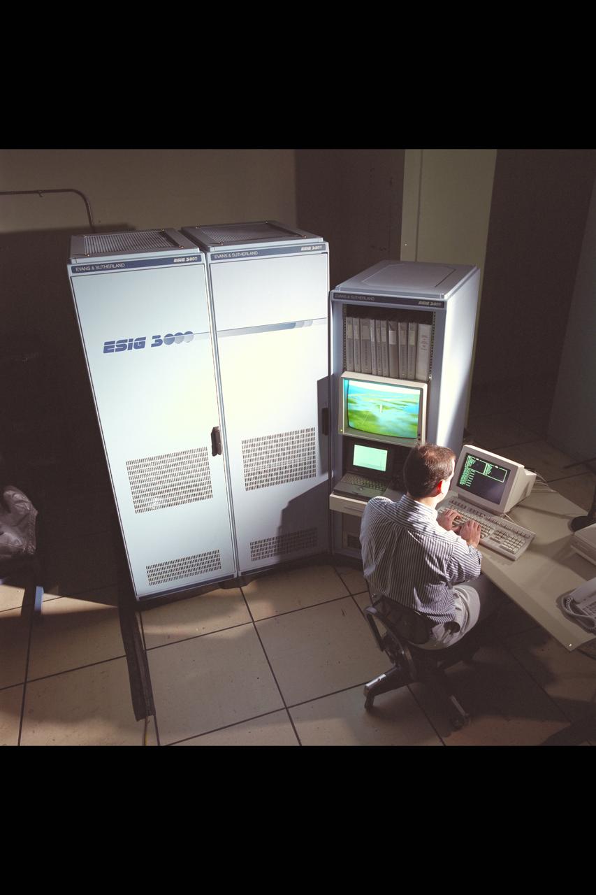
ESIG-3000 Computer for VMS graphic creation with Chris Sweeney
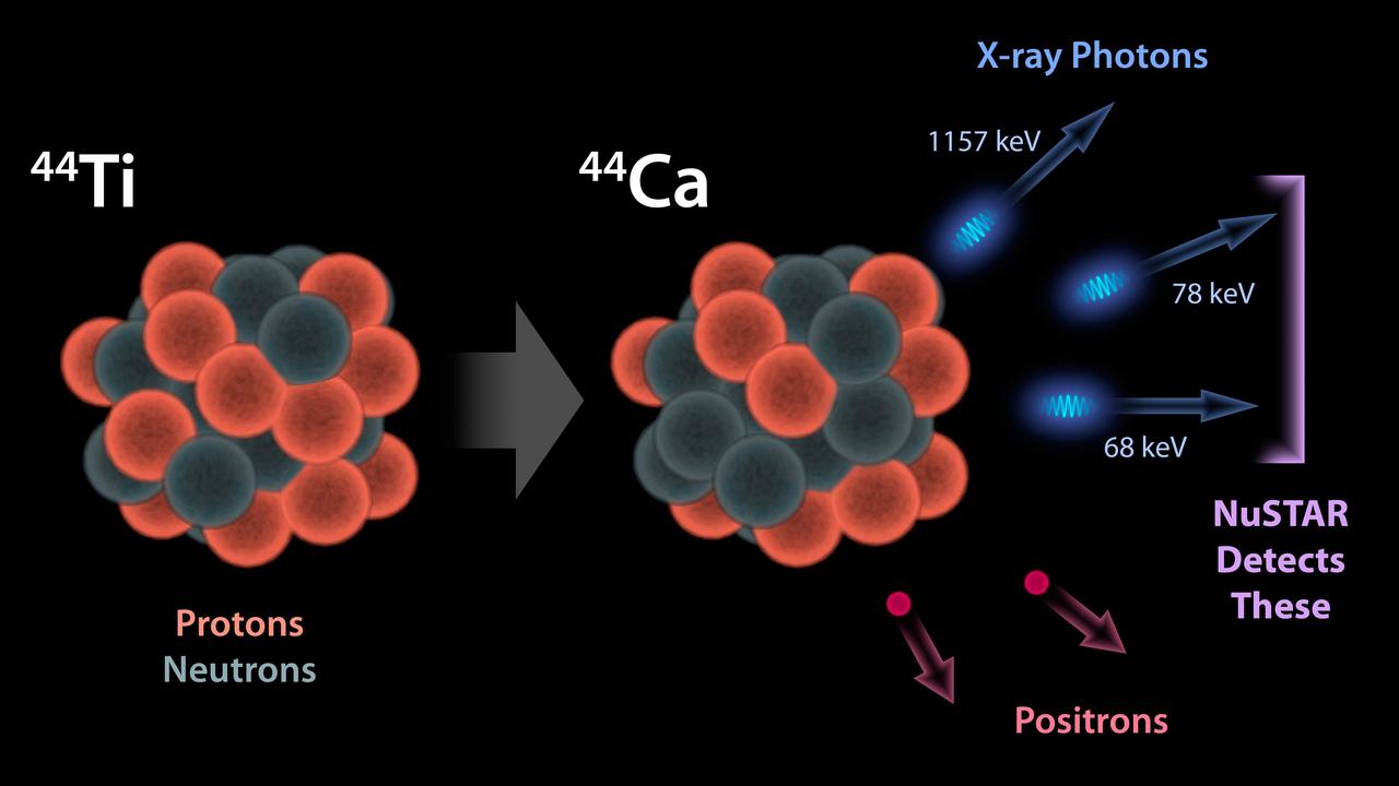
This diagram illustrates why NASA NuSTAR can see radioactivity in the remains of exploded stars for the first time. The observatory detects high-energy X-ray photons that are released by a radioactive substance called titanium-44.

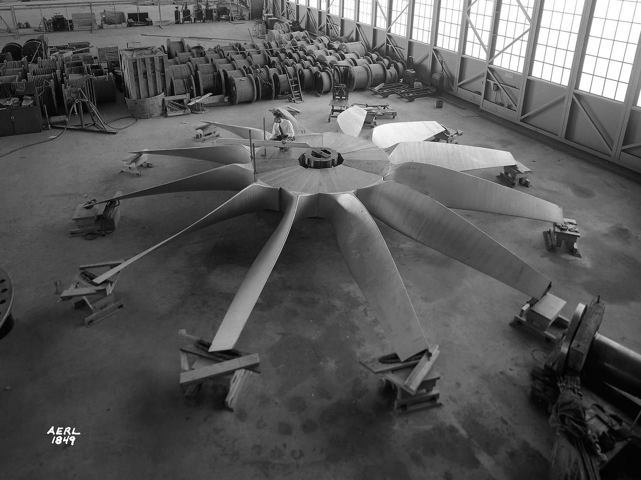
A mechanic and apprentice work on a wooden impeller in the Fabrication Shop at the NACA Lewis Flight Propulsion Laboratory. The 260-person Fabrication Division created almost all of the equipment and models used at the laboratory. The Technical Services Building, referred to as the “Fab Shop”, contained a number of specialized shops in the 1940s and 1950s. These included a Machine Shop, Sheet Metal Shop, Wood and Pattern Shop, Instrument Shop, Thermocouple Shop, Heat Treating Shop, Metallurgical Laboratory, and Fabrication Office. The Machine Shop fabricated research equipment not commercially available. During World War II these technicians produced high-speed cameras for combustion research, impellers and other supercharger components, and key equipment for the lab’s first supersonic wind tunnel. The Wood and Pattern Shop created everything from control panels and cabinets to aircraft model molds for sheet metal work. The Sheet Metal Shop had the ability to work with 0.01 to 4-inches thick steel plates. The Instrument Shop specialized in miniature parts and instrumentation, while the Thermocouple Shop standardized the installation of pitot tubes and thermocouples. The Metallurgical Laboratory contained a control lab for the Heat Treating Shop and a service lab for the NACA Lewis research divisions. The Heat Treating Shop heated metal parts to optimize their physical properties and contained a Precision Castings Foundry to manufacture equipment made of heat resisting alloys.
IMAGE CREATIONS OF BUCKEYE BEAR THE AVON EAST ELEMENTARY SCHOOL MASCOT FOR THE STS104 SHUTTLE MISSION
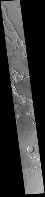
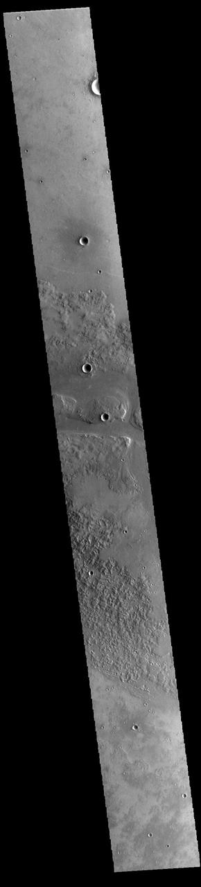
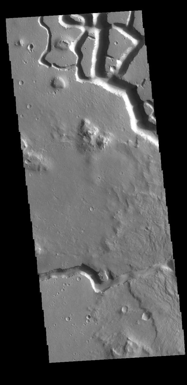
Today's VIS image is located near Hydraotes Chaos. The linear depressions in the region appear to be the start of valley formation that are the first part of chaos creation. It is thought that removal of subsurface ice/water drives the formation of chaos. Orbit Number: 88686 Latitude: 1.32181 Longitude: 322.473 Instrument: VIS Captured: 2021-12-11 17:03 https://photojournal.jpl.nasa.gov/catalog/PIA25201

NASA Hubble peers into a small portion of the nebula near the star cluster NGC 2074. The region is a firestorm of raw stellar creation, perhaps triggered by a nearby supernova explosion. It lies about 170,000 light-years away near the Tarantula
SCOTT PHILLIPS STANDS NEAR HIS LATEST WOODWORKING CREATION FEATURING A SHUTTLE MODEL AND ALL OF THE MISSION PINS FROM PREVIOUS LAUNCHES.
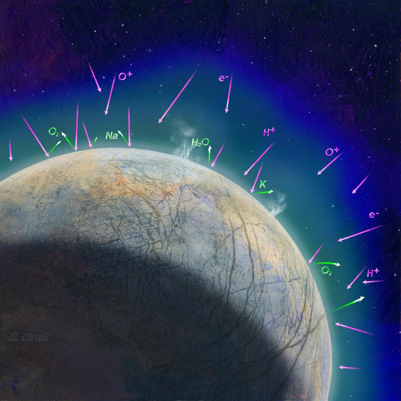
This artist's concept shows how scientists think the thin atmosphere on Jupiter's moon Europa is formed. It illustrates how the impact of high-energy, charged particles can kick up material from the surface and how possible plumes might also contribute to the atmosphere. NASA's Europa Clipper mission aims to better understand the moon's atmosphere by measuring its chemical composition with the MAss Spectrometer for Planetary EXploration/Europa (MASPEX) and "sniffing" the dust grains blasted off the surface with the SUrface Dust Analyzer (SUDA). These two instruments will help scientists understand whether Europa harbors the composition and chemistry required to host life. Europa Clipper's three main science objectives are to determine the thickness of the moon's icy shell and its interactions with the ocean below, to investigate its composition, and to characterize its geology. The mission's detailed exploration of Europa will help scientists better understand the astrobiological potential for habitable worlds beyond our planet. https://photojournal.jpl.nasa.gov/catalog/PIA26107
ISS042E292504 (03/01/2015) --- US astronaut Terry Virts observed this scene from the International Space Station on Feb.1, 2015. He sent this image via Twitter with the remark, "The camera doesn't do it justice - floating in space, looking down on creation, seeing new color shades".
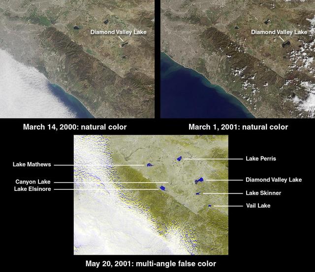
This image from NASA Terra satellite of Diamond Valley Lake Reservoir, near the city of Hemet in Riverside County, billed as the largest earthworks construction project in U.S.history.
This VIS image shows many of the channel segments of Granicus Valles. Granicus Valles is a complex channel system located west of Elysium Mons. The system is approximately 750km long. It is likely that both water and lava played a part in creation of the feature. Orbit Number: 93896 Latitude: 28.5809 Longitude: 132.256 Instrument: VIS Captured: 2023-02-13 16:59 https://photojournal.jpl.nasa.gov/catalog/PIA25906
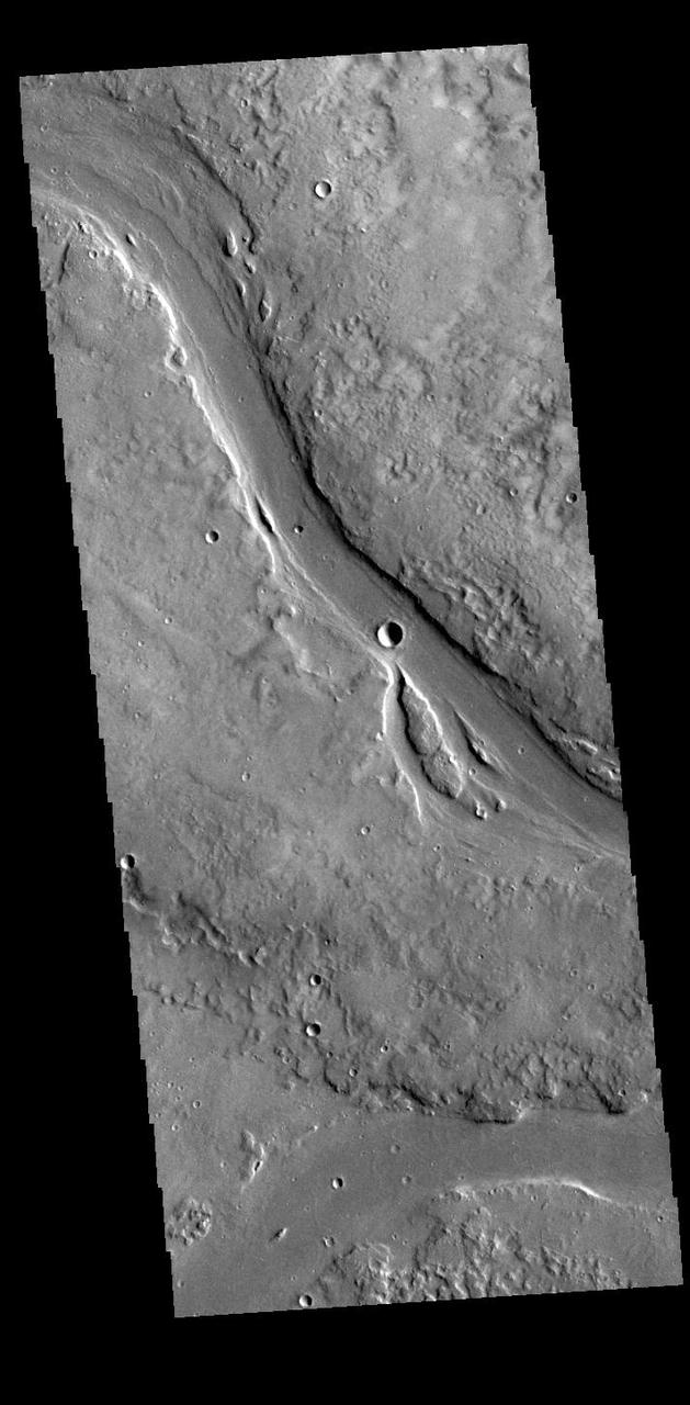
This VIS image shows two of the channel segments of Granicus Valles. Granicus Valles is a complex channel system located west of Elysium Mons. The system is approximately 750km long. It is likely that both water and lava played a part in creation of the feature. Orbit Number: 88156 Latitude: 28.6099 Longitude: 129.149 Instrument: VIS Captured: 2021-10-29 01:49 https://photojournal.jpl.nasa.gov/catalog/PIA25127
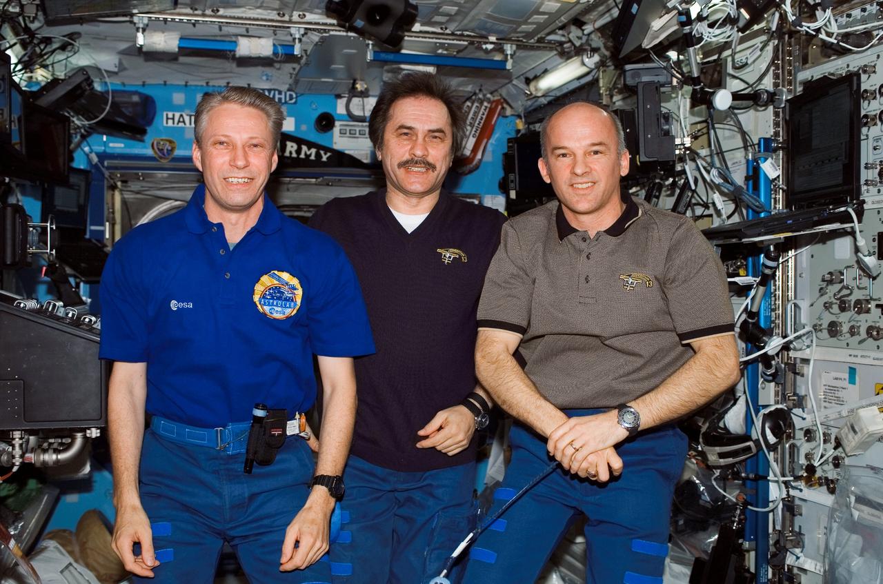
ISS013-E-65695 (10 Aug. 2006) --- European Space Agency (ESA) astronaut Thomas Reiter (left), Expedition 13 flight engineer; cosmonaut Pavel V. Vinogradov, commander representing Russia's Federal Space Agency; and astronaut Jeffrey N. Williams, NASA space station science officer and flight engineer, join Chef Emeril Lagasse during a special call in the Destiny laboratory of the International Space Station. Earlier the crew tasted several of his gourmet creations, delivered to the station by the Space Shuttle Discovery in July.
This VIS image shows part of Granicus Valles. Granicus Valles is a complex channel system located west of Elysium Mons. The system is approximately 750km (466 miles) long. It is likely that both water and lava played a part in creation of the feature. Orbit Number: 94545 Latitude: 28.4791 Longitude: 129.351 Instrument: VIS Captured: 2023-04-08 03:29 https://photojournal.jpl.nasa.gov/catalog/PIA26033
This VIS image shows many of the channel segments of Granicus Valles. Granicus Valles is a complex channel system located west of Elysium Mons. The system is approximately 750km (466 miles) long. It is likely that both water and lava played a part in creation of the feature. Orbit Number: 85523 Latitude: 29.3053 Longitude: 128.19 Instrument: VIS Captured: 2021-03-26 06:42 https://photojournal.jpl.nasa.gov/catalog/PIA24829
This VIS image shows many of the channel segments of Granicus Valles. Granicus Valles is a complex channel system located west of Elysium Mons. The system is approximately 750km long. It is likely that both water and lava played a part in creation of the feature. Orbit Number: 81542 Latitude: 26.6111 Longitude: 135.512 Instrument: VIS Captured: 2020-05-02 11:47 https://photojournal.jpl.nasa.gov/catalog/PIA23994
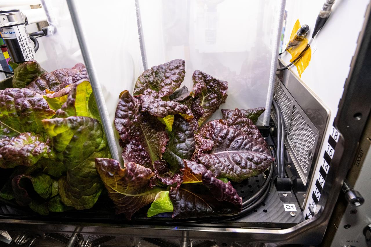
iss072e404269 (Dec. 27, 2024) --- Red Romaine lettuce is pictured growing inside the Kibo laboratory module's Advanced Plant Habitat aboard the International Space Station. The lettuce was being grown for the Plant Habitat-07 space botany investigation that is exploring how plants and their associated communities of microorganisms respond to different levels of water in microgravity. Results could support plant growth and the creation of systems that produce safe and nutritious food for crew members on future space missions.
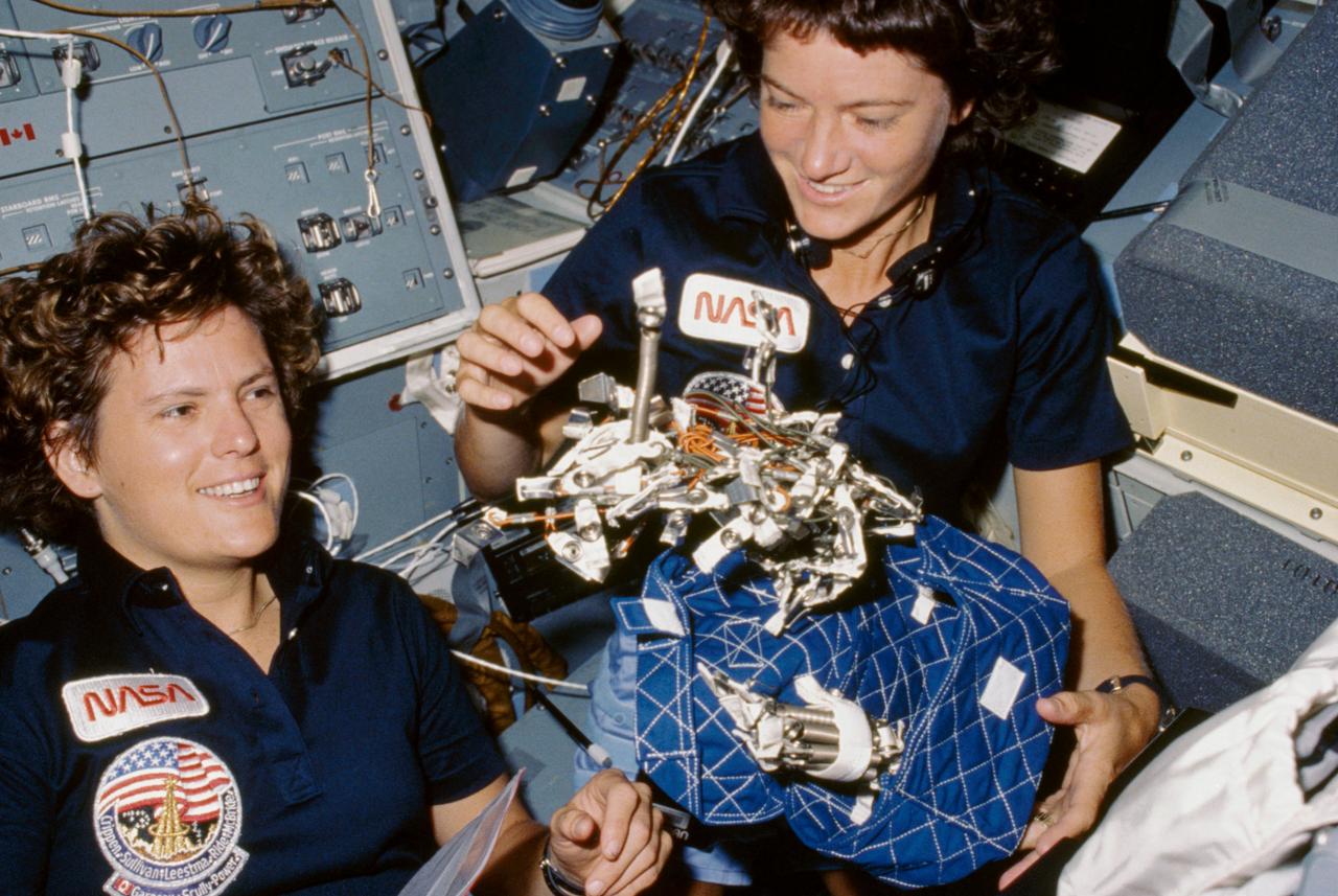
41G-07-021 (5-13 October 1984) --- Astronauts Kathryn D. Sullivan, left, and Sally K. Ride show off what appears to be a "bag of worms", a product of their creativity. The "bag" is a sleep restraint and the majority of the "worms" are springs and clips used with the sleep restraint in its normal application. Clamps, a bungee cord and Velcro strips are other recognizable items in the "creation".
This VIS image shows part of Granicus Valles. Granicus Valles is a complex channel system located west of Elysium Mons. The system is approximately 750km (466 miles) long. It is likely that both water and lava played a part in creation of the feature. Orbit Number: 94832 Latitude: 28.5187 Longitude: 217.227 Instrument: VIS Captured: 2023-05-01 18:38 https://photojournal.jpl.nasa.gov/catalog/PIA26193
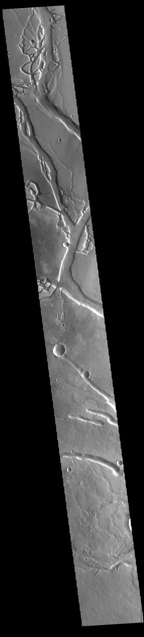
This VIS image shows many of the channel segments of Granicus Valles. Granicus Valles is a complex channel system located west of Elysium Mons. The system is approximately 750km long. It is likely that both water and lava played a part in creation of these features. Orbit Number: 85373 Latitude: 26.3625 Longitude: 135.996 Instrument: VIS Captured: 2021-03-13 22:16 https://photojournal.jpl.nasa.gov/catalog/PIA24779
This VIS image shows two segments of the channel system called Granicus Valles. Granicus Valles is a complex channel system located west of Elysium Mons. The system is approximately 750km (466 miles) long. It is likely that both water and lava played a part in creation of this feature. Orbit Number: 85635 Latitude: 24.8871 Longitude: 137.814 Instrument: VIS Captured: 2021-04-04 12:00 https://photojournal.jpl.nasa.gov/catalog/PIA24859
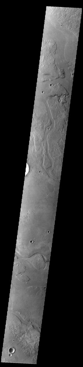
This VIS image shows many of the channel segments of Granicus Valles. Granicus Valles is a complex channel system located west of Elysium Mons. The system is approximately 750km long. It is likely that both water and lava played a part in creation of the feature. Orbit Number: 93615 Latitude: 28.8116 Longitude: 132.055 Instrument: VIS Captured: 2023-01-21 14:23 https://photojournal.jpl.nasa.gov/catalog/PIA25871
This VIS image shows many of the channel segments of Granicus Valles. Granicus Valles is a complex channel system located west of Elysium Mons. The system is approximately 750km long. It is likely that both water and lava played a part in creation of the feature. Orbit Number: 85972 Latitude: 27.7058 Longitude: 135.363 Instrument: VIS Captured: 2021-05-02 05:58 https://photojournal.jpl.nasa.gov/catalog/PIA24215
This VIS image shows one of the channels that comprise Granicus Valles. Granicus Valles is a complex channel system located west of Elysium Mons. The system is approximately 750km long (466 miles). It is likely that both water and lava played a part in creation of the feature. Orbit Number: 93946 Latitude: 28.3677 Longitude: 129.844 Instrument: VIS Captured: 2023-02-17 19:48 https://photojournal.jpl.nasa.gov/catalog/PIA25934

51D-09-014 (12-19 April 1985) --- U.S. Senator E. J. (Jake) Garn (left), payload specialist; and Karol J. Bobko, mission commander, show a copy of a cartoon from the Doonesbury strip of Garry Trudeau. The senator had been the subject of a series of Trudeau's creations prior to 51-D. The single enlarged panel is autographed by the crewmembers.
This VIS image shows part of Granicus Valles. Granicus Valles is a complex channel system located west of Elysium Mons. The system is approximately 750km long (466 miles). It is likely that both water and lava played a part in creation of the feature. Orbit Number: 94807 Latitude: 28.4465 Longitude: 130.95 Instrument: VIS Captured: 2023-04-29 17:14 https://photojournal.jpl.nasa.gov/catalog/PIA26174
This VIS image shows many of the channel segments of Granicus Valles. Granicus Valles is a complex channel system located west of Elysium Mons. The system is approximately 750km long. It is likely that both water and lava played a part in creation of the feature. Orbit Number: 89541 Latitude: 27.8744 Longitude: 132.073 Instrument: VIS Captured: 2022-02-20 02:50 https://photojournal.jpl.nasa.gov/catalog/PIA25378
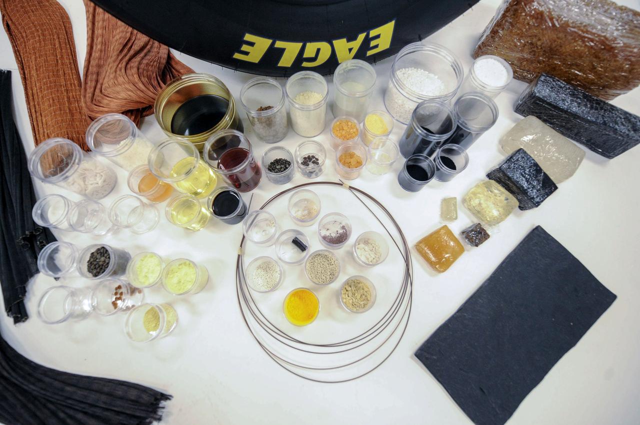
jsc2019e040131 (7/17/2019) --- Tires are comprised of up to 60 different components, ranging from chemicals and fillers to multiple types of rubber and reinforcing cords. The Pushing the Limits of Silica Fillers for Tire Applications (Goodyear Tire) investigation evaluates creation of novel silica forms and structures, or morphologies, using traditional techniques to form silica fillers in microgravity. The space environment may yield results not possible in ground-based environments. Better understanding of silica morphology and the relationship between silica structure and properties may improve the silica design process as well as silica rubber formulation and tire manufacturing and performance on the ground. (Image courtesy of: The Goodyear Tire & Rubber Company)
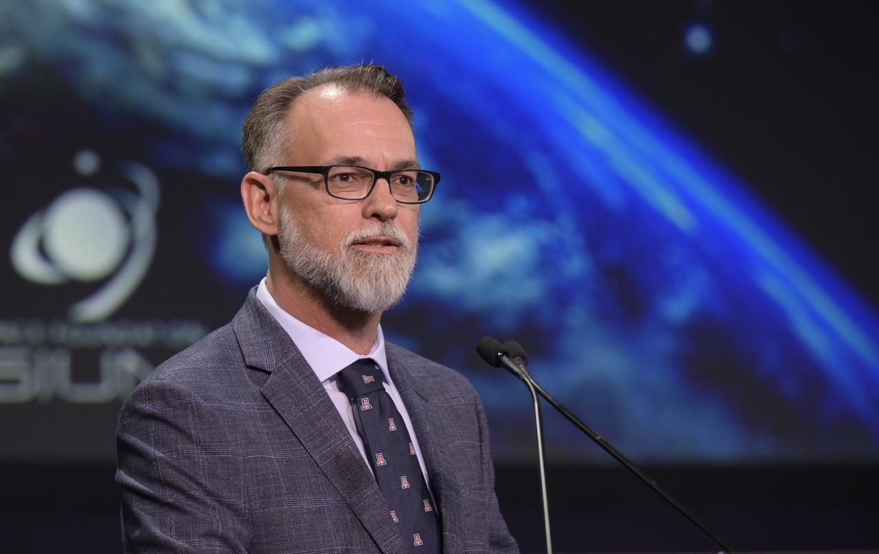
University of Arizona OSIRIS-REx Principal Investigator Dante Lauretta gives remarks after the 2022 John L. “Jack” Swigert, Jr., Award for Space Exploration was presented to the OSIRIS-REx team by the Space Foundation during the 37th Space Symposium, Monday, April 4, 2022, in Colorado Springs, Colorado. The John L. “Jack” Swigert, Jr., Award for Space Exploration recognizes extraordinary accomplishments by a company, space agency, or consortium of organizations in the realm of space exploration and discovery. The award honors the memory of astronaut John L. “Jack” Swigert, Jr., one of the inspirations for the creation of Space Foundation. Photo Credit: (NASA/Bill Ingalls)
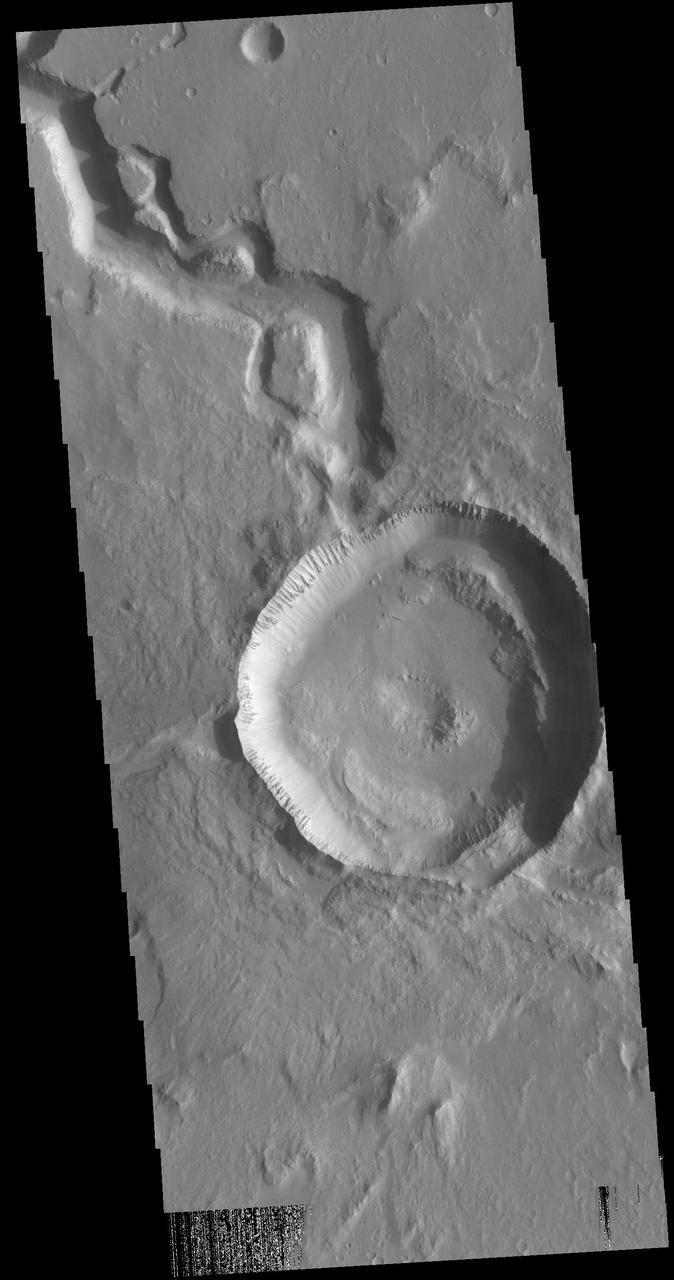
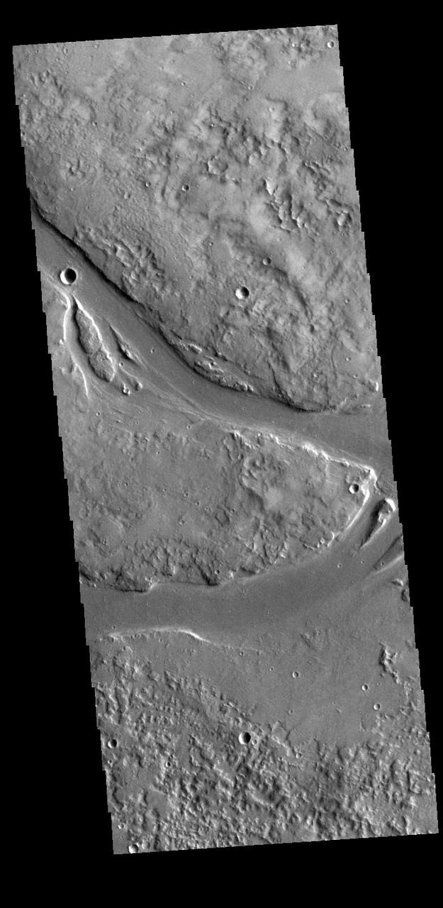
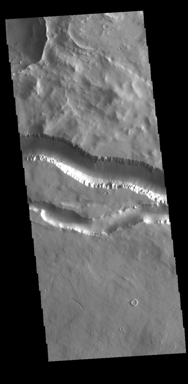
Today's VIS image shows a crater on Hephaestus Fossae. The crater is fairly young, as there is only minimal modification of the crater floor. While it appears that the crater sits of top of the channel, the creation of the crater may have also created the channel. The impact event would have caused subsurface heating, melting any subsurface ice in the region which would have created surface flow to form the channel. Orbit Number: 72447 Latitude: 17.8067 Longitude: 125.698 Instrument: VIS Captured: 2018-04-14 11:35 https://photojournal.jpl.nasa.gov/catalog/PIA22605

NASA Associate Administrator for Science Thomas Zurbuchen gives remarks after the 2022 John L. “Jack” Swigert, Jr., Award for Space Exploration was presented to the OSIRIS-REx team by the Space Foundation during the 37th Space Symposium, Monday, April 4, 2022, in Colorado Springs, Colorado. The John L. “Jack” Swigert, Jr., Award for Space Exploration recognizes extraordinary accomplishments by a company, space agency, or consortium of organizations in the realm of space exploration and discovery. The award honors the memory of astronaut John L. “Jack” Swigert, Jr., one of the inspirations for the creation of Space Foundation. Photo Credit: (NASA/Bill Ingalls)

jsc2019e040132 (3/10/2015) --- Preflight image of silica, a common element used in tires to help enhance performance in areas such as fuel efficiency and wet traction. The Pushing the Limits of Silica Fillers for Tire Applications (Goodyear Tire) investigation evaluates creation of novel silica forms and structures, or morphologies, using traditional techniques to form silica fillers in microgravity. The space environment may yield results not possible in ground-based environments. Better understanding of silica morphology and the relationship between silica structure and properties may improve the silica design process as well as silica rubber formulation and tire manufacturing and performance on the ground. (Image courtesy of: The Goodyear Tire & Rubber Company)
One of the most captivating views acquired during NASA MESSENGER first Mercury flyby was of the crater Apollodorus surrounded by the radiating troughs of Pantheon Fossae. The team nicknamed the combined feature as "the spider." Since then, MESSENGER has acquired many other striking views of this unique feature located near the center of Caloris basin. Although Apollodorus of Damascus (the namesake of the crater) is thought to be the architect of the Pantheon in Rome (the namesake of the fossae), the crater Apollodorus is thought to be unrelated to the creation of Pantheon Fossae. Instrument: Mercury Dual Imaging System (MDIS) Center Latitude: 39.1° Center Longitude: 164.3° E Scale: Apollodorus has a diameter of 42 kilometers (26 miles) http://photojournal.jpl.nasa.gov/catalog/PIA19410
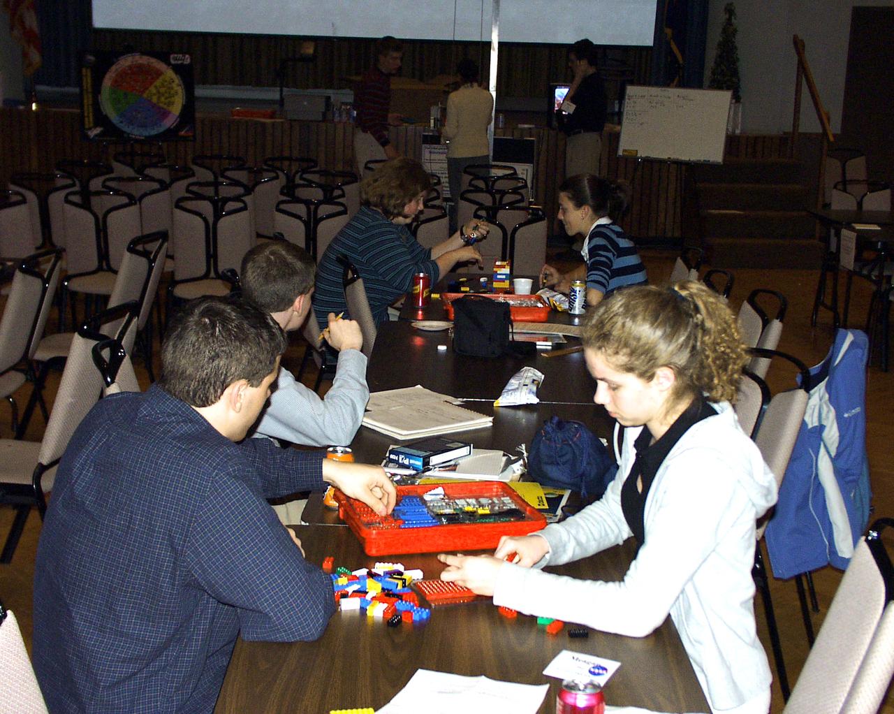
Members from all four teams were mixed into pairs to work on a Lego (TM) Challenge device to operate in the portable drop tower demonstrator (background). These two team members are about to try out their LEGO (TM) creation. This was part of the second Dropping in a Microgravity Environment (DIME) competition held April 23-25, 2002, at NASA's Glenn Research Center. Competitors included two teams from Sycamore High School, Cincinnati, OH, and one each from Bay High School, Bay Village, OH, and COSI Academy, Columbus, OH. DIME is part of NASA's education and outreach activities. Details are on line at http://microgravity.grc.nasa.gov/DIME_2002.html.
NASA engineers Scott Olive (left) and Bo Clarke answer questions during the 2007 FIRST (For Inspiration and Recognition of Science and Technology) Robotics Competition regional kickoff event held Saturday, Jan. 6, 2007, at StenniSphere, the visitor center at NASA Stennis Space Center near Bay St. Louis, Miss. The SSC employees and FIRST Robotics volunteer mentors are standing near a mock-up of the playing field for the FIRST Robotics' 2007 `Rack n' Roll' challenge. Roughly 300 students and adult volunteers - representing 29 high schools from four states - attended the kickoff to hear the rules of `Rack n' Roll.' The teams will spend the next six weeks building and programming robots from parts kits they received Saturday, then battle their creations at regional spring competitions in New Orleans, Houston, Atlanta and other cities around the nation. FIRST aims to inspire students in the pursuit of engineering and technology studies and careers.
STS077-162-036 (19-29 May 1996) --- An oblique view of eastern New York State, Lake Ontario and the Saint Lawrence River. This view of New York State looking northeast was provided by the crew members of the mission. The Linhof camera, a 4x5 format instrument, provides a wide panorama of the region. If the picture is oriented with the NASA logo to the left bottom corner, North will be to the upper side of the frame. Lake Ontario is in the upper left corner and the Catskills are in the lower portion of the scene. The Finger Lakes from Cayuga to Oneida are in the left-center. One of the remarkable aspects of this photograph is this part of New York only averages 68 cloud free days per year. According to scientists studying the photo collection, the entire area of this photograph was covered by glaciers during the ice ages. The glaciers left their marks in the creation of the Finger Lakes and the formation of Lake Ontario.
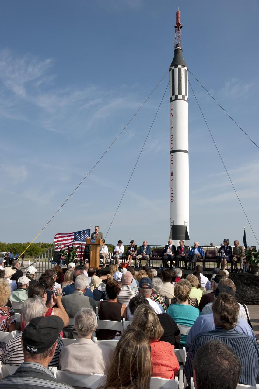
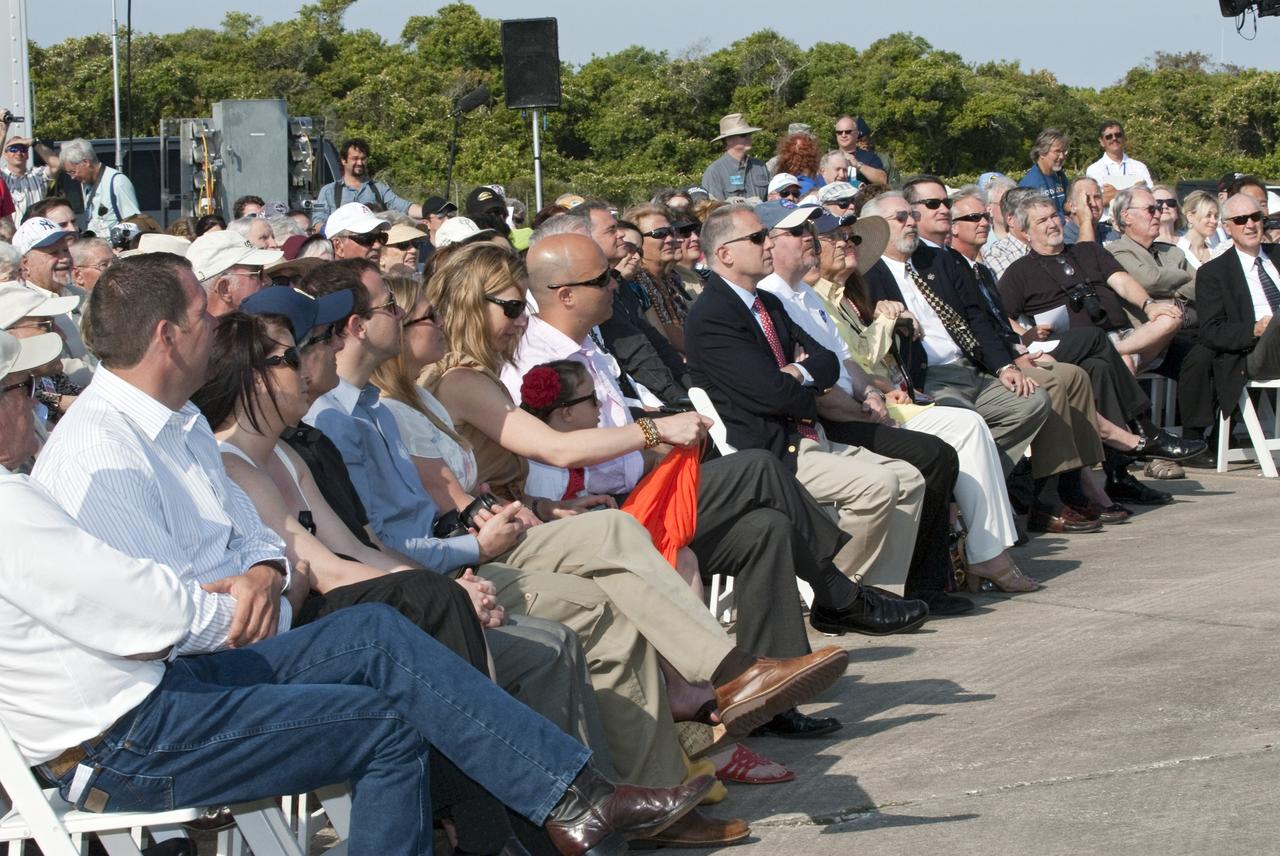
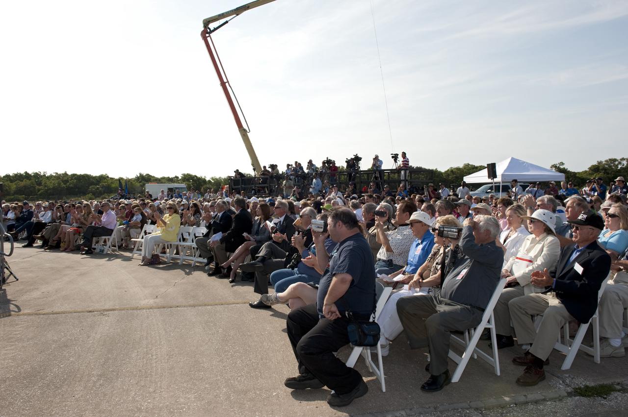
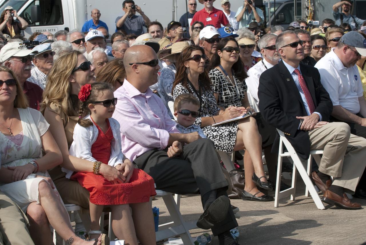
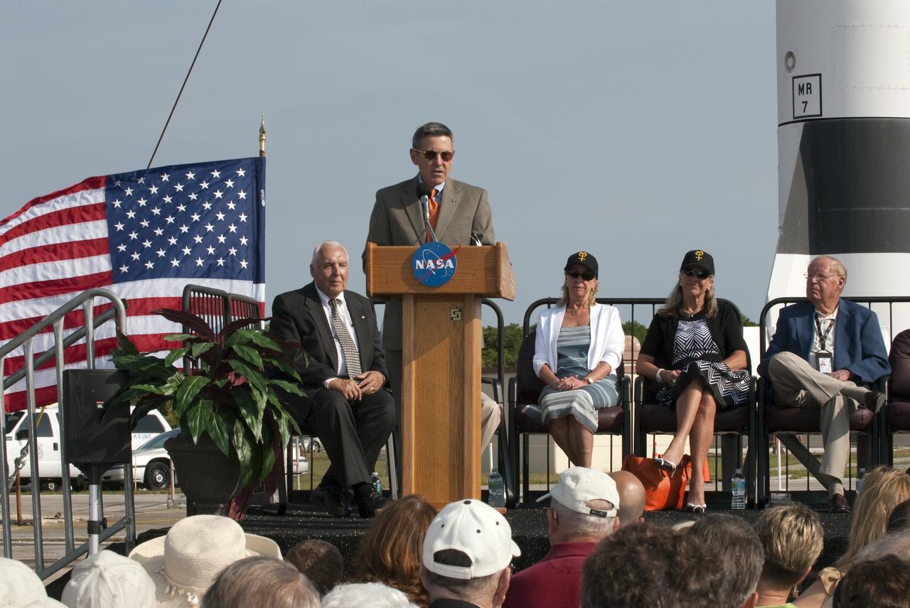
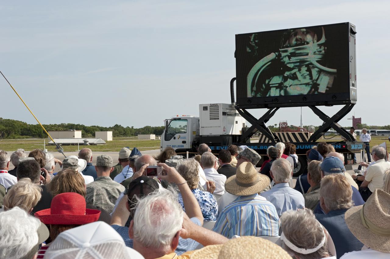
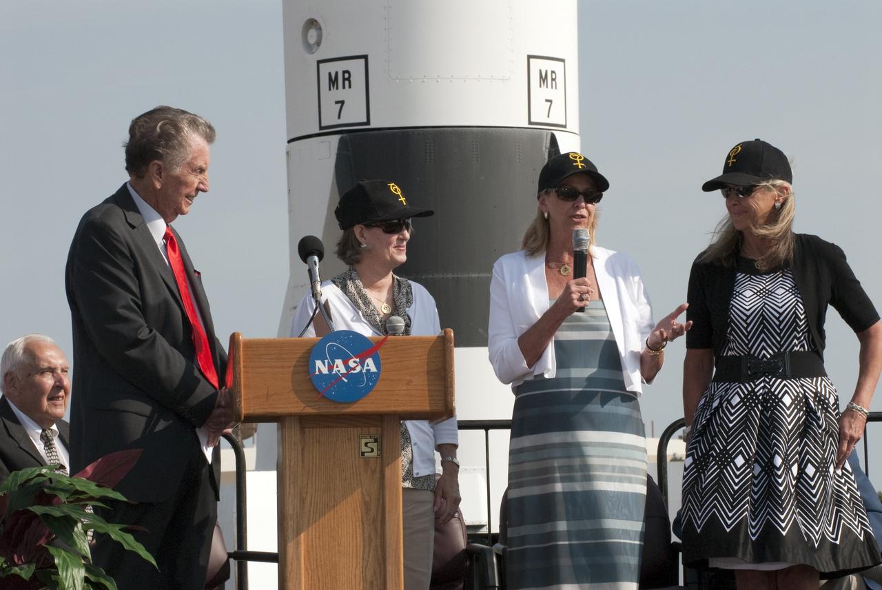
CAPE CANAVERAL, Fla. -- NASA Administrator Charlie Bolden addresses the audience during a celebration at Complex 5/6 on Cape Canaveral Air Force Station in Florida. The celebration was held at the launch site of the first U.S. manned spaceflight May 5, 1961, to mark the 50th anniversary of the flight. Fifty years ago, astronaut Alan Shepard lifted off inside the Mercury capsule, "Freedom 7," atop an 82-foot-tall Mercury-Redstone rocket at 9:34 a.m. EST, sending him on a remarkably successful, 15-minute suborbital flight. The event was attended by more than 200 workers from the original Mercury program and included a re-creation of Shepard's flight and recovery, as well as a tribute to his contributions as a moonwalker on the Apollo 14 lunar mission. For more information, visit www.nasa.gov/topics/history/milestones/index.html. Photo credit: NASA/Kim Shiflett
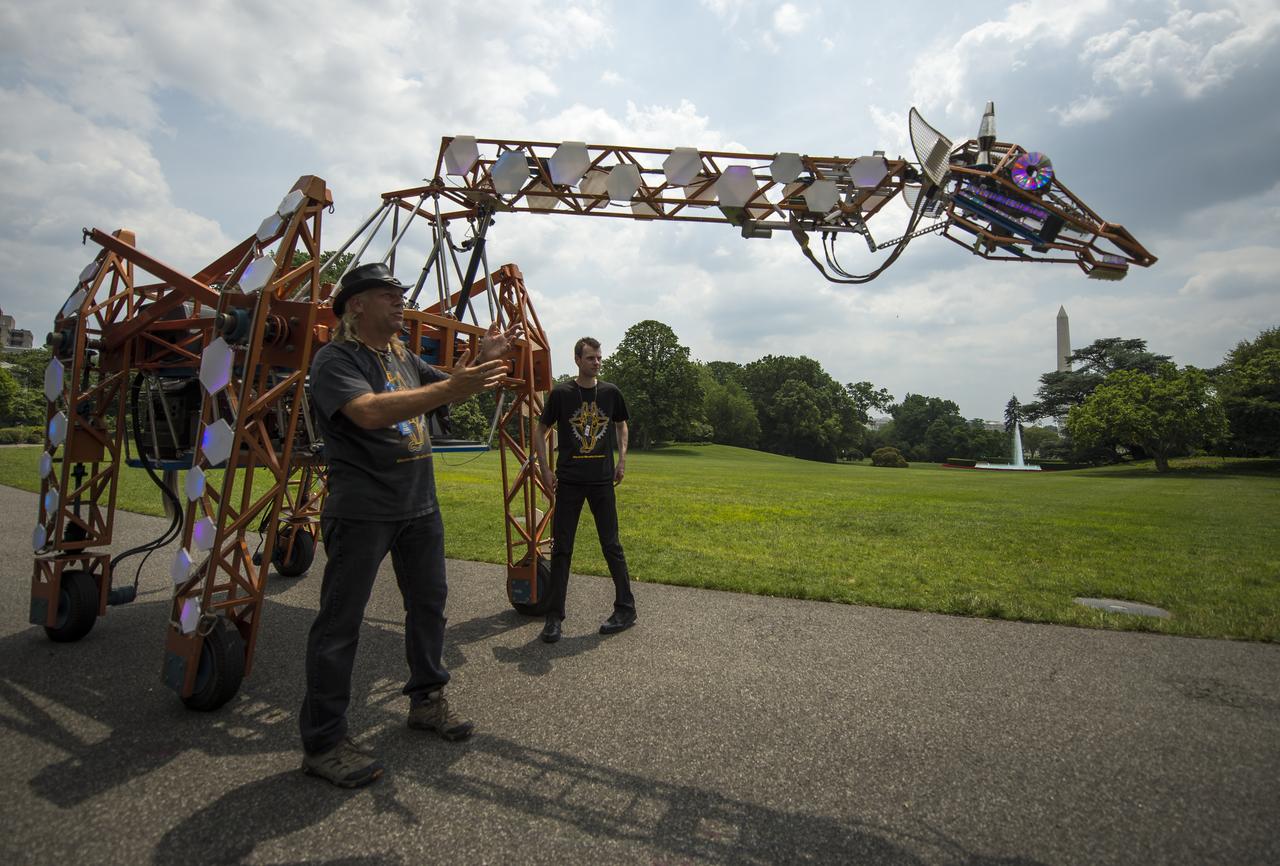
Lindsay Lawlor, of San Diego, Calif., left, demonstrates his creation, a 17-foot-tall, robotic giraffe that "walks" on wheels and is powered by a 12-horsepower hybrid fuel-engine motor, during the first ever White House Maker Faire, which brings together students, entrepreneurs, and everyday citizens who are using new tools and techniques to launch new businesses, learn vital skills in science, technology, engineering, and math (STEM), and fuel the renaissance in American manufacturing, at the White House, Wednesday, June 18, 2014 in Washington. The President announced new steps the Administration and its partners are taking to support the ability of more Americans, young and old, to have to access to these tools and techniques and brings their ideas to life. Photo Credit: (NASA/Bill Ingalls)
CAPE CANAVERAL, Fla. -- Kennedy Space Center Director and former astronaut Bob Cabana addresses the audience at a celebration at Complex 5/6 on Cape Canaveral Air Force Station in Florida. The celebration was held at the launch site of the first U.S. manned spaceflight May 5, 1961, to mark the 50th anniversary of the flight. Fifty years ago, astronaut Alan Shepard lifted off inside the Mercury capsule, "Freedom 7," atop an 82-foot-tall Mercury-Redstone rocket at 9:34 a.m. EST, sending him on a remarkably successful, 15-minute suborbital flight. The event was attended by more than 200 workers from the original Mercury program and included a re-creation of Shepard's flight and recovery, as well as a tribute to his contributions as a moonwalker on the Apollo 14 lunar mission. For more information, visit www.nasa.gov/topics/history/milestones/index.html. Photo credit: NASA/Kim Shiflett
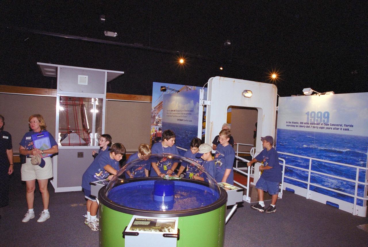
Children on a tour at the KSC Visitor Complex get an early look at the Discovery Channel's Liberty Bell 7 Space Capsule Exhibit, which opens to the public on Saturday, June 17. They are on a re-creation of the deck of Ocean Project, the ship that located and recovered the space capsule from the floor of the Atlantic Ocean. Liberty Bell 7 launched U.S. Air Force Captain Virgil “Gus” Grissom July 21, 1961, on a mission that lasted 15 minutes and 37 seconds before sinking. It lay undetected for nearly four decades before a Discovery Channel expedition located it and recovered it. The space capsule, now restored and preserved, is part of an interactive exhibit touring science centers and museums in 12 cities throughout the United States until 2003. The exhibit also includes hands-on elements such as a capsule simulator, a centrifuge, and ROV pilot
CAPE CANAVERAL, Fla. -- Invited guests attend a celebration at Complex 5/6 on Cape Canaveral Air Force Station in Florida. The celebration was held at the launch site of the first U.S. manned spaceflight May 5, 1961, to mark the 50th anniversary of the flight. Fifty years ago, astronaut Alan Shepard lifted off inside the Mercury capsule, "Freedom 7," atop an 82-foot-tall Mercury-Redstone rocket at 9:34 a.m. EST, sending him on a remarkably successful, 15-minute suborbital flight. The event was attended by more than 200 workers from the original Mercury program and included a re-creation of Shepard's flight and recovery, as well as a tribute to his contributions as a moonwalker on the Apollo 14 lunar mission. For more information, visit www.nasa.gov/topics/history/milestones/index.html. Photo credit: NASA/Kim Shiflett
CAPE CANAVERAL, Fla. -- Invited guests and media representatives attend a celebration at Complex 5/6 on Cape Canaveral Air Force Station in Florida. The celebration was held at the launch site of the first U.S. manned spaceflight May 5, 1961, to mark the 50th anniversary of the flight. Fifty years ago, astronaut Alan Shepard lifted off inside the Mercury capsule, "Freedom 7," atop an 82-foot-tall Mercury-Redstone rocket at 9:34 a.m. EST, sending him on a remarkably successful, 15-minute suborbital flight. The event was attended by more than 200 workers from the original Mercury program and included a re-creation of Shepard's flight and recovery, as well as a tribute to his contributions as a moonwalker on the Apollo 14 lunar mission. For more information, visit www.nasa.gov/topics/history/milestones/index.html. Photo credit: NASA/Kim Shiflett
CAPE CANAVERAL, Fla. -- Invited guests of all ages attend a celebration at Complex 5/6 on Cape Canaveral Air Force Station in Florida. The celebration was held at the launch site of the first U.S. manned spaceflight May 5, 1961, to mark the 50th anniversary of the flight. Fifty years ago, astronaut Alan Shepard lifted off inside the Mercury capsule, "Freedom 7," atop an 82-foot-tall Mercury-Redstone rocket at 9:34 a.m. EST, sending him on a remarkably successful, 15-minute suborbital flight. The event was attended by more than 200 workers from the original Mercury program and included a re-creation of Shepard's flight and recovery, as well as a tribute to his contributions as a moonwalker on the Apollo 14 lunar mission. For more information, visit www.nasa.gov/topics/history/milestones/index.html. Photo credit: NASA/Kim Shiflett
CAPE CANAVERAL, Fla. -- Kennedy Space Center Director and former astronaut Bob Cabana addresses the audience at a celebration at Complex 5/6 on Cape Canaveral Air Force Station in Florida. The celebration was held at the launch site of the first U.S. manned spaceflight May 5, 1961, to mark the 50th anniversary of the flight. Fifty years ago, astronaut Alan Shepard lifted off inside the Mercury capsule, "Freedom 7," atop an 82-foot-tall Mercury-Redstone rocket at 9:34 a.m. EST, sending him on a remarkably successful, 15-minute suborbital flight. The event was attended by more than 200 workers from the original Mercury program and included a re-creation of Shepard's flight and recovery, as well as a tribute to his contributions as a moonwalker on the Apollo 14 lunar mission. For more information, visit www.nasa.gov/topics/history/milestones/index.html. Photo credit: NASA/Kim Shiflett
CAPE CANAVERAL, Fla. -- Invited guests enjoy a tribute to astronaut Alan Shepard during a celebration at Complex 5/6 on Cape Canaveral Air Force Station in Florida. The celebration was held at the launch site of the first U.S. manned spaceflight May 5, 1961, to mark the 50th anniversary of the flight. Fifty years ago, astronaut Alan Shepard lifted off inside the Mercury capsule, "Freedom 7," atop an 82-foot-tall Mercury-Redstone rocket at 9:34 a.m. EST, sending him on a remarkably successful, 15-minute suborbital flight. The event was attended by more than 200 workers from the original Mercury program and included a re-creation of Shepard's flight and recovery, as well as a tribute to his contributions as a moonwalker on the Apollo 14 lunar mission. For more information, visit www.nasa.gov/topics/history/milestones/index.html. Photo credit: NASA/Kim Shiflett
Anchorage, Alaska and Cook Inlet are seen in this 30 by 30 km (19 by 19 miles) sub-image, acquired May 12, 2000 by the Advanced Spaceborne Thermal Emission and Reflection Radiometer (ASTER). Orbiting at an altitude of 705 km (430 miles) on board NASA's Terra satellite, ASTER provides data at a resolution of 15 m (47 feet) and allows creation of this simulated natural color image. At the center of the image is the Ted Stevens Anchorage International Airport; in the upper right corner is Elmendorf Air Force Base. Dark green coniferous forests are seen in the northwest part of the image. A golf course, with its lush green fairways, is just south of the Air Force Base. The image covers an area of 30 by 30 km, was acquired May 12, 2000, and is located at 61.2 degrees north latitude and 149.9 degrees west longitude. http://photojournal.jpl.nasa.gov/catalog/PIA02675
CAPE CANAVERAL, Fla. -- Invited guests attending a celebration at Complex 5/6 on Cape Canaveral Air Force Station in Florida tour the blockhouse. The celebration was held at the launch site of the first U.S. manned spaceflight May 5, 1961, to mark the 50th anniversary of the flight. Fifty years ago, astronaut Alan Shepard lifted off inside the Mercury capsule, "Freedom 7," atop an 82-foot-tall Mercury-Redstone rocket at 9:34 a.m. EST, sending him on a remarkably successful, 15-minute suborbital flight. The event was attended by more than 200 workers from the original Mercury program and included a re-creation of Shepard's flight and recovery, as well as a tribute to his contributions as a moonwalker on the Apollo 14 lunar mission. For more information, visit www.nasa.gov/topics/history/milestones/index.html. Photo credit: NASA/Kim Shiflett
CAPE CANAVERAL, Fla. -- Invited guests enjoy the program presented at a celebration at Complex 5/6 on Cape Canaveral Air Force Station in Florida. The celebration was held at the launch site of the first U.S. manned spaceflight May 5, 1961, to mark the 50th anniversary of the flight. Fifty years ago, astronaut Alan Shepard lifted off inside the Mercury capsule, "Freedom 7," atop an 82-foot-tall Mercury-Redstone rocket at 9:34 a.m. EST, sending him on a remarkably successful, 15-minute suborbital flight. The event was attended by more than 200 workers from the original Mercury program and included a re-creation of Shepard's flight and recovery, as well as a tribute to his contributions as a moonwalker on the Apollo 14 lunar mission. For more information, visit www.nasa.gov/topics/history/milestones/index.html. Photo credit: NASA/Kim Shiflett
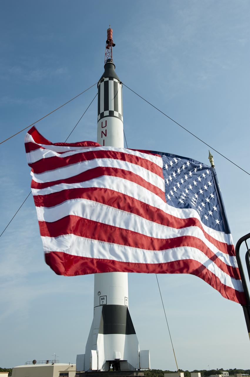
CAPE CANAVERAL, Fla. -- The U.S. flag waves proudly in front of a replica of a Mercury-Redstone rocket at Complex 5/6 on Cape Canaveral Air Force Station in Florida. A celebration was held at the launch site of the first U.S. manned spaceflight May 5, 1961, to mark the 50th anniversary of the flight. Fifty years ago, astronaut Alan Shepard lifted off inside the Mercury capsule, "Freedom 7," atop an 82-foot-tall Mercury-Redstone rocket at 9:34 a.m. EST, sending him on a remarkably successful, 15-minute suborbital flight. The event was attended by more than 200 workers from the original Mercury program and included a re-creation of Shepard's flight and recovery, as well as a tribute to his contributions as a moonwalker on the Apollo 14 lunar mission. For more information, visit www.nasa.gov/topics/history/milestones/index.html. Photo credit: NASA/Kim Shiflett

Children on a tour at the KSC Visitor Complex get an early look at the Discovery Channel's Liberty Bell 7 Space Capsule Exhibit, which opens to the public on Saturday, June 17. They are on a re-creation of the deck of Ocean Project, the ship that located and recovered the space capsule from the floor of the Atlantic Ocean. Liberty Bell 7 launched U.S. Air Force Captain Virgil “Gus” Grissom July 21, 1961, on a mission that lasted 15 minutes and 37 seconds before sinking. It lay undetected for nearly four decades before a Discovery Channel expedition located it and recovered it. The space capsule, now restored and preserved, is part of an interactive exhibit touring science centers and museums in 12 cities throughout the United States until 2003. The exhibit also includes hands-on elements such as a capsule simulator, a centrifuge, and ROV pilot
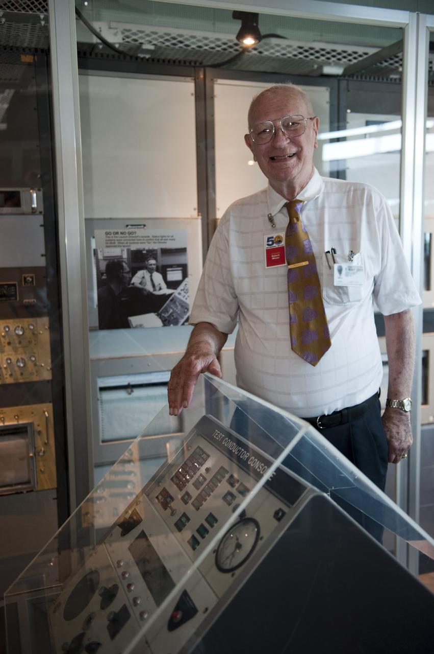
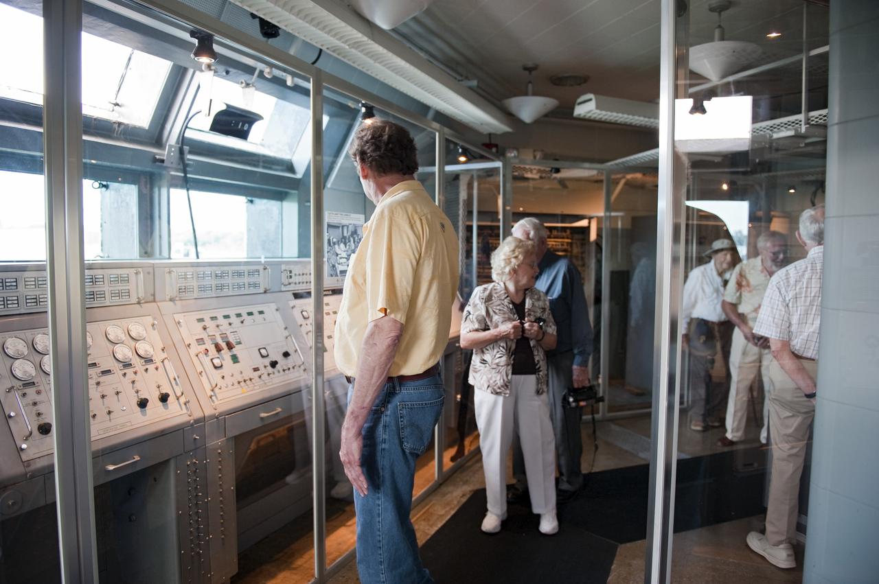
CAPE CANAVERAL, Fla. -- Bob Moser, former chief test conductor for the Mercury-Redstone launches, tours the blockhouse at Complex 5/6 on Cape Canaveral Air Force Station in Florida. The celebration was held at the launch site of the first U.S. manned spaceflight May 5, 1961, to mark the 50th anniversary of the flight. Fifty years ago, astronaut Alan Shepard lifted off inside the Mercury capsule, "Freedom 7," atop an 82-foot-tall Mercury-Redstone rocket at 9:34 a.m. EST, sending him on a remarkably successful, 15-minute suborbital flight. The event was attended by more than 200 workers from the original Mercury program and included a re-creation of Shepard's flight and recovery, as well as a tribute to his contributions as a moonwalker on the Apollo 14 lunar mission. For more information, visit www.nasa.gov/topics/history/milestones/index.html. Photo credit: NASA/Kim Shiflett
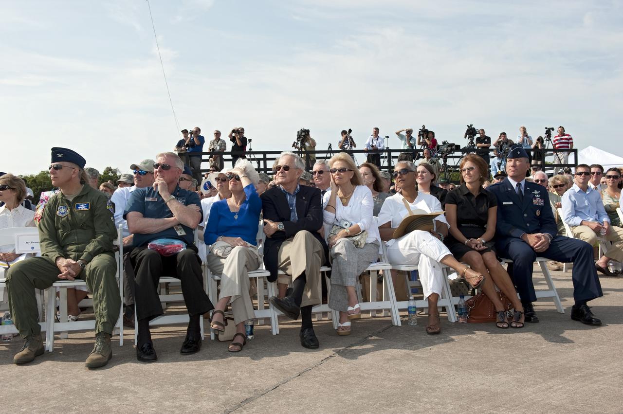
CAPE CANAVERAL, Fla. -- Mercury astronaut Scott Carpenter participates in a celebration at Complex 5/6 on Cape Canaveral Air Force Station in Florida. The celebration was held at the launch site of the first U.S. manned spaceflight May 5, 1961, to mark the 50th anniversary of the flight. Fifty years ago, astronaut Alan Shepard lifted off inside the Mercury capsule, "Freedom 7," atop an 82-foot-tall Mercury-Redstone rocket at 9:34 a.m. EST, sending him on a remarkably successful, 15-minute suborbital flight. The event was attended by more than 200 workers from the original Mercury program and included a re-creation of Shepard's flight and recovery, as well as a tribute to his contributions as a moonwalker on the Apollo 14 lunar mission. For more information, visit www.nasa.gov/topics/history/milestones/index.html. Photo credit: NASA/Kim Shiflett

CAPE CANAVERAL, Fla. -- Lieutenant General Susan J. Helms, commander of the 14th Air Force and former astronaut, addresses the audience at a celebration at Complex 5/6 on Cape Canaveral Air Force Station in Florida. The celebration was held at the launch site of the first U.S. manned spaceflight May 5, 1961, to mark the 50th anniversary of the flight. Fifty years ago, astronaut Alan Shepard lifted off inside the Mercury capsule, "Freedom 7," atop an 82-foot-tall Mercury-Redstone rocket at 9:34 a.m. EST, sending him on a remarkably successful, 15-minute suborbital flight. The event was attended by more than 200 workers from the original Mercury program and included a re-creation of Shepard's flight and recovery, as well as a tribute to his contributions as a moonwalker on the Apollo 14 lunar mission. For more information, visit www.nasa.gov/topics/history/milestones/index.html. Photo credit: NASA/Kim Shiflett
CAPE CANAVERAL, Fla. -- On Cape Canaveral Air Force Station in Florida, invited guests tour the blockhouse at Complex 5/6 during a celebration of Alan Shepard's historic flight 50 years ago. From left are Robert Sieck, former shuttle launch director; Andy Anderson, former manager for communications in the Mercury Mission Control Center; Bob Moser, former chief test conductor for the Mercury-Redstone launches; and John Twigg, former backup chief test conductor for the Mercury-Redstone launches. The celebration was held at the launch site of the first U.S. manned spaceflight May 5, 1961, to mark the 50th anniversary of the flight. Fifty years ago, astronaut Alan Shepard lifted off inside the Mercury capsule, "Freedom 7," atop an 82-foot-tall Mercury-Redstone rocket at 9:34 a.m. EST, sending him on a remarkably successful, 15-minute suborbital flight. The event was attended by more than 200 workers from the original Mercury program and included a re-creation of Shepard's flight and recovery, as well as a tribute to his contributions as a moonwalker on the Apollo 14 lunar mission. For more information, visit www.nasa.gov/topics/history/milestones/index.html. Photo credit: NASA/Kim Shiflett
This VIS image shows part of Hephaestus Fossae. Hephaestus Fossae is a complex channel system in Utopia Planitia near Elysium Mons. It has been proposed that the channel formed by the release of melted subsurface ice during the impact event that created the crater just off the left side of the image – only the ejecta is seen in this image. The crater is fairly young, as there is only minimal modification of the crater floor. While it appears that the crater sits of top of the channel, the creation of the crater may have also created the channel. The impact event would have caused subsurface heating, melting any subsurface ice in the region which would have created surface flow to form the channel. Additionally, the nearby Elysium volcanic center created subsurface heating that may have played a part in creating both Hephaestus Fossae and Hebrus Valles to the north. Orbit Number: 94645 Latitude: 17.6141 Longitude: 126.055 Instrument: VIS Captured: 2023-04-16 09:02 https://photojournal.jpl.nasa.gov/catalog/PIA26040
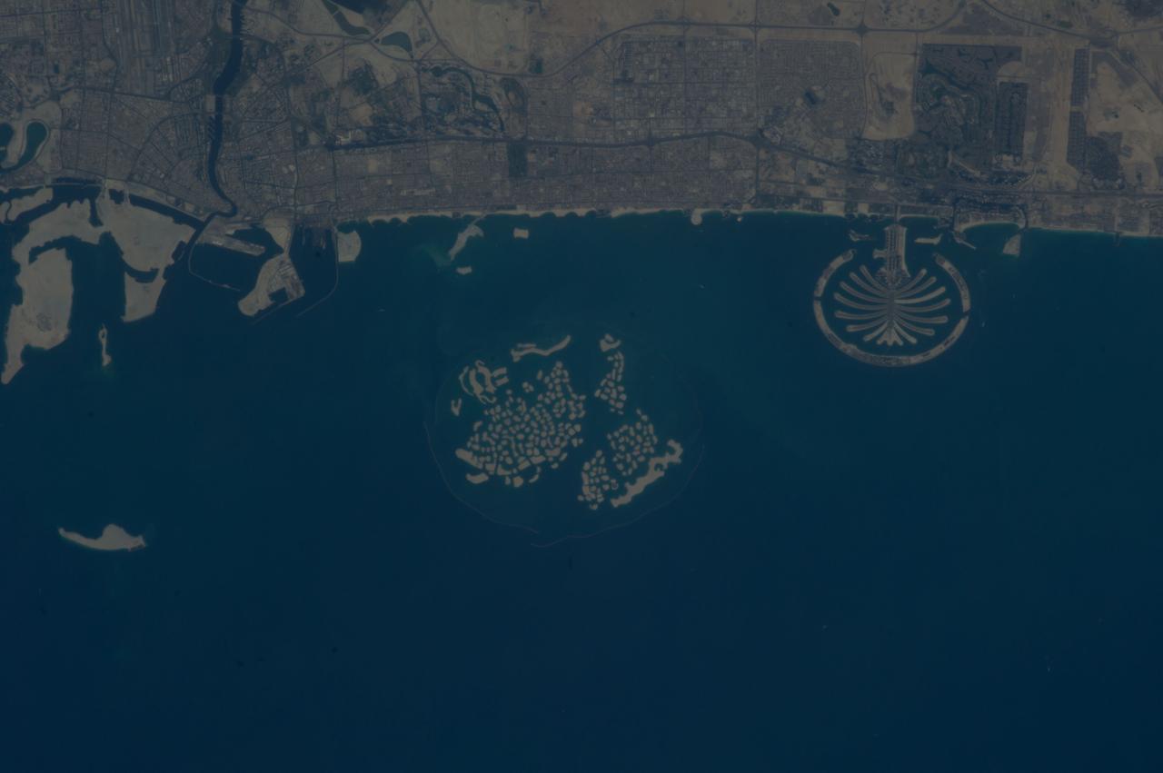
ISS037-E-011470 (14 Oct. 2013) --- Man-made archipelagos near Dubai, United Arab Emirates, are featured in this image photographed by an Expedition 37 crew member on the International Space Station, flying at approximately 220 miles above Earth. The municipality of Dubai is the largest city of the Persian Gulf emirate of the same name, and has built a global reputation for large-scale developments and architectural works. Among the most visible of these developments -- particularly from the perspective of astronauts onboard the space station -- are three man-made archipelagos. The two Palm Islands -- Palm Jumeirah (right) and Palm Jebel Ali (out of frame further to the right) -- appear as stylized palm trees when viewed from above. The World Islands (center frame) evoke a rough map of the world from an air- or space-borne perspective. The Palm Jumeirah project began in 2001 and required more than 50 million cubic meters of dredged sand to raise the islands above the Persian Gulf sea level. Construction of the Palm Jumeirah islands was completed in 2006; for several years now they have been developed for residential and commercial housing and infrastructure. Creation of the World Islands was begun in 2003 and completed in 2008, using 320 million cubic meters of sand and 37 million tons of rock for the surrounding 27 kilometer-long protective breakwater.
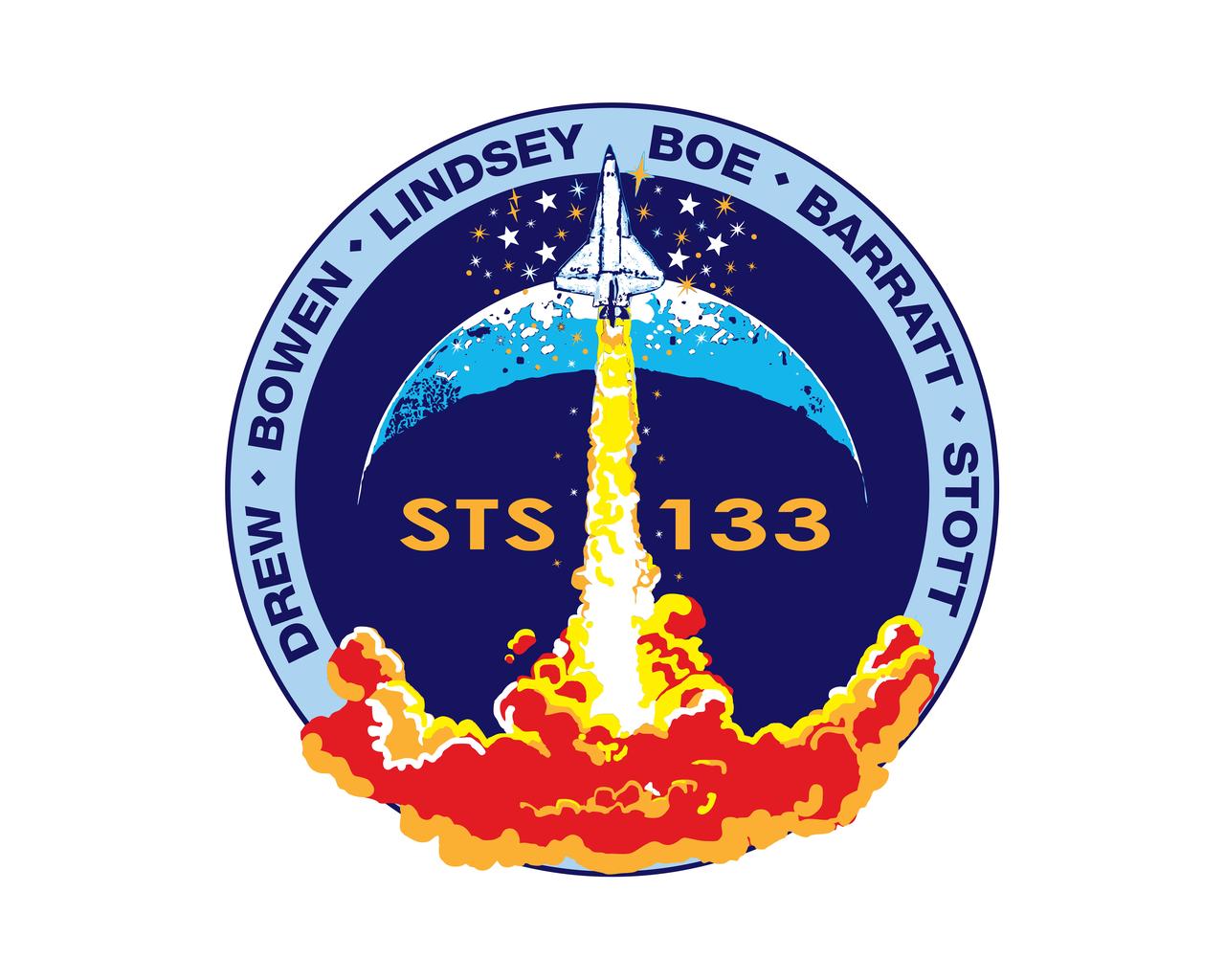
STS133-S-001 (June 2010, Revised January 2011) --- The STS-133 mission patch is based upon sketches from the late artist Robert McCall; they were the final creations of his long and prodigious career. In the foreground, a solitary orbiter ascends into a dark blue sky above a roiling fiery plume. A spray of stars surrounds the orbiter and a top lit crescent forms the background behind the ascent. The mission number, STS-133, is emblazoned on the patch center, and crew members' names are listed on a sky-blue border around the scene. The space shuttle Discovery is depicted ascending on a plume of flame as if it is just beginning a mission. However it is just the orbiter, without boosters or an external tank, as it would be at mission's end. This is to signify Discovery's completion of its operational life and the beginning of its new role as a symbol of NASA's and the nation's proud legacy in human spaceflight. The NASA insignia design for space shuttle flights is reserved for use by the astronauts and for other official use as the NASA Administrator may authorize. Public availability has been approved only in the forms of illustrations by the various news media. When and if there is any change in this policy, which is not anticipated, the change will be publicly announced. Photo credit: NASA
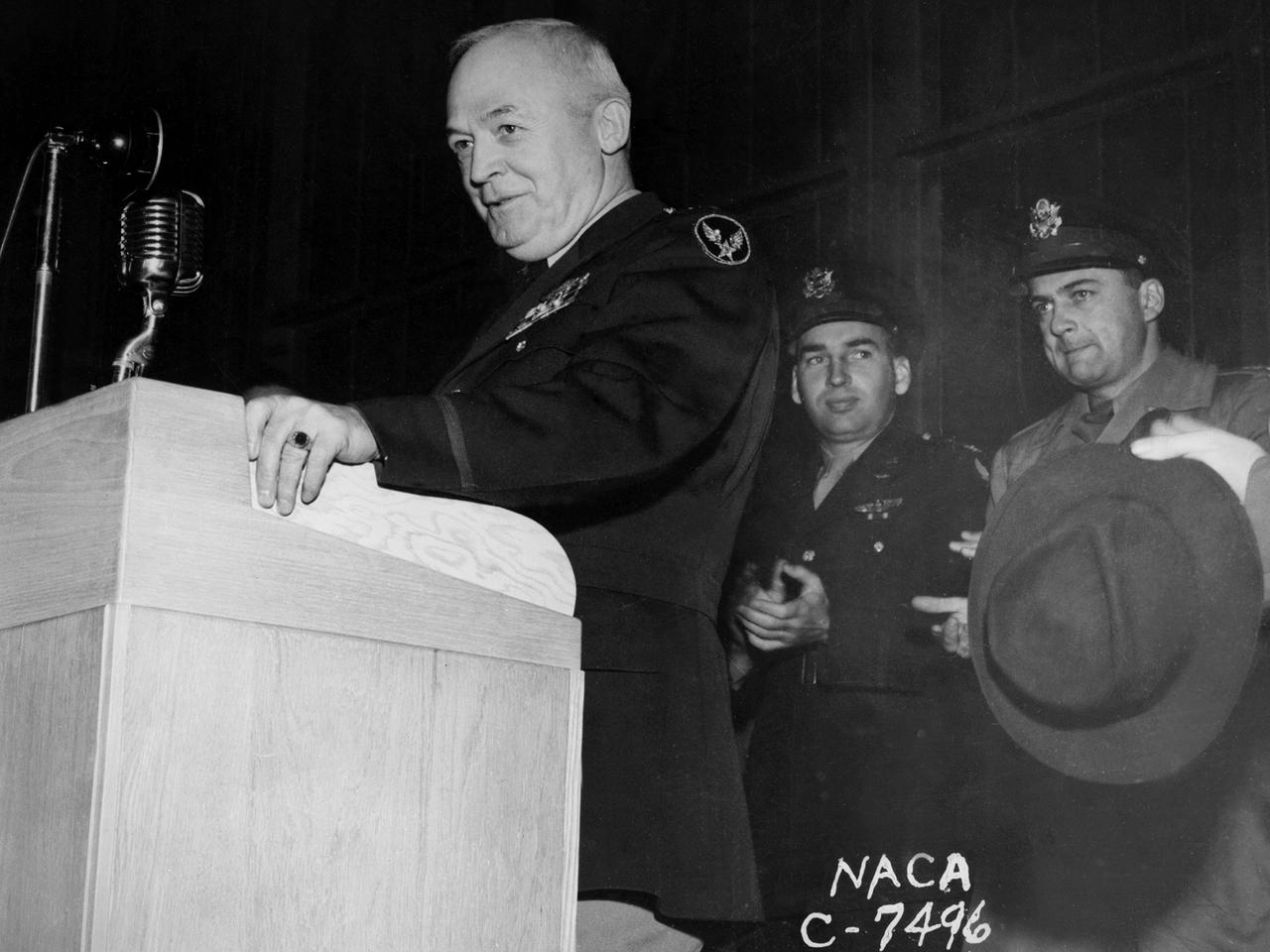
General Henry “Hap” Arnold, Commander of the US Army Air Forces during World War II, addresses the staff at the National Advisory Committee for Aeronautics (NACA) Aircraft Engine Research Laboratory on November 9, 1944. Arnold told the employees assembled in the hangar, “You’ve got a dual task. You’ve got a job ahead of you to keep the army and the navy air forces equipped with the finest equipment that you can for this war. You also have the job of looking forward into the future and starting now those developments, those experiments, that are going to keep us in our present situation—ahead of the world in the air. And that is quite a large order, and I leave it right in your laps.” Arnold served on the NACA’s Executive Committee in Washington from 1938 to 1944 and had been a strong advocate for the creation of the new engine research facility in Cleveland. Arnold believed in continual research and development. He pressed the nation’s aviation leaders to pursue the new jet engine technology, while simultaneously pushing to increase the performance of the nation’s largest piston engine for the B–29 Superfortress program. The general’s hectic wartime agenda limited his visit to the Cleveland laboratory to just a few hours, but he toured several of the NACA’s new test facilities including the Static Jet Propulsion Laboratory, the Icing Research Tunnel, and a B–24 Liberator in the hangar.
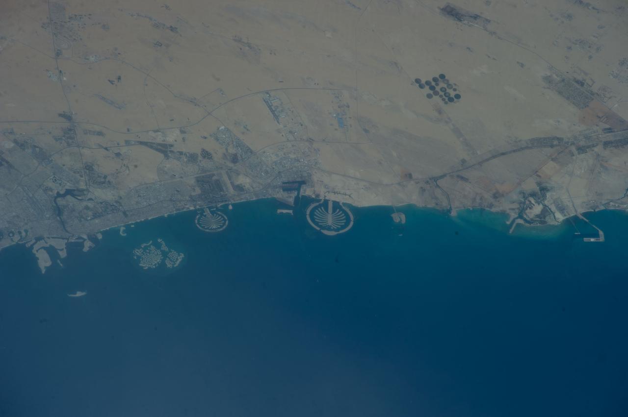
ISS039-E-011515 (13 April 2014) --- Man-made archipelagos near Dubai, United Arab Emirates, are featured in this image photographed by an Expedition 39 crew member on the International Space Station, flying at 220 miles above Earth. The municipality of Dubai is the largest city of the Persian Gulf emirate of the same name, and has built a global reputation for large-scale developments and architectural works. Among the most visible of these developments -- particularly from the perspective of astronauts onboard the ISS -- are three man-made archipelagos. The two Palm Islands -- Palm Jumeirah to the left of center, and Palm Jebel Ali, just to the right of center, appear as stylized palm trees when viewed from above. The World Islands (near left edge) evoke a rough map of the world from an air- or space-borne perspective. The Palm Jumeirah project began in 2001 and required more than 50 million cubic meters of dredged sand to raise the islands above the Persian Gulf sea level. Construction of the Palm Jumeirah islands was completed in 2006; they are now being developed for residential and commercial housing and infrastructure. Creation of the World Islands was begun in 2003 and completed in 2008, using 320 million cubic meters of sand and 37 million tons of rock for the surrounding 27 kilometer-long protective breakwater.
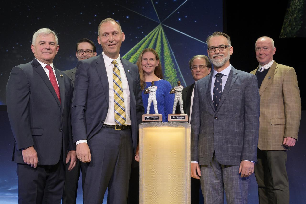
Space Foundation Chief Executive Officer Thomas E. Zelibor, Rear Admiral, USN (Ret.); left, Mike Moreau, Deputy Project Manager, Space Science Mission Operations, NASA Goddard Space Flight Center; NASA Associate Administrator for Science Thomas Zurbuchen; Sandra Freund, OSIRIS-REx Mission Operations Manager, Lockheed Martin Space; Pete Antreasian, OSIRIS-REx Navigation Team Chief, KinetX; University of Arizona OSIRIS-REx Principal Investigator Dante Lauretta; Rich Burns, Project Manager, Space Science Mission Operations, NASA Goddard Space Flight Center, right, pose for a photograph during the awarding of the 2022 John L. “Jack” Swigert, Jr., Award for Space Exploration given to the OSIRIS-REx team by the Space Foundation during the 37th Space Symposium, Monday, April 4, 2022, in Colorado Springs, Colorado. The John L. “Jack” Swigert, Jr., Award for Space Exploration recognizes extraordinary accomplishments by a company, space agency, or consortium of organizations in the realm of space exploration and discovery. The award honors the memory of astronaut John L. “Jack” Swigert, Jr., one of the inspirations for the creation of Space Foundation. Photo Credit: (NASA/Bill Ingalls)
The grand opening of NASA’s new, world-class laboratory for research into future space transportation technologies located at the Marshall Space Flight Center (MSFC) in Huntsville, Alabama, took place in July 2004. The state-of-the-art Propulsion Research Laboratory (PRL) serves as a leading national resource for advanced space propulsion research. Its purpose is to conduct research that will lead to the creation and development of innovative propulsion technologies for space exploration. The facility is the epicenter of the effort to move the U.S. space program beyond the confines of conventional chemical propulsion into an era of greatly improved access to space and rapid transit throughout the solar system. The laboratory is designed to accommodate researchers from across the United States, including scientists and engineers from NASA, the Department of Defense, the Department of Energy, universities, and industry. The facility, with 66,000 square feet of useable laboratory space, features a high degree of experimental capability. Its flexibility allows it to address a broad range of propulsion technologies and concepts, such as plasma, electromagnetic, thermodynamic, and propellant propulsion. An important area of emphasis is the development and utilization of advanced energy sources, including highly energetic chemical reactions, solar energy, and processes based on fission, fusion, and antimatter. The Propulsion Research Laboratory is vital for developing the advanced propulsion technologies needed to open up the space frontier, and sets the stage of research that could revolutionize space transportation for a broad range of applications.
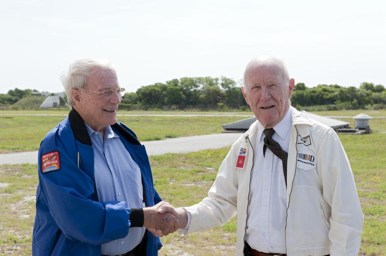
CAPE CANAVERAL, Fla. -- During a celebration at Complex 5/6 on Cape Canaveral Air Force Station in Florida, Mercury astronaut Scott Carpenter greets Calvin Fowler, the launch conductor for Carpenter's Mercury-Atlas 7 mission on May 24, 1962. The celebration was held at the launch site of the first U.S. manned spaceflight May 5, 1961, to mark the 50th anniversary of the flight. Fifty years ago, astronaut Alan Shepard lifted off inside the Mercury capsule, "Freedom 7," atop an 82-foot-tall Mercury-Redstone rocket at 9:34 a.m. EST, sending him on a remarkably successful, 15-minute suborbital flight. The event was attended by more than 200 workers from the original Mercury program and included a re-creation of Shepard's flight and recovery, as well as a tribute to his contributions as a moonwalker on the Apollo 14 lunar mission. For more information, visit www.nasa.gov/topics/history/milestones/index.html. Photo credit: NASA/Kim Shiflett
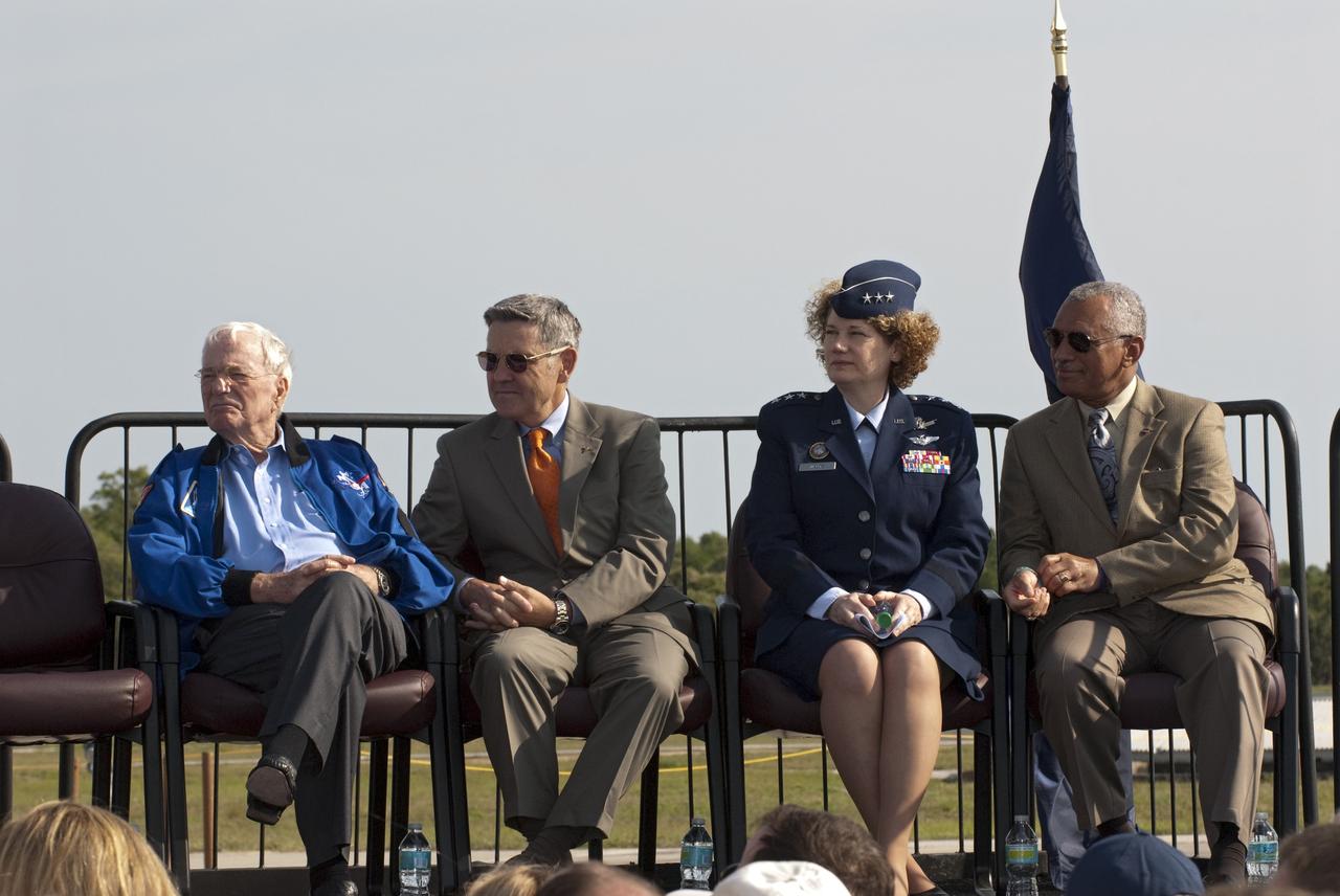
CAPE CANAVERAL, Fla. -- From left, Mercury astronaut Scott Carpenter; Kennedy Space Center Director and former astronaut Bob Cabana; Lieutenant General Susan J. Helms, commander of the 14th Air Force and former astronaut; and NASA Administrator Charlie Bolden participate in a celebration at Complex 5/6 on Cape Canaveral Air Force Station in Florida. The celebration was held at the launch site of the first U.S. manned spaceflight May 5, 1961, to mark the 50th anniversary of the flight. Fifty years ago, astronaut Alan Shepard lifted off inside the Mercury capsule, "Freedom 7," atop an 82-foot-tall Mercury-Redstone rocket at 9:34 a.m. EST, sending him on a remarkably successful, 15-minute suborbital flight. The event was attended by more than 200 workers from the original Mercury program and included a re-creation of Shepard's flight and recovery, as well as a tribute to his contributions as a moonwalker on the Apollo 14 lunar mission. For more information, visit www.nasa.gov/topics/history/milestones/index.html. Photo credit: NASA/Kim Shiflett
ISS018-E-028898 (7 Feb. 2009) --- The summit of Popocatepetl Volcano in Mexico is featured in this image photographed by an Expedition 18 crewmember on the International Space Station. Volcano Popocatepetl, a large stratovolcano located approximately 70 kilometers to the southeast of Mexico City, is considered by many volcanologists to be ?the planet?s riskiest volcano?. The volcano warrants this distinction because of its proximity to one of the most densely populated megacities on Earth (population near 23 million in 2009). The variety of potential volcanic hazards at Popocatepetl is also considerable, including explosive eruptions of ash, pyroclastic flows (hot, fluidized masses of rock and gas that flow rapidly downhill), and debris avalanches. This detailed photograph of the summit crater of Popocatepetl (center) also highlights Ventorillo and Noroccidental Glaciers ? together with ice on nearby Iztaccihuatl Volcano and Pico de Orizaba (Mexico?s highest peak and the highest volcano in North America), these are the only mountain glaciers in tropical North America. The presence of glaciers on Popocatepetl is also connected with another volcanic hazard ? the creation of dangerous mudflows, or lahars, should the ice melt during eruptive activity. At the time this image was taken, steam and ash plumes were observed at the volcano ? a faint white steam plume is visible against gray ash deposits on the eastern and southern flanks of the volcano.
A new, world-class laboratory for research into future space transportation technologies is under construction at the Marshall Space Flight Center (MSFC) in Huntsville, AL. The state-of-the-art Propulsion Research Laboratory will serve as a leading national resource for advanced space propulsion research. Its purpose is to conduct research that will lead to the creation and development of irnovative propulsion technologies for space exploration. The facility will be the epicenter of the effort to move the U.S. space program beyond the confines of conventional chemical propulsion into an era of greatly improved access to space and rapid transit throughout the solar system. The Laboratory is designed to accommodate researchers from across the United States, including scientists and engineers from NASA, the Department of Defense, the Department of Energy, universities, and industry. The facility, with 66,000 square feet of useable laboratory space, will feature a high degree of experimental capability. Its flexibility will allow it to address a broad range of propulsion technologies and concepts, such as plasma, electromagnetic, thermodynamic, and propellantless propulsion. An important area of emphasis will be development and utilization of advanced energy sources, including highly energetic chemical reactions, solar energy, and processes based on fission, fusion, and antimatter. The Propulsion Research Laboratory is vital for developing the advanced propulsion technologies needed to open up the space frontier, and will set the stage of research that could revolutionize space transportation for a broad range of applications.
CAPE CANAVERAL, Fla. -- NBC reporter Jay Barbree introduces Alice Wackermann, Julie Jenkins and Laura Churchley, daughters of astronaut Alan Shepard, to the audience at a celebration at Complex 5/6 on Cape Canaveral Air Force Station in Florida. The celebration was held at the launch site of the first U.S. manned spaceflight May 5, 1961, to mark the 50th anniversary of the flight. Fifty years ago, astronaut Alan Shepard lifted off inside the Mercury capsule, "Freedom 7," atop an 82-foot-tall Mercury-Redstone rocket at 9:34 a.m. EST, sending him on a remarkably successful, 15-minute suborbital flight. The event was attended by more than 200 workers from the original Mercury program and included a re-creation of Shepard's flight and recovery, as well as a tribute to his contributions as a moonwalker on the Apollo 14 lunar mission. For more information, visit www.nasa.gov/topics/history/milestones/index.html. Photo credit: NASA/Kim Shiflett

These four nebulae (star-forming clouds of gas and dust) are known for their breathtaking beauty: the Eagle Nebula (which contains the Pillars of Creation), the Omega Nebula, the Trifid Nebula, and the Lagoon Nebula. In the 1950s, a team of astronomers made rough distance measurements to some of the stars in these nebulae and were able to infer the existence of the Sagittarius Arm. Their work provided some of the first evidence of our galaxy's spiral structure. In a new study, astronomers have shown that these nebulae are part of a substructure within the arm that is angled differently from the rest of the arm. A key property of spiral arms is how tightly they wind around a galaxy. This characteristic is measured by the arm's pitch angle. A circle has a pitch angle of 0 degrees, and as the spiral becomes more open, the pitch angle increases. Most models of the Milky Way suggest that the Sagittarius Arm forms a spiral that has a pitch angle of about 12 degrees, but the protruding structure has a pitch angle of nearly 60 degrees. Similar structures – sometimes called spurs or feathers – are commonly found jutting out of the arms of other spiral galaxies. For decades scientists have wondered whether our Milky Way's spiral arms are also dotted with these structures or if they are relatively smooth. https://photojournal.jpl.nasa.gov/catalog/PIA24577
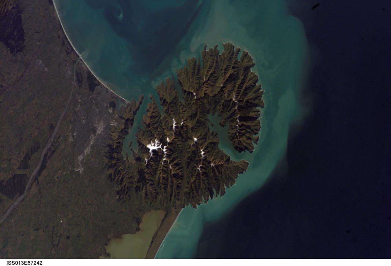
ISS013-E-67242 (15 Aug. 2006) --- Christchurch, New Zealand is featured in this image photographed by an Expedition 13 crewmember on the International Space Station. Snow highlights the peaks of the Banks Peninsula to the southeast of the city. The Peninsula has a radically different landscape compared to the adjoining flat Canterbury Plains on which Christchurch is situated. This is a result of the geology of the Banks Peninsula -- it is formed from the overlapping cones of the extinct Lyttelton and Akaroa volcanoes. Subsequent erosion of the cones formed the heavily dissected terrain visible in the image, and sea level rise led to the creation of several harbors around the Peninsula. Erosion continues unabated today, as evidenced by the apron of greenish blue sediment-laden waters surrounding the Banks Peninsula. Other features of interest in the image include the braided Waimakariri River to the north-northwest of the city, and the greenish brown waters of Lake Ellesmere. The coloration of the water is due both to its shallow depth (1.4 meters average) and its high concentrations of nitrogen and phosphorus - conditions which lead to a high abundance of green algae.
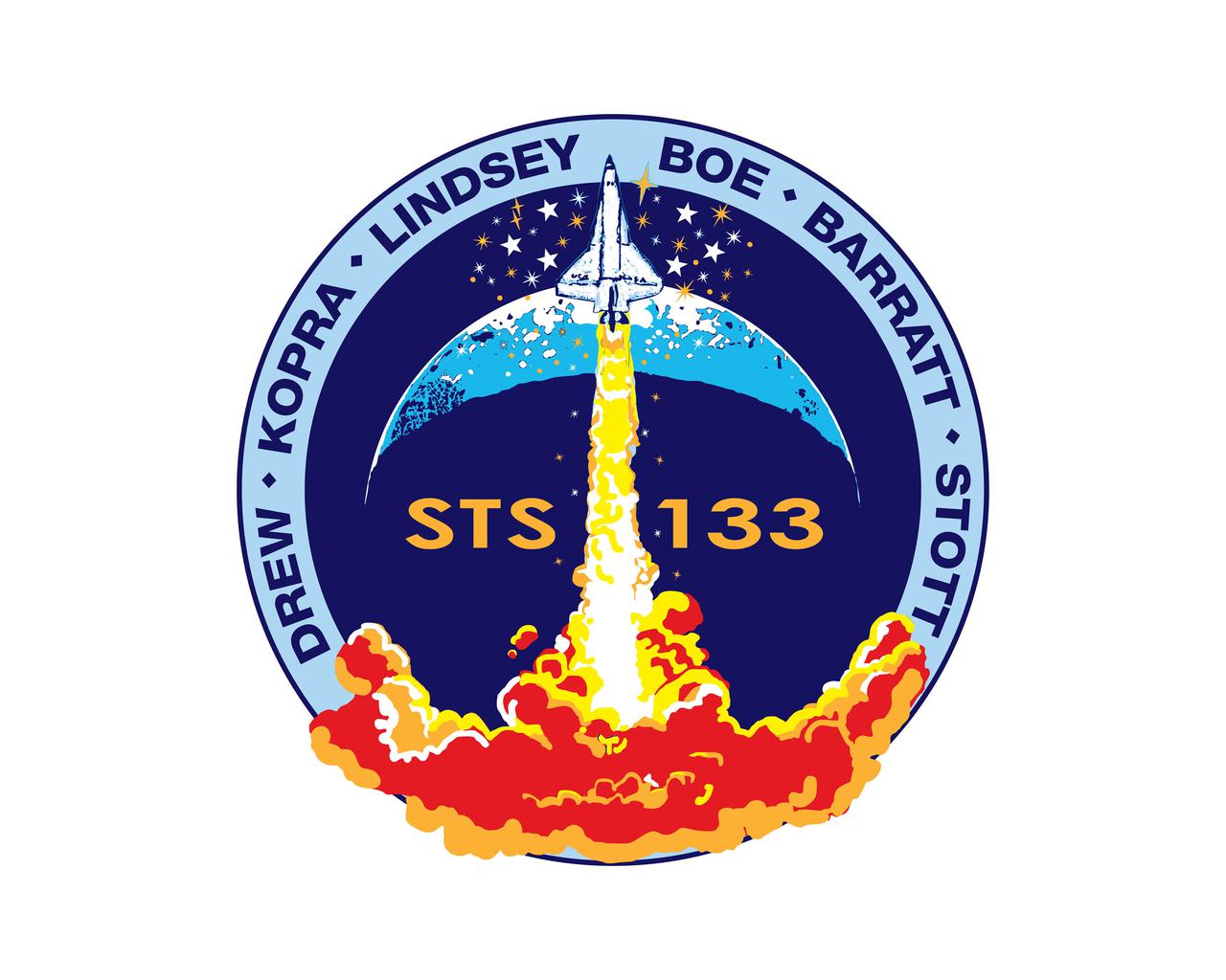
JOHNSON SPACE CENTER, Houston - STS133-S-001 ---- The STS-133 mission patch is based upon sketches from the late artist Robert McCall; they were the final creations of his long and prodigious career. In the foreground, a solitary orbiter ascends into a dark blue sky above a roiling fiery plume. A spray of stars surrounds the orbiter and a top lit crescent forms the background behind the ascent. The mission number, STS-133, is emblazoned on the patch center, and crewmembers' names are listed on a sky-blue border around the scene. The Shuttle Discovery is depicted ascending on a plume of flame as if it is just beginning a mission. However it is just the orbiter, without boosters or an external tank, as it would be at mission's end. This is to signify Discovery's completion of its operational life and the beginning of its new role as a symbol of NASA's and the nation's proud legacy in human spaceflight. The NASA insignia design for shuttle and space station flights is reserved for use by the astronauts and for other official use as the NASA Administrator may authorize. Public availability has been approved only in the form of illustrations by the various news media. When and if there is any change in this policy, which is not anticipated, it will be publicly announced. Photo credit: NASA or National Aeronautics and Space Administration
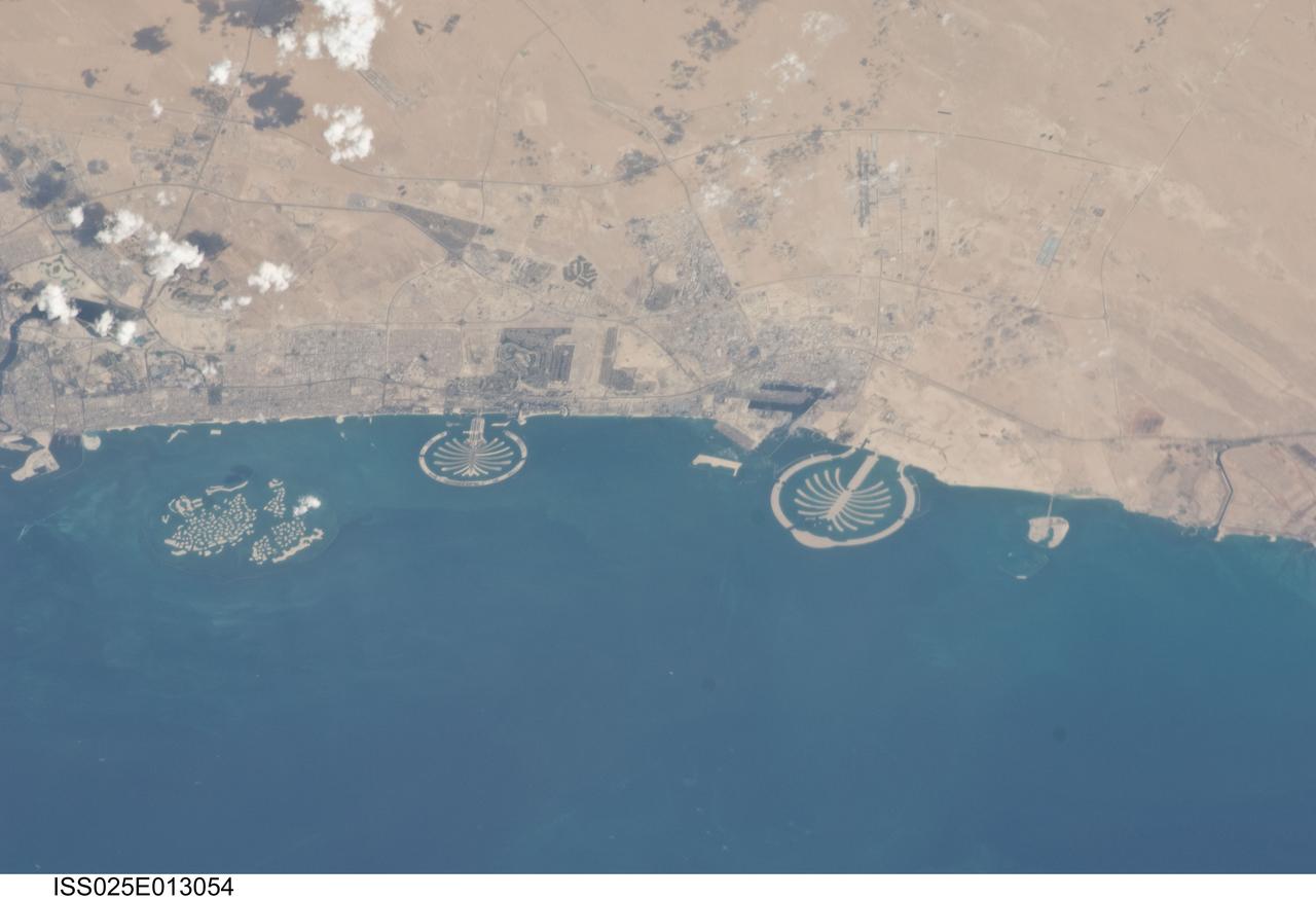
ISS025-E-013054 (7 Nov. 2010) --- Man-made archipelagos near Dubai, United Arab Emirates, are featured in this image photographed by an Expedition 25 crew member on the International Space Station, flying at 220 miles above Earth. The municipality of Dubai is the largest city of the Persian Gulf emirate of the same name, and has built a global reputation for large-scale developments and architectural works. Among the most visible of these developments -- particularly from the perspective of astronauts onboard the ISS -- are three man-made archipelagos. The two Palm Islands -- Palm Jumeirah to the left of center, and Palm Jebel Ali, just to the right of center, appear as stylized palm trees when viewed from above. The World Islands (near left edge) evoke a rough map of the world from an air- or space-borne perspective. The Palm Jumeirah project began in 2001 and required more than 50 million cubic meters of dredged sand to raise the islands above the Persian Gulf sea level. Construction of the Palm Jumeirah islands was completed in 2006; they are now being developed for residential and commercial housing and infrastructure. Creation of the World Islands was begun in 2003 and completed in 2008, using 320 million cubic meters of sand and 37 million tons of rock for the surrounding 27 kilometer-long protective breakwater.
CAPE CANAVERAL, Fla. -- From left, NBC reporter Jay Barbree and Alice Wackermann, Julie Jenkins (at microphone) and Laura Churchley, daughters of astronaut Alan Shepard, participate in a celebration at Complex 5/6 on Cape Canaveral Air Force Station in Florida. The celebration was held at the launch site of the first U.S. manned spaceflight May 5, 1961, to mark the 50th anniversary of the flight. Fifty years ago, astronaut Alan Shepard lifted off inside the Mercury capsule, "Freedom 7," atop an 82-foot-tall Mercury-Redstone rocket at 9:34 a.m. EST, sending him on a remarkably successful, 15-minute suborbital flight. The event was attended by more than 200 workers from the original Mercury program and included a re-creation of Shepard's flight and recovery, as well as a tribute to his contributions as a moonwalker on the Apollo 14 lunar mission. For more information, visit www.nasa.gov/topics/history/milestones/index.html. Photo credit: NASA/Kim Shiflett
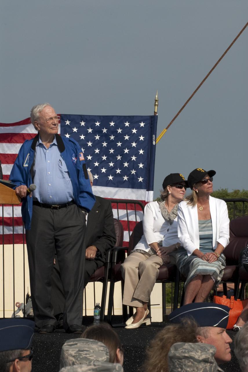
CAPE CANAVERAL, Fla. -- From left, Mercury astronaut Scott Carpenter and Alice Wackermann and Julie Jenkins, daughters of astronaut Alan Shepard, enjoy a tribute to Shepard during a celebration at Complex 5/6 on Cape Canaveral Air Force Station in Florida. The celebration was held at the launch site of the first U.S. manned spaceflight May 5, 1961, to mark the 50th anniversary of the flight. Fifty years ago, astronaut Alan Shepard lifted off inside the Mercury capsule, "Freedom 7," atop an 82-foot-tall Mercury-Redstone rocket at 9:34 a.m. EST, sending him on a remarkably successful, 15-minute suborbital flight. The event was attended by more than 200 workers from the original Mercury program and included a re-creation of Shepard's flight and recovery, as well as a tribute to his contributions as a moonwalker on the Apollo 14 lunar mission. For more information, visit www.nasa.gov/topics/history/milestones/index.html. Photo credit: NASA/Kim Shiflett
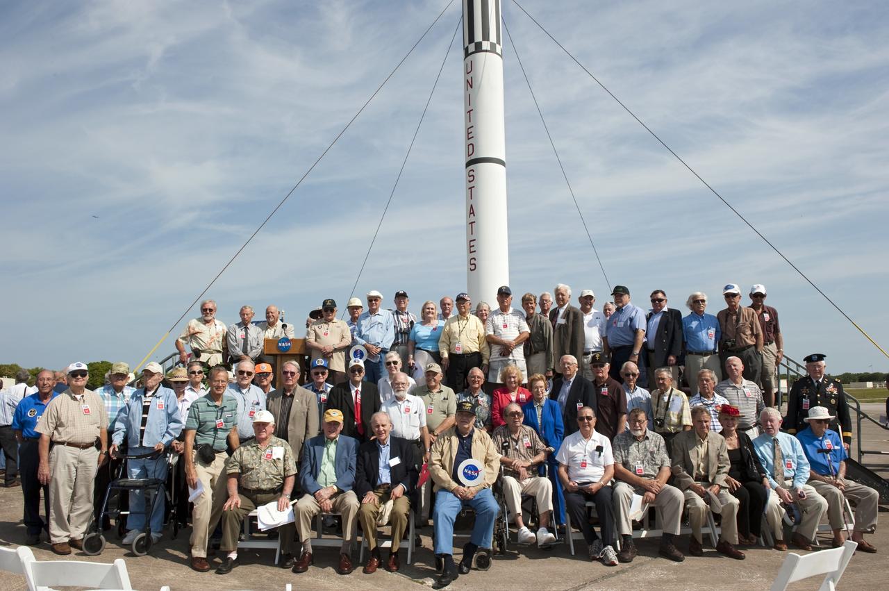
CAPE CANAVERAL, Fla. -- More than 200 workers from the original Mercury program pose for a group photo in front of a replica of a Mercury-Redstone rocket during a celebration at Complex 5/6 on Cape Canaveral Air Force Station in Florida. The celebration was held at the launch site of the first U.S. manned spaceflight May 5, 1961, to mark the 50th anniversary of the flight. Fifty years ago, astronaut Alan Shepard lifted off inside the Mercury capsule, "Freedom 7," atop an 82-foot-tall Mercury-Redstone rocket at 9:34 a.m. EST, sending him on a remarkably successful, 15-minute suborbital flight. The event was attended by more than 200 workers from the original Mercury program and included a re-creation of Shepard's flight and recovery, as well as a tribute to his contributions as a moonwalker on the Apollo 14 lunar mission. For more information, visit www.nasa.gov/topics/history/milestones/index.html. Photo credit: NASA/Kim Shiflett
The grand opening of NASA’s new, world-class laboratory for research into future space transportation technologies located at the Marshall Space Flight Center (MSFC) in Huntsville, Alabama, took place in July 2004. The state-of-the-art Propulsion Research Laboratory (PRL) serves as a leading national resource for advanced space propulsion research. Its purpose is to conduct research that will lead to the creation and development of innovative propulsion technologies for space exploration. The facility is the epicenter of the effort to move the U.S. space program beyond the confines of conventional chemical propulsion into an era of greatly improved access to space and rapid transit throughout the solar system. The laboratory is designed to accommodate researchers from across the United States, including scientists and engineers from NASA, the Department of Defense, the Department of Energy, universities, and industry. The facility, with 66,000 square feet of useable laboratory space, features a high degree of experimental capability. Its flexibility allows it to address a broad range of propulsion technologies and concepts, such as plasma, electromagnetic, thermodynamic, and propellant propulsion. An important area of emphasis is the development and utilization of advanced energy sources, including highly energetic chemical reactions, solar energy, and processes based on fission, fusion, and antimatter. The Propulsion Research Laboratory is vital for developing the advanced propulsion technologies needed to open up the space frontier, and sets the stage of research that could revolutionize space transportation for a broad range of applications.
CAPE CANAVERAL, Fla. -- Program participants pose for a group photo in front of a replica of a Mercury-Redstone rocket during a celebration at Complex 5/6 on Cape Canaveral Air Force Station in Florida. From left are Hugh Harris, former director of Public Affairs at Kennedy Space Center; Alice Wackermann, Julie Jenkins and Laura Churchley, daughters of astronaut Alan Shepard; Jack King, former chief, Public Information Office, Marshall Space Flight Center; Bob Moser, former chief test conductor for the Mercury-Redstone launches; NBC reporter Jay Barbree; Mercury astronaut Scott Carpenter; Kennedy Space Center Director Bob Cabana; Lieutenant General Susan J. Helms, commander of the 14th Air Force and former astronaut; and NASA Administrator Charlie Bolden. The celebration was held at the launch site of the first U.S. manned spaceflight May 5, 1961, to mark the 50th anniversary of the flight. Fifty years ago, astronaut Alan Shepard lifted off inside the Mercury capsule, "Freedom 7," atop an 82-foot-tall Mercury-Redstone rocket at 9:34 a.m. EST, sending him on a remarkably successful, 15-minute suborbital flight. The event was attended by more than 200 workers from the original Mercury program and included a re-creation of Shepard's flight and recovery, as well as a tribute to his contributions as a moonwalker on the Apollo 14 lunar mission. For more information, visit www.nasa.gov/topics/history/milestones/index.html. Photo credit: NASA/Kim Shiflett
This image is illuminated by sunlight from the upper left. Looking like pieces of sliced and broken swiss cheese, the upper layer of the martian south polar residual cap has been eroded, leaving flat-topped mesas into which are set circular depressions such as those shown here. The circular features are depressions, not hills. The largest mesas here stand about 4 meters (13 feet) high and may be composed of frozen carbon dioxide and/or water. Nothing like this has ever been seen anywhere on Mars except within the south polar cap, leading to some speculation that these landforms may have something to do with the carbon dioxide thought to be frozen in the south polar region. On Earth, we know frozen carbon dioxide as "dry ice." On Mars, as this picture might be suggesting, there may be entire landforms larger than a small town and taller than 2 to 3 men and women that consist, in part, of dry ice. No one knows for certain whether frozen carbon dioxide has played a role in the creation of the "swiss cheese" and other bizarre landforms seen in this picture. The picture covers an area 3 x 9 kilometers (1.9 x 5.6 miles) near 85.6°S, 74.4°W at a resolution of 7.3 meters (24 feet) per pixel. This picture was taken by the Mars Global Surveyor (MGS) Mars Orbiter Camera (MOC) during early southern spring on August 3, 1999. http://photojournal.jpl.nasa.gov/catalog/PIA02367
Two companies have successfully commercialized a specialized welding tool developed at the Marshall Space Flight Center (MSFC). Friction stir welding uses the high rotational speed of a tool and the resulting frictional heat created from contact to crush, "stir" together, and forge a bond between two metal alloys. It has had a major drawback, reliance on a single-piece pin tool. The pin is slowly plunged into the joint between two materials to be welded and rotated as high speed. At the end of the weld, the single-piece pin tool is retracted and leaves a "keyhole," something which is unacceptable when welding cylindrical objects such as drums, pipes and storage tanks. Another drawback is the requirement for different-length pin tools when welding materials of varying thickness. An engineer at the MSFC helped design an automatic retractable pin tool that uses a computer-controlled motor to automatically retract the pin into the shoulder of the tool at the end of the weld, preventing keyholes. This design allows the pin angle and length to be adjusted for changes in material thickness and results in a smooth hole closure at the end of the weld. Benefits of friction stir welding, using the MSFC retractable pin tool technology, include the following: The ability to weld a wide range of alloys, including previously unweldable and composite materials; provision of twice the fatigue resistance of fusion welds and no keyholes; minimization of material distortion; no creation of hazards such as welding fumes, radiation, high voltage, liquid metals, or arcing; automatic retraction of the pin at the end of the weld; and maintaining full penetration of the pin.
This VIS image shows part of Hephaestus Fossae. Hephaestus Fossae is a complex channel system in Utopia Planitia near Elysium Mons. It has been proposed that the channel formed by the release of melted subsurface ice during the impact event that created the crater just off the bottom right of the image – only the ejecta is seen in this image. The crater is fairly young, as there is only minimal modification of the crater floor. While it appears that the crater sits of top of the channel, the creation of the crater may have also created the channel. The impact event would have caused subsurface heating, melting any subsurface ice in the region which would have created surface flow to form the channel. Additionally, the nearby Elysium volcanic center created subsurface heating that may have played a part in creating both Hephaestus Fossae and Hebrus Valles to the north. The THEMIS VIS camera is capable of capturing color images of the Martian surface using five different color filters. In this mode of operation, the spatial resolution and coverage of the image must be reduced to accommodate the additional data volume produced from using multiple filters. To make a color image, three of the five filter images (each in grayscale) are selected. Each is contrast enhanced and then converted to a red, green, or blue intensity image. These three images are then combined to produce a full color, single image. Because the THEMIS color filters don't span the full range of colors seen by the human eye, a color THEMIS image does not represent true color. Also, because each single-filter image is contrast enhanced before inclusion in the three-color image, the apparent color variation of the scene is exaggerated. Nevertheless, the color variation that does appear is representative of some change in color, however subtle, in the actual scene. Note that the long edges of THEMIS color images typically contain color artifacts that do not represent surface variation. Orbit Number: 86796 Latitude: 17.9392 Longitude: 125.437 Instrument: VIS Captured: 2021-07-09 02:13 https://photojournal.jpl.nasa.gov/catalog/PIA24995
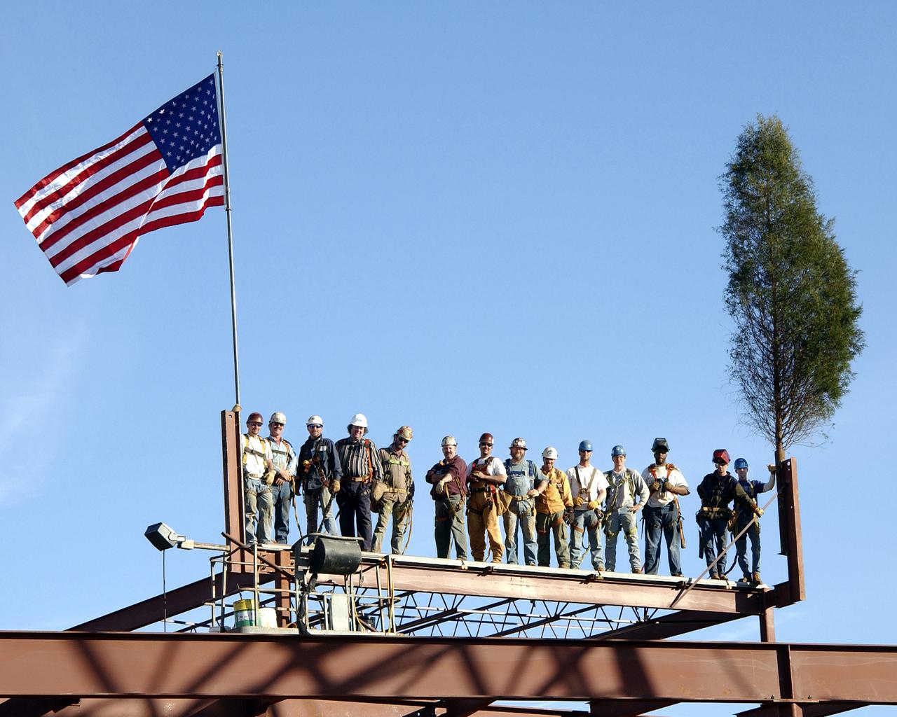
A new, world-class laboratory for research into future space transportation technologies is under construction at the Marshall Space Flight Center (MSFC) in Huntsville, AL. The state-of-the-art Propulsion Research Laboratory will serve as a leading national resource for advanced space propulsion research. Its purpose is to conduct research that will lead to the creation and development of irnovative propulsion technologies for space exploration. The facility will be the epicenter of the effort to move the U.S. space program beyond the confines of conventional chemical propulsion into an era of greatly improved access to space and rapid transit throughout the solar system. The Laboratory is designed to accommodate researchers from across the United States, including scientists and engineers from NASA, the Department of Defense, the Department of Energy, universities, and industry. The facility, with 66,000 square feet of useable laboratory space, will feature a high degree of experimental capability. Its flexibility will allow it to address a broad range of propulsion technologies and concepts, such as plasma, electromagnetic, thermodynamic, and propellantless propulsion. An important area of emphasis will be development and utilization of advanced energy sources, including highly energetic chemical reactions, solar energy, and processes based on fission, fusion, and antimatter. The Propulsion Research Laboratory is vital for developing the advanced propulsion technologies needed to open up the space frontier, and will set the stage of research that could revolutionize space transportation for a broad range of applications. This photo depicts construction workers taking part in a tree topping ceremony as the the final height of the laboratory is framed. The ceremony is an old German custom of paying homage to the trees that gave their lives in preparation of the building site.
National Advisory Committee for Aeronautics (NACA) engineers assembled the Altitude Wind Tunnel’s (AWT) large wooden drive fan inside the hangar at the Aircraft Engine Research Laboratory. When it was built at the in the early 1940s the AWT was among the most complex test facilities ever designed. It was the first wind tunnel capable of operating full-scale engines under realistic flight conditions. This simulation included the reduction of air temperature, a decrease in air pressure, and the creation of an airstream velocity of up to 500 miles per hour. The AWT was constructed in 1942 and 1943. This photograph shows NACA engineers Lou Hermann and Jack Aust assembling the tunnel’s drive fan inside the hangar. The 12-bladed, 31-foot-diameter spruce wood fan would soon be installed inside the wind tunnel to create the high-speed airflow. This massive propeller was designed and constructed by the engine lab's design team at Langley Field. John Breisch, a Langley technician with several years of wind tunnel installation experience, arrived in Cleveland at the time of this photograph to supervise the fan assembly inside the hangar. He would return several weeks later to oversee the actual installation in the tunnel. The fan was driven at 410 revolutions per minute by an 18,000-horsepower General Electric induction motor that was located in the rear corner of the Exhauster Building. An extension shaft connected the motor to the fan. A bronze screen protected the fan against damage from failed engine parts sailing through the tunnel. Despite this screen the blades did become worn or cracked over time and had to be replaced. An entire new fan was installed in 1951.

NASA image release April 22, 2010 This brand new Hubble photo is of a small portion of one of the largest seen star-birth regions in the galaxy, the Carina Nebula. Towers of cool hydrogen laced with dust rise from the wall of the nebula. The scene is reminiscent of Hubble's classic "Pillars of Creation" photo from 1995, but is even more striking in appearance. The image captures the top of a three-light-year-tall pillar of gas and dust that is being eaten away by the brilliant light from nearby bright stars. The pillar is also being pushed apart from within, as infant stars buried inside it fire off jets of gas that can be seen streaming from towering peaks like arrows sailing through the air. Credit: NASA, ESA, and M. Livio and the Hubble 20th Anniversary Team (STScI) To read learn more about this image go to: <a href="http://www.nasa.gov/mission_pages/hubble/science/hubble20th-img.html" rel="nofollow">www.nasa.gov/mission_pages/hubble/science/hubble20th-img....</a> <b><a href="http://www.nasa.gov/audience/formedia/features/MP_Photo_Guidelines.html" rel="nofollow">NASA image use policy.</a></b> <b><a href="http://www.nasa.gov/centers/goddard/home/index.html" rel="nofollow">NASA Goddard Space Flight Center</a></b> enables NASA’s mission through four scientific endeavors: Earth Science, Heliophysics, Solar System Exploration, and Astrophysics. Goddard plays a leading role in NASA’s accomplishments by contributing compelling scientific knowledge to advance the Agency’s mission. <b>Follow us on <a href="http://twitter.com/NASAGoddardPix" rel="nofollow">Twitter</a></b> <b>Like us on <a href="http://www.facebook.com/pages/Greenbelt-MD/NASA-Goddard/395013845897?ref=tsd" rel="nofollow">Facebook</a></b> <b>Find us on <a href="http://instagram.com/nasagoddard?vm=grid" rel="nofollow">Instagram</a></b>
FIRST LEGO League participants listen to Aerospace Education Specialist Chris Copelan explain the playing field for 'Nano Quest' during a recent FLL kickoff event at StenniSphere, the visitor center at NASA Stennis Space Center. The kickoff began the 2006 FLL competition season. Eighty-five teachers, mentors, parents and 9- to 14-year-old students from southern and central Mississippi came to SSC to hear the rules for Nano Quest. The challenge requires teams to spend eight weeks building and programming robots from LEGO Mindstorms kits. They'll battle their creations in local and regional competitions. The Dec. 2 competition at Mississippi Gulf Coast Community College will involve about 200 students. FIRST LEGO League, considered the 'little league' of the FIRST (For Inspiration and Recognition of Science and Technology) Robotics Competition, partners FIRST and the LEGO Group. Competitions aim to inspire and celebrate science and technology using real-world context and hands-on experimentation, and to promote the principles of team play and gracious professionalism. Because NASA advocates robotics and science-technology education, the agency and SSC support FIRST by providing team coaches, mentors and training, as well as competition event judges, referees, audio-visual and other volunteer staff personnel. Two of Mississippi's NASA Explorer Schools, Bay-Waveland Middle and Hattiesburg's Lillie Burney Elementary, were in attendance. The following schools were also represented: Ocean Springs Middle, Pearl Upper Elementary, Long Beach Middle, Jackson Preparatory Academy, North Woolmarket Middle, D'Iberville Middle, West Wortham Middle, Picayune's Roseland Park Baptist Academy and Nicholson Elementary, as well as two home-school groups from McComb and Brandon. Gulfport and Picayune Memorial-Pearl River high schools' FIRST Robotics teams conducted robotics demonstrations for the FLL crowd.
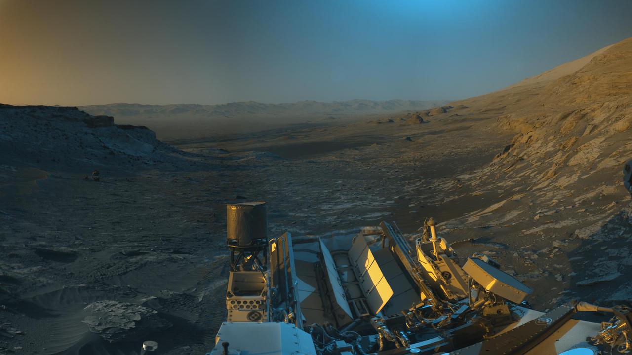
NASA's Curiosity Mars rover used its black-and-white navigation cameras to capture panoramas of this scene at two times of day. Blue, orange, and green color was added to a combination of both panoramas for an artistic interpretation of the scene. On Nov. 16, 2021 (the 3,299th Martian day, or sol, of the mission), engineers commanded Curiosity to take two sets of mosaics, or composite images, capturing the scene at 8:30 a.m. and again at 4:10 p.m. local Mars time. The two times of day provided contrasting lighting conditions that brought out a variety of unique landscape details. They combined the two scenes in an artistic re-creation that includes images from the morning scene in blue, the afternoon scene in orange, and a combination of both in green. The main image is an artistic interpretation of the scene. Figure 1 is the mosaic taken in the afternoon. Figure 2 is the mosaic taken in the morning. At the center of the image is the view back down Mount Sharp, the 3-mile-tall (5-kilometer-tall) mountain that Curiosity has been driving up since 2014. Rounded hills can be seen in the distance at center-right; Curiosity got a closer view of these back in July, when the rover started to see intriguing changes in the landscape. A field of sand ripples known as the "Sands of Forvie" stretches a quarter- to a half-mile (400 to 800 meters) away. At the far right of the panorama is the craggy "Rafael Navarro Mountain," named after a Curiosity team scientist who passed away earlier this year. Poking up behind it is the upper part of Mount Sharp, far above the area Curiosity is exploring. Mount Sharp lies inside Gale Crater, a 96-mile-wide (154-kilometer-wide) basin formed by an ancient impact; Gale Crater's distant rim stands 7,500 feet tall (2.3 kilometers), and is visible on the horizon about 18 to 25 miles away (30 to 40 kilometers). https://photojournal.jpl.nasa.gov/catalog/PIA24937
Attendees listen during the May 22, 1956 Inspection of the new 10- by 10-Foot Supersonic Wind Tunnel at the National Advisory Committee for Aeronautics (NACA) Lewis Flight Propulsion Laboratory. The facility, known at the time as the Lewis Unitary Plan Tunnel, was in its initial stages of operation. The $33 million 10- by 10 was the most powerful wind tunnel in the nation. Over 150 guests from industry, other NACA laboratories, and the media attended the event. The speakers, from left to right in the front row, addressed the crowd before the tour. Lewis Director Raymond Sharp began the event by welcoming the visitors to the laboratory. NACA Director Hugh Dryden discussed Congress’ Unitary Plan Act and its effect on the creation of the facility. Lewis Associate Director Abe Silverstein discussed the need for research tools and the 10- by 10’s place among the NACA’s other research facilities. Lewis Assistant Director Eugene Wasielewski described the detailed design work that went into the facility. Carl Schueller, Chief of the 10- by 10, described the tunnel’s components and how the facility operated. Robert Godman led the tour afterwards. The 10- by 10 can test engines up to five feet in diameter at supersonic speeds and simulated altitudes of 30 miles. Its main purpose is to investigate problems relating to engine inlet and outlet geometry, engine matching and interference effects, and overall drag. The tunnel’s 250,000-horsepower electric motor drive, the most powerful of its kind in the world, creates air speeds between Mach 2.0 and 3.5.
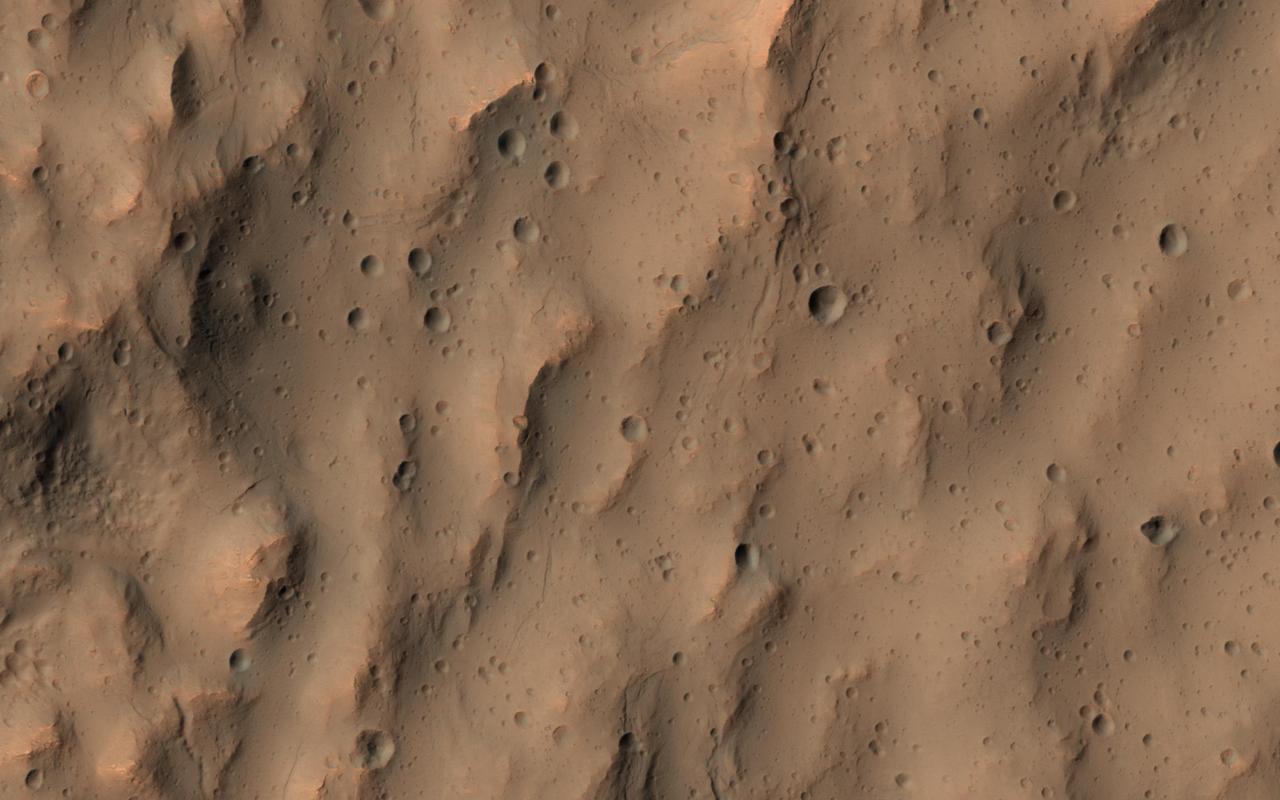
This image of a southern mid-latitude crater was intended to investigate the lineated material on the crater floor. At the higher resolution of HiRISE, the image reveals a landscape peppered by small impact craters. These craters range from about 30 meters in diameter down to the resolution limit (about 2 meter diameter in this image acquired by averaging 2x2 picture elements). Such dense clusters of small craters are frequently formed by secondary craters, caused by the impact of material that was excavated and ejected from the surface of Mars during the creation of a larger nearby crater by the impact of a comet or an asteroid. Secondary impact craters are both interesting and vexing. They are interesting because they show the trajectories of the material that was ejected from the primary impact with the greatest speeds, typically material from near the surface of the blast zone. Secondary craters are often found along the traces of crater rays, linear features that extend radially from fresh impact craters and can reach many crater diameters in length. Secondary craters can be useful when crater rays are visible and the small craters can be associated with a particular primary impact crater. They can be used to constrain the age of the surface where they fell, since the surface must be older than the impact event. The age of the crater can be approximately estimated from the probability of an impact that produced a crater of such a size within a given area of Mars over a given time period. But these secondary craters can also be perplexing when no crater rays are preserved and a source crater is not easily identifiable, as is the case here. The impact that formed these secondary craters took place long enough ago that their association with a particular crater has been erased. They do not appear along the trace of a crater ray that is still apparent in visible or thermal infrared observations. These secondary craters complicate the task of estimating the age of the lineated material on the crater floor. It is necessary to distinguish secondary craters from the primary impacts that we rely upon to estimate the ages of Martian surfaces. The large number of small craters clustered together here is typical of crater rays elsewhere on Mars and suggests that these are indeed, secondary impact craters. http://photojournal.jpl.nasa.gov/catalog/PIA14450

The dusty face of the Eagle Nebula and its surroundings are revealed in this image based on data from NASA's Wide Field Survey Explorer (WISE). WISE detects infrared light, or a range of wavelengths longer than what the human eye can see. This large star forming region is about 5,700 light years away from Earth and is most famous for being home to the the "Pillars of Creation," a region famously imaged by NASA's Hubble and James Webb space telescopes. The WISE data reveals the entire structure of the nebula surrounding the pillars, which themselves can be seen as a faint yellow-green feature inside the white circle. While the WISE view of the "Pillars" is not as sharp as those taken by Webb and Hubble, the telescope's wide field of view allows us to explore the extended nebula around it. When viewed in visible light, the dust is dark and opaque. In these infrared wavelengths, the dust becomes more translucent, and emits infrared light, shown in green, yellow, and red in this image. The data used in this image came from WISE's primary mission which ran from 2009 to 2011. In 2013, NASA took the spacecraft out of hibernation and began using it to track and study near-Earth objects. The mission and the spacecraft were renamed NEOWISE. However, the data is still being used by astronomers to study objects and regions outside our solar system. Blue and cyan are used to represent infrared light at wavelengths of 3.4 and 4.6 microns, while green and red display longer wavelengths of 12 and 22 microns, respectively. Animation available at https://photojournal.jpl.nasa.gov/catalog/PIA25433
ISS013-E-63766 (2 Aug. 2006) --- Berkeley Pit and Butte, Montana are featured in this image photographed by an Expedition 13 crewmember on the International Space Station. The city of Butte, Montana has long been a center of mining activity. Underground mining of copper began in Butte in the 1870s, and by 1901 underground workings had extended to the groundwater table. Thus began the creation of an intricate complex of underground drains and pumps to lower the groundwater level and continue the extraction of copper. Water extracted from the mines was so rich in dissolved copper sulfate that it was also "mined" (by chemical precipitation) for the copper it contained. In 1955, the Anaconda Copper Mining Company began open-pit mining for copper in what is now know as the Berkeley Pit (dark oblong area in center). The mine took advantage of the existing subterranean drainage and pump network to lower groundwater until 1982, when the new owner ARCO suspended operations at the mine. The groundwater level swiftly rose, and today water in the Pit is more than 900 feet deep. Many features of the mine workings are visible in this image such as the many terraced levels and access roadways of the open mine pits (gray and tan sculptured surfaces). A large gray tailings pile of waste rock and an adjacent tailings pond are visible to the north of the Berkeley Pit. Color changes in the tailings pond are due primarily to changing water depth. The Berkeley Pit is listed as a federal Superfund site due to its highly acidic water, which contains high concentrations of metals such as copper and zinc. The Berkeley Pit receives groundwater flowing through the surrounding bedrock and acts as a "terminal pit" or sink for these heavy metal-laden waters. Ongoing efforts include regulation of water flow into the pit to reduce filling of the Pit and potential release of contaminated water into local aquifers or surface streams.
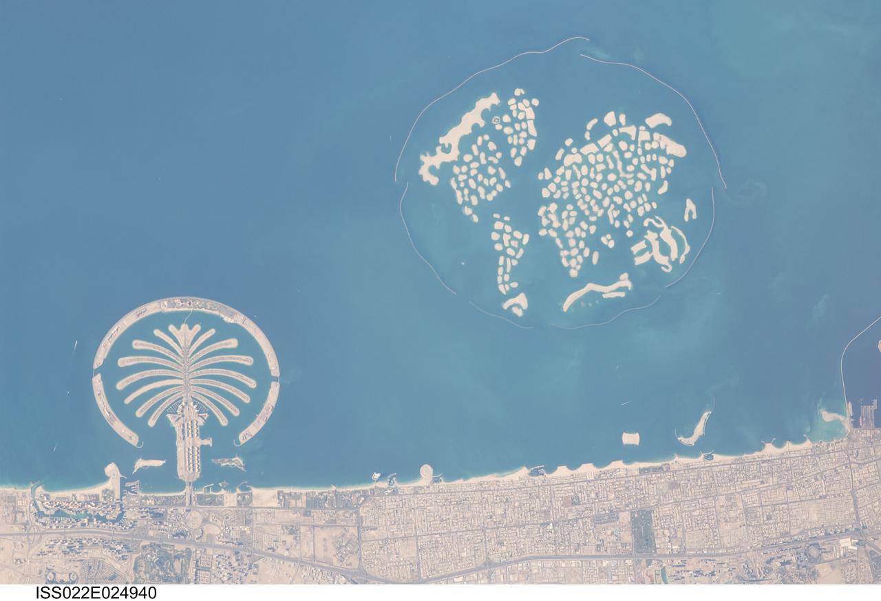
ISS022-E-024940 (13 Jan. 2010) --- Man-made archipelagos near Dubai, United Arab Emirates are featured in this image photographed by an Expedition 22 crew member on the International Space Station. The municipality of Dubai is the largest city of the Persian Gulf emirate of the same name, and has built a global reputation for large-scale developments and architectural works. Among the most visible of these developments ? particularly from the perspective of astronauts onboard the ISS ? are three man-made archipelagos. The two Palm Islands (Palm Jumeirah and Palm Jebel Ali) appear as stylized palm trees when viewed from above. The World Islands evoke a rough map of the world from an air- or space-borne perspective. Palm Jumeirah and the World Islands are highlighted in this view. Palm Jumeirah (lower left) was begun in 2001 and required more than 50 million cubic meters of dredged sand to raise the islands above the Persian Gulf sea level. Construction of the Palm Jumeirah islands was completed in 2006; they are now being developed for residential and commercial housing and infrastructure. Creation of the 300 World Islands (upper right) was begun in 2003 and completed in 2008, using 320 million cubic meters of sand and 37 million tons of rock for the surrounding 27 kilometer-long protective breakwater. Also visible at the lower edge of the image is another notable built structure ? the Burj Tower (white rectangle at lower right and inset image). The Burj Tower ? or Burj Khalifa ? stands 800 meters high, and is currently the world?s tallest structure. The photograph captures enough detail to make out the tapering outline of the building as well as its dark needle-like shadow pointing towards the northeast.
NASA's Perseverance Mars rover dropped the last of 10 tubes at the "Three Forks" sample depot on Jan. 28, 2023, the 690th Martian day, or sol, of the mission. This image of the 10th tube was taken by the WATSON (Wide Angle Topographic Sensor for Operations and eNgineering) camera on the end of the rover's 7-foot-long (2-meter-long) robotic arm. This final sample is what's called a "witness" tube – one of three collected by the rover so far and the only one deposited at the depot. Witness tubes are similar to the sample tubes that hold Martian rock and sediment, except they have been preloaded with a variety of materials that can capture molecular and particulate contaminants. They are opened on the Martian surface to "witness" the ambient environment near sample collection sites. With samples returned to Earth in the future, the witness tubes would be used to determine if samples being collected might be contaminated with materials that traveled with the rover from Earth. The Three Forks depot, the first sample depot on another world, is a crucial milestone in the NASA-ESA (European Space Agency) Mars Sample Return campaign, which aims to bring Mars samples to Earth for closer study. The Perseverance rover will be the primary means to convey the collected samples to a future robotic lander as part of the campaign. The lander would, in turn, use a robotic arm to place the samples in a containment capsule aboard a small rocket that would blast off to Mars orbit, where another spacecraft would capture the sample container and return it safely to Earth. Hosting the duplicate set, the Three Forks depot will serve as a backup if Perseverance can't deliver its samples. A key objective for Perseverance's mission on Mars is astrobiology, including the search for signs of ancient microbial life. The rover will characterize the planet's geology and past climate, pave the way for human exploration of the Red Planet, and be the first mission to collect and cache Martian rock and regolith (broken rock and dust). Subsequent NASA missions, in cooperation with ESA (European Space Agency), would send spacecraft to Mars to collect these sealed samples from the surface and return them to Earth for in-depth analysis. The Mars 2020 Perseverance mission is part of NASA's Moon to Mars exploration approach, which includes Artemis missions to the Moon that will help prepare for human exploration of the Red Planet. https://photojournal.jpl.nasa.gov/catalog/PIA25340
ISS036-E-039778 (3 Sept. 2013) --- Caldera lakes to the northwest of Rome, Italy are featured in this image photographed by an Expedition 36 crew member on the International Space Station. The Lazio region of central Italy has many landforms of volcanic origin, including several large lakes that mark the locations of ancient volcanoes. This photograph highlights two such lakes, Lago di Vico and Lago Bracciano, located to the northwest of the capital city of Rome. Both lakes are located within calderas, large depressions that form after violent explosive eruptions empty a volcano’s underlying magma chamber. Any remnants of the volcanic edifice can then collapse into the newly-formed void space, leading to the creation of large depressions. These depressions can then fill partially or completely with water, forming permanent lakes. Lago Bracciano (left) is the larger of the two lakes highlighted in the image; it is approximately eight kilometers wide at its widest point, and is located 32 kilometers northwest of Rome. According to scientists, the volcanic activity that led to the formation of Lago Bracciano began approximately 600,000 years ago and continued to approximately 40,000 years ago as part of the formation of the Sabatini volcanic complex. While part of the lake formation was due to caldera collapse of part of a large magma chamber, the current depression was also formed by movement along numerous faults in the area – a process known as volcano-tectonic collapse. Located approximately 24 kilometers to the north-northwest of Lago Bracciano, Lago di Vico (right) occupies part of a caldera associated with eruptive activity that began approximately 800,000 years ago and continued until approximately 90,000 years ago. The caldera formed largely by the catastrophic eruption of the ancestral Vico volcano approximately 200,000-150,000 years ago. The final phase of volcanic activity in the caldera led to the formation of a small lava cone in the northeast quadrant known as Mount Venus. The extent of the lakes of Bracciano and Vico are readily apparent in this image due to sunglint – light reflecting back towards the observer from the water surfaces. This reflection gives a mirror-like sheen to the water surfaces in the image. Dark green forested areas associated with parks are visible near both lakes, while light gray to white regions indicate built areas - such as the city of Viterbo at right - and tilled fields (bottom center).

A panoramic view of a vast, sculpted area of gas and dust where thousands of stars are being born has been captured by NASA's Hubble Space Telescope. The image, taken by Hubble's Wide Field and Planetary Camera 2, is online at http://hubblesite.org/newscenter/archive/releases/2001/21/image/a/. The camera was designed and built by NASA's Jet Propulsion Laboratory, Pasadena, Calif. The photo offers an unprecedented, detailed view of the entire inner region of the fertile, star-forming 30 Doradus Nebula. The mosaic picture shows that ultraviolet radiation and high-speed material unleashed by the stars in the cluster, called R136 (the large blue blob left of center), are weaving a tapestry of creation and destruction, triggering the collapse of looming gas and dust clouds and forming pillar-like structures that incubate newborn stars. The 30 Doradus Nebula is in the Large Magellanic Cloud, a satellite galaxy of the Milky Way located 170,000 light-years from Earth. Nebulas like 30 Doradus are signposts of recent star birth. High-energy ultraviolet radiation from young, hot, massive stars in R136 causes surrounding gaseous material to glow. Previous Hubble telescope observations showed that R136 contains several dozen of the most massive stars known, each about 100 times the mass of the Sun and about 10 times as hot. These stellar behemoths formed about 2 million years ago. The stars in R136 produce intense "stellar winds," streams of material traveling at several million miles an hour. These winds push the gas away from the cluster and compress the inner regions of the surrounding gas and dust clouds (seen in the image as the pinkish material). The intense pressure triggers the collapse of parts of the clouds, producing a new star formation around the central cluster. Most stars in the nursery are not visible because they are still encased in cocoons of gas and dust. This mosaic image of 30 Doradus consists of five overlapping pictures taken between January 1994 and September 2000 by the Wide Field and Planetary Camera 2. Several color filters enhance important details in the stars and the nebula. Blue corresponds to the hot stars. The greenish color denotes hot gas energized by the central cluster of stars. Pink depicts the glowing edges of the gas and dust clouds facing the cluster, which are being bombarded by winds and radiation. Reddish-brown represents the cooler surfaces of the clouds, which are not receiving direct radiation from the central cluster. http://photojournal.jpl.nasa.gov/catalog/PIA04200
On December 10, 2013 the Moderate Resolution Imaging Spectroradiometer (MODIS) aboard NASA’s Terra satellite flew across the central Atlantic Ocean and captured a true-color image of the Canary Islands. Lying off of the coast of Western Sahara and Morocco, the islands were created by successive submarine volcanic eruptions which raised the ocean floor vertically until some of land rose above sea level. The oldest islands lie in the east and the youngest in the west. From east to west, the major islands seen in this image are: Lanzarote, Fuerteventura, Gran Canaria, Tenerife, La Gomera, La Palmera and El Hierro. While the creation of the islands began in the Late Cretaceous Period (70 – 80 million years ago), active volcanic activity continues. In 2011, a spectacular submarine eruption occurred just off the shore of El Hierro. The volcano became quiet again, but very recently increasing earthquakes and changing height of El Hierro suggested the volcano may again be entering an active eruptive phase. On December 27 the island’s volcano monitoring agency had raised the volcanic eruption risk for El Hierro to “yellow” – a code that means increasing activity but no eruption imminent. That afternoon a magnitude 5.1 earthquake struck offshore at El Hierro. The epicenter was 9 miles (15 km) deep, and it was one of the largest quakes ever recorded at the island. Credit: NASA/GSFC/Jeff Schmaltz/MODIS Land Rapid Response Team <b><a href="http://www.nasa.gov/audience/formedia/features/MP_Photo_Guidelines.html" rel="nofollow">NASA image use policy.</a></b> <b><a href="http://www.nasa.gov/centers/goddard/home/index.html" rel="nofollow">NASA Goddard Space Flight Center</a></b> enables NASA’s mission through four scientific endeavors: Earth Science, Heliophysics, Solar System Exploration, and Astrophysics. Goddard plays a leading role in NASA’s accomplishments by contributing compelling scientific knowledge to advance the Agency’s mission. <b>Follow us on <a href="http://twitter.com/NASA_GoddardPix" rel="nofollow">Twitter</a></b> <b>Like us on <a href="http://www.facebook.com/pages/Greenbelt-MD/NASA-Goddard/395013845897?ref=tsd" rel="nofollow">Facebook</a></b> <b>Find us on <a href="http://instagram.com/nasagoddard?vm=grid" rel="nofollow">Instagram</a></b>

ISS015-E-07928 (13 May 2007) --- Isla San Lorenzo and Isla Las Animas are featured in this image photographed by an Expedition 15 crewmember on the International Space Station. Located in the northern Gulf of California, Isla (island) San Lorenzo and Isla Las Animas -- part of the Midriff Islands -- record geologic processes involved in the creation of the Baja California peninsula over several hundred million years, according to scientists. A geologist walking along the 17-kilometer long central ridge of Isla San Lorenzo from the southeastern to the northwestern end would first encounter Cretaceous granitic rock in the southeastern third of the island (light tan, center left). The central third of the island is comprised mainly of older Paleozoic metamorphic rocks (brown, center; directly above "Isla San Lorenzo"). Together, these very old rocks form the crystalline "basement" of the island. The northwestern third of Isla San Lorenzo, and much of adjacent Isla Las Animas, is composed of much more recent volcanic and marine sedimentary rocks (yellow-brown to light brown, center right). According to scientists, these rocks were formed by volcanoes and fissure eruptions in and around basins in the growing Gulf of California between 5-8 million years ago. The islands themselves were formed as a result of uplift of crustal blocks along the southeastward-trending San Andreas Fault. This image illustrates the largely pristine nature of these islands. The islands are located in the rain shadow of mountains on the Baja Peninsula to the west, and arid conditions prevail through much of the year. The scarcity of water has limited human presence on the islands, and allowed flora and fauna unique to each island (known as endemic species) to flourish -- particularly reptiles. The islands are also home to colonies of seabirds and seals, both of which take advantage of deep productive waters adjacent to the eastern Baja coast. Shallow waters and high levels of nutrients can also lead to blooms of green phytoplankton; two such blooms can be seen along the coastline of Isla Las Animas (center right, in north and west-facing embayments). Surface water patterns around the islands -- enhanced by sunlight reflectance off the water surface -- are due to wind- and current-induced roughness (silver-gray regions). Regions of dark blue water are indicative of calm surface conditions, or the presence of oils and surfactants that decrease surface tension.