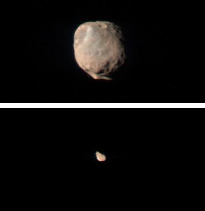
CRISM Views Phobos and Deimos
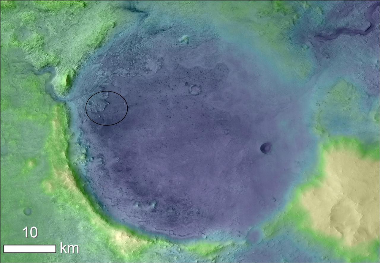
CRISM First Targeted Observation of Mars
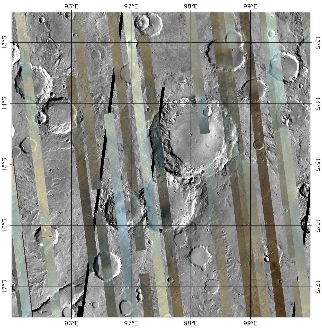
CRISM Global Mapping of Mars, Part 1
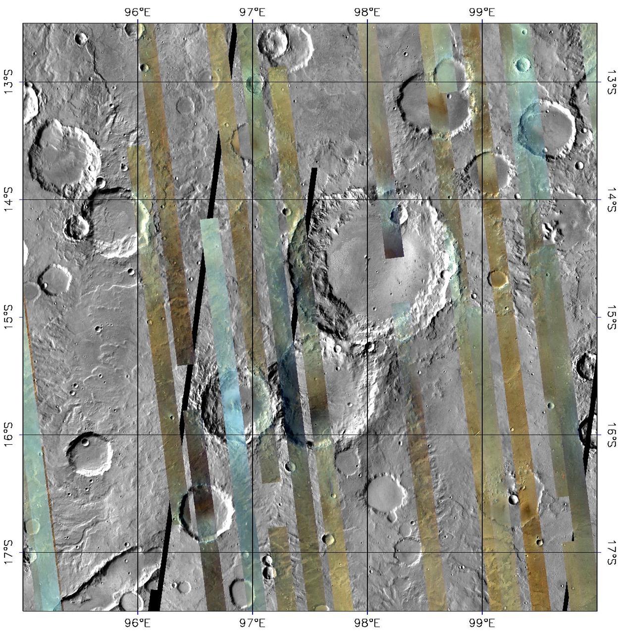
CRISM Global Mapping of Mars, Part 2
CRISM Global Mapping of Mars, Part 3

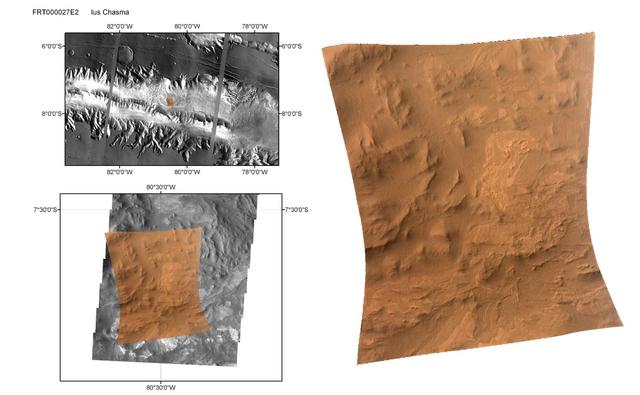
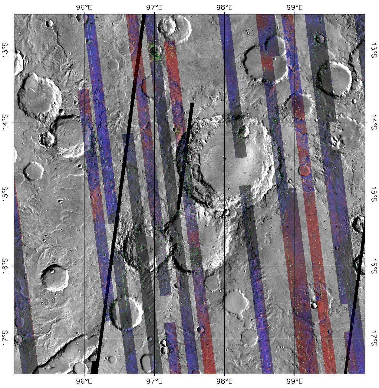
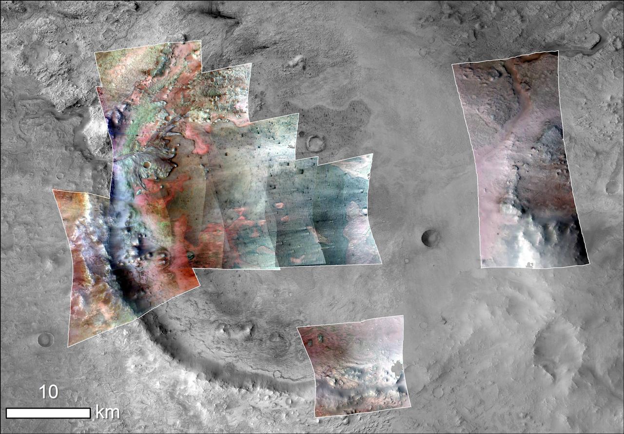
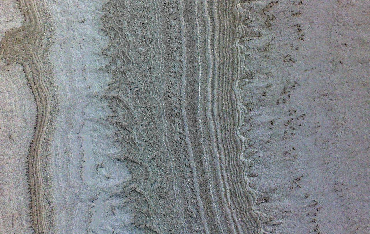
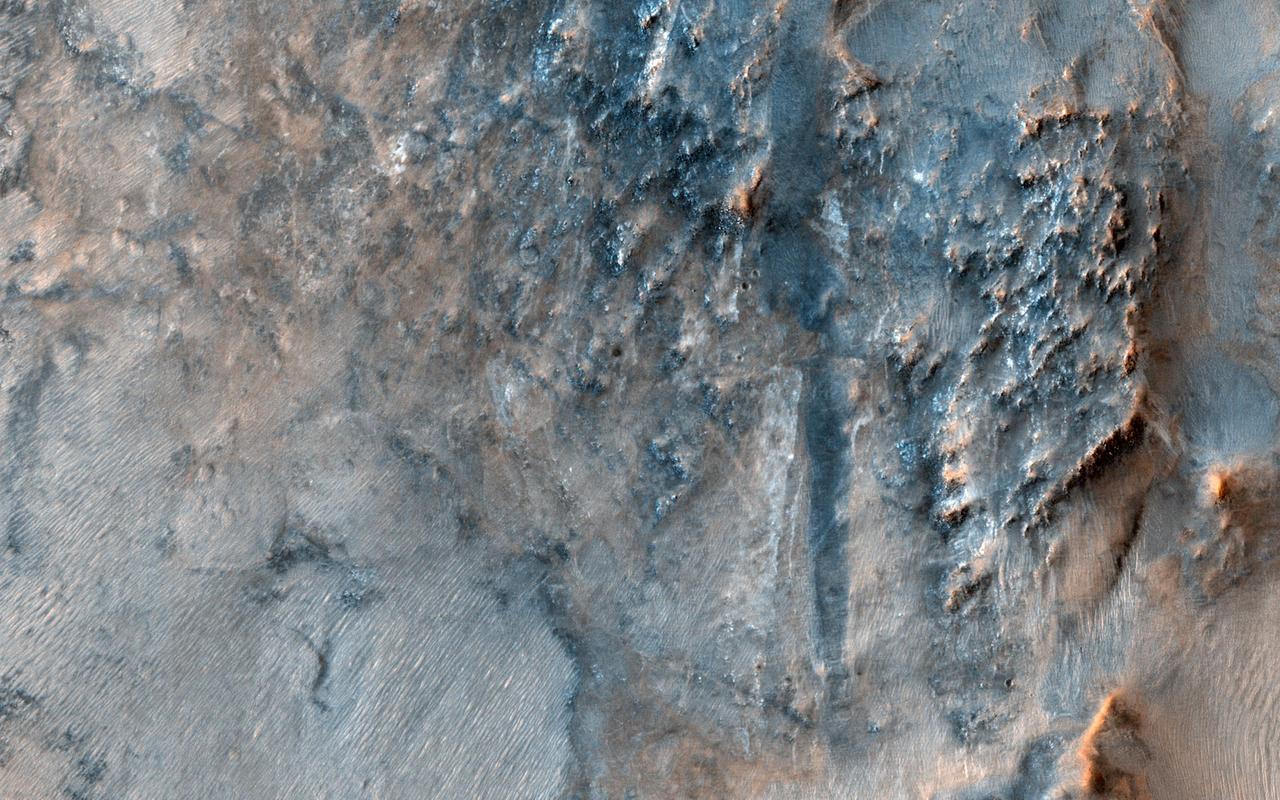
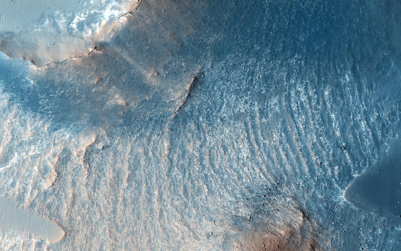
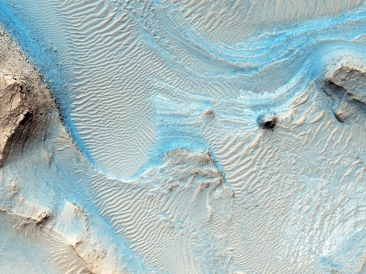
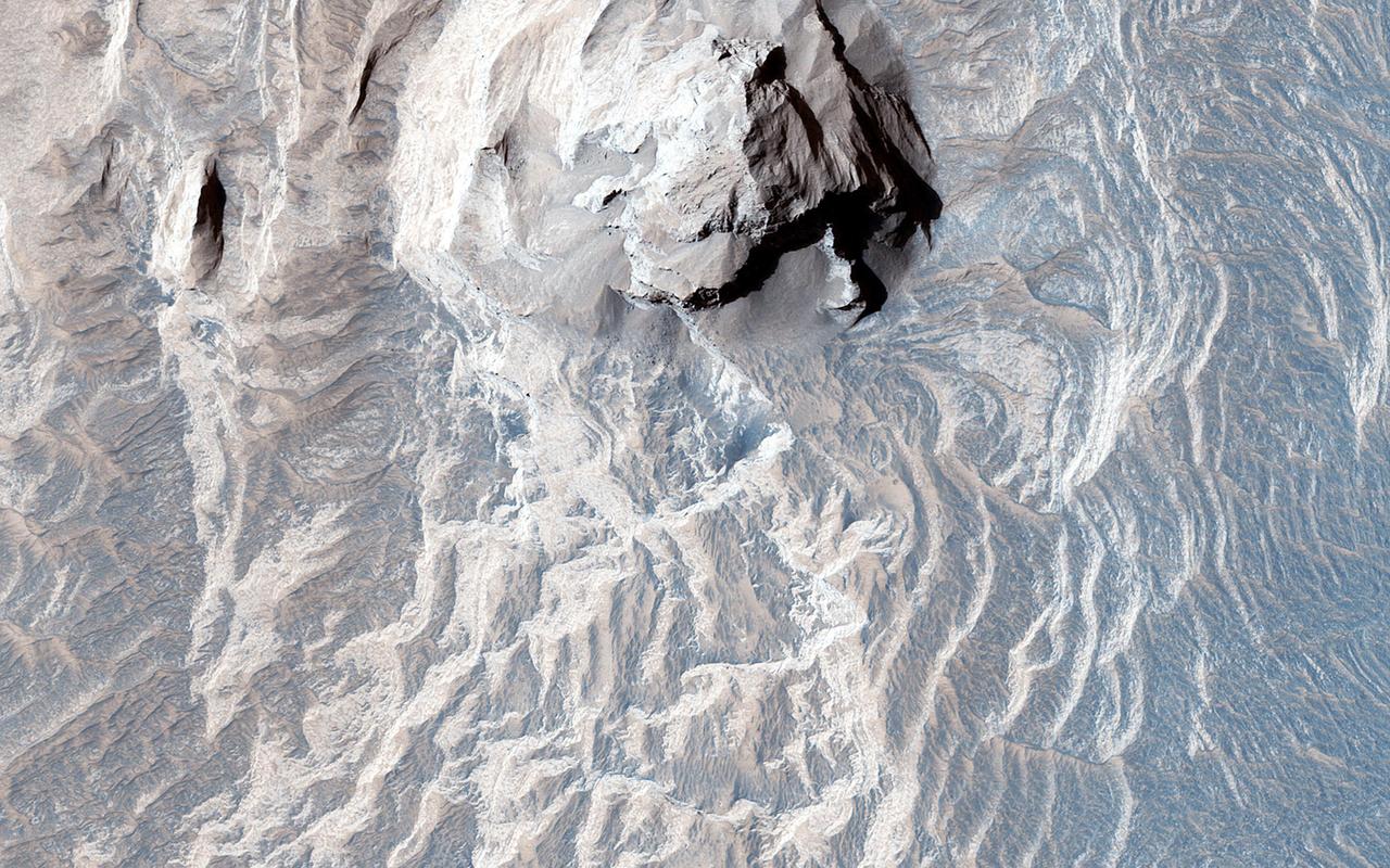
CRISM Mulitspectral Map of Eastern Candor Chasma
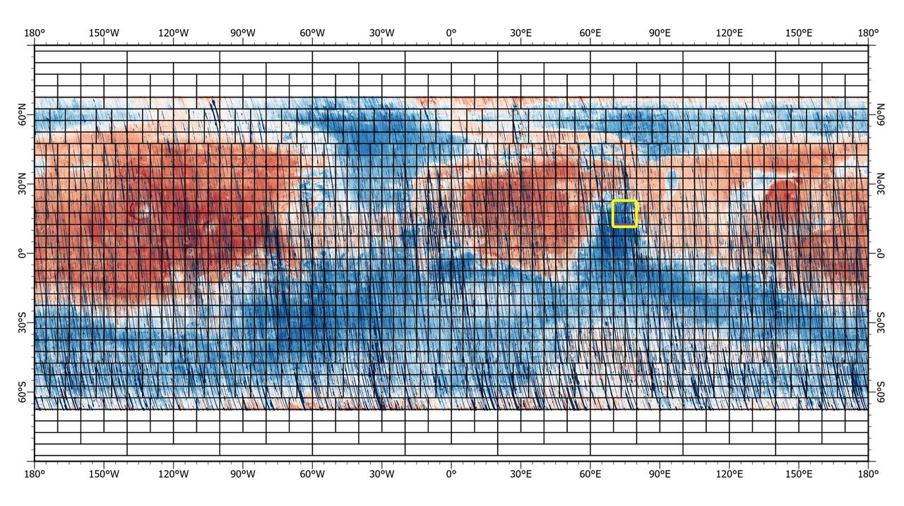
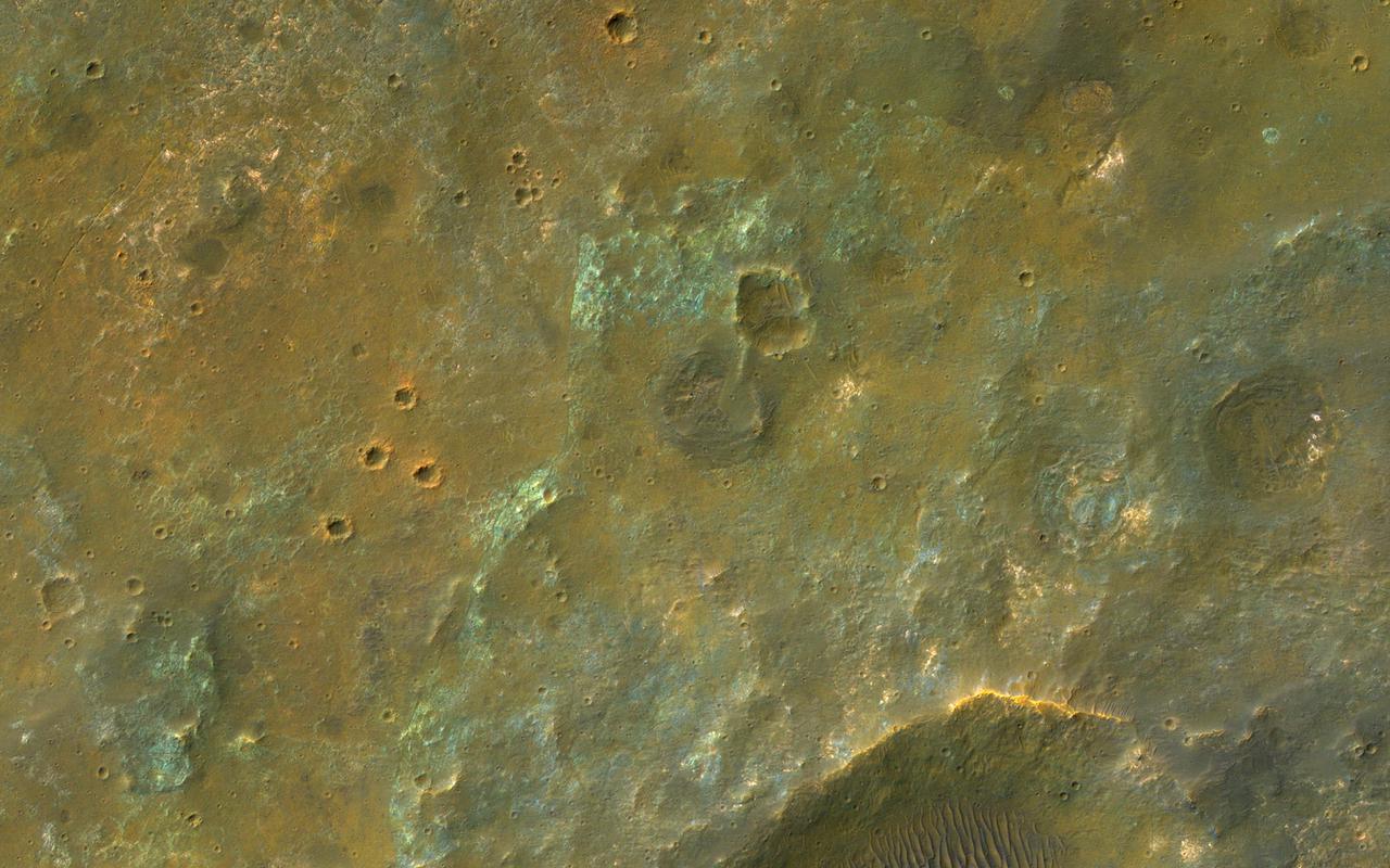
This 72-color near-global map of the Red Planet was captured by NASA's Mars Reconnaissance Orbiter (MRO) using its Compact Reconnaissance Imaging Spectrometer for Mars, or CRISM. The yellow square indicates the Nili Fossae region of Mars, which is highlighted in six views in PIA25364. The map is one of the last major datasets CRISM will ever produce; the instrument will be decommissioned by the end of 2022. Data for the 6.3-gigapixel map was collected over 11 years of CRISM operations. The instrument arrived at Mars with three cryocoolers that allowed it to see in a range of wavelengths, including infrared; in 2017, the last of those cryocoolers stopped working, severely limiting the number of wavelengths CRISM could "see." https://photojournal.jpl.nasa.gov/catalog/PIA25363
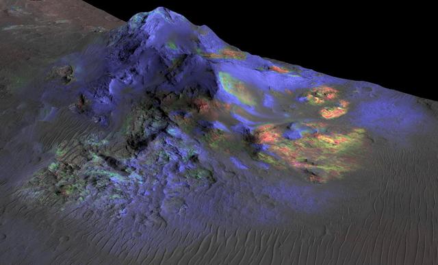
Deposits of impact glass have been preserved in Martian craters, including Alga Crater, shown here. Detection of the impact glass by researchers at Brown University, Providence, Rhode Island, is based on data from the Compact Reconnaissance Imaging Spectrometer for Mars (CRISM) on NASA's Mars Reconnaissance Orbiter. In color coding based on analysis of CRISM spectra, green indicates the presence of glass. (Blues are pyroxene; reds are olivine.) Impact glass forms in the heat of a violent impact that excavates a crater. Impact glass found on Earth can preserve evidence about ancient life. A deposit of impact glass on Mars could be a good place to look for signs of past life on that planet. This view shows Alga Crater's central peak, which is about 3 miles (5 kilometers) wide within the 12-mile (19-kilometer) diameter of this southern-hemisphere crater. The information from CRISM is shown over a terrain model and image, based on observations by the High Resolution Imaging Science Experiment (HiRISE) camera. The vertical dimension is exaggerated by a factor of two. http://photojournal.jpl.nasa.gov/catalog/PIA19673
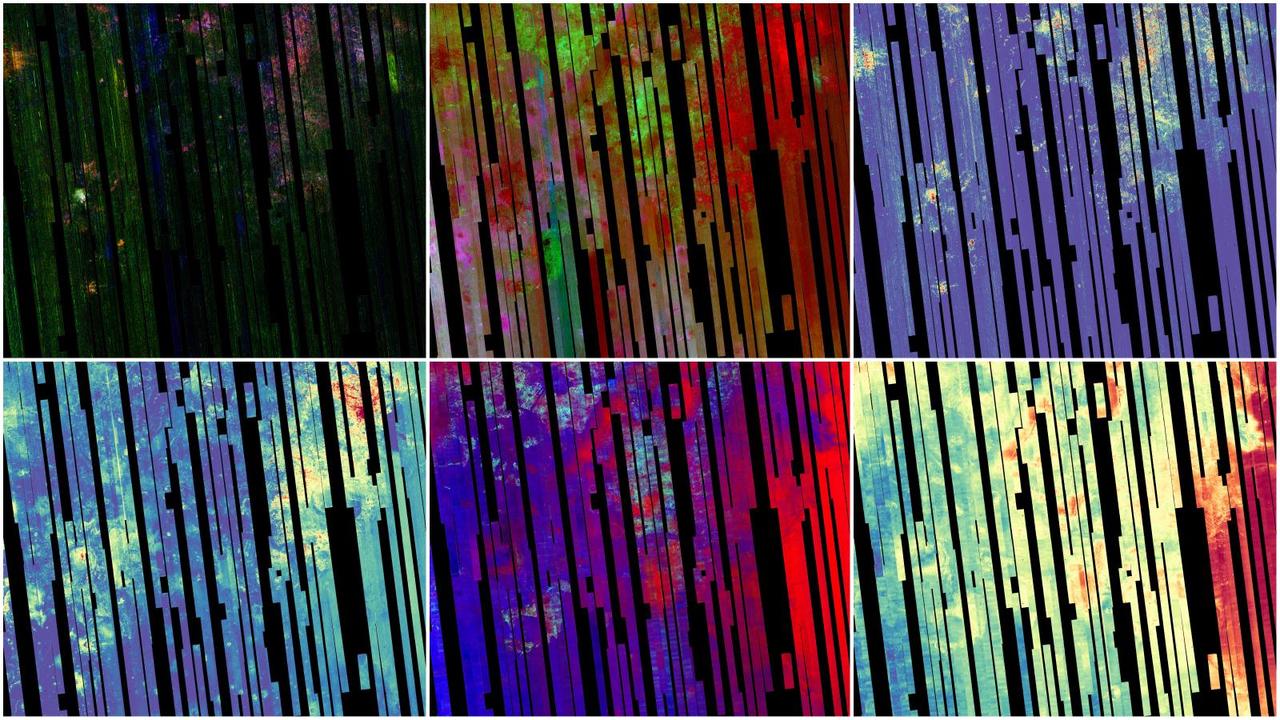
This image shows six views of the Nili Fossae region of Mars captured by the Compact Reconnaissance Imaging Spectrometer for Mars, or CRISM, one of the instruments aboard NASA's Mars Reconnaissance Orbiter. The varying colors represent minerals on the Martian surface seen in different wavelengths of light. Each of these views was produced as part of a near-global map made up of about 1,764 individual segments. The 72-color map is the last major dataset CRISM will ever produce; the instrument will be decommissioned by the end of 2022. Data for the 6.3-gigapixel map was collected over 11 years of CRISM operations. The instrument arrived at Mars with three cryocoolers that allowed it to see in a range of wavelengths, including infrared; in 2017, the last of those cryocoolers stopped working, severely limiting the number of wavelengths CRISM could "see." https://photojournal.jpl.nasa.gov/catalog/PIA25364
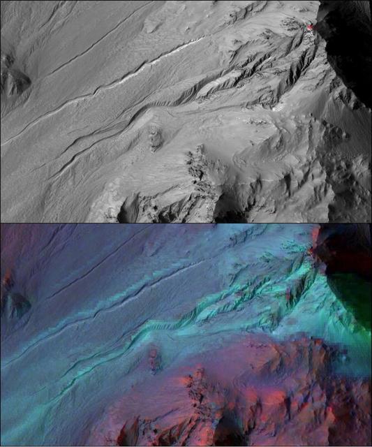
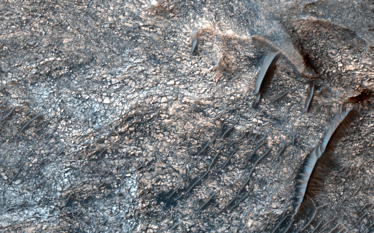
The highly incised Martian gullies seen in the top image resemble gullies on Earth that are carved by liquid water. However, when the gullies are observed with the addition of mineralogical information (bottom), no evidence for alteration by water appears. The pictured area spans about 2 miles (3 kilometers) on the eastern rim of Hale Crater. The High Resolution Imaging Science Experiment (HiRISE) camera on NASA's Mars Reconnaissance Orbiter took the visible-light image. Color-coded compositional information added in the lower version comes from the same orbiter's Compact Reconnaissance Imaging Spectrometer for Mars (CRISM). Color coding in light blue corresponds to surface composition of unaltered mafic material, of volcanic origin. Mafic material from the crater rim is carved and transported downslope along the gully channels. No hydrated minerals are observed within the gullies, in the data from CRISM, indicating limited interaction or no interaction of the mafic material with liquid water. These findings and related observations at about 100 other gully sites on Mars suggest that a mechanism not requiring liquid water may be responsible for carving these gullies on Mars. (Gullies on Mars are a different type of feature than seasonal dark streaks called recurring slope lineae or RSL; water in the form of hydrated salt has been identified at RSL sites.) The HiRISE image is a portion of HiRISE observation PSP_002932_1445. The lower image is from the same HiRISE observation, with a CRISM mineral map overlaid. http://photojournal.jpl.nasa.gov/catalog/PIA20763
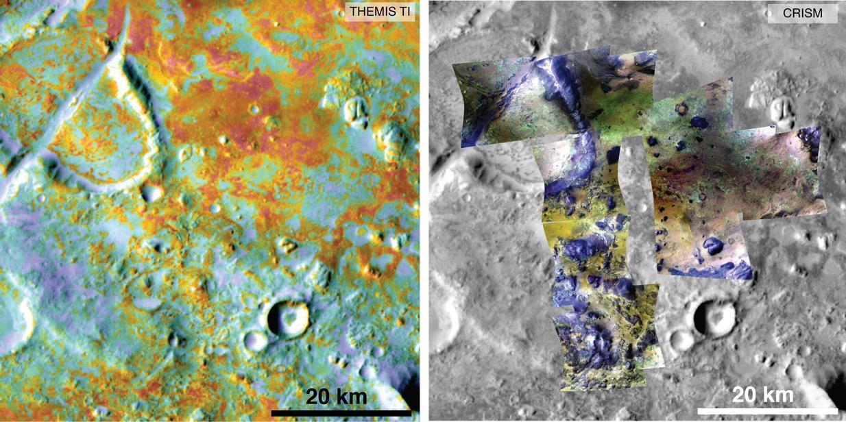
Researchers estimating the amount of carbon held in the ground at the largest known carbonate-containing deposit on Mars utilized data from three different NASA Mars orbiters. Each image in this pair covers the same area about 36 miles (58 kilometers) wide in the Nili Fossae plains region of Mars' northern hemisphere. The tally of carbon content in the rocks of this region is a key piece in solving a puzzle of how the Martian atmosphere has changed over time. Carbon dioxide from the atmosphere on early Mars reacted with surface rocks to form carbonate, thinning the atmosphere. The image on the left presents data from the Thermal Emission Imaging System (THEMIS) instrument on NASA's Mars Odyssey orbiter. The color coding indicates thermal inertia -- the property of how quickly a surface material heats up or cools off. Sand, for example (blue hues), cools off quicker after sundown than bedrock (red hues) does. The color coding in the image on the right presents data from the Compact Reconnaissance Imaging Spectrometer for Mars (CRISM) instrument on NASA's Mars Reconnaissance Orbiter. From the brightness at many different wavelengths, CRISM data can indicate what minerals are present on the surface. In the color coding used here, green hues are consistent with carbonate-bearing materials, while brown or yellow hues are olivine-bearing sands and locations with purple hues are basaltic in composition. The gray scale base map is a mosaic of daytime THEMIS infrared images. Annotations point to areas with different surface compositions. The scale bar indicates 20 kilometers (12.4 miles). http://photojournal.jpl.nasa.gov/catalog/PIA19816
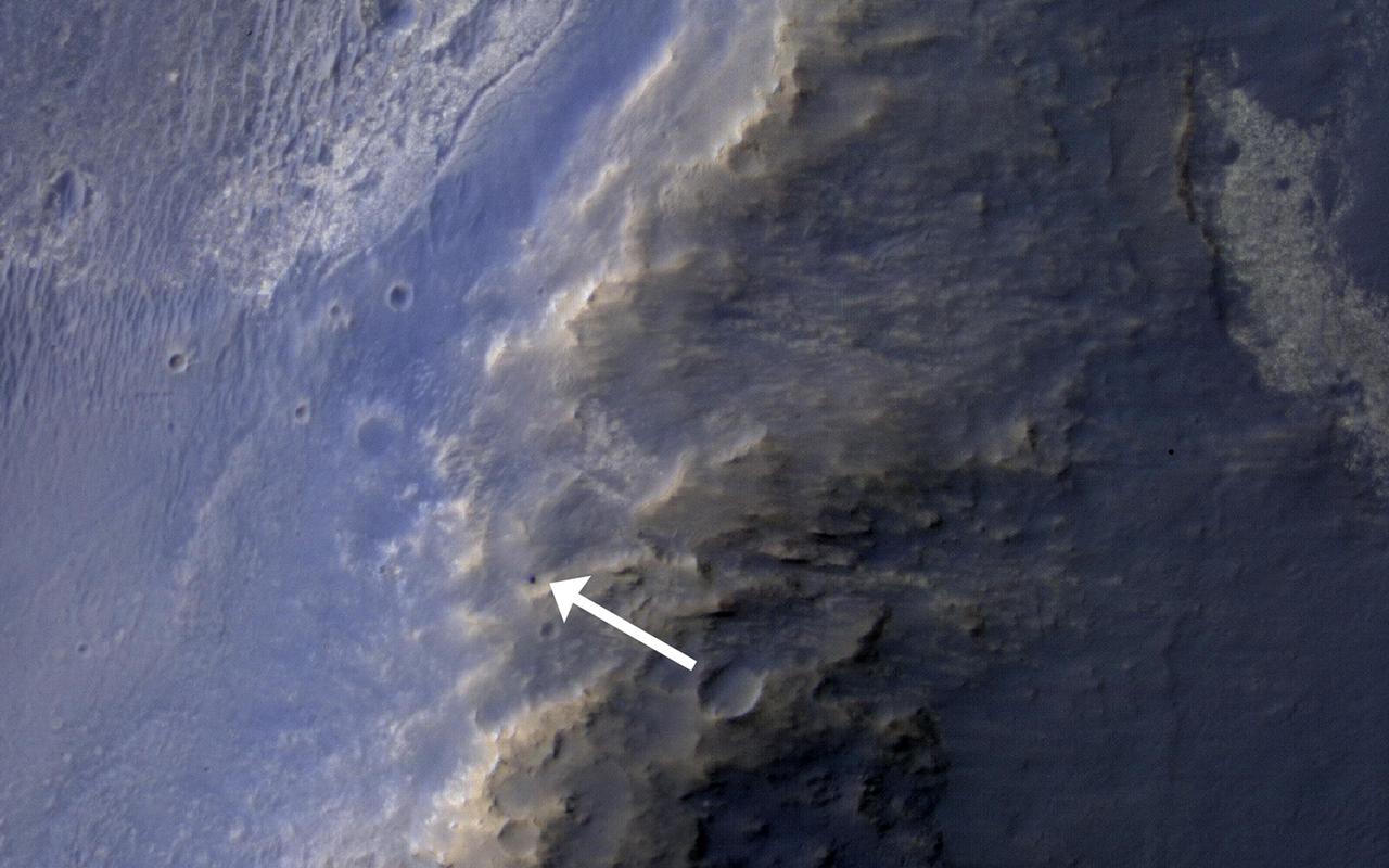
This HiRISE image of the Opportunity rover was acquired as a coordinated ride-along observation with the CRISM instrument, also onboard the Mars Reconnaissance Orbiter.

The CRISM, a mineral mapping instrument on NASA Mars Reconnaissance Orbiter, began observing Mars after its lens cover was opened on Sept. 27, 2006.
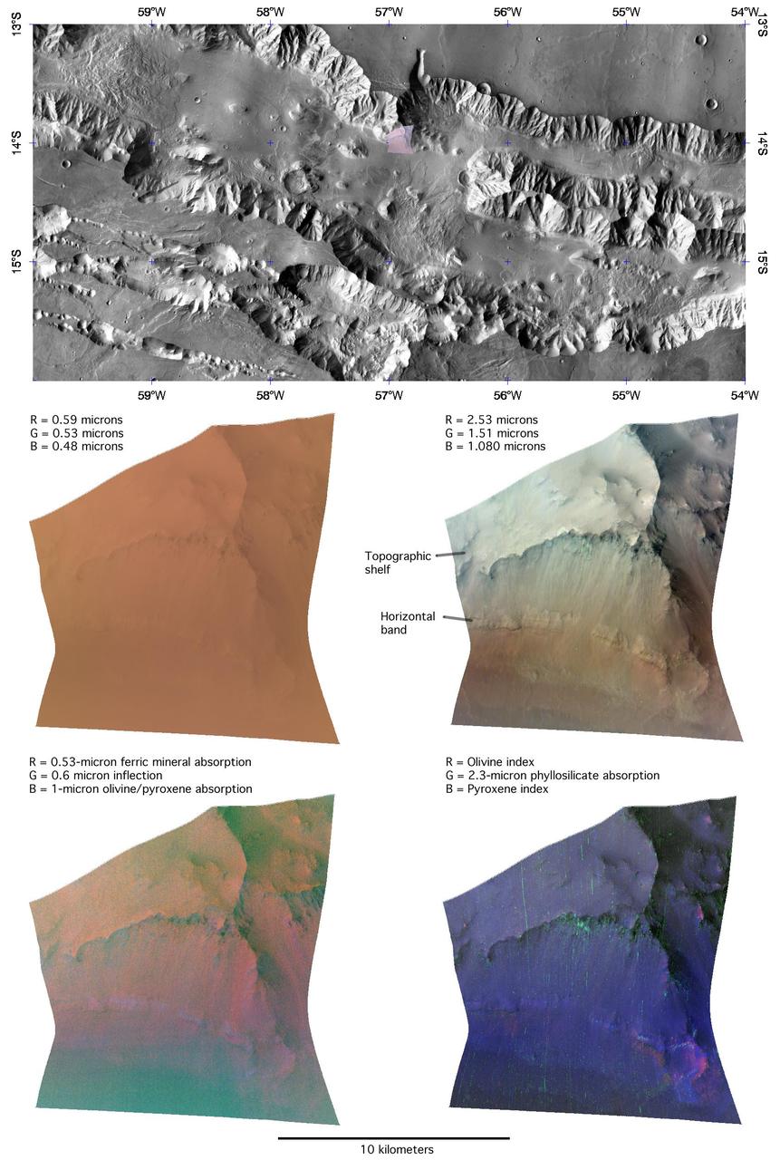
This image of the northern wall of Coprates Chasma, in Valles Marineris, was taken by the Compact Reconnaissance Imaging Spectrometer for Mars CRISM on June 16, 2007.
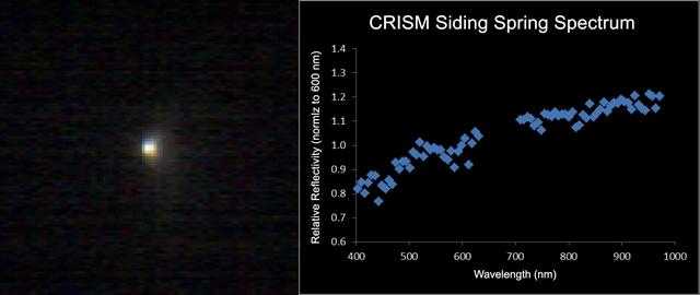
The Compact Reconnaissance Imaging Spectrometer for Mars CRISM aboard NASA Mars Reconnaissance Orbiter obtained this spectrum for comet C/2013 A1 Siding Spring during the comet close approach to Mars.
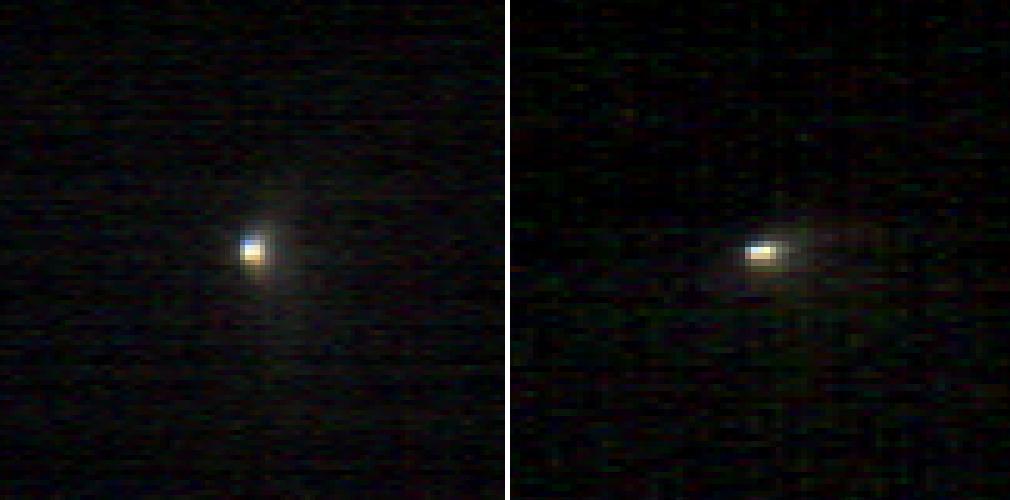
These two infrared images of comet C/2013 A1 Siding Spring were taken by the Compact Reconnaissance Imaging Spectrometer for Mars CRISM aboard NASA Mars Reconnaissance Orbiter on Oct. 19, 2014.
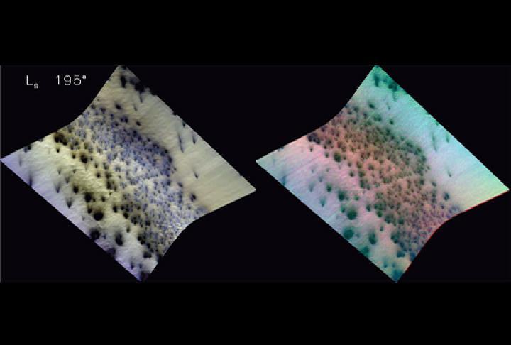
NASA CRISM onboard the Mars Reconnaissance Orbiter shows Mars seasonal caps consist of frozen carbon dioxide mixed with smaller amounts of water ice frost and dust.

This artist concept is of Z Camelopardalis Z Cam, a stellar system featuring a collapsed, dead star, or white dwarf, and a companion star. This image shows one of the first regions of Mars measured after CRISM cover was opened
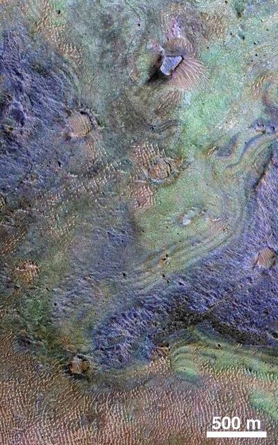
The color coding on this CRISM composite image of an area on Mars is based on infrared spectral information interpreted as evidence of various minerals present. Carbonate, which is indicative of a wet and non-acidic history, occurs in very small patches.
These mountains are in a region called Sisyphi Montes. The base image from NASA 2001 Mars Odyssey shows a portion of the region about 130 miles. Red outlines indicate possible subglacial volcanic structures. MRO CRISM data are at upper right.
This 3D perspective view is a composite of both HiRISE and data from CRISM, another instrument onboard MRO. This view covers a small patch of ancient Martian real estate in Terra Sirenum. CRISM collects spectral data that can be used as a chemical fingerprint for the upper most surface. This information suggests that this small patch of surface is covered with salts (chlorides) represented in green and water-rich clays that appear in blue. CRISM colors can be added to high-resolution images to enhance our knowledge of these materials. They also match nicely with the surface features in our HiRISE image. For example, a fissure near the center of the image may be a a clue to the origin of the salts. The fissure may be a fracture where warm salt-laden water may have welled up, erupted and ponded on the surface. These waters then evaporated leaving the salt-rich deposits behind. https://photojournal.jpl.nasa.gov/catalog/PIA22867
Candor Chasma in central Valles Marineris is filled with light-toned layered deposits thought to be sandstones, perhaps formed in an ancient wet and potentially habitable environment. The CRISM instrument on MRO has acquired thousands high-resolution spectral images across Mars, often with simultaneous coverage by HiRISE, but sometimes, for a variety of reasons, without HiRISE coverage. We are now trying to complete coordinated coverage over such locations, to enable geologic interpretations based on both the compositional information of CRISM and the high-resolution imaging of HiRISE. https://photojournal.jpl.nasa.gov/catalog/PIA23676
HiRISE reveals small-scale shapes that often correlate with mineral units and provides information about stratigraphy (i.e., what's on top and relative ages). This image was acquired for co-analysis with a spectrometer instrument also on our spacecraft called CRISM (Compact Reconnaissance Imaging Spectrometer for Mars). It shows polygonal units that match clay-rich areas. Plus, this region is colorful! This location, in Eridania Basin, was the site of an ancient lake, so these clay-rich sediments may have been habitable. While CRISM cannot acquire new data from their infrared channel due to lack of cooling, they have acquired much previous data that lacks HiRISE coverage. https://photojournal.jpl.nasa.gov/catalog/PIA23105
Color has been added to highlight minerals in this image of Jezero Crater on Mars, the landing site for NASA's Mars 2020 mission. The green color represents minerals called carbonates, which are especially good at preserving fossilized life on Earth. Red represents olivine sand eroding out of carbonate-containing rocks. The image was created using data taken by NASA's Mars Reconnaissance Orbiter and its Compact Reconnaissance Imaging Spectrometer for Mars (CRISM) and Context Camera (CTX). https://photojournal.jpl.nasa.gov/catalog/PIA23380
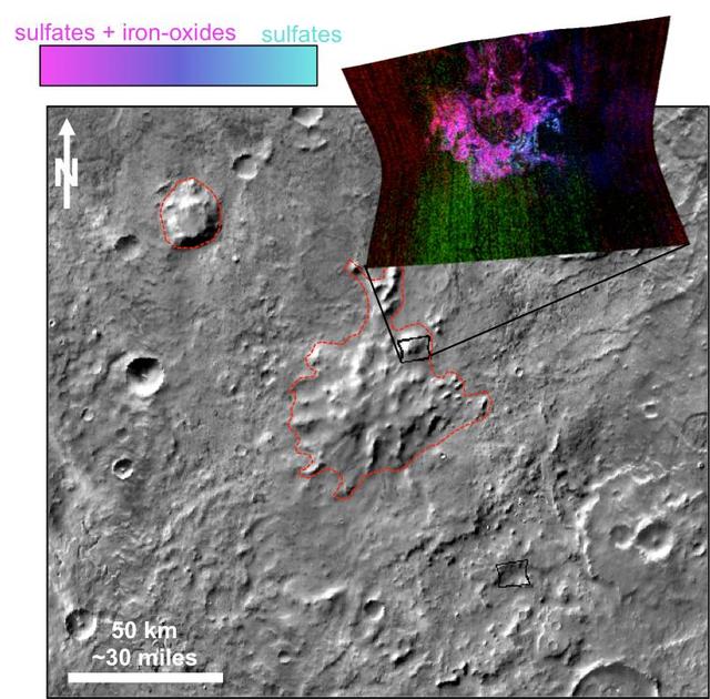
This image was acquired to get more information about a site where the CRISM instrument detected hydrated sulfates. The bright materials are likely to be sediments rich in the hydrated sulfates, and this image shows that most of the material is covered by a thin deposit of dark material, perhaps sand. We also see streamlined patterns that suggest fluvial processes were involved in depositing or eroding the sulfate-rich sediments. https://photojournal.jpl.nasa.gov/catalog/PIA26327
Some regions of Mars are not very colorful, but we can be surprised by local features. This image of an impact crater in the south Syrtis Major region was acquired as a "ride-along" with a CRISM observation, which targeted this location because that instrument's team expected a distinct composition. Our enhanced image reveals colors ranging from red to green to blue. These are infra-red shifted colors (infrared-red-blue) so it's different than what we would see with our eyes. https://photojournal.jpl.nasa.gov/catalog/PIA22727
Large impacts produce uplifted central structures, either peaks, or pits, or an uplifted peak with a central pit. This crater south of Aurorae Chaos has a central pit exposing bedrock units with diverse colors, indicating diverse rock compositions. This crater includes clay-rich minerals identified by the CRISM instrument on MRO. See this enhanced-color cutout over the eastern half of the central pit. https://photojournal.jpl.nasa.gov/catalog/PIA23737
![The combination of morphological and topographic information from stereo images from NASA's Mars Reconnaissance Orbiter, as well as compositional data from near-infrared spectroscopy has been proven to be a powerful tool for understanding the geology of Mars. Beginning with the OMEGA instrument on the European Space Agency's Mars Express orbiter in 2003, the surface of Mars has been examined at near-infrared wavelengths by imaging spectrometers that are capable of detecting specific minerals and mapping their spatial extent. The CRISM (Compact Reconnaissance Imaging Spectrometer for Mars) instrument on our orbiter is a visible/near-infrared imaging spectrometer, and the HiRISE camera works together with it to document the appearance of mineral deposits detected by this orbital prospecting. Mawrth Vallis is one of the regions on Mars that has attracted much attention because of the nature and diversity of the minerals identified by these spectrometers. It is a large, ancient outflow channel on the margin of the Southern highlands and Northern lowlands. Both the OMEGA and CRISM instruments have detected clay minerals here that must have been deposited in a water-rich environment, probably more than 4 billion years ago. For this reason, Mawrth Vallis is one of the two candidate landing sites for the future Mars Express Rover Mission planned by the European Space Agency. This image was targeted on a location where the CRISM instrument detected a specific mineral called alunite, KAl3(SO4)2(OH)6. Alunite is a hydrated aluminum potassium sulfate, a mineral that is notable because it must have been deposited in a wet acidic environment, rich in sulfuric acid. Our image shows that the deposit is bright and colorful, and extensively fractured. The width of the cutout is 1.2 kilometers. The map is projected here at a scale of 50 centimeters (19.7 inches) per pixel. [The original image scale is 60.1 centimeters (23.7 inches) per pixel (with 2 x 2 binning); objects on the order of 180 centimeters (70.9 inches) across are resolved.] North is up. https://photojournal.jpl.nasa.gov/catalog/PIA21936](https://images-assets.nasa.gov/image/PIA21936/PIA21936~medium.jpg)
The combination of morphological and topographic information from stereo images from NASA's Mars Reconnaissance Orbiter, as well as compositional data from near-infrared spectroscopy has been proven to be a powerful tool for understanding the geology of Mars. Beginning with the OMEGA instrument on the European Space Agency's Mars Express orbiter in 2003, the surface of Mars has been examined at near-infrared wavelengths by imaging spectrometers that are capable of detecting specific minerals and mapping their spatial extent. The CRISM (Compact Reconnaissance Imaging Spectrometer for Mars) instrument on our orbiter is a visible/near-infrared imaging spectrometer, and the HiRISE camera works together with it to document the appearance of mineral deposits detected by this orbital prospecting. Mawrth Vallis is one of the regions on Mars that has attracted much attention because of the nature and diversity of the minerals identified by these spectrometers. It is a large, ancient outflow channel on the margin of the Southern highlands and Northern lowlands. Both the OMEGA and CRISM instruments have detected clay minerals here that must have been deposited in a water-rich environment, probably more than 4 billion years ago. For this reason, Mawrth Vallis is one of the two candidate landing sites for the future Mars Express Rover Mission planned by the European Space Agency. This image was targeted on a location where the CRISM instrument detected a specific mineral called alunite, KAl3(SO4)2(OH)6. Alunite is a hydrated aluminum potassium sulfate, a mineral that is notable because it must have been deposited in a wet acidic environment, rich in sulfuric acid. Our image shows that the deposit is bright and colorful, and extensively fractured. The width of the cutout is 1.2 kilometers. The map is projected here at a scale of 50 centimeters (19.7 inches) per pixel. [The original image scale is 60.1 centimeters (23.7 inches) per pixel (with 2 x 2 binning); objects on the order of 180 centimeters (70.9 inches) across are resolved.] North is up. https://photojournal.jpl.nasa.gov/catalog/PIA21936
This image covers the high plains about 25 kilometers (15 miles) south of Coprates Chasma, near the eastern end of the Valles Marineris canyon system. Here, the CRISM instrument on MRO has detected clay minerals, which imply substantial water-rock interactions in the past. These minerals often have a reddish- to yellow appearance in HiRISE images. In this observation, the minerals appear concentrated along the boundaries of polygons up to 10 meters across. Perhaps the water-rock interactions at this site were most extensive within a network of pre-existing fractures dissecting the bedrock. Rough, blue-to-purplish material appears to overlie the polygonal fractures in portions of the image. We also see lighter blue-to-green materials. While CRISM can provide a time constraint to the compositions of these varied materials, HiRISE shows us how they relate to each other and how such a colorful scene could have been assembled over geologic time. https://photojournal.jpl.nasa.gov/catalog/PIA24700
This image taken by NASA's Mars Reconnaissance Orbiter (MRO) shows ice sheets at Mars' south pole. The spacecraft detected clays near this ice; scientists have proposed such clays are the source of radar reflections that have been previously interpreted as liquid water using data from the ESA (European Space Agency) Mars Express orbiter. Flying 186 miles (300 kilometers) above the Martian surface, MRO used its High-Resolution Imaging Science Experiment (HiRISE) camera to study the ice sheets while using its Compact Reconnaissance Imaging Spectrometer (CRISM) to map out clay minerals near the ice. https://photojournal.jpl.nasa.gov/catalog/PIA24763
This colorful image, acquired on May 21, 2018 by NASA's Mars Reconnaissance Orbiter, shows clays within the Eridania basin region. Many scientists using orbital data have proposed that a large lake may have once existed here during the Late Noachian through Early Hesperian time periods, and then much of the water drained out to the north via Ma'adim Vallis. Understanding where and what kind of clay exists within this region using CRISM data can help scientists learn more about how long the postulated lake existed and the water chemistry within the lake. More information is available at https://photojournal.jpl.nasa.gov/catalog/PIA22588
This animation shows a proposed route for NASA's Curiosity rover, which is climbing lower Mount Sharp on Mars. The annotated version of the map labels different regions that scientists working with the rover would like to explore in coming years. A flyover video explains them in more detail. Data used in creating this map came from several instruments on NASA's Mars Reconnaissance Orbiter (MRO), including the High Resolution Imaging Science Experiment (HiRISE), Compact Reconnaissance Imaging Spectrometer for Mars (CRISM) and the Context Camera (CTX). The High Resolution Stereo Camera (HRSC) instrument on the European Space Agency's Mars Express also contributed data. Animation available at https://photojournal.jpl.nasa.gov/catalog/PIA23179

This 280-kilometer diameter crater center has experienced a long history of water activity. Within the crater is a heavily faulted and fractured terrain called Aram Chaos that consists of darker volcanic rocks that were disrupted as a result of water and/or magma withdrawal in the subsurface. Above this chaotic terrain are brighter materials made up of different kinds of sulfates that formed when water filled the crater. CRISM data collected along with HiRISE images indicate that the sulfates consist of monohydrated, polyhydrated, and ferric hydroxysulfate, with each composition representing a different geochemical environment within the waters that once resided within Aram Chaos. https://photojournal.jpl.nasa.gov/catalog/PIA25358
This image of the Nili Fossae region, to the west of the great Isidis basin, shows layered bedrock with many impact craters. Nili Fossae is one of the most mineralogically important sites on Mars. Remote observations by the infrared spectrometer onboard MRO (called CRISM) suggest the layers in the ancient craters contain clays, carbonates, and iron oxides, perhaps due to hydrothermal alteration of the crust. However, the impact craters have been degraded by many millions of years of erosion so the original sedimentary, impact ejecta, or lava flows are hard to distinguish. The bright linear features are sand dunes, also known as "transverse aeolian dunes," because the wind direction is at ninety degrees to their elongated orientation. This shows that the erosion of Nili Fossae continues to the present day with sand-sized particles broken off from the local rocks mobilized within the dunes. https://photojournal.jpl.nasa.gov/catalog/PIA23452
It has been known since the 1970s when the Viking orbiters took pictures of Mars that there are large (i.e., several kilometers-thick) mounds of light-toned deposits within the central portion of Valles Marineris. More recent higher resolution images of Mars, including this image of Melas Chasma, show that the wall rocks of Valles Mariners also contain similar, albeit thinner, light-toned deposits. Spectral data from the CRISM instrument indicate that the larger mounds are composed of sulfates. Some of the wall rock deposits are also made up of sulfates, but others contain clays or mixtures of several kinds of hydrated materials, suggesting that multiple aqueous processes, perhaps at different times within Valles Marineris, formed the variety of deposits we now observe. http://photojournal.jpl.nasa.gov/catalog/PIA21102
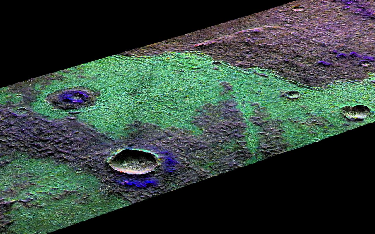
This image covers the inside of an impact crater on the northern plains of Mars. It was intended to provide a baseline image of sand dunes on the crater floor, which could be monitored for potential motion in future pictures. Much more than sand is visible. The dark, undulating dunes sit atop a colorful surface of exposed bedrock. Based on the crater's diameter of roughly 25 kilometers, these rocks may have been previously buried over a mile beneath the surface. The varying colors likely reflect diverse mineral compositions. (The CRISM instrument, also on MRO, has detected different minerals in the neighboring larger Micoud Crater, whose rim lies about 50 kilometers east-southeast of this image.) Excavated by impact, the colorful rocks here remain visible in part thanks to the winds that shape the overlying sand dunes, which help to sweep the crater's center clear of surface dust. https://photojournal.jpl.nasa.gov/catalog/PIA23847
Lighter colors represent higher elevation in this image of Jezero Crater on Mars, the landing site for NASA's Mars 2020 mission. The oval indicates the landing ellipse, where the rover will be touching down on Mars. The color added to this image helps the crater rim stand out clearly, and makes it easier to spot the shoreline of a lake that dried up billions of years ago. Scientists want to visit this shoreline because it may have preserved fossilized microbial life, if any ever formed on Mars. The image was created using data from a combination of instruments and spacecraft: NASA's Mars Global Surveyor and its Mars Orbiter Laser Altimeter (MOLA); NASA's Mars Reconnaissance Orbiter and its Compact Reconnaissance Imaging Spectrometer for Mars (CRISM) and Context Camera (CTX); and the European Space Agency's Mars Express and its High Resolution Stereo Camera (HRSC). https://photojournal.jpl.nasa.gov/catalog/PIA23511
A variety of diverse morphological features are present in this image (21 by 5.5 kilometers) located in the southeastern area of the Nili Fossae region and just northeast of Syrtis Major. This particular region has been studied intensely due to the presence of volcanics from Syrtis Major and impact ejecta from the Isidis Basin. The region is rich in unaltered mafic deposits, in contact with diverse altered deposits rich in clays, carbonates, and sulfates. These deposits make the Nili Fossae region one of the most colorful regions on Mars, which is most distinctive in infrared color composites (IRB). HiRISE IRB color aids in chemical and mineral-type mapping, especially when correlated with other MRO instruments such as CRISM. http://photojournal.jpl.nasa.gov/catalog/PIA19940
Sedimentary deposits are common within Valles Marineris. Most larger chasmata contain kilometer-thick light-toned layered deposits composed of sulfates. However, some of the chasmata, like Ius Chasma shown in this image from NASA Mars Reconnaissance Orbiter, lack these deposits or have much thinner deposits. The light-toned deposits in Ius Chasma are observed both along the floor and inner wallrock materials. Some of the light-toned deposits appear to post-date formation of the chasma floor, whereas other deposits appear to lie beneath wallrock materials, indicating they are older. By examining the stratigraphy using digital terrain models and 3D images, it should be possible to decipher the relative ages of the different geologic units. CRISM data may also provide insight into the mineralogy, which will tell scientists about the aqueous conditions that emplaced the light-toned deposits. http://photojournal.jpl.nasa.gov/catalog/PIA19855
This image from NASA's Mars Reconnaissance Orbiter (MRO) shows a hill with a central crater. Such features have been interpreted as both mud volcanoes (really a sedimentary structure) and as actual volcanoes (the erupting lava kind). They occur on the floor of Valles Marineris below a closed topographic contour that could have held a lake, and the compaction of wet sediments may have created mud volcanoes. The fracture pattern of the bright flow unit surrounding the hill resembles mud cracks. However, there have also been observations from the CRISM instrument interpreted as high-temperature minerals, suggesting actual volcanism, although not necessarily at this location. Fine layers in the hill are consistent with either volcanism or mud flows. Either way, this activity is relatively recent in geologic time and may mark habitable subsurface environments. https://photojournal.jpl.nasa.gov/catalog/PIA22514

Capri Chasma is located in the eastern portion of the Valles Marineris canyon system, the largest known canyon system in the Solar System. Deeply incised canyons such as this are excellent targets for studying the Martian crust, as the walls may reveal many distinct types of bedrock. This section of the canyon was targeted by HiRISE based on a previous spectral detection of hematite-rich deposits in the area. Hematite, a common iron-oxide mineral, was first identified here by the Mars Global Surveyor Thermal Emission Spectrometer (TES). In this TES image, red pixels indicate higher abundances of hematite, while the blue and green pixels represent different types of volcanic rocks (e.g., basalt). Hematite in the Meridiani Planum region was also detected with the TES instrument (which we can see with the bright red spot on the Global TES mineral map). As a consequence, Meridiani Planum was the first landing site selected on Mars due to the spectral detection of a mineral that may have formed in the presence of liquid water. Shortly after landing, the Opportunity rover detected the presence of hematite in the form of concretions called "blueberries." The blueberries are found in association with layers of sulfate salt-rich rocks. The salts are hypothesized to have formed through the raising and lowering of the groundwater table. During one such an event, the rock altered to form the hematite-rich blueberries. As the rock was eroded away, the more resistant hematite-rich blueberries were plucked out and concentrated on the plains as a "lag" deposit. Martian blueberries are observed to be scattered across the plains of Meridiani along Opportunity's traverse from Eagle Crater to Endeavor Crater, where Opportunity continues to explore after its mission began over 10 years ago. This infrared-color image close-up highlights what is possibly the hematite-rich deposits nestled between different types of bedrock terraces in Capri Chasma. The bluish terrace is likely volcanic in origin, possibly basaltic, whereas the greenish rocks remain unidentified. The central reddish terrace is possibly where some of the hematite may be concentrated. The higher elevation terrace with the lighter-colored materials is likely a sulfate-rich rock (based on CRISM data in the area). Given the presence of both sulfate salts and hematite in this area, akin to the deposits and associations explored by the Opportunity rover in Meridiani Planum, it might be that these materials in Capri Chasma may share a similar origin. The yellow rectangular box shown on the TES spectral map outlines the corresponding location of the HiRISE image. Although the outline does not appear to contain a high hematite abundance, we note that the lower resolution of TES (about 3 to 6 kilometers per pixel) may exclude smaller exposures and finer sub-pixel details not-yet captured, but could be with HiRISE. A follow-up observation by the CRISM spectrometer may reveal additional details and a spectral signature for hematite in the vicinity at a finer resolution than TES. http://photojournal.jpl.nasa.gov/catalog/PIA21274
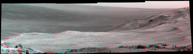
This stereo scene from NASA's Mars Exploration Rover Opportunity shows part of "Marathon Valley," a destination on the western rim of Endeavour Crater, as seen from an overlook north of the valley. The image combines views from the left eye and right eye of Opportunity's panoramic camera (Pancam) to appear three-dimensional when seen through blue-red glasses with the red lens on the left. The component Pancam images were taken on March 13, 2015, during the 3,958th Martian day, or sol, of Opportunity's work on Mars. The scene spans from east, at left, to southeast. The rover team selected Marathon Valley as a science destination because observations of this location using the Compact Reconnaissance Imaging Spectrometer for Mars (CRISM) instrument on NASA's Mars Reconnaissance Orbiter yielded evidence of clay minerals, a clue to ancient wet environments. By the time Opportunity explores Marathon Valley, the rover will have exceeded a total driving distance equivalent to an Olympic marathon. Opportunity has been exploring the Meridiani Planum region of Mars since January 2004. http://photojournal.jpl.nasa.gov/catalog/PIA19153
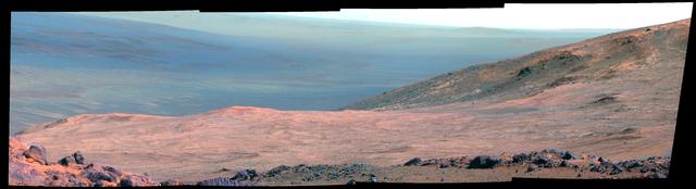
This view from NASA's Mars Exploration Rover Opportunity shows part of "Marathon Valley," a destination on the western rim of Endeavour Crater, as seen from an overlook north of the valley. In this version of the image, the landscape is presented in false color to make differences in surface materials more easily visible. The scene spans from east, at left, to southeast. It combines four pointings of the rover's panoramic camera (Pancam) on March 13, 2015, during the 3,958th Martian day, or sol, of Opportunity's work on Mars. The rover team selected Marathon Valley as a science destination because observations of this location using the Compact Reconnaissance Imaging Spectrometer for Mars (CRISM) instrument on NASA's Mars Reconnaissance Orbiter yielded evidence of clay minerals, a clue to ancient wet environments. By the time Opportunity explores Marathon Valley, the rover will have exceeded a total driving distance equivalent to an Olympic marathon. Opportunity has been exploring the Meridiani Planum region of Mars since January 2004. The image combines exposures taken through three of the Pancam's color filters at each of the four camera pointings, using filters centered on wavelengths of 753 nanometers (near-infrared), 535 nanometers (green) and 432 nanometers (violet). http://photojournal.jpl.nasa.gov/catalog/PIA19152
![Holden Crater in southern Margaritifer Terra displays a series of finely layered deposits on its floor. The layered deposits are especially well exposed in the southwestern section of the crater where erosion by water flowing through a breach in the crater rim created spectacular outcrops. In this location, the deposits appear beneath a cap of alluvial fan materials (tan to brown in this image). Within the deposits, individual layers are nearly flat-lying and can be traced for hundreds of meters to kilometers. Information from the CRISM instrument on the Mars Reconnaissance Orbiter suggests that at least some of these beds contain clays. By contrast, the beds in the overlying alluvial fan are less continuous and dip in varying directions, showing less evidence for clays. Collectively, the characteristics of the finely bedded deposits suggest they may have been deposited into a lake on the crater floor, perhaps fed by runoff related to formation of the overlying fans. The map is projected here at a scale of 25 centimeters (9.8 inches) per pixel. [The original image scale is 25.9 centimeters (10.2 inches) per pixel (with 1 x 1 binning); objects on the order of 78 centimeters (30.7 inches) across are resolved.] North is up. http://photojournal.jpl.nasa.gov/catalog/PIA21561](https://images-assets.nasa.gov/image/PIA21561/PIA21561~medium.jpg)
Holden Crater in southern Margaritifer Terra displays a series of finely layered deposits on its floor. The layered deposits are especially well exposed in the southwestern section of the crater where erosion by water flowing through a breach in the crater rim created spectacular outcrops. In this location, the deposits appear beneath a cap of alluvial fan materials (tan to brown in this image). Within the deposits, individual layers are nearly flat-lying and can be traced for hundreds of meters to kilometers. Information from the CRISM instrument on the Mars Reconnaissance Orbiter suggests that at least some of these beds contain clays. By contrast, the beds in the overlying alluvial fan are less continuous and dip in varying directions, showing less evidence for clays. Collectively, the characteristics of the finely bedded deposits suggest they may have been deposited into a lake on the crater floor, perhaps fed by runoff related to formation of the overlying fans. The map is projected here at a scale of 25 centimeters (9.8 inches) per pixel. [The original image scale is 25.9 centimeters (10.2 inches) per pixel (with 1 x 1 binning); objects on the order of 78 centimeters (30.7 inches) across are resolved.] North is up. http://photojournal.jpl.nasa.gov/catalog/PIA21561
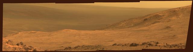
This view from NASA's Mars Exploration Rover Opportunity shows part of "Marathon Valley," a destination on the western rim of Endeavour Crater, as seen from an overlook north of the valley. The scene spans from east, at left, to southeast. It combines four pointings of the rover's panoramic camera (Pancam) on March 13, 2015, during the 3,958th Martian day, or sol, of Opportunity's work on Mars. The rover team selected Marathon Valley as a science destination because observations of this location using the Compact Reconnaissance Imaging Spectrometer for Mars (CRISM) instrument on NASA's Mars Reconnaissance Orbiter yielded evidence of clay minerals, a clue to ancient wet environments. By the time Opportunity explores Marathon Valley, the rover will have exceeded a total driving distance equivalent to an Olympic marathon. Opportunity has been exploring the Meridiani Planum region of Mars since January 2004. This version of the image is presented in approximate true color by combining exposures taken through three of the Pancam's color filters at each of the four camera pointings, using filters centered on wavelengths of 753 nanometers (near-infrared), 535 nanometers (green) and 432 nanometers (violet). http://photojournal.jpl.nasa.gov/catalog/PIA19151

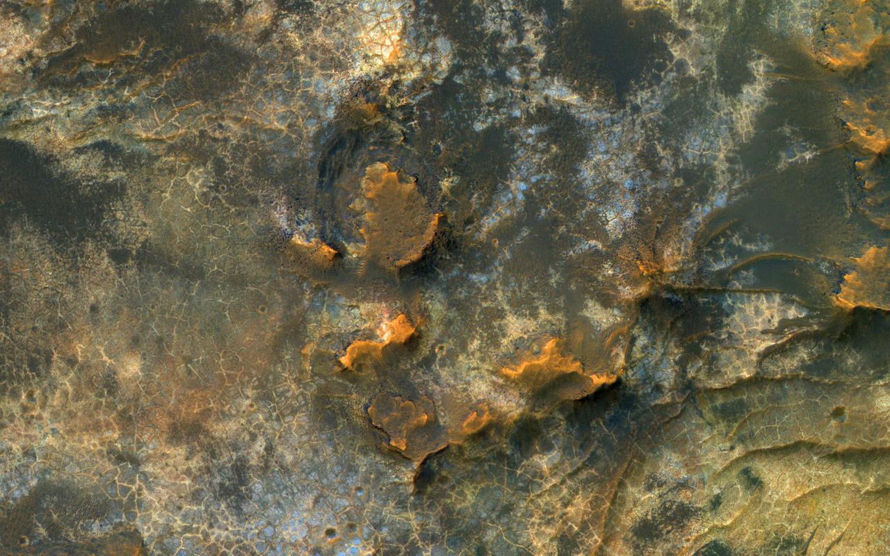
In this image, NASA's Mars Reconnaissance Orbiter (MRO) observes an impact crater with associated bright deposits that at first glance give the appearance of seasonal frost or ice accumulations. MRO has an onboard spectrometer called CRISM that can distinguish between ices and other minerals. Unfortunately, there is currently no coverage of this particular spot. However, it can be deduced through several lines of evidence that this is, in fact, not ice. Just like Earth, Mars experiences seasons that change as the planet orbits the Sun. Seasonal changes are most apparent at the higher latitudes. As these regions in each hemisphere enter their respective summer seasons, the Sun rises higher in the Martian sky causing frost and ice to sublimate, and illuminate more features across the landscape. As the high latitudes of each hemisphere move toward their respective winters, the days (called "sols") grow shorter and the sun hangs low on the horizon, giving rise to prolonged periods of cold, darkness, and frost accumulation. First, it should be noted that at the time this image was taken, the Southern hemisphere is at the end of the summer season, so any frost or ice deposits have long since sublimated away. Second, numerous HiRISE images of seasonal targets show that ice accumulates on pole-facing slopes. The deposits in question are situated on a slope that faces the equator, and would not accumulate deposits of frost. Thus, it can be concluded that these exposures are light-toned mineral deposits. https://photojournal.jpl.nasa.gov/catalog/PIA21766
In this image from NASA's Mars Reconnaissance Orbiter, layering within the light-toned sulfate deposit is the result of different states of hydration. Some of the layers have sulfates with little water (known as monohydrated sulfates) whereas other layers have higher amounts of water (called polyhydrated sulfates). The different amounts of water within the sulfates may reflect changes in the water chemistry during deposition of the sulfates, or may have occurred after the sulfates were laid down when heat or pressure forced the water out of some layers, causing a decrease in the hydration state. Many locations on Mars have sulfates, which are sedimentary rocks formed in water. Within Valles Marineris, the large canyon system that cuts across the planet, there are big and thick sequences of sulfates. The CRISM instrument on MRO is crucial for telling scientists which type of sulfate is associated with each layer, because each hydration state will produce a spectrum with absorptions at specific wavelengths depending upon the amount of water contained within the sulfate. https://photojournal.jpl.nasa.gov/catalog/PIA21935

This panorama from the Mast Camera (Mastcam) of NASA's Curiosity Mars rover shows details of "Vera Rubin Ridge," which stretches about 4 miles (6.5 kilometers), end-to-end, on the northwestern flank of lower Mount Sharp. The view combines 112 images taken with the Mastcam's right-eye camera, which has a telephoto lens, on April 4, 2017, during the 1,657th Martian day, or sol, of Curiosity's work on Mars. It has been white-balanced so that colors of the rock and sand materials resemble how they would appear under daytime lighting conditions on Earth. It spans from east-southeast on the left to south-southwest on the right, from a rover location about half a mile (0.8 kilometer) from the closest part of the ridge. Hematite, an iron-oxide mineral, has been detected in this ridge by the Compact Reconnaissance Imaging Spectrometer for Mars (CRISM) on NASA's Mars Reconnaissance Orbiter. The ridge has been an identified destination for Curiosity since before the rover's August 2012 landing near the base of Mount Sharp, inside Gale Crater. The ridge was informally named in early 2017 in memory of Vera Cooper Rubin (1928-2016), whose astronomical observations provided evidence for the existence of the universe's dark matter. An annotated version and full resolution TIFF files are available at https://photojournal.jpl.nasa.gov/catalog/PIA21717
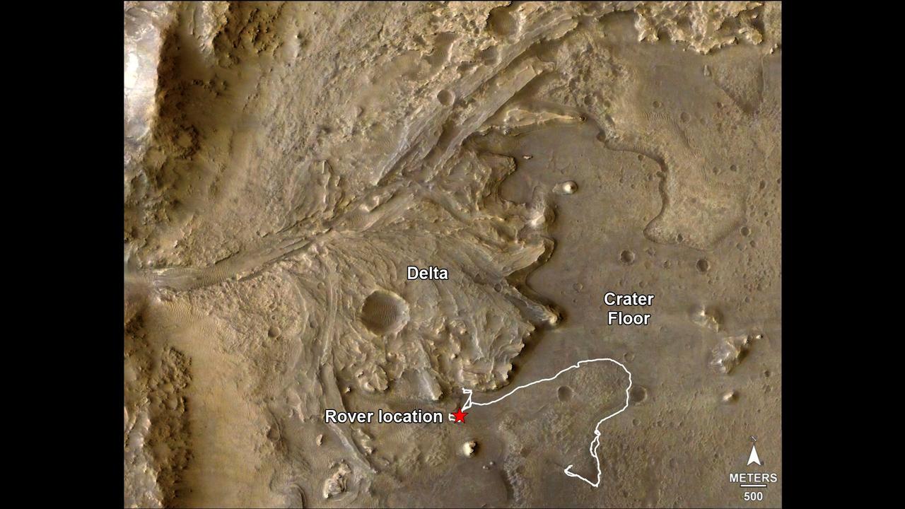
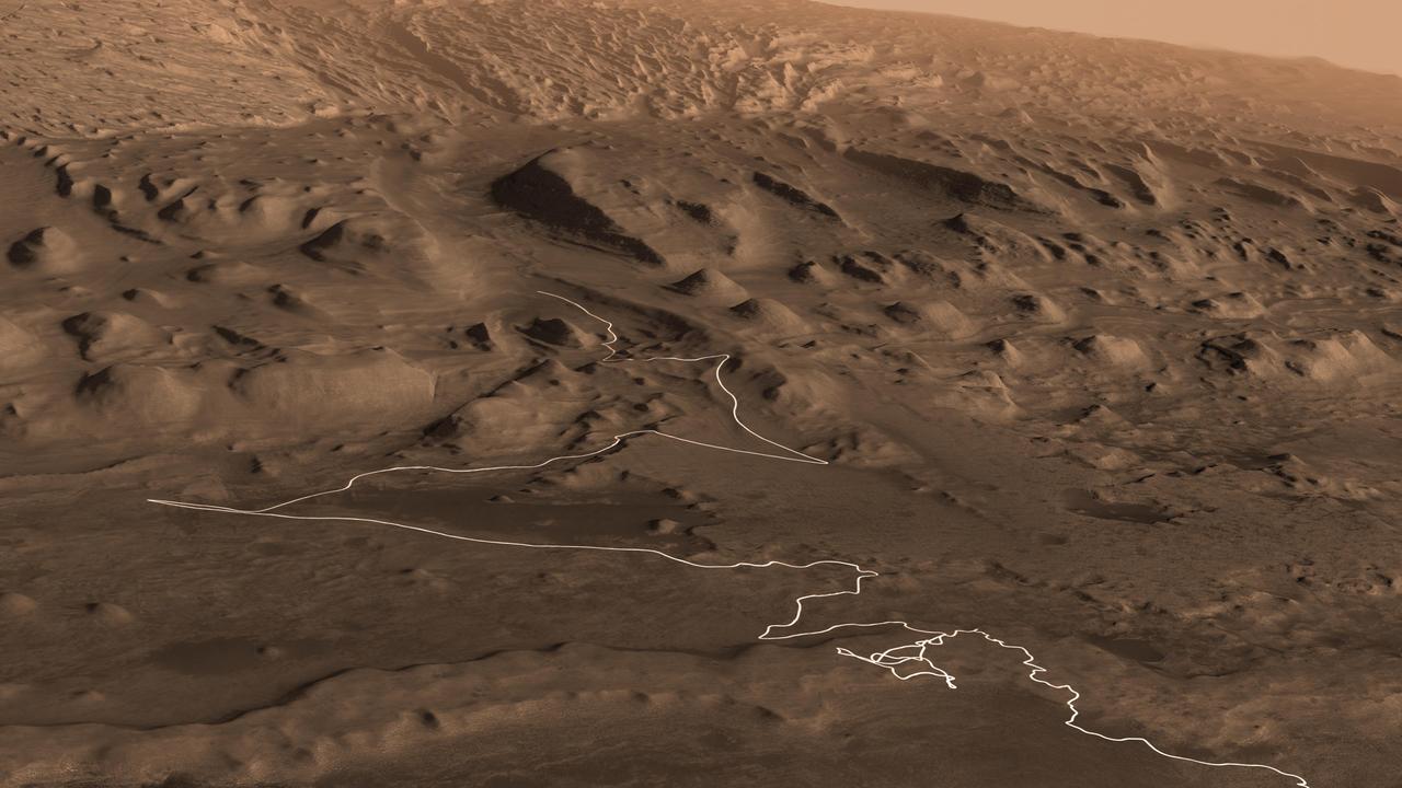
The route of NASA's Perseverance Mars rover – from its landing site on the floor of Jezero Crater to the ancient river delta, which it is currently exploring – is shown in this annotated image composed of overhead views from the agency's Mars Reconnaissance Orbiter (MRO). The red star indicates the location of the rover in September 2022. Perseverance touched down at "Octavia E. Butler Landing" on Feb. 18, 2021, and explored formations (abbreviated "fm" in the annotation) known as "Séítah" and "Máaz" on the floor of Jezero Crater before driving toward the delta region. The delta, which Perseverance reached in April 2022, is a fan-shaped area where, billions of years ago, a river once flowed into a lake and deposited rocks and sediment. Scientists consider it one of the best places on Mars to search for potential signs of ancient microbial life. For this image, the Perseverance team and the U.S. Geological Survey collaborated on the base map, combining multiple images from the High Resolution Imaging Experiment (HiRISE) camera with color from the Compact Reconnaissance Imaging Spectrometer for Mars (CRISM), both instruments aboard MRO. The HiRISE images used span a period from 2007 to 2017. A key objective for Perseverance's mission on Mars is astrobiology, including the search for signs of ancient microbial life. The rover will characterize the planet's geology and past climate, pave the way for human exploration of the Red Planet, and be the first mission to collect and cache Martian rock and regolith (broken rock and dust). Subsequent NASA missions, in cooperation with ESA (European Space Agency), would send spacecraft to Mars to collect these sealed samples from the surface and return them to Earth for in-depth analysis. The Mars 2020 Perseverance mission is part of NASA's Moon to Mars exploration approach, which includes Artemis missions to the Moon that will help prepare for human exploration of the Red Planet. https://photojournal.jpl.nasa.gov/catalog/PIA24922
Nothing gets a geologist more excited than layered bedrock, except perhaps finding a fossil or holding a meteorite in your hand. All of these things create a profound feeling of history, the sense of a story that took place ages ago, long before we came appeared. Layered bedrock in particular tells a story that was set out chapter by chapter as each new layer was deposited on top of older, previously deposited layers. Here in Nili Fossae, we see layered bedrock as horizontal striations in the light toned sediments in the floor of a canyon near Syrtis Major. (Note: illumination is from the top of the picture) The ancient layered rocks appear in pale whitish and bluish tones. They are partially covered by much younger ripples made up of dust and other wind blown sediments. The rock of the nearby canyon wall is severely fractured and appears to have shed sand and rocks and boulders onto the floor. This canyon did not form by fluvial erosion: it is part of a system of faults that formed a series of graben like this one, but water probably flowed through Nili Fossae in the distant past. Orbital spectral measurements by the OMEGA instrument on Mars Express and CRISM on MRO detected an abundance of clay minerals of different types in the layered sediments inside Nili Fossae, along with other minerals that are typical of sediments that were deposited by water. The various colors and tones of the layered rocks record changes in the composition of the sediments, details that can tell us about changes in the Martian environment eons ago. Nili Fossae is a candidate site for a future landed robotic mission that could traverse across these layers and make measurements that could be used to unravel a part of the early history of Mars. Nili Fossae is a history book that is waiting to be read. http://photojournal.jpl.nasa.gov/catalog/PIA21206
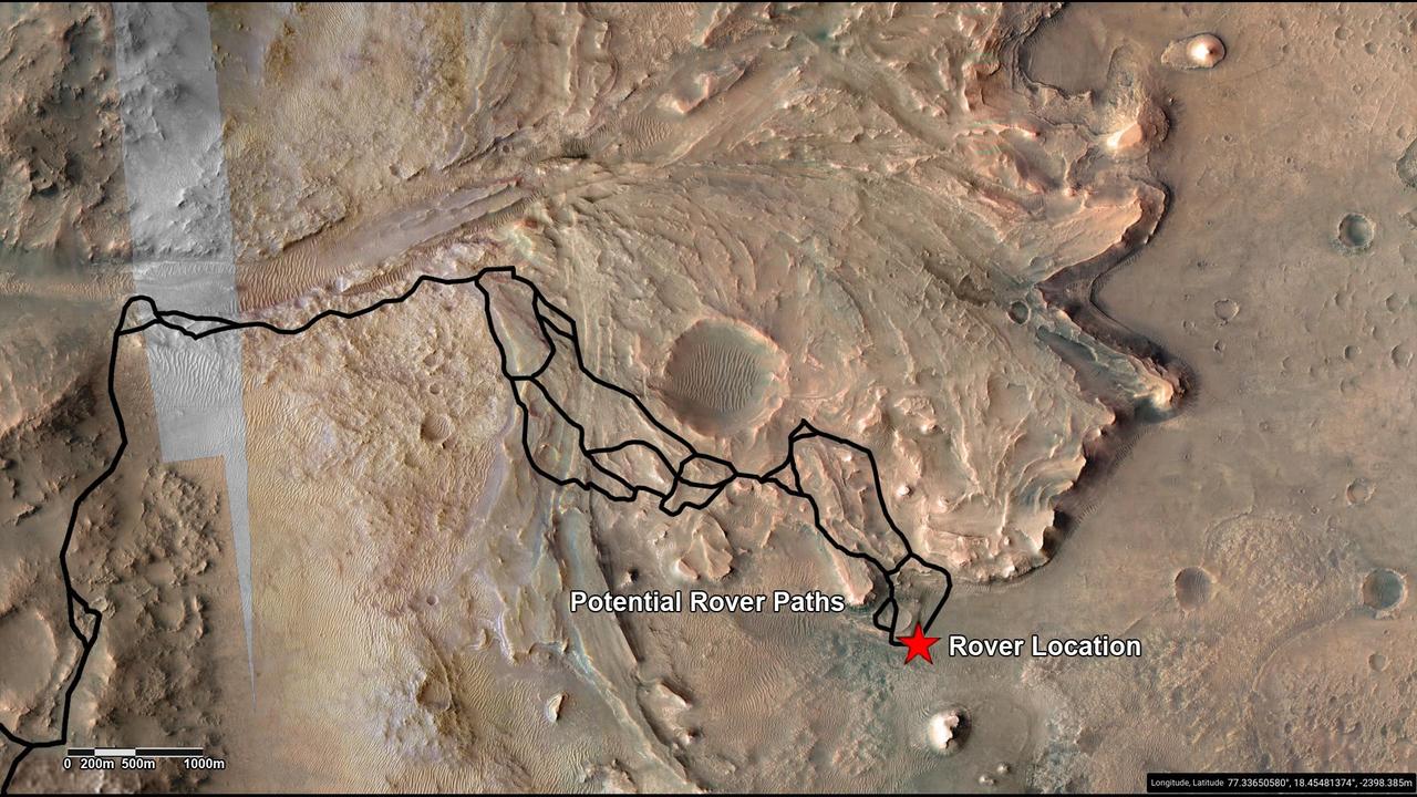
This annotated image highlights potential routes that NASA's Perseverance team is considering in September 2022 for the rover to drive from the front of an ancient river delta to the rim of Jezero Crater. The team will continue to investigate the Martian terrain and consider the science potential of these options before choosing the rover's route. The Perseverance team and the U.S. Geological Survey collaborated on the base map seen here, combining multiple images from the High Resolution Imaging Experiment (HiRISE) camera with color from the Compact Reconnaissance Imaging Spectrometer for Mars (CRISM), both instruments aboard NASA's Mars Reconnaissance Orbiter (MRO). The HiRISE images used span a period from 2007 to 2017. Perseverance landed on the floor of Jezero Crater on Feb. 18, 2021. The delta, which Perseverance reached in April 2022, is a fan-shaped area where an ancient river once flowed into an ancient lake and deposited rocks and sediment. A key objective for Perseverance's mission on Mars is astrobiology, including the search for signs of ancient microbial life. The rover will characterize the planet's geology and past climate, pave the way for human exploration of the Red Planet, and be the first mission to collect and cache Martian rock and regolith (broken rock and dust). Subsequent NASA missions, in cooperation with ESA (European Space Agency), would send spacecraft to Mars to collect these sealed samples from the surface and return them to Earth for in-depth analysis. The Mars 2020 Perseverance mission is part of NASA's Moon to Mars exploration approach, which includes Artemis missions to the Moon that will help prepare for human exploration of the Red Planet. https://photojournal.jpl.nasa.gov/catalog/PIA25244
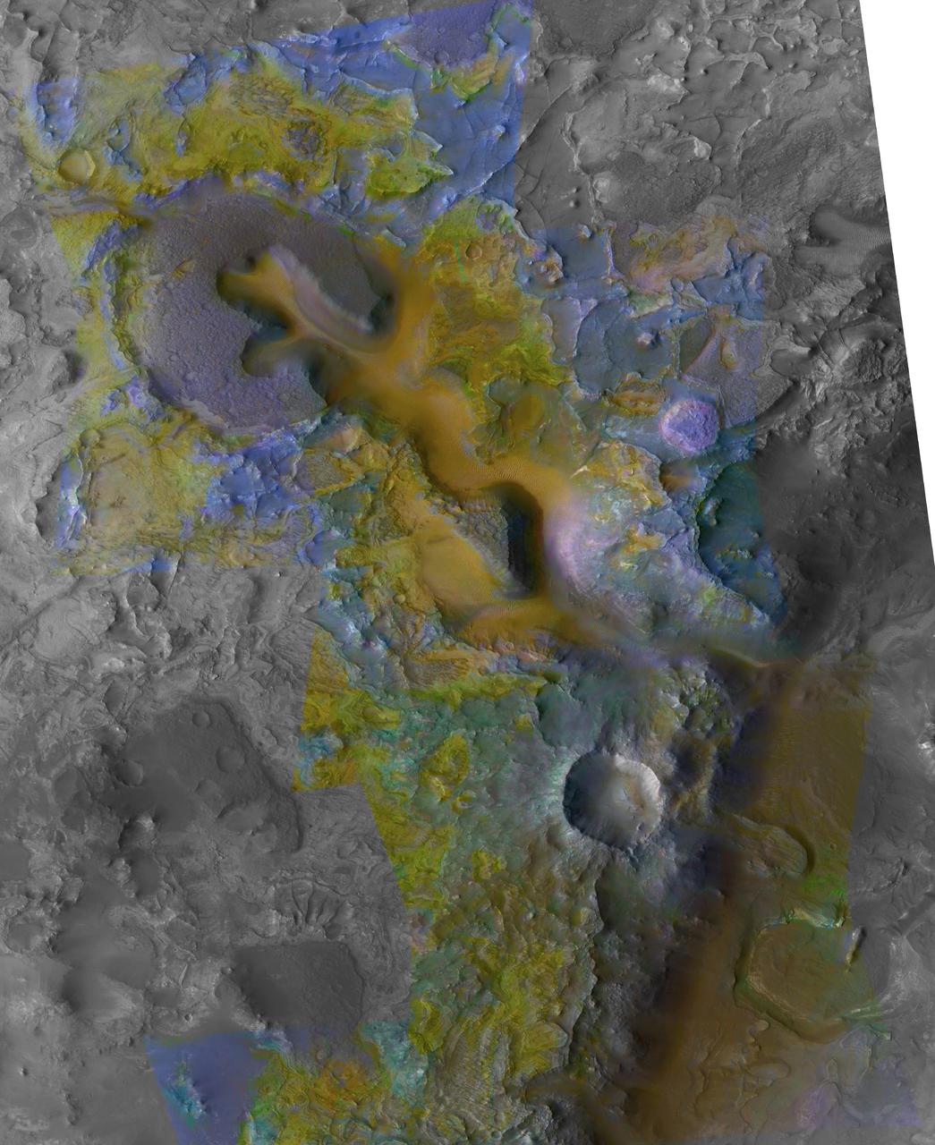
This view combines information from two instruments on NASA's Mars Reconnaissance Orbiter to map color-coded composition over the shape of the ground in a small portion of the Nili Fossae plains region of Mars' northern hemisphere. This site is part of the largest known carbonate-rich deposit on Mars. In the color coding used for this map, green indicates a carbonate-rich composition, brown indicates olivine-rich sands, and purple indicates basaltic composition. Carbon dioxide from the atmosphere on early Mars reacted with surface rocks to form carbonate, thinning the atmosphere by sequestering the carbon in the rocks. An analysis of the amount of carbon contained in Nili Fossae plains estimated the total at no more than twice the amount of carbon in the modern atmosphere of Mars, which is mostly carbon dioxide. That is much more than in all other known carbonate on Mars, but far short of enough to explain how Mars could have had a thick enough atmosphere to keep surface water from freezing during a period when rivers were cutting extensive valley networks on the Red Planet. Other possible explanations for the change from an era with rivers to dry modern Mars are being investigated. This image covers an area approximately 1.4 miles (2.3 kilometers) wide. A scale bar indicates 500 meters (1,640 feet). The full extent of the carbonate-containing deposit in the region is at least as large as Delaware and perhaps as large as Arizona. The color coding is from data acquired by the Compact Reconnaissance Imaging Spectrometer for Mars (CRISM), in observation FRT0000C968 made on Sept. 19, 2008. The base map showing land shapes is from the High Resolution Imaging Science Experiment (HiRISE) camera. It is one product from HiRISE observation ESP_010351_2020, made July 20, 2013. http://photojournal.jpl.nasa.gov/catalog/PIA19817
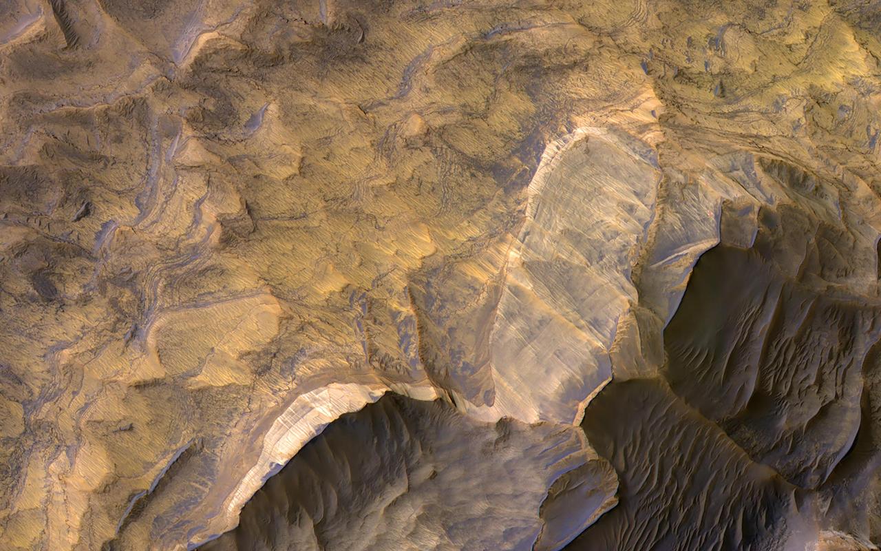
The layered sedimentary deposits inside the giant canyons of Mars have puzzled scientists for decades. These light toned deposits have fine, horizontal laminations that are unlike the rugged rim rock of the Valles Marineris as seen by NASA's Mars Reconnaisance Orbiter (MRO). Various ideas for the origin of the layered sediments have suggested lake deposits, wind blown dust and sand, or volcanic materials that erupted after the canyon was formed, and possibly filled with water. One particular layered deposit, called Ceti Mensa, attracted attention because its deep red color in images collected by the Viking Orbiter mission during the 1970s. Located in west Candor Chasma in the north of the Valles Marineris, Ceti Mensa is an undulating plateau that rises 3 kilometers above the canyon floor and is bounded by steep scarps up to 1.5 kilometers in height. Deep red hues are on the west-facing scarp in particular. The red tint may be due to the presence of crystalline ferric oxide, suggesting that the material may have been exposed to heat or water, or both. Spectral measurements by the Mars Express OMEGA and MRO CRISM instruments confirm the presence of hydrated sulfate salts, such as gypsum and kieserite . These minerals are important for two reasons. On Earth, they typically form in wet environments, suggesting that the deposits in Ceti Mensa may have formed under water. On Mars, these deposits could be valuable to future Martian colonists as fertilizer for growing crops. In a view of the colorful west-facing scarp of Ceti Mensa, we see the interior layers of the deposit, giving us a window into the past history of the sediments as they accumulated over time. We also see layers that were previously too small to view, and a surface that is thoroughly fractured, eroded into knobs, and partially covered by young dark sand dunes. https://photojournal.jpl.nasa.gov/catalog/PIA22051
Tithonium Chasma is a part of Valles Marineris, the largest canyon in the Solar System. If Valles Marineris was located on Earth, at more than 4,000 kilometers long and 200 kilometers wide, it would span across almost the entire United States. Tithonium Chasma is approximately 800 kilometers long. A "chasma," as defined by the International Astronomical Union, is an elongate, steep-sided depression. The walls of canyons often contain bedrock exposing numerous layers. In some regions, light-toned layered deposits erode faster than the darker-toned ones. The layered deposits in the canyons are of great interest to scientists, as these exposures may shed light on past water activity on Mars. The CRISM instrument on MRO indicates the presence of sulfates, hydrated sulfates, and iron oxides in Tithonium Chasma. Because sulfates generally form from water, the light-toned sulfate rich deposits in the canyons may contain traces of ancient life. The mid-section of this image is an excellent example of the numerous layered deposits, known as interior layered deposits. The exact nature of their formation is still unclear. However, some layered regions display parallelism between strata while other regions are more chaotic, possibly due to past tectonic activity. Lobe-shaped deposits are associated with depositional morphologies, considered indicative of possible periglacial activity. Overall, the morphological and lithological features we see today are the result of numerous geological processes, indicating that Mars experienced a diverse and more active geological past. http://photojournal.jpl.nasa.gov/catalog/PIA19868
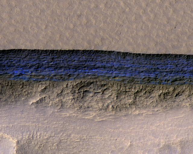
Click on the image for larger version A cross-section of a thick sheet of underground ice is exposed at the steep slope (or scarp) that appears bright blue in this enhanced-color view from the High Resolution Imaging Science Experiment (HiRISE) camera on NASA's Mars Reconnaissance Orbiter. The view covers an area about 550 yards (500 meters) wide. Figure 1 includes a 100-meter (109-yard) scale bar. North is toward the top. The upper third of the image shows level ground that is about 140 yards (130 meters) higher in elevation than the ground in the bottom third. In between, the scarp descends sharply, exposing about 260 vertical feet (80 vertical meters) of water ice. Color is exaggerated to make differences in surface materials easier to see. The presence of exposed water ice at this site was confirmed by observation with the same orbiter's Compact Reconnaissance Imaging Spectrometer for Mars (CRISM). In January 2018, in the journal Science, researchers reported finding and studying eight such ice-exposing scarps in the middle latitudes of Mars. The presence of vast underground ice deposits in Mars' middle latitudes was known previously. The report of unusual sites where they are exposed provides new information about their depth and layering. It also identifies potential water resources for future Mars missions and possibilities for studying Martian climate history by examining the ice layers holding a record of past climate cycles. The ice may have been deposited as snow when the tilt of Mars' rotation axis was greater than it is now. HiRISE observation ESP_022389_1230 was made on May 7, 2011, at 56.6 degrees south latitude, 114.1 degrees east longitude. https://photojournal.jpl.nasa.gov/catalog/PIA22077
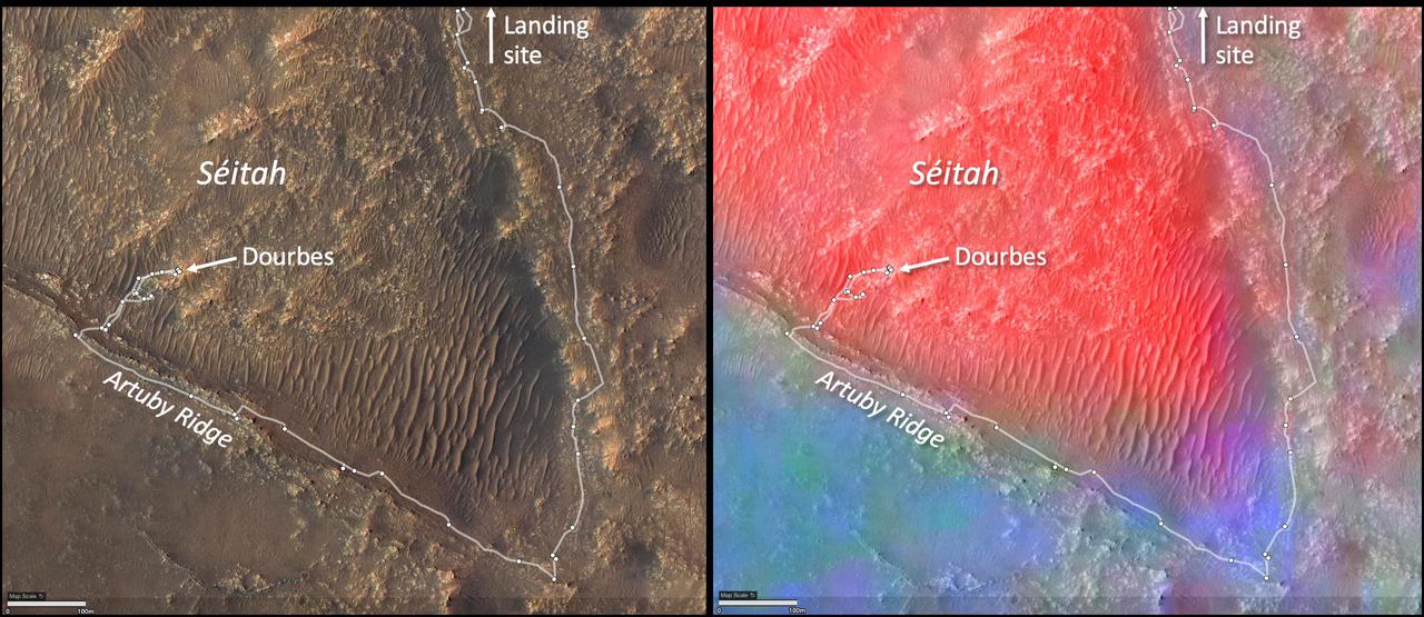
These annotated images show two views of the "Séítah" geologic unit of Mars' Jezero Crater. The map on the left shows terrain features of the crater with annotations depicting the rover's route during its first science campaign. "Artuby" is a ridgeline running along a portion of the southern boundary of Séítah. "Dourbes" is the name of an abrading target on a rock in South Séítah. The multi-hued map on the right shows the diversity of igneous (solidified from lava or magma) minerals in the same region. Olivine is shown in red. Calcium-poor pyroxene in green. Calcium-rich pyroxene is in blue. A key objective for Perseverance's mission on Mars is astrobiology, including the search for signs of ancient microbial life. The rover will characterize the planet's geology and past climate, pave the way for human exploration of the Red Planet, and be the first mission to collect and cache Martian rock and regolith (broken rock and dust). Subsequent NASA missions, in cooperation with ESA (European Space Agency), would send spacecraft to Mars to collect these sealed samples from the surface and return them to Earth for in-depth analysis. The Mars 2020 Perseverance mission is part of NASA's Moon to Mars exploration approach, which includes Artemis missions to the Moon that will help prepare for human exploration of the Red Planet. https://photojournal.jpl.nasa.gov/catalog/PIA25024