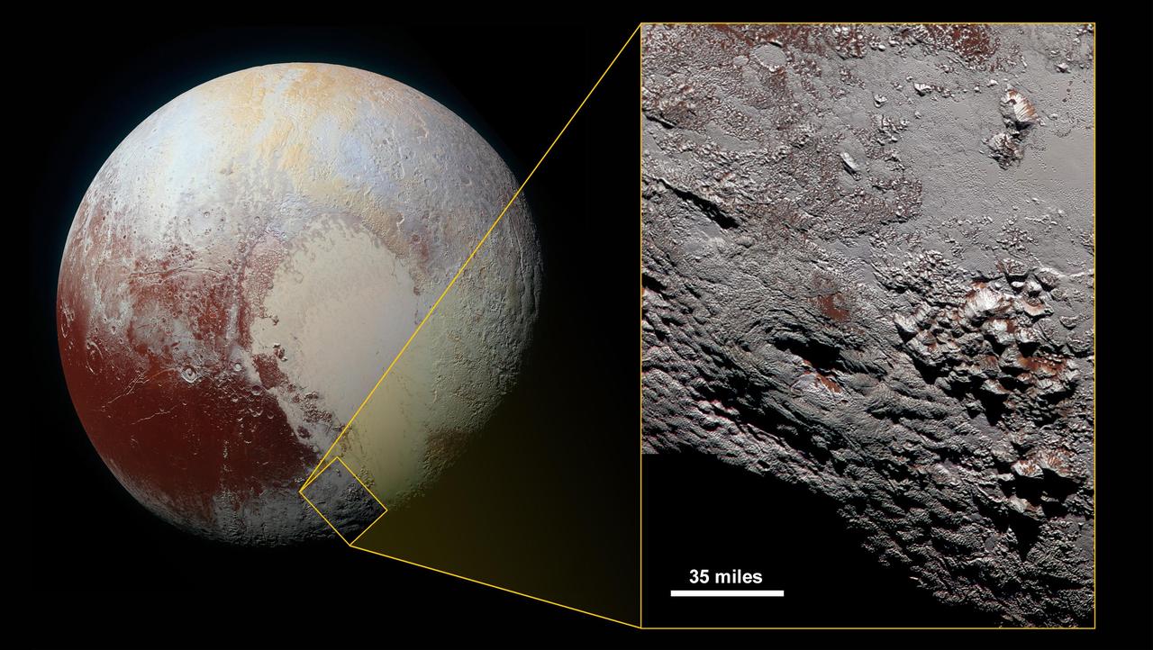
Scientists with NASA New Horizons mission have assembled the highest-resolution color view of one of two potential cryovolcanoes spotted on the surface of the distant planet by the passing New Horizons spacecraft in July 2015. At about 90 miles (150 kilometers) across and 2.5 miles (4 kilometers) high, the feature -- informally named Wright Mons -- is enormous. If it is in fact a volcano, as suspected, it would be the largest such feature discovered in the outer solar system. Mission scientists are intrigued by the sparse distribution of red material in the image and wonder why it is not more widespread. Also perplexing is that there is only one identified impact crater on Wright Mons itself, telling scientists that the surface (as well as some of the crust underneath) was created relatively recently. This is turn may indicate that Wright Mons was volcanically active late in Pluto's history. This composite image includes pictures taken by the New Horizons spacecraft's Long Range Reconnaissance Imager (LORRI) on July 14, 2015, from a range of about 30,000 miles (48,000 kilometers), showing features as small as 1,500 feet (450 meters) across. Sprinkled across the LORRI mosaic is enhanced color data from the Ralph/Multispectral Visible Imaging Camera (MVIC) gathered about 20 minutes after the LORRI snapshots were taken, from a range of 21,000 miles (34,000 kilometers) and at a resolution of about 2,100 feet (650 meters) per pixel. The entire scene is 140 miles (230 kilometers) across. http://photojournal.jpl.nasa.gov/catalog/PIA20361
This frame from a movie is based on data from NASA Cassini spacecraft and shows a flyover of an area of Saturn moon Titan known as Sotra Facula. Scientists believe Sotra is the best case for an ice volcano, or cryovolcano, region on Titan.
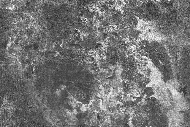
This radar image of Titan shows Ganesa Macula, interpreted as a cryovolcano ice volcano, and its surroundings. Cryovolcanism is thought to have been an important process on Titan and may still be happening today
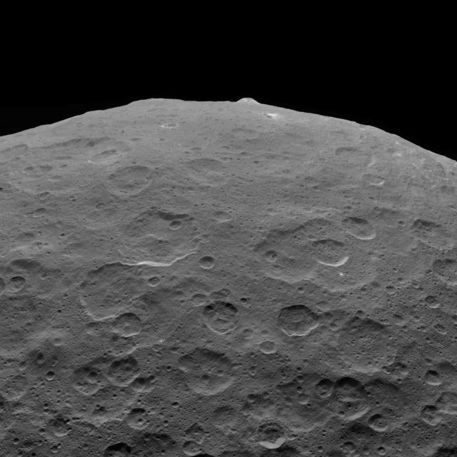
This photo of Ceres and one of its key landmarks, Ahuna Mons, was one of the last views Dawn transmitted before it depleted its remaining hydrazine and completed its mission. This view, which faces south, was captured on Sept. 1, 2018 at an altitude of 2,220 miles (3,570 kilometers) as the spacecraft was ascending in its elliptical orbit. At its lowest point, the orbit dipped down to only about 22 miles (35 kilometers), which allowed Dawn to acquire very high-resolution images in this final phase of its mission. Some of the close-up images of Ceres are shown here. Ahuna Mons is about 12 miles (20 kilometers) across and 2.5 miles (4 kilometers) high and displays sodium carbonate along its flanks. This is the most recent of a potential two dozen cryovolcanoes whose remnants are found across Ceres' surface. https://photojournal.jpl.nasa.gov/catalog/PIA22769
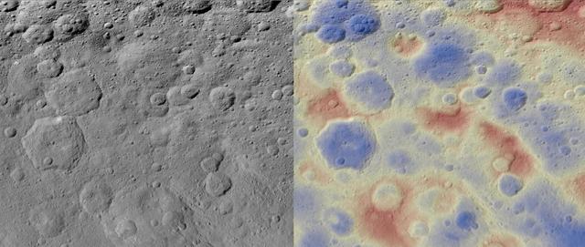
These images show a subtle feature on Ceres called Kwanzaa Tholus. Kwanzaa, meaning "first fruits" in Swahili, is an African-American festival based on ancient African harvest celebrations, and takes place from December 26 to January 1. A tholus is a type of small mountain. Kwanzaa Tholus measures about 22 by 12 miles (35 by 19 kilometers) and is elevated about 2 miles (3 km) above its surroundings. Because the mountain does not rise sharply above the ground, it is difficult to see in the mosaic on the left, although a small crescent-shaped shadow stands out. The image on the right, which is an elevation map of the area, shows where Kwanzaa Tholus is more prominently. The rounded shape of Kwanzaa Tholus is typical of tholi (plural of tholus) in general, but is different than other examples found on Ceres (like Dalien Tholus) and Mars. This region is particularly rich in this type of feature: The current Ceres map shows six named tholi and montes (slightly bigger mountains) in the region (centered around 32 degrees north, 327 degrees east) and several others including Ahuna Mons farther south. Scientists say Kwanzaa Tholus may have once been as prominent as Ahuna Mons, the tallest and most noticeable mountain on Ceres. Ahuna Mons is likely a cryovolcano, a volcano formed by the gradual accumulation of thick, slowly flowing icy materials. Because ice https://www.nasa.gov/feature/goddard/2016/ceres-cryo-volcano/is not strong enough to preserve an elevated structure for extended periods, cryovolcanoes on Ceres are expected to gradually collapse over tens of millions of years. This means Kwanzaa Tholus and other tholi in that area could be degraded mountains, which also formed from cryovolcanic activity. The mosaic on the left combines images taken by NASA's Dawn spacecraft in its high-altitude mapping orbit (HAMO) at about 915 miles (1,470 kilometers) above the surface. The spatial resolution is 450 feet (140 meters) per pixel. https://photojournal.jpl.nasa.gov/catalog/PIA21916
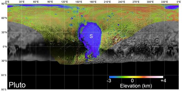
On July 14, 2015, NASA's New Horizons spacecraft made its historic flight through the Pluto system. This detailed, high-quality global mosaic of Pluto was assembled from nearly all of the highest-resolution images obtained by the Long-Range Reconnaissance Imager (LORRI) and the Multispectral Visible Imaging Camera (MVIC) on New Horizons. The mosaic is the most detailed and comprehensive global view yet of Pluto's surface using New Horizons data. It includes topography data of the hemisphere visible to New Horizons during the spacecraft's closest approach. The topography is derived from digital stereo-image mapping tools that measure the parallax -- or the difference in the apparent relative positions -- of features on the surface obtained at different viewing angles during the encounter. Scientists use these parallax displacements of high and low terrain to estimate landform heights. The global mosaic has been overlain with transparent, colorized topography data wherever on the surface stereo data is available. Terrain south of about 30°S was in darkness leading up to and during the flyby, so is shown in black. Examples of large-scale topographic features on Pluto include the vast expanse of very flat, low-elevation nitrogen ice plains of Sputnik Planitia ("P") -- note that all feature names in the Pluto system are informal -- and, on the eastern edge of the encounter hemisphere, the aligned, high-elevation ridges of Tartarus Dorsa ("T") that host the enigmatic bladed terrain, mountains, possible cryovolcanos, canyons, craters and more. https://photojournal.jpl.nasa.gov/catalog/PIA21861