Against the Current

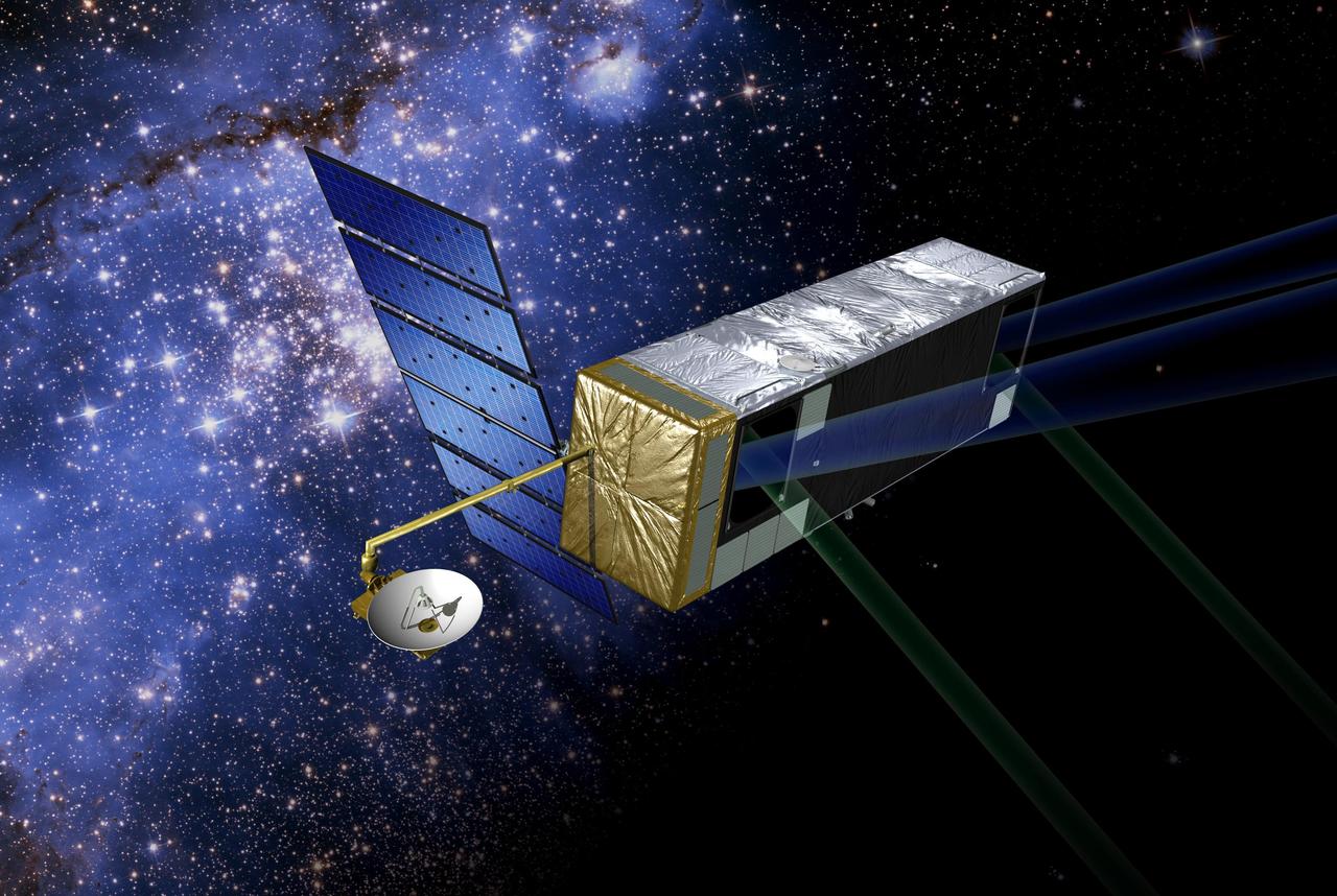
This February 8, 2016 composite image reveals the complex distribution of phytoplankton in one of Earth's eastern boundary upwelling systems — the California Current. Recent work suggests that our warming climate my be increasing the intensity of upwelling in such regions with possible repercussions for the species that comprise those ecosystems. NASA's OceanColor Web is supported by the Ocean Biology Processing Group (OBPG) at NASA's Goddard Space Flight Center. Our responsibilities include the collection, processing, calibration, validation, archive and distribution of ocean-related products from a large number of operational, satellite-based remote-sensing missions providing ocean color, sea surface temperature and sea surface salinity data to the international research community since 1996. Credit: NASA/Goddard/Suomin-NPP/VIIRS <b><a href="http://www.nasa.gov/audience/formedia/features/MP_Photo_Guidelines.html" rel="nofollow">NASA image use policy.</a></b> <b><a href="http://www.nasa.gov/centers/goddard/home/index.html" rel="nofollow">NASA Goddard Space Flight Center</a></b> enables NASA’s mission through four scientific endeavors: Earth Science, Heliophysics, Solar System Exploration, and Astrophysics. Goddard plays a leading role in NASA’s accomplishments by contributing compelling scientific knowledge to advance the Agency’s mission. <b>Follow us on <a href="http://twitter.com/NASAGoddardPix" rel="nofollow">Twitter</a></b> <b>Like us on <a href="http://www.facebook.com/pages/Greenbelt-MD/NASA-Goddard/395013845897?ref=tsd" rel="nofollow">Facebook</a></b> <b>Find us on <a href="http://instagrid.me/nasagoddard/?vm=grid" rel="nofollow">Instagram</a></b>
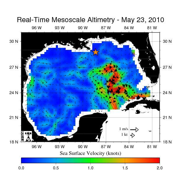
The northern portion of the Gulf of Mexico Loop Current, shown in red, appears about to detach a large ring of current, creating a separate eddy. An eddy is a large, warm, clockwise-spinning vortex of water -- the ocean version of a cyclone.
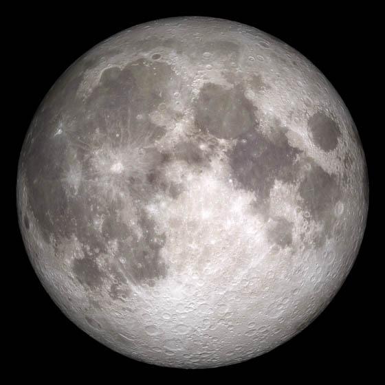
Current moon as viewed on Wednesday, June 15, 2011, 19:00 UT (Phase 100%) This marks the first time that accurate shadows at this level of detail are possible in such a computer simulation. The shadows are based on the global elevation map being developed from measurements by the Lunar Orbiter Laser Altimeter (LOLA) aboard the Lunar Reconnaissance Orbiter (LRO). LOLA has already taken more than 10 times as many elevation measurements as all previous missions combined. The Moon always keeps the same face to us, but not exactly the same face. Because of the tilt and shape of its orbit, we see the Moon from slightly different angles over the course of a month. When a month is compressed into 12 seconds, as it is in this animation, our changing view of the Moon makes it look like it's wobbling. This wobble is called libration. The word comes from the Latin for "balance scale" (as does the name of the zodiac constellation Libra) and refers to the way such a scale tips up and down on alternating sides. The sub-Earth point gives the amount of libration in longitude and latitude. The sub-Earth point is also the apparent center of the Moon's disk and the location on the Moon where the Earth is directly overhead. The Moon is subject to other motions as well. It appears to roll back and forth around the sub-Earth point. The roll angle is given by the position angle of the axis, which is the angle of the Moon's north pole relative to celestial north. The Moon also approaches and recedes from us, appearing to grow and shrink. The two extremes, called perigee (near) and apogee (far), differ by more than 10%. The most noticed monthly variation in the Moon's appearance is the cycle of phases, caused by the changing angle of the Sun as the Moon orbits the Earth. The cycle begins with the waxing (growing) crescent Moon visible in the west just after sunset. By first quarter, the Moon is high in the sky at sunset and sets around midnight. The full Moon rises at sunset and is high in the sky at midnight. The third quarter Moon is often surprisingly conspicuous in the daylit western sky long after sunrise. Celestial north is up in these images, corresponding to the view from the northern hemisphere. The descriptions of the print resolution stills also assume a northern hemisphere orientation. To adjust for southern hemisphere views, rotate the images 180 degrees, and substitute "north" for "south" in the descriptions. Credit: <a href="http://svs.gsfc.nasa.gov/index.html" rel="nofollow">NASA/Goddard Space Flight Center Scientific Visualization Studio</a> <b><a href="http://www.nasa.gov/centers/goddard/home/index.html" rel="nofollow">NASA Goddard Space Flight Center</a></b> enables NASA’s mission through four scientific endeavors: Earth Science, Heliophysics, Solar System Exploration, and Astrophysics. Goddard plays a leading role in NASA’s accomplishments by contributing compelling scientific knowledge to advance the Agency’s mission. <b>Follow us on <a href="http://twitter.com/NASA_GoddardPix" rel="nofollow">Twitter</a></b> <b>Join us on <a href="http://www.facebook.com/pages/Greenbelt-MD/NASA-Goddard/395013845897?ref=tsd" rel="nofollow">Facebook</a></b> <b>Find us on <a href="http://web.stagram.com/n/nasagoddard/?vm=grid" rel="nofollow">Instagram</a></b>
SL4-137-3632 (February 1974) --- A photograph taken from the Skylab space station in Earth orbit illustrating an atmospheric wave pattern by the affect of a small mountainous island on wind currents. Various patterns can be seen downwind of small islands. Often a Von Karmon vortex can be seen which appears as a spiral pattern. Multiple vortices have been photographed on previous missions. This photograph illustrates a "bow wave" pattern which extends for hundreds of miles downwind from the island. The island itself is often clear when a wave pattern is formed downstream. This particular pattern is very symmetrical. These wave patterns are most common in the South Pacific. This picture was taken by a Skylab 4 crewmen using a hand-held 70mm Hasselblad camera. Photo credit: NASA

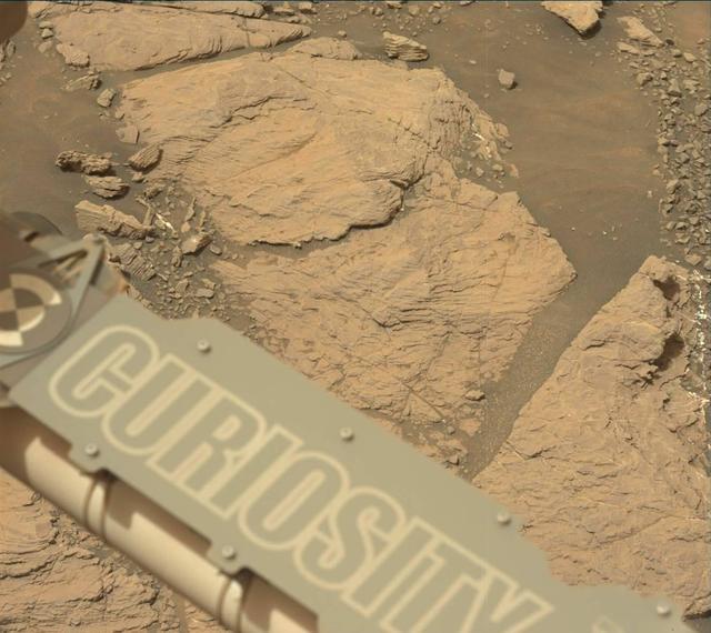
Cross-bedding seen in the layers of this Martian rock is evidence of movement of water recorded by the waves or ripples of loose sediment the water passed over, such as a current in a lake. This image is from NASA Curiosity Mars rover.
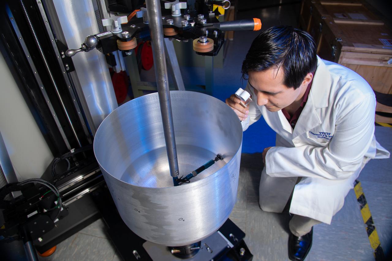
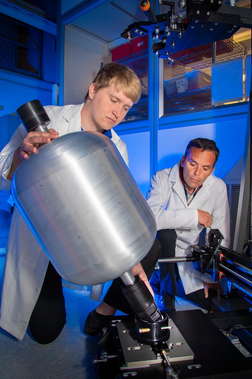
Edgar Reyes, a materials engineer and recent graduate of The University of Texas at El Paso, visually inspects a crack identified on the outer surface of a composite overwrapped pressure vessel (COPV) following an internal eddy-current through-wall nondestructive inspection conducted at the NASA White Sands Test Facility in Las Cruces, N.M. Eddy-current testing is one of many electromagnetic testing methods used in nondestructive testing to identify cracks in COPVS that can potentially threaten spacecraft crew and mission success. Photo Credit: (NASA/Reed P. Elliott)
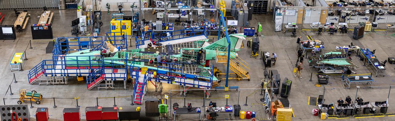
This overhead view of the X-59 shows the aircraft’s current state of assembly at Lockheed Martin Skunk Works in Palmdale, California. Throughout the manufacturing process, the team often removes components to effectively and safely assemble other sections of the aircraft. The X-59’s horizontal tails and lower empennage were recently removed from the aircraft and can be seen behind it as the team prepares for the installation of the engine. The X-59 is the centerpiece of the Quesst mission which plans to help enable commercial supersonic air travel over land.
SL4-137-3721 (February 1974) --- Plankton blooms and color variations in the Falkland Current east of the Argentina coast in the South Atlantic Ocean as seen from the Skylab space station in Earth orbit. This picture was taken by one of the Skylab 4 crewmen using a hand-held 70mm Hasselblad camera. The Skylab 4 crew made many observations of the Falkland Current and related phenomena. This current flows north and northeastward along the Argentine coast near 40 degree south latitude where it meets the Brazil Current and the two swing eastward. The study of such photographs as this one can add significantly to our knowledge and understanding of the oceans. Photo credit: NASA
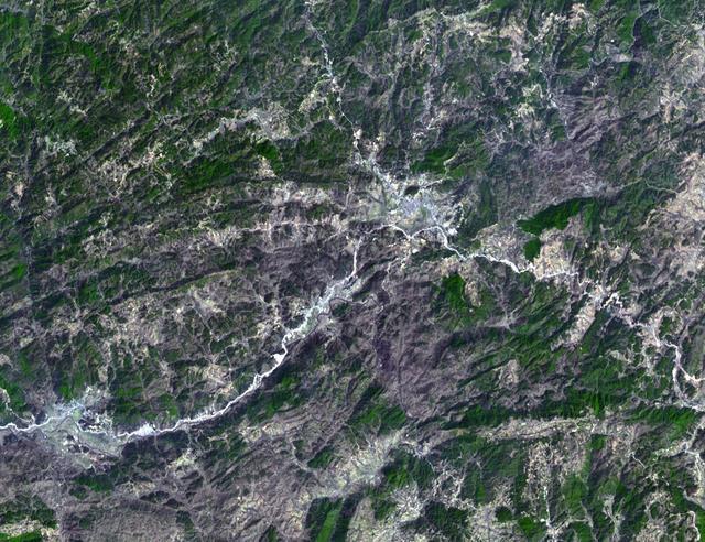
The northeast coast of Hokkaido and Kunashir Island, Japan (44.0N, 143.0E) are seen bordered by drifting sea ice. The sea ice has formed a complex pattern of eddies in response to surface water currents and winds. Photos of this kind aid researchers in describing local ocean current patterns and the effects of wind speed and direction on the drift of surface material, such as ice floes or oil. Kunashir is the southernmost of the Kuril Islands.
SL4-137-3655 (16 Dec. 1973) --- An island wake produced by the Antipodes Islands in the ocean current south of New Zealand is seen in this photograph taken from the Skylab space station in Earth orbit. A Skylab 4 crewmen took the picture with a hand-held 70mm Hasselblad camera. The bow wave pattern is quite evident and can be used to determine the current speed from the angle of the bow wave if the propagation speed of the surface wave is known. Also, evident is the darker band extending downstream from the island tens of miles. This is the actual wake of the island. The existence of water color differences from within to outside a turbulent island wake may indicate a temperature difference, with cooler water being stirred to the surface in the wake. This temperature difference could be used to drive a thermo-electric type generator to reduce small islands' dependence on imported oil for power generation. Photo credit: NASA
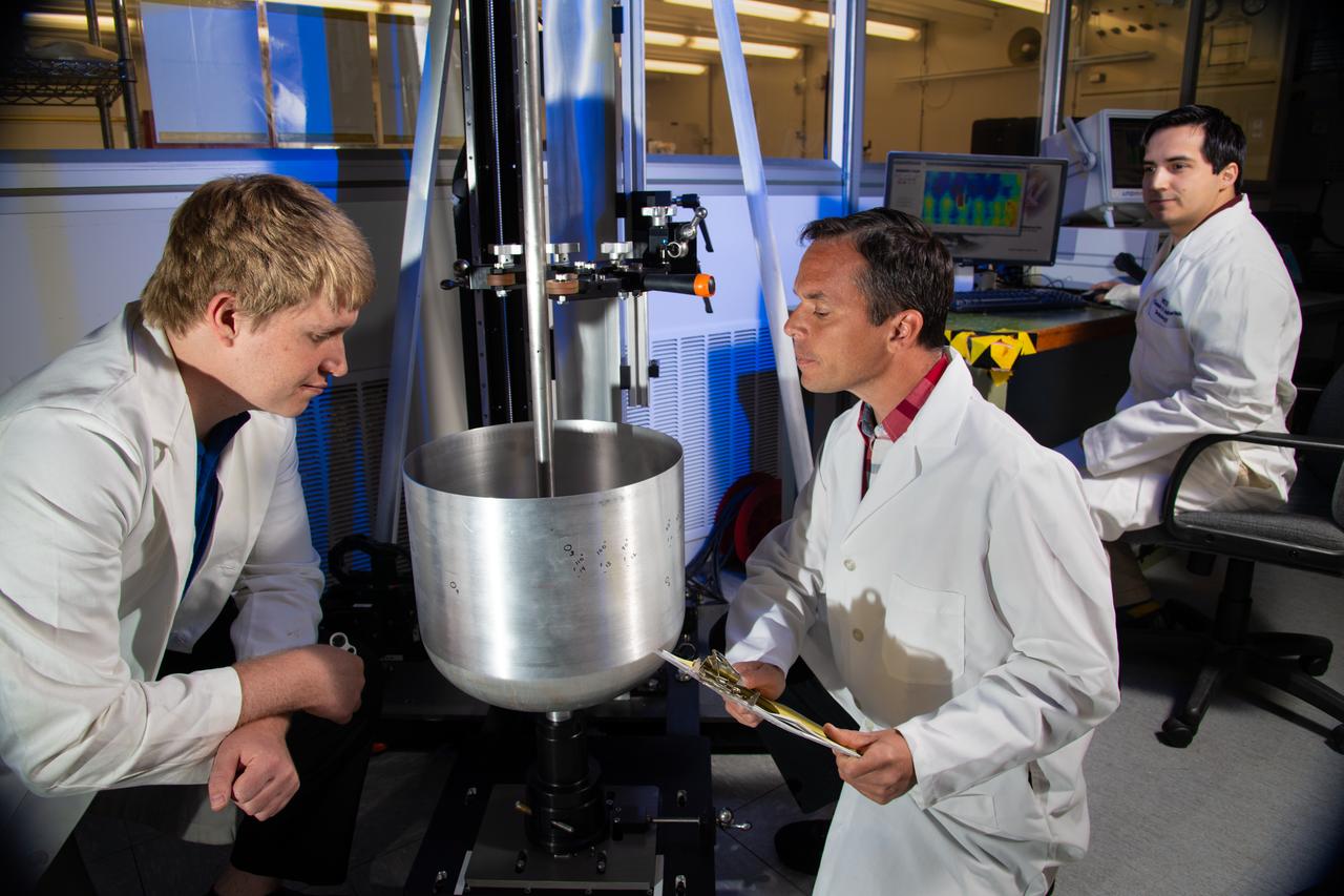
Engineers (from left) Ayrton Jordan, Anthony Milana and Edgar Reyes from the NASA White Sands Test Facility (WSTF) in Las Cruces, N.M. qualify an interior surface pressure vessel crack inspection using the eddy current nondestructive testing technique to find flaws smaller than more common and less capable penetrant testing methods. Detecting cracks smaller than the eye can detect is an important feature as manufacturers push performance limits to achieve lighter, more efficient spacecraft. Photo Credit: (NASA/Reed P. Elliott)
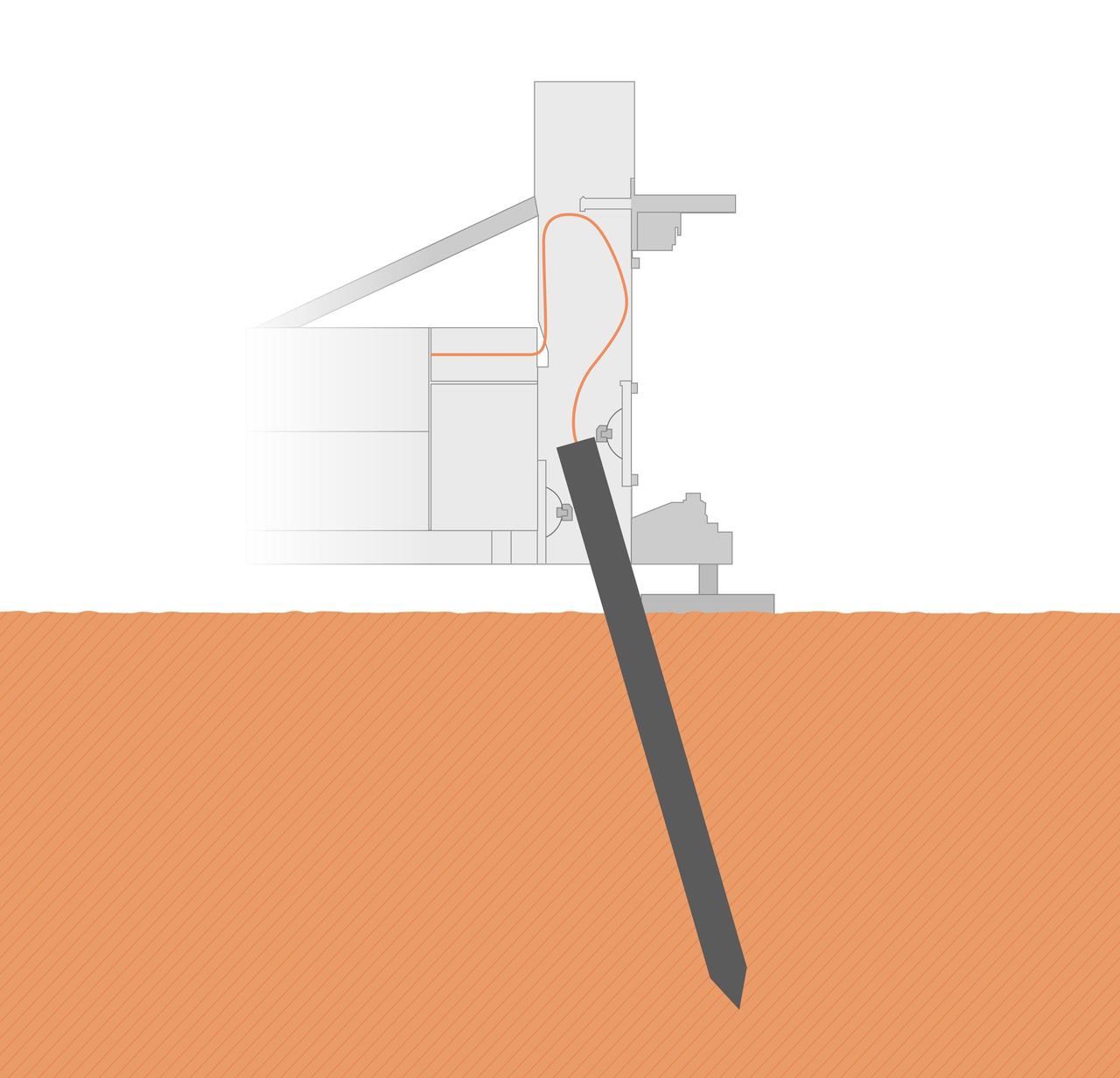
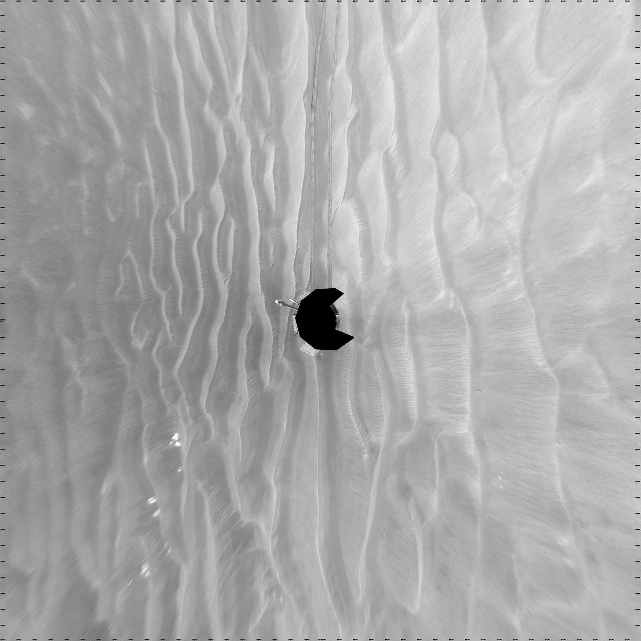
The self-hammering "mole," part of the Heat Flow and Physical Properties Package (HP3) on NASA's InSight lander, was only partially buried in the soil of Mars as of early June 2019, as shown in this illustration. Engineering analysis has determined that the bottom of the mole is currently about 12-14 inches (30-35 centimeters) deep into Martian ground, with a bit of its top still inside the HP3 support structure. The mole is tilted about 19 degrees. https://photojournal.jpl.nasa.gov/catalog/PIA23274

STS054-72-056 (13-19 Jan 1993) --- A ship wake in the Bay of Bengal is noticeable in this 70mm frame. The sun glint pattern on the ocean reveals many patterns of sea surface roughness related to currents, waves, wind roughening, and biology that and are not apparent when the ocean is viewed away from the Sun's reflection. In this view of the Bay of Bengal, southeast of Madras, India, sun glint highlights convergence zones between ocean currents (bright, linear features), a eddy, and the wake of a ship. In several locations where the ship has passed areas of current shear, the ship wake is distorted, indicating the relative current direction.

This large tabular iceberg, broken off from the Antarctic Ice Sheet, was spotted in the South Atlantic Ocean (57.0S, 57.0W) southeast of the tip of South America as it was slowly being moved north and east by wind, current and tidal influences. This type of iceberg, never to be seen in the northern hemisphere, is typical for Antarctica. Although some such icebergs are as large as 100 km in length, this one measures about 35 by 69 km.
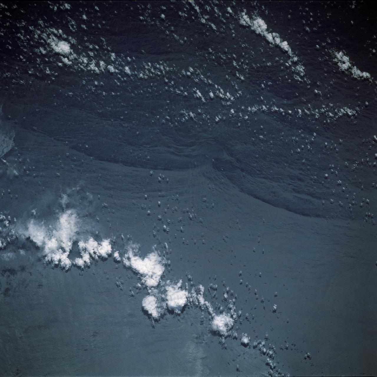
SL4-137-3608 (14 Dec. 1973) --- A view of cold water eddies in the Falkland Current off the South Atlantic coast of southern Argentina as seen from the Skylab space station in Earth orbit. This picture was taken by one of the Skylab 4 crewmen using a hand-held 70mm Hasselblad camera. This land area (left corner) extends south along the coast from Puerto Deseado (center left border) for about 50 miles. Within the ocean, several light blue areas are visible and represent the occurrence of plankton with the Falkland Current. Over the ocean, the cold water eddies are identified by the circular cloud-free areas within the cloud street pattern and bordered by cumulus cloud buildup (white). The cloud streets indicate the wind is from the southwest and do not form over eddies because energy form the atmosphere is absorbed by the cold ocean water. On the downwind side of the eddies, cumulus clouds tend to form as the cold moist air flows over the warmer water. Similar cloud and eddy features have been observed by the Skylab 4 crewmen in the Yucatan Current off Yucatan Peninsula and in some parts of the South Pacific. Studies are underway by Dr. George Maul, NOAA, and Dr. Robert Stevenson, ONR, to determine the significance of the cold water eddies to ocean dynamics. Photo credit: NASA
Artist's concept of the current mission configuration. SIM PlanetQuest (formerly called Space Interferometry Mission), currently under development, will determine the positions and distances of stars several hundred times more accurately than any previous program. This accuracy will allow SIM to determine the distances to stars throughout the galaxy and to probe nearby stars for Earth-sized planets. SIM will open a window to a new world of discoveries. http://photojournal.jpl.nasa.gov/catalog/PIA04248
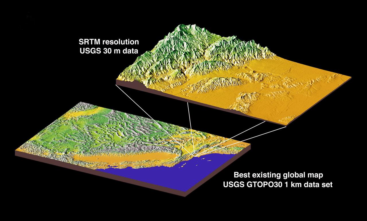
JSC2000E01552 (January 2000) --- This chart compares currently available global map data with the data which will be provided by SRTM during STS-99. The area depicted is the California coast. The SRTM mission will have approximately 1,000 scheduled data takes (every time Endeavour is over land). Data acquisition will be conducted in excess of 80 hours. The recording rate for data will be 180 Mbits/sec for C-band, 90 Mbits/sec for X-band. Total raw radar data will be approximately 9.8 terabytes (15,000 CDs). The mission will utilize some 300 high-density tapes (each tape records 30 min. of C-band, or 60 min. of X-band data).
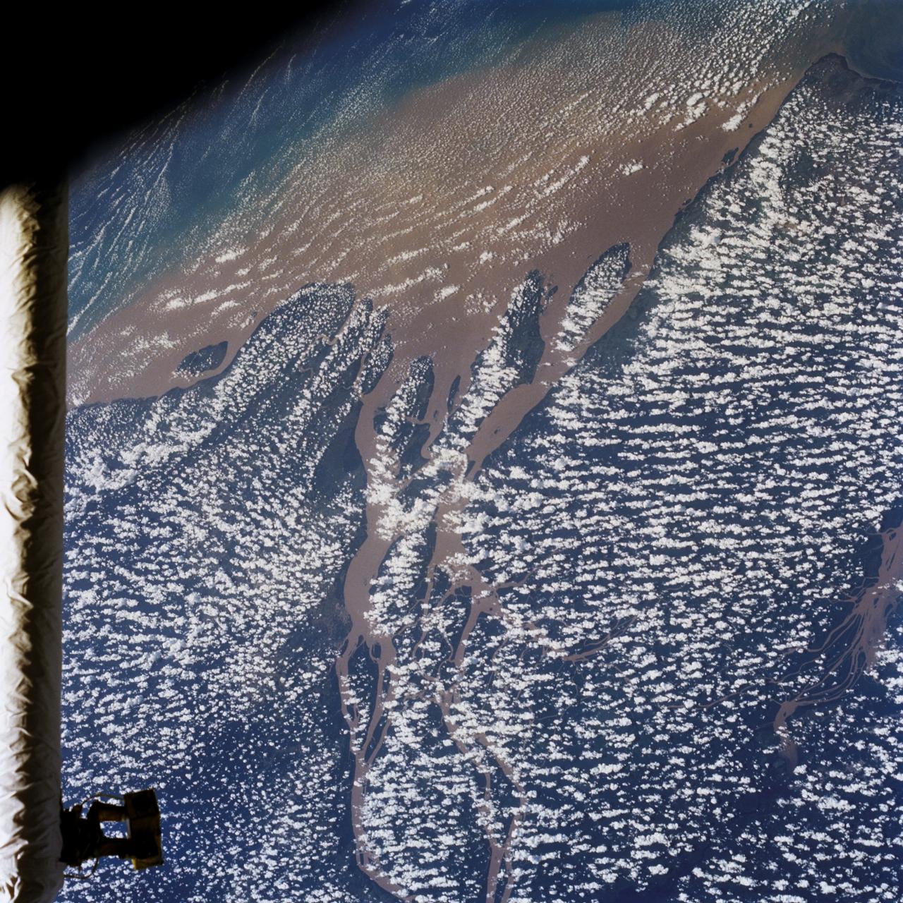
STS046-80-009 (31 July-8 Aug. 1992) --- A view of the mouth of the Amazon River and the Amazon Delta shows a large sediment plume expanding outward into the Atlantic Ocean. The sediment plume can be seen hugging the coast north of the Delta. This is caused by the west-northwest flowing Guyana Current. The large island of Marajo is partially visible through the clouds.
Engineers Ayrton Jordan (left) and Anthony Milana (right) at the NASA White Sands Test Facility (WSTF) in Las Cruces, N.M. install a metallic liner into the multipurpose pressure vessel scanner that could one day become part of a composite overwrapped pressure vessel. A slotted ball joint at the base of the rotary stage allows the tank to pivot resulting in helical scans that are more reliable when measuring interior and exterior 3D surface profiles. Photo Credit: (NASA/Reed P. Elliott)
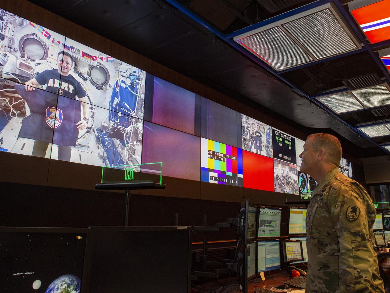
Army Lt. Gen. James Dickinson, right, commanding general of the U.S. Army Space and Missile Defense Command, speaks with NASA astronaut and current International Space Station crew member Andrew Morgan, an Army colonel, during an Oct. 8 downlink to the Payload Operations Integration Center at NASA’s Marshall Space Flight Center.
JSC2007-E-23730 (May 2007) --- Computer-generated artist's rendering of the International Space Station following scheduled activities of May 15, 2007. This angle shows the port side of the orbiting complex. Progress 25 resupply vehicle docks to the Zvezda Service Module aft port. Soyuz 14 (TMA-10) remains docked to the Zarya Module nadir port and Progress 24 resupply vehicle remains linked to the Pirs Docking Compartment.
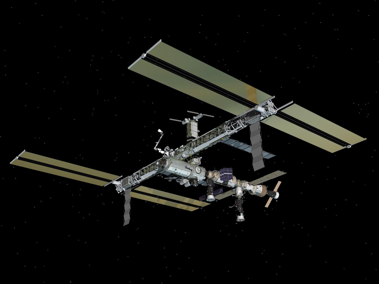
JSC2007-E-47328 (September 2007) --- Computer-generated artist's rendering of the International Space Station as of Sept. 27, 2007. This angle shows the port side of the orbiting complex. Soyuz 14 (TMA-10) undocks from the Zarya nadir port and relocates to the Zvezda Service Module aft port. Progress 26 resupply vehicle remains docked to the Pirs Docking Compartment.

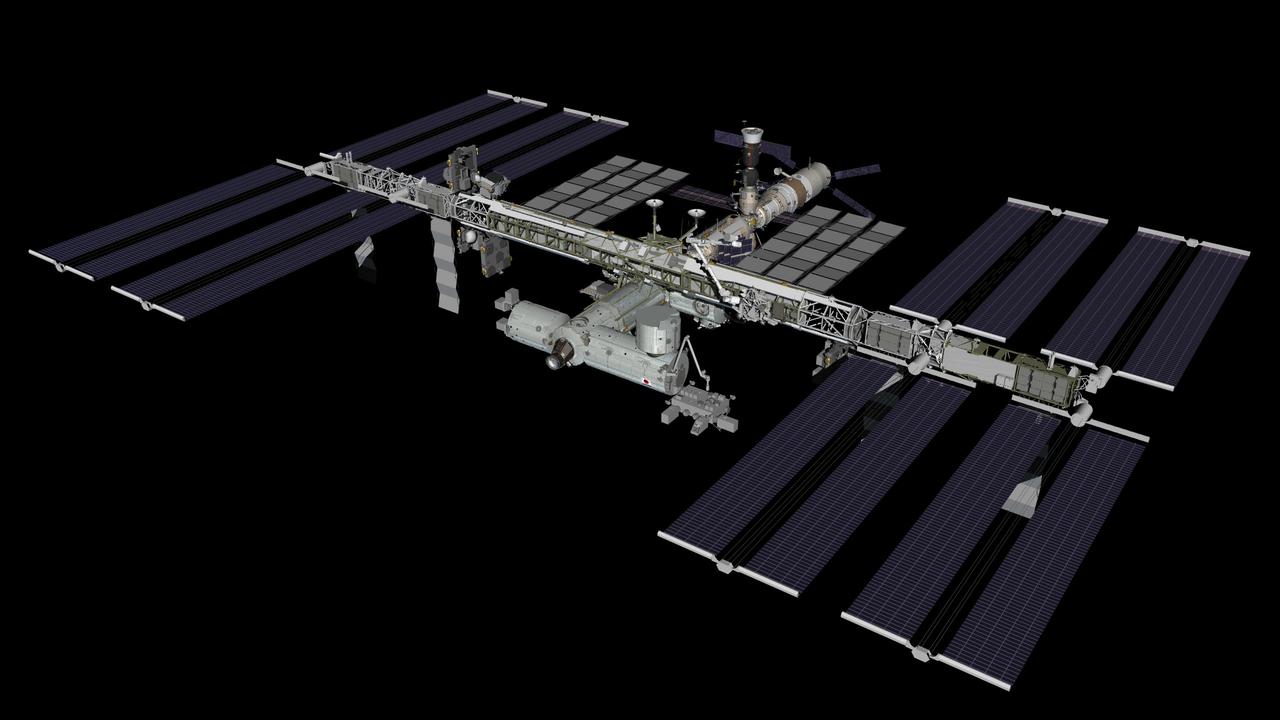
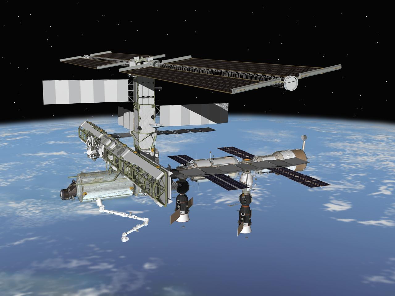
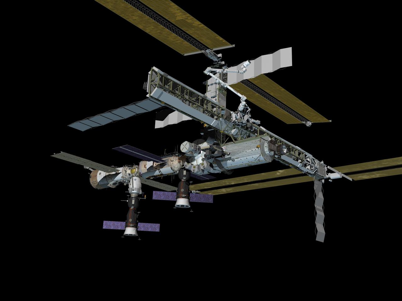
JSC2011-E-016181 (February 2011) --- Computer-generated artist?s rendering of the International Space Station as of Feb. 18, 2011. The Japanese Kounotori2 H-II Transfer Vehicle (HTV2) relocates to the Harmony node?s zenith port in preparation for the arrival of STS-133. Progress 41 resupply vehicle is docked to the Pirs Docking Compartment. Soyuz 25 (TMA-20) is docked to the Rassvet Mini-Research Module 1 (MRM1). Progress 39 resupply vehicle remains docked to the Zvezda Service Module?s aft port and Soyuz 24 (TMA-01M) is linked to the Poisk Mini-Research Module 2 (MRM2). Photo credit: NASA or National Aeronautics and Space Administration
JSC2007-E-47329 (September 2007) --- Computer-generated artist's rendering of the International Space Station as of Sept. 28, 2007. Zarya module's arrays are retracted to allow room for the future deployment of the thermal control system radiators. Soyuz 14 (TMA-10) is docked to the Zvezda Service Module aft port and Progress 26 resupply vehicle remains docked to the Pirs Docking Compartment.
JSC2007-E-51287 (October 2007) --- Computer-generated artist's rendering of the International Space Station as of Oct. 12, 2007. This angle shows the port side of the orbiting complex. Soyuz 15 (TMA-11) docks to the Zarya nadir port -- transporting the Expedition 16 crew and spaceflight participant to the station. Progress 26 resupply vehicle is linked to the Pirs Docking Compartment and Soyuz 14 (TMA-10) remains docked to the Zvezda Service Module aft port.
JSC2011-E-016183 (February 2011) --- Computer-generated artist?s rendering of the International Space Station as of Feb. 23, 2011. The European Space Agency's ?Johannes Kepler? Automated Transfer Vehicle-2 (ATV2) docks to the Zvezda Service Module?s aft port. Progress 41 resupply vehicle is docked to the Pirs Docking Compartment. Soyuz 25 (TMA-20) remains docked to the Rassvet Mini-Research Module 1 (MRM1). Soyuz 24 (TMA-01M) is linked to the Poisk Mini-Research Module 2 (MRM2) and the Japanese Kounotori2 H-II Transfer Vehicle (HTV2) is attached to the Harmony node?s zenith port. Photo credit: NASA or National Aeronautics and Space Administration
JSC2005-E-28435 (July 2005) --- Computer-generated artist's rendering of the International Space Station following scheduled activities of July 19, 2005. This angle shows the port side of the orbiting complex. Soyuz 10 moves from Pirs Docking Compartment to nadir port of the Zarya Module. The Progress 18 resupply vehicle remains docked to the aft end of the Zvezda Service Module.
JSC2005-E-28436 (July 2005) --- Computer-generated artist's rendering of the International Space Station following scheduled activities of July 19, 2005. This angle shows the starboard side of the orbiting complex. Soyuz 10 moves from Pirs Docking Compartment to nadir port of the Zarya Module. The Progress 18 resupply vehicle remains docked to the aft end of the Zvezda Service Module.
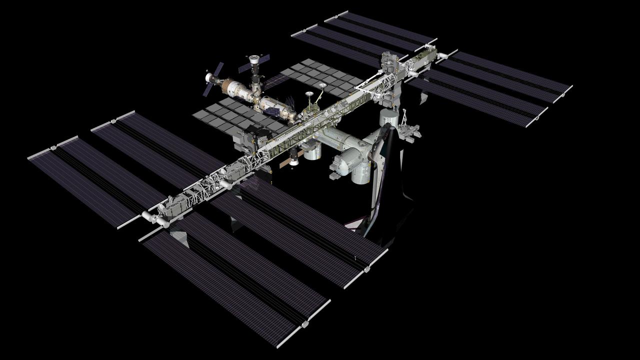
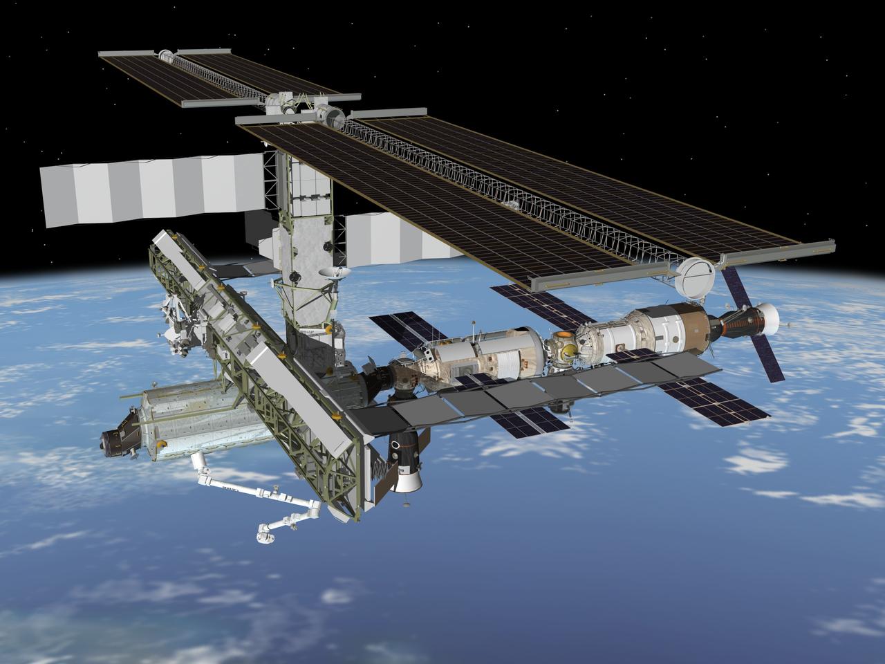
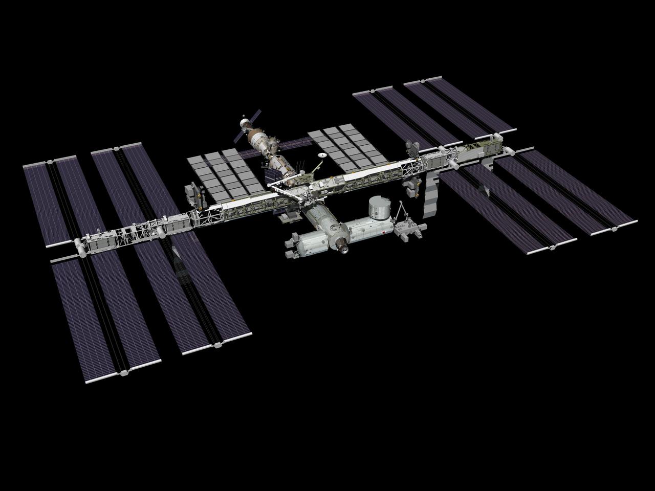
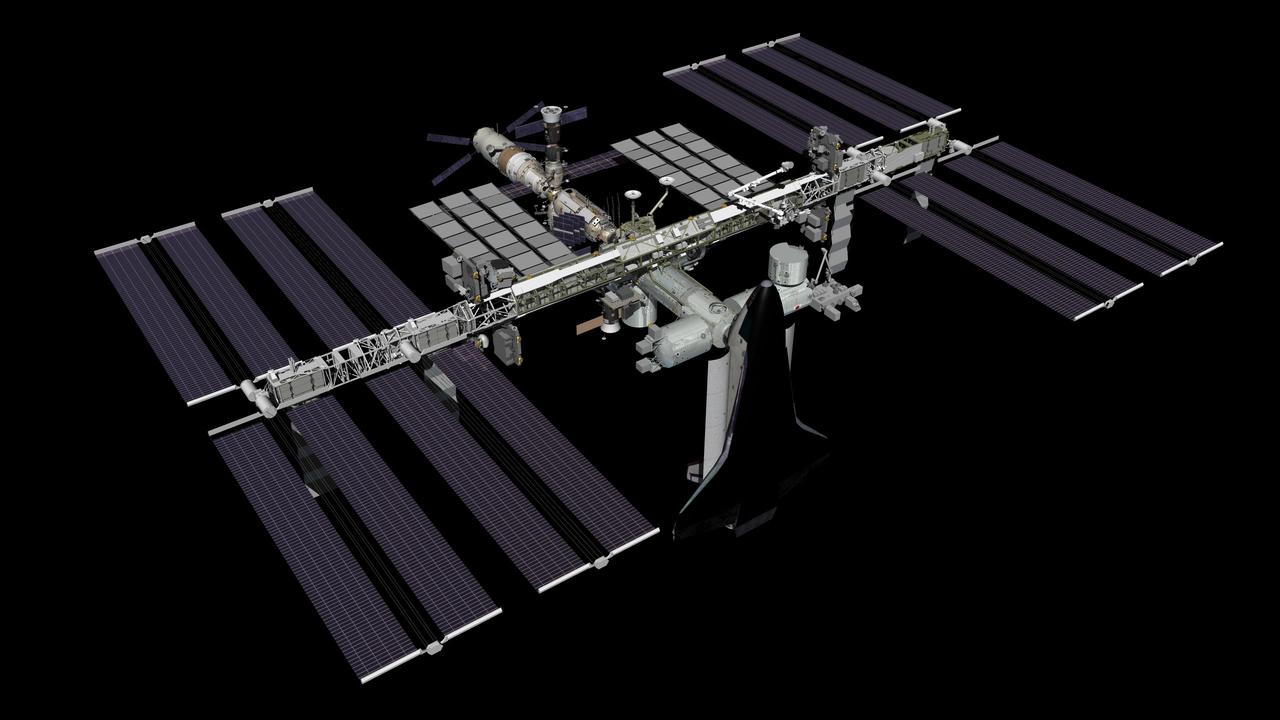
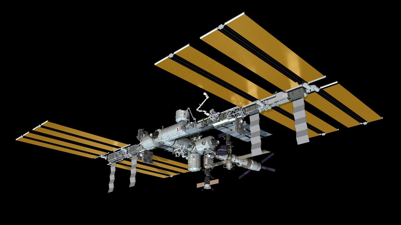
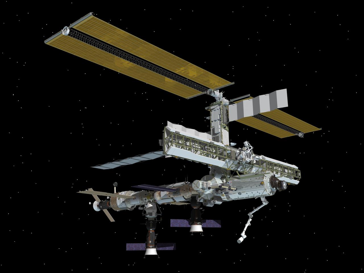
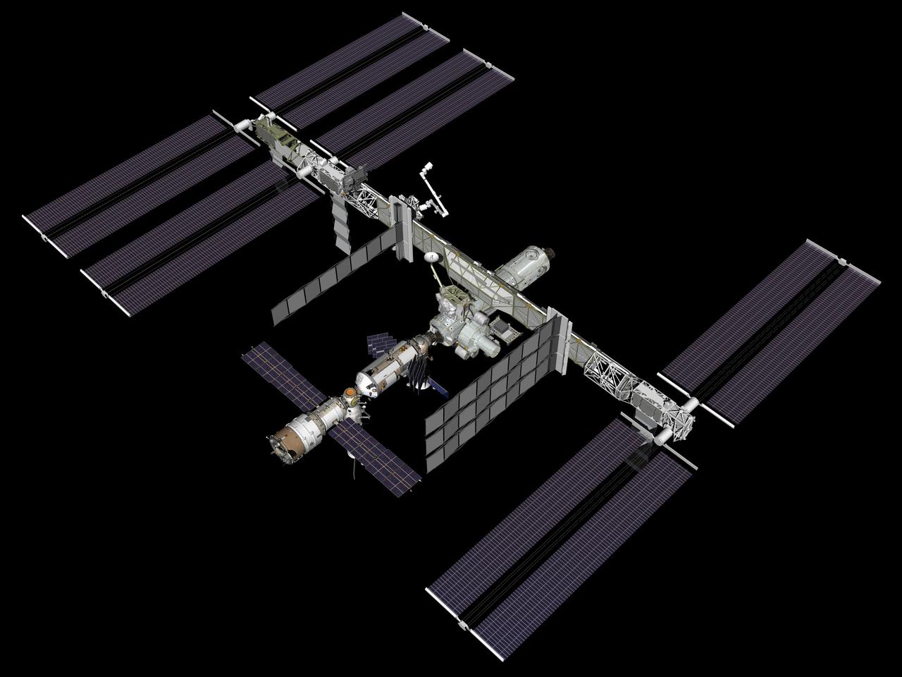
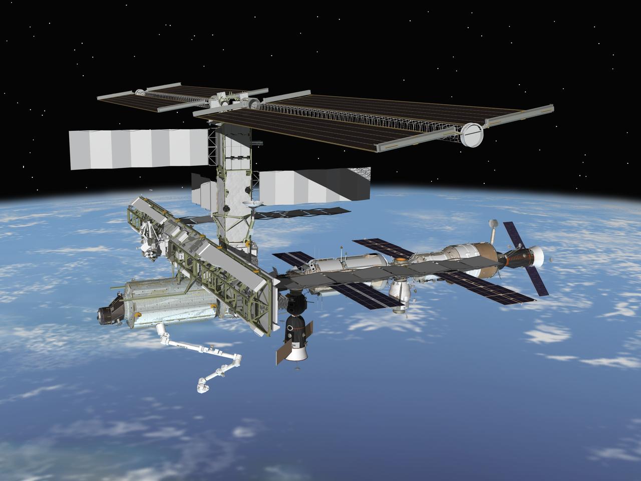
JSC2011-E-061555 (July 2011) --- Computer-generated artist?s rendering of the International Space Station as of July 10, 2011. STS-135 space shuttle Atlantis docks to the space station, bringing supplies on the Raffaello multi-purpose logistics module (MPLM). Progress 43 is linked to the aft port of the Zvezda Service Module. Soyuz 27 (TMA-02M) is docked to the Rassvet Mini-Research Module 1 (MRM1). Progress 42 is attached to the Pirs Docking Compartment and Soyuz 26 (TMA-21) is docked to the Poisk Mini-Research Module 2 (MRM2). Photo credit: NASA
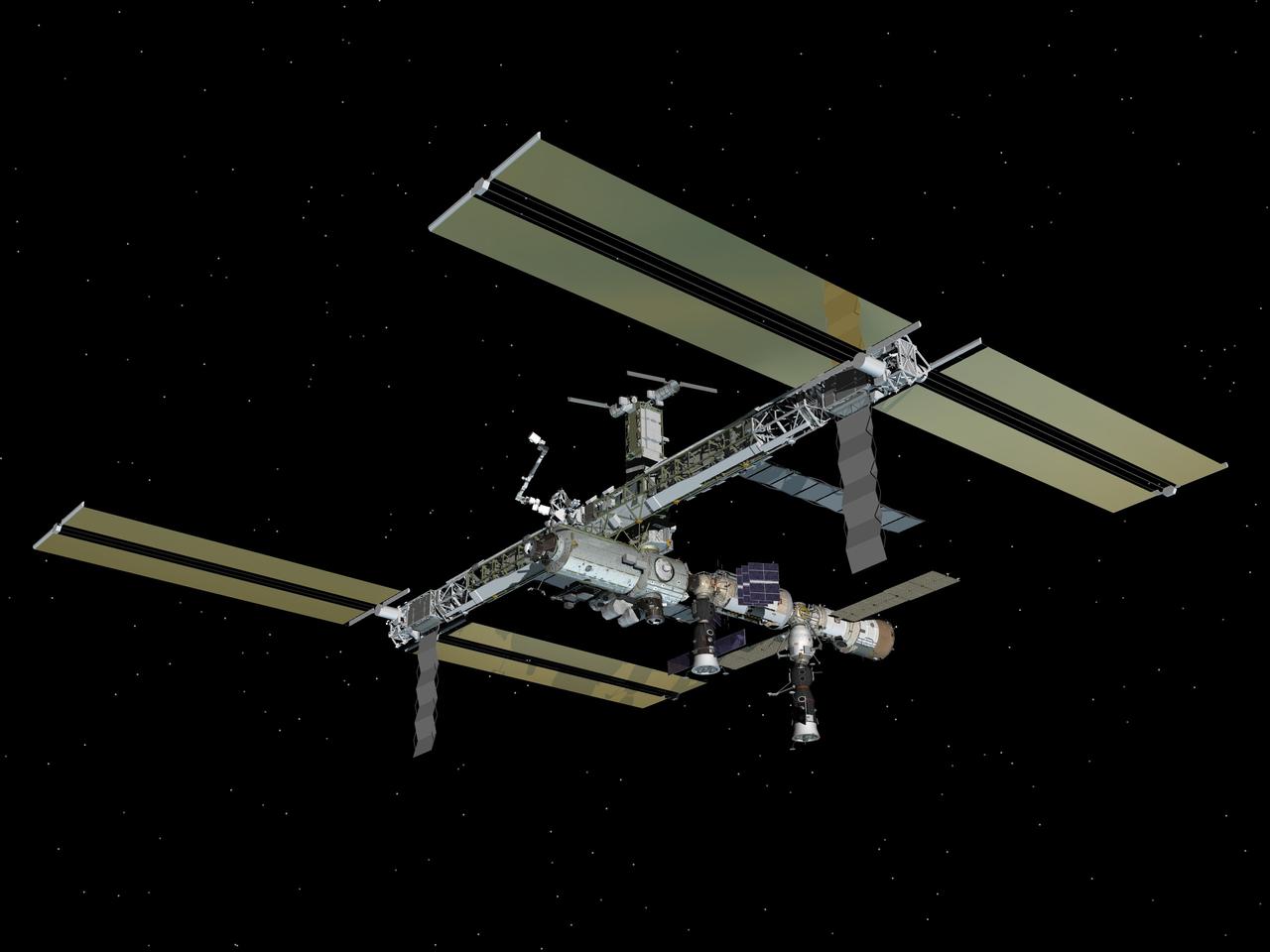
JSC2007-E-51288 (October 2007) --- Computer-generated artist's rendering of the International Space Station as of Oct. 21, 2007. This angle shows the port side of the orbiting complex. Soyuz 14 (TMA-10) undocks from the Zvezda Service Module aft port -- returning the Expedition 15 crew and spaceflight participant. Soyuz 15 (TMA-11) is docked to the Zarya nadir port and Progress 26 resupply vehicle remains docked to the Pirs Docking Compartment.
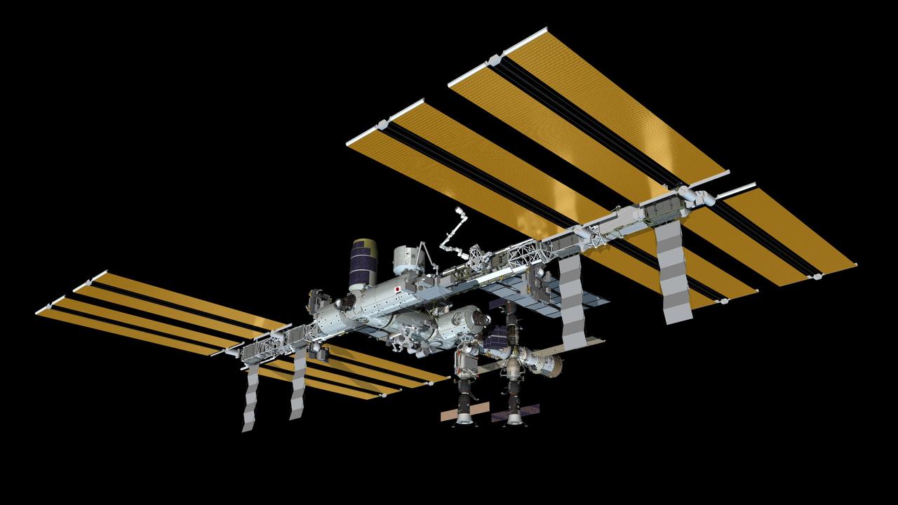
JSC2011-E-016182 (February 2011) --- Computer-generated artist?s rendering of the International Space Station as of Feb. 20, 2011. Progress 39 resupply vehicle undocks from the Zvezda Service Module?s aft port. Progress 41 resupply vehicle is docked to the Pirs Docking Compartment. Soyuz 25 (TMA-20) remains docked to the Rassvet Mini-Research Module 1 (MRM1). Soyuz 24 (TMA-01M) is linked to the Poisk Mini-Research Module 2 (MRM2) and the Japanese Kounotori2 H-II Transfer Vehicle (HTV2) is attached to the Harmony node?s zenith port. Photo credit: NASA or National Aeronautics and Space Administration
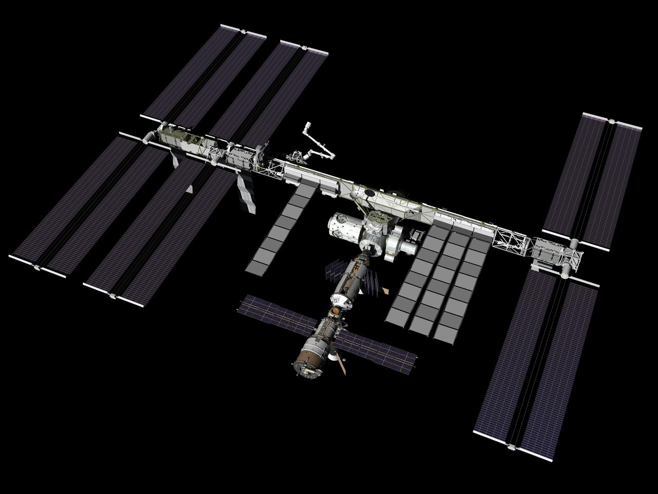
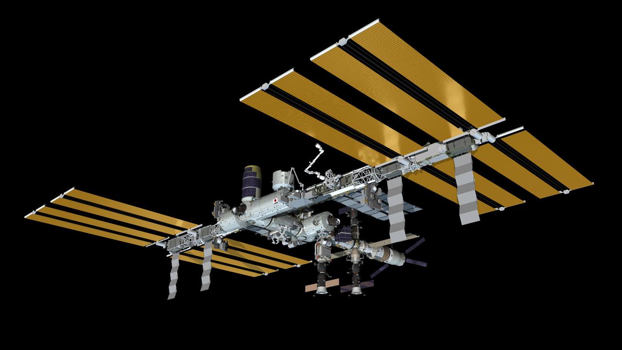
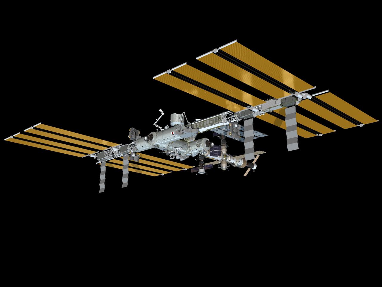
JSC2007-E-093440 (October 2007) --- Computer-generated artist's rendering of the International Space Station as of Oct. 30, 2007 during the STS-120/10A mission. Harmony node is attached to the port side of the Unity node. Starboard TCS radiators are fully deployed. P6 truss segment is relocated to the end of the P5 segment and the P6 solar arrays and radiator are deployed.
This image from NASA Terra spacecraft shows a cluster of villages known as Mawsynram in India, which is the current world record holder for the wettest place on earth.
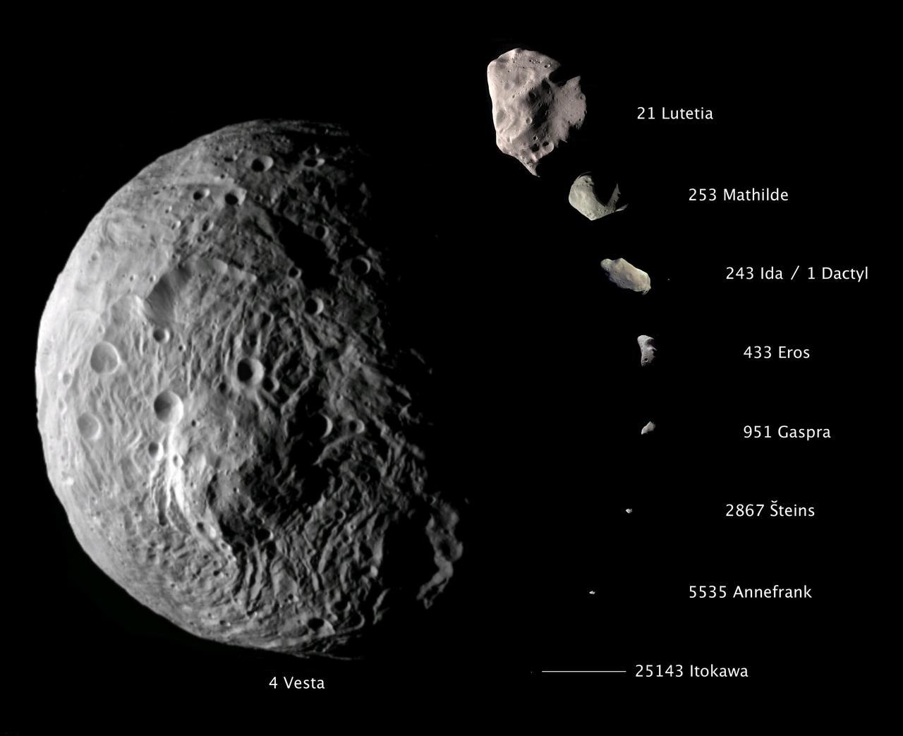
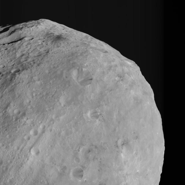
Vesta is the largest asteroid visited by a spacecraft. It is currently being observed by NASA Dawn spacecraft, which has entered orbit around Vesta.

These images are of HED howardite, eucrite and diogenite meteorites, a large group of meteorites believed to originate from asteroid Vesta, a hypothesis that is consistent with current Dawn observations.
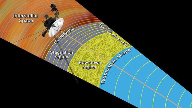
This artist concept shows the outer layers of our solar bubble, or heliosphere, and nearby interstellar space. NASA Voyager 1 is currently exploring a region of interstellar space.
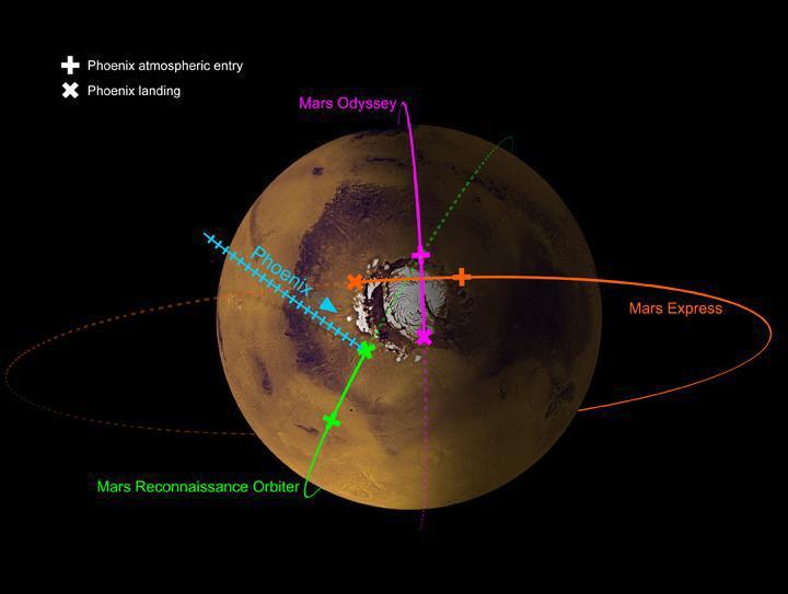
This image shows the paths of three spacecraft currently in orbit around Mars, as well as the path by which NASA Phoenix Mars Lander will approach and land on the planet.
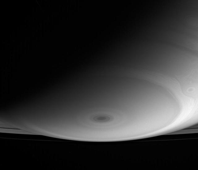
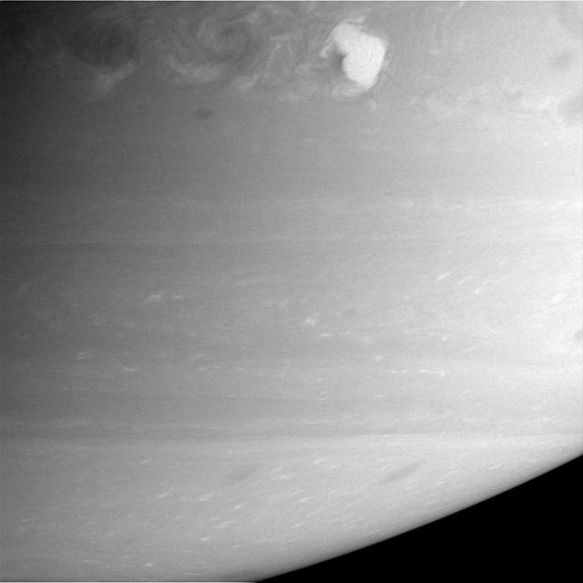
The Cassini spacecraft current high-inclination orbit allows for some fantastic perspectives, like this shot of Saturn south pole, which looks toward the rings beyond
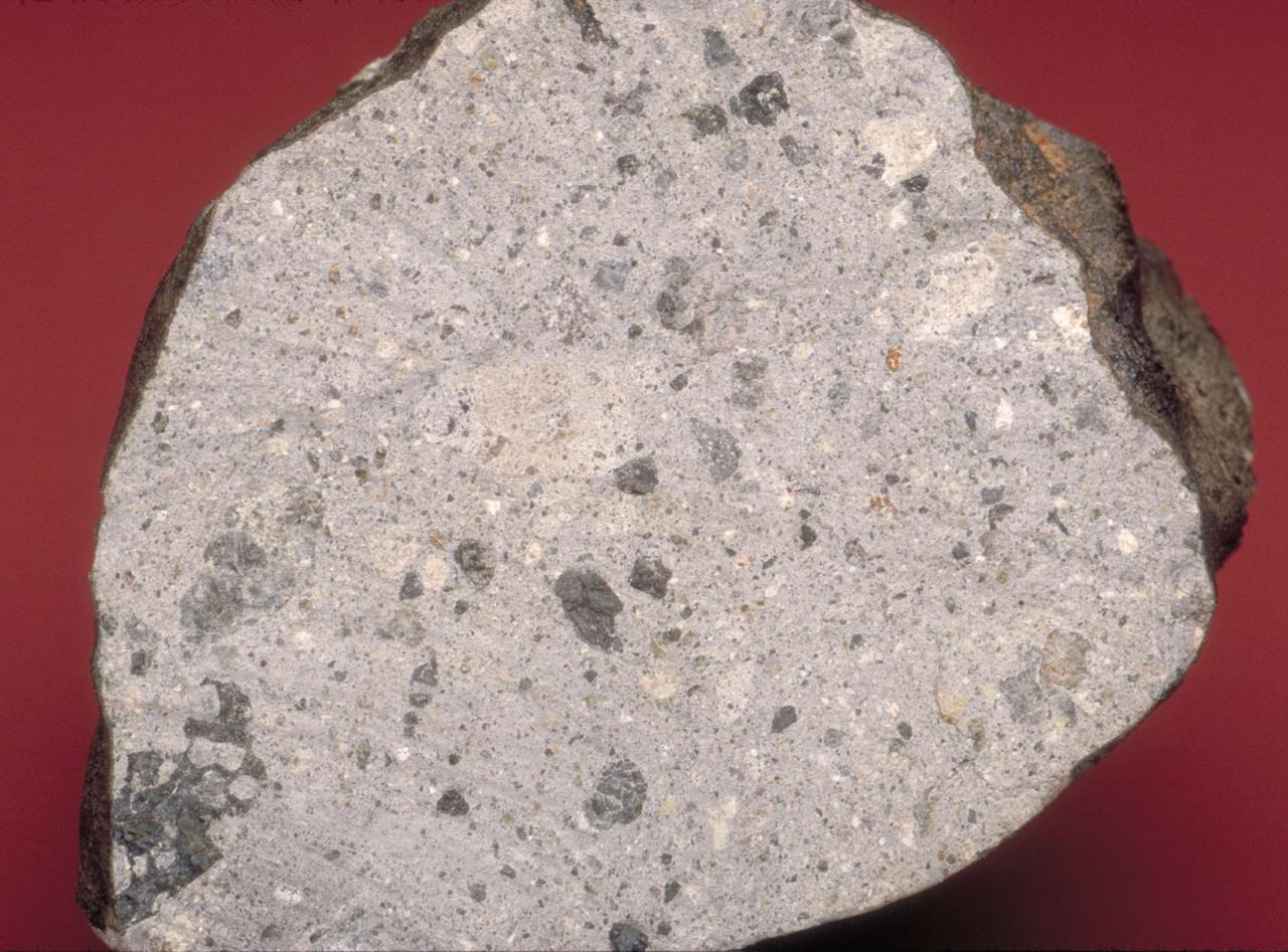
These images are of HED howardite, eucrite and diogenite meteorites are a large group of meteorites believed to originate from asteroid Vesta, a hypothesis that is consistent with current Dawn observations.
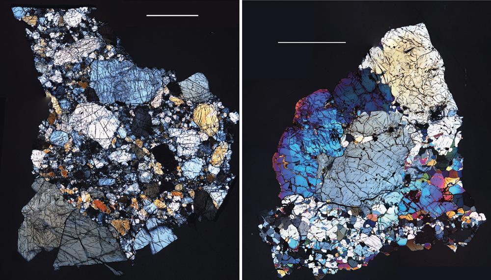
These images are of HED howardite, eucrite and diogenite meteorites are a large group of meteorites believed to originate from asteroid Vesta, a hypothesis that is consistent with current Dawn observations.
This image from NASA Dawn spacecraft shows dark colored mountains top of the image in the northern region of asteroid Vesta. The origin of such mountains is currently being investigated.
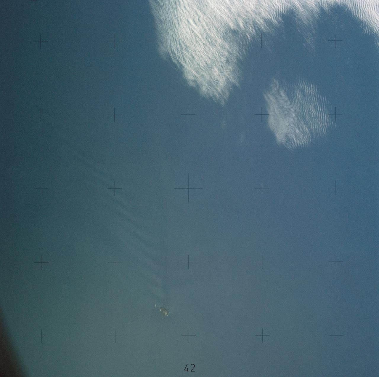
STS039-83-091 (28 April-6 May 1991) --- (HOLD PHOTO WITH BARRIER ISLANDS ALONG THE LEFT SIDE). This photograph of the water sunglint pattern along the Outer Banks of North Carolina was taken with a 70mm handheld camera equipped with color visible film and a 250mm lens. The islands appear as dark areas along the left side of the frame and Cape Hatteras is seen to the left and slightly above frame center. Sunglint is composed of light reflected from the water surface and the patterns seen in this photo are largely the result of sea surface roughness. Smooth water has a mirror-like reflectance and is represented in the photo as a bright area. Rough water, on the other hand, tends to disperse the light reflected from the water surface and, therefore, appears dark. Water currents in this area are extremely dynamic because the swift, northward flowing Gulf Stream (the offshore darker water along the right side of the photo) diverges from the coastline north of Cape Hatteras. The sharp line between bright and dark water is the western boundary of the Gulf Stream.
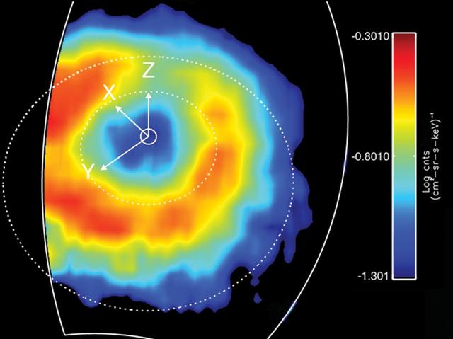
Like Earth, Saturn has an invisible ring of energetic ions trapped in its magnetic field. This feature is known as a "ring current." This ring current has been imaged with a special camera on Cassini sensitive to energetic neutral atoms. This is a false color map of the intensity of the energetic neutral atoms emitted from the ring current through a processed called charged exchange. In this process a trapped energetic ion steals and electron from cold gas atoms and becomes neutral and escapes the magnetic field. The Cassini Magnetospheric Imaging Instrument's ion and neutral camera records the intensity of the escaping particles, which provides a map of the ring current. In this image, the colors represent the intensity of the neutral emission, which is a reflection of the trapped ions. This "ring" is much farther from Saturn (roughly five times farther) than Saturn's famous icy rings. Red in the image represents the higher intensity of the particles, while blue is less intense. Saturn's ring current had not been mapped before on a global scale, only "snippets" or areas were mapped previously but not in this detail. This instrument allows scientists to produce movies (see PIA10083) that show how this ring changes over time. These movies reveal a dynamic system, which is usually not as uniform as depicted in this image. The ring current is doughnut shaped but in some instances it appears as if someone took a bite out of it. This image was obtained on March 19, 2007, at a latitude of about 54.5 degrees and radial distance 1.5 million kilometres (920,000 miles). Saturn is at the center, and the dotted circles represent the orbits of the moon's Rhea and Titan. The Z axis points parallel to Saturn's spin axis, the X axis points roughly sunward in the sun-spin axis plane, and the Y axis completes the system, pointing roughly toward dusk. The ion and neutral camera's field of view is marked by the white line and accounts for the cut-off of the image on the left. The image is an average of the activity over a (roughly) 3-hour period. http://photojournal.jpl.nasa.gov/catalog/PIA10094
JSC2009-E-224040 (November 2009) --- Computer-generated artist?s rendering of the International Space Station as of November 2009, after the STS-129/ULF3 installation of the ExPRESS Logistic Carrier 1 (port nadir) and ExPRESS Logistic Carrier 2 (starboard zenith) on the central truss. The Russian Mini-Research Module 2 (MRM2) docks to the Zvezda Service Module?s zenith port as of Nov. 12.
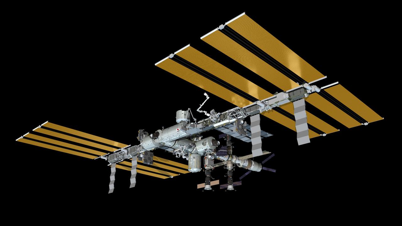
JSC2011-E-037290 (May 2011) --- Computer-generated artist?s rendering of the International Space Station as of May 19, 2011. STS-134 space shuttle Endeavour delivers the Express Logistics Carrier 3 (ELC3) and Alpha Magnetic Spectrometer (AMS) to the space station. This angle shows the port side of the orbiting complex. Photo credit: NASA
JSC2009-E-224041 (November 2009) --- Computer-generated artist?s rendering of the International Space Station as of November 2009, after the STS-129/ULF3 installation of the ExPRESS Logistic Carrier 1 (port nadir) and ExPRESS Logistic Carrier 2 (starboard zenith) on the central truss. The Russian Mini-Research Module 2 (MRM2) docks to the Zvezda Service Module?s zenith port as of Nov. 12.
JSC2006-E-42992 (September 2006) --- Computer-generated artist's rendering of the International Space Station following scheduled activities of Sept. 29, 2006. This angle shows the port side view of the orbiting complex. Soyuz 12 (TMA-8) spacecraft undocks from the Zarya Module nadir port--returning the Expedition 13 crew and spaceflight participant to Earth. Soyuz 13 (TMA-9) is connected to the Zvezda Service Module aft port and Progress 22 resupply vehicle remains linked to the Pirs Docking Compartment.
JSC2006-E-42993 (September 2006) --- Computer-generated artist's rendering of the International Space Station following scheduled activities of Sept. 29, 2006. This angle shows the starboard side view of the orbiting complex. Soyuz 12 (TMA-8) spacecraft undocks from the Zarya Module nadir port--returning the Expedition 13 crew and spaceflight participant to Earth. Soyuz 13 (TMA-9) is connected to the Zvezda Service Module aft port and Progress 22 resupply vehicle remains linked to the Pirs Docking Compartment.
JSC2010-E-188990 (November 2010) --- Computer-generated artist?s rendering of the International Space Station as of Nov. 24, 2010. Soyuz 23 (TMA-19) undocks from the Rassvet Mini-Research Module 1 (MRM1), returning Expedition 25 crew members (Wheelock, Walker, Yurchikhin) to Earth. Progress 40 resupply vehicle is docked to the Pirs Docking Compartment. Progress 39 resupply vehicle remains docked to the Zvezda Service Module?s aft port and Soyuz 24 (TMA-01M) is linked to the Poisk Mini-Research Module 2 (MRM2). Photo credit: NASA or National Aeronautics and Space Administration

JSC2011-E-030801 (April 2011) --- Computer-generated artist?s rendering of the International Space Station as of April 6, 2011. Soyuz 26 (TMA-21) docks to the Poisk Mini-Research Module 2 (MRM2) bringing Expedition 27 crew members (Borisenko, Garan and Samokutyaev). Progress 41 resupply vehicle is docked to the Pirs Docking Compartment. Soyuz 25 (TMA-20) remains linked to the Rassvet Mini-Research Module 1 (MRM1). The European Space Agency's ?Johannes Kepler? Automated Transfer Vehicle-2 (ATV2) is attached to the Zvezda Service Module?s aft port. Photo credit: NASA or National Aeronautics and Space Administration
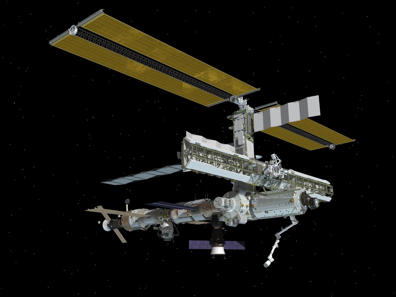
JSC2011-E-037291 (May 2011) --- Computer-generated artist?s rendering of the International Space Station as of May 30, 2011. STS-134 space shuttle Endeavour departs, leaving new hardware: the Express Logistics Carrier 3 (ELC3) and Alpha Magnetic Spectrometer (AMS); and installed the Orbiter Boom Sensor System (OBSS) on the S1 truss. This angle shows the port side of the orbiting complex. Photo credit: NASA
JSC2011-E-037289 (April 2011) --- Computer-generated artist?s rendering of the International Space Station as of April 29, 2011. Progress 42 resupply vehicle docks from the Pirs Docking Compartment. Soyuz 26 (TMA-21) is docked to the Poisk Mini-Research Module 2 (MRM2) and Soyuz 25 (TMA-20) remains linked to the Rassvet Mini-Research Module 1 (MRM1). The European Space Agency's ?Johannes Kepler? Automated Transfer Vehicle-2 (ATV2) is attached to the Zvezda Service Module?s aft port. Photo credit: NASA
JSC2011-E-037292 (May 2011) --- Computer-generated artist?s rendering of the International Space Station as of May 19, 2011. STS-134 space shuttle Endeavour delivers the Express Logistics Carrier 3 (ELC3) and Alpha Magnetic Spectrometer (AMS) to the space station. This angle shows the starboard side of the orbiting complex. Photo credit: NASA
JSC2011-E-037293 (May 2011) --- Computer-generated artist?s rendering of the International Space Station as of May 30, 2011. STS-134 space shuttle Endeavour departs, leaving new hardware: the Express Logistics Carrier 3 (ELC3) and Alpha Magnetic Spectrometer (AMS); and installed the Orbiter Boom Sensor System (OBSS) on the S1 truss. This angle shows the starboard side of the orbiting complex. Photo credit: NASA
JSC2011-E-037288 (April 2011) --- Computer-generated artist?s rendering of the International Space Station as of April 22, 2011. Progress 41 resupply vehicle undocks from the Pirs Docking Compartment. Soyuz 26 (TMA-21) is docked to the Poisk Mini-Research Module 2 (MRM2) and Soyuz 25 (TMA-20) remains linked to the Rassvet Mini-Research Module 1 (MRM1). The European Space Agency's ?Johannes Kepler? Automated Transfer Vehicle-2 (ATV2) is attached to the Zvezda Service Module?s aft port. Photo credit: NASA
JSC2010-E-188991 (December 2010) --- Computer-generated artist?s rendering of the International Space Station as of Dec. 17, 2010. Soyuz 25 (TMA-20) docks to the Rassvet Mini-Research Module 1 (MRM1), bringing three Expedition 26 crew members (Kondratyev, Coleman, Nespoli) to the ISS. Progress 40 resupply vehicle is docked to the Pirs Docking Compartment. Progress 39 resupply vehicle remains docked to the Zvezda Service Module?s aft port and Soyuz 24 (TMA-01M) is linked to the Poisk Mini-Research Module 2 (MRM2). Photo credit: NASA or National Aeronautics and Space Administration
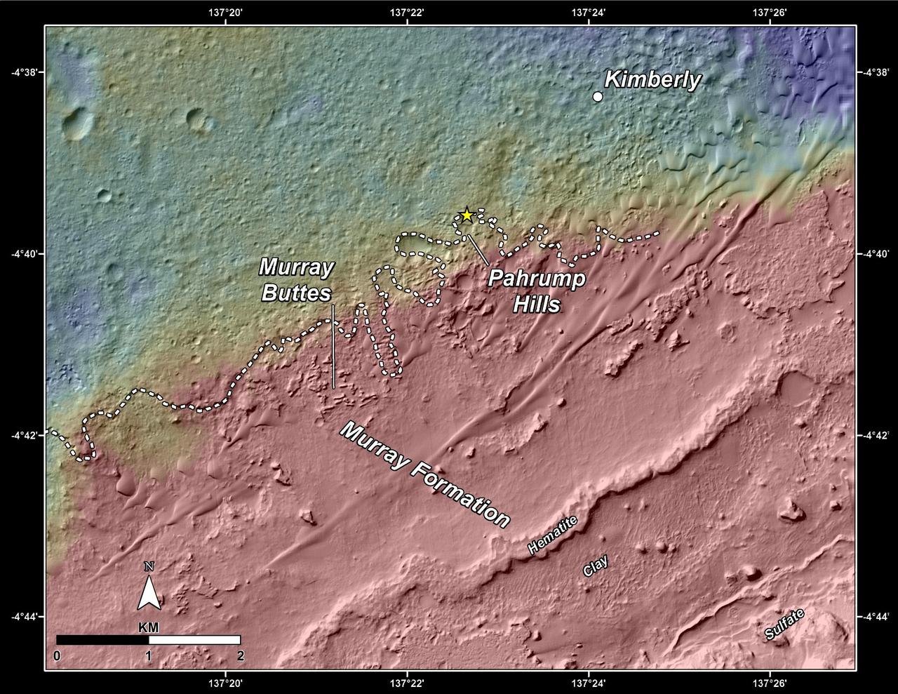
This topography map shows a portion of the Gale Crater region on Mars, where NASA Mars Curiosity rover landed on August 6, 2014. The rover marked with a star is currently headed toward Pahrump Hills.
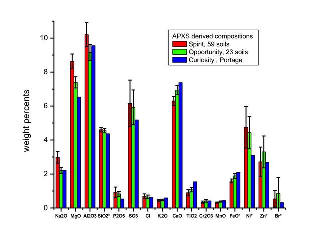
This graph compares the elemental composition of typical soils at three landing regions on Mars: Gusev Crater, from Spirit; Meridiani Planum, from Opportunity; and now Gale Crater, where NASA newest Curiosity rover is currently investigating.
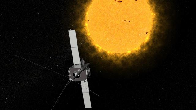
An artist conception of one of NASA Solar Terrestrial Relations Observatory STEREO spacecraft. The two observatories currently lie on either side of the sun, providing views of the entire sun simultaneously.
This image from NASA MESSENGER is one of many from the latest vulcanoid search are currently being transmitted to Earth. Vulcanoids are small rocky bodies that have been postulated to exist but not yet been detected.
NASA Opportunity had driven 72.3 meters southward 237 feet that sol. Engineers drove the rover backward as a strategy to counteract an increase in the amount of current drawn by the drive motor of the right-front wheel. This is a vertical projection.
Australia is the only continent without any current volcanic activity, but it hosts one of the world largest extinct volcanoes, the Tweed Volcano. Rock dating methods indicate that eruptions here lasted about three million years.
This image from NASA Dawn spacecraft shows a very shadowed region in Vesta northern hemisphere. Roughly the upper one third of asteroid Vesta northern hemisphere is currently in shadow.
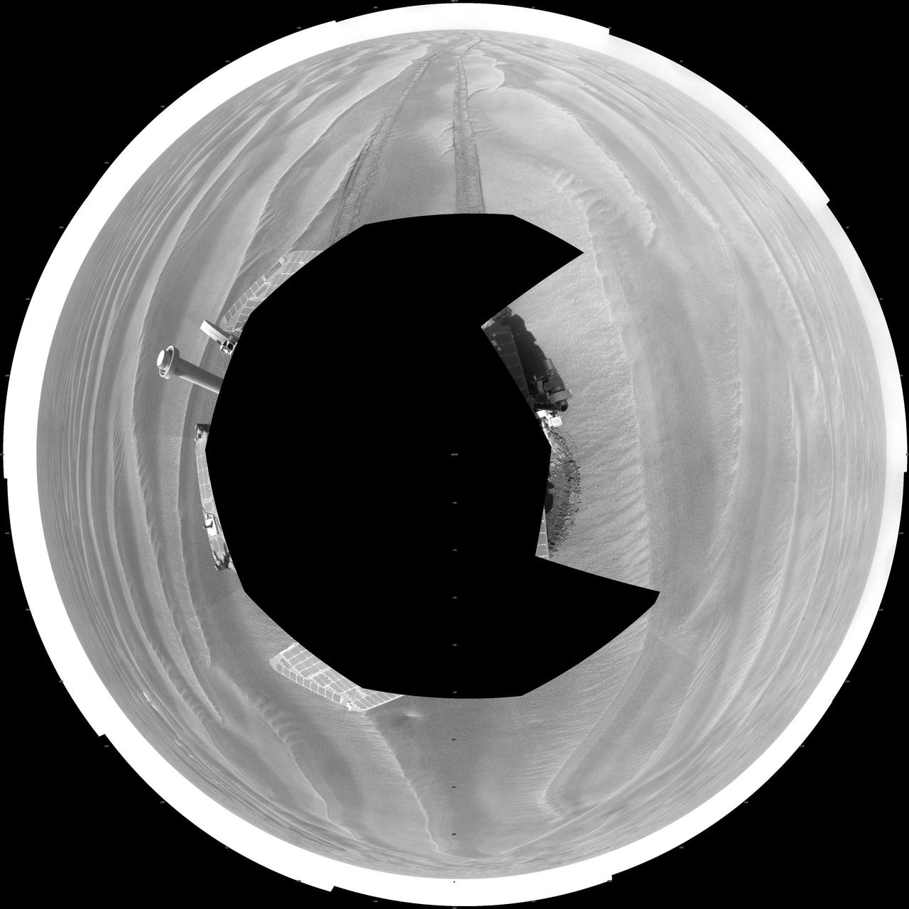
NASA Opportunity had driven 72.3 meters southward 237 feet that sol. Engineers drove the rover backward as a strategy to counteract an increase in the amount of current drawn by the drive motor of the right-front wheel. This is a polar projection.
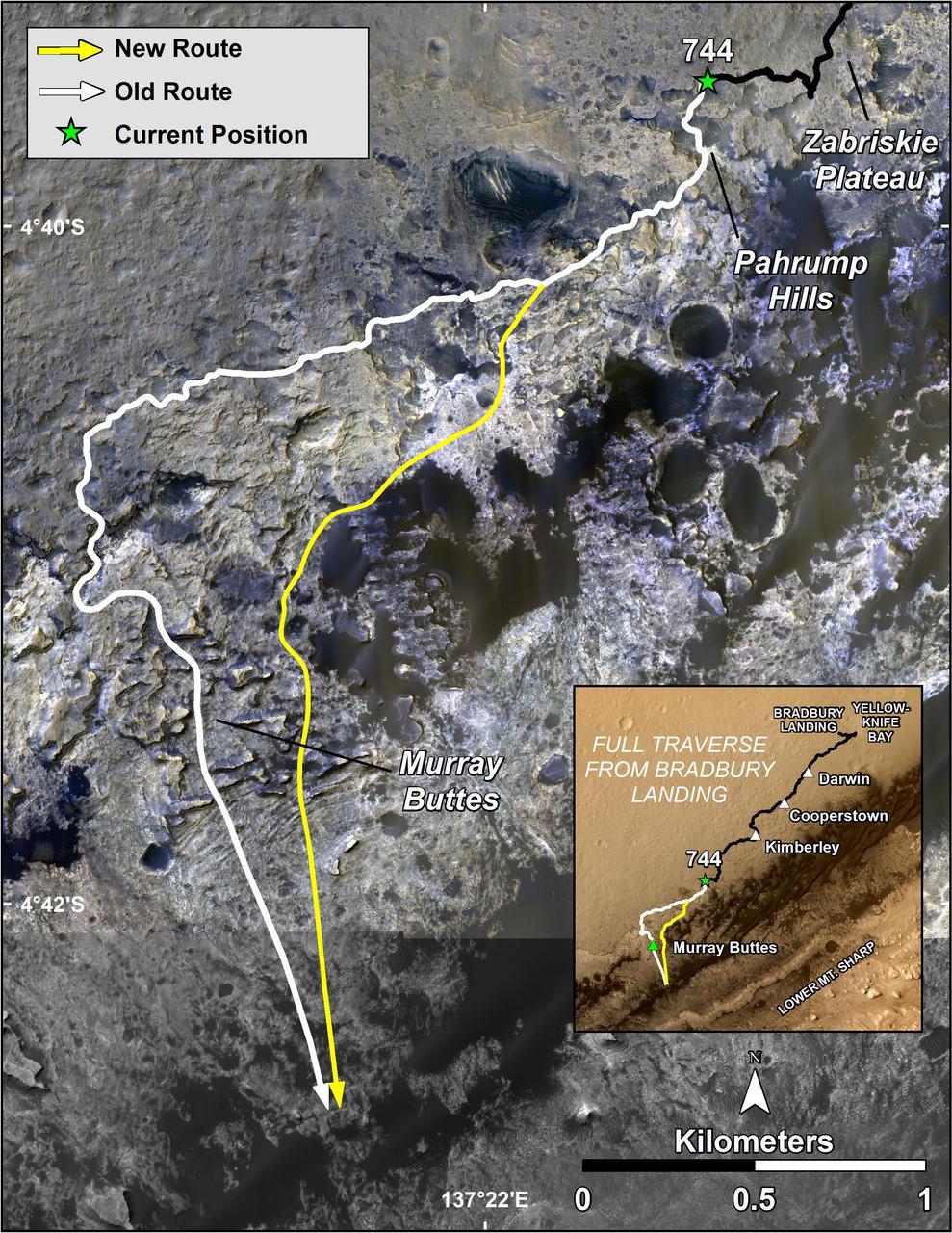
The route of NASA Mars Curiosity rover up the slopes of Mount Sharp on Mars is indicated in yellow in this image. The rover current position is marked with a star. This new route provides excellent access to many features in the Murray Formation.
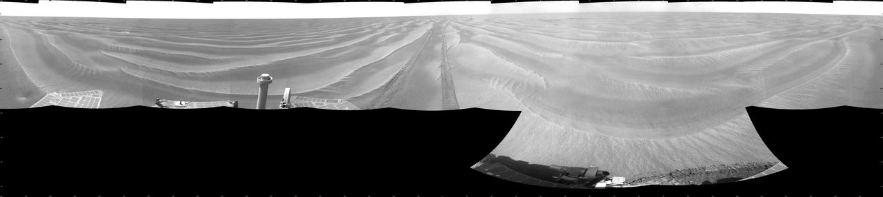
NASA Opportunity had driven 72.3 meters southward 237 feet that sol. Engineers drove the rover backward as a strategy to counteract an increase in the amount of current drawn by the drive motor of the right-front wheel. This is a cylindric projection.
STS044-79-077 (24 Nov.-1 Dec. 1991) --- This photograph, captured from the Earth-orbiting Space Shuttle Atlantis, shows sunglint pattern in the western tropical Indian Ocean. Several large internal waves reflect around a shallow area on the sea floor. NASA scientists studying the STS-44 photography believe the shallow area to be a sediment (a submerged mountain) on top of the Mascarene Plateau, located northeast of Madagascar at approximately 5.6 degrees south latitude and 55.7 degrees east longitude. Internal waves are similar to surface ocean waves, except that they travel inside the water column along the boundary between water layers of different density. At the surface, their passage is marked on the sea surface by bands of smooth and rough water. These bands appear in the sunglint pattern as areas of brighter or darker water. NASA scientists point out that, when the waves encounter an obstacle, such as a near-surface seamount, they bend or refract around the obstacle in the same manner as surface waves bend around an island or headland.
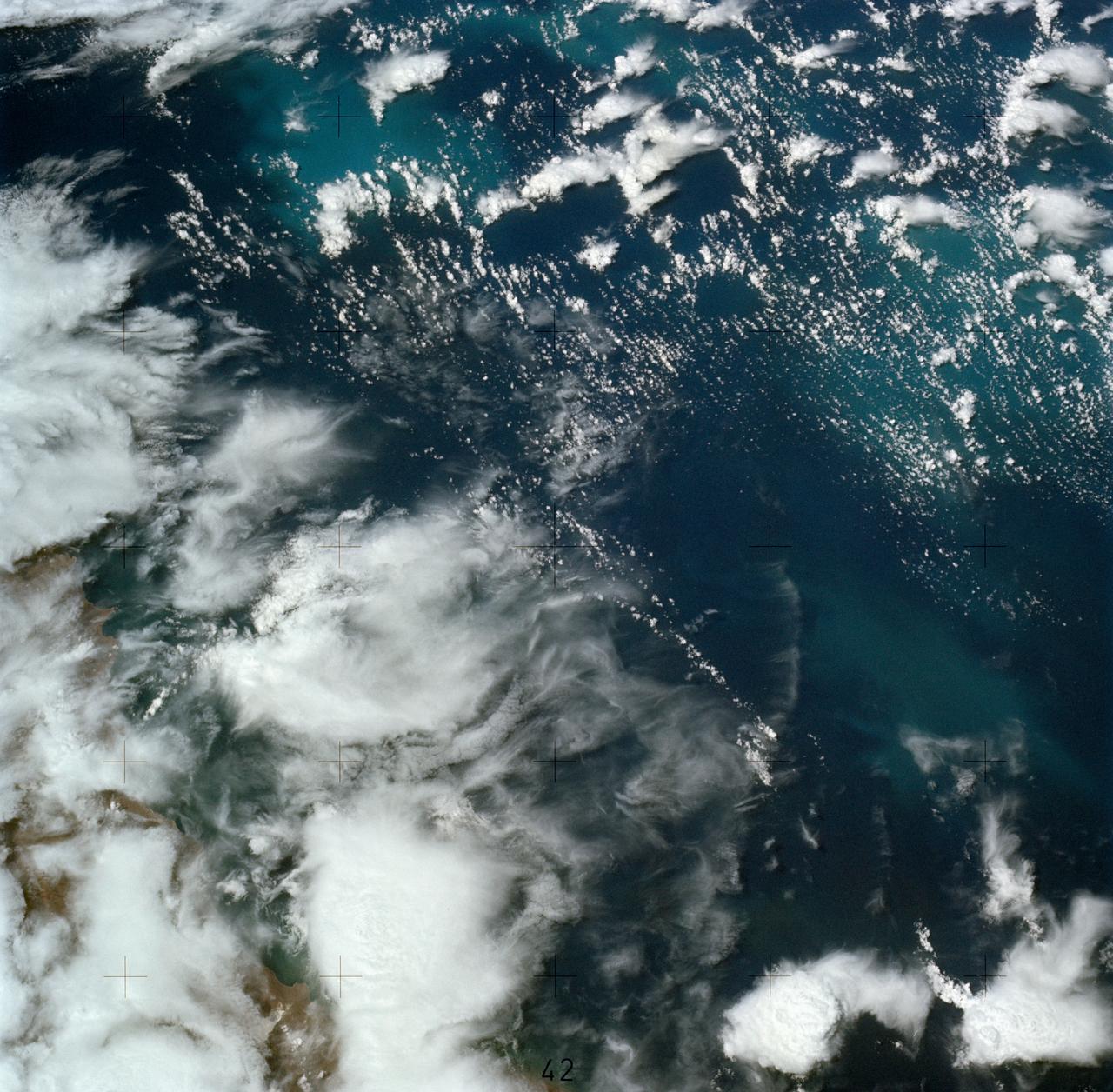
STS054-95-042 (13-19 Jan 1993) --- The Equatorial Pacific Ocean is represented in this 70mm view. The international oceanographic research community is presently conducting a program called Joint Global Ocean Flux Study (JGOFS) to study the global ocean carbon budget. A considerable amount of effort within this program is presently being focused on the Equatorial Pacific Ocean because of the high annual average biological productivity. The high productivity is the result of nearly constant easterly winds causing cool, nutrient-rich water to well up at the equator. In this view of the sun glint pattern was photographed at about 2 degrees north latitude, 103 degrees west longitude, as the Space Shuttle passed over the Equatorial Pacific. The long narrow line is the equatorial front, which defines the boundary between warm surface equatorial water and cool, recently upwelled water. Such features are of interest to the JGOFS researchers and it is anticipated that photographs such as this will benefit the JGOFS program.
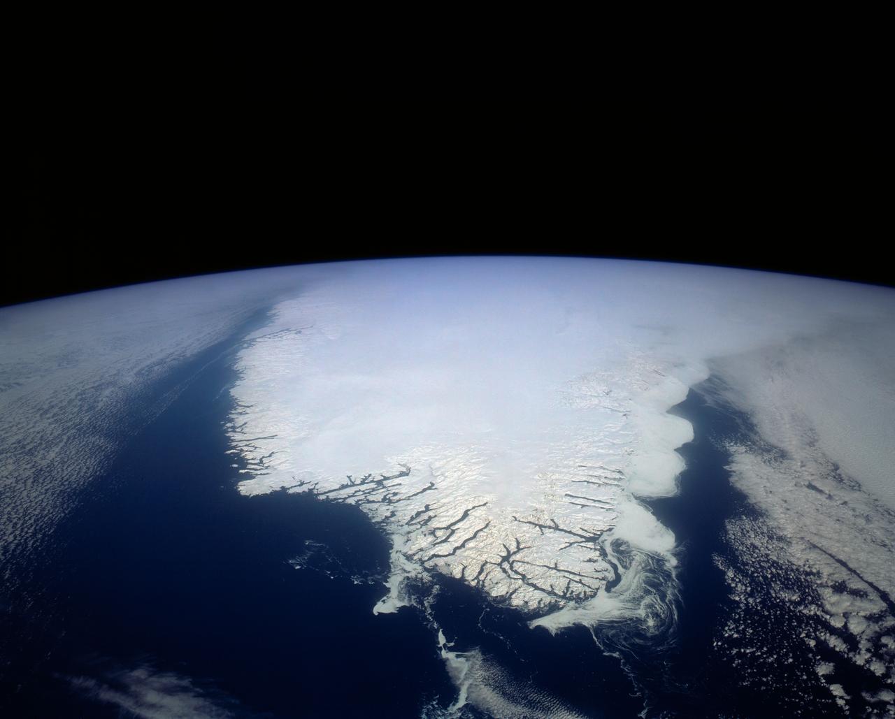
This spectacular north looking view of south Greenland (62.0N, 46.0W) shows numerous indentations along the coastline, many of which contain small settlements. These indentations are fiords carved by glaciers of the last ice age. Even today, ice in the center of Greenland is as much as 10,000 ft. thick and great rivers of ice continuously flow toward the sea, where they melt or break off as icebergs - some of which may be seen floating offshore.
STS007-05-245 (18-24 June 1983) --- A rare view of internal waves in the South China Sea. Several different series of internal waves are represented in the 70mm frame, exposed with a handheld camera by members of the STS-7 astronaut crew aboard the Earth-orbiting Challenger. The land area visible in the lower left is part of the large island of Hainan, China.
STS040-614-047 (5-14 June 1991) --- This image is of the Norfolk, Virginia -- Southern Delmarva Peninsula Southern Chesapeake Bay Area as seen in sunlight. The exposure is adjusted to emphasize the water patterns present. The outgoing tide generates considerable turbulence as it passes through the mouth of the bay. This is displayed by differences in reflective properties of the water surface due to differences in slope and turbidity. Ship wakes and the wakes of subsurface structures are seen clearly. The bridge tunnel system linking Norfolk with the peninsula and its effect on the system is quite apparent. Sunglint images over land areas were also acquired which emphasize land-water boundaries as demonstrated here in the small Delmarva inlets as a tool for wetland mapping, and river, lake and even pond description. During the first few days of the STS-40 mission the Eastern Seaboard of the United States was free of clouds and haze providing excellent photography of many of the major cities and the countryside of that area as well as the Gulf Stream.
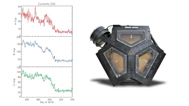
The set of graphs on the left illustrates the drop in electrical current detected in three directions by Voyager 2's plasma science experiment (PLS) to background levels. They are among the key pieces of data that Voyager scientists used to determine that Voyager 2 entered interstellar space, the space between stars, in November 2018. The disappearance in electrical current in the sunward-looking detectors indicates the spacecraft is no longer in the outward flow of solar wind plasma. It is instead in a new plasma environment -- interstellar medium plasma. The image on the right shows the Faraday cups of the PLS. The three sunward pointed cups point in slightly different directions in order to measure the direction of the solar wind. The fourth cup (on the upper left) points perpendicular to the others. https://photojournal.jpl.nasa.gov/catalog/PIA22922
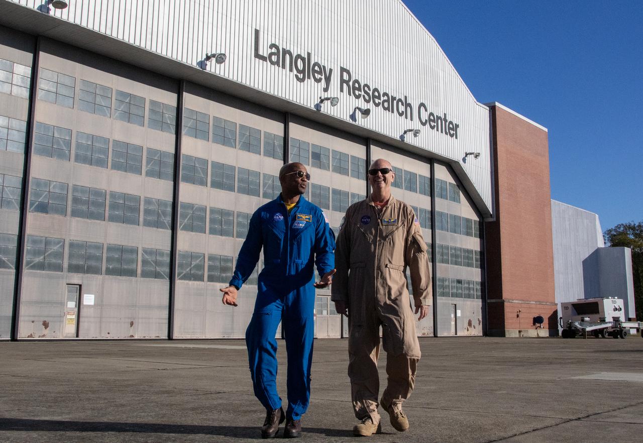
Former flight test instructor and current NASA test pilot Nils Larson reunited with former student and current astronaut Victor Glover on Oct. 21 during an open house at NASA's Langley Research Center in Hampton, Virginia.
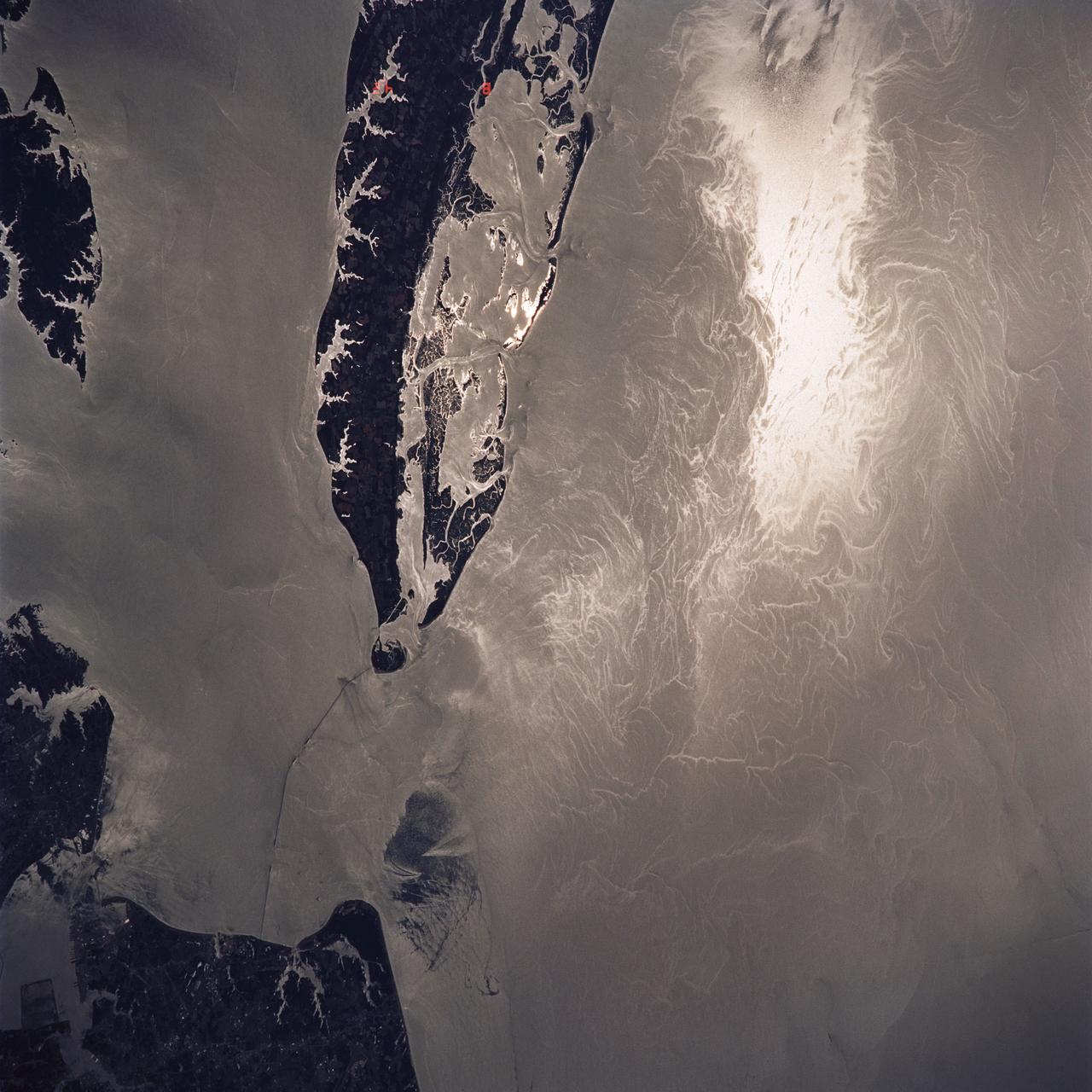
ISS039-E-11773 (14 April 2014) --- Photographed with a camera equipped with an 80mm lens from the International Space Station, patterns of sea ice in the Sea of Okhotsk reveal the dynamics of ocean currents that could otherwise only be seen in sunglint. In this Expedition 39 photo, one can see nearly 1,000 kilometers (600 miles) of the East Sakhalin Current, which is carrying winter ice south toward Japan’s Hokkaido Island. The current is marked by the narrow corridor of dense ice that hugs the coast of Russia’s Sakhalin Island. As it approaches Hokkaido, the ice patterns show a series of eddies and swirls. The East Sakhalin Current wanes in summer when the Soya Current begins to enter the Sea of Okhotsk. This inrush of summer water starts in April and, according to NASA scientists, probably expresses itself in this image as ice pattern to the east above Hokkaido. The Sakhalin current turns east and transports ice toward the Kuril Island chain. Some ice can spill through gaps in the islands, where it is swept southwest by the Kuril Current (lower right).
NASA's Curiosity Mars rover took this image with its Mast Camera (Mastcam) on Feb. 10, 2019 (Sol 2316). The rover is currently exploring a region of Mount Sharp nicknamed "Glen Torridon" that has lots of clay minerals. https://photojournal.jpl.nasa.gov/catalog/PIA23047
JSC2009-E-028064 (February 2009) --- Computer-generated artist?s rendering of the International Space Station as of Feb. 5, 2009. Progress 31 resupply vehicle undocks from the Pirs Docking Compartment. Soyuz 17 (TMA-13) remains docked to the Zarya nadir port.

JSC2010-E-180118 (October 2010) --- Computer-generated artist?s rendering of the International Space Station as of Oct. 29, 2010. Progress 40 resupply vehicle docks to the Pirs Docking Compartment. Progress 39 resupply vehicle remains docked to the Zvezda Service Module?s aft port. Soyuz 23 (TMA-19) is attached to the Rassvet Mini-Research Module 1 (MRM1) and Soyuz 24 (TMA-01M) is linked to the Poisk Mini-Research Module 2 (MRM2). Photo credit: NASA or National Aeronautics and Space Administration
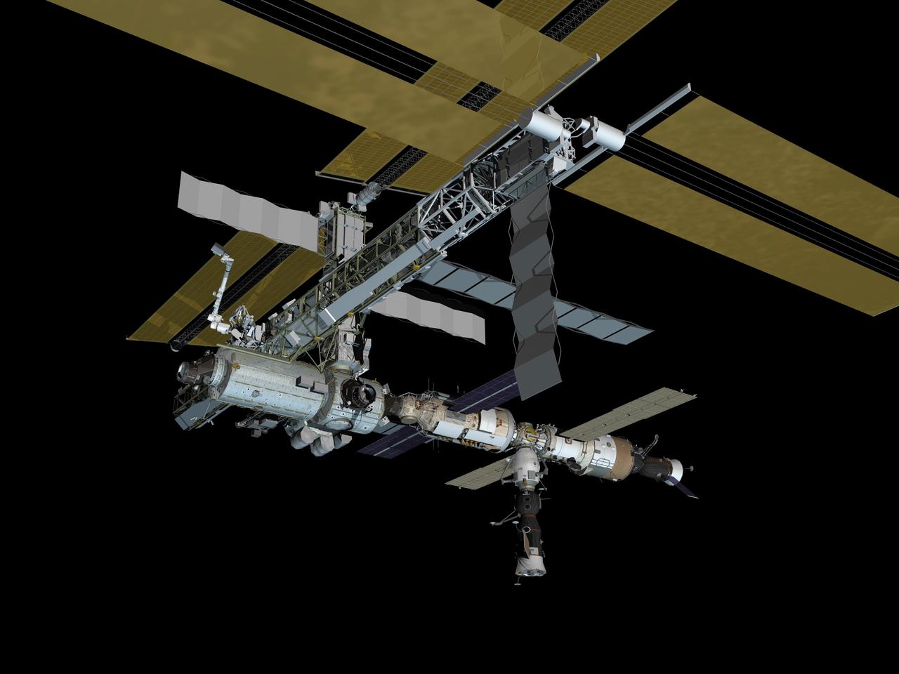
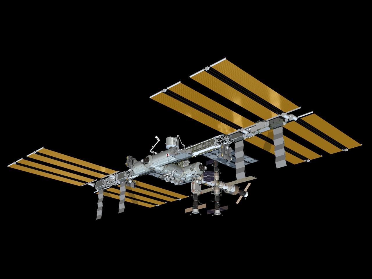
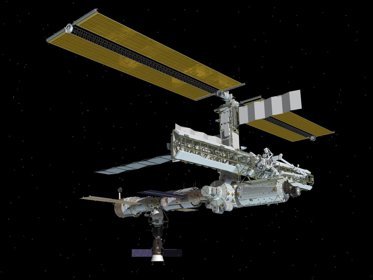
JSC2011-E-072139 (July 2011) --- Computer-generated artist?s rendering of the starboard view of the complete configuration of the International Space Station as of July 18, 2011, following the STS-135 mission. Progress 43 is linked to the aft port of the Zvezda Service Module. Soyuz 27 (TMA-02M) is docked to the Rassvet Mini-Research Module 1 (MRM1). Progress 42 is attached to the Pirs Docking Compartment and Soyuz 26 (TMA-21) is docked to the Poisk Mini-Research Module 2 (MRM2). Photo credit: NASA
JSC2010-E-086856 (June 2010) --- Computer-generated artist?s rendering of the International Space Station as of June 28, 2010. Soyuz 23 (TMA-19) relocates from the Zvezda Service Module?s aft port to the Rassvet Mini-Research Module 1 (MRM1). Progress 37 resupply vehicle is linked to the Pirs Docking Compartment and Soyuz 22 (TMA-18) remains docked to the Poisk Mini-Research Module 2 (MRM2).
JSC2006-E-06376 (April 2006) --- Computer-generated artist’s rendering of the International Space Station following scheduled activities of April 8, 2006. This angle shows the port side view of the orbiting complex. Soyuz 11 undocks from the Zvezda Service Module aft port, returning the Expedition 12 crew to Earth. Soyuz 12 is docked to the Zarya Module nadir port and Progress 20 resupply vehicle remains docked to the Pirs Docking Compartment.
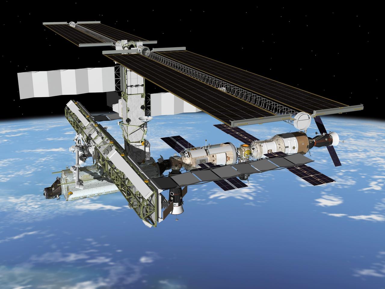
JSC2011-E-054427 (June 2011) --- Computer-generated artist?s rendering of the International Space Station as of June 20, 2011. The European Space Agency's Automated Transfer Vehicle-2 (ATV-2) undocks from the aft port of Zvezda Service Module. Soyuz 27 (TMA-02M) is docked to MRM1. Progress 42 is docked to Pirs. Soyuz 26 (TMA-21) is docked to Poisk. Photo credit: NASA

JSC2008-E-035387 (May 2008) --- Computer-generated artist's rendering of the International Space Station as of May 16, 2008. Progress 29 resupply vehicle docks to the Zarya nadir port. Soyuz 16 (TMA-12) is linked to the Pirs Docking Compartment and the Jules Verne Automated Transfer Vehicle (ATV-1) remains docked to the Zvezda Service Module aft port.

JSC2011-E-013461 (January 2011) --- Computer-generated artist?s rendering of the International Space Station as of Jan. 23, 2011. Progress 40 resupply vehicle undocks from the Pirs Docking Compartment. Soyuz 25 (TMA-20) is docked to the Rassvet Mini-Research Module 1 (MRM1). Progress 39 resupply vehicle remains docked to the Zvezda Service Module?s aft port and Soyuz 24 (TMA-01M) is linked to the Poisk Mini-Research Module 2 (MRM2). Photo credit: NASA or National Aeronautics and Space Administration
JSC2009-E-028065 (February 2009) --- Computer-generated artist?s rendering of the International Space Station as of Feb. 13, 2009. Progress 32 resupply vehicle docks to the Pirs Docking Compartment. Soyuz 17 (TMA-13) remains docked to the Zarya nadir port.
JSC2010-E-040842 (March 2010) --- Computer-generated artist?s rendering of the International Space Station as of March 18, 2010. Soyuz 20 (TMA-16) undocks from the Poisk Mini-Research Module 2 (MRM2), returning NASA astronaut Jeffrey Williams, Expedition 22 commander; and Russian cosmonaut Maxim Suraev, Soyuz commander and Expedition 22 flight engineer, to Earth. Soyuz 21 (TMA-17) is linked to the Zarya nadir port. Progress 35 resupply vehicle remains docked to the Pirs Docking Compartment and Progress 36 is linked to the Zvezda Service Module?s aft port.

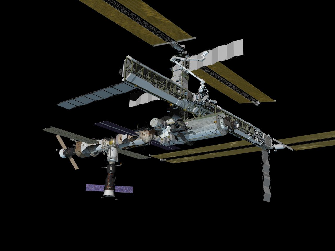
JSC2011-E-087735 (September 2011) --- Computer-generated artist?s rendering of the International Space Station as of Sept. 15, 2011. Soyuz 26 (TMA-21) undocks from the Poisk Mini-Research Module 2 (MRM2), returning Expedition 28 crew members (Borisenko, Samokutyaev, Garan) to Earth. Soyuz 27 (TMA-02M) is docked to the Rassvet Mini-Research Module 1 (MRM1). Progress 42 is attached to the Pirs Docking Compartment. Photo credit: NASA

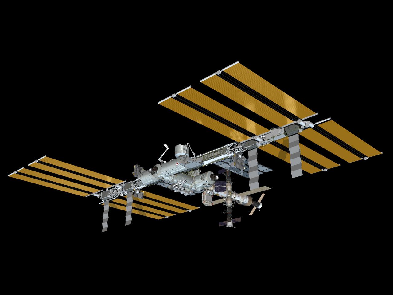
JSC2011-E-204147 (November 2011) --- Computer-generated artist?s rendering of the International Space Station as of Nov. 2, 2011. Progress 45 docks to the Pirs Docking Compartment. Soyuz 27 (TMA-02M) is attached to the Rassvet Mini-Research Module 1 (MRM1). Photo credit: NASA
JSC2006-E-23391 (June 2006) --- Computer-generated artist's rendering of the International Space Station following scheduled activities of June 26, 2006. This angle shows the starboard side view of the orbiting complex. Progress 22 resupply vehicle docks to the Pirs Docking Compartment. Progress 21 remains docked to the Zvezda Service Module aft port and Soyuz 12 remains docked to the Zarya Module nadir port.
JSC2005-E-21682 (June 2005) --- Computer-generated artist's rendering of the International Space Station following scheduled activities of June 15, 2005. This angle shows the starboard side of the orbiting complex. Progress 17 resupply vehicle undocks from the aft end of the Zvezda Service Module. Soyuz 10 remains docked to Pirs.
JSC2009-E-053516 (March 2009) --- Computer-generated artist?s rendering of the International Space Station as of March 15, 2009. S6 integrated truss segment installation and solar array deployment are complete. Progress 32 resupply vehicle remains docked to the Pirs Docking Compartment and Soyuz 17 (TMA-13) remains linked to the Zarya nadir port.
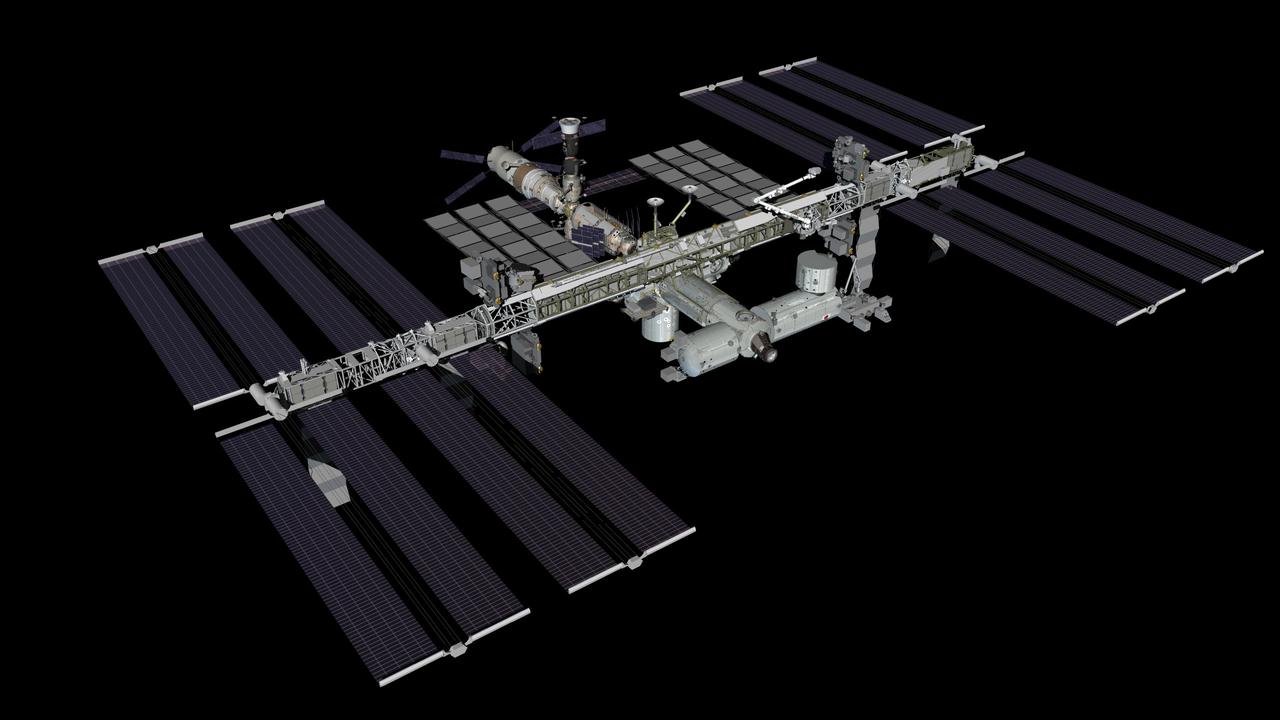
JSC2011-E-013463 (January 2011) --- Computer-generated artist?s rendering of the International Space Station as of Jan. 29, 2011. Progress 41 resupply vehicle docks to the Pirs Docking Compartment. The Japanese Kounotori2 H-II Transfer Vehicle (HTV2) is berthed to the Harmony node?s nadir port. Soyuz 25 (TMA-20) is docked to the Rassvet Mini-Research Module 1 (MRM1). Progress 39 resupply vehicle remains docked to the Zvezda Service Module?s aft port and Soyuz 24 (TMA-01M) is linked to the Poisk Mini-Research Module 2 (MRM2). Photo credit: NASA or National Aeronautics and Space Administration
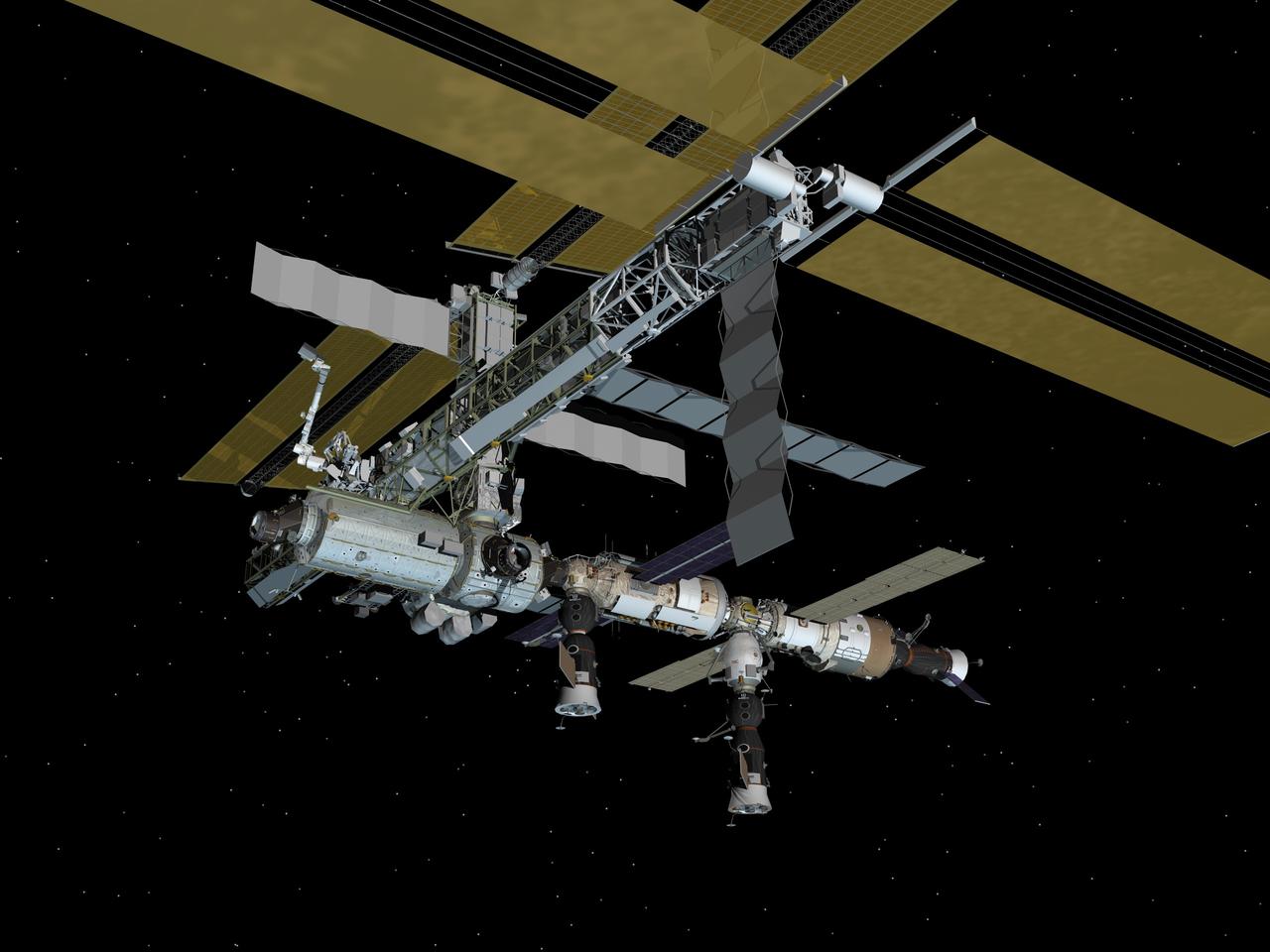
JSC2006-E-45448 (October 2006) --- Computer-generated artist's rendering of the International Space Station following scheduled activities of Oct. 26, 2006. This angle shows the port side of the orbiting complex. Progress 23 resupply vehicle docks to the Zvezda Service Module aft port. Soyuz 13 (TMA-9) is connected to Zarya Module nadir port and Progress 22 resupply vehicle remains linked to the Pirs Docking Compartment.
JSC2010-E-052987 (April 2010) --- Computer-generated artist?s rendering of the International Space Station as of April 22, 2010. Progress 35 resupply vehicle undocks from the Pirs Docking Compartment. Soyuz 22 (TMA-18) is linked to the Poisk Mini-Research Module 2 (MRM2) and Soyuz 21 (TMA-17) remains docked to the Zarya nadir port. Progress 36 resupply vehicle is linked to the Zvezda Service Module?s aft port.

JSC2006-E-05925 (March 2006) --- Computer-generated artist’s rendering of the International Space Station following scheduled activities of March 3, 2006. This angle shows the port side view of the orbiting complex. Progress 19 resupply vehicle undocks from the Zvezda Service Module. Soyuz 11 remains docked to the nadir port of the Zarya Module and Progress 20 resupply vehicle remains docked to the Pirs Docking Compartment.
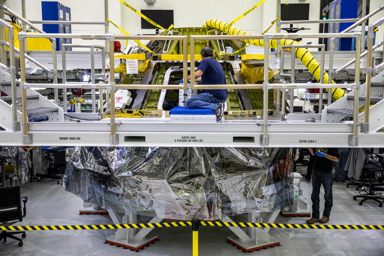
Inside the Neil Armstrong Operations and Checkout Building high bay at NASA's Kennedy Space Center in Florida, assembly continues on Orion’s Artemis II crew module on Feb. 5, 2021. The capsule will house astronauts during its mission around the Moon. Recently, teams removed the spacecraft from its clean room environment, where they have been performing the buildup of the Environmental Control and Propulsion System (ECPS) prior to their installation into the crew module. It will return to the clean room to complete ECPS final welds and assemblies. Artemis II will confirm all of the Orion spacecraft’s systems operate as designed in the actual environment of deep space with astronauts aboard. As part of the Artemis Program, NASA will send the first woman and next man to the Moon.
JSC2007-E-099882 (November 2007) --- Computer-generated artist's rendering of the 10A stage configuration of the International Space Station as of Nov. 14, 2007. The Harmony node with Pressurized Mating Adapter (PMA-2) attached is relocated to the front of the Destiny laboratory.
JSC2006-E-43325 (October 2006) --- Computer-generated artist's rendering of the International Space Station following scheduled activities of Oct. 10, 2006. This angle shows the starboard side view of the orbiting complex. Soyuz 13 (TMA-9) relocates from the Zvezda Service Module aft port to the Zarya Module nadir port. Progress 22 resupply vehicle remains docked to the Pirs Docking Compartment.
JSC2005-E-40052 (September 2005) --- Computer-generated artist's rendering of the International Space Station following scheduled activities of Sept. 10, 2005. This angle shows the port side of the orbiting complex. Progress 19 resupply vehicle docks to the aft end of the Zvezda Service Module. Soyuz 10 is docked to the nadir port of the Zarya Module.
JSC2004-E-18461 (April 2004) --- This artist's rendering depicts the port side of the International Space Station following the April 29 departure of Soyuz 7, which had earlier been docked to Pirs. The presence of Soyuz 8 vehicle, as it appeared after the April 21 docking to the nadir port of the Zarya module, is also depicted. The Progress 13 resupply vehicle is docked to the aft end of the Zvezda Service Module.